plate tectonics definition of ‘plate tectonics’ plate(s) – “flat” pieces of the...
TRANSCRIPT

Plate TectonicsPlate TectonicsDefinition of ‘Plate Tectonics’Definition of ‘Plate Tectonics’
Plate(s)Plate(s) – “flat” pieces of the – “flat” pieces of the lithosphere that cover the dynamic earthlithosphere that cover the dynamic earthTectonTecton – Greek word for ‘movement’ – Greek word for ‘movement’Plate TectonicsPlate Tectonics – The study of – The study of movement, creation, and destruction of movement, creation, and destruction of lithospheric (crustal) plateslithospheric (crustal) platesDynamicDynamic – constantly changing – constantly changing

Continental Drift TheoryContinental Drift Theory
• Claimed that the continents were once connected into one huge continent called Pangaea (means all lands)
• Scientists rejected Wegener’s theory because he could not prove WHY or HOW the continents moved.
Alfred Wegener (meteorologist), 1912Alfred Wegener (meteorologist), 1912

Alfred Wegener (cont.)
First clue:• Continents
seem to ‘fit together’ (South America & Africa)

Alfred Wegener (cont.)original drawings from Wegener’s book “Origin of the Continents and Oceans”

Evidence I – Fossil Clues
• Fossils found on continents 1000’s of miles apart: Mesosaurus and Glossopteris


Evidence II - Glaciers
• Glacial deposits and striations in tropical areas

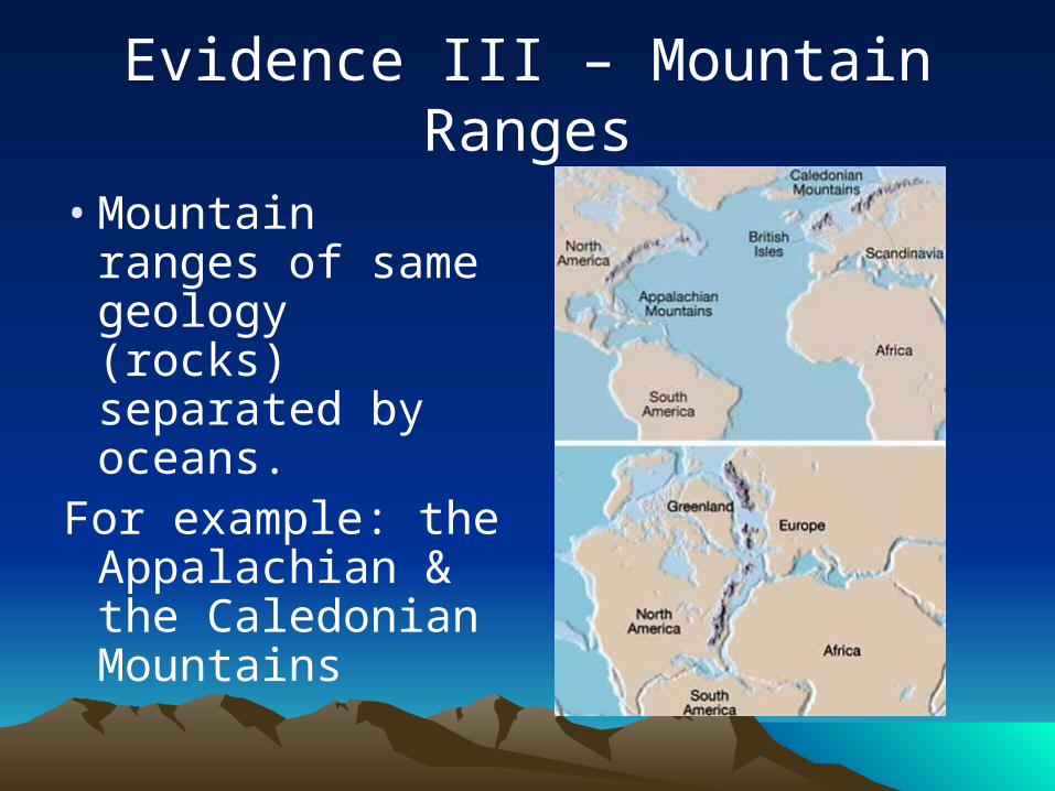
Evidence III – Mountain Ranges
• Mountain ranges of same geology (rocks) separated by oceans.
For example: the Appalachian & the Caledonian Mountains

Evidence IVMineral and Rock Deposits
Other Paleoclimate indicators:• Coal deposits in North America
and Europe (and artic areas)• Coral reefs in Northern Canada• Vast sand dunes (desert
indicators) not in latitudes associated with deserts.

Alfred Wegener (cont.)
**Scientists rejected Wegener’s theory because he could not prove WHY or HOW the continents moved.
Wegener died on a meteorological expedition in Greenland in 1930; his theory still unaccepted.

Sea Floor SpreadingHarry Hess (1960)
• Professor of Geology at Princeton UniversityProfessor of Geology at Princeton University
• World War II broke out, while on active duty World War II broke out, while on active duty as a navy sea captain, he took “soundings” as a navy sea captain, he took “soundings” of the ocean floor topography and found of the ocean floor topography and found the Mid-Atlantic Ridge system.the Mid-Atlantic Ridge system.
• Continuing his research after the war, Hess Continuing his research after the war, Hess speculated that the sea floor was spreading speculated that the sea floor was spreading out from vents in the cracks where hot out from vents in the cracks where hot magma oozed up to the surface.magma oozed up to the surface.

Sea Floor SpreadingSea Floor Spreading• Theory developed that magma from the
Earth’s mantle rises to the surface at the mid-ocean ridge and cools to form new seafloor – like a conveyor belt


EvidenceEvidence
• Rock AgeRock Age – rocks are youngest at – rocks are youngest at the ridge, and they get older as the ridge, and they get older as you move away from the ridge / you move away from the ridge / toward the continentstoward the continents
• Magnetic CluesMagnetic Clues – iron minerals in – iron minerals in rocks, like basalt, align themselves rocks, like basalt, align themselves with the magnetic north pole at with the magnetic north pole at the time they crystallize. the time they crystallize.

SeaSea FloorFloor SpreadingSpreading
• ridges had high ridges had high heat flow and heat flow and universal volcanism universal volcanism throughoutthroughout
• new magma slowly new magma slowly pushes away from pushes away from the ridge, causing the ridge, causing separation of the separation of the ocean floor.ocean floor.
(not in notes)(not in notes)

SeaSea FloorFloor SpreadingSpreading

SeaSea FloorFloor SpreadingSpreading
• the Mid-Ocean Ridge is the longest mountain chain in the world:
nearly 46,000 miles long in total
undersea mountains more than 12,000 feet high & 1,200 miles wide

SeaSea FloorFloor SpreadingSpreading
Paleomagnetism• Study of the
intensity and orientation of the earth's magnetic field
• Magnetic orientation is ‘frozen’ in metal bearing igneous rocks

SeaSea FloorFloor SpreadingSpreading(In 1963, Fred Vine & Drummond Matthews)(In 1963, Fred Vine & Drummond Matthews)
• Discovered that throughout geologic time, the polarity of the Earths Magnetic field has been reversed
• This reversal has been recorded in the rocks on either side of the mid-ocean ridges

Magnetic InclinationMagnetic Inclination
• The Earth's magnetic field is curved, and the inclination of the magnetic grains gives an estimate of the “paleolatitude”:– Equator: horizontal– Mid-latitude: high angle– Pole: straight up


The End?


The End … keep clicking…The End … keep clicking…
Hi, thanks for visiting the notes and making it through to the end….
…Now for a Jolly Rancher of your favorite flavor…
… go to ‘PowerPoint Notes’ and scroll down… click on the link ‘cLass Rules’ and follow the directions….
Now – DO NOT SHARE THIS INFORMATION WITH ANYONE – IF TOO MANY PEOPLE COME TO ME, I’LL KNOW THAT SOMEONE SQUEELED!!