plate tectonics packet - hmxearthsciencehmxearthscience.com/warehouse/linkviewers/handouts... ·...
TRANSCRIPT

plate tectonicS
Name: ___________________________________ Period: ____

2
Video #1: Introduction (SLIDE 2)Video #1: Introduction (SLIDE 2)
1. What makes Erta Ale a
special volcano?
2. Why is the Earth’s heat
important?
3. How old is the Earth?
Describe how it formed and why it is so hot.
The theory of Plate tectonics states that... (SLIDES 3-6)
1.
2.
3.
4.
The key to plate tectonics is Convection. (SLIDES 7-27)The key to plate tectonics is Convection. (SLIDES 7-27)
In your own words, describe the process of convection.
Draw a simple labeled diagram showing how convection currents work.
3
Video #2: CONVECTION (SLIDE 28)Video #2: CONVECTION (SLIDE 28)
1. What is convection and how does it move the plates?
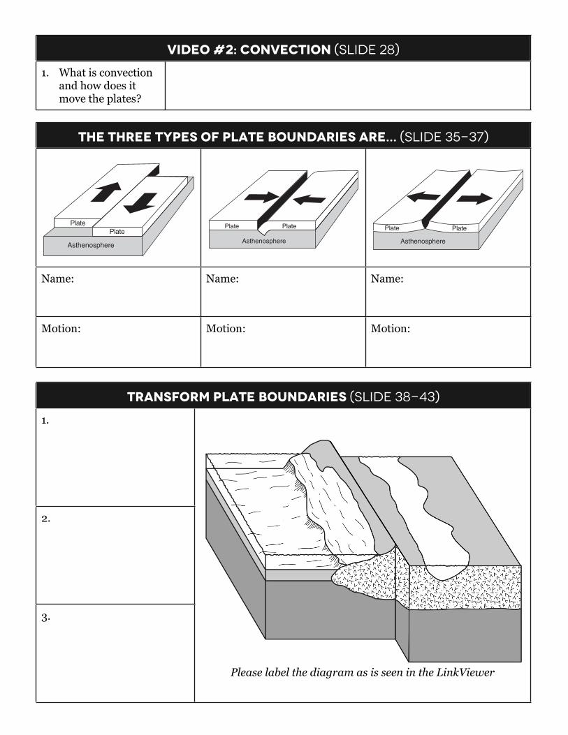
The Three types of plate boundaries are... (SLIDE 35-37)The Three types of plate boundaries are... (SLIDE 35-37)The Three types of plate boundaries are... (SLIDE 35-37)
28 Which cross section below best represents the conditions that cause early winter lake-effect snowstorms inNew York State?
29 Which block diagram best represents the relative direction of plate motion at the San Andreas Fault?
Plate
Plate
Asthenosphere
( 1 )
Plate
( 3 )
PlatePlate
Asthenosphere
PlatePlate
Asthenosphere
( 2 )
Asthenosphere
( 4 )
Plate
Condensation Condensation
EvaporationSnow
Evaporation
Warm lakewater
Cold air
Cold land
( 1 )
Snow
Cold lakewater
Warm air
Warm land
( 3 )
Snow
Warm lakewater
Cold air
Cold land
( 2 )
Snow
Cold lakewater
Warm air
Warm land
( 4 )
P.S./E. Sci.–June ’10 [7] [OVER]
Name: Name: Name:
Motion: Motion: Motion:
transform plate boundaries (SLIDE 38-43)transform plate boundaries (SLIDE 38-43)
1.
Please label the diagram as is seen in the LinkViewer
2.
Please label the diagram as is seen in the LinkViewer
3.
Please label the diagram as is seen in the LinkViewer
4
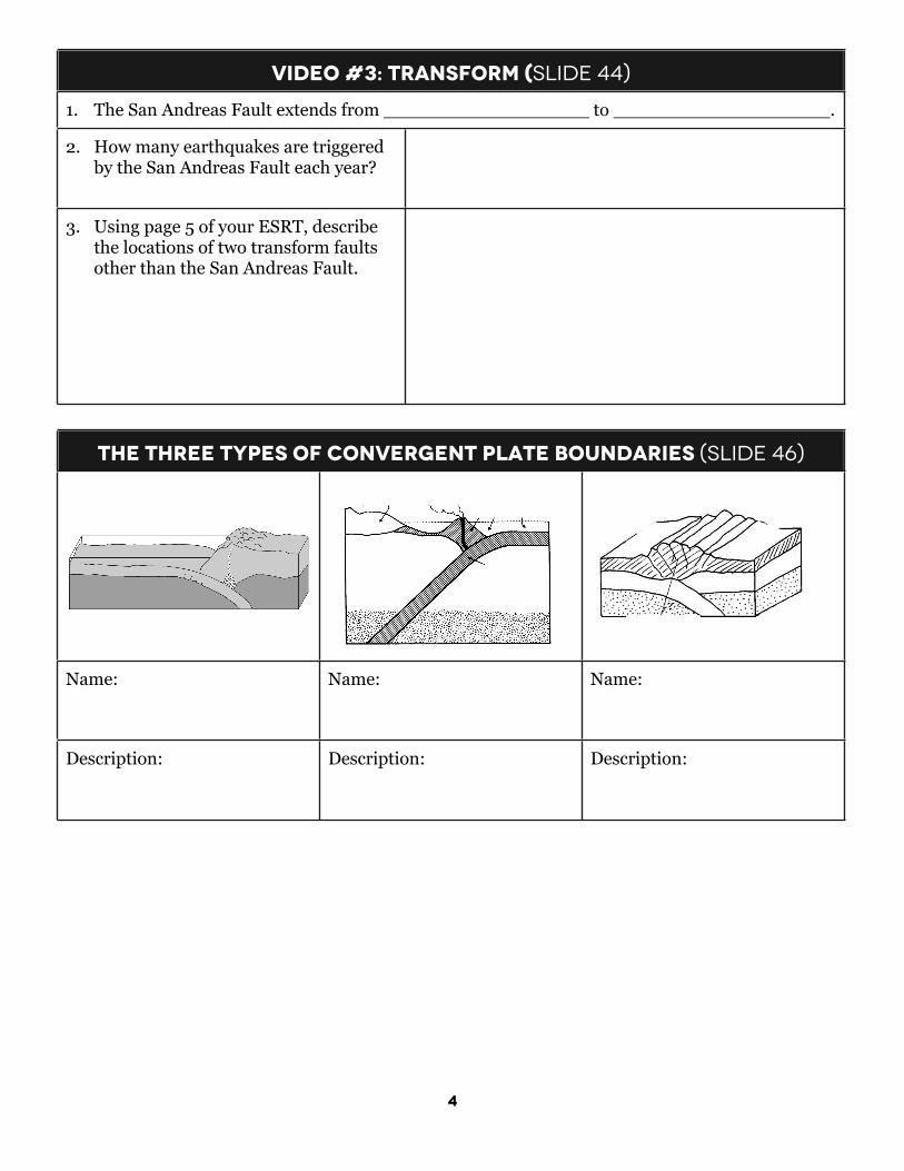
Video #3: TRANSFORM (SLIDE 44)Video #3: TRANSFORM (SLIDE 44)
1. The San Andreas Fault extends from __________________ to ___________________.1. The San Andreas Fault extends from __________________ to ___________________.
2. How many earthquakes are triggered by the San Andreas Fault each year?
3. Using page 5 of your ESRT, describe the locations of two transform faults other than the San Andreas Fault.
The Three types of CONVERGENT plate boundaries (SLIDE 46)The Three types of CONVERGENT plate boundaries (SLIDE 46)The Three types of CONVERGENT plate boundaries (SLIDE 46)
Name: Name: Name:
Description: Description: Description:

5
Video #4: Subduction (SLIDE 54)Video #4: Subduction (SLIDE 54)
1. What causes the
earthquakes along the subduction boundary?
Subduction Zone (SLIDE 47-53)Subduction Zone (SLIDE 47-53)
1.
Please label the diagram as is seen in the LinkViewer
2.
Please label the diagram as is seen in the LinkViewer
3.
Please label the diagram as is seen in the LinkViewer
4.
Please label the diagram as is seen in the LinkViewer
6
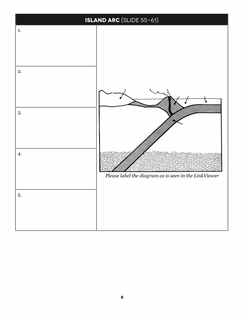
ISLAND ARC (SLIDE 55-61)ISLAND ARC (SLIDE 55-61)
1.
Please label the diagram as is seen in the LinkViewer
2.
Please label the diagram as is seen in the LinkViewer
3.
Please label the diagram as is seen in the LinkViewer
4.
Please label the diagram as is seen in the LinkViewer
5.
Please label the diagram as is seen in the LinkViewer

7
Video #5: COLLISION (SLIDE 67)Video #5: COLLISION (SLIDE 67)
1. How long did it take for the Himalayas to be
uplifted 5 miles high?
2. What evidence proves that the Himalayas were uplifted from beneath
sea level?
3. Describe the two ways the Himalayas are
moving.
Collision Zone (SLIDE 62-66)Collision Zone (SLIDE 62-66)
1.
Please label the diagram as is seen in the LinkViewer
2.
Please label the diagram as is seen in the LinkViewer
3.
Please label the diagram as is seen in the LinkViewer
8
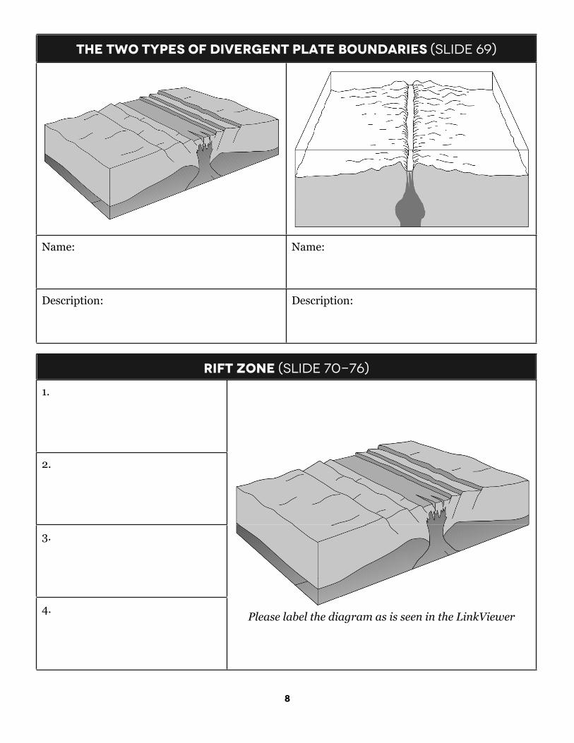
The two types of divergent plate boundaries (SLIDE 69)The two types of divergent plate boundaries (SLIDE 69)
Name: Name:
Description: Description:
rift Zone (SLIDE 70-76)rift Zone (SLIDE 70-76)
1.
Please label the diagram as is seen in the LinkViewer
2.
Please label the diagram as is seen in the LinkViewer
3.
Please label the diagram as is seen in the LinkViewer4.
Please label the diagram as is seen in the LinkViewer

9
Video #6: rift valley (SLIDE 76)Video #6: rift valley (SLIDE 76)
1. Explain why the East
African Rift is opening up.
Mid-ocean ridge (SLIDE 77-82)Mid-ocean ridge (SLIDE 77-82)
1.
Please label the diagram as is seen in the LinkViewer
2.
Please label the diagram as is seen in the LinkViewer
3.
Please label the diagram as is seen in the LinkViewer4.
Please label the diagram as is seen in the LinkViewer
Evidence supporting seafloor spreading (SLIDE 83-93)Evidence supporting seafloor spreading (SLIDE 83-93)
P.S. E./Sci.–Jan. ’02 [8]
33 The map below shows the Atlantic Ocean divided into zones A, B, C, and D. The Mid-Atlantic Ridge islocated between zones B and C.
Which graph best represents the geologic age of the surface bedrock on the ocean bottom?
Mid-AtlanticRidge
ZoneA
ZoneB
ZoneC
ZoneD
Oldest
Youngest
Mid-AtlanticRidge
ZoneA
ZoneB
ZoneC
ZoneD
Oldest
Youngest
( 3 )
( 4 )
Bedr
ock A
geBe
droc
k Age
Mid-AtlanticRidge
( 1 )
( 2 )
Youngest ZoneA
ZoneB
ZoneC
ZoneD
Bedr
ock A
ge
Oldest
Mid-AtlanticRidge
ZoneA
ZoneB
ZoneC
ZoneD
Oldest
Youngest
Bedr
ock A
ge
Greenland Iceland
Britain Europe
Africa
Azores
SouthAmerica
NorthAmerica
Cuba
ZoneA
ZoneB
ZoneDZone
C
Mid-AtlanticRidge
Color in Zones A, B, C, and D using green for older crust and yellow for younger crust.
1. Using your own words, describe how the
patterns of magnetism on the seafloor supports the idea of seafloor spreading.

10
HOT SPOT (SLIDE 99-111)HOT SPOT (SLIDE 99-111)
1.
Please label the diagram as is seen in the LinkViewer
2.
Please label the diagram as is seen in the LinkViewer
3.
Please label the diagram as is seen in the LinkViewer4. Please label the diagram as is seen in the LinkViewer
Video #8: Hot spots 1 (SLIDE 112)Video #8: Hot spots 1 (SLIDE 112)
1. What is the name of the
new Hawaiian island currently forming at the bottom of the Pacific Ocean?
Video #9: Hot spots 2 (SLIDE 113)Video #9: Hot spots 2 (SLIDE 113)
1. How long is the chain of seamounts and volcanic
islands formed by the Hawaiian Hot Spot?
2. What geographic
direction is the Pacific plate moving (you will have to listen carefully and think!)