plum tree island nwr: public scoping · pdf fileplum tree island nwr: public scoping ....
TRANSCRIPT

Plum Tree Island NWR: Public Scoping
September 13-14, 2012
U.S. Fish & Wildlife Service

Refuge System Mission “To administer a national network of lands and waters for the conservation, management, and where appropriate, restoration of the fish, wildlife, and plant resources* and their habitats within the United States for the benefit of present and future generations of Americans.”
*Federal trust resources are a priority
• Endangered and threatened species • Migratory birds • Migratory and inter-jurisdictional fish • Certain marine mammals • Wetlands

What is a CCP? Why is it important? • Comprehensive Conservation Plan (CCP)
• A 15-year strategic plan for the Refuge
• Fulfills laws and Service policy, and helps achieve agency mission and refuge purposes
• Includes a vision for the refuge
• Defines goals, objectives, and strategies for all refuge programs; identifies staffing and facilities
• Addresses key issues identified by the Service, other agencies, the public, and partners
• Encourages partner, public, and community involvement in planning and implementation
• Provides continuity and consistency in refuge management

Refuge Planning • U.S. Fish and Wildlife Service Mission • Refuge System Mission • Refuge Purpose • National/Regional Goals and Priorities • Ecosystem Goals and Objectives (in development) • Refuge Vision • Goals • Objectives • Strategies • Monitoring and Feedback

CCP Process
September 2012
Spring 2013
Fall 2013 Winter 2012-2013
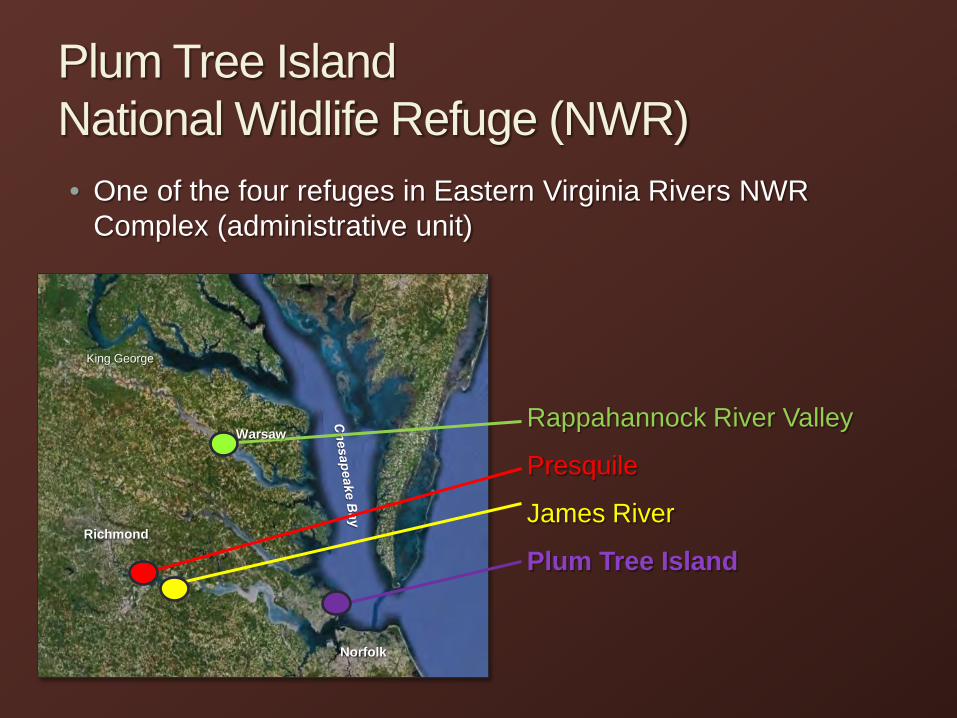
Plum Tree Island National Wildlife Refuge (NWR) • One of the four refuges in Eastern Virginia Rivers NWR
Complex (administrative unit)
Rappahannock River Valley
Presquile
James River
Plum Tree Island Richmond
Norfolk
King George
Warsaw

Refuge Vicinity Land Cover
Largest salt marsh in the Lower Chesapeake Bay

Historic Land Use and Activities 9500 B.C. Evidence of Virginia Indians presence dates from Paleo-Indian period
through to European Contact
1608-1609 Captain John Smith’s first and second voyages
… Europeans historically used area for stock grazing, hunting, and fishing
1917 Acquisition of land by U.S. Government – Department of Defense
1917 - 1959 Practice target, live bombing, gunnery, rocket firing, munitions handling training site
1958 Three children seriously injured by interacting with unexploded ordnance
1959 - Certificate of Clearance for Surface Ordnance - NASA began test free-flight aircraft models and vertical take-off and landing airplanes
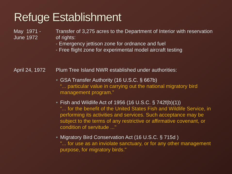
Refuge Establishment May 1971 - Transfer of 3,275 acres to the Department of Interior with reservation June 1972 of rights: - Emergency jettison zone for ordnance and fuel - Free flight zone for experimental model aircraft testing
April 24, 1972 Plum Tree Island NWR established under authorities:
• GSA Transfer Authority (16 U.S.C. § 667b) “... particular value in carrying out the national migratory bird management program.”
• Fish and Wildlife Act of 1956 (16 U.S.C. § 742f(b)(1)) "... for the benefit of the United States Fish and Wildlife Service, in performing its activities and services. Such acceptance may be subject to the terms of any restrictive or affirmative covenant, or condition of servitude ..."
• Migratory Bird Conservation Act (16 U.S.C. § 715d ) "... for use as an inviolate sanctuary, or for any other management purpose, for migratory birds."
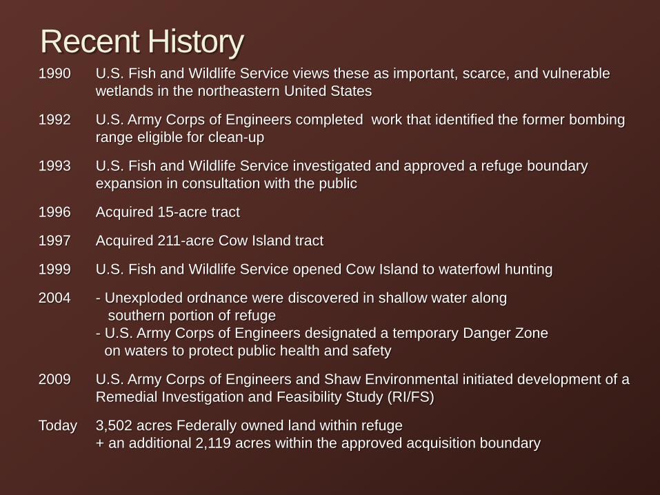
Recent History 1990 U.S. Fish and Wildlife Service views these as important, scarce, and vulnerable
wetlands in the northeastern United States
1992 U.S. Army Corps of Engineers completed work that identified the former bombing range eligible for clean-up
1993 U.S. Fish and Wildlife Service investigated and approved a refuge boundary expansion in consultation with the public
1996 Acquired 15-acre tract
1997 Acquired 211-acre Cow Island tract
1999 U.S. Fish and Wildlife Service opened Cow Island to waterfowl hunting
2004 - Unexploded ordnance were discovered in shallow water along southern portion of refuge - U.S. Army Corps of Engineers designated a temporary Danger Zone on waters to protect public health and safety
2009 U.S. Army Corps of Engineers and Shaw Environmental initiated development of a Remedial Investigation and Feasibility Study (RI/FS)
Today 3,502 acres Federally owned land within refuge + an additional 2,119 acres within the approved acquisition boundary
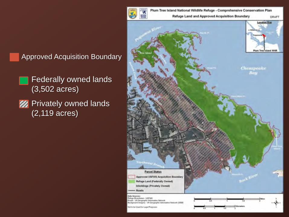
• Approved Acquisition Boundary
• Federally owned lands (3,502 acres)
• Privately owned lands (2,119 acres)

Draft Vision Statement
Plum Tree Island National Wildlife Refuge encompasses the largest contiguous salt marsh ecosystem in the lower Chesapeake Bay. Located along the Atlantic Flyway, the refuge offers diverse salt marshes, tidal streams and long, wooded ridges that support millions of waterfowl, marsh and wading birds, and shorebirds throughout the year. Sandy beaches offer secluded habitat for breeding and nesting wildlife, including the Federally threatened northeastern beach tiger beetles.
The refuge offers rare opportunity for Hampton Roads area residents and visitors to safely enjoy expansive views of abundant wildlife thriving in these important, vulnerable, and scarce salt marshes. In partnership with others, the refuge’s wildlife habitats support the rich traditions of hunting, fishing, and boating in the Chesapeake Bay.
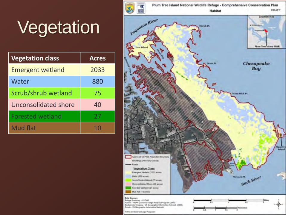
Vegetation Vegetation class Acres
Emergent wetland 2033
Water 880
Scrub/shrub wetland 75
Unconsolidated shore 40
Forested wetland 27
Mud flat 10

Wildlife • Noteworthy bird observations
• Foraging: sharp-tailed sparrow, little blue heron, black-necked stilt
• Breeding: black duck, northern harrier, sedge wren
• Wintering: black duck, mallard, Canada goose
Common Loon Brown Pelican Double-crested Cormorant Tundra Swan Canada Goose Snow Goose Mallard Black Duck Blue-winged Teal Green-winged Teal Canvasback Greater Scaup Lesser Scaup Common Goldeneye Bufflehead Red-breasted Merganser Vulture Red-shouldered Hawk Northern Harrier
Osprey Bobwhite Yellow-crowned Night Heron Green-backed Heron Tricolored Heron Little Blue Heron Snowy Egret Great Egret Great Blue Heron American Bittern Glossy Ibis Clapper Rail Virginia Rail American Oystercatcher Whimbrel Black-necked Stilt Willet Greater Yellowlegs Lesser Yellowlegs
Short-billed Dowitcher Dunlin Semi-palmated Sandpiper Great Black-backed Gull Laughing Gull Herring Gull Common Tern Forster’s Tern Least Tern Sandwich Tern Black Skimmer Mourning Dove Kingfisher Chimney Swift Eastern Kingbird Tree Swallow Purple Martin Rough-winged Swallow Barn Swallow
American Crow Fish Crow House Wren Marsh Wren Sedge Wren Catbird Starling Prairie Warbler Yellow Warbler Common Yellowthroat Indigo Bunting Sharp-tailed Sparrow Seaside Sparrow Song Sparrow Eastern Meadowlark Red-winged Blackbird Brown-headed Cowbird Boat-tailed Grackle American Goldfinch
76 Species Sighted at PTI in 1989 + Messick Marsh in 1992
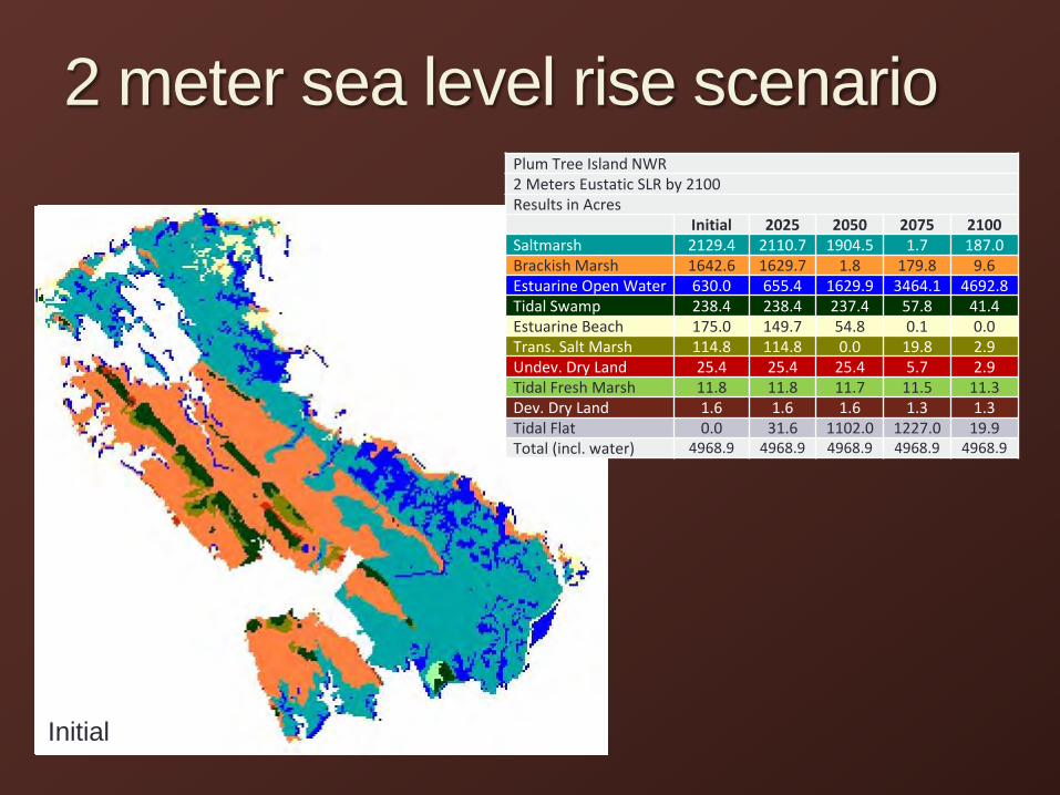
2100
2 meter sea level rise scenario
2075 2050 2025 Initial
Plum Tree Island NWR 2 Meters Eustatic SLR by 2100 Results in Acres Initial 2025 2050 2075 2100 Saltmarsh 2129.4 2110.7 1904.5 1.7 187.0 Brackish Marsh 1642.6 1629.7 1.8 179.8 9.6 Estuarine Open Water 630.0 655.4 1629.9 3464.1 4692.8 Tidal Swamp 238.4 238.4 237.4 57.8 41.4 Estuarine Beach 175.0 149.7 54.8 0.1 0.0 Trans. Salt Marsh 114.8 114.8 0.0 19.8 2.9 Undev. Dry Land 25.4 25.4 25.4 5.7 2.9 Tidal Fresh Marsh 11.8 11.8 11.7 11.5 11.3 Dev. Dry Land 1.6 1.6 1.6 1.3 1.3 Tidal Flat 0.0 31.6 1102.0 1227.0 19.9 Total (incl. water) 4968.9 4968.9 4968.9 4968.9 4968.9

Current Wildlife-Dependent Recreation
• Waterfowl hunting – Cow Island only
• No other public uses USFWS Hunting Blinds

Existing Partnerships
• National Park Service • Captain John Smith Chesapeake National Historic Trail
• Chesapeake Bay Watertrails and Gateways Network

Issues to Address in CCP • Landscape Scale/Ecosystem-wide Issues
• climate change, roles within regional land protection, water quality
• Land Management Issues • management, restoration, monitoring, inventories, research
• Public Use Programs • range or quality of programs, access, conflicts, impacts
• priority public uses and secondary public uses
Fishing Hunting
Wildlife observation Photography
Environmental Education Interpretation

Issues to Address in CCP • Facilities, Infrastructure, Staffing Issues
• safety, suitability, accessibility, additional needs
• Community Relations/Outreach/Local Economy • tourism, quality of life, local impact
• Agencies and Partner Coordination • regional planning, technical assistance, volunteer
opportunities

Andy Hofmann, Refuge Manager Eastern Virginia Rivers National Wildlife Refuge Complex
336 Wilna Rd Warsaw, VA 22572 (804) 333-1470 [email protected]
http://www.fws.gov/northeast/plumtreeisland
U.S. Fish & Wildlife Service