png08 - a new geoid model for papua new guinea
TRANSCRIPT

PNG08 - A new geoid model for Papua New Guinea
Richard StanawayQuickclose
46th Association of Surveyors of Papua New Guinea Congress, Port Moresby, 1-3 August 2012

46th Association of Surveyors of Papua New Guinea Congress, Port Moresby, 1-3 August 2012
What is a geoid?
Universität Stuttgart
The geoid is a surfaceapproximatingMean Sea Level(MSL)

46th Association of Surveyors of Papua New Guinea Congress, Port Moresby, 1-3 August 2012
What does a geoid model do?
Different geoid models result in different MSL values
● Enables conversion of GNSS/GPS heights (which use theWGS84 or other closely aligned ellipsoid) to approximateMean Sea Level (MSL)
● The geoid model is the difference between the WGS84ellipsoid and a geoid approximating MSL (the N value)
● MSL ≈ ellipsoid height – N value(H ≈ h – N)

46th Association of Surveyors of Papua New Guinea Congress, Port Moresby, 1-3 August 2012
The Geoid in PNG – old assumptions
Assumption that the geoid in PNG is coincident to MSL.We know now that this isn’t true.

46th Association of Surveyors of Papua New Guinea Congress, Port Moresby, 1-3 August 2012
EGM2008 Geoid height in PNG
m
Plot showing EGM2008 N values over PNG. The geoid in PNG is up to85 m above the WGS84 ellipsoid .

46th Association of Surveyors of Papua New Guinea Congress, Port Moresby, 1-3 August 2012
Height of MSL above the geoid
MSL surface is above the geoid in tropical zones due tothermal expansion of the ocean.
Technical University of Denmark – National Space Institute

46th Association of Surveyors of Papua New Guinea Congress, Port Moresby, 1-3 August 2012
MSL geoid difference in PNG
MSL surface is between 0.7 m (Milne Bay Province) & 1.4 m(Manus) above the most recent geoid (e.g. EGM2008).

46th Association of Surveyors of Papua New Guinea Congress, Port Moresby, 1-3 August 2012
MSL EGM2008 correction plane to derive PNG08
m
Sites in purple are tide gauges used to compute the MSL / ellipsoid /EGM2008 offset. The MSL / EGM2008 offsets are shown.
46th Association of Surveyors of Papua New Guinea Congress, Port Moresby, 1-3 August 2012
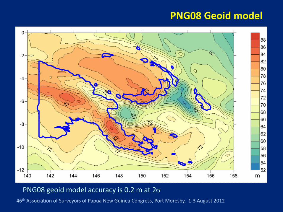
PNG08 Geoid model
PNG08 geoid model accuracy is 0.2 m at 2σ
m
46th Association of Surveyors of Papua New Guinea Congress, Port Moresby, 1-3 August 2012
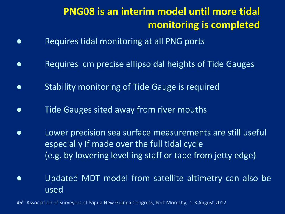
PNG08 is an interim model until more tidal monitoring is completed
● Requires tidal monitoring at all PNG ports
● Requires cm precise ellipsoidal heights of Tide Gauges
● Stability monitoring of Tide Gauge is required
● Tide Gauges sited away from river mouths
● Lower precision sea surface measurements are still usefulespecially if made over the full tidal cycle(e.g. by lowering levelling staff or tape from jetty edge)
● Updated MDT model from satellite altimetry can also beused

46th Association of Surveyors of Papua New Guinea Congress, Port Moresby, 1-3 August 2012
Using WxTideto predict Tides

46th Association of Surveyors of Papua New Guinea Congress, Port Moresby, 1-3 August 2012
Computing Ellipsoid Height at Tide Gauges
Static baseline from PNG94 control
or, AUSPOS or NRCan
AUSPOS www.ga.gov.au/bin/gps.pl
NRCan www.geod.nrcan.gc.ca/online_data_e.php

46th Association of Surveyors of Papua New Guinea Congress, Port Moresby, 1-3 August 2012
Computing MSL and geoid correction RLPRED = RLEGM + D
RLLAT = RLPRED - low
RLHAT = RLPRED - high
RLMSL = (RLHAT + RLLAT )/2
c = RLMSL - RLEGM
Compute RL on Prediction Datum
Compute LAT
Compute HAT
Compute MSL
Compute correction to Geoid model (zero order term)

46th Association of Surveyors of Papua New Guinea Congress, Port Moresby, 1-3 August 2012
Direct measurementsof sea level from a BM
Measurement is averageof 3 wave tips and 3 wavetroughs within 3-4 minutes

46th Association of Surveyors of Papua New Guinea Congress, Port Moresby, 1-3 August 2012
Worked Example
RLEGM2008 of BM4 = 3.766 m
Mean D = -0.62
RLPRED = RLEGM + D
RLPRED = 3.766 + -0.62 = 3.15
Low = -0.20 (from WxTide)
High = 1.80 (from WxTide)
RLLAT = RLPRED - low
RLLAT = 3.15 - -0.20 = 3.35
RLHAT = RLPRED - hat
RLHAT = 3.15 - 1.80 = 1.35
RLMSL = (3.35 + 1.35)/2 = 2.35 c = RLMSL - RLEGM
c = 2.35 - 3.766 = -1.42
RLMSL = (RLHAT + RLLAT )/2

46th Association of Surveyors of Papua New Guinea Congress, Port Moresby, 1-3 August 2012
DMA 10˚x10 ˚ Model – UGLY!
This very inaccurate model is still used in many software packages and GPSreceivers – e.g. Trimble, Hemisphere, OmniSTAR.Results in many significant errors in bathymetry and hydrography!
m
46th Association of Surveyors of Papua New Guinea Congress, Port Moresby, 1-3 August 2012
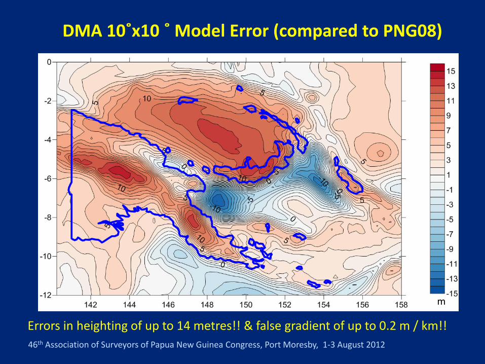
DMA 10˚x10 ˚ Model Error (compared to PNG08)
Errors in heighting of up to 14 metres!! & false gradient of up to 0.2 m / km!!
m

46th Association of Surveyors of Papua New Guinea Congress, Port Moresby, 1-3 August 2012
PNG08 geoid model – where to find it
Text format csv format Leica GEM Trimble GGF Topcon/Sokkia
GFF format

46th Association of Surveyors of Papua New Guinea Congress, Port Moresby, 1-3 August 2012
PNG08 work flow
● Use PNG08 model with GNSS / GPS processing softwareRTK controller and AUSPOS or NRCan ellipsoid heights.
● MSL(PNG08) = PNG94 ellipsoid height – PNG08 N value(H ≈ h – N)
● PNG Geodetic database being converted to PNG08PNG08 update could become gazetted vertical datum
● PNG08 Reduced Levels (RLs) may differ from existing RLsby several metres (e.g. in Highlands, CDW datum, LAT)(difference should be consistent over local area)
● PNG08 values are within 0.2 m of MSL

46th Association of Surveyors of Papua New Guinea Congress, Port Moresby, 1-3 August 2012
What can happen if the geoid model is wrong!
Thank you