polar & glacial impactssydney2018.aseg.org.au/documents/monday abstracts/m3.4a.pdf ·...
TRANSCRIPT

AEGC 2018: Sydney, Australia 1
EVIDENCE FOR GLACIAL AND POLAR IMPACTS IN THE PERMIAN COAL MEASURES OF THE SYDNEY BASIN Malcolm Bocking* Bocking Associates 8 Tahlee Close, Castle Hill, NSW 2154, Australia [email protected] *presenting author
SUMMARY
This paper recognises that the Permian sequence of the Sydney Basin formed at a time the basin is indicated by polar wander curves
to have been very close to the South Pole. That same Permian sequence contains some evidence for sometimes subtle Polar and Glacial
impacts. In particular, Arctic Holocene geomorphological features, such as eskers, and ephemeral lacustrine environments, provide
possible analogues for elements within the Permian coal measures and adjacent strata of the Sydney Basin. This paper also suggests
more evidence for repeated climate change should become apparent with closer inspection of Sydney Basin strata.
The flat lakebeds of huge, but little recognised, ice dammed lakes, recently existed throughout much of North America. These are seen
as the modern equivalents of those that contributed to the regions post Triassic geology, especially in Alberta and Saskatchewan where
accommodation, created by subsidence associated with uplift of the adjacent Rocky Mountains, has ensured preservation of the
sedimentary succession. Only the most recent such lake sediments are preserved further east in Manitoba, where repeated glaciation
may have obliterated many previous deposits. These lakes are seen as the possible environments in which floating plants, probably
with nitrogen fixing physiology similar to the Azolla genus, may have formed extensive peat deposits. This hypothesis is reinforced
by the ability of Azolla to grow rapidly in the long daylight hours peculiar to summer in the polar regions. Subsequent burial under ice
sheets up to 3 or 4 kilometres in thickness may have contribute to lithification processes - including coalification. The recent lake
deposits are interleaved with huge linear gravel deposits, originating as eskers and possibly moraines, which are similar in many ways
to the conglomerate strata that are so prominent in the Newcastle Coal Measures and also exist elsewhere in the Sydney Basin.
Key words: Sydney Basin, esker, glacial, polar, Lake Agassiz, Lake Winnipeg, peat formation, Azolla sp., Newcastle Coal Measures
INTRODUCTION
Since the 1880s geologists working in the Sydney Basin have speculated about the degree and timing of contributions by glacial
processes in the formation of the Permian coal bearing and marine sequences of the Sydney Basin and its extensions. Herbert (1980)
placed fjord like topography and alpine glaciation at the base of the southern Sydney Basin. Conaghan (1982) suggested large lakes,
hydroponic coal & ‘Gilbert’ deltas and others have given us Jökulhlaups. Branagan (1983) reviewed the lack of evidence for some 2km
of missing Late Triassic or Jurassic sequence. Bocking & Howes (1986) recognised 55km long conglomerate ‘channels’, up to 80m
thick but entirely within 8m coal seams. Creech (2000) presented the numerous tonstein bands of the Fassifern seam to this Symposium.
He suggested the preservation of such uniform, thin and continuous bands would best be explained if ash fall tuffs were deposited in a
subaqueous environment. He also pointed out the almost complete absence of trees except at the very top of seams. These enigmatic
features have for decades puzzled geologists, who only recognised the major glaciations and extinction events, when climatic change,
driven by Milankovitch Cycles, might be expected to have left more frequent, regular but subtle evidence.
Review of glacial processes, driven in part by the need to monitor climate change, shows the ice caps of this planet are far more
dynamic places than once was thought, especially during periods of global warming. It appears that some high latitude
geomorphological processes, only now being observed, might also be seen to have been at work during the formation of the Permian
Coal Measures of eastern Australia. However, the role that a cold or polar climate might play is fundamentally at odds with
contemporary concepts of vegetation, swamps, peat and coal, and a closer interpretation of the evidence is warranted.
A high latitude, cyclical, inter glacial model for coal measure formation is herein suggested, which may have been similar to that now
discernible in Quaternary and current Arctic landforms. Such high latitude marine, glacial and lacustrine environments are here
presented to have had correlatives within the coal measure sequences of the Sydney. The required time scale and cyclicity are supported
by the high resolution of CA IDTIMS zircon age dating (Nicoll et al 2017). Much of the evidence is tantalising, but the relative
inaccessibility of current day high latitude environments has restricted previous research. All sequence stratigraphers, sedimentologists
and coal geologists are encouraged to take an interest in the expanding understanding of polar geomorphological / geological processes,
and view not only the Sydney Basin sedimentary sequences, but all sedimentary basins from a different perspective.
AEGC 2018: Sydney, Australia 2
PRESENTING THE EVIDENCE
Location & Climate
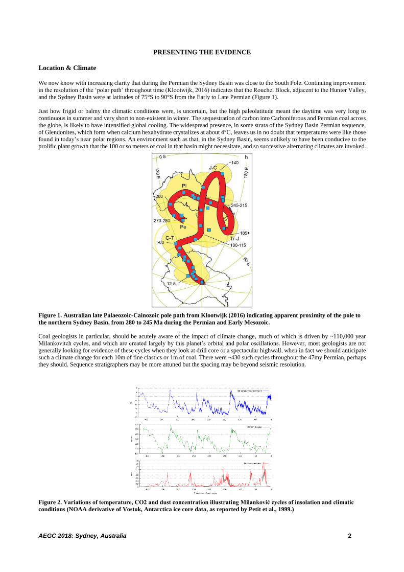
We now know with increasing clarity that during the Permian the Sydney Basin was close to the South Pole. Continuing improvement
in the resolution of the ‘polar path’ throughout time (Klootwijk, 2016) indicates that the Rouchel Block, adjacent to the Hunter Valley,
and the Sydney Basin were at latitudes of 75°S to 90°S from the Early to Late Permian (Figure 1).
Just how frigid or balmy the climatic conditions were, is uncertain, but the high paleolatitude meant the daytime was very long to
continuous in summer and very short to non-existent in winter. The sequestration of carbon into Carboniferous and Permian coal across
the globe, is likely to have intensified global cooling. The widespread presence, in some strata of the Sydney Basin Permian sequence,
of Glendonites, which form when calcium hexahydrate crystalizes at about 4°C, leaves us in no doubt that temperatures were like those
found in today’s near polar regions. An environment such as that, in the Sydney Basin, seems unlikely to have been conducive to the
prolific plant growth that the 100 or so meters of coal in that basin might necessitate, and so successive alternating climates are invoked.
Figure 1. Australian late Palaeozoic-Cainozoic pole path from Klootwijk (2016) indicating apparent proximity of the pole to
the northern Sydney Basin, from 280 to 245 Ma during the Permian and Early Mesozoic.
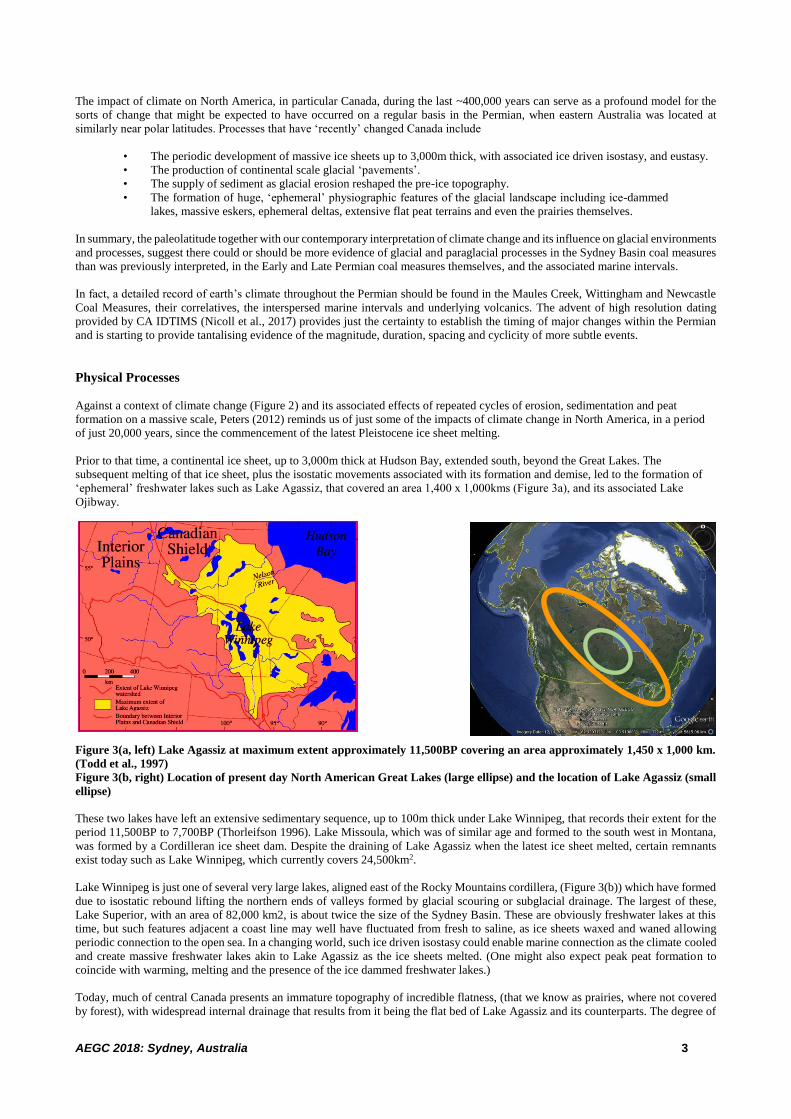
Coal geologists in particular, should be acutely aware of the impact of climate change, much of which is driven by ~110,000 year
Milankovitch cycles, and which are created largely by this planet’s orbital and polar oscillations. However, most geologists are not
generally looking for evidence of these cycles when they look at drill core or a spectacular highwall, when in fact we should anticipate
such a climate change for each 10m of fine clastics or 1m of coal. There were ~430 such cycles throughout the 47my Permian, perhaps
they should. Sequence stratigraphers may be more attuned but the spacing may be beyond seismic resolution.
Figure 2. Variations of temperature, CO2 and dust concentration illustrating Milanković cycles of insolation and climatic
conditions (NOAA derivative of Vostok, Antarctica ice core data, as reported by Petit et al., 1999.)
AEGC 2018: Sydney, Australia 3
The impact of climate on North America, in particular Canada, during the last ~400,000 years can serve as a profound model for the
sorts of change that might be expected to have occurred on a regular basis in the Permian, when eastern Australia was located at
similarly near polar latitudes. Processes that have ‘recently’ changed Canada include
• The periodic development of massive ice sheets up to 3,000m thick, with associated ice driven isostasy, and eustasy.
• The production of continental scale glacial ‘pavements’.
• The supply of sediment as glacial erosion reshaped the pre-ice topography.
• The formation of huge, ‘ephemeral’ physiographic features of the glacial landscape including ice-dammed
lakes, massive eskers, ephemeral deltas, extensive flat peat terrains and even the prairies themselves.
In summary, the paleolatitude together with our contemporary interpretation of climate change and its influence on glacial environments
and processes, suggest there could or should be more evidence of glacial and paraglacial processes in the Sydney Basin coal measures
than was previously interpreted, in the Early and Late Permian coal measures themselves, and the associated marine intervals.
In fact, a detailed record of earth’s climate throughout the Permian should be found in the Maules Creek, Wittingham and Newcastle
Coal Measures, their correlatives, the interspersed marine intervals and underlying volcanics. The advent of high resolution dating
provided by CA IDTIMS (Nicoll et al., 2017) provides just the certainty to establish the timing of major changes within the Permian
and is starting to provide tantalising evidence of the magnitude, duration, spacing and cyclicity of more subtle events.
Physical Processes
Against a context of climate change (Figure 2) and its associated effects of repeated cycles of erosion, sedimentation and peat
formation on a massive scale, Peters (2012) reminds us of just some of the impacts of climate change in North America, in a period
of just 20,000 years, since the commencement of the latest Pleistocene ice sheet melting.
Prior to that time, a continental ice sheet, up to 3,000m thick at Hudson Bay, extended south, beyond the Great Lakes. The
subsequent melting of that ice sheet, plus the isostatic movements associated with its formation and demise, led to the formation of
‘ephemeral’ freshwater lakes such as Lake Agassiz, that covered an area 1,400 x 1,000kms (Figure 3a), and its associated Lake
Ojibway.
Figure 3(a, left) Lake Agassiz at maximum extent approximately 11,500BP covering an area approximately 1,450 x 1,000 km.
(Todd et al., 1997)
Figure 3(b, right) Location of present day North American Great Lakes (large ellipse) and the location of Lake Agassiz (small
ellipse)
These two lakes have left an extensive sedimentary sequence, up to 100m thick under Lake Winnipeg, that records their extent for the
period 11,500BP to 7,700BP (Thorleifson 1996). Lake Missoula, which was of similar age and formed to the south west in Montana,
was formed by a Cordilleran ice sheet dam. Despite the draining of Lake Agassiz when the latest ice sheet melted, certain remnants
exist today such as Lake Winnipeg, which currently covers 24,500km2.
Lake Winnipeg is just one of several very large lakes, aligned east of the Rocky Mountains cordillera, (Figure 3(b)) which have formed
due to isostatic rebound lifting the northern ends of valleys formed by glacial scouring or subglacial drainage. The largest of these,
Lake Superior, with an area of 82,000 km2, is about twice the size of the Sydney Basin. These are obviously freshwater lakes at this
time, but such features adjacent a coast line may well have fluctuated from fresh to saline, as ice sheets waxed and waned allowing
periodic connection to the open sea. In a changing world, such ice driven isostasy could enable marine connection as the climate cooled
and create massive freshwater lakes akin to Lake Agassiz as the ice sheets melted. (One might also expect peak peat formation to
coincide with warming, melting and the presence of the ice dammed freshwater lakes.)
Today, much of central Canada presents an immature topography of incredible flatness, (that we know as prairies, where not covered
by forest), with widespread internal drainage that results from it being the flat bed of Lake Agassiz and its counterparts. The degree of

AEGC 2018: Sydney, Australia 4
internal drainage and evaporation in this setting creates its own salinity environment and throughout geological time has contributed
to the formation of Canada’s fabulous Potash deposits. Parts of these flat areas are covered by black organic rich soils and also extensive
peat deposits. We know the recent lakes developed and dried up several times due to isostatic tilting. The parent material for the organic
soils is the lake deposits and we can speculate as to whether the peat has formed alongside the lakes when they were smaller, on the
bed of the lakes when they were was dry and exposed, or within the lakes as an actual lake sediment.
Figure 4 What environment allows such uniformity of peat and stone band formation in Australian coal?
The eastern shore of Lake Winnipeg is the home of North America’s peat producing industry. Interestingly adjacent to the current
onshore peat farming operations, the peat deposits are seen to extend under Lake Winnipeg. Other than the reporting of Thorleifson
(1996 ) and Todd et al (1997), little research has been found to date on the sediments of Lake Winnipeg. In Manitoba, the peat horizons
generally thicken to the north, where cold moisture retaining environments are seen enhance the preservation of peat, and repeated
freezing and thawing disturbs the flat terrain. The peat is conventionally thought to be the product of plant growth in cold Arctic tundra
like conditions, but the environment has cycled many times and the present climate may not be the only peat forming and preserving
environment. Apparent algal blooms and floating aquatic plants can be seen in satellite imaging of 31,000km2 Great Bear Lake in
northern Canada. Given the cold temperatures, such material is unlikely to decay if it sinks to the bottom of such lakes.
Biological Processes
Integrated Ocean Drilling Program (IOPD) drilling, since that in 2004 on the Lomonosov Ridge in the Arctic Ocean, has intersected
several instances of peat formation within the Arctic and near Arctic seas. This drilling has revealed that the freshwater surface-floating
heterosporous fern Azolla arctica, (Azollaceae, Salviniales), bloomed and reproduced in the Arctic Ocean on a massive scale during
the early Middle Eocene (Collinson et al 2010). Multi meter thick beds of peat have resulted, in waters hundreds of metres deep. A
related species Azolla jutlandica has also been identified in North Sea drilling.
Tudge (2009) addressed the Azolla findings tangentially in his interpretation of climate change drivers. He suggested that the massive
blooms were responsible for significant atmospheric CO2 reduction leading to Cainozoic cooling. The Azolla genus are floating plants
which are particularly successful in fresh water and high latitude waters where their Nitrogen fixing capability enables prolific growth
in conditions with continuous sunlight. Azolla sp also turns up in the high TOC Rundle shale formations and the Green River source
rocks in the Rocky Mountains.
Figure 5 Floating plants with potential for sub-aqueous peat formation.

AEGC 2018: Sydney, Australia 5
Bujak & Bujak (2014) report that Azolla is actually a fern that floats freely on the surface of quiescent freshwater bodies, such as
ponds, lakes and gently flowing rivers, and it is one of the fastest growing plants on the planet, doubling its biomass in as little as two
days. Azolla is a fern because of its internal structure and the way that it reproduces, but it looks nothing like a fern. Its leaves are
composed of small spongy lobes, just a few millimetres long, which float on the water with hair-like tendrils dangling in the water
below. Its larger dorsal leaves are buoyant and contain cavities enclosing a symbiotic cyanobacterium called Anabaena azollae. Its role
in the formation of coal is speculative but the possibility of a similar plant physiology contributing to Permian coal formed in extremely
high latitudes is tantalizing. A floating habit would certainly make the uniform conditions of Figure 4 more understandable and
environment, such as that shown in the preceding Figure 5, is worth considering.
Geological (Glacial and Polar) Processes
Recent interest in the progressive melting of ice sheets has re-ignited interest in glacial processes. Very large volumes of surface
meltwater are seen to drop hundreds of metres down ‘moulins’ (mills) to flow into ‘englacial’ or sub-glacial waterways (Figures 6a &
6b). These eventually lead to the ice sheet margin. Large hydrostatic heads and water volumes can result in rapid water flow and
abrasive power. Eskers are the result of sediment remaining in englacial and sub glacial waterways and when the ice melts, eskers form
long ridges of clastic sediments that are typically moderately well sorted and rounded. The actual sediment can vary from sand to
boulder size. They are found across the Arctic and near Arctic lands. The name comes from the Irish term ‘eiscir’ meaning long ridge.
Figure 6(a, left) Meltwater flow into Moulin, Greenland, (Photo by Roger Braithwaite, Uni of Manchester)
Figure 6(b, right) Moulin, Greenland, (Photo by Francis le Gruen, Somewhere Club)
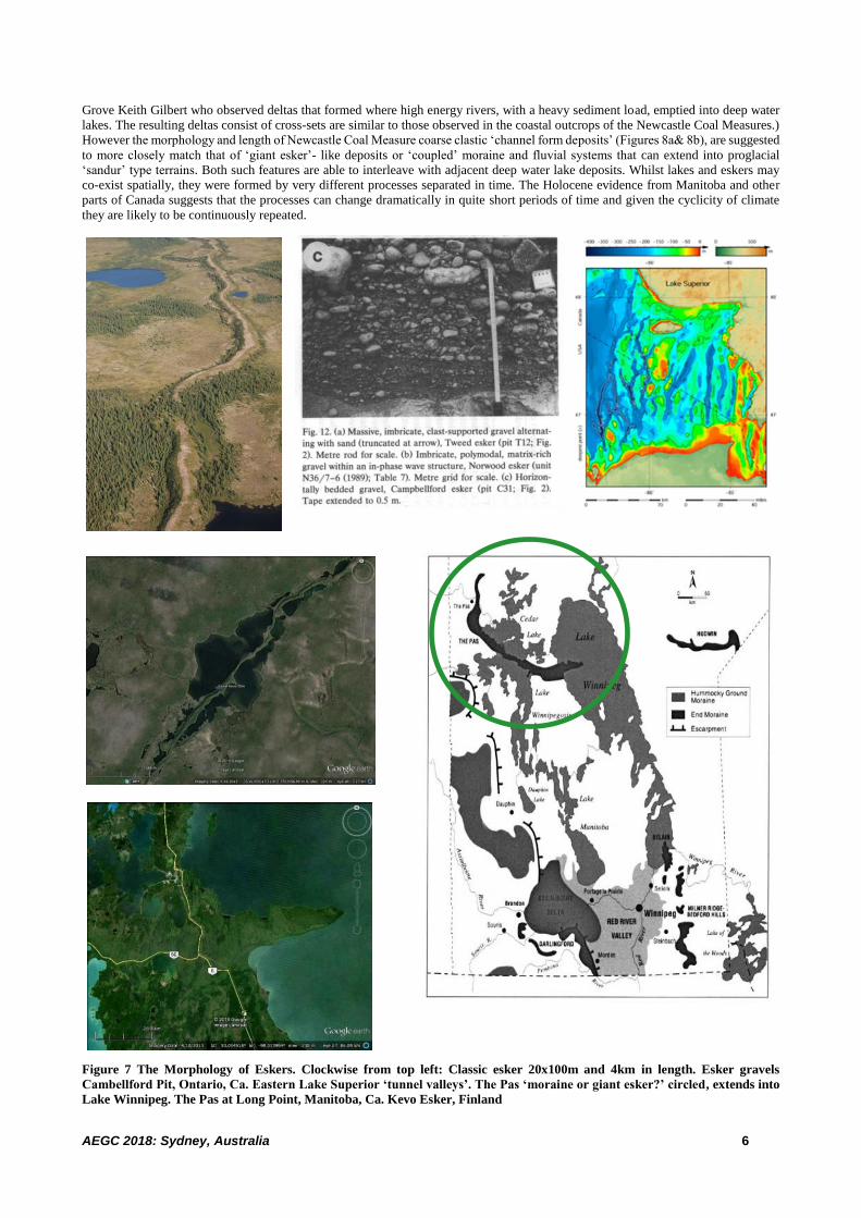
Eskers can vary in size from tens of metres in length and width, to hundreds of kilometres in length and kilometres in width. Their
confinement within ice sheets and subsequent draping across the landscape when the ice sheets melt (Figure 7), enables coarse clastic
material to be laid down somewhat incongruously in flat, low energy environments. Similar deposits could also form where high energy
fluvial channels are fed from under ice waterways, but, where rather than the sub glacially derived waters flowing away from the ice
sheet, they are trapped against it by regional isostasy enabling high energy flow along the ice margin instead. Such fluvial systems may
be anomalously high energy for the locality and only last as long as the ice sheet is present. With isostatic rebound such systems might
be forced to migrate progressively with a retreating ice sheet.
Eskers can be abundant, typically following the alignment of pre-existing drainage (Figure 7). Eskers can lead into ‘tunnel valleys’,
that if flooded, can form fjords. Multiple tunnel valleys, are each the size of the Gloucester Basin, scour the bed of eastern Lake Superior
(Figure 7). Three giant eskers in Canada stand out.
The Pas extends to Long Point in Lake Winnipeg some 300km away (Figure 7). At some 60m thick and 10 to
15km in width, it exceeds the Teralba Conglomerate in size and shape. It lines up in the west with the palaeo
Saskatchewan River but its origin as a terminal moraine or esker is the subject of debate and speculation.
Brandon Hills appear to be a remnant of an east flowing esker that sits west of and on top of the Assiniboine
palaeo-delta.
Munro Esker is 15 to 80m high, 3 to 5 km wide and extends 300km north-south across Ontario. It is better
explored than most as it overlies several uranium prospects.
The conglomerate strata of the Newcastle Coal Measures, such as the Teralba and Bolton Point Conglomerates, shown since the 1980s
to form elongate, high energy, channel like deposits, sit enigmatically in the otherwise flat and supposedly swampy or marshy coal
forming environments. The coal forming model of huge freshwater lakes with Gilbert deltas, first suggested to have operated in the
Sydney Basin by Conaghan in 1982, is probably close to a suitable analogue. (A Gilbert delta is so named after American geologist
AEGC 2018: Sydney, Australia 6
Grove Keith Gilbert who observed deltas that formed where high energy rivers, with a heavy sediment load, emptied into deep water
lakes. The resulting deltas consist of cross-sets are similar to those observed in the coastal outcrops of the Newcastle Coal Measures.)
However the morphology and length of Newcastle Coal Measure coarse clastic ‘channel form deposits’ (Figures 8a& 8b), are suggested
to more closely match that of ‘giant esker’- like deposits or ‘coupled’ moraine and fluvial systems that can extend into proglacial
‘sandur’ type terrains. Both such features are able to interleave with adjacent deep water lake deposits. Whilst lakes and eskers may
co-exist spatially, they were formed by very different processes separated in time. The Holocene evidence from Manitoba and other
parts of Canada suggests that the processes can change dramatically in quite short periods of time and given the cyclicity of climate
they are likely to be continuously repeated.
Figure 7 The Morphology of Eskers. Clockwise from top left: Classic esker 20x100m and 4km in length. Esker gravels
Cambellford Pit, Ontario, Ca. Eastern Lake Superior ‘tunnel valleys’. The Pas ‘moraine or giant esker?’ circled, extends into
Lake Winnipeg. The Pas at Long Point, Manitoba, Ca. Kevo Esker, Finland
AEGC 2018: Sydney, Australia 7
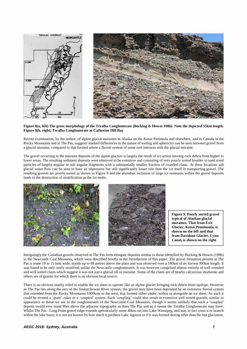
Figure 8(a, left) The gross morphology of the Teralba Conglomerate (Bocking & Howes 1986). Note the depicted 55km length.
Figure 8(b, right) Teralba Conglomerate at Catherine Hill Bay
Recent examination, by the author, of alpine glacial moraines in Alaska on the Kenai Peninsula and elsewhere, and in Canada in the
Rocky Mountains and at The Pas, suggests marked differences in the nature of sorting and sphericity can be seen between gravel from
a glacial moraine, compared to that formed where a fluvial system of some sort interacts with the glacial moraine.
The gravel occurring in the moraine deposits of the alpine glaciers is largely the result of ice action moving rock debris from higher to
lower areas. The resulting sediment deposits were observed to be extensive and consisting of very poorly sorted boulder to sand sized
particles of largely angular to sub angular fragments with a substantially smaller fraction of rounded clasts. At these locations sub
glacial water flow can be seen to have an impressive but still significantly lesser role than the ice itself in transporting gravel. The
resulting gravels are poorly sorted as shown in Figure 9 and the abundant inclusion of large ice remnants within the gravel deposits
leads to the destruction of stratification as the ice melts.
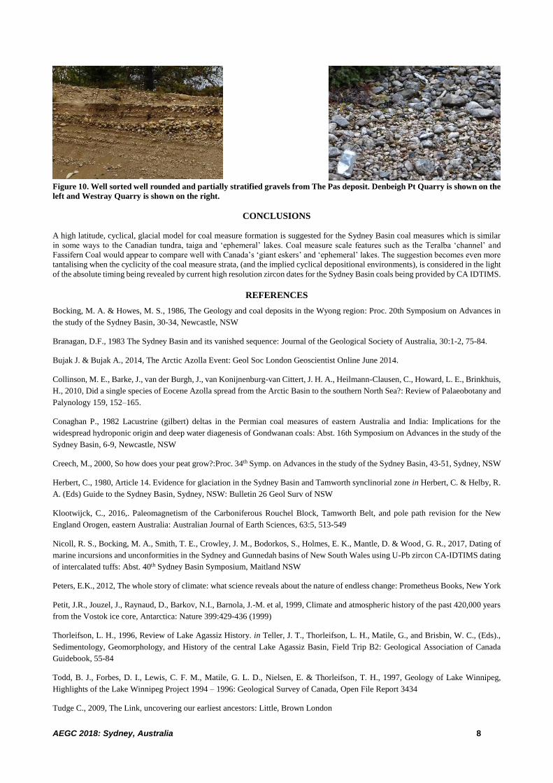
Intriguingly the Canadian gravels observed at The Pas form elongate deposits similar to those identified by Bocking & Howes (1986)
in the Newcastle Coal Measures, which were described briefly in the Introduction of this paper. The gravel formation present at The
Pas is some 10 to 15 kms wide, stands up to 80 metres above the plain and was observed over a 180km of its known 300km length. It
was found to be only rarely stratified, unlike the Newcastle conglomerates. It was however comprised almost entirely of well rounded
and well sorted clasts which suggest it was not just a glacial till or moraine. Some of the clasts are of nearby calcareous mudstone and
others are of granite for which there is no obvious local source.
There is no obvious nearby relief to enable the ice sheet to operate like an alpine glacier bringing rock debris from upslope. However
as The Pas lies along the axis of the Saskatchewan River system, the gravel may have been deposited by an extensive fluvial system
that extended from the Rocky Mountains 1000kms to the west, that formed either under, within or alongside an ice sheet. As such it
could be termed a ‘giant’ esker or a ‘coupled’ system. Such ‘coupling’ could also result in extensive well sorted gravels, similar in
appearance to those we see in the conglomerates of the Newcastle Coal Measures, though it seems unlikely that such a ‘coupled’
deposit would ever stand 80m above the adjacent topography as does The Pas and as it seems the Teralba Conglomerate may have.
Whilst The Pas - Long Point gravel ridge extends spectacularly some 40km out into Lake Winnipeg, and may in fact cross it or branch
within the lake basin, it is not yet known by how much it predates Lake Agassiz or if it was formed during other than the last glaciation.
Figure 9. Poorly sorted gravel
typical of Alaskan glacial
moraines. That from Exit
Glacier, Kenai Penninsula, is
shown on the left and that
from Davidson Glacier, Lynn
Canal, is shown on the right
AEGC 2018: Sydney, Australia 8
Figure 10. Well sorted well rounded and partially stratified gravels from The Pas deposit. Denbeigh Pt Quarry is shown on the
left and Westray Quarry is shown on the right.
CONCLUSIONS
A high latitude, cyclical, glacial model for coal measure formation is suggested for the Sydney Basin coal measures which is similar
in some ways to the Canadian tundra, taiga and ‘ephemeral’ lakes. Coal measure scale features such as the Teralba ‘channel’ and
Fassifern Coal would appear to compare well with Canada’s ‘giant eskers’ and ‘ephemeral’ lakes. The suggestion becomes even more
tantalising when the cyclicity of the coal measure strata, (and the implied cyclical depositional environments), is considered in the light
of the absolute timing being revealed by current high resolution zircon dates for the Sydney Basin coals being provided by CA IDTIMS.
REFERENCES
Bocking, M. A. & Howes, M. S., 1986, The Geology and coal deposits in the Wyong region: Proc. 20th Symposium on Advances in
the study of the Sydney Basin, 30-34, Newcastle, NSW
Branagan, D.F., 1983 The Sydney Basin and its vanished sequence: Journal of the Geological Society of Australia, 30:1-2, 75-84.
Bujak J. & Bujak A., 2014, The Arctic Azolla Event: Geol Soc London Geoscientist Online June 2014.
Collinson, M. E., Barke, J., van der Burgh, J., van Konijnenburg-van Cittert, J. H. A., Heilmann-Clausen, C., Howard, L. E., Brinkhuis,
H., 2010, Did a single species of Eocene Azolla spread from the Arctic Basin to the southern North Sea?: Review of Palaeobotany and
Palynology 159, 152–165.
Conaghan P., 1982 Lacustrine (gilbert) deltas in the Permian coal measures of eastern Australia and India: Implications for the
widespread hydroponic origin and deep water diagenesis of Gondwanan coals: Abst. 16th Symposium on Advances in the study of the
Sydney Basin, 6-9, Newcastle, NSW
Creech, M., 2000, So how does your peat grow?:Proc. 34th Symp. on Advances in the study of the Sydney Basin, 43-51, Sydney, NSW
Herbert, C., 1980, Article 14. Evidence for glaciation in the Sydney Basin and Tamworth synclinorial zone in Herbert, C. & Helby, R.
A. (Eds) Guide to the Sydney Basin, Sydney, NSW: Bulletin 26 Geol Surv of NSW
Klootwijck, C., 2016,. Paleomagnetism of the Carboniferous Rouchel Block, Tamworth Belt, and pole path revision for the New
England Orogen, eastern Australia: Australian Journal of Earth Sciences, 63:5, 513-549
Nicoll, R. S., Bocking, M. A., Smith, T. E., Crowley, J. M., Bodorkos, S., Holmes, E. K., Mantle, D. & Wood, G. R., 2017, Dating of
marine incursions and unconformities in the Sydney and Gunnedah basins of New South Wales using U-Pb zircon CA-IDTIMS dating
of intercalated tuffs: Abst. 40th Sydney Basin Symposium, Maitland NSW
Peters, E.K., 2012, The whole story of climate: what science reveals about the nature of endless change: Prometheus Books, New York
Petit, J.R., Jouzel, J., Raynaud, D., Barkov, N.I., Barnola, J.-M. et al, 1999, Climate and atmospheric history of the past 420,000 years
from the Vostok ice core, Antarctica: Nature 399:429-436 (1999)
Thorleifson, L. H., 1996, Review of Lake Agassiz History. in Teller, J. T., Thorleifson, L. H., Matile, G., and Brisbin, W. C., (Eds).,
Sedimentology, Geomorphology, and History of the central Lake Agassiz Basin, Field Trip B2: Geological Association of Canada
Guidebook, 55-84
Todd, B. J., Forbes, D. I., Lewis, C. F. M., Matile, G. L. D., Nielsen, E. & Thorleifson, T. H., 1997, Geology of Lake Winnipeg,
Highlights of the Lake Winnipeg Project 1994 – 1996: Geological Survey of Canada, Open File Report 3434
Tudge C., 2009, The Link, uncovering our earliest ancestors: Little, Brown London