policies and requirements - carlsbad, ca
TRANSCRIPT

Landscape Manual
Policies and Requirements
F e b r u a r y 2 0 1 6


i City of Carlsbad Landscape Manual
Table of Contents
Section 1: Applicability
A. Purpose ................................................................................................................................................................... 1
B. Projects Subject to this Manual .............................................................................................................................. 1
1. Public and Private Developments
2. Projects Meeting Minimum WELO Thresholds
C. Water Efficient Landscape Worksheet – Exemptions ............................................................................................ 2
D. Projects with Limited Requirements ...................................................................................................................... 2
E. Modifications to Requirements .............................................................................................................................. 2
F. Discrepancies with Other Documents .................................................................................................................... 3
G. Minimum Requirements......................................................................................................................................... 3
H. Landscape Checklist ................................................................................................................................................ 3
I. Process Summary ................................................................................................................................................... 4
1. Conceptual Landscape Plans
2. Landscape Construction Documents
3. Construction Phase – Documents and Actions Required for Project Completion
Section 2: Policies
A. Inter-relationship .................................................................................................................................................... 6
B. Sustainability Policies ............................................................................................................................................. 6
C. Water Conservation Policies................................................................................................................................... 6
D. Planting Policies ...................................................................................................................................................... 7
E. Irrigation Policies .................................................................................................................................................... 7
F. Streetscape Program Policies ................................................................................................................................. 8
G. Fire Protection Policies ........................................................................................................................................... 8
H. Slope Revegetation/Erosion Control Policies ......................................................................................................... 8
Section 3: Preliminary Concept Plans
A. Submittal Requirements ............................................................................................................................................. 9
1. Conceptual Landscape Plan
2. Conceptual Water Conservation Plan
3. Conceptual Fire Protection Plan
4. Conceptual Maintenance Responsibility Exhibit
B. General Requirements ............................................................................................................................................. 10
1. Preparer
2. Plan Size and Format
3. General Contents
4. Landscape Checklist
ii City of Carlsbad Landscape Manual
C. Conceptual Landscape Plan ....................................................................................................................................... 11
1. Planting Plan
2. Planting Palette
3. Existing Plant Material
4. Planting Restrictions
5. Turfgrass Restrictions
6. Minimum Slope Planting Requirements
7. Planting Design
8. Low Impact Development (LID) Features
9. Landscape Design Features
10. Trails
11. Corner Sight Distance
12. Caltrans Sight Distance Lines
13. Parking Lots and Perimeters
14. Microclimate Enhancement/Solar Access
15. Streetscape Design
D. Conceptual Water Conservation Plan ......................................................................................................................... 17
1. Water Supply
2. Water Conservation Features
3. Hydrozone Diagram
4. Maximum Applied Water Allowance (MAWA)
5. Preliminary Estimated Total Water Use (ETWU)
E. Conceptual Fire Protection Plan ........................................................................................................................... 19
1. Regulatiory Compliance
2. Fire Protection Plan
3. Reduced Fire Buffers
F. Conceptual Maintenance Responsibility Exhibit ........................................................................................................... 19
Section 4: Landscape Construction Documents
A. Landscape Documentation Package ..................................................................................................................... 20
B. General Requirements ......................................................................................................................................... 20
1. Preparer
2. Consistency with Conceptual Landscape Plan
3. Plan Size and Format
C. Special Requirements ........................................................................................................................................... 21
1. Projects within the Public Domain
2. Projects Subject to Fire Protection Requirements
3. Slope Revegetation/Erosion Control Plans
4. Habitat Restoration Plans
D. Water Conservation Requirements ...................................................................................................................... 23
1. Planting for Water Efficient Landscapes
2. Mulching
3. Fountains and/or Water Features
4. Model Homes

iii City of Carlsbad Landscape Manual
E. WELO Documentation .......................................................................................................................................... 24
1. Hydrozone Information Table
2. Water Budget Calculations
F. Soil Analysis Report and Recommendations ........................................................................................................ 25
G. Landscape Checklist .............................................................................................................................................. 26
H. Planting Plan ......................................................................................................................................................... 26
1. Planting Plan Requirements
2. Planting Details and Specifications
I. Landscape Construction Plan ............................................................................................................................... 27
J. Grading Design ..................................................................................................................................................... 27
K. Irrigation Plan ....................................................................................................................................................... 27
1. Public Projects
2. Recycled Water
3. Irrigation Plan Requirements
4. Irrigation Efficiency
5. Specific Irrigation Requirements
Section 5: Fire Protection Requirements
A. Application .............................................................................................................................................................. 33
B. General Requirements ............................................................................................................................................. 33
1. California Fire and Building Codes
2. Offsite Fire Hazard Areas
3. Access
4. Debris Removal
5. Inspections
6. Fencing
7. Photographic Documentation
C. Condition A – Manufactured Slopes ........................................................................................................................... 34
D. Condition B – Natural Slopes with Native Vegetation ...................................................................................................... 39
E. Condition C – General Fuel Modification ..................................................................................................................... 43
Section 6: Streetscape Program
A. Applicability .......................................................................................................................................................... 47
B. Street Tree Requirements .................................................................................................................................... 47
C. Arterial Road Requirements ................................................................................................................................. 48
D. Median Landscape Construction Requirements (Arterial Roadways) .................................................................. 48
1. General Requirement
2. Median Concrete
3. Soil
4. Median Planting
E. Irrigation Requirements ....................................................................................................................................... 50
1. Specific Requirements for Arterial Roads and Medians

iv City of Carlsbad Landscape Manual
Section 7: Slope Revegetation/Erosion Control
A. Slope Planting ....................................................................................................................................................... 51
1. Areas of Application (Planting)
2. Slope Planting Standards
3. Plants
4. Hydroseed
5. Rocky Slopes
B. Slope Irrigation ..................................................................................................................................................... 53
1. Areas of Application (Irrigation)
2. Slope Irrigation Standards
Section 8: Installation and Completion
A. General Installation Requirements ....................................................................................................................... 54
1. Monitoring
2. Changes to Approved Plans
3. Plant Installation
B. General Maintenance Requirements ................................................................................................................... 55
1. General Landscape Maintenance
2. General Irrigation Maintenance
3. Maintenance of Fuel Modification Zones
C. Installation for Slope Revegetation/Erosion Control .................................................................................................. 56
1. Commencement of Irrigation Installation
2. Completion of Planting and Irrigation Installation
D. Documents Required for Project Completion ...................................................................................................... 56
1. Certificate of Completion (Landscape Installation)
2. Soil Analysis Report and Recommendations
3. Irrigation Watering Schedule (WELO Requirement)
4. Maintenance Schedule (WELO Requirement)
5. Final As-Built Plans
6. Letter of Certification (Release of Security)
7. Added Requirements - Public Projects, Medians and Other City-maintained Landscape Areas)

v City of Carlsbad Landscape Manual
List of Appendices
Appendix A: Seven Principles for Water-Efficient Landscapes Appendix B: Landscape Checklist Appendix C: High and Moderate Fuel Plants Appendix D: Prescriptive Compliance Option Appendix E: Streetscape Themes Appendix F: WELO Worksheets Appendix G: Sustainable Landscaping Brochure Glossary
List of Figures
Figure 3-A Sight Distance Triangle ........................................................................................................................ 13 Figure 3-B Driveway Sight Distance ...................................................................................................................... 13 Figure 3-C Parking Lot Design Using LID Features ................................................................................................ 15 Figure 3-D Standard Parking Lot Design ............................................................................................................... 16 Figure 5-A Condition A – Manufactured Slopes ................................................................................................... 37 Figure 5-B Condition B – Native Vegetation on Natural Slopes ............................................................................ 41 Figure 5-C Condition C – General Fuel Modification ............................................................................................ 45 Figure 6-A Median Layout ..................................................................................................................................... 49

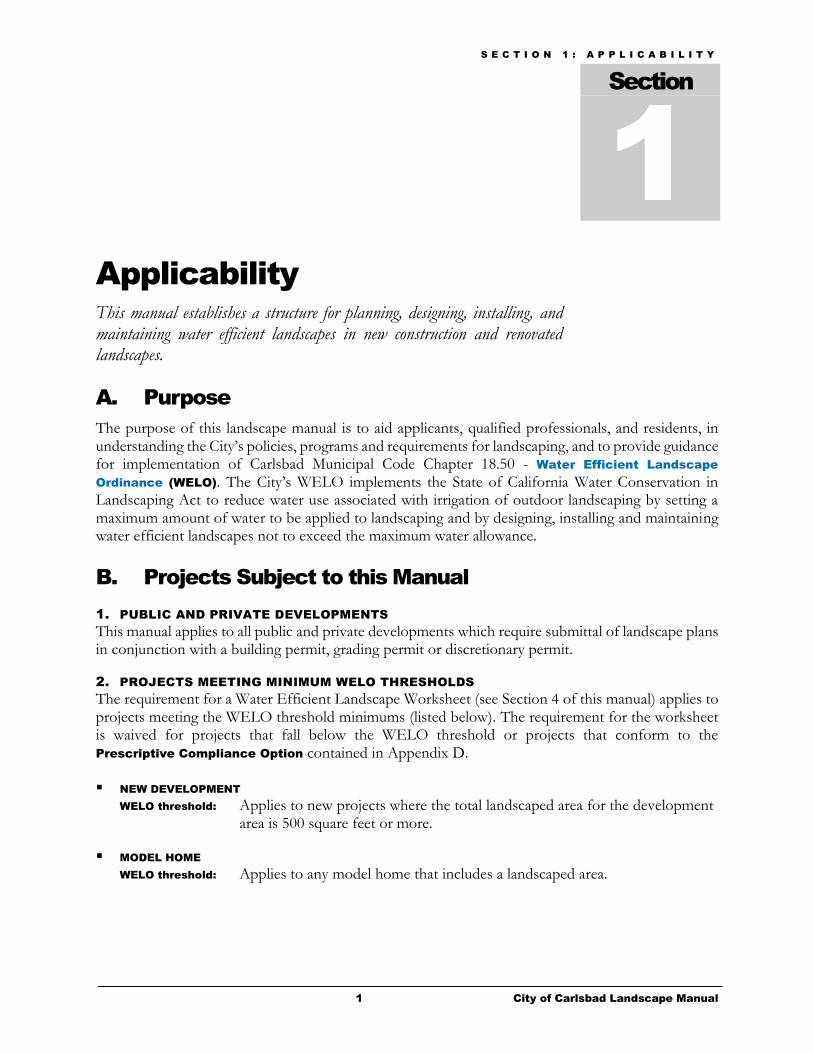
S E C T I O N 1 : A P P L I C A B I L I T Y
1 City of Carlsbad Landscape Manual
Applicability
This manual establishes a structure for planning, designing, installing, and maintaining water efficient landscapes in new construction and renovated landscapes.
A. Purpose
The purpose of this landscape manual is to aid applicants, qualified professionals, and residents, in understanding the City’s policies, programs and requirements for landscaping, and to provide guidance for implementation of Carlsbad Municipal Code Chapter 18.50 - Water Efficient Landscape
Ordinance (WELO). The City’s WELO implements the State of California Water Conservation in Landscaping Act to reduce water use associated with irrigation of outdoor landscaping by setting a maximum amount of water to be applied to landscaping and by designing, installing and maintaining water efficient landscapes not to exceed the maximum water allowance.
B. Projects Subject to this Manual
1. PUBLIC AND PRIVATE DEVELOPMENTS
This manual applies to all public and private developments which require submittal of landscape plans in conjunction with a building permit, grading permit or discretionary permit.
2. PROJECTS MEETING MINIMUM WELO THRESHOLDS
The requirement for a Water Efficient Landscape Worksheet (see Section 4 of this manual) applies to projects meeting the WELO threshold minimums (listed below). The requirement for the worksheet is waived for projects that fall below the WELO threshold or projects that conform to the Prescriptive Compliance Option contained in Appendix D.
NEW DEVELOPMENT
WELO threshold: Applies to new projects where the total landscaped area for the development area is 500 square feet or more.
MODEL HOME
WELO threshold: Applies to any model home that includes a landscaped area.
Section
1
S E C T I O N 1 : A P P L I C A B I L I T Y
2 City of Carlsbad Landscape Manual
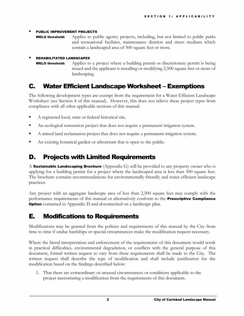
PUBLIC IMPROVEMENT PROJECTS
WELO threshold: Applies to public agency projects, including, but not limited to public parks and recreational facilities, maintenance districts and street medians which contain a landscaped area of 500 square feet or more.
REHABILITATED LANDSCAPES
WELO threshold: Applies to a project where a building permit or discretionary permit is being issued and the applicant is installing or modifying 2,500 square feet or more of landscaping.
C. Water Efficient Landscape Worksheet – Exemptions
The following development types are exempt from the requirement for a Water Efficient Landscape Worksheet (see Section 4 of this manual). However, this does not relieve these project types from compliance with all other applicable sections of this manual.
A registered local, state or federal historical site.
An ecological restoration project that does not require a permanent irrigation system.
A mined land reclamation project that does not require a permanent irrigation system.
An existing botanical garden or arboretum that is open to the public.
D. Projects with Limited Requirements
A Sustainable Landscaping Brochure (Appendix G) will be provided to any property owner who is applying for a building permit for a project where the landscaped area is less than 500 square feet. The brochure contains recommendations for environmentally-friendly and water efficient landscape practices. Any project with an aggregate landscape area of less than 2,500 square feet may comply with the performance requirements of this manual or alternatively conform to the Prescriptive Compliance
Option contained in Appendix D and documented on a landscape plan.
E. Modifications to Requirements
Modifications may be granted from the policies and requirements of this manual by the City from time to time if undue hardships or special circumstances make the modification request necessary. Where the literal interpretation and enforcement of the requirements of this document would result in practical difficulties, environmental degradation, or conflicts with the general purpose of this document, formal written request to vary from these requirements shall be made to the City. The written request shall describe the type of modification and shall include justification for the modification based on the findings described below:
1. That there are extraordinary or unusual circumstances or conditions applicable to the project necessitating a modification from the requirements of this document.
S E C T I O N 1 : A P P L I C A B I L I T Y
3 City of Carlsbad Landscape Manual
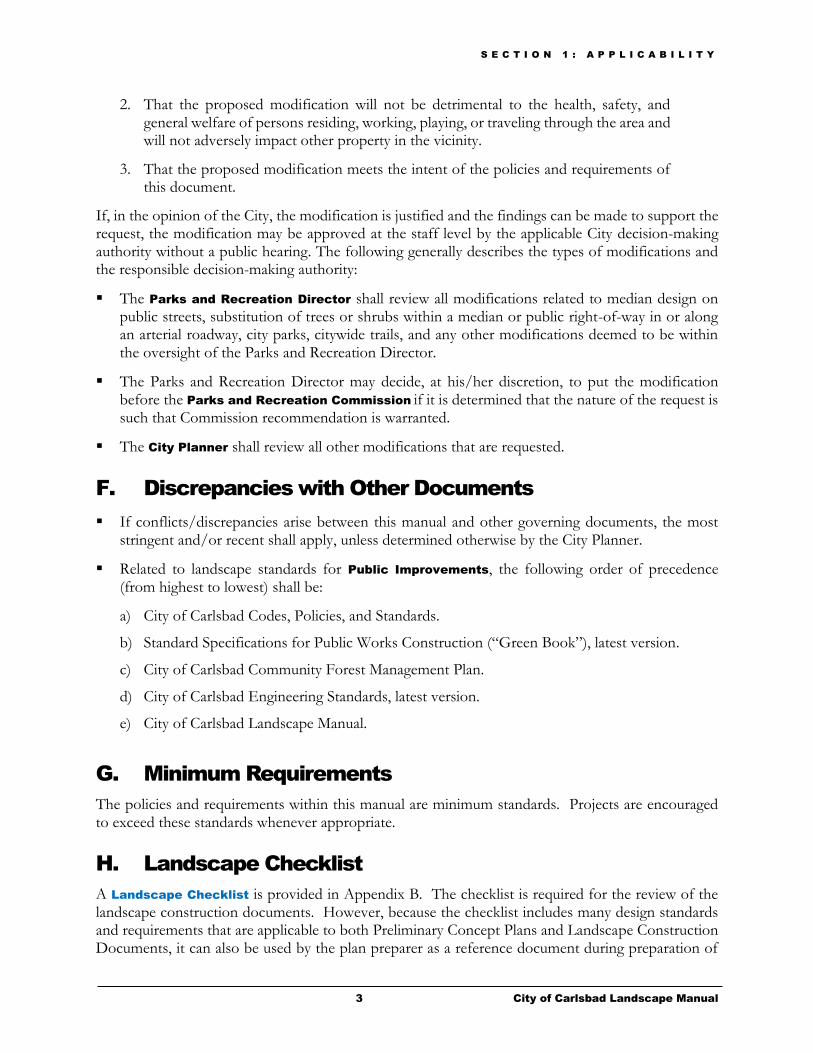
2. That the proposed modification will not be detrimental to the health, safety, and general welfare of persons residing, working, playing, or traveling through the area and will not adversely impact other property in the vicinity.
3. That the proposed modification meets the intent of the policies and requirements of this document.
If, in the opinion of the City, the modification is justified and the findings can be made to support the request, the modification may be approved at the staff level by the applicable City decision-making authority without a public hearing. The following generally describes the types of modifications and the responsible decision-making authority:
The Parks and Recreation Director shall review all modifications related to median design on public streets, substitution of trees or shrubs within a median or public right-of-way in or along an arterial roadway, city parks, citywide trails, and any other modifications deemed to be within the oversight of the Parks and Recreation Director.
The Parks and Recreation Director may decide, at his/her discretion, to put the modification before the Parks and Recreation Commission if it is determined that the nature of the request is such that Commission recommendation is warranted.
The City Planner shall review all other modifications that are requested.
F. Discrepancies with Other Documents
If conflicts/discrepancies arise between this manual and other governing documents, the most stringent and/or recent shall apply, unless determined otherwise by the City Planner.
Related to landscape standards for Public Improvements, the following order of precedence (from highest to lowest) shall be:
a) City of Carlsbad Codes, Policies, and Standards.
b) Standard Specifications for Public Works Construction (“Green Book”), latest version.
c) City of Carlsbad Community Forest Management Plan.
d) City of Carlsbad Engineering Standards, latest version.
e) City of Carlsbad Landscape Manual.
G. Minimum Requirements
The policies and requirements within this manual are minimum standards. Projects are encouraged to exceed these standards whenever appropriate.
H. Landscape Checklist
A Landscape Checklist is provided in Appendix B. The checklist is required for the review of the landscape construction documents. However, because the checklist includes many design standards and requirements that are applicable to both Preliminary Concept Plans and Landscape Construction Documents, it can also be used by the plan preparer as a reference document during preparation of

S E C T I O N 1 : A P P L I C A B I L I T Y
4 City of Carlsbad Landscape Manual
the Conceptual Landscape Plans. Note that the checklist does not encompass all of the landscape manual requirements, nor does it include the entire text of the listed items. The plan preparer should refer to the main text of the landscape manual to ensure that all of the design standards and requirements are incorporated into both the conceptual landscape plans and landscape construction documents.
I. Process Summary
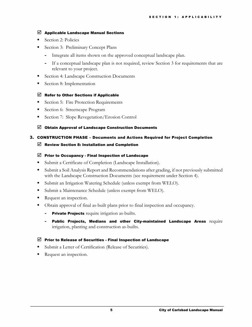
This section is intended to serve as a general guideline to illustrate the steps that are required from concept to completion.
1. CONCEPTUAL LANDSCAPE PLANS
Submittal Requirements
Conceptual Landscape Plans are required as part of the discretionary review process and must be included as part of the application submittal package to the Planning Division.
If your project only requires a building permit, skip this section and go to Landscape Construction Documents on the following page.
Applicable Landscape Manual Sections
Section 2: Policies
Section 3: Preliminary Concept Plans
Refer to Other Sections if Applicable
Section 5: Fire Protection Requirements
Section 6: Streetscape Program
Section 7: Slope Revegetation/Erosion Control
Refer to Other City Documents
City of Carlsbad Codes, Policies, and Standards
Master Plans
Specific Plans
Scenic Corridor Guidelines
Community Forest Management Plan
2. LANDSCAPE CONSTRUCTION DOCUMENTS
Submittal Requirements
Landscape Construction Documents shall be based on the approved Conceptual Landscape Plans (if applicable).
Plans for Public Projects shall be submitted to the Land Development Engineering Division for review by the Parks and Recreation Department.
Plans for Private Development Projects shall be submitted to the Planning Division.
All other required Landscape Construction Documents shall be submitted to the Planning Division.
S E C T I O N 1 : A P P L I C A B I L I T Y
5 City of Carlsbad Landscape Manual
Applicable Landscape Manual Sections
Section 2: Policies
Section 3: Preliminary Concept Plans
- Integrate all items shown on the approved conceptual landscape plan.
- If a conceptual landscape plan is not required, review Section 3 for requirements that are relevant to your project.
Section 4: Landscape Construction Documents
Section 8: Implementation
Refer to Other Sections if Applicable
Section 5: Fire Protection Requirements
Section 6: Streetscape Program
Section 7: Slope Revegetation/Erosion Control
Obtain Approval of Landscape Construction Documents
3. CONSTRUCTION PHASE – Documents and Actions Required for Project Completion
Review Section 8: Installation and Completion
Prior to Occupancy - Final Inspection of Landscape
Submit a Certificate of Completion (Landscape Installation).
Submit a Soil Analysis Report and Recommendations after grading, if not previously submitted with the Landscape Construction Documents (see requirement under Section 4).
Submit an Irrigation Watering Schedule (unless exempt from WELO).
Submit a Maintenance Schedule (unless exempt from WELO).
Request an inspection.
Obtain approval of final as-built plans prior to final inspection and occupancy.
- Private Projects require irrigation as-builts.
- Public Projects, Medians and other City-maintained Landscape Areas require irrigation, planting and construction as-builts.
Prior to Release of Securities - Final Inspection of Landscape
Submit a Letter of Certification (Release of Securities).
Request an inspection.
S E C T I O N 2 : P O L I C I E S
6 City of Carlsbad Landscape Manual
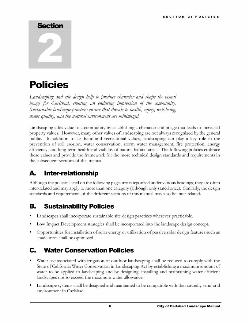
Policies
Landscaping and site design help to produce character and shape the visual image for Carlsbad, creating an enduring impression of the community. Sustainable landscape practices ensure that threats to health, safety, well-being, water quality, and the natural environment are minimized. Landscaping adds value to a community by establishing a character and image that leads to increased property values. However, many other values of landscaping are not always recognized by the general public. In addition to aesthetic and recreational values, landscaping can play a key role in the prevention of soil erosion, water conservation, storm water management, fire protection, energy efficiency, and long-term health and viability of natural habitat areas. The following policies embrace these values and provide the framework for the more technical design standards and requirements in the subsequent sections of this manual.
A. Inter-relationship
Although the policies listed on the following pages are categorized under various headings, they are often inter-related and may apply to more than one category (although only stated once). Similarly, the design standards and requirements of the different sections of this manual may also be inter-related.
B. Sustainability Policies
Landscapes shall incorporate sustainable site design practices wherever practicable.
Low Impact Development strategies shall be incorporated into the landscape design concept.
Opportunities for installation of solar energy or utilization of passive solar design features such as shade trees shall be optimized.
C. Water Conservation Policies
Water use associated with irrigation of outdoor landscaping shall be reduced to comply with the State of California Water Conservation in Landscaping Act by establishing a maximum amount of water to be applied to landscaping and by designing, installing and maintaining water efficient landscapes not to exceed the maximum water allowance.
Landscape systems shall be designed and maintained to be compatible with the naturally semi-arid environment in Carlsbad.
Section
2

S E C T I O N 2 : P O L I C I E S
7 City of Carlsbad Landscape Manual
The use of state-of-the-art irrigation technology to conserve water is required.
Landscape design shall promote the values and benefits of landscapes while recognizing the need to utilize water and other resources efficiently.
Owners of existing landscapes are encouraged to use water efficiently and without waste.
The principles of water efficient landscaping shall be incorporated into the design and maintenance of landscape.
Plants known to have high water needs shall be used sparingly and in situations where they will require the least amount of water.
Public areas receiving the highest intensity of use, such as recreation areas and urban gathering spaces shall receive the highest priority for landscape water consumption.
Irrigation systems for all projects, except for single-family dwellings or front yard irrigation on individually metered condos, shall be designed to use non-potable, treated recycled water, unless approved otherwise by the City.
Use of rain gardens, rain harvesting, and properly-designed graywater systems is encouraged.
In the event of a declared water shortage or mandatory water conservation measures, a project shall comply with all water allocation programs adopted by state and local government.
D. Planting Policies
In general, landscaping shall:
Enhance and be compatible with the positive character of existing neighborhoods and Carlsbad as a whole.
Maintain and enhance the public’s health, safety, and welfare through proper design, selection, and location of plant materials and other landscape features.
Incorporate native and drought tolerant plant materials whenever possible.
Ensure that invasive or noxious plants are not used.
Feature ground cover, shrubs, and trees to screen elements of unsightliness and screen/soften new improvements.
Provide privacy where appropriate.
Accentuate and enhance architecture.
Provide and enhance opportunities for outdoor recreation, relaxing and dining.
E. Irrigation Policies
Irrigation systems shall be designed to provide the optimum amount of water to the landscape for plant growth without causing soil erosion and runoff.
Irrigation plans shall promote the industry standard for public safety in all aspects of the irrigation system.
S E C T I O N 2 : P O L I C I E S
8 City of Carlsbad Landscape Manual
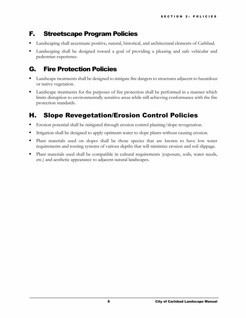
F. Streetscape Program Policies
Landscaping shall accentuate positive, natural, historical, and architectural elements of Carlsbad.
Landscaping shall be designed toward a goal of providing a pleasing and safe vehicular and pedestrian experience.
G. Fire Protection Policies
Landscape treatments shall be designed to mitigate fire dangers to structures adjacent to hazardous or native vegetation.
Landscape treatments for the purposes of fire protection shall be performed in a manner which limits disruption to environmentally sensitive areas while still achieving conformance with the fire protection standards.
H. Slope Revegetation/Erosion Control Policies
Erosion potential shall be mitigated through erosion control planting/slope revegetation.
Irrigation shall be designed to apply optimum water to slope plants without causing erosion.
Plant materials used on slopes shall be those species that are known to have low water requirements and rooting systems of various depths that will minimize erosion and soil slippage.
Plant materials used shall be compatible in cultural requirements (exposure, soils, water needs, etc.) and aesthetic appearance to adjacent natural landscapes.
S E C T I O N 3 : P R E L I M I N A R Y C O N C E P T P L A N S
9 City of Carlsbad Landscape Manual
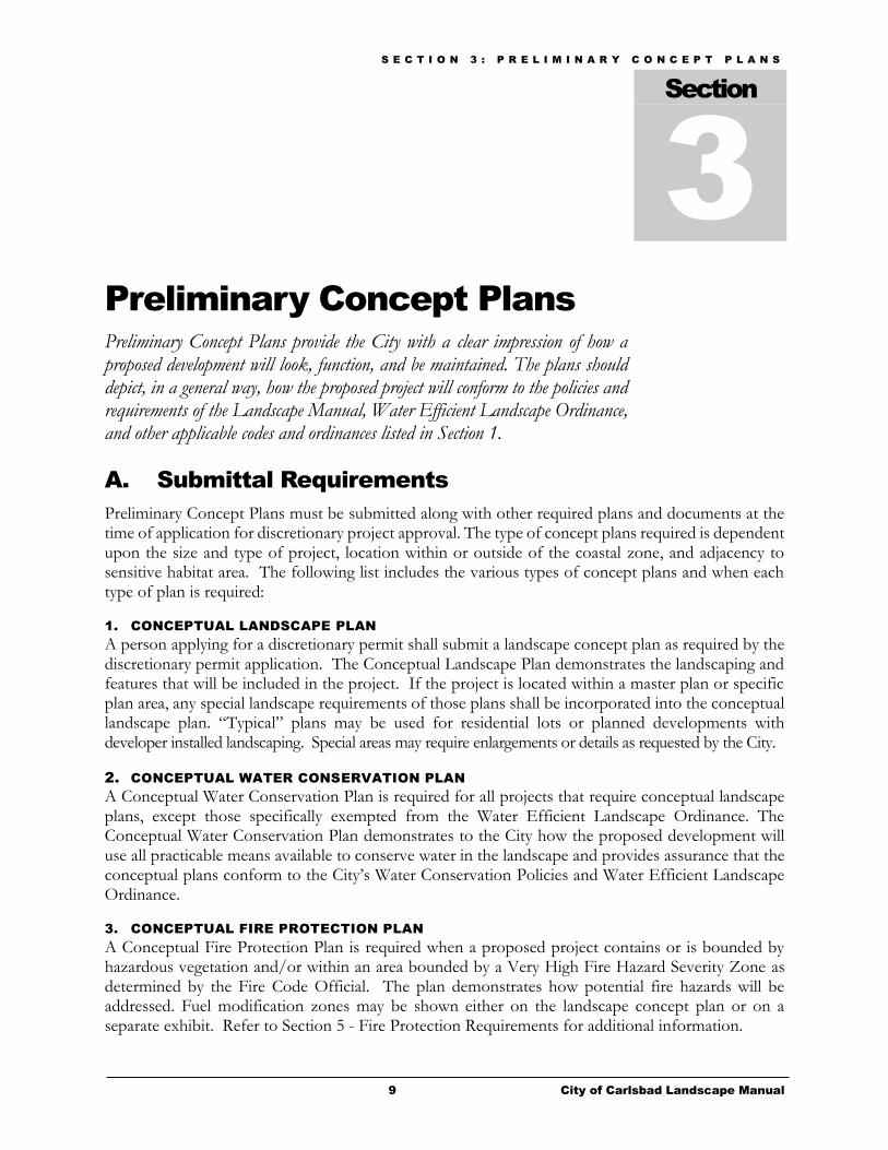
Preliminary Concept Plans
Preliminary Concept Plans provide the City with a clear impression of how a proposed development will look, function, and be maintained. The plans should depict, in a general way, how the proposed project will conform to the policies and requirements of the Landscape Manual, Water Efficient Landscape Ordinance, and other applicable codes and ordinances listed in Section 1.
A. Submittal Requirements
Preliminary Concept Plans must be submitted along with other required plans and documents at the time of application for discretionary project approval. The type of concept plans required is dependent upon the size and type of project, location within or outside of the coastal zone, and adjacency to sensitive habitat area. The following list includes the various types of concept plans and when each type of plan is required:
1. CONCEPTUAL LANDSCAPE PLAN
A person applying for a discretionary permit shall submit a landscape concept plan as required by the discretionary permit application. The Conceptual Landscape Plan demonstrates the landscaping and features that will be included in the project. If the project is located within a master plan or specific plan area, any special landscape requirements of those plans shall be incorporated into the conceptual landscape plan. “Typical” plans may be used for residential lots or planned developments with developer installed landscaping. Special areas may require enlargements or details as requested by the City.
2. CONCEPTUAL WATER CONSERVATION PLAN
A Conceptual Water Conservation Plan is required for all projects that require conceptual landscape plans, except those specifically exempted from the Water Efficient Landscape Ordinance. The Conceptual Water Conservation Plan demonstrates to the City how the proposed development will use all practicable means available to conserve water in the landscape and provides assurance that the conceptual plans conform to the City’s Water Conservation Policies and Water Efficient Landscape Ordinance.
3. CONCEPTUAL FIRE PROTECTION PLAN
A Conceptual Fire Protection Plan is required when a proposed project contains or is bounded by hazardous vegetation and/or within an area bounded by a Very High Fire Hazard Severity Zone as determined by the Fire Code Official. The plan demonstrates how potential fire hazards will be addressed. Fuel modification zones may be shown either on the landscape concept plan or on a separate exhibit. Refer to Section 5 - Fire Protection Requirements for additional information.
Section
3
S E C T I O N 3 : P R E L I M I N A R Y C O N C E P T P L A N S
10 City of Carlsbad Landscape Manual
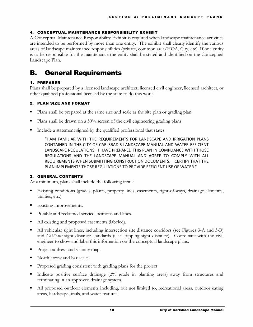
4. CONCEPTUAL MAINTENANCE RESPONSIBILITY EXHIBIT
A Conceptual Maintenance Responsibility Exhibit is required when landscape maintenance activities are intended to be performed by more than one entity. The exhibit shall clearly identify the various areas of landscape maintenance responsibilities (private, common area/HOA, City, etc). If one entity is to be responsible for the maintenance the entity shall be stated and identified on the Conceptual Landscape Plan.
B. General Requirements
1. PREPARER
Plans shall be prepared by a licensed landscape architect, licensed civil engineer, licensed architect, or other qualified professional licensed by the state to do this work.
2. PLAN SIZE AND FORMAT
Plans shall be prepared at the same size and scale as the site plan or grading plan.
Plans shall be drawn on a 50% screen of the civil engineering grading plans.
Include a statement signed by the qualified professional that states:
“I AM FAMILIAR WITH THE REQUIREMENTS FOR LANDSCAPE AND IRRIGATION PLANS CONTAINED IN THE CITY OF CARLSBAD’S LANDSCAPE MANUAL AND WATER EFFICIENT LANDSCAPE REGULATIONS. I HAVE PREPARED THIS PLAN IN COMPLIANCE WITH THOSE REGULATIONS AND THE LANDSCAPE MANUAL AND AGREE TO COMPLY WITH ALL REQUIREMENTS WHEN SUBMITTING CONSTRUCTION DOCUMENTS. I CERTIFY THAT THE PLAN IMPLEMENTS THOSE REGULATIONS TO PROVIDE EFFICIENT USE OF WATER."
3. GENERAL CONTENTS
At a minimum, plans shall include the following items:
Existing conditions (grades, plants, property lines, easements, right-of-ways, drainage elements, utilities, etc.).
Existing improvements.
Potable and reclaimed service locations and lines.
All existing and proposed easements (labeled).
All vehicular sight lines, including intersection site distance corridors (see Figures 3-A and 3-B) and CalTrans sight distance standards (i.e.: stopping sight distance). Coordinate with the civil engineer to show and label this information on the conceptual landscape plans.
Project address and vicinity map.
North arrow and bar scale.
Proposed grading consistent with grading plans for the project.
Indicate positive surface drainage (2% grade in planting areas) away from structures and terminating in an approved drainage system.
All proposed outdoor elements including, but not limited to, recreational areas, outdoor eating areas, hardscape, trails, and water features.

S E C T I O N 3 : P R E L I M I N A R Y C O N C E P T P L A N S
11 City of Carlsbad Landscape Manual
4. LANDSCAPE CHECKLIST
A Landscape Checklist is provided in Appendix B. The checklist is required for the review of the landscape construction documents. However, because the checklist includes many design standards and requirements that are applicable to both Preliminary Concept Plans and Landscape Construction Documents, it can also be used by the plan preparer as a reference document during preparation of the Conceptual Landscape Plans. Note that the checklist does not encompass all of the landscape manual requirements, nor does it include the entire text of the listed items. The plan preparer should refer to the main text of the landscape manual to ensure that all of the design standards and requirements are incorporated into the conceptual landscape plans.
C. Conceptual Landscape Plan
The Conceptual Landscape Plan shall include, but not be limited to the following items:
1. PLANTING PLAN
The planting plan shall consist of a drawing that illustrates, on a page or pages, the conceptual locations of all planting areas, existing vegetation to be retained or removed, planting palette, plant types represented by symbols, hardscape areas, landscape design features (including Low Impact Development (LID) BMPs), natural features, and water features.
2. PLANTING PALETTE
The planting palette shall include:
Common and botanical plant names.
Tree types and quantities.
Shrub types and spacing with general layout.
Ground cover types and spacing.
Proposed plant sizes (either by number or percentage (%) of total quantity).
3. EXISTING PLANT MATERIAL
Generally identify all existing woody plant material to be removed or retained.
Trees over 12 inches in diameter shall be identified on the plan individually as to caliper size and type and labeled to be retained or removed.
4. PLANTING RESTRICTIONS
Invasive species shall not be added to a landscaped area.
Trees shall not be planted within a public utility easement unless otherwise approved by the City.
Avoid planting trees and large shrubs above or near sewer laterals, water mains, meter boxes and other utilities.
Trees with broad branch structures shall be planted only where sufficient space is available.
Plant type, size at maturity, and location shall be selected to avoid obstructing existing or planned passive solar energy systems.
S E C T I O N 3 : P R E L I M I N A R Y C O N C E P T P L A N S
12 City of Carlsbad Landscape Manual
Trees with surface root systems shall be planted only where sufficient space is available, unless the plan provides for installation of root control barriers or other appropriate devices to control surface roots.
5. TURFGRASS RESTRICTIONS
Turfgrass shall not be allowed:
On a slope greater than 25% grade (4:1 slope).
On a center island median strip or on a parking lot island within a commercial, industrial, institutional, or multi-family project.
In a landscaped area that cannot be efficiently irrigated, such as avoiding runoff or overspray.
6. MINIMUM PLANTING REQUIREMENTS
All trees (except on slopes 3:1 or steeper) shall be a minimum of 15 gallon size.
50% of the shrubs (except on slopes 3:1 or steeper) shall be a minimum of five (5) gallon size.
Woody shrubs shall be planted over herbaceous ground cover areas to cover 60% of the ground cover area (at mature size).
Spacing of plants shall allow for their size at maturity.
Refer to Section 7- Slope Revegetation/ Erosion Control for slope planting requirements.
7. PLANTING DESIGN
Plants in a transitional area (adjacent to native vegetation) shall consist of a combination of site adaptive and compatible native and/or non-native species, and shall conform to the requirements in Section 5 – Fire Protection Requirements.
Evergreen plants shall be used to screen unsightly elements and shall be spaced to provide 100% screening within two (2) years of installation.
Areas of public and private recreation facilities (ball field, park, golf course, etc.) shall be designed to limit turfgrass in any portion of a landscaped area not essential for the operation of the facility.
Areas generally not visible to the public or site occupants (backs of buildings, service areas, behind fences and screens, etc.) shall incorporate plant materials other than turfgrass, unless the area is
designated as a recreation area.
8. LOW IMPACT DEVELOPMENT (LID) FEATURES
The project landscaping shall be designed to support the stormwater approach/design per the site plans and Storm Water Quality Management Plan (SWQMP).
Include vegetated swales or landscape buffer strips that filter storm runoff and increase on-site rainwater retention from impervious areas.
Show stormwater treatment systems such as retention or biofiltration basins and include an appropriate planting palette to support the design.
Indicate the location of any pervious pavement areas (sidewalks, parking areas, etc.).
S E C T I O N 3 : P R E L I M I N A R Y C O N C E P T P L A N S
13 City of Carlsbad Landscape Manual
Appropriate landscaping palettes shall be provided for scenarios where runoff drains into vegetated bio-swales associated with Low Impact Development (LID) techniques. The landscape palettes for these areas shall consist of plant species (groundcover, appropriate grasses, shrubs and/or trees) that will tolerate conditions of both low-flow drainage and larger storm events and that will function to filter urban runoff and increase on-site rainwater retention in accordance with the Carlsbad BMP Design Manual.
9. LANDSCAPE DESIGN FEATURES
The following features shall be included in the Conceptual Landscape Plan:
Active and passive recreational areas (play structures, seating areas, basketball/volleyball courts, etc.).
Employee eating areas and associated tables, seats, and/or benches.
Hardscape areas (indicate the proposed type of decorative treatment).
Provide a detailed description of any water features that will be included in the landscaped area.
Other design features and details as needed for clarity (trails, fencing, parking lot lighting, trellis structures, raised planters, etc.).
10. TRAILS
Trail Planning, Design, and Construction Standards are available from the Parks and Recreation Department.
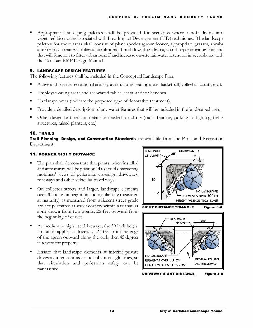
11. CORNER SIGHT DISTANCE
The plan shall demonstrate that plants, when installed and at maturity, will be positioned to avoid obstructing motorists' views of pedestrian crossings, driveways, roadways and other vehicular travel ways.
On collector streets and larger, landscape elements over 30 inches in height (including planting measured at maturity) as measured from adjacent street grade are not permitted at street corners within a triangular zone drawn from two points, 25 feet outward from the beginning of curves.
At medium to high use driveways, the 30 inch height limitation applies at driveways 25 feet from the edge of the apron outward along the curb, then 45 degrees in toward the property.
Ensure that landscape elements at interior private driveway intersections do not obstruct sight lines, so that circulation and pedestrian safety can be maintained.
25’
25’
BEGINNING
OF CURVE
SIDEWALK
SIDEWALK 25’
APRON
45O
MEDIUM TO HIGH
USE DRIVEWAY
DRIVEWAY SIGHT DISTANCE Figure 3-B
SIGHT DISTANCE TRIANGLE Figure 3-A
NO LANDSCAPE
ELEMENTS OVER 30” IN
HEIGHT WITHIN THIS ZONE
NO LANDSCAPE
ELEMENTS OVER 30” IN
HEIGHT WITHIN THIS ZONE

S E C T I O N 3 : P R E L I M I N A R Y C O N C E P T P L A N S
14 City of Carlsbad Landscape Manual
12. CALTRANS SIGHT DISTANCE LINES
Landscape features (shrubs, trees, fencing, etc.) shall be selected to ensure that no visual impairments or obstructions are located within the CalTrans sight distance lines.
CalTrans sight distance lines have a horizontal and vertical component (profile). Coordinate with the civil engineer to determine the location and height restrictions within the required sight distance area.
13. PARKING LOTS AND PERIMETERS (OUTDOOR/AT GRADE)
Parking lots shall integrate Low Impact Development (LID) features (see Figure 3-C for examples).
Minor modifications to the parking lot design requirements may be permitted only if the modifications are necessary to achieve LID objectives. Modifications shall be subject to approval by the City.
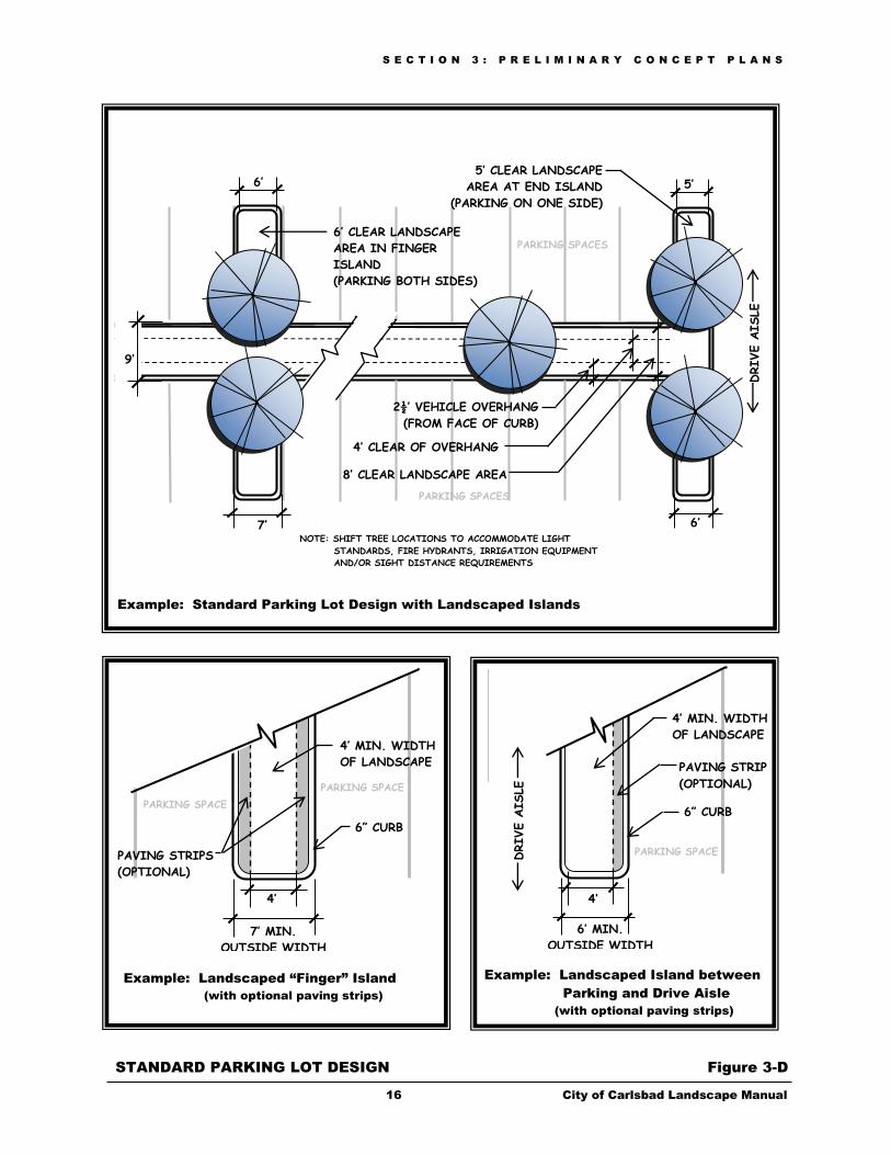
A minimum of 3% of the parking area shall be landscaped. The “parking area” includes all parking spaces and drive aisles.
A perimeter landscape border of at least eight (8) feet in width (exclusive of curbs) shall be provided around each outdoor/at grade parking area unless the Zoning Ordinance or other governing document specifically provides otherwise. The perimeter landscaped border (between property lines and parking areas) may include any landscaped yard, setback, or landscaped area otherwise required within the property and shall be continuous except for required access points. A perimeter landscape border is not required between a parking lot and building. The planting within the perimeter landscape border is not counted towards the 3% landscape requirement for parking lots.
Trees shall be provided at the minimum rate of one (1) tree per every four (4) parking spaces. Tree installations intended to satisfy this requirement shall be located within the parking area, exclusive of the parking lot setbacks. Trees shall be located in close proximity to the spaces they are to shade.
Trees shall be planted a minimum of two (2) feet from the back of curbs.
Any lane of through traffic shall be separated from parking spaces by a landscaped island with a minimum outside width of six (6) feet and a minimum landscape width of four (4) feet (see Figure 3-D for examples).
Islands at the end of each row of parking shall be used as a planting area.
If a landscaped strip is provided perpendicular to rows of parking spaces, the planting area shall be designed to provide a minimum of four (4) feet of landscaping clear of vehicle overhangs.
Long rows of parking should be broken up with landscaped islands. Landscaped islands should be provided at intervals of one island for approximately every 12 to 15 parking spaces.
If landscaped “finger” islands are provided between parking spaces, they shall be designed with a minimum outside width of seven (7) feet and a minimum landscape width of four (4) feet (see Figure 3-D for examples).

S E C T I O N 3 : P R E L I M I N A R Y C O N C E P T P L A N S
15 City of Carlsbad Landscape Manual
To facilitate passengers entering and exiting vehicles, landscaped islands may include a hardscape surface (paving strip) between the planter bed and parking space, provided that a minimum landscaped width of four (4) feet is maintained. The hardscape surface (not including curb) may be included in the 3% of landscape area.
Parking areas shall be screened from adjacent property or streets through the use of planting or any combination of planting, mounding, and decorative walls. Screening elements shall have a total height of at least three (3) feet.
PARKING LOT DESIGN USING LID FEATURES Figure 3-C
WIDTH
VARIES
PERVIOUS PAVING
PER ENGINEER’S
SPECIFICATIONS
2 1/2’
OVERHANG L C
PLANT TREE 2’ MINIMUM FROM
INSIDE EDGE OF PLANTER CURB
6’ X 6’ TREE WELL
(OUTSIDE LENGTH)
PARKING SPACES
PARKING SPACES
Example: Parking Lot with Pervious Paving
PAVEMENT EDGE
(VARIES)
2 ½’ VEHICLE OVERHANG
0” CURB - RUNOFF IS DIRECTED
INTO LANDSCAPED DRAINAGE SWALE
PER ENGINEER’S SPECIFICATION
4’ MIN.
CURB AT TREE CUT-OUT
3’
WHEEL STOP
PARKING SPACES
PARKING SPACES
Example: Parking Lot with Landscaped Drainage Swale
S E C T I O N 3 : P R E L I M I N A R Y C O N C E P T P L A N S
16 City of Carlsbad Landscape Manual
Example: Standard Parking Lot Design with Landscaped Islands
Example: Landscaped “Finger” Island
(with optional paving strips)
STANDARD PARKING LOT DESIGN Figure 3-D
2½’ VEHICLE OVERHANG
(FROM FACE OF CURB)
4’ CLEAR OF OVERHANG
8’ CLEAR LANDSCAPE AREA
NOTE: SHIFT TREE LOCATIONS TO ACCOMMODATE LIGHT
STANDARDS, FIRE HYDRANTS, IRRIGATION EQUIPMENT
AND/OR SIGHT DISTANCE REQUIREMENTS
5’ CLEAR LANDSCAPE
AREA AT END ISLAND
(PARKING ON ONE SIDE)
5’
6’ CLEAR LANDSCAPE
AREA IN FINGER
ISLAND
(PARKING BOTH SIDES)
6’
7’ 6’
9’
4’
PAVING STRIPS
(OPTIONAL)
6” CURB
4’
7’ MIN.
OUTSIDE WIDTH
6’ MIN.
OUTSIDE WIDTH
4’ MIN. WIDTH
OF LANDSCAPE
PAVING STRIP
(OPTIONAL)
6” CURB
4’ MIN. WIDTH
OF LANDSCAPE
PARKING SPACE
PARKING SPACE
PARKING SPACE DRIVE A
ISLE
PARKING SPACES
PARKING SPACES
DRIVE A
ISLE
Example: Landscaped Island between
Parking and Drive Aisle
(with optional paving strips)
S E C T I O N 3 : P R E L I M I N A R Y C O N C E P T P L A N S
17 City of Carlsbad Landscape Manual
14. MICROCLIMATE ENHANCEMENT/SOLAR ACCESS
Trees shall be located to shade south and west facing windows, walls, outdoor living spaces except as limited by the solar access requirements below.
Site design and landscaping shall provide solar access by adhering to the provisions in the State laws described below:
- The California Solar Rights Acts of 1978
Expressly adds the right of receiving sunlight upon or over land to the list of recognized easements, to be known as “Solar Easements.”
Defines a “Solar Energy System” to include active or passive systems and describes the requirements of a solar easement.
- The California Solar Shade Control Act of 1978 provides that no adjacent property owner shall obstruct more than 10% percent of a collector’s sky space (with possible exemptions) at any time on any day of the year.
15. STREETSCAPE DESIGN
Refer to Section 6 - Streetscape Program for streetscape and median requirements.
D. Conceptual Water Conservation Plan
The Conceptual Water Conservation Plan shall include, but not be limited to the following items:
1. WATER SUPPLY
Landscape water meters, defined as either a dedicated water service meter, private submeter, or flow sensor and master valve shall be installed for all non-residential irrigated landscapes of 1,000 square feet or more and residential irrigated landscapes of 5,000 square feet or more. A landscape water meter may be either a customer service meter dedicated to landscape use provided by the city or a privately owned meter or submeter.
Indicate the existing and/or future recycled water or graywater systems.
Provide a colored or hatched plan clearly showing where recycled water, graywater and potable water are proposed to be used for irrigation.
Irrigation systems for all projects, except for service to a single-family residence or front yard irrigation on individually metered condos, shall be designed to use non-potable, treated recycled water, unless an exemption is approved by the City Utilities Department
2. WATER CONSERVATION FEATURES
Provide a written description of all water conservation features including addressing Water Efficient
Landscape Principles (see Appendix A) that will be incorporated into the project.

S E C T I O N 3 : P R E L I M I N A R Y C O N C E P T P L A N S
18 City of Carlsbad Landscape Manual
3. HYDROZONE DIAGRAM*
Include one “hydrozone diagram” which identifies grouping of plants within the individual hydrozones (high, moderate, low, very low or special landscape areas) and which indicates the square footage and irrigation method of each area.
* For more information, see Section 4.E - WELO Documentation.
4. MAXIMUM APPLIED WATER ALLOWANCE (MAWA)*
A landscape project subject to the Water Efficient Landscape Ordinance (see Section 1) shall include calculations which document the maximum applied water allowance (MAWA). A landscape project shall not exceed the MAWA. The MAWA for a landscape project shall be determined by the following equation:
Residential: MAWA = (ETo)(0.62)[(0.55 x LA) + (0.45 x SLA)]
Non-Residential: MAWA = (ETo)(0.62)[(0.45 x LA) + (0.55 x SLA)]
The abbreviations used in the equation have the following meanings:
MAWA Maximum Applied Water Allowance in gallons per year. ETo Evapotranspiration in inches per year. 0.62 Conversion factor to gallons per square foot.
0.55 or 0.45 ET adjustment factor for plant factors and irrigation efficiency. LA Landscaped area includes special landscaped area in square feet.
0.45 or 0.55 The additional ET adjustment factor for a special landscaped area (1.0 - 0.55 = 0.45 or 1.0 – 0.45 = 0.55)
SLA Special landscaped area in square feet.
5. PRELIMINARY ESTIMATED TOTAL WATER USE (ETWU)*
A landscape project subject to the Water Efficient Landscape Ordinance (see Section 1) shall include a preliminary estimate of the total water use (ETWU) using the following equation. The calculations shall be shown on a Hydrozone Information Table (see Appendix F) and shall list each hydrozone and shall identify the plant types and water features in the hydrozone, the irrigation methods used, the square footage, and the percentage of the total landscape area of the project that the hydrozone represents.
SLA
IE
HAxPF)62.0)(ETo(ETW U
S E C T I O N 3 : P R E L I M I N A R Y C O N C E P T P L A N S
19 City of Carlsbad Landscape Manual
The abbreviations used in the equation have the following meanings:
ETWU Estimated total water use in gallons per year. ETo Evapotranspiration in inches per year. 0.62 Conversion factor to gallons per square foot. PF Plant factor from WUCOLS HA Hydrozone Area in square feet. Each HA shall be classified based upon the
data included in the landscape and irrigation plan as high, moderate, low, or very low water use.
IE Irrigation Efficiency of the irrigation method used in the hydrozone. SLA Special landscaped area in square feet.
* For more information, see Section 4.E - WELO Documentation.
E. Conceptual Fire Protection Plan
1. REGULATORY COMPLIANCE
The Conceptual Fire Protection Plan shall demonstrate in a general way how the proposed project will conform to the policies and requirements of this document, particularly the Fire Policies (Section 2) and Fire Protection Requirements (Section 5).
2. FIRE PROTECTION PLAN
The plan shall include a written and graphic plan and sections illustrating the following:
Fire hydrant locations.
Rear yard setbacks.
Fuel modification zones as outlined in Section 5.
Emergency/maintenance access.
Maintenance responsibility and schedule of frequency.
Any other project modification to protect the development from fire hazards.
Street widths dimensioned.
3. REDUCED FIRE BUFFERS
In rare occasions, reduced fire buffers may be approved by the Fire Code Official or his designee. In these instances, the applicant must provide written documentation from the Fire Code Official that indicates the location and approved width of the fire buffer.
F. Conceptual Maintenance Responsibility Exhibit
The Maintenance Responsibility Exhibit shall be prepared at a scale and size (preferably one sheet) that provides an overall view of the project and shall clearly identify the various areas of landscape maintenance responsibilities (private, common area/homeowners’ association (HOA), City, etc).

S E C T I O N 4 : L A N D S C A P E C O N S T R U C T I O N D O C U M E N T S
20 City of Carlsbad Landscape Manual
Landscape Construction Documents
Landscape construction documents translate the provisions set forth in any approved conceptual project submittals and the policies and requirements of this manual into working documents for landscape construction.
A. Landscape Documentation Package
A Landscape Documentation Package is required for all landscape projects that meet the applicability requirements in Section 1. Projects that are exempt from the Water Efficient Landscape Ordinance (under the WELO thresholds), but which require landscape plans, are not required to submit the Water Efficient Landscape Worksheet required with the WELO documentation. The following primary components shall be included in the Landscape Documentation Package:
WELO Documentation
Soil Analysis Report and Recommendations
Landscape Checklist
Planting Plan
Landscape Construction Plan
Grading Design
Irrigation Plan
The following sections provide detailed descriptions of each of the components listed above as well as a list of the General Requirements and project-specific Special Requirements for landscape submittals.
B. General Requirements
1. PREPARER
Plans shall be prepared by a licensed landscape architect, licensed civil engineer, licensed architect, or other qualified professional licensed by the state to do this work.
Section
4
S E C T I O N 4 : L A N D S C A P E C O N S T R U C T I O N D O C U M E N T S
21 City of Carlsbad Landscape Manual
Irrigation plans may be prepared by an irrigation consultant. However, plans must include the stamp of the licensed landscape architect or other licensed professional responsible for the work.
2. CONSISTENCY WITH CONCEPTUAL LANDSCAPE PLAN
The landscape construction documents shall be designed in accordance with Sections 3 and 4 of this manual, and shall incorporate all of the features shown on the approved conceptual landscape plan (if one was required).
3. PLAN SIZE AND FORMAT
All landscape plan submittals shall include a City Title Sheet as follows:
- The Standard Planning Division Title Sheet includes the City title block; drawing index, Declaration of Responsible Charge, Water Efficient Landscape Declaration, backflow preventer testing information, inspection procedures, DigAlert information, and areas for vicinity map, location map, and key map.
- The City Recycled Water Title Sheet includes the City title block, general notes, signage notes, legend, instructions for required project information, vicinity map, typical signs, DigAlert information, inspection procedures, the Declaration of Responsible Charge, and CMWD and Department of Environmental Health signature blocks.
Plans shall be prepared on standard 24” x 36” City of Carlsbad “D” Sheets with the Planning Division title block. A one (1) inch border shall be provided on the right hand side of the sheet.
Plans shall be drawn at 1” = 20’ unless otherwise approved by the City.
Planting and irrigation plans shall be drawn on a 50% screen of the civil engineer grading plans.
For multiple sheet projects, each sheet shall provide a “Graphic Key” (reduced overall project map) indicating the portion of the project that each sheet covers. The graphic key shall be included on the title sheet.
At a minimum, the plans shall include all of the General Contents items listed in Section 3.B.3.
C. Special Requirements
In addition to the general requirements listed above, the following project types have additional submittal requirements:
1. PROJECTS WITHIN THE PUBLIC DOMAIN
Projects in this category include, but are not limited to, public projects, medians, streetscapes, public or private projects within the public domain and other City-maintained landscape areas.
Specific Streetscape Program requirements are included in Section 6 of this manual.
Plans shall be reviewed by the Parks and Recreation Department.
Landscaping within the areas described above are subject to specific irrigation and/or planting requirements. Contact the Parks and Recreation Department for informational materials.
High water use plants, characterized by a plant factor of 0.7 – 1.0 are prohibited in street medians.
S E C T I O N 4 : L A N D S C A P E C O N S T R U C T I O N D O C U M E N T S
22 City of Carlsbad Landscape Manual
2. PROJECTS SUBJECT TO FIRE PROTECTION REQUIREMENTS
Specific Fire Protection Requirements are included in Section 5 of this manual.
When Fuel Modification Zones are required for a project, they shall be illustrated on the planting plan or on a separate sheet in the Landscape Construction Document submittal package.
3. SLOPE REVEGETATION/EROSION CONTROL PLANS
Specific Slope Revegetation/Erosion Control Plan requirements are included in Section 7 of this manual.
Slope revegetation/erosion control plans may be included in the General Planting, Irrigation, and Construction Plan submittal.
Plans may be drawn at the same scale as used for the grading plan, provided that drawing scale is no smaller than one inch equals forty feet (1” = 40’) unless otherwise approved by the City.
4. HABITAT RESTORATION PLANS
Habitat Restoration Plans shall be prepared as a separate Landscape Documentation Package and shall include the following items:
- Restoration Plan that includes the required mitigation for habitat impacts.
- Long-term Maintenance, Monitoring, and Reporting Plan.
- Landscape Plans that reflect the specific planting requirements of the Restoration Plan.
- Irrigation Plans.
- Property Analysis Record (PAR).
Plans may be drawn at the same scale as used for the grading plan, provided that drawing scale is no smaller than one inch equals forty feet (1” = 40’) unless otherwise approved by the City.
Plans shall incorporate, as appropriate, the recommendations contained in the City of Carlsbad Habitat Management Plan (HMP) guidelines. The guidelines are available on the HMP website and include:
Guidelines for Preserve Management.
Guidelines for Habitat Creation and Restoration.
Guidelines for Riparian and Wetland Buffers.
S E C T I O N 4 : L A N D S C A P E C O N S T R U C T I O N D O C U M E N T S
23 City of Carlsbad Landscape Manual
D. Water Conservation Requirements
1. PLANTING FOR WATER EFFICIENT LANDSCAPES
All plants shall be grouped in hydrozones and the irrigation shall be designed to deliver water to hydrozones based on the moisture requirements of the plant grouping.
A hydrozone may mix plants of moderate and low water use or mix plants of high water use with plants of moderate water use.
No high water use plants shall be allowed in a low water use hydrozone.
2. SOIL PREPARATION AND MULCHING
Prior to planting of any materials, compacted soils shall be transformed to a friable condition. On engineered slopes, only amended planting holes need meet the requirement of this section.
Soil amendments shall be incorporated according to the recommendations of the soil analysis report and what is appropriate for the plants selected.
Landscape installations shall incorporate compost at a rate of a minimum four cubic yards per 1,000 square feet of permeable area to a depth of six inches into the soil. Soil with greater than 6% organic matter in the top 6 inches of soil is exempt from the requirement of this section.
The application of organic mulch materials made from recycled or post-consumer materials shall take precedence over inorganic materials unless recycled or post-consumer organic products are not locally available.
A minimum three (3) inch layer of mulch shall be applied on all exposed soil surfaces in each landscaped area except in turfgrass areas, direct seeding applications, or erosion control plantings where mulch is not recommended. To provide habitat for beneficial insects and other wildlife, up to 5% of the landscape area may be left without mulch. Designated insect or wildlife habitat must be included in the landscape design plan.
The mulch thickness may taper down to one (1) inch thick in areas adjacent to hard surfaces such as sidewalks curbs, or drives where the difference between the finish grade and top of the hard surface is less than three (3) inches. Mulch may also taper down to one (1) inch adjacent to trees, shrubs and ground cover plantings.
Impervious materials shall not be placed under the mulch.
Highly flammable mulch material shall not be used.
The mulching portion of seed/mulch slurry in hydro-seeded applications that meet current engineering standards, satisfies the mulching requirement of this section.
3. FOUNTAINS AND/OR WATER FEATURES
Fountains and/or water features shall have recirculating systems and shall be designed to minimize evaporative loss.
Fountains, decorative pools and ponds shall utilize recycled water if available or shall be designed to utilize recycled water so that it can be utilized when it becomes available. The design and equipment shall conform to state or local water and health agency requirements related to recycled water.
S E C T I O N 4 : L A N D S C A P E C O N S T R U C T I O N D O C U M E N T S
24 City of Carlsbad Landscape Manual
Use of recycled water in fountains or water features is subject to approval by the San Diego County Department of Environmental Health or California Department of Public Health.
4. MODEL HOMES
New single-family residential developments containing one or more model home(s): A water efficient landscaping brochure shall be available for each group of adults visiting the model home. At a minimum, each brochure shall include information describing the water efficient features of the model’s landscaping; resources for additional information regarding water efficiency in landscaping; contact information for the local water purveyor and Planning Division; and a reference to the requirements of this landscape manual. A copy of the brochure shall be provided to the Planning Division prior to the City authorizing temporary occupancy as a model home.
An educational sign shall be placed in the front yard of each model home so that it is visible and readable from the roadway. The sign shall be white with black capital lettering at least two inches high and shall state “THIS MODEL HOME USES WATER EFFICIENT LANDSCAPING AND IRRIGATION”.
The sign shall include information about the site water use as designed per City ordinance: specify who designed and installed the water efficient landscape; and demonstrate low water use approaches to landscaping such as using native plants, graywater systems and rainwater retention systems.
E. WELO Documentation
A landscape project subject to the Water Efficient Landscape Ordinance shall include a Water
Efficient Landscape Worksheet that calculates the Maximum Applied Water Allowance (MAWA) and the Estimated Total Water Use (ETWU) for the project. The MAWA and the ETWU for a landscape project shall be determined by the formulas shown in Appendix F. Additionally, the following information shall be included:
1. HYDROZONE INFORMATION TABLE
Each hydrozone listed in the table shall identify the plant types and water features in the hydrozone, the irrigation methods used, the square footage, and the percentage of the total landscaped area of the project that the hydrozone represents.
The plant types shall be categorized as turfgrass/high water use, moderate water use, low water use, or very low water use.
2. WATER BUDGET CALCULATIONS
The water budget calculations shall use the formulas for the MAWA and ETWU, and shall meet the following requirements:
Plant Factor
Water budget calculations shall use the plant factors from WUCOLS. On a plan that mixes plants that require a different amount of water within a hydrozone, the plant factor for the highest water using plant in the hydrozone shall be used.
S E C T I O N 4 : L A N D S C A P E C O N S T R U C T I O N D O C U M E N T S
25 City of Carlsbad Landscape Manual
Plant Factors
Very Low Water Use Plants 0.1
Low Water Use Plants 0.3
Moderate Water Use Plants 0.5
High Water Use Plants and Turfgrass 0.8
Temporarily Irrigated Areas
Areas with temporary irrigation shall be included in the low water use hydrozone. “Temporarily irrigated” as used in this manual means the period of time when plantings only receive water until they become established.
Water Features
The surface area of a water feature, including swimming pools, shall be included in a high water use hydrozone.
Non-Vegetated Areas Adjustment to landscaped area for non-vegetated areas such as rock and stone, or pervious design features (such as decomposed granite ground cover) that are adjacent to a vegetated area may be included in the calculation of the MAWA and ETWU provided the features are integrated into the design of the landscape area and the primary purpose of the feature is decorative.
Special Landscape Areas
Each special landscaped area shall be identified on the worksheet and the area's water use calculated using an Evapotranspiration Adjustment Factor (ETAF) of 1.0.
F. Soil Analysis Report and Recommendations
A soil analysis report and recommendations shall be submitted to and approved by the City. If grading is not required for the project, the report shall be submitted with the landscape documentation package. If the project involves mass grading of the site, the soil analysis report and recommendations shall be submitted with the Certificate of Completion required by Section 8.
The soil analysis shall include information about the soil texture, soil infiltration rate, pH, total soluble salts, sodium, and percent organic matter. Soil samples shall be taken from enough locations on the site to represent an adequate cross section of conditions. In projects with
SPECIAL LANDSCAPED AREA (SLA)
The water use of a SLA may be calculated using an ETAF of 1.0.
Special Landscaped Areas include the following:
Areas of the landscape dedicated to edible plants.
An area irrigated with recycled water.
Water features that use treated recycled water.
An area within a park, sports field or golf course where turfgrass provides a passive or active recreational surface.
A public pool

S E C T I O N 4 : L A N D S C A P E C O N S T R U C T I O N D O C U M E N T S
26 City of Carlsbad Landscape Manual
multiple landscape installations or a large landscape project of more than 10,000 square feet, a soil sampling rate of 1 in 7 lots or 15% is an adequate cross section.
The report shall identify any recommended soil amendments, type, and quantity that may be necessary to foster plant growth and plant survival in the landscaped areas.
The approved recommendations for amendments and backfill shall be incorporated into the landscape plans prior to the start of construction and shall become part of the approved plans.
G. Landscape Checklist
A copy of the Landscape Checklist (Appendix B) shall be included with the submittal of the landscape construction documents. Note that the checklist does not encompass all of the landscape manual requirements, nor does it include the entire text of the listed items. The plan preparer should refer to the main text of the landscape manual to ensure that all of the design standards and requirements are incorporated into the plans.
H. Planting Plan
1. PLANTING PLAN REQUIREMENTS
The planting plan shall include the following:
Existing and proposed grades and drainage elements.
All elements shown on the approved conceptual landscape plan.
All existing and proposed outdoor elements including, but not limited to, recreational areas, outdoor eating areas, hardscape, trails and water features.
All amenities for employee eating areas (as required by the City for certain office/industrial/ commercial projects) including (at a minimum) site furniture, hardscape, trash receptacles, and picnic tables.
A graphic representation of all plant material to be installed within each landscape area.
A plant palette that lists all vegetation by common and botanical plant name and that includes the total quantities by container size and species.
Identification of all areas permanently and solely dedicated to edible plants.
Seed mix information, including at a minimum the mix, rate, purity, germination, inoculation, fertilization, binder and mulch.
2. PLANTING DETAILS AND SPECIFICATIONS
Planting details and specifications shall include, but not be limited to the following:
General planting notes, details, and specifications.
Planting details to ensure uniform planting of landscape.
Slope planting detail (if applicable) that indicates the rear of the planting pit shall be graded to a maximum 1:1 slope and that this slope shall be covered with erosion control fabric, as approved by the City.

S E C T I O N 4 : L A N D S C A P E C O N S T R U C T I O N D O C U M E N T S
27 City of Carlsbad Landscape Manual
Double stake or guy (with flagging) for non-self supporting trees.
Specifications for root control barriers for trees located within five (5) feet of a sidewalk or hard surface.
Weed abatement program.
I. Landscape Construction Plan
Plans for landscape construction shall include, but not be limited to the following:
General landscape construction notes and specifications.
Construction details for all landscape features, including fences, fountains/water features, landscape lighting, walls, walkways/trails, trellises, and signs.
If any aspects of the landscape construction (including those items listed above) are shown on the architect’s or engineer’s plans, that information shall be indicated on the landscape plans and referenced as to plans and sheet numbers.
If signage is included on the landscape plans, a note shall be included on the plan indicating that all project signs and/or monument signs require a separate permit.
J. Grading Design
A copy of the grading plan shall be submitted with the landscape construction documents. Previously approved grading plans, as-built grading plans, or grading plans undergoing the grading permit approval process are acceptable submittals. If a project does not require approval of a grading plan, the following information shall be included in the landscape plans:
General information shall include, but not be limited to, elevations, slope heights, drainage patterns, pad elevations, storm water management, and finish grade.
The plans shall indicate positive surface drainage (2% grade in planting areas) away from structures and terminating in an approved drainage system.
The grading on the project site shall be designed for the efficient use of water by minimizing soil erosion, runoff and water waste, resulting from precipitation and irrigation.
The grading design shall be designed to comply with best management practices required by Municipal Code Chapter 15.12, Storm Water Management and Discharge Control.
K. Irrigation Plan
1. PUBLIC PROJECTS
Contact the Parks and Recreation Department for a list of current approved equipment.
2. RECYCLED WATER
Projects shall be designed to utilize recycled water and/or other alternative non-potable water sources for landscaping to the satisfaction of the City, unless an exemption is approved by the City Utilities Division.

S E C T I O N 4 : L A N D S C A P E C O N S T R U C T I O N D O C U M E N T S
28 City of Carlsbad Landscape Manual
A person who uses recycled water under this section shall be entitled to an ETAF of 1.0.
Dual distribution systems may be required for projects using recycled and potable water for landscape irrigation, as approved by the City. Pipes carrying recycled water shall be purple.
All regional and local water and health code requirements related to recycled water use that are in force at the time of final landscape approval shall apply including, but not limited to, installation of labeled or colored irrigation pipe and appurtenances to denote recycled water use.
A physical separation shall be provided between adjacent areas irrigated with recycled water and potable water. Separation shall be provided by distance, concrete mow curbs or other approved methods.
Projects using recycled water shall include a peak watering window calculation proving that the irrigation systems can complete all watering cycles within a maximum eight (8) hour window.
Unless the drip line is purple in color, it shall be marked every 10 feet on center with approved recycled water identification and markings.
Hose bib connections are not allowed on systems using recycled water.
Irrigation signage is required stating that the landscaping is being irrigated with recycled water.
3. GRAYWATER SYSTEMS
Graywater systems are encouraged to assist in on-site landscape irrigation. A graywater system shall conform to the California Plumbing Code (Title 24, Part 5, Chapter 16) and any applicable local standards.
4. IRRIGATION PLAN REQUIREMENTS
The plans shall include all general irrigation notes, details and specifications, signature blocks, and any other items that may be determined to be necessary by the City.
The schematic plan shall illustrate the location, type and size of all components of the irrigation system that will provide water to the landscaped area, including the controller, water lines, master shut-off valve, valves, sprinkler heads, moisture sensing devices, rain switches, quick couplers, pressure regulators, backflow prevention devices, and signage.
A legend shall be included which identifies all symbols and indicates the manufacturer, precipitation rate, g.p.m.’s, radii of each head type and detail reference call out as well as any pertinent information about equipment used.
All systems shall have their equipment sized, their control valve size and station number given, and their gallon per minute stated. Pipe sizes shall be indicated numerically (i.e. ½”, ¾”, etc.).
All water meters or other points of connection (P.O.C.), both temporary and permanent, shall be noted and sizes called out. Any temporary elements shall note the intended duration of use.
Plans shall indicate the type of water meter (recycled or potable) and the location shall be identified by the street station number to coincide with the locations shown on the public improvement plans. Public potable and recycled water mains shall be shown on the plans.
S E C T I O N 4 : L A N D S C A P E C O N S T R U C T I O N D O C U M E N T S
29 City of Carlsbad Landscape Manual
Main lines shall be clearly delineated outside the street right of way unless otherwise approved by the City.
The plan shall show the static water pressure at the point of connection to the public water supply, the maximum flow rate in gallons per minute, and the design operating pressure in pounds per square inch.
Pressure calculations for the lowest pressure (worst case) system for each point of connection shall be submitted with the plans. Each piece of equipment shall be listed in the calculation along with the associated loss. The calculation shall include the total pressure loss of all equipment used in the system to the point of connection. The calculation shall indicate the total residual pressure by subtracting the total loss from the available static pressure at the point of connection. A minimum 10% residual pressure shall be provided based on the existing hydraulic grade line of the water system.
The plan shall identify each area irrigated with recycled water, graywater, and other non-potable water.
Separate water service for landscaping (including, but not limited to connections, water meters, and back flow preventers) shall be provided for all commercial/industrial projects, golf courses, parks, and residential common areas in projects over four (4) dwelling units.
5. IRRIGATION EFFICIENCY
The irrigation system shall be designed with a landscape irrigation efficiency necessary to meet the MAWA.
Irrigation circuits shall be organized into hydrozones based on plants, sun and shade exposure, topography, and soils.
The irrigation system shall be designed to prevent runoff, overspray, low-head drainage and other similar conditions where irrigation water flows or sprays onto areas not intended for irrigation. Areas less than ten (10) feet in width in any direction shall be irrigated with subsurface irrigation or other means that produces no runoff or overspray.
The irrigation in a transitional area shall be designed so that no overspray or runoff shall enter an adjacent native habitat area that is not irrigated.
The irrigation system shall be designed to apply water at a rate not exceeding the infiltration rate of the soil.
When irrigation will be used for vegetation within 24 inches of an impermeable surface, overhead irrigation shall not be permitted and only subsurface irrigation shall be used, unless the adjacent impermeable surfaces are designed and constructed to cause water to drain entirely into a landscaped area.
- The plan shall provide that any slope greater than 25% will be irrigated with an irrigation system with a precipitation rate of 0.75 inches per hour or less to prevent runoff and erosion. As used in this chapter, 25% grade means one (1) foot of vertical elevation change for every four (4) feet of horizontal length. An applicant may employ an alternative design if the plan demonstrates that no runoff or erosion will occur.

S E C T I O N 4 : L A N D S C A P E C O N S T R U C T I O N D O C U M E N T S
30 City of Carlsbad Landscape Manual
6. SPECIFIC IRRIGATION REQUIREMENTS
Point of Connection
- Water service (point of connection) installation for landscape shall be in place as required to coincide with planting timing.
Backflow Devices
- City approved backflow preventers to protect the potable water supply shall be installed per City standards and shall comply with all applicable health and safety codes and details as required by the City Utility and Maintenance Department.
- Backflow preventers are not required on recycled water services except where an injector or other potential hazard is specified. Irrigation systems that are conditioned for recycled water but will use potable water pending recycled water availability will require backflow assemblies.
- Backflow preventers shall be tested by a certified tester and results must be given to the owner and the Water District.
- Pipe between the meter and backflow preventer shall be copper.
Master Control Valve
- Master shut-off valves are required on all projects except landscapes that make use of technology that allows for the individual control of sprinklers that are individually pressurized in a system equipped with low pressure shut down features. Master control valves shall be of the normally closed type and shall be activated by the automatic controller.
- The master control valve shall be located just downstream of the point of connection.
Flow Sensors
- Flow sensors that detect high flow conditions created by system damage or malfunction are required for all non-residential landscapes and residential landscapes of 5,000 square feet or larger.
Design Pressure
- Where static water pressure exceeds 60 psi at the control valve, “pressure regulating type” remote control valves shall be provided within each circuit.
- Pressure regulating device shall be used where the static pressure at the point of connection exceeds 80 psi. Pressure differential within the lateral piping circuits shall not exceed 20% of the designed operating pressure.
- Pressure regulators shall be installed between a meter and a backflow device.
- The requirement for pressure regulators and pressure regulating valves may be waived if it can be shown through the pressure calculations that the system will operate more efficiently without them.
- Water velocities within any segment of pipe within the system shall not exceed five (5) feet per second.
S E C T I O N 4 : L A N D S C A P E C O N S T R U C T I O N D O C U M E N T S
31 City of Carlsbad Landscape Manual
Piping
- All pipe must be below grade except for risers and distribution tubing for drip irrigation systems.
- On-grade pipe is not allowed unless it is demonstrated to the satisfaction of the City that the rocky condition of the slope would prevent trenching. In cases where on-grade pipe is allowed it shall be the galvanized type or UVR resistant PVC approved by the City.
- PVC pressure mains shall be class 315 (2 inch or larger) or schedule 40 (1 ½ inch or smaller). Mainlines shall be located outside of the street right-of-way unless otherwise approved by the City.
- PVC lateral lines shall be class 200 except that ½” shall be schedule 40.
- Minimum pipe coverage shall be as follows: Pressure lines less than 3” diameter - 18” cover Pressure lines 3” to 5 ½” diameter - 24” cover Pressure lines 6” or greater in diameter - 36” cover Lateral lines of all sizes - 12” cover
- Recycled irrigation systems shall provide for two (2) layers of warning tape running continuous along the route of the mainline. One shall be located immediately on top of the mainline pipe and one shall be located 12 inches above the top of the mainline.
Sleeving
- Crossing of roads with irrigation pipe or wiring shall be avoided wherever possible. Sleeves shall be installed if a crossing must be made.
- Sleeves for irrigation lines under roads shall be schedule 80 PVC and sleeves under paving (non-roads) shall be schedule 40 PVC, with a minimum size of two (2) times the size of the line it serves.
- Minimum coverage for sleeves shall be as follows: Sleeves under roads that are 6” or less in diameter – 36” cover Sleeves under roads that are greater than 6” in diameter – 48” cover Sleeves under paving (non-roads) that are less than 3” in diameter – 18” cover Sleeves under paving (non-roads) that are 3” – 5-1/2” in diameter – 24” cover Sleeves under paving (non-roads) that are 6” or greater in diameter – 36” cover
- Controller wires located under streets or other permanent improvements shall be installed in separate PVC sleeves corresponding to the type and depth as specified above.
- The locations of irrigation sleeves shall be placed on the irrigation plans and on the improvement plans (if applicable) for reference.
Thrust Blocks
- Thrust blocks consisting of a minimum of one (1) cubic foot of concrete (200) psi) shall be installed around main lines 3” and above at elbows and at points of change in direction.
Controller
- All irrigation systems shall be operated by an automatic controller(s) utilizing non-volatile memory.
- All irrigation systems shall be equipped with an automatic controller capable of dual or multiple programming.
- Controllers must have multiple cycle start capacity and a flexible calendar program.

S E C T I O N 4 : L A N D S C A P E C O N S T R U C T I O N D O C U M E N T S
32 City of Carlsbad Landscape Manual
- Irrigation controllers shall be equipped with rain shut-off devices (weather based system or soil moisture detection system).
Shut-off/Zone Control Valves
- The irrigation system shall provide for the installation of a manual shutoff valve as close as possible to the water supply. Additional manual shutoff valves shall be installed between each zone of the irrigation system and the water supply.
Quick Coupling Valves
- Quick coupling valves shall be installed at a maximum of every 150 feet along the mainline and as needed to adequately service the area.
Quick couplers for recycled water shall include reverse ACME type threads.
Quick couplers for potable water shall be the lug type.
Sprinkler Heads
- Sprinkler heads shall have matched precipitation rates within each control valve circuit and head types shall not be mixed within the circuit.
- Sprinkler head spacing in turfgrass areas and where stream sprays, rotors or impacts are used shall be equal to 50% of the diameter spray.
- Pop up heads shall be used within 10 feet of any pedestrian use.
- Only pop-up heads or drip systems shall be used in the public right-of-way.
- Risers over 12 inches in height must be staked (staking shall be with galvanized pipe and clamps (2) or as approved by the City).
- All irrigation emission devices must meet the requirements set in the American National Standards Institute (ANSI) standard, American Society of Agricultural and Biological Engineers’/International Code Council’s (ASABE/ICC 802-2014 “Landscape Irrigation Sprinkler and Emitter Standard”). All sprinkler heads installed in the landscape must document a distribution uniformity low quarter of 0.65 or higher using the protocol defined in ASABE/ICC 802-2014.
- Swing joints or other riser rotation components are required on all risers subject to damage that are adjacent to hardscapes or in high traffic areas of turfgrass.
Check Valves
- Check valves shall be used to prevent low head drainage.
- Serviceable check valves located in valve boxes or on risers (above grade) are required where elevation differential may cause low head drainage.
Deep Watering Device
- All trees in turfgrass areas shall be irrigated with a “deep watering device” (drip or bubbler application inside a drain pipe).
S E C T I O N 5 : F I R E P R O T E C T I O N R E Q U I R E M E N T S
33 City of Carlsbad Landscape Manual
Fire Protection Requirements
A Fire Protection Plan is required when a proposed project contains or is bounded by hazardous vegetation or when a proposed project is within an area bounded by a Very High Fire Hazard Severity Zone, or as determined by the Fire Code Official or his representative.
A. Application
The applicant shall develop a Fire Protection Plan which meets the fire protection requirements of the Landscape Manual and which conforms to the most current requirements for Wildland Urban Interface Areas, as adopted by the City of Carlsbad. Environmental constraints or other restrictions placed upon the development shall not be considered justification for modification or subordination of fire protection standards. The site planning of the development shall satisfy both the fire protection standards and environmental constraints. In addition to the General Requirements listed below, the design, installation, and modification of existing vegetation shall be in conformance with one of the following “Conditions” for fuel modification zones or as required or modified by the Fire Code Official or his/her designee.
B. General Requirements
1. CALIFORNIA FIRE AND BUILDING CODES
The plan shall conform to Chapter 49 of the California Fire Code and/or Chapter 7a of the California Building Code, as adopted by the City of Carlsbad.
2. OFFSITE FIRE HAZARD AREAS
It is the applicant’s responsibility to secure agreements with owners of adjacent property to modify/mitigate offsite wildland fire hazards to the subject property, so that conformance with the fire protection plan and adopted standards is achieved and maintained.
3. ACCESS
Maintenance access shall be provided to all fire protection areas. All maintenance access points shall be identified on the recorded drawings and a maintenance access agreement shall be recorded for the subject property.
Section
5
S E C T I O N 5 : F I R E P R O T E C T I O N R E Q U I R E M E N T S
34 City of Carlsbad Landscape Manual
4. DEBRIS REMOVAL
Debris and trimmings produced by maintenance and thinning shall be removed from the site or shall be converted to mulch by a chipping machine and evenly dispersed over the area to a maximum depth of four (4) inches.
5. INSPECTIONS
Inspections of fuel modification zones may occur throughout the year. The Fire Code Official or his representative shall provide detailed maintenance requirements in the event of a dispute. All required maintenance will be in accordance with the approved plans. Additional maintenance may be required at the discretion of the Fire Code Official.
6. FENCING
Fencing returns that are attached to a structure and/or any fence located within the drip line of the eaves shall be constructed with noncombustible materials if located within 100 feet of undisturbed native areas.
7. PHOTOGRAPHIC DOCUMENTATION
The Fire Code Official may require documentary photographs of slopes at the time of treatment. These photographs will remain in possession of the City as a reference for future compliance inspections by the City.
C. Condition A – Manufactured Slopes
Fuel modification zones for manufactured slopes abutting hazardous native vegetation. (See Figure 5- A)
ZONE A-1
Zone A-1 shall be measured horizontally 20 feet outward from the outlying edge of any habitable structure(s) or inward from the top of slope.
Planting within Zone A-1 shall consist of ground cover or low growing shrubs species (less than three (3) feet in height) known to have fire resistive qualities.
No trees or shrubs (over three (3) feet in height at maturity) shall be allowed.
Irrigation shall be required and maintained.
All attachments to the structure shall be noncombustible.
No solid fuel fire pits or outdoor fire places shall be permitted.
ZONE A-2
Zone A-2 shall be measured horizontally 20 feet outward from the outlying edge of Zone A-1.
Planting within this zone shall consist of low water use plant species known to have slow burning, low fuel characteristics.
No trees shall be allowed.
Irrigation shall be required and maintained.

S E C T I O N 5 : F I R E P R O T E C T I O N R E Q U I R E M E N T S
35 City of Carlsbad Landscape Manual
If Zone A-2 crosses over a fence line, a six (6) foot wide strip of modified landscaping shall be provided parallel to the fence line in order to provide access for firefighters. Plants located within the six (6) foot access area shall not exceed a height of 18 inches at maturity.
ZONE A-3
Zone A-3 shall be measured outward from the outlying edge of Zone A-2. It shall include the remainder of the area between Zone A-2 and high risk fire areas.
The horizontal distance from the structure(s) to hazardous native vegetation shall not be less than 60 feet.
Planting within this zone shall consist of low water use or drought tolerant plant species known to have slow burning, low fuel characteristics.
Trees may be allowed at the discretion of the Fire Code Official provided that, at maturity, a 20-foot spacing can be maintained between the tree canopies.
Irrigation shall be required and maintained.

36 City of Carlsbad Landscape Manual
This page is intentionally left blank.

S E C T I O N 5 : F I R E P R O T E C T I O N R E Q U I R E M E N T S
37 City of Carlsbad Landscape Manual
CONDITION A – MANUFACTURED SLOPES Figure 5-A
Native
Vegetation
Undisturbed native
vegetation
No irrigation
Fuel Modification Zones
Fuel modification zones for manmade
slopes abutting native vegetation
Zone A-2
20 feet
Slow burning/low
fuel plants
No trees
Irrigated
Zone A-3
20 feet
Slow burning/low
fuel plants
Tree canopies spaced
20 feet apart
Irrigated
Zone A-1
20 feet
Fire resistive plants
No trees or shrubs
Irrigated
No solid fuel fire
pits or fireplaces
Only noncombustible
patio covers
6 feet
20 feet
between
canopies
Existing vegetation shall be
trimmed to 18 inches high
within 6 feet of fence
(if fence is present)

This page is intentionally left blank.
S E C T I O N 5 : F I R E P R O T E C T I O N R E Q U I R E M E N T S
39 City of Carlsbad Landscape Manual
D. Condition B – Natural Slopes with Native Vegetation
Fuel modification zones for natural slopes with native vegetation where removal of native vegetation is restricted. (See Figure 5-B)
ZONE B-1
Zone B-1 shall be measured horizontally 20 feet from the outlying edge of any habitable structure(s) toward the native vegetation or inward from the top of slope or edge of native vegetation.
Planting within this area shall consist of ground cover or low growing shrub species (less than three (3) feet in height) known to have fire resistive qualities or as otherwise required by the City.
No trees or shrubs (over three (3) feet in height at maturity) shall be permitted.
Irrigation shall be required and maintained.
All attachments to the structure shall be noncombustible.
No solid fuel fire pits or outdoor fire places shall be permitted.
ZONE B-2
Zone B-2 shall be measured horizontally 20 feet outward from the outlying edge of Zone B-1
“High fuel” species, as listed in Appendix C, shall be removed.
Up to 50% of the volume of the “moderate fuel” species, as listed in Appendix C, shall be removed by selective pruning.
Planting within this zone shall consist of low fuel species.
Trees and large tree-form shrubs (e.g. Oaks, Sumac, Toyon) which are being retained shall be pruned to provide clearance equal to three (3) times the height of the surrounding understory plant material or six (6) feet, whichever is higher. Dead and excessively twiggy growth shall be removed.
Irrigation shall be required and maintained.
If Zone B-2 crosses over a fence line, a six (6) foot wide strip of modified landscaping shall be provided parallel to the fence line in order to provide access for firefighters. Plants located within the six (6) foot access area shall not exceed a height of 18 inches at maturity.
ZONE B-3
Zone B-3 shall be measured horizontally 20 feet outward from the outlying edge of Zone B-2. The outer edge of Zone B-3 shall extend horizontally to a point at least 60 feet from structures.
“High fuel” species, as listed in Appendix C shall be removed.

S E C T I O N 5 : F I R E P R O T E C T I O N R E Q U I R E M E N T S
40 City of Carlsbad Landscape Manual
Up to 50% of the volume of vegetation shall be thinned. Shrubs may be retained provided that they are pruned to a maximum height of four (4) feet.
Trees and tree-like shrubs (e.g. Oaks, Sumac, Toyon) which are being retained shall be pruned to provide clearance equal to three times the height of the surrounding understory plant material or six (6) feet, whichever is higher. Dead and excessively twiggy growth shall also be removed.
Irrigation is not required.

S E C T I O N 5 : F I R E P R O T E C T I O N R E Q U I R E M E N T S
41 City of Carlsbad Landscape Manual
CONDITION B – NATIVE VEGETATION ON NATURAL SLOPES Figure 5-B
For areas where removal of native vegetation is
restricted within the fuel modification zones
Zone B-1
20 feet
Fire resistive plants
No trees or shrubs
Irrigated
No solid fuel fire
pits or fireplaces
Only noncombustible
patio covers
Zone B-3
20 feet
Selective pruning
of 50% of the
volume of native
vegetation
100% removal of
high fuel species
No irrigation
Zone B-2
20 feet
Selective pruning
of 50% of the
volume of native
vegetation
100% removal of
high fuel species
Slow burning/low
fuel plants
Irrigated
Native
Vegetation
Undisturbed native
vegetation
No irrigation
6 feet
Prune trees and large
shrubs to provide a
clearance of 3 times
the height of the
understory plants
3x height of
understory
Fuel Modification Zones
Existing vegetation shall be
trimmed to 18 inches high
within 6 feet of fence
(if fence is present)

This page is intentionally left blank.
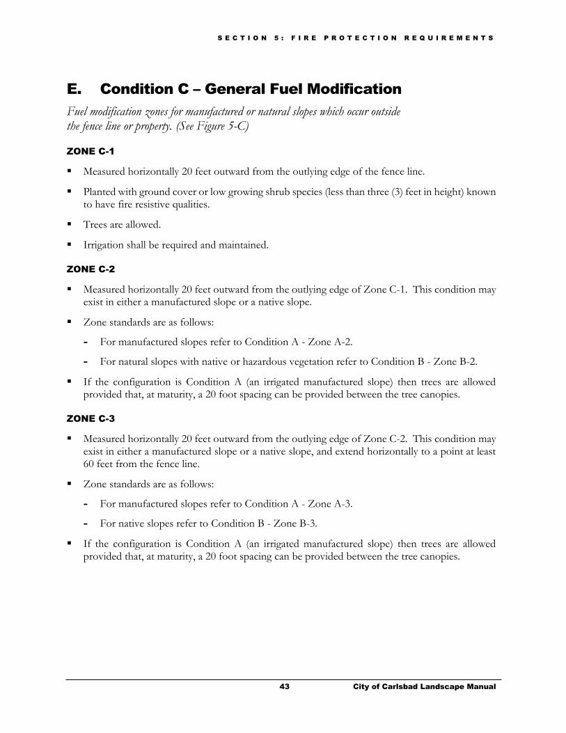
S E C T I O N 5 : F I R E P R O T E C T I O N R E Q U I R E M E N T S
43 City of Carlsbad Landscape Manual
E. Condition C – General Fuel Modification
Fuel modification zones for manufactured or natural slopes which occur outside the fence line or property. (See Figure 5-C)
ZONE C-1
Measured horizontally 20 feet outward from the outlying edge of the fence line.
Planted with ground cover or low growing shrub species (less than three (3) feet in height) known to have fire resistive qualities.
Trees are allowed.
Irrigation shall be required and maintained.
ZONE C-2
Measured horizontally 20 feet outward from the outlying edge of Zone C-1. This condition may exist in either a manufactured slope or a native slope.
Zone standards are as follows:
- For manufactured slopes refer to Condition A - Zone A-2.
- For natural slopes with native or hazardous vegetation refer to Condition B - Zone B-2.
If the configuration is Condition A (an irrigated manufactured slope) then trees are allowed provided that, at maturity, a 20 foot spacing can be provided between the tree canopies.
ZONE C-3
Measured horizontally 20 feet outward from the outlying edge of Zone C-2. This condition may exist in either a manufactured slope or a native slope, and extend horizontally to a point at least 60 feet from the fence line.
Zone standards are as follows:
- For manufactured slopes refer to Condition A - Zone A-3.
- For native slopes refer to Condition B - Zone B-3.
If the configuration is Condition A (an irrigated manufactured slope) then trees are allowed provided that, at maturity, a 20 foot spacing can be provided between the tree canopies.

44 City of Carlsbad Landscape Manual
This page is intentionally left blank.
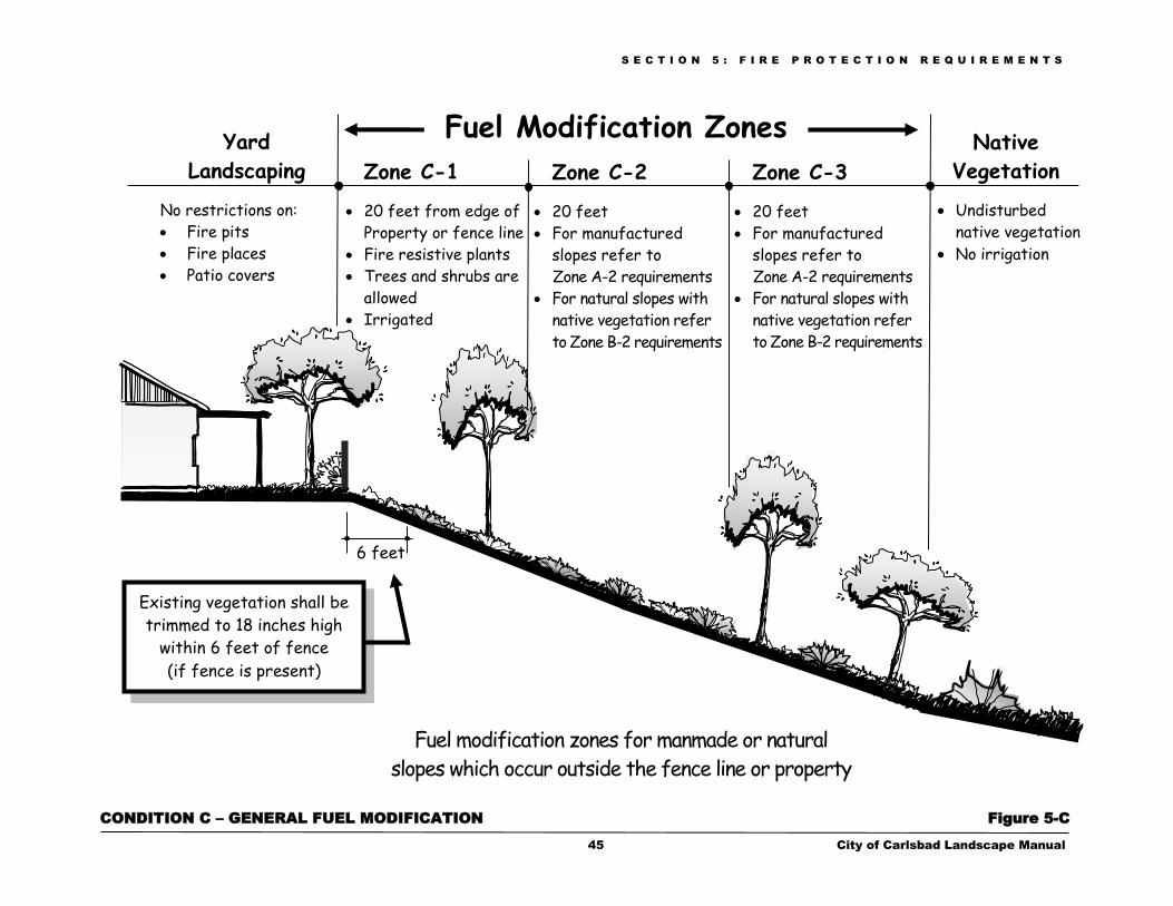
S E C T I O N 5 : F I R E P R O T E C T I O N R E Q U I R E M E N T S
45 City of Carlsbad Landscape Manual
CONDITION C – GENERAL FUEL MODIFICATION Figure 5-C
Zone C-3
20 feet
For manufactured
slopes refer to
Zone A-2 requirements
For natural slopes with
native vegetation refer
to Zone B-2 requirements
Fuel modification zones for manmade or natural
slopes which occur outside the fence line or property
Yard
Landscaping
No restrictions on:
Fire pits
Fire places
Patio covers
Native
Vegetation
Undisturbed
native vegetation
No irrigation
Zone C-2
20 feet
For manufactured
slopes refer to
Zone A-2 requirements
For natural slopes with
native vegetation refer
to Zone B-2 requirements
Zone C-1
20 feet from edge of
Property or fence line
Fire resistive plants
Trees and shrubs are
allowed
Irrigated
6 feet
Fuel Modification Zones
Existing vegetation shall be
trimmed to 18 inches high
within 6 feet of fence
(if fence is present)

This page is intentionally left blank.
S E C T I O N 6 : S T R E E T S C A P E P R O G R A M
47 City of Carlsbad Landscape Manual
Streetscape Program
Visual corridors play an important role in developing an image of Carlsbad, which in turn creates an enduring impression to aid in the City’s sense of place and community pride. The streetscape program includes requirements that ensure a safe streetscape design and contribute to a pleasing vehicular and pedestrian experience that accentuates the positive, natural, historical and architectural elements of Carlsbad.
A. Applicability
Projects that include the following elements are subject to the Streetscape Program requirements:
Mobility Element Street System landscaped medians
Manufactured slopes abutting public/private streets
Frontage setbacks abutting public/private streets
Rear and side yards that abut public/private streets
B. Street Tree Requirements
Provide a minimum of one (1) tree for every 40 feet of street frontage. Trees may be planted on center or grouped.
Street tree planting located on designated major streets shall be designed to provide continuity with the established street scene.
Master Plans or Specific Plans may include project-specific street tree requirements.
Trees shall be selected from the approved tree replacement list identified in Chapter 6 of the Carlsbad Community Forest Management Plan, unless approved otherwise.
Street trees shall be located:
- A minimum of seven (7) feet from any underground utility.
- In areas that do not conflict with public utilities.
- Outside of sight distance areas.
- Inside the public right of way, unless approved otherwise by the City.
Section
6
S E C T I O N 6 : S T R E E T S C A P E P R O G R A M
48 City of Carlsbad Landscape Manual
Street trees may be located within the public right-of-way, subject to approval by the City, for projects that are:
- Within a public street (i.e., arterial medians, traffic circles).
- Within the Village Review (V-R) Zone (CMC Chapter 21.35).
- Subject to the Planned Development Requirements (CMC Chapter 21.45).
- Within the Beach Area Overlay (BAO) Zones (CMC Chapter 21.82).
- Subject to City Council Policy 66 -Livable Neighborhoods.
Trees planted within five (5) feet of public sidewalks or other hardscape shall be installed with root barriers approved by the City.
C. Road Requirements
These roadways throughout the City have individual streetscape themes that create a recognizable identity for each particular thoroughfare or segment. The themes are based on the character or heritage of that specific area of Carlsbad and are described in more detail in Appendix E –Streetscape Themes. Substitutions for the landscape and hardscape elements described for each theme are permitted, provided that concrete and landscaping within the median and right-of-way are designed to provide street scene continuity. Alternative median designs using Low Impact Development features are also possible, as described below.
The specific trees creating a streetscape theme are made up of four types of trees: Median, Theme,
Support, and Project Identity/Accent Trees.
PERCENTAGE TOTAL OF
STREETSCAPE TREES
Median Island Trees – These trees complement the street trees and shall be installed as part of the required street improvements.
N/A
Theme Trees – These trees set the overall character of the streetscape and are located along the roadside but outside the right-of-way.
50%
(100% OF STANDARD)
Support Trees – These trees complement the theme tree. Select trees which fit the project site conditions.
30%
Project Identity/Accent Trees – The applicant can choose the best tree for the project and submit it for approval.
20%
D. Median Landscape Construction Requirements
1. GENERAL REQUIREMENTS
Unless otherwise approved by the City, median improvements on public streets are considered to be public improvements. Therefore, construction drawings for median landscaping, irrigation,
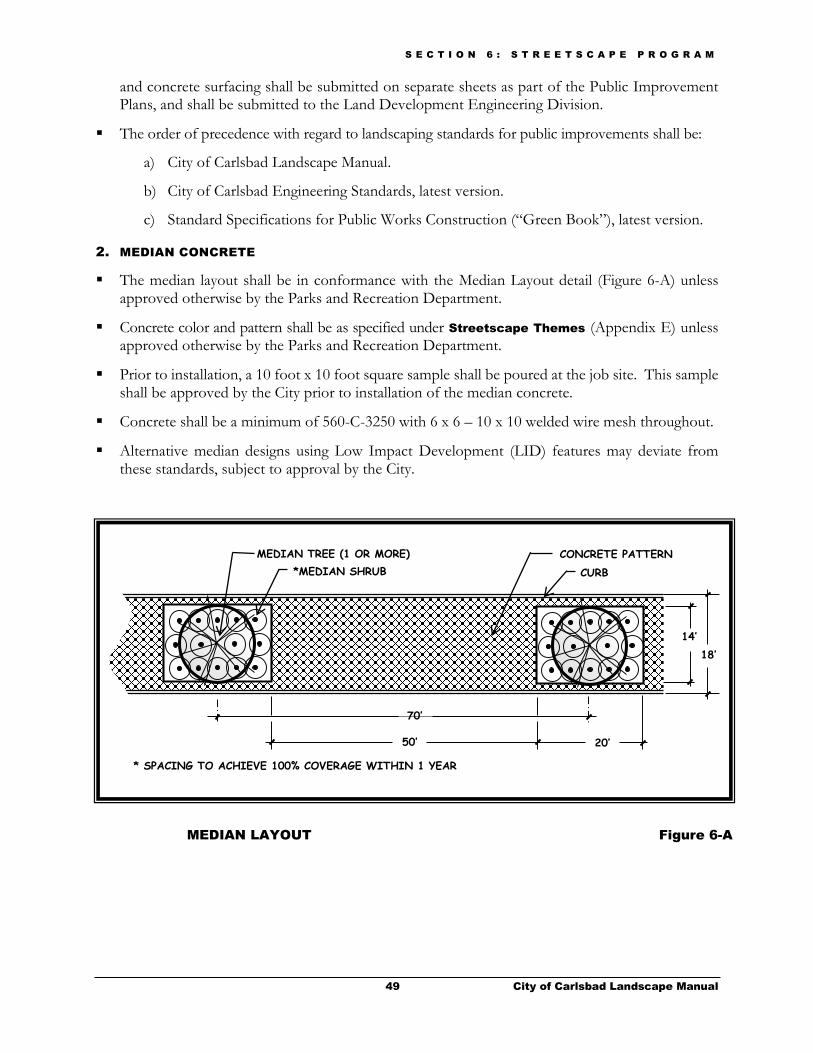
S E C T I O N 6 : S T R E E T S C A P E P R O G R A M
49 City of Carlsbad Landscape Manual
and concrete surfacing shall be submitted on separate sheets as part of the Public Improvement Plans, and shall be submitted to the Land Development Engineering Division.
The order of precedence with regard to landscaping standards for public improvements shall be:
a) City of Carlsbad Landscape Manual.
b) City of Carlsbad Engineering Standards, latest version.
c) Standard Specifications for Public Works Construction (“Green Book”), latest version.
2. MEDIAN CONCRETE
The median layout shall be in conformance with the Median Layout detail (Figure 6-A) unless approved otherwise by the Parks and Recreation Department.
Concrete color and pattern shall be as specified under Streetscape Themes (Appendix E) unless approved otherwise by the Parks and Recreation Department.
Prior to installation, a 10 foot x 10 foot square sample shall be poured at the job site. This sample shall be approved by the City prior to installation of the median concrete.
Concrete shall be a minimum of 560-C-3250 with 6 x 6 – 10 x 10 welded wire mesh throughout.
Alternative median designs using Low Impact Development (LID) features may deviate from these standards, subject to approval by the City.
MEDIAN TREE (1 OR MORE)
*MEDIAN SHRUB
CONCRETE PATTERN
CURB
* SPACING TO ACHIEVE 100% COVERAGE WITHIN 1 YEAR
14’
50’
70’
20’
18’
MEDIAN LAYOUT Figure 6-A
S E C T I O N 6 : S T R E E T S C A P E P R O G R A M
50 City of Carlsbad Landscape Manual
3. SOIL
Finish grade shall be two (2) inches below the concrete surface of the median.
Soil shall be suitable for plant growth and free of harmful substances or deleterious materials.
4. MEDIAN PLANTING
Trees and shrubs shall be as specified in Appendix E - Streetscape Themes unless approved otherwise by the Parks and Recreation Department.
Trees shall be 24 inch box minimum size; one or more per planter.
Shrubs shall be five (5) gallon minimum size.
Shrub spacing shall be such that 100% coverage will occur within one year.
Installation details shall conform to the Public Project Landscape Details available through the Parks and Recreation Department.
High water use plants, characterized by a plant factor of 0.7 to 1.0 are prohibited in street medians.
E. Irrigation Requirements
1. SPECIFIC REQUIREMENTS FOR ARTERIAL ROADS AND MEDIANS
All irrigation components shall conform to the Approved Irrigation Equipment List available through the Parks and Recreation Department. Any substitutions must be approved, in writing, by the Parks and Recreation Department prior to preparation and submittal of plans.
Installation details shall conform to current City of Carlsbad codes, policies, and standards.
Controllers and backflow devices shall be located two (2) feet inside the public right-of-way in the planting area unless specified otherwise by the City.
Water meters shall be installed as required by the public water purveyors.
Controllers shall be installed in separate steel locking enclosures. Enclosures shall have the following words stenciled with two (2) inch high white letters on the side facing the street. “CITY
OF CARLSBAD MEDIAN IRRIGATION”
Sleeving shall conform to irrigation requirements in Sect. 4 - Landscape Construction Documents.
No irrigation circuit shall span separate islands.
No irrigation circuit shall span more than five planters.
The irrigation system shall consist of pop-up overhead spray heads servicing the shrubs and deep watering devices (bubbler inside a drain pipe) servicing the trees. This requirement when applied to a median, is exempt from and supersedes any overhead spray limitation as noted for irrigation in other sections of this manual.
Quick couplers shall be installed along the mainline at a minimum of 150 feet on center or no less than every third median planter.
The public median irrigation shall be metered separately from the private parkway irrigation supply to ensure that public and private irrigation systems will function independently.

S E C T I O N 7 : S L O P E R E V E G E T A T I O N / E R O S I O N C O N T R O L
51 City of Carlsbad Landscape Manual
Slope Revegetation/Erosion Control
Soil erosion, loss of topsoil, and siltation of waterways and lagoons is detrimental to the quality of life in Carlsbad. Establishing permanent landscaping on slopes or disturbed areas is the most effective way to control erosion.
A. Slope Planting
1. AREAS OF APPLICATION (Planting)
Slopes – 6:1 or steeper and:
- 3 feet or less in vertical height and adjacent to public walks or streets require at a minimum Standard #1 (cover crop or erosion control matting.).
- Greater than 3 feet to 8 feet in vertical height require Standards #1 (erosion control matting shall be installed in lieu of a cover crop), #2 and #3.
- In excess of 8 feet in vertical height require Standards #1 (erosion control matting shall be installed in lieu of a cover crop), #2, #3 and #4.
Areas graded flatter than 6:1 require a cover crop per Standard #1 when they have one or more of the following conditions:
- Sheet graded pads not scheduled for improvements within six (6) months of completion of rough grading.
- A potential erosion problem as determined by the City.
- Identified by the City as highly visible areas to the public or have special conditions that warrant immediate treatment.
2. SLOPE PLANTING STANDARDS
Slopes requiring erosion control measures, as specified above, shall be treated with one or more of the following planting standards:
Section
7
S E C T I O N 7 : S L O P E R E V E G E T A T I O N / E R O S I O N C O N T R O L
52 City of Carlsbad Landscape Manual
Standard #1 – COVER CROP/ AND EROSION CONTROL MATTING
- Cover crop shall be a seed mix typically composed of quick germinating and fast covering grasses, clovers and/or wild flowers. Submit the specific seed mix for City approval prior to application.
- The cover crop shall be applied at a rate and manner sufficient to provide ninety (90%) percent coverage within thirty (30) days.
- Type of erosion control matting shall be as approved by the City and affixed to the slope as recommended by the manufacturer.
- On slopes 3 feet or less in vertical height where adjacent to public walks or streets:
When planting occurs between August 15 and April 15, erosion control matting shall be required.
During the remainder of the year, the cover crop and/or erosion control matting may be used.
- On slopes greater than 3 feet in height, erosion control matting shall be required and a cover crop shall not be used, unless otherwise approved by the City.
Standard #2 – GROUND COVER
- One hundred (100%) percent of the area shall be planted with a ground cover known to have excellent soil binding characteristics (planted from a minimum size of flatted material and spaced to provide full coverage within one (1) year).
Standard #3 – LOW SHRUBS
- Low spreading woody shrubs (planted from a minimum of 1-gallon containers) shall cover a minimum of seventy (70%) percent of the slope face (at mature size).
Standard #4 – TREES AND/OR LARGE SHRUBS
- Trees and/or large shrubs (planted from a minimum of 1-gallon containers) shall be installed at a minimum rate of one (1) plant per two hundred (200) square feet.
3. PLANTS
Plant materials used on slopes shall be those species that are known to have low water requirements and rooting systems of various depths that will minimize erosion and soil slippage.
4. HYDROSEED
Hyrdroseed in lieu of Standard #2 may be allowed if approved by the City and under the following conditions:
- Native plants are required to be planted as a condition of approval of the project by the City or other presiding agency and the required species are commercially unavailable in container or flatted stock.
- The slope is determined by the City to be too rocky for hand planting.
The hydroseed mix shall consist of a variety of long lived plant materials with root systems of varying depth.

S E C T I O N 7 : S L O P E R E V E G E T A T I O N / E R O S I O N C O N T R O L
53 City of Carlsbad Landscape Manual
5. ROCKY SLOPES
Planting is not required for:
Cut slopes that are determined by the City Engineer to be rocky in character and not subject to damage by erosion.
Any rocky slopes that are protected against erosion damage by other methods that have been specifically recommended by a soils engineer, engineering geologist, or equivalent authority and found to offer erosion protection equal to that provided by the planting specified in this section and they are approved by the City Engineer.
B. Slope Irrigation
1. AREAS OF APPLICATION (Irrigation)
All slope areas requiring planting shall be irrigated with a permanent automatically controlled irrigation system covering 100% of the planted area and in conformance with the following slope irrigation standards:
2. SLOPE IRRIGATION STANDARDS
Water service
- The plans shall demonstrate that the water service will be assigned to the proper current or future property owner(s) by ensuring that the water meter or point-of-connection (POC) is located within the ownership boundaries of the landscaped area served by the water meter. This is especially important on subdivisions and other complex projects that involve offsite work.
- Plans shall specify the size and type of proposed water service and meter. The location shall coincide with locations provided by the public improvement plans.
- Plans shall provide pressure loss calculations for each POC to ensure a minimum ten (10%) percent residual pressure based on the existing hydraulic grade line of the existing water system and the worse-case zone of the irrigation layout.
Pipe
- On-grade pipe is not allowed unless it is demonstrated to the satisfaction of the City that the rocky condition of the slope would prevent trenching.
- In cases where on-grade pipe is allowed it shall be the galvanized type or UVR resistant PVC approved by the City.
Separate circuits
- The top, bottom, and middle of slopes shall be designed to operate on separate circuits.
- Level planting areas five (5) feet or greater in width and adjacent to roads or walls shall be irrigated separately from the slopes.
Sprinkler head types
- The plan shall provide that any slope greater than twenty-five (25%) percent will be irrigated with an irrigation system with a precipitation rate of 0.75 inches per hour or less to prevent runoff and erosion. A 25% grade means one (1) foot of vertical elevation change for every four (4) feet of horizontal length. An applicant may employ an alternative design if the plan demonstrates that no runoff or erosion will occur.
S E C T I O N 8 : I N S T A L L A T I O N A N D C O M P L E T I O N
54 City of Carlsbad Landscape Manual
Installation and Completion
This section provides general installation and maintenance requirements that apply to all landscape projects within the City. Additionally, a list of documents that are required prior to receiving final approval for the landscape portion of a project are included and followed by a more detailed description of the contents of each of the required documents.
A. General Installation Requirements
1. MONITORING
The professional of record is required to monitor the installation of all irrigation and landscaping.
The contractor shall contact the professional of record prior to beginning landscape work and the designer of work shall review the project utility locations and revise plans accordingly to fully screen all utilities from view and protect all utilities (above & below grade) from invasive plant growth and roots.
Installation shall be complete prior to requesting final inspection for the project.
2. CHANGES TO APPROVED PLANS
All projects requiring approval of landscape plans must install and maintain the landscape in a manner which substantially conforms to the approved plans. Any changes to the approved landscape plans,
prior to or during installation, must be approved by the City in advance per the following processes:
Substitutions. Any materials substitutions shall be approved in writing in advance by the City.
Minor Construction Drawing Change. Changes to approved construction drawings where less than 25% of the design is modified shall be subject to a Minor Construction Drawing Change and submitted through the City Planning Division review process as required for approval per the Landscape Construction Change Submittal Checklist.
Major Construction Drawing Change. Changes to approved construction drawings where between 25% and 75% of the design is modified shall be subject to a Major Construction Drawing Change and submitted through the City Planning Division review process as required for approval per the Landscape Construction Change Submittal Checklist.
Section
8
S E C T I O N 8 : I N S T A L L A T I O N A N D C O M P L E T I O N
55 City of Carlsbad Landscape Manual
Over 75% Modification to Approved Plans. Changes to approved construction drawings where more than 75% of the design is modified will be considered as a new submittal and subject to new fees and full review.
3. PLANT INSTALLATION
Plants shall be installed in accordance with the San Diego Regional Standard Drawings unless approved otherwise.
B. General Maintenance Requirements
1. GENERAL LANDSCAPE MAINTENANCE
Planting areas shall be pruned and maintained to ensure a healthy and thriving condition.
Dead, dying and diseased vegetation shall be replaced.
Planted areas shall be maintained in a relatively weed-free condition and clear of undergrowth which may cause undue fire hazards.
Invasive species shall be eradicated.
Landscape shall be maintained to avoid obstructing motorist's views.
Mulch shall be replenished as needed. Supplemental soil amendments shall be added when necessary to support and maintain healthy plant growth.
Plants shall be fertilized and watered at such intervals as are necessary to promote optimum growth.
Integrated Pest Management principles and practices shall be included in the maintenance program.
2. GENERAL IRRIGATION MAINTENANCE
Landscape irrigation shall be applied at a rate not exceeding the infiltration rate of the soil (minimizing erosion and water waste) but sufficiently to allow for healthy plant growth.
Routine inspections shall be performed to guard against runoff and erosion and to detect plant or irrigation system failure.
The irrigation system and its components shall be repaired and replaced as necessary.
3. MAINTENANCE OF FUEL MODIFICATION ZONES
Areas of developments approved and subject to the requirements of Section 5 (Fire Protection Requirements) of this manual shall be maintained by the responsible private party (ie: underlying property owner or easement holder) in conformance with the approved Fire Protection Plan.
Plants shall be kept pruned to the volume requirements of the applicable Fuel Modification Zone.

S E C T I O N 8 : I N S T A L L A T I O N A N D C O M P L E T I O N
56 City of Carlsbad Landscape Manual
C. Installation for Slope Revegetation/Erosion Control
1. COMMENCEMENT OF IRRIGATION INSTALLATION
Installation of irrigation as shown on the approved plans shall commence within 10 days of the time when each slope is brought to grade as shown on the approved grading plans, unless otherwise permitted by the City’s engineering inspector.
2. COMPLETION OF PLANTING AND IRRIGATION INSTALLATION
Planting and irrigation for the areas described in Section 7 (Slope Revegetation/Erosion Control) shall be completely installed, as shown on the approved plans, within 30 days after the irrigation installation first commences, unless otherwise permitted by the City’s engineering inspector.
D. Documents Required for Project Completion
The following list of documents must be submitted to the City’s landscape inspector prior to final approval of landscape installation and release of security:
Certificate of Completion (Landscape Installation)
Soil Analysis Report and Recommendations
Irrigation Watering Schedule (Not required for projects exempt from WELO)
Maintenance Schedule (Not required for projects exempt from WELO)
Final As-built Plans
Irrigation Audit
Letter of Certification (Release of Security)
Added Requirements - Public Projects, Medians and City-maintained Landscape
Areas
1. CERTIFICATE OF COMPLETION (Landscape Installation)
The Certificate of Completion shall be submitted on the form provided by the City of Carlsbad and shall be signed by the professional of record.
A statement shall be included verifying that the landscaping and irrigation has been installed in conformance with the approved landscape and irrigation plans, all recommended soil amendments were incorporated, the installed irrigation system is functioning as designed and approved, the irrigation control system was properly programmed in accordance with the irrigation schedule, and the person operating the system has received all required maintenance and irrigation plans.
Private developments. The Certificate of Completion shall be submitted prior to granting a Permit of Occupancy. If the project is not encumbered by securities, the Letter of Certification and final irrigation as-builts must also be provided prior to occupancy.
For work done on public property that will be City-maintained, the Certificate of Completion shall be submitted prior to City approval of the work and prior to the required maintenance period.

S E C T I O N 8 : I N S T A L L A T I O N A N D C O M P L E T I O N
57 City of Carlsbad Landscape Manual
2. SOIL ANALYSIS REPORT AND RECOMMENDATIONS
Projects that require a grading permit. If the project involves mass grading of the site, the Soil Analysis Report and Recommendations, required under Section 4, must be submitted with the Certificate of Completion.
Projects that do not require a grading permit. If a grading permit is not required for the project, the report shall be submitted with the landscape documentation package and approved prior to the start of construction.
3. IRRIGATION WATERING SCHEDULE (WELO Requirement)
An irrigation watering schedule shall be prepared by the professional of record for all landscape projects subject to the Water Efficient Landscape Ordinance. The schedule shall be submitted to the City prior to granting a permit of occupancy and shall include the following information:
A description of the automatic irrigation system that will be used for the project.
The ETo data relied on to develop the irrigation schedule, including the source of the data.
The time period when overhead irrigation will be scheduled and confirm that no overhead irrigation shall be used between 10:00 a.m. and 6:00 p.m.
Irrigation systems using recycled water shall be scheduled for use between the hours of 10:00 p.m. and 6:00 a.m.
The parameters used for setting the irrigation system controller for watering times for:
- The plant establishment period
- Established landscaping
- Temporarily irrigated areas
- Different seasons during the year
The consideration used for each station for the following factors:
- The days between irrigation
- Station run time in minutes for each irrigation event, designed to avoid runoff
- Number of cycle starts required for each irrigation event, designed to avoid runoff
- Amount of water to be applied on a monthly basis
- The root depth setting
- The plant type setting
- The soil type
- The slope factor
- The shade factor

S E C T I O N 8 : I N S T A L L A T I O N A N D C O M P L E T I O N
58 City of Carlsbad Landscape Manual
4. MAINTENANCE SCHEDULE (WELO Requirement)
A maintenance schedule for the landscaping and irrigation system shall be prepared for all landscape projects subject to the Water Efficient Landscape Ordinance. The schedule shall be submitted to the City prior to granting a permit of occupancy and shall include provisions for the following:
General Landscape and Irrigation Maintenance. The schedule shall identify the entity that will be responsible for maintenance and shall provide for all of the general landscape and irrigation maintenance requirements listed in Section 8.B.
Water Efficient Landscape Maintenance. In addition to the general maintenance requirements, the maintenance schedule for landscape projects that are subject to the Water Efficient Landscape Ordinance shall include provisions to:
- Maintain and operate the landscaping and irrigation system on the property consistent with the MAWA.
- Maintain the irrigation system to meet or exceed an irrigation efficiency necessary to meet MAWA.
- Replace broken or malfunctioning irrigation system components with components of the same materials and specifications, their equivalent or better.
- Ensure that when vegetation is replaced, replacement plantings are representative of the hydrozone in which the plants were removed and are typical of the water use requirements of the plants removed, so that the replaced vegetation does not result in mixing high water use plants with low water use plants in the same hydrozone.
5. FINAL AS-BUILT PLANS
Final as-built plans shall be submitted and approved prior to release of securities.
Private projects require submittal of irrigation as-builts only. Final as-built plans shall be drafted clearly to the satisfaction of the City Planner.
Public Projects, Medians and Other City-maintained Landscape Areas require submittal of irrigation, planting, and construction as-builts. Final as-built plans shall be drafted clearly to the satisfaction of the Parks and Recreation Department.
Final as-built plans shall include (but not be limited to) the following minimum information:
- Irrigation:
Dimension all mainline and control wires (maximum every 100 feet along routing), and mainline changes in direction from two permanent points of reference.
Dimension all mainline equipment (water meter, backflow, flow sensor, master valve, remote control valves, quick coupler valves, ball/gate valves, etc.) from two permanent points of reference.
- Planting:
Changes in plant layout (minor changes are not required to be noted).
Substitutions in plant materials.
- Construction:
Changes in site layout (minor changes are not required to be noted).
S E C T I O N 8 : I N S T A L L A T I O N A N D C O M P L E T I O N
59 City of Carlsbad Landscape Manual
6. LETTER OF CERTIFICATION (Release of Security)
Prior to the release of security, the professional of record on the project shall submit a letter to the City’s landscape inspector certifying that he or she has inspected the work and that the project complies with the following conditions:
Planting and irrigation has been maintained in substantial conformance to the approved plans.
Plant materials are growing in a healthy and thriving condition.
All planting and related erosion control measures are in place and functional. Erosion control plantings provide a minimum 75% cover of the slope areas.
There is no evidence of excessive runoff from the irrigation system causing a soil erosion problem and/or wasting water.
7. IRRIGATION AUDIT REQUIREMENT & HYDROZONE DIAGRAM
Prior to release of security, the applicant shall submit a landscape irrigation audit that verifies water use is within the parameters of what was approved on the project. The audit shall be conducted by a third party certified landscape irrigation auditor. Landscape audits shall not be conducted by the person(s) who designed the landscape or installed the landscape.
A diagram of the irrigation plan showing hydrozones shall be kept with the irrigation controller for subsequent management purposes.
8. ADDED REQUIREMENTS - Public Projects, Medians and Other City-maintained
Landscape Areas
Maintenance Schedule. A schedule, showing the proposed maintenance activities and frequencies, shall be submitted to the City for approval at the time of acceptance of the median landscape construction or other City-maintained landscape area, and prior to commencement of the landscape maintenance period.
Maintenance Period for Medians. The developer is responsible to maintain all median hardscape, landscape and irrigation per the approved plan for 120 days from the date of the last inspection and approval by the City’s landscape inspector, or until the street improvements have been accepted by the City, whichever of the two periods is determined to be longer. Prior to acceptance, landscaping shall be deemed established and the irrigation system shall be operating properly to the satisfaction of the Parks and Recreation Director.
Prior to Final Acceptance. Landscaping shall be deemed healthy, established, and free of pests and diseases. All trash and debris shall be removed in addition to any weeds.
Final Acceptance. At the time of final acceptance, the City shall be given all controller enclosure keys, quick coupler keys, operation manuals, colored controller charts, and other items called out in the approved plans and specifications as necessary to maintain the landscape.

Appendices

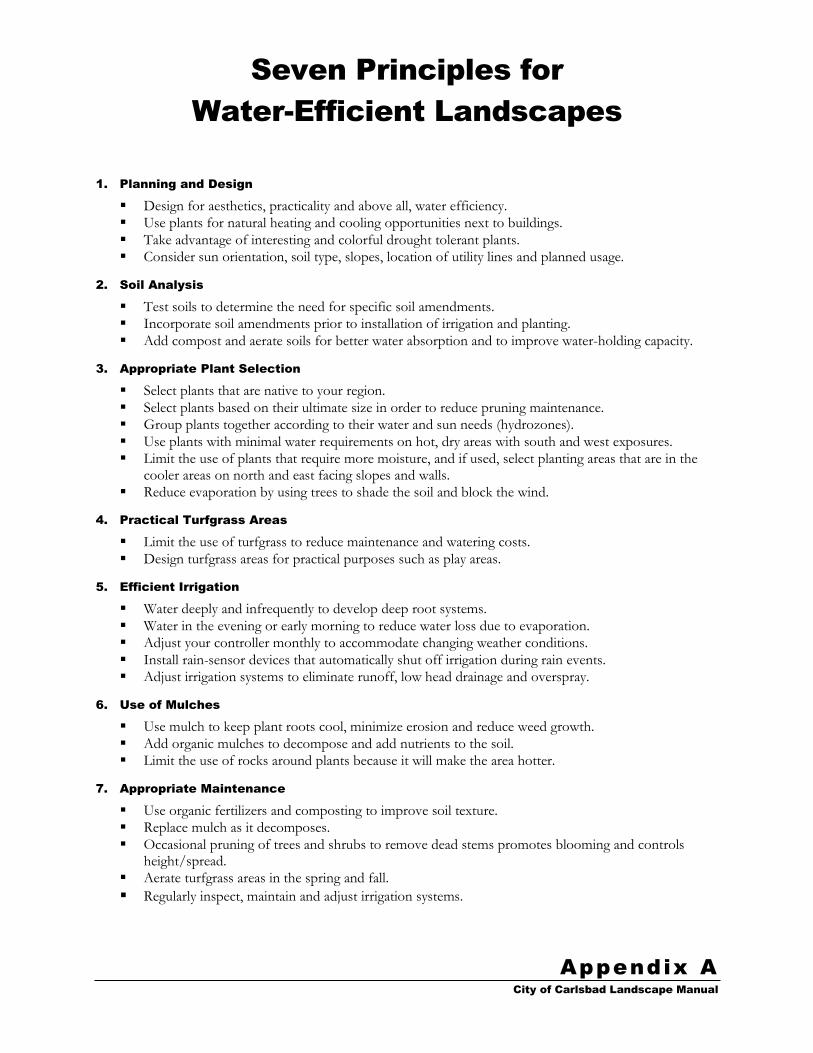
Seven Principles for
Water-Efficient Landscapes
City of Carlsbad Landscape Manual
Appendix A
1. Planning and Design
Design for aesthetics, practicality and above all, water efficiency.
Use plants for natural heating and cooling opportunities next to buildings.
Take advantage of interesting and colorful drought tolerant plants.
Consider sun orientation, soil type, slopes, location of utility lines and planned usage.
2. Soil Analysis
Test soils to determine the need for specific soil amendments.
Incorporate soil amendments prior to installation of irrigation and planting.
Add compost and aerate soils for better water absorption and to improve water-holding capacity.
3. Appropriate Plant Selection
Select plants that are native to your region.
Select plants based on their ultimate size in order to reduce pruning maintenance.
Group plants together according to their water and sun needs (hydrozones).
Use plants with minimal water requirements on hot, dry areas with south and west exposures.
Limit the use of plants that require more moisture, and if used, select planting areas that are in the cooler areas on north and east facing slopes and walls.
Reduce evaporation by using trees to shade the soil and block the wind.
4. Practical Turfgrass Areas
Limit the use of turfgrass to reduce maintenance and watering costs.
Design turfgrass areas for practical purposes such as play areas.
5. Efficient Irrigation
Water deeply and infrequently to develop deep root systems.
Water in the evening or early morning to reduce water loss due to evaporation.
Adjust your controller monthly to accommodate changing weather conditions.
Install rain-sensor devices that automatically shut off irrigation during rain events.
Adjust irrigation systems to eliminate runoff, low head drainage and overspray.
6. Use of Mulches
Use mulch to keep plant roots cool, minimize erosion and reduce weed growth.
Add organic mulches to decompose and add nutrients to the soil.
Limit the use of rocks around plants because it will make the area hotter.
7. Appropriate Maintenance
Use organic fertilizers and composting to improve soil texture.
Replace mulch as it decomposes.
Occasional pruning of trees and shrubs to remove dead stems promotes blooming and controls height/spread.
Aerate turfgrass areas in the spring and fall.
Regularly inspect, maintain and adjust irrigation systems.


Landscape Checklist
City of Carlsbad Landscape Manual
Appendix B
The following are excerpts from the requirements found in the body of the landscape manual. They do not necessarily encompass the entire extent of each requirement, but rather represent the essence of each item. When clarification is needed, the plan preparer should refer to the main text of the landscape manual for the complete requirement.
This checklist must be photocopied, filled out, signed and submitted with plans.
PROJECT NAME:
PROJECT NUMBER:
(CT, SDP, etc.)
TYPE OF PLANS (check all that apply)
Private Project Public Project Medians Streetscapes
Habitat Restoration Recycled Water Model Homes Trails
Fire Protection Plans Slope Revegetation ___________ ___________
YES N/A GENERAL REQUIREMENTS Reference
Submittals contain all required information and conform to the applicable formats. All Sections
Submittals conform to the plan size and format requirements. Section 3.B.2 Section 4.B.3
Plans prepared by licensed landscape architect, civil engineer, architect, or other qualified professional licensed by the state.
Section 3.B.1 Section 4.B.1
24” x 36” standard City title sheet with Planning Division title block is used and all information provided.
Section 4.B.3 24” x 36” standard City recycled water title sheet is used and all information provided
when recycled water is being proposed for use.
24” x 36” standard City of Carlsbad ‘D’ sheets with Planning Division title block.
Plans drawn at 1”=20’ (unless otherwise approved by the City).
Planting and irrigation plans drawn on 50% screen of civil engineer grading plan. Section 3.B.2 Section 4.B.3
Each plan sheet provided with bar scale, north arrow and graphic key for multiple sheet projects.
Section 3.B.3 Section 4.B.3
Existing and proposed grades and drainage elements shown. Section 3.B.3 Section 4.H.1
All elements on approved landscape concept plan shown. (check all that apply)
Section 3.C.9 Sections 4.B.2 and 4.H.1
existing features recreational areas play structures
hardscape outdoor eating areas water features
outdoor structures employee eating areas Site furniture
drinking fountains other:___________ other:___________
Property lines, right-of-ways, existing and proposed easements shown and labeled. Section 3.B.3
Vehicular sight lines shown and labeled (CalTrans and 25 foot sight distance triangle).
Storm water treatment systems shown and labeled. Section 3.C.8
Show and label impervious and pervious pavement.
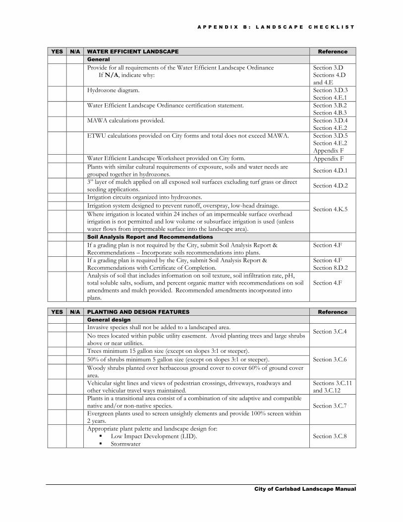
A P P E N D I X B : L A N D S C A P E C H E C K L I S T
City of Carlsbad Landscape Manual
YES N/A WATER EFFICIENT LANDSCAPE Reference
General
Provide for all requirements of the Water Efficient Landscape Ordinance If N/A, indicate why:
Section 3.D Sections 4.D and 4.E
Hydrozone diagram. Section 3.D.3 Section 4.E.1
Water Efficient Landscape Ordinance certification statement. Section 3.B.2 Section 4.B.3
MAWA calculations provided. Section 3.D.4 Section 4.E.2
ETWU calculations provided on City forms and total does not exceed MAWA. Section 3.D.5 Section 4.E.2 Appendix F
Water Efficient Landscape Worksheet provided on City form. Appendix F
Plants with similar cultural requirements of exposure, soils and water needs are grouped together in hydrozones.
Section 4.D.1
3” layer of mulch applied on all exposed soil surfaces excluding turf grass or direct seeding applications.
Section 4.D.2
Irrigation circuits organized into hydrozones.
Section 4.K.5
Irrigation system designed to prevent runoff, overspray, low-head drainage.
Where irrigation is located within 24 inches of an impermeable surface overhead irrigation is not permitted and low volume or subsurface irrigation is used (unless water flows from impermeable surface into the landscape area).
Soil Analysis Report and Recommendations
If a grading plan is not required by the City, submit Soil Analysis Report & Recommendations – Incorporate soils recommendations into plans.
Section 4.F
If a grading plan is required by the City, submit Soil Analysis Report & Recommendations with Certificate of Completion.
Section 4.F Section 8.D.2
Analysis of soil that includes information on soil texture, soil infiltration rate, pH, total soluble salts, sodium, and percent organic matter with recommendations on soil amendments and mulch provided. Recommended amendments incorporated into plans.
Section 4.F
YES N/A PLANTING AND DESIGN FEATURES Reference
General design
Invasive species shall not be added to a landscaped area. Section 3.C.4 No trees located within public utility easement. Avoid planting trees and large shrubs
above or near utilities.
Trees minimum 15 gallon size (except on slopes 3:1 or steeper).
Section 3.C.6
50% of shrubs minimum 5 gallon size (except on slopes 3:1 or steeper).
Woody shrubs planted over herbaceous ground cover to cover 60% of ground cover area.
Vehicular sight lines and views of pedestrian crossings, driveways, roadways and other vehicular travel ways maintained.
Sections 3.C.11 and 3.C.12
Plants in a transitional area consist of a combination of site adaptive and compatible native and/or non-native species. Section 3.C.7
Evergreen plants used to screen unsightly elements and provide 100% screen within 2 years.
Appropriate plant palette and landscape design for:
Low Impact Development (LID).
Stormwater
Section 3.C.8

A P P E N D I X B : L A N D S C A P E C H E C K L I S T
City of Carlsbad Landscape Manual
YES N/A PLANTING AND DESIGN FEATURES (continued) Reference
General technical
General planting notes, details and specifications. Section 4.H.2
Graphic representation and location of all existing plant material to remain and to be removed and proposed plant material to be installed.
Section 3.C.3 Section 4.H.1
Trees over 12” in diameter identified by caliper size, type & label to be retained or removed.
Section 3.C.3
Plant palette that lists all existing and proposed vegetation by common and botanical name and includes total quantities by container size and species.
Section 3.C.2 Section 4.H.1
Areas permanently and solely dedicated to edible plants identified. Section 4.H.1 Seed mix information to include mix, rate, purity, germination, inoculation,
fertilization, binder and mulch.
Trees staked or guyed. Section 4.H.2 Slope planting detail indicates the rear of planting pit shall be graded to Maximum 1:1
slope and slope covered with erosion control fabric.
Trees located within 5 feet of public sidewalks or other hardscape have root barriers. Section 4.H.2 Section 6.B
Streetscape requirements
One street tree per 40 feet of street frontage (planted on-center or grouped). Section 6.B
Street trees located on designated major roads designed to provide continuity with established street scene or Streetscape Themes.
Section 6.C Appendix E
Street trees located: A minimum 3 feet outside of the public right of way. A minimum 7 feet away from sewer lines. So as not to conflict with public utilities. Outside of vehicular sight lines.
Section 6.B
Street trees are located within the public right-of way. If YES, state reason why:
Section 6.B
Parking lots
Minimum 3% of parking area landscaped.
Section 3.C.13
Trees provided at minimum rate of 1 tree per every 4 parking stalls.
Trees planted a minimum of 2 feet from back of curb.
5 foot wide planting strip next to through traffic lane.
4 foot clear landscaping in planters between double parking rows (where applicable).
Islands at the end of each parking row shall be used as planted area.
Minimum 8 foot wide perimeter landscape strip around parking facilities.
3 foot high screen around parking lots (berms, shrubs and/or walls).
Slope revegetation/erosion control
Slopes 6:1 or steeper and in excess of 8 feet in vertical height have: a) Standard #1 - cover crop and erosion control matting b) Standard #2 - ground cover from flats; 100% coverage within 1 year c) Standard #3 - low spreading shrubs (min. 1 gal.); 70% coverage d) Standard #4 - trees and/or large shrubs (min. 1 gal.); one plant/200 sf
Sections 7.A.1 and 7.A.2
Slopes 6:1 or steeper and greater than 3 feet and up to 8 feet in vertical height have Standard #1, #2, and #3 above.
Slopes 6:1 or steeper and 3 feet or less in vertical height and adjacent to public walks or streets shall have Standard #1 above.
Slopes graded flatter than 6:1 have standard #1 above when they have one or more of the following conditions:
a) Sheet graded pads not scheduled for improvements within 6 months of completion of rough grading.
b) Potential erosion problem. c) Highly visible area.
Plant materials and seed mixes consist of a variety of long lived, low water requirement plant materials with root systems of varying depth.
Section 7.A.3

A P P E N D I X B : L A N D S C A P E C H E C K L I S T
City of Carlsbad Landscape Manual
YES N/A IRRIGATION Reference
General
General irrigation notes, details and specifications.
Section 4.K.4
Illustrate location, type and size of all components of the irrigation system.
Legend explaining all symbols with manufacturer, precipitation rate, g.p.m’s, radii of each sprinkler type and detail reference.
All equipment sized, their control valve size and station number provided and gallon per minute stated. Pipe sizes indicated.
Pressure loss calculation provided for worst case valve with minimum 10% residual provided.
Section 4.K.4 Section 7.B.2
Designed for use of recycled water (excluding private residential or front yards of individually metered condos) (current or future). If exempted from this requirement, provide documentation from the City of Carlsbad Utilities Department.
Section 3.D.1 Section 4.K.2
Irrigation provided to fire suppression areas where applicable. Sections 5.C, 5.D and 5.E
Point of connection/backflow
Separate water service for landscaping (except residential projects under 4 units).
Section 4.K.4
Water meters shown with type (recycled or potable), sizes noted, static pressure provided, and maximum flow rate in gallons per minute with design operating pressure.
Water meter location shall coincide with locations provided by the public improvement plans. Note the street station number on the irrigation plan.
Section 4.K.4 Section 7.B.2
Pipe between meter and backflow is copper. Section 4.K.6
Backflow preventers provided per code and/or City standards.
Backflow testing notes.
Pressure regulation
Pressure regulating valves used when pressure exceeds 60 psi at the valve. Section 4.K.6
Pressure regulating device used when pressure exceeds 80 psi at POC.
Pressure differential within circuits less than 20%
Controller
Automatic controller capable of dual or multiple programming and multiple cycle start capacity. Section 4.K.6
Equipped with rain shut-off (weather based system or soil moisture detection).
Valves
Manual shut-off valve at water supply.
Section 4.K.6
Manual shutoff valves installed between each zone of system and water supply.
Master shut-off valves activated by automatic controller except with individual control sprinklers with individual pressure systems.
Flow sensors for non-residential landscapes and residential landscapes over 5,000 sq. ft.
Gallons per minute provided for each remote control valve.
Quick couplers installed at a maximum of 150 feet along mainline.
Lug type quick couplers for potable water.
Check valves to prevent low head drainage.
Serviceable check valves where elevation differential may cause low head drainage.
Pipe/sleeves
Water velocities in pipe at 5 feet per second or less.
Section 4.K.6
All pipe below grade (18” minimum for main and 12” for laterals).
PVC mains Class 315 (2” or larger) or Schedule 40 (1-½” or smaller).
PVC lateral Class 200 (except for ½” shall be schedule 40).
Sleeves under improvements (Sch. 80 under roads minimum 36” cover; Sch. 40 other than under roads minimum 18” cover) 2 times the line size.
Sleeves provided for control wires under improvements.
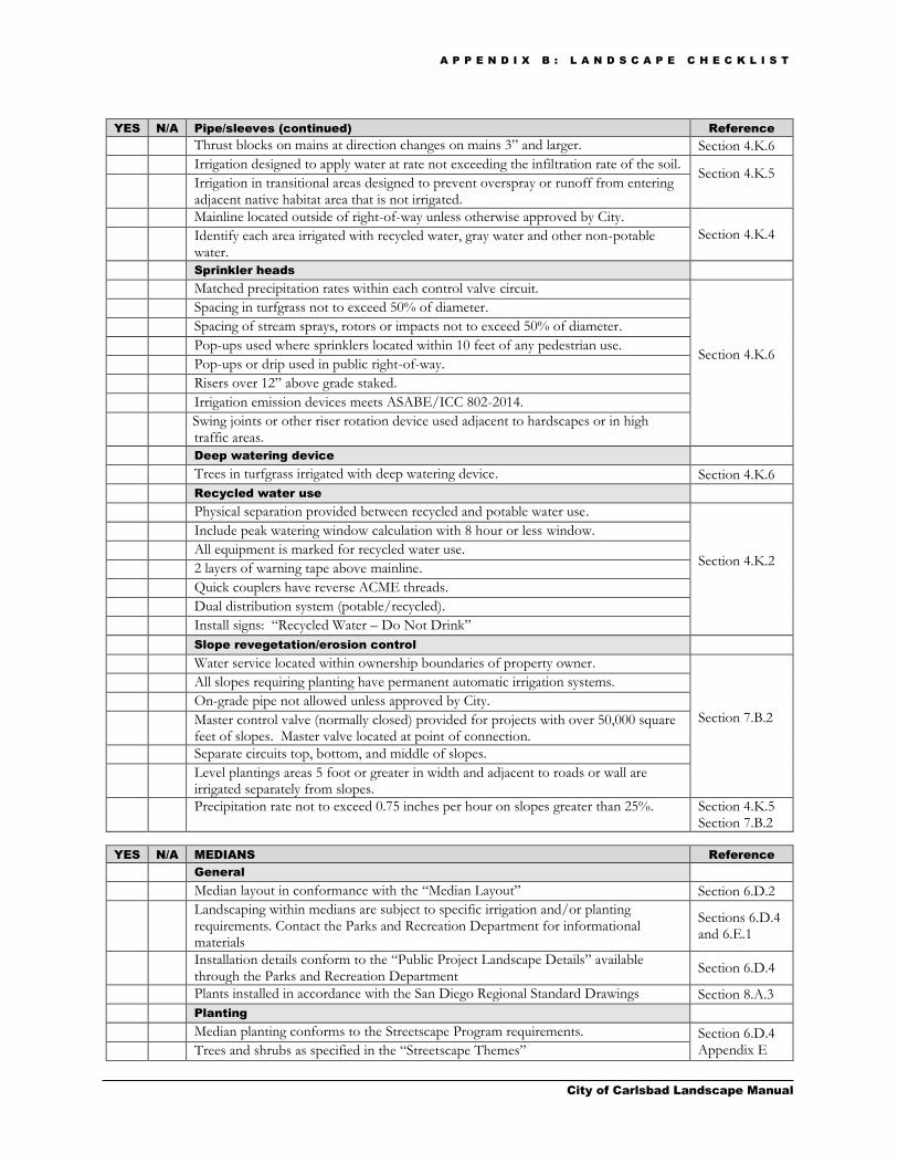
A P P E N D I X B : L A N D S C A P E C H E C K L I S T
City of Carlsbad Landscape Manual
YES N/A Pipe/sleeves (continued) Reference
Thrust blocks on mains at direction changes on mains 3” and larger. Section 4.K.6
Irrigation designed to apply water at rate not exceeding the infiltration rate of the soil. Section 4.K.5 Irrigation in transitional areas designed to prevent overspray or runoff from entering
adjacent native habitat area that is not irrigated.
Mainline located outside of right-of-way unless otherwise approved by City.
Section 4.K.4 Identify each area irrigated with recycled water, gray water and other non-potable water.
Sprinkler heads
Matched precipitation rates within each control valve circuit.
Section 4.K.6
Spacing in turfgrass not to exceed 50% of diameter.
Spacing of stream sprays, rotors or impacts not to exceed 50% of diameter.
Pop-ups used where sprinklers located within 10 feet of any pedestrian use.
Pop-ups or drip used in public right-of-way.
Risers over 12” above grade staked.
Irrigation emission devices meets ASABE/ICC 802-2014.
Swing joints or other riser rotation device used adjacent to hardscapes or in high traffic areas.
Deep watering device
Trees in turfgrass irrigated with deep watering device. Section 4.K.6
Recycled water use
Physical separation provided between recycled and potable water use.
Section 4.K.2
Include peak watering window calculation with 8 hour or less window.
All equipment is marked for recycled water use.
2 layers of warning tape above mainline.
Quick couplers have reverse ACME threads.
Dual distribution system (potable/recycled).
Install signs: “Recycled Water – Do Not Drink”
Slope revegetation/erosion control
Water service located within ownership boundaries of property owner.
Section 7.B.2
All slopes requiring planting have permanent automatic irrigation systems.
On-grade pipe not allowed unless approved by City.
Master control valve (normally closed) provided for projects with over 50,000 square feet of slopes. Master valve located at point of connection.
Separate circuits top, bottom, and middle of slopes.
Level plantings areas 5 foot or greater in width and adjacent to roads or wall are irrigated separately from slopes.
Precipitation rate not to exceed 0.75 inches per hour on slopes greater than 25%. Section 4.K.5 Section 7.B.2
YES N/A MEDIANS Reference
General
Median layout in conformance with the “Median Layout” Section 6.D.2
Landscaping within medians are subject to specific irrigation and/or planting requirements. Contact the Parks and Recreation Department for informational materials
Sections 6.D.4 and 6.E.1
Installation details conform to the “Public Project Landscape Details” available through the Parks and Recreation Department
Section 6.D.4
Plants installed in accordance with the San Diego Regional Standard Drawings Section 8.A.3
Planting
Median planting conforms to the Streetscape Program requirements. Section 6.D.4 Appendix E Trees and shrubs as specified in the “Streetscape Themes”
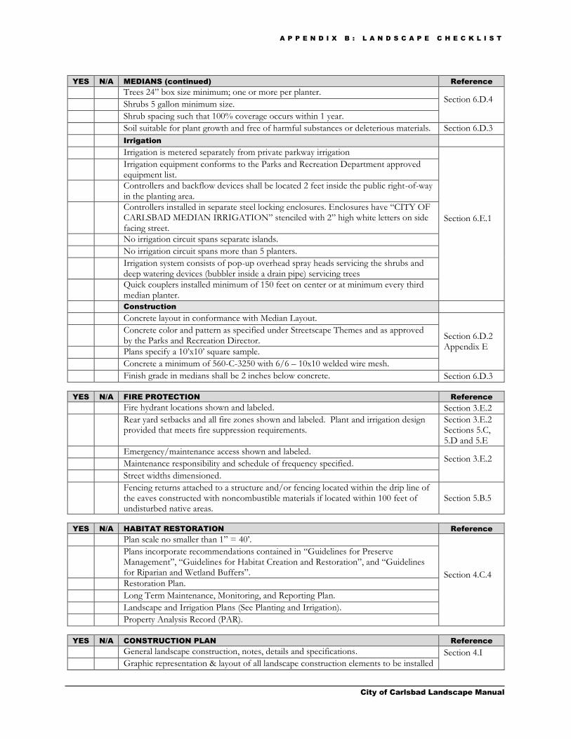
A P P E N D I X B : L A N D S C A P E C H E C K L I S T
City of Carlsbad Landscape Manual
YES N/A MEDIANS (continued) Reference
Trees 24” box size minimum; one or more per planter. Section 6.D.4
Shrubs 5 gallon minimum size.
Shrub spacing such that 100% coverage occurs within 1 year.
Soil suitable for plant growth and free of harmful substances or deleterious materials. Section 6.D.3
Irrigation
Irrigation is metered separately from private parkway irrigation
Section 6.E.1
Irrigation equipment conforms to the Parks and Recreation Department approved equipment list.
Controllers and backflow devices shall be located 2 feet inside the public right-of-way in the planting area.
Controllers installed in separate steel locking enclosures. Enclosures have “CITY OF CARLSBAD MEDIAN IRRIGATION” stenciled with 2” high white letters on side facing street.
No irrigation circuit spans separate islands.
No irrigation circuit spans more than 5 planters.
Irrigation system consists of pop-up overhead spray heads servicing the shrubs and deep watering devices (bubbler inside a drain pipe) servicing trees
Quick couplers installed minimum of 150 feet on center or at minimum every third median planter.
Construction
Concrete layout in conformance with Median Layout.
Section 6.D.2 Appendix E
Concrete color and pattern as specified under Streetscape Themes and as approved by the Parks and Recreation Director.
Plans specify a 10’x10’ square sample.
Concrete a minimum of 560-C-3250 with 6/6 – 10x10 welded wire mesh.
Finish grade in medians shall be 2 inches below concrete. Section 6.D.3
YES N/A FIRE PROTECTION Reference
Fire hydrant locations shown and labeled. Section 3.E.2
Rear yard setbacks and all fire zones shown and labeled. Plant and irrigation design provided that meets fire suppression requirements.
Section 3.E.2 Sections 5.C, 5.D and 5.E
Emergency/maintenance access shown and labeled. Section 3.E.2
Maintenance responsibility and schedule of frequency specified.
Street widths dimensioned.
Fencing returns attached to a structure and/or fencing located within the drip line of the eaves constructed with noncombustible materials if located within 100 feet of undisturbed native areas.
Section 5.B.5
YES N/A HABITAT RESTORATION Reference
Plan scale no smaller than 1” = 40’.
Section 4.C.4
Plans incorporate recommendations contained in “Guidelines for Preserve Management”, “Guidelines for Habitat Creation and Restoration”, and “Guidelines for Riparian and Wetland Buffers”.
Restoration Plan.
Long Term Maintenance, Monitoring, and Reporting Plan.
Landscape and Irrigation Plans (See Planting and Irrigation).
Property Analysis Record (PAR).
YES N/A CONSTRUCTION PLAN Reference
General landscape construction, notes, details and specifications. Section 4.I Graphic representation & layout of all landscape construction elements to be installed

A P P E N D I X B : L A N D S C A P E C H E C K L I S T
City of Carlsbad Landscape Manual
YES N/A CONSTRUCTION PLAN (continued) Reference
Aspects of landscape construction shown on architects’, engineers’ or other plans is indicated on the landscape plans and references plans and sheet numbers where occurs.
Section 4.I
Fountains/water features shall have recirculating systems. Section 4.D.3
Fountains, decorative pools and ponds shall utilize recycled water if available.
Detailed description of each water feature included in the landscape area. Section 3.C.9
All signage including monuments require separate permits. If signage is included on the plans a note is to be added as follows: “All project signage and monuments shall require a separate permit under the city of Carlsbad signage review process.”
Section 4.I
Model homes
Educational signage with text specified. Section 4.D.4
YES N/A GRADING DESIGN (For projects that do not require approval of a grading
plan and an as-built grading plan or previously approved grading plan does
not exist)
Reference
Elevations, slope heights, drainage patterns, pad elevations, storm water management and finish grades shown.
Section 4.J
Plans indicate positive drainage away from structures and termination in approved drainage system.
Grading designed for efficient use of water, minimizing soil erosion, runoff and water waste.
Grading designed to comply with best management practices.
Integrates Low Impact Development (LID) features. If YES, briefly describe types: Section 3.C.8
PLAN PREPARER:
COMPANY NAME:
DATE:

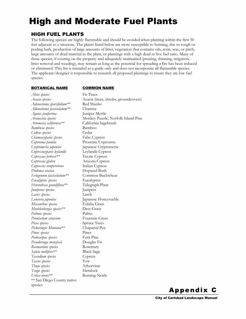
High and Moderate Fuel Plants
City of Carlsbad Landscape Manual
Appendix C
HIGH FUEL PLANTS
The following species are highly flammable and should be avoided when planting within the first 50 feet adjacent to a structure. The plants listed below are more susceptible to burning, due to rough or peeling bark, production of large amounts of litter, vegetation that contains oils, resin, wax, or pitch, large amounts of dead material in the plant, or plantings with a high dead to live fuel ratio. Many of these species, if existing on the property and adequately maintained (pruning, thinning, irrigation, litter removal and weeding), may remain as long as the potential for spreading a fire has been reduced or eliminated. This list is intended as a guide only and does not incorporate all flammable species. The applicant/designer is responsible to research all proposed plantings to insure they are low fuel species.
BOTANICAL NAME COMMON NAME
Abies species Acacia species Adenostoma sparsifolium** Adenostoma fasciculatum** Agonis juniperina Araucaria species Artemesia californica** Bambusa species Cedrus species Chamaecyparis species Coprosma pumila Cryptomeria japonica Cupressocyparis leylandii Cupressus forbesii** Cupressus glabra Cupressus sempervirens Dodonea viscosa Eriogonum fasciculatum** Eucalyptus species Heterotheca grandiflora** Juniperus species Larix species Lonicera japonica Miscanthus species Muehlenbergia species** Palmae species Pennisetum setaceum Picea species Pickeringia Montana** Pinus species Podocarpus species Pseudotsuga menziesii Rosmarinus species Salvia mellifera** Taxodium species Taxus species Thuja species Tsuga species Urtica urens** ** San Diego County native species
Fir Trees Acacia (trees, shrubs, groundcovers) Red Shanks Chamise Juniper Myrtle Monkey Puzzle, Norfolk Island Pine California Sagebrush Bamboo Cedar False Cypress Prostrate Coprosma Japanese Cryptomeria Leylandii Cypress Tecate Cypress Arizona Cypress Italian Cypress Hopseed Bush Common Buckwheat Eucalyptus Telegraph Plant Junipers Larch Japanese Honeysuckle Eulalia Grass Deer Grass Palms Fountain Grass Spruce Trees Chaparral Pea Pines Fern Pine Douglas Fir Rosemary Black Sage Cypress Yew Arborvitae Hemlock Burning Nettle
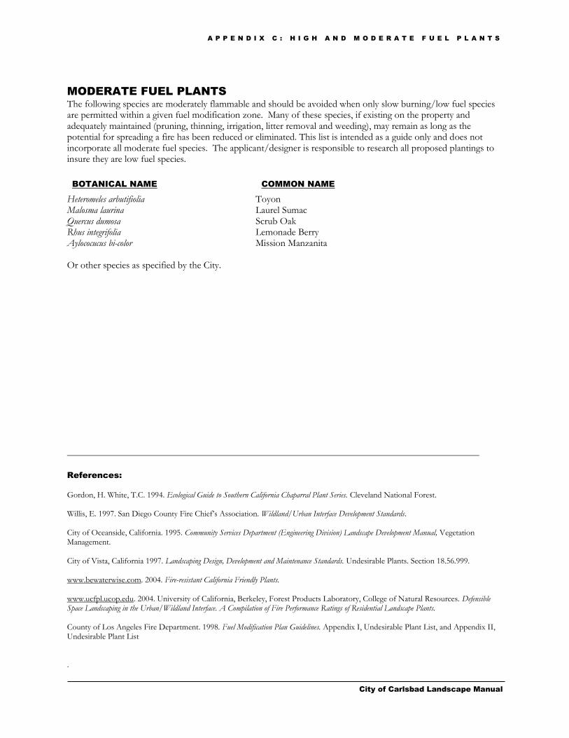
A P P E N D I X C : H I G H A N D M O D E R A T E F U E L P L A N T S
City of Carlsbad Landscape Manual
MODERATE FUEL PLANTS
The following species are moderately flammable and should be avoided when only slow burning/low fuel species are permitted within a given fuel modification zone. Many of these species, if existing on the property and adequately maintained (pruning, thinning, irrigation, litter removal and weeding), may remain as long as the potential for spreading a fire has been reduced or eliminated. This list is intended as a guide only and does not incorporate all moderate fuel species. The applicant/designer is responsible to research all proposed plantings to insure they are low fuel species.
BOTANICAL NAME COMMON NAME
Heteromeles arbutifiolia Toyon Malosma laurina Laurel Sumac Quercus dumosa Scrub Oak Rhus integrifolia Lemonade Berry Aylococucus bi-color Mission Manzanita Or other species as specified by the City.
References:
Gordon, H. White, T.C. 1994. Ecological Guide to Southern California Chaparral Plant Series. Cleveland National Forest. Willis, E. 1997. San Diego County Fire Chief’s Association. Wildland/Urban Interface Development Standards. City of Oceanside, California. 1995. Community Services Department (Engineering Division) Landscape Development Manual, Vegetation Management. City of Vista, California 1997. Landscaping Design, Development and Maintenance Standards. Undesirable Plants. Section 18.56.999. www.bewaterwise.com. 2004. Fire-resistant California Friendly Plants. www.ucfpl.ucop.edu. 2004. University of California, Berkeley, Forest Products Laboratory, College of Natural Resources. Defensible Space Landscaping in the Urban/Wildland Interface. A Compilation of Fire Performance Ratings of Residential Landscape Plants. County of Los Angeles Fire Department. 1998. Fuel Modification Plan Guidelines. Appendix I, Undesirable Plant List, and Appendix II, Undesirable Plant List .

Appendix D Prescriptive Compliance Option
City of Carlsbad Landscape Manual
Appendix D
This appendix contains prescriptive requirements which may be used as a compliance option to the Water Efficient Landscape Ordinance and this Landscape Manual for projects of less than 2,500 square feet. Compliance with the following items is mandatory and must be documented on a landscape plan in order to use this option.
Project Applicant: Date:
Project Address: Assessor’s Parcel Number:
Total Landscape Area: Turf Area: Plant Area:
Project Type:
Water Supply Type:
Project Contact Name and Number:
“I agree to comply with the requirements of the prescriptive compliance option to the City of Carlsbad Landscape Manual”
Signed: Date:
YES N/A REQUIREMENTS
A. Incorporate compost at a rate of at least four cubic yards per 1,000 square feet to a depth of six inches into landscape area (unless contraindicated by a soil test)
B. Plant material shall comply with all of the following:
1. For residential areas, install climate adapted plants that require occasional, little or no summer water (average WUCOLS plant factor 0.3) for 75% of the plant area excluding edibles and areas using recycled water.
2. For non-residential areas, install climate adapted plants that require occasional, little or no summer water (average WUCOLS plant factor 0.3) for 100% of the plant area excluding edibles and areas using recycled water.
3. A minimum three inch (3″) layer of mulch shall be applied on all exposed soil surfaces of planting areas except in turf areas, creeping or rooting groundcovers, or direct seeding applications where mulch is contraindicated.
C. Turf shall comply with all of the following:
1. Turf shall not exceed 25% of the landscape area in residential areas, and there shall be no turf in non-residential areas.
2. Turf shall not be planted on sloped areas which exceed a slope of 1 foot vertical elevation change for every 4 feet of horizontal length.
3. Turf is prohibited in parkways less than 10 feet wide, unless the parkway is adjacent to a parking strip and used to enter and exit vehicles. Any turf in parkways must be irrigated by subsurface irrigation or by other technology that creates no overspray or runoff.
D. Irrigation systems shall comply with the following:
1. Automatic irrigation controllers are required and must use evapotranspiration or soil moisture sensor data and utilize a rain sensor.
2. Irrigation controllers shall be of a type which does not lose programming data in the event the primary power source is interrupted.
3. Pressure regulators shall be installed on the irrigation system to ensure the dynamic pressure of the system is within the manufacturers recommended pressure range.
4. Manual shut-off valves (such as a gate valve, ball valve, or butterfly valve) shall be installed as close as possible to the point of connection of the water supply.
5. All irrigation emission devices must meet the requirements set in the ANSI standard, ASABE/ICC 802-2014. “Landscape Irrigation Sprinkler and Emitter Standard,” All sprinkler heads installed in the landscape must document a distribution uniformity low quarter of 0.65 or higher using the protocol defined in ASABE/ICC 802-2014.
6. Areas less than ten (10) feet in width in any direction shall be irrigated with subsurface irrigation or other means that produces no runoff or overspray.
E. For non-residential projects with landscape areas of 1,000 sq. ft. or more, a private submeter(s) to measure landscape water use shall be installed.
At the time of final inspection, the permit applicant must provide the owner of the property with a certificate of completion, certificate of installation, irrigation schedule and a schedule of landscape and irrigation maintenance.

City of Carlsbad Landscape Manual

Streetscape Themes
City of Carlsbad Landscape Manual
Appendix E
Alga Road
THEME: Coastal foothills
PLANTING SCHEME: Informal
LANDSCAPE: Median Tree: Pinus canariensis, Canary Island Pine
Median Shrubs: Coprosma kirkii (west of El Camino Real) Lantana M. species (east of El Camino Real)
Theme Tree: Pinus canariensis, Canary Island Pine
Support Trees: Eucalyptus torquata Eucalyptus Pine species
(1)
MEDIAN ISLAND
CONCRETE: To match existing median condition in Alga Road
Cannon Road - Carlsbad Boulevard to El Camino Real THEME: Lagoon vistas and wetlands PLANTING SCHEME: Informal
LANDSCAPE: Median Tree: Melaleuca leucadendra, Cajeput Tree Median Shrubs: Limonium perezii, Statice
Baccharis pilularis, Coyote Brush
Theme Tree: Pinus torreyanna, Torrey Pine
Support Trees: Eucalyptus species Melaleuca leucadendra, Cajeput Tree
(1)
MEDIAN ISLAND *Surface Texture: Exposed aggregate with brick bands around
CONCRETE: each planter. *Color: Concrete (natural), brick (charcoal)
*or to match existing median condition in Cannon Road
(1) A pervious paving alternative to median island concrete may be used within median islands, subject to review and approval by the
Parks and Recreation Department and the Land Development Engineering Division.
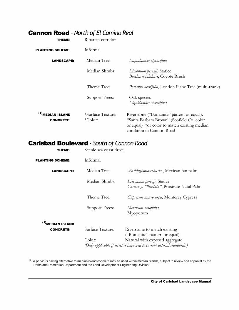
City of Carlsbad Landscape Manual
Cannon Road – North of El Camino Real THEME: Riparian corridor PLANTING SCHEME: Informal
LANDSCAPE: Median Tree: Liquidamber styraciflua
Median Shrubs: Limonium perezii, Statice Baccharis pilularis, Coyote Brush
Theme Tree: Platanus acerifolia, London Plane Tree (multi-trunk)
Support Trees: Oak species Liquidamber styraciflua
(1)
MEDIAN ISLAND *Surface Texture: Riverstone (“Bomanite” pattern or equal).
CONCRETE: *Color: “Santa Barbara Brown” (Scofield Co. color or equal) *or color to match existing median
condition in Cannon Road
Carlsbad Boulevard - South of Cannon Road THEME: Scenic sea coast drive PLANTING SCHEME: Informal
LANDSCAPE: Median Tree: Washingtonia robusta , Mexican fan palm Median Shrubs: Limonium perezii, Statice
Carissa g. “Prostata” ,Prostrate Natal Palm Theme Tree:
Cupressus macrocarpa, Monterey Cypress
Support Trees: Melaleuca nesophila Myoporum
(1)
MEDIAN ISLAND
CONCRETE: Surface Texture: Riverstone to match existing (“Bomanite” pattern or equal) Color: Natural with exposed aggregate (Only applicable if street is improved to current arterial standards.) (1) A pervious paving alternative to median island concrete may be used within median islands, subject to review and approval by the
Parks and Recreation Department and the Land Development Engineering Division.
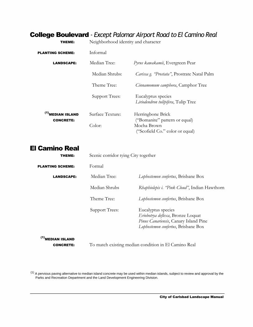
City of Carlsbad Landscape Manual
College Boulevard - Except Palomar Airport Road to El Camino Real THEME: Neighborhood identity and character PLANTING SCHEME: Informal
LANDSCAPE: Median Tree: Pyrus kawakamii, Evergreen Pear
Median Shrubs: Carissa g. “Prostata”, Prostrate Natal Palm
Theme Tree: Cinnamomum camphora, Camphor Tree
Support Trees: Eucalyptus species Liriodendron tulipifera, Tulip Tree
(1)
MEDIAN ISLAND Surface Texture: Herringbone Brick
CONCRETE: (“Bomanite” pattern or equal)
Color: Mocha Brown (“Scofield Co.” color or equal)
El Camino Real
THEME: Scenic corridor tying City together PLANTING SCHEME: Formal
LANDSCAPE: Median Tree: Lophostemon confertus, Brisbane Box Median Shrubs Rhaphiolepis i. “Pink Cloud”, Indian Hawthorn
Theme Tree: Lophostemon confertus, Brisbane Box
Support Trees: Eucalyptus species
Eriobotrya deflexa, Bronze Loquat Pinus Canariensis, Canary Island Pine Lophostemon confertus, Brisbane Box
(1)
MEDIAN ISLAND
CONCRETE: To match existing median condition in El Camino Real
(1) A pervious paving alternative to median island concrete may be used within median islands, subject to review and approval by the
Parks and Recreation Department and the Land Development Engineering Division.

City of Carlsbad Landscape Manual
La Costa Avenue - La Costa/El Camino Real to I-5 Freeway THEME: Lagoon vistas and wetlands PLANTING SCHEME: Informal
LANDSCAPE: Median Tree: None
Median Shrubs: Mahonia a. “compacta”, Compact Oregon Grape Raphiolepsis i. “Pink Cloud”, Indian Hawthorn
Theme Tree: Salix babylonia, Weeping Willow Support Trees: Eucalyptus viminalis, Manna Gum
Platanus racemosa, California Sycamore
(1)
MEDIAN ISLAND Surface Texture: Running Bond Cobblestone (“Bomanite”
CONCRETE: pattern or equal) with exposed aggregate Color: natural
Palomar Airport Road - I-5 to El Camino Real THEME: Oak grove woodland PLANTING SCHEME: Informal
LANDSCAPE: Median Tree: Quercus ilex, Holly Oak
Median Shrubs: Agapanthus orientalis, Lilly of the Nile
Theme Tree: Oak species
Support Trees: Alnus rhomifolia, White Alder Platanus racemosa, California Sycamore (multi-trunk)
(1)
MEDIAN ISLAND
CONCRETE: To match existing median condition in Palomar Airport Road
(1) A pervious paving alternative to median island concrete may be used within median islands, subject to review and approval by the
Parks and Recreation Department and the Land Development Engineering Division.
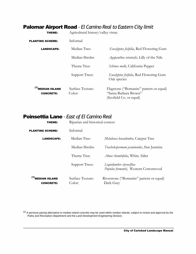
City of Carlsbad Landscape Manual
Palomar Airport Road - El Camino Real to Eastern City limit THEME: Agricultural history/valley vistas PLANTING SCHEME: Informal
LANDSCAPE: Median Tree: Eucalyptus ficifolia, Red Flowering Gum Median Shrubs: Agapanthus orientalis, Lilly of the Nile
Theme Tree: Schinus molle, California Pepper
Support Trees: Eucalyptus ficifolia, Red Flowering Gum
Oak species
(1)
MEDIAN ISLAND Surface Texture: Flagstone (“Bomanite” pattern or equal)
CONCRETE: Color: “Santa Barbara Brown”
(Scofield Co. or equal)
Poinsettia Lane - East of El Camino Real THEME: Riparian and historical context PLANTING SCHEME: Informal
LANDSCAPE: Median Tree: Melaleuca leucadendra, Cajeput Tree
Median Shrubs: Trachelospermum jasminoides, Star Jasmine
Theme Tree: Alnus rhombifolia, White Alder
Support Trees: Liquidamber styraciflua Populus fremontii, Western Cottonwood
(1)
MEDIAN ISLAND Surface Texture: Riverstone (“Bomanite” pattern or equal)
CONCRETE: Color: Dark Grey
(1) A pervious paving alternative to median island concrete may be used within median islands, subject to review and approval by the
Parks and Recreation Department and the Land Development Engineering Division.
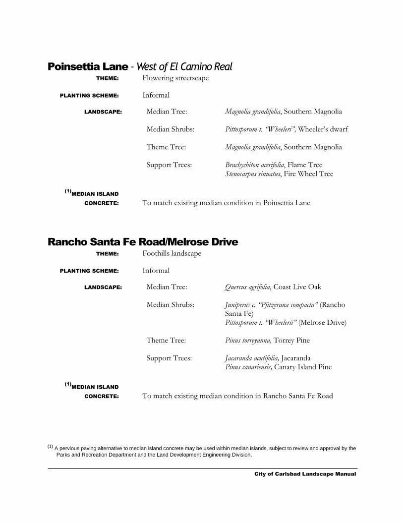
City of Carlsbad Landscape Manual
Poinsettia Lane - West of El Camino Real THEME: Flowering streetscape
PLANTING SCHEME: Informal
LANDSCAPE: Median Tree: Magnolia grandifolia, Southern Magnolia Median Shrubs: Pittosporum t. “Wheeleri”, Wheeler’s dwarf
Theme Tree: Magnolia grandifolia, Southern Magnolia
Support Trees: Brachychiton acerifolia, Flame Tree
Stenocarpus sinuatus, Fire Wheel Tree
(1)
MEDIAN ISLAND
CONCRETE: To match existing median condition in Poinsettia Lane
Rancho Santa Fe Road/Melrose Drive
THEME: Foothills landscape PLANTING SCHEME: Informal
LANDSCAPE: Median Tree: Quercus agrifolia, Coast Live Oak Median Shrubs: Juniperus c. “Pfitzerana compacta” (Rancho
Santa Fe) Pittosporum t. “Wheelerii” (Melrose Drive)
Theme Tree: Pinus torreyanna, Torrey Pine
Support Trees: Jacaranda acutifolia, Jacaranda Pinus canariensis, Canary Island Pine
(1)
MEDIAN ISLAND
CONCRETE: To match existing median condition in Rancho Santa Fe Road
(1) A pervious paving alternative to median island concrete may be used within median islands, subject to review and approval by the
Parks and Recreation Department and the Land Development Engineering Division.
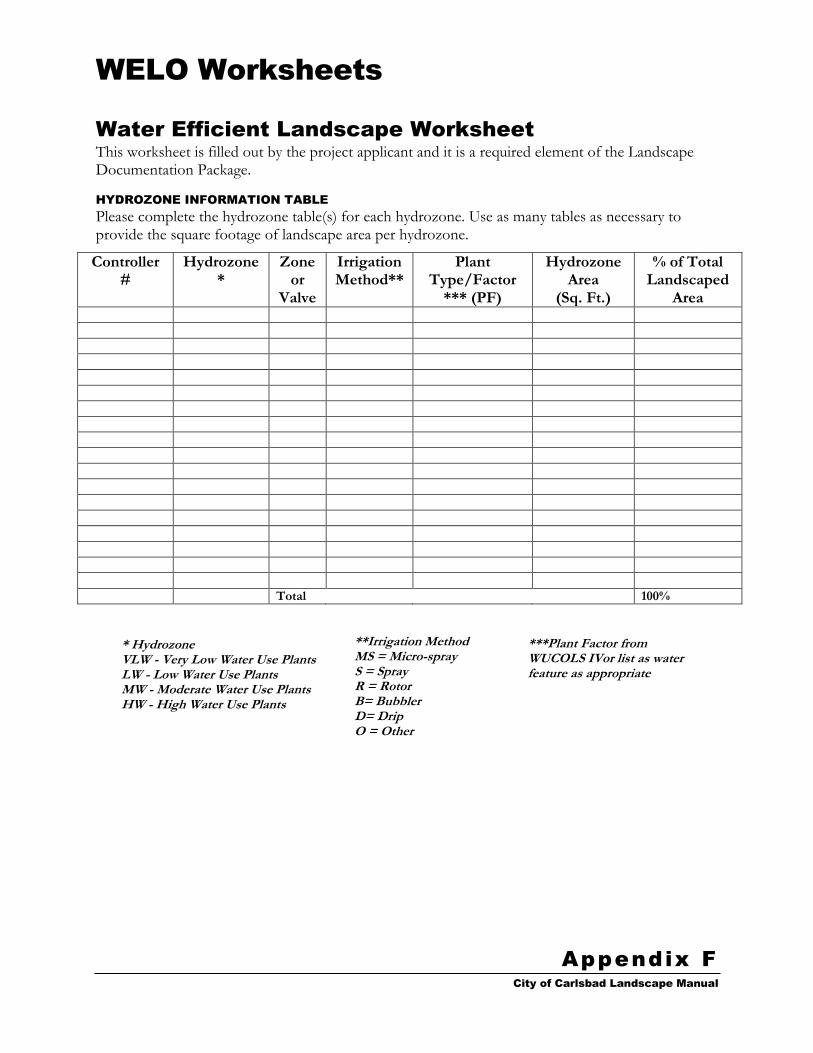
WELO Worksheets
City of Carlsbad Landscape Manual
Appendix F
Water Efficient Landscape Worksheet
This worksheet is filled out by the project applicant and it is a required element of the Landscape Documentation Package.
HYDROZONE INFORMATION TABLE
Please complete the hydrozone table(s) for each hydrozone. Use as many tables as necessary to provide the square footage of landscape area per hydrozone.
Controller #
Hydrozone*
Zone or
Valve
Irrigation Method**
Plant Type/Factor
*** (PF)
Hydrozone Area
(Sq. Ft.)
% of Total Landscaped
Area
Total 100%
* Hydrozone VLW - Very Low Water Use Plants LW - Low Water Use Plants MW - Moderate Water Use Plants HW - High Water Use Plants
**Irrigation Method MS = Micro-spray S = Spray R = Rotor B= Bubbler D= Drip O = Other
***Plant Factor from WUCOLS IVor list as water feature as appropriate
* Hydrozone VLW - Very Low Water Use Plants LW - Low Water Use Plants MW - Moderate Water Use Plants HW - High Water Use Plants
**Irrigation Method MS = Micro-spray S = Spray R = Rotor B= Bubbler D= Drip O = Other
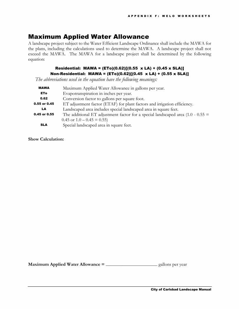
A P P E N D I X F : W E L O W O R K S H E E T S
City of Carlsbad Landscape Manual
Maximum Applied Water Allowance
A landscape project subject to the Water Efficient Landscape Ordinance shall include the MAWA for the plans, including the calculations used to determine the MAWA. A landscape project shall not exceed the MAWA. The MAWA for a landscape project shall be determined by the following equation:
Residential: MAWA = (ETo)(0.62)[(0.55 x LA) + (0.45 x SLA)]
Non-Residential: MAWA = (ETo)(0.62)[(0.45 x LA) + (0.55 x SLA)]
The abbreviations used in the equation have the following meanings:
MAWA Maximum Applied Water Allowance in gallons per year. ETo Evapotranspiration in inches per year. 0.62 Conversion factor to gallons per square foot.
0.55 or 0.45 ET adjustment factor (ETAF) for plant factors and irrigation efficiency. LA Landscaped area includes special landscaped area in square feet.
0.45 or 0.55 The additional ET adjustment factor for a special landscaped area (1.0 - 0.55 = 0.45 or 1.0 – 0.45 = 0.55)
SLA Special landscaped area in square feet.
Show Calculation:
Maximum Applied Water Allowance = ______________________ gallons per year
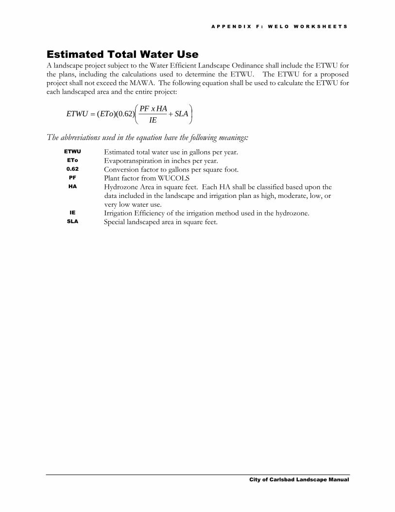
A P P E N D I X F : W E L O W O R K S H E E T S
City of Carlsbad Landscape Manual
Estimated Total Water Use
A landscape project subject to the Water Efficient Landscape Ordinance shall include the ETWU for the plans, including the calculations used to determine the ETWU. The ETWU for a proposed project shall not exceed the MAWA. The following equation shall be used to calculate the ETWU for each landscaped area and the entire project:
The abbreviations used in the equation have the following meanings:
ETWU Estimated total water use in gallons per year. ETo Evapotranspiration in inches per year. 0.62 Conversion factor to gallons per square foot. PF Plant factor from WUCOLS HA Hydrozone Area in square feet. Each HA shall be classified based upon the
data included in the landscape and irrigation plan as high, moderate, low, or very low water use.
IE Irrigation Efficiency of the irrigation method used in the hydrozone. SLA Special landscaped area in square feet.
SLA
IE
HAxPFEToETWU )62.0)((

A P P E N D I X F : W E L O W O R K S H E E T S
City of Carlsbad Landscape Manual
Hydrozone Table for Calculating ETWU
Please complete the hydrozone table(s). Use as many tables as necessary.
CITY OF CARLSBAD ESTIMATED TOTAL WATER USE (ETWU)
Hydrozone Number (1 – 5 with SLA Zone Below – use as many tables as necessary to complete all hydrozones)
Process Step No. (Below)
1 2 3 4 5 SLA
Evapotranspiration Rate (ETo)*
1
Conversion Factor 2 0.62
(Step 1 x Step 2) 3
Plant Factor (PF)** (From WUCOLS) (VLW – HW) (0.1 - 0.8)
4
Area of Hydrozone (sq. ft.) (HA)
5
(Step 4 x Step 5) 6
Irrigation Efficiency (IE)*** 7
(Step 6 ÷ Step 7) 8
(Total All Step 8 + Total SLA sq. ft. in Step 5)
9
(Step 3 x Step 9) Estimated Total Water Use in gallons per year (ETWU) - Total shall not exceed MAWA
10
ETo* West of I-5 = 40.0 East of I-5 and West of El Camino Real = 44.0 East of El Camino Real = 47.0 Applicant may provide a different ETo if supported by documentation subject to approval by the City Planning Division
** Plant Factor & Water Use 0.1 = VLW - Very Low Water Use Plants 0.3 = LW - Low Water Use Plants 0.5 = MW - Moderate Water Use Plants 0.8 = HW - High Water Use Plants
***IE Micro-spray = .80 Spray = .72 Rotor = .72 MP Rotator = .75 Bubbler = .75 Drip = .80

City of Carlsbad Landscape Manual
Appendix G
Sustainable Landscaping Brochure


Sustainable Planting Design
Plant Selection
Select water-conserving native or climate appropriate plants that will not require supplemental irrigation when established.
Select species that require minimal shearing and that are suitable to the size of the planting area.
Turfgrass Restrictions
Limit turfgrass to slopes less than 25 percent.
Limit the use of water-intensive landscaping and turfgrass areas.
Plant Groupings
Group plants with similar water requirements (hydrozones) so that they can be irrigated with the same controller.
Use a 3 inch layer of mulch on all exposed soil surfaces within landscape planter areas.
Sustainable Irrigation Design
Water Waste Prevention
Incorporate a rain shut-off device into the irrigation system.
Adjust irrigation systems to eliminate runoff, low head drainage and overspray.
Avoid irrigating during times of high temperature or wind.
Irrigation Water Source
Install a rain garden system, rain harvest system, or graywater system.
Ask for and retain a copy of the irrigation plan to facilitate future repairs/modifications.
Additional Resources
Search these in a web browser:
City of Carlsbad Landscape Manual Carlsbad
Environmental Services Carlsbad Municipal
Water District Carlsbad Gardening Tips
Be Waterwise
The Water Conservation Garden H2OUSE
Water Saver Home Water Wiser
20-Gallon Challenge
California Landscape Contractors Association
Create a customized watering schedule
(watering calculator)
Water Saving Landscape Plans
California Invasive Plant Council
City of Carlsbad Community & Economic
Development Department 1635 Faraday Ave. Carlsbad, CA 92008
Phone 760-602-4600 Fax 760-602-8554
Visit us online at: www.carlsbadca.gov
Sustainable Landscaping
A homeowner ’s guide to eco -friendly &
water efficient landscape practices
Community & Economic Development
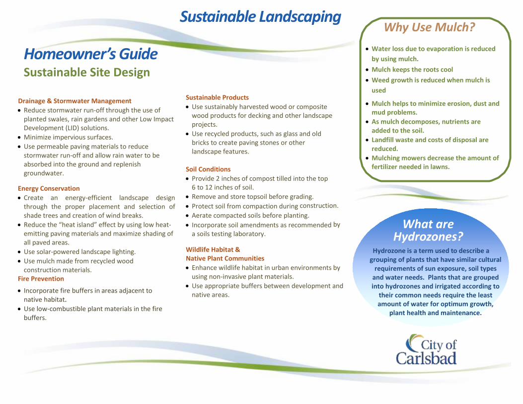
Homeowner’s Guide Sustainable Site Design
Drainage & Stormwater Management
Reduce stormwater run-off through the use of planted swales, rain gardens and other Low Impact Development (LID) solutions.
Minimize impervious surfaces.
Use permeable paving materials to reduce stormwater run-off and allow rain water to be absorbed into the ground and replenish groundwater.
Energy Conservation
Create an energy-efficient landscape design through the proper placement and selection of shade trees and creation of wind breaks.
Reduce the “heat island” effect by using low heat-emitting paving materials and maximize shading of all paved areas.
Use solar-powered landscape lighting.
Use mulch made from recycled wood construction materials.
Fire Prevention
Incorporate fire buffers in areas adjacent to native habitat.
Use low-combustible plant materials in the fire buffers.
Sustainable Landscaping
Sustainable Products
Use sustainably harvested wood or composite wood products for decking and other landscape projects.
Use recycled products, such as glass and old bricks to create paving stones or other landscape features.
Soil Conditions
Provide 2 inches of compost tilled into the top 6 to 12 inches of soil.
Remove and store topsoil before grading.
Protect soil from compaction during construction.
Aerate compacted soils before planting.
Incorporate soil amendments as recommended by
a soils testing laboratory.
Wildlife Habitat & Native Plant Communities
Enhance wildlife habitat in urban environments by using non-invasive plant materials.
Use appropriate buffers between development and native areas.
Why Use Mulch?
Water loss due to evaporation is reduced
by using mulch.
Mulch keeps the roots cool
Weed growth is reduced when mulch is
used
Mulch helps to minimize erosion, dust and mud problems.
As mulch decomposes, nutrients are added to the soil.
Landfill waste and costs of disposal are reduced.
Mulching mowers decrease the amount of fertilizer needed in lawns.
What are Hydrozones?
Hydrozone is a term used to describe a grouping of plants that have similar cultural
requirements of sun exposure, soil types and water needs. Plants that are grouped into hydrozones and irrigated according to
their common needs require the least amount of water for optimum growth,
plant health and maintenance.

Glossary
City of Carlsbad Landscape Manual
Approved Means approved by the City of Carlsbad.
Automatic Irrigation Controller Means an automatic timing device used to remotely control valves that operate an irrigation system. Automatic irrigation controllers are able to self-adjust and schedule irrigation events using either evapotranspiration (ETo) (weather-based) or soil moisture data.
Bar Scale Means the scale of the drawing notated on a line such that when the plan is reduced or enlarged, the corresponding scale can be measured off of the line.
Building Permit Means a permit to engage in a certain type of construction on a specific location, as defined by Carlsbad Municipal Code Section 18.04.015.
Carlsbad BMP Design Manual Refers to the Carlsbad BMP Design Manual, latest version. This document outlines the stormwater process and requirements for development projects.
Certified Landscape Irrigation
Auditor
Certified landscape irrigation auditor means a person certified to perform landscape irrigation audits by an accredited academic institution, a professional trade organization or other program such as the US Environmental Protection agency’s WaterSense irrigation auditor certification program and Irrigation Association’s Certified Landscape Irrigation Auditor program.
City Means the City of Carlsbad.
Common Recreation Area Means a recreation area owned in common by a development and set apart from other areas of the project by the lot lines or other distinct elements. Common Recreation area is the area used to meet any recreation requirements of the City.
Compost Means the safe and stable product of controlled biologic decomposition of organic materials that is beneficial to plant growth.
Corner Sight Distance Means a zone between the right of way and a line connecting two points that are measured along the curb line of two intersecting streets. The points are measured 25 feet outward from the beginning of curve on one street segment and 25 feet outward from the beginning of curve on the other street segment (see Figures 3-A and 3-B).
Cover Crop Means a relatively fast growing, quick spreading plant material applied to an area so as to provide erosion control prior to establishment of the more permanent, long-lived plants.
Days Means calendar days.
Developer Means a person who seeks or receives permits for or who undertakes land development activities who is not a single family homeowner. Developer includes a developer’s partner, associate, employee, consultant, trustee or agent.
Director Means the City of Carlsbad Director of Community and Economic Development or anyone to whom the Director has designated or hired to administer or enforce this chapter.
G L O S S A R Y
City of Carlsbad Landscape Manual
Discretionary Permit Means any permit requiring a decision making body to exercise judgment prior to its approval, conditional approval or denial.
Distribution Uniformity Means the measure of the uniformity of irrigation water over a defined area.
Erosion Control Means short and long term protection of soil surfaces from wind and water soil transport.
Estimated Total Water Use
(ETWU)
Means the estimated total water use in gallons per year for a landscaped area.
Evapotranspiration
Adjustment Factor (ETAF)
Means a factor that when applied to reference ETo, adjusts for plant water requirements and irrigation efficiency, two major influences on the amount of water that is required for a healthy landscape.
Evapotranspiration (ETo) Means the quantity of water evaporated from adjacent soil and other surfaces and transpired by plants during a specified time period. "Reference evapotranspiration” means a standard measurement of environmental parameters which affect the water use of plants. ETo is given in inches per day, month, or year and is an estimate of the ETo of a large field of four-inches to seven-inches tall, cool season turfgrass that is well watered. Reference ETo is used as the basis of determining the MAWA so that regional differences in climate can be accommodated.
Finish Grade Means the final grade or elevation of the non-hardscape portion of a project after all construction is complete as called for in the plans.
Finish Surface Means the final grade or elevation of hardscape portions of the site after all the construction is complete as called for in the plans.
Fire Code Official Means the City of Carlsbad Fire Chief or his/her designee.
Flow Sensor Means an inline device installed at the supply point of the irrigation system that produces a repeatable signal proportional to flow rate. Flow sensors must be connected to an automatic irrigation controller, or flow monitor capable of receiving flow signals and operating master valves. This combination flow sensor/controller may also function as a landscape water meter or submeter.
Friable Means a soil condition that is easily crumbled or loosely compacted down to a minimum depth per planting material requirements that allows for the roots of newly planted material to spread unimpeded.
Fuel Modification Zone Means a strip of land where combustible vegetation has been modified and partially or totally replaced with approved drought-tolerant, fire-resistant, and/or irrigated plants to provide an acceptable level of risk from vegetation fires. Fuel modification reduces radiant and convective heat, thereby reducing the amount of heat exposure on the roadway or structure and providing fire suppression forces with a safer area in which to take action.
Grading Means any excavation, fill, clearing and/or grubbing of vegetation, or any combination thereof as defined by Carlsbad Municipal Code Chapter 15.16.
G L O S S A R Y
City of Carlsbad Landscape Manual
Grass/Grasses Means a ground cover surface of non-mowed grasses such as Carex, Juncus, Acorus species, and other non-mowed grasses or hybrid derivatives of such grasses that are typically used for bio-swales, Low Impact Developments (LID) and non-recreational uses.
Graywater As defined by the California Health and Safety Code Section 17922.12, means untreated wastewater that has not been contaminated by any toilet discharge, has not been affected by infectious, contaminated, or unhealthy bodily wastes, and does not present a threat from contamination by unhealthful processing, manufacturing, or operating wastes. "Graywater" includes wastewater from bathtubs, showers, bathroom washbasins, clothes washing machines, and laundry tubs, but does not include wastewater from kitchen sinks or dishwashers.
Hardscape Means non-planted areas consisting of any pervious or non-pervious durable surface material including, but not limited to, concrete or concrete products, brick, asphalt, applied decomposed granite surfaces, etc.
High/Moderate Fuel Species Describes a species of plant based on the amount (high or moderate) of available and potentially combustible vegetative material, usually expressed as
tons/acre.
High Risk Fire Area Means a native or manmade landscape consisting of primarily of woody shrubs and trees that have a relatively high potential for sustaining fire as determined by the Fire Code Official.
High Use Driveway Means a driveway that handles equal to or more than 500 ADT, defined per the City of Carlsbad Engineering Standards, latest version.
Homeowner-Provided
Landscaping
Means landscaping installed either by a homeowner or a licensed contractor hired by a homeowner for a single-family residence.
Hydrozone Means a portion of the landscape area having plants with similar water needs. A hydrozone may be irrigated or non-irrigated.
Inside Edge of Curb Means the face of the curb that is adjacent to a planting area.
Invasive Species Means species of plants not historically found in California that spread outside cultivated areas and may damage environmental or economic resources. (See California Invasive Plant Council at www.cal-ipc.org)
Irrigation Consultant Means a person considered an expert in the irrigation field and the majority of his/her work is in preparing irrigation construction documents.
Irrigation Efficiency Means the measurement of the amount of water beneficially used divided by the water applied. Irrigation efficiency is derived from measurements and estimates of irrigation system characteristics and management practices.
G L O S S A R Y
City of Carlsbad Landscape Manual
Landscaped Area Means an area with plants, turfgrass and/or other vegetation. A landscaped area includes a water feature either in an area with vegetation or that stands alone. A landscaped area may also include non-vegetated design features adjacent to an area with vegetation, provided that the features are integrated into the design of the landscape area and the primary purpose of the features are decorative. A landscaped area does not include the footprint of a building, decks, patio, sidewalk, curbs, driveway, parking lot or other hardscape. A landscaped area also does not include an area without irrigation designated for non-development such as designated open space or area with existing native vegetation. The landscaped area refers to the area to be landscaped as part of the work for which the current approval by the City is being sought.
Landscape Manual Means the manual, approved by the Carlsbad City Council, that establishes specific design criteria and guidance to implement the requirements of Carlsbad Municipal Code Chapter 18.50 – Water Efficient Landscape.
Landscape Plans Means plans that cover the proposed construction of landscaped items including planting, irrigation, patios, sidewalks, and other hardscape items, signs, walls, trellises, etc.
Landscape Water Meter Means an inline device installed at the irrigation supply point that measures the flow of water into the irrigation system and is connected to a totalizer to record water use.
Licensed Means licensed by the State of California.
Long Lived Means perennial plant material that under normal growing conditions has a life span of greater than 8 years.
Low Head Drainage Means a sprinkler head or other irrigation device that continues to emit water after the water to the zone in which the device is located has shut off.
Low Impact Development (LID) Means site design methods that limit the use of impervious surfaces and encourage methods that drain rainfall runoff through landscape areas to encourage filtering of urban runoff prior to discharge from the site. When employed, these methods reduce runoff rates and durations resulting from development. For more information, refer to the Carlsbad BMP Design Manual.
Low Volume Irrigation Means the application of irrigation water at low pressure through a system of tubing or lateral lines and low volume emitters such as drip lines or bubblers. Low volume irrigation systems are specifically designed to apply small volumes of water slowly at or near the root zone of plants.
Master Shut-off Valve Means an automatic valve installed at the irrigation supply point which controls water flow into the irrigation system. When this valve is closed water will not be supplied to the irrigation system.
Maximum Applied Water
Allowance (MAWA)
Means the maximum allowed annual water use for a specific landscaped area based on the square footage of the area, the ETAF and the reference ETo.
Medium Use Driveway Means a driveway that handles greater than 200 Average Daily Trips (ADT) but less than 500 ADT, as defined per the City of Carlsbad Engineering Standards, latest version.

G L O S S A R Y
City of Carlsbad Landscape Manual
Mulch Means an organic material such as leaves, bark, straw or inorganic mineral materials such as rocks, gravel or decomposed granite left loose and applied to the soil surface to reduce evaporation, suppress weeds, moderate soil temperature or prevent soil erosion.
Non-Vegetated Areas Means an area that includes features such as rock or stone, or pervious design features such as decomposed granite, which are adjacent to a vegetated area.
Overspray Means the water from irrigation that is delivered outside an area targeted for the irrigation and makes contact with a surface not intended to be irrigated.
Park Means a public or private recreation area/facility as a separate unit, set apart from other development by property lines or other distinct elements.
Parking Areas Means areas used for access drives, aisles, stalls, maneuvering, and landscaping within that portion of the site that is devoted to vehicle parking and circulation (excluding any required parking setbacks).
Pervious Means any surface or material that allows the passage of water through the material and into underlying soil.
Plant Factor Means a factor when multiplied by the ETo, estimates the amount of water a plant needs (see Section 4.E).
Professional of Record Means the preparer of the project’s landscape concept plans and/or landscape construction documents. The professional of record shall be a licensed landscape architect, licensed civil engineer, licensed architect, or other landscape professional licensed by the state to do this work.
Public Water Purveyor Means a public utility, municipal water district, municipal irrigation district or municipality that delivers water to customers.
Rain Gardening
Means a method of managing stormwater and filtering pollutants by directing stormwater runoff from roofs, driveways or other impervious surfaces into shallow, vegetated landscape areas (rain gardens) where it can soak into the ground and be naturally filtered by plants, bacteria and soil. Rain gardens are often designed as low maintenance landscaping feature planted with perennial native plants that are naturally adapted to wet conditions.
Rain Harvesting Means a method of collecting water-from a roof, driveway, or other hard surface during a rainfall-and channeling it into a rain barrel or other container to be saved for use in landscaping or in the household.
Reclaimed Water Means tertiary treated effluent, suitable for use in landscaping or water features as determined by the presiding water district (see “recycled water”).
Recycled Water Sometimes referred to as “reclaimed water”, means water obtained from the
treatment of domestic water waste which is suitable for direct beneficial use or a controlled use that otherwise would not occur and also meets the highest level in conformance with California Code of Regulations, Title 22, Division 4, Chapter 3 (use of recycled water for irrigation and for impoundments), currently section 60304 and section 60305.
Reference Evapotranspiration See Evapotranspiration.
Runoff Means water that is not absorbed by the soil or landscape to which it is applied and flows from the landscaped area.
G L O S S A R Y
City of Carlsbad Landscape Manual
Run-off Means irrigation water that is applied at a rate above the infiltration rate of the soil which causes water to drain away on the surface from the landscape area it is intended to service.
Sight Distance Triangle See Corner Sight Distance and Sight Distance Corridor.
Sight Distance Corridor Means a prescribed area with limitations where no obstructions such as planting, trees, fences, monuments, etc shall be installed that would impede the view restrictions per this manual.
Special Landscaped Area
Means: an area of the landscape dedicated to edible plants; an area irrigated with recycled water; water features that use treated recycled water; an area dedicated as turfgrass area within a park, sports field or golf course where turfgrass provides a passive or active recreational surface; or a public pool.
Structure Means anything constructed or erected which requires location on the ground or attached to something having a location on the ground, but not including fences or walls used as fences less than six (6) feet in height.
Submeter Means a master valve and flow sensor device to measure water applied to the landscape that is installed after the primary utility water meter.
Subsurface Irrigation Means an irrigation device with a delivery line and water emitters installed below the soil surface that slowly and frequently emit small amounts of water into the soil to irrigate plant roots.
Transitional Area Means a portion of a landscaped area that is adjacent to a natural or undisturbed area and is designated to ensure that the natural area remains unaffected by plantings and irrigation installed on the property.
Turfgrass Means a ground cover surface of mowed grasses such as bermuda, bluegrass, fescue, rye, St. Augustine, zoyzia, and other mowed turfgrasses or hybrid derivatives of such turfgrasses that are typically used for a recreational use.
Typical Species Means a group of plants with similar appearance and cultural requirements, (not intended to be a complete list of such plants).
Very High
Fire Hazard Severity Zone
Means an area, designated by the Director of Forestry and Fire Protection pursuant to Chapter 49 of the California Fire Code, which is not a state responsibility area.
Water Feature Means a design element where open water performs an aesthetic or recreational function. A water feature includes a pond, lake, waterfall, fountain, artificial streams, spa and swimming pool. Constructed wetlands used for on-site wastewater treatment or stormwater best management practices are not water features.
WELO Means Water Efficient Landscape Ordinance.
Woody Plants Means plants that have stems and trunks that consist of bark.
WUCOLS Means “Water Use Classification of Landscape Species” published by the University of California Cooperative Extension and the Department of Water Resources, as of January 2014, or the most recent version thereof.