port phillip heritage review -...
TRANSCRIPT

Port Phillip Heritage Review
Volume 1 – Exhibition Version
Amendment C117 (Feb. 2016)
NOTE: This is an exhibition version of the document that shows only sections affected by changes proposed through Amendment C117. Changes to the document are shown in tracked changes.

Port Phill ip Heritage Review
Volume 1 Exhibition Version, Amendment C117 (Feb. 2016) Page 2
Contents
1. Introduction .......................................................................................................................................................... 4
1.1 Port Phillip Heritage Review .................................................................................................................................. 4
1.2 Updating the Port Phillip Heritage Review ............................................................................................................ 5
2. Brief ........................................................................................................................................................................ 6
3. Study Method ....................................................................................................................................................... 7
3.1 Thematic Environmental History ........................................................................................................................... 7
3.2 Field Survey ........................................................................................................................................................... 7
3.3 Heritage Overlay Areas .......................................................................................................................................... 8
3.4 Data Sheets ........................................................................................................................................................... 8
3.5 Schedule to the Heritage Overlay Table ................................................................................................................ 9
4. Recommendations ............................................................................................................................................ 10
4.1 Port Phillip Heritage Review ................................................................................................................................ 10
4.2 Heritage Place ..................................................................................................................................................... 10
4.3 Conservation Principles and Guidelines .............................................................................................................. 11
4.4 Heritage Register Nominations ........................................................................................................................... 11
5. Environmental History .................................................................................................................................... 12
5.1 Introduction ........................................................................................................................................................ 12
5.2 Migration ............................................................................................................................................................. 12
5.3 Transport ............................................................................................................................................................. 14
5.4 Industry ............................................................................................................................................................... 20
5.5 Settlement: Growth and Change ......................................................................................................................... 24
5.6 Education ............................................................................................................................................................ 37
5.7 Government Services .......................................................................................................................................... 39
5.8 Ways of Life ......................................................................................................................................................... 44
6. Heritage Overlay Areas .................................................................................................................................. 51
6.1 Introduction ........................................................................................................................................................ 51
6.2 Port Melbourne ‐ Ho1 ......................................................................................................................................... 52
6.3 Port Melbourne HO1 ‐ Port Melbourne West Sub‐Precinct ................................................................................ 61
6.4 Port Melbourne HO1 ‐ Port Melbourne East Sub‐Precinct .................................................................................. 71
6.5 Port Melbourne HO1 ‐ Bay Street Commercial Sub‐Precinct .............................................................................. 76
6.6 Port Melbourne HO1 ‐ Port Melbourne Railway Reserves Sub‐Precinct ............................................................. 81
6.7 Port Melbourne ‐ the Garden City Housing Estates ‐ Ho2 ................................................................................... 90
6.8 South Melbourne City Road Industrial Area ‐ Ho4 .............................................................................................. 99
6.9 St Kilda Hill – Ho5 .............................................................................................................................................. 107
6.10 St. Kilda East ‐ Ho6 ............................................................................................................................................ 117
6.11 Elwood, St Kilda, Balaclava, Ripponlea ‐ Ho7 .................................................................................................... 125
6.12 Elwood:Glenhuntly and Ormond Roads ‐ HO8 .................................................................................................. 138
6.13 Inkerman Street (East) ‐ HO315 ........................................................................................................................ 149
6.14 Carlisle Street (East) ‐ HO316 ............................................................................................................................ 157
6.15 Hotham Street (Balaclava) ‐ Ho317 ................................................................................................................... 164

Port Phill ip Heritage Review
Volume 1 Exhibition Version, Amendment C117 (Feb. 2016) Page 3
6.16 Brighton Road (Elwood) ‐ Ho318 ....................................................................................................................... 169
6.17 Swallow Street (Port Melbourne) ‐ Ho382 ........................................................................................................ 176
6.18 Chusan Street (East St Kilda) ‐ Ho385 ................................................................................................................ 182
6.19 Godfrey Avenue/Raglan Street (East St Kilda) ‐ Ho386 ..................................................................................... 188
6.20 Hammerdale Avenue (East St Kilda) ‐ Ho387 .................................................................................................... 194
6.21 Holroyd Court (East St Kilda) ‐ Ho388 ................................................................................................................ 201
6.22 Kalymna Grove/Inkerman Street (East St Kilda) ‐ Ho389 .................................................................................. 207
6.23 Mooltan Avenue (East St Kilda) ‐ Ho390 ........................................................................................................... 213
6.24 Murchison Street/Alma Road (East St Kilda) ‐ Ho391........................................................................................ 219
6.25 Orange Grove (East St Kilda) ‐ Ho392 ................................................................................................................ 227
6.26 Elwood Canal ‐ Ho 402 ...................................................................................................................................... 234
6.27 Addison Street/Milton Street (Elwood) ‐ Ho 403 .............................................................................................. 244
6.28 Byron Stree/Mason Avenue (Elwood) ‐ Ho 404................................................................................................. 255
6.29 Mccrae Street (Elwood) ‐ HO 405 ...................................................................................................................... 265
6.30 Nightingale Street Precinct– Ho439 .................................................................................................................. 270
6.31 Emerald Hill Residential Precinct – Ho440 ........................................................................................................ 282
6.32 St Vincent Place East (South Melbourne) – H0441 ............................................................................................ 295
6.33 Albert Park Residential Precinct / Part Montague Precinct – Ho442 ................................................................ 304
6.34 Bridport Street/Victoria Avenue Commercial Precinct (Albert Park) – Ho443 .................................................. 313
6.35 Middle Park & St Kilda West Precinct – Ho444 ................................................................................................. 321
6.36 Armstrong Street Commercial Precinct (Middle Park) – Ho445 ........................................................................ 337
6.37 Albert Park Lake Precinct – H0446 .................................................................................................................... 345
6.38 Port Melbourne Cricket Ground – H0447 .......................................................................................................... 356
6.39 Edwards Park – H0448....................................................................................................................................... 368
7. Horticultural Assessment ............................................................................................................................. 373
Prepared for the City of Port Phillip by Andrew Ward, Architectural Historian

Port Phill ip Heritage Review
Volume 1 Exhibition Version, Amendment C117 (Feb. 2016) Page 5
The City of Port Phillip, having been formed by the amalgamation of the Cities of Port Melbourne, South Melbourne and St. Kilda, had inherited several urban conservation studies. They had been prepared at different times, commencing in 1975 and using different criteria for the evaluation of the significance of places. Furthermore, the municipal boundaries represented discontinuities in the identified urban conservation areas, placing the integrity of the new City’s conservation strategy at risk. The studies were as follows:
Yuncken Freeman Ashton Wilson: South Melbourne Conservation Study (1975),
Jacobs Lewis Vines: Port Melbourne Conservation Study (1979),
Allom Lovell Sanderson Pty. Ltd.: South Melbourne Conservation Study (1987),
Nigel Lewis and Associates: St. Kilda Conservation Study Area 1 (1982),
David Bick: St. Kilda Conservation Study Area 2 (1985),
Robert Peck von Hartel Trethowan with Henshall Hansen Associates: City of St. Kilda Twentieth Century Architectural Study (1992), and
Allom Lovell and Associates: Port Melbourne Conservation Study Review (1995).
1.2 Updating the Port Phillip Heritage Review
Since the gazettal of the original Port Phillip Heritage Review in 2000, additional assessments of places and areas of heritage significance have been completed. The following heritage studies were commissioned:
Graeme Butler and Associates: Swallow Street (2004)
Heritage Alliance: East St Kida Heritage Study (2004)
Heritage Alliance: Elwood Heritage Review (2005)
Heritage Alliance: Nightingale Street Heritage Study (2008)
Heritage Alliance & Built Heritage: Review of Heritage Overlay 3 (2009 / 2010)
Lovell Chen: Review of Heritage Overlay 1 (2011).
Biosis Pty Ltd: Fishermans Bend Heritage Study (2013)
Biosis Pty Ltd: Fishermans Bend additional heritage place assessments (2015)
The resultant findings have been included in the Port Phillip Heritage Review through the Planning Scheme Amendment process.2
The assessment framework used in each of the above heritage assessments is based upon the framework developed by Andrew Ward as outlined in the following chapters.
2 The Port Phillip Heritage Review is an incorporated document in the Port Phillip Planning Scheme. Planning Scheme Amendments C24, C29, C32, C46, C52, C54, C70, C72, C74, and C89 and C117 enabled new information on heritage places and heritage areas within the municipality to be included in the Port Phillip Heritage Review.

Port Phill ip Heritage Review
Volume 1 Exhibition Version, Amendment C117 (Feb. 2016) Page 99
6.8 South Melbourne City Road Industrial Area - Ho4 Existing Designations:
Heritage Council Register: nil
National Estate Register: nil
National Trust Register: nil
6.8.1 Description
This Area is bisected by the St. Kilda light railway embankment and bordered by Ferrars Street on its west side, the Westgate Freeway on its north side and by Market Street on its south side. City Road is the principal thoroughfare through the Area and it is terminated at one end by the elevated Westgate Freeway and at the other by the former St. Kilda railway bridge and embankment. Its visual integrity has been recently compromised by large advertising sky signs erected on factory roofs and on freestanding poles within the Area to be viewed at speed by motorists passing on the nearby freeway. South City Holden, formerly the assembly plant and central administrative offices for the General Motors Corporation of America, is the dominant building at the north-east end of City Road. It is a large two storeyed showroom and office complex of the inter-war period in the Classical Revival mode and its façade survives in a substantially intact state. At the rear, Blackeney Place is a fully pitched lane overlooked by Holden’s Quality Spare Parts building, formerly the premises of the Ballarat Brewing Company Ltd. No. 48 Cecil Street opposite also demonstrates the early-twentieth century origins of the Area, as do the present timber framed auction rooms, formerly the premises of Johns and Waygood, structural and general engineers. This section area marks the core of the Area, the auction rooms facing the former cable tram engine house, which is not only of historical interest but also of architectural interest as an ostentatious late Victorian Renaissance influenced building not unlike other engine houses in Melbourne. The railway bridge is distinguished by its bluestone piers and riveted iron girders and the curved embankment, which survives as a reminder of the South Bank viaduct, demolished in 1993 to make way for the Casino complex. This alignment is given emphasis by the fully pitched lane known as Railway Place that follows the embankment on its west side linking the industrial buildings previously noted with no. 129 Douglas Street, once a stores building for Elder Smith and Co. Ltd. and 21 Meaden Street, formerly Dunne and McLeod’s stores. Nearby, surviving early industrial buildings in Ferrars Street include the former premises of the Union Can Company Pty. Ltd. At the Ferras Street / City Road intersection, the “Wayside Inn” of 1915 recalls the role of South Melbourne’s hotels in accommodating, feeding and in other ways sustaining the local working population. Pitched kerbs remain in City Road and Cecil Street to complement the pitched lanes found frequently throughout this section of South Melbourne.
The name Ballantyne Street, formerly Grant Street, is an indicator of the presence of K.L. Ballantyne Pty. Ltd., wholesale grocers, whose clinker brick premises impart a domestic character to this otherwise commercial Area. Nearby is the two storeyed offices and warehousing space at no.9, formerly the premises of Marrickville Margerine Pty. Ltd. and resplendent today for its prestigious Moderne façade treatment. At the back of Ballantynes’ are massive industrial premises presently associated with Spotlight and a two storeyed bi-chrome brick (?) building occupied by H.W. Hoarse Pty. Ltd., motor engineer as recently as 1950204. On the other side of Market Street are the red brick premises formerly occupied by D. W. Dalton and Co., engineers alongside the Modernist façade of the old Herald and Weekly Times stores205.
204 Sands and McDougall directory. 205 Now occupied by Australia Post.

Port Phill ip Heritage Review
Volume 1 Exhibition Version, Amendment C117 (Feb. 2016) Page 100
6.8.2 History
Kearney’s map of 1855 shows that the land north of City Road (then Sandridge Road) was poorly drained and avoided on account of its flood prone nature. To the immediate south was Emerald Hill. The Port Melbourne railway had been in existence for a year with the St. Kilda line following as far as Emerald Hill on 16.9.1858. Circumstances are substantially the same on Commander Cox’s map of 1866. There are industrial premises on the Yarra River bank and walking tracks connect them with the Sandridge Road and Emerald Hill across the land subsequently developed as a part of Melbourne’s industrial hub. The St. Kilda railway approached the Sandridge Road on a low presumably timber trestle bridge over a large pond, which in times of flood would have become a sheet of water. It was subsequently replaced by the present viaduct by the Victorian Railways when David Munro contracted to build the Southbank viaduct on 25.1.1886 between the surviving Falls Bridge and Clarendon Street followed by the City Road bridge erected by Mephan and Ferguson in 1899206.
The Port Melbourne cable tramway service was opened along City Road as the second last cable line to be opened on 20.6.1890. A new engine house was erected at nos. 357-61 City Road. Although a preferred location would have been at the junction of the Port Melbourne and South Melbourne lines, the present site was selected presumably on account of the inflated land prices of the day207. As a consequence, the South Melbourne cable had to be routed back through the Port Melbourne tunnels before being deflected back into Clarendon Street. When the Yarra River flooded, the tunnels and engine house pit would be filled leading to water damage to the cable. At this time, the south side of City Road was fully built up. West of the engine house were single storeyed terraces mixed with industrial enterprises running down to the level crossing at Whiteman Street. There were some houses on the north side of City Road and two industrial premises opposite the engine house. In Ferrars Street row houses were the order of the day. In Market Street houses were again numerically superior to factories and it can be concluded that South Melbourne’s nineteenth century industrial ascendancy was achieved without a significant impact on the land in this Area.
Priestley notes that “regenerated industry and business provided the basis for South Melbourne’s swift rise in population during the first decades of the twentieth century”208. The flood prone land around the railway line played a role in this growth. Port development at the time was paralleled by an extension of the riverside industry prompting the Council to embark on a program of pitching the main roads in the Area. In 1908 the Union Can Company purchased the terraced houses in Ferrars Street at the railway line and commenced building its manufacturing premises, close by the docks where its sheet metal was offloaded. By 1938, this company had expanded to cover most of the block between Ferrars and Meaden Streets. W. H. Johnsons Jams was also in Meaden Street, next door was a paint manufacturer Brolite Pty Ltd., which had a spectacular explosion destroy much of the factory in 1947, but it continued to operate at least into the late 1950s.209 Johns and Waygood, later Johns Perry, established their premises in City Road in 1910. The main offices at the Cecil Street corner are recent but the workshops alongside recall the company’s long association with the Area. It was Peter Johns who built at least one of the iron houses in Coventry Street and the footbridge at South Melbourne station210. By 1926 the General Motors Corporation of America was building its assembly plant and national administrative headquarters in City Road. By the late 1930’s motor buses were seen to be an effective alternative to the provision of electric tramway services and when the Port and South Melbourne cable services closed on 13.3.1937, they were replaced by buses. The road surface in City Road was eventually reconstructed without the tramway lines that continue to be typical of Melbourne’s principal thoroughfares.
206 See Ward, A., “The St. Kilda Railway”, 1981. 207 Keating, J.D., Mind The Curve! A History of the Cable Trams, MUP, 1970, p.77. 208 Priestley, op.cit., p.240. 209 Fishermans Bend additional heritage place assessments (Biosis Pty Ltd, 2015), p99 210 Notes prepared by Dr. Peter Milner for the National Trust Industrial History Committee.

Port Phill ip Heritage Review
Volume 1 Exhibition Version, Amendment C117 (Feb. 2016) Page 101
In recent years, the original builders of the factories in the Area have, with exceptions including General Motors Holden, merged or moved out, leaving their buildings to be torn down for redevelopment or converted into modern offices.
6.8.3 Thematic Context
Building settlements, towns and cities:
Planning urban settlement
Making suburbs
Supplying urban services (transport)
6.8.4 Statement of Significance
The South Melbourne City Road Industrial Area occupies industrial land also containing some rare surviving examples of remnant residential buildings211 between the Westgate Freeway and the St. Kilda railway bridge over City Road. It is historically important (Criterion A) for its capacity to demonstrate South Melbourne’s industrial growth on the low lying land south of the Yarra River during the first four decades of this century. Some of the buildings demonstrate South Melbourne’s pre-eminence as a location for Melbourne’s leading manufacturing companies during this period. The Area is also of interest for the surviving evidence of the South Melbourne Council’s public works associated with the paving and draining of the Area as a necessary pre-cursor to its development. Finally, the survival of the railway bridge and embankment and the cable tramway engine house demonstrate the nineteenth century’s answer to transport problems, as does the Westgate Freeway demonstrate contemporary solutions.
6.8.5 Recommendations
Recommended for inclusion in the Schedule to the Heritage Overlay Table in the City of Port Phillip Planning Scheme.
6.8.6 Assessment
Andrew Ward, July, 1998.
211 Fishermans Bend additional heritage place assessments (Biosis Pty Ltd, 2015) p95

Port Phill ip Heritage Review
Volume 1 Exhibition Version, Amendment C117 (Feb. 2016) Page 102
Figure 6.8–1 – Extract from Kearney’s 1855 Map of Melbourne prepared by Captain Andrew Clarke, Surveyor General.
Source: SLV

Port Phill ip Heritage Review
Volume 1 Exhibition Version, Amendment C117 (Feb. 2016) Page 103
Figure 6.8–2 – Extract from Commander Cox’s 1866 Survey of Hobsons Bay and the Yarr a River.
Source: SLV

Port Phill ip Heritage Review
Volume 1 Exhibition Version, Amendment C117 (Feb. 2016) Page 104
Figure 6.8–3 – City Road in 1890, showing the cable tramway being installed with the engine house at left. Notice the absence of development on the right hand side of City Road.
Source: Cranston, J., The Melbourne Cable Trams 1885‐1940, Craftsman Publishing, Melbourne, 1988, p.42.
Port Phill ip Heritage Review
Volume 1 Exhibition Version, Amendment C117 (Feb. 2016) Page 105
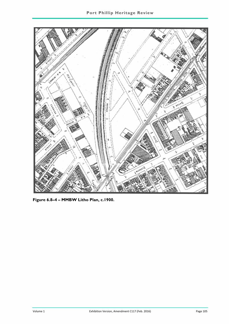
Figure 6.8–4 – MMBW Litho Plan, c.1900.

Port Phill ip Heritage Review
Volume 1 Exhibition Version, Amendment C117 (Feb. 2016) Page 106
Figure 6.8–5 – City Road, with the former cable tramway engine house at left and the former Johns and Waygood factory at right.
Figure 6.8–6 – Former General Motors Corporation headquarters, City Road, looking towards the railway overbridge.

Port Phill ip Heritage Review
Volume 1 Exhibition Version, Amendment C117 (Feb. 2016) Page 304
6.33 Albert Park Residential Precinct / Part Montague Precinct – Ho442Existing Designations:
Heritage Council Register: nil
National Estate Register: nil
National Trust Register: nil
Previous Heritage Studies:
Conservation Study 1975: Precincts 9, 10, 11, 16, 17, 18, 26 (part), 27, 28 and 29
Conservation Study 1987: UC1: Precinct D
Heritage Review 2000: Heritage Overlay 3 (part)
6.33.1 History
Kearney’s 1855 map of Melbourne, which depicts existing and proposed development in the city and inner suburbs at that time, indicates that the land between the Emerald Hill settlement and the foreshore was not only virtually undeveloped at that time, but that further development was evidently not being considered. Nothing was shown between the southern boundary of the settlement – a sinuous roadway then known as Nelson Place (now Nelson Road) - and the elongated salt-water lagoon just across the municipal boundary in Sandridge. Although the principal thoroughfares of Bridport Street and Albert Road (then known as Beach Road) both extended all the way to the beach at that time, the land between them was vacant save for the dotted outline of a subdivision along the ocean frontage. The only structures depicted on Kearney’s map were a gun emplacement at the end of Beach Road (then recently constructed to defend the bay, and thus the entire colony, from perceived naval attack) and a post at the end of Bridport Street, which marked the municipal boundary.266
There was evidently little further development over the next decade, as Hodgkinson’s 1864 map of Albert Park depicts a virtually identical scenario. The original foreshore battery, erected in 1855, had been supplemented by two more gun emplacements, completed in 1860. 267 Cox’s map of South Melbourne, prepared in 1866, shows a few small buildings in fenced enclosures along the foreshore (also associated with military occupation) but no sign of the seaside subdivision shown on the 1855 map, nor indeed of the Bridport Street and Beach Road extensions. This low-lying land remained isolated for some time, separated from Sandridge by the salt-water lagoon, and from Emerald Hill by the new St Kilda railway line, which had opened in 1857. The future settlement of this area was initially facilitated by the withdrawal of military forces from the foreshore barracks in 1870, and by the demolition of the gun emplacements over the next few years.268 The first development in the area took place in 1872, when, as noted by Allom Lovell Sanderson, “the South Melbourne Gas Company secured a six acre site for its works in the swampland adjoining the municipality boundary between South and Port Melbourne.269
266 S Priestley, South Melbourne, p 90. 267 S Priestley, South Melbourne, p 90. 268 S Priestley, South Melbourne, p 90. The foreshore battery at South Melbourne were superseded by a new gun emplacements erected at the heads, and also by the arrival of the ironclad warship Cerberus in 1871. 269 Allom Lovell Sanderson, 3/16.

Port Phill ip Heritage Review
Volume 1 Exhibition Version, Amendment C117 (Feb. 2016) Page 305
Figure 6.33–1 – Detail of Kearney Map (1855) showing the limited development of this area, south of Emerald Hill
(source: Map Collection, State Library of Victoria)
Figure 6.33–2 – Detail of Cox Map (1866), showing that little had changed by that time; note military barracks near beach
(source: Map Collection, State Library of Victoria
Residential settlement began slowly and gradually, initially spurred by the belated development of St Vincent Place. This distinctive subdivision, with its curved crescents and central public reserve, had been proposed in 1854 as an extension to the Emerald Hill town plan but was not formally subdivided until the 1860s. As the first houses finally appeared there from the late 1860s, residential development inevitably began to spread further south and east into the hitherto undeveloped parts of what is now Albert Park. Dundas Place, and the adjacent portion of Bridport Street (west of Ferrars Street) both appear for the first time in the Sands & McDougall Directory in 1870, followed, one year later, by Cardigan Place. The east side of Nelson Road, which marked the edge of the Emerald Hill township, had developed steadily from the mid-1850s, but the west side is not recorded in the directories until 1874. There were only three residents there at that time, but this number had increased to twelve by 1875. Two years later, the new Star & Garter Hotel opened at the end of the block, on the Dorcas Street corner. Development soon spread even further west, with Mountain Street and Pickles Street making their initial appearances in directories in 1878, followed by Greig Street in 1880.
Further to the south, the low-lying land was being gradually reclaimed, prompting a boom of residential settlement from the early 1880s. The Sands & McDougall Directory for 1884 recorded many new streets for the first time, including Barrett Street, Danks Street, Foote Street, Glover Street, Graham Street, Iffla Street, Page Street, Richardson Street and Withers Street. These were followed by Lyell Street, Tribe Street and St Vincent Street West in 1885, by Reed Street in 1887 and by Henderson Street in 1888. Nearer to the beach, a large tract of land bounded by Danks Street, Kerferd Road, Ashworth Street and Bleak House was subject to speculative development in two stages. The first stage (1890) carved up the land east of Phillipson Street into 26 new residential allotments, followed a year later by a further eighteen lots to the west.270
270 Lodged Plans No 3406 (declared 18 December 1891) and 4194 (declared 30 October 1890).

Port Phill ip Heritage Review
Volume 1 Exhibition Version, Amendment C117 (Feb. 2016) Page 306
Figure 6.33–3 – Detail of MMBW Map (1895), showing Victoria Avenue in centre; note relatively dense residential development, gasworks at extreme left, and vacant land (including Dinsdale Street) along Kerferd Road side.
(source: Map Collection, Education Resource Centre, University of Melbourne)
Typically, this residential boom was accompanied by an expansion of associated community facilities. More hotels appeared, most notably the three-storeyed Hotel Victoria on the prominent corner of Beaconsfield Parade and Kerferd Road (1887). One year earlier, a Carmelite priory – the first in Melbourne – had been established on Beaconsfield Parade (now the Kilbride Centre at No 52).
Figure 6.33–4 – 1940’s Postcard showing west side of Kerferd Road/Terrace House, Victoria Avenue, Albert Park, 1889
(source; Port Phillip City Collection)
A few more Protestant churches appeared during this period, including the Presbyterian Church near the corner of Merton and O’Grady Streets (c.1885) and the Wesleyan Methodist Church at the junction of Bridport Street and Cardigan Place (1890). As noted by Allom Lovell Sanderson, further

Port Phill ip Heritage Review
Volume 1 Exhibition Version, Amendment C117 (Feb. 2016) Page 307
residential expansion during this period was prompted by the opening of the Victoria Avenue tramline in 1890.271
The MMBW map of the area, prepared in 1895, indicates dense development throughout much of the precinct, with rows of small cottages and villas. There were relatively few vacant allotments still remaining in the precinct’s north portion, but some occasionally large areas of undeveloped land south of Graham Street, and, more noticeably, between Phillipson Street and Kerferd Road. These, however, gradually filled out during the early twentieth century. According to the Sands & McDougall Directory, the first houses in the hitherto undeveloped block of Dinsdale Street (between Phillipson and Kerferd) were noted on the south side of the street in 1902. Five years later, there were three houses on the south side (Nos 32, 34 and 36) and another “four vacant houses” on the north side. By 1908, the block had fully developed, with twelve occupied houses on each side (designated as Nos 31 to 53 and 32 to 54). Similar development spread along the north side of Page Street, the west side of Kerferd Road, the south side of Ashworth Street and elsewhere. It has been suggested that the same developer or builder was responsible for all of these.
According to the MMBW map, there was also a few pockets of undeveloped land north of Moubray Street in the 1890s, including a large block on the corner of O’Grady and Merton streets (opposite the Presbyterian Church) and another along the south side of Little O’Grady Street. The latter was subsequently developed with a row of single-fronted brick cottages that were first recorded in the Sands & McDougall Directory in 1908. It has been said that these were built to accommodate workers at the nearby Morris Brothers Dairy, although electoral rolls reveal that the original residents comprised labourers, butchers, carters, carpenter and others – but not dairy employees. The dairy itself, which stood nearby at 370 Montague Street, was an existing facility that had been taken over by James Morris and his brothers around the turn of the century, complementing another depot that they had operated for some years at Bay Street, Port Melbourne.272
By the early 1910s, the precinct had almost entirely filled out, and there was consequently little new residential development in the area during the inter-war years. A small number of bungalow-style dwellings were built on the few undeveloped allotments that remained. In one instance, a new house was erected at the rear of an existing Victorian villa on the corner of Moubray and Finlay streets. Curiously, while the inter-war period saw the nearby seaside suburbs of St Kilda and Elwood transformed by a boom of apartment development, very few examples of that type appeared in this part of Albert Park. One notable exception – perhaps not surprisingly erected on the site of an earlier Victorian dwelling – was Avenue Court at 64 Victoria Avenue, designed in 1934 by leading modern architect I G Anderson.273 Two decades later, an entire row of nineteenth century dwellings in Victoria Avenue would be cleared for the construction of a much larger apartment development – the 17-storey Layfield Court, which formed part of the ambitious slum reclamation program carried out by the Housing Commission of Victoria during the 1960s.
6.33.2 Description
The Albert Park Residential Precinct, nominally bounded by Beaconsfield Parade, Pickles Street and Kerferd Road and City Road / Crockford Street (including some properties on the northern side of the corner of Montague Street and City Road in the Montague Precinct), comprises all the land between the original Emerald Hill township and the foreshore, which developed from the early 1870s. The central part of the St Vincent Place estate is not included, as this area is not only already covered by an existing heritage overlay (HO258) but is also on the Victorian Heritage Register. Neither of those existing listings, however, include the outer perimeter of the original St Vincent
271 Allom Lovell Sanderson 3/16. 272 S Priestley, South Melbourne, p 106. See also Sands & McDougall Directory, 1900, 1901. 273 National Trust of Australia (Victoria). Citation for Avenue Court, 64 Victoria Avenue, Albert Park.

Port Phill ip Heritage Review
Volume 1 Exhibition Version, Amendment C117 (Feb. 2016) Page 308
Place estate – that is, the contiguous portions of Park Street, Nelson Road and Cardigan Place – and these portions consequently been incorporated into the present Albert Park Residential Precinct.
Figure 6.33–5 – Typical row of single-fronted block-fronted Victorian cottages in St Vincent Street
Figure 6.33–6 – Double-fronted timber villas along Pickles Street. The low brick fence is not considered sympathetic.
The street layout within the precinct is irregular due to the merging of several discrete subdivision patterns. The southern end of the precinct, for example, has a conventional grid-like layout of streets running parallel and perpendicular to the foreshore, while the western part has streets in similar alignment to Pickles Street. The remaining part of the precinct has streets that follow the alignment of the adjacent St Vincent Place estate, which was laid out in 1855 (although not developed until the early 1870s). The three discrete geometries overlap between Moubray Street, Richardson Street and St Vincent Street, resulting in a number of triangular street blocks and others with acute corner sites. The streets themselves vary from major thoroughfares of generous width (eg Bridport Street, Victoria Street, Nelson Street and Beaconsfield Parade), to smaller cross streets (eg Barrett Street, Withers Street, Finlay Street) and the even narrower one-way streets (eg Little Vincent Street, Little Page Street and Dorcas Lane). Many streets retain original bluestone kerbs or gutters, and a number of laneways (and even some minor streets such as Little Page Street) retain bluestone pitching. The unusually wide bluestone spoon gutter along Kerferd Road, which was provided to assist in the drainage of swampy land in the area, is also a particularly notable feature.
The precinct, which was largely settled between the early 1870s and the late 1880s, is still dominated by nineteenth century housing, with some associated retail strip development along Bridport Street, the south side of Dundas Place, and the east side of Victoria Avenue (qv separate commercial precinct).
Much of the precinct remains strongly characterised by single-storey Victorian dwellings in the form of single-fronted cottages and double-fronted villas, variously of timber or brick construction. Single-fronted timber cottages proliferate throughout much of the precinct, defining the area’s character as a nineteenth century working class suburb. The short streets to the western part of the precinct (eg Lyell, Iffla, Mountain and Tribe Streets, et al) consist almost entirely of such dwellings, with block-fronted facades and simple verandahs with cast iron columns and wrought iron lace friezes. They also proliferate in those streets closer to the beach (where land would have been cheaper), with some notable clusters in Ashworth Street, Danks Street, Graham Street and Reed Street. Little Page Street contains two interesting pairs of semi-detached single-fronted cottages with gable ends to the street, set back only by the width of their narrow verandahs.
The beachside streets also contain large numbers of single-fronted brick cottages, sometime in long rows of identical dwellings (eg 169-187 Danks Street). Single-fronted brick cottages tend to be less

Port Phill ip Heritage Review
Volume 1 Exhibition Version, Amendment C117 (Feb. 2016) Page 309
common in the precinct’s north-west, although a few comparable rows exist such as Harlem Terrace, a row of nine rendered cottages at 21-37 Iffla Street, and Sandgate Terrace, a row of five in bichromatic brick at 54-62 Mountain Street. While the eastern part of the precinct (between Bridport Street and Kerferd Road) is generally characterised by larger and grander Victorian residences, these are still interspersed with clusters of single-fronted brick cottages (eg 390-398 Montague Street). They are also found in larger numbers in the smaller north-south streets (eg Faussett Street) and, more prominently, in the east-west streets (eg Finlay Street, O’Grady Street and Little O’Grady Street). The last named street – another of those very narrow lane-like streets that permeate certain parts of the precinct – contains a fine row of gable-roofed cottages at Nos 3-19 that, notwithstanding their Victorian form, were actually erected as late as c.1908.
Larger double-fronted villas exist in generally smaller numbers throughout the precinct. Scattered example in timber construction can be found in the precinct’s northeast, including some in Bridport Street West, Pickles Street, Dorcas Street (eg Nos 411 and 431 and elsewhere), Iffla Street (No 22), Mountain Street (eg Nos 21 and 35) and elsewhere. One extremely unusual double-fronted timber villa at 55 Greig Street had its block-fronted façade built right to the property line. Closer to the beach, a distinctive row of five double-fronted timber villas survives at 42-50 Little Page Street, set back from this narrow bluestone-pitched roadway only by the width of their narrow verandahs. In this part of the precinct, there are also some examples with asymmetrical frontages and canted bay windows in Withers Street (Nos 62-68) and Foote Street (eg Nos 55, 57). Double-fronted brick villas become more common as one heads further east. St Vincent Street, for example, contains a mix of single-fronted cottages in both timber and brick, plus some larger double-fronted brick villas.
The even larger and grander Victorian residences within the precinct tend to be concentrated on those streets that extend out from the St Vincent Place estate. Rows of double-storey terraced houses proliferate along Madden Street, Dundas Place, Montague Street and Merton Street. The last named street also has a pair of three-storeyed terraces (eg No 79-81), and an impressive row of thirteen double-storeyed terraces (on the north side, between Dundas Place and O’Grady Street) that is said to be the longest row of identical houses in South Melbourne – and perhaps even in the entire metropolitan area. By contrast, the smaller connecting streets, such as Finlay and O’Grady streets, are characterised by smaller single-storey villas and cottages – mostly of brick construction, but occasionally of timber.
Double-storey terraced houses can also be found in numbers along the major thoroughfares of Beaconsfield Parade, the west side of Nelson Road, and the west side of Victoria Avenue. These are less common elsewhere, particularly in the northeast of the precinct (eg double-storey terraces at 7 & 18 Lyell Street, and 433-437 Dorcas Street). Some of the larger double-storeyed Victorian residence near the beach incorporate rooftop towers, clearly intended to exploit ocean views. Examples include the terrace dwellings at 43 Withers Street and 73 Reed Street, and a larger double-fronted townhouse at 92 Danks Street.
As the precinct had virtually filled out before the turn of the century, there are relatively few examples of early twentieth century housing therein. A notable exception is the development of Dinsdale Street, which comprises rows of double-fronted Edwardian villas with asymmetrical facades. Similar but not entirely identical, these houses are expressed in the typical Queen Anne vocabulary of face red brick with hipped or gambrel roofs clad in slate or terracotta tile (some with ridge cresting), and porches with turned posts and timber slat friezes. Comparable but smaller pocket of Edwardian housing exists on the south side of nearby Ashworth Street, and along the prominent thoroughfares of Kerferd Road and Nelson Road. Otherwise, dwellings from that era tend to be represented by only a few isolated examples (eg villa at 64 Merton Street).
Inter-war houses are also uncommon, represented by such examples as the attic-storeyed bungalows at 60 Finlay Street and 18 Ashworth Street. A fine three-storeyed block of flats in the Moderne style, known as Avenue Court, stands at 64 Victoria Avenue, although atypical in the context of the precinct, is nevertheless of architectural and aesthetic interest in its own right as a fine example of the work of its architect, I G Anderson.

Port Phill ip Heritage Review
Volume 1 Exhibition Version, Amendment C117 (Feb. 2016) Page 310
Figure 6.33–7 – A particularly fine row of double-storey rendered terrace houses in Montague Street
Figure 6.33–8 – Double-storey rendered townhouse in Danks Street, with Housing Commission flats looming behind
While retail development was concentrated on parts of Bridport Street, Cardigan Place, Dundas Place and Victoria Avenue, a number of other commercial buildings can be found throughout the precinct. These take the form of modest single-storey Victorian or Edwardian shopfronts (such as 13 Lyell Street) or larger double-storeyed residential shops (with a dwelling above), invariably in the ubiquitous form of corner stores with splayed entries (eg at 41 Lyell Street, and several others along Nelson Road). The precinct contains a number of grander non-residential buildings that provide evidence of the expansion of community facilities in the late nineteenth century, and remain today as prominent landmarks in the area. Ecclesiastical presence is dominated by two striking red brick churches, conspicuously sited on oddly-shaped acute-angled sites at either end of Bridport Street – the former Wesleyan Methodist Church at Cardigan Place, and the somewhat later Anglican Church at Madden Street. The former Presbyterian Church at 47 O’Grady Street, although smaller in scale, otherwise forms a distinctive element in the predominantly residential streetscape, as does the former Carmelite Priory (now Kilbride Centre) at 52 Beaconsfield Parade.
6.33.3 References 1. Kearney Map (1855)
2. Cox Map (1866)
3. MMBW Map (1895)
4. Sands & McDougall Directory (various)
6.33.4 Thematic Context Settlement, Growth & Change
The late Nineteenth Century Boom
Ways of Life
South Melbourne
6.33.5 Comparative Analysis
The Albert Park Residential precinct represents a fine and notably particular extensive collection of late Victorian housing, mostly dating from the Boom period of the 1880s. Although there are many pockets of contemporaneous residential development throughout the municipality, these tend to vary considerably in both extent and variety.

Port Phill ip Heritage Review
Volume 1 Exhibition Version, Amendment C117 (Feb. 2016) Page 311
The fine rows of double-storey terrace houses that dominate the edges of the precinct (ie Dundas Place to the east, Nelson Road to the north and Beaconsfield Parade to the south) have numerous counterparts elsewhere in the municipality. The most exceptional examples are those in the St Vincent Place development, including the smaller portion to the east of the railway line (ie Howe Crescent and Ferrars Place) as well as the larger one to the west (ie St Vincent Place proper). Other fine rows can be found elsewhere, such as Raglan Street (west of Clarendon Street) in South Melbourne, Inkerman Street (between Camden and Nelson streets) in Balaclava, and along Canterbury Road (west of Armstrong Street) and Kerferd Road in Middle Park. The rows of smaller single- and double-fronted villas that characterise the bulk of the Albert Park Precinct can also be compared to similar developments elsewhere. Notable streetscapes of modest single-fronted brick cottages include Thomson Street (west of Clarendon Street) in South Melbourne, and Richardson Street in Middle Park. Counterparts in timber abound in certain parts of Middle Park (eg Neville Street) and elsewhere, such as the particularly cohesive streetscape in Chusan Street, St Kilda East. All of these examples, however, tend to be relatively small-scaled areas in contrast to the more extensive development evident in the Albert Park precinct.
As an example of a cohesive development of late Victorian housing of various types, the Albert Park Precinct is most comparable to the nineteenth-century portions of Middle Park, and St Vincent Place (western portion) in Albert Park. The former, which also largely dates back to the early 1880s, has a similar mix of modest cottages, larger villas, double-storey terraces and freestanding townhouses. The same can also be said of St Vincent Place East in South Melbourne, albeit on a smaller and more concentrated scale. While certain parts of St Kilda (eg St Kilda Hill) also contain a range of late Victorian housing, this is invariably supplemented by a pervasive overlay of inter-war development, which imparts an entirely different character to the area.
6.33.6 Statement of Significance
What is Significant?
The Albert Park Residential Precinct, nominally bounded by Kerferd Road, Beaconsfield Parade, Pickles Street, Nelson Road and Bridport Street and City Road / Crockford Street (including some properties on the northern side of the corner of Montague Street and City Road in the Montague Precinct), covers the most intact portion of an area that largely developed from the mid 1870s to the early 1890s. Formerly occupied by low-lying land that was flood prone in parts and elsewhere occupied by a military battery, the area underwent little residential development until military presence with withdrawn and land reclamation commenced in the early 1880s. Today, it remains strongly characterised by late Victorian housing, which demonstrate a broad range of typologies: from the humblest single-fronted timber cottages through to larger villas in brick and timber, to grander double-storey brick terraces and townhouses.
How is It Significant?
The precinct is of historical, aesthetic and architectural significance to the City of Port Phillip.
Why is It Significant?
Historically, the precinct is significant as an early, ambitious and notable attempt to encourage residential development beyond the boundaries of the Emerald Hill township of 1852. The gradual expansion to the south, southeast and southwest of the original settlement, over several successive phases, is significantly demonstrated by the building stock itself. The prominent streets closest to Emerald Hill and St Vincent Place (such as Nelson Road, Cardigan Place, Dundas Place and Park Street) remain strongly characterised by 1870s development, while the more intensive development of the 1880s Boom period is more evident in the smaller streets to the south and south-west. The subsequent infill of Edwardian housing, most notably apparent in the precinct’s south-eastern corner