post impact mars climate simulations using a gcm
TRANSCRIPT
Post Impact Mars Climate Simulations using a GCM. A. Colaprete1, R. M. Haberle2, T. L. Segura3, O. B. Toon3, K. Zahnle 1SETI (NASA Ames Research Center, Moffett Field, MS 245-3, Mountain View,CA 94035, [email protected], 2NASA Ames Research Center (NASA Ames Research Center, Moffett Field, MS 245-3, Mountain View,CA 94035),3Program in Atmospheric and Oceanic Sciences, Laboratory for Atmospheric and Space Physics, University of Colorado, Campus Box 392, Boulder, CO, 80309.
Introduction: The first images returned by the Mariner 7 spacecraft of the Martian surface showed a landscape heavily scared by impacts. Mariner 9 imaging revealed geomorphic features including valley networks and outflow channels that suggest liquid water once flowed at the surface of Mars. Further evidence for water erosion and surface modification has come from the Viking Spacecraft, Mars Pathfinder and Mars Global Surveyor's (MGS) Mars Obiter Camera (MOC). This evidence includes apparent paleolake beds, fluvial fans and sedimentary layers (Cabrol and Grinn, 1999; Heberle et al., 2001). There is evidence for subsurface water as well. Rampart crates suggest an abundance of water in the near surface regolith (Mouginis-Mark, 1986). The estimated erosion rates necessary to explain the observed surface morphologies (Golombek and Bridges, 2000) present a conundrum. The rates of erosion appear to be highest when the early sun was fainter and only 75% as luminous as it is today. Furthermore the rates of erosion appear to correlate with the rate at which Mars was impacted (Carr and Waenke, 1992). All of this evidence suggests to a very different climate than what exists on Mars today. The most popular paradigm for the formation of the valley networks is that Mars had at one time a warm (Taverage > 273), stable and wetter climate. Possible warming mechanisms have included increased surface pressures (Pollack et al, 1987), carbon dioxide clouds (Forget and Pierrehumbert, 1997) and trace greenhouse gasses. Yet to date climate models have not been able to produce a continuously warm and wet early Mars (Haberle, 1998). An alternate possibility is transient warm and wet conditions initiated by large impacts. It is widely accepted that even relatively small impacts (~10 km) have altered the past climate of Earth to such an extent as to cause mass extinctions (Toon et al., 1997). Mars has been impacted with a similar distribution of objects. The impact record at Mars is preserved in the abundance of observable craters on it surface. Impact induced climate change must have occurred on Mars. Background
Large Impacts: The impacts of asteroids and
comets larger than 100 km in diameter have left more
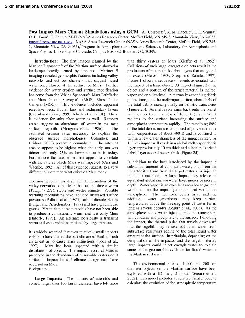
than thirty craters on Mars (Kieffer et al. 1992). Collisions of such large, energetic objects result in the production of meters thick debris layers that are global in extent (Melosh 1989; Sleep and Zahnle, 1997). Figure 1 shows a sequence of events associated with the impact of a large object. At impact (Figure 2a) the object and a portion of the target material is melted, vaporized or pulverized. A thermally expanding debris plume transports the melt/vapor portion, about 20% of the total debris mass, globally on ballistic trajectories (Figure 2b). As melt/vapor rains back onto the planet with temperature in excess of 1600 K (Figure 2c) it radiates to the surface increasing the surface and atmospheric temperature rapidly. The remaining 80% of the total debris mass is composed of pulverized rock with temperatures of about 400 K and is confined to within a few crater diameters of the impact center. A 100 km impact will result in a global melt/vapor debris layer approximately 10 cm thick and a local pulverized debris layer several meters thick (Figure 2d). In addition to the heat introduced by the impact, a substantial amount of vaporized water, both from the impactor itself and from the target material is injected into the atmosphere. A large impact may release an equivalent global surface water layer meters or more in depth. Water vapor is an excellent greenhouse gas and works to trap the impact generated heat within the atmosphere. The hot rock debris layer and the additional water greenhouse may keep surface temperatures above the freezing point of water for as long as several decades (Segura et al., 2002). As the atmosphere cools water injected into the atmosphere will condense and precipitate to the surface. Following the impact, the thermal pulse that travels downward into the regolith may release additional water from subsurface reservoirs adding to the total liquid water amount at the surface. In principle, depending on the composition of the impactor and the target material, large impacts could inject enough water to explain some of the geomorphic evidence for liquid water at the Martian surface.
The environmental effects of 100 and 200 km diameter objects on the Martian surface have been explored with a 1D (height) model (Segura et al., 2002). This model includes a radiative transfer code to calculate the evolution of the atmospheric temperature
Sixth International Conference on Mars (2003) 3281.pdf
following the impact and a model of the regolith to calculate the evolution of the ground temperature. In all simulations Segura et al. (2002) assumed a surface pressure of 150 mbar (CO2 + water vapor) and a 1% water fraction in the impactor and target material. It was found that the planet can be kept above freezing for years (decades) following the impact of a 100 (200) km diameter object, and that a half a meter (few meters) of water may precipitate from the atmosphere and melt from the subsurface as a result of this warming. Larger impacts kept the planet above freezing for centuries, and released larger amounts of water. These 1D calculations suggest that large impacts have the potential to drastically alter the climate for many years and provide a source of surface water. At a minimum, large impacts would have worked to redistribute water globally as injected water is transported and condenses out. Multiple impacts over time may have worked to globally fractionate Martian subsurface water through a process of release and transport.
GCM Simulations: The obvious limitation of
these 1D calculations is the absence of dynamics. An accurate assessment of the effects of impacts on the climate will need to include the transport of both heat and water vapor. Reported here are the initial results of post impact climate simulations using the Ames Mars General Circulation Model (MGCM). A hydrological cycle has been incorporated into the
Ames MGCM that includes the formation of clouds, precipitation and surface reservoirs. In these simulations, an initial warm and wet atmosphere, like that which would immediately follow an impact, is allowed to evolve back to a steady state.
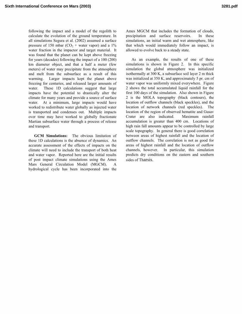
As an example, the results of one of these simulations is shown in Figure 2. In this specific simulation the global atmosphere was initialized isothermally at 300 K, a subsurface soil layer 2 m thick was initialized at 350 K, and approximately 5 pr. cm of water vapor was uniformly mixed everywhere. Figure 2 shows the total accumulated liquid rainfall for the first 100 days of the simulation. Also shown in Figure 2 is the MOLA topography (black contours), the location of outflow channels (black speckles), and the location of network channels (red speckles). The location of the region of observed hematite and Gusav Crater are also indicated. Maximum rainfall accumulation is greater than 400 cm. Locations of high rain fall amounts appear to be controlled by large scale topography. In general there is good correlation between areas of highest rainfall and the location of outflow channels. The correlation is not as good for areas of highest rainfall and the location of outflow channels, however. In particular, this simulation predicts dry conditions on the eastern and southern sides of Tharsis.
Sixth International Conference on Mars (2003) 3281.pdf

Figure 1.
Figure 2.
Sixth International Conference on Mars (2003) 3281.pdf