potential risks to integration - buckinghamshire county...
TRANSCRIPT


HS2-EWR Integration GRIP 2 Feasibility Report 148476-NWR-REP-MPM-000003
Page 9 of 357
Potential Risks to Integration
The principal risks are considered to be:
· Delay to granting of required powers (hybrid Bill and Transportand Works Act Order)
· Delay to/or misalignment of programme timelines· Changes to cost and programme commitments resulting from
industry affordability and deliverability reviews· Complexity of Railway Systems interactions between HS2 and
EWR2

HS2-EWR Integration GRIP 2 Feasibility Report 148476-NWR-REP-MPM-000003
Page 10 of 357
2 DEFINITIONS AND ABBREVIATIONS
2.1 Definitions
The following definitions have been used throughout the text.
Term Definition
Base Scheme The scheme for HS2 contained in the hybrid BillEWR2 CrossSection Network Rail generic cross section
EWR2 Scheme Network Rail proposed scheme for the East West Railproject, Phase 2
HS2/EWR2IntegratedScheme
The scheme that would accommodate HS2 and EWR2meeting the requirements of both railways
Table 2 – Definitions
2.2 Abbreviations
The following abbreviations and acronyms have been used throughoutthe text.
Acronym Explanation
AP Additional Provision
ASPRO Asset Protection
ATFS Autotransformer Feeder Site
ATS Autotransformer Site
CRD Client Requirements Document
EMC Electromagnetic Compatibility
EWR East West Rail
EWR2 East West Rail Project Phase 2
GRIP Governance of Railway Investment Projects
HS2/EWR2 The Integration Project at the interface of HS2 and EWR2
HS2/ HS2L High Speed 2/ High Speed 2 Limited
IMD Infrastructure Maintenance Depot
LoD Limits of Deviation
MCJ(2,3,4)
Engineers Line Reference for the Marylebone ClaydonJunction Line
NR Network Rail

HS2-EWR Integration GRIP 2 Feasibility Report 148476-NWR-REP-MPM-000003
Page 11 of 357
Acronym Explanation
OHLE /OLE Overhead Line Equipment
ONW On Network Works
OXD Engineers Line Reference for the Oxford to Bletchley line
PDS Project Definition Statement
PPA Protective Provisions Agreement
PRA Engineers Line Reference for the Princes Risborough toAylesbury line
TWAO Transport and Works Act Order
WMF Waste management facilities in Calvert Green,Buckinghamshire
Table 3 – Abbreviations
HS2-EWR Integration GRIP 2 Feasibility Report 148476-NWR-REP-MPM-000003
Page 12 of 357
3 INTRODUCTION
3.1 Background
3.1.1 This report concerns the interface of two railway projects, HS2 andEWR2. HS2 is a planned high-speed railway, Phase 1 of which willdirectly link the city centres of London and Birmingham. EWR is aplanned upgrade of the existing conventional railway connecting EastAnglia with central, southern and western England.
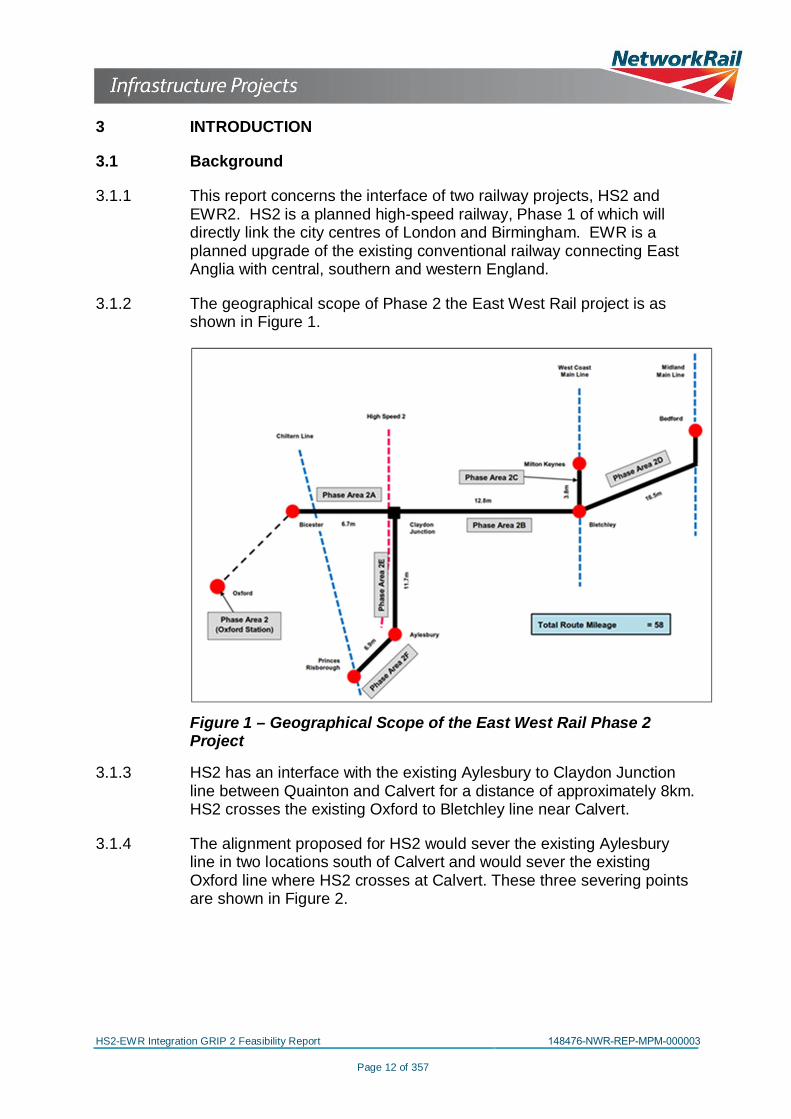
3.1.2 The geographical scope of Phase 2 the East West Rail project is asshown in Figure 1.
Figure 1 – Geographical Scope of the East West Rail Phase 2Project
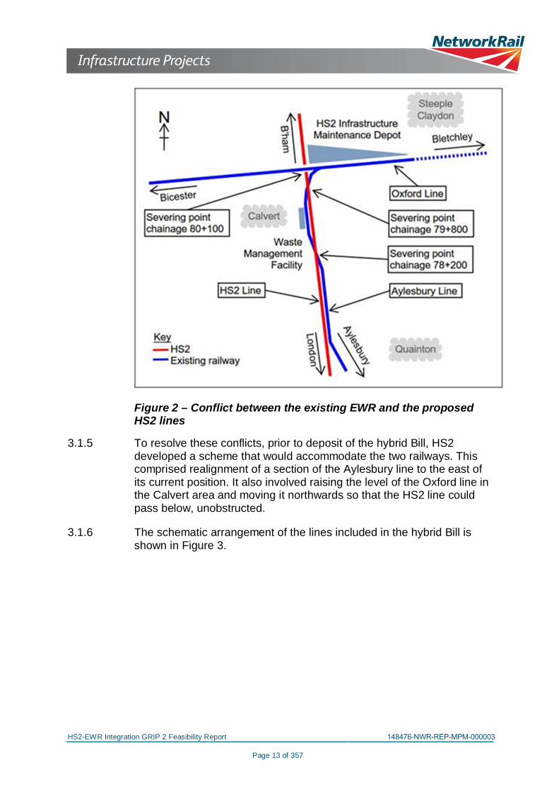
3.1.3 HS2 has an interface with the existing Aylesbury to Claydon Junctionline between Quainton and Calvert for a distance of approximately 8km.HS2 crosses the existing Oxford to Bletchley line near Calvert.
3.1.4 The alignment proposed for HS2 would sever the existing Aylesburyline in two locations south of Calvert and would sever the existingOxford line where HS2 crosses at Calvert. These three severing pointsare shown in Figure 2.
HS2-EWR Integration GRIP 2 Feasibility Report 148476-NWR-REP-MPM-000003
Page 13 of 357
Figure 2 – Conflict between the existing EWR and the proposedHS2 lines
3.1.5 To resolve these conflicts, prior to deposit of the hybrid Bill, HS2developed a scheme that would accommodate the two railways. Thiscomprised realignment of a section of the Aylesbury line to the east ofits current position. It also involved raising the level of the Oxford line inthe Calvert area and moving it northwards so that the HS2 line couldpass below, unobstructed.
3.1.6 The schematic arrangement of the lines included in the hybrid Bill isshown in Figure 3.

HS2-EWR Integration GRIP 2 Feasibility Report 148476-NWR-REP-MPM-000003
Page 14 of 357
Figure 3 – HS2 and East West Rail Arrangement at Calvert
3.2 Respective Application for Powers
3.2.1 Both projects are seeking powers to allow construction to begin. HS2has submitted a hybrid Bill and is seeking Parliamentary approval whileNetwork Rail is preparing an application for a Transport and Works ActOrder. Although the development of HS2 through the hybrid Billacknowledges and allows for EWR, the development of EWR to datedoes not acknowledge HS2.
3.2.2 Under the hybrid Bill HS2L will acquire powers to build the high speedrailway and, in addition, that part of the Aylesbury Line in the limitedarea south of Calvert where it runs closest to HS2. Further south HS2and the Aylesbury Line diverge, the space between them becomingless constrained. Powers for upgrade of the Aylesbury Line in this areaare being sought through the Transport and Works Act Order, which ispromoted by Network Rail.
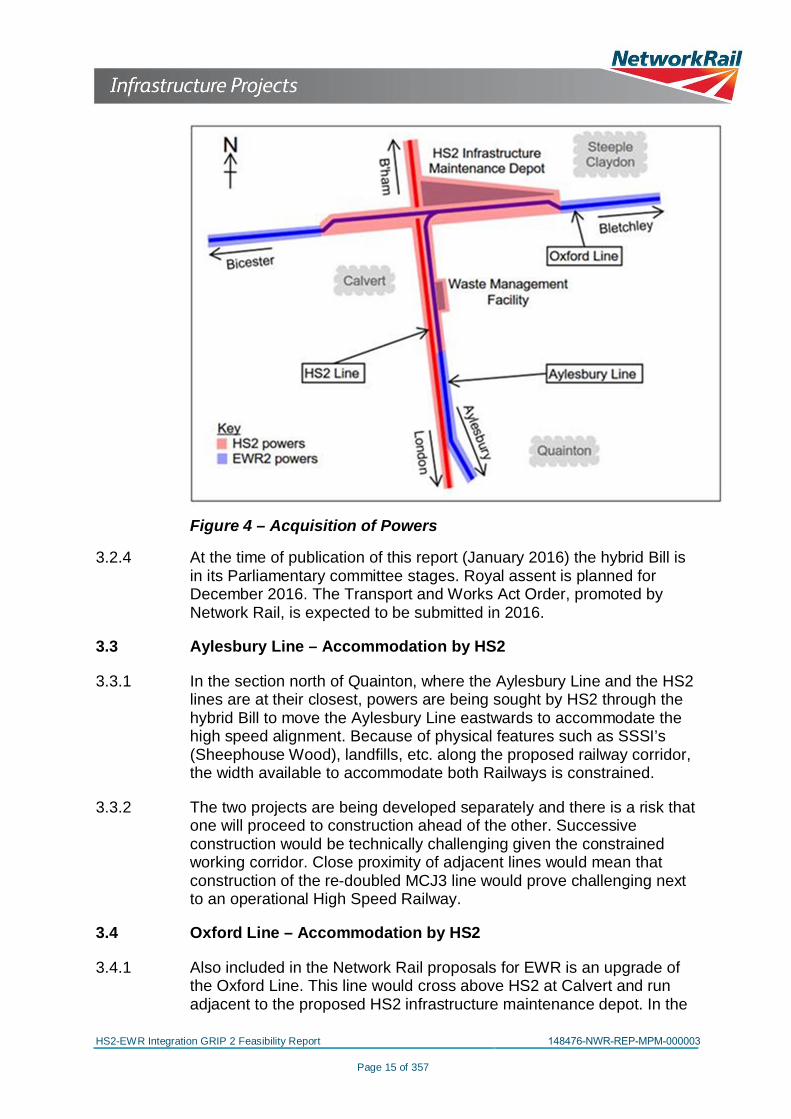
3.2.3 Also under the hybrid Bill, HS2 has sought powers to build a section ofthe Oxford Line in the Calvert area on a realigned section to the northof the existing line. Acquisition of powers by the respective projects isshown in Figure 4.
HS2-EWR Integration GRIP 2 Feasibility Report 148476-NWR-REP-MPM-000003
Page 15 of 357
Figure 4 – Acquisition of Powers
3.2.4 At the time of publication of this report (January 2016) the hybrid Bill isin its Parliamentary committee stages. Royal assent is planned forDecember 2016. The Transport and Works Act Order, promoted byNetwork Rail, is expected to be submitted in 2016.
3.3 Aylesbury Line – Accommodation by HS2
3.3.1 In the section north of Quainton, where the Aylesbury Line and the HS2lines are at their closest, powers are being sought by HS2 through thehybrid Bill to move the Aylesbury Line eastwards to accommodate thehigh speed alignment. Because of physical features such as SSSI’s(Sheephouse Wood), landfills, etc. along the proposed railway corridor,the width available to accommodate both Railways is constrained.
3.3.2 The two projects are being developed separately and there is a risk thatone will proceed to construction ahead of the other. Successiveconstruction would be technically challenging given the constrainedworking corridor. Close proximity of adjacent lines would mean thatconstruction of the re-doubled MCJ3 line would prove challenging nextto an operational High Speed Railway.
3.4 Oxford Line – Accommodation by HS2
3.4.1 Also included in the Network Rail proposals for EWR is an upgrade ofthe Oxford Line. This line would cross above HS2 at Calvert and runadjacent to the proposed HS2 infrastructure maintenance depot. In the
HS2-EWR Integration GRIP 2 Feasibility Report 148476-PBR-REP-EMF-000002
Page 16 of 357
hybrid Bill HS2L based its scheme on the understanding that thisNetwork Rail upgrade would be operational at the time of HS2construction. As such it sought powers to build an elevated section ofthe Oxford Line to the north of the existing alignment (offline) thusallowing the HS2 line to run beneath it. This arrangement allowedconstruction of the scheme without disturbing the operational OxfordLine.
3.4.2 It is now more likely that works for HS2 will precede EWR in the Calvertarea. Consequently there may be no need for an offline re-alignment ofthe Oxford Line at Calvert. Confirmation through development of anintegrated programme could yield a capital cost saving.
3.5 Geographical Definition of the HS2/EWR2 Interface Area
3.5.1 The geographical scope covers the proposed works at the interfacebetween the HS2 and EWR2 projects. In terms of HS2 chainage andexisting features this is as follows.
Line Reference Limits
Aylesbury LineFrom Quainton in the south to West Street bridge (HS2chainage 71+500m to 81+500m), covering both HS2and Aylesbury Line corridors
Oxford Line
From Charndon overbridge (carrying Main Street) in thewest to existing Middle Claydon No. 8 footpath levelcrossing (near Queen Catherine Road) in the east,covering the Oxford line
Table 4 – Geographical Limits of the Interface Area
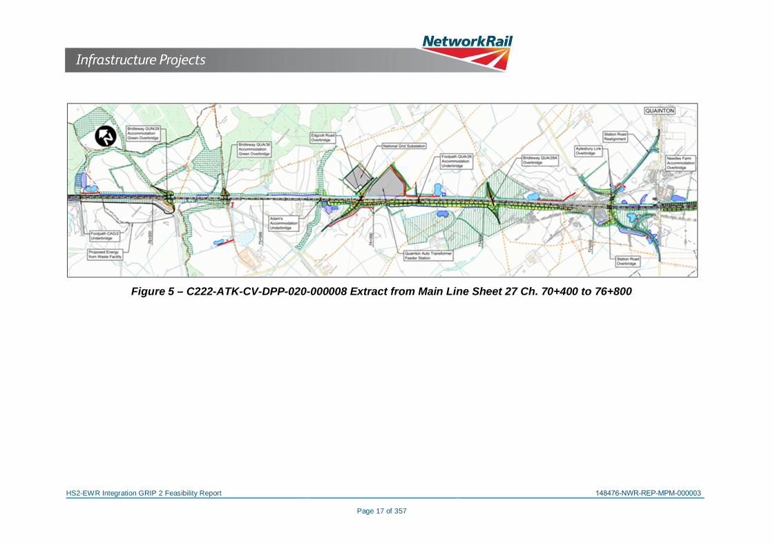
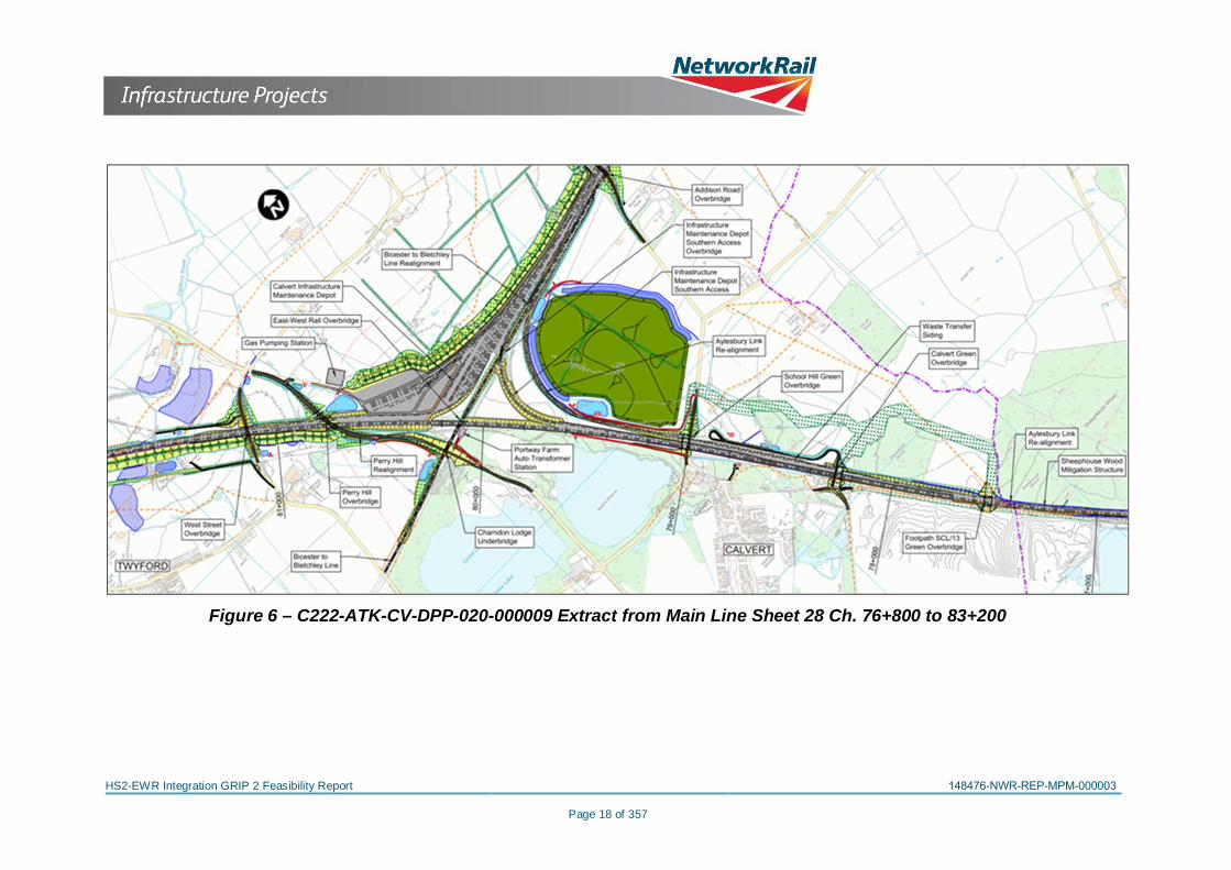
This area is shown in the following drawing extracts.
Drawing Number Title
C222-ATK-CV-DPP-020-000008
Main Line Sheet 27Chainage 70+400 to 76+800
C222-ATK-CV-DPP-020-000009
Main Line Sheet 28Chainage 76+800 to 83+200
Table 5 – Interface Area Drawing References
Calvert and Quainton, as shown on the plans, are approximately 18kmand 11km north west of Aylesbury respectively.
HS2-EWR Integration GRIP 2 Feasibility Report 148476-NWR-REP-MPM-000003
Page 17 of 357
Figure 5 – C222-ATK-CV-DPP-020-000008 Extract from Main Line Sheet 27 Ch. 70+400 to 76+800

HS2-EWR Integration GRIP 2 Feasibility Report 148476-NWR-REP-MPM-000003
Page 18 of 357
Figure 6 – C222-ATK-CV-DPP-020-000009 Extract from Main Line Sheet 28 Ch. 76+800 to 83+200

HS2-EWR Integration GRIP 2 Feasibility Report 148476-NWR-REP-MPM-000003
Page 19 of 357
4 CURRENT STATUS OF THE TWO SCHEMES
4.1 EWR2 Scheme
4.1.1 The current scheme for the EWR2 project in the HS2/ EWR2 InterfaceArea does not consider HS2, i.e. EWR2 proposes to upgrade theexisting infrastructure on the current MCJ and OXD alignments. It isdefined on the 100000 series drawings in Appendix 2.2. They showthe proposals for the OXD and the MCJ in the geographical area whereHS2 and EWR2 would interface.
4.1.2 In order to deliver the NR requirements, a cross-section of the EWR2twin track corridor with electrification was developed during the EWR2feasibility stage. It is taken as a statement of NR’s spatial requirementsalong the OXD and MCJ corridors (i.e. new works are to incorporatecorridors of dimensions as shown on that cross-section such thatprovision of twin tracks and OLE along the OXD and MCJ is notprecluded, whether at first opening to the public or in the future). Thegeneric EWR2 Cross-Section, which has been developed to a GRIPStage 2 feasibility level of design, is as shown in Figure 7.
Figure 7 – EWR2 twin track corridor with electrification(Dimensions in mm)
4.1.3 The 100000 series drawings together with the EWR2 Cross-Section inFigure 7 define the EWR2 Scheme.
4.2 Base Scheme
4.2.1 HS2L and Network Rail agreed that the version of the HS2 schemedesign in the HS2/ EWR2 Interface Area to be used for the purposes ofthis HS2/ EWR2 integration exercise is the hybrid Bill scheme asamended by AP2 but together with the amended workable design for

HS2-EWR Integration GRIP 2 Feasibility Report 148476-NWR-REP-MPM-000003
Page 20 of 357
the WMF sidings to the east (the latter formerly developed for andinitially included in AP2 but transferred to AP4).
4.2.2 This scheme is referred to as the Base Scheme for the purpose of thisreport. Unlike the EWR2 scheme, this scheme seeks to accommodateboth HS2 and EWR2. It is therefore taken as the starting point fordeveloping an integrated design.
4.2.3 In the Base Scheme, the relationship between HS2 and the MCJ alongthis corridor is broadly as follows:
· from about HS2 chainage 72+200 to 76+400, HS2 and the MCJare at broadly the same level, and the MCJ corridor is unaffected
· from HS2 chainage 76+400 to approximately 77+700, including inthe general vicinity of Sheephouse Wood, the two railwaysremain at roughly the same level, but the MCJ is shifted by about1-2 metres eastwards, although without infringing uponSheephouse Wood
· from chainage 77+700 to Claydon Junction, the railways divergeincreasingly, both vertically as HS2 descends to go under theOXD and the MCJ remains flat to meet the OXD, and horizontallyas the MCJ4 chord is displaced eastwards to accommodate theHS2 IMD southern rail access.
4.2.4 The Base Scheme provides corridor width to the east of the HS2alignment for the initial construction of a single track MCJ railway withpassive provision for the later addition of a second track. This corridorwidth is provided over the northern part of the section from 76+400northwards to Claydon.
4.2.5 The cross-section in the vicinity of Sheephouse developed for the BaseScheme is as shown on HS2 drawing number C241-PBR-RT-DSE-020-000003 revision P01 dated 13/08/2013 entitled Calvert EWR –Aylesbury Line Cross Section at HS2 Chainage 77+294. This is shownon Figure 8 below. It shows that the Base Scheme accommodates twotracks on the MCJ, but does not actively consider lateral provision forfuture electrification of the MCJ. The assumption was that during HS2construction, only one NR track on the MCJ3, the eastern of the two,would be operational, and that the second track would be provided inthe future.
4.2.6 A set of drawings has been produced to show the Base Scheme in theHS2/ EWR2 Interface Area. They are the 200000 series of drawings.These are in Appendix 2.3.

HS2-EWR Integration GRIP 2 Feasibility Report 148476-NWR-REP-MPM-000003
Page 21 of 357
Figure 8 – C241-PBR-RT-DSE-020-000003, Calvert EWR – Aylesbury Line Cross Section at HS2 Chainage77+294

HS2-EWR Integration GRIP 2 Feasibility Report 148476-NWR-REP-MPM-000003
Page 22 of 357
4.2.7 The principal assumptions and/or constraints upon the HS2 Billprogramme were as follows:
· EWR2 would be completed and operational before HS2construction commenced, with (i) the OXD twin track andelectrified, and (ii) the MCJ only a single track and not electrified.Accordingly the HS2 construction work would be carried outalongside an operational railwayRail access to the WMF had to be maintained throughoutconstruction
4.2.8 A schedule of the HS2 documents and drawings that have been drawnon for this study is given in Appendix 3.
HS2-EWR Integration GRIP 2 Feasibility Report 148476-NWR-REP-MPM-000003
Page 23 of 357
5 REQUIREMENTS
5.1 Development of Network Rail’s Requirements for HS2 and EWR2
The development of NR’s requirements for HS2, culminating in theProtective Provisions Agreement (PPA), and subsequently of NR’sClient Requirements Document (CRD) for EWR2 is shown in thefollowing table:
No Date Key document
1 11th October 2012 NR requirements (V1)
2 12th March 2013 HS2 v2.0 Requirements
3 9th April 2013 Network Rail HS2 Requirements 13-0409
4 15th May 2013 NR requirements (V2)
5 24th October 2013Project Definition Statement (PDS) –Calvert East-West Rail
6 3rd February 2014 NR requirements (V3)
7 28th February 2014 Protective Provisions Agreement (PPA)
8 5th March 2014NR’s Client Requirements Document(CRD) for EWR2
Table 6 – Development of Network Rail’s Requirements for HS2and EWR2
5.2 HS2 v2.0 Requirements incorporating NR Requirements within theBase Scheme
The designs used for the HS2 hybrid Bill were based on therequirements in document number LWM-HS2-SA-WIS-000-000002entitled ‘HS2 Project Requirements - Phase 1: Interim PreliminaryDesign V2.0’, dated 12th March 2013. Appendix A of the documentcontains the following requirements relating to the Interface Area:
Location Requirements
Calvert –Infrastructureto beconsistent withEast West Railproject
W12 + electrification clearances
Double track between Bicester Town & BletchleyRemodelling of Claydon Junction and provision of 477m run-round loop for freight trains to and from Calvert (likely to becombined with 775m recessing loop)578m bi-directional passenger loop at Calvert
100mph line speed between Bicester and Bletchley & 90mphbetween Claydon & AylesburyProvision for extension of EWR services beyond Aylesbury
Table 7 – HS2L’s Requirements for EWR2

HS2-EWR Integration GRIP 2 Feasibility Report 148476-NWR-REP-MPM-000003
Page 24 of 357
5.3 NR requirements (V2) for HS2
Network Rail requirements for HS2 are contained in the spreadsheetentitled ‘Network Rail HS2 Requirements 13-0409’, dated 9th April2013. A copy of this document is in Appendix 1.1. The mainrequirements in respect of EWR are as follows:
Ref. Requirements
1 HS2 shall be integrated with EWR through collaboration with the EWRproject
2 Double track shall be facilitated on the East West Rail (EWR), including theQuainton to Calvert section.
3 A run-round loop for freight trains of at least 477m in length shall be providedfor trains operating to and from Calvert.
4 A bi-directional passenger loop suitable for trains of 578m shall be providedat Calvert.
5 A line speed of 100mph between Bicester and Bletchley and 90mph betweenClaydon and Aylesbury shall be facilitated with the infrastructure.
6
The risk assessment for all affected level crossings (Claydon Level Crossing(Queen Catherine Road) and the footpath crossings) shall be revised orundertaken if not in existence to include all implications from HS2 and thenecessary actions implemented.
7Sufficient clearance shall be included on the classic lines for electrificationOLE at all locations where HS2 intersects with the classic lines irrespectiveof whether electrification is currently installed or planned.
8
Where HS2 runs adjacent to classic lines allowance shall be provided duringthe works and on completion for electrification of the classic lines irrespectiveof whether electrification is currently installed or planned, for exampleavoiding stray currents and leaving space for OLE mast positions.
Table 8 – NR’s Requirements v2 for EWR2
These were submitted to NR on 14th May 2013 as NR requirements(V2). With the exception of item 7, they were adopted by NR. (Asregards item 7, HS2 stated their design is not anticipated to impact onthe Claydon Level Crossing (Queen Catherine Road) as the HS2 worksdoes not extend as far as the level crossing.)
5.4 HS2L’s Project Definition Statement for the Base Scheme
A copy of HS2L’s Project Definition Statement (PDS) C241 – CalvertEast-West Rail, dated 24th October 2013 is in Appendix 1.2. This setsout NR requirements for this area as follows:
Ref. Requirements
1 Provision of W12 + electrification gauge clearance on all NR lines
2 Allowance for double track and electrification on the OXD
3 Passive provision for double track on the MCJ

HS2-EWR Integration GRIP 2 Feasibility Report 148476-NWR-REP-MPM-000003
Page 25 of 357
Ref. Requirements
4 Details of the remodelling of Claydon Junction to be provided by project
5 Provision of 477m run-round loop for freight trains to and from Calvert (likelyto be combined with 775m recessing loop)
6 Provision for a 578m bi-directional passenger loop at Calvert
7 The alignment of the OXD and MCJ should permit lines speeds of 100mphand 90mph respectively
Table 9 – NR Requirements in HS2L’s PDS
5.5 Protective Provisions Agreement (PPA)
The PPA was signed on 28th February 2014. The requirements withrespect to EWR include those in the following table (see Appendix 9for extracts from the PPA):
Location Requirements
Crossing Of EastWest Rail
HS2 shall be integrated with EWR through collaboration withthe EWR project.
Double track shall be facilitated on the EWR, including theQuainton to Calvert section.
A run-round loop for freight trains of at least 477m in lengthshall be provided for trains operating to and from Calvert.
Passive provision shall be made for Up and Down freight loopssuitable for 775m long trains between Claydon and Bletchlev.
It shall be permissible for active provision of one of the 775mlong loops (NR-HS2-0408) to satisfy the requirement for the477m long run-round loop (NR-HS2-0409).
A bi-directional passenger loop suitable for trains of 578m shallbe provided on the MCJ lines at Calvert.
100mph line speed between Bicester and Bletchley & 90mphbetween Claydon & Aylesbury
HS2 will undertake risk assessment model to demonstrate ifHS2 impacts on Claydon Level crossing. Any risks that areidentified from the risk assessment will be agreed betweenHS2 and NR as to the action ownership.
Compensated equivalent gradients on the Oxford to Bedford(OXD) track shall be no steeper than 0.67%.
Compensated equivalent gradients on the Marylebone toClaydon (MCJ) track shall be no steeper than 0.90%.
Conventional RailSystems
HS2 to provide minimum clearances in accordance with NRtrack design standards for current and possible futureelectrification
Table 10 – PPA Requirements related to EWR

HS2-EWR Integration GRIP 2 Feasibility Report 148476-NWR-REP-MPM-000003
Page 26 of 357
5.6 Network Rail’s Requirements dated 5th March 2014 for the EastWest Rail Phase 2 project
NR’s Client Requirements Document (CRD) for EWR2 is in Appendix1.3. The CRD includes the following requirements in either theInfrastructure Specification (section 6 of the document) or theElectrification Specification (section 7 of the document:
Ref. Requirements
1 Route between Oxford and Bletchley (Denbigh Hall Junction) to beelectrified on behalf of the “Electric Spine” project (see section 7 below)
2 New structures to be built to W10 AND W12+ (electrification) gaugebetween Princes Risborough and Claydon Junction.
3Target line speed between Oxford – Bletchley - Bedford is 100mph unlessthis is not realistically achievable due to infrastructure constraints or highcost.
4Target line speed between Claydon and Princes Risborough is 90mphunless this is not realistically achievable due to infrastructure constraints orhigh cost.
5 Minimum Route Availability (RA) 10 or RA 12 if deliverable at marginal cost.
6Interface with HS2 at Claydon to be designed to take into account HS2requirements in the area, in particular access to the HS2 maintenancedepot and the alignment of the intersection bridge.
7 Signalling control strategy to be developed in accordance with widernational strategy.
8The route between Oxford and Bletchley (Denbigh Hall Junction) is to beelectrified as part of the East West works, under remit from the ElectricSpine Project Team.
9
The Claydon Junction – Aylesbury section will not be electrified at thisstage, but will form part of any subsequent project to electrify the Chilternroutes out of Marylebone. All new works should, therefore, be designed toaccommodate electrification at a later date, although there is norequirement at this stage to clear the whole route to W10 AND W12+(electrification) gauge unless a case can be made for doing so.
Table 11 – NR’s CRD Requirements related to the Interface Area
In summary, the NR requirement is that the OXD and the MCJ are bothto be double track, the OXD is to be electrified, and the MCJ is toaccommodate electrification at a future date.
5.7 HS2L’s Requirements for HS2 in the interface area
HS2L’s requirements for HS2 in the interface area are that HS2 is to bedouble track, is to be electrified, and is to be designed for up to 18trains per hour travelling at up to 360 kph.

HS2-EWR Integration GRIP 2 Feasibility Report 148476-NWR-REP-MPM-000003
Page 27 of 357
6 DEVELOPING AN INTEGRATED SCHEME
6.1 Introduction
6.1.1 This section examines how far the Base Scheme delivers the currentHS2L and NR requirements. It finds that a number of modificationsshould be made to achieve a fully integrated scheme, in particular inorder to resolve a shortfall in the width of the combined HS2/MCJcorridor where the two railways run in parallel between Quainton andCalvert.
6.2 Assumptions and Constraints
6.2.1 The key constraints on developing an integrated scheme include, forexample:
· The HS2 LoD· NR’s property boundary· Provision for the WMF sidings· HS2 alignment constraints· Sheephouse Wood Site of Special Scientific Interest· Interactions and compatibility between HS2 and NR Rail
Systems.· Mitigation of environmental impacts, including the Sheephouse
Wood Mitigation structure
6.2.2 The hybrid Bill scheme is based upon HS2L’s and NR’s respectiverequirements as understood at the time of its preparation by HS2L in2013.
6.3 Methodology
6.3.1 The report examines two principal issues:
· To what extent does the Base Scheme deliver both HS2’s andNR’s current requirements, and if not what are the features of thescheme that need to be addressed in order to obtain an HS2/EWR2 Integrated Scheme
· the most cost effective way of delivering this scheme in the HS2/EWR2 Interface Area
6.3.2 The approach taken to establishing how far the Base Schemeaccommodates NR’s requirements for ERW2 is as follows:
· Overlay the EWR2 Cross-Section on the Base Scheme along theMCJ and OXD to confirm that it can fit within the available space.This was done by setting the EWR2 Cross-Section alongside the

High Speed 2 / East West Rail Phase 2 Integration
GRIP Stage 2 Feasibility ReportFebruary 2016
Network Rail Contract Number 148476
eB Ref: 148476-NWR-REP-MPM-000003
HS2-EWR Integration GRIP 2 Feasibility Report 148476-NWR-REP-MPM-000003
Page 28 of 357
HS2 trace to see if the eastern side falls within the LoD/NRproperty boundary. (It could equally have been done by settingthe EWR2 Cross-Section alongside the LoD/NR propertyboundary to see if there was any overlap with the HS2 trace – theresult conclusions would have been the same). The results areshown on a set of drawings, the 200500 series, showing cross-sections taken through the MCJ and OXD in the Base Scheme,including at all bridges, and representative locations along theMCJ and OXD
· The EWR2 Scheme drawings (the 100000 series) and the BaseScheme drawings (the 200000 series) are used to populate aSchedule of Works (see Appendix 7.1), recording for any givenlocation (for example a bridge) the works that EWR2 would carryout, and the works that HS2 would carry out. This schedule is inturn interrogated to establish whether any changes are requiredto the Base Scheme to achieve the functionality required byEWR2.
6.4 Track and Alignment: OXD Corridor.
6.4.1 In the Base Scheme, the OXD is shifted approximately 30 metres to thenorth (so that it can be constructed off-line of the operational OXD,which it was assumed would be in place before HS2 constructioncommenced). It is raised on embankment and new bridges to carry itover HS2 and the HS2 southern rail access into the IMD.
6.4.2 Because the OXD is now not expected to be operational before thestart of HS2 construction, and provided a blockade is acceptable, thereis the opportunity to construct the OXD “on-line”. This would avoidabortive work. It is subject to design verification that a revised design iscompatible with the HS2 LoD and/ or the NR property boundary.
6.5 Track and Alignment: MCJ Corridor
6.5.1 Development of the EWR2 alignment between Claydon Junction andAylesbury to feasibility stage was completed in May 2015. Thisalignment was produced on the basis that there was no proposal tobuild HS2. By contrast, this report considers the arrangement thatincludes both railways alongside one another occupying a sharedcorridor between Claydon Junction and Quainton Road, a distance ofapproximately 6.8 kilometres.
6.5.2 Requirements for EWR2 prepared by Network Rail anticipate that theroute will be electrified at a later date. Accommodation of electrificationmasts and associated lateral clearances, along the MCJ corridor wasnot provided for in the HS2 Base Scheme.

HS2-EWR Integration GRIP 2 Feasibility Report 148476-NWR-REP-MPM-000003
Page 29 of 357
6.5.3 The cross-sections along the combined HS2/MCJ corridor are drawn,based on:
· the HS2 generic cross-section based on drawing C241-PBR-RT-DSE-020-000002 P01
· locating the EWR2 cross-section alongside the HS2 genericcross-section
6.5.4 Combined HS2/MCJ Corridor Study
6.5.4.1 A detailed analysis of the combined cross sHS2/MCJ corridor followsbelow.
6.5.4.2 The two railways run alongside each other from Claydon Junctionsouthwards to Quainton, which is approximately between HS2chainage 80+000 and 72+000. North of chainage 76+400, the HS2LoD lie on the eastern side of the MCJ, and south of it they lie on thewestern side.
6.5.4.3 North of chainage 78+400, HS2 and MCJ diverge both horizontally andvertically. It can be seen from the cross-sections on drawings 200506,200507 & 200508 (see Appendix 2.4) that the EWR2 Cross-Sectioncan be accommodated and NR’s requirements met in that part of theMCJ.
6.5.4.4 Further south the two railways are alongside each other, and theirrelative positions are shown in a series of sections (see the 200500drawing series in Appendix 2.4). These show that the combinedHS2/EWR corridor, including the NR generic section and the HS2generic section, needs to be optimised in order to keep the railwayswithin the NR property boundary and the HS2 LoD.
6.5.4.5 The corridor between HS2 chainages 78+400 and 72+000 is shown onDrawing EWRH-EMD-DRG-PBL-200201 Revision P03, ‘NR and HS2Quainton - Calvert Potential Corridor Width Constraints’. This drawingis in Appendix 4. It comprises a plan of the alignment, relevant crosssections and a tabulation of results. In addition to the railwayalignments the plan indicates the HS2 LoD. Also shown is the NRproperty boundary, which has been taken from the current EWR2consultation drawings. Various geographical features are shownincluding Sheephouse Wood which is immediately east of the railwayalignments.
6.5.4.6 At a number of locations, the generic cross-section from the BaseScheme is compared to the Network Rail generic cross section. Asimple check is carried out to identify whether the combined corridor,needs to be optimised in order to keep the railways within the NRproperty boundary and the HS2 LoD.

HS2-EWR Integration GRIP 2 Feasibility Report 148476-NWR-REP-MPM-000003
Page 30 of 357
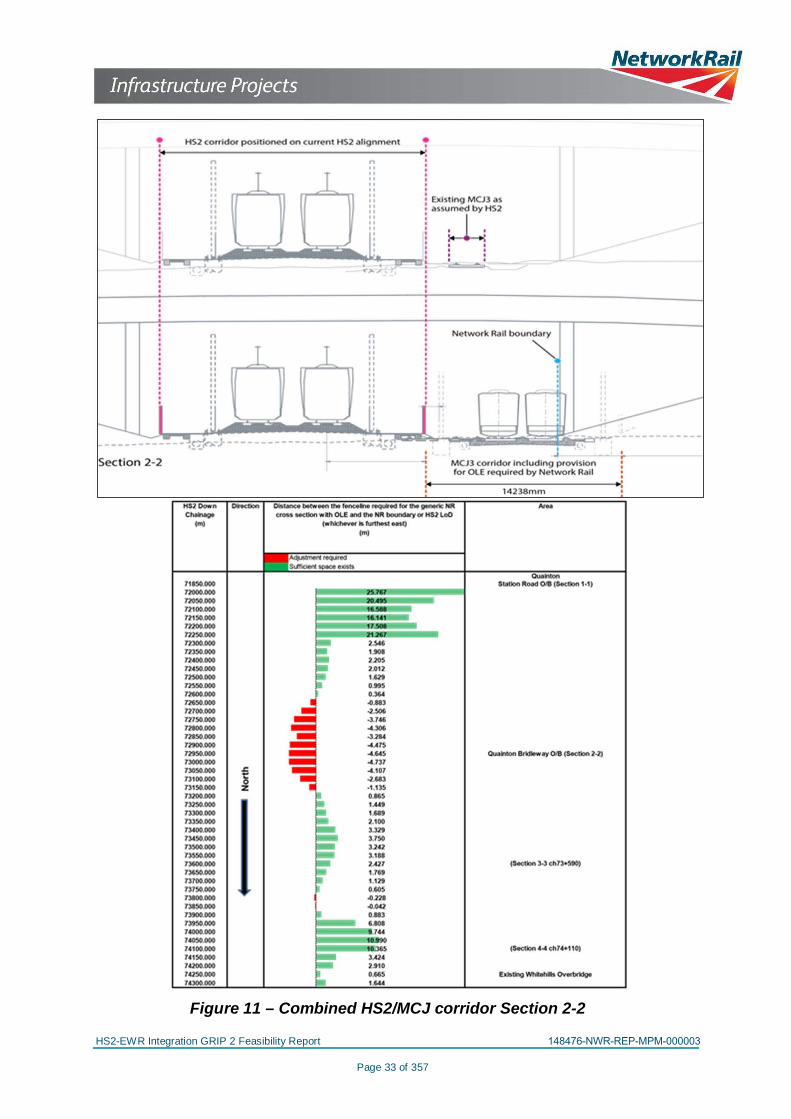
6.5.4.7 Areas where optimisation is needed are tabulated on the drawing in 50metre chainage intervals. These indicate in green those areas wherethe proposed EWR2 generic cross-section can be accommodated, andin red those areas where modification will be required to achieve a fit.This tabulation and the representative cross-section numbers 10-10, 6-6 and 2-2, where the typical cross-sections from the Base Scheme arecompared to those with the EWR2 trace overlain, are reproduced belowfor convenience.
6.5.4.8 Between chainage 77+500 and 76+700 the railways pass the westernboundary of the Sheephouse Wood Site of Special Scientific Interestnotified under Section 28 of the Wildlife and Countryside Act 1981. Thestatus of the woodland means that encroachment of its boundary toconstruct railway works is unlikely to be acceptable. Section 10-10shows the HS2 and the EWR2 proposed cross section, applied at themost constrained point opposite Sheephouse Wood. This section alsoincludes a notional outline of the proposed Sheephouse WoodMitigation Structure.
6.5.4.9 Sections 6-6 and 2-2 show the HS2 and EWR2 generic cross-sectionsin other areas along the corridor.
6.5.4.10 It is clear from this study that optimisation of the HS2 generic cross-section and the Network Rail generic cross section is needed in thelocations identified in Figures 9 to 11 where the two railways run inparallel between Quainton and Calvert.

HS2-EWR Integration GRIP 2 Feasibility Report 148476-NWR-REP-MPM-000003
Page 31 of 357
Figure 9 – Combined HS2/MCJ corridor Section 10-10
7,700.000 52-tO ~·-7f7SO.OOO 2.m ~·-76100.000 ,~,.
~w-76450.000 ~"'" ~·-16900..000 ·tAtS
~·-7 .. 50.000 ·U.S ~·-nooo.ooo ., t5 ~·-n050.000 O.S34
~·-ntoo.ooo 0.676 ~·-ntso.ooo 0~
~·-71200..000 ·1.2117 ~·-rrno..ooo ~
~·-n2k000 .)M) ~w-~lofttO.tOI 17)()0.000 -3.562
~·-17350.000 ~-"' ~·-n.oo.ooo 1.$64 ~·-n•so.ooo uoo ~·-nsoo.ooo 8.5$5
~·-nsso.ooo UQ• ~·-(S«dott ,,.,,, n&oo.ooo 1.)90
~·-n&so.ooo 10.101 ~·-moo.ooo ' " ~·-n1so.ooo ~ 10-$31
~·-n-ooo t:: 10,340
~·-naso.ooo 0 t.a.c7 ~·-ntoo.ooo z 1.737 o.c_..sw-
mso.ooo 7AIO ~·-1tOOO.OOO 5.)0t ~·-noso.ooo ~~
~·-11100.000 '·'" ~ w-(S«dott 11·121 11150.000 .a. .. HS2LOO-- o.c_..sw-1I20o.OOO .a. .. HS2LOO--
_,. he~
11250.000 .a. .. HS2LOO-- WWISoc:Uon t).t)CIITI•ml 11)00,000 rio *'HS2LOO-- w ,. r..-y 11)50.000 M*'HS2LOO-- w ,. r..-y - MIHHS2LOO-- -~''-'41 ~000 MHHS2LOO-- Wute ~ 1l5oo.ooo MIHHS2LOO-- w.,. ~ 11)50.000 rio .. HS2LOO-- w ,. r..-y - '*'HS2LOO-- w ,. r..-y 11650.000 .a. .. HS2LOO-- w •• F..-y 11700.000 MHHS2LOO-- WHit ~ 11750.000 MHHS2LOO-- he~ neoo.ooo .a. .. HS2LOO-- , .. ~ 11*50..000 .. HS2LOO-- r..-y 1ltOO..OOO .a. .. HS2LOO-- F..-y 11950.000 .a. .. HS2LOO-- F•81y

HS2-EWR Integration GRIP 2 Feasibility Report 148476-NWR-REP-MPM-000003
Page 32 of 357
Figure 10 – Combined HS2/MCJ corridor Section 6-6
• .
Section 6-6
74350.000 7.UOO.OOO 7«50.000 74*-000 74550.000 74iCIO.OOO 74650.000 747 000 747!i0.000 1.-ooo 74t!.O.OOO 7 000 74950.000 7~000 7~000
~I 000 7SI50.000 7~.000 7$250.000 7»00.000 7S3 000 7S.OO.OOO 7~:.0.000 7$$(0000 1')$50.000 ~000 7~.000
~71».000 7S750.000 ~.000
75150.000 7-000 rw.oo.ooo 71000.000 ~:.0.000 NIOO.OOO NI!.O.OOO ~000 nlSO.OOO "*-000 mso.ooo -000 n450.000 71000.000 mso.ooo n600.000 ~000
€ 0 z
.,._.......,tot.,.~
--· 0U - ... N~ IIOurld.llyOI H~L..o 110'*'lo-tb()
tool
1»0 ..m Ll71 U3Ci U.ct 0611 .0.107 o.t4)
OJI7 O.IM ·'-'1!1 .u .. -I~
l .lO$ U04 1.17$ · I ,IU .0.320 0.101 1.002
5241 '.)29 )707
·IMI 0.211 OAU 0.101 .OAI7 .0.741 .0.202 OA-47 1.2tt 2.111 O.JOI ·1.201 OAOO U3l
•
twork Rail bound ry
HS2-EWR Integration GRIP 2 Feasibility Report 148476-NWR-REP-MPM-000003
Page 33 of 357
Figure 11 – Combined HS2/MCJ corridor Section 2-2
•
Sect ion 2-2
HS2 corr dot posltloned on currMt HS2 llgnmMt
71 000 nooo.ooo noeo.ooo 71100.000 n1:oo.ooo 7noo.ooo 722$0.000 moo..ooo 723$0.000
rtoiOO.OOO n4:i0.000 ~000 72$50.000 ~000 7-.GOO moo,ooo 1n:oo.ooo neoo.ooo Tll$0.000 ntoo.OOO 7~
7-.ooo 71050.000 7)100.000 7)1$0.000 7l200..000 7»50..000 7»00.000 7»SS.OOO 7)4()0.000 7)450.000
7»00.000 7)$$0.000
7ll00.000 7~ 71700.000 7)1$0.000 neoo.ooo 7~000 7-.ooG 7-000 7-.GOO 7~000 U100.000 7.,:oo.ooo 7~
7-000
.. .. .. .. .. .. .. .. .. .. .. ..
uoe 2~ 2.012 1~
0.995 0.3e0 .0.11) .uot ~U6 .... -3.1N ..,.rs -4.645 ... 737 ... 107 .uu ·1.1)5 0.16) 1.Ut 1Mt 2.100 ).J2t )7$0 3242 ) .1 .. 2.427 11 1.12t uos .one .0.0<1 0.11) ·-144
•
cw-..,_..,OIIIC-2~

HS2-EWR Integration GRIP 2 Feasibility Report 148476-NWR-REP-MPM-000003
Page 34 of 357
6.5.5 Mitigations
6.5.5.1 The study results have indicated that there are a number of areaswhere the the HS2 generic cross-section and the Network Rail genericcross-section need to be optimised.
6.5.5.2 There are a number of mitigations that should be examined in order toaccommodate the two railways within the existing LoD. Thesemitigations include, but are not limited to:
· Using a twin track cantilever OLE support on one side of theEWR2 alignment
· Using a twin track cantilever OLE support on one side of the HS2alignment
· Develop an integrated design for the HS2 and EWR2 trackdrainage
· Explore walkway designs for both HS2 and EWR2· Further design development of the Sheephouse Wood Mitigation
Structure to optimize footprint· Sharing of the combined corridor (such as the “10 foot”) and
structures by HS2L and NR, although it is recognised theintention is to have separate systems
· Optimisation of both HS2 and MCJ alignments to increase theoverall width of the combined corridor.
6.6 Bridges - Accommodation of OLE
6.6.1 The headroom of each bridge along the MCJ was checked, using the200500 series cross-section drawings, to confirm that an OLEclearance of 5600mm required by NR clearance is being provided. Theresult is that all bridges have clearance between top of rail and soffit ofstructure in excess of 5600mm.
6.7 Rail Systems
6.7.1 It is recommended that the design for NR Rail Systems on the MCJ,and for the HS2 systems along the parallel HS2 trace, are developed toconfirm the various cable routes and other trackside equipment to beaccommodated, in sufficient degree to determine spatial requirements.
6.7.2 In addition, the mutual interactions and compatibility between the HS2and NR Rail Systems (the former including Quainton AutotransformerFeeder Station) should be investigated in order to establish theisolation/separation and/or interconnection arrangements that arenecessary, and to determine the corresponding spatial requirementsand implications along the combined HS2/MCJ line. This would involvedevelopment of, amongst other things:
HS2-EWR Integration GRIP 2 Feasibility Report 148476-NWR-REP-MPM-000003
Page 35 of 357
· a co-ordinated earthing & bonding strategy· an EMC approach and mitigations, and· respective electrification designs
6.7.3 These should address relevant hazards and risks, including forexample:
· rise of earth potential· transferred potentials· touch voltages· EMC coupling· control traction/fault return current paths for both HS2 and NR
electrification systems
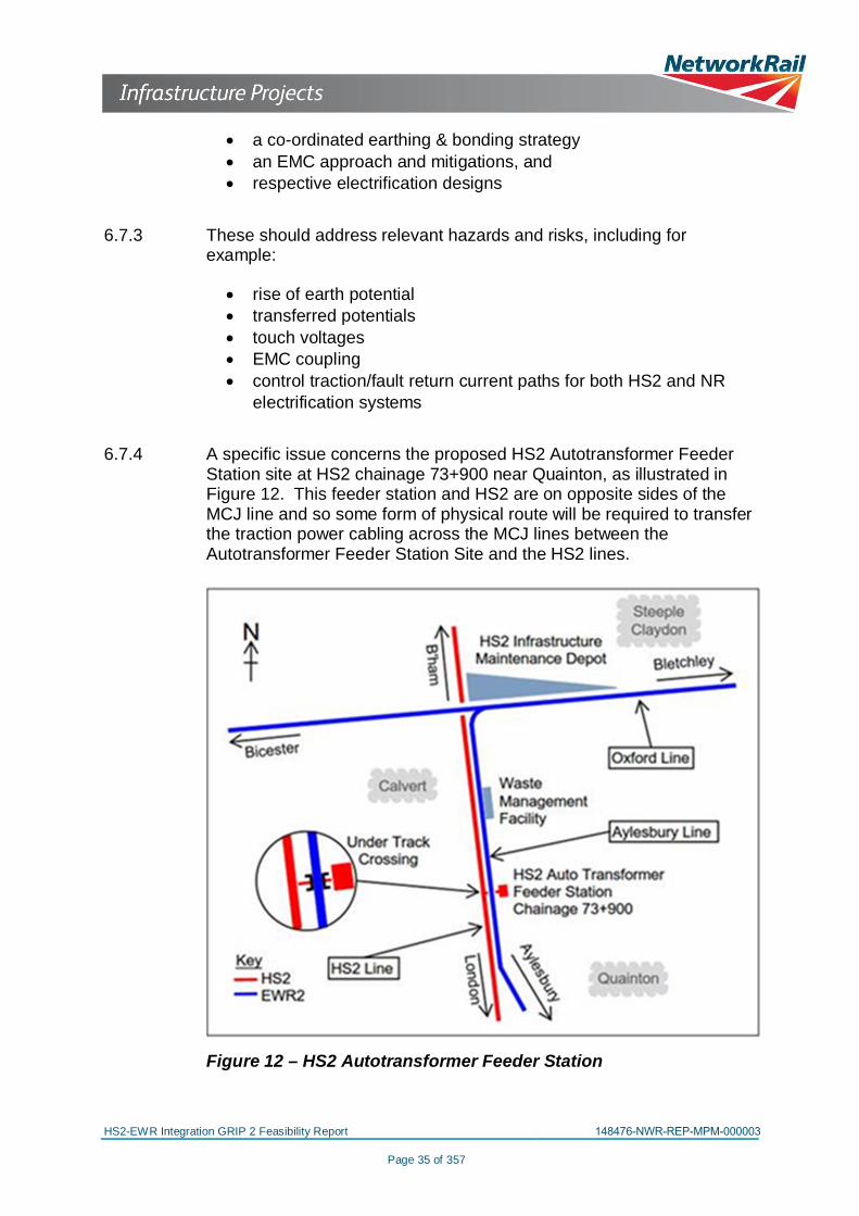
6.7.4 A specific issue concerns the proposed HS2 Autotransformer FeederStation site at HS2 chainage 73+900 near Quainton, as illustrated inFigure 12. This feeder station and HS2 are on opposite sides of theMCJ line and so some form of physical route will be required to transferthe traction power cabling across the MCJ lines between theAutotransformer Feeder Station Site and the HS2 lines.
Figure 12 – HS2 Autotransformer Feeder Station
HS2-EWR Integration GRIP 2 Feasibility Report 148476-NWR-REP-MPM-000003
Page 36 of 357
6.7.5 A GRIP 2 Telecoms Network Impact Assessment is required by theremit. This is in Appendix 5.The works in the Calvert IMD area will require the relocation of anexisting train radio base station and associated fixedtelecommunications network (FTN) node, and probably the creation ofa telecoms network interface between NR and HS2. The preciselocation of the new base station will be determined as design andintegration with the new OXD OLE substation at Claydon develop. Itsproposed approximate location is shown on Drawing 200014. Therelocation of the mast can be accommodated within the HS2 LoD andthe provisions in the hybrid Bill.The area will also require cable route diversions at the IMD SouthernAccess overbridge, where the HS2 southern chord passes underEWR2 Section 2B to enter the IMD, and the EWR2 chord MCJ4connecting Section 2E to 2B at Claydon Junction requires slewingeastwards.Most of the northern half of the Section 2E alignment is slewedeastwards and the trackside cable route must be realigned accordingly.The pinch point at Sheephouse Wood will only present a challenge ifone or more High Voltage cable routes are also required along theEWR2 Section 2E alignment – this is subject to the nature of theelectrification solution arrived at. The High Voltage cable must beadequately separated from the Low Voltage /S&T route to minimiseEMC problems and would normally be on the opposite side of the track.The Low Voltage /S&T cable route should be on the east side tomaximise separation from the HS2 traction power system.
6.8 Impact on signal sighting and existing NR access arrangements
6.8.1 The impact on signal sighting has been assessed.
6.8.2 The alignment of rail through the area is generally straight with a slightleft hand curve in the up direction around Sheephouse Wood; the HS2alignment is on the outside of the curve so any fencing at the HS2boundary will not directly interfere with signal sighting on EWR2.
6.8.3 The adjacent HS2 must be given consideration during the positioning ofsignals on EWR2. Some increase in the reading time of signals may beconsidered appropriate due to distraction factors, and consideration ofthe adjacent HS2 should be given in the GRIP 3 signal sighting reportfor EWR2
6.9 Environmental Mitigation
6.9.1 The environmental impacts of HS2 have been comprehensivelyassessed. A summary of the HS2 environmental issues and thecorresponding works proposed as mitigation is given in Appendix 6.
HS2-EWR Integration GRIP 2 Feasibility Report 148476-NWR-REP-MPM-000003
Page 37 of 357
Of these notable inclusions are the Sheephouse Wood MitigationStructure and the green overbridges.
6.9.2 Although the environmental assessment of EWR2 is at an earlier stagethan HS2, there will be mitigation works proposed for EWR2 that couldbe delivered as part of HS2/EWR2 integration, given the proximity ofthe two schemes. The approach to the EWR2 Environmental ImpactAssessment (EIA) was subject of a formal Scoping Report submitted tothe Department for Transport in June 2014. The Scoping Opinion wasreceived from the Department in August 2014. This Opinion includedcomments from Natural England concerning the methodology to beused to determine the environmental baseline and the methodologythat NR will apply to determine the impacts of EWR2 on the naturalenvironment. These observations are taken into account in the studiescurrently taking place. The Scoping Report acknowledges the need,under the relevant Regulations, for the EWR2 Environmental Statementto consider the cumulative environmental effects the scheme will havein combination with other development proposals. Principal among theschemes to be subject of this cumulative assessment is HS2.
6.9.3 Additional assessments will be required where there are changes to theBase Scheme to achieve an integrated scheme.
6.9.4 There are two areas of flood risk (Areas of both Zones 2 and 3)relevant to the integration of EWR2 and HS2 (see Figure 13 below forclarity); one associated with a watercourse running along the southernedge of Sheephouse Wood, which extends west from the middle ofSheephouse Wood towards Greatmoor, and another watercoursecrossing the track close to Woodlands Farm. These add anotherenvironmental constraint to an already sensitive area (i.e. SheephouseWood) in a confined corridor. Once conclusions are reached about theintegrated design, it will be possible to confirm whether the sensitivityapplied when modelling the impact of the Scheme was appropriate andthe capacity of the flood plain storage that is proposed to mitigate theimpact is adequate.

HS2-EWR Integration GRIP 2 Feasibility Report 148476-NWR-REP-MPM-000003
Page 2 of 357
Report Title
Report Status
Job No
Date
eB Document Number
: HS2 EWR2 Integration GRIP Stage 2 Feasibility
: For Issue
: 3513769B
: February 2016
:
Version Control
Version Status Date By Reviewed By
1.0 For Issue 25/01/2016 RGA S. Brunton
1.1 For Issue 08/02/2016 RGA S. Brunton

HS2-EWR Integration GRIP 2 Feasibility Report 148476-NWR-REP-MPM-000003
Page 38 of 357
Figure 13 – Main Rivers, and Land within Flood Zone 3
Note: the figure is reproduced from the Environmental Agency’s FloodMap for Surface Water Basic & Flood Zone Data (September 2015)
6.10 Utilities
6.10.1 The affected utility suppliers have been identified in the Schedule ofWorks in Appendix 7.1
6.10.2 Schematics of the principal diversions are included in Appendix 7.2.
6.10.3 Diversion of the utilities in the existing Calvert Station Bridge(MCJ3/563) to facilitate its replacement by the proposed School HillGreen overbridge is addressed in section 7.7.
6.10.4 New road bridges are proposed at Perry Hill and Addison Road. Theseneed to be constructed prior to the diversion of the existing utilities andthe demolition of the existing bridge.
6.10.5 Planning of the works needs to take due account of:
· High Pressure gas mains diversions often incur a 12 month‘Feasibility Phase’ in advance of the construction works, to allowfor activities such as the feasibility study, detailed design,procurement, resource and outage planning
· Long lead time for materials associated with the HP gas main
HS2-EWR Integration GRIP 2 Feasibility Report 148476-NWR-REP-MPM-000003
Page 39 of 357
· Interruptions to the supply of the HP gas mains, in order to makethe new connections, can only be undertaken during the summermonths
· Assumptions, to be confirmed, that construction of new ‘offline’HP gas mains can be undertaken during winter months
· Phasing associated with the diversion of telecoms, and outagesare not usually permitted close to major events
6.11 Highways
6.11.1 Preliminary design drawings from HS2 show the majority of the newbridges on the MCJ being constructed ‘off line’ next to the existingstructure. This allows the existing carriageway to be used during theconstruction of the new structure. Once the new bridge is finished thetraffic is moved over onto the new structure, allowing the original bridgeto be demolished to accommodate the new rail corridors.
6.11.2 The only bridge over the MCJ that is shown as being reconstructed online is School Hill bridge. This is addressed in section 7.7
6.11.3 The replacement Charndon Lodge, Perry Hill and Addison Roadbridges are all proposed off line of the existing highway, and could beconstructed without affecting the existing highway route, and then trafficswapped over onto the new road to allow the HS2 works to commence.If the OXD is built on-line, it may be possible to reduce the length ofAddison Road bridge, having to span across only the existing OXDcorridor and not also the off-line OXD.
6.11.4 The temporary traffic diversions associated with the rebuilding of WestStreet Bridge and School Hill Road Bridge, both use Perry Hill Road asdiversionary route. As Perry Hill Road will also be subject to temporaryclosure (for bridge construction) it is important that this is phased suchthat all three roads are not closed at the same time. The relativelocation of the three roads and diversions are shown on Figure 14,below:
HS2-EWR Integration GRIP 2 Feasibility Report 148476-NWR-REP-MPM-000003
Page 40 of 357
Figure 14 – Highway Diversions in the Calvert Area
6.11.5 The current HS2 proposals for the Quainton end of the parallel runningsection show that two roads - Station Road and Fidlers Field Road - aresevered by HS2. This is addressed by a realignment of Station Roadapproximately 400m north of its current location with associated newbridges over both EWR2 and HS2. Fidlers Field Road is tied into thisnew road layout. The phasing of these works will need to be such thatthe HS2 proposed road network to the east and west of the MCJcorridor is in place before the existing Station Road is closed. This willensure that when Fidlers Field road is closed, there will be analternative available in the interim. The realignments of Station Roadand Fidlers Field Road are shown on Figure 15, below:

HS2-EWR Integration GRIP 2 Feasibility Report 148476-NWR-REP-MPM-000003
Page 41 of 357
Figure 15 – Highway Realignment in the Quainton Area
6.11.6 It should be noted that the EWR2 scheme replaces the existing UpperSouth Farm user worked crossing with a new farm accommodationbridge at approximately HS2 chainage 72+200.
6.12 Schedule of Works
6.12.1 The Base Scheme and the EWR2 Scheme are each broken down intoelements of permanent work. Typical elements are bridges,earthworks, retaining walls, utility diversions, etc. They are used topopulate a “Schedule of Works” covering both schemes.
6.12.2 This schedule is used to identify any works that are required by EWR2and HS2. These are used to establish any additions required to theBase Scheme in order to achieve an Integrated Scheme. The“Schedule of Works” is in Appendix 7.1.
6.13 Network Change
6.13.1 This is not an issue for this stage of the integration study, but in duecourse Network Rail will be required to submit a Network Changeapplication to gain agreement for the changes proposed to theinfrastructure within the integration area:
· Re-location of the waste management facilities private siding tothe east of the MCJ3 with associated junction re-modelling
· Connection between the HS2 IMD sidings and NR infrastructureon the OXD lines in the vicinity of Claydon Junction

HS2-EWR Integration GRIP 2 Feasibility Report 148476-NWR-REP-MPM-000003
Page 42 of 357
· OXD freight loop
6.13.2 The hybrid Bill does not gain consents for Network Change and it willneed to be sought separately through the Network Change regulatoryprocess. Although Network Rail has to make the Network Changerequest, a combined Network Rail and HS2L strategy will be required.
6.14 Proposed solutions to achieve an HS2/EWR2 Integrated Scheme
A number of developments are proposed in order to meet both HS2L’sand NR’s requirements, and to facilitate a more integrated solutionwhich avoids abortive work. These are as follows:
Location Base SchemeProposal EWR2 Proposal
Proposedsolution toachieveIntegratedScheme
MCJCorridorHS2Chainages72+000 -78+000
Twin tracked HS2 withelectrification & twintracked MCJ (one trackpassive provision) withno provision forelectrification
twin trackedMCJ withpassiveprovision forelectrification
Twin tracked HS2with electrification& twin trackedMCJ with passiveprovision forelectrification
ClaydonJunctioneast ofrevisedMCJ4 chord
No proposalnew EWR2electrificationsubstation
new EWR2electrificationsubstationrequired – earlydevelopment workongoing andoptions beingconsidered.
ClaydonJunctionadjacent torelocatedMCJ4 chord
Relocation of mast tosouthern perimeter ofOXD corridor
No proposal
Coordinate Mastand newsubstationlocations so thatmast is at least100 metres fromsubstation
OXD Line
Build a new OXD off-line to preventdisruption during HS2construction (EWR2operational prior toHS2 construction)
Upgrade OXD totwin track withelectrification onexisting corridor,withoutconsidering HS2
Both options to beconsidered in nextdesign stages.
HS2-EWR Integration GRIP 2 Feasibility Report 148476-NWR-REP-MPM-000003
Page 43 of 357
Location Base SchemeProposal EWR2 Proposal
Proposedsolution toachieveIntegratedScheme
OXD/29CharndonOverbridge
No proposal
Existing bridgeto bereconstructed(note thatdelivery of thisbridge is EWR2TWAOdependent)
Incorporate bridgeinto the HS2/EWR2 IntegratedSchemedevelopment
QueenCatherineRoadOverbridge
No proposal
New bridgerequired toreplace levelcrossing (notethat delivery ofthis bridge isEWR2 TWAOdependent)
Incorporate bridgeinto HS2/ EWR2IntegratedSchemedevelopment
Table 12 – Proposed solutions to achieve an HS2/EWR2 IntegratedScheme

HS2-EWR Integration GRIP 2 Feasibility Report 148476-NWR-REP-MPM-000003
Page 44 of 357
7 INTEGRATED PROGRAMME
7.1 Assumptions and Constraints upon the Integrated HS2/EWR2programme:
7.1.1 Any dates stated concerning the hybrid Bill and its enactment or theEWR2 TWAO process are those assumed as at the outset of the study.They are subject to change and should be regarded as indicative only.
7.1.2 The assumptions and/or constraints upon the Integrated HS2/EWR2programme are as follows:
· No work will have started on EWR2 in the interface area beforethe hybrid Bill is enacted if abortive work is to be avoided.
· The scope of the EWR2 works within the integrated scheme, andtherefore to be addressed in the integrated programme, includes(i) the OXD twin track and with electrification, and (ii) the MCJwith twin track, and passive provision for electrification
· As before, rail access to the WMF has to be maintainedthroughout construction
· Mass haul is not taken into account as far as development of theintegrated programme is concerned.
· hybrid Bill Royal Assent – December 2016· HS2 earliest start of construction – July 2017· EWR2 TWA Order application to be submitted May 2016· EWR2 TWA Order made by the Secretary of State – November
2017
7.2 Operations
7.2.1 An operations analysis for HS2 and East West Rail Integration isincluded in Appendix 8.
7.2.2 This concludes as follows:
7.2.2.1 Whilst EWR2 is being constructed, at least one route (MCJ or OXD)must be maintained open for freight traffic, primarily for WMF, but alsofor Bicester Ministry of Defence until such time as the normal route viaOxford is restored to use. The latter is expected to be in Spring 2016and therefore should not affect the programme.
7.2.2.2 WMF traffic currently has paths on the Chiltern Main Line from theLondon area via Princes Risborough and Aylesbury. However if theMCJ line is closed, this route will not be available. Possible alternativesare shown in the following table:

HS2-EWR Integration GRIP 2 Feasibility Report 148476-NWR-REP-MPM-000003
Page 45 of 357
Alternative routeImplications
Other CommentsInfrastructure Timetabling
West Coast MainLineBletchley -Claydon Junction- Calvert
EWR Bletchley– ClaydonJunction mustbe operational
Spare paths onWest Coast MainLine (London toBletchley) arelimited
Bletchley – Claydoncurrently out of use.Not operationallydesirable to reverse atBletchley.
Great WesternMain LineOxford -ClaydonJunction (reverse)- Calvert
EWR Bicester –ClaydonJunction mustbe operational
Spare paths onGreat WesternMain Line(London to –Oxford) arelimited
This is the currentWMF diversion route.
Chiltern MainLinePrincesRisborough-Bicester- BicesterMinistry ofDefence sidings(reverse) –Claydon Junction(reverse) - Calvert
EWR Bicester –ClaydonJunction mustbe operationalBicesterMinistry ofDefence sidingsavailable fortrain reversal
Spare paths onChiltern Main Linenorth of PrincesRisborough arelimited
Requires two reversalsen route, but this couldbe made moreoperationally efficientby running with alocomotive at eachend
Table 13 – Alternative routes to WMF
Of the three alternative routes, the route via the Great Western MainLine and Oxford appears the most suitable from a freight train operationpoint of view, although it may be difficult to obtain paths, particularlybetween Didcot and Oxford.
7.2.2.3 If EWR2 is still under construction during the period when HS2 is beingconstructed, any materials delivered to the Calvert area would have tobe routed as described in 7.2.2.2 above. The route via PrincesRisborough and Aylesbury would be the optimum route if available; itmay be possible to path HS2 delivery trains in the “vacant” train pathsnot used by WMF trains.
7.3 Future NR Long-Term Workbank Plans
7.3.1 A meeting was held with NR on 15th September 2015 to understandwhat constraints and/or opportunities might arise from their currentworkbank proposals in respect of construction of the HS2/ EWR2Integrated Scheme.
7.3.2 NR referenced a drawing showing the proposed 2016-2019 works inthe area, an update of which they subsequently provided, as follows:

HS2-EWR Integration GRIP 2 Feasibility Report 148476-NWR-REP-MPM-000003
Page 46 of 357
Figure 16 – Chiltern Proposed Access Strategy 2016-2019
Figure 17 – Chiltern Proposed Access Strategy 2016-2019
7.3.3 The conclusion of the meeting was that nothing in the 2016-2019 NRworkbank precludes blockading the MCJ and/or the OXD. It is noted
HS2-EWR Integration GRIP 2 Feasibility Report 148476-NWR-REP-MPM-000003
Page 47 of 357
that any blockade strategy would need, nevertheless, to be looked at ina routewide context.
7.3.4 (NR noted that the HS2/EWR2 integration works on the OXD providean opportunity to carry out reconstruction/ replacement of bridge NAJ23(NAJ3/27 = OXD37) carrying the Chiltern Line over; the OXD runsunderneath this. This bridge is not part of the integration works.However, its reconstruction could be done at the same time as theOXD works, perhaps during a 52 hour possession on the NAJ or OXD.)
7.4 Consents
Background
7.4.1 The hybrid Bill, if enacted, will grant the powers to construct Phase Oneof the HS2 network, but will also grant powers to:
· build and maintain HS2 and its associated works (including worksto the railway network as specified in the HS2 Bill)
· compulsorily acquire interests in the land required· affect or change rights of way, including the stopping-up or
diversion of highways and waterways (permanently ortemporarily)
· modify infrastructure belonging to statutory undertakers (e.g.utility companies)
· carry out work on listed buildings and demolish buildings inconservation areas, and
· carry out protective works to buildings and third-partyinfrastructure.
It will also grant the necessary changes to existing legislation tofacilitate construction and operation of Phase One of HS2.
7.4.2 The consents strategy for EWR2 is to secure powers to acquire landand deemed planning consent through the submission of a Transportand Works Act Order application. The scheme is currently at publicconsultation stage and GRIP 3 designs are being developed. As at thestart of this study it is envisaged that this application will be submittedin May 2016 and determined by November 2017, a year after the HS2Bill. However, these dates are subject to change.
Accommodating Change
7.4.3 The intent is that the changes arising from integration should bemanaged within the Limits of Deviation (LoD) in the HS2 hybrid Bill,and, where appropriate, by including provisions for the HS2/EWR2Integrated Scheme in the EWR2 TWAO.

HS2-EWR Integration GRIP 2 Feasibility Report 148476-NWR-REP-MPM-000003
Page 3 of 357
Contents
1 EXECUTIVE SUMMARY ...................................................................................................... 7
2 DEFINITIONS AND ABBREVIATIONS .............................................................................. 102.1 Definitions .................................................................................................................. 102.2 Abbreviations ............................................................................................................. 10
3 INTRODUCTION ................................................................................................................ 123.1 Background ............................................................................................................... 123.2 Respective Application for Powers ............................................................................. 143.3 Aylesbury Line – Accommodation by HS2 ................................................................. 153.4 Oxford Line – Accommodation by HS2 ...................................................................... 153.5 Geographical Definition of the HS2/EWR2 Interface Area .......................................... 16
4 CURRENT STATUS OF THE TWO SCHEMES.................................................................. 194.1 EWR2 Scheme .......................................................................................................... 194.2 Base Scheme ............................................................................................................ 19
5 REQUIREMENTS ............................................................................................................... 235.1 Development of Network Rail’s Requirements for HS2 and EWR2 ............................ 235.2 HS2 v2.0 Requirements incorporating NR Requirements within the Base
Scheme............................................................................................................... 235.3 NR requirements (V2) for HS2 ................................................................................... 245.4 HS2L’s Project Definition Statement for the Base Scheme ........................................ 245.5 Protective Provisions Agreement (PPA) ..................................................................... 255.6 Network Rail’s Requirements dated 5th March 2014 for the East West Rail
Phase 2 project ................................................................................................... 265.7 HS2L’s Requirements for HS2 in the interface area ................................................... 26
6 DEVELOPING AN INTEGRATED SCHEME ...................................................................... 276.1 Introduction ................................................................................................................ 276.2 Assumptions and Constraints .................................................................................... 276.3 Methodology .............................................................................................................. 276.4 Track and Alignment: OXD Corridor. .......................................................................... 286.5 Track and Alignment: MCJ Corridor ........................................................................... 286.6 Bridges - Accommodation of OLE .............................................................................. 346.7 Rail Systems .............................................................................................................. 346.8 Impact on signal sighting and existing NR access arrangements ............................... 366.9 Environmental Mitigation ............................................................................................ 366.10 Utilities ....................................................................................................................... 386.11 Highways ................................................................................................................... 396.12 Schedule of Works ..................................................................................................... 416.13 Network Change ........................................................................................................ 416.14 Proposed solutions to achieve an HS2/EWR2 Integrated Scheme ............................. 42
HS2-EWR Integration GRIP 2 Feasibility Report 148476-NWR-REP-MPM-000003
Page 48 of 357
7.5 Protective Provisions (including ONW & ASPRO)
7.5.1 The HS2 hybrid Bill will grant powers for scheduled works (set out inSchedule 1 of the Bill) that will modify NR infrastructure. A ProtectiveProvisions Agreement (PPA) has been agreed between the Secretaryof State for Transport and Network Rail to safeguard Network Railinterests. A summary of those parts of the Protective ProvisionsAgreement between Network Rail Infrastructure Limited and theSecretary of State for Transport as is relevant to this report is given isin Appendix 9 of this report.
7.5.2 The Protective Provisions set out in the PPA apply to the followingcategories of work – On Network Works, Specified On Network Works,Overbridges and Underbridges, and Future Provisions.
7.5.3 On Network Works are defined in the PPA as any part of the HighSpeed 2 Works (including any Protective Works) as requires themodification, relocation, removal or replacement of any RailwayProperty within the Relevant Limits but excluding any Specified OnNetwork Works.
7.5.4 NR can elect not to carry out any ONW, in which case these works willbe carried out by the Secretary of State. Such works are calledSpecified On Network Works. A Schedule of these works is set out inthe PPA, with those relevant to this report being in item 8 of schedule 5.These are shown Appendix 9.
7.5.5 The list of Specified On Network Works contained in Item 8 of Schedule5 of the PPA has been reviewed against the works recommended to bein the HS2/ EWR2 Integrated Scheme. Should Network Rail agreewith HS2 that these are works that should be undertaken by theSecretary of State, consideration should be given to including thefollowing infrastructure in the proposed HS2/EWR2 Integrated scheme:
· Upper Farm South (overbridge required to maintain agriculturalaccess)
· Queen Catherine Bridge (overbridge required to accommodatediversion resulting from level crossing closure)
7.5.6 Specific provisions relating to works to construct new or modify existingstructures and bridges are set out in clause 12 of the PPA and will besubject to the Secretary of State and Network Rail entering intoOverbridge or Underbridge Agreements prior to carrying out the works.
7.5.7 Clause 13 of the PPA requires the consent of Network Rail to theclosure of level crossings required for HS2 Scheme.
HS2-EWR Integration GRIP 2 Feasibility Report 148476-NWR-REP-MPM-000003
Page 49 of 357
7.6 Undertakings and Commitments
7.6.1 Schedule 10 of the PPA contains a list of Network Rail Requirements(extracted in Appendix 9 of this report). As with all the provisionscontained in the PPA, these Requirements form part of the HS2project’s Undertakings and Assurances. Should NR and HS2L agreethat works to accommodate the future electrification of the MCJ are partof the EWR2 project, then the commitment (NR-HS2-0400) to projectcollaboration and integration is a compliance issue. Schedule 11provides further specific details in relation to the table in Schedule 10.
7.6.2 Clause 5 of the PPA relates to Asset Protection and Approvals andrequires that the Secretary of State enters into an Asset ProtectionAgreement (a framework template for which is included in Schedule 9of the PPA) prior to the commencement of works. The PPA commitsthe Secretary of State to procuring and carrying out works inaccordance with the terms of the Asset Protection Agreement. Theidentification of works requiring Asset Protection Agreements andcompletion of these agreements will require contractor involvement andtherefore no further consideration can be given to the provisions forasset protection at this stage.
7.7 School Hill Green Overbridge / MCJ3/563 Calvert Station Bridge
7.7.1 The existing Calvert Station Bridge (MCJ3/563) carries the singlecarriageway Werner Terrace over the existing MCJ corridor and theWMF sidings.
7.7.2 The bridge is proposed to be replaced by the HS2 079-S1 School HillGreen overbridge, spanning across HS2, MCJ and the WMF.
7.7.3 The existing bridge carries utilities for Anglian Water & Sewerage,British Telecom and Western Power. There is also an overhead powertransmission cable route running northeast/southwest approximately200m south of the bridge. These need to be diverted temporarily tofacilitate construction of the new bridge.
7.7.4 The current proposal for the bridge based utilities is to temporarilydivert them south along Brackley Lane for approximately 200m, then topass under the existing operational MCJ3 railway corridor and WMFsidings before continuing in a northeast direction through open land toeventually re-join the School Hill Road. Once the new bridge has beenconstructed, all utilities (including the overhead power transmissioncables) will be permanently diverted into the new road alignment andbridge.
7.7.5 The temporary utility diversion facilitates the main construction worksduring which School Hill Road is closed for 1.5 - 2 years. Theproposed School Hill Green overbridge has two spans: the western onespans over the existing MCJ3, the existing waste transfer sidings, the

HS2-EWR Integration GRIP 2 Feasibility Report 148476-NWR-REP-MPM-000003
Page 50 of 357
proposed HS2 up and down tracks, and the HS2 IMD southern accesstracks; the eastern one spans over the relocated MCJ3 and the newWMF sidings.
7.7.6 The utility diversion allows demolition of the existing bridge (under a NRpossession). Following local slewing of the MCJ line the new bridgecan be constructed off line without blockading the existing MCJ3corridor (including WMF). Once these elements have been completedthe new MCJ3 and waste transfer siding can be moved to their newlocation. Following the track move to the east, the existing redundanttrack can be demolished, followed by the final diversion of the utilitiesinto the new bridge.
7.7.7 It should be noted that the relocated WMF will not be functional until thenew bridge is completed, giving road access to the new WMF facility.
7.8 Scenario Options
7.8.1 The construction sequencing for the permanent works in the HS2/EWR2 Interface Area should be such as to avoid abortive works.There are in principle two programme options driven by the WMFconstraint, namely:
Scenario 1: prioritise the construction of the new OXD:
· Initially maintain rail access to the WMF facility from the south viathe PRA and MCJ, close the OXD, MCJ4 and that part of MCJ3north of the WMF
· Construct the new OXD on-line, over both the future HS2mainline and the HS2 southern rail access into the IMD
· Construct the new WMF facility, the relocated MCJ4 chord andthat part of MCJ3 north of the WMF, with its connection into thenew WMF
· Connect these new works to the section of OXD between Calvertand Bicester, and test and commission (subject to the EWR2OXD being complete)
· Switch the WMF facilities from the existing to the new location,with rail access coming via the OXD, thereby releasing the MCJto be closed under a blockade and the works along the newHS2/MCJ combined corridor to be constructed.
· Connect these new works to the section of MCJ betweenQuainton and Aylesbury, and test and commission
Scenario 2: prioritise the construction of the new MCJ:
· Initially maintain rail access to the WMF facility from the north viathe OXD, MCJ4 and that part of MCJ3 north of the existing WMFfacility
HS2-EWR Integration GRIP 2 Feasibility Report 148476-NWR-REP-MPM-000003
Page 51 of 357
· Construct the new MCJ3 north of Quainton, the relocated MCJ4chord, the new WMF facility, and that part of MCJ3 north of theWMF, with its connection into the new WMF
· Connect these new works to the section of MCJ betweenQuainton and Aylesbury, and test and commission
· Switch the WMF facilities from the existing to the new location,with rail access coming via the new MCJ, thereby releasing theOXD to be closed under a blockade and the works to provide thenew OXD on-line, over both the future HS2 mainline and the HS2southern rail access into the IMD to be carried out.
· Connect the new OXD to the section of OXD between Calvertand Bicester, and test and commission
7.9 HS2/EWR2 Construction Programmes
7.9.1 Neither of the scenarios shows an advantage over the other as regardstotal time. Prioritising the new OXD has advantages of giving earlieraccess to the IMD
7.9.2 Delivery programmes for each scenario are in Appendix 10. Thedates are tentative, and assume construction starts mid 2017. Theycontain sufficient elements of HS2 works to complete the EWR2 workswithin the area of integration. At completion of the programmes theEWR2 works within the HS2/ EWR2 Interface Area are ready to beconnected with the complete EWR2 works (Phases 2A – 2F) and theroute is available for HS2 to install their works unrestricted by EWR2.
7.10 Programme advantages of an Integrated Scheme
7.10.1 In the Base Scheme, there would be regular passenger services onboth the OXD and the MCJ throughout the construction period. In thecase of the OXD, it would be up to three passenger trains and onefreight train per hour, the passenger trains travelling at up to 100 mph.In the case of the MCJ, it would be up to one passenger train and onefreight train per hour, the passenger trains travelling at up to 90 mph.There are no planned blockades in the Base Scheme and the railservices restrict construction access.
7.10.2 In comparison, in either scenario, under the integrated scheme theworks would be carried out under a blockade in place with no trainsrunning, excepting only those areas where rail access to the WMF forup to five freight trains per day is maintained. There are no passengerservices to be maintained through the integrated works scheme duringconstruction.
7.10.3 The Base Scheme mitigates the impact of the OXD services to aconsiderable extent by building the new OXD civils works off-line, but atthe cost of additional civils works. However, there is not the available

HS2-EWR Integration GRIP 2 Feasibility Report 148476-NWR-REP-MPM-000003
Page 52 of 357
land to mitigate in a similar manner the impact of the MCJ servicesoperating during construction of the Base Scheme
7.10.4 The integrated scheme, by contrast, affords easier access forconstruction, giving consequential efficiencies, and provides a saferworking and construction environment. The construction efficiencieswould offer opportunities to shorten the construction durations ascompared to the Base Scheme.
7.10.5 This comparison can be summarized as follows:
Planned EWR Train Service Specification Operating During HS2Construction Period
SchemePassengerTrains (eachdirection)
Freight Trains(eachdirection)
Consequence
Base
3 trains perhour on OXDline1 train per houron MCJ line
1 train per houron OXD line1 train per houron MCJ line
· Restricted constructionaccess along the MCJ
· Longer constructionduration
· Requires greatermitigation measures toensure safety
Integrated NoneUp to 5 trainsper day to theWMF
· Relatively unrestrictedconstruction access
· Shorter constructionduration
· Inherently saferenvironment
Table 14 – programme advantages of integrated scheme
7.10.6 The extent of the potential efficiencies of the Integrated Scheme shouldbe evaluated as the design of the scheme and construction planning isdeveloped.
7.11 Consequences of Delay in Receiving Consents
7.11.1 If there are delays in obtaining HS2 Bill Powers, then construction ofthe integrated works cannot commence.
7.11.2 If there are delays in obtaining EWR2 TWAO Powers, then the majorityof the integrated works can still be progressed, including the new WMFfacility; however, construction of the following works would be deferred:
· Queen Catherine Road Bridge and approaches· OXD/29 Charndon Road Bridge
HS2-EWR Integration GRIP 2 Feasibility Report 148476-NWR-REP-MPM-000003
Page 53 of 357
7.12 Delivery Strategy
7.12.1 The key to successful delivery of the integrated works is developmentof a coordinated design that meets the requirements of both projects.
7.12.2 To achieve this, it is anticipated that HS2 and NR would cooperate toproduce coordinated designs that are mutually acceptable. This wouldstart with the two railways and their respective systems, and, onceresolved, followed by development of the supporting civils andstructural works.
7.12.3 A construction delivery strategy should be developed at the next stage.
HS2-EWR Integration GRIP 2 Feasibility Report 148476-NWR-REP-MPM-000003
Page 54 of 357
8 SAFETY AND TECHNICAL COMPLIANCE
8.1 Construction (Design and Management) Regulations
Design and implementation of the works will be conducted inaccordance with the Construction (Design and Management)Regulations 2015. Compliance ensures proper consideration of healthand safety during a project’s development so that risk of harm to thosewho build, use and maintain the works is reduced. This includesidentifying, eliminating or controlling foreseeable risks throughout theproject lifecycle.
The integrated project includes works sponsored by two client bodies(HS2 and NR). Consequently, agreement will need to be reachedregarding which entity operates as ‘Client’ under CDM. In addition eachof the client entities is likely to appoint its own design organisation tolead the design of their respective works. Again an agreement will haveto be reached regarding which of them is the Principal Designer underCDM.
8.2 Access for Maintenance and Future Construction
8.2.1 Access and fencing arrangements need to cater for:
· Construction, including if EWR2 becomes operational whilst HS2construction is continuing alongside
· How maintenance access to EWR2 infrastructure will beachieved
· How maintenance access to HS2 infrastructure will be achieved· The future installation and ongoing maintainability of OLE along
the MCJ.· Security of each Railway
8.2.2 Access points to EWR2 have been considered in the HS2 PDS. In thearea of parallel running, access to the HS2 and EWR2 infrastructureneeds further development to ensure that sufficient vehicular andpedestrian access is available to each infrastructure systemindependent of the other. This will be subject to how the issues alongthe MCJ are resolved, which must take due account of maintenance.
8.2.3 Finally a solution must take due cognisance of security, and its spatialimplications.
8.3 Common Safety Method
The Common Safety Method (CSM) regulations were published asEuropean Directive 2004/49/EC Article 6(3) (a). They provide guidanceon a common approach to safety for changed or new systems. At thecurrent stage of design (GRIP Stage 2) design interfaces are not yet

HS2-EWR Integration GRIP 2 Feasibility Report 148476-NWR-REP-MPM-000003
Page 55 of 357
fully defined. Network Rail is facilitating workshops to identify hazardsand assess risk.
8.4 Technical Specifications for Interoperability (TSI)
Both HS2 and EWR2 are being designed to meet the European UnionTechnical Specifications for Interoperability (TSI).
This report recommends that designs and programmes are integratedin the area in question and therefore attention is drawn to particularissues as follows.
· Current noise limit value requirements cover the main operatingconditions for single railway running. An assessment of noiselevels as a result of the integration of both schemes should bemade
· Electromagnetic compatibility of the two systems should bedemonstrated. This has not yet been carried out. Consequently itshould be addressed at a later design stage
· Derailment protection

HS2-EWR Integration GRIP 2 Feasibility Report 148476-NWR-REP-MPM-000003
Page 57 of 357
10 CONCLUSIONS
10.1 Integrated Scheme
Foremost among the conclusions is that in the Calvert area the twoschemes can be integrated so that each meets its requirements. It isacknowledged that a significant amount of design development workwill be required to achieve integration.
It has also been concluded that the two schemes can be integratedwithout alteration to the current applications for powers in the HS2 Bill,although the EWR2 draft Order would need amendment from onebased on the current EWR2 scheme.
It is anticipated that the proposed railway alignments may need to beoptimised (without changing the HS2 LoD) during the development ofthe integrated scheme.
10.2 Integrated Programme
The integrated programme for HS2 and EWR works in the Calvert areahas been developed to take account of the sequencing scenariosdescribed in section 7.8. This work has concluded that throughintegration of the programmes there is an overall reduction in the scopeof infrastructure construction, avoiding abortive work on both the OXDand the MCJ.
In addition the important rail access to the waste management facility atCalvert is preserved throughout.
The integrated scheme affords improved access for construction, givingconsequential efficiencies, and provides a safer working andconstruction environment. The construction efficiencies may offeropportunities to shorten the construction durations as compared to theBase Scheme.
In comparing the possible programme sequences, neither of the twoscenarios demonstrated an overall time saving over the other at thisstage of development. This needs further programme and constructionsequencing development to better understand the preferred deliverystrategy going forward.
10.3 Benefits
By combining the schemes as a single integrated project in the Calvertarea there are significant benefits available. These are as follows.


HS2-EWR Integration GRIP 2 Feasibility Report 148476-NWR-REP-MPM-000003
Page 59 of 357
11 RECOMMENDATIONS
11.1 Principal Recommendations
The integration study has developed the following primaryrecommendations.
Principal Recommendations
1
Develop a single integrated design solution for HS2 and EWR2 whichbuilds upon the HS2 Base Scheme and resolves the issues identifiedwithin this report in order to deliver the requirements of HS2 andNetwork Rail.
2Obtain unified direction regarding the integration of HS2 and EWR2 toprevent further abortive development work on the East West RailPhase 2 project
3 Promote a single approach to public and stakeholder engagement
4Develop a programme for design and construction of the integratedscheme building upon the scenarios described in this report.
Table 15 – Principal Recommendations
11.2 Supplementary Recommendations
Acceptance and implementation of the above primaryrecommendations will allow the development of an integrated design ofHS2 and EWR in the Calvert area. The following supplementaryrecommendations apply to the process of developing the integratedscheme.
Ref. Supplementary Recommendation
1The integrated design should recognise and deliver therequirements of HS2L and NR. The integrated design shouldmeet the technical standards of both projects
2
In addition to meeting the current requirements of both railwaysthe integrated design should allow for future upgrade of the linesin terms of predicted capacity and technical systems of traction,signalling and telecommunications
3A combined stakeholder management team should beestablished to communicate, with a consistent approach, thepromotion of a single integrated project
4
Access should be provided for maintenance to be carried outsafely whilst recognising the specific characteristics of therailways in terms of operating speed, noise generation andrestrictions on timing
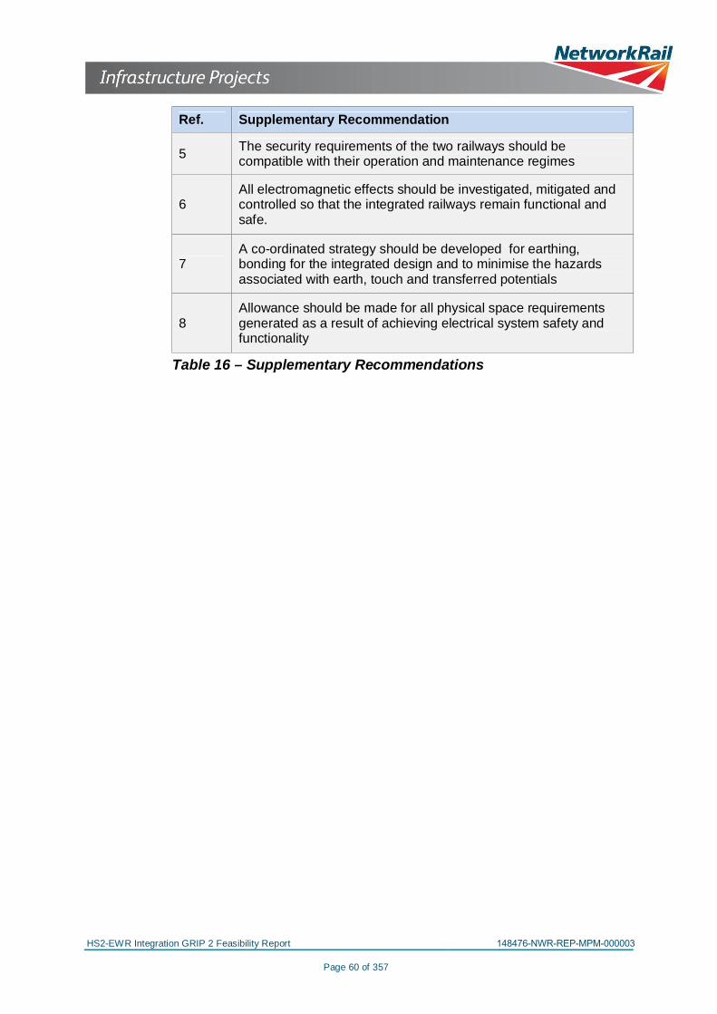
HS2-EWR Integration GRIP 2 Feasibility Report 148476-NWR-REP-MPM-000003
Page 60 of 357
Ref. Supplementary Recommendation
5 The security requirements of the two railways should becompatible with their operation and maintenance regimes
6All electromagnetic effects should be investigated, mitigated andcontrolled so that the integrated railways remain functional andsafe.
7A co-ordinated strategy should be developed for earthing,bonding for the integrated design and to minimise the hazardsassociated with earth, touch and transferred potentials
8Allowance should be made for all physical space requirementsgenerated as a result of achieving electrical system safety andfunctionality
Table 16 – Supplementary Recommendations
HS2-EWR Integration GRIP 2 Feasibility Report 148476-NWR-REP-MPM-000003
Page 6 of 357
Table 15 – Principal Recommendations ........................................................................................ 59Table 16 – Supplementary Recommendations .............................................................................. 60
List of FiguresFigure 1 – Geographical Scope of the East West Rail Phase 2 Project ......................................... 12Figure 2 – Conflict between the existing EWR and the proposed HS2 lines .................................. 13Figure 3 – HS2 and East West Rail Arrangement at Calvert ......................................................... 14Figure 4 – Acquisition of Powers ................................................................................................... 15Figure 5 – C222-ATK-CV-DPP-020-000008 Extract from Main Line Sheet 27 Ch. 70+400 to76+800 .......................................................................................................................................... 17Figure 6 – C222-ATK-CV-DPP-020-000009 Extract from Main Line Sheet 28 Ch. 76+800 to83+200 .......................................................................................................................................... 18Figure 7 – EWR2 twin track corridor with electrification (Dimensions in mm) ................................ 19Figure 8 – C241-PBR-RT-DSE-020-000003, Calvert EWR – Aylesbury Line Cross Section atHS2 Chainage 77+294 .................................................................................................................. 21Figure 9 – Combined HS2/MCJ corridor Section 10-10 ................................................................. 31Figure 10 – Combined HS2/MCJ corridor Section 6-6 ................................................................... 32Figure 11 – Combined HS2/MCJ corridor Section 2-2 ................................................................... 33Figure 12 – HS2 Autotransformer Feeder Station ......................................................................... 35Figure 13 – Main Rivers, and Land within Flood Zone 3 ................................................................ 38Figure 14 – Highway Diversions in the Calvert Area...................................................................... 40Figure 15 – Highway Realignment in the Quainton Area ............................................................... 41Figure 16 – Chiltern Proposed Access Strategy 2016-2019 .......................................................... 46Figure 17 – Chiltern Proposed Access Strategy 2016-2019 .......................................................... 46

HS2-EWR Integration GRIP 2 Feasibility Report 148476-NWR-REP-MPM-000003
Page 7 of 357
1 EXECUTIVE SUMMARY
The proposed design for High Speed 2 (HS2) in the Calvert areasignificantly impacts upon Network Rail infrastructure. The proposedEast West Rail Phase 2 (EWR2) scheme seeks to upgrade theinfrastructure and its current proposals conflict with HS2 as bothprojects stand.
The purpose of the High Speed 2 and East West Rail Phase 2integration study is to identify these conflicts, consider the requirementsof both projects in their current stages of development and investigatepossible options for integration. The options will try to minimiseconstruction and environmental impacts whilst delivering aneconomically viable solution (subject to funding) that will benefit the UKtaxpayer.
This report details the key issues and proposed scope of works. Itidentifies constraints, impacts and interdependencies. Furthermore itdevelops a number of integrated construction delivery scenarios whichshould be investigated in further detail as the design of both schemesprogresses.
Findings
It is feasible to integrate both schemes. There are however a number oftechnical and programme challenges which need to be resolved todeliver both schemes requirements whilst generating efficiencies andbenefits.
The principal design and construction challenges to achieving anintegrated scheme are as follows:
· Progress the Base Scheme design and incorporate the EWR2requirements that are not currently addressed in the BaseScheme
· Further development of both projects’ cross-sections is requiredto fit within the combined railway corridor identified in the BaseScheme. Relevant, practical mitigations are outlined in this reportwhich are feasible but technically demanding
· HS2 and EWR2 run in close proximity for approximately 7km.Through this area the railway system requirements will need tobe considered and developed jointly
· Timescales for delivery of HS2 and EWR2 are not currentlyaligned in the Calvert area, particularly in relation to acquisition ofpowers and construction programmes. Were they to be aligned inan integrated manner, efficiencies could be realised