powys county council local development plan - 2011...
TRANSCRIPT
1
Powys LDP HS6 Action Points Council Responses
Powys LDP Examination – Council’s Response to Action Points from
Hearing Session 6 – Transport, Infrastructure & Delivery
Action Point To be completed by
Officer Agreed
AP1 – CPRW to provide additional evidence on projected traffic movements arising from proposed four-turbine wind farm (Reeves Hill).
12 May 2017
CJ/PM Agreed
Council Action/Matters Arising Change
The following information was received by email from CPRW 11th April 2017:
“Proposed Reeves Hill Wind Farm Construction Traffic
The RHWF example on p16 of the attachment was given to show the volume of traffic renewable energy schemes can generate.
The RHWF Plan was submitted to both Powys CC and Herefordshire C because the proposed turbines were in Herefordshire and the proposed access was in Powys (but Herefordshire permission expired in 2015 so the scheme will not be built). The proposed turbines were 4 x Enercon with blade-tip height 105m and rotor diameter 70.5m. The wind turbines envisaged for the Local Search Areas are considerably larger at blade-tip height 120m and rotor diameter 80m and we estimate that 25MW wind farms would each contain 11 or 12 turbines and thus each would generate traffic over three times these figures. The RHWF traffic estimate does not include the substantial off-site road works for access.
For attachment - Click to Download”
The Council notes this information which relates to a planning application in 2008 for 4 wind turbines located in Herefordshire. A new access road to serve the proposal was proposed through the county of Powys with the actual turbines located in Herefordshire. While consent was granted for the turbines by Herefordshire two planning applications in Powys relating to the access were withdrawn. The development has not proceeded and the planning consent lapsed.
Powys County Council
Local Development Plan - 2011 – 2026

2
Powys LDP HS6 Action Points Council Responses
The data relating to wind turbines envisaged in the Local Search Areas above is purely speculative. The LSAs are search areas only and no specific proposals relating to any developments have been made.
AP2 – CPRW to submit suggested wording, and PCC to consider changing Policy DM15(10).
12 May 2017
CJ/PM Agreed
Council Action/Matters Arising Change
The following information was received by email from CPRW 11th April 2017:
“I am attaching the Herefordshire Traffic Policy and the Reeves Hill Wind Farm Construction Management Plan mentioned by CPRW Powys Branches at Hearing Session 6.
Herefordshire LDP Traffic Policy
Policy T9 Road freight (Page 144/Chapter8/Herefordshire LDP)
When considering proposals for development of new or expanded businesses that generate commercial road traffic, regard will be had to the environmental effects of heavy goods vehicles and other service vehicles and to the traffic impacts on both the strategic and local road network. Proposals that generate service vehicle movements that would unacceptably affect the amenity, safety and character of the existing or neighbouring environments by virtue of danger, noise, traffic generation and congestion, air pollution, visual intrusion or causing parking problems, will not be permitted. All proposals will be expected to incorporate adequate operational arrangements within their layout, and include traffic management measures and workplace travel plans and more sustainable delivery systems where appropriate.
https://www.herefordshire.gov.uk/downloads/file/5373/chapter_8_transport
In addition, the whole UDP is incorporated into the Core Strategy, concertina-fashion with around a dozen traffic policies merged under MT1 - T9 is echoed in the first para below (https://www.herefordshire.gov.uk/downloads/file/1804/section_5_-_general_policies)
Policy MT1 – Traffic management, highway safety and promoting active travel
Development proposals should incorporate the following principle requirements covering movement and transportation:
1. demonstrate that the strategic and local highway network can absorb the traffic impacts of the development without adversely affecting the safe and efficient flow of traffic on the network or that traffic impacts can be managed to acceptable levels to reduce and mitigate any adverse impacts from the development;
2. promote and, where possible, incorporate integrated transport connections and supporting infrastructure (depending on the nature and location of the site), including access to services by means other than private motorised transport;
3. encourage active travel behaviour to reduce numbers of short distance car journeys through the use of travel plans and other promotional and awareness

3
Powys LDP HS6 Action Points Council Responses
raising activities;
4. ensure that developments are designed and laid out to achieve safe entrance and exit, have appropriate operational and manoeuvring space, accommodate provision for all modes of transport, the needs of people with disabilities and provide safe access for the emergency services;
5. protect existing local and long distance footways, cycleways and bridleways unless an alternative route of at least equal utility value can be used, and facilitate improvements to existing or provide new connections to these routes, especially where such schemes have been identified in the Local Transport Plan and/or Infrastructure Delivery Plan; and
6. have regard to with both the council’s Highways Development Design Guide and cycle and vehicle parking standards as prescribed in the Local Transport Plan - having regard to the location of the site and need to promote sustainable travel choices.”
The Council has considered the wording submitted by CPRW above and noted that Policy
T9 forms part of the Herefordshire Unitary Development Plan ⋅ March 2007, which has been superseded by Herefordshire Local Plan – Core Strategy 2011-2031 from which Policy MT1 is derived.
The Council proposes to delete existing DM15 (10):
10. It meets all highway access requirements and vehicular parking standards and incorporates the access needs of all transport users, especially pedestrians and cyclists and those with disabilities or mobility impairment. Proposals considered to generate significant amounts of travel or traffic will only be considered where they include a satisfactory Transport Assessment and/or a Travel Plan.
Replace with the following proposed criterion (10):
10. The development has been designed and located to minimise the impacts on the transport network - journey times, resilience and efficient operation - whilst ensuring that highway safety for all transport users is not detrimentally impacted upon. Development proposals should meet all highway access requirements, (for all transport users), vehicular parking standards and demonstrate that the strategic and local highway network can absorb the traffic impacts of the development without adversely affecting the safe and efficient flow of traffic on the network or that traffic impacts can be managed to acceptable levels to reduce and mitigate any adverse impacts from the development.
Accordingly, as a consequential change make deletions and changes to paragraphs 4.2.51A & 4.2.52A to 4.2.53A:
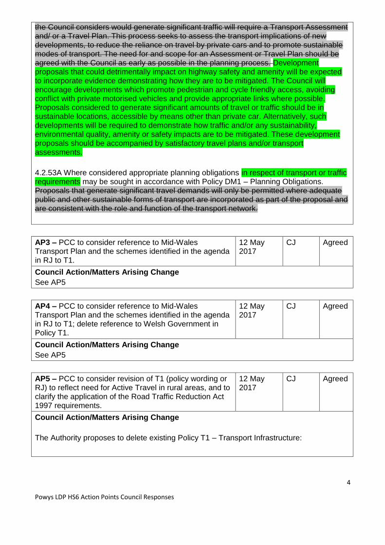
4.2.51A & 4.2.52A Transport requirements. Highway access and parking requirements are important considerations for most developments, especially the implications they have for highway safety, the environment, local communities and the economy. All proposals that
4
Powys LDP HS6 Action Points Council Responses
the Council considers would generate significant traffic will require a Transport Assessment and/ or a Travel Plan. This process seeks to assess the transport implications of new developments, to reduce the reliance on travel by private cars and to promote sustainable modes of transport. The need for and scope for an Assessment or Travel Plan should be agreed with the Council as early as possible in the planning process. Development proposals that could detrimentally impact on highway safety and amenity will be expected to incorporate evidence demonstrating how they are to be mitigated. The Council will encourage developments which promote pedestrian and cycle friendly access, avoiding conflict with private motorised vehicles and provide appropriate links where possible. Proposals considered to generate significant amounts of travel or traffic should be in sustainable locations, accessible by means other than private car. Alternatively, such developments will be required to demonstrate how traffic and/or any sustainability, environmental quality, amenity or safety impacts are to be mitigated. These development proposals should be accompanied by satisfactory travel plans and/or transport assessments.
4.2.53A Where considered appropriate planning obligations in respect of transport or traffic requirements may be sought in accordance with Policy DM1 – Planning Obligations. Proposals that generate significant travel demands will only be permitted where adequate public and other sustainable forms of transport are incorporated as part of the proposal and are consistent with the role and function of the transport network.
AP3 – PCC to consider reference to Mid-Wales Transport Plan and the schemes identified in the agenda in RJ to T1.
12 May 2017
CJ Agreed
Council Action/Matters Arising Change
See AP5
AP4 – PCC to consider reference to Mid-Wales Transport Plan and the schemes identified in the agenda in RJ to T1; delete reference to Welsh Government in Policy T1.
12 May 2017
CJ Agreed
Council Action/Matters Arising Change
See AP5
AP5 – PCC to consider revision of T1 (policy wording or RJ) to reflect need for Active Travel in rural areas, and to clarify the application of the Road Traffic Reduction Act 1997 requirements.
12 May 2017
CJ Agreed
Council Action/Matters Arising Change
The Authority proposes to delete existing Policy T1 – Transport Infrastructure:

5
Powys LDP HS6 Action Points Council Responses
Policy T1 – Transport Infrastructure Transport infrastructure and traffic management improvements will be permitted where they support Welsh Government priorities for promoting growth and sustainable jobs, tackling poverty, and ensuring sustainable rural communities. In particular this would be where such measures: 1. Improve the safety of transport users, especially those making ‘active travel’ journeys by walking or cycling.
2. Reduce traffic congestion and/or improve the local environment.
3. Reduce demand for travel by private transport.
4. Provide, promote and improve sustainable forms of travel.
Replace with:
Policy T1 – Travel, Traffic & Transport Infrastructure
Transport infrastructure, traffic management improvements and development
proposals should incorporate the following principle requirements:
1. Safe and efficient flow of traffic for all transport users, including more
vulnerable users, and especially those making ‘Active Travel’ journeys by
walking or cycling;
2. Manage any impacts to the network and the local environment to acceptable
levels and mitigate any adverse impacts; and,
3. Minimise demand for travel by private transport and encourage, promote and
improve sustainable forms of travel including Active Travel opportunities in all
areas.
Transport infrastructure improvements will be supported where they promote
sustainable growth, maximise the efficiency and safety of the transport systems,
improve public and private transport integration and encourage passenger and
freight rail operations.
4.5.1A The policy seeks to enable transport and traffic infrastructure improvements to
ensure an efficient, effective and integrated system but one which has regard to the safety
of all road users in all areas especially those making ‘purposeful journeys’ as Active Travel
and the impact it may have on the transport network and the local environment.
4.5.1 This policy It seeks to support the coordination of a wide range of traffic management measures and transport interchange developments that will maximise the efficiency and safety of the transport system including road, rail, pedestrian and cyclist travel networks and connections. 4.5.2 Appropriately located public transport interchange developments support sustainable travel and can reduce the demand for travel by private car. Developments that support

6
Powys LDP HS6 Action Points Council Responses
public and private transport integration, such as Park and Ride/Share Schemes and Bus Stops that complement the use of local and national bus or rail services, taxi ranks and train and bus stations will be supported. 4.5.3 Proposals that benefit rail passenger operations and proposals that support rail freight
opportunities will be encouraged. Transport policy applicable to all developments including
the safeguarding of key transport corridors, the requirements for transport assessments
and travel plans, and access and parking requirements are addressed by the Development
Management and Strategic Policies.
4.5.4 The Mid Wales Joint Local Transport Plan (Mid Wales LTP) is a statutory document
that was approved by the Welsh Government (WG) in May 2015. The Mid Wales LTP
covers a programme of projects for the period 2015-2020 and provides a longer term
framework for schemes up until 2030. Should funding become available it will facilitate the
progression of the following specifically identified proposals:
A44 Radnor Forest Bends and East-West routes (2015 – 2020)
B4385 Beulah to A4081 Llanyre (2020 – 2030)
The Road Traffic Reduction Act 1997
For clarification, it is understood that the Welsh Government undertook via the Wales Transport Act 2006 to discharge the requirements of the “transport functions” as required under the “The Road Traffic Reduction Act 1997” by local authorities under the requirements of the production of the Regional Transport Plan 2009, and subsequent Local Transport 2014. Subsequently, WG have approved both the RTP 2009 and LTP 2014, and therefore PCC would consider that we and the other regional authorities have discharged the duty within PPW Transport 1.1.8.
AP6 – Delete para 4.2.54a with revised paragraph and another standards document – Setting Local Speed Limits in Wales, 2009.
12 May 2017
CJ Agreed
Council Action/Matters Arising Change
In accordance with Council’s Statement (ED032.6) for Hearing session 6: Delete paragraph: 4.2.54A Further guidance is provided by PPW, TAN18: Transport, the CSS Wales Parking Standards 2008, the Council’s Design Guide for Industrial and Residential Infrastructure, Manual for Streets and Manual for Streets II. The Design Manual for Roads and Bridges (DMRB) is the relevant standard where developments may impact on trunk roads.

7
Powys LDP HS6 Action Points Council Responses
Replace with: 4.2.54A For the county road network further guidance is provided by PPW, TAN 18, Manual for Streets, Manual for Streets 2, Design Manual for Roads and Bridges (DMRB), the CSS Wales Parking Standards and Setting Local Speed Limits in Wales 2009. Developments that access onto and impact the trunk road network will be assessed by the Welsh Government, who solely use the DMRB standards.
AP7 – PCC to update Appendix 1 in light of updated flood assessments. Phasing info on employment allocations. Include revised text at 6a9 is included in Appendix 1.
12 May 2017
CS/AH Agreed
Council Action/Matters Arising Change
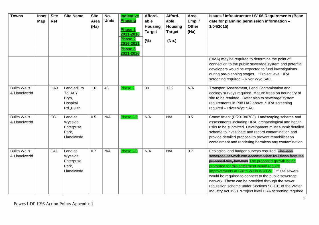
Appendix 1 to this statement includes a revised Appendix 1 of the Plan showing the proposed Matters Arising Changes. The proposed Matters Arising Changes include phasing information on the employment allocations and commitments and the insertion of text beneath the allocations table to display the paragraph proposed in the Council’s statement to hearing session 6 regarding the updating of FCAs following the publication of Policy Clarification Letter CL-03-16.
The information on FCAs and flood risk in the issues / infrastructure column of the Settlement allocations table has also been updated to include the information submitted with the Council’s statement to hearing session 6 (paragraph 6.a.1). This Matters Arising Change has been proposed to provide consistency on how the nature of the flood risk is described, on what is required and where appropriate how the site has been informed by the Strategic Flood Consequences Assessment (SFCA).
Please note that there are other proposed Matters Arising Changes highlighted in Appendix 1, these relate to Action Points arising from other hearing sessions but reflect the ‘live’ LDP document.
AP8 - Amendment to reasoned justification of DM4 to include reference to uplands.
12 May 2017
CS Agreed
Council Action/Matters Arising Change
The insertion of the following sentence into the reasoned justification of DM4 is proposed as a Matters Arising Change 4.2.30a “The definition of floodplain within this Policy is consistent with Planning Policy Wales; it is where water flows in times of flood and includes upland areas”. Please see Appendix 2
AP9 – Review policy DM5(2) by removing criteria and make amendment to reasoned justification to refer to WG non-statutory guidance.
12 May 2017
CS Agreed
Council Action/Matters Arising Change
Appendix 2 to this document contains the proposed Matters Arising Changes for revised

8
Powys LDP HS6 Action Points Council Responses
wording to DM4 and DM5 and the reasoned justification text. This change has been conducted so that it is not more onerous than national policy but is in line with para 10.11 of TAN 15.
A consequential change to this proposal will be the renaming of the SPG to “Land Drainage” rather than “Sustainable Drainage Systems (SUDS)”. Paragraph 4.2.33a (“A SPG will be produced to provide further guidance on the minimum amount of information required to demonstrate that the proposed approach is feasible and/ or that the detailed design could be covered by way of a planning condition) has been inserted into the reasoned justification of Policy DM5, this paragraph shows why the SPG is required and how it will aid the implementation of the policy.
AP10 – Clarify wording in Policy DM11 – prolonged / genuine.
12 May 2017
CJ Agreed
Council Action/Matters Arising Change
Policy DM11 - Protection of Existing Community Facilities and Services The loss of the following existing Community Facilities and Services will only be permitted in respect of:as follows: 1. An existing community or indoor recreation facility, where it can be demonstrated that:
i. Appropriate alternative provision is to be made available or the potential for continued use is no longer viable; and ii. Alternative solutions to support the long term use of the facility for the community have been adequately explored.
2. An existing neighbourhood shop, village shop, public house or service where it can be demonstrated that:
i. The premises have been for sale and/or vacant for a prolonged period minimum of 6 months and genuine attempts at actively marketing the existing use during that time have been unsuccessful. ii. Alternative solutions to support the long-term economic viability of the business have been demonstrated to be adequately explored.
4.2.49 Proposals that would result in the loss of community facilities and indoor recreation should be justified. Alternative solutions should be considered unless it can be proven that continued provision is not economically viable. 4.2.50 Given their importance, the Council recognises the need to retain existing
neighbourhood and village shops and services. A flexible approach to the use of existing
premises can help sustain much needed facilities and it may be appropriate for a local
village pub to operate as a village shop or sub-post office. This may reduce the need for
local people to travel long distances in search of essential services, and at the same time
may provide additional revenue for the business. It may also be possible to secure the

9
Powys LDP HS6 Action Points Council Responses
long-term viability of the business through alternative business models such as community
ownership. A prolonged period for marketing purposes is defined as at least 6 months.
4.2.51 Proposals promoting alternative uses of existing neighbourhood or village shops, public houses or other services will be required to demonstrate that the premises have been actively marketed for a minimum of 6 months and that genuine efforts to sell or let the property over that period have been unsuccessful. Evidence of active marketing of a property should include details of the sales literature, advertisement campaign and buyer interest over the period.
AP11 – Remove duplicated text in 4.2.1 from Policy DM1 and review use of word “will” in second sentence (“may” may be more appropriate).
12 May 2017
AR Agreed
Council Action/Matters Arising Change
The Council proposes to remove the duplicated text from policy DM1 and retains this text in the reasoned justification for policy DM1. The Council has reviewed the use of the word “will” in the second sentence and proposes to change this to “may”, as follows:
Where on-site provision or mitigation is not appropriate, off-site provision, or a financial contribution towards it, will may be sought.
Proposed Matters Arising Changes to policy DM1 are set out in Appendix 3 to this response.
10
Powys LDP HS6 Action Points Council Responses
General note on Action Points (APs):
These will normally be agreed in principal by the Inspector and the LPA, and any other
participant as required, at the end of the relevant hearing session. Where possible the AP
will specify an agreed timeframe for completion. If it is not possible to determine the
timeframe at the time of discussion, the LPA will liaise with the Inspector over this via the
Programme Officer. The Planning Inspector will send the suggested form of wording for the
APs to the LPA via the Programme Officer as soon as practicable after the end of a hearing
session. Once the LPA is satisfied that the contents are accurate, they will be published to
the Examination website as soon as possible in the interests of transparency. The LPA will
work on the schedule of Matters Arising Changes (MACs) in parallel with the APs and their
AP responses, ensuring that MACs are accurately recorded at the earliest possible stage.
The Inspector will confirm when she expects to be sent an up to date MAC Schedule; this
will normally be in advance of the final hearing session.
Appendices
Appendix 1 - Action Point 7, Revised Appendix 1 to the Plan
Appendix 2 - Action Points 8 and 9, Revised Policies DM4 and DM5
Appendix 3 - Proposed Matters Arising Changes to Policy DM1

1
Powys LDP HS6 Action Points Appendix 1
Appendix 1 - Hearing Session 6 Action Point 7,
Revised Appendix 1 to the Plan – Settlement Allocations
Towns Inset
Map
Site
Ref
Site Name Site
Area
(Ha)
No. Units
Indicative Phasing Phase 1 2011-2016
Afford-
able
Housing
Target
(%)
Afford-
able
Housing
Target
(No.)
Area
Empl /
Other
(Ha)
Issues / Infrastructure / S106 Requirements (Base
date for planning permission information –
1/04/2015)
Phase 2 2016-2021
Phase 3 2021-2026
Builth Wells
& Llanelwedd
P08 HC1 The Old Skin
Warehouse
Site, Brecon
Rd, Builth.
0.3 7 Phase 1/2 N/A 0.0 N/A Commitment. *Project level HRA screening required –
River Wye SAC
Builth Wells
& Llanelwedd
HC2 Hay Road
Garage
0.2 11 Phase 2 N/A 0.0 N/A Commitment. *Project level HRA screening required –
River Wye SAC. Site lies within the historic settlement
core of Builth Wells archaeological intervention maybe
required.
Builth Wells
& Llanelwedd
HC3 Builth Wells
Cottage
Hospital
0.5 17 Phase 1 100 17.0 N/A 100% Affordable Housing Commitment (P/2013/1190:
Full Planning Permission)
Builth Wells
&
Llanelwedd,
HA2 Land west of
primary
school, Builth
Wells
2.2 59 Phase 3 30 17.7 N/A Transport Assessment required. There are isolated
incidents of flooding in the public sewerage system that
need to be resolved. Potential developers can either wait
for DCWW to resolve the flooding, subject to funding
being approved by Ofwat, or progess the improvements
through the sewerage requisition provisions of the Water
Industry Act 1991 or s106 of the Town and Country
Planning Act 1990. A hydraulic modelling assessment
2
Powys LDP HS6 Action Points Appendix 1
Towns Inset
Map
Site
Ref
Site Name Site
Area
(Ha)
No. Units
Indicative Phasing Phase 1 2011-2016
Afford-
able
Housing
Target
(%)
Afford-
able
Housing
Target
(No.)
Area
Empl /
Other
(Ha)
Issues / Infrastructure / S106 Requirements (Base
date for planning permission information –
1/04/2015)
Phase 2 2016-2021
Phase 3 2021-2026
(HMA) may be required to determine the point of
connection to the public sewerage system and potential
developers would be expected to fund investigations
during pre-planning stages. *Project level HRA
screening required – River Wye SAC.
Builth Wells
& Llanelwedd
HA3 Land adj. to
Tai Ar Y
Bryn,
Hospital
Rd.,Builth
1.6 43 Phase 2 30 12.9 N/A Transport Assessment, Land Contamination and
ecology surveys required. Mature trees on boundary of
site to be retained. Refer also to sewerage system
requirements in P08 HA2 above. *HRA screening
required – River Wye SAC.
Builth Wells
& Llanelwedd
EC1 Land at
Wyeside
Enterprise
Park,
Llanelwedd
0.5 N/A Phase 2/3 N/A N/A 0.5 Commitment (P/2013/0703). Landscaping scheme and
assessments including HRA, archaeological and health
risks to be submitted. Development must submit detailed
scheme to investigate and record contamination and
provide detailed proposal to prevent remobilisation
containment and rendering harmless any contamination.
Builth Wells
& Llanelwedd
EA1 Land at
Wyeside
Enterprise
Park,
Llanelwedd
0.7 N/A Phase 2/3 N/A N/A 0.7 Ecological and badger surveys required. The local
sewerage network can accommodate foul flows from the
proposed site, however The proposed growth being
promoted for this settlement would require
improvements at Builth Wells WwTW. Off site sewers
would be required to connect to the public sewerage
network. These can be provided through the sewer
requisition scheme under Sections 98-101 of the Water
Industry Act 1991.*Project level HRA screening required

3
Powys LDP HS6 Action Points Appendix 1
Towns Inset
Map
Site
Ref
Site Name Site
Area
(Ha)
No. Units
Indicative Phasing Phase 1 2011-2016
Afford-
able
Housing
Target
(%)
Afford-
able
Housing
Target
(No.)
Area
Empl /
Other
(Ha)
Issues / Infrastructure / S106 Requirements (Base
date for planning permission information –
1/04/2015)
Phase 2 2016-2021
Phase 3 2021-2026
– River Wye SAC.
Knighton P24 HC1 Former
clothing
factory, West
Street.
0.5 21 Phase 3 N/A 7.0 N/A Commitment (PR73301) (P/2010/0798). Site overlies the
Offa’s Dyke Scheduled Ancient Monument therefore
further consents and archaeological intervention may be
required. Previously developed brownfield site so any
proposed development must submit detailed scheme to
investigate and record contamination and provide
detailed proposal to prevent remobilisation containment
and rendering harmless any contamination.
Knighton HA1 Adj ‘Shirley’
Ludlow
Road.
0.96 24 Phase 2 N/A 8.0 N/A Sloping site. Highways, any new junction will need to
meet standards for visibility and adoptability.
Development brief to protect setting of Scheduled
Ancient Monument required. Site awaiting signing of
S106 (P/2009/0038)
Knighton HC2 Site of former
Motorway
mouldings
factory
0.5 18 Phase 3 10 7 N/A Commitment. Site part in Shropshire – Full site
previously planning permission for 36. (PR3227/05)
(P/2010/0115, P/2013/0504). Part of site in TAN 15 C2
flood zone. If any further planning application is
submitted the developer will need to revisit the Flood
Consequences Assessment to ensure flood risk is up to
date. Recommend consultation with Emergency
Services / Emergency Planners re access / egress.
Assessment of slope stability along south side of site
necessary. Contains the site of a historic asset, any
proposed development here may require archaeological

4
Powys LDP HS6 Action Points Appendix 1
Towns Inset
Map
Site
Ref
Site Name Site
Area
(Ha)
No. Units
Indicative Phasing Phase 1 2011-2016
Afford-
able
Housing
Target
(%)
Afford-
able
Housing
Target
(No.)
Area
Empl /
Other
(Ha)
Issues / Infrastructure / S106 Requirements (Base
date for planning permission information –
1/04/2015)
Phase 2 2016-2021
Phase 3 2021-2026
intervention as part of any planning application.
Previously developed brownfield site so any proposed
development must submit detailed scheme to investigate
and record contamination and provide detailed proposal
to prevent remobilisation containment and rendering
harmless any contamination.
Knighton HA3 Presteigne
Road
3.5 70 Phase 3 10 7.0 N/A New allocation. Potential need for traffic calming
measures and appropriate design for new junction to
meet standards for visibility and adoptability. Hydraulic
modelling required as upstream of a small diameter pipe
(Waste Water), potential need for improvements. Off site
water mains may be required, and could be provided
through a water requisition scheme under Sections 41-
44 of the Water Industry Act 1991. Site subject to
surface water drainage issues which will need to be
addressed to prevent flooding downslope. Other site
specific issues include the fact that the site is sloping
and without sensitive design may dominate the
approach to, and be visible across, the settlement. Site
adjoins active farming enterprise. Power lines cross site.
Ecological Survey advised to inform enhancement,
retain hedgerows and trees where possible. Pond close
to NW corner of site.
Llandrindod
Wells
P28 HC1 Land at Gate
Farm
0.2 10 Phase 2 N/A 0.0 N/A Commitment (P/2009/0186 outline granted, P/2013/0923
reserved matters pending). *Project level HRA screening

5
Powys LDP HS6 Action Points Appendix 1
Towns Inset
Map
Site
Ref
Site Name Site
Area
(Ha)
No. Units
Indicative Phasing Phase 1 2011-2016
Afford-
able
Housing
Target
(%)
Afford-
able
Housing
Target
(No.)
Area
Empl /
Other
(Ha)
Issues / Infrastructure / S106 Requirements (Base
date for planning permission information –
1/04/2015)
Phase 2 2016-2021
Phase 3 2021-2026
required – River Wye SAC.
Llandrindod
Wells
HC2 Highland
Moors
1.3 16 Phase 2 N/A 0.0 N/A Commitment. PR475404 Full planning permission.
*Project level HRA screening required – River Wye SAC.
Trunk road improvements (in the form of right turn lanes,
roundabouts or possibly traffic lights) may be required if
any further planning applications submitted.
Llandrindod
Wells
HC3 Site adj,
Autopalace
0.2 22 Phase 3 N/A 0.0 N/A Commitment. Series. PR114621 Full planning
permission. *Project level HRA screening required –
River Wye SAC.
Llandrindod
Wells
HA1 Land adj.
Crabtree
Green
2.2 50 Phase 2 30 15.0 N/A P/2013/0444 Application for outline planning permission
Pending. Planning Committee resolved to permit subject
to a legal agreement being completed. The current
planning application has demonstrated that subject to
mitigation and controls to be secured by condition, the
development will not be harmful to the SSSI/SAC.
Northern and western edge of the site is within TAN 15
C2 zone, this area will not be able to be developed.
Llandrindod
Wells
HA2 Tremont
Park
extension
4.5 122 Phase 2/3 30 36.6 N/A New allocation. Ecological / Botanical Survey advised to
inform enhancement. Off site works to connect with
public sewer may would be required and could be
provided through the sewer requisition scheme under
Sections 98-101 of the Water Industry Act 1991*Project
level HRA screening required – River Wye SAC.
6
Powys LDP HS6 Action Points Appendix 1
Towns Inset
Map
Site
Ref
Site Name Site
Area
(Ha)
No. Units
Indicative Phasing Phase 1 2011-2016
Afford-
able
Housing
Target
(%)
Afford-
able
Housing
Target
(No.)
Area
Empl /
Other
(Ha)
Issues / Infrastructure / S106 Requirements (Base
date for planning permission information –
1/04/2015)
Phase 2 2016-2021
Phase 3 2021-2026
Llandrindod
Wells
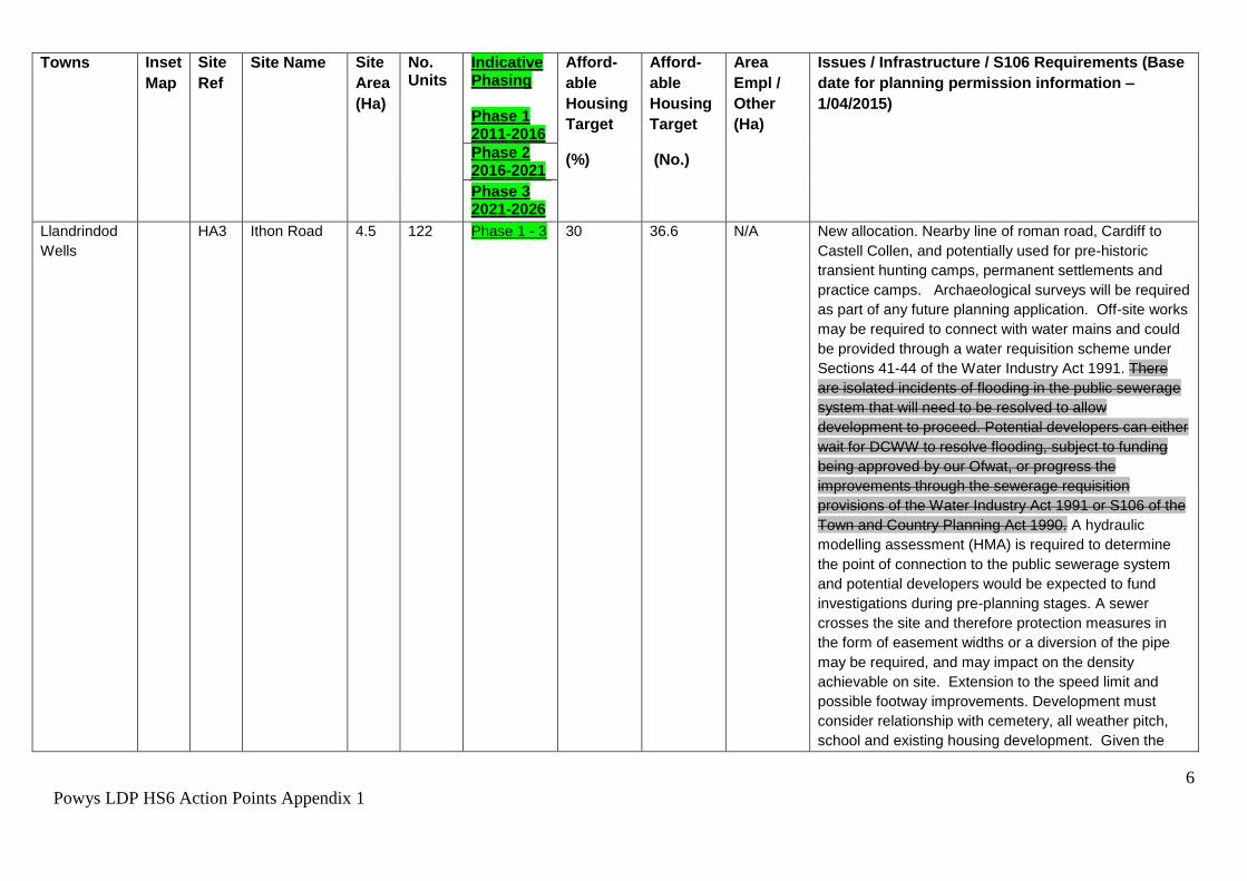
HA3 Ithon Road 4.5 122 Phase 1 - 3 30 36.6 N/A New allocation. Nearby line of roman road, Cardiff to
Castell Collen, and potentially used for pre-historic
transient hunting camps, permanent settlements and
practice camps. Archaeological surveys will be required
as part of any future planning application. Off-site works
may be required to connect with water mains and could
be provided through a water requisition scheme under
Sections 41-44 of the Water Industry Act 1991. There
are isolated incidents of flooding in the public sewerage
system that will need to be resolved to allow
development to proceed. Potential developers can either
wait for DCWW to resolve flooding, subject to funding
being approved by our Ofwat, or progress the
improvements through the sewerage requisition
provisions of the Water Industry Act 1991 or S106 of the
Town and Country Planning Act 1990. A hydraulic
modelling assessment (HMA) is required to determine
the point of connection to the public sewerage system
and potential developers would be expected to fund
investigations during pre-planning stages. A sewer
crosses the site and therefore protection measures in
the form of easement widths or a diversion of the pipe
may be required, and may impact on the density
achievable on site. Extension to the speed limit and
possible footway improvements. Development must
consider relationship with cemetery, all weather pitch,
school and existing housing development. Given the

7
Powys LDP HS6 Action Points Appendix 1
Towns Inset
Map
Site
Ref
Site Name Site
Area
(Ha)
No. Units
Indicative Phasing Phase 1 2011-2016
Afford-
able
Housing
Target
(%)
Afford-
able
Housing
Target
(No.)
Area
Empl /
Other
(Ha)
Issues / Infrastructure / S106 Requirements (Base
date for planning permission information –
1/04/2015)
Phase 2 2016-2021
Phase 3 2021-2026
important design considerations relating to the
relationship with adjacent uses and the site topography,
a development brief will be required to be prepared.
*Project level HRA screening required – River Wye SAC.
Llandrindod
Wells
HA4 Land at
Ridgebourne
Drive,
7.6 100 Phase 1/2 30 30.0 N/A Large Site capable of being phased beyond the Plan
period. Development Brief required for phasing and
potential future phasing as provision of internal road
scheme necessary to realise full allocation. Plan
anticipates approx. 3.7 ha being developed. Transport
Assessment and provision of a ‘ghost’ island right
turning lane in the trunk road. Right turn lane required at
the junction with the trunk road. Site lies near the Lake
Park Local Nature Reserve, ecology survey required to
demonstrate no adverse impact from development and
to inform mitigation and enhancements. Local sewerage
network can accommodate foul flows from the site
however off site sewers may would be required and can
be provided through the sewer requisition scheme under
Sections 98-101 of the Water Industry Act 1991.
Contaminated land survey required. *Project level HRA
screening required – River Wye SAC.
Llandrindod
Wells
EA1 Heart of
Wales
Business
Park
3.9 N/A Phase 2/3 N/A N/A 3.9 Only part developable. Drainage pond on part of
allocation. This is a biodiversity rich site supporting
Great Crested Newts. An ecological survey is required to
inform enhancement through development. Site is
crossed by a sewer and protection measures in the form

8
Powys LDP HS6 Action Points Appendix 1
Towns Inset
Map
Site
Ref
Site Name Site
Area
(Ha)
No. Units
Indicative Phasing Phase 1 2011-2016
Afford-
able
Housing
Target
(%)
Afford-
able
Housing
Target
(No.)
Area
Empl /
Other
(Ha)
Issues / Infrastructure / S106 Requirements (Base
date for planning permission information –
1/04/2015)
Phase 2 2016-2021
Phase 3 2021-2026
of easement widths or a diversion of the pipe may be
required, and may impact upon the density achievable
on site. Off-site water connection required. *Project level
HRA screening required – River Wye SAC.
Llanfair
Caereinion
P30 HA1 Land at
Tanyfron,
Llanfair
Caereinion
2.4 40 Phase 2 10 4.0 N/A New access to be created through the garage (a further
10 residential units to the 30 may be built here on
brownfield land). Concerns from the community
regarding highways issues will need to be resolved
through highways alterations including the closure of
existing access points, and traffic management /
pedestrian access to be detailed in a development brief.
The whole site to be developed together as one.
However the steep middle part of the site is not to be
developed and is for access only. *Project level HRA
screening required – Tanat and Vwrnwy Bat sites SAC.
Llanfair
Caereinion
HA2 UDP
Allocation
M154 HA3
OS 6906,
Land North
of Watergate
Street
1.1 20 Phase 3 10 2.0 N/A Highway improvements along Watergate Street,
awaiting the signing of a S106 agreement for
P/2009/0484. *Project level HRA screening required –
Tanat and Vwrnwy Bat sites SAC.

9
Powys LDP HS6 Action Points Appendix 1
Towns Inset
Map
Site
Ref
Site Name Site
Area
(Ha)
No. Units
Indicative Phasing Phase 1 2011-2016
Afford-
able
Housing
Target
(%)
Afford-
able
Housing
Target
(No.)
Area
Empl /
Other
(Ha)
Issues / Infrastructure / S106 Requirements (Base
date for planning permission information –
1/04/2015)
Phase 2 2016-2021
Phase 3 2021-2026
Llanfyllin P32 HC1 Adjacent 38
Maes Y
Dderwen,
Llanfyllin
0.4 14 Phase 2 N/A 5.0 N/A Commitment. Ref: M/2007/1043. *Project level HRA
screening required – Tanat and Vwrnwy Bat sites SAC.
Llanfyllin HA1 Land
opposite
Maesydre,
Llanfyllin
0.5 14 Phase 2 10 1.4 N/A *Project level HRA screening required – Tanat and
Vwrnwy Bat sites SAC.
Llanfyllin HA2 Maesydre
Field,
Llanfyllin
2.3 55 Phase 3 10 5.5 N/A Two sites need to be developed together as highways
access needs to come from site furthest from the
settlement. It is imperative that this scheme is of good
sensitive design as it is near a Y Dolydd Listed Building
and will be creating a new gateway into Llanfyllin,
therefore a Development Brief is required *Project level
HRA screening required – Tanat and Vwrnwy Bat sites
SAC.
Llanfyllin HA2 Field 7674,
South of
Maesydre,
Llanfyllin
3.8 90 Phase 2/3 10 9.0 N/A
Llanidloes P35 HC1 Lower
Green,
Victoria
Avenue
0.8 31 Phase 2 N/A 9.0 N/A Commitment. P/2006/0103
10
Powys LDP HS6 Action Points Appendix 1
Towns Inset
Map
Site
Ref
Site Name Site
Area
(Ha)
No. Units
Indicative Phasing Phase 1 2011-2016
Afford-
able
Housing
Target
(%)
Afford-
able
Housing
Target
(No.)
Area
Empl /
Other
(Ha)
Issues / Infrastructure / S106 Requirements (Base
date for planning permission information –
1/04/2015)
Phase 2 2016-2021
Phase 3 2021-2026
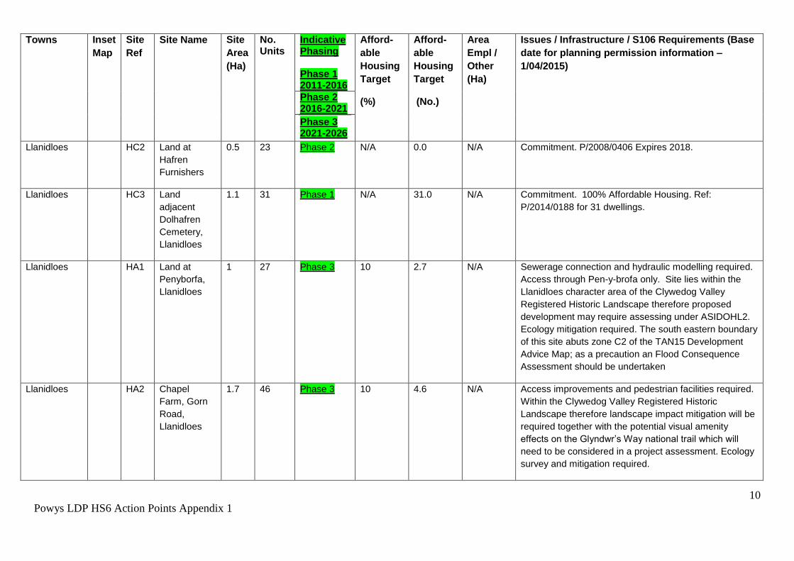
Llanidloes HC2 Land at
Hafren
Furnishers
0.5 23 Phase 2 N/A 0.0 N/A Commitment. P/2008/0406 Expires 2018.
Llanidloes HC3 Land
adjacent
Dolhafren
Cemetery,
Llanidloes
1.1 31 Phase 1 N/A 31.0 N/A Commitment. 100% Affordable Housing. Ref:
P/2014/0188 for 31 dwellings.
Llanidloes HA1 Land at
Penyborfa,
Llanidloes
1 27 Phase 3 10 2.7 N/A Sewerage connection and hydraulic modelling required.
Access through Pen-y-brofa only. Site lies within the
Llanidloes character area of the Clywedog Valley
Registered Historic Landscape therefore proposed
development may require assessing under ASIDOHL2.
Ecology mitigation required. The south eastern boundary
of this site abuts zone C2 of the TAN15 Development
Advice Map; as a precaution an Flood Consequence
Assessment should be undertaken
Llanidloes HA2 Chapel
Farm, Gorn
Road,
Llanidloes
1.7 46 Phase 3 10 4.6 N/A Access improvements and pedestrian facilities required.
Within the Clywedog Valley Registered Historic
Landscape therefore landscape impact mitigation will be
required together with the potential visual amenity
effects on the Glyndwr’s Way national trail which will
need to be considered in a project assessment. Ecology
survey and mitigation required.
11
Powys LDP HS6 Action Points Appendix 1
Towns Inset
Map
Site
Ref
Site Name Site
Area
(Ha)
No. Units
Indicative Phasing Phase 1 2011-2016
Afford-
able
Housing
Target
(%)
Afford-
able
Housing
Target
(No.)
Area
Empl /
Other
(Ha)
Issues / Infrastructure / S106 Requirements (Base
date for planning permission information –
1/04/2015)
Phase 2 2016-2021
Phase 3 2021-2026
Llanidloes P35 EC1 Land at Parc
Hafren,
Llanidloes
0.5 N/A Phase 2/3 N/A N/A 0.5 Commitment on northern part of site (P2012/0611,
P/2013/0729).
Llanidloes EA1 Land at Parc
Busnes
Derwen
Fawr,
Llanidloes
1.2 N/A Phase 2/3 N/A N/A 1.2 Brownfield site. Ecology mitigation required for loss of
extended phase 1 habitat. Land contamination survey
required.
Llanidloes EA2 Land at Parc
Hafren,
Llanidloes
1.2 N/A Phase 2/3 N/A N/A 1.2 Ecology survey and mitigation required for loss of
extended phase 1 habitat.
Llanwrtyd
Wells
P39 HC1 The Vicarage
Field, Beulah
Road,
Llanwrtyd
0.5 7 Phase 2/3 N/A 0.0 N/A Commitment. *Project level HRA screening required –
River Wye SAC.
Llanwrtyd
Wells
HC2 OS 2664
Caemawr, off
Ffos Road
1.9 47 Phase 3 N/A 6.0 N/A Commitment. *Project level HRA screening required –
River Wye SAC.
Llanwrtyd
Wells
HC3 OS 1451
Meadow
View, Station
Road
0.8 19 Phase 2/3 N/A 6.0 N/A Commitment. S106. *Project level HRA screening
required – River Wye SAC.

12
Powys LDP HS6 Action Points Appendix 1
Towns Inset
Map
Site
Ref
Site Name Site
Area
(Ha)
No. Units
Indicative Phasing Phase 1 2011-2016
Afford-
able
Housing
Target
(%)
Afford-
able
Housing
Target
(No.)
Area
Empl /
Other
(Ha)
Issues / Infrastructure / S106 Requirements (Base
date for planning permission information –
1/04/2015)
Phase 2 2016-2021
Phase 3 2021-2026
Machynlleth P42 HA1 OS1546,
Aberystwyth
Road
1.4 29 Phase 3 10 2.9 N/A Site awaiting signing of s106 (P/2013/0144). Off site
sewers would be required to connect to the public
sewerage network and can be provided through the
sewer requisition scheme under Sections 98-101 of the
Water Industry Act 1991. *Project level HRA screening
maybe required – Dyfi Estuary SAC, Llyn Peninsula and
Sarnau SAC , Cors Fochno SAC and Meirionydd
Oakwood and Bat sites. A Flood Consequence
Assessment will be required. The north west boundary
of this site abuts zone C2 of the TAN15 Development
Advice Map; as a precaution a Flood Consequence
Assessment should be undertaken.
Machynlleth HA2 Land
Adjacent
HA1,
Aberystwyth
Rd
0.5 14 Phase 3 10 1.4 N/A Ecological Survey will be required to inform
enhancements. Road access via adjoining site allocation
to the east on to roundabout. Offsite sewers would be
required to connect to the public sewerage network and
can be provided through the sewer requisition scheme
under Sections 98-101 of the Water Industry Act 1991.
*Project level HRA screening maybe required – Dyfi
Estuary SAC, Llyn Peninsula and Sarnau SAC, Cors
Fochno SAC and Meirionydd Oakwood and Bat sites. A
Flood Consequence Assessment will be required. The
western boundary of this site abuts zone C2 of the
TAN15 Development Advice Map; as a precaution a
Flood Consequence Assessment should be undertaken.
13
Powys LDP HS6 Action Points Appendix 1
Towns Inset
Map
Site
Ref
Site Name Site
Area
(Ha)
No. Units
Indicative Phasing Phase 1 2011-2016
Afford-
able
Housing
Target
(%)
Afford-
able
Housing
Target
(No.)
Area
Empl /
Other
(Ha)
Issues / Infrastructure / S106 Requirements (Base
date for planning permission information –
1/04/2015)
Phase 2 2016-2021
Phase 3 2021-2026
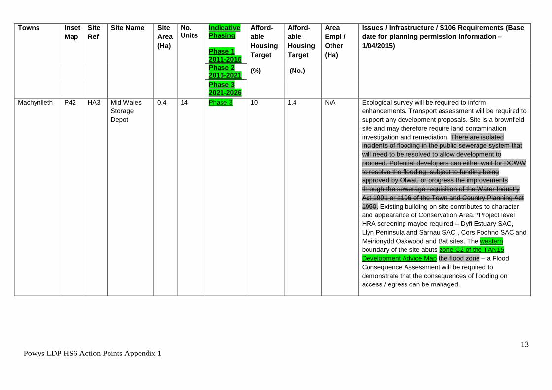
Machynlleth P42 HA3 Mid Wales
Storage
Depot
0.4 14 Phase 3 10 1.4 N/A Ecological survey will be required to inform
enhancements. Transport assessment will be required to
support any development proposals. Site is a brownfield
site and may therefore require land contamination
investigation and remediation. There are isolated
incidents of flooding in the public sewerage system that
will need to be resolved to allow development to
proceed. Potential developers can either wait for DCWW
to resolve the flooding, subject to funding being
approved by Ofwat, or progress the improvements
through the sewerage requisition of the Water Industry
Act 1991 or s106 of the Town and Country Planning Act
1990. Existing building on site contributes to character
and appearance of Conservation Area. *Project level
HRA screening maybe required – Dyfi Estuary SAC,
Llyn Peninsula and Sarnau SAC , Cors Fochno SAC and
Meirionydd Oakwood and Bat sites. The western
boundary of the site abuts zone C2 of the TAN15
Development Advice Map the flood zone – a Flood
Consequence Assessment will be required to
demonstrate that the consequences of flooding on
access / egress can be managed.
14
Powys LDP HS6 Action Points Appendix 1
Towns Inset
Map
Site
Ref
Site Name Site
Area
(Ha)
No. Units
Indicative Phasing Phase 1 2011-2016
Afford-
able
Housing
Target
(%)
Afford-
able
Housing
Target
(No.)
Area
Empl /
Other
(Ha)
Issues / Infrastructure / S106 Requirements (Base
date for planning permission information –
1/04/2015)
Phase 2 2016-2021
Phase 3 2021-2026
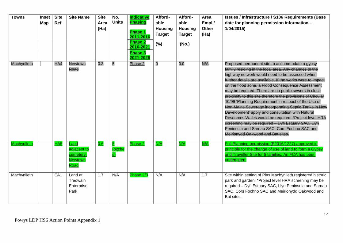
Machynlleth HA4 Newtown
Road
0.3 5 Phase 2 0 0.0 N/A Proposed permanent site to accommodate a gypsy
family residing in the local area. Any changes to the
highway network would need to be assessed when
further details are available. If the works were to impact
on the flood zone, a Flood Consequence Assessment
may be required. There are no public sewers in close
proximity to this site therefore the provisions of Circular
10/99 ‘Planning Requirement in respect of the Use of
Non-Mains Sewerage incorporating Septic Tanks in New
Development’ apply and consultation with Natural
Resources Wales would be required. *Project level HRA
screening may be required – Dyfi Estuary SAC, Llyn
Peninsula and Sarnau SAC, Cors Fochno SAC and
Meirionydd Oakwood and Bat sites.
Machynlleth HA5 Land
adjacent to
cemetery,
Newtown
Road
0.6 5
(pitche
s)
Phase 2 N/A N/A N/A Full Planning permission (P2016/1227) approved in
principle for the change of use of land to form a Gypsy
and Traveller Site for 5 families. An FCA has been
undertaken.
Machynlleth EA1 Land at
Treowain
Enterprise
Park
1.7 N/A Phase 2/3 N/A N/A 1.7 Site within setting of Plas Machynlleth registered historic
park and garden. *Project level HRA screening may be
required – Dyfi Estuary SAC, Llyn Peninsula and Sarnau
SAC, Cors Fochno SAC and Meirionydd Oakwood and
Bat sites.

15
Powys LDP HS6 Action Points Appendix 1
Towns Inset
Map
Site
Ref
Site Name Site
Area
(Ha)
No. Units
Indicative Phasing Phase 1 2011-2016
Afford-
able
Housing
Target
(%)
Afford-
able
Housing
Target
(No.)
Area
Empl /
Other
(Ha)
Issues / Infrastructure / S106 Requirements (Base
date for planning permission information –
1/04/2015)
Phase 2 2016-2021
Phase 3 2021-2026
Montgomery P45 HC1 Land at New
Road
2.6 13 Phase 1 N/A 6.0 N/A Commitment (final phase). Completed. Lies within the
Trefaldwyn character area of the Vale of Montgomery
Registered Historic Landscape. *Project level HRA
screening required – Montgomery Canal SAC
(hydrological connections).
Montgomery HA1 Land at
Verlon,
Forden Road
10.8 54 Phase 3 20 10.8 N/A Large Site capable of being phased beyond the Plan
period. Development Brief required for phasing and
potential future phasing as provision of new link road
necessary to realise full allocation. Plan anticipates
approx. 2 ha being developed. Sensitive site re:
heritage and landscape buffer required for Sewage
Treatment Works. Lies within the Trefaldwyn character
area of the Vale of Montgomery Registered Historic
Landscape - so will require assessing under
ASIDOHL2. Site lies immediately close to three
Scheduled Ancient Monuments, ‘Montgomery Castle’,
‘Montgomery Town Walls’ and ‘Ffridd Faldwyn hillfort’
development adjacent to these sites may come within
the terms of 1979 Scheduled Ancient Monuments and
Archaeological Areas Act and would require consultation
with Cadw and CPAT to ascertain the effects that it
might have on the setting of this historic asset. Any
development here may also require archaeological
intervention as part of any planning application. As part
of any development proposal the existing junction of the
B4385/B4388 will need to be permanently closed up to
16
Powys LDP HS6 Action Points Appendix 1
Towns Inset
Map
Site
Ref
Site Name Site
Area
(Ha)
No. Units
Indicative Phasing Phase 1 2011-2016
Afford-
able
Housing
Target
(%)
Afford-
able
Housing
Target
(No.)
Area
Empl /
Other
(Ha)
Issues / Infrastructure / S106 Requirements (Base
date for planning permission information –
1/04/2015)
Phase 2 2016-2021
Phase 3 2021-2026
all vehicular traffic. Site is within a catchment that is
failing WFD objectives (due to phosphate levels).
Therefore foul water disposal must go to a mains public
sewer or developer must show private connection is not
adding to phosphate levels in the catchment.
Development proposals must be identified through the
preparation of a development brief that takes account of
all issues including constraints and viability. *Project
level HRA screening required – Montgomery Canal SAC
(hydrological connections).
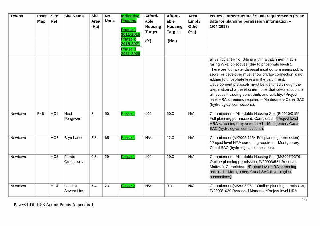
Newtown P48 HC1 Heol
Pengwern
2 50 Phase 1 100 50.0 N/A Commitment – Affordable Housing Site (P/2010/0199
Full planning permission). Completed. *Project level
HRA screening maybe required – Montgomery Canal
SAC (hydrological connections).
Newtown HC2 Bryn Lane 3.3 65 Phase 1 N/A 12.0 N/A Commitment (M/2005/1154 Full planning permission).
*Project level HRA screening required – Montgomery
Canal SAC (hydrological connections).
Newtown HC3 Ffordd
Croesawdy
0.5 29 Phase 1 100 29.0 N/A Commitment – Affordable Housing Site (M/2007/0376
Outline planning permission, P/2009/0521 Reserved
Matters). Completed. *Project level HRA screening
required – Montgomery Canal SAC (hydrological
connections).
Newtown HC4 Land at
Severn Hts,
5.4 23 Phase 2 N/A 0.0 N/A Commitment (M/2003/0511 Outline planning permission,
P/2008/1620 Reserved Matters). *Project level HRA

17
Powys LDP HS6 Action Points Appendix 1
Towns Inset
Map
Site
Ref
Site Name Site
Area
(Ha)
No. Units
Indicative Phasing Phase 1 2011-2016
Afford-
able
Housing
Target
(%)
Afford-
able
Housing
Target
(No.)
Area
Empl /
Other
(Ha)
Issues / Infrastructure / S106 Requirements (Base
date for planning permission information –
1/04/2015)
Phase 2 2016-2021
Phase 3 2021-2026
(Brimmon
Close)
screening required – Montgomery Canal SAC
(hydrological connections).
Newtown HC5 Rock Farm 8.5 103 Phase 2 N/A 17.0 N/A Commitment (Series of Permissions). *Project level HRA
screening required – Montgomery Canal SAC
(hydrological connections). Site impinges on the historic
settlement core of Llanllwchaiarn therefore any
proposed development here may require archaeological
intervention as part of any planning application.
Newtown HC6 Rear of
Pentecostal
Church
1 27 Phase 3 100 27.0 N/A Commitment – Affordable Housing Site (M/1997/0426
Full planning permission). An overflow car park to serve
the Pentecostal Church has been built on part of the site
and has been granted full planning permission
retrospectively P/2010/1053). *Project level HRA
screening required – Montgomery Canal SAC
(hydrological connections).
Newtown HC8 Former
Magistrates
Court and TA
building,
Back Lane
0.1 23 Phase 1/2 N/A 6 N/A Commitment. Full planning permission (P/2013/0891).
Newtown HC9 Severnside
Yard,
Commercial
Street,
0.5 48 Phase 1/2 N/A 48.0 N/A Full planning permission (P/2013/1185). Under
construction. *Project level HRA screening required –
Montgomery Canal SAC (hydrological connections).

18
Powys LDP HS6 Action Points Appendix 1
Towns Inset
Map
Site
Ref
Site Name Site
Area
(Ha)
No. Units
Indicative Phasing Phase 1 2011-2016
Afford-
able
Housing
Target
(%)
Afford-
able
Housing
Target
(No.)
Area
Empl /
Other
(Ha)
Issues / Infrastructure / S106 Requirements (Base
date for planning permission information –
1/04/2015)
Phase 2 2016-2021
Phase 3 2021-2026
Newtown
Newtown HC1
0
1 Wesley
Place,
Newtown
0.01
5
6 Phase 1 0 0 N/A Commitment. Full planning permission (P/2014/0144).
Newtown HA2 Hendidley 0.55 15 Phase 2 20 3 N/A Part of residential site remaining undeveloped. *Project
level HRA screening required - Montgomery Canal SAC
(hydrological connections).
Newtown HA3 South of
Heol
Treowen
Extension
2.6 70 Phase 2/3 20 14.0 N/A An ecological survey will be required at the planning
application stage in order to inform mitigation and
enhancement. The topography of the site and utility
corridors will be significant considerations when drawing
up development proposals for this site. *Project level
HRA screening required - Montgomery Canal SAC
(hydrological connections).
Newtown HA4 South of
Heol
Treowen /
Great
Brimmon
6.8 136 Phase 3 20 27.2 N/A Outline planning permission (M/2003/1354) has lapsed.
It is noted that an ecological survey, along with bat and
dormice surveys, have been carried out in May 2015.
Depending on progress with any new application that
may be submitted for development of this site, update
surveys may be required to inform mitigation and
enhancement as part of a future planning application.
Density of site may be affected by utility
corridors.*Project level HRA screening required -

19
Powys LDP HS6 Action Points Appendix 1
Towns Inset
Map
Site
Ref
Site Name Site
Area
(Ha)
No. Units
Indicative Phasing Phase 1 2011-2016
Afford-
able
Housing
Target
(%)
Afford-
able
Housing
Target
(No.)
Area
Empl /
Other
(Ha)
Issues / Infrastructure / S106 Requirements (Base
date for planning permission information –
1/04/2015)
Phase 2 2016-2021
Phase 3 2021-2026
Montgomery Canal SAC (hydrological connections).
Newtown EA1 Llanidloes
Road
5.6
4.14
N/A Phase 2/3 N/A N/A 2 Only 2ha. of the allocated site lies outside of the C2
zone of the Development Advice Mapping
accompanying TAN15. Therefore, until a satisfactory
Flood Consequences Assessment as recommended in
the Strategic Flood Consequences Assessment is
prepared, the western half of the site will only be
appropriate for open space and landscaping. An
ecological survey will be required to inform
enhancements. *Project level HRA screening maybe
required - Montgomery Canal SAC (hydrological
connections). The site overlies the line of the Roman
Road, therefore proposed development here will require
archaeological intervention as part of any planning
application.
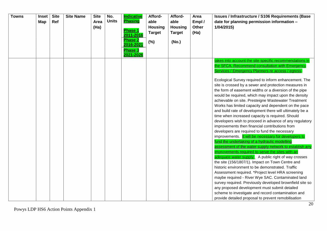
Presteigne P51 MUA
1
Former Kaye
Foundry Site
2.0 60 Phase 2/3 30 18.0 0.4
(Retail)
The Strategic Flood Consequences Assessment (SFCA)
has identified that 6% of the site is in flood zone C2 - this
area will only be appropriate for open space /
landscaping, however the SFCA has also demonstrated
that Flood risk at the site is considered manageable (in
line with TAN 15). Demonstration that access / egress
to the site can be achieved in line with guidance set out
in TAN15 should be provided in a site specific FCA that
20
Powys LDP HS6 Action Points Appendix 1
Towns Inset
Map
Site
Ref
Site Name Site
Area
(Ha)
No. Units
Indicative Phasing Phase 1 2011-2016
Afford-
able
Housing
Target
(%)
Afford-
able
Housing
Target
(No.)
Area
Empl /
Other
(Ha)
Issues / Infrastructure / S106 Requirements (Base
date for planning permission information –
1/04/2015)
Phase 2 2016-2021
Phase 3 2021-2026
takes into account the site specific recommendations in
the SFCA. Recommend consultation with Emergency
Services / Emergency Planners re access / egress.
Ecological Survey required to inform enhancement. The
site is crossed by a sewer and protection measures in
the form of easement widths or a diversion of the pipe
would be required, which may impact upon the density
achievable on site. Presteigne Wastewater Treatment
Works has limited capacity and dependent on the pace
and build rate of development there will ultimately be a
time when increased capacity is required. Should
developers wish to proceed in advance of any regulatory
improvements then financial contributions from
developers are required to fund the necessary
improvements. It will be necessary for developers to
fund the undertaking of a hydraulic modelling
assessment of the water supply network to establish any
improvements required to serve the sites with an
adequate water supply. A public right of way crosses
the site (156/1807/1). Impact on Town Centre and
historic environment to be demonstrated. Traffic
Assessment required. *Project level HRA screening
maybe required - River Wye SAC. Contaminated land
survey required. Previously developed brownfield site so
any proposed development must submit detailed
scheme to investigate and record contamination and
provide detailed proposal to prevent remobilisation

21
Powys LDP HS6 Action Points Appendix 1
Towns Inset
Map
Site
Ref
Site Name Site
Area
(Ha)
No. Units
Indicative Phasing Phase 1 2011-2016
Afford-
able
Housing
Target
(%)
Afford-
able
Housing
Target
(No.)
Area
Empl /
Other
(Ha)
Issues / Infrastructure / S106 Requirements (Base
date for planning permission information –
1/04/2015)
Phase 2 2016-2021
Phase 3 2021-2026
containment and rendering harmless any contamination.
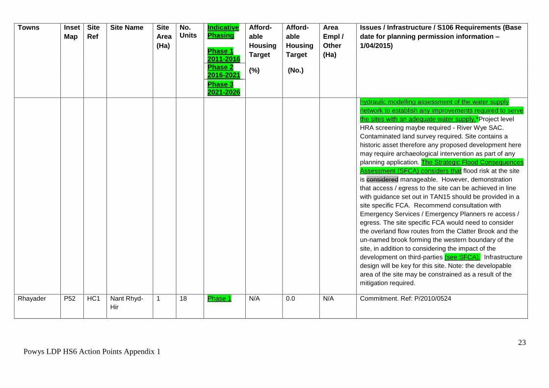
Presteigne HC1 Knighton
Road Site.
0.6 11 Phase 1 100 11 N/A Commitment 100% affordable housing - P/2013/1026
Presteigne HA2 Joe Deakins
Road Site
1.3 35 Phase 3 30
10.5 N/A Offsite works required to connect with the water main
which is approximately 160m away. Offsite works may
be required to connect with the public sewer and can be
provided through the sewer requisition scheme under
sections 98-101 of the Water Industry Act 1991.
Presteigne Wastewater Treatment Works has limited
capacity and dependent on the pace and build rate of
development there will ultimately be a time when
increased capacity is required. Should developers wish
to proceed in advance of any regulatory improvements
then financial contributions from developers are required
to fund the necessary improvements. It will be
necessary for developers to fund the undertaking of a
hydraulic modelling assessment of the water supply
network to establish any improvements required to serve
the sites with an adequate water supply. *Project level
HRA screening maybe required - River Wye SAC.
Contaminated land survey required. Highways
improvements required include the re-configuration of
the junction of Broadaxe Lane with the Presteigne By
22
Powys LDP HS6 Action Points Appendix 1
Towns Inset
Map
Site
Ref
Site Name Site
Area
(Ha)
No. Units
Indicative Phasing Phase 1 2011-2016
Afford-
able
Housing
Target
(%)
Afford-
able
Housing
Target
(No.)
Area
Empl /
Other
(Ha)
Issues / Infrastructure / S106 Requirements (Base
date for planning permission information –
1/04/2015)
Phase 2 2016-2021
Phase 3 2021-2026
Pass B4355.
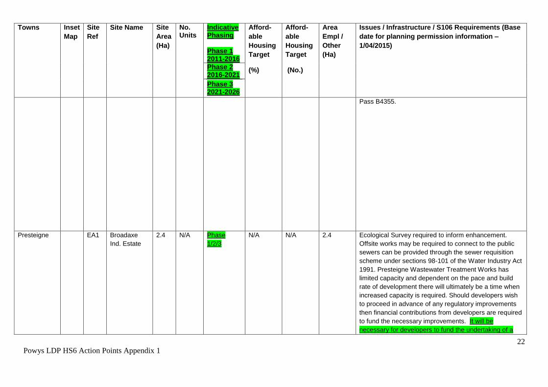
Presteigne EA1 Broadaxe
Ind. Estate
2.4 N/A Phase
1/2/3
N/A N/A 2.4 Ecological Survey required to inform enhancement.
Offsite works may be required to connect to the public
sewers can be provided through the sewer requisition
scheme under sections 98-101 of the Water Industry Act
1991. Presteigne Wastewater Treatment Works has
limited capacity and dependent on the pace and build
rate of development there will ultimately be a time when
increased capacity is required. Should developers wish
to proceed in advance of any regulatory improvements
then financial contributions from developers are required
to fund the necessary improvements. It will be
necessary for developers to fund the undertaking of a
23
Powys LDP HS6 Action Points Appendix 1
Towns Inset
Map
Site
Ref
Site Name Site
Area
(Ha)
No. Units
Indicative Phasing Phase 1 2011-2016
Afford-
able
Housing
Target
(%)
Afford-
able
Housing
Target
(No.)
Area
Empl /
Other
(Ha)
Issues / Infrastructure / S106 Requirements (Base
date for planning permission information –
1/04/2015)
Phase 2 2016-2021
Phase 3 2021-2026
hydraulic modelling assessment of the water supply
network to establish any improvements required to serve
the sites with an adequate water supply.*Project level
HRA screening maybe required - River Wye SAC.
Contaminated land survey required. Site contains a
historic asset therefore any proposed development here
may require archaeological intervention as part of any
planning application. The Strategic Flood Consequences
Assessment (SFCA) considers that flood risk at the site
is considered manageable. However, demonstration
that access / egress to the site can be achieved in line
with guidance set out in TAN15 should be provided in a
site specific FCA. Recommend consultation with
Emergency Services / Emergency Planners re access /
egress. The site specific FCA would need to consider
the overland flow routes from the Clatter Brook and the
un-named brook forming the western boundary of the
site, in addition to considering the impact of the
development on third-parties (see SFCA). Infrastructure
design will be key for this site. Note: the developable
area of the site may be constrained as a result of the
mitigation required.
Rhayader P52 HC1 Nant Rhyd-
Hir
1 18 Phase 1 N/A 0.0 N/A Commitment. Ref: P/2010/0524

24
Powys LDP HS6 Action Points Appendix 1
Towns Inset
Map
Site
Ref
Site Name Site
Area
(Ha)
No. Units
Indicative Phasing Phase 1 2011-2016
Afford-
able
Housing
Target
(%)
Afford-
able
Housing
Target
(No.)
Area
Empl /
Other
(Ha)
Issues / Infrastructure / S106 Requirements (Base
date for planning permission information –
1/04/2015)
Phase 2 2016-2021
Phase 3 2021-2026
Rhayader HC2 Old Builders
Supply Depot
0.2 10 Phase 1 N/A 3.0 N/A Commitment. Ref: P/2009/0321
Rhayader HA1 Tir Gaia 3.5 70 Phase 2/3 30 21.0 N/A Pending planning application. Ref: P/2010/1383.
*Project level HRA screening required - River Wye SAC.
Contaminated land survey required.
Rhayader HA2 Land off East
Street
0.6 16 Phase 3 30 4.8 N/A Part of site (along the south east boundary) is within the
flood zone and will need to be left as open space,
developable area is reduced accordingly although whole
site is allocated. The eastern boundary of this site abuts
zone C2 of the TAN15 Development Advice Map; as a
precaution a Flood Consequence Assessment should be
undertaken. Ecological Survey required to inform
enhancements, retention of substantial buffer along
watercourse is desirable. *Project level HRA screening
required - River Wye SAC. Contaminated land survey
required.

25
Powys LDP HS6 Action Points Appendix 1
Towns Inset
Map
Site
Ref
Site Name Site
Area
(Ha)
No. Units
Indicative Phasing Phase 1 2011-2016
Afford-
able
Housing
Target
(%)
Afford-
able
Housing
Target
(No.)
Area
Empl /
Other
(Ha)
Issues / Infrastructure / S106 Requirements (Base
date for planning permission information –
1/04/2015)
Phase 2 2016-2021
Phase 3 2021-2026
Rhayader EA1 Brynberth
Ind. Estate
3.7 N/A Phase 2/3 N/A N/A 3.7 Ecological Survey Required to inform enhancements,
retention of a substantial buffer along the watercourse is
desirable. The site is crossed by a sewer and protection
measures in the form of easement widths or a diversion
of the pipe would be required, which may impact upon
density achievable on site. Offsite works are required to
connect the whole area to the water mains. *Project
level HRA screening required - River Wye SAC.
Contaminated land survey required. Access is affected
by flooding - a Flood Consequence Assessment will be
required at the planning application stage which will
need to demonstrate that flood risks and consequences
to the access can be managed acceptably (see Powys
SFCA). The Strategic Flood Consequences Assessment
(SFCA) has demonstrated that Flood risk at the site is
considered manageable (in line with TAN 15).
Demonstration that access / egress to the site can be
achieved in line with guidance set out in TAN15 should
be provided in a site specific FCA that takes into account
the site specific recommendations in the SFCA.
Recommend consultation with Emergency Services /
Emergency Planners re access / egress.
Welshpool P57 HC1 Burgess
Land,
Welshpool
5 73 Phase 2 N/A 22.0 N/A Commitment. Under construction. *Project level HRA
screening required - Montgomery Canal SAC
(hydrological connections) and Tanat & Vyrnwy Bat
Sites SAC.
26
Powys LDP HS6 Action Points Appendix 1
Towns Inset
Map
Site
Ref
Site Name Site
Area
(Ha)
No. Units
Indicative Phasing Phase 1 2011-2016
Afford-
able
Housing
Target
(%)
Afford-
able
Housing
Target
(No.)
Area
Empl /
Other
(Ha)
Issues / Infrastructure / S106 Requirements (Base
date for planning permission information –
1/04/2015)
Phase 2 2016-2021
Phase 3 2021-2026
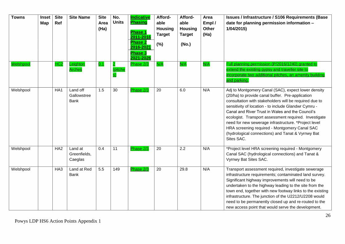
Welshpool HC2 Leighton
Arches
0.1 2
(pitche
s)
Phase 2/3 N/A N/A N/A Full planning permission (P/2016/1240) granted to
extend the existing gypsy and traveller site to
incorporate two additional pitches, an amenity building
and parking.
Welshpool HA1 Land off
Gallowstree
Bank
1.5 30 Phase 2/3 20 6.0 N/A Adj to Montgomery Canal (SAC), expect lower density
(20/ha) to provide canal buffer. Pre-application
consultation with stakeholders will be required due to
sensitivity of location - to include Glandwr Cymru - Canal and River Trust in Wales and the Council’s
ecologist. Transport assessment required. Investigate
need for new sewerage infrastructure. *Project level
HRA screening required - Montgomery Canal SAC
(hydrological connections) and Tanat & Vyrnwy Bat
Sites SAC.
Welshpool HA2 Land at
Greenfields,
Caeglas
0.4 11 Phase 2/3 20 2.2 N/A *Project level HRA screening required - Montgomery
Canal SAC (hydrological connections) and Tanat &
Vyrnwy Bat Sites SAC.
Welshpool HA3 Land at Red
Bank
5.5 149 Phase 2/3 20 29.8 N/A Transport assessment required, investigate sewerage
infrastructure requirements; contaminated land survey.
Significant highway improvements will need to be
undertaken to the highway leading to the site from the
town end, together with new footway links to the existing
infrastructure. The junction of the U2212/U2208 would
need to be permanently closed up and re-routed to the
new access point that would serve the development.
27
Powys LDP HS6 Action Points Appendix 1
Towns Inset
Map
Site
Ref
Site Name Site
Area
(Ha)
No. Units
Indicative Phasing Phase 1 2011-2016
Afford-
able
Housing
Target
(%)
Afford-
able
Housing
Target
(No.)
Area
Empl /
Other
(Ha)
Issues / Infrastructure / S106 Requirements (Base
date for planning permission information –
1/04/2015)
Phase 2 2016-2021
Phase 3 2021-2026
*Project level HRA screening required - Montgomery
Canal SAC (hydrological connections) and Tanat &
Vyrnwy Bat Sites SAC. Development proposals must be
identified through the preparation of a development brief
that takes account of all issues including constraints and
viability.
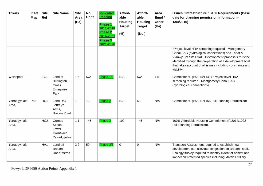
Welshpool EC1 Land at
Buttington
Cross
Enterprise
Park
1.5 N/A Phase 1/2 N/A N/A 1.5 Commitment. (P/2014/1141) *Project level HRA
screening required - Montgomery Canal SAC
(hydrological connections)
Ystradgynlais
Area,
P58 HC1 Land R/O
Jeffrey's
Arms,
Brecon Road
1 18 Phase 2 N/A 6.0 N/A Commitment. (P/2011/1166 Full Planning Permission)
Ystradgynlais
Area,
HC2 Gurnos
School,
Lower
Cwmtwrch,
Ystradgynlais
1.1 45 Phase 2 100 45 N/A 100% Affordable Housing Commitment (P/2014/1022
Full Planning Permission).
Ystradgynlais
Area,
HA1 Land off
Brecon
Road,Ystrad
2.2 59 Phase 2/3 0 0 N/A Transport Assessment required to establish how
development can alleviate congestion on Brecon Road.
Ecology survey required to identify extent of habitat and
impact on protected species including Marsh Fritillary
28
Powys LDP HS6 Action Points Appendix 1
Towns Inset
Map
Site
Ref
Site Name Site
Area
(Ha)
No. Units
Indicative Phasing Phase 1 2011-2016
Afford-
able
Housing
Target
(%)
Afford-
able
Housing
Target
(No.)
Area
Empl /
Other
(Ha)
Issues / Infrastructure / S106 Requirements (Base
date for planning permission information –
1/04/2015)
Phase 2 2016-2021
Phase 3 2021-2026
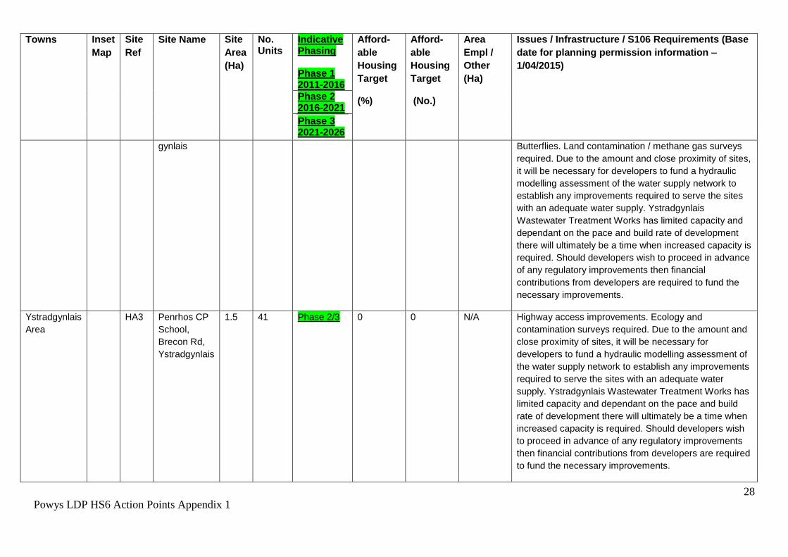
gynlais Butterflies. Land contamination / methane gas surveys
required. Due to the amount and close proximity of sites,
it will be necessary for developers to fund a hydraulic
modelling assessment of the water supply network to
establish any improvements required to serve the sites
with an adequate water supply. Ystradgynlais
Wastewater Treatment Works has limited capacity and
dependant on the pace and build rate of development
there will ultimately be a time when increased capacity is
required. Should developers wish to proceed in advance
of any regulatory improvements then financial
contributions from developers are required to fund the
necessary improvements.
Ystradgynlais
Area
HA3 Penrhos CP
School,
Brecon Rd,
Ystradgynlais
1.5 41 Phase 2/3 0 0 N/A Highway access improvements. Ecology and
contamination surveys required. Due to the amount and
close proximity of sites, it will be necessary for
developers to fund a hydraulic modelling assessment of
the water supply network to establish any improvements
required to serve the sites with an adequate water
supply. Ystradgynlais Wastewater Treatment Works has
limited capacity and dependant on the pace and build
rate of development there will ultimately be a time when
increased capacity is required. Should developers wish
to proceed in advance of any regulatory improvements
then financial contributions from developers are required
to fund the necessary improvements.

29
Powys LDP HS6 Action Points Appendix 1
Towns Inset
Map
Site
Ref
Site Name Site
Area
(Ha)
No. Units
Indicative Phasing Phase 1 2011-2016
Afford-
able
Housing
Target
(%)
Afford-
able
Housing
Target
(No.)
Area
Empl /
Other
(Ha)
Issues / Infrastructure / S106 Requirements (Base
date for planning permission information –
1/04/2015)
Phase 2 2016-2021
Phase 3 2021-2026
Ystradgynlais
Area
HA5 Glanrhyd
Farm,
Ystradgynlais
0.3 8 Phase 2 0 0 N/A Ecology and land contamination surveys required. The
site is crossed by a sewer and protection measures in
the form of easement widths or a diversion of pipe would
be required, which may impact upon the density
achievable on site. Due to the amount and close
proximity of sites, it will be necessary for developers to
fund a hydraulic modelling assessment of the water
supply network to establish any improvements required
to serve the sites with an adequate water supply.
Ystradgynlais Wastewater Treatment Works has limited
capacity and dependant on the pace and build rate of
development there will ultimately be a time when
increased capacity is required. Should developers wish
to proceed in advance of any regulatory improvements
then financial contributions from developers are required
to fund the necessary improvements.
Ystradgynlais
Area
HA9 Penrhos
Farm
3 76 Phase 3 0 0 N/A Highways improvement, ecology, land contamination assessments required. Site within buffer zone of existing minerals extraction permission. 0.52ha for access, landscaping and open space. Due to the amount of proposed development, and the close proximity of sites, it may be necessary for developers to fund the undertaking of a hydraulic modelling assessment of the water supply network to establish any improvements required to serve the sites with an adequate water supply. Ystradgynlais Wastewater Treatment Works (WwTW)

30
Powys LDP HS6 Action Points Appendix 1
Towns Inset
Map
Site
Ref
Site Name Site
Area
(Ha)
No. Units
Indicative Phasing Phase 1 2011-2016
Afford-
able
Housing
Target
(%)
Afford-
able
Housing
Target
(No.)
Area
Empl /
Other
(Ha)
Issues / Infrastructure / S106 Requirements (Base
date for planning permission information –
1/04/2015)
Phase 2 2016-2021
Phase 3 2021-2026
has limited capacity. Should potential developers wish to commence in advance of the AMP6 scheme then financial contributions from developers are required to fund the necessary improvements.
Ystradgynlais
Area,
HA1
0
Brynygroes 4.5 136 Phase 2/3 0 0 N/A Planning Application P/2014/1133
Ystradgynlais
Area,
HA1
1
Penrhos
School
Extension
4.5 122 Phase 2/3 0 0 N/A Highways access via P58 HA3. Within 100m of former
landfill so risk assessment required. Ecology and
contamination surveys required. Due to the amount and
close proximity of sites, it will be necessary for
developers to fund a hydraulic modelling assessment of
the water supply network to establish any improvements
required to serve the sites with an adequate water
supply. Ystradgynlais Wastewater Treatment Works has
limited capacity and dependant on the pace and build
rate of development there will ultimately be a time when
increased capacity is required. Should developers wish
to commence in advance of the AMP6 scheme then
financial contributions from developers are required to
fund the necessary improvements.
Ystradgynlais
Area,
HA1
2
Cynlais
Playing
Fields
0.64 10 Phase 2 0 0 N/A Requires remodelling of layby exit to form satisfactory access to site. Part of site within TAN15 C2 flood zone and a larger extent within Zone B. Flood Consequence Assessment required The south western boundary of this site includes a small area (0.02ha) of zone C2 of the TAN15 Development Advice Map; this area cannot be developed, a Flood Consequence Assessment should
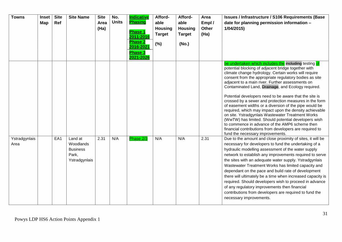
31
Powys LDP HS6 Action Points Appendix 1
Towns Inset
Map
Site
Ref
Site Name Site
Area
(Ha)
No. Units
Indicative Phasing Phase 1 2011-2016
Afford-
able
Housing
Target
(%)
Afford-
able
Housing
Target
(No.)
Area
Empl /
Other
(Ha)
Issues / Infrastructure / S106 Requirements (Base
date for planning permission information –
1/04/2015)
Phase 2 2016-2021
Phase 3 2021-2026
be undertaken which includes the including testing of potential blocking of adjacent bridge together with climate change hydrology. Certain works will require consent from the appropriate regulatory bodies as site adjacent to a main river. Further assessments on Contaminated Land, Drainage, and Ecology required. Potential developers need to be aware that the site is crossed by a sewer and protection measures in the form of easement widths or a diversion of the pipe would be required, which may impact upon the density achievable on site. Ystradgynlais Wastewater Treatment Works (WwTW) has limited. Should potential developers wish to commence in advance of the AMP6 scheme then financial contributions from developers are required to fund the necessary improvements.
Ystradgynlais
Area
EA1 Land at
Woodlands
Business
Park,
Ystradgynlais
2.31 N/A Phase 2/3 N/A N/A 2.31 Due to the amount and close proximity of sites, it will be
necessary for developers to fund the undertaking of a
hydraulic modelling assessment of the water supply
network to establish any improvements required to serve
the sites with an adequate water supply. Ystradgynlais
Wastewater Treatment Works has limited capacity and
dependant on the pace and build rate of development
there will ultimately be a time when increased capacity is
required. Should developers wish to proceed in advance
of any regulatory improvements then financial
contributions from developers are required to fund the
necessary improvements.

32
Powys LDP HS6 Action Points Appendix 1
Towns Inset
Map
Site
Ref
Site Name Site
Area
(Ha)
No. Units
Indicative Phasing Phase 1 2011-2016
Afford-
able
Housing
Target
(%)
Afford-
able
Housing
Target
(No.)
Area
Empl /
Other
(Ha)
Issues / Infrastructure / S106 Requirements (Base
date for planning permission information –
1/04/2015)
Phase 2 2016-2021
Phase 3 2021-2026
Hay-on-Wye P21 MUA
1
Land at
Gypsy Castle
Lane
1.8 49 Phase 2
(Housing)
Phase 2/3
(Employme
nt)
30 14.7 2.4 Mixed use site - Need for joint development brief with
PCC and BBNPA to ensure the site contributes to joint
policy aspirations.
Highways, new junction with the county class II road will
be required along with the stopping up for vehicular use
of sections of the existing Gypsy Castle Lane. Surface
water flooding issue with culvert improvements required,
ecology survey. Recreation space provision to be
included on site. The foul flows from this development
would pass through two Welsh Water Sewerage
Pumping Stations and the cumulative effect of flows
from the site would require an assessment of the
sewerage pumping stations to establish whether
improvements are required. If improvements are
required the sewer requisition provisions of the Water
Industry Act 1991 can apply. Hay on Wye Wastewater
Treatment Works has limited capacity and dependant on
the pace and build rate of development there will
ultimately be a time when increased capacity is required.
Should developers wish to proceed in advance of any
regulatory improvements then financial contributions
from developers are required to fund the necessary
improvements. *Project level HRA screening required -
River Wye SAC. Site lies within the Hay character area
of the Middle Wye Registered Historic Landscape
therefore proposed development may require assessing
under ASIDOHL2.

33
Powys LDP HS6 Action Points Appendix 1
Large
Villages
Inset
Map
Site Ref Site Name Site
Area
(Ha)
No.
Units
Indicative Phasing Phase 1 2011-2016
Affordable
Housing
Target (%)
Affordable
Housing
Target (No.)
Area
Empl/
Other
(Ha)
Issues / Infrastructure / S106 Requirements
(Base date for planning permission
information - 1/04/2015)
Phase 2 2016-2021
Phase 3 2021-2026
Abercrave P01 HA1 Land to East
of
Maesycribart
h
0.5 14 Phase 2/3 0 0 N/A Drainage improvements and ecology survey
required. Two separate landowners, agree
access to whole of site. Ystradgynlais
Wastewater Treatment Works has limited
capacity and dependant on the pace and build
rate of development there will ultimately be a
time when increased capacity is required.
Should developers wish to proceed in advance
of any regulatory improvements then financial
contributions from developers are required to
fund the necessary improvements.
Abermule P02 HA1 Land
adjoining
Abermule
House
0.4 10 Phase 3 20 2.0 N/A Ecological Survey may be required to inform
enhancements. Utility corridors adjoin site and
will need to be considered in drawing up
development proposals for the site. Offsite works
will be required to achieve an appropriate
Highways access (e.g. visibility splays and
pedestrian links).*Project level HRA screening
required - Montgomery Canal SAC (hydrological
connections).
Abermule HA2 Land
adjacent The
Meadows &
Land
3.3 30 Phase 3 20 6.0 N/A Large Site capable of being phased beyond the
Plan period. Development Brief required for
phasing and access road scheme to realise full
allocation. Plan anticipates approx. 1.1 ha being

34
Powys LDP HS6 Action Points Appendix 1
Large
Villages
Inset
Map
Site Ref Site Name Site
Area
(Ha)
No.
Units
Indicative Phasing Phase 1 2011-2016
Affordable
Housing
Target (%)
Affordable
Housing
Target (No.)
Area
Empl/
Other
(Ha)
Issues / Infrastructure / S106 Requirements
(Base date for planning permission
information - 1/04/2015)
Phase 2 2016-2021
Phase 3 2021-2026
adjacent
Parkside
developed. Site comprises 3 distinct parts that
are subject of a number of constraints relating to
issues such as highways access, utility corridors
and flooding. The western boundary of this
southern parcel of the site abuts zone C2 of the
TAN15 Development Advice Map; as a
precaution a Flood Consequence Assessment
should be undertaken. A comprehensive scheme
for the development of the entire allocation shall
be identified through the preparation of a
development brief that takes account of all
constraints, viability and phasing (with no more
than 30 dwellings within the Plan period).*Project
level HRA screening required - Montgomery
Canal SAC (hydrological connections).
Abermule EA1 Abermule
Business
Park
2.6 N/A Phase 2/3 N/A N/A 2.6 The site previously benefitted from O outline
planning permission P/2009/1353 which has
lapsed. Serviced site. *Project level HRA
screening required - Montgomery Canal SAC
(hydrological connections). Flood risk - at risk in
the 0.1% annual probability fluvial flood event
and sSite falls wholly within TAN 15 C2 Flood
Zone, proposals will need to be in line with
national policy – TAN 15 and will require a Flood
Consequence Assessment. A previous Flood
Consequence Assessment for this site was able

35
Powys LDP HS6 Action Points Appendix 1
Large
Villages
Inset
Map
Site Ref Site Name Site
Area
(Ha)
No.
Units
Indicative Phasing Phase 1 2011-2016
Affordable
Housing
Target (%)
Affordable
Housing
Target (No.)
Area
Empl/
Other
(Ha)
Issues / Infrastructure / S106 Requirements
(Base date for planning permission
information - 1/04/2015)
Phase 2 2016-2021
Phase 3 2021-2026
to demonstrate that B1 uses (FCA36594/FCA01)
were acceptable in line with TAN 15. If any
further planning application is submitted the
developer will need to revisit the Flood
Consequences Assessment to ensure flood risk
is up to date. Recommend consultation with
Emergency Services / Emergency Planners re
access / egress.
Arddleen P03 HA1 Land West of
Trederwen
House
1.7 17 Phase 2 20 3.4 Large Site capable of being phased beyond the
Plan period. Development Brief required for
provision of community car park to realise full
allocation. Plan anticipates approx. 0.6 ha being
developed. Sensitive heritage - listed Trederwen
House nearby. Sympathetically designed car
park could usefully buffer listed building. *Project
level HRA screening required - Montgomery
Canal SAC (hydrological connections) and Tanat
and Vyrnwy Bat sites SAC. This site is within a
catchment that is failing WFD objectives (due to
phosphate levels). Therefore foul water disposal
must go to a mains public sewer or developer
must show private connection is not adding to
phosphate levels in the catchment.
Berriew P04 HA1 Land to east
of the village,
0.7 12 Phase 3 20 2.4 Sensitive canal side site at gateway into village. Density has been reduced to reflect need for a canal buffer and presence/potential preservation

36
Powys LDP HS6 Action Points Appendix 1
Large
Villages
Inset
Map
Site Ref Site Name Site
Area
(Ha)
No.
Units
Indicative Phasing Phase 1 2011-2016
Affordable
Housing
Target (%)
Affordable
Housing
Target (No.)
Area
Empl/
Other
(Ha)
Issues / Infrastructure / S106 Requirements
(Base date for planning permission
information - 1/04/2015)
Phase 2 2016-2021
Phase 3 2021-2026
adjacent
canal.
of existing canal related buildings. Development will be required to demonstrate that a safe means of access can be created and a footpath connected to the existing footway network. Pre-application consultation with stakeholders advised - to include Glandwr Cymru - Canal and River Trust in Wales,
heritage and ecology officers. There is a known water vole population (protected species) on the canal. Development of the site will need to include a scheme which conserves the water vole population. Pre-application discussions with NRW should be conducted to ensure satisfactory mitigation measures are offered as an intrinsic component of the re-development proposals. *Project level HRA screening required - Montgomery Canal SAC (hydrological connections). The site includes a number of canal related features. Development here may require prior archaeological intervention (consult and involve CPAT).
Bettws
Cedewain
P05 HC1 Bryn Bechan 0.4 10 Phase 3 N/A 4.0 N/A Commitment M/2002/0187 (Renewal of outline
planning permission M1997 0614, P/2008/0167
Reserved Matters). *Project level HRA screening
required - Montgomery Canal SAC (hydrological
connections).
Boughrood &
Llyswen
P06 HC1 The Depot
Boughrood
0.3 12 Phase 1/2 N/A 4.0 N/A Commitment. (PR154003, P/2009/1270,
VAR/2014/0007)

37
Powys LDP HS6 Action Points Appendix 1
Large
Villages
Inset
Map
Site Ref Site Name Site
Area
(Ha)
No.
Units
Indicative Phasing Phase 1 2011-2016
Affordable
Housing
Target (%)
Affordable
Housing
Target (No.)
Area
Empl/
Other
(Ha)
Issues / Infrastructure / S106 Requirements
(Base date for planning permission
information - 1/04/2015)
Phase 2 2016-2021
Phase 3 2021-2026
Site under construction.
Boughrood &
Llyswen
HC2 Beeches
Park ,
Boughrood
0.3 5 Phase 1 N/A 0.0 N/A Commitment. (P/2011/0110, P/2012/0696,
P/2012/1070, P/2013/0601) Site under
construction.
Boughrood &
Llyswen
HA1 Land at
Llyswen adj
B24 HA3 adj
to Llys
Meillion
1.1 30 Phase 3 30 9
N/A LNG pipeline – site within 250m and 440m buffer
zone protected area – refer to Health & Safety
Executive for acceptable number of units and
density. Access must be onto adjoining estate
road of Llys Meilion. Assessment of surface
drainage required. Highways - Improvements to
A479 Trunk Road highway footpath access to
village and traffic controlling measures required.
Category 1 Minerals safeguarding area -
Resource assessment required with proposals
for prior extraction if proven. Middle Wye Valley
Historic Landscape (proposed development may
require assessing under ASIDOHL2). Ecology
Survey required. Play space provision required.
*Project level HRA screening required - River
Wye SAC.
Boughrood &
Llyswen
HA2 Land
adjoining
Beeches
Park,
Boughrood
0.8 15 Phase 3 30 4.5
N/A Transport Assessment for trunk road access
required.
Ecology survey required. Appropriate internal
highways design required. Need for
development brief to ensure site contributes to

38
Powys LDP HS6 Action Points Appendix 1
Large
Villages
Inset
Map
Site Ref Site Name Site
Area
(Ha)
No.
Units
Indicative Phasing Phase 1 2011-2016
Affordable
Housing
Target (%)
Affordable
Housing
Target (No.)
Area
Empl/
Other
(Ha)
Issues / Infrastructure / S106 Requirements
(Base date for planning permission
information - 1/04/2015)
Phase 2 2016-2021
Phase 3 2021-2026
sustainable development. Pedestrian facilities
required. Category 1 & 2 Minerals safeguarding
area - Resource assessment required with
proposals for prior extraction if proven. Site
requires ground and surface water drainage
assessment *Project level HRA screening
required - River Wye SAC.
Bronllys P07 HC1 Land
adjacent to
Bronllys
Court
1.5 34 Phase 1/2 N/A 8.0 N/A Commitment (P/2008/0405, P/2010/0864,
P/2013/0922)
Bronllys HA3 Land to rear
of
Greenfields
Bronllys
0.3 6 Phase 3 30 1.8 N/A Highways & pedestrian facilities improvements.
*Project level HRA screening required - River
Wye SAC. Contaminated land survey required.
Site contains a historic asset and partly impinges
on the historic settlement core of Bronllys
therefore any proposed development here may
require archaeological intervention as part of any
planning application.
Bronllys HA1 Land adj
Bronllys CP
School,
Neuadd
Terrace
1.4 38 Phase 1/2 30 11.4 N/A Access from Bronllys Class III road only. No
access from bypass. Ecology Survey required.
There are isolated incidents of flooding in the
public sewerage system that will need to be
resolved to allow development to proceed.
Potential developers can either wait for DCWW
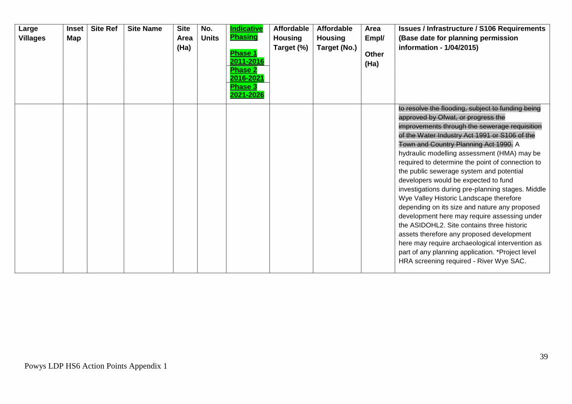
39
Powys LDP HS6 Action Points Appendix 1
Large
Villages
Inset
Map
Site Ref Site Name Site
Area
(Ha)
No.
Units
Indicative Phasing Phase 1 2011-2016
Affordable
Housing
Target (%)
Affordable
Housing
Target (No.)
Area
Empl/
Other
(Ha)
Issues / Infrastructure / S106 Requirements
(Base date for planning permission
information - 1/04/2015)
Phase 2 2016-2021
Phase 3 2021-2026
to resolve the flooding, subject to funding being
approved by Ofwat, or progress the
improvements through the sewerage requisition
of the Water Industry Act 1991 or S106 of the
Town and Country Planning Act 1990. A
hydraulic modelling assessment (HMA) may be
required to determine the point of connection to
the public sewerage system and potential
developers would be expected to fund
investigations during pre-planning stages. Middle
Wye Valley Historic Landscape therefore
depending on its size and nature any proposed
development here may require assessing under
the ASIDOHL2. Site contains three historic
assets therefore any proposed development
here may require archaeological intervention as
part of any planning application. *Project level
HRA screening required - River Wye SAC.

40
Powys LDP HS6 Action Points Appendix 1
Large
Villages
Inset
Map
Site Ref Site Name Site
Area
(Ha)
No.
Units
Indicative Phasing Phase 1 2011-2016
Affordable
Housing
Target (%)
Affordable
Housing
Target (No.)
Area
Empl/
Other
(Ha)
Issues / Infrastructure / S106 Requirements
(Base date for planning permission
information - 1/04/2015)
Phase 2 2016-2021
Phase 3 2021-2026
Bronllys HA2 Land at
Bronllys to
the west of
Hen Ysgubor
0.6 10 Phase 2/3 30 3.0 N/A Site subject of application (P/2014/1190). There
are isolated incidents of flooding in the public
sewerage system that will need to be resolved to
allow development to proceed. Potential
developers can either wait for DCWW to resolve
the flooding, subject to funding being approved
by Ofwat, or progress the improvements through
the sewerage requisition of the Water Industry
Act 1991 or S106 of the Town and Country
Planning Act 1990. A hydraulic modelling
assessment (HMA) may be required to
determine the point of connection to the public
sewerage system and potential developers
would be expected to fund investigations during
pre-planning stages. Middle Wye Valley Historic
Landscape. *Project level HRA screening
required - River Wye SAC. Site lies within the
historic settlement core of Bronllys any proposed
development here may require archaeological
intervention as part of any planning application
Caersws P09 HC1 Part of Buck
Hotel, Main
Street
N/A 5 Phase 2 N/A 1 N/A Commitment. Full planning permission
P/2013/0834.
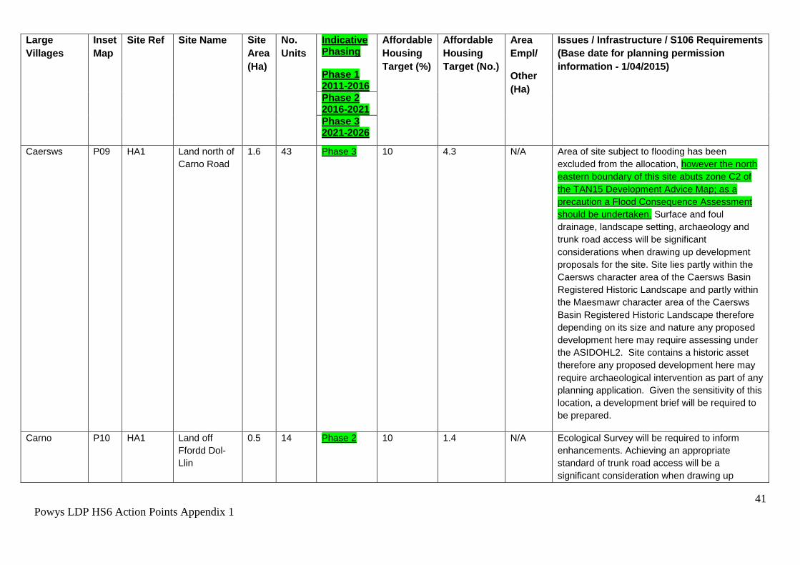
41
Powys LDP HS6 Action Points Appendix 1
Large
Villages
Inset
Map
Site Ref Site Name Site
Area
(Ha)
No.
Units
Indicative Phasing Phase 1 2011-2016
Affordable
Housing
Target (%)
Affordable
Housing
Target (No.)
Area
Empl/
Other
(Ha)
Issues / Infrastructure / S106 Requirements
(Base date for planning permission
information - 1/04/2015)
Phase 2 2016-2021
Phase 3 2021-2026
Caersws P09 HA1 Land north of
Carno Road
1.6 43 Phase 3 10 4.3 N/A Area of site subject to flooding has been
excluded from the allocation, however the north
eastern boundary of this site abuts zone C2 of
the TAN15 Development Advice Map; as a
precaution a Flood Consequence Assessment
should be undertaken. Surface and foul
drainage, landscape setting, archaeology and
trunk road access will be significant
considerations when drawing up development
proposals for the site. Site lies partly within the
Caersws character area of the Caersws Basin
Registered Historic Landscape and partly within
the Maesmawr character area of the Caersws
Basin Registered Historic Landscape therefore
depending on its size and nature any proposed
development here may require assessing under
the ASIDOHL2. Site contains a historic asset
therefore any proposed development here may
require archaeological intervention as part of any
planning application. Given the sensitivity of this
location, a development brief will be required to
be prepared.
Carno P10 HA1 Land off
Ffordd Dol-
Llin
0.5 14 Phase 2 10 1.4 N/A Ecological Survey will be required to inform
enhancements. Achieving an appropriate
standard of trunk road access will be a
significant consideration when drawing up
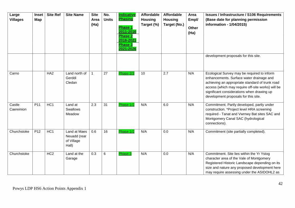
42
Powys LDP HS6 Action Points Appendix 1
Large
Villages
Inset
Map
Site Ref Site Name Site
Area
(Ha)
No.
Units
Indicative Phasing Phase 1 2011-2016
Affordable
Housing
Target (%)
Affordable
Housing
Target (No.)
Area
Empl/
Other
(Ha)
Issues / Infrastructure / S106 Requirements
(Base date for planning permission
information - 1/04/2015)
Phase 2 2016-2021
Phase 3 2021-2026
development proposals for this site.
Carno HA2 Land north of
Gerddi
Cledan
1 27 Phase 2/3 10 2.7 N/A Ecological Survey may be required to inform
enhancements. Surface water drainage and
achieving an appropriate standard of trunk road
access (which may require off-site works) will be
significant considerations when drawing up
development proposals for this site.
Castle
Caereinion
P11 HC1 Land at
Swallows
Meadow
2.3 31 Phase 1/2 N/A 6.0 N/A Commitment. Partly developed, partly under
construction. *Project level HRA screening
required - Tanat and Vwrnwy Bat sites SAC and
Montgomery Canal SAC (hydrological
connections).
Churchstoke P12 HC1 Land at Maes
Neuadd (rear
of Village
Hall)
0.6 16 Phase 1/2 N/A 0.0 N/A Commitment (site partially completed).
Churchstoke HC2 Land at the
Garage
0.3 6 Phase 3 N/A 0.0 N/A Commitment. Site lies within the Yr Ystog
character area of the Vale of Montgomery
Registered Historic Landscape depending on its
size and nature any proposed development here
may require assessing under the ASIDOHL2 as

43
Powys LDP HS6 Action Points Appendix 1
Large
Villages
Inset
Map
Site Ref Site Name Site
Area
(Ha)
No.
Units
Indicative Phasing Phase 1 2011-2016
Affordable
Housing
Target (%)
Affordable
Housing
Target (No.)
Area
Empl/
Other
(Ha)
Issues / Infrastructure / S106 Requirements
(Base date for planning permission
information - 1/04/2015)
Phase 2 2016-2021
Phase 3 2021-2026
part of any planning application.
Churchstoke HC3 Land at the
Hatchery
0.5 12 Phase 2 N/A 5.0 N/A Commitment. Site lies within the Yr Ystog
character area of the Vale of Montgomery
Registered Historic Landscape depending on its
size and nature any proposed development here
may require assessing under the ASIDOHL2 as
part of any planning application.
Churchstoke HC4 Land
adjacent The
View
0.43 11 Phase 3 N/A 0 N/A Committed Site
Churchstoke HA1 Land west of
Fir House
1.34 36 Phase 2/3 20 7.2 Site lies within the Yr Ystog character area of the Vale of Montgomery Registered Historic Landscape depending on its size and nature any proposed development here may require assessing under the ASIDOHL2 as part of any planning application. Access works will be required to meet acceptable highways standards. Highways advise that access works should have regard to the potential residential use of land opposite. Ecological survey is likely to be required to inform enhancements. The Strategic Flood Consequences Assessment has identified land drainage issues on this site, these should be addressed through a site specific
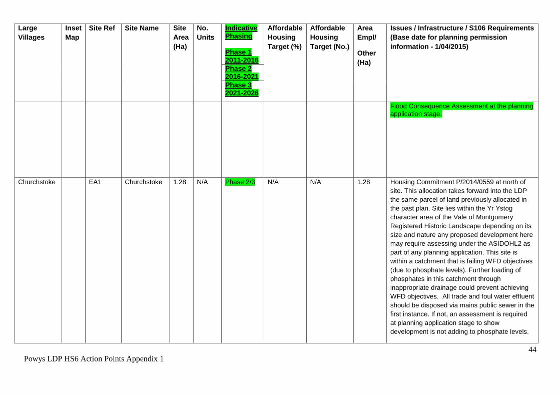
44
Powys LDP HS6 Action Points Appendix 1
Large
Villages
Inset
Map
Site Ref Site Name Site
Area
(Ha)
No.
Units
Indicative Phasing Phase 1 2011-2016
Affordable
Housing
Target (%)
Affordable
Housing
Target (No.)
Area
Empl/
Other
(Ha)
Issues / Infrastructure / S106 Requirements
(Base date for planning permission
information - 1/04/2015)
Phase 2 2016-2021
Phase 3 2021-2026
Flood Consequence Assessment at the planning application stage.
Churchstoke EA1 Churchstoke 1.28 N/A Phase 2/3 N/A N/A 1.28 Housing Commitment P/2014/0559 at north of
site. This allocation takes forward into the LDP
the same parcel of land previously allocated in
the past plan. Site lies within the Yr Ystog
character area of the Vale of Montgomery
Registered Historic Landscape depending on its
size and nature any proposed development here
may require assessing under the ASIDOHL2 as
part of any planning application. This site is
within a catchment that is failing WFD objectives
(due to phosphate levels). Further loading of
phosphates in this catchment through
inappropriate drainage could prevent achieving
WFD objectives. All trade and foul water effluent
should be disposed via mains public sewer in the
first instance. If not, an assessment is required
at planning application stage to show
development is not adding to phosphate levels.

45
Powys LDP HS6 Action Points Appendix 1
Large
Villages
Inset
Map
Site Ref Site Name Site
Area
(Ha)
No.
Units
Indicative Phasing Phase 1 2011-2016
Affordable
Housing
Target (%)
Affordable
Housing
Target (No.)
Area
Empl/
Other
(Ha)
Issues / Infrastructure / S106 Requirements
(Base date for planning permission
information - 1/04/2015)
Phase 2 2016-2021
Phase 3 2021-2026
Clyro P13 HC1 Land South
east of Clyro
(A)
0.6 21 Phase 2 N/A 6.0 N/A Commitment. (RAD/2003/0557). Six local needs
units under construction
Clyro HA1 Land South
east of Clyro
(B)
0.5 14 Phase 3 30
4.2
N/A Highways & access improvements essential.
Potential developers need to be aware that the
site is crossed by a sewer and protection
measures in the form of easement widths or a
diversion of the pipe would be required, which
may impact upon the density achievable on site.
The proposed growth being promoted for this
settlement would require improvements to Clyro
Wastewater treatment works which would need
to be funded through Welsh Water's Asset
Management Plan or potentially earlier through
developer contributions. Land contamination and
ecology surveys required. *Project level HRA
screening required - River Wye SAC. Site lies
within the Bryn-yr-hydd character area of the
Middle Wye Registered Historic Landscape.
Depending on its size and nature any proposed
development here may require assessing under
the ASIDOHL2 as part of any planning
application

46
Powys LDP HS6 Action Points Appendix 1
Large
Villages
Inset
Map
Site Ref Site Name Site
Area
(Ha)
No.
Units
Indicative Phasing Phase 1 2011-2016
Affordable
Housing
Target (%)
Affordable
Housing
Target (No.)
Area
Empl/
Other
(Ha)
Issues / Infrastructure / S106 Requirements
(Base date for planning permission
information - 1/04/2015)
Phase 2 2016-2021
Phase 3 2021-2026
Crewgreen P15 HA1 Land
Opposite The
Firs (between
Malt House
Farm & Bryn
Mawr)
1.5 23 Phase 2 20 4.6 N/A Expect reduced density and careful design to
protect/enhance existing ecological features,
including pond - sensitive landscape -
development proposals should be identified
through the preparation of a development brief
that takes account of all issues including
constraints and viability. Investigation required
to satisfy highways requirements and also
investigate capacity of sewerage infrastructure.
*Project level HRA screening required - Tanat
and Vwrnwy Bat sites SAC.
Crossgates P16 HC1 Oaktree
Meadows
1.4 15 Phase 2 N/A 0.0 N/A Commitment. Ref: PR6115/01 Full planning
permission. *Project level HRA screening
required - River Wye SAC. Consideration needs
to be given to drainage on this site.
Crossgates HA1 Land South
of Studio
Cottage
0.7 19 Phase 3 30 5.7 N/A Ecological Survey to inform enhancement.
Potential developers need to be aware that this
site is crossed by a water main and protection
measures in the form of easement widths or a
diversion of the pipe would be required, which
may impact upon the density achievable on site.
The proposed growth being promoted for this
settlement would require improvements at
Crossgates Wastewater Treatment Works which
would need to be funded through DCWW's
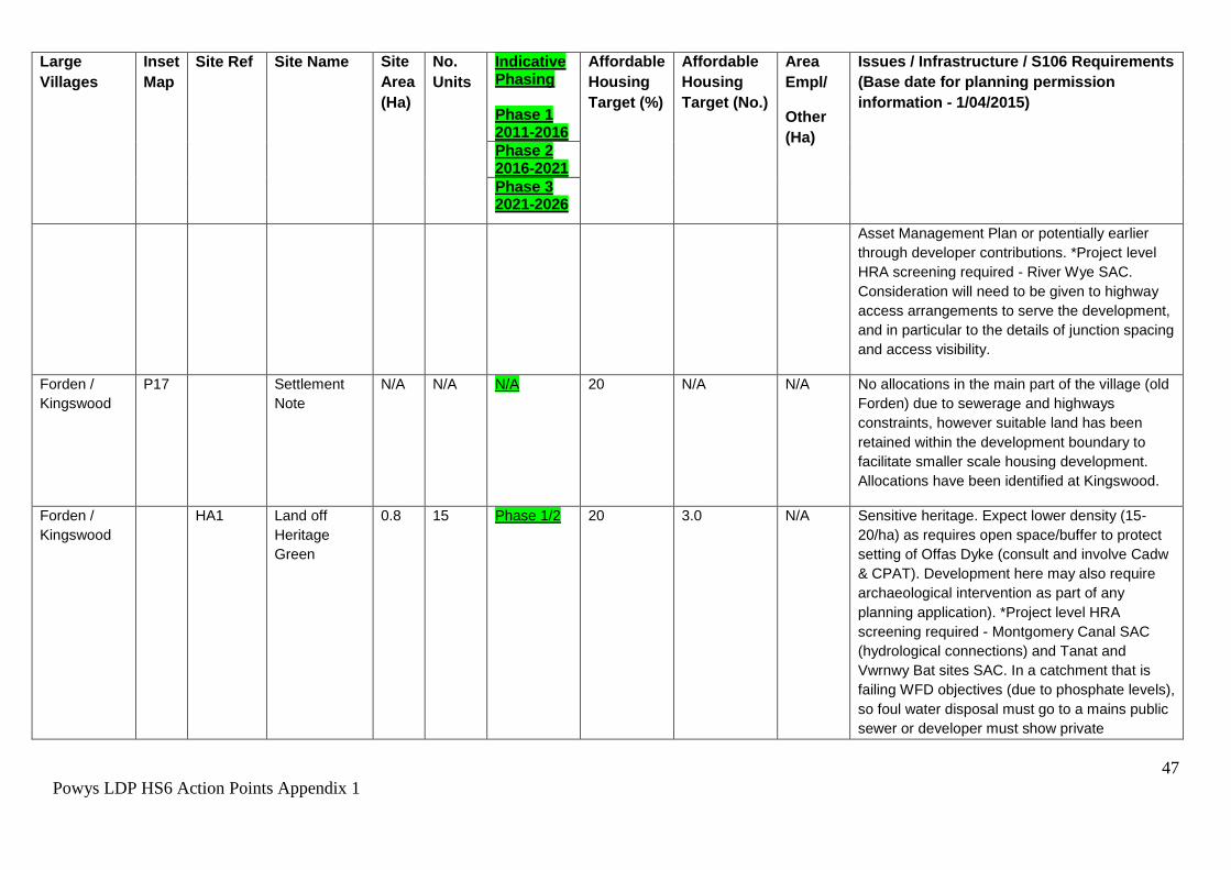
47
Powys LDP HS6 Action Points Appendix 1
Large
Villages
Inset
Map
Site Ref Site Name Site
Area
(Ha)
No.
Units
Indicative Phasing Phase 1 2011-2016
Affordable
Housing
Target (%)
Affordable
Housing
Target (No.)
Area
Empl/
Other
(Ha)
Issues / Infrastructure / S106 Requirements
(Base date for planning permission
information - 1/04/2015)
Phase 2 2016-2021
Phase 3 2021-2026
Asset Management Plan or potentially earlier
through developer contributions. *Project level
HRA screening required - River Wye SAC.
Consideration will need to be given to highway
access arrangements to serve the development,
and in particular to the details of junction spacing
and access visibility.
Forden /
Kingswood
P17 Settlement
Note
N/A N/A N/A 20 N/A N/A No allocations in the main part of the village (old
Forden) due to sewerage and highways
constraints, however suitable land has been
retained within the development boundary to
facilitate smaller scale housing development.
Allocations have been identified at Kingswood.
Forden /
Kingswood
HA1 Land off
Heritage
Green
0.8 15 Phase 1/2 20 3.0 N/A Sensitive heritage. Expect lower density (15-
20/ha) as requires open space/buffer to protect
setting of Offas Dyke (consult and involve Cadw
& CPAT). Development here may also require
archaeological intervention as part of any
planning application). *Project level HRA
screening required - Montgomery Canal SAC
(hydrological connections) and Tanat and
Vwrnwy Bat sites SAC. In a catchment that is
failing WFD objectives (due to phosphate levels),
so foul water disposal must go to a mains public
sewer or developer must show private

48
Powys LDP HS6 Action Points Appendix 1
Large
Villages
Inset
Map
Site Ref Site Name Site
Area
(Ha)
No.
Units
Indicative Phasing Phase 1 2011-2016
Affordable
Housing
Target (%)
Affordable
Housing
Target (No.)
Area
Empl/
Other
(Ha)
Issues / Infrastructure / S106 Requirements
(Base date for planning permission
information - 1/04/2015)
Phase 2 2016-2021
Phase 3 2021-2026
connection is not adding to phosphate levels in
the catchment.
Forden /
Kingswood
HA2 Land
between
Heatherwood
& Kingswood
Lane
0.5 10 Phase 3 20 2.0 N/A Up to 10 dwellings reliant on addressing
highways concerns - access is permitted off the
adjacent housing estate (Heatherwood) or
significant highway improvements are
undertaken on the U2487. Sensitive heritage -
Requires buffer to protect setting of Offas Dyke
(consult and involve Cadw & CPAT,
development here may also require
archaeological intervention as part of any
planning application). *Project level HRA
screening required - Montgomery Canal SAC
(hydrological connections) and Tanat and
Vwrnwy Bat sites SAC. In a catchment that is
failing WFD objectives (due to phosphate levels).
Therefore foul water disposal must go to a mains
public sewer or developer must show private
connection is not adding to phosphate levels in
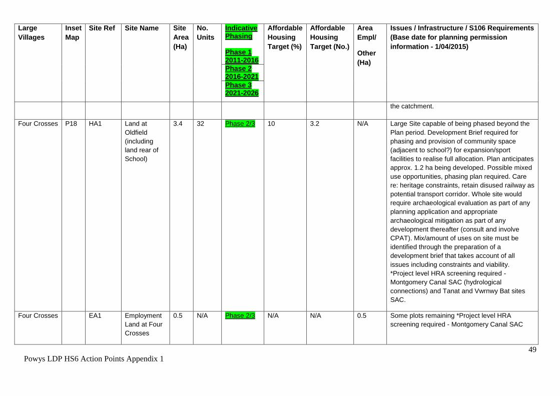
49
Powys LDP HS6 Action Points Appendix 1
Large
Villages
Inset
Map
Site Ref Site Name Site
Area
(Ha)
No.
Units
Indicative Phasing Phase 1 2011-2016
Affordable
Housing
Target (%)
Affordable
Housing
Target (No.)
Area
Empl/
Other
(Ha)
Issues / Infrastructure / S106 Requirements
(Base date for planning permission
information - 1/04/2015)
Phase 2 2016-2021
Phase 3 2021-2026
the catchment.
Four Crosses P18 HA1 Land at
Oldfield
(including
land rear of
School)
3.4 32 Phase 2/3 10 3.2 N/A Large Site capable of being phased beyond the
Plan period. Development Brief required for
phasing and provision of community space
(adjacent to school?) for expansion/sport
facilities to realise full allocation. Plan anticipates
approx. 1.2 ha being developed. Possible mixed
use opportunities, phasing plan required. Care
re: heritage constraints, retain disused railway as
potential transport corridor. Whole site would
require archaeological evaluation as part of any
planning application and appropriate
archaeological mitigation as part of any
development thereafter (consult and involve
CPAT). Mix/amount of uses on site must be
identified through the preparation of a
development brief that takes account of all
issues including constraints and viability.
*Project level HRA screening required -
Montgomery Canal SAC (hydrological
connections) and Tanat and Vwrnwy Bat sites
SAC.
Four Crosses EA1 Employment
Land at Four
Crosses
0.5
N/A Phase 2/3 N/A N/A 0.5
Some plots remaining *Project level HRA
screening required - Montgomery Canal SAC
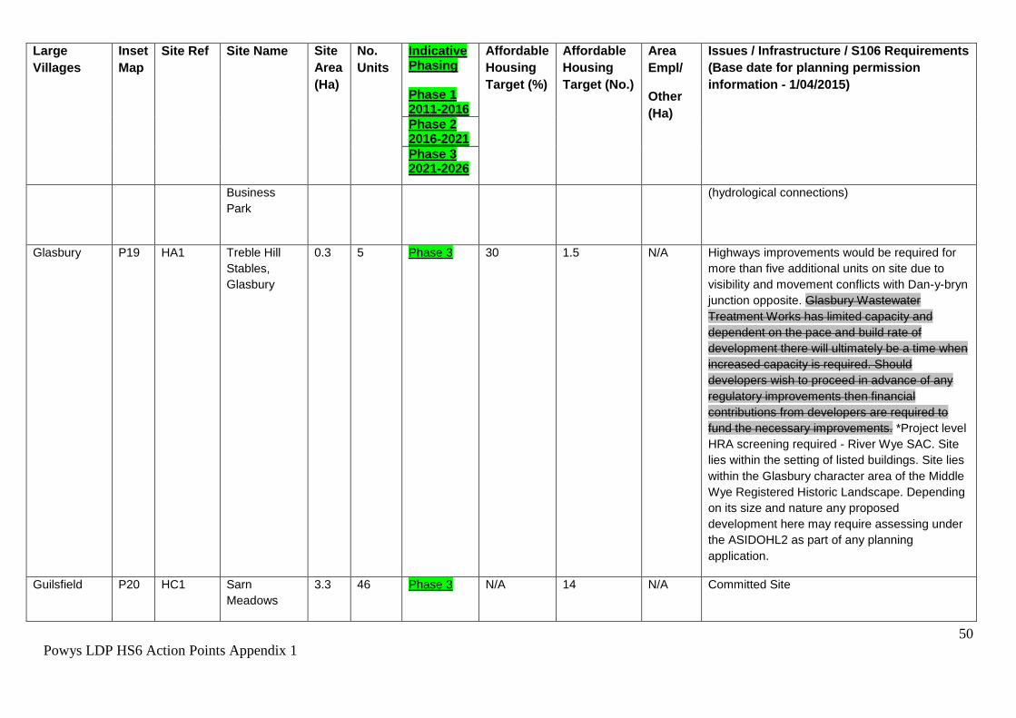
50
Powys LDP HS6 Action Points Appendix 1
Large
Villages
Inset
Map
Site Ref Site Name Site
Area
(Ha)
No.
Units
Indicative Phasing Phase 1 2011-2016
Affordable
Housing
Target (%)
Affordable
Housing
Target (No.)
Area
Empl/
Other
(Ha)
Issues / Infrastructure / S106 Requirements
(Base date for planning permission
information - 1/04/2015)
Phase 2 2016-2021
Phase 3 2021-2026
Business
Park
(hydrological connections)
Glasbury P19 HA1 Treble Hill
Stables,
Glasbury
0.3 5 Phase 3 30 1.5 N/A Highways improvements would be required for
more than five additional units on site due to
visibility and movement conflicts with Dan-y-bryn
junction opposite. Glasbury Wastewater
Treatment Works has limited capacity and
dependent on the pace and build rate of
development there will ultimately be a time when
increased capacity is required. Should
developers wish to proceed in advance of any
regulatory improvements then financial
contributions from developers are required to
fund the necessary improvements. *Project level
HRA screening required - River Wye SAC. Site
lies within the setting of listed buildings. Site lies
within the Glasbury character area of the Middle
Wye Registered Historic Landscape. Depending
on its size and nature any proposed
development here may require assessing under
the ASIDOHL2 as part of any planning
application.
Guilsfield P20 HC1 Sarn
Meadows
3.3 46 Phase 3 N/A 14 N/A Committed Site

51
Powys LDP HS6 Action Points Appendix 1
Large
Villages
Inset
Map
Site Ref Site Name Site
Area
(Ha)
No.
Units
Indicative Phasing Phase 1 2011-2016
Affordable
Housing
Target (%)
Affordable
Housing
Target (No.)
Area
Empl/
Other
(Ha)
Issues / Infrastructure / S106 Requirements
(Base date for planning permission
information - 1/04/2015)
Phase 2 2016-2021
Phase 3 2021-2026
Guilsfield HA1 Land adj
Celyn Lane
0.9 20 Phase 2/3 20 4.0 N/A Highways Improvement/local link road required,
closure of existing junction. The north western
boundary of this site abuts zone C2 of the
TAN15 Development Advice Map; as a
precaution a Flood Consequence Assessment
should be undertaken. Development must avoid
flood risk areas. Sensitive ecological issues -
liaison with NRW required at pre-application
stage - European Protected Species Licence
likely to be required.
*Project level HRA screening will be required
with regards to Granllyn SAC. Given the
proximity of Granllyn SAC there is a high
likelihood that great crested newts may be
present or utilise the site for distribution to
surrounding environment- development
proposals will require appropriate surveys and
detailed mitigation plans to ensure that the
development does not result in barriers to
migration, fragmentation of habitats (including
breeding and terrestrial habitat outside of the
Granllyn SAC), disturbance, increased
recreational pressures, incidental capture and
killing which could affect the ecological
functionality of the SAC. Given the complexity
and level of detail required regarding mitigation

52
Powys LDP HS6 Action Points Appendix 1
Large
Villages
Inset
Map
Site Ref Site Name Site
Area
(Ha)
No.
Units
Indicative Phasing Phase 1 2011-2016
Affordable
Housing
Target (%)
Affordable
Housing
Target (No.)
Area
Empl/
Other
(Ha)
Issues / Infrastructure / S106 Requirements
(Base date for planning permission
information - 1/04/2015)
Phase 2 2016-2021
Phase 3 2021-2026
to ensure no likely significant impact to the
Granllyn SAC it is considered that a S106 will be
required. Lower density reflects the requirement
for potential mitigation measures/buffers for
protected species and land required for link
road.
Additional HRA Screening may also be required
in relation to Montgomery Canal SAC
(hydrological connections) and Tanat and
Vyrnwy Bat sites SAC.
Guilsfield HA2 Land to East
of Groes-
lwyd,
Guilsfield
0.8 22 Phase 1/2 20 4.4 N/A The flood zone has been excluded from the
allocation, however the northern boundary of this
site abuts zone C2 of the TAN15 Development
Advice Map; as a precaution a Flood
Consequence Assessment should be
undertaken. Part of field nearest existing built
form is allocated so that a green buffer is
retained to nearby Groes-llwyd. Access point to
be determined with highways including
relocation of existing 30mph speed limit,
footways to link up with the existing
infrastructure.*Project level HRA screening
required - Granllyn SAC & Montgomery Canal
SAC (hydrological connections) and Tanat and
Vyrnwy Bat sites SAC.
53
Powys LDP HS6 Action Points Appendix 1
Large
Villages
Inset
Map
Site Ref Site Name Site
Area
(Ha)
No.
Units
Indicative Phasing Phase 1 2011-2016
Affordable
Housing
Target (%)
Affordable
Housing
Target (No.)
Area
Empl/
Other
(Ha)
Issues / Infrastructure / S106 Requirements
(Base date for planning permission
information - 1/04/2015)
Phase 2 2016-2021
Phase 3 2021-2026
Howey P22 HA1 Land at
Crossways
Court.
1.4 38 Phase 2/3 30 11.4 N/A Ecology Survey to inform enhancement, include
a 10m buffer along the boundary with the
railway. Requires significant works to the trunk
road junction with class III road. Nearby Tree
Preservation Order. Potential developers need to
be aware that the site is crossed by a water main
and protection measures in the form of
easement widths or a diversion of the pipe would
be required, which may impact upon the density
achievable on site.*Project level HRA screening
required - River Wye SAC.
Howey HA2 Land
adjacent
Goylands
Estate
0.8 12 Phase 3 30 3.6 N/A Previous permissions in relation to residential
development have lapsed. Potential developers
need to be aware that the site is crossed by a
sewer and protection measures in the form of
easement widths or a diversion of the pipe would
be required, which may impact upon the density
achievable on site.*Project level HRA screening
required - River Wye SAC.
Kerry P23 HC1 Dolforgan
View, Kerry
2.1 62 Phase 2 N/A 0.0 N/A Full planning permission (P/2009/0106). If the
current permission is not implemented affordable
housing contribution will be sought on future
proposals for this site. Site contains two historic
assets, any proposed development here may
require archaeological intervention as part of any

54
Powys LDP HS6 Action Points Appendix 1
Large
Villages
Inset
Map
Site Ref Site Name Site
Area
(Ha)
No.
Units
Indicative Phasing Phase 1 2011-2016
Affordable
Housing
Target (%)
Affordable
Housing
Target (No.)
Area
Empl/
Other
(Ha)
Issues / Infrastructure / S106 Requirements
(Base date for planning permission
information - 1/04/2015)
Phase 2 2016-2021
Phase 3 2021-2026
planning application. *Project level HRA
screening required - Montgomery Canal SAC
(hydrological connections).
Knucklas P25 HC1 Old Station
Works
0.28 6 Phase 2 20 2 N/A Commitment (RAD/2005/0555)
Knucklas P25 HA1 Land at
Castle Green
0.4 17 Phase 1/2 10 1.7 N/A PR143106, (P/2012/0272 - Site awaiting signing
of S106)
Llanbrynmair P26 HC1 Bryncoch 1 5 Phase 2 N/A 2.0 N/A Partially Committed. Ref: P/2014/1060
Llanbrynmair HA1 Land west of
Bryncoch
0.7 19 Phase 3 10 1.9 N/A Ecological Survey will be required to inform
enhancements. Road access via committed site
to the north. Transport assessment may be
required to ascertain impacts on Trunk Road.
Off-site highway infrastructure improvements
required.
Llandinam P27 HA1 Land
opposite Old
Barn Close,
Llandinam
0.3 8 Phase 3 10 0.8 N/A Highways improvements, ecology.
55
Powys LDP HS6 Action Points Appendix 1
Large
Villages
Inset
Map
Site Ref Site Name Site
Area
(Ha)
No.
Units
Indicative Phasing Phase 1 2011-2016
Affordable
Housing
Target (%)
Affordable
Housing
Target (No.)
Area
Empl/
Other
(Ha)
Issues / Infrastructure / S106 Requirements
(Base date for planning permission
information - 1/04/2015)
Phase 2 2016-2021
Phase 3 2021-2026
Llandrinio P29 HA1 Gwernybatto
Land off
Orchard Croft
1.1 30 Phase 2 20 6.0 N/A *Project level HRA screening required -
Montgomery Canal SAC (hydrological
connections) and Tanat and Vwrnwy Bat sites
SAC.
Llanfechain P31 HA1 Land north of
Church,
Llanfechain
1 25 Phase 3 10 2.5 N/A Flood zone excluded, however the south
western boundary of this site abuts zone C2 of
the TAN15 Development Advice Map; as a
precaution a Flood Consequence Assessment
should be undertaken. *Project level HRA
screening required - Tanat and Vwrnwy Bat sites
SAC. Site lies within the historic settlement core
of Llanfechain, any proposed development here
may require archaeological intervention as part
of any planning application. Highways access
will need to be obtained via the adjacent housing
estate Phasell Maes Dinas (U4978). The existing
unadopted highway would need to be upgraded
and offered for adoption in order to serve the
allocation. Possibility of groundwater flooding /
high water table - careful design in respect to
surface water disposal is needed, i.e. soakaways
may not be effective if there is a high water
table. Further investigation and monitoring of
groundwater levels over a period of time is
needed as part of any revised FCA submission.
56
Powys LDP HS6 Action Points Appendix 1
Large
Villages
Inset
Map
Site Ref Site Name Site
Area
(Ha)
No.
Units
Indicative Phasing Phase 1 2011-2016
Affordable
Housing
Target (%)
Affordable
Housing
Target (No.)
Area
Empl/
Other
(Ha)
Issues / Infrastructure / S106 Requirements
(Base date for planning permission
information - 1/04/2015)
Phase 2 2016-2021
Phase 3 2021-2026
Development Brief will be required for this site.
Llangurig P33 HA1 Land adj.
Maesllan,
Llangurig
0.7 19 Phase 3 10 1.9 N/A Highways improvements, Ecology, Heritage,
Drainage. Llangurig Wastewater Treatment
Works has limited capacity and dependant on
the pace and build rate of development there will
ultimately be a time when increased capacity is
required. Should developers wish to proceed in
advance of any regulatory improvements then
financial contributions from developers are
required to fund the necessary improvements.
*Project level HRA screening required - River
Wye SAC.
Llangynog P34 HA1 Llangynog
Glebe
0.3 8 Phase 3 10 0.8 N/A Needs to be accessed from the road to the south
east, outside of the development boundary. The
access point falls within TAN 15, C2 flood zone,
a Flood Consequence Assessment will be
required at the planning application stage.
*Project level HRA screening required - Tanat
and Vwrnwy Bat sites SAC, the Berwyn and

57
Powys LDP HS6 Action Points Appendix 1
Large
Villages
Inset
Map
Site Ref Site Name Site
Area
(Ha)
No.
Units
Indicative Phasing Phase 1 2011-2016
Affordable
Housing
Target (%)
Affordable
Housing
Target (No.)
Area
Empl/
Other
(Ha)
Issues / Infrastructure / S106 Requirements
(Base date for planning permission
information - 1/04/2015)
Phase 2 2016-2021
Phase 3 2021-2026
South Clwyd Mountains SAC and Berwyn SPA.
Site impinges on the historic settlement core of
Llangynog, any proposed development here may
require archaeological intervention as part of any
planning application. The site also lies within the
Llangynog character area of the Tanat Valley
Registered Historic Landscape. Depending on
its size and nature any proposed development
here may require assessing under the
ASIDOHL2 as part of any planning application.
Llanrhaeadr-
ym-
Mochnant
P36 HA1 Land at Maes
yr Esgob,
Llanrhaeder
ym Mochnant
0.7 19 Phase 2/3 10 1.9 N/A *Project level HRA screening required - Tanat
and Vwrnwy Bat sites SAC. Site lies within the
Llanrhaeadr-ym-Mochnant character area of the
Tanat Valley Registered Historic Landscape.
Depending on its size and nature any proposed
development here may require assessing under
the ASIDOHL2 as part of any planning
application.
Llansantffraid
-ym-Mechain
P37 HC1 Land off
Fford
Spoonley,
Llansantffraid
0.4 12 Phase 1/2 N/A 3.0 N/A Commitment.
Llansantffraid
-ym-Mechain
HC2 Bronhyddon 0.42 5 Phase 2 N/A 0 N/A Committed Site

58
Powys LDP HS6 Action Points Appendix 1
Large
Villages
Inset
Map
Site Ref Site Name Site
Area
(Ha)
No.
Units
Indicative Phasing Phase 1 2011-2016
Affordable
Housing
Target (%)
Affordable
Housing
Target (No.)
Area
Empl/
Other
(Ha)
Issues / Infrastructure / S106 Requirements
(Base date for planning permission
information - 1/04/2015)
Phase 2 2016-2021
Phase 3 2021-2026
Llansantffraid
-ym-Mechain
HA1 Land at
Spoonley
Farm,
Llansantffraid
0.8 22 Phase 2/3 10 2.2 N/A *Project level HRA screening required -
Montgomery Canal SAC (hydrological
connections). Tanat and Vwrnwy Bat sites SAC..
Llansantffraid
-ym-Mechain
HA2 Land adj.
Maes y cain,
Llansantffraid
-ym-Mechain
0.6 13 Phase 2/3 10 1.3 N/A *Project level HRA screening required -
Montgomery Canal SAC (hydrological
connections) and Tanat and Vwrnwy Bat sites
SAC.
Llansilin P38 HC1 Land
Opposite the
Wynnstay
Inn, Llansilin
0.7 23 Phase 2 N/A 8.0 N/A Commitment. Ref: P/2012/1144 - Section 73 on
Outline. *Project level HRA screening required -
Tanat and Vwrnwy Bat sites SAC.
Llanymynech P40 HC1 UDP
allocation
M170 HA1
(Parc
Llwyfen)
PT OS 3978,
Off Ashfield
Terrace
0.4 13 Phase 1 N/A 0.0 N/A Commitment, site partially complete. *Project
level HRA screening required - Montgomery
Canal SAC (hydrological connections) and Tanat
and Vyrnwy Bat sites SAC.
Llanymynech HA1 Land adj Parc
Llwyfen
0.4 11 Phase 2 10 1.1 N/A *Project level HRA screening required -
Montgomery Canal SAC (hydrological
connections) and Tanat and Vyrnwy Bat sites

59
Powys LDP HS6 Action Points Appendix 1
Large
Villages
Inset
Map
Site Ref Site Name Site
Area
(Ha)
No.
Units
Indicative Phasing Phase 1 2011-2016
Affordable
Housing
Target (%)
Affordable
Housing
Target (No.)
Area
Empl/
Other
(Ha)
Issues / Infrastructure / S106 Requirements
(Base date for planning permission
information - 1/04/2015)
Phase 2 2016-2021
Phase 3 2021-2026
SAC.
Llanymynech HA2 Land off
Carreghofa
Lane
1.6 20 Phase 2 10 2 N/A Large Site capable of being phased beyond the
Plan period. Development Brief required for
phasing and potential restoration of Montgomery
Canal to realise full allocation. Plan anticipates
approx. 0.75 ha being developed. Investigation
required to satisfy highways requirements
(upgrading required in terms of width and
footway provisions) and also investigate capacity
of sewerage infrastructure as site will need
connection to mains drainage. Ensure any new
works/infrastructure etc. does not compromise
proposals for restoration of canal. The site
contains significant archaeological remains and
will require archaeological assessment,
evaluation and probably full archaeological
excavation as part of any development (consult
and involve CPAT). *Project level HRA
screening required - Montgomery Canal SAC
(hydrological connections) and Tanat and
Vyrnwy Bat sites SAC.

60
Powys LDP HS6 Action Points Appendix 1
Large
Villages
Inset
Map
Site Ref Site Name Site
Area
(Ha)
No.
Units
Indicative Phasing Phase 1 2011-2016
Affordable
Housing
Target (%)
Affordable
Housing
Target (No.)
Area
Empl/
Other
(Ha)
Issues / Infrastructure / S106 Requirements
(Base date for planning permission
information - 1/04/2015)
Phase 2 2016-2021
Phase 3 2021-2026
Llanyre P41 HC1 Land
between
Moorlands
and Llyr
0.6 12 Phase 2 N/A 6.0 N/A Commitment. Outline planning permission.
P/2013/0887.
Llanyre P41 HA1 Land at
Llanyre Farm
0.7 19 Phase 3 30 5.7 N/A Requires third party land for access (PCC
owned).There are isolated incidents of flooding
in the public sewerage system that will need to
be resolved to allow development to proceed.
Potential developers can either wait for DCWW
to resolve the flooding, subject to funding being
approved by Ofwat, or progress the
improvements through the sewerage requisition
provisions of the Water Industry Act 1991 or
s106 of the Town and Country Planning Act
1990. The proposed growth being promoted for
this settlement would require improvements at
Llanyre Wastewater Treatment Works which
would need to be funded through DCWW's
Asset Management Plan or potentially earlier
through developer contributions. Offsite works
required to connect with the water main and
public sewers. A hydraulic modelling
assessment (HMA) may be required to
determine the point of connection and/or any
network improvements to the public sewerage
system and potential developers would be
61
Powys LDP HS6 Action Points Appendix 1
Large
Villages
Inset
Map
Site Ref Site Name Site
Area
(Ha)
No.
Units
Indicative Phasing Phase 1 2011-2016
Affordable
Housing
Target (%)
Affordable
Housing
Target (No.)
Area
Empl/
Other
(Ha)
Issues / Infrastructure / S106 Requirements
(Base date for planning permission
information - 1/04/2015)
Phase 2 2016-2021
Phase 3 2021-2026
expected to fund investigations during pre-
planning stages. Llanyre Village Tree
Preservation Order and village green nearby.
Ecological Survey required to inform
enhancement. *Project level HRA screening
required - River Wye SAC. Site impinges on the
historic settlement core of Llanyre any proposed
development here may require archaeological
intervention as part of any planning application.
Meifod P43 HA1 Pentre works
and adjacent
land, Meifod
1.9 45 Phase 3 10 4.5 N/A Majority of site falls into DAM C1. Site benefits
from NRW maintained defences at present. FCA
prepared and reviewed by NRW (reference
SE/2014/117751/01). FCA has demonstrated
that consequences of flooding can be managed
acceptably in line with national guidance (TAN
15). Further FCA will be required at planning
application stage to inform design and layout of
site required. Highways improvements needed
include a pedestrian link to rest of settlement.
Close working with CADW and CPAT will be
required to ensure the protection of the SAM,
development here may also require
archaeological intervention as part of any
planning application. *Project level HRA
screening required - Tanat and Vwrnwy Bat sites

62
Powys LDP HS6 Action Points Appendix 1
Large
Villages
Inset
Map
Site Ref Site Name Site
Area
(Ha)
No.
Units
Indicative Phasing Phase 1 2011-2016
Affordable
Housing
Target (%)
Affordable
Housing
Target (No.)
Area
Empl/
Other
(Ha)
Issues / Infrastructure / S106 Requirements
(Base date for planning permission
information - 1/04/2015)
Phase 2 2016-2021
Phase 3 2021-2026
SAC. Contaminated land survey will be required.
Middletown P44 HA1 Land west of
Golfa Close
0.7 19 Phase 3 20 3.8 N/A Highways stipulation that access should be
taken off Golfa Close. *Project level HRA
screening required - Montgomery Canal SAC
(hydrological connections) and Tanat and
Vwrnwy Bat sites SAC.
New Radnor P46 HC1 Water Street
Farm
0.6 14 Phase 2 N/A 5.0 N/A Commitment. (P/2008/1685).The site contains a
historic asset and lies within the historic
settlement core of New Radnor any proposed
development here may require archaeological
intervention as part of any planning application.
Newbridge
on Wye
P47 HC1 The Orchard 0.3 5 Phase 2 100 5.0 N/A Commitment. 100% Affordable. (Outline
Planning Permission P2008/1151). *Project level
HRA screening required - River Wye SAC.
Penybontfaw
r
P49 HA1 Land east of
Ysgol
Pennant,
Penybontfawr
0.4 11 Phase 2/3 10 1.1 N/A Highways Alterations. *Project level HRA
screening required -Tanat and Vyrnwy Bat sites
SAC, the Berwyn and South Clwyd Mountains
SAC and the Berwyn SPA.
Pontrobert P50 HA1 Land at Y
Fferm,
Pontrobert,
Meifod,
0.5 6 Phase 2 10 0.6 N/A Highways improvements required as per the
lapsed planning permission M/2007/0324.
*Project level HRA screening required - Tanat
and Vwrnwy Bat sites SAC.
63
Powys LDP HS6 Action Points Appendix 1
Large
Villages
Inset
Map
Site Ref Site Name Site
Area
(Ha)
No.
Units
Indicative Phasing Phase 1 2011-2016
Affordable
Housing
Target (%)
Affordable
Housing
Target (No.)
Area
Empl/
Other
(Ha)
Issues / Infrastructure / S106 Requirements
(Base date for planning permission
information - 1/04/2015)
Phase 2 2016-2021
Phase 3 2021-2026
Powys
Three Cocks P53 MUA1 Land
between/adj
Gwernyfed
Avenue,
Three Cocks
4 32 Phase 2
(Housing)
Phase1/2
(Employme
nt)
30 9.6 3.4 Mixed use. Part of site has existing employment
use by agricultural contractor / machinery sales
business. Part of site has permission for factory
& office accommodation. (B/05/0038, B/07/0155,
B/07/0296, P/2012/1185). Development Brief
required to reflect predominant employment
usage of site. Ecology Survey and Drainage
Assessment required. The northern boundary of
this site abuts zone C2 of the TAN15
Development Advice Map; as a precaution it is
recommended that this area is left as a green
buffer zone. Foul flows from this development
would pass through the Welsh Water terminal
Sewerage Pumping Station and would require
an assessment of the sewerage pumping station
to establish whether improvements are required.
If improvements are required the sewer
requisition provisions of the Water Industry Act
1991 can apply. The proposed growth being
promoted for this settlement would require
improvements at Aberllyfni Wastewater
Treatment Works which would need to be
64
Powys LDP HS6 Action Points Appendix 1
Large
Villages
Inset
Map
Site Ref Site Name Site
Area
(Ha)
No.
Units
Indicative Phasing Phase 1 2011-2016
Affordable
Housing
Target (%)
Affordable
Housing
Target (No.)
Area
Empl/
Other
(Ha)
Issues / Infrastructure / S106 Requirements
(Base date for planning permission
information - 1/04/2015)
Phase 2 2016-2021
Phase 3 2021-2026
funded through DCWW's asset management
plan or potentially earlier through developer
contributions. HER site*Project level HRA
screening required - River Wye SAC. Site
contains a historic asset. Any proposed
development here may require archaeological
intervention as part of any planning application.
Site lies within the Gwernyfed character area of
the Middle Wye Registered Historic Landscape.
Depending on its size and nature any proposed
development here may require assessing under
the ASIDOHL2 as part of any planning
application.
Trefeglwys P54 HC1 Land to West
of Llwyncelyn
(Phase 2)
0.9 17 Phase 2 N/A 8.0 N/A Commitment. Ref.: M/2007/0561
Tregynon P55 HA1 Rear of
Bethany
Chapel
0.9 24 Phase 2/3 20 4.8 N/A An ecological survey will be required to inform
mitigation and enhancements. Appropriate
arrangements for highway access and chapel
parking will need to form part of any
development proposals for this site.
65
Powys LDP HS6 Action Points Appendix 1
Large
Villages
Inset
Map
Site Ref Site Name Site
Area
(Ha)
No.
Units
Indicative Phasing Phase 1 2011-2016
Affordable
Housing
Target (%)
Affordable
Housing
Target (No.)
Area
Empl/
Other
(Ha)
Issues / Infrastructure / S106 Requirements
(Base date for planning permission
information - 1/04/2015)
Phase 2 2016-2021
Phase 3 2021-2026
Trewern P56 HA1 Land east of
Trewern
School
4.1 27 Phase 2 20 5.4 N/A Large Site capable of being phased beyond the
Plan period. Development Brief required for
phasing and working with school/landowner(s) to
create acceptable joint access and improved
parking arrangements (PCC own the third party
land) to realise full allocation. Plan anticipates
approx. 1.0 ha being developed. Highways
improvement required. Development must avoid
flood risk areas. The northern boundary of this
site abuts zone C2 of the TAN15 Development
Advice Map; as a precaution a Flood
Consequence Assessment should be
undertaken. Investigate suitable
community/ecological uses for flood plain area
adj. to site. Sewerage infrastructure will need
investigation. Protect/enhance ecology including
existing mature trees and watercourses.
Development proposals should be identified
through the preparation of a development brief
that takes account of all issues including
constraints and viability. *Project level HRA
screening required - Montgomery Canal SAC
(hydrological connections) and Tanat and
Vwrnwy Bat sites SAC.

66
Powys LDP HS6 Action Points Appendix 1
Large
Villages
Inset
Map
Site Ref Site Name Site
Area
(Ha)
No.
Units
Indicative Phasing Phase 1 2011-2016
Affordable
Housing
Target (%)
Affordable
Housing
Target (No.)
Area
Empl/
Other
(Ha)
Issues / Infrastructure / S106 Requirements
(Base date for planning permission
information - 1/04/2015)
Phase 2 2016-2021
Phase 3 2021-2026
Employment
Sites outside
settlements
P59 EA1 Buttington
Quarry and
Brickworks,
Nr Welshpool
6 N/A Phase 2/3 N/A N/A 6 Brownfield site, partly in employment use,
allocated for further expansion for General
Industrial Uses. Expansion dependant on new
access (extant p.p.). Heritage/Ecology Value.
The site is adjacent to a geological SSSI, the
design of development must be sympathetic to
the SSSI so that the protected area is not
significantly affected. Development proposals
should be identified through the preparation of a
development brief that takes account of all
issues including constraints. *Project level HRA
screening required - Montgomery Canal SAC
(hydrological connections). Buttington
Brickworks SSSI. The site contains significant
industrial remains as regards the sites of railway
related features and development here may
require prior archaeological intervention and
possibly post consent works (consult and involve
CPAT).
P60 EC1 Land at
Offa’s Dyke
Business
Park,
Welshpool
7.3 N/A Phase
1/2/3
N/A N/A 7.3 Commitment. Employment Land. *Project level
HRA screening required - Montgomery Canal
SAC (hydrological connections)

67
Powys LDP HS6 Action Points Appendix 1
Notes:
* In line with the Habitats Regulations it will be necessary for project level assessments to be undertaken where there is a potential for significant effects from development on
European Sites. Any development project that could have an adverse effect on integrity of a European site will not be in accordance with the development plan, within the
meaning of S.38 (6) of the Planning and Compulsory Purchase Act 2004. Where sites are shown as committed (have planning permission), screening of any fresh
applications will be necessary.
It is likely that many of the allocations in this list have the potential to support protected species and/or other features of biodiversity interest. The table identifies the sites
where ecological surveys are known to be required. However, as there will be no previous records available for some sites and therefore uncertainty regarding the presence
of protected species and features of biodiversity interest at many of the sites where no ecological survey is currently identified, the applicant is advised to consider whether an
ecological survey is required when preparing a scheme to be submitted for planning permission, and to ensure that all the necessary information is submitted in support of an
application to enable its likely impacts to be assessed.
All Flood Consequence Assessments (FCAs) prepared before 1st December 2016 will need to be revisited at the planning application stage to take into account the latest
climate change allowances as detailed in policy clarification letter and associated guidance note – ‘CL-03-16 - Climate change allowances for Planning purposes’.
Other Outstanding Housing Commitments elsewhere in the Plan Area (as at 01/04/2015) *
Location Additional Inset
(AI) Maps
Site
Ref.
Site Name Site
Area
(Ha)
No.
Units
Indicative Phasing Phase 1 2011-2016
Affordable
Housing
Target (%)
Affordable
Housing
Target (No.)
Area Empl/
Other (Ha)
Phase 2 2016-2021
Phase 3 2021-2026
Adfa Additional Inset 01 HLB1 The Former Timber Yard 0.24 8 Phase 2 N/A 3 N/A
Cemmaes Additional Inset 02 HLB1 Land Opposite Glanafon 0.44 5 Phase 2/3 N/A 0 N/A
Cemmaes HLB2 Adjoining Maesyllan 0.22 6 Phase 3 N/A 6 N/A
Coedway Additional Inset 03 HLB1 PT OS 0078 0.39 5 Phase 2 N/A 2 N/A
Commins Coch Additional Inset 04 HLB1 Dyfi 4x4 0.32 5 Phase 2 N/A 2 N/A
68
Powys LDP HS6 Action Points Appendix 1
Garth Additional Inset 05 HLB1 Station Road 0.26 8 Phase 2 N/A 0 N/A
Gwystre Additional Inset 06 HLB1 Adjoining Camlo Close 0.24 5 Phase 3 N/A 2 N/A
Llanbister Additional Inset 07 HLB1 Land Rear of School 0.29 5 Phase 2 N/A 1 N/A
Llanddew Additional Inset 08 HLB1 Opposite Village Hall 0.57 10 Phase 2 N/A 3 N/A
Llanddewi Additional Inset 09 HLB1 Land to the Rear of Llanddewi
Hall
0.71 18 Phase 2 N/A 5 N/A
Llanfihangel
Talyllyn
Additional Inset 10 HLB1 Pistyll Farm 0.55 10 Phase 1/2 N/A 3 N/A
Llangammarch
Wells
Additional Inset 11 HLB1 Land Opposite Pen Y Bryn 1.51 16 Phase 2 N/A 5 N/A
Penybont Additional Inset 12 HLB1 Cattle Market 0.48 16 Phase 2 N/A 9 N/A
Nantmel Additional Inset 13 HLB1 Brynteg 1.47 8 Phase 3 N/A 3 N/A
* These sites are not in Towns or Large Villages as defined by the LDP Settlement Hierarchy. They are sites which have an extant planning permission at the
base date: 01/04/2015, they have been permitted under Unitary Development Plan Policy and are therefore part of the Housing Land Bank (HLB).
However the sites may be contrary to the LDP’s Policies and Proposals, any renewals or resubmissions of planning applications on these sites will need to
demonstrate compliance with LDP Policy H1.

69
Powys LDP HS6 Action Points Appendix 1
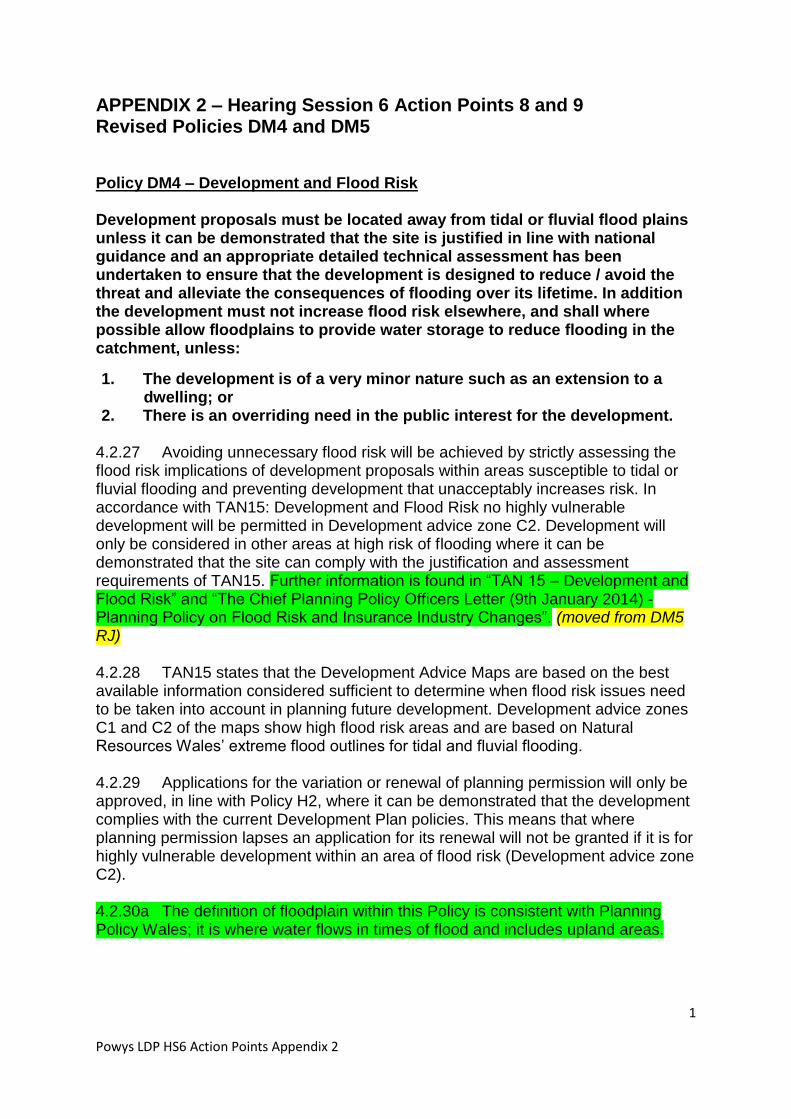
1
Powys LDP HS6 Action Points Appendix 2
APPENDIX 2 – Hearing Session 6 Action Points 8 and 9 Revised Policies DM4 and DM5 Policy DM4 – Development and Flood Risk Development proposals must be located away from tidal or fluvial flood plains unless it can be demonstrated that the site is justified in line with national guidance and an appropriate detailed technical assessment has been undertaken to ensure that the development is designed to reduce / avoid the threat and alleviate the consequences of flooding over its lifetime. In addition the development must not increase flood risk elsewhere, and shall where possible allow floodplains to provide water storage to reduce flooding in the catchment, unless:
1. The development is of a very minor nature such as an extension to a dwelling; or
2. There is an overriding need in the public interest for the development. 4.2.27 Avoiding unnecessary flood risk will be achieved by strictly assessing the flood risk implications of development proposals within areas susceptible to tidal or fluvial flooding and preventing development that unacceptably increases risk. In accordance with TAN15: Development and Flood Risk no highly vulnerable development will be permitted in Development advice zone C2. Development will only be considered in other areas at high risk of flooding where it can be demonstrated that the site can comply with the justification and assessment requirements of TAN15. Further information is found in “TAN 15 – Development and Flood Risk” and “The Chief Planning Policy Officers Letter (9th January 2014) - Planning Policy on Flood Risk and Insurance Industry Changes”. (moved from DM5 RJ) 4.2.28 TAN15 states that the Development Advice Maps are based on the best available information considered sufficient to determine when flood risk issues need to be taken into account in planning future development. Development advice zones C1 and C2 of the maps show high flood risk areas and are based on Natural Resources Wales’ extreme flood outlines for tidal and fluvial flooding. 4.2.29 Applications for the variation or renewal of planning permission will only be approved, in line with Policy H2, where it can be demonstrated that the development complies with the current Development Plan policies. This means that where planning permission lapses an application for its renewal will not be granted if it is for highly vulnerable development within an area of flood risk (Development advice zone C2). 4.2.30a The definition of floodplain within this Policy is consistent with Planning Policy Wales; it is where water flows in times of flood and includes upland areas.
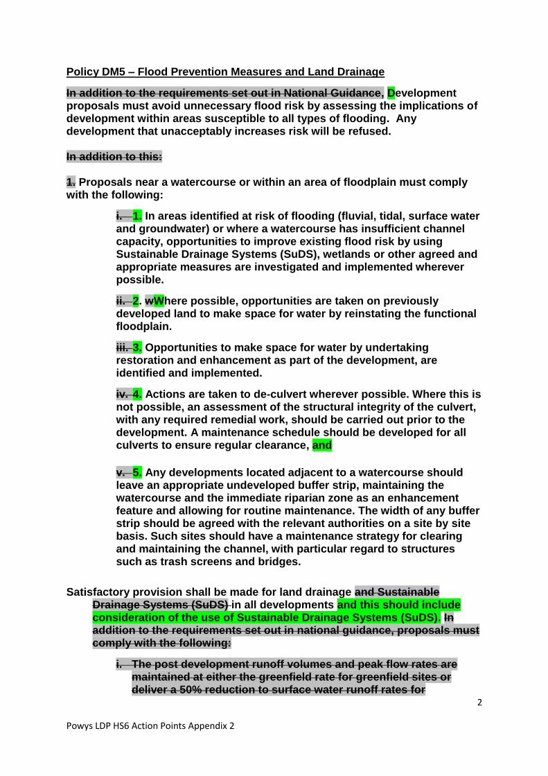
2
Powys LDP HS6 Action Points Appendix 2
Policy DM5 – Flood Prevention Measures and Land Drainage
In addition to the requirements set out in National Guidance, Development proposals must avoid unnecessary flood risk by assessing the implications of development within areas susceptible to all types of flooding. Any development that unacceptably increases risk will be refused. In addition to this: 1. Proposals near a watercourse or within an area of floodplain must comply with the following:
i. 1. In areas identified at risk of flooding (fluvial, tidal, surface water and groundwater) or where a watercourse has insufficient channel capacity, opportunities to improve existing flood risk by using Sustainable Drainage Systems (SuDS), wetlands or other agreed and appropriate measures are investigated and implemented wherever possible.
ii. 2. wWhere possible, opportunities are taken on previously developed land to make space for water by reinstating the functional floodplain.
iii. 3. Opportunities to make space for water by undertaking restoration and enhancement as part of the development, are identified and implemented.
iv. 4. Actions are taken to de-culvert wherever possible. Where this is not possible, an assessment of the structural integrity of the culvert, with any required remedial work, should be carried out prior to the development. A maintenance schedule should be developed for all culverts to ensure regular clearance, and
v. 5. Any developments located adjacent to a watercourse should leave an appropriate undeveloped buffer strip, maintaining the watercourse and the immediate riparian zone as an enhancement feature and allowing for routine maintenance. The width of any buffer strip should be agreed with the relevant authorities on a site by site basis. Such sites should have a maintenance strategy for clearing and maintaining the channel, with particular regard to structures such as trash screens and bridges.
Satisfactory provision shall be made for land drainage and Sustainable Drainage Systems (SuDS) in all developments and this should include consideration of the use of Sustainable Drainage Systems (SuDS). In addition to the requirements set out in national guidance, proposals must comply with the following:
i. The post development runoff volumes and peak flow rates are maintained at either the greenfield rate for greenfield sites or deliver a 50% reduction to surface water runoff rates for

3
Powys LDP HS6 Action Points Appendix 2
brownfield sites (up to and including the 1 in 100 year event inclusive of an appropriate allowance for climate change for both development scenarios).
ii. SuDS are included for all new development; space should be integrated or set aside for SuDS and used to inform the overall site layout.
iii. Hardstanding areas are kept to a minimum and infiltration techniques and the re-use of water are considered before attenuation devices.
iv. SuDS have a maintenance strategy to ensure they are maintained and working efficiently.
If SuDS cannot be implemented, a full written justification should be submitted explaining why this is the case.
4.2.30 TAN15: Development and Flood Risk, advises that no highly vulnerable development will be permitted in development advice zone C2; and that development will only be considered in other areas defined to be at high risk of flooding in the Development Advice Maps where it can be demonstrated that the site can comply with the justification and assessment requirements of TAN15. However as the Lead Local Flood Authority - Powys County Council is responsible for managing local flood risk from other sources of flooding such as ordinary watercourses, surface runoff and groundwater. The Council’s Local Flood Risk Management Strategy contains measures and objectives, “To ensure that planning decisions are properly informed by flooding issues and the impact future development may have on flood risk management and long term developments”. To ensure that the LDP assists the Council in fulfilling this role the Strategic Flood Consequences Assessment (SFCA) advises that “The vulnerability of the development from other sources of flooding should be considered as well as the effect of the new development on surface water runoff.” 4.2.31 The policy seeks to implement and reflect the actions identified in the relevant River Basin Management Plans and Catchment Flood Management Plans together with the recommendations from the LDP’s Strategic Flood Consequences Assessment (Stages 1 and 2). 4.2.31A - It is not the intention for this Policy to be applied to canals. 4.2.32 Proposals near a watercourse or within an area of floodplain need to take due consideration of the implications of new development on water courses and floodplains and aid the reduction or better management of existing flood risk for communities, infrastructure and businesses. Powys is also important as an upstream catchment for several major rivers including the Rivers Wye and Severn for water storage and alleviating flooding downstream. By including within the policy the identification of opportunities to undertake river restoration and enhancement, and to make space for water, as part of the development it is proposed that actions such as the removal of in-stream obstructions and anthropogenic features, removal of non-native species and the erection of fencing to control access to the river bank could

4
Powys LDP HS6 Action Points Appendix 2
potentially be implemented. Further information is found in “TAN 15 – Development and Flood Risk” and “The Chief Planning Policy Officers Letter (9th January 2014) - Planning Policy on Flood Risk and Insurance Industry Changes” (moved to DM4 RJ). 4.2.33 Sustainable Drainage Systems. The use of SuDS to manage surface water flows can be an important tool in minimising flood risk by increasing permeable surfaces in an area which allows water to seep into the ground rather than running off into the drainage system. The Welsh Government has produced “Recommended non-statutory standards for sustainable drainage (SuDS) in Wales – designing, constructing, operating and maintaining surface water drainage systems” (January 2016). It would be of assistance at the development management stage if developers could have regard to these standards in submitting planning applications where relevant. The effective use of permeable surfaces, soakaways and water storage areas should be incorporated in development where technically possible. Schemes for the use of rainwater harvesting (and storage such as cisterns) for non-drinking water purposes and/or grey water recycling for toilets and other relevant purposes will also be supported. SuDs are not only important for the minimisation of flood risk but also have wider benefits for water quality, pollution prevention together with recreational and social benefits. 4.2.33a An SPG will be produced to provide further guidance on the minimum amount of information required to demonstrate that the proposed approach is feasible and or that the detailed design could be covered by way of a planning condition. 4.2.34 The Flood and Water Management Act (2010) requires SuDS to be incorporated into all construction works that have drainage implications. However, this Part (3) of the Act has yet to be implemented in Wales and the SuDS policy above is intended to bridge the gap until the Act does come into force. Appendix 4 of TAN15 provides information and advice about the use and implementation of SUDS as part of a proposed development. SPG will also be produced to provide further guidance of the use and implementation of SUDS. 4.2.35 With regard to hydrology, development must be designed so that the rate of water leaving the site is kept at existing rates and where practicable slowed and is channelled to the most appropriate location. The use of sustainable drainage systems, green roofs, porous surfaces, storage systems and native planting is encouraged where appropriate.

1
Powys LDP HS6 Action Points Appendix 3
APPENDIX 3 - Hearing Session 6 Action Point 11
Proposed Matters Arising Changes to Policy DM1
Policy DM1 – Planning Obligations
Planning obligations will be sought by agreement with applicants, where necessary, to ensure that:
1. The development provides for adequate infrastructure necessary to serve the proposal, and that satisfactory maintenance and / or restoration arrangements are achieved;
2. Significant adverse socio-economic and environmental impacts are addressed and mitigated;
3. Benefits are secured in the public interest to meet the additional demands of development proposals on local communities.
Where on-site provision or mitigation is not appropriate, off-site provision, or a financial contribution towards it, will may be sought. In securing improvements to infrastructure, facilities, services and related works through planning obligations, where they are necessary to make the development acceptable, the Council will pay due regard to the overall development viability, including the cost of measures that are necessary to physically deliver a development and ensure that it is acceptable in planning terms. Such obligations may include:
Essential infrastructure or utilities.
The provision of affordable housing within residential developments.
Community, educational, health, recreation, leisure and open space facilities.
Transport infrastructure including sustainable transport measures and the rights of way network.
Renewable/low carbon energy infrastructure.
Ecological mitigation.
Welsh Language mitigation.
Other facilities and services and/or mitigation measures as considered necessary.
In the event that Should it be demonstrated that for viability reasons considerations indicate that not all of the identified contributions can be reasonably required, priority contributions will be determined on the basis of the individual circumstances of each case.

2
Powys LDP HS6 Action Points Appendix 3
4.2.1 The Council will only look to use planning obligations where planning conditions are considered inappropriate.1 In securing improvements to infrastructure, facilities, services and related works through planning obligations, where they are necessary to make the development acceptable, the Council will pay due regard to the overall development viability, including the cost of measures that are necessary to physically deliver a development and ensure that it is acceptable in planning terms. Such obligations may include: • Essential infrastructure or utilities. • The provision of affordable housing within residential developments. • Community, educational, health, recreation, leisure and open space facilities. • Transport infrastructure including sustainable transport measures and the rights of way network. • Renewable/low carbon energy infrastructure. • Ecological mitigation. • Welsh Language mitigation. • Other facilities and services and/or mitigation measures as considered necessary. 4.2.2 Planning obligations will be negotiated under section 106 of the Town and Country Planning Act 1990 and in accordance with the guidance set out within Welsh Office Circular 13/97 (or subsequent revisions), and the viability of development will be taken into account. In general priority will be given to ensuring that essential transport and utility infrastructure required for development to be implemented is provided (e.g. water, sewage, access). Once this has been secured, in the case of housing developments, the delivery of affordable housing required by Strategic Policy SP3 and Housing Policy H4 will be the priority in any further negotiations unless there is an overwhelming need for the available contribution, in whole or in part, to be allocated for some other necessary purpose/s. Further guidance on securing planning obligations will be provided within a Supplementary Planning Guidance. 4.2.3 The Planning Act 2008 made provision for Councils to seek contributions from development for infrastructure through a Community Infrastructure Levy (CIL)22. Contributions from a CIL can be used to fund infrastructure at a county-wide level including transport schemes, schools and leisure centres. In order to encourage authorities to introduce CIL, the regulations restricted the pooling of S106 contributions to a maximum of 5 contributions from the 6th April 2015 (including all relevant S106 contributions received since 6th April 2010). 4.2.4 The Powys Local Development Plan and Community Infrastructure Levy Viability Assessment (2014) considered the impact on development viability of the proposed LDP policies and from introducing a CIL. It concluded that there was scope to introduce a CIL although the Council will not make a decision on whether to 1 Planning conditions – see PPW, Section 3.6; Planning Obligations – see PPW, Section 3.7. http://wales.gov.uk/topics/planning/policy/ppw/?lang=en

3
Powys LDP HS6 Action Points Appendix 3
pursue a CIL until the LDP has been adopted. It should be noted that the deliverability of site allocations proposed by the plan is not dependant on the introduction of a CIL, although site-specific planning obligations will continue to be sought in accordance with the regulations.