precious metals associated with late cretaceous …
TRANSCRIPT

May 7,1996 Price: $8.00
Division of Geological & Geophysical Surveys
PUBLIC-DATA FILE 96-15
PRECIOUS METALS ASSOCIATED WITH LATE CRETACEOUS-EARLY TERTIARY IGNEOUS
ROCKS OF SOUTHWESTERN ALASKA
T.K. Bundtzen Alaska Geological Survey
and
ML. Miller U.S. Geological Survey
May 1996
THIS REPORT HAS NOT BEEN REVIEWED FOR TECHNICAL CONTENT (EXCEPT AS NOTED IN TEXT) OR FOR
CONFORMITY TO THE EDITORIAL STANDARDS OF DGGS.
Released by
STATE OF ALASKA DEPARTMENT OFNATURALRESOURCES
Division of Geological & Geophysical Surveys 794 University Avenue, Suite 200 Fairbanks, Alaska 99709-3645

Economic Geology Monograpl~ 9, 1997, pp. 242-286
~ Precious Metals Associated with Late Cretaceous-Early Tertiary
Igneous Rocks of Southwestern Alaska
Senior Economic Geologist, Alaska Department of Natural Resources, Division of Geological and Geophysical Suroeys, 794 University Avenue, Fairbanks, Alaska 99709
AND MARTI L. MILLER
Research Geologist, U.S. Geological Survey, 4200 University Drive, Anchorage, Alaska 99508
Abstract
Placer gold and precious metal-bearing lode deposits of southwestern Alaska lie within a region 550 by 350 km, herein referred to as the Kuskokwim mineral belt. This mineral belt has yielded 100,240 kg (3.22 Moz) of gold, 12,813 kg (412,000 oz) of silver, 1,377,412 kg (39,960 flasks) of mercury, and modest amounts of antimony and tungsten derived primarily from Late Cretaceous-early Tertiary igneous complexes of four major types: (1) alkali-calcic, comagmatic volcanic-plutonic complexes and isolated plutons, (2) calc-alkaline, meta-aluminous reduced plutons, (3) peraluminous alaskite or granite-porphyry sills and dike swarms, and (4) andesite-rhyolite subaerial volcanic rocks.
About 80 percent of the 77 to 52 Ma intrusive and volcanic rocks intrude or overlie the middle to Upper Cretaceous Kuskokwim Group sedimentary and volcanic rocks, as well as the Paleozoic-Mesozoic rocks of the Nixon Fork, Innoko, Goodnews, and Ruby preaccretionary terranes.
The major precious metal-bearing deposit tyh& related to ~ 2 e Cretaceous-early Tertiary igneous complexes of the Kuskokwim mineral belt are subdivided as follows: (1) plutonic-hosted copper-gold polymetallic stock- work, skam, and vein deposits, (2) peraluminous granite-porphyry-hosted gold polymetallic deposits, (3) plutonic-related, boron-enriched silver-tin polymetallic breccia pipes and replacement deposits, (4) gold and silver mineralization in epithermal systems, and (5) gold polymetallic heavy mineral placer deposits. Ten deposits genetically related to Late Cretaceous-early Tertiary intrusions contain minimum, inferred reserves amounting to 162,572 kg (5.23 Moz) of gold, 201,015 kg (6.46 Moz) of silver, 12,160 metric tons (t) of tin, and 28,088 t of copper.
The lodes occur in veins, stockworks, breccia pipes, and replacement deposits that formed in epithermal to mesothermal temperature-pressure conditions. Fluid inclusion, isotopic age, mineral assemblage, alteration assemblage, and structural data indicate that many of the mineral deposits associated with Late Cretaceous- early Tertiary volcanic and plutonic rocks represent geologically and spatially related, vertically zoned hydro- thermal systems now exposed at several erosional levels.
Polymetallic gold deposits of the Kuskokwim mineral belt are probably related to 77 to 52 Ma plutonism and volcanism associated with a period of rapid, north-directed subduction of the Kula plate. The geologic interpretation suggests that igneous complexes of the Kuskokwim mineral belt formed in an intracontinental back-arc setting during a period of extensional, wrench fault tectonics.
The Kuskokwim mineral belt has many geologic and metallogenic features similar to other precious metal- bearing systems associated with arc-related igneous rocks such as the Late Cretaceous-early Tertiary Rocky Mountain alkalic province, the Jurassic Mount Milligan district of central British Columbia, the Andean orogen of South America, and the Okhotsk-Chukotka belt of northeast Asia.
Introduction
PRECIOUS metal-enriched, polymetallic deposits associated with Late Cretaceous-early Tertiary igneous complexes form an important metallogenic region in western and southwest- ern Alaska. These deposits lie within a northeast-trending, elongate belt that encompasses much of southwestern and part of western Alaska and is herein referred to as the Kusko- kwim mineral belt, named after the Kuskokwim Mountains, the principle geographic feature in the region. This paper (1) presents an overview of past mineral resource development, (2) summarizes the regional geologic setting, (3) briefly de- scribes the nature of the Late Cretaceous-early Tertiary igne- ous rocks, (4) describes and classifies precious metal mineral deposits, (5) presents metallogenic and tectonic models, and (6) offers guidelines for future exploration.
The Kuskokwim Mountains form a broad northeast-trend-
ing belt of accordant rounded ridges and broad sediment- filled lowlands occasionally graced by rugged and locally glaci- ated, igneous-cored massifs. This study covers a region 550 km long by 350 km wide (192,500 km2) extending from Good- news Bay, on the extreme southwestern coast, to Von Frank Mountain, about 100 km northeast of McGrath (Fig. 1).
Mineralized volcanic and plutonic rocks of Late Cretaceous to early Tertiary age are widespread in the province and have been the source of rich placer gold deposits, the host for economic mercury-antimony lodes, and the focus of recent exploration for gold polymetallic, epithermal gold-silver, cop- per-molybdenum porphyry, and rare earth element (REE) resources of several mineral deposit types. Gray e t al. (1997) describe the mercury deposits of the study area. This paper discusses the geology of the gold and silver-bearing deposit types.

PRECIOUS METALS ASSOCIATED WITH IGNEOUS ROCKS, S\\7 AK 243
1620 1590 its-first, mesothermal polymetallic gold and epithermal mercury-antimony vein deposits and, later, strategic mineral deposits such as platinum at Goodnews Bay (see footnote in Table 1). Lode gold mining took place intermittently from 1911 to 1960. Mercury mining began in the 1920s, peaked in the 1950s, and had ceased by the mid-1970s.
The third period of mineral development was spurred by the high precious metal prices of the late 1970s and early 1980s, when modern exploration firms began to explore the region for bulk mineablc gold deposits. Since the mid-1980s, significant new gold-silver resources have been proven at Donlin Creek, at Vinasale Mountain, and at the Golden Horn
62' and Chicken Mountain deposits in the Iditarod-Flat district (Table 2).
Metallic mineral production has been confined to gold, mercury, antimony, tungsten, and silver. All but 2,140 kg (68,810 oz) of the total 100,240 kg (3.22 million oz) of gold mined in the Kuskokwim mineral belt was derived from
610 placer deposits eroded from Mesozoic-Cenozoic igneous complexes (Table 1). Nearly 85 percent of the 1,377,412 kg (39,960 flasks) of mercury mined in the region was won from
I loo K~lometers I lodes in the Red Devil mine; the remaining production origi- nated from a dozen, small, high-grade cinnabar lodes scat- tered throughout the Kuskokwim mineral belt. Modest amounts of tungsten, silver, and antimony were produced as by-products of gold and mercury mines, and almost all of the 12,813 kg (412,000 oz) of silver recovered was a by-product of placer gold refining (Table 1).
Regional Geology and Tectonic Setting
Rocks in the Kuskokwim mineral belt are broadly subdi-
FIG. 1. Map of the Kuskokwim mineral belt (hatched pattern), showing principal settlements (solid squares), 1:250,000 quadrangles (outlined let- tering), and boundaries of historic gold mining districts, as summarized by Ransome and Kerns (1954).
A brief history of mineral resource development In the first half of the nineteenth century, Russians ex-
plored the southern Kuskokwim Mountains and in 1838 found cinnabar-stibnite deposits near Kolmakof Fort; this was the first mineral discovery made by Russians in Alaska (Spurr, 1900). The search for paying quantities of gold in the Kusko- kwim mineral belt began with the Aniak discoveries of 1901. These were followed successively by the Innoko (1906), Idi- tarod (1909), Nixon Fork (1910), Marshall (1913), and Tolstoi (1916) discoveries. These placer gold rushes prompted a se- ries of geologic and mineral resource investigations by the U.S. Geological Survey in the Kuskokwim River basin (Mad- dren, 1909, 1910, 1911; Eakin, 1914; Mertie, 1922; Mertie and Harrington, 1924). Placer gold is still being produced from all of these mining districts (Table 1). Mertie (1936) suggested that most placer gold deposits of the Kuskokwim mineral belt were associated with Tertiary plutons and stocks. Modern isotopic age dating indicates that these igneous bod- ies are Late Cretaceous to early Tertiary (Miller and Bundt- Zen, 1994; Wilson et al., 1994).
The next major period of mineral resource development concentrated on exploitation of several types of lode depos-
vided into two groups, by age and tectonic histor;: Lower Cretaceous and older fault-bounded terranes, and middle Cretaceous and younger overlap and basin fill assemblages of sedimentary and volcanic rocks, which were subsequently intruded by mafic to felsic plutons (Bundtzen and Gilbert, 1983; Decker et al., 1994; Miller and Bundtzen, 1994).
Proterozoic to Lower Cretaceous rocks crop out in fault- bounded belts that generally parallel the northeasterly struc- tural grain of the region (Fig. 2). These older rocks can be grouped into four categories: (1) terranes or assemblages of continental affinity; (2) terranes formed near continental mar- gins; (3) oceanic crust and subduction zone complexes; and (4) island-arc and related flysch sequences. The first category contains the oldest units in the region, represented by the Late Archean(?) to Early Proterozoic Kilbuck terrane (Box et al., 1990) and Idono Complex (Miller et al., 1991). The Late(?) Proterozoic to Paleozoic Ruby terrane (Patton et al., 1994) lies east and north of the Idono Complex. These oldest lithologies form discontinuous fault-bounded rock sequences that lie along the northwestern edge of the Kuskokwlm Mountains. Rocks that were deposited in a continental margin setting lie in the eastern and central parts of the Kuskohm mineral belt and consist of parts of the Nixon Fork, Dillinger, and Mystic terranes, which have been collectively referred to as the "Farewell terrane" by Decker et al. (1994). The Nixon Fork and Dillinger terranes, which are characterized by Middle Cambrian to Devonian platform carbonate and deeper water carbonate-clastic rocks, respectively (Bundtzen
244 BUNDTZEN AND MILLER
TABLE 1. Gold, Silver, and Mercury Production from the Kuskokwiln Mineral Belt of Southwestern Alaska, by Mining District, 1900-1995
Total gold production Placer gold Lode gold Silver Mercury District (kg) (kg) (kg) (kg) (kg)
Marshall-Anvik Tolstoi Innoko McGrath-McKinley Iditarodl Donlin Aniak-Tuluksak Bethel Goodnews Bay3
Total
3,835 3,450
18,436 4,074
48,402 750
16,893 1,336
924 98,100 kg
(3,145,000 oz)
N R NR
5 2,043
92 N R N R NR N R
2,140 kg (68,810 oz)
394 335
2,012 770
6,789 66
2,027 300 120
12,813 kg (412,000 oz)
NR NR NR
1,723 55
51,710 1,323,924'
NR NR
1,377,412 kg (39,960 flasks)
Gold production data from Bundtzen et al. (1994, 1996); districts from Ransome and Kerns (1954); see Figure 1; NR = not recorded Includes production from the Flat, Moore, Julian, and Granite Creek camps ' Mercury production probably conservative; production from Kolmakof mine is unknown 3Also produced 19,935 kg (641,000 oz) of placer platinum-group elements derived from a zoned ultramafic cornplex of Jurassic age at Red Mountain
and Gilbert, 1983; Patton et al., 1994), and the Mystic terrane, which is a heterogeneous assemblage of Devonian to Lower Jurassic clastic, carbonate, and volcanic rocks (Jones et al., 1982; Decker et al., 1994), have probably been displaced from North American sources by right-lateral movement along the Denali-Farewell, Iditarod-Nixon Fork, Tintina, and related faults.
Paleozoic-Mesozoic oceanic crust and subduction assem- blages occur primarily in the western half of the Kuskokwlm mineral belt. As subdivided here, this group contains parts of the Innoko and Angayucham-Tozitna terranes composed of Devonian to Upper Jurassic oceanic crust and related sedi- mentary rocks (Patton et al., 1994); all of the Goodnews ter- rane, an Ordovician to Upper Jurassic subduction complex (Box, 1985; Decker et al., 1994); and the Tikchik terrane, a chaotic assemblage of Ordovician to Early Cretaceous blocks in matrix (Jones et al., 1987; Decker et al., 1994).
Island-arc and related flysch sequences, which are found throughout the Kuskokwim mineral belt, make up the last category of middle Cretaceous and older rocks. Included in this group are the Togiak terrane, composed of Upper Triassic to Lower Cretaceous volcanic and epiclastic rocks (Box, 1985; Box et al., 1993; Decker et al., 1994); the Nyac terrane, com- posed largely of volcanic and volcaniclastic rocks of Jurassic and Cretaceous age (Box et al., 1993; Decker et al., 1994); part of the Koyukuk terrane, which consists of Permian or older carbonate and clastic rocks and early Mesozoic igneous rocks, which are unconformably overlain by Jurassic-Creta- ceous volcanic and volcaniclastic rocks (Patton et al., 1994); and a part of the Kahiltna terrane, an Upper Jurassic to Lower Cretaceous volcaniclastic turbidite-dominated basin se- quence (Wallace et al., 1989; Decker et al., 1994).
Amalgamation of the lithotectonic terranes of western Alaska was completed prior to middle Cretaceous time (Decker et al., 1994; Patton et al., 1994). Subsequently, these older terranes were eroded and partly covered by terrigenous clastic rocks deposited into the Yukon-Koyukuk and Kusko- kwim basins. Both basin fill sequences are middle to Late Cretaceous in age and have prograding turbidite, shallow- marine, and shoreline facies (Miller and Bundtzen, 1994; Patton et al., 1994), which suggest that both basins filled in
by early Late Cretaceous time. The Yukon-Koyukuk basin deposits are largely volcaniclastic, reflecting erosion of the surrounding Koyukuk and Angayucham-Tozitna terranes (Patton et al., 1994). The regionally extensive Upper Creta- ceous Kuskokwim Group was deposited primarily by turbidity currents into an elongate, probably strike-slip basin (Bundt- Zen and Gilbert, 1983; Miller and Bundtzen, 1994). Local interbedded tuffs and volcaniclastic sandstone in the Kusko- kwim Group indicate a provenance sometimes similar to the Yukon-Koyukuk basin deposits, but much of the Kuskokwim Group is derived from a mixture of sedimentary and meta- morphic terranes (Decker et al., 1994).
Volcanic-plutonic complexes, plutons, and extensive dike and sill swarms intrude and overlie the older terranes and the Cretaceous flysch basin fill sequences. These Late Creta- ceous-early Tertiary igneous rocks host a variety of mineral deposits that form the Kuskokwim mineral belt. Small, iso- lated fields of Late Tertiary alkali-olivine basalts and andesite overlie all other bedrock units (Hoare and Coonrad, 1959; Bundtzen and Laird, 1991).
Unconsolidated fluvial, colluvial, and eolian deposits that range in age from late Tertiary to Holocene cover at least 50 percent of the maturely eroded Kuskokwim Mountains. Pleistocene glaciation was restricted to resistant, igneous- cored upland mountain ranges and locally affected the distri- bution of heavy mineral placers deposits in the study area.
The dominant deformation affecting rocks of the Kusko- kwim mineral belt began in Late Cretaceous time, although earlier deformational events are preserved in preamalgam- ation, pre-Cretaceous rocks (Patton et al., 1994). The postac- cretionary, overlap assemblages were deformed in a right- lateral, wrench fault tectonic environment characterized by en echelon folds and high-angle faults (Miller and Bundtzen, 1994). The oldest overlap assemblages (middle Cretaceous) are the most highly deformed and were subjected to multiple fold episodes characterized by steep subisoclinal folds; the Late Cretaceous and younger rocks are more broadly folded. The wrench fault tectonic environment probably controlled the formation of the Yukon-Koyukuk and Kuskokwim basins and the emplacement of Late Cretaceous-early Tertiary plu- tonic and volcanic rocks (Miller and Bundtzen, 1992, 1994).
TABLE 2. Selected Gold- and Silver-Bearing Lode Deposits Associated with Late Cretaceous-Early Tertiary Igneous Complexes, Kuskokwim Mineral Belt, Showing Metallic Resource Estimates Where Available
Principal Mineralization Gold Silver Copper Tin Deposit name Deposit type commodities (t) (kn) (kg) (t) (kg) References
Chicken Mountain Au, Ag, As, Sb, Cu Bundtzen et al. (1992); V. Hollister. written commun. (1992)
Bundtzen et al. (1992) J. DiMarchi, pers. commun. (1993) Bundtzen and Laird (1991) Hickok (1990b); this study Hickok (199Oa); this study Bundtzen et al. (1994)
Golden Horn Von Frank Mountain Owhat-Mission Creek Wattamuse prospect Ikuk prospect Nixon Fork
Plutonic-hosted Cu-Au-polymetallic Plutonic-hosted Cu-Au-polymetallic Plutonic-hosted Cu-Au-polymetallic Plutonic-hosted Cu-Au-polymetallic Plutonic-hosted Cu-Au-polymetallic An-Cu-Bi skarn associated with
deposit *e above Plutonic-hosted Cu-Au-polymetallic Granite-porphyry An-polymetallic
Au, As, W, Sb Au, Cu An, Ag, Cu, As An, Ag Au, Ag Au, Ag, Cu, Bi
Candle Hills Donlin
Au, Ag, Cu Au, Ag, Sb
Bundtzen and Laird (198313); this study Retherford and McAtee (1994); Bundtzen et al.
(1996); this study Bundtzen and Laird (1983, 1983a); this study DiMarchi (1993); Bundtzen (1986); Swainbank et al.
(1995) Bundtzen et al. (1985)
Independence mine Vinasale Mountain
Au, Ag, Sb Au, Ag
Granite and Julian Creeks
Ophir dike swarm Amold-Willow Creek
Au, Ag, Sb
Bundtzen and Laird (1980); this study Nokleberg et al. (1993); this study
prospect Cirque Plutonic-related, boron-enriched Cu, Ag, Sn 175,000 - 77,875 6,125 - Bundtzen and Laird (1982); M.L.. Miller, T.K.
Ag-Sn-plymetallic Bundtzen, and J.E. Gray, written commun. (1995) Tolstoi Plutonic-related, boron-enriched Cu, Ag 1,500,000 - - - - Bundtzen and Laird (1982); M.L. Miller, T.K.
Ag-Sn-polymetallic Bundtzen, and J.E. Gray, written commuu. (1995) Bismarck Creek Plutonic-related, boron-enriched Ag, Sn, Cu, Zn 498,000 - 23,804 797 682,260 This study
Ag-Sn-plymetallic Granite Mountain Plutonic-related, boron-enriched Ag, Sn 5,000,000 - - - - This study
pipe Ag-Sn-polymetdic Win Plutonic-related, boron-enriched Ag, Sn - - - - - Burleigh (1992a)
Ag-Sn-polymetallic Won Plutonic-related, boron-enriched Ag, Sn 1,937,060 - 89,646 1,821 11,476,080 Bnrleigh (1992b)
Ag-Sn-po1,ymetallic Pupinski Plutonic-related, boron-enriched Cu, Ag, Sn, Zn - - - - - This study
Ag-Sn-polymetdic Dishna River Au-Ag epithermal Au, Ag, Sb 37,600 92 - - - This study Kolmakof Au-Ag epithermal Hg, Sb, Au, Ag, Te - - - - - Bundtzen et al. (1993); this study Poison Creek Au-Ag epithermal Au, Ag, Hg - - - - - This study Yetna volcanic field Au-Ag epithermal Ag, Au - - - - This study Bogus Creek Au-Ag epithermal Ag, Au, Sb - - - - - This study
Total - - 77,482,405 162,572 201,015 28,088 12,158,340 (5,227,000 oz) (6,464,000 02) (12,160 t)
The metallic volume estimates summarized in this table represent a range of levels of uncertainty that lumps inferred, proven, and probable resources and reserves - - - resource estimates unavaitable
246 BUNDTZEN AND MILLER
FIG. 2. Regional geology of southwestern Alaska, showing distribution of pre-, syn-, and postaccretionary geologic units, Late Cretaceous-early Tertiary igneous complexes, and names of the significant precious metal-bearing mineral deposits of the Kuskokwim mineral belt that are discussed in this paper. Geologic base from unpublished compilation by M.L. Miller and T.K. Bundtzen (1994).

PRECIOUS METALS ASSOCIATED W I T H IGNEOUS ROCKS, S W AK
Volcanic-plutonic complexes Number of samples
12
Perelumlnous granite porphyry
Subaerlel volcanlc flelds
Volcanic-plutonic complexes (plulonlc rocks)
Volcanlc-plutonic complexes (volcanlc rocks)
FIG. 3. Histogram summary of selected isotopic age determinations from Late Cretaceous-early Tertiary igneous rocks in the Kuskokwim mineral belt. Shading indicates age from a mineralized system. Most age determinations are by conventional K-Ar method. However, six determinations (four subaer- ial volcanic rocks and two plutonic rock samples) are by 4%rpgAr total fusion method, which yielded the same age ranges as the K-Ar analytical method. Data are from Moll et al. (1981), Patton and Moll (1985), Miller et al. (1989), Bundtzen and Laird (1991), Solie et al. (1991), Box et al. (1993), DiMarchi (1993), Miller and Bundtzen (1994), W.W. Patton, Jr., and E.J. Moll-Stalcup (written commun., 1995), and this report.
Description of Late Cretaceous-Early Tertiary Igneous Rocks
Late Cretaceous-early Tertiary igneous rocks of the Kusko- kwim mineral belt form a 550-km-long belt of intrusive rocks and volcanic fields extending from Goodnews Bay, on the southwestern coast, northeast to Von Frank Mountain; the belt may continue an additional 220 km to the Cosna River in interior Alaska. These rocks, which range in age from 77 to 52 Ma (Wilson et al., 1994; Fig. 3), intrude and overlie many of the Paleozoic-Mesozoic lithotectonic terranes and both Cretaceous basin fill sequences in southwestern and western Alaska. About 70 percent of the Late Cretaceous- early Tertiary igneous complexes intrude and overlie the Up- per Cretaceous Kuskokwim Group. In the following sum- mary, stated K-Ar isotope ages (except minimum ages) con- tain an analytical error of 2.5 percent; stated 4 0 ~ r / 3 9 ~ r isotope ages, an analytical error of approximately 0.5 percent; and fission track ages, an analytical error of about 8 percent.
At least a dozen volcanic-plutonic complexes intrude the Kuskokwim Group in the area examined (Fig. 2). The largest and best exposed of these igneous complexes occur in the Beaver Mountains of the north-central I l tarod quadrangle and in the Russian, Honl, Chuilnik, and Kiokluk Mountains of the Sleetmute quadrangle. Other, smaller volcanic-plutonic complexes are found at Twin, Cloudy, Page, and Von Frank Mountains in the Medfra quadrangle; the Candle Hills in the McGrath quadrangle; at Takotna Mountain, Mount Joaquin, Chicken Mountain, and Granite Mountain in the Iditarod quadrangle; at Marvel Dome and Kupchuk River in the Bethel quadrangle; and at Wattamuse and Ikuk in the Good- news quadrangle (Fig. 2). Geologic mapping has shown that slightly older volcanic rocks are intruded by comagmatic high- level intrusions. The volcanic-plutonic complexes of the Kus- kokwim mineral belt range in size from the 650-km2 Beaver Mountains complex (the largest) to the 8-km2 Mount Joaquin complex (Fig. 2).
Extrusive sections of the volcanic-plutonic complexes are generally 500 to 1,000 m thick and consist of basal tuffs overlain by andesite and basaltic andesite flows and lesser volcanic agglomerate (Miller ancl Bundtzen, 1988, 1994; Decker et al., 1995). Recognition of the same volcanic succes- sion on opposite sides of the Iditarod-Nixon Fork fault in the Beaver Mountains and at DeCourcy Mountain, respectively, led Miller and Bundtzen (1988) to estimate that approxi- mately 90 km of right-lateral offset had occurred along the Iditarod-Nixon Fork fault since Late Cretaceous time. This offset volcanic section forms the Iditarod Volcanics and ranges in age from 76 to 58 Ma; 23 isotopic ages average 68.3 Ma (Fig. 3). Volcanic components of the Chuilnik and Ki- okluk Mountains volcanic-plutonic complexes south of Sleet- mute (Figs. 1, 2) have yielded a similar age range of 75 to 64 Ma (Reifenstuhl et al., 1984; Miller et al., 1989; Decker et a]., 1995). Volcanic components of the Horn Mountains (Sleetmute quadrangle) and Russian Mountains (Russian Mission quadrangle) volcanic-plutonic complexes have, to date, yielded only Late Cretaceous isotopic ages (Bundtzen and Laird, 1991; Bundtzen et al., 1993).
Plutonic rocks associated with the volcanic-plutonic com- plexes range in composition from alkali gabbro to granite, but monzonite and quartz syenite are the most common com- positions in the intrusions. Collcentric mineral reaction rims, for example, olivine-clinopyroxene-orthopyroxene-biotite (amphibole), are commonly observed in thin section; these textural relationships indicate that a well-developed differen- tiation process occurs in intrusions of the volcanic-plutonic complexes (Bundtzen et al., 1992). Most of the volcanic-plu- tonic complexes intrude the Kuskokwim Group, but a few intrude the Yukon-Koyukuk basin fill sequence and some of the older lithotectonic terranes. Hornfels aureoles as wide as 2 km surround the larger plutons, and in some areas, the occurrence of sandstone hornfels indicates the presence of a buried pluton at depth. K-Ar and 4 0 ~ r / 3 g ~ r data from the plutons indicate a bimodal distribution of ages: one group ranges from 64 to 61 Ma, the other from 71 to 66 Ma. The latter group predominates; 42 isotopic ages from both popula- tions average 67.7 Ma (Fig. 3).
248 BUNDTZEN A N D MZLLER
Calc-alkaline plutons without volcanic rocks
Plutons ranging in composition from diorite to granite in- trude pre-Tertiary rocks throughout the Kuskokwim mineral belt. They range in composition from diorite to granite and exhibit the same age range and mineralogy as intrusions of the volcanic-plutonic complexes; however, the calc-alkaline plutons lack overlying volcanic stratigraphy. The largest plu- tons include those in the Taylor Mountains and Bonanza Hills (Fig. 2). K-Ar isotope ages range from 70 to 62 Ma, or about the same as those for plutons in volcanic-plutonic complexes; 12 isotopic ages average 68.1 Ma. Because of similarities in age and composition, this plutonic suite has been combined with plutons of volcanic-plutonic complexes in Figure 3.
Subaerial volcanic rocks
Subaerial volcanic rocks-generally without plutonic equivalents-form extensive fields that overlie older preac- cretionary terranes in the Yetna River drainage (Iditarod and Holy Cross quadrangles), in the Blackburn Hills area (Una- lakleet and Holy Cross quadrangles), at Wolf Creek Mountain (Holy Cross quadrangle), at Poison Creek north of Anvik (Unalakleet quadrangle), and along the northern flanks of the Kilbuck Mountains (Bethel and Russian Mission quadran- gles). These volcanic fields range from 80 km2 at Wolf Creek Mountain to about 5,000 km?n the Yetna River area, which inakes them the most aerially extensive of the Late Creta- ceous-early Tertiary igneous suites. K-Ar ages range from 74 to 52 Ma; 26 isotopic ages average 62.5 Ma, making them slightly younger than the extrusive components of the volca- nic-plutonic cornplexes (Fig. 3). These volcanic fields locally contain thick accumulations of ash-flow tuffs in addition to more typical andesitic volcanic flows. Small felsic intrusions are associated with the Wolf Creek Mountain and Blackburn Hills fields, but otherwise they exhibit petrographic and geo- chemical features similar to those of the other subaerial volca- nic centers. Results of 35 major oxide analyses-25 from the Yetna volcanic field (Miller and Bundtzen, 1994), six from the Kilbuck Mountains (Box et al., 1993), and four from Wolf Creek Mountain (T.K. Bundtzen and M.L. Miller, unpub. data)-suggest broad calc-alkaline trends similar to the volca- nic-plutonic complexes. A genetic relationship between magma sources of the volcanic-plutonic complexes and the subaerial volcanic fields is indicated, despite some differences in the average ages of the two suites.
Peralz~minous granite-porphyry dikes, stocks, and sills
Peraluminous granite-porphyry dikes, stocks, and sills are volumetrically minor but form important and distinct rocks in the study area. The dominant composition is granite or alkali quartz granite; however, minor amounts of granodiorite and quartz monzodiorite also exist in the suite (Fie. 4). These . " intrusions are peraluminous and corundum normative and commonly contain garnet phenocrysts. Available K-Ar and "'~r/~'Ar analyses range from 71 to 61 Ma; 29 isotopic ages
ies occur average 67.5 Ma (Fig. 3). The granite-porphyry bod' in elongate belts almost certainly controlled by northeast- trending, high-angle, regional faults. Individual sills or dikes rarelv cover more than 2 or 3 km2. A maioritv of the pranite-
J , " porphyry dikes, sills, and small plutons occur in the central
and northern portions of the Kuskokwim mineral belt and might be spatially related to the larger volcanic-plutonic com- plexes and transcurrent faults (Fig. 2). However, small intru- sions of this type probably occur throughout the study area.
Petrogenesis of Late Cretaceous-early Tertia y igneous rocks
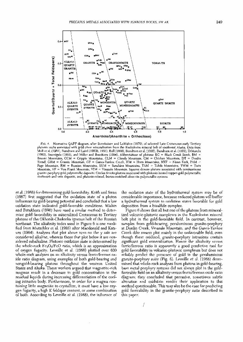
The volcanic-plutonic complexes and the subaerial volcanic rocks are probably genetically related, as suggested by their common spatial association, and supported by similar chemis- try and isotopic ages (Bundtzen et al., 1992; Szumigala, 1993; Miller and Bundtzen, 1994; Moll-Stalcup, 1994). When plot- ted on the normative QAPF (Q = silica minerals, A = alkali feldspars, including albite, P = plagioclase, F = feldspathoid minerals) diagram of Streckeisen and LeMaitre (1979), com- positions of mineralized plutons rocks range from diorite to alkali granite (Fig. 4). Based on the alkali-lime index of Pea- cock (1931), most of the volcanic and plutonic rocks from mineralized systems in the Kuskokwim mineral belt exhibit alkali-calcic affinities (Fig. 5), which is supported by petro- graphic data as well.
Figure 3 summarizes 120 isotopic age determinations from selected Late Cretaceous-early Tertiary igneous rocks in the Kuskokwiin mineral belt. Shaded areas depict igneous ages from mineralized complexes. Most of the isotopic age dates are K-Ar mineral and whole-rock ages; however, six determi- nations are " ~ r / ~ % r total fusion dates, which yielded the same ages as those determined by the K-Ar analytical method. On the basis of regional geology, structural deformation, igne- ous petrographic studies, and the isotopic age results, we believe that most plutonic and volcanic rocks in the Kusko- kwim mineral belt underwent simple thermal histories. Hence the older K-Ar age determinations summarized in Figure 3 are believed to be accurate representations of crys- tallization ages of the four igneous suites.
Rb-Sr isotope data from six mineralized volcanic-plutonic igneous suites in the study area exhibit 87~r/86Sr initial ratios ranging from 0.70472 to 0.70585, suggesting that the Late Cretaceous-early Tertiary volcanic fields and volcanic-plu- tonic coinplexes from the Kuskokwim mineral belt are mantle derived, which is also consistent with their origins in a sub- duction-related environment (Table 3).
Although similar in age to other Late Cretaceous-early Ter- tiaiy igneous rocks, the granite-porphyry suite is chemically distinct. The rocks are peraluminous, corundum normative, and locally contain garnet phenocrysts, suggesting derivation from melted continental crust (Miller and Bundtzen, 1994). Limited REE data (Bundtzen et al., 1992) indicate that the granite-porphyry in the Kuskokwlm mineral belt is substan- tially depleted in heavy rare earth elements, whereas the other types of volcanic and plutonic rocks in the Kuskokwim mineral belt are not. Geochemical evidence (high aluminum content) and mineralogical evidence (garnet phenocrysts) suggest that the granite-porphyry dikes and sills may involve partial melting of continental crust brought about by high heat flow generated during emplacement of the volcanic- plutonic complexes previously described.
Major oxide data froin 13 gold-bearing plutons in the Kus- k o h m mineral belt were plotted on an alkalinity versus ferric/ferrous oxide ratio diagram, as advocated by Leveille
PRECIOUS METALS ASSOCIATED WITH IGNEOUS ROCKS, SW AK
.TAM
TONALITE
N CI
DIORITE
0.0 0.2 0.4 0.6 0.8 1 .O
Anorthltel(Anorth1te + Orthoclase)
FIG. 4. Normative QAPF diagram, after Streckeisen and LeMaitre (1979), of selected Late Cretaceous-early Tertia~y plutonic rocks associated with gold-silver mineralization from the Kuskokwim mineral belt of southwest Alaska. Data from Moll et al. (1981), Bundtzen and Laird (1983b, 1991), Bull (1988), Bundtzen et al. (1992), Bundtzen et al. (1993), DiMarchi (1993), Szumigala (1993), and Miller and Bundtzen (1994). Abbreviations of plutons: BC = Black Creek Stock, BM = Beaver Mountains, CCM = Cripple Mountains, CLM = Cloudy Mountain, CM = Chicken Mountain, DT = Donlin Trend, GRM = Granite Mountain, GY = Ganes-Yankee Creek, HM = Horn Mountains, NXF = Nixon Fork, PAM = Page Mountain, RM = Russian Mountains, SUM = Sunshine Mountains, TAM = Talida Mountains, TWM = Twin Mountain, VF = Von Frank Mountain, VIM = Vinasale Mountain. Squares denote plutons associated with peraluminous granite-poiyhyry gold polymetallic deposits. Circles denote plutons associated with plutonic-hosted copper-gold polymetallic stockwork and vein deposits, and plutonic-related, boron-enriched silver-tin polyinetallic systems.
et al. (1988) for determining gold favorability. Keith and Swan (1987) first suggested that the oxidation state of a pluton influences its gold-bearing potential and concluded that a low oxidation state indicated gold-favorable conditions. Mishin and Petukhora (1990) have used a similar method to deter- mine gold favorability in mineralized Cretaceous to Tertiary plutons of the Okhotsk-Chukotka igneous belt of the Russian northeast. The alkalinity index used in Figure 6 is one modi- fied from MutschIer et al. (1985) after Macdonald and Kats- ura (1964). Analyses that plot above zero on the y axis are considered alkaline, whereas those that plot below it are con- sidered subalkaline. Plutonic oxidation state is determined by the whole-rock Fe20dFe0 ratio, which is an approximation of oxygen fugacity. Leveille et al. (1988) plotted over 630 whole-rock analyses on an alkalinity versus ferriclferrous ox- ide ratio diagram, using examples of both gold-bearing and nongold-bearing plutons throughout the western United States and Alaska. These workers argued that magnetite-rich magmas result in a decrease in gold concentration in the residual liquids during increasing differentiation of the cool- ing intrusive body. Furthermore, in order for a magma con- taining little magnetite to crystallize, it must have a low oxy- gen fugacity, a high K feldspar content, or some combination of both. According to Leveille et al. (1988), the influence of
the oxidation state of the hydrothermal system may be of considerable importance, because reduced plutons wiII buffer a hydrothermal system to oxidation states favorable for gold deposition from a bisulfide complex.
Figure 6 shows that all but one of the plutons from mineral- ized volcanic-plutonic complexes in the Kuskokwim mineral belt plot in the gold-favorable field. In contrast, however, samples from gold-bearing, peraluminous granite-porphyry at Donlin Creek, Vinasale Mountain, and the Ganes-Yankee Creek dike swarm plot mainly in the unfavorable field, even though these oxidized, granite-porphyry intrusions contain significant gold mineralization. Hence the alkalinity versus ferric/ferrous ratio is apparently a good predictive tool for gold favorability in volcanic-plutonic complexes but does not reliably predict the presence of gold in the peraluminous granite-porphyry suite (Fig. 6). Leveille et al. (1988) deter- mined that whole-rock analyses from plutons in gold-bearing, base metal porphyry systems did not always plot in the gold- favorable field on an alkalinity versus ferriclferrous oxide ratio dagram; they concluded that pervasive, sonletimes subtle alteration and oxidation render their application to this methocl questionable. This may also be the case for predicting gold favorability in the granite-porphyry suite described in this paper.

BUNDTZEN AND MlLLER
Alkallc Alkalic-calcic Calclc-alkallc Calclc VF.
8 -
oF AVM
OF ARM
Q) u - )< A ~ Y OGM bRM AGc 0 6-
AGV
0
. 0 OVA
I I I I I I I 40 44 48 52 56 80 04 68 72
Weight % S102
EXPLANATION
A A Granite porphyly dikes GC = Granite Creek GM = Granite Mountain 0 end plutons F = Flat CP = Candle piuton u" Pluton,ic rocks related to RM = Russian Mountains BM = Beaver Mountains
2 l plutonlc hosted Cu-Au and TP = Tatalina pluton HM = Horn Mountains i0 Ag-Sn pdymetalb deposits z D = Donlinswam VM = Vinasate Mountains
Volcanic rocks in volcanic- GY = Ganes-Yankee dike VFI = Von Franklcloudy plutonic complexes swarm CM Mountain
FIG. 5. Classification of volcanic and plutonic rocks from selected mineralized Late Cretaceous-early Tertiary igneous complexes in the Kuskokwim mineral belt, using the alkali-lime index of Peacock (1931). Volcanic-plutonic complexes generally lot in the alkali-calcic field; granite-porphyry complexes show a wide scatter of data points. Data from Moll et al. (1981), Bundtzen and Laird (1983b), Bundtzen et al. (1992), Bundtzen et al. (1993), Miller and Bundtzen (1994), and authors (unpub. data).
Economic Geology
Classijcation scheme for Late Cretaceous-earl9 Tertia y metallogeny
Mineral deposits associated with igneous rocks of the Kus- kokwim mineral belt are characterized by their alteration, metal content, mineralogy, detailed geologic setting, age, and trace element and isotopic data. Five major groups of mineral deposit types are summarized in this paper: (1) plutonic- hosted copper-gold polymetallic stockwork, skam, and vein deposits, (2) peraluminous granite-~orph~r~-hosted gold po-
lymetallic deposits, (3) plutonic-related, boron-enriched sil- Ger-tin p~l~metallic mineralization in breccia pipes and as replacement deposits, (4) gold and silver mineralization asso- ciated with e~ithermal svstems. and ( 5 ) gold ~olvmetallic , I ,
heavy minerallplacer depisits. Table 2 lists the major recious metal-bearing deposits of the Kuskokwim mineral i' elt, di- vides them by deposit type, lists principal commodities pres- ent in each deposit, and provides resource grade and size estimates where available. None of the deposits has been completely explored.
Other mineral deposits associated with the Late Creta-
TABLE 3. Rb-Sr Isotope Data from Selected Late Cretaceous-Early Tertialy Igneous Complexes in the Kuskokwim Mineral Belt
Rb Sr "SrP6Sr Field no. Rocky type Loc&ityl ( p p 4 (pprn) R7~bp6Sr "Srls6Sr (initial)'
78BT435 Monzonite Mount Joaquin 115 580 0.574 0.70556 0.70499 78BT461 Monzodiorite Takotna 141 475 0.858 0.70611 0.70526 78BT379 Monzonite Candle Hills 138 541 0.736 0.70658 0.70585 82BT431 Alkali gabbro Golden Horn-Black Creek 155 619 0.725 0.70544 0.70472 81BT524 Basalt Beaver Mountains 236 63 1 1.082 0.70613 0.70505 77BT234 Basalt Candle Hills 106 518 0.591 0.70712 0.70653
Analyses by Teledyne Isotopes, Westwood, New Jersey; Accuracy of concentration data is -t 1%, determined through repeated analyses of well- characterized reference materials; precision of 87SrPfi~r (initial) is generated from each mass spectrum run
' Localities in Figure 2 Calculated using -1.42 X lo-'' yr-' and age = 70 Ma

PREClOUS METALS ASSOCIATED WITH IGNEOUS ROCKS, SW AK 251
N 6 0 ?2 P 4 @? 4 (D F 2
e + 0 3 z - c -2
e Q 2 -4 m
GOLD UNFAVORABLE .- P .,
0 0.5 1 .O 1.5 2.0 2.5
Weight percent Fe,O$FeO
FIG. 6. Plot of gold favorability, utilizing alkalinity versus ferriclferrous ratio, as advocated by Leveille et al. (1988), from 13 gold-bearing plutons in the Kuskokwim mineral belt. Identification and data sources are as follows: BM = Beaver Mountains (Bundtzen and Laird, 1982; Szumigala, 1993); BMT = Barometer Mountain (unpub, data, this study), CL = Cloudy Moun- tain (Moll et al., 1981); CM = Chicken Mountain (Bundtzen et al., 1992); DT = Donlin trend (Bundtzen et a]., 1993); GH = Golden Horn (Bundtzen et a]., 1992); GY = Ganes-Yankee Creek complex (unpub. data, this study); HM = Horn Mountains (Bundtzen et al., 1993); NF = Nixon Fork (Moll et al., 1981; unpub. data, this study); RM = Russian Mountains (Bundtzen and Laird, 1991); SM = Sunshine Mountain (Moll et al., 1981); SR = Sulokna stock (Moll et al., 1981); TM = Telida Mountain (Moll et al., 1981); V = Vinasale (DiMarchi, 1993; unpub, data, this study); VF = Von Frank Mountain (Moll et al., 1981). Circles denote (1) plutons associated with plutonic-hosted copper-gold polymetallic stockwork and vein deposits; and (2) plutonic-related, boron-enriched silver-tin polymetallic systems. Squares denote plutons associated with peraluminous granite-porphyry-hosted gold polymetallic deposits.
ceous-early Tertiary igneous rocks of the Kuskokwiin mineral belt include (1) molybdenum porphyry prospects at Fox Hills, Molybdenum Mountain, and McLeod (Nokleberg et al., 1995), (2) REE mineralization associated with felsic volcanic calderas and plutons in the Sischu volcanic field and at Wolf Creek Mountain, and (3) more than a dozen, past-producing, structurally controlled mercury-antimony deposits in flysch, which include the DeCourcy Mountain, Barometer, Cinnabar Creek, Mountain Top, and Red Devil mines (Sainsbury and MacKevett, 1965). These three metallic deposit types are not described in detail in this paper. Gray et al. (1997) describe mercury-antimony systems in the study area. Nokleberg et al. (1987,1993) and Bundtzen and Koch (1993) provide com- pilations of significant placer and lode mineral deposits of Alaska, which include selected mineral deposits in the Kusko- kwim mineral belt.
Table 4 presents average elemental content of 20 represen- tative precious metal-bearing deposits in the Kuskokwim min- eral belt. Figure 7 provides photographs of mineralized sam- ples that illustrate megascopic textures and sulfide, sulfosalt, oxide, and alteration mineralogy of precious metal deposits in the study area. Figure 8 provides photomicrographs that illustrate selected paragenetic relationships between sulfide and sulfosalt minerals. These figures and tables are frequently referred to in discussion of the four mineral deposit types below. During our discussion of igneous rocks, unless other- wise referenced, the principal classification schemes used are
Streckeisen and LeMaitre (1979) for plutonic rocks and Irvine and Baragar (1971) for volcanic rocks.
Plutonic-hosted copper-gold polyinetallic stockwork, skarn, and vein deposits
Plutonic-hosted copper-gold polymetallic stockwork, skarn, and vein deposits are found in at least eight volcanic-plutonic complexes in the Kuskokwim mineral belt. All eight examples described here-Chicken Mountain, Golden Horn, Von Frank Mountain, Candle Hills, Nixon Fork, Owhat-Mission Creek, and the Wattamuse and Ikuk prospects-contain many attributes of disseminated, bulk tonnage gold deposits. Quartz sulfide stockwork occurs in the Chicken Mountain, Golden Horn, and Von Frank Mountain deposits but is not as well recognized in the Owhat-Mission Creek, Wattamuse, and Ikuk prospects or in the Candle Hills and Nixon Fork plutons.
Alteration types, where recognized, include biotite + K feldspar or sericite + quartz + dolomite + ankerite in plu- tonic centers (protore) and a weakly developed propylitic (chlorite-iron oxide) alteration dlstal from intrusive centers. Early base metal-rich sulfide veins contain strong ankeiite alteration; gold-bearing veins usually contain dolomite and chlorite alteration. Late-forming veins generally exhibit argil- lic and silicic alteration zones. Secondary metallic enrichment or supergene zones are absent in all deposits examined, and surface iron staining is only weakly developed.
Samples of mineralization from four sulfide quartz deposi- tional events in the Chicken Mountain and Golden Horn lodes contain both liquid-rich and solid-bearing inclusions that exhibit at least one gas phase; all inclusions are generally NaCl poor (1.8-5.5 wt %) and contain 70 to 80 percent Hz0 (Bundtzen et al., 1992; Table 5, this study).
Silver to gold ratios from five representative plutonic- hosted copper-gold polymetallic deposits in the study area range from 0.6:l to 6.3:l and average 3.3:l (Table 4). Princi- pal metals present are copper, gold, silver, arsenic, and anti- mony. Moderately elevated levels of lead, tungsten, bismuth, uranium, thorium, and molybdenum locally occur in these deposits (Table 4). One deposit (Chicken Mountain) contains anomalous tantalum in zones developed during an early deut- eric-magmatic mineralizing event.
All of the plutons that host these mineral deposits range in age from 66 to 71 Ma. Most intrude Kuskokwim Group flysch, a few intrude the Goodnews terrane, and one intrudes the Nixon Fork terrane (Fig. 2). The best examples of the plutonic-hosted copper-gold polymetallic deposit type gener- ally occur in complex multiphased plutons that contain alka- line compositional phases such as alkali gabbro or monzodi- orite.
The geology, structure, mineralogy, metallic content, and alteration found in most plutonic-hosted copper-gold poly- metallic stockwork, skam, and vein deposits of the study area generally conform to the alkalic porphyry copper-gold model of Lowell and Guilbert (1970) or to deposit models 20c (por- phyry Cu-Au; Cox, 1986b), 18b (Cu skarn; Cox and Theodore, 1986), and 22c (polymetallic veins; Cox, 1986a), respectively. The plutonic-hosted copper-gold polymetallic deposits con- tain an estimated 25,980 kg of gold, or 16 percent of the known gold resources in the Kuskokwim mineral belt.

TABLE 4. Average Elemental Content of 20 Representative Precious Metal-Bearing, Hard-Rock Mineral Deposits of Late Cretaceous-Early Tertiary Age in the Kuskokwim Mineral Belt of Southwest Alaska
No. of samples
Au Ag As Sb Hg Cu Pb Zn Bi Cr U Th Mo Nb Sn W Co Ni analyzed' References
Plutonic-hosted copper-gold-polpetallic deposits
Chicken Mountain 1.20 4.6 617 53 1.56 490 17 46 1.0 165 4.5 8.0 65 31.0 7 5 28 99 98 Bundtzen et a]. (1992); this study; Richard Gosse, written comin. (1990)
Golden Horn 9.90 21.8 19,000 12,000 2.96 343 210 75 2.0 304 3.0 8.5 3 29.0 ND 20,000 11 4.5 47 Bundtzen et al. (1992); this study Russian Mountain 4.50 28.0 95,900 2,000 ND 8,700 1,042 287 93.0 281 12.4 9.1 1.8 34.0 22 22 170 125 51 Bundtzen and Laird (1991); this
Lodes study Candle 0.80 2.9 - ND - 299 59 78 ND 20 8.9 23.2 ND ND ND ND 8 100 15 Bundtzen and Laird (1963b); this
study Nixon Fork-Mystery 164.70 95.0 5,150 653 - 42,096 1,763 - 1217.0 51 ND ND 17.0 1.5 13 ND 49 25 5 This study
Perduminous granite-porphyry-hosted gold-polymetallic deposits
Donlin 3.20 2.7 664 3,500 2.38 105 69 4.3 ND 138 - ND ND ND 9 2 21 28 24 McGimsey et al. (1988); this study 43 ND 28 68 16 Bundtzen and Laird (1980);
m Ganes-Yankee Creek 1.85 2.0 2,214 ND 0.18 42 146 38 3.7 389 - ND ND ND
McGimsey et al. (1988) % Ophir 0.23 2.3 1,645 ND - 84 5 ND ND 129 3.1 8.9 ND ND ND 5 ND 67 20 Bundtzen and Laird (1980); this
study 8 h Granite Creek 0.65 3.1 44 24,308 0.10 12 11 50 ND 5.3 - ND ND ND 1.0 ND 6 26 42 Brmdtmn et al. (1985): McGimsey '
et al. (1988)
Plutonic-related, boron-enriched silver-tin-polymetallic deposits
Cirque 0.22 516.0 718 1,327 0.31 41,369 5,123 621
Tolstoi 0.43 149.2 2,527 130 ND 3,461 699 1,578
Bismarck Creek ND 16.4 403 79 0.07 155 183 2,674 Granite Mountain ND 0.9 42 ND 0.04 15 92 236 Pupinski 0.04 261.0 965 100 - 45,750 104 1,099
Won ND 42.0 4,277 396 - 470 919 1,101 Win ND 388.0 10,810 1.743 - 687 2,656 622
P 233.0 45 7.9 18.3 1.0 1.0 780 9 27 15 16 Bundtzen and Laird (1982);
P h
McGimsey et al. (1988); this 3
study 10.0 192 3.8 12.3 3.5 80.0 29 ND 23 48 13 Bundtzen and Laird (1982);
McGi~nsey et al. (1988) 3.8 83 4.9 5.3 2.0 5.0 1,370 73 3 49 65 This study; McGimsey et al. (1988)
15.4 247 - ND ND ND 60 ND 18 59 11 McGimsey et al. (1988); this study ND 154 E D - 2.0 1.0 36 535 20 23 5 This study; Richard Flander,
written commun. (1995) - - - - - - 5,930 135 - - 18 Burleigh (1992b) 159.0 - - - - 373.0 51,660 - - - 20 Burleigh (1992a)
Epithermd gold-silver deposits
Kolinakof 1.02 3.6 17 6,500 >50.00 35 15 46 0.2 312 1.5 4.0 ND 19 ND 2 26 48 13 Bundtzen et a]. (1993); this study Glenn Gulch 2.88 155.9 1,296 75,437 2.82 343 176 74 8.1 183 - 7.6 ND ND 3 20 5 7 9 Bundtzen et al. (1992) Dishna River 1.82 0.1 4,762 4,888 4.10 15 ND 35 ND 69 - ND ND ND ND ND 10 43 16 McGimsey et a]. (1988) Bogus Creek 0.58 107.3 87 38 2.19 76 172 97 ND 17 ND ND 1.0 ND 10 ND 5 7 9 This study
Data derived from reference cited and tbis study; analytical methods described in the references; Au, Ag, As, and Sb were analyzed by fire assay techniques; other elements by atomic absorption spectrophotomet~, neutron activation, and emisriurl spectrophotometry techniques; because representative values were sought, only deposits with five or more analyses were included in this table; the average metal contents presented do not necessarily constitute the average grade of mineral reserves present in the deposits
All values in ppm; ND = below limits of detection; - = not analyzed

PRECIOUS METALS ASSOCIATED WITH IGNEOUS ROCKS, SW AK

254 BUNDTZEN AND MILLER
PRECIOUS METALS ASSOCIATED WITH IGNEOUS ROCKS, sw AK 255
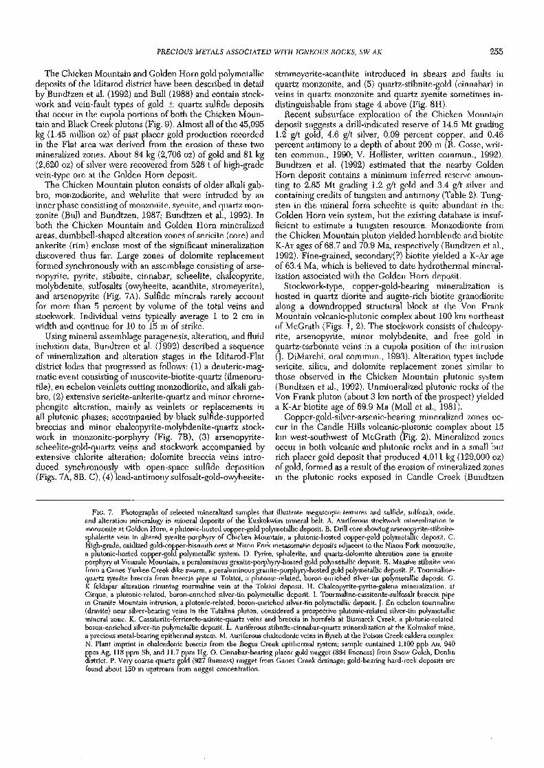
The Chicken Mountain and Golden Horn gold polymetallic deposits of the Iditarod district have been described in detail by Bundtzen et al. (1992) and Bull (1988) and contain stock- work and vein-fault types of gold + quartz sulfide deposits that occur in the cupola portions of both the Chicken Moun- tain and Black Creek plutons (Fig. 9). Almost all of the 45,095 kg (1.45 million oz) of past placer gold production recorded in the Flat area was derived from the erosion of these two mineralized zones. About 84 kg (2,706 oz) of gold and 81 kg (2,620 oz) of silver were recovered from 528 t of high-grade vein-type ore at the Golden Horn deposit.
The Chicken Mountain pluton consists of older alkali gab- bro, monzodiorite, and wehrlite that were intruded by an inner phase consisting of monzonite, syenite, and quartz mon- zonite (Bull and Bundtzen, 1987; Bundtzen et al., 1992). In both the Chicken Mountain and Golden Horn mineralized areas, dumbbell-shaped alteration zones of sericite (core) and ankerite (rim) enclose most of the significant mineralization discovered thus far. Large zones of dolomite replacement formed synchronously with an assemblage consisting of arse- nopyrite, pyrite, stibnite, cinnabar, scheelite, chalcopyrite, molybdenite, sulfosalts (owyheeite, acanthite, stromeyerite), and arsenopyrite (Fig. 7A). Sulfide minerals rarely account for more than 5 percent by volume of the total veins and stockwork. Individual veins typically average 1 to 2 cm in width and continue for 10 to 15 m of strike.
Using mineral assemblage paragenesis, alteration, and fluid inclusion data, Bundtzen et al. (1992) described a sequence of mineralization and alteration stages in the Iditarod-Flat district lodes that progressed as follows: (1) a deuteric-mag- matic event consisting of muscovite-biotite-quartz (ilmenoru- tile), en echelon veinlets cutting monzodiorite, and alkali gab- bro, (2) extensive sericite-ankerite-quartz and minor chrome- phengite alteration, mainly as veinlets or replacements in all plutonic phases; accompanied by black sulfide-supported breccias and minor chalcopyrite-molybdenite-quartz stock- work in monzonite-porphyry (Fig. 7B), (3) arsenopyrite- scheelite-gold-quartz veins and stockwork accompanied by extensive chlorite alteration; dolomite breccia veins intro- duced synchronously with open-space sulfide deposition (Figs. 7A, 8B, C), (4) lead-antimony sulfosalt-gold-owyheeite-
stromeyerite-acanthite introduced in shears and faults in quartz monzonite, and (5) quartz-stibnite-gold (cinnabar) in veins in quartz monzonite and quartz syenite sometimes in- distinguishable from stage 4 above (Fig. 8H).
Recent subsurface exploration of the Chicken Mountain deposit suggests a drill-indicated reserve of 14.5 Mt grading 1.2 g/t gold, 4.6 g/t silver, 0.09 percent copper, and 0.46 percent antimony to a depth of about 200 m (R. Gosse, writ- ten commun., 1990; V. Hollister, written commun., 1992). Bundtzen et al. (1992) estimated that the nearby Golden Horn deposit contains a minimum inferred reserve amoun- ting to 2.85 Mt grading 1.2 g/t gold and 3.4 g/t silver and containing credits of tungsten and antimony (Table 2). Tung- sten in the mineral form scheelite is quite abundant in the Golden Horn vein system, but the existing database is insuf- ficient to estimate a tungsten resource. Monzodiorite from the Chicken Mountain pluton yielded hornblende and biotite K-Ar ages of 68.7 and 70.9 Ma, respectively (Bundtzen et al., 1992). Fine-grained, secondary(?) biotite yielded a K-Ar age of 63.4 Ma, which is believed to date hydrothermal mineral- ization associated with the Golden Horn deposit.
Stockwork-type, copper-gold-bearing mineralization is hosted in quartz diorite and augite-rich biotite granodiorite along a downdropped structural block at the Von Frank Mountain volcanic-plutonic complex about 100 km northeast of McGrath (Figs. 1, 2). The stockwork consists of chalcopy- rite, arsenopyrite, minor molybdenite, and free gold in quartz-carbonate veins in a cupola position of the intrusion (J. Diklarchi, oral commun., 1993). Alteration types include sericite, silica, and dolomite replacement zones similar to those observed in the Chicken Mountain plutonic system (Bundtzen et al., 1992). Unmineralized plutonic rocks of the Von Frank pluton (about 3 km north of the prospect) yielded a K-Ar biotite age of 69.9 Ma (Moll et al., 1981).
Copper-gold-silver-arsenic-bearing mineralized zones oc- cur in the Candle Hills volcanic-plutonic complex about 15 km west-southwest of McGrath (Fig. 2). Mineralized zones occur in both volcanic and plutonic rocks and in a small but rich placer gold deposit that produced 4,011 kg (129,000 oz) of gold, formed as a result of the erosion of mineralized zones in the plutonic rocks exposed in Candle Creek (Bundtzen
FIG. 7 . Photographs of selected mineralized samples that illustrate megascopic textures and sulfide, sulfosalt, oxide, and alteration mineralogy in mineral deposits of the Kuskokwim mineral belt. A. Auriferous stockwork mineralization in monzonite at Golden Horn, a plutonic-hosted copper-gold polymetallic deposit. B. Drill core showing arsenopyrite-stibnite- sphalerite vein in altered syenite-porphyry of Chicken Mountain, a plutonic-hosted copper-gold polymetallic deposit. C. High-grade, oxidized gold-copper-bismuth ores at Nixon Fork inetasomatic deposits adjacent to the Nixon Fork monzonite, a plutonic-hosted copper-gold polymetallic system. D. Pyrite, sphalerite, and quartz-dolomite alteration zone in granite- porphyry at Vinasale Mountain, a peraluminous granite-porphyry-hosted gold polymetallic deposit. E. Massive stibnite vein from a Ganes-Yankee Creek dike swarm, a peraluminous granite-porphyry-hosted gold polymetallic deposit. F. Tourmaline- quartz syenite breccia from breccia pipe at Tolstoi, a plutonic-related, boron-enriched silver-tin polymetallic deposit. G. K feldspar alteration rimming tourmaline vein at the Tolstoi deposit. H. Chalcopyrite-pyrite-galena mineralization, at Cirque, a plutonic-related, boron-enriched silver-tin polymetallic deposit. I. Tourmaline-cassiterite-sulfosalt breccia pipe in Granite Mountain intrusion, a plutonic-related, boron-enriched silver-tin polymetallic deposit. J. En echelon tourmaline (dravite) near silver-bearing veins in the Tatalina pluton, considered a prospective plutonic-related silver-tin polymetallic mineral zone. K. Cassiterite-ferricrete-axinite-quartz veins and breccia in hornfels at Bismarck Creek, a plutonic-related, boron-enriched silver-tin polymetallic deposit. L. Auriferous stibnite-cinnabar-quartz mineralization at the Kolmakof mine, a precious metal-bearing epithermal system. M. Auriferous chalcedonic veins in flysch at the Poison Creek caldera complex. N. Plant imprint in chalcedonic breccia from the Bogus Creek epithermal system; sample contained 1,180 ppb Au, 940 ppm Ag, 118 ppm Sb, and 11.7 ppm Hg. 0. Cinnabar-bearing placer gold nugget (884 fineness) from Snow Gulch, Donlin district. P. Very coarse quartz gold (927 fineness) nugget from Ganes Creek drainage; gold-bearing hard-rock deposits are found about 150 m upstream from nugget concentration.

256 BUNDTZEN A N D MILLER
FIG. 8. Photomicrographs from selected mineral deposits in the Kuskokwim mineral belt, illustrating paragenetic relationships between sulfide and sulfosalt minerals. Photomicrographs by Cannon Electron Microprobe, Inc. A. Gold with bismuthinite in chalcopyrite from the Owhat prospect, a plutonic-hosted copper-gold polymetallic deposit. B. Scheelite containing 0.6 percent molybdenum in lattice substitution, from the Golden Horn plutonic-hosted copper-gold polymetallic

PKECIOUS METALS ASSOCIATED WITH IGNEOUS HOCKS, SW AK 257
TABLE 5. Schematic Summary Illustrating Mineralogical and Temperature Zonation of Mesothermal, Precious, and Base Metal Stockwork and Vein Deposits, and of Epithermd Gold-Mercury-Antimony Veins on Chicken Mountain and in the Golden Horn Area, Flat District
Generalized temperature-pressure
Mineral de~osits' Alteration Mineral assemblage Geotherrnometrv estimates conditions
Chicken Mountain Dicldte, weakly silicic (event 4)
Flat airstrip Golden Horn
(event 5) Glenn Gulch Weakly argillic
(event 2) Golden Horn
(event 4)
Chicken Mountain (event 3)
Golden Horn Chloritic and dolomitic (event 3)
Minnie Gulch Chicken Mountain
(event 2)
Golden Horn Strong ankerite (event 2) alteration; local fluorite
introduction Glenn Gulch
(event 1) Golden Horn Deuteric-magmatic
(event 1)
Deepest zone, Chicken Mountain (event 1)
Cinnabar + stibnite + gold + quartz
Cinnabar + quartz + stibnite Auriferous cinnabar + stibnite +
quartz Stibnite + boulangerite + silver
sulfosalts Bonlangerite + arsenopyrite +
owyheeite + stromeyerite
Pyrite + arsenate + silver sulfosalts
Arsenopyrite + scheelite + tetrahedrite + gold + quartz; trace cl~alcopyrite
Barite + boulangerite + gold Chalcopyrite + molybdenite +
chalcopyrite + arsenopyrite + quartz
Chalcopyrite + galena + arsenopyrite
Arsenopyrite
Muscovite + biotite + ilmenorutile + quartz
Muscovite + biotite + ilmenorutile + cassiterite(?) + quartz
148°C based on average hornogenisation temperature (n = 8) of fluid inclilsions in quartz
NA
Lowest mesothermal or epithermal
Lower mesothermal
N A 239°C based on average
ho~nogenization temperature (n = 14) of fluid inclusions in quartz
330°C based on arsenopyrite Mesothermal geothermometer
401°C based on decrepitation Upper mesothermal te~nperature prior to or hypothermal homogenization
387°C based on decrepitation temperature prior to ho~nogenization
All data from Bundtzen et al. (1992) and this study; NA = not available Mineral events refer to the paragenetic position of a mineral assemblage for each deposit, based on age and crosscutting relationships
and Laird, 1983b). An ankerite alteration zone ranging from 5 to 15 m wide can be traced for about 350 m along the faulted(?) contact between augite-rich, olivine monzonite and basaltic andesite. Thin quartz veinlets containing anomalous gold, antimony (stibnite), and arsenic cut the alteration halo. This mineralized zone occurs within a larger (500 by 40 m), elliptically shaped zone of anomalous gold (200 ppb) in soils (P. Rush, written coinmun., 1990). Chalcopyrite-quartz-epi- dote veins are conspicuously abundant in overlying, propyliti- cally altered, basaltic andesite of the Candle Hills volcanic- plutonic complex. Abundant mercury (cinnabar) and anoma- lous platinum metals were identified in dredge concentrates at Candle Creek, but the lode sources for these metals remain unknown. The Candle Hills pluton yielded a K-Ar biotite age of 69.7 Ma (Bundtzen and Laird, 198313).
The Owhat, Headwall, and Mission Creek deposits in the
Russian Mountains 30 km northeast of Aniak are fracture controlled, gold polymetallic-tourmaline-axinite veins that are structurally controlled along joints oriented N 25" W in quartz syenite of the Russian Mountains pluton (Figs. 1, 2). Each deposit contains major arsenopyrite and chalcopyrite and mi- nor amounts of antimony sulfosalts, cobalt-rich pyrite, cassit- erite, metazeunerite ( C U ( U O ~ ) ~ ( A s O ~ ) ~ ' 8H20), and galena. Unlike most other plutonic-hosted copper-gold polymetallic deposits in the Kuskokwim mineral belt, the Russian Moun- tains deposits contain large amounts of tourmaline and axinite alteration in both sheeted veins and disseminated in quartz syenite host rock. Lens-shaped ankerite alteration halos up to 50 m wide envelop all three deposits. Combined with other occurrences, the three deposits form a northwest-trending zone of mineralization 4 km long by 2 km wide in the eastern portion of the Russian Mountains pluton. In addition to gold,
deposit. C. Gold in arsenopyrite, also from the Golden Horn deposit. D. Boulangerite (with silver-enriched rims) in chalcopyrite, from the Cirque plutonic-related, boron-enriched silver-tin polymetallic deposit. E. Stromeyerite in association with chalcopyrite, from the Tolstoi plutonic-related, boron-enriched silver-tin polymetallic deposit. F. A Pb-Sb-B sulfosalt in iron oxide, from the Bismarck Creek plutonic-related, boron-enriched silver-tin polymetallic deposit. G. Cinnabar in association with gold in concentrate, from the Kolmokof area. H. Late stibnite as a cementing agent in arsenopyrite, from the Glenn Gulch precious metal-hearing epithermal vein.

258 B UNDTZEN AND MILLER
PRECIOUS METALS ASSOClATED WITH IGNEOUS ROCKS, SW AK 259
copper, and arsenic, the Russian Mountains deposits contain pluton intrudes Paleozoic limestone, which has resulted in anomalous tin, uranium, silver, cobalt, and bismuth. Electron the formation of a copper-gold-bismuth skarn. microprobe analysis indicated that gold accompanied bismuth in association with both arsenopyrite and chalcopyrite (Fig. Peraluminous granite-porphy y-hosted gold polymtallic 8A). Limited electron microprobe analyses reported by deposits Bundtzen and Laird (1991) show 29.0 to 33.0 at &t perce*t arsenic in arsenopyrite. Using techniques described by Kretschmar and Scott (1976), arsenic crystallization tempera- tures would be approximately 320°C for arsenopyrite in the Owhat deposit. Bundtzen and Laird (1991) estimated that 229,000 t grading 4.5 g/t gold, 2.0 percent copper, and 5 to 9 percent arsenic exists in the three deposits. The quartz syenite pluton, which intrudes a shoreline facies of the Kusko- kwim Group basin-fill sequence, yielded a K-Ar biotite age of 70.3 Ma.
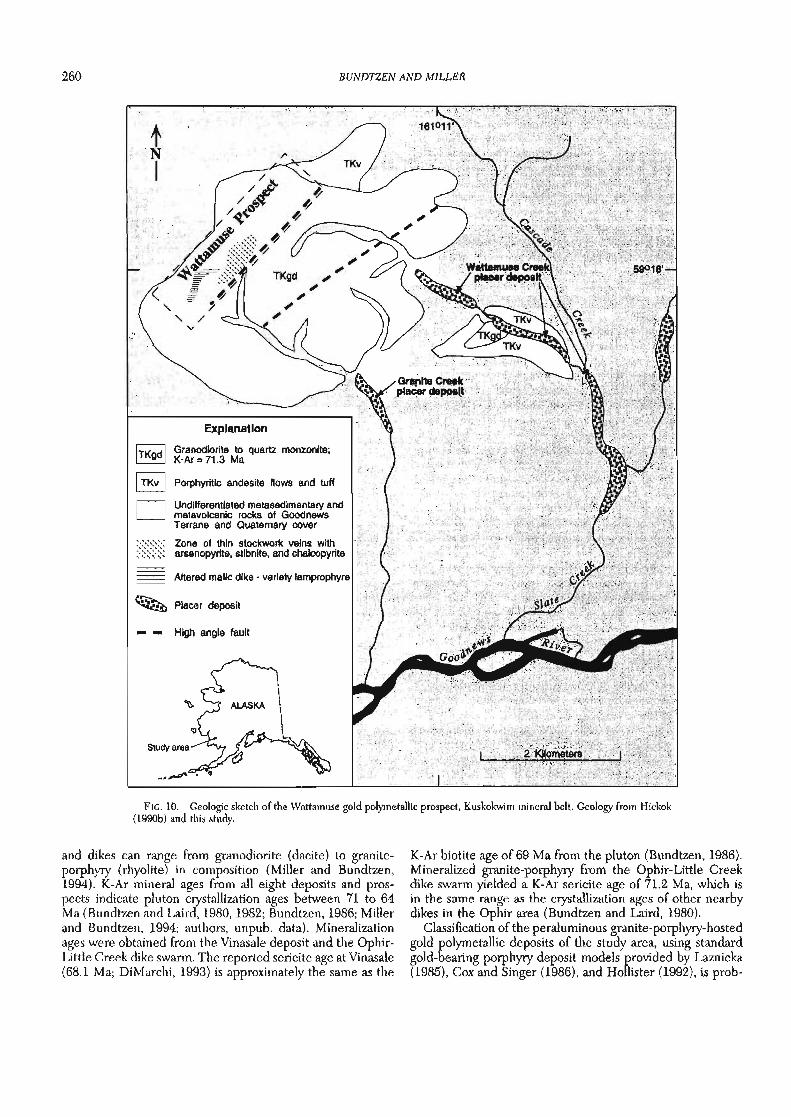
The Wattamuse and Ikuk prospects in the Goodnews Bay quadrangle contain quartz-carbonate-sulfide-gold veins, stockworks, and disseminations that are hosted in two small composite plutons of dioritic to quartz monzonitic composi- tion (Figs. 2, 10). Volcanic rock remnants of an eroded volca- n i~-~lu tonic complex crop out southeast of the Wattamuse Creek prospect. The Late Cretaceous-early Tertiary igneous complexes of Wattamuse and Ikuk intrude Paleozoic-Meso- zoic rocks of the Goodnews terrane. Both prospects contain chalcopyrite, arsenopyrite, and stibnite and have yielded assays of up to 9.5 g/t gold. Arsenic averaged 0.08 percent over an area 300 by 300 m at Ikuk; realgar is associated with mineralized zones at Wattamuse. Linear zones of silicic, propylitic, and sericitic alteration measuring 20 to 30 m wide parallel the quartz-carbonate-sulfide-gold veins at both pros- pects (Hickok, 1990a, b).
Copper-gold-bismuth skarn deposits occur in Ordovician limestone of the Telsitna Formation, which forms part of the Nixon Fork terrane about 50 km northeast of McGrath (Figs. 1, 2). Prior to 1960, about 1,850 kg (57,500 oz) of gold were recovered from ores averaging about 50 g/t gold, which con- tained credits of copper and bismuth. According to Herreid (1966), the deposits consist of chalcopyrite, pyrite, bornite, and native bismuth in irregular replacement bodies in skarn within 150 m of the 68 Ma Nixon Fork pluton (Moll et al., 1981). Gangue minerals include abundant garnet, diopside, epidote, and apatite. Newberry et al. (1997) provide detailed descriptions concerning classification and genesis of the skarn deposits at Nixon Fork. Consolidated Nevada Goldfields Cor- poration is currently developing the property into a small, high-grade underground lode gold mine. The most recent calculations available put mineable reserves at 85,348 t grad- ing 48.4 g/t gold, with credits of silver, copper, and bismuth. Active mine production began in October 1995.
Most of the plutonic-hosted copper-gold polymetallic de- posits in the K u s k o h m mineral belt are associated with mineralized plutons that intrude Cretaceous flysch. The min- eralized pluton at Nixon Fork is probably a plutonic-hosted copper-gold polymetallic system; however, the Nixon Fork
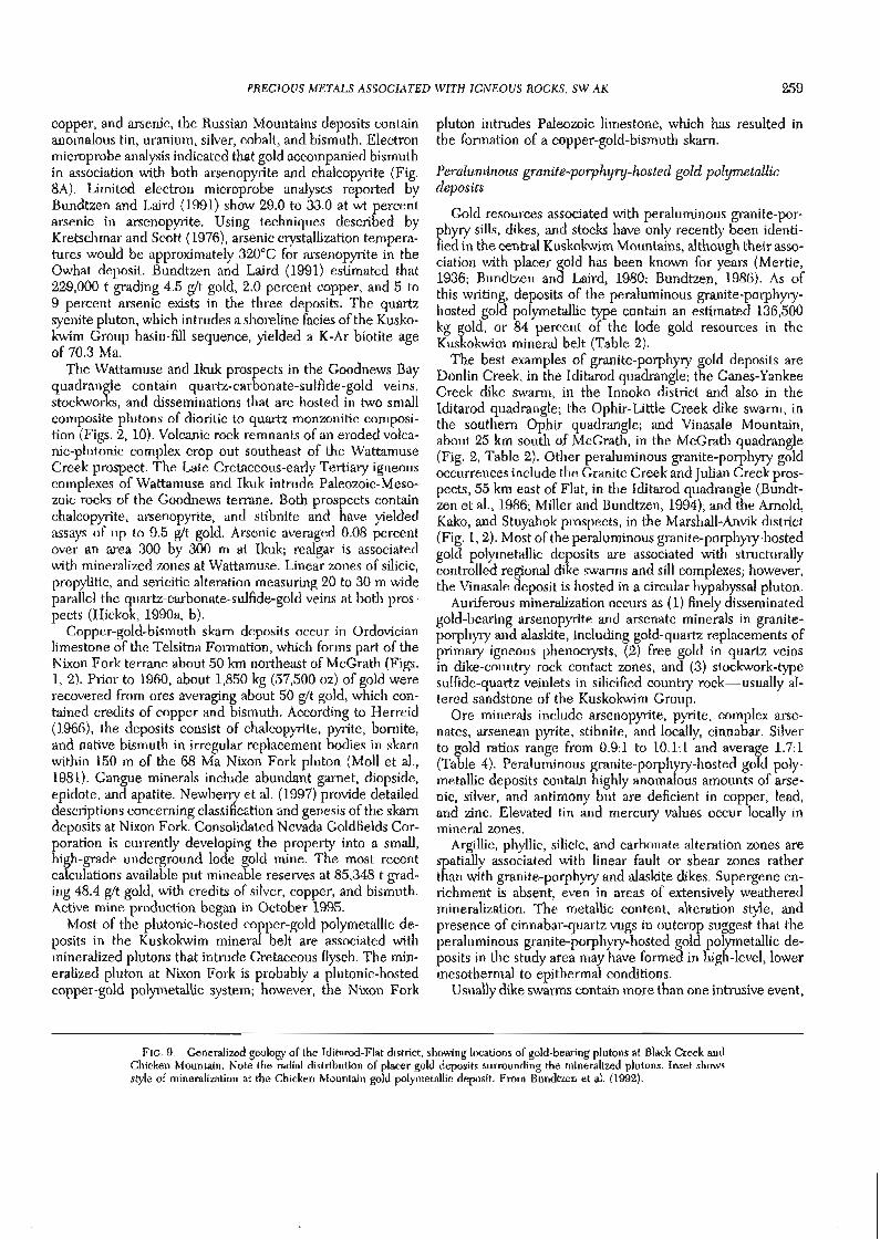
Gold resources associated with peraluminous granite-por- phyry sills, dikes, and stocks have only recently been identi- fied in the central Kuskokwim Mountains, although their asso- ciation with placer gold has been known for years (Mertie, 1936; Bundtzen and Laird, 1980; Bundtzen, 1986). As of this writing, deposits of the peraluminous granite-porphyry- hosted gold polymetallic type contain an estimated 136,500 kg gold, or 84 percent of the lode gold resources in the Kuskohvim mineral belt (Table 2).
The best examples of granite-porphyry gold deposits are Donlin Creek, in the Iditarod quadrangle; the Ganes-Yankee Creek dike swarm, in the Innoko district and also in the Iditarod quadrangle; the Ophir-Little Creek dike swarm, in the southern Ophir quadrangle; and Vinasale Mountain, about 25 km south of McGrath, in the McGrath quadrangle (Fig. 2, Table 2). Other peraluminous granite-porphyry gold occurrences include the Granite Creek and Julian Creek pros- pects, 55 km east of Flat, in the Iditarod quadrangle (Bundt- zen et al., 1986; Miller and Bundtzen, 1994); and the Arnold, Kako, and Stuyahok prospects, in the Marshall-Anvik district (Fig. 1,2). Most of the peraluminous granite-porphyry-hosted gold polyrnetallic deposits are associated with structurally controlled regional dike swarms and sill complexes; however, the Vinasale deposit is hosted in a circular hpabyssal pluton.
Auriferous mineralization occurs as (1) finely disseminated gold-bearing arsenopyrite and arsenate minerals in granite- porphyry and alaskite, including gold-quartz replacements of primary igneous phenocrysts, (2) free gold in quartz veins in dike-country rock contact zones, and (3) stockwork-type sulfide-quartz veinlets in silicified country rock-usually al- tered sandstone of the Kuskohm Group.
Ore minerals include arsenopyrite, pyrite, complex arse- nates, arsenean pyrite, stibnite, and locally, cinnabar. Silver to gold ratios range from 0.9:l to 10.1:1 and average 1.7:1 (Table 4). Peraluminous granite-porphyry-hosted gold poly- metallic deposits contain highly anomalous amounts of arse- nic, silver, and antimony but are deficient in copper, lead, and zinc. Elevated tin and mercury values occur locally in mineral zones.
Argillic, phyllic, silicic, and carbonate alteration zones are spatially associated with linear fault or shear zones rather than with granite-porphyry and alaskite dikes. Supergene en- richment is absent, even in areas of extensively weathered mineralization. The metallic content, alteration style, and presence of cinnabar-quartz vugs in outcrop suggest that the peralurninous granite-porphyry-hosted gold polymetallic de- posits in the study area may have formed in high-level, lower mesothermal to epithermal conditions.
Usually dike swarms contain more than one intrusive event,
FIG. 9. Generalized geology of the Iditarod-Flat district, showing locations of gold-bearing plutons at Black Creek and Chicken Mountain. Note the radial distribution of placer gold deposits surrounding the mineralized plutons. Inset shows style of mineralization at the Chicken Mountain gold polymetallic deposit. From Bundtzen et al. (1992).
BUNDTZEN AND MILLER
Porphyritic andesite flows and tuff
Undifferentiated rnetasedirnentary and rnetavolcanic rocks of Goodnews Terrane and Quaternary cover
= = High angle fault
FIG. 10. Geologic sketch of the Wattamuse gold poly~netallic prospect, Kuskokwim mineral belt. Geology from Hickok (1990b) and this study.
and dikes can range from granodiorite (dacite) to granite- porphyry (rhyolite) in colnposition (Miller and Bundtzen, 1994). K-Ar mineral ages from all eight deposits and pros- pects indicate pluton crystallization ages between 71 to 64 Ma (Bundtzen and Laird, 1980, 1982; Bundtzen, 1986; Miller and Bundtzen, 1994; authors, unpub. data). Mineralization ages were obtained from the Vinasale deposit and the Ophir- Little Creek dike swarm. The reported sericite age at Vinasale (68.1 Ma; DiMarchi, 1993) is approximately the same as the
K-Ar biotite age of 69 Ma from the pluton (Bundtzen, 1986). Mineralized granite-porphyry from the Ophir-Little Creek dike swarm yielded a K-Ar sericite age of 71.2 Ma, which is in the same range as the crystallization ages of other nearby dikes in the Ophir area (Bundtzen and Laird, 1980).
Classification of the peraluminous granite-porphyry-hosted gold polymetallic deposits of the study area, using standard gold-bearing porphyry deposit models provided by Laznicka (1985), Cox and Singer (1986), and Hollister (1992), is prob-
PRECIOUS METALS ASSOCIATED WITH IGNEOUS ROCKS, SW AK 261
lematic. Copper is absent in the peraluminous granite-por- phyry-hosted deposits of the Kuskokwim mineral belt, whereas gold-bearing porphyry systems described in Cox and Singer (1986) and by Laznicka (1985) usually contain substan- tial copper and other elevated base metals. Concentric hydro- thermal alteration zones are absent in the peraluminous gran- ite-porphyry-hosted deposits of the study area but are usually a primary constituent of the gold-enriched porphyry model of Cox (1986b). The porphyry gold deposit model of Hollister (1992) is deficient in copper and contains abundant arsenic, like peraluminous granite-porphyry-hosted gold polymetallic deposits of the study area. However, the porphyry gold depos- its of Hollister's (1992) model contain tungsten, molybdenum, bismuth, and tellurium, which are absent in peraluminous granite-porphyry-hosted gold polymetallic deposits of the study area (Table 4).
At the Donlin Creek property, which lies 25 km northeast of the Horn Mountains (Figs. 2, ll), at least three phases of mineralized felsic dikes and sills intrude K u s k o h m Group lithic sandstone and siltstone. The deposits have been briefly described by Mertie (1936) and Cady et al. (1955), and min- eral resource investigations have been recently completed by the authors, private mining firms, and Calista Corporation (Retherford and McAtee, 1994). The granite-porphyry dikes and sills at Donlin Creek extend north-northeast from the Horn Mountains to the Iditarod-Nixon Fork fault just south of Chicken Mountain, a distance of about 50 km. Miller and Bundtzen (1994) reported K-Ar muscovite ages of 65.1 and 70.9 Ma from granite-porphyry sills near Snow Gulch and Dome Creek, respectively. The mineral deposits explored to date consist of seven separately defined mineralized bodies that lie along approximately 6 km of a linear dike-sill swarm emplaced along the northeast-trending Donlin fault (Fig. 11). Mineralization consists of quartz-stibnite veins in granite-por- phyry and silicified sandstone, quartz gold replacements of phenocrysts, and wide vein-disseminated quartz sulfide zones that lie along shears and stockwork zones. Ore minerals in- clude auriferous pyrite, stibnite, cinnabar, arsenopyrite, and sulfosalts. Trenching and drilling conducted from 1989 to 1990 by Westgold, Inc., indicated that seven orebodies- the Carolyn, Snow, Queen, Rochelieu, Upper Lewis, Middle Lewis, and Lower Lewis zones-contained an inferred re- serve of 3,871,025 t grading 3.15 g/t gold, or 12,194 kg (392,090 oz) gold (Retherford and McAtee, 1994). Placer Dome U.S., which is conducting explorations on the property, recently announced that the Donlin Creek deposits contain 111,960 kg (3.6 million oz) gold in 40.4 Mt of mineralization (Stratman, 1996).
Gold-bearing, quartz-carbonate-sulfide veins and sulfide disseminations are hosted in peraluminous granite-porphyry of the 40-km-long Ganes-Yankee Creek dike swarm (Figs. 2, 12). The highest concentration of metallic mineralization occurs in a zone 4 by 0.5 km near the divide separating Ganes and Yankee Creeks, both drainages of which have produced at least 6,354 kg (204,330 oz) of placer gold and 863 kg (27,764 oz) of by-product silver. Most of the mineralized zones in the dike swarm consist of disseminated sulfides in dikes and quartz stockwork in sandstone adjacent to dikes. Linear zones of ankerite-sericite alteration envelop the dikes and also 5 to 15 m of the host sedimentary rocks. At the
Independence deposit, disseminated arsenopyrite, pyrite, cinnabar, stibnite, stephanite, and other sulfosalts occur in dike rock and altered sandstone of the Kuskokwim Group (Fig. 8E). Free gold in quartz was identified in veins adjacent to dike-country rock contacts in several localities northeast of the Independence mine. Carbonate alteration is controlled along hairline fractures both in wall rock and at dike-sand- stone contacts. The Independence deposit was briefly devel- oped in 1912, when about 5 kg (161 oz) of gold were won from about 113 t of ore.
Farther to the southwest, the Ganes-Yankee Creek dike swarm is truncated by the Iditarod-Nixon Fork fault. Restora- tion of the 88 to 94 km of right-lateral offset proposed by Miller and Bundtzen (1988) for the Iditarod-Nixon Fork fault reveals that the Ganes-Yankee and Donlin Creek dike swarms formed part of the same metallogenic belt now offset by the Iditarod-Nixon Fork fault (Miller and Bundtzen, 1994; Fig. 2).
Granite-porphyry dikes and sills containing gold, antimony, and arsenic cut the Kuskokwim Group in two distinct areas in the George River basin about 60 km east of Chicken Moun- tain (Fig. 2). At Granite Creek three of four granite-porphyry bodies trend northeast for 25 km and are apparently the source of placer gold in Granite Creek. Gold-bearing stibnite veins occur in shear zones adjacent to the dikes (Bundtzen et al., 1986). At Julian Creek porphyry sills up to 500 m wide are also the apparent lode sources of placer gold. The two dike-sill swarms at Julian and Granite Creeks have been offset from each other right laterally by about 15 km along a north- east-trending high-angle fault (Fig. 2).
Two concentrations of granite-porphyry dike swarms and stocks and altered mafic dikes cut Kuskokwim Group clastic rocks near the abandoned mining town of Ophir, 55 km west of McGrath (Figs. 1,2, 13). The gold-arsenic-antimony-bear- ing dikes are the probable source of approximately 3,380 kg (108,680 oz) of gold produced in Ophir, Spruce, Little, and Ester Creeks, which are downslope or downstream from the mineralized dike swarms. The dike swarms trend northeast for a distance of at least 25 km before disappearing in both directions under Quaternary cover. Although not clearly linked to faulting, the Ophir-Little Creek swarms trend south- west toward the high-angle Beaver Mountains fault (Bundt- Zen and Laird, 1982). Two gold arsenic-enriched prospects in a large granite-porphyry dike near the head of Ester Creek have been prospected with surface trenching and sampling, though with inconclusive results. Alteration in the mineral- ized dikes includes weakly developed argillic alteration that parallels the dike-country rock contacts. Elevated vanadium (1,500 ppm) and tungsten (100 ppm) occur in some mineral- ized samples. Abundant scheelite was recovered from placer operations just below the dike swarm on Little Creek. Bundt- Zen and Laird (1980) reported a K-Ar age of 70.1 Ma from sericite in the mineralized Ester Creek dike, which is believed to date hydrothermal alteration and mineralization.
Mineralized granite and quartz porphyry dikes and sills cut altered metabasalt of the arc-related Koyukuk terrane at the Arnold or Willow Creek prospect, about 25 km east of Marshall in the Marshall-Anvik district (Figs. 1, 2). Three N 55" W-trending dikes that can be traced for approximately 230 m of strike length have steep dips and contain most of

262 BUNDTZEN A N D MILLER
FIG. 11. Geology of the Donlin Creek dike swarm, adapted from Retherford and McAtee (1994). Inset from this study.
the known gold mineralization. The Arnold prospect was ate alteration forms a large halo of up to 40 m around the dug to explore a quartz vein stockwork with scattered small mineralized zones. Chip-channel samples collected during breccia zones hosted in andesite tuff. Sulfide mineralization this study contain 3.4 to 28 g/t gold and anomalous molybde- is chiefly arsenopyrite and pyrite, but minor amounts of num, arsenic, copper, lead, and silver. The Arnold and re- molybdenite and chalcopyrite also occur. Silica-iron-carbon- lated prospects are thought to be the source of approxi-

PRECIOUS METALS ASSOCIATED WITH IGNEOUS ROCKS, SW AK
Independence Mine
1 meter channel
I 30 Meters I
EXPLANATION
0 Quaternary, undlfferenliated rnnn Tailings or rubble n fmm trenches
.:;); Placer mine tailings a - Fault
I on*r porphy~~ ern. minor biotite monzonite and felslc Syndlne dlkes (one K-Ar dike swarm age =65.8 U . 9 Ma) 90, Strike and dip Volcanic agglomerate
@ Prospect trench IKhfl Hornfels
Kuskokwim Group, und~fferentiated
- Altered dlkes
- Quamcarbonate-gold bearing sulfide vein, shown in trenches
FIG. 12. Geology of part of the Ganes-Yankee Creek dike swarm, Innoko district, Kuskokwim mineral belt, showing the location of the Independence lode gold mine and distribution of heavy mineral placer deposits. Data modified from Bundtzen and Laird (1982, 1983a).
mately 3,450 kg (110,930 oz) of gold won from placer depos- its mined in nearby Willow Creek. One K-Ar biotite age of 65 Ma was obtained from a mineralized intrusion near the prospect. Similar granite-porphyry dikes and sills are the presumed lode sources of placer gold in the Kako Creek and Stuyahok areas, which are located in the eastern exten- sions of the Marshall-Anvik gold district (Fig. 2). At Stuya- hok, granite-porphyry and alaskite sills and dikes that in-
trude Neocomian volcaniclastic rocks of the Yukon-Koyukuk terrane are found directly underneath commercial placer gold deposits.
A mineralized, multiphased, 6-km2 pluton consisting of monzonite, quartz monzonite, and granite-porphyry intruded the Kuskokwim Group at Vinasale Mountain, about 25 km south of McGrath. Recent industry exploration efforts sum- marized by DiMarchi (1993) have delineated one of the most
264 BUNDTZEN AND MILLER
FIG. 13. Geology of the Ophir-Little Creek auriferous dike swarm, Innoko district, Kuskokwim mineral belt, illustrating the relationship between mineralized dikes and commercial placer gold deposits. Data adapted from Bundtzen and Laird (1980).
important lode gold resources in the Kuskokwim mineral belt (Fig. 14). A 1:63,360-scale reconnaissance geologic map of the area (Bundtzen, 1986) included descriptions of placer and lode deposits in Alder Creek (a southerly gulch draining Vinasale Mountain) and also reported a K-Ar biotite age of 69 Ma from a quartz monzonite phase of the intrusion. Ac- cording to DiMarchi (1993), mineralization occurs as dissemi- nations, breccias, dolomite veins, and segregations wholly hosted in intrusive phases of the Vinasale pluton. Alteration identified during mineral exploration include silicification, sericitization, dolomitization, and propylitic replacement of mafic minerals (Fig. 7D). The largest and most significant concentrations of gold in the Central zone are introduced into areas of intense sericite alteration and silica flooding; over 90 percent of the gold is contained in sulfides and sulfosalts of arsenic and antimony (DiMarchi, 1993). Based on about 11,260 m of drilling, the Central zone of the Vinasale deposit is estimated to contain about 10.3 Mt of ore grading 2.40 g/ t gold and credits of silver and antimony, or about 24,540 kg (789,000 oz) of in-place gold resources. Further detailed information on the Vinasale deposit is provided by McCoy et al. (1997).
Plutonic-related, boron-enriched silver-tin polymetallic deposits
Small meta-aluminous to peraluminous, alkali-calcic to calc-alkaline, hornblende-bearing intermediate to felsic plu- tons and volcanic-plutonic complexes that range in age from 71 to 59 Ma are associated with boron-enriched silver-tin polymetallic deposits throughout the Kuskokwim mineral belt. The best examples in the study area include the Cirque, Tolstoi, Granite Mountain, and Bismarck Creek deposits in the Iditarod quadrangle (Fig. 2). Similar mineralization has been described at the Win and Won deposits (Burleigh, 1992a, b), northwest of McGrath, and in a tin-silver occur- rence on the Cosna River (Burleigh, 1989), 300 km northeast of McGrath, a probable extension of the Kuskokwim mineral belt. Approximately 20 additional prospects and occurrences of this deposit type are described in the Iditarod quadrangle (M.L. Miller, T.K. Bundtzen, and J.E. Gray, written com- mun., 1996).
Host plutons of the silver-tin polymetallic deposit type can range from diorite to quartz monzonite but are generally less differentiated than the intrusions that host the copper-gold

PRECIOUS METALS ASSOCIATED WITH IGNEOUS ROCKS, SW AK 265
4' EXPLANATION
0 Undifferentiated alluvium (Q)
Granite porphyry ( .
Biotite monzonlte and syenite (TKmsy)
, , , Porphyritic quartz monzonite and granite (TKqm)
Kuskokwim Group clastic rocks (Kus)
< Placer gold-scheellte deposit
/ High-angle fault
Strike and dip of beds
Approximate location of central mineral zone; from DiMarchi (1 993)
FIG. 14. Geology of the Vinasale Mountain gold deposit, southwestern Alaska, showing location of the Central zone, the main concentration of auriferous mineralization. Regional geology by Bundtzen (1986).
polymetallic deposit type. Hornblende is common in the sil- ver-tin polymetallic plutons, whereas it is generally absent in plutons associated with copper-gold polymetallic mineraliza- tion. Although extensive boron metasomatism (introduction of large amounts of tourmaline and axinite) is characteristic of silver-tin polymetallic systems, this alteration type is some- times also associated with the plutonic-related copper-gold polymetallic deposits described earlier.
Silver-tin polymetallic mineralization in the study area ex- hibits the following morphological types: (1) circular or dumbbell-shaped tourmaline-axinite breccia pipes in plutons andlor overlying hornfels (Fig. 7F, I), (2) en echelon tourma- line-quartz stockwork in cupolas of plutons (Fig. 7J), and (3) large boron-replacement zones in hornfels breccia and al- tered volcanic rocks, where the presence of brown to purple axinite is characteristic (Fig. 7K). Multiple phases of sulfides and oxides including cassiterite, chalcopyrite, sphalerite, arse- nopyrite, bismuth sulfosalts, and ilmenorutile accompany the boron deposits. Deposits occur in both intrusive cupolas and hornfels aureoles in almost equal amounts.
Alteration consists mainly of extensive boron metasoma- tism in the form of ferro-axinite and tourmaline, accompanied by anatase and extensive ferricrete oxidation. Potassium feld- spar alteration haloes are often found rimming tourmaline veins (Fig. 7G).
Silver to gold ratios from three representative deposits
widely range from 347: 1 to 6,525: 1 and average 3,072: 1 (Table 4). The plutonic-related, boron-enriched silver-tin polymetal- lic deposits contain elevated levels of arsenic, antimony, cop- per, lead, zinc, niobium, and bismuth. Anomalous indium (118 ppm) was found in the Tolstoi and Bismarck Creek deposits, respectively. Other prospects and occurrences of this deposit type in the study area, which have been briefly described by Szumigala (1995) and by M.L. Miller, T.K. Bundtzen, and J.E. Gray (written commun., 1996), also con- tain high silver to gold ratios and elevated tin, zinc, lead, and bismuth values. The anomalous tin, zinc, silver, and bismuth contents, the high silver to gold ratios, and the alteration style seem to distinguish this type of deposit from other plutonic- related deposit types in the Kuskokwim mineral belt de- scribed in this paper.
Three plutons that host plutonic-related, boron-enriched silver-tin polymetallic deposits yielded K-Ar biotite crystalli- zation ages of 63 to 59 Ma, distinctly younger than those of other mineralized plutons in the study area. However, the Beaver Mountains and Moore Creek plutons, which contain mineralization of this type, yield K-Ar mineral ages averaging 70 Ma, or the same as other mineralized plutons.
Bundtzen and Gilbert (1983) noted that tin-bearing poly- metallic deposits in the Beaver Mountains and on Tatalina Mountain were similar to porphyry-related boron-silver-tin systems described by Sillitoe et al. (1975), and probably not

266 BUNDTZEN AND MILLER
1 / 1 1 , , ,
Tourmaline-aulflde zone wlth quartz- tourmaline-axinite veinlets containing O 2 to 20 percent wlfldes and fluorite
Tourmaline felsite wNh 4-10 percent tounnallne roseltes or bands by volume
I 30Meters I
Abred basan and tun mi pendants
Bedrock talus
Stmcturally lnclsed bedrodc drainage wlth faun gouge and colluvium
H Chip sample location
- Fault
B- Cirque Deposit
-Clrqu-n
O.OBX Zn WMAe
FIG. 15. Two examples of high-level, plutonic-related, boron-enriched silver-tin polymetallic mineralization in the Beaver Mountains. A. Tolstoi prospect, illustrating extensive tourmaline-sulfide breccia zones (geologic traverse along a steep ridge line). B. Cirque copper-silver (gold) deposit, showing N 70°E fracture zone and tourmaline-axinite-fluorite breccia zone. Both deposits occur just below roof pendants of basaltic andesite.
similar to tin greisen, porphyry, or vein deposits typified by those in Cornwall, England (Hosking, 1970) or Lost River (Sainsbury, 1969; Hudson and Arth, 1983) and Sleitat, Alaska (Burleigh, 1991). The latter two deposits are usually associ- ated with muscovite and/or biotite leucogranite (S type) and accompanied by wolframite, topaz, and REE minerals. The plutonic-related silver-tin polymetallic deposits of the Kusko- kwim mineral belt most likely correspond to both 20a (por- phyry Sn; Reed, 1986) and 20b (Sn polymetallic; Togashi, 1986) deposit models.
Late Cretaceous-early Tertiary volcanic and plutonic rocks in the Beaver Mountains (Fig. 2) host a variety of mineralized veins, breccia pipes, and replacement bodies that contain anomalous Ag, Cu, Pb, W, Sn, Nb, and As; the largest zones of mineralization found to date occur in the Tolstoi and Cirque deposits (Figs. 2, 15, Table 4). The Cirque deposit consists of parallel tourmaline-axinite-sulfide fracture fillings in a high-level cupola of quartz syenite belonging to the Beaver Mountains pluton (Bundtzen and Laird, 1982). The mineral- ization extends vertically for at least 250 m but is capped by a volcanic roof pendant. Copper and silver values (up to 21% and 1,108 g/t, respectively) were obtained from channel sam- ples at the Cirque deposit (Fig. 7H). Sixteen samples from several levels of the Cirque deposit averaged 0.078 percent tin (Table 4).
The nearby Tolstoi deposit consists of several parallel tour- maline-sulfide breccia zones in a cupola position of the Beaver Mountains stock (Fig. 7F, G). The mineralization, which con- sists of arsenopyrite, chalcopyrite, and pyrite, is similar to that observed at the Cirque deposit, except that sulfides at the Tolstoi deposit are more disseminated in nature and boron replacement is more extensive (Fig. 15). Silver-rich sulfosalts including stromeyerite and boulangerite were found in associ- ation with chalcopyrite in the Tolstoi and Cirque deposits; the presence of these minerals may explain the relatively high silver content observed in the high-grade copper mineraliza- tion at both localities (Fig. 8D, E, Table 4).
Boron-enriched silver-copper-quartz veins cut a small monzonite pluton at the Broken Shovel prospect, about 70 km southwest of McGrath (Figs. 1, 2). The 4-km2 pluton, which yielded a K-Ar biotite age of 68.3 Ma, intrudes the Upper Cretaceous Kuskokwim Group flysch. The chalcopy- rite-arsenopyrite-quartz vein trends for 200 m in a northeast direction and features en echelon sheeted tourmaline veins nearly 30 m thick that extend along the hanging wall for the entire length of the deposit. Silver to gold ratios average 555:l; six analyses average 0.25 percent arsenic, 0.24 percent antimony, 0.07 percent lead, and 0.48 percent copper (Bundt- Zen et al., 1988).
Silver-bearing, boron-enriched quartz-sulfide-tourmaline-

PRECIOUS METALS ASSOCIATED WITH IGNEOUS ROCKS, SW AK
Explanation
Quatemary alluvium
Quatemary, undifferentiated
Late Cretaceous to early Tertlaty altered intermediate intrusive or volcanic rocks
Late Cretaceous to early Tertlety hornfels
Cretaceous unaltered Kuskokwim Group, C E l deep waterfacies Mineralized ferricretequartz-axinltelt cassiterite zone; crosshatch indicates intense breccia development
Zone of abundant axlnlte veins
Anticline
d1 Strlke and dip of beds
D 6 High angle faul showing relative U- movement
Sample numbers and assay data listed In table (analyses by Bondar-Clegg, Inc.)
1 Chip channel sample
84bt136* Pan concentrate sample
ALASKA
FIG. 16. Generalized geologic map of plutonic-related, boron-enriched silver-tin polymetallic mineralization at Bismarck Creek, central Iditarod quadrangle. Inset shows the mineralization in the westernmost hornfels breccia zone. Data from this study.
I
manganese-axinite stockwork covers an elliptically shaped zone 200 m2 in hornfels sandstone above syenite intrusive rocks of the Tatalina Mountain pluton about 35 km west- southwest of McGrath (Figs. 2, 7J). Several prospect pits expose the better mineralization and yielded values up to 5 g/t silver, 100 ppm copper, and locally up to 0.5 percent lead. Pan concentrates from nearby Carl Creek, which has headwaters in the northern portion of the mineralized zone, have yielded up to 2,000 ppm bismuth, 23 g/t silver, and 500 ppm tin. Based on geochemistry, mineralogy, and alteration, this poorly explored mineralized zone is classified as a plu- tonic-related, boron-enriched silver-tin polymetallic system. Bundtzen and Laird (1983a) reported a K-Ar biotite age of 61 Ma from the underlying syenite intrusion.
An east- to northeast-trending zone of quartz-cassiterite- tourmaline-axinite gossan in a large sandstone hornfels aure- ole 12 km2 was discovered on a ridge line at the head of Bismarck Creek, a tributary to the George River (Figs. 2,16). No pluton is exposed, but a hornblende-bearing volcanic(?) unit crops out about 5 km west-northwest of the hornfels aureole (Miller and Bundtzen, 1994). Secondary biotite is locally abundant in the hornfels aureole and occurs as dark
red, fine-grained network veins, clots, and replacement zones in breccia. A 30-m-wide mineralized zone in the westernmost part of the hornfels aureole can be traced for about 300 m along strike, before disappearing underneath vegetative cover1 Three other similar ferricrete-quartz-axinite-cassiterite breccia zones occur in the prominent hornfels aureole. Black cassitkrite has been identified in late-stage veins, but only traces of a lead-antimony sulfosalt, galena, and sphalerite were ifound, probably owing to extensive surface oxidation (Figs.l7K, 8F). Silver values from chip-channel samples range from 2 to 63 g/t; tin values from the same samples range from trace amounts to 2.80 percent. Based on extensive surface sampling and geologic modeling, the Bismarck Creek deposit has an inferred reserve of 498,000 t grading 0.137 percent tin, 47.8 g/t silver, 0.16 percent copper, and 0.26 zinc and contains anomalous fluorine, bismuth, antimony, indium, and lead. ,
Sil+er-tin polymetallic mineralization on Granite Moun- tain, which is about 20 km southeast of Bismarck Creek, consists of several tourmaline breccia and tourmaline-sheeted zones in both quartz monzonite intrusive phases and sur- rounding volcanic and sedimentary hornfels (Miller and

268 BUNDTZEN AND MILLER
Bundtzen, 1994). One tourmaline breccia zone is 400 m long, 15 m wide, and cylindrical in cross section and contains anom- alous silver, tin, bismuth, and zinc (Table 4, Fig. 71). One K- Ar biotite age of 62.6 Ma was obtained from quartz monzonite adjacent to the metasomatized host rocks.
According to Burleigh (1992a, b), mineralization at the Win and Won prospects consists of polymetallic-sulfide and quartz-cassiterite assemblages in veins and breccias within a quartz-tourmaline-altered hornfels aureole. Nearby interme- diate dikes and small intrusions cut hornfels near the silver- tin polymetallic mineralization. Most of the mineralized areas at both the Win and Won deposits are extensively oxidized, and cassiterite is the main ore mineral identified. Electron microprobe analysis revealed the presence of three subtypes of lead-bismuth-antimony-silver sulfosalts. Burleigh (1992a) reported that veins and breccia veins from the Win deposit contain as much as 643 g/t silver and 6.97 percent tin; 20 high-graded samples averaged 5.16 percent tin and 388 g/t silver (Table 4). A few scattered gold anomalies were reported by Burleigh (1992a) at the Win prospect, but the average of 103 samples was below 100 ppb. Based on surface sampling, Burleigh (1992b) estimated that the Won deposit contains 1.94 Mt of mineralization grading 0.59 percent tin and 42 g/ t silver. Both the Win and Won deposits also contain anoma- lous niobium, antimony, bismuth, indium, and selenium.
Boron-enriched silver-tin polymetallic mineralization cuts monzonite at the Pupinski prospect, about 5 km southeast of the Nixon Fork copper-gold-bismuth skarns described pre- viously. Disseminated to locally massive pods of chalcopyrite, disseminated acanthite(?), and minor cassiterite occur in a 100-m-long, 25-m-wide, elliptical tourmaline-quartz grei- senlike zone about 1 km from the southeastern margin of the Nixon Fork pluton. Limited analyses indicate the presence of up to 261 glt silver, 4.58 percent copper, 0.11 percent zinc, 36 ppm tin, and 535 ppm tungsten (Table 4). Gold was usually below the detection limit (50 ppb) in samples analyzed for this study, and auriferous zones have not been recognized at the Pupinski prospect (R. Flanders, oral commun., 1995).
Gold-silver deposits associated with epithemal systems
Euithermal gold and silver mineralization is associated with ~ a t i ~retaceois-early Tertiary igneous rocks throughout the Kuskokwlm mineral belt. We tentatively subdivide these epi- thermal systems into three subtypes: (1) structurally con- trolled (gold)-mercury-antimony deposits related to altered olivine basalt dikes, (2) low-temperature gold-antimony-mer- cury-bearing shear zones in high-level portions of mineralized intrusive rocks. and (3) chalcedonic breccias hosted in subaer- ~,
ial volcanic piles, including stockwork veins adjacent to calc- alkaline, andesite to rhyolite volcanic calderas.
Silica-carbonate, potassic-phyllic, and adularia-chalcedonic alteration predominate in the three deposit subtypes above. All epithermal gold-silver occurrences contain variable amounts of cinnabar and stibnite and are usually accompanied by silver sulfosalts and free gold. Silver to gold ratios are highly variable, ranging from 0.06:l to 1851 and averaging 61:l (Table 4).
Although isotopic age dates are lacking for epithermal gold- silver deuosits in the studv area. several are available from
I , the spatially related, epithermal mercury-antimony deposits.
Miller and Bundtzen (1994) reported a K-Ar whole-rock age of 76 Ma from hydrothermally altered mafic basalt at the DeCourcy Mountain mercurantimony mine (Fig. 2). Gray et al. (1992) reported a Ar O/Ar3' plateau age of 72.5 Ma from hydrothermal sericite at the Fairview mercury-antimony deposit near Sleetmute and a minimum age of 72 Ma from hydrothermal sericite at the Rhyolite mercury pros- pect on Juninggulra Mountain, north of the Horn Mountains (Figs. 1 ,2) . The Rhyolite prospect is hosted in a southwestern extension of the granite-porphyry dike and sill swarm that hosts the Donlin granite-porphyry gold polyrnetallic deposits described in this paper (Figs. 2, 11).
Although highly variable and poorly studied, the three gold- silvgr deposit subtypes associated with epithermal systems in the study area may correspond to the deposit models 25a (hoe spring Au-Ag; Berger, 1986), 25b (Creede epithermal veins; Mosier et al., 1986b), and 25d (Sado epithermal veins; Mosier et al., 1986a), respectively. Gold reserves in epither- mal gold-silver deposits in the study area are sparse, owing to lack of detailed exploration. A modest reserve estimate of 92 kg (2,960 oz) gold is inferred in the Dishna River deposit (Table 2).
Epithermal cinnabar-stibnite deposits of the study area are part of a well-studied mercury belt (Sainsbury and MacKe- vett, 1965) that extends nearly 500 km from the Red Top mine, near Bristol Bay, to Mount Joaquin, near McGrath (Fig. 1). Mercury and minor antimony has been recovered from about a dozen deposits, and 85 percent of the total 1.38 million kg (39,960 flasks) of mercury was produced from the Red Devil deposit near Sleetmute in the Aniak-Tuluksak dis- trict (Fig. 1, Table 1). These cinnabar-stibnite deposits are spatially, and probably genetically, related to the gold-silver mineralization in epithermal systems of the study area.
At the Red Devil mine, high-angle structures cut Creta- ceous Kuskokwim Group flysch and altered mafic dikes. The cinnabar-stibnite-bearing fluids probably utilized the faulted mafic dikes as structural conduits, because there is no clear link to the mercury-antimony mineralization and the dikes themselves. Herreid (1962) first described vertical mineral zonation at Red Devil. Near-surface ore shoots are generally composed of quartz-cinnabar, but stibnite/cinnabar ratios in- creqse with depth. On the fifth and deepest level, about 180 m Gelow the surface, ore shoots consist mainly of stibnite- quartz and contain only traces of cinnabar.
Fluid inclusion studies by Roedder (1963, 1972) and H.E. Belkin (reported in Miller et al., 1989) support the contention that ore deposition took place at relatively shallow depths in the hydrothermal system. Homogenization temperatures of Red Devil cinnabar crystals range from 158" to 164OC, and in quartz gangue vein material, from 169" to 210°C (Miller et al., 1989). Assuming COz densities of 0.25 g/cm3 and trapping temperatures of 160" to 200°C, Miller et al. (1989) estimated a trapping temperature at Red Devil of 150 to 200 bars or up to 1,500 bars if inclusions were trapped in a water column. Cumulative evidence suggests that the quartz-Hg-Sb solu- tions at Red Devil and probably other similar deposits formed in epithermal conditions -perhaps in a hot springs environ- ment. One unusual feature of the Red Devil deposits is the high level of hydrocarbons in fluid inclusions in both quartz and cinnabar (Roedder, 1963). Microthermometer and mass

PRECIOUS METALS ASSOClATED WITH IGNEOUS ROCKS, SW AK 269
spectrometry analyses from several other Hg-Sb deposits in the study area indicate that fluid inclusions are composed of more than 95 percent HzO and up to 4 percent COz and contain trace amounts of Nz and CH4 (Gray et al., 1992). Gray et al. (1997) present more detailed features of the mercury- antimony lodes of southwest Alaska.
Several epithermal mercury-antimony systems in the Kus- kokwim mineral belt contain anomalous gold values. Mineral- ization at the Kolmakof mine, 30 km east of Aniak, consists of narrow stringers of cinnabar as well as arsenopyrite in silica-carbonate-altered breccia zones and fractures within altered mafic dikes that intrude Kuskokwim Group clastic rocks (Figs. 2,7L, 17). Chalcedonic-adularia zones have been introduced into the quartz breccias hosting the main cinna- bar-stibnite zones. Bundtzen et al. (1993) reported that three samples near the largest mineralized mafic dikes contained 3.24 to 10.0 g/t gold (Figs. 8G, 17) and 0.8 to 45 g/t silver, as well as elevated values of copper (91 ppm) and cerium (1,470 ppm). Quartz-carbonate veins in bleached sandstone
75 m east of the main Kolmakof Hg-Au-Ag deposit contain 27 to 66 ppm tellurium and 24 to 54 ppm molybdenum.
Although primarily the site of plutonic-hosted copper gold polyrnetallic deposits, high-level mercury-antimony deposits also occur on Chicken Mountain and at the Glenn and Minnie Gulch deposits immediately north of Flat (Figs. 2, 7). Bundt- Zen et al. (1992) found native gold and electrum in cinnabar at the Glenn Gulch stibnite-gold-silver deposit near the Golden Horn mine (Fig. 8H) and described auriferous stibnite-cinna- bar veins near the Idaho occurrence on Chicken Mountain. These deposits are believed to have formed in low-tempera- ture, epithermal conditions away from the higher tempera- ture Golden Horn and Chicken Mountain plutonic-hosted copper-gold polymetallic systems (Table 3).
Stibnite-gold-quartz veins cut Kuskokwim Group sand- stone near the head of the Dishna River, about 45 km north of Chicken Mountain (Fig. 2). This previously unreported occurrence can be traced for about 140 m of strike before disappearing at both ends under Quaternary cover. Open-
FIG. 17. Geologic sketch of the Kolmakof mercury mine, Sleetmute C-8 quadrangle, illustrating precious metal-bearing mineral zones in a Kuskokwim mercury lode. Data from this study. Sketch by T.K. Bundtzen and G.M. Laird, June 22, 1991.

270 BUNDTZEN A N D MILLER
space texture in quartz, chalcedonic alteration, elevated mer- cury values (Table 4), and low-temperature dickite alteration near vein contacts suggests this deposit formed under epither- ma1 conditions.
Gold-bearing chalcedonic quartz veins cut Upper Creta- ceous Yukon-Koyukuk flysch near the rim of the Poison Creek volcanic field, about 125 km northwest of McGrath (Figs. 1,2, 18). The auriferous mineralization discovered thus far formed about 2 km from a curvilinear faulted contact between the flysch and andesite tuffs and flows; this contact zone is be- lieved to be the rim of a volcanic caldera, which is composed of ash-flow tuff, siliceous sinter, felsic tuff, andesite tuff, and basaltic andesite (Fig. 18). Grab samples of chalcedonic quartz veins intruding flysch (Fig. 7M) contain up to 3.5 g/t gold, 25 g/t silver, and 1,500 ppm arsenic (authors, unpub. data). The volcanic field yielded a K-Ar whole-rock age of 65.2 Ma (Patton and Moll, 1984).
Gold-silver-bearing samples have been recently found in the Yetna volcanic field (Fig. 2). Values as high as 10 g/t
silver, 3 g/t gold, 100 ppm tin, and 500 ppm lead have been reported from chalcedonic breccias, shear zones, and gossan in the Yetna volcanic field (McGimsey et al., 1988). Miller and Bundtzen (1994) reported a K-Ar age date of 60.1 Ma from andesite hosting one of the Yetna volcanic field epither- ma1 Au-Ag occurrences.
Significant epithermal gold-silver mineralization is hosted in altered andesite at Bogus Creek, about 25 km west of the old mining camp of Nyac (Figs. 2, 19). The deposit occurs in Late Cretaceous-early Tertiary andesite that overlies marine andesite and tuff of the Jurassic-aged Nyac terrane. A small, Late Cretaceous quartz monzonite pluton intrudes the Nyac terrane about 4 km southeast of the deposit (Fig. 19). Farther to the east, however, an elongate granitic pluton radiometri- cally dated as 110 Ma is thought to be the source of placer gold mined in California Creek and probably in the Tuluksak River as well. The Bogus Creek gold-silver prospect consists of stringers and fracture fillings of chalcedonic silica, locally abundant carbonized breccia, and wood chips (Fig. 7N). Plant
Explanation
a Quaternary alluvium
0 Quaternary, undifferentiated
Undifferentiated volcanic rocks of Poison Creek
~iiiceous sinter deposit
lTvf Fine grained felsic tuff
ignirnbrtte/ash flow tuff
Andesite tuff and flow
Yukon-Koyukuk Rysch
?!-I- Strike end dip of beds
- Inferred high angle fault
- - inferred curvilinear fauWcaldera limit
Sudy area
FIG. 18. Geologic sketch of the Poison Creek volcanic field, northern Kuskokwim mineral belt. Inset illustrates relation- ship of caldera(?) core, rim, and gold-bearing chalcedonic stockwork veins in Cretaceous flysch. Data from Alaska Division of Geological and Geophysical Surveys (1993) and Bundtzen (unpub. data).
PRECIOUS METALS ASSOCIATED WITH ZGNEOUS ROCKS, SW AK
Explanation
Early Tertiary? andesite and basalt
Late Cretaceous to early Tertiaty granite to quartz monzonite
Cretaceous hornfels
Cretaceous Kuskokwltn Group flysch
U Thrust fault
FIG. 19. Geologic sketch of western Aniak-Tuluksak district, Kuskokwim mineral belt, illustrating the style of chalcedonic alteration at the Bogus Creek Au-Ag epithermal system.
fossils discovered by the late Bruce Hickok from chalcedonic tina (Hollick, 1930)-which suggests that gold-silver-bearing, breccia at Bogus Creek resemble the Late Cretaceous low-temperature hydrothermal fluids reached surface condi- forms-either Cladophbbis septentrionalis or Nilssoni sero- tions probably in a hot spring environment. Selected samples

272 BUNDTZEN AND MILLER
in chalcedonically altered shear zones at Bogus Creek run as high as 3.7 g/t Au, 940 g/t Ag, 334 ppm As, 972 ppm Pb, and 118 ppm Sb.
Gold polymetallic heavy mineral placer deposits
The Kuskokwim mineral belt encompasses parts or all of the Marshall-Anvik, Tolstoi, McGrath-McKinley, Innoko, Idi- tarod, Donlin, Aniak-Tuluksak, Bethel, and Goodnews Bay mining districts (Fig. 1; Ransome and Kerns, 1954; Cobb, 1973). All but 2,140 kg of the total 100,240 kg of gold pro- duced from these districts during the period 1898 to 1995 (Bundtzen et al., 1994, 1996) was recovered from placer de- posits (Table 1). Production records from every commercial placer gold deposit in the Kuskokwim mineral belt were ex- amined. Placer gold production has been subdivided ac- cording to presumed lode sources, which were identified on the basis of detailed bedrock and surficial geologic mapping in the placer districts, examination of gold fineness and heavy mineral contents from both placer and lode deposits, and positive identification of the four precious metal deposit types described in this paper as being the probable source of the placer gold. Other bedrock sources for placer gold in the study area include Jurassic mafic-ultramafic rocks and middle Cretaceous granitic rocks. When lode sources are ambiguous or believed to originate from more than one bedrock source, the deposit type for the placer gold is considered unknown. We estimate that 61,490 kg of gold, or 63 percent of the total 98,100 kg of placer gold production, was derived from plutonic-hosted copper-gold polymetallic stockwork, skam, and vein deposits; 20,191 kg of gold, or 20 percent, came from the peraluminous granite-porphyry-hosted gold polymetallic systems; 13,697 kg of gold, or 14 percent, was derived from mineralized, middle Cretaceous plutons in the Bear Creek and Tuluksak River portions of the Aniak-Tuluksak district (which are not described in this paper); and 2,722 kg of gold, or 3 percent, was derived from Jurassic, zoned ultramafic complexes of the Goodnews Bay district, auriferous epither- ma1 systems in volcanic rocks, and unknown sources (Table 6).
Gold-bearing placer deposits formed downslope or down- stream from Late Cretaceous-early Tertiary igneous com- plexes at Nixon Fork, Candle Hills, Vinasale Mountain, the Ganes-Yankee Creek dike swarm, the Ophir-Little Creek dike swarm, Moore Creek, Chicken Mountain, Granite Creek, Donlin Creek, Julian Creek, Bear Creek, Marvel Creek, Mar- vel Dome, the Cripple Mountains, Wattamuse Creek, Kako Creek, Stuyahok River, and Willow Creek (Fig. 2). Indeed, the exploitation of the placer deposits led to the discovery of lode deposits as well, such as the Golden Horn, Chicken Mountain, Owhat-Headwall-Mission Creek, Nixon Fork, Snow Gulch (Donlin), and Independence (Ganes-Yankee Creek) gold-bearing deposits described above. Bundtzen et al. (1987) utilized suites of specific heavy minerals in concen- trates collected in the study area to locate or define the hard- rock sources better for the heavy placer minerals found in the streams. Predictably, these studies showed that heavy minerals found in placer deposits had sources in upslope or upstream lode deposits.
Fineness or purity of the placer gold varies with differing lode sources (Table 7). Placer gold eroded from peraluminous
granite-porphyry-hosted gold polymetallic deposits and oc- currences in the Innoko, Iditarod (George), Donlin, and Mar- shall-Anvik districts has fineness values ranging from 654 to 973 and averaging 840 (Table 7). Gold originating in the plutonic-hosted copper-gold polymetallic stockwork and vein deposits in the Tolstoi, McKinley-McGrath, and Iditarod (Flat) districts have a narrower fineness range of 847 to 902. Gold derived from streams draining middle Cretaceous plu- tons in the Aniak-Tuluksak district have fineness values rang- ing from 838 to 994 and averaging 933 (Table 7). Trace ele- ment analyses and limited electron inicroprobe data show that placer gold from both plutonic-hosted deposit types contains anomalous As, Cu, Hg, and especially Sb in addition to the typically high silver content common to most placer gold (Bundtzen et al., 1987). Some placer gold from Flat and Otter Creeks, which drain the Chicken Mountain and Golden Horn copper-gold polymetallic stock and vein deposits, contains tiny inclusions of chalcopyrite. Placer gold samples from throughout the Kuskokwim mineral belt contain trace to anomalous mercury values; for example, 10 gold grains from Snow Gulch, in the Donlin district, were found to contain from 3.55 to 8.98 percent mercury, which in some cases actually exceeded the silver content of the bullion (B. Can- non, written commun., 1995).
The combination of trace element content and gold fine- ness data suggests that gold from both the peraluminous gran- ite-porphyry and plutonic-hosted copper-gold polymetallic stockwork and vein-type deposits formed in conditions span- ning the mesothermal to epithermal ranges. High amounts of mercury, antimony, and silver in gold suggest deposition in the epithermal temperature range, whereas a high copper content indicates deposition in the mesothermal temperature range. High-fineness gold, such as the placer gold in the Tolstoi, McKinley-McGrath, and Iditarod (Flat) districts (Ta- ble 7), is thought to form in higher temperature conditions (Badalov and Badalova, 1967; Boyle, 1979). Gold fineness data from placer deposits eroding gold-silver epithermal sys- tems in volcanic rocks of the study area are absent.
Bundtzen et al. (1987) detected anomalous platinum met- als (437-5,250 ppb PGE) in placer gold from stream drain- ages at Flat, in the Cripple Mountains, and from Candle Hills, all of which erode Late Cretaceous-early Tertiary, plutonic- hosted copper-gold polymetallic stockwork and vein deposits. It is not known whether the platinum (mainly palladium) occurs as immiscible masses in the crystal lattice of placer gold or as discrete grains in gold. Plutons from these three areas contain wehrlite, alkali gabbro, and monzodiorite intru- sive phases (Bundtzen and Laird, 198313; Miller and Bundt- Zen, 1994).
Distribution of heavy mineral placers in the study area have been influenced by a variety of conditions, including such structural deformations as vertical movement along faults, stream drainage evolution in a periglacial environment, the relative amount of unroofing of mineralized source rock, and the presence or absence of Pleistocene glaciation (Bundt- Zen et al., 1985).
Many gold-bearing alluvial terraces found in the Kusko- kwim mineral belt and throughout interior and western Alaska are relict stream drainages that began to form in Mio- cene to Pliocene time (Hopkins et al., 1971). An asymmetrical

TABLE 6. Summary of Gold-Silver Polyrnetallic Mineral Deposit Types from Late Cretaceous-Early Tertiary Igneous Complexes, Kuskokwim Mineral Belt, Southwest Alaska
Plutonic-volcanic Deposit type Geology of host rocks compositions Mineralogy of ore Structure, morphology Alteration Remarks
1. Plutonic-hosted Volcanic-plutonic complexes Heterogeneous and variable, Deeper levels contain chalcopyrite, Vertically zoned systems in Ankerite, potassic, propylitic Accounts for 25,980 kg copper-gold- intrude Kuskokwim Group from alkali gabhro to molybdenite, scheelite, and intrusive stockworks, minor (chlorite-epidote), and gold, or 16% of known plymetallic and Nukluk terrane; some granite; many average arsenopyrite; upper levels stockwork in hornfels cap silicic alteration; no clear lode gold resources in stockwork-vein plutons intrude Paleozoic monzonite; generally contain Ag-Sb sulfosalts, and overlying volcanics; patterns developed in the Kuskokwim mineral (skam) limestone meta-aluminous and range arsenites, stibnite, free gold; mesothermal T-P conditions most mineralized plutons; belt
from 40 to 67% Si02; oxidized skams contain cuprite at depth; epithermal T-P early pyroxene magnetite- contains elevated Th and and malachite protore rich in conditions at higher levels; garnet, later wollastonite U; generally reduced bornite and chalcopyrite cupola zones are best in skam types (femdfe~~ous ratio) targets for gold; structural conditions zones in exoskam near
pluton best target for skam deposits
2. Peraluminous Granite-porphyry dikes and Several varieties of Stibnite, cinnabar, arsenopyite, Sh Generally high-level Argdhc, potassic, and silicic Accounts for 136,500 kg granite- sills that give way to shallow peraluminous alaskite to sulfosalt emplacement along high- alteration plus dickite gold, or 84% of known P~OP~YTY- intrusions alkalic granite, frequently angle faults (Ganes-Yankee lode gold resources in hosted gold- contains garnet; heavy and Donlin faults): Kuskokwim mineral belt polymetallic REE depletion trends; orebodies are distinct lenses
possible product of crustal in both porphyry and host melting; both oxidized rocks and reduced intrusions present
3. Plutonic-related Hosted in hornfels sedimentary Meta-aluminous to Cassiterite, Sh-Ag sulfosalts, Veins, stockworks, and Strong boron Recently recognized boron-enriched rock, volcanic rocks, and peraluminous; chalcopyite, salena; abundant replacements metasomatism; silicic deposit type; potentially silver-tin- high-level plutonic rocks; undersaturated, reduced tourmaline, quartz, axinite alteration in intrusion- large silver resources plymetallic usually a component of plutons of two ages: gangue minerals hosted types; axinite- may be zoned part of greisen and volcanic-plutonic complexes, 651170 and 58-62 Ma; the tourmaline veins and deposit type 1 above vein deposits which intrude Kuskokwim younger ages stockwork in hornfels
Group flysch predominate; fewer intrusive phases than type 1 above.
4. Epithermal Highly variable: (1) associated (1) Highly altered olivine (1) Cinnabar, stibnite, free gold; High-level systems in all cases: (1) Silica-carbonate and Poorest understood of all gold-silver with altered m d c dikes; (2) basalt; (2) meta- (2) cinnabar, stibnite, arsenates, (1) introduction along faults; dickite; (2) potassic, gold-silver resources of systems distal to stockwork deposit aluminous; reduced, Ag sulfosalts; (3) sulfosalts, (2) as distal zones to phyllic; (3) chalcedonic, study area; accounts for
types above; (3) chalcedonic monozonite to granitic cinnabar porphyry or vein type Ag- adularia <1% of known gold veins and stockwork zones in plutons; (3) calc-alkalic Au polymetallic deposits; (3) resources in Kuskokwim host rocks andesite to rhyolite as ling structures distal to mineral belt
volcanic host rocks volcanic calderas 5. Heavy mineral Stream, colluvial, and residual All deposit types listed Free gold, electrum, cinnabar, Residual or colluvial deposits NA Lode sources for 98,100 kg
placer deposits accumulations derived from above have generated stibnite, ilmenite, develop on grussified placer gold mined in erosion of mineral 6eposit heavy mineral gold magnesiochromite, cassiterite, mineralized intrusions and Kuskokwim mineral belt types listed above placers in Kuskokwim monazite, garnet, edenite, in dike nvarms; fluvial (1990-1995) derived as
mineral belt richterite, scheelite, radioactive placers found in both follows: plutonic-hosted zircon, ilmenorutile, trace ancestral and modem Cn-Au stockwork and platinum-group elements stream gravels; best deposits vein, 61,490 kg (63%);
occur in third-order peraluminous granite- streams; richness dependent porphyry Au- on age and reconcentration polymetallic, 20,191 kg processes (20%); middle
Cretaceous plutons, 13,697 kg (14%); all other types, 2,722 kg (3%)
NA = not available
TABLE 7. Summary of Heavy Mineral Placer Data from Selected Portions of the Kuskokwim Mineral Belt
Gold District1 Geology of presumed lode source Major and minor heavy minerals Anomalies, remarks fineness2
Tolstoi Late Cretaceous-early Tertiary, meta-aluminous, alkali-calcic to quartz alkalic plutons of monzonitic composition
Innoko Bimodal dike swarms; gold mainly from peraluminous granite-porphyry, with contribution from alkali- calcic monzonite on Yankee Creek; both intrusive suites are of Late Cretaceous-early Tertiary age
McKinley-McGrath Meta-aluminous, quartz alkalic monzonitic plutons in Candle Hills; all of Late Cretaceous-early Tertiary age
Iditarod (Moore) Meta-aluminous, alkalic-calic boron-enriched plutons of monzonitic composition; Late Cretaceous-early Tertiary age
Iditarod (George) Both meta-aluminous, alkalic calcic monzonite and peraluminous granite-porphyry (very similar to Innoko-Ophir); both suites of Late Cretaceous- early Tertiary age
Idltarod (Flat) Meta-aluminous, quartz alkalic gabbro to monzonite plutons of Late Cretaceous-early Tertiary age
Donlin Peraluminous granite-porphyry dikes of Late Cretaceous-early Tertiary age
Aniak-Tuluksak Mineralized middle Cretaceous pluton is probable source of about 70% of placer gold; remainder derived from Late Cretaceous-early Tertiary plutons and epithermal veins
Bethel Veins in monzonite to granodiorite plutons of Late Cretaceous-early Tertiary age
Marshall-Anvik Peraluminous, granite-porphyry dikes, sill, and small plutons intrude Lower Cretaceous (Neocomian) volcanic and volcaniclastic rocks of Yukon-Koyukuk terrane
864-902; Zircon, magnetite, ilmenite, samarskite, avg = 897 powellite, xanthoconite, cassiterite
846-898; Magnetite, cinnabar, chromite or avg = 853 magnesio-chromite, scheelite,
monazite, ilmenorutile, native silver, platinum
894-902; Magnetite, magnesio-chromite, avg = 898 cinnabar, olivine, ilmenorutile, sodic
amphibole, scheelite, platinum 758-883; Chromite, cinnabar, native silver, silver avg = 836 sulfosalts
835-857; Magnetite, garnet, cinnabar, stibnite, avg = 853 monazite
847-874; Cinnabar, chromite, arsenopyrite, avg = 867 pyrite, zircon, cinnabar, ilmenomtile,
scheelite, cassiterite 802-901; Garnet, cassiterite, stibnite, monazite, avg = 837 cinnabar
838-994; Stibnite, cinnabar, megnetite, avg = 933 cassiterite, chalcopyrite
Platinum in gold bullion at Colorado Creek; anomalous tin, niobium, molybdenum, and uranium; silver sulfides
Scheelite very abundant in Little Creek; platinum from Boob Creek probably derived from Jurassic ophiolite
Anomalous platinum in gold bullion; niobium end member in ilmenorutile
Highest silver/gold ratio of any district
ti Julian Creek has most radioactive concentrates of all 2
examined 2 b
Anomalous platinum in gold bullion; uranium in 3
zircon; scheelite and cinnabar very abundant in Otter Creek drainage
E l? h
Radioactive concentrates similar to Julian Creek; a mercury content in selected gold grains from Snow Gulch ranges from 3.55 to 8.98%
Gold from Bear Creek contains minor intergrowths of chalcopyite; Spruce Creek gold contains gold telluride calaverite and inclusions of mtile in gold
avg = 875 Cinnabar, zircon, ilmenorutile Gold from Eureka Creek contains aurostibite (AuSb) and bismuth sulfosalts
654-973; Cinnabar, stibnite, arsenopyrite, pyrite, Gold grains from Flat Creek show intricate vermicular avg = 817 monazite sunburst muscovite inclusions
' District locations shown in Figure 1 Fineness data from Smith (1941), Bundtzen et al. (1987), and this study

PRECIOUS IMETALS ASSOCIATED W l T H lGNEOLTS ROCKS, SIV AK 275
valley, one in which opposing valley sides have markedly dif- ferent slope angles, is the characteristic stream profile in the Kuskokwirn mineral belt. The steer, walls of asvinmetrical valleys face north or east, whereas th i gentle slope; face south or west. This asymmetry is considered normal (Melton, 1960) and is probably the result of greater solifluction activity re- sulting from greater thermal exposure on south or southwest slopes. In contrast, the steeper valley slopes on the north or east receive less sunlight and are frequently frozen. As a result, the permafrost thaws differentially, and colluvial mate- rials move down the south- or west-facing slopes and advance toward east- or north-facing frozen buttresses. This process forces perennial streams to migrate south or west, creating active channels against the steep valley walls. During migra- tion, the stream leaves a successive series of older alluvial terraces. Many placer gold-bearing drainages in the Kusko- kwim mineral belt evolved in this fashion. Of the estimated 78 gold placer deposits known in the Kuskokwim mineral belt, 62 of the valleys (or 84%) exhibit valley asymmetry show- ing gentle west- or south-facing slopes, 8 (11%) exhibit valley asymmetry showing gentle east- or north-facing slopes, and 4 (5%) exhibit no pronounced valley asymmetry at all. Figure 20 illustrates the placer gold deposits and normal valley asym- metrv of S ~ r u c e Creek. in the Innoko district.
~iconcehrat ion cycles seem to be important local features of placer deposits in the Kuskokwim mineral belt, and third- order streams seem to have produced the richest placer gold deposits. In the Donlin district, economic quantities of placer gold are restricted to zones where modern stream gulches intersect the auriferous (but subeconomic) Donlin bench, an ancestral drainage of Donlin Creek (Fig. 11). Donlin Creek originally flowed northeast into the Iditarod River, which eventually drains into the Yukon River basin; after regional tilting, the drainage reversed direction and flowed into the Kuskokwim River basin. Enriched placer gold occurs where younger streams and gulches cut and reconcentrate gold de- rived from the older Donlin Bench gravel deposits.
Modern stream, alluvial terrace, colluvial, and residual placer deposits have all been exploited in the study area but are particularly well developed in the Iditarod-Flat district. Bundtzen et al. (1992) have described a progressive evolution from residual to eluvial to stream heaw mineral ~ l a c e r devel- opment as a result of progressive erosion of plutonic-hosted copper-gold polymetallic stockwork and vein deposits on Chicken Mountain and in Black Creek from the late Tertiary to the present (Figs. 2, 9). High-grade paystreaks on the Willow bench, an ancestral stream of Willow Creek, are found where younger streams intersect the older auriferous terrace alluvium; the geomorphological setting of Willow Creek is analogous to reconcentration processes observed at Donlin Creek, described above.
In both the Ophir and Canes-Yankee Creek areas of the Innoko district (Figs. 2, 12, 13), gold polymetallic placer de- posits occur in both ancestral (Tertiary?) terraces and younger, Pleistocene-age stream gravels. The placers formed during multiple periods of erosion and reconcentration of gold derived from mineralized, peraluminous granite-por- phyry dikes, sills, and stocks.
Placer gold has been found in small quantities in the Bea- ver, Russian, and Horn Mountains, all of which contain gold-
bearing vein-type mineralization (Fig. 2). However, no com- mercial placer gold production has ever taken place in these areas. All three mountain ranges have undergone at least four periods of Pleistocene glaciation, ranging from early Pleisto- cene to early Holocene (Kline and Bundtzen, 1986). Glacial activity frequently disperses, buries, or removes heavy min- eral placer concentrations deposited by streams. For example, about 75 percent of placer gold mined in Alaska and nearly 80 percent of placer gold recovered in Yukon Territory, Can- ada, have come from areas that either were never glaciated or were subjected to erosion and concentration processes during interglacial periods (Bundtzen, 1980; Morison, 1990). In the latter case (i.e., the Valdez Creek mine in south-central Alaska), placer deposits were subsequently preserved through burial by younger glaciofluvial deposits (Reger and Bundtzen, 1990).
Placer deposits throughout the Kuskokwinl mineral belt are from 1 to 20 in thick and contain from less than 0.5 to 15 g/t gold, averaging about 0.8 glt gold. Scheelite and cinna- bar have been recovered as commercial by-products from placer gold deposits in the Innoko, McGrath-McKinley, and Iditarod-Flat districts (Figs. 1 ,2) . All the placer gold deposits of the study area have yielded by-product silver (Table 1).
Metallogenic Model and Discussion
Figure 21 and Table 6 compare the four precious metal- bearing lode mineral deposit types and placer deposits associ- ated with Late Cretaceous-early Tertiary igneous rocks of the Kuskokwim mineral belt. The detailed geology, trace element geochemistry, ore mineralogy, and ore paragenesis discussed earlier in this paper indicate that the lode types span the hypothermal(?), mesothermal, and epithermal temperature and pressure conditions. Data from these studies, coupled with exploration drilling by private firms, support the con- tention that vertical and lateral mineral zonation occurs in precious metal-bearing systems throughout the study area. Higher temperature-pressure (mesothermal to hypother- mal[?]) deposits occur at deeper structural levels and at lower temperature-pressure mineral assemblages formed in lower mesothermal and epithermal conditions. The mineral depos- its related to Late Cretaceous-early Tertiary igneous com- plexes throughout the Kuskokwiin mineral belt represent similar, if not the same, zoned hydrothermal systems now exposed at several erosional levels.
Plutonic-hosted copper-gold polymetallic deposits in the Russian Mountains and in the Iditarod-Flat district contain temperature-pressure mineralization in the upper mesother- inal or hypothermal(?) range. Geothermometry data on arse- nopyrite summarized by Bundtzen and Laird (1991) indicate that gold-bearing arsenopyrite from the Owhat deposit in the Russian Mountains crystallized at 320°C. Deep levels of the Chicken Mountain and Golden Horn deposits show initial mineralizing events containing deuteric-magmatic muscovite- biotite-quartz alteration and decrepitation temperatures from quartz of 387" and 401°C, respectively (Table 5).
Plutonic-hosted copper-gold polymetallic, plutonic-related boron-enriched silver-tin ~olvmetallic. and era luminous
I ,
granite-porphyry-hosted gold polymetallic dLposits were probably deposited in the lower to middle mesothermal ranges. Second, third, and fourth mineralizing events in the

276 BUNDTZEN AND MILLER
rozen DIU
Alluv ial bench 1
4 'Alluvium
FIG. 20. Asymmetrical valley formation in the Kuskokwim mineral belt and its influence on gold placer deposits. Example depicted here is the Spmce Creek placer deposit, in the Innoko district.
Chicken Mountain and Golden Horn deposits that deposited copper, gold, arsenic, silver, and lead minerals show homoge- nization temperatures of 148" to 239°C from fluid inclusions in quartz gangue (Table 5). Bull (1988) estimated that the mineralized Chicken Mountain pluton was emplaced at 1.0 to 1.5 kbars or in shallow epizonal conditions, based on plotting feldspar crystallization temperatures on a granite minimum curve.
Homogenization temperatures of quartz fluid inclusions from the Broken Shovel deposit near Moore Creek, which is interpreted in this paper as a boron-enriched silver-tin polymetallic deposit type, range from 254" to 380°C and aver- age 297°C (Bundtzen et al., 1988).
No homogenization temperatures from peraluminous gran- ite-porphyry-hosted gold polymetallic deposits exist from the study area. A mesothermal classification is based primarily on textural relationships and mineral assemblages. Muscovite (in contrast to sericite) alteration, more typical of mesother- mal altered zones in porphyry deposits, has been recognized
in almost all deposits. Arsenopyrite, pyrite, stibnite, and silver sulfosalts thought to be associated with lower mesothermal mineralization occur in most deposits. Alteration zones gener- ally lack chalcedony and adularia, typically associated with epithermal systems. Retherford and McAtee (1994) reported, however, that the Donlin deposit(s) formed in epithermal conditions, citing (1) close spatial association with cinnabar mineralization, (2) illite alteration, and (3) low-temperature clay minerals associated with quartz sulfide breccia veins. They further speculated that copper porphyry-type mineral- ization lies below the main Donlin gold polymetallic deposits, based on the presence of higher temperature muscovite and base metal-bearing veins encountered at depth. Selected gold grains from Donlin Creek placer deposits contains from 3.55 to 8.98 percent mercury, which illustrates the high mercury content in the Donlin Creek mineral deposits. The Rhyolite mercury deposit, which probably formed in epithermal condi- tions, is hosted in the same peraluminous granite-porphyry dike and sill swarm as the Donlin deposit(s). It is likely that
PRECIOUS METALS ASSOCIATED WlTH IGNEOUS ROCKS, SU7 AK 277
FIG. 21. A composite metallogenic model for gold-silver polyrnetallic mineralization in the Kuskokwim mineral belt of southwest Alaska, depicting four styles of mineralization: (1) peraluminous granite-porphyry gold polymetallic deposits and associated high-level dike swanns; (2) gold-silver in epithermal systems associated with volcanism and hot spring environ- ments; (3) plutonic-related, boron-enriched silver-tin polymetallic systems associated with tourmaline breccia pipes and base metal porphyry systems; and (4) plutonic-hosted copper-gold polymetallic stockworks and veins, probably alkalic copper-gold systems.
peraluminous granite-porphyry-hosted gold polymetallic de- posits in the study area formed in conditions spanning the mesothermal and epithermal ranges.
Gold-silver deposits associated with altered mafic dikes, andesitic calderas, or volcanic fields, or those distal to plu- tonic-hosted copper-gold polymetallic stockwork and vein de- posits, formed in low-temperature, low-pressure epithermal conditions. Fluid inclusions from spatially related mercury- antimony deposits formed in the range of 160" to 210°C and under 150 to 1,500 bars (Miller et al., 1989; Gray et al., 1992). Chalcedonic (+ adularia) alteration occurs in the DeCourcy Mountain, Bogus Creek, Poison Creek, and Kolmakof depos- its discussed earlier.
Determining absolute ages of precious metal-bearing de- posits associated witkLate Cretaceous-early Tertiary igneous complexes is hampered by the sparsity of isotopic age data, and in many instances, the mineralization age of a specific deposit is inferred from the isotopic age of genetically related igneous rocks. However, nine isotopic mineral ages from six deposits have been completed in the study area. Hydrother- mal sericite from the Ophir-Little Creek peraluminous gran- ite-porphyry-hosted gold polymetallic prospect yielded a K- Ar age of 70.1 Ma, which is, within analytical error, the same age as the 71.2 Ma age determined on primary igneous mus- covite in the dike swarm near Ophir. DiMarchi (1993) ob- tained a K-Ar date of 68.0 Ma from hydrothermal sericite and a fission track age of 69.0 Ma from apatite from the
central zone at the Vinasale Mountain granite-porphyry gold polymetallic deposit. He also reported fission track ages of 73.0 and 69.0 Ma from the northeast mineral zone on Vinasale Mountain; within analytical error, all ages are the same as crystallization ages obtained from the pluton, which are 68.1 and 69.0 Ma (Bundtzen, 1986; DiMarchi, 1993). Epithermal mercury-antimony deposits at the DeCourcy Mountain, Fair- view, and Rhyolite deposits have yielded K-Ar and 40~r/39Ar ages of 76.0, 72.5, and 72.0 Ma, respectively. All are similar to the ages of nearby intrusive bodies and volcanic fields, which have been radiometrically dated to range from 65 to 74 Ma at DeCourcy Mountain, Barometer Mountain, and in the Horn Mountains. Secondary(?) biotite from the Black Creek pluton that might date mineralizing events of the Golden Horn copper-gold polymetallic stockwork and vein deposit, yielded a K-Ar isotopic age of 63.4 Ma, which is the youngest mineralization age in the belt. We have no isotopic ages from boron-enriched silver-tin polymetallic deposits in the study area. Host plutons for this deposit type range in age from 70.9 to 59.4 Ma, and three of the deposits are associated with plutons whose isotopic ages range from 63 to 59 Ma.
With the exception of the isotopic age from the Golden Horn deposit, all available mineralization ages cluster in the range between 76 and 68 Ma. The available data, although sparse, seem to indicate that mineral deposits and Late Creta- ceous-early Tertiary igneous complexes in the Kuskokwim
278 BUNDTZEN A N D M I L L E R
TABLE 8. Sulfur Isotone Analyses from Late Cretaceous-Earlv Tertiarv Sulfide-Bearing Mineral Denosits in the Kuskokwim Mineral Belt, Alaska
Sample no. Ore deposit name Mineral deposit type Mineral P4s (0100)
Chicken Mountain Owhat Vinasale Vinasale Tolstoi Tolstoi Cirque Bismarck Creek Bismarck Creek Kolmakof Kolmakof Red Devil Dishna River
Plutonic-hosted copper-gold-polymetallic Plutonic-hosted copper-gold-polymetallic Peraluminous granite-porphyry-hosted gold-polymetallic Peraluminous granite-porphyry-hosted gold-polymetallic Plutonic-related, boron-enriched silver-tin-polymetallic Plutonic-related, boron-enriched silver-tin-polymetallic Plutonic-related, boron-enriched silver-tin-polyrnetallic Plutonic-related, boron-enriched silver-tin-polymetallic Plutonic-related, boron-enriched silver-tin-polymetallic Epithermal gold-silver Epithermal gold-silver Epithermal gold-silver Epithermal gold-silver
Antimony sulfosalt Arsenopyrite Sphalerite Pyrite Chalcopyrite Chalcopyrite Chalcopyrite Sphalerite Galena Cinnabar Cinnabar Cinnabar Stibnite
1Sp2S - 1 1,000; standard is Canyon Diablo tmilite Analyses by Krueger Enterprises, Incl; 634S,.,,,,l, %o = 34 32 Sl S standard
mineral belt, as summarized in this paper, are about the same age. Additional isotopic age data should be collected to date all deposit types, especially the plutonic-related, boron-en- riched silver-tin polymetallic deposit type.
Table 8 summarizes sulfur isotope data from nine mineral deposits representative of the four lode deposit types dis- cussed in this paper. The sulfide minerals have relatively light 634S values that range from -6.5 to -0.9 per mil and average -3.4 per mil, which contrasts with heavier 6 3 4 ~ values from plutonic-related deposits of Cretaceous age in the Fairbanks and Kantishna districts of interior Alaska (Gilbert and Bundt- zen, 1979; Metz, 1991; T.K. Bundtzen unpub. data). The lightest S34S values are associated with the plutonic-hosted copper-gold polymetallic (avg -6.4%0) and gold-silver epi- thermal (avg -4.8%0) deposit types. Samples from the Tol- stoi, Cirque, and Bismarck Creek plutonic-related, boron- enriched silver-tin polymetallic deposits yielded slightly heav- ier S34S values that average -2.9 per mil. Ishihara et al. (1992, 1995) reported that similar light sulfur isotope analyses from mineral deposits in the Okhotsk-Chukotka mineral belt of the Russian northeast and the Sanyo and Ryoke mineral belts of northern Japan are the result of metallogenic processes associated with reduced, ilmenite series plutons of Mesozoic- Tertiary age. This interpretation would be consistent with our observations that many precious metal-bearing plutons of the Kuskokwim mineral belt exhibit reduced (ilmenite series) characteristics (see Fig. 6).
In contrast, sulfides from the Vinasale peraluminous gran- ite-porphyy-hosted gold polymetallic deposit yielded the heaviest S3 S values (0.8 and 0.9%0; Table 8). The Vinasale, Donlin, Ganes-Yankee, and other precious metal-bearing granite-porphyry dike and sill swarms in the stud area exhibit
3Y a high oxidation state (Fig. 6). Their heavier 6 S values and oxidized character reinforce our contention that the peralu- minous granite-porphyry-hosted gold polymetallic deposit type is distinct from others described in this paper.
Lead isotope values obtained from galenas at 16 mineral deposits in the Kuskokwim mineral belt (Gaccetta and Church, 1989; this study) are distinctly less radiogenic than those from samples associated with subduction-related plu-
tons of Cretaceous-Tertiary age in the western United States (Fig. 22). Only galena from the Nixon Fork skarn deposit plots in the intrinsic, plutonic-related deposit field, as defined by Newberry et al. (1995). Galenas from the remaining depos- its of the Kuskokwim mineral belt plot in the field of mixed origin deposits, for which Newberry et al. (1995) attribute both plutonic and metamorphic fluid involvement in the min- eralizing process. However, we envision little if any metamor- phic fluid involvement in the formation of Kuskohm min- eral belt lodes. The less radiogenic lead values from the Kus- kokwim deposits may reflect the alkalic component of many Kuskokwim mineral belt plutons and the possible contribu- tion of mantle to their origin (Newberry and Brew, 1993).
Overall characteristics of three of the four precious metal- bearing lode deposits described in this paper resemble those of published ore deposit models. The plutonic-hosted copper- gold polymetallic stockwork, skarn, and vein deposits conform to deposit models 20c (porphyry Cu-Au; Cox, 1986b), 18b (Cu skarn; Cox and Theodore, 1986), and 22c (polymetallic veins; Cox, 1986a). The plutonic-related, boron-enriched sil- ver-tin polymetallic deposits best conform to deposit models 20a (porphyry Sn; Reed, 1986) and 20b (Sn polymetallic; Togashi, 1986). The three gold-silver deposit subtypes associ- ated with epithermal systems likely correlate with deposit models 25a (hot spring Au-Ag; Berger, 1986), 25b (Creede epithermal veins; Mosier et al., 1986b), and 25d (Sado epi- thermal veins; Mosier et al., 1986a).
The relationship between the plutonic-hosted copper-gold polymetallic vein, skarn, and stockwork deposits and the plu- tonic-related, boron-enriched silver-tin polymetallic deposits of the Kuskokwim mineral belt is uncertain. High silver/gold ratios; anomalous tin, bismuth, zinc, indium, and lead values; morphology; and boron metasomatism characterize the latter deposit type, whereas low silver/gold ratios; high arsenic, cop- per, molybdenum, and antimony; and little or no boron meta- somatism characterize the former. Plutons hosting the boron- enriched silver-tin polyrnetallic deposits at Granite Mountain, Tatalina Mountain, and Bismarck Creek have distinctly younger ages and are within the same age range as the Sleitat tin-tungsten deposit in the Taylor Mountains quadrangle

PRECIOUS METALS ASSOCIATED WITH IGNEOUS ROCKS, SW AK
. _--- - A
\ -1 Western U.S. subduction relatedplutons . I
15.70 - I
Field of "mlxed orfgln" . - deposits I .2 -', , ..
Fleld of 'exfrinslc" deposlfs
FIG. 22. Lead isotope ratios for galenas from precious metal-bearing deposits in the Kuskokwim mineral belt of southwest Alaska. Data mainly from Gaccetta and Church (1989) and this study. BC (Beaver Creek), CM (Chicken Mountain), GH (Golden Horn), and NF (Nixon Fork) are plutonic-hosted copper-gold poly~netallic deposits; GC (Granite Creek), I (Independence), S (Snow Gulch), and V (Vinasale Mountain) are peraluminous granite-porphyry-hosted gold polymetallic deposits; C (Cirque), B (Broken Shovel), MC (Mission Creek), T (Tolstoi), and UC (Upper Cirque) are plutonic-related, boron-enriched silver-tin polymetallic deposits; D (DeCourcy Mountain), R (Rhyolite), and RD (Red Devil) are gold-silver deposits associated with epithermal systems. Field for Cretaceous-Tertiary subduction-related plutons in the western United States from Zartman (1974) and Newberry et al. (1995); fields for extrinsic (nonpluton-related) and mixed origin (plutonic and metamorphic) deposits after Newberry et al. (1995).
(Burleigh, 1991). However, the lode deposits in the Russian Mountains have characteristics of both deposit types. They carry high bismuth and tin and show boron metasomatism characteristic of the boron-enriched silver-tin polymetallic type, but they have low silverlgold ratios, elevated uranium and thorium, and low zinc values, which are characteristic of the plutonic-hosted copper-gold polymetallic deposit type. The Nixon Fork pluton hosts both skarns (the Nixon Fork mine) that correlate with the plutonic-hosted copper-gold polymetallic deposit type and a structurally controlled silver- tin-copper deposit (Pupinski), which is thought to be the boron-enriched silver-tin polymetallic deposit type. Detailed studies by Szumigala (1995) of mineral occurrences in the Beaver Mountains, which have been classified as the boron- enriched silver-tin polymetallic type in this paper, show that fluid inclusions are usually small, liquid rich, and NaCl poor and contain slight amounts of vapor and no daughter prod- ucts. Fluid inclusions in most porphyry systems usually con- tain high salinities, evidence of double boiling, and daughter crystals (Roedder, 1984); hence a key line of evidence linking Beaver Mountains mineralization (such as the Cirque and Tolstoi deposits) to porphyry copper-gold systems is missing.
Classification of the peraluminous granite-porphyry-hosted gold polymetallic deposits of the Kuskokwim mineral belt is problematical. Copper is usually absent in the granite-por- phyry-hosted gold polymetallic deposits of the study area, whereas gold-bearing porphyry models described in Cox and Singer (1986) and by Laznicka (1985) usually contain substan- tial copper and other elevated base metals. Concentric hydro- thermal alteration haloes and joint-controlled vein sulfide stockwork, typical of copper-gold porphyries, are not devel- oped in deposits of the study area. Deposits described by the ~ o r p h ~ r y gold model of Hollister (1992) are deficient in cop- per and contain abundant arsenic, like the peraluminous gran-
ite-porphyry gold polymetallic deposits of the study area. However, deposits in the model of Hollister (1992) contain tungsten, molybdenum, bismuth, and tellurium, which are generally absent in the peraluminous granite-porphyry gold polymetallic deposits of the study area.
Spurr (1906), Bercaw et al. (1987), and Prudden and Ju- cevic (1988) have described auriferous mineralization in the Mineral Ridge and Divide districts of southwest Nevada that is similar to that of the peraluminous granite-porphyry-hosted gold polymetallic deposits of the Kuskokwim mineral belt. In southwest Nevada, peraluminous granite-alaskite-aplite dikes and sills that intrude Cambro-Ordovician limestone and quartzite contain gold-silver mineralization. In the Divide district, high correlation coefficients exist among gold, silver, mercury, arsenic, and antimony (Prudden and Jucevic, 1988). In the Mineral Ridge district, Spurr (1906, p. 122-123) de- scribed "bodies of auriferous quartz, which probably sepa- rated in gelatinous form from alaskite during the process of crystallization and are of the same age and nature as the intergranular quartz of granite and alaskite." He further stated that the gold is principally in the free state, although some is contained in sulfides and feldspar phenocrysts. At the Donlin Creek peraluminous granite-porphyry-hosted gold polymetallic deposit, gold is found intergrown with feld- spar phenocrysts and disseminated with arsenates in both dikes and country rock. At the Stuyahok peraluminous gran- ite-porphyry-hosted mineralization in the Marshall-Anvik dis- trict, primary igneous(?) muscovite is found as radiating sun- bursts in gold bullion derived from mineralized granite-por-
phyry. Sidorov and Eremin (1995) and Nokleberg et al. (1993)
have described mineralization in northeast Russia that is simi- lar to the peraluminous granite-porphyry deposits of the study area. The Maiskoye deposit consists of stibnite, arsenopyrite,

280 BUNDTZEN AND MILLER
arsenic-rich pyrite, and uncommon lead and silver sulfosalts that occur in, and adjacent to, a large, north-south-trendng dike and sill swarm of quartz feldspar porphyry, granite, gra- nosyenite, ~orphyry, and lamprophyre that intrude Triassic siltstone. Linear alteration zones of sericitization and silicifi- cation envelop the dike and sill swarm. Up to 250 t of gold resources are contained in gold deposits at Maiskoye (Gorya- chev, 1995).
Regardless of specific deposit correlation, peraluminous granite-porphyry-hosted gold polymetallic deposits of the Kuskokwim mineral belt may belong to a new subclass of granitoid-related gold deposits.
Paradoxically, there is an inverse relationship between his- torical placer gold production and the current lode gold re- serve bases associated with the two most important gold- " bearing mineral deposit types. For example, 63 percent of past placer gold production in the study area is derived from plutonic-hosted copper-gold polymetallic deposits, but only 16 percent of the known lode reserves are associated with this deposit type. Conversely, 20 percent of past placer gold production and 84 percent of known lode gold resources of the study area are associated with peraluminous granite- porphyry-hosted gold polymetallic deposits. This inverse rela- tionship of placer gold production to lode gold resource is probably caused mainly by geomorphological factors in three key areas. Plutonic-hosted copper-gold polymetallic deposits in the Iditarod-Flat district, which produced over half of the placer gold of the study area, have been dissected by mature third- and fourth-order streams that concentrated rich and productive placer gold deposits. Conversely, the Donlin dis- trict and Vinasale Mountain, which together contain about 84 percent of the study area's peraluminous granite-porphyry- associated lode gold resources, have been only weakly dis- sected by first- and second-order streams. In particular, Vina- sale Mountain has been dissected by perennial streams that have allnost no catchment basin development. Hence, the Donlin district and Vinasale Mountain have been subjected to significantly less mature heavy mineral placer development than the Flat district and have produced only modest amounts of placer gold.
Regional Implications
Almost all of the precious metal-bearing mineral deposits of the Kuskokwirn mineral belt are related to the Late Creta- ceous-early Tertiary igneous activity spanning the range of 77 to 52 Ma. Wallace and Engebretson (1984) suggested that the magmatic episode accompanied a period of rapid, northerly motion of the now-defunct Kula plate. Magmatic rocks of middle Tertiary age (50-35 Ma) are uncommon in the belt; workers including Moll-Stalcup (1994) and Wallace and Engebretson (1984) suggested this coincided with a pe- riod of plate reorganization prior to middle Tertiary to pres- ent-day subduction of the Pacific plate and formation of the Aleutian magmatic arc. Bradley et al. (1993) discussed the timing of early Tertiary ridge subduction in southern Alaska, citing isotopic ages from over 158 plutons in the area. Ac- cording to their model, igneous rocks of the same age range as art of the Kuskohm mineral belt (66-63 Ma) were forked above a slab window related to 'ridge subduction. Nokleberg et al. (1995) believe that the Late Cretaceous-
early Tertiary magmatic arc(s) and associated lnetallogeny of interior and western Alaska developed during continued counterclockwise rotation of mainland Alaska and initiation of strike-slip faulting. These faults displaced previously accreted terranes and served as structural conduits for plutonism and volcanism. Moll and Patton (1982), Bergman and Doherty (1986), and Moll-Stalcup (1994) regarded the Late Creta- ceous-early Tertiary igneous rocks of the Alaska Range and Kuskokwiln Mountains as part of the same belt. Moll-Stalcup and Arth (1991) referred to both igneous belts as the Alaska Late Cretaceous-early Tertiary province, citing trace element, major oxide, and isotopic age data.
Hence, the origins of the Kuskokwim mineral belt are still being debated, although most workers agree that the mag- matic rocks are subduction related. The results of this study agree with the suggestions of Bundtzen and Gilbert (1983), Gernuts et al., (1983), and Swanson et al. (1987) that the magmatism occurred in an intracontinental back-arc setting or in the landward portion of the Alaska Range magmatic arc, as indicated by (1) the alkali-calcic nature of the igneous rocks (more alkaline than many age-equivalent Alaska Range igneous suites), (2) wrench-fault tectonics in the study area, (3) the existence of peraluminous magmas, and (4) the types of mineral deposits in the belt. For example, deposits similar to the plutonic-hosted copper-gold polymetallic deposits and plutonic-related, boron-enriched silver-tin polymetallic de- posits of the Kuskohm mineral belt also occur in back-arc extensional environments in South America (Hollister, 1978). Sinclair (1986) suggested that early Tertiary peraluminous intrusions in Yukon Territory formed during extensional tec- tonism related to strike-slip faulting, which is what we advo- cate for emplacement of similar plutons, that is, the gold- bearing peraluminous granite-porphyry of the Kuskokwim mineral belt (Miller and Bundtzen, 1994).
Szumigala (1993) discussed the lack of a spatial pattern of incompatible element data from plutonic data in the Kusko- kwim Mountains. In addition, isotopic age data (summarized by Solie et al., 1991) indicate a general absence of plutonic crystallization ages for the age range 70 to 60 Ma in the western Alaska Range; this same time span constitutes the most common mineral crystallization ages from plutons and volcanic rocks in the Kuskokwim Mountains.
Table 9 briefly compares the salient features of arc-related mineral belts in the Western Hemisphere that are similar to the Kuskokwim mineral belt. The mineral deposits of the study area compare to metallogenic belts associated with the early Tertiary Rocky Mountain alkalic province of central- eastern Montana (Wilson and Kyser, 1988; Mutschler et al., 1985, 1991), the Jurassic Mount Milligan alkalic complex of western Canada (Rebgliati, 1989), the late Tertiary plutonic and volcanic rocks of the Andean orogen of South America (Hollister, 1978), and the Okhotsk-Chukotka volcanogenic belt of the Russian northeast (Bely, 1994). The Andean oro- gen-Kuskokwim mineral belt comparison is restricted only to the Cenozoic elements of the Andean orogen, since differing styles of mineralization span the entire Mesozoic and Ceno- zoic in the former area.
The precious metal-bearing deposits of Late Cretaceous- early Tertiary age in the Okhotsk-Chukotka igneous belt in the Russian Far East can be compared with the Kuskokwim

PRECIOUS METALS ASSOCIATED WITH IGNEOUS ROCKS, SW AK 28 1
&; 8
E 3 & z j 2 .I;,u~~ -a .+
kg+ &,,G m 2 9 g Cur & -0 aa.23 $ $ Y 9 Q a , m m h a 2 , B & - ~
< A - 2 zqz 1 Y . f a, 8 z % . ~ ; E" m.o-Ta ~ f % z "3 b<i3,G , . z w a c a,
2 0 s . ~ % a -0, 0 a g a o 2 8 6&$ ,$ 'adz E $8 $3 j , G . g 83 -0 g g P 8,. $ 6 2 $ 3 , ; p R a + ~ e g . 2 3 m d a, *a< & & g $ ,us a, V 1 a . E $ Z b g i & a ' Z a, 6.. i p d g & g . s : + & , a $ y - & $ ~ 8 + ~ $ . s ? a g 1 -az~z<&j& > 2 5 a
mineral belt, utilizing data from Bely (19941, Nokleberg et al. (1993), and Layer et al. (1994). Higher level, volcanic- hosted epithermal systems predominate in the former area, whereas plutonic-hosted precious metal-bearing systems seem to predominate in the Kuskokwim mineral belt. Other- wise, the similarities in trace element, isotopic age, structural, and tectonic frameworks are compelling for both areas.
Guidelines for Exploration
Miners panning placer gold and other heavy metallic min- erals in stream, colluvial, and hill slope deposits of known placer camps have found many significant precious metal lode deposits in the Kuskokwim mineral belt. This time-proven technique continues to be a valuable exploration tool that delineates the boundaries of known gold-silver mineralization as well as discovery of new deposits in the Kuskokwim mineral belt. However, the absence of paying quantities of placer gold or specific heavy minerals in a given area does not necessarily imply that gold-silver resources are absent in that area. For example, placer gold resources are generally absent in glaci- ated highlands such as the Beaver, Horn, and Russian Moun- tains volcanic-plutonic complexes of the Kuskokwim mineral belt, even though gold-silver-bearing mineral deposits such as the Cirque, Tolstoi, Owhat-Mission Creek, and Whitewing exist in these uplands. Kline and Bundtzen (1986) attributed the absence of commercial gold placer deposits in the Beaver Mountains to dispersion and burial by glaciation. Glaciated highlands deserve diligent exploration work, because early prospectors relied almost exclusiveIy on the goId pan as their principal exploration tool.
Discriminating plutonic rocks in the Kuskokwim mineral belt on the basis of chemistry (Newberry et al., 1988) and isotopic age should prove useful in determining mineral ex- ploration targets. Nearly all the precious metal-bearing plu- tons in the study area are 70 to 65 Ma (Fig. 3). Most of the gold-silver-bearing plutons exhibit reduced character, based on their location on an alkalinity versus ferridferrous oxide ratio diagram (Leveille et al., 1988). For example, nearly all the larger monzonitic stocks associated with volcanic-plutonic complexes in the study area are gold favorable when sub- jected to this gold-discriminant method (Fig. 6). However, the granite-porphyry complexes, which contain 84 percent of the known gold reserves in the Kuskokwim mineral belt (Ta- ble 6), are gold unfavorable when plotted on the alkalinity versus ferridferrous oxide ratio diagram. Ubiquitous alter- ation in gold-bearing porphyry systems is thought by Leveille et al. (1988) to limit this gold-discriminant method. This may explain why the whole-rock igneous analyses from gold-bear- ing peraluminous granite-porphyry systems of the study area do not always plot in the gold-favorable field. Nevertheless, locating a pluton that both yields an age of 70 to 65 Ma and exhibits a reduced oxidation state might be a viable first step for a gold exploration program in the Kuskokwim mineral belt.
Soil geochemistry has been a successful exploration tool at the Chicken Mountain, Vinasale Mountain, Donlin Creek, Wattamuse Creek, and Candle Creek mineral deposits (Fig. 2). Because most of the Kuskokwim mineral belt has been subjected to mechanical erosion (as opposed to chemical ero- sion) in a periglacial, subarctic environment, gold and other

282 BUNDTZEN A N D MILLEH
heavy minerals liberated from hard-rock mineralization con- centrate in soil cover. Specifically, the "C" soil horizon has proven capable of preserving detrital gold eroded from hard- rock mineralization at Candle Creek and Chicken Mountain (S. Dashevsky, pers. coinmun., 1988; R. Gosse, pers. com- mun., 1990).
Application of the metallogenic model presented in this paper can serve as a generalized exploration guide for pre- cious metals in the Kuskokwim mineral belt. Plutonic-hosted copper-gold polymetallic stockwork, skarn, and vein mineral- ization is usually localized in the cupola portions of volcanic- plutonic complexes. For example, precious metal mineraliza- tion appears to be confined to the highest 250 m of the intrusive rock on Chicken Mountain and in the Beaver Moun- tains; hence, focusing an exploration drilling effort on high- level plutons or in hornfels sedimentary or volcanic rocks that cap intrusions could lead to new discoveries. Furthermore, determining the extent of erosion of the cap rocks in volcanic- plutonic con~plexes and mineralized intrusions in known placer mining districts would assist in determining how much placer gold or other heavy minerals have been eroded from the mineral deposit and, more important, how much of the precious metal lode deposit(s) remains.
Published regional geophysical and radiometric surveys, which have been carried out by state and federal agencies, can help define target areas for precious metals in the Kuskohln mineral belt. Reconnaissance gamma-ray spectrometer data were acquired by the National Uranium Resource Evaluation program in much of the study area (Aero Service Division, 1980a, b, c, d). Mineralized intrusive rocks such as the Beaver, Horn, and Russian Mountains show gamma-ray anomalies, which indicate that potassiun~-enriched igneous rocks exist in these areas.
Published 1:250,000-scale aeromagnetic surveys of the Sleetmute (Miller et a]., 1989) and Medfra (Patton et al., 1982) quadrangles indicate that elliptical magnetic anomalies ranging from 300 to 700 y indicate both exposed and buried plutons of mainly mafic and intermediate composition throughout the Kuskokwim mineral belt. Neither study could differentiate between reversed and nornlally magnetized plu- tons. In the time interval of the Late Cretaceous-early Ter- tiary metallogeny described in this paper (77-52 Ma), at least five magnetic field reversals are known (Ness et al., 1980). Mull et al. (1995) have interpreted similar magnetic anorna- lies underneath as much as 1,500 m of Quaternary and Ter- tiary sediments in the Bethel basin as being buried, reversed, and normally magnetized plutons of Late Cretaceous-early Tertiary age. Patton et al. (1982) discovered that several 200 to 500 y anomalies corresponded to mineralized, thermally altered volcanic and sedimentary rocks in the Medfra quad- rangle.
A regional aeromagnetic survey of the Iditarod quadrangle (Aero Service Division, 1982) revealed a large, 45-km2 aero- magnetic low that overlies the Bismarck Creek hornfels aure- ole and associated tin-silver polymetallic prospect described in this paper; similar aeromagnetic lows probably indicate buried intrusions and might serve as guides to exploration for high-level precious metal mineral deposits.
DiMarchi (1993) used very low frequency surveys to define
geochemical soil anomalies further and to refine structural controls in the Vinasale Mountain gold system.
Alteration might also guide exploration. DiMarchi (1993) described a propylitic halo surrounding the central ore zone at the Vinasale Mountain gold deposit. Szumigala (1993) mapped concentric silicate, quartz, and sulfide zones that envelop the Cirque, Tolstoi, and related deposits described in this paper in the west-central Beaver Mountains.
In summary, a variety of tools exist for mineral exploration in the Kuskokwim mineral belt. Much of the study area has undereone onlv reconnaissance-scale mineral reso6rce inves-
0 i
tigations; we regard the region as a geologic frontier. In addi- tion, approximately 85 percent of the land is owned by the state of Alaska and native corporations and is therefore open to mineral entrv. Given these conditions. it is likelv that sie-
V
nificant gold-sifver resources remain to be discoveied in the Kuskokwiln mineral belt.
Acknowledgments
Our mineral and geologic investigations in the Kuskokwim mineral belt began in the late 1970s and have continued to the present during 1:63,360-scale geologic mapping programs in the McGrath, Iditarod, Sleetmute, Russian Mission, Bethel, and Ophir quadrangles. Ten years ago, the Alaska Division of Geological and Geophysical Surveys and the U.S. Geological Survey cooperated in a resource study of the Idi- tarod 1:250,000 quadrangle; more recently they began joint studies in the Sleetmute quadrangle. Many of our colleagues who worked on these projects contributed to our understand- ing of the metallogeny of southwestern Alaska. G. Laird, B. Gamble, M. Lockwood, K. Bull, and J . Gray helped sample deposits and gather geologic data for mines and prospects throughout the study area. S. Swanson worked with K. Bull and T. Bundtzen on an earlier study of igneous rocks in the northern part of the study area. J. Bressler, J. Prey, E. Hodos, J. DiMarchi, R. Gosse, S. Dashevsky, P. Rush, J. Miscovich, D. Szumigala, R. Flanders, D. Cox, and L. Freeman, all of whom have studied mineral deposits in the Kuskokwim min- eral belt, discussed various aspects of the regional geology and mineral deposits of the region and provided constructive comments. D. Szumigala made a significant contribution to the understanding of the northern part of the study area through his doctoral studies of the geology and mineralization in the Beaver Mountains and adjacent areas (Szumigala, 1993). K. Bull's (1988) work in the Flat district and J. Di- Marchi's (1993) work on Vinasale Mountain likewise contrib- uted to the understanding of precious metal-bearing Late Cretaceous-early Tertiary igneous complexes. We especially thank R. Retherford. T. McAtee. and the late B. Hickok of
' J
the Calista Corporation for sharing their knowledge of miner- alized Late Cretaceous-early Tertiary igneous complexes in the southern portion of the study area. H. Noyes of Doyon Ltd. provided assistance for our work near Flat.
We especially thank W. Nokleberg for his helpful advice during our work in the Kuskokvam mineral belt. The senior author compiled descriptive data for p~l~metal l ic mineral de- posits from southwestern Alaska for a comparative regional metallogenic study of Alaska and the Russian northeast, which was published in Nokleberg et al. (1993).


PRECIOUS METALS ASSOCIATED WITH lGNEOUS ROCKS. SW AK 285
Miller, M.L., Bradshaw, J.Y., Kimbrough, D.L., Stern, T.W., and Bundtzen, T.K., 1991, Isotopic evidence for Early Proterozoic age of the Idono Com- plex, west-central Alaska: Journal of Geology, v. 99, p. 209-223.
Mishin, L.F., and Petukhora, L.L., 1990, Iron oxidation as an index of metal- logenic specialization of volcano-plutonic complexes: Pacific Geology, v. 4, p. 24-29.
Moll, E.J., and Patton, W.W., Jr., 1982, Preliminary report on the Late Cretaceous and early Tertiary volcanic and related plutonic rocks in west- ern Alaska: U.S. Geological Survey Circular 844, p. 73-76.
Moll, E.J., Silherman, M.L., and Patton, W.W., Jr., 1981, Chemistry, mineral- ogy, and K/Ar ages of igneous and metamorphic rocks of the Medfra quadrangle, Alaska: U.S. Geological Survey Open-File Report 80-811-C, scale 1:250,000, 19 p.
Moll-Stalcup, E.J., 1994, Latest Cretaceous and Cenozoic magmatism in mainland Alaska: Boulder, Colorado, Geological Society of America, Geol- ogy of North America, v. G1, p. 589-619.
Moll-Stalcup, E.J., and Arth, J.G., 1991, Isotopic and chemical constraints on the petrogenesis of the Blackburn Hills volcanic field, western Alaska: Geochimica et Cosmochimica Acta, v. 55, p. 3753-3776.
Morison, S.R., 1990, Regional placer deposit setting in Yukon Territory, Canada: Alaska Placer Mining Association Annual Conference, l l th, Fair- banks, Alaska, 1990, Proceedings, p. 76-77.
Mosier, D.L., Berger, B.R., and Singer, D.A., 1986a, Descriptive model of Sado epithermal veins: U.S. Geological Survey Bulletin 1693, p. 154.
Mosier, D.L., Sato, T., Page, N.J., Singer, D.A., and Berger, B.R., 1986b, Descriptive model of Creede epithermal veins: U.S. Geological Survey Bulletin 1693, p. 145.
Mull, C.G., Bundtzen, T.K., and Reifenstuhl, R.R., 1995, Hydrocarbon po- tential of the lower Kuskokwim River area, Yukon-Kuskokwim delta, southwest Alaska: Alaska Division of Geological and Geophysical Surveys Public-Data File 95-28, 34 p.
Mutschler, F.E., Griffin, M.E., Stevens, D.S., and Shannon, S.S., Jr., 1985, Precious metal deposits related to alkaline rocks in the North American Cordillera: An interpretive review: Geological Society of South Africa Transactions, v. 88, p. 355-377.
Mutschler, F.E., Mooney, T.C., and Johnson, D.C., 1991, Precious metal deposits related to alkaline igneous rocks: A space-time trip through the Cordillera: Mining Engineering, v. 43, p. 304-309.
Ness, G., Levi, S., and Couch, R., 1980, Marine magnetic anomaly tiine scales for the Cenozoic and Late Cretaceous: A precis critique and synthe- sis: Reviews of Geophysics and Space Physics, v. 18, p. 753-770.
Newberry, R.J., and Brew, D.A., 1993, The alkalic(?) connection in the Juneau gold belt [abs.]: Alaska Miners Association Conference, 4th, Ju- neau, Alaska, May 1993, Abstracts of Professional Papers, p. 25-26.
Newberry, R.J., Burns, L.E., Solie, D.N., and Clautice, K.1-I., 1988, A revised geologic model for the North Star gold belt, interior Alaska: Progress report: Alaska Division of Geological and Geopl~ysical Surveys Public- Data File 88-23, 21 p.
Newberry, R.J., McCoy, D.T., and Brew, D.A., 1995, Plutonic-hosted gold ores in Alaska: Igneous vs. metamorphic origins: Resource Geology Special Issue 18, p. 57-100.
Newberry, R.J., Allegro, G.L., Cutler, S.E., Hagen-Levelle, J.H., Adains, D.D., Nicholson, L.C., Weglarz, T.B., Bakke, A.A., Clautice, K.H., Coulter, G.A., Ford, M.J., Myers, G.L., and Szumigala, D.J., 1997, Skarn deposits of Alaska: ECONOMIC GEOLOGY MONOGRAPH 9, p. 355-395.
Nokleberg, W.J., Bundtzen, T.K., Berg, H.C., Brew, D.A., Giybeck, D., Robinson, M.S., Smith, T.E., and Yeend, W., 1987, Significant metallifer- ous lode deposits and placer districts of Alaska: U.S. Geological Survey Bulletin 1786, scale 1:5,000,000, 104 p.
NoMeberg, W.J., Bundtzen, T.K., Grybeck, D., Koch, R.D., Eremin, R.A., Rozenblum, I.S., Sidorov, A.A., Byalobzhesky, S.G., Sosunov, G.M., Shpik- erman, V.I., and Gorodinsky, M.E., 1993, Metallogenesis of mainland Alaska and the Russian northeast: U.S. Geological Survey Open-File Re- port 93-339, scale 1:4,000,000, 222 p.
NoMeberg, W.J., Bundtzen, T.K., Brew, D.A., and Plafker, G., 1995, Metallo- genesis and tectonics of porphyry copper and molybdenu~n (gold, silver), and granitoid hosted gold deposits of Alaska: Canadian Institute of Mining and Metallurgy Special Volume 46, p. 103-141.
Patton, W.W., Jr., and Moll, E.J., 1984, Reconnaissance geology of the noith- em part of the Unalakleet quadrangle: U.S. Geological Survey Circular 868, p. 24-27. - 1985, Geologic map of the northern and central parts of Unalakleet
quadrangle, Alaska: U.S. Geological Survey Miscellaneous Field Studies Map MF-1749, scale 1:250,000.
Patton, W.W., Jr., Cady, J.W., and Moll, E.J., 1982, Aeromagnetic interpreta- tion of the Medfra quadrangle, Alaska: U.S. Geological Survey Open-File Report 80-811-E, scale 1:250,000, 14 p.
Patton, W.W., Jr., Box, S.E., Moll-Stalcup, E.J., and Miller, T.P., 1994, Geology of west-central Alaska: I3oulder, Colorado, Geological Society of America, Geology of North America, v. 61 , p. 241-269.
Peacock, M.A., 1931, Classification of igneous rock series: Journal of Geol- ogy, v. 39, p. 54-67,
Prudden, J.M., and Jucevic, E.P., 1988, Precious metal mineralization and exploration potential of the Central Divide mining district, Esmeralda County, Nevada: Salt Lake City, Utah, Prudden Geosciences, Ltd., unpub- lished mine development report, 33 p.
Ransome, A.L., and Kerns, W.H., 1954, Names and definitions of regions, districts, and subdistricts of Alaslta: U.S. Bureau of Mines Information Circular 7679, 91 p.
Rebgliati, M., 1989, Mt. Milligan: An alkaline intrusive-related copper-gold deposit: Northwest Miners Association Annual Convention, 95th, Spokane, Washington, December 2-6, 1989, Abstracts, v. 2, 7 p.
Reed, B.L., 1986, Descriptive model of porphyry Sn: U.S. Geological Survey Bulletin 1693, p. 108.
Heger, R.D., and Bundtzen, T.K., 1990, Multiple glaciation and gold-placer formation, Valdez Creek Valley, western Cleaiwater Mountains, Alaska: Alaslta Division of Geological and Geophysical Surveys Professional Re- port 107, scale 1:63,360, 34 p.
Reifenstuhl, R.R., Robinson, M.S., Smith, T.E., Albanese, M.D., and Allegro, G.A., 1984, Geologic map of the Sleetmute B-6 quadrangle, Alaska: Alaska Division of Geological and Geopllysical Surveys Report of Investigations 84-12, scale 1:40,000.
Retherford, R.M., and McAtee, J., 1994, Donlin Creek property, southwest- ern Alaska: Anchorage, Calista Corporation Land Department, unpub- lished report, scale 1:10,000, 27 p.
Roedder, E., 1963, Studies of fluid inclusions, 2. Freezing data and their interpretation: ECONOMIC GEOLOGY, v. 58, p. 167-211. - 1972, Composition of fluid inclusions: U.S. Geological Survey Profes-
sional Paper 440-JJ, 164 p. - 1984, Fluid inclusions: Reviews in Mineralogy, v. 12, 644 p. Sainsbuiy, C.L., 1969, Geology and ore deposits of the central York Moun-
tains, western Seward Peninsula, Alaska: U.S. Geological Survey Bulletin 1287, 101 p.
Sainsbuq, C.L., and MacKevett, E.M., Jr., 1965, Quicksilver deposits of southwestern Alaska: U.S. Geological Survey Bulletin 1187, 89 p.
Sidorov, A.A., and Eremin, li.A., 1995, Metallogeny of gold-silver lode depos- its of northeast Russia: Alaska Miners Association Special Volume 1, p. 109- 120.
Sillitoe, R.H., I-Ialls, C., and Grant, J.N., 1975, Porphyry tin deposits in Bolivia: ECONOMIC GEOLOGY, v. 70, p. 913-927.
Sinclair, W.D., 1986, Early Tertiary topaz rhyolites and associated mineral deposits in the northern Canadian Cordillera: Products of anorogenic magmatisin [abs.]: Geological Association of Canada Program with Ab- stracts, v. 11, p. 127-128.
Sinitl~, P.S., 1941, Fineness of gold from Alaska placers: U.S. Geological Survey Bulletin 910, p. 147-272.
Solie, D.N., Bundtzen, T.K., and Gilbert, W.G., 1991, KIAr ages of igneous rocks in the McGrath quadrangle, Alaska: Alaska Division of Geological and Geophysical Surveys Public-Data File 91-23, 8 p.
Spurr, J.E., 1900, A reconnaissance in southwestern Alaska in 1898: U.S. Geological Survey 20th Annual Report, pt. 7, p. 31-264. - 1906, Ore deposits of the Silver Peak quadrangle, Nevada: U.S. Geolog-
ical Survey Professional Paper 55, scale 1:125,000, 174 p. Stratman, J.M., ed., 1996, News in brief: Alaslta Miner, v. 24, p. 5. Strcckeisen, A,, and LeMaitre, H.W., 1979, A chemical approximation to
the modal QAPF classification of the igneous rocks: Neues Jalirbach fiir Mineralogie Abhandlungen, v. 136, p. 169-206.
Swainbank, R.C., Bundtzen, T.K., Clougl~, A.H., Henning, M.W., and Han- sen, E.W., 1995, Alaska's mineral industry, 1994: Alaska Division of Geo- logical and Geophysical Su~veys Special Report 49, 77 p.
Swanson, S.E., Bull, K.F., Newberry, R.J., and Bundtzen, T.K., 1987, Late Cretaceous magmatisin in the Kuskokwim Mountains belt, southwest Alaska [abs.]: Geological Society of America Abstracts with Programs, v. 19, p. 861.
Szumigala, D.J., 1993, Gold mineralization related to Cretaceous-Tertiary

286 BUNDTZEN A N D M I L L E R
magmatism in the Kuskokwim Mountains of west-central and southwest- em Alaska: Unpublished Ph.D. dissertation, Los Angeles, University of California, 301 p. - 1995, Mineralization and zoning of polymetallic veins in the Beaver
Mountains volcano-plutonic complex, Iditarod quadrangle, west-central Alaska: Alaska Division of Geological and Geophysical Surveys Profes- sional Report 117, p. 79-97.
Togashi, Y., 1986, Descriptive model of Sn-polymetallic veins: U.S. Geologi- cal Survey Bulletin 1693, p. 109.
Wallace, W.K., and Engebretson, D.C., 1984, Relationships between plate motions and Late Cretaceous to Paleocene magmatism in soutl~western Alaska: Tectonics, v. 3, p. 295-315.
Wallace, W.K., Hanks, C.L., and Rogers, J.F., 1989, The southern Kahiltna terrane: Implications for the tectonic evolution of soutl~western Alaska: Geological Society of America Bulletin, v. 101, p. 1389-1407.
Wilson, F.H., Shew, N., and DuBois, G.D., 1994, Map and table showing isotopic age data in Alaska: Boulder, Colorado, Geological Society of America, Geology of North America, v. G1, pl. 8, scale 1:2,500,000.
Wilson, M.R., and Kyser, T.K., 1988, Geochemistry of porphy~y-hosted Au- Ag deposits in the Little Rocky Mountains, Montana: ECONOMIC GEOL- OGY, v. 83, p. 1329-1346.
Zartman, R.E., 1974, Lead isotopic provinces in the Cordillera of the western United States and their geologic significance: ECONOMIC GEOLOGY, V. 69, p. 792-805.