precise determination of the orthometric height of mt ... · eilat 2009, fig working weeksociedade...
TRANSCRIPT

1
Sociedade de Geografia de Lisboa, 14 Janeiro 2008 1Eilat 2009, FIG Working Week
Precise Determination of the OrthometricHeight of Mt. Kilimanjaro
Sociedade de Geografia de Lisboa, 14 Janeiro 2008 2Eilat 2009, FIG Working Week
The team KILI2008 PORTUGALRui Fernandes (UBI, IDL)Machiel Bos (UP, CIIMAR)Miguel Miranda (UL, IDL)Joaquim Luís (UAlg, CIMA)Jorge Santos (UC, INESCC)André Sá (IPG, IDL)
TANZANIAJohn A. Msemwa (SMD)Saburi John (ARU)Essau Mligo (SMD)Goodchance J. Tetti (SMD)Hassan M. Ubwa (SMD)John R. Sorwa (SMD)Maenda Kwimbere (ARU) Elifuraha Saria (ARU)Paul Emmanuel (ARU)
KENYAHussein Farah (RCMRD)Charles Muya Kamamia (RCMRD)
EGYPTElsayed Issawi (NRIAG)Anwar Radwan (NRIAG)
USARob Painter (Trimble)

2
Sociedade de Geografia de Lisboa, 14 Janeiro 2008 3Eilat 2009, FIG Working Week
• MOTIVATION AND INNOVATION
• DATA ACQUISITION
• DATA PROCESSING AND RESULTS
SUMMARY
Sociedade de Geografia de Lisboa, 14 Janeiro 2008 4Eilat 2009, FIG Working Week
Mount Kilimanjaro is the highest point of Africa and the highestisolated mountain which summit can be reached without the use
of special climbing equipment.
Furthermore, its location close to equator, associated with the existence
of permanent glaciers and its almost perfect volcano shape has contributed to make this mountain one of the most important
natural landmarks in the world.
MOTIVATION & INNOVATION

3
Sociedade de Geografia de Lisboa, 14 Janeiro 2008 5Eilat 2009, FIG Working Week
The current accepted value of 5 895 m was measured in 1952.
However, this value had a large uncertainty since it was obtained by classical trigonometric surveying using
triangles having sizes with distances of 55Km and height differences up to 4 000 m.
MOTIVATION & INNOVATION
Sociedade de Geografia de Lisboa, 14 Janeiro 2008 6Eilat 2009, FIG Working Week
In 1999, a first attempt to determine the orthometricheight of Mt. Kilimanjaro using GPS was done by an international team formed by Tanzanian and German researchers (John et al., 2000).
- short period of GPS observations
- EMG96 for the geoid undulation model
The final value obtained was 5 892.55m.
MOTIVATION & INNOVATION

4
Sociedade de Geografia de Lisboa, 14 Janeiro 2008 7Eilat 2009, FIG Working Week
In order to use GNSS to compute heights with respect to a national datum, two steps are necessary:
Since GPS provides the height (h ) with respect to a reference ellipsoid (WGS84), it is necessary to know the local geoid undulation (N) in order to estimate the orthometric height (H ):
H ≅ h + N
GNSS observations also need to be done at points with known coordinates in the national datum in order to convert the orthometricheight between the global and the local datum.
MOTIVATION & INNOVATION
Sociedade de Geografia de Lisboa, 14 Janeiro 2008 8Eilat 2009, FIG Working Week
Uncertainties of Global Geoid Models:
EGM96 (left) and EGM2008 (right) geoid undulations (with respect to WGS84) for the Kilimanjaro region.
MOTIVATION & INNOVATION
EGM96 EGM2008
Kilimanjaro

5
Sociedade de Geografia de Lisboa, 14 Janeiro 2008 9Eilat 2009, FIG Working Week
EGM2008 and EGM96 predicted geoid undulation differences between Latitudes 1.5ºS and 5.5ºS and Longitudes 35ºE and 0ºE (centered in
Kilimanjaro).
They vary between -1.86m and +1.76m, with the largest gradient in the Kilimanjaro region.
EGM96 was the model used to compute the geoid undulation for the 1999 observation.
MOTIVATION & INNOVATION
EGM2008-EGM96Min: -1.86mMax: +1.76m
Sociedade de Geografia de Lisboa, 14 Janeiro 2008 10Eilat 2009, FIG Working Week
This comparison shows that previous global models were not accurate enough to be used in order to achieve decimeter
level uncertainty in the computation of the orthometric height of Mt. Kilimanjaro. It was necessary to construct a local geoid.
Notice that EGM2008 was not yet released when the project started. But, this project also allowed us to evaluate EGM2008
for this region.
MOTIVATION & INNOVATION
EGM2008-EGM96Min: -1.86mMax: +1.76m

6
Sociedade de Geografia de Lisboa, 14 Janeiro 2008 11Eilat 2009, FIG Working Week
OUR PROPOSED METHODOLOGY:
To measure h: Large period of observations in the Uhuru peak using GNSS capable receivers on a physically materialized
marker.
To compute N: Construction of a local geoid using a set of gravimetric (and GNSS) observations as dense as possible.
Marangu route
MOTIVATION & INNOVATION
Sociedade de Geografia de Lisboa, 14 Janeiro 2008 12Eilat 2009, FIG Working Week
Two reference stations were installed in the framework of the KILI2008 expedition:
The first one (donated by Trimble) was installed in Moshi and it is now a CORS (Continuous Operating Reference Station) part of
the AFREF project.
The second was installed in Himo, close to the departure gate during the duration of the filed works in order to ensure
redundancy of reference station.
MoshiHimo
DATA ACQUISITION

7
Sociedade de Geografia de Lisboa, 14 Janeiro 2008 13Eilat 2009, FIG Working Week
The field work took place between 1 and 9 of October. Three teams were formed:
Team A – GNSS (Trimble R8) measurements in the Uhuru peak (5 hours on the fifth day) and during the climb (for other studies)
Team B – Gravimetric observations (Scintrex G5) around and within the mountain (joined Team A the first 2 days of the climb)
Team C – Gravimetric observations (Scintrex G3) around the mountain.
DATA ACQUISITION
Sociedade de Geografia de Lisboa, 14 Janeiro 2008 14Eilat 2009, FIG Working Week
Teams B and C also coordinated gravimetric points with GNSS observations (Trimble R8 receivers)
A total of 106 GNSS points and 99 gravimetric points were observed during the 9 days.
DATA ACQUISITION
8
Sociedade de Geografia de Lisboa, 14 Janeiro 2008 15Eilat 2009, FIG Working Week
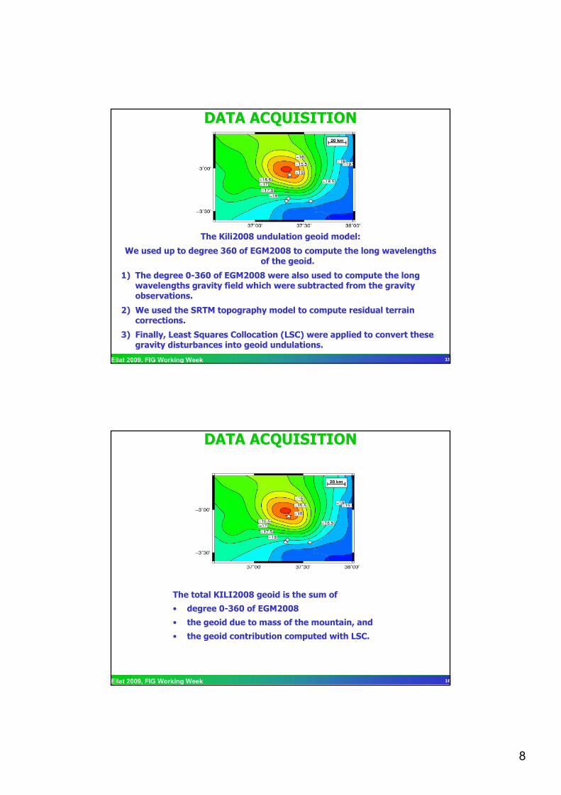
The Kili2008 undulation geoid model:
We used up to degree 360 of EGM2008 to compute the long wavelengths of the geoid.
1) The degree 0-360 of EGM2008 were also used to compute the long wavelengths gravity field which were subtracted from the gravityobservations.
2) We used the SRTM topography model to compute residual terrain corrections.
3) Finally, Least Squares Collocation (LSC) were applied to convert these gravity disturbances into geoid undulations.
DATA ACQUISITION
Sociedade de Geografia de Lisboa, 14 Janeiro 2008 16Eilat 2009, FIG Working Week
The total KILI2008 geoid is the sum of
• degree 0-360 of EGM2008
• the geoid due to mass of the mountain, and
• the geoid contribution computed with LSC.
DATA ACQUISITION

9
Sociedade de Geografia de Lisboa, 14 Janeiro 2008 17Eilat 2009, FIG Working Week
The differences between KILI2008 geoid and EGM2008
Moshi: -19 cm
Himo: -12 cm
Uhuru Peak: +24 cm
The ellipsoidal heights (h) and the Kili2008 undulations (N) areboth referred to the WGS84 ellipsoid. Therefore, the
orthometric height (H) is refered to the global datum used at EGM2008 that intends to minimize the differences between
the Mean Sea Surface and the geoid at a global scale.
EGM2008 model for Kilimanjaro region
DATA PROCESSING & RESULTS
Sociedade de Geografia de Lisboa, 14 Janeiro 2008 18Eilat 2009, FIG Working Week
The GNSS solutions were obtained using different GNSS data processing software packages. First, we computed the precise ellipsoidal heights (and horizontal coordinates) with respect to
the latest realization of the global reference frame – ITRF2005 –for the two reference stations (Moshi and Himo).
DATA PROCESSING & RESULTS

10
Sociedade de Geografia de Lisboa, 14 Janeiro 2008 19Eilat 2009, FIG Working Week
The position of that two stations were fixed in order to computethe ellipsoidal height of Uhuru Peak.
We have computed solutions using GIPSY, BERNESE, TBC (commercial software), and, for external check, we also used
online processing services: AUSPOS and SCOUT:
DATA PROCESSING & RESULTS
Sociedade de Geografia de Lisboa, 14 Janeiro 2008 20Eilat 2009, FIG Working Week
DATA PROCESSING & RESULTS
Differences between the solutions obtained with the academic applications reach 16 cm.
Possible causes:a) Different procedures used to align the solution with the ITRF2005;b) Different models for the antenna phase center;c) Different tropospheric models;

11
Sociedade de Geografia de Lisboa, 14 Janeiro 2008 21Eilat 2009, FIG Working Week
In Kilimanjaro region, only one benchmark with known orthometric height referred to the official Tanzanian vertical
datum was found close to Moshi. This point was observed with GNSS and the orthometric height with respect to KILI2008
datum was computed.
The difference to the global datum at Moshi was 1.28 m.
This offset was applied to the value computed for the Uhuru Peak with respect to the KILI2008 datum.
DATA PROCESSING & RESULTS
5890.95 m5890.79 mTanzanian Vertical Datum
5889.67 m5889.51 mKili2008 (Global) Datum
Bernese solutionGipsy solutionReference Datum
Sociedade de Geografia de Lisboa, 14 Janeiro 2008 22Eilat 2009, FIG Working Week
The final value obtained for the orthometric height of Mt. Kilimanjaro is about 4 m lower than the previous one
established by trigonometric leveling in the Tanzanian vertical datum (and about 5.5 m if we consider the global vertical
datum).
It is also 1.3 m lower than the estimate with GPS done in 1999.
Clearly, this difference is larger than the associated uncertainty of our computation.
CONCLUSIONS

12
Sociedade de Geografia de Lisboa, 14 Janeiro 2008 23Eilat 2009, FIG Working Week
By comparing the different computed solutions using different software and methodologies, we can say that the error in the computation of the ellipsoidal height is at decimeter level.
The error in geoid computation is also at decimeter level (±15 cm).
This give us a total uncertainty about 25 cm in the computed value of the orthometric height of Mt. Kilimanjaro.
CONCLUSIONS
Sociedade de Geografia de Lisboa, 14 Janeiro 2008 24Eilat 2009, FIG Working Week
The uncertainty value of 25 cm does not include the possible error on the conversion from the KILI2008 vertical datum into
the Tanzanian. Since we had only one point available, there was not the possibility to verify the measured offset.
CONCLUSIONS

13
Sociedade de Geografia de Lisboa, 14 Janeiro 2008 25Eilat 2009, FIG Working Week
The improvement on the computation of the final value for the orthometric height of Mt. Kilimanjaro is now more dependent
on the improvement in the models used to compute the ellipsoidal height and on the geoid computation than in the
acquisition of more field observations.
CONCLUSIONS
Sociedade de Geografia de Lisboa, 14 Janeiro 2008 26Eilat 2009, FIG Working Week
CONTACTS
PORTUGALRui Fernandes (UBI, IDL)[email protected]
Machiel Bos (UP, CIIMAR)[email protected]
TANZANIAJohn A. Msemwa (SMD)[email protected]