prehistoric and historic settlement patterns in western cyprus
TRANSCRIPT
Prehistoric and historic settlement patterns in western Cyprus (with a discussion of Cypriot Neolithic
stone tool technology)
By: J. M. Adovasio, G. F. Fry, J. D. Gunn and R. F. Maslowski
1975. J. Adovasio, G. Fry, J.D. Gunn, and R. Maslowski. Prehistoric and Historic Settlement Patterns of
Western Cyprus with a Discussion of Cypriote Neolithic Stone Tool Technology. World Archaeology
6(3), pp.339-364. DOI: 10.1080/00438243.1975.9979614
Made available courtesy of Taylor & Francis: http://www.tandf.co.uk/journals/titles/00438243.asp
***Reprinted with permission. No further reproduction is authorized without written permission from
Taylor & Francis. This version of the document is not the version of record. Figures and/or pictures may
be missing from this format of the document.***
Abstract:
Intensive site survey in the Paphos District of western Cyprus indicates considerable variation in preferred
settlement locus from the early Neolithic period to modern times. Settlement data for each major chronological
period are summarized and related to factors of topography, elevation, available water, lithic sources, access to
arable land, and potential for defence. Included is a discussion of Neolithic stone tool technology within the
survey area.
Article:
Introduction
Cyprus, with an area of 6,093 km2., is the third largest island in the Mediterranean. It is situated in the eastern
portion of that sea, south of Turkey and west of Syria. As Catling noted (1966: 4), the north coast of the island
lies under the eye of Anatolia. The nearest point on the Anatolian coast is some 69•2 km. north of Cape
Kormatiki, while Latakia in north Syria lies but 122.3 km. east of Cape Andreas, the tip of the Cypriot `pan
handle'. From Larnaca on the south coast to Port Said in the Nile delta, it is some 424.8 km. The nearest Greek
islands are 400-odd km. to the west.
Geologically, the island is of relatively recent origin and clearly constitutes a land mass formerly connected to
the Anatolian peninsula (Pantazis 1971). Palaeontological investigations have revealed a fauna which is
appropriate to a region which was once an integral part of Asia.
The principal geographic features of Cyprus are two mountain ranges in the north and south-west, separated by
the broad Mesaoria Plain. These ranges represent extensions of the Amanus and Casius ranges in nearby
Anatolia and north Syria.
The Northern or Kyrenia range forms a narrow belt running practically the whole length of the north coast. The
average elevation of this chain is c. 600 m. with a maximum elevation of 1,007 m. near the extreme western
edge of the range. In the east, these mountains gradually diminish in elevation as they extend out along the
narrow Karpass Peninsula.
The mountains in the south-west are known as the Southern or Troodos range. This range or massif is
substantially larger in area as well as higher in elevation than the Kyrenia chain and occupies nearly one half of
the island. The highest point in the Troodos is Mount Olympus or Chionistra, 1,920 m. above sea-level.
The research reported herein was initiated in the Khrysokhou river drainage of the Paphos District in far
western Cyprus (fig. 15). This area lies west of the Troodos Massif and is the major drainage running to the
north coast in the extreme western portion of the island.

Geology and topography
The geology of the Khrysokhou drainage is relatively uncomplicated. (The summary presented below is drawn
largely from a map prepared by Lapierre: 1971.) Directly adjacent to Khrysokhou Bay is a narrow strip of
marine terrace deposits of Pleistocene age. This strip, which is, in effect, the delta of the Khrysokhou, extends
inland some to 2 km. and consists primarily of calcarenites. To the east, this strip gradually feathers out along
the coast; while 8 km. west of Polis, it abuts on the lower reaches (c. 100 m. in elevation) of the Pakhna
Formation and the Lefkara Group. These geological units are of Upper Cretaceous to Miocene age and will be
discussed further below.
Directly south of Polis along the entire course of, and on both sides of, the Khrysokhou river are encountered
the Myrtou marls, sandy marls and calcarenites of the Nicosia Formation. These low-lying (less than ioo m. in
elevation), heavily dissected units are of Pliocene age.
Flanking terraces are pronounced on both sides of the Khrysokhou and rise in a series of steps to a maximum
elevation of some 600 m. These terraces consist of gypsum, marl, manly limestones, calcarenites and chalks
assignable to the Pakhna Formation and the Lefkara Group. These geological formations account for most of
the exposures encountered in the uplands of the Khrysokhou drainage and include in certain areas large
concentrations of chert contained within the chalk deposits. (These lithic sources are discussed in the Cypriot
Neolithic Technology section.)
Climate and hydrology
The Khrysokhou drainage shares in the Mediterranean climate which prevails over the rest of the island. Mean
maximum monthly temperatures range from 27° C in July and August to to° C in January and February while
mean maximum daily temperatures range from 32-35° C to 7—to° C during the aforementioned months. Mean
annual temperature is c. 19° C.
The Khrysokhou drainage presently lies within the 450--600 mm. per year rainfall cline with precipitation
normally falling during the winter months (Tullstrom 197o). However, the period encompassed by our survey

was practically devoid of rainfall. In fact, December 1973 was the last month in one of the longest and most
severe droughts in recent history.
The Khrysokhou is a 'dry' river and presently contains water only after heavy rains which are relatively
infrequent. Contained ground water is presently restricted in the Khrysokhou area to a series of reef and detrital
limestone aquifers within the Pakhna and Lefkara geological units. The aquifers are present on both the eastern
and western flanks of the Khrysokhou river. The Pakhna Formation also contains confined ground water in
highly retentive chalks interbedded with marls. The aquifers are confined to the higher elevations (i.e. above too
m.) of the Khrysokhou drainage. Ground water in the lower elevation is generally unconfined and encountered
in deltaic sand-gravel deposits, terrestrial fanglomerate and terrace formations.
Flora and Fauna
The present flora of the Khrysokhou drainage may be accurately called depauperate. Overgrazing by sheep and
goats coupled with the effects of cyclical erosion and drought has rendered much of the area a semi-desert.
Vegetation, where present, consists entirely of xeric flora with an occasional incidence in irrigated, or otherwise
well watered localities of cultivated olive, carob, orange, lemon and grapefruit trees. The most common
domesticate found in this area is grapes. Aleppo pine is occasionally encountered in the higher elevations of the
drainage.
Modern fauna, both terrestrial and avian, is likewise impoverished due chiefly to excessive hunting pressure.
Sundays and Wednesdays are 'shooting' days in the Khrysokhou area, with the unfortunate result that during
two seasons of survey, we observed but six wild animals (birds excluded) including one fox and five hares.
In prehistoric times this area may have been moderately to heavily forested with a wide range of mammalian
fauna available. However, controlled data on prehistoric flora and fauna in the Khrysokhou region is generally
lacking.
History of research and methodology In December of 1972 an archaeological reconnaissance of the Khrysokhou drainage was initiated. This
reconnaissance was expressly designed to investigate this relatively remote and almost archaeologically
unknown portion of the island. As originally conceived, the survey had two principal objectives: (I) the
delineation and elucidation of the nature, extent and fluctuation of prehistoric and historic settlement patterns
and (z) the identification and collection of Neolithic and possibly pre-Neolithic stone artefacts.
Survey headquarters were established in the town of Polis in the delta of the Khrysokhou river directly adjacent
to Khrysokhou Bay. During the survey, the west bank of the river was examined as far south as the village of
Skoulli, a distance of some 5.6 km. The east bank of the river was surveyed to the hamlet of Evretou, c. 9.7 km.
south-east of Polis. In addition to the river flood plain, the graded terraces, tributary gullies, washes and
canyons were surveyed to a distance of up to 4-8 km. east of the river at Phasli village. Additional forays were
made outside of the Khrysokhou drainage proper on to the uplands of the Akamas Peninsula to the west. All
areas were examined on foot and considerable effort was expended to insure that literally every potential site
locus was investigated and recorded. This survey was terminated in January of 1974.
All ceramic artefacts recovered during the survey were processed in the field and subsequently identified and
assigned chronological periods using comparative collections in the Cyprus Museum. Lithic artefacts were
analysed in the Department of Anthropology of the University of Pittsburgh.
All pertinent data recovered during the 1972-3 reconnaissance were programmed for computer analysis. The
data were coded according to the format presented in table 3. Two hundred and twenty-three sites were recorded
within the survey area delimited above. On the basis of extensive surface collections of ceramics and/or lithics,
the great majority of sites appear to represent multi-component occupations. Individual components were
identified on ceramic criteria by Mr Loulloupis of the Cyprus Museum. For the purposes of this analysis, the

presence of diagnostic rim sherds and/or bases of a known chronological period was sufficient to identify a
component at any given site. In the case of Neolithic components, assignations were occasionally made on the
presence of ground stone tools of established Neolithic configurations. On these bases alone, a total of 706
components were recognized at the 223 sites identified during the survey. The mean number of components
identified per site is 3-16.
The computer analysis, including mapping, treated all components of all sites as discrete representatives of
temporal settlement patterns. For this reason the term 'site' is frequently used interchangeably with component
in this study. All components were analysed relative to horizontal distribution, elevation and proximity to
aquifers or other potential water sources. The patterns which emerged were contour mapped by SYMAP
(SYnagraphic MAPping), a program developed at Harvard University and maintained on the University of
Pittsburgh Computer System.
Three occupational, elevational zones were utilized in this analysis: Zone I — 0 to 150 m. ; Zone II — 150 to
300 m.; Zone III — 300 m. and above. These zones were selected because they generally correspond to the
three major topographic discontinuities which exist in the Khrysokhou drainage. Zone I includes the flood plain
of the Khrysokhou and the lower flanking terraces on both sides of the river. Zone II includes gently sloping to
relatively steep hillsides, while Zone III is the flat plateau country high above the valley of the Khrysokhou.
The distribution of components within these zones was plotted through time. The sequent settlement patterns
which emerged from this analysis are herein termed settlement systems and are described and discussed below
by standard chronological periods. If patterns were constant for a number of periods, these periods were lumped
in the analysis. The periods used below and their temporal limits are adapted from Karageorghis (i969) and
Bucholz and Karageorghis (1973).
Settlement systems in the Khrysokhou drainage
Pre-Neolithic: ?-5800 B.C.
Despite intensive scrutiny, no sites which could positively be identified as pre-Neolithic were recorded within
the Khrysokhou drainage. However, several individual artefact discoveries were made which strongly suggest
the distinct possibility of pre-Neolithic occupation of this area. All of these discoveries were made in Zones II
and III and are discussed in detail in the Neolithic technology section.

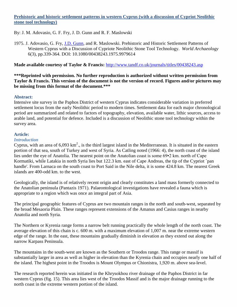
Neolithic: 5800-3000 B.C.
Twelve Neolithic components were located in the Khrysokhou drainage. All, with one exception, appear to
represent substantial settlements ranging from a minimum of 0.5 to a maximum of 5 h. in extent. The exception
is a very small settlement which may be a single homestead or hamlet. The distribution of Neolithic sites is
plotted in fig. 16. As indicated, there is a definite preference during this period for higher elevation sites on both
the east and west flanks of the Krysokhou. The majority (8) of the Neolithic sites are situated in elevational
Zone II, that is between 150 and 300 m. above sea-level. Two sites are located in upper Zone I very nearly at
the interface of Zones I/II ; while three sites are located well up in Zone III. Topographically, Zones II and III
include gently sloping to relatively steep hillsides, the tops of steep hillocks, high saddles as well as high
plateaus. All of these localities are directly adjacent to permanent water in the form of seeps and springs and the
distribution of Neolithic sites corresponds almost perfectly with the plotted extent of the limestone aquifers
contained within the Pakhna and Lefkara geological units.
Of secondary, but by no means minimal, importance in the location of Neolithic sites is the immediate
availability of a variety of high grade cherts, flints and other crypto-crystalline rocks within the limits of Zones
II and III. Similarly, these zones are rich in andesite which was heavily utilized in the manufacture of ground
stone tools during the Neolithic.
Arable land in the direct vicinity of Neolithic sites is, with the exception of the settlement at Myrmikoph, quite
marginal and must have been so in prehistoric times. The location of these sites does, however, provide ready
access to upland biota, which was apparently rich, as well as to resources of the Khrysokhou valley bottom.
Defensibility, per se, does not appear to have been a major factor in the disposition of Neolithic sites within the
Khrysokhou drainage, though their high elevation provides them with no little advantage in that regard.
Significantly, the Neolithic settlement pattern represented in the survey area has also been repeated from
elsewhere on the island and now appears to be the standard type for the Neolithic period (Catling 1966;
Karageorghis 1969).
Chalcolithic: 3000-2300 B.C.
Only two sites ascribable to this period were recorded in the survey area. Both are settlements located in Zone
II. The low frequency of Chalcolithic sites may reflect a diminution of population during this period or the more
likely possibility that Chalcolithic sites are totally masked by later occupations. Since the location of the two
Chalcolithic sites represents no change from the preceding period, they were mapped along with the Neolithic
sites and are so plotted in fig. 16.
Presumably, the preference for higher elevations during the Chalcolithic reflects the continuing operation of the
same selectional processes as were operative during the Neolithic. The Chalcolithic preference for high altitude
settlements near permanent water has been documented for other parts of the island (Catling 1966: 15).
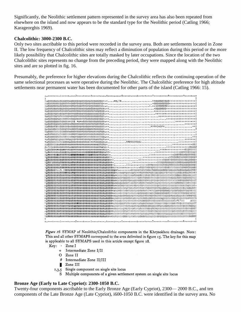
Bronze Age (Early to Late Cypriot): 2300-1050 B.C.
Twenty-four components ascribable to the Early Bronze Age (Early Cypriot), 2300— 2000 B.C., and ten
components of the Late Bronze Age (Late Cypriot), i600-1050 B.C. were identified in the survey area. No
Middle Bronze Age sites (Middle Cypriot), 2000—1600 B.C., were encountered anywhere in the Khrysokhou
drainage or the adjacent Akamas highlands. The 34 Bronze Age components include: 20 small to medium-size
settlements, 5 large settlements (surface scatters greater than zoo m2.), 4 settlements with adjacent cemeteries,
and 5 cemeteries.
All Bronze Age components have been grouped together in this analysis because the basic settlement pattern is,
with the notable hiatus during Middle Bronze times, relatively homogeneous throughout this period. As fig. 17
shows, Bronze Age sites tend to be located at lower elevations than their Neolithic predecessors. While a lrage
number of sites continue to occur in Zone II, there is a dramatic increase in sites from Zone I. It should be
stressed that the Bronze Age sites from Zone II are located, as a rule, proportionally lower than the earlier
Neolithic sites within the same zone. Likewise, despite the fact that Bronze Age sites continue to be erected on
eminences, perhaps for defensive reasons, rarely are these features as steep or precipitous as those utilized
during the Neolithic. All of the above underscores the basic fact that Bronze Age sites tend to occur in closer
proximity to the narrow Khrysokhou flood plain. This trend towards lower elevations as preferred site loci is
probably related to the significantly greater amount of arable land available at these elevations. Conversely,
proximity to Ethic sources and aquifers appears to be a much less important settlement variable during the
Bronze Age.
The absence of Middle Bronze Age sites in the Khrysokhou area is somewhat enigmatic. According to
Karageorghis (1973 : 133), Cyprus became wealthy during this period as a result of trade with its Near Eastern
neighbours. Apparently, however, this wealth is not reflected in settlement density which Catling (1966: 37)
notes is generally low at this time, particularly in western Cyprus. It may well be that Middle Bronze Age sites
within the Khrysokhou have been obliterated by later occupations. In this regard it may be noted that Late
Bronze Age sites in the survey area are somewhat scarcer than Early Bronze sites and occasionally reverse the
trend noted above to lower elevations. Several Late Bronze Age sites, including a substantial fortified

settlement, occur in Zone III. These sites are anomalies of a sort, as they occur where arable land is scarce
though permanent water is abundant. All the upland Late Bronze sites do have enormous defensive potential,
however, which could account for their location. It should be, added that the upland as well as lowland Late
Bronze sites in the Khrysokhou drainage represent divergences from the Late Bronze pattern on the rest of the
island. Sites of this period tend to be clustered on the coasts (Catling: 1966: 50) rather than the interior.
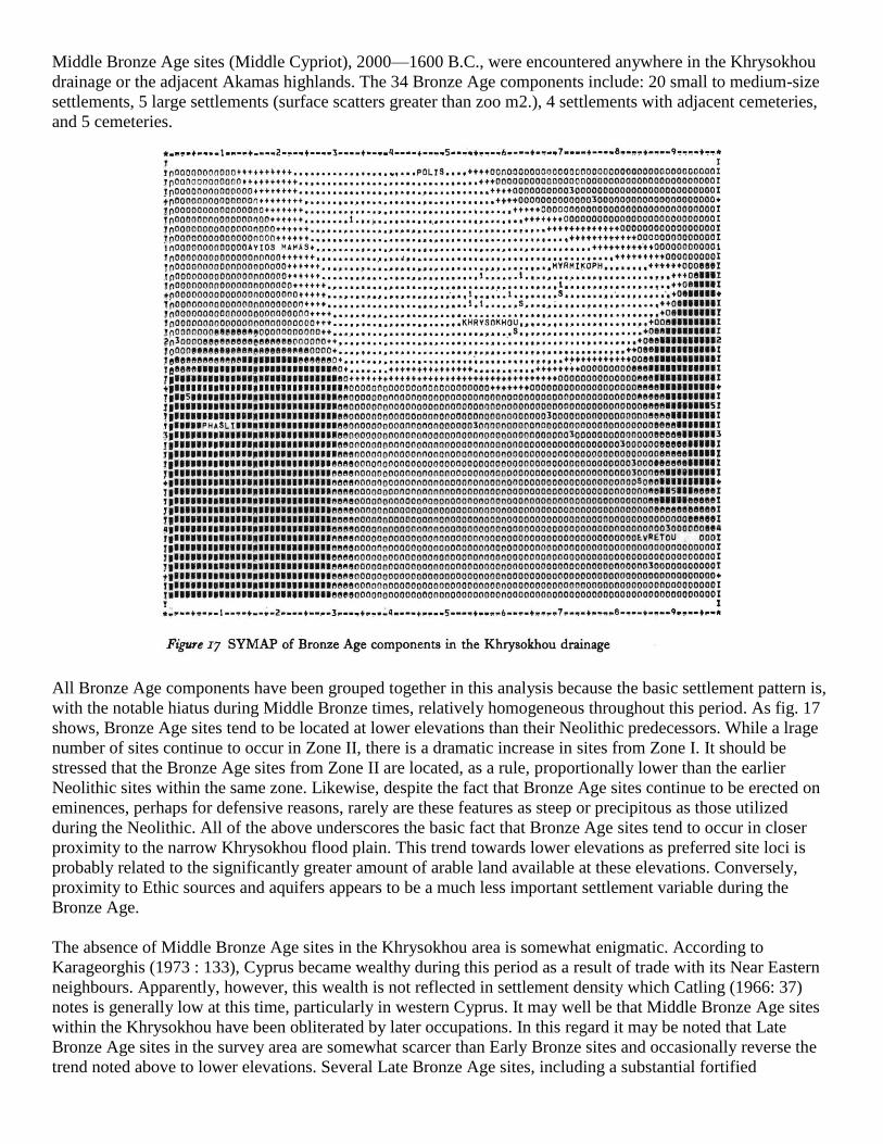
Cypro-Geometric to Hellenistic: 1050-50 B.C.
Included here are one Cypro-Geometric cemetery (1050-700 B.C.); 9 cemeteries, I household (hamlet), 14 small
to medium-size settlements, and 1 large settlement of Cypro-Archaic Age (600-400 B.C.); 10 cemeteries, 2
households, 21 small to medium- size settlements, and 2 settlements with associated cemeteries of Cypro-
Classical Age (400-325 B.C.); and 3 cemeteries, 18 small to medium-size settlements, 1 large settlement and 4
settlements with adjacent cemeteries of the Hellenistic period (325—50 B.C.). All of the foregoing components
are restricted to Zones I and II and for this reason are treated as a unit and so plotted in fig. 18.
The settlement pattern represented by the eighty-seven sites ascribed to this settlement system reflects the
culmination of the trend towards progressively lower site locus preference initiated in the Bronze Age. The
prime locational variable in the distribution of all sites of this time appears to be access to arable land. Virtually
all of the eighty- seven sites are located on low-lying terraces or knolls directly adjacent to the flood plain, or on
the slightly higher, gently sloping flanks on either side of the river. Few of the lowland sites appear to have been
selected for their natural defensive potential. A notable exception to the lowland preference pattern is a single
very large Hellenistic town with associated cemetery located near the upper limits of Zone II. This town
dominates a natural pass in the flanking hills adjacent to the Khrysokhou drainage and literally controls access
to the valley bottom from this direction. If terracing is practised, arable land is moderately plentiful in the
vicinity of this settlement and the defensive, or, more accurately, strategic advantages of the site are great. This
town probably represented the major upland habitation in the entire Khrysokhou drainage during Hellenistic
times.
It should be added that with the exception of the Cypro-Geometric period, apparently represented by a solitary
cemetery, the density of settlement appears to be more or less constant during this entire time span. The scarcity
of Cypro-Geometric settlements is not readily explainable as the single cemetery located during the survey is
exceptionally large, and suggests a reasonably substantial population. Finally, if the sheer number of
components ascribable to any settlement system considered in this study is any direct sign of population
density, the system discussed here represents the highest population density yet encountered in the Khrysokhou
archaeological sequence.
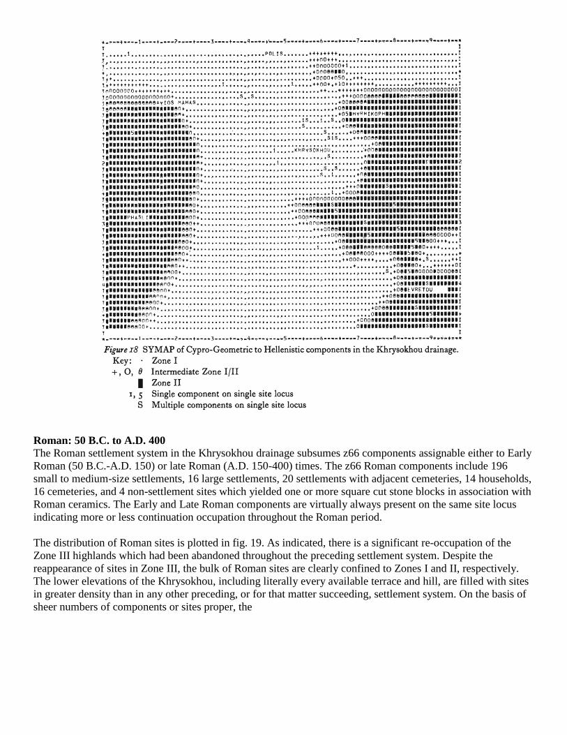
Roman: 50 B.C. to A.D. 400
The Roman settlement system in the Khrysokhou drainage subsumes z66 components assignable either to Early
Roman (50 B.C.-A.D. 150) or late Roman (A.D. 150-400) times. The z66 Roman components include 196
small to medium-size settlements, 16 large settlements, 20 settlements with adjacent cemeteries, 14 households,
16 cemeteries, and 4 non-settlement sites which yielded one or more square cut stone blocks in association with
Roman ceramics. The Early and Late Roman components are virtually always present on the same site locus
indicating more or less continuation occupation throughout the Roman period.
The distribution of Roman sites is plotted in fig. 19. As indicated, there is a significant re-occupation of the
Zone III highlands which had been abandoned throughout the preceding settlement system. Despite the
reappearance of sites in Zone III, the bulk of Roman sites are clearly confined to Zones I and II, respectively.
The lower elevations of the Khrysokhou, including literally every available terrace and hill, are filled with sites
in greater density than in any other preceding, or for that matter succeeding, settlement system. On the basis of
sheer numbers of components or sites proper, the
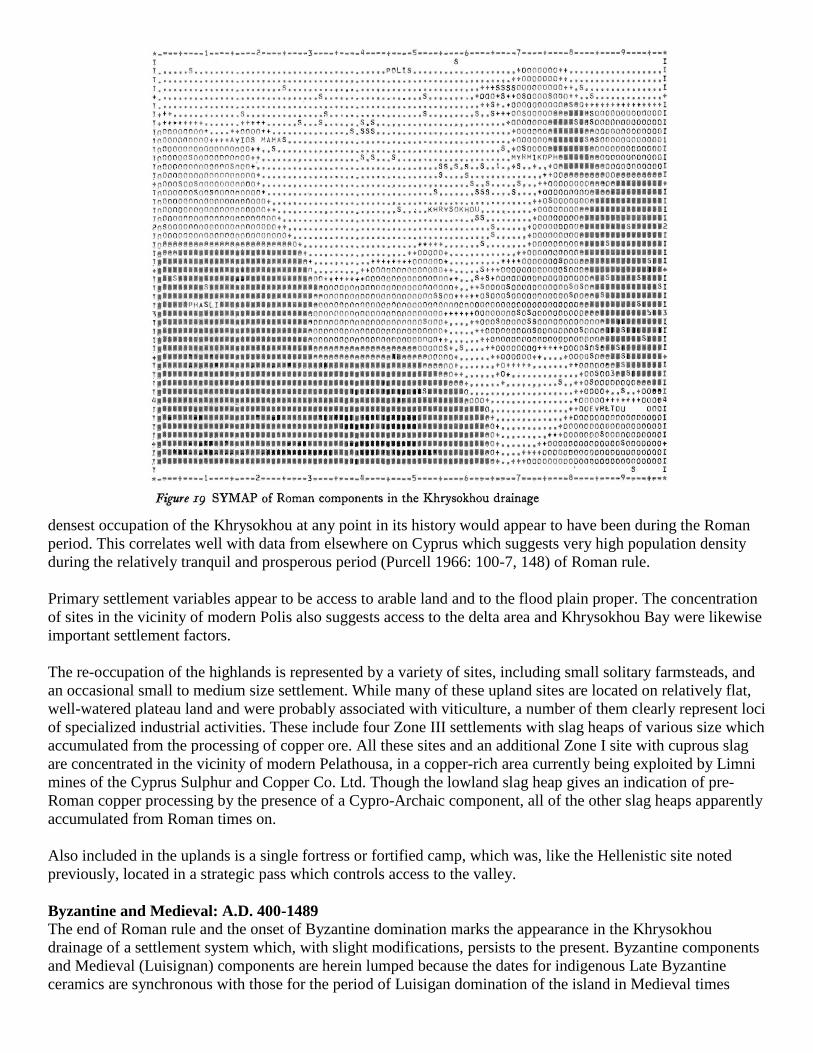
densest occupation of the Khrysokhou at any point in its history would appear to have been during the Roman
period. This correlates well with data from elsewhere on Cyprus which suggests very high population density
during the relatively tranquil and prosperous period (Purcell 1966: 100-7, 148) of Roman rule.
Primary settlement variables appear to be access to arable land and to the flood plain proper. The concentration
of sites in the vicinity of modern Polis also suggests access to the delta area and Khrysokhou Bay were likewise
important settlement factors.
The re-occupation of the highlands is represented by a variety of sites, including small solitary farmsteads, and
an occasional small to medium size settlement. While many of these upland sites are located on relatively flat,
well-watered plateau land and were probably associated with viticulture, a number of them clearly represent loci
of specialized industrial activities. These include four Zone III settlements with slag heaps of various size which
accumulated from the processing of copper ore. All these sites and an additional Zone I site with cuprous slag
are concentrated in the vicinity of modern Pelathousa, in a copper-rich area currently being exploited by Limni
mines of the Cyprus Sulphur and Copper Co. Ltd. Though the lowland slag heap gives an indication of pre-
Roman copper processing by the presence of a Cypro-Archaic component, all of the other slag heaps apparently
accumulated from Roman times on.
Also included in the uplands is a single fortress or fortified camp, which was, like the Hellenistic site noted
previously, located in a strategic pass which controls access to the valley.
Byzantine and Medieval: A.D. 400-1489
The end of Roman rule and the onset of Byzantine domination marks the appearance in the Khrysokhou
drainage of a settlement system which, with slight modifications, persists to the present. Byzantine components
and Medieval (Luisignan) components are herein lumped because the dates for indigenous Late Byzantine
ceramics are synchronous with those for the period of Luisigan domination of the island in Medieval times
(A.D. 1192 to 1489). Medieval ceramics are different, however, than local Late Byzantine wares; thus, the two
ceramic traditions, while synchronous, are not synonymous.
Included in this settlement system are 88 components of Early Byzantine age (A.D. 400-700), 15 components of
Middle Byzantine age (A.D. 700-1192), 36 components of Late Byzantine age and 20 Medieval (Luisignan)
components (A.D. 1192-1489). The 159 Byzantine/Medieval components include 1o8 small to medium-size
settlements, to large settlements, 14 households, 12 settlements with adjacent cemeteries, 8 cemeteries and 7
non-settlement/cemetery sites with evidence of Byzantine or Medieval utilization.
Byzantine and Medieval components are mapped in fig. 2o. With the exception of a slight decrease in the
proportion of sites in Zone I and a marked decrease in the total number of sites represented, there is little change
from the preceding Roman settlement system.
The dramatic diminution of sites during Byzantine times is ascribable to a number of factors (Purcell 1966: 105-
60). Of primary importance are a series of earthquakes which struck Cyprus from A.D. 332 to the end of Roman
rule on the island. These quakes caused severe damage to settlements and disrupted water supplies either by
destroying aqueducts (Karageorghis 1969: 226) and/or altering the prevailing water table. The effects of the
latter would be felt most profoundly in lowland areas, heavily dependent on unconfined ground water, such as
Zone I in the Khrysokhou drainage.
To further compound matters, the isostatic cataclysms noted above were often accompanied by droughts,
famines, plagues and other disastrous 'acts of God' with the result that the first half of the fourth century saw a
catastrophic decline in Cypriot population (Purcell 1969: 105-6).
While Cypriot population density increased somewhat after the effects of the natural calamities had dissipated, a
series of Arab raids from c. 648-965 caused further settlement destruction and attendant loss of life.
It is presumed that the decrease in frequency of sites in the Khrysokhou drainage is but a reflection of the more
general population decline and settlement attrition evidenced throughout Cyprus during earlier Byzantine times.
Here it might be added that an eloquent testimonial to local conditions within the Khrysokhou drainage is
available from the industrial sites isolated in the preceding period. While all show signs of continuing
occupation in Early Byzantine times, the smelting of copper ceases abruptly thereafter and was never resumed
until the present.
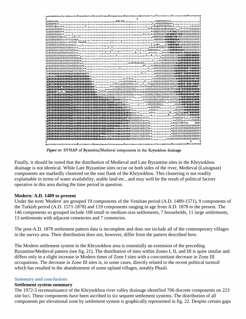
Finally, it should be noted that the distribution of Medieval and Late Byzantine sites in the Khrysokhou
drainage is not identical. While Late Byzantine sites occur on both sides of the river, Medieval (Luisignan)
components are markedly clustered on the east flank of the Khrysokhou. This clustering is not readily
explainable in terms of water availability, arable land etc., and may well be the result of political factors
operative in this area during the time period in question.
Modern: A.D. 1489 to present
Under the term 'Modern' are grouped 19 components of the Venitian period (A.D. 1489-1571), 9 components of
the Turkish period (A.D. 1571-1878) and 119 components ranging in age from A.D. 1878 to the present. The
146 components so grouped include 108 small to medium-size settlements, 7 households, 11 large settlements,
13 settlements with adjacent cemeteries and 7 cemeteries.
The post-A.D. 1878 settlement pattern data is incomplete and does not include all of the contemporary villages
in the survey area. Their distribution does not, however, differ from the pattern described here.
The Modern settlement system in the Khrysokhou area is essentially an extension of the preceding
Byzantine/Medieval pattern (see fig. 21). The distribution of sites within Zones I, II, and III is quite similar and
differs only in a slight increase in Modern times of Zone I sites with a concomitant decrease in Zone III
occupations. The decrease in Zone III sites is, in some cases, directly related to the recent political turmoil
which has resulted in the abandonment of some upland villages, notably Phasli.
Summary and conclusions
Settlement system summary
The 1972-3 reconnaisaance of the Khrysokhou river valley drainage identified 706 discrete components on 223
site loci. These components have been ascribed to six sequent settlement systems. The distribution of all
components per elevational zone by settlement system is graphically represented in fig. 22. Despite certain gaps

in the record (e.g. the Middle Bronze Age), the available data clearly suggest a number of basic trends in the
evolution of settlement systems within the Khrysokhou drainage.
During the Neolithic/Chalcolithic settlement system there is a definite preference for high-altitude habitations
with a corresponding avoidance of the Zone I lowlands. Primary locational considerations appear to have been
access to permanent, contained ground water in the Zone II aquifers and the availability of various crypto-
crystalline rocks and andesite within the same zone and adjacent Zone III. Of marginal concern, at least during
this settlement system, is access to arable land which is generally scarce in the vicinity of all but one
Neolithic/Chalcolithic site. The lack of arable land is perhaps indicative of a low reliance on agricultural
products with a corresponding dependence on wild food resources. If this is the case, the location of the
Neolithic/ Chalcolithic sites provides ready access to the potentially rich highland biome. While
Neolithic/Chalcolithic sites tend to occur in naturally defensible localities, this does not appear to have been a
primary locational concern.
The Bronze Age settlement system is marked by the initiation of a trend towards lower elevations as preferred
site loci. Access to arable land and the Khrysokhou flood plain appear to be the primary settlement variables.
Proximity to lithic sources would seem to be of much less importance than in the preceding settlement system;
while, access to the aquifers of Zone II is likewise a reduced, though by no means inconsequential, settlement
factor. Defensive potential may well be a consideration during this time, particularly in the location of certain
Zone III loci towards the end of this settlement system.
During the Cypro-Geometric to Hellenistic settlement system, the trend towards lower site loci reaches its
zenith. Most sites are concentrated in the lower portions of Zone II and in the lowlands of Zone I, while the
uplands of Zone III are deserted. Again, access to arable land and the flood plain are primary settlement
considerations. Continued selection for defensive potential is reflected in the upper Zone II Hellenistic
fortress/town.

The Roman settlement system witnesses the re-occupation of the Zone III highlands as well as the continued
proliferation of sites in lower Zones II and I respectively. The re-occupation of the uplands is apparently related
both to agricultural, or more properly viticultural, concerns and to a new variable, access to copper deposits.
The concentration of sites in the vicinity of modern Polis suggests access to the delta as well as to Khrysokhou
Bay were likewise important Roman settlement variables.
The settlement system initiated in Byzantine/Medieval times is, with minor fluctua-
tions, continued to the present. bites are encountered in all three zones though the concentration is in the lower
elevations. Arable land is the primary locational consideration. The operation of various political factors is
apparent at several junctures during all of the post-Roman settlement systems and is manifested today by the
desertion of certain Zone III sites.
With the signal exception of the trend towards lower site loci as preferred habitations, perhaps the most notable
factor in the six settlement systems summarized above is the relatively constant proportion of sites in Zone II.
Though the number of sites in Zones I and III change considerably through time, Zone II is never seriously
depopulated, much less abandoned totally (cf. Bronze Age Zone III). This settlement continuity is probably
directly tied to the reef and detrital limestone aquifers of Zone II which may well have provided a constant
supply of water even during the disastrous earthquakes of the late fourth century A.D.
Population trends
Certain trends in the population of the Khrysokhou drainage through time may, with caution, be abstracted from
the settlement data presented above. Using the sheer number of components of all types per settlement system
as general indicators of population density, it is possible to reconstruct a population histogram for the
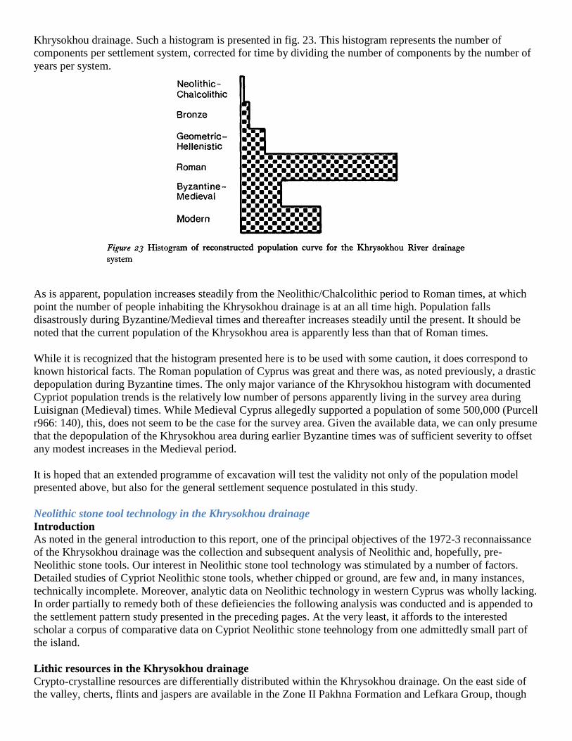
Khrysokhou drainage. Such a histogram is presented in fig. 23. This histogram represents the number of
components per settlement system, corrected for time by dividing the number of components by the number of
years per system.
As is apparent, population increases steadily from the Neolithic/Chalcolithic period to Roman times, at which
point the number of people inhabiting the Khrysokhou drainage is at an all time high. Population falls
disastrously during Byzantine/Medieval times and thereafter increases steadily until the present. It should be
noted that the current population of the Khrysokhou area is apparently less than that of Roman times.
While it is recognized that the histogram presented here is to be used with some caution, it does correspond to
known historical facts. The Roman population of Cyprus was great and there was, as noted previously, a drastic
depopulation during Byzantine times. The only major variance of the Khrysokhou histogram with documented
Cypriot population trends is the relatively low number of persons apparently living in the survey area during
Luisignan (Medieval) times. While Medieval Cyprus allegedly supported a population of some 500,000 (Purcell
r966: 140), this, does not seem to be the case for the survey area. Given the available data, we can only presume
that the depopulation of the Khrysokhou area during earlier Byzantine times was of sufficient severity to offset
any modest increases in the Medieval period.
It is hoped that an extended programme of excavation will test the validity not only of the population model
presented above, but also for the general settlement sequence postulated in this study.
Neolithic stone tool technology in the Khrysokhou drainage
Introduction
As noted in the general introduction to this report, one of the principal objectives of the 1972-3 reconnaissance
of the Khrysokhou drainage was the collection and subsequent analysis of Neolithic and, hopefully, pre-
Neolithic stone tools. Our interest in Neolithic stone tool technology was stimulated by a number of factors.
Detailed studies of Cypriot Neolithic stone tools, whether chipped or ground, are few and, in many instances,
technically incomplete. Moreover, analytic data on Neolithic technology in western Cyprus was wholly lacking.
In order partially to remedy both of these defieiencies the following analysis was conducted and is appended to
the settlement pattern study presented in the preceding pages. At the very least, it affords to the interested
scholar a corpus of comparative data on Cypriot Neolithic stone teehnology from one admittedly small part of
the island.
Lithic resources in the Khrysokhou drainage
Crypto-crystalline resources are differentially distributed within the Khrysokhou drainage. On the east side of
the valley, cherts, flints and jaspers are available in the Zone II Pakhna Formation and Lefkara Group, though
there is a marked scarcity of materials suitable for knapping north of Evretou. In the general vicinity of Evretou,
a variety of high-grade whitish and tan cherts is generally available in the form of nodules which occur in
clastic, redeposited limestone outcrops. South of Evretou, pebbles and cobbles of translucent chalcedony can be
found lying on the upland fields and atop ridges.
On the west side of the Khrysokhou, the Zone II and III uplands are mueh more richly endowed with cherts,
flints and jaspers suitable for tool making. The reef and detrital limestones, again of the Pakhna and Lefkara
Units, on this side of the valley contain nodular crypto-crystalline materials of diverse morphology and colours.
Commonly encountered are blue and black flints and cherts, yellow and red jaspers, as well as tan and white
cherts. These last are similar to the crypto-crystalline materials of the same colours found across the valley.
South and west of Neokhorion in the Zone III highlands of the Akamas Peninsula are exposures of bedded chert
ascribable to the Mammonia Formation Cherts Unit. Cherts of this formation are occasionally encountered at
lower elevations of the west flank of the Khrysokhou and were utilized in prehistoric tool production.
Owing to the variety of lithic sources available on the west flank of the Khrysokhou, one is virtually never out
of sight of a potential supply of raw material for tool manufacturing. Many of the nodules which litter the Zone
II and III fields at present are, however, small and shattered, with larger pieces a relative rarity.
Exposures of igneous rocks, notably andesite, are also relatively common in the Zone II uplands on both sides
of the Khrysokhou and were heavily exploited in the production of Neolithic ground stone artefacts.
Chipped stone
The chipped stone industry from the Khrysokhou drainage is known primarily through two surface collections
made at the sites of Ayios Mamas on the west side of the valley and Myrmikoph on the east (fig. 15). Though
Neolithic chipped stone artefacts were recovered from other sites in the Khrysokhou drainage, these seldom
amount to more than a dozen pieces. These incidental finds can only serve to illuminate the distribution of
artefact types or industries identified at the two major Neolithic sites in the area.
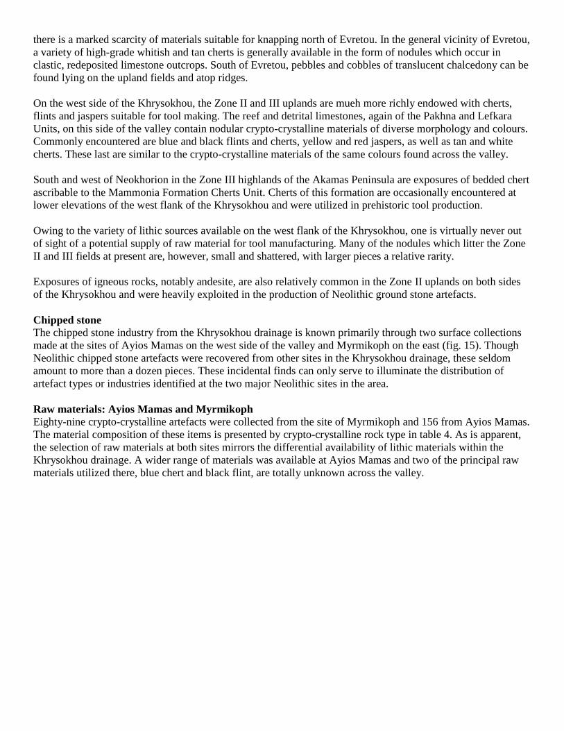
Raw materials: Ayios Mamas and Myrmikoph
Eighty-nine crypto-crystalline artefacts were collected from the site of Myrmikoph and 156 from Ayios Mamas.
The material composition of these items is presented by crypto-crystalline rock type in table 4. As is apparent,
the selection of raw materials at both sites mirrors the differential availability of lithic materials within the
Khrysokhou drainage. A wider range of materials was available at Ayios Mamas and two of the principal raw
materials utilized there, blue chert and black flint, are totally unknown across the valley.
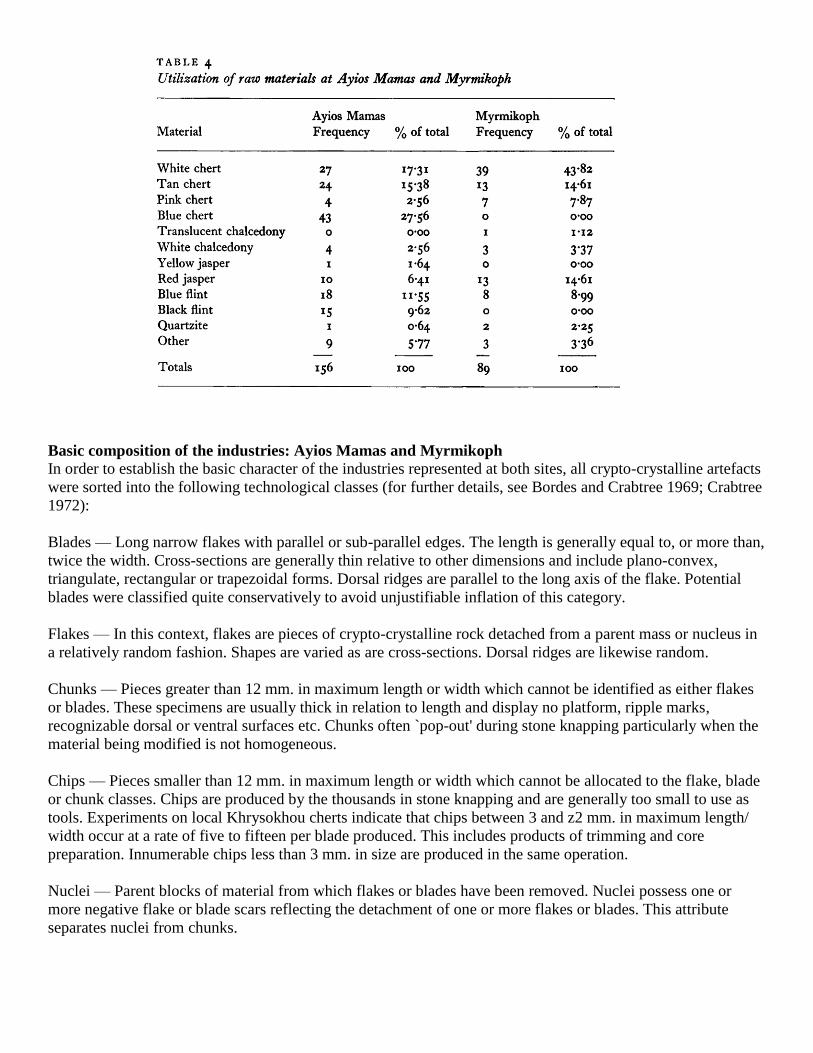
Basic composition of the industries: Ayios Mamas and Myrmikoph
In order to establish the basic character of the industries represented at both sites, all crypto-crystalline artefacts
were sorted into the following technological classes (for further details, see Bordes and Crabtree 1969; Crabtree
1972):
Blades — Long narrow flakes with parallel or sub-parallel edges. The length is generally equal to, or more than,
twice the width. Cross-sections are generally thin relative to other dimensions and include plano-convex,
triangulate, rectangular or trapezoidal forms. Dorsal ridges are parallel to the long axis of the flake. Potential
blades were classified quite conservatively to avoid unjustifiable inflation of this category.
Flakes — In this context, flakes are pieces of crypto-crystalline rock detached from a parent mass or nucleus in
a relatively random fashion. Shapes are varied as are cross-sections. Dorsal ridges are likewise random.
Chunks — Pieces greater than 12 mm. in maximum length or width which cannot be identified as either flakes
or blades. These specimens are usually thick in relation to length and display no platform, ripple marks,
recognizable dorsal or ventral surfaces etc. Chunks often `pop-out' during stone knapping particularly when the
material being modified is not homogeneous.
Chips — Pieces smaller than 12 mm. in maximum length or width which cannot be allocated to the flake, blade
or chunk classes. Chips are produced by the thousands in stone knapping and are generally too small to use as
tools. Experiments on local Khrysokhou cherts indicate that chips between 3 and z2 mm. in maximum length/
width occur at a rate of five to fifteen per blade produced. This includes products of trimming and core
preparation. Innumerable chips less than 3 mm. in size are produced in the same operation.
Nuclei — Parent blocks of material from which flakes or blades have been removed. Nuclei possess one or
more negative flake or blade scars reflecting the detachment of one or more flakes or blades. This attribute
separates nuclei from chunks.
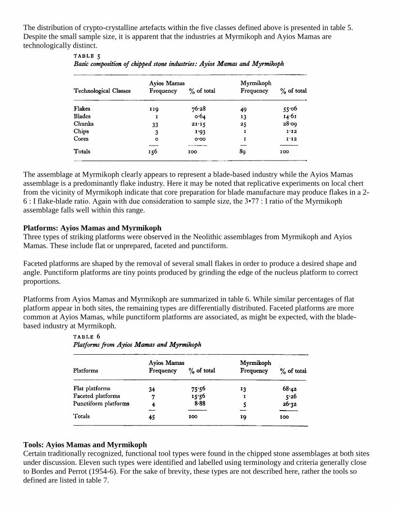
The distribution of crypto-crystalline artefacts within the five classes defined above is presented in table 5.
Despite the small sample size, it is apparent that the industries at Myrmikoph and Ayios Mamas are
technologically distinct.
The assemblage at Myrmikoph clearly appears to represent a blade-based industry while the Ayios Mamas
assemblage is a predominantly flake industry. Here it may be noted that replicative experiments on local chert
from the vicinity of Myrmikoph indicate that core preparation for blade manufacture may produce flakes in a 2-
6 : I flake-blade ratio. Again with due consideration to sample size, the 3•77 : I ratio of the Myrmikoph
assemblage falls well within this range.
Platforms: Ayios Mamas and Myrmikoph
Three types of striking platforms were observed in the Neolithic assemblages from Myrmikoph and Ayios
Mamas. These include flat or unprepared, faceted and punctiform.
Faceted platforms are shaped by the removal of several small flakes in order to produce a desired shape and
angle. Punctiform platforms are tiny points produced by grinding the edge of the nucleus platform to correct
proportions.
Platforms from Ayios Mamas and Myrmikoph are summarized in table 6. While similar percentages of flat
platform appear in both sites, the remaining types are differentially distributed. Faceted platforms are more
common at Ayios Mamas, while punctiform platforms are associated, as might be expected, with the blade-
based industry at Myrmikoph.
Tools: Ayios Mamas and Myrmikoph
Certain traditionally recognized, functional tool types were found in the chipped stone assemblages at both sites
under discussion. Eleven such types were identified and labelled using terminology and criteria generally close
to Bordes and Perrot (1954-6). For the sake of brevity, these types are not described here, rather the tools so
defined are listed in table 7.

Comparatively, the proportion of tool types represented at Ayios Mamas and Myrmikoph is similar, notably in
scrapers, notched pieces and retouched pieces. Ayios Mamas, however, has a richer selection of tool types and
includes four more types than are present ay Myrmikoph.
In addition to the types listed in table 7, Myrmikoph produced a medial blade fragment of red jasper with
noticeable sickle sheen. This is the only such item encountered during the entire survey.
Ground stone
Ground stone tools were encountered in great abundance in the Khrysokhou drainage and were used, in some
cases, as the primary criterion for the identification of Neolithic sites. Forms represented included mortars,
pestles, mans, querns, adzes, celts, axes and several varieties of 'sharpening' stones. Though no attempt was
made to make sizeable collections of these items, considerable attention was devoted to ascertaining the
operational construction sequence of ground stone artefacts. Specimens representing all stages of the
manufacturing sequence were recovered at Ayios Mamas and Myrmikoph and the standard Neolithic
production procedure within the Khrysokhou drainage appears to be as follows: initially, a cobble of igneous
rock, preferably grey/green andesite, was selected from one of the many locally abundant Zone II outcrops in
the valley. No little effort appears to have been spared in selecting a piece as near as possible to the shape and
size of the intended finished implement. Such andesite `blanks' frequently litter Neolithic sites in the
Khrysokhou area.
Next, the cobble was unifacially, or rarely bifacially, chipped to thin and shape it to the desired outline or
profile. Finally, this preform was then ground to the desired proportions and smoothness using a grinding stone
which was also of andesite.
Some insight into the final phases of the construction operation were gained through replicative experiments. A
miniature adze preform was chipped out and one long edge was ground. It was readily apparent that the
grinding operation was most efficient and rapid when the grinding stone was moistened with water. The choice
of andesite as a grinding stone maximizes the principle that abrasion of materials of the same substance tends to
generate more friction than materials of different substances. By moistening the hammerstone in water, residue
from the grinding process is retained on the surface of the stone, thus increasing friction still further. This
residue or paste is essential to the operation and care must be taken that too much much water is not added to
the surface.

Grinding the edge and side of an adze blade approximately 50 mm. in length required 3o minutes of labour.
Presumably an experienced artisan could finish a job of this magnitude in an hour or two. In this perspective,
the great number of ground stone tools found on Cypriot Neolithic sites is not surprising. Rather, it is a
testimony to the basic efficiency of the manufacturing sequence detailed above.
Summary and conclusions
On the somewhat slender evidence presented on the preceding pages, several basic conclusions about Neolithic
stone technology in the Khrysokhou drainage may be drawn. First, it would appear that at least two basic
chipped stone industries are represented in the area: a blade-based industry at Myrmikoph and a flake industry
at Ayios Mamas. Second, a well-developed ground stone industry is associated with both chipped stone
complexes. While, in point of fact, ground stone tools are both more numerous and diversified in the
Khrysokhou area than their chipped stone counterparts. This discussion will focus on the latter.
Obviously, the most salient fact about the chipped stone industries from Ayios Mamas and Myrmikoph is their
diversity. This diversity extends from the selection of crypto-crystalline raw materials through basic production
operations to frequency of functional tool types. The industry from Myrmikoph, with its generalized blade tech-
nology and relatively lower number of distinct tool types, appears more typically 'Neolithic' than the industry
from Ayios Mamas. Conversely, the Ayios Mamas assemblage, though based on flakes, is typologically more
specialized and, hence, resembles Upper Palaeolithic or even earlier industries with their high number of
specific tool types. The use of faceted platforms at Ayios Mamas underscores this resemblance. Faceted plat-
forms are traditionally associated with Mousteroid industries which lasted almost into the Holocene in some
areas of the Levant. On these criteria, it is suggested that the Ayios Mamas assemblage is more conservative
and may be the older of the two in question.
This position would seem to be supported by several other factors, not the least of which is the ecology of the
sites themselves. Myrmikoph is located very nearly at the interface of Zones I and II on a large, flat tract of rich,
arable land. Permanent water from the Zone II aquifers is locally abundant. It is, in short, an ideal location for
an agricultural settlement.
Ayios Mamas, on the other hand, though located at roughly the same elevation is strikingly different. The
terrain, except for a narrow corridor leading through the site, is impassable to all except goats, sheep, and slow
moving humans. Bush-sized blocks of jagged limestone up to a metre high cover the landscape.
Vegetation is restricted to a few hardy xerophytic plants. Though Ayios Mamas is a huge site (c. 5 h2.) and
occupies much of a plateau bound on both sides by sheer canyons trending north-east to south-west, arable land
is at a bare minimum. Subsistence, in the immediate vicinity of the site must needs have been limited to the
hunting or herding of agile animals.
It is suggested that the differences in technology at the two sites is related to differences in subsistence
orientation, with the implicit premise that herding in the rugged uplands precedes intensive farming in the
lowlands. Moreover, it is also suggested that these early pastoralists may have retained more conservative
stone-working traditions as they made the transition from hunting to herding. The Myrmikoph horticulturalists,
on the other hand, developed or imported a different lithic technology to meet the requirements of a different
subsistence base.
Finally, it should be noted that some slight support for the greater antiquity of the Ayios Mamas assemblage is
afforded by a number of individual tool finds tentatively ascribed by the writers to the Pre-Neolithic. All such
finds were made well up on the western side of the drainage in Zones II or III. The rugged terrain is not unlike
the setting at Ayios Mamas. These materials include a bifacially worked chopper made on a partially
decorticated cobble of pebble chert, a remarkably Levallois-like chalcedony uniface with a faceted platform, a
unifacial side-scraper of Middle Palaeolithic appearance and a large nucleus, again with a faceted platform. All
of these specimens were found eroding out of gravel deposits and were not associated with any other artefactual
materials. While these tools would be distinctly out of place at Myrmikoph or any similar blade-based
assemblage, most, with the notable exception of the chopper, generally resemble (or, more accurately,
foreshadow) the materials recovered at Ayios Mamas.
It is expected that excavations at Myrmikoph and Ayios Mamas will help to elucidate the relationship of their
respective stone industries and in so doing shed light on the broader problem of the origins and diversity of
Neolithic stone technology on Cyprus.
Acknowledgements
The research reported herein was supported by a number of institutions. The 1972 reconnaissance was funded
by the Research Council of Youngstown State University, The Center for International Studies of the University
of Pittsburgh, and the National Geographic Society. The senior author wishes to recognize with gratitude the
contributions to this report of Dr Joel Gunn and Mr Robert Maslowski, Department of Anthropology,
University of Pittsburgh. Dr Gunn performed the lithic analysis of the Neolithic assemblage utilized below and
supervised the computer analysis of the survey data. Maps were also prepared by Dr Gunn. Mr Maslowski
analysed the ceramic materials recovered during the 1972-3 surveys. The manuscript was typed by Mrs
Kathleen Adovasio.
Major assistance on Cyprus was provided by Dr Vassos Karageorghis, Director of the Department of
Antiquities, Mr Loulloupis, Research Archaeologist, Cyprus Museum, Mr George Maliotis, Geologist, Hellenic
Mining Co., and Mr Th. M. Pantazis, Cyprus Geological Survey.
A special word of thanks is owed the members of the Australian Civilian Police Detachment stationed in Polis
(U.N.), who assisted us in every possible way and whose hospitality rendered our stay in Western Cyprus most
pleasant.
The 1972 contingent:
P. Toy, O.I.C.
G. Hodgson, G. Galloway, W. Magnusson, T. Page, L. Senior, and C. Woolford.
The 1973 contingent:
T. Davies, O.I.C.
D. Hibbard, J. Power, B. Tite, K. Tucknott, R. Wile, and C. Zadow.
We should also like to note that the co-operation extended to us by countless Greek and Turkish Cypriots,
including government officials, museum staff, local businessmen, farmers, and shepherds was of the highest
order. Without their help, we would have accomplished little.
References
Bordes, F. and Crabtree, D. 1969. The Corbiac blade technique and other experiments. Tebiwa. 12:2.
Bucholz, H. G. and Karageorghis, V. x973. Prehistoric Greece and Cyprus. London: Phaidon Press.
Catling, H. W. 1966. Cyprus in the Neolithic and Bronze Age Periods. Cambridge Ancient History Fascicle,
No. 43.
Crabtree, D. E. 1972. An introduction of flintworking. Occasional Papers of the Idaho State University
Museum, No. 28. Pocatello.
Karageorghis, V. 1969. The Ancient Civilization of Cyprus. Geneva: Nagel Publishers.
Lapierre, H. 1971. Geological map of the Polis-Paphos area. Drawn and prepared for lithographic printing by
the Geological Survey Department, Cyprus. Copies obtainable from the Director of the Lands and Surveys
Department, Nicosia, Cyprus.
Sonneville-Bordes, D. de and Perrot, J. 1954. Lexique typologique du Paléolithique supérieur. Outillage
Lithique. I: Grattoirs. II: Outils solutréens. Bulletin de la Société Préhistorique Française. Vol. 51, No. 7.
Sonneville-Bordes, D. de and Perrot, J. 1955. Lexique typologique du Paléolithique supérieur. Outillage
Lithique. II: Outils composites, perçois. Bulletin de la Société Préhistorique Française. Vol. 52. Nos 1-2.

Sonneville-Bordes, D. de and Perrot, J. 1956—a. Lexique typologique du Paléolithique supérieur. Outillage
Lithique. IV: Burins. Bulletin de la Société Préhistorique Française. Vol. 53, Nos 7-8.
Sonneville-Bordes, D. de and Perrot, J. 1956—b. Lexique typologique du Paléolithique supérieur. Outillage
Lithique. V: Outillage a bord abattu. VI: Pieces variées. IX: Outillage lamellaire. Pointe azilienne. Bulletin de
la Société Préhistorique Française. Vol. 53, No. 9.
Tullstrom, N. H. 0. 197o. Hydrogeological map of Cyprus. Drawn and prepared for lithographic printing by the
Geological Survey Department, Cyprus. Copies obtainable from the Director of the Lands and Surveys
Department, Nicosia, Cyprus.