preliminary geotechnical summary - · pdf file361 belgrade avenue november 9, 2016 west...
TRANSCRIPT

ATTACHMENT A
PRELIMINARY GEOTECHNICAL SUMMARY

Kevin M. Martin, P.E.KMM Geotechnical Consultants, LLC
7 Marshall Road
Hampstead, NH 03841603-489-5556 (p)/ 603-489-5558 (f)/781-718-4084(m)
MEMORANDUM
TO: Lightship Engineering, LLC39 Industrial Park Road, Unit CPlymouth, Massachusetts 02360
FROM: Kevin M. Martin, P.E.Geotechnical Engineer
DATE: November 9, 2016
RE: PRELIMINARY GEOTECHNICAL SUMMARYPROPOSED CHARTER SCHOOL361 BELGRADE AVENUEWEST ROXBURY, MASSACHUSETTS
This memorandum serves as a preliminary geotechnical summary report for the referenced project. The contents of this memorandum are subject to the attached Limitations.
SITE & PROJECT DESCRIPTION
Present development includes a commercial building with pavement areas. A MBTA rail lineborders the rear of the property. The project will include removal of the building and otherconstruction to accommodate a new, 3-4 story charter school. Limited Plans were available at thistime. The project is in the preliminary or conceptual stage at this time. Based on visual review, thesite possesses a gradual downward slope. KMM has limited knowledge of prior construction, useand/or development of the property except what is visible.
The purpose of this study is to review the subgrade conditions and provide a preliminarygeotechnical evaluation as it pertains to feasible means of foundation support. This report does notinclude an environmental assessment relative to oil, gasoline, solid waste and/or other hazardousmaterials. The environmental conditions of the property are being reviewed by LightshipEngineering. This study also does not include review of site design or construction issues such asinfiltration systems, excavation support systems, underground utilities, protection of surroundingbuildings/utilities, shoring, crane pads or other site and/or temporary design unless addressed herein.
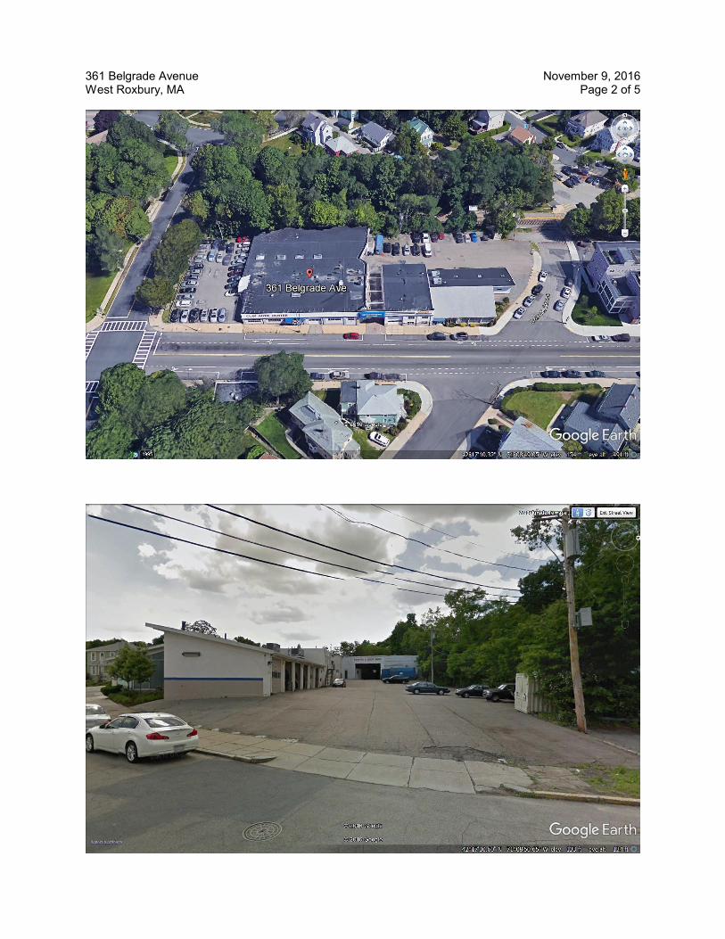
361 Belgrade Avenue November 9, 2016West Roxbury, MA Page 2 of 5

361 Belgrade Avenue November 9, 2016West Roxbury, MA Page 3 of 5
SUBSURFACE EXPLORATION PROGRAM
Test Borings
The exploration program for the project included five (5) test borings completed around the site. Thetest borings (B1 to B5) were advanced to depths of .17-22 ft utilizing 4¼ inch hollow stem augers. Soil samples were typically retrieved at no greater than 5 ft intervals with a 2 inch diameter split-spoon sampler. Standard Penetration Tests (SPTs) were performed at the sampling intervals ingeneral accordance with ASTM-D1586 (Standard Method for Penetration Test and Split-BarrelSampling of Soils). Field descriptions and penetration resistance of the soils encountered, observeddepth to groundwater and other pertinent data are contained on the attached Test Boring Logs.
SUBSURFACE CONDITIONS
The subsurface conditions include (1) undocumented Fill underlain by (2) Granular Glacial soils then (3) Fine Sand with variable Silt. A Subsurface Profile depicting the soil and groundwater conditionsis attached for review.

361 Belgrade Avenue November 9, 2016West Roxbury, MA Page 4 of 5
Fill was encountered at all the test holes to depths of .3-10 ft. Deeper Fill was encountered at B4& B5. The Fill varies in composition but generally consists of a dark brown, Sand, little gravel, littlesilt.. Trace amounts of rubble, loam and other matter are embedded in the Fill. The Fill varies fromloose to medium dense. Fill should also be expected around existing foundations and utilities.
The parent site soils include Granular soils underlain by fine-grained soils. The Granular soilsinclude a brown, fine to medium Sand with little to some gravel and silt. These soils are generallySandy in composition. At depth, the soils include a Fine Sand & Silt. These fine-grained soils arepresent at depths of .8-18 ft. The fine-grained composition renders these soils moisture sensitive,poor-draining and frost susceptible. The overburden soils are stable, dense and compact.
Groundwater was encountered in the test holes at depths of .12-15 ft below grade. Some of theshallower soils were mottled (re-dox staining) suggesting seasonal groundwater fluctuations. Itshould be noted that fluctuations in the level of the groundwater may occur due to variations inrainfall, temperature, flooding, utilities and other factors differing from the time of themeasurements. This study was completed at a time of seasonally low groundwater.
361 Belgrade Avenue November 9, 2016West Roxbury, MA Page 5 of 5
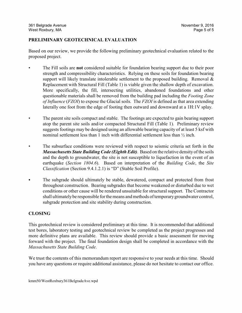
PRELIMINARY GEOTECHNICAL EVALUATION
Based on our review, we provide the following preliminary geotechnical evaluation related to theproposed project.
• The Fill soils are not considered suitable for foundation bearing support due to their poorstrength and compressibility characteristics. Relying on these soils for foundation bearingsupport will likely translate intolerable settlement to the proposed building. Removal &Replacement with Structural Fill (Table 1) is viable given the shallow depth of excavation.More specifically, the fill, intersecting utilities, abandoned foundations and otherquestionable materials shall be removed from the building pad including the Footing Zoneof Influence (FZOI) to expose the Glacial soils. The FZOI is defined as that area extendinglaterally one foot from the edge of footing then outward and downward at a 1H:1V splay.
• The parent site soils compact and stable. The footings are expected to gain bearing supportatop the parent site soils and/or compacted Structural Fill (Table 1). Preliminary reviewsuggests footings may be designed using an allowable bearing capacity of at least 5 ksf withnominal settlement less than 1 inch with differential settlement less than ½ inch.
• The subsurface conditions were reviewed with respect to seismic criteria set forth in theMassachusetts State Building Code (Eighth Edit). Based on the relative density of the soilsand the depth to groundwater, the site is not susceptible to liquefaction in the event of anearthquake (Section 1804.6). Based on interpretation of the Building Code, the SiteClassification (Section 9.4.1.2.1) is “D” (Stable Soil Profile).
C The subgrade should ultimately be stable, dewatered, compact and protected from frostthroughout construction. Bearing subgrades that become weakened or disturbed due to wetconditions or other cause will be rendered unsuitable for structural support. The Contractorshall ultimately be responsible for the means and methods of temporary groundwater control,subgrade protection and site stability during construction.
CLOSING
This geotechnical review is considered preliminary at this time. It is recommended that additionaltest bores, laboratory testing and geotechnical review be completed as the project progresses andmore definitive plans are available. This review should provide a basic assessment for movingforward with the project. The final foundation design shall be completed in accordance with theMassachusetts State Building Code. We trust the contents of this memorandum report are responsive to your needs at this time. Shouldyou have any questions or require additional assistance, please do not hesitate to contact our office.
kmm50/WestRoxbury361BelgradeAve.wpd

LIMITATIONS
Explorations
1. The analyses, recommendations and designs submitted in this report are based in part upon the dataobtained from preliminary subsurface explorations. The nature and extent of variations betweenthese explorations may not become evident until construction. If variations then appear evident, itwill be necessary to re-evaluate the recommendations of this report.
2. The generalized soil profile described in the text is intended to convey trends in subsurfaceconditions. The boundaries between strata are approximate and idealized and have been developedby interpretation of widely spaced explorations and samples; actual soil transitions are probablymore gradual. For specific information, refer to the individual test pit and/or boring logs.
3. Water level readings have been made in the test pits and/or test borings under conditions stated onthe logs. These data have been reviewed and interpretations have been made in the text of thisreport. However, it must be noted that fluctuations in the level of the groundwater may occur dueto variations in rainfall, temperature, and other factors differing from the time the measurementswere made.
Review
4. It is recommended that this firm be given the opportunity to review final design drawings andspecifications to evaluate the appropriate implementation of the recommendations provided herein.
5. In the event that any changes in the nature, design, or location of the proposed areas are planned, theconclusions and recommendations contained in this report shall not be considered valid unless thechanges are reviewed and conclusions of the report modified or verified in writing by KMMGeotechnical Consultants, LLC.
Construction
6. It is recommended that this firm be retained to provide geotechnical engineering services during theearthwork phases of the work. This is to observe compliance with the design concepts,specifications, and recommendations and to allow design changes in the event that subsurfaceconditions differ from those anticipated prior to the start of construction.
Use of Report
7. This report has been prepared for the exclusive use of Lightship Engineering, LLC in accordancewith generally accepted soil and foundation engineering practices. No other warranty, expressed orimplied, is made.
8. This report has been prepared for this project by KMM Geotechnical Consultants, LLC. This reportwas completed for preliminary design purposes and may be limited in its scope to complete anaccurate bid. Contractors wishing a copy of the report may secure it with the understanding that itsscope is limited to preliminary geotechnical design considerations only.
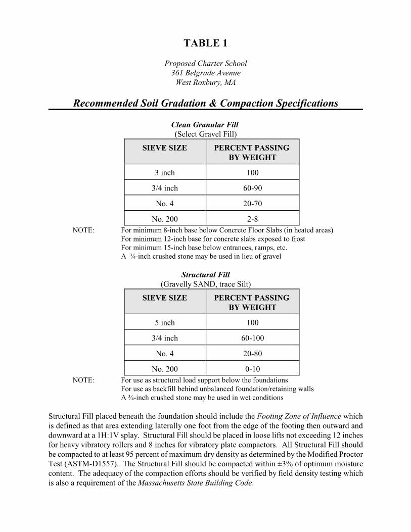
TABLE 1
Proposed Charter School361 Belgrade Avenue
West Roxbury, MA
Recommended Soil Gradation & Compaction Specifications
Clean Granular Fill (Select Gravel Fill)
SIEVE SIZE PERCENT PASSING BY WEIGHT
3 inch 100
3/4 inch 60-90
No. 4 20-70
No. 200 2-8
NOTE: For minimum 8-inch base below Concrete Floor Slabs (in heated areas) For minimum 12-inch base for concrete slabs exposed to frost For minimum 15-inch base below entrances, ramps, etc. A ¾-inch crushed stone may be used in lieu of gravel
Structural Fill(Gravelly SAND, trace Silt)
SIEVE SIZE PERCENT PASSING BY WEIGHT
5 inch 100
3/4 inch 60-100
No. 4 20-80
No. 200 0-10
NOTE: For use as structural load support below the foundationsFor use as backfill behind unbalanced foundation/retaining wallsA ¾-inch crushed stone may be used in wet conditions
Structural Fill placed beneath the foundation should include the Footing Zone of Influence whichis defined as that area extending laterally one foot from the edge of the footing then outward anddownward at a 1H:1V splay. Structural Fill should be placed in loose lifts not exceeding 12 inchesfor heavy vibratory rollers and 8 inches for vibratory plate compactors. All Structural Fill shouldbe compacted to at least 95 percent of maximum dry density as determined by the Modified ProctorTest (ASTM-D1557). The Structural Fill should be compacted within ±3% of optimum moisturecontent. The adequacy of the compaction efforts should be verified by field density testing whichis also a requirement of the Massachusetts State Building Code.

TEST BORING LOG SHEET 1Soil Exploration Corp.
Geotechnical Drilling
Groundwater Monitor Well
Lightship Engineering, LLC
Site: 355-361 Belgrade AvenueBORING B-1
148 Pioneer Drive
Leominster, MA 01453
978 840-0391
West Roxbury, MA
PROJECT NO. 16-1039
DATE: November 3, 2016
Ground Elevation: GROUNDWATER OBSERVATIONSDate Started: October 28, 2016 DATE DEPTH CASING STABILIZATION
Date Finished: October 28, 2016 10/28/1 14 ft n/a
Driller: GG
Soil Engineer/Geologist:
Depth Casing Sample Visual IdentificationFt. bl/ft No. Pen/Rec Depth Blows/6” Strata of Soil and / or Rock Sample
1
5
10
15
20
25
30
35
1
2
3
4
5
6
11”
10”
2”
12”
21”
11”
6”-2’6”
2’6”-4’6”
5’0”-5’9”
10’0”-12’0”
15’0”-17’0”
20’0”-22’0”
3-3-4-10
11-21-24-27
54-70/3”
21-21-21-22
17-21-21-23
21-26-50/3”
4”
2’6”
8’
Pavement__________________________________________________
Dark Brown, loamy, silty Sand w/ gravel, dry (FILL)___________________________________________________
Brown, fine to coarse Sand & Gravel, little silt, cobbles, dry
___________________________________________________
Brown, Fine Sand w/ Silt
___________________________________________________
End of boring at 22 ftWater encountered at 14 ft
Notes: Hollow Stem Auger Size - 4 1/4"
Cohesionless: 0 - 4 V. Loose, 4 - 10 Loose, Trace 0 to 10% CASING SAMPLE CORE TYPE
10 -30 M Dense, 30 -50 Dense, 50+ V Little 10 to 20% ID SIZE (IN) SS
Cohesive: 0 -2 V Soft, 2 -4 Soft, 4 -8 M Some 20 to 35% HAMMER WGT (LB) 140 lb.
8 -15 Stiff, 15 -30 V. Stiff, 30 + Hard. And 35% to 50% HAMMER FALL (IN) 30"

TEST BORING LOG SHEET 2Soil Exploration Corp.
Geotechnical Drilling
Groundwater Monitor Well
Lightship Engineering, LLC
Site: 355-361 Belgrade AvenueBORING B-2
148 Pioneer Drive
Leominster, MA 01453
978 840-0391
West Roxbury, MA
PROJECT NO. 16-1039
DATE: November 3, 2016
Ground Elevation: GROUNDWATER OBSERVATIONSDate Started: October 28, 2016 DATE DEPTH CASING STABILIZATION
Date Finished: October 28, 2016 10/28/1 n/a
Driller: GG
Soil Engineer/Geologist:
Depth Casing Sample Visual IdentificationFt. bl/ft No. Pen/Rec Depth Blows/6” Strata of Soil and / or Rock Sample
1
5
10
15
20
25
30
35
1
2
3
4
5
6
12”
15”
18”
17”
14”
3”
6”-2’6”
2’6”-4’6”
5’0”-7’0”
10’0”-12’0”
15’0”-17’0”
20’0”-20’4”
3-4-4-5
5-7-7-12
11-13-14-14
20-24-24-26
30-41-40-43
70/4”
4”
2’6”
8’
21’4”
Pavement__________________________________________________Dark Brown, fine to coarse Sand, some gravel, little silt, tracerubble, dry (FILL)___________________________________________________Brown, mottled, fine to medium Sand, little silt, little gravel
Brown, mottled, fine to medium Sand, some silt, trace gravel,dry
___________________________________________________
Brown, Fine Sand, some silt, dry
__________________________________________________
End of boring at 21’4”No water encountered
Notes: Hollow Stem Auger Size - 4 1/4"
Cohesionless: 0 - 4 V. Loose, 4 - 10 Loose, Trace 0 to 10% CASING SAMPLE CORE TYPE
10 -30 M Dense, 30 -50 Dense, 50+ V Little 10 to 20% ID SIZE (IN) SS
Cohesive: 0 -2 V Soft, 2 -4 Soft, 4 -8 M Some 20 to 35% HAMMER WGT (LB) 140 lb.
8 -15 Stiff, 15 -30 V. Stiff, 30 + Hard. And 35% to 50% HAMMER FALL (IN) 30"
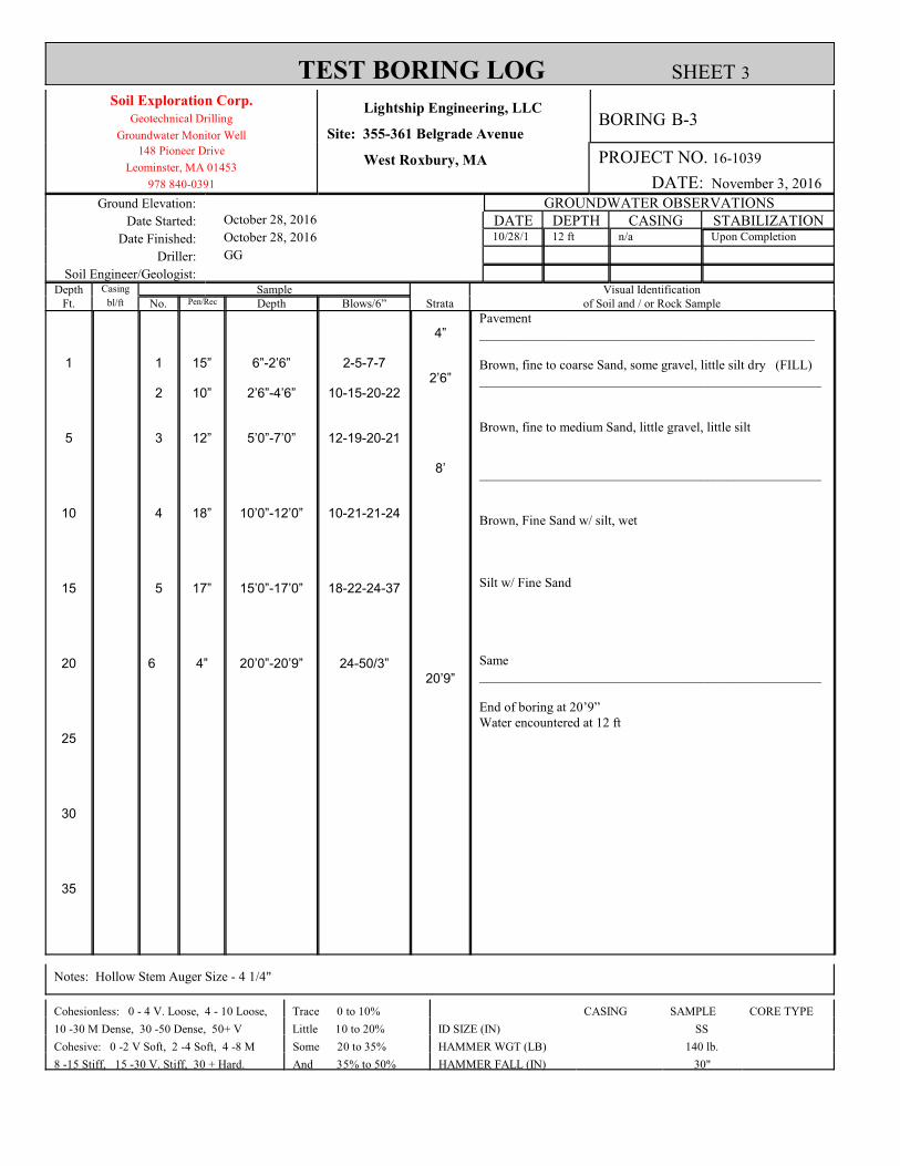
TEST BORING LOG SHEET 3Soil Exploration Corp.
Geotechnical Drilling
Groundwater Monitor Well
Lightship Engineering, LLC
Site: 355-361 Belgrade AvenueBORING B-3
148 Pioneer Drive
Leominster, MA 01453
978 840-0391
West Roxbury, MA
PROJECT NO. 16-1039
DATE: November 3, 2016
Ground Elevation: GROUNDWATER OBSERVATIONSDate Started: October 28, 2016 DATE DEPTH CASING STABILIZATION
Date Finished: October 28, 2016 10/28/1 12 ft n/a Upon Completion
Driller: GG
Soil Engineer/Geologist:
Depth Casing Sample Visual IdentificationFt. bl/ft No. Pen/Rec Depth Blows/6” Strata of Soil and / or Rock Sample
1
5
10
15
20
25
30
35
1
2
3
4
5
6
15”
10”
12”
18”
17”
4”
6”-2’6”
2’6”-4’6”
5’0”-7’0”
10’0”-12’0”
15’0”-17’0”
20’0”-20’9”
2-5-7-7
10-15-20-22
12-19-20-21
10-21-21-24
18-22-24-37
24-50/3”
4”
2’6”
8’
20’9”
Pavement__________________________________________________
Brown, fine to coarse Sand, some gravel, little silt dry (FILL)___________________________________________________
Brown, fine to medium Sand, little gravel, little silt
___________________________________________________
Brown, Fine Sand w/ silt, wet
Silt w/ Fine Sand
Same___________________________________________________
End of boring at 20’9”Water encountered at 12 ft
Notes: Hollow Stem Auger Size - 4 1/4"
Cohesionless: 0 - 4 V. Loose, 4 - 10 Loose, Trace 0 to 10% CASING SAMPLE CORE TYPE
10 -30 M Dense, 30 -50 Dense, 50+ V Little 10 to 20% ID SIZE (IN) SS
Cohesive: 0 -2 V Soft, 2 -4 Soft, 4 -8 M Some 20 to 35% HAMMER WGT (LB) 140 lb.
8 -15 Stiff, 15 -30 V. Stiff, 30 + Hard. And 35% to 50% HAMMER FALL (IN) 30"

TEST BORING LOG SHEET 4Soil Exploration Corp.
Geotechnical Drilling
Groundwater Monitor Well
Lightship Engineering, LLC
Site: 355-361 Belgrade AvenueBORING B-4
148 Pioneer Drive
Leominster, MA 01453
978 840-0391
West Roxbury, MA
PROJECT NO. 16-1039
DATE: November 3, 2016
Ground Elevation: GROUNDWATER OBSERVATIONSDate Started: October 28, 2016 DATE DEPTH CASING STABILIZATION
Date Finished: October 28, 2016 10/28/1 n/a
Driller: GG
Soil Engineer/Geologist:
Depth Casing Sample Visual IdentificationFt. bl/ft No. Pen/Rec Depth Blows/6” Strata of Soil and / or Rock Sample
1
5
10
15
20
25
30
35
1
2
3
4
5
6
12”
14”
10”
14”
13”
12”
6”-2’6”
2’6”-4’6”
5’0”-7’0”
10’0”-12’0”
15’0”-17’0”
20’0”-22’0”
4-6-7-14
7-7-6-8
8-7-7-7
7-8-8-9
10-26-24-29
10-17-26-31
4”
11’
18’
Pavement__________________________________________________
Dark Brown, Sand & Gravel, little silt, trace rubble (FILL)
Dark Brown, Sand, little gravel, little silt
Same (FILL)
Grey, Sand & Gravel, some silt, dry___________________________________________________
Brown, fine to medium Sand, little gravel, little silt
___________________________________________________
Brown, Fine Sand, some silt___________________________________________________
End of boring at 22 ftNo water encountered
Notes: Hollow Stem Auger Size - 4 1/4"
Cohesionless: 0 - 4 V. Loose, 4 - 10 Loose, Trace 0 to 10% CASING SAMPLE CORE TYPE
10 -30 M Dense, 30 -50 Dense, 50+ V Little 10 to 20% ID SIZE (IN) SS
Cohesive: 0 -2 V Soft, 2 -4 Soft, 4 -8 M Some 20 to 35% HAMMER WGT (LB) 140 lb.
8 -15 Stiff, 15 -30 V. Stiff, 30 + Hard. And 35% to 50% HAMMER FALL (IN) 30"
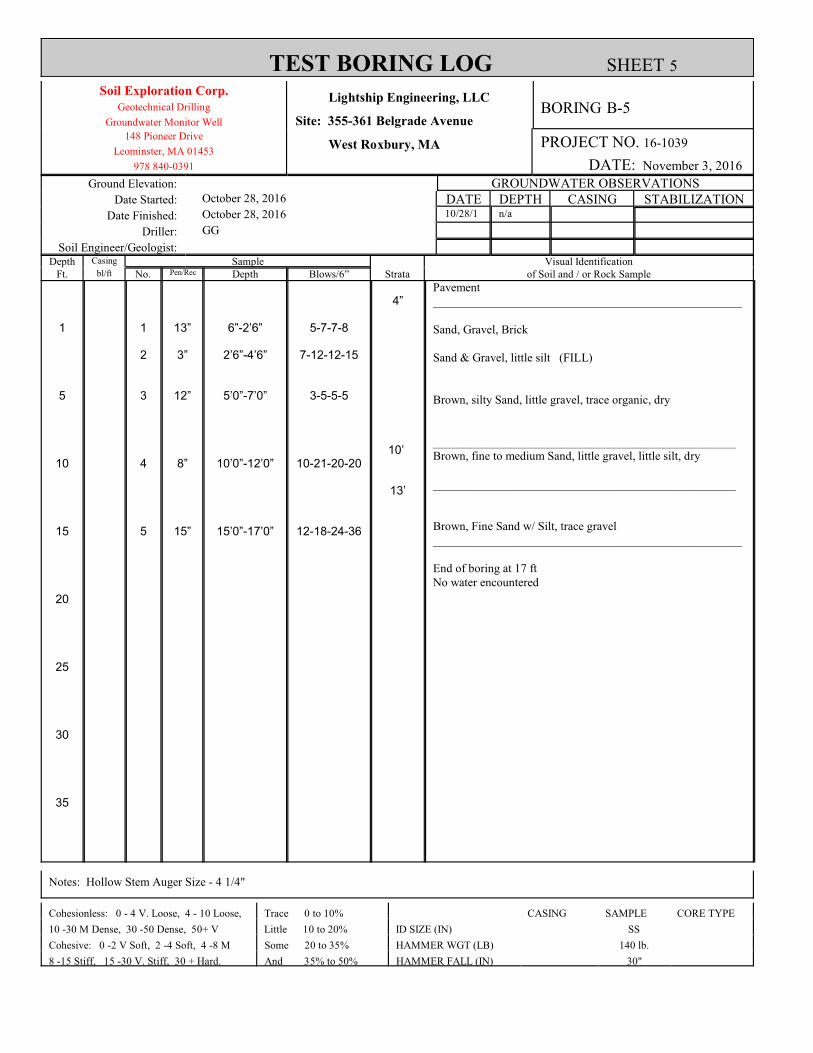
TEST BORING LOG SHEET 5Soil Exploration Corp.
Geotechnical Drilling
Groundwater Monitor Well
Lightship Engineering, LLC
Site: 355-361 Belgrade AvenueBORING B-5
148 Pioneer Drive
Leominster, MA 01453
978 840-0391
West Roxbury, MA
PROJECT NO. 16-1039
DATE: November 3, 2016
Ground Elevation: GROUNDWATER OBSERVATIONSDate Started: October 28, 2016 DATE DEPTH CASING STABILIZATION
Date Finished: October 28, 2016 10/28/1 n/a
Driller: GG
Soil Engineer/Geologist:
Depth Casing Sample Visual IdentificationFt. bl/ft No. Pen/Rec Depth Blows/6” Strata of Soil and / or Rock Sample
1
5
10
15
20
25
30
35
1
2
3
4
5
13”
3”
12”
8”
15”
6”-2’6”
2’6”-4’6”
5’0”-7’0”
10’0”-12’0”
15’0”-17’0”
5-7-7-8
7-12-12-15
3-5-5-5
10-21-20-20
12-18-24-36
4”
10’
13’
Pavement___________________________________________________
Sand, Gravel, Brick
Sand & Gravel, little silt (FILL)
Brown, silty Sand, little gravel, trace organic, dry
__________________________________________________Brown, fine to medium Sand, little gravel, little silt, dry __________________________________________________
Brown, Fine Sand w/ Silt, trace gravel___________________________________________________
End of boring at 17 ftNo water encountered
Notes: Hollow Stem Auger Size - 4 1/4"
Cohesionless: 0 - 4 V. Loose, 4 - 10 Loose, Trace 0 to 10% CASING SAMPLE CORE TYPE
10 -30 M Dense, 30 -50 Dense, 50+ V Little 10 to 20% ID SIZE (IN) SS
Cohesive: 0 -2 V Soft, 2 -4 Soft, 4 -8 M Some 20 to 35% HAMMER WGT (LB) 140 lb.
8 -15 Stiff, 15 -30 V. Stiff, 30 + Hard. And 35% to 50% HAMMER FALL (IN) 30"