preliminary hydrology report prologis - kaiser
TRANSCRIPT
PRELIMINARY HYDROLOGY REPORT
For
Prologis - Kaiser PROJ-2019-00005
PROJECT LOCATION
13557 San Bernardino Avenue in the County of San Bernardino
APN: 0238-031-32, -33, -34, -35, -36
DEVELOPER
Prologis, L.P. 3546 Concours Street, Suite 100
Ontario, CA 91764 949-215-3796
PREPARED BY
Huitt-Zollars, Inc. David White, P.E.
3990 Concours Suite 330 Ontario, CA 91764 Ph: 909.941.7799 Fax: 909.941.7789
PREPARATION DATE
June 25th, 2019 Revised: December 18, 2019
HZ PROJECT NUMBER
R307465.01
David White, P.E. C52921, Exp 12/31/2020
Table of Contents Title Page Introduction 1 Purpose 1 Existing Condition 1 Discussion 1 Hydrologic Analysis 2 Results 2
List of Appendices Appendix A Preliminary Hydrology Maps Appendix B 100-year Rational Method Hydrologic Analysis Appendix C Hydraulic Calculations Appendix D Soil Group Map and Isohyetal Map Appendix E References
1
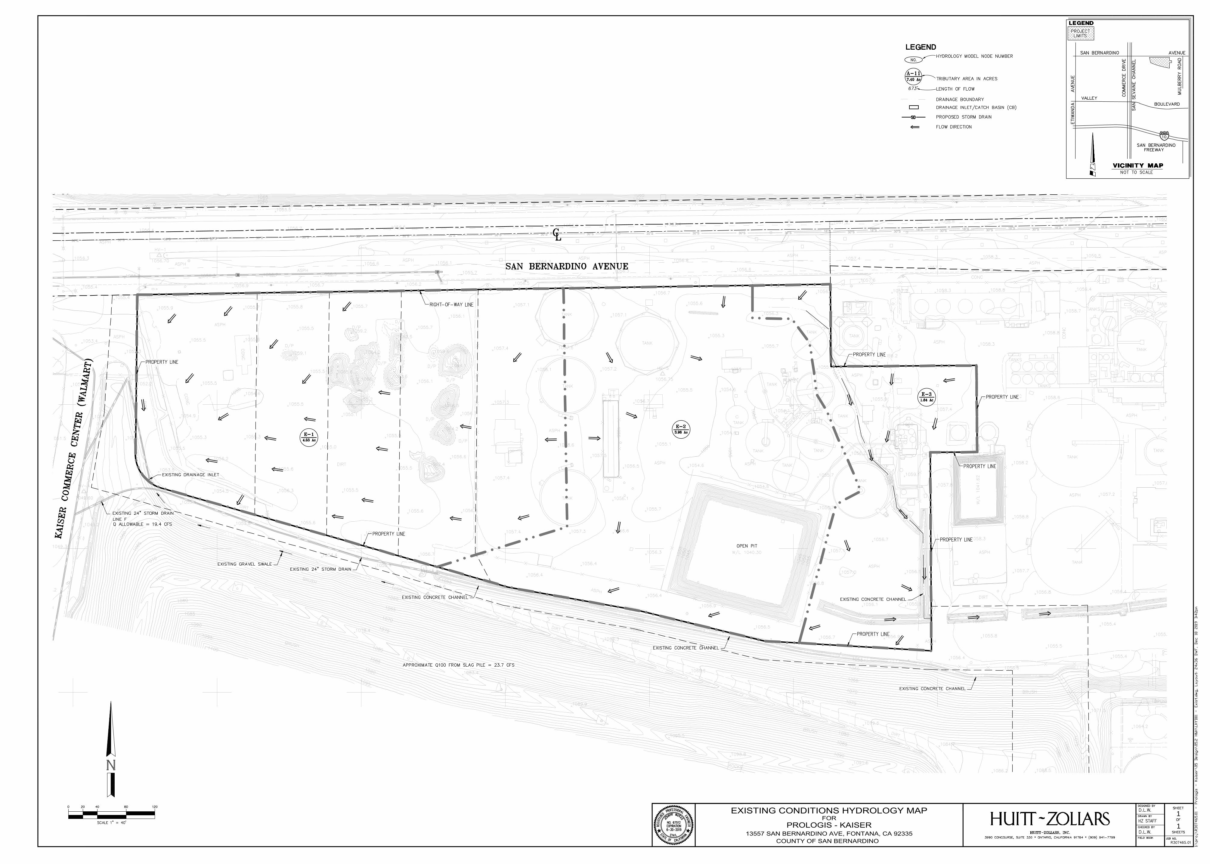
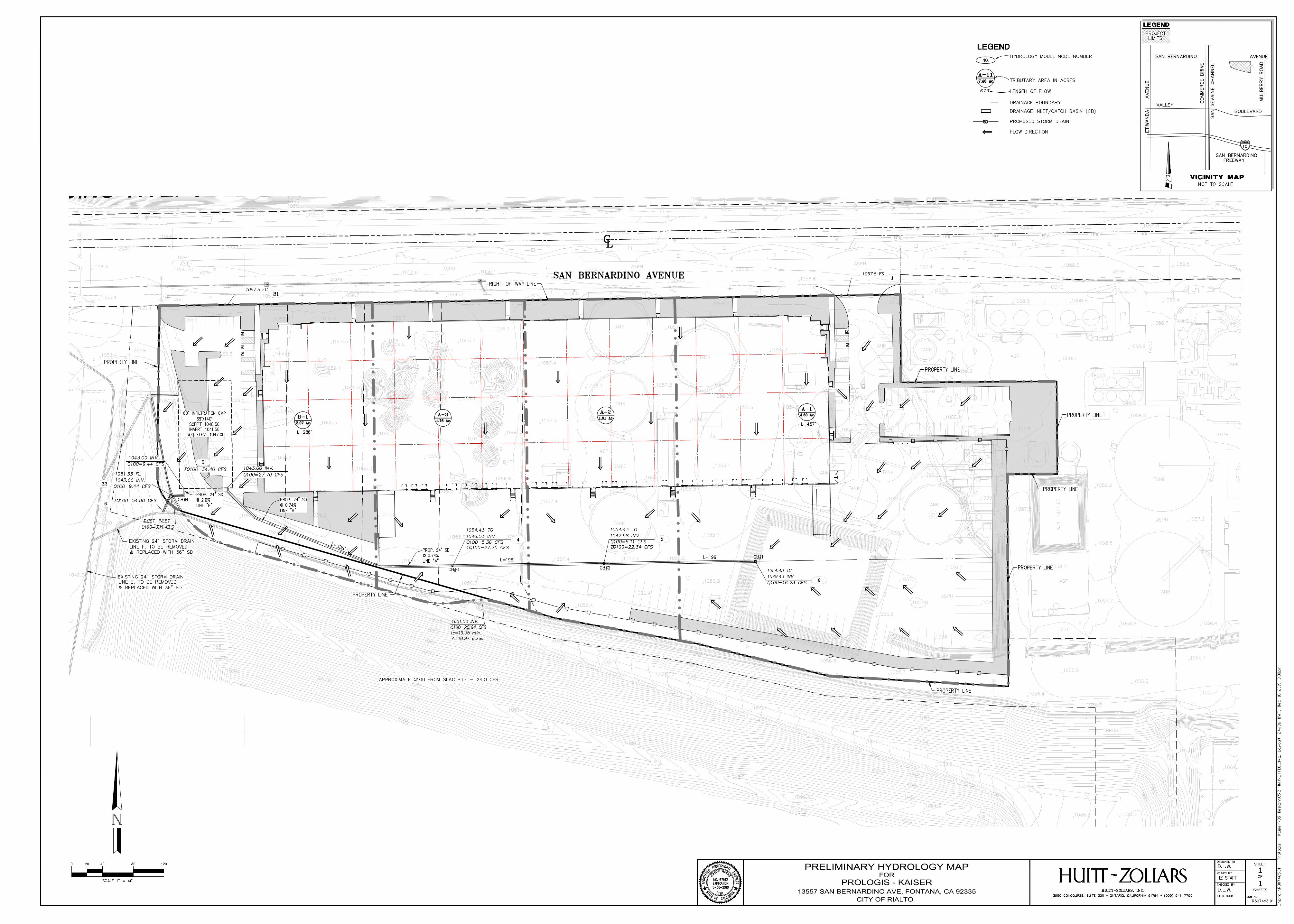
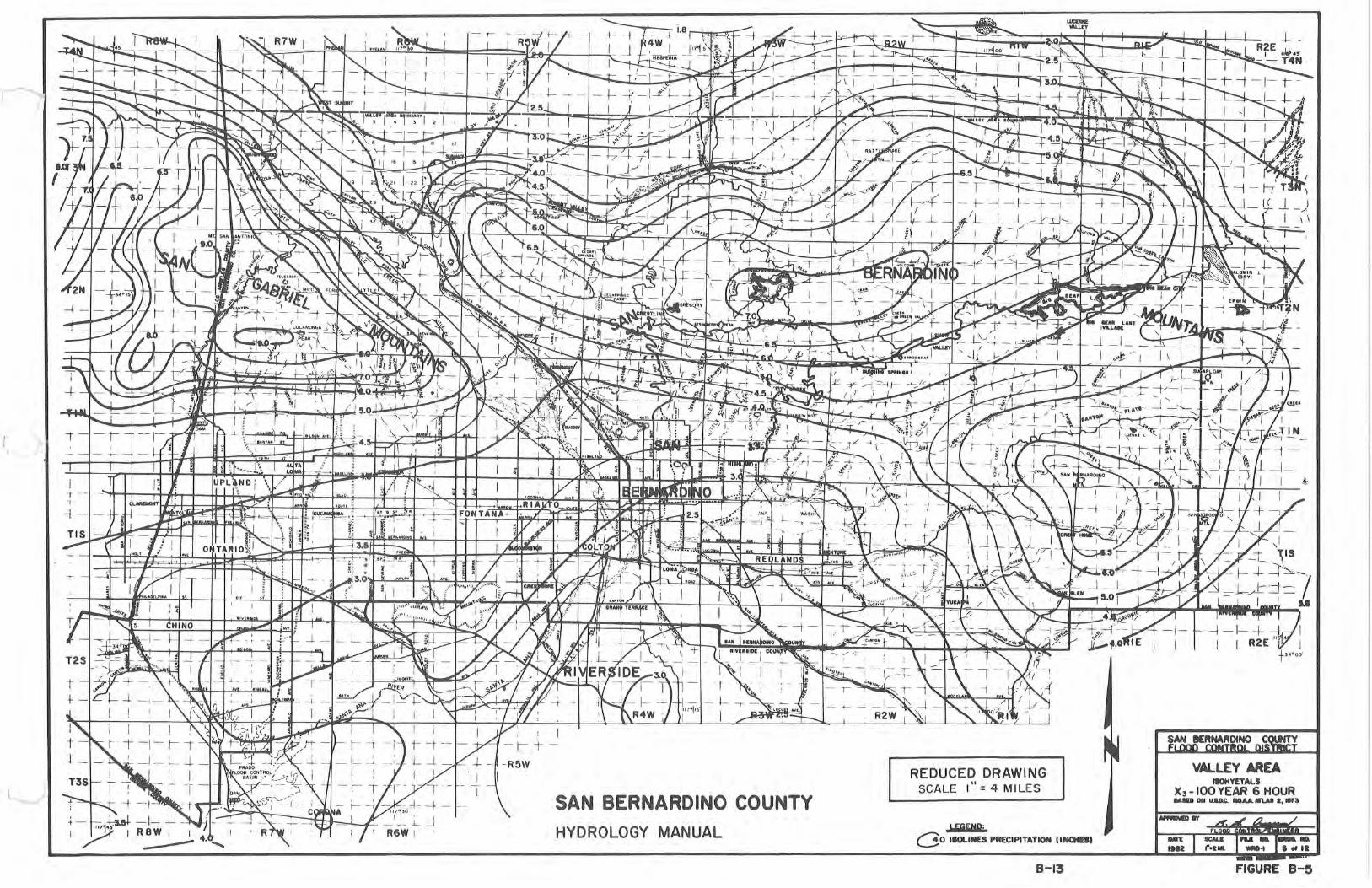
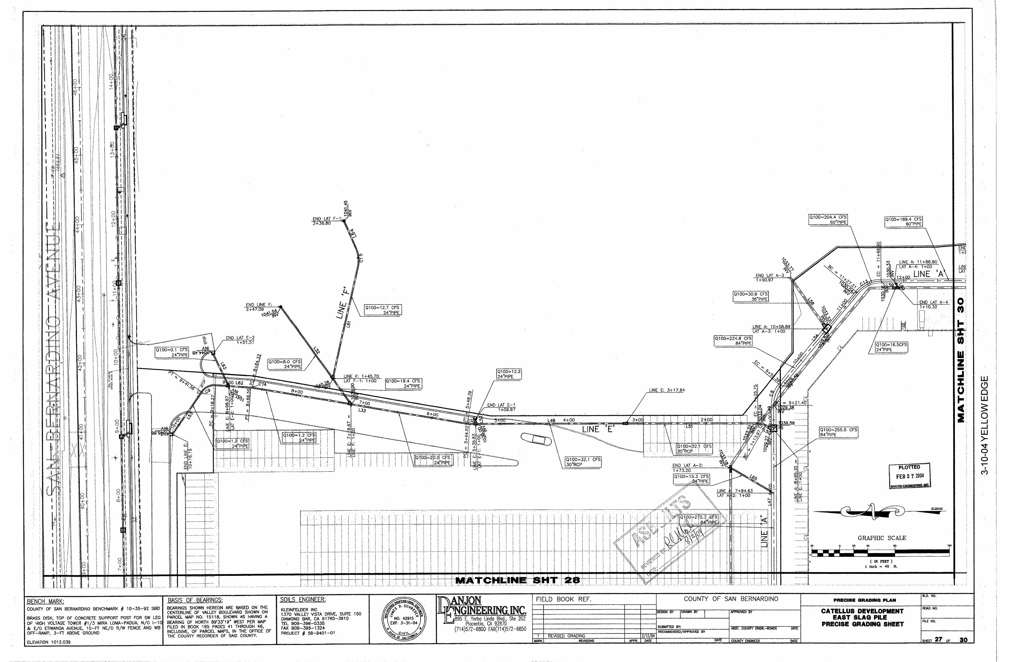
Introduction This preliminary hydrology analysis has been prepared for Prologis, L.P. The project is a new development of an industrial warehouse facility located at the 13557 San Bernardino Avenue in County of San Bernardino, California. The proposed building is approximately 164,960 square feet on approximately 10.13 acres of partially developed land. Purpose The purpose of this report is to present the drainage concept and determine the design flow rates for the project site. The hydrology maps and calculations reflect the tributary areas and 100-year storm event runoff flows. Existing Condition The project site is a uniquely shaped and graded parcel and is currently occupied by an abandoned water treatment plant on the east half of the property. The project site generally consists of three drainage areas as indicated on the Existing Hydrology Map. Area E1 comprises roughly the west half of the site and sheet flows from east to west. Runoff from area E1 enters an existing drainage inlet at the southwest corner of the site and continues flowing in an existing private storm drain line. Area E-2 is located in the east central portion of the site and appears to sheet flow to a large open pit with some runoff making it to the open channel along the south property line. The open channel flows west and enters a private 24” storm drain. Area E-3, the east portion of the existing site, flows from north to south in a non-uniform swale and drains into an existing channel along the east property line and continues flowing east through the CSI property to the Mulberry channel. Discussion For the proposed condition, the runoff will be directed to the on-site underground infiltration system located in the west parking lot, see Appendix A for proposed on-site hydrology map. The overflow from the underground infiltration system will be discharged to a proposed 36” storm drain located in the southwest corner of the site, which replaces an existing 24” storm drain pipe (Line F). The existing storm drain is part of the Kaiser Commerce Center private storm drain system (see Appendix E) and was installed to collect runoff from the subject property. Unfortunately when the slag pile south of the subject site was capped, 13 acres of runoff was diverted to Line F, which leaves no capacity for the subject site. The Kaiser Commerce Center private storm drain system provided multiple laterals at various locations for the future runoff from the slag pile, so although the proposed discharge to Lines E and F has increased, the overall Q of the downstream system will not change. Since the existing storm drain was designed to accept runoff from the subject site, the existing runoff is irrelevant and the data has been omitted from the existing hydrology map. Site runoff from the east side of the building roof and east parking area will be collected by catch basin #1. The collected runoff will then be conveyed through the proposed on-site storm drain Line A to the underground infiltration system. Site runoff from the center portion of the building roof and truck dock area will be collected by catch basins #2 and #3. The collected runoff will then be conveyed through the proposed on-site storm drain Line A to the underground infiltration system.
2
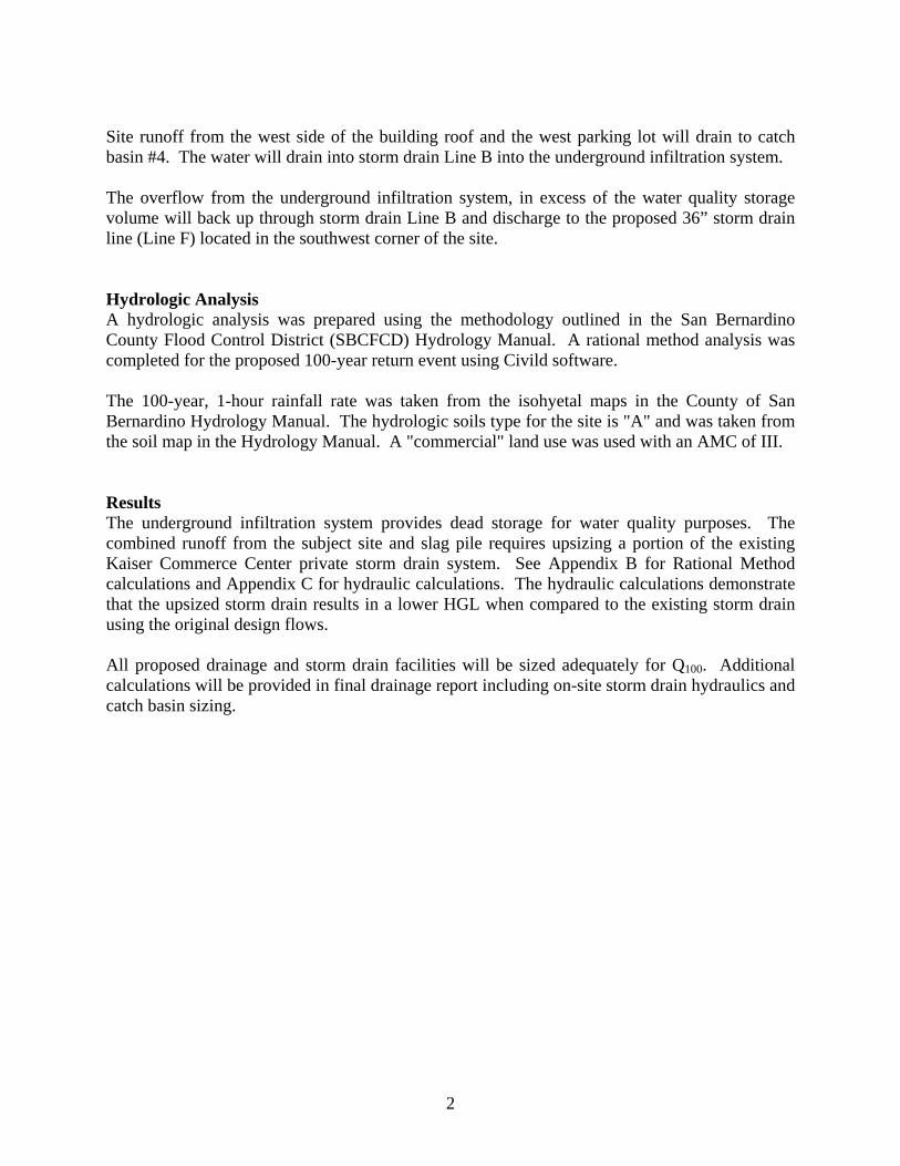
Site runoff from the west side of the building roof and the west parking lot will drain to catch basin #4. The water will drain into storm drain Line B into the underground infiltration system. The overflow from the underground infiltration system, in excess of the water quality storage volume will back up through storm drain Line B and discharge to the proposed 36” storm drain line (Line F) located in the southwest corner of the site. Hydrologic Analysis A hydrologic analysis was prepared using the methodology outlined in the San Bernardino County Flood Control District (SBCFCD) Hydrology Manual. A rational method analysis was completed for the proposed 100-year return event using Civild software. The 100-year, 1-hour rainfall rate was taken from the isohyetal maps in the County of San Bernardino Hydrology Manual. The hydrologic soils type for the site is "A" and was taken from the soil map in the Hydrology Manual. A "commercial" land use was used with an AMC of III. Results The underground infiltration system provides dead storage for water quality purposes. The combined runoff from the subject site and slag pile requires upsizing a portion of the existing Kaiser Commerce Center private storm drain system. See Appendix B for Rational Method calculations and Appendix C for hydraulic calculations. The hydraulic calculations demonstrate that the upsized storm drain results in a lower HGL when compared to the existing storm drain using the original design flows. All proposed drainage and storm drain facilities will be sized adequately for Q100. Additional calculations will be provided in final drainage report including on-site storm drain hydraulics and catch basin sizing.

Appendix A Preliminary Hydrology Maps
W
18"S
18"S
18"S
18"S
18"S
18"S
18"S
18"S
30"S
30"S
30"S
30"S
30"S
30"S
30"S
30"S
30"S
30"S
30"S
30"S
30"S30"S
30"S30"S
30"S
30"S
30"S
30"S
30"S
30"S
30"S
1
1
PROLOGIS - KAISER
COUNTY OF SAN BERNARDINO
13557 SAN BERNARDINO AVE, FONTANA, CA 92335
EXISTING CONDITIONS HYDROLOGY MAP
FOR
18"S
18"S
18"S
18"S
18"S
18"S
18"S
18"S
1
1
CITY OF RIALTO
PRELIMINARY HYDROLOGY MAP
FOR
PROLOGIS - KAISER
13557 SAN BERNARDINO AVE, FONTANA, CA 92335

Appendix B 100-year Rational Method Hydrologic Analysis
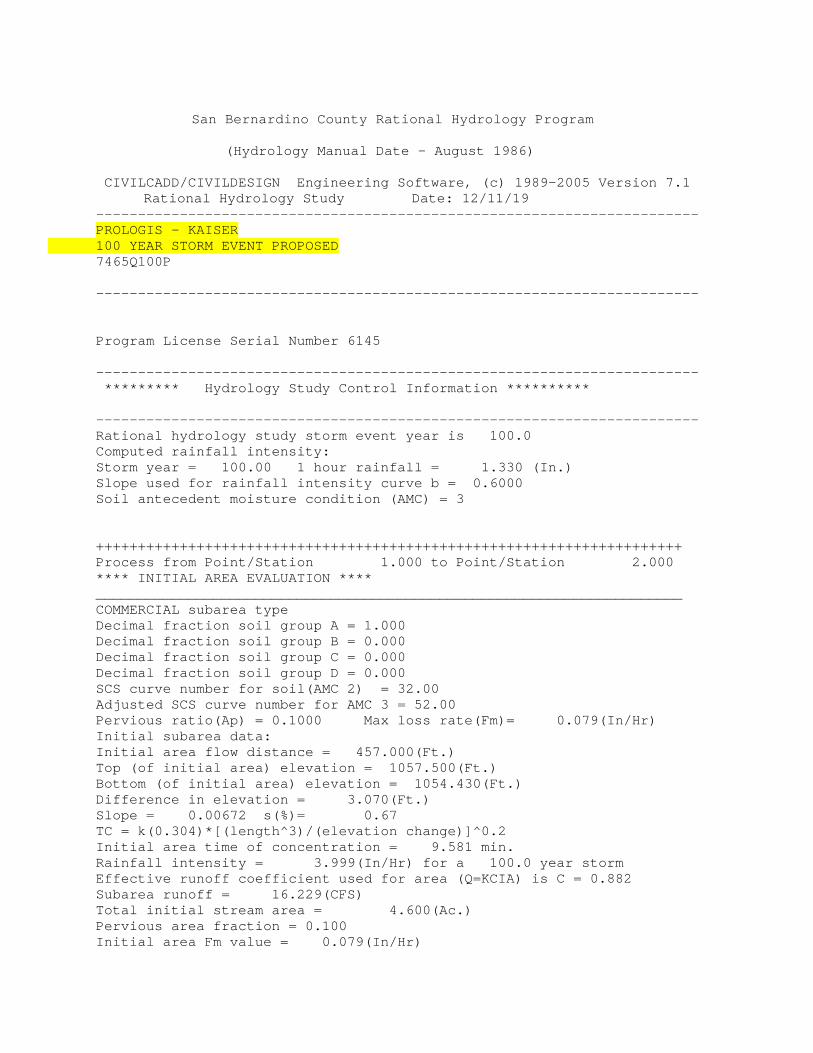
San Bernardino County Rational Hydrology Program (Hydrology Manual Date - August 1986) CIVILCADD/CIVILDESIGN Engineering Software, (c) 1989-2005 Version 7.1 Rational Hydrology Study Date: 12/11/19 ------------------------------------------------------------------------ PROLOGIS - KAISER 100 YEAR STORM EVENT PROPOSED 7465Q100P ------------------------------------------------------------------------ Program License Serial Number 6145 ------------------------------------------------------------------------ ********* Hydrology Study Control Information ********** ------------------------------------------------------------------------ Rational hydrology study storm event year is 100.0 Computed rainfall intensity: Storm year = 100.00 1 hour rainfall = 1.330 (In.) Slope used for rainfall intensity curve b = 0.6000 Soil antecedent moisture condition (AMC) = 3 ++++++++++++++++++++++++++++++++++++++++++++++++++++++++++++++++++++++ Process from Point/Station 1.000 to Point/Station 2.000 **** INITIAL AREA EVALUATION **** ______________________________________________________________________ COMMERCIAL subarea type Decimal fraction soil group A = 1.000 Decimal fraction soil group B = 0.000 Decimal fraction soil group C = 0.000 Decimal fraction soil group D = 0.000 SCS curve number for soil(AMC 2) = 32.00 Adjusted SCS curve number for AMC 3 = 52.00 Pervious ratio(Ap) = 0.1000 Max loss rate(Fm)= 0.079(In/Hr) Initial subarea data: Initial area flow distance = 457.000(Ft.) Top (of initial area) elevation = 1057.500(Ft.) Bottom (of initial area) elevation = 1054.430(Ft.) Difference in elevation = 3.070(Ft.) Slope = 0.00672 s(%)= 0.67 TC = k(0.304)*[(length^3)/(elevation change)]^0.2 Initial area time of concentration = 9.581 min. Rainfall intensity = 3.999(In/Hr) for a 100.0 year storm Effective runoff coefficient used for area (Q=KCIA) is C = 0.882 Subarea runoff = 16.229(CFS) Total initial stream area = 4.600(Ac.) Pervious area fraction = 0.100 Initial area Fm value = 0.079(In/Hr)
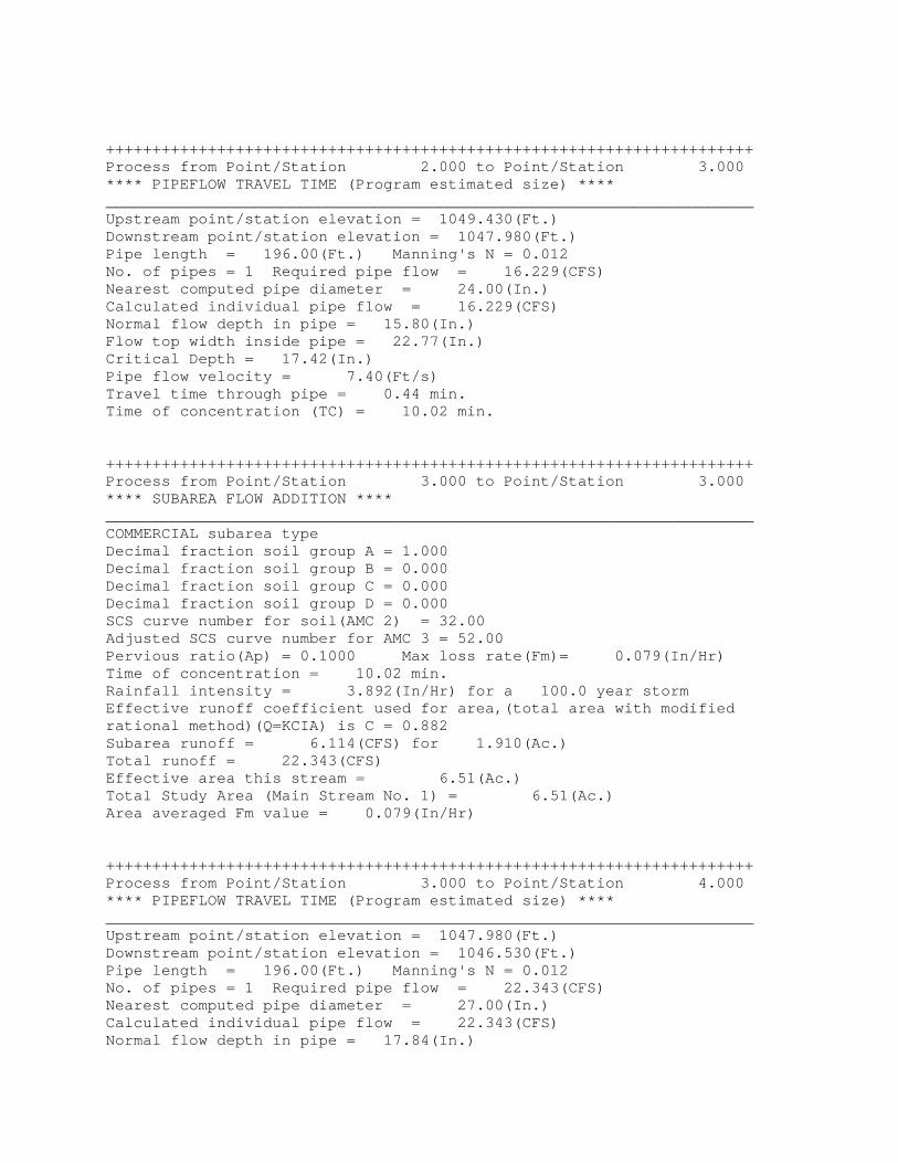
++++++++++++++++++++++++++++++++++++++++++++++++++++++++++++++++++++++ Process from Point/Station 2.000 to Point/Station 3.000 **** PIPEFLOW TRAVEL TIME (Program estimated size) **** ______________________________________________________________________ Upstream point/station elevation = 1049.430(Ft.) Downstream point/station elevation = 1047.980(Ft.) Pipe length = 196.00(Ft.) Manning's N = 0.012 No. of pipes = 1 Required pipe flow = 16.229(CFS) Nearest computed pipe diameter = 24.00(In.) Calculated individual pipe flow = 16.229(CFS) Normal flow depth in pipe = 15.80(In.) Flow top width inside pipe = 22.77(In.) Critical Depth = 17.42(In.) Pipe flow velocity = 7.40(Ft/s) Travel time through pipe = 0.44 min. Time of concentration (TC) = 10.02 min. ++++++++++++++++++++++++++++++++++++++++++++++++++++++++++++++++++++++ Process from Point/Station 3.000 to Point/Station 3.000 **** SUBAREA FLOW ADDITION **** ______________________________________________________________________ COMMERCIAL subarea type Decimal fraction soil group A = 1.000 Decimal fraction soil group B = 0.000 Decimal fraction soil group C = 0.000 Decimal fraction soil group D = 0.000 SCS curve number for soil(AMC 2) = 32.00 Adjusted SCS curve number for AMC 3 = 52.00 Pervious ratio(Ap) = 0.1000 Max loss rate(Fm)= 0.079(In/Hr) Time of concentration = 10.02 min. Rainfall intensity = 3.892(In/Hr) for a 100.0 year storm Effective runoff coefficient used for area,(total area with modified rational method)(Q=KCIA) is C = 0.882 Subarea runoff = 6.114(CFS) for 1.910(Ac.) Total runoff = 22.343(CFS) Effective area this stream = 6.51(Ac.) Total Study Area (Main Stream No. 1) = 6.51(Ac.) Area averaged Fm value = 0.079(In/Hr) ++++++++++++++++++++++++++++++++++++++++++++++++++++++++++++++++++++++ Process from Point/Station 3.000 to Point/Station 4.000 **** PIPEFLOW TRAVEL TIME (Program estimated size) **** ______________________________________________________________________ Upstream point/station elevation = 1047.980(Ft.) Downstream point/station elevation = 1046.530(Ft.) Pipe length = 196.00(Ft.) Manning's N = 0.012 No. of pipes = 1 Required pipe flow = 22.343(CFS) Nearest computed pipe diameter = 27.00(In.) Calculated individual pipe flow = 22.343(CFS) Normal flow depth in pipe = 17.84(In.)
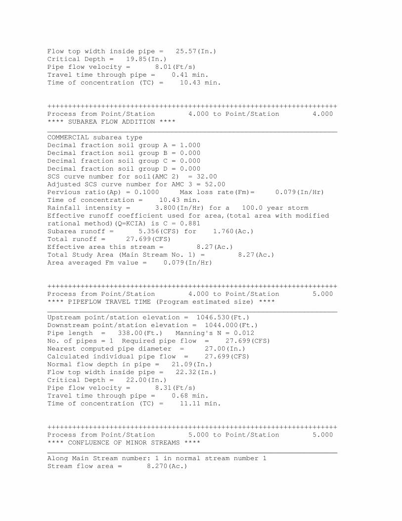
Flow top width inside pipe = 25.57(In.) Critical Depth = 19.85(In.) Pipe flow velocity = 8.01(Ft/s) Travel time through pipe = 0.41 min. Time of concentration (TC) = 10.43 min. ++++++++++++++++++++++++++++++++++++++++++++++++++++++++++++++++++++++ Process from Point/Station 4.000 to Point/Station 4.000 **** SUBAREA FLOW ADDITION **** ______________________________________________________________________ COMMERCIAL subarea type Decimal fraction soil group A = 1.000 Decimal fraction soil group B = 0.000 Decimal fraction soil group C = 0.000 Decimal fraction soil group D = 0.000 SCS curve number for soil(AMC 2) = 32.00 Adjusted SCS curve number for AMC 3 = 52.00 Pervious ratio(Ap) = 0.1000 Max loss rate(Fm)= 0.079(In/Hr) Time of concentration = 10.43 min. Rainfall intensity = 3.800(In/Hr) for a 100.0 year storm Effective runoff coefficient used for area,(total area with modified rational method)(Q=KCIA) is C = 0.881 Subarea runoff = 5.356(CFS) for 1.760(Ac.) Total runoff = 27.699(CFS) Effective area this stream = 8.27(Ac.) Total Study Area (Main Stream No. 1) = 8.27(Ac.) Area averaged Fm value = 0.079(In/Hr) ++++++++++++++++++++++++++++++++++++++++++++++++++++++++++++++++++++++ Process from Point/Station 4.000 to Point/Station 5.000 **** PIPEFLOW TRAVEL TIME (Program estimated size) **** ______________________________________________________________________ Upstream point/station elevation = 1046.530(Ft.) Downstream point/station elevation = 1044.000(Ft.) Pipe length = 338.00(Ft.) Manning's N = 0.012 No. of pipes = 1 Required pipe flow = 27.699(CFS) Nearest computed pipe diameter = 27.00(In.) Calculated individual pipe flow = 27.699(CFS) Normal flow depth in pipe = 21.09(In.) Flow top width inside pipe = 22.32(In.) Critical Depth = 22.00(In.) Pipe flow velocity = 8.31(Ft/s) Travel time through pipe = 0.68 min. Time of concentration (TC) = 11.11 min. ++++++++++++++++++++++++++++++++++++++++++++++++++++++++++++++++++++++ Process from Point/Station 5.000 to Point/Station 5.000 **** CONFLUENCE OF MINOR STREAMS **** ______________________________________________________________________ Along Main Stream number: 1 in normal stream number 1 Stream flow area = 8.270(Ac.)
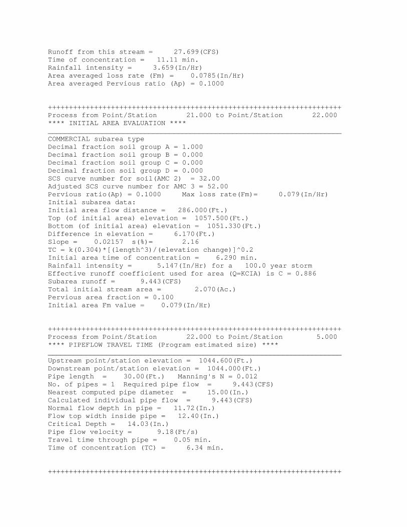
Runoff from this stream = 27.699(CFS) Time of concentration = 11.11 min. Rainfall intensity = 3.659(In/Hr) Area averaged loss rate (Fm) = 0.0785(In/Hr) Area averaged Pervious ratio (Ap) = 0.1000 ++++++++++++++++++++++++++++++++++++++++++++++++++++++++++++++++++++++ Process from Point/Station 21.000 to Point/Station 22.000 **** INITIAL AREA EVALUATION **** ______________________________________________________________________ COMMERCIAL subarea type Decimal fraction soil group A = 1.000 Decimal fraction soil group B = 0.000 Decimal fraction soil group C = 0.000 Decimal fraction soil group D = 0.000 SCS curve number for soil(AMC 2) = 32.00 Adjusted SCS curve number for AMC 3 = 52.00 Pervious ratio(Ap) = 0.1000 Max loss rate(Fm)= 0.079(In/Hr) Initial subarea data: Initial area flow distance = 286.000(Ft.) Top (of initial area) elevation = 1057.500(Ft.) Bottom (of initial area) elevation = 1051.330(Ft.) Difference in elevation = 6.170(Ft.) Slope = 0.02157 s(%)= 2.16 TC = k(0.304)*[(length^3)/(elevation change)]^0.2 Initial area time of concentration = 6.290 min. Rainfall intensity = 5.147(In/Hr) for a 100.0 year storm Effective runoff coefficient used for area (Q=KCIA) is C = 0.886 Subarea runoff = 9.443(CFS) Total initial stream area = 2.070(Ac.) Pervious area fraction = 0.100 Initial area Fm value = 0.079(In/Hr) ++++++++++++++++++++++++++++++++++++++++++++++++++++++++++++++++++++++ Process from Point/Station 22.000 to Point/Station 5.000 **** PIPEFLOW TRAVEL TIME (Program estimated size) **** ______________________________________________________________________ Upstream point/station elevation = 1044.600(Ft.) Downstream point/station elevation = 1044.000(Ft.) Pipe length = 30.00(Ft.) Manning's N = 0.012 No. of pipes = 1 Required pipe flow = 9.443(CFS) Nearest computed pipe diameter = 15.00(In.) Calculated individual pipe flow = 9.443(CFS) Normal flow depth in pipe = 11.72(In.) Flow top width inside pipe = 12.40(In.) Critical Depth = 14.03(In.) Pipe flow velocity = 9.18(Ft/s) Travel time through pipe = 0.05 min. Time of concentration (TC) = 6.34 min. ++++++++++++++++++++++++++++++++++++++++++++++++++++++++++++++++++++++
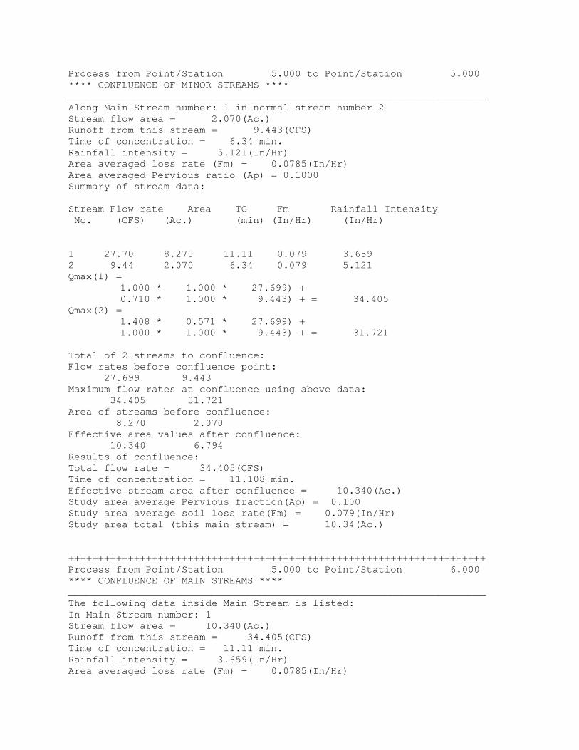
Process from Point/Station 5.000 to Point/Station 5.000 **** CONFLUENCE OF MINOR STREAMS **** ______________________________________________________________________ Along Main Stream number: 1 in normal stream number 2 Stream flow area = 2.070(Ac.) Runoff from this stream = 9.443(CFS) Time of concentration = 6.34 min. Rainfall intensity = 5.121(In/Hr) Area averaged loss rate (Fm) = 0.0785(In/Hr) Area averaged Pervious ratio (Ap) = 0.1000 Summary of stream data: Stream Flow rate Area TC Fm Rainfall Intensity No. (CFS) (Ac.) (min) (In/Hr) (In/Hr) 1 27.70 8.270 11.11 0.079 3.659 2 9.44 2.070 6.34 0.079 5.121 Qmax(1) = 1.000 * 1.000 * 27.699) + 0.710 * 1.000 * 9.443) + = 34.405 Qmax(2) = 1.408 * 0.571 * 27.699) + 1.000 * 1.000 * 9.443) + = 31.721 Total of 2 streams to confluence: Flow rates before confluence point: 27.699 9.443 Maximum flow rates at confluence using above data: 34.405 31.721 Area of streams before confluence: 8.270 2.070 Effective area values after confluence: 10.340 6.794 Results of confluence: Total flow rate = 34.405(CFS) Time of concentration = 11.108 min. Effective stream area after confluence = 10.340(Ac.) Study area average Pervious fraction(Ap) = 0.100 Study area average soil loss rate(Fm) = 0.079(In/Hr) Study area total (this main stream) = 10.34(Ac.) ++++++++++++++++++++++++++++++++++++++++++++++++++++++++++++++++++++++ Process from Point/Station 5.000 to Point/Station 6.000 **** CONFLUENCE OF MAIN STREAMS **** ______________________________________________________________________ The following data inside Main Stream is listed: In Main Stream number: 1 Stream flow area = 10.340(Ac.) Runoff from this stream = 34.405(CFS) Time of concentration = 11.11 min. Rainfall intensity = 3.659(In/Hr) Area averaged loss rate (Fm) = 0.0785(In/Hr)
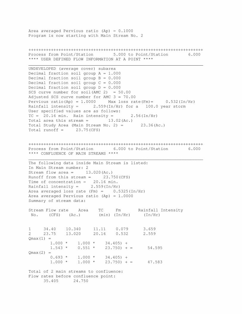
Area averaged Pervious ratio (Ap) = 0.1000 Program is now starting with Main Stream No. 2 ++++++++++++++++++++++++++++++++++++++++++++++++++++++++++++++++++++++ Process from Point/Station 5.000 to Point/Station 6.000 **** USER DEFINED FLOW INFORMATION AT A POINT **** ______________________________________________________________________ UNDEVELOPED (average cover) subarea Decimal fraction soil group A = 1.000 Decimal fraction soil group B = 0.000 Decimal fraction soil group C = 0.000 Decimal fraction soil group D = 0.000 SCS curve number for soil(AMC 2) = 50.00 Adjusted SCS curve number for AMC 3 = 70.00 Pervious ratio(Ap) = 1.0000 Max loss rate(Fm)= 0.532(In/Hr) Rainfall intensity = 2.559(In/Hr) for a 100.0 year storm User specified values are as follows: TC = 20.16 min. Rain intensity = 2.56(In/Hr) Total area this stream = 13.02(Ac.) Total Study Area (Main Stream No. 2) = 23.36(Ac.) Total runoff = 23.75(CFS) ++++++++++++++++++++++++++++++++++++++++++++++++++++++++++++++++++++++ Process from Point/Station 6.000 to Point/Station 6.000 **** CONFLUENCE OF MAIN STREAMS **** ______________________________________________________________________ The following data inside Main Stream is listed: In Main Stream number: 2 Stream flow area = 13.020(Ac.) Runoff from this stream = 23.750(CFS) Time of concentration = 20.16 min. Rainfall intensity = 2.559(In/Hr) Area averaged loss rate (Fm) = 0.5325(In/Hr) Area averaged Pervious ratio (Ap) = 1.0000 Summary of stream data: Stream Flow rate Area TC Fm Rainfall Intensity No. (CFS) (Ac.) (min) (In/Hr) (In/Hr) 1 34.40 10.340 11.11 0.079 3.659 2 23.75 13.020 20.16 0.532 2.559 Qmax(1) = 1.000 * 1.000 * 34.405) + 1.543 * 0.551 * 23.750) + = 54.595 Qmax(2) = 0.693 * 1.000 * 34.405) + 1.000 * 1.000 * 23.750) + = 47.583 Total of 2 main streams to confluence: Flow rates before confluence point: 35.405 24.750
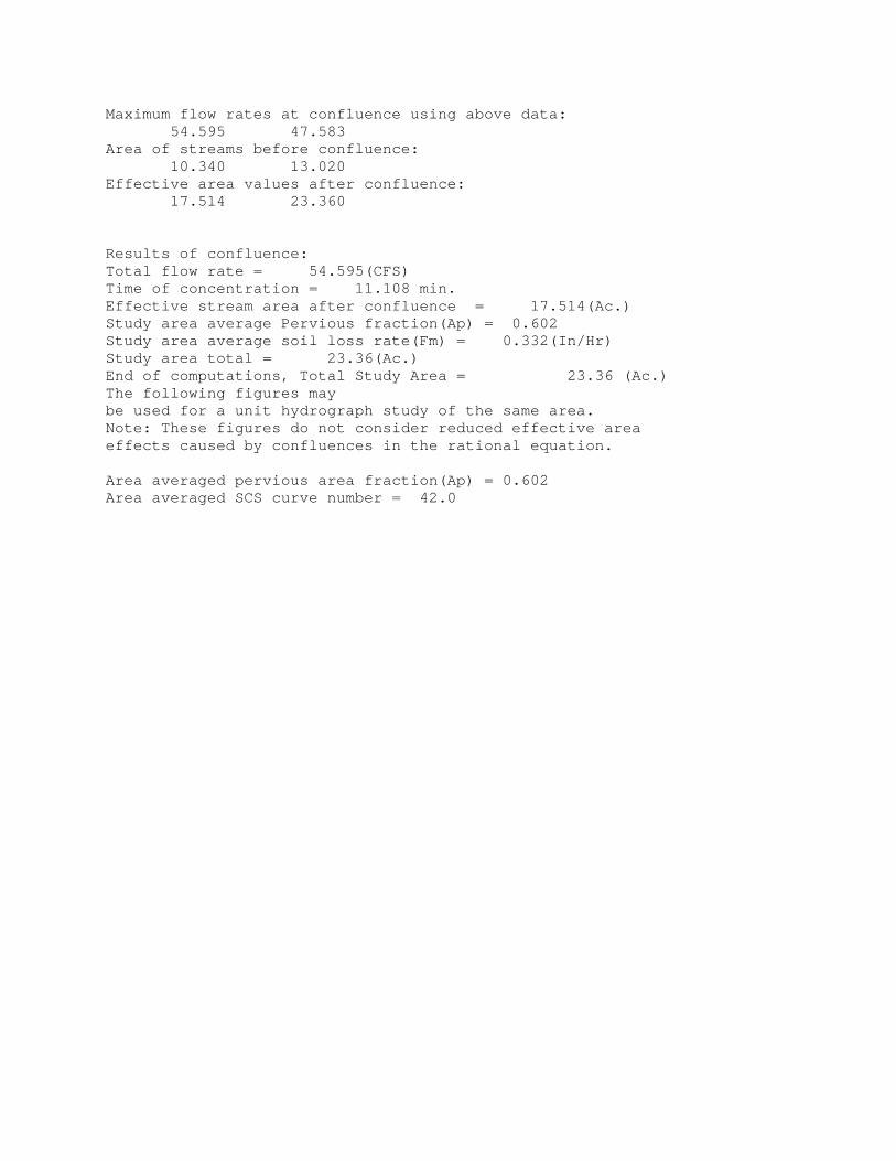
Maximum flow rates at confluence using above data: 54.595 47.583 Area of streams before confluence: 10.340 13.020 Effective area values after confluence: 17.514 23.360 Results of confluence: Total flow rate = 54.595(CFS) Time of concentration = 11.108 min. Effective stream area after confluence = 17.514(Ac.) Study area average Pervious fraction(Ap) = 0.602 Study area average soil loss rate(Fm) = 0.332(In/Hr) Study area total = 23.36(Ac.) End of computations, Total Study Area = 23.36 (Ac.) The following figures may be used for a unit hydrograph study of the same area. Note: These figures do not consider reduced effective area effects caused by confluences in the rational equation. Area averaged pervious area fraction(Ap) = 0.602 Area averaged SCS curve number = 42.0

Appendix C Hydraulic Calculations
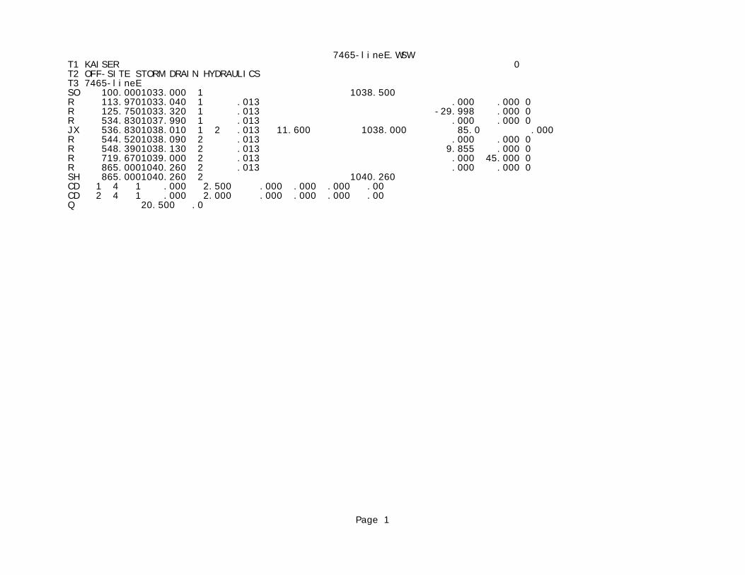
7465-lineE.WSWT1 KAISER 0 T2 OFF-SITE STORM DRAIN HYDRAULICS T3 7465-lineE SO 100.0001033.000 1 1038.500 R 113.9701033.040 1 .013 .000 .000 0 R 125.7501033.320 1 .013 -29.998 .000 0 R 534.8301037.990 1 .013 .000 .000 0 JX 536.8301038.010 1 2 .013 11.600 1038.000 85.0 .000 R 544.5201038.090 2 .013 .000 .000 0 R 548.3901038.130 2 .013 9.855 .000 0 R 719.6701039.000 2 .013 .000 45.000 0 R 865.0001040.260 2 .013 .000 .000 0 SH 865.0001040.260 2 1040.260 CD 1 4 1 .000 2.500 .000 .000 .000 .00 CD 2 4 1 .000 2.000 .000 .000 .000 .00 Q 20.500 .0
Page 1
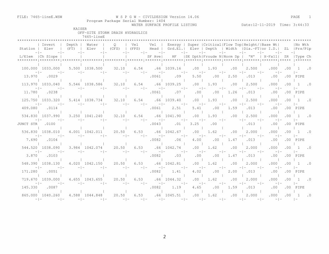
FILE: 7465-lineE.WSW W S P G W - CIVILDESIGN Version 14.06 PAGE 1 Program Package Serial Number: 1404 WATER SURFACE PROFILE LISTING Date:12-11-2019 Time: 3:44:33 KAISER OFF-SITE STORM DRAIN HYDRAULICS 7465-lineE ************************************************************************************************************************** ******** | Invert | Depth | Water | Q | Vel Vel | Energy | Super |Critical|Flow Top|Height/|Base Wt| |No Wth Station | Elev | (FT) | Elev | (CFS) | (FPS) Head | Grd.El.| Elev | Depth | Width |Dia.-FT|or I.D.| ZL |Prs/Pip -|- -|- -|- -|- -|- -|- -|- -|- -|- -|- -|- -|- -|- -| L/Elem |Ch Slope | | | | SF Ave| HF |SE Dpth|Froude N|Norm Dp | "N" | X-Fall| ZR |Type Ch *********|*********|********|*********|*********|*******|*******|*********|*******|********|********|*******|*******|***** |******* | | | | | | | | | | | | | 100.000 1033.000 5.500 1038.500 32.10 6.54 .66 1039.16 .00 1.93 .00 2.500 .000 .00 1 .0 -|- -|- -|- -|- -|- -|- -|- -|- -|- -|- -|- -|- -|- |- 13.970 .0029 .0061 .09 5.50 .00 2.50 .013 .00 .00 PIPE | | | | | | | | | | | | | 113.970 1033.040 5.546 1038.586 32.10 6.54 .66 1039.25 .00 1.93 .00 2.500 .000 .00 1 .0 -|- -|- -|- -|- -|- -|- -|- -|- -|- -|- -|- -|- -|- |- 11.780 .0238 .0061 .07 .00 .00 1.26 .013 .00 .00 PIPE | | | | | | | | | | | | | 125.750 1033.320 5.414 1038.734 32.10 6.54 .66 1039.40 .00 1.93 .00 2.500 .000 .00 1 .0 -|- -|- -|- -|- -|- -|- -|- -|- -|- -|- -|- -|- -|- |- 409.080 .0114 .0061 2.51 5.41 .00 1.59 .013 .00 .00 PIPE | | | | | | | | | | | | | 534.830 1037.990 3.250 1041.240 32.10 6.54 .66 1041.90 .00 1.93 .00 2.500 .000 .00 1 .0 -|- -|- -|- -|- -|- -|- -|- -|- -|- -|- -|- -|- -|- |- JUNCT STR .0100 .0043 .01 3.25 .00 .013 .00 .00 PIPE | | | | | | | | | | | | | 536.830 1038.010 4.001 1042.011 20.50 6.53 .66 1042.67 .00 1.62 .00 2.000 .000 .00 1 .0 -|- -|- -|- -|- -|- -|- -|- -|- -|- -|- -|- -|- -|- |- 7.690 .0104 .0082 .06 4.00 .00 1.47 .013 .00 .00 PIPE | | | | | | | | | | | | | 544.520 1038.090 3.984 1042.074 20.50 6.53 .66 1042.74 .00 1.62 .00 2.000 .000 .00 1 .0 -|- -|- -|- -|- -|- -|- -|- -|- -|- -|- -|- -|- -|- |- 3.870 .0103 .0082 .03 .00 .00 1.47 .013 .00 .00 PIPE | | | | | | | | | | | | | 548.390 1038.130 4.020 1042.150 20.50 6.53 .66 1042.81 .00 1.62 .00 2.000 .000 .00 1 .0 -|- -|- -|- -|- -|- -|- -|- -|- -|- -|- -|- -|- -|- |- 171.280 .0051 .0082 1.41 4.02 .00 2.00 .013 .00 .00 PIPE | | | | | | | | | | | | | 719.670 1039.000 4.655 1043.655 20.50 6.53 .66 1044.32 .00 1.62 .00 2.000 .000 .00 1 .0 -|- -|- -|- -|- -|- -|- -|- -|- -|- -|- -|- -|- -|- |- 145.330 .0087 .0082 1.19 4.65 .00 1.59 .013 .00 .00 PIPE | | | | | | | | | | | | | 865.000 1040.260 4.588 1044.848 20.50 6.53 .66 1045.51 .00 1.62 .00 2.000 .000 .00 1 .0 -|- -|- -|- -|- -|- -|- -|- -|- -|- -|- -|- -|- -|- |-
2
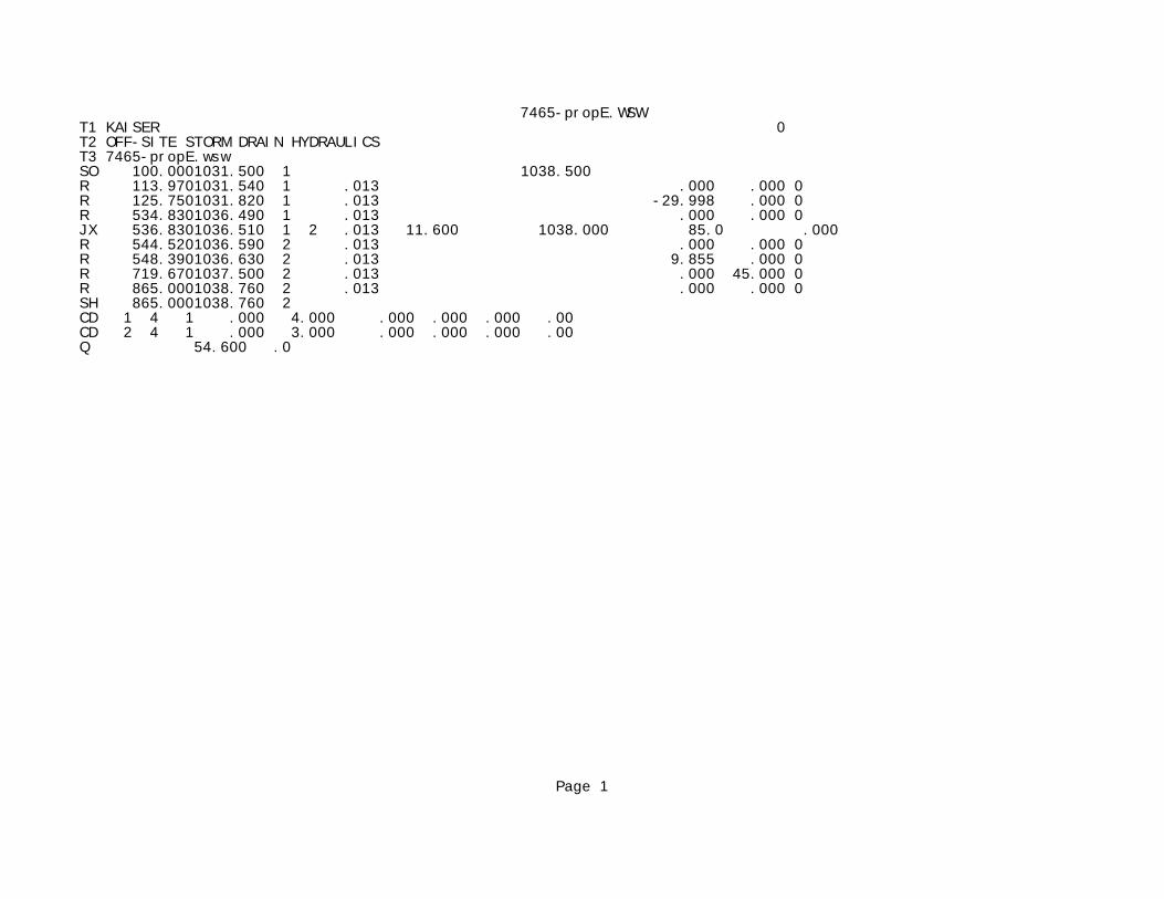
7465-propE.WSWT1 KAISER 0 T2 OFF-SITE STORM DRAIN HYDRAULICS T3 7465-propE.wsw SO 100.0001031.500 1 1038.500 R 113.9701031.540 1 .013 .000 .000 0 R 125.7501031.820 1 .013 -29.998 .000 0 R 534.8301036.490 1 .013 .000 .000 0 JX 536.8301036.510 1 2 .013 11.600 1038.000 85.0 .000 R 544.5201036.590 2 .013 .000 .000 0 R 548.3901036.630 2 .013 9.855 .000 0 R 719.6701037.500 2 .013 .000 45.000 0 R 865.0001038.760 2 .013 .000 .000 0 SH 865.0001038.760 2 CD 1 4 1 .000 4.000 .000 .000 .000 .00 CD 2 4 1 .000 3.000 .000 .000 .000 .00 Q 54.600 .0
Page 1
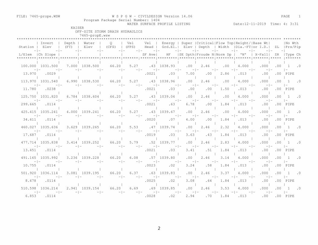
FILE: 7465-prope.WSW W S P G W - CIVILDESIGN Version 14.06 PAGE 1 Program Package Serial Number: 1404 WATER SURFACE PROFILE LISTING Date:12-11-2019 Time: 4: 3:31 KAISER OFF-SITE STORM DRAIN HYDRAULICS 7465-propE.wsw ************************************************************************************************************************** ******** | Invert | Depth | Water | Q | Vel Vel | Energy | Super |Critical|Flow Top|Height/|Base Wt| |No Wth Station | Elev | (FT) | Elev | (CFS) | (FPS) Head | Grd.El.| Elev | Depth | Width |Dia.-FT|or I.D.| ZL |Prs/Pip -|- -|- -|- -|- -|- -|- -|- -|- -|- -|- -|- -|- -|- -| L/Elem |Ch Slope | | | | SF Ave| HF |SE Dpth|Froude N|Norm Dp | "N" | X-Fall| ZR |Type Ch *********|*********|********|*********|*********|*******|*******|*********|*******|********|********|*******|*******|***** |******* | | | | | | | | | | | | | 100.000 1031.500 7.000 1038.500 66.20 5.27 .43 1038.93 .00 2.46 .00 4.000 .000 .00 1 .0 -|- -|- -|- -|- -|- -|- -|- -|- -|- -|- -|- -|- -|- |- 13.970 .0029 .0021 .03 7.00 .00 2.86 .013 .00 .00 PIPE | | | | | | | | | | | | | 113.970 1031.540 6.990 1038.530 66.20 5.27 .43 1038.96 .00 2.46 .00 4.000 .000 .00 1 .0 -|- -|- -|- -|- -|- -|- -|- -|- -|- -|- -|- -|- -|- |- 11.780 .0238 .0021 .03 .00 .00 1.50 .013 .00 .00 PIPE | | | | | | | | | | | | | 125.750 1031.820 6.784 1038.604 66.20 5.27 .43 1039.04 .00 2.46 .00 4.000 .000 .00 1 .0 -|- -|- -|- -|- -|- -|- -|- -|- -|- -|- -|- -|- -|- |- 299.665 .0114 .0021 .63 6.78 .00 1.84 .013 .00 .00 PIPE | | | | | | | | | | | | | 425.415 1035.241 4.000 1039.241 66.20 5.27 .43 1039.67 .00 2.46 .00 4.000 .000 .00 1 .0 -|- -|- -|- -|- -|- -|- -|- -|- -|- -|- -|- -|- -|- |- 34.611 .0114 .0020 .07 4.00 .00 1.84 .013 .00 .00 PIPE | | | | | | | | | | | | | 460.027 1035.636 3.629 1039.265 66.20 5.53 .47 1039.74 .00 2.46 2.32 4.000 .000 .00 1 .0 -|- -|- -|- -|- -|- -|- -|- -|- -|- -|- -|- -|- -|- |- 17.687 .0114 .0019 .03 3.63 .43 1.84 .013 .00 .00 PIPE | | | | | | | | | | | | | 477.714 1035.838 3.414 1039.252 66.20 5.79 .52 1039.77 .00 2.46 2.83 4.000 .000 .00 1 .0 -|- -|- -|- -|- -|- -|- -|- -|- -|- -|- -|- -|- -|- |- 13.451 .0114 .0021 .03 3.41 .51 1.84 .013 .00 .00 PIPE | | | | | | | | | | | | | 491.165 1035.992 3.236 1039.228 66.20 6.08 .57 1039.80 .00 2.46 3.14 4.000 .000 .00 1 .0 -|- -|- -|- -|- -|- -|- -|- -|- -|- -|- -|- -|- -|- |- 10.755 .0114 .0023 .02 3.24 .58 1.84 .013 .00 .00 PIPE | | | | | | | | | | | | | 501.920 1036.114 3.081 1039.195 66.20 6.37 .63 1039.83 .00 2.46 3.37 4.000 .000 .00 1 .0 -|- -|- -|- -|- -|- -|- -|- -|- -|- -|- -|- -|- -|- |- 8.678 .0114 .0025 .02 3.08 .64 1.84 .013 .00 .00 PIPE | | | | | | | | | | | | | 510.598 1036.214 2.941 1039.154 66.20 6.69 .69 1039.85 .00 2.46 3.53 4.000 .000 .00 1 .0 -|- -|- -|- -|- -|- -|- -|- -|- -|- -|- -|- -|- -|- |- 6.853 .0114 .0028 .02 2.94 .70 1.84 .013 .00 .00 PIPE
2
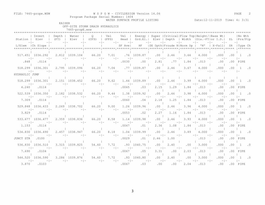
FILE: 7465-prope.WSW W S P G W - CIVILDESIGN Version 14.06 PAGE 2 Program Package Serial Number: 1404 WATER SURFACE PROFILE LISTING Date:12-11-2019 Time: 4: 3:31 KAISER OFF-SITE STORM DRAIN HYDRAULICS 7465-propE.wsw ************************************************************************************************************************** ******** | Invert | Depth | Water | Q | Vel Vel | Energy | Super |Critical|Flow Top|Height/|Base Wt| |No Wth Station | Elev | (FT) | Elev | (CFS) | (FPS) Head | Grd.El.| Elev | Depth | Width |Dia.-FT|or I.D.| ZL |Prs/Pip -|- -|- -|- -|- -|- -|- -|- -|- -|- -|- -|- -|- -|- -| L/Elem |Ch Slope | | | | SF Ave| HF |SE Dpth|Froude N|Norm Dp | "N" | X-Fall| ZR |Type Ch *********|*********|********|*********|*********|*******|*******|*********|*******|********|********|*******|*******|***** |******* | | | | | | | | | | | | | 517.451 1036.292 2.812 1039.104 66.20 7.01 .76 1039.87 .00 2.46 3.66 4.000 .000 .00 1 .0 -|- -|- -|- -|- -|- -|- -|- -|- -|- -|- -|- -|- -|- |- .848 .0114 .0030 .00 2.81 .77 1.84 .013 .00 .00 PIPE | | | | | | | | | | | | | 518.299 1036.301 2.795 1039.096 66.20 7.06 .77 1039.87 .00 2.46 3.67 4.000 .000 .00 1 .0 -|- -|- -|- -|- -|- -|- -|- -|- -|- -|- -|- -|- -|- |- HYDRAULIC JUMP | | | | | | | | | | | | | 518.299 1036.301 2.151 1038.452 66.20 9.62 1.44 1039.89 .00 2.46 3.99 4.000 .000 .00 1 .0 -|- -|- -|- -|- -|- -|- -|- -|- -|- -|- -|- -|- -|- |- 4.240 .0114 .0065 .03 2.15 1.29 1.84 .013 .00 .00 PIPE | | | | | | | | | | | | | 522.539 1036.350 2.182 1038.532 66.20 9.44 1.38 1039.92 .00 2.46 3.98 4.000 .000 .00 1 .0 -|- -|- -|- -|- -|- -|- -|- -|- -|- -|- -|- -|- -|- |- 7.309 .0114 .0060 .04 2.18 1.25 1.84 .013 .00 .00 PIPE | | | | | | | | | | | | | 529.848 1036.433 2.269 1038.702 66.20 9.00 1.26 1039.96 .00 2.46 3.96 4.000 .000 .00 1 .0 -|- -|- -|- -|- -|- -|- -|- -|- -|- -|- -|- -|- -|- |- 3.829 .0114 .0053 .02 2.27 1.16 1.84 .013 .00 .00 PIPE | | | | | | | | | | | | | 533.677 1036.477 2.359 1038.836 66.20 8.58 1.14 1039.98 .00 2.46 3.93 4.000 .000 .00 1 .0 -|- -|- -|- -|- -|- -|- -|- -|- -|- -|- -|- -|- -|- |- 1.153 .0114 .0047 .01 2.36 1.08 1.84 .013 .00 .00 PIPE | | | | | | | | | | | | | 534.830 1036.490 2.457 1038.947 66.20 8.18 1.04 1039.99 .00 2.46 3.89 4.000 .000 .00 1 .0 -|- -|- -|- -|- -|- -|- -|- -|- -|- -|- -|- -|- -|- |- JUNCT STR .0100 .0029 .01 2.46 1.00 .013 .00 .00 PIPE | | | | | | | | | | | | | 536.830 1036.510 3.315 1039.825 54.60 7.72 .93 1040.75 .00 2.40 .00 3.000 .000 .00 1 .0 -|- -|- -|- -|- -|- -|- -|- -|- -|- -|- -|- -|- -|- |- 7.690 .0104 .0067 .05 3.31 .00 2.03 .013 .00 .00 PIPE | | | | | | | | | | | | | 544.520 1036.590 3.286 1039.876 54.60 7.72 .93 1040.80 .00 2.40 .00 3.000 .000 .00 1 .0 -|- -|- -|- -|- -|- -|- -|- -|- -|- -|- -|- -|- -|- |- 3.870 .0103 .0067 .03 .00 .00 2.04 .013 .00 .00 PIPE
3
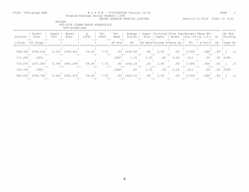
FILE: 7465-prope.WSW W S P G W - CIVILDESIGN Version 14.06 PAGE 3 Program Package Serial Number: 1404 WATER SURFACE PROFILE LISTING Date:12-11-2019 Time: 4: 3:31 KAISER OFF-SITE STORM DRAIN HYDRAULICS 7465-propE.wsw ************************************************************************************************************************** ******** | Invert | Depth | Water | Q | Vel Vel | Energy | Super |Critical|Flow Top|Height/|Base Wt| |No Wth Station | Elev | (FT) | Elev | (CFS) | (FPS) Head | Grd.El.| Elev | Depth | Width |Dia.-FT|or I.D.| ZL |Prs/Pip -|- -|- -|- -|- -|- -|- -|- -|- -|- -|- -|- -|- -|- -| L/Elem |Ch Slope | | | | SF Ave| HF |SE Dpth|Froude N|Norm Dp | "N" | X-Fall| ZR |Type Ch *********|*********|********|*********|*********|*******|*******|*********|*******|********|********|*******|*******|***** |******* | | | | | | | | | | | | | 548.390 1036.630 3.333 1039.963 54.60 7.72 .93 1040.89 .00 2.40 .00 3.000 .000 .00 1 .0 -|- -|- -|- -|- -|- -|- -|- -|- -|- -|- -|- -|- -|- |- 171.280 .0051 .0067 1.15 3.33 .00 3.00 .013 .00 .00 PIPE | | | | | | | | | | | | | 719.670 1037.500 3.749 1041.249 54.60 7.72 .93 1042.18 .00 2.40 .00 3.000 .000 .00 1 .0 -|- -|- -|- -|- -|- -|- -|- -|- -|- -|- -|- -|- -|- |- 145.330 .0087 .0067 .97 3.75 .00 2.18 .013 .00 .00 PIPE | | | | | | | | | | | | | 865.000 1038.760 3.463 1042.223 54.60 7.72 .93 1043.15 .00 2.40 .00 3.000 .000 .00 1 .0 -|- -|- -|- -|- -|- -|- -|- -|- -|- -|- -|- -|- -|- |-
4

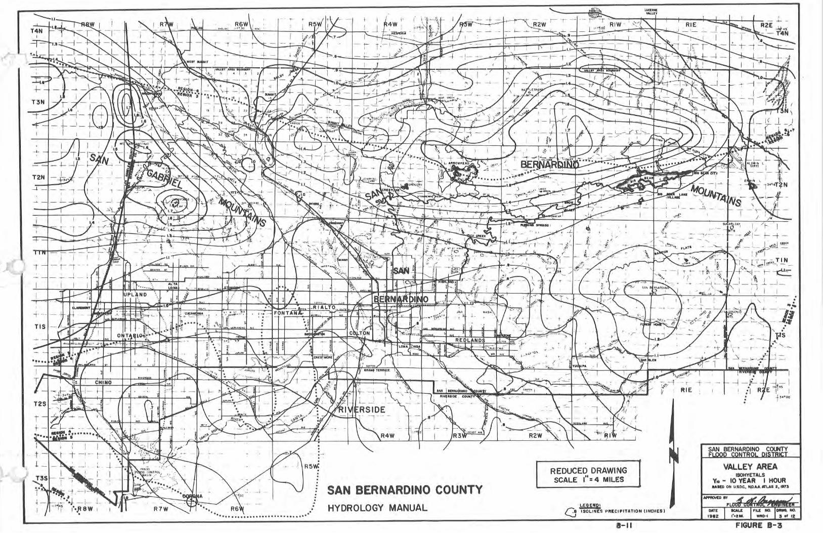
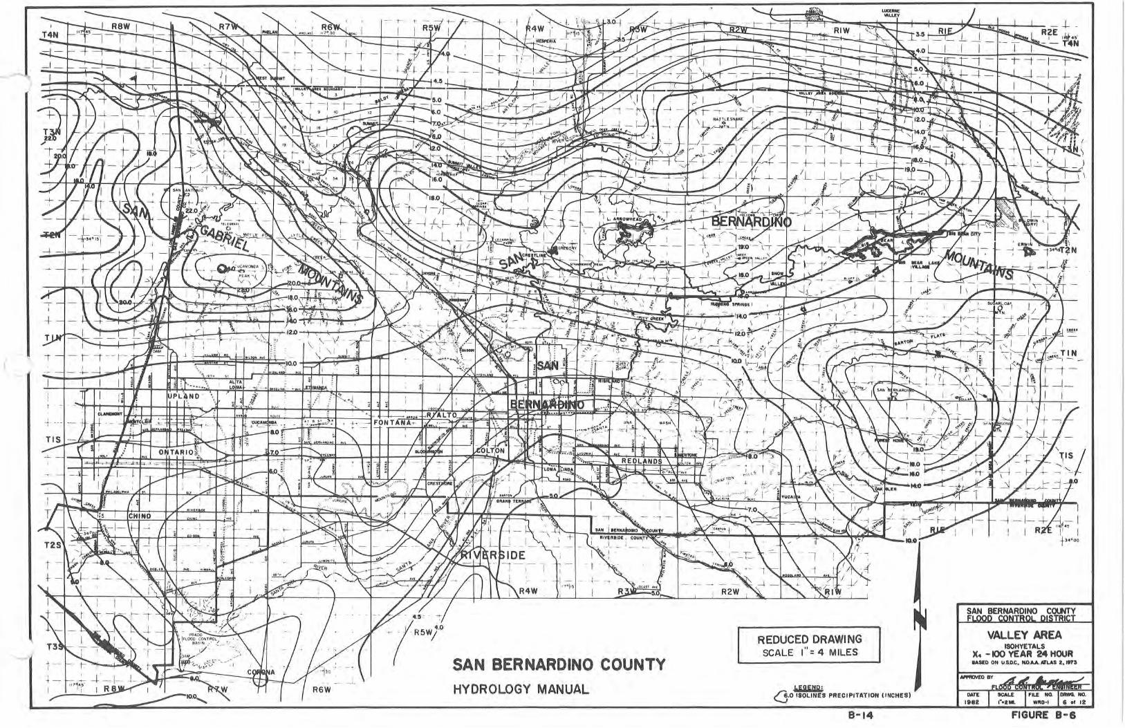
Appendix D Soil Group Map and Isohyetal Map

Appendix E References
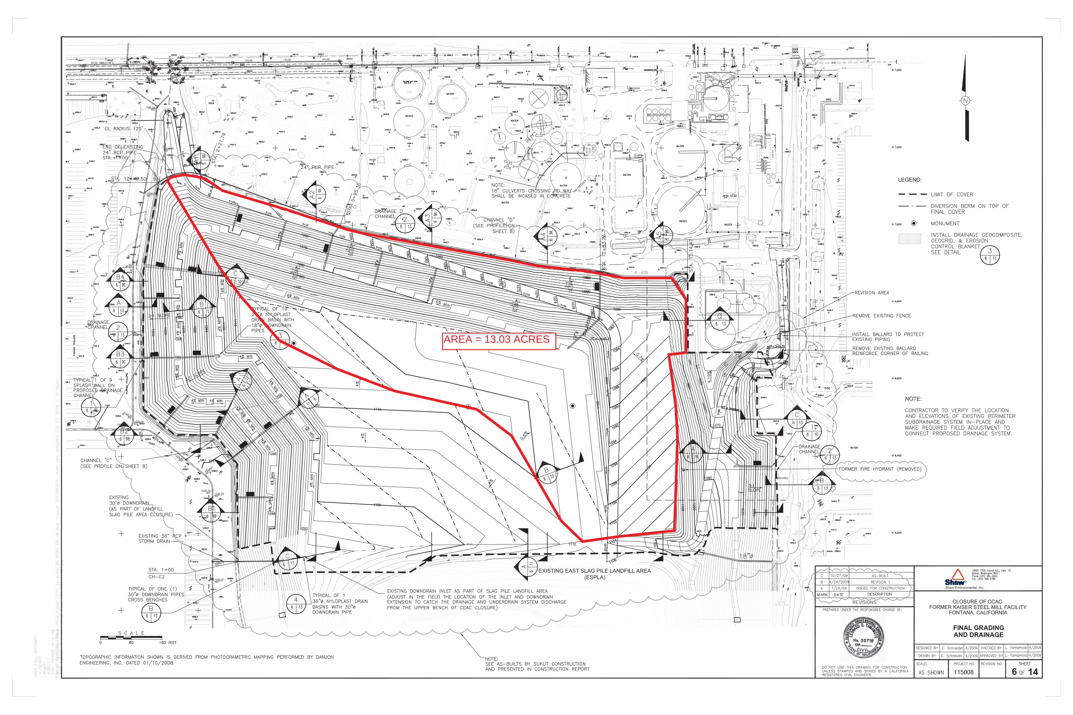
AREA = 13.03 ACRES