preliminary land use - boardmantohemingway.com w yh e r i v e r s n a k e riv er s n a k e r i v e r...
TRANSCRIPT
O R E G O N
E N E R G YDEPARTMENT OF
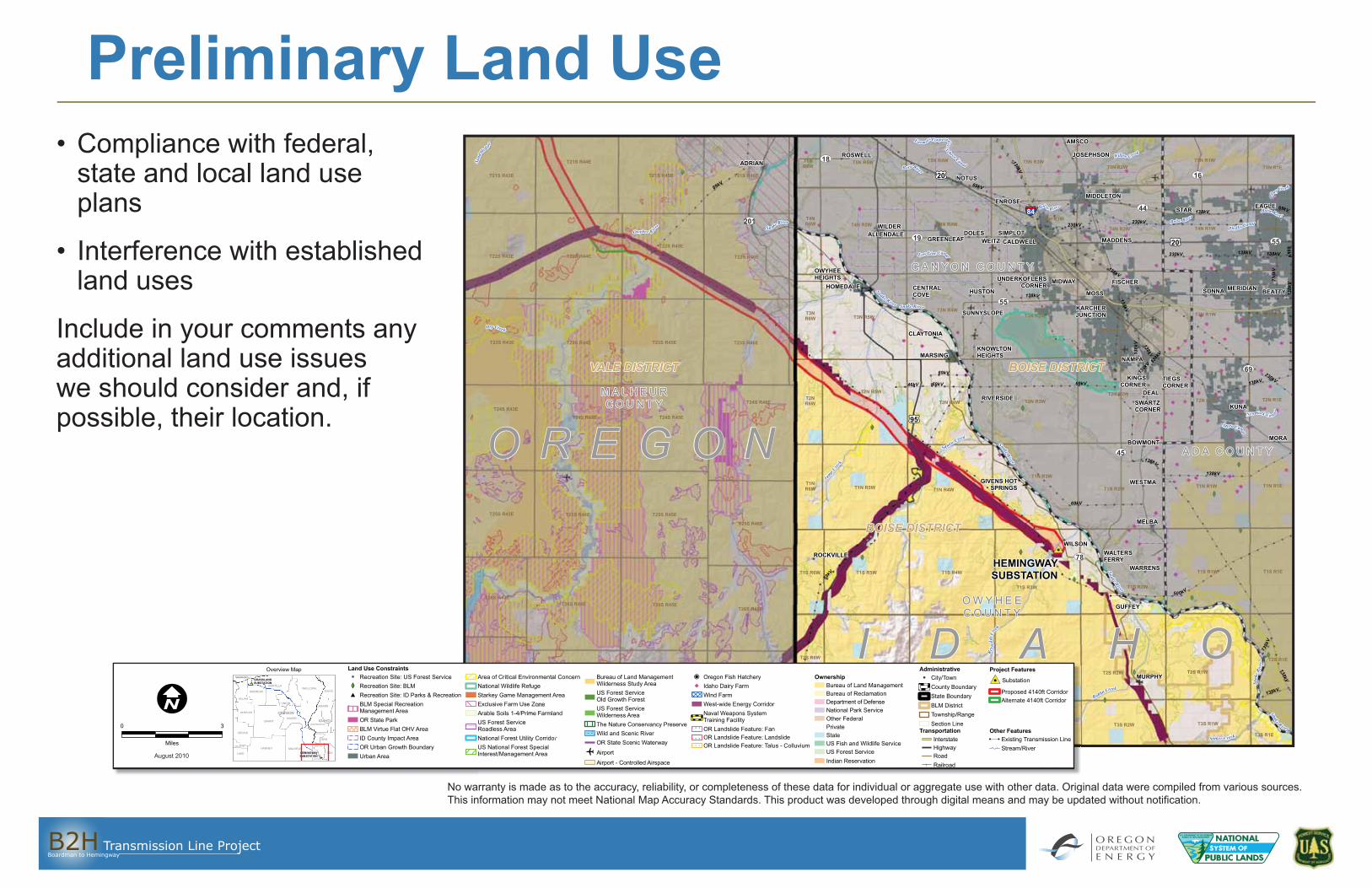
Preliminary Land Use• Compliance with federal,
state and local land use plans
• Interference with established land uses
Include in your comments any additional land use issues we should consider and, if possible, their location.
Owyhee R iver
Snake River
Snake River
M ora C anal
DryCreek
Boise River
Phylli s Canal
SnakeRiver
Snake R iver
Ne w York Ca n al
Jump Cree
k
Squa w Creek
Boise Ri v er
Sand
Holl ow
Reyn
old s C
reek
Bo iseRiver
Sn akeRiver
Snak
e Riv
er
Boise Ri ver
Rabbit Creek
Farm er sC ooperativeS
ebree Canal
Snake River
o r Cr
Willo w Creek
Dry Creek
Sinke r Creek
Lo w Line Canal
84
18
45
16
19
78
69
201
55
55
44
O R E G O N
I D A H O
HEMINGWAYSUBSTATION
VALE DISTRICT
138kV
138kV
138kV
69kV
230kV
138kV
69kV
69kV
230kV
138kV
230k
V
69kV
69kV
138kV
138k
V
46kV
230kV
138kV
138kV
138k
V
69kV
69kV
138kV
69kV
69kV
138kV
138k
V138k
V
50 0kV
230kV
138kV
138kV
138kV
138k
V
CLAYTONIA
KARCHERJUNCTIONSUNNYSLOPE
CENTRALCOVE BEATTYHUSTON SONNA MERIDIAN
MOSS
UNDERKOFLERSCORNER FISCHER
OWYHEEHEIGHTS MIDWAY
MADDENSCALDWELLWEITZDOLES SIMPLOT
GREENLEAFALLENDALE
WILDER
STAR EAGLEENROSE
MIDDLETON
NOTUS
ROSWELL JOSEPHSON
AMSCO
ADRIAN
HOMEDALE
REYNOLDS
MURPHY
GUFFEY
WARRENS
WALTERSFERRY
ROCKVILLE
WILSON
MELBA
WESTMAGIVENS HOTSPRINGS
BOWMONTMORA
KUNARIVERSIDE
SWARTZCORNER
DEAL
TIEGSCORNER
KINGSCORNER
NAMPA
KNOWLTONHEIGHTSMARSING
BOISE DISTRICT
BOISE DISTRICT
T5N R1WT5N R4WT5N R5WT5N R2W
T3S R1WT3S R2WT3S R3WT3S R4W
T1S R1E
T4N R1E
T2S R1E
T5N R3W
T1S R5W T1S R4W
T5N R1E
T1S R3W
T4N R5W
T3S R5W
T3N R3W
T1S R2W
T3N R1E
T2N R2W
T1S R1W
T1N R5W
T2N R1E
T1N R4W
T3N R5W
T1N R3W
T1N R2W
T2N R3W
T2S R1W
T1N R1W
T2N R4W
T1N R1E
T2N R1W
T2N R5W
T3N R4W
T3S R1E
T2S R2WT2S R3WT2S R4WT2S R5W
T3N R1W
T4N R1W
T4N R3W
T4N R2W
T3N R2W
T4N R4W
T3NR6W
T2S R6W
T28S R46ET28S R45ET28S R44ET28S R43E
T27S R46ET27S R45ET27S R44E
T2NR6W
T26S R46ET26S R45ET26S R44E
T26S R43E
T25S R46E
T25S R45ET25S R44ET25S R43E
T24S R46E
T1S R6W
T1NR6W
T24S R44E T24S R45E
T23S R46ET23S R45ET23S R44ET23S R43E
T22S R46ET22S R44ET22S R43E
T24S R43E
T21S R46ET21S R45E
T21S R44E
T21S R43E
T27S R43E
T22S R45E
T5NR6W
T3S R6W
T4NR6W
C A N Y O N C O U N T Y
A D A C O U N T Y
M A L H E U RC O U N T Y
O W Y H E EC O U N T Y
95
20
20
CROOK
LLOWA
ADAMS
IDAHO
DESCHUTESHA
LAKE
LAND
IDAHO
Overview Map Land Use ConstraintsRecreation Site: US Forest Service Recreation Site: BLMRecreation Site: ID Parks & RecreationBLM Special Recreation Management Area OR State ParkBLM Virtue Flat OHV AreaID County Impact AreaOR Urban Growth BoundaryUrban Area
Area of Critical Environmental ConcernNational Wildlife RefugeStarkey Game Management AreaExclusive Farm Use ZoneArable Soils 1-4/Prime FarmlandUS Forest ServiceRoadless AreaNational Forest Utility CorridorUS National Forest Special Interest/Management Area
Bureau of Land ManagementWilderness Study AreaUS Forest ServiceOld Growth ForestUS Forest ServiceWilderness AreaThe Nature Conservancy PreserveWild and Scenic RiverOR State Scenic Waterway
Airport
Airport - Controlled Airspace
Oregon Fish HatcheryIdaho Dairy FarmWind FarmWest-wide Energy CorridorNaval Weapons System Training FacilityOR Landslide Feature: FanOR Landslide Feature: LandslideOR Landslide Feature: Talus - Colluvium
OwnershipBureau of Land ManagementBureau of ReclamationDepartment of DefenseNational Park ServiceOther FederalPrivateStateUS Fish and Wildlife ServiceUS Forest ServiceIndian Reservation
0 3
Miles
AdministrativeCity/TownCounty BoundaryState BoundaryBLM DistrictTownship/RangeSection Line
TransportationInterstateHighwayRoadRailroad
Project Features
Substation
Proposed 4140ft CorridorAlternate 4140ft Corridor
Other FeaturesExisting Transmission LineStream/River
August 2010
orroo CCCrrCC
RREYYNNOOLDLDSS
TT33SS R R33WWTT33SS R4W R4W
T2S R3WT2S R4WT2S R5W
T28S R46ET28S R45ET28S R44ET28S R43E
T27S R46ET27S R45ET27S R44ETT2277SS R R443E3E
CROOK
LLOWA
ADAMS
IDAHO
DESCHUTESHA
LAKE
LLAND
IDAD HO
Overvrr iew Map Land Use ConstraintsRecreation Site: US Forest ServiceRecreation Site: BLMRecreation Site: ID Parks & RecreationBLM Special RecreationManagement AreaOR State ParkBLM Virtue Flat OHV AreaID County Impact AreaOR Urban Growth BoundaryUrban Area
Area of Critical Environmental ConcernNational Wildlife RefugeStarkey Game Management AreaExclusive Farm Use ZoneArable Soils 1-4/Prime FarmlandUS Forest ServiceRoadless AreaNational Forest Utility CorridorUS National Forest SpecialInterest/Management Area
Bureau of Land ManagementWilderness Study AreaUS Forest ServiceOld Growth ForestUS Forest ServiceWilderness AreaThe Nature Conservrr ancy PreserveWild and Scenic RiverOR State Scenic Waterwrr ay
Airport
Airport - Controlled Airspace
Oregon Fish HatcheryIdaho Dairy FarmWind FarmWest-wide Energy CorridorNaval Weapons SystemTraining FacilityOR Landslide Feature: FanOR Landslide Feature: LandslideOR Landslide Feature: TaTT lus - Colluvium
OwnershipBureau of Land ManagementBureau of ReclamationDepartment of DefenseNational Park ServiceOther FederalPrivateStateUS Fish and Wildlife ServiceUS Forest ServiceIndian Reservation
0 3
Miles
AdministrativeCity/yy TowTT nCounty BoundaryState BoundaryrrBLM DistrictToTT wnship/RangeSection Line
Transportrr ationInterstateHighwayRoadRailroad
Projo ect Features
Substation
Proposed 4140ftf CorridorAlternate 4140ftff Corridor
Other FeaturesExisting Transmission LineStream/River
T28S R46ET28S R45ET28S R44E3EgAAuAuAAuAuAuAuAAuAuAuAuAuAuAAuAAAAAuuuguguggugggguguguuuguggg stststtttss 22220000 0000TT2288SS RR4433August 2010AuAuAAAAAAAAAAAAAuuuuuuAAAAuAAAAA guguguggggggugggustssssssstsssttssttt 22222222200010100010 000000TT228SS RR4433
T3S R5W
T28S R44ET28S R43E
T3S R6WCROOK
WALLOWA
WHEELER
ADA
ADAMS
CANYON
GEM
IDAHO
OWYHEE
PAYETTE
WASHINGTON
BAKER
KLICKITAT
DESCHUTES
GILLIAM
GRANT
HARNEY
LAKE
MALHEUR
MORROW
UMATILLA
UNION
GRASSLANDSUBSTATION
HEMINGWAYSUBSTATION
IDAHO
OREGON
WASHINGTON
Overview Map Land Use ConstraintsRecreation Site: US Forest Service Recreation Site: BLMRecreation Site: ID Parks & RecreationBLM Special Recreation Management Area OR State ParkBLM Virtue Flat OHV AreaID County Impact AreaOR Urban Growth BoundaryUrban Area
Area of Critical Environmental ConcernNational Wildlife RefugeStarkey Game Management AreaExclusive Farm Use ZoneArable Soils 1-4/Prime FarmlandUS Forest ServiceRoadless AreaNational Forest Utility CorridorUS National Forest Special Interest/Management Area
Bureau of Land ManagementWilderness Study AreaUS Forest ServiceOld Growth ForestUS Forest ServiceWilderness AreaThe Nature Conservancy PreserveWild and Scenic RiverOR State Scenic Waterway
Airport
Airport - Controlled Airspace
Oregon Fish HatcheryIdaho Dairy FarmWind FarmWest-wide Energy CorridorNaval Weapons System Training FacilityOR Landslide Feature: FanOR Landslide Feature: LandslideOR Landslide Feature: Talus - Colluvium
OwnershipBureau of Land ManagementBureau of ReclamationDepartment of DefenseNational Park ServiceOther FederalPrivateStateUS Fish and Wildlife ServiceUS Forest ServiceIndian Reservation
0 3
Miles
AdministrativeCity/TownCounty BoundaryState BoundaryBLM DistrictTownship/RangeSection Line
TransportationInterstateHighwayRoadRailroad
Project Features
Substation
Proposed 4140ft CorridorAlternate 4140ft Corridor
Other FeaturesExisting Transmission LineStream/River
August 2010
No warranty is made as to the accuracy, reliability, or completeness of these data for individual or aggregate use with other data. Original data were compiled from various sources. This information may not meet National Map Accuracy Standards. This product was developed through digital means and may be updated without notifi cation.