preliminary mitigated negative declarationsfmea.sfplanning.org/2014.0198e_pmnd.pdf · appendix d:...
TRANSCRIPT

Preliminary Mitigated Negative Declaration
Date: May 13, 2015 Case No.: 2014.0198E Project Title: 850 Bryant Street – Hall of Justice
Rehabilitation and Detention Facility Project Zoning: Western SoMa Special Use District Public Use (P) Zoning District 105-J Height and Bulk District Service/Arts/Light Industrial (SALI) Zoning District 30-X Height and Bulk District Block/Lot: 3759/009 through 012, 014, 043, 045, a portion of 042, and Harriet Street and
Ahern Way street rights-of way Lot Size: 40,276 square feet Project Sponsor Jumoke Akin-Taylor San Francisco Department of Public Works Building, Design and Construction, Project Management (415) 557-4751
Dan Santizo City and County of San Francisco Sheriff’s Department Sheriff’s Bureau of Building Services (415) 522-8123 Lead Agency: San Francisco Planning Department Staff Contact: Christopher Espiritu - (415) 575-9022 [email protected]
PROJECT DESCRIPTION: The site for the proposed Hall of Justice (HOJ) Rehabilitation and Detention Facility (RDF) project is located in San Francisco’s South of Market neighborhood, at the intersection of Bryant and Sixth streets, and consists of eight parcels: Assessor’s Block 3759, Lots 9 through 12, 14, 43, 45, a portion of Lot 42, and portions of the Harriet Street and Ahern Way rights-of-way. The western portion of the project site (the HOJ site), located at 850 Bryant Street, contains the existing eight-story, 117-foot-tall (105 feet to the rooftop plus an additional 12-foot-tall mechanical penthouse), 610,000-gsf HOJ, constructed between 1958 and 1961. The existing HOJ serves as one of the primary County Jail Facilities for the San Francisco Sheriff’s Department. County Jails No. 3 (CJ#3) and No. 4 (CJ#4) are located on the 6th and 7th floors of the existing HOJ. Other uses within the existing HOJ include the justice center for the San Francisco County Superior Court, the Chief Medical Examiner and morgue, and the current operational headquarters for the San Francisco Police Department. County Jails No. 3 (CJ#3) and No. 4 (CJ#4) are located on the 6th and 7th floors of the existing HOJ. Directly east of the HOJ site is the project building site, which is bounded by Ahern Way to the north, Sixth Street to the east, Bryant Street to the south, and Harriet Street to the west. The 40,276-sf project building site contains two vacant lots, areas of surface parking, and five existing buildings: a one-story, 6,000-gsf office building, constructed in 1956 (444 Sixth Street); a one-story, 5,100-gsf commercial building, constructed in 1959 (450 Sixth Street); a three-story, 7,150-gsf,
www.sfplanning.org Revised 10/5/12

Preliminary Mitigated Negative Declaration May 13, 2015
CASE NO. 2014.0198E 850 Bryant Street – Hallof Justice
Rehabilitation and Detention Facility
14-unit single room occupancy (SRO) residential building with ground-floor retail, constructed in 1916 (480-484 Sixth Street); a three-story, 16,500-gsf office building, constructed in 2003 (800-804 Bryant Street); and a one-story, 2,000-gsf McDonald’s restaurant, constructed in 1996 (820 Bryant Street). The project building site also includes portions of the Harriet Street and Ahern Way rights-of way.
The proposed project is a joint-agency effort between the City and County of San Francisco Department of Public Works and the City and County of San Francisco Sheriff’s Department. The proposed project calls for construction of a new, approximately 200,000-gsf, 110-foot-tall (95 feet to the rooftop plus an additional 15-foot-tall mechanical penthouse) RDF on the project building site. The City and County of San Francisco would acquire the project building site for development of the proposed project. All the existing buildings on the project building site, with the exception of the buildings at 480-484 Sixth Street (Block 3759/Lot 10) and 800-804 Bryant Street (Block 3759/Lot 11), would be demolished. The proposed project would require legislative amendments to the Planning Code to reclassify the zoning designation on the project building site from SALI to P and to reclassify the height and bulk district from 30-X to 95-J.
The proposed RDF would replace the existing CJ#3 and CJ#4 and is a part of a larger program to relocate City agencies from the seismically deficient HOJ. The proposed RDF would be constructed as a maximum security facility, compliant with adult detention facility codes and standards, with a capacity of up to 640 beds, a 30 percent reduction (265 fewer beds) from the combined capacity in CJ#3 and CJ#4 of 905 beds. The proposed RDF would also include space for administrative offices, staff support, exercise, mental and medical health services, and programs and classroom space for the inmates.
The proposed project would include improvements within the Harriet Street and Ahern Way rights-of-way. A subterranean tunnel would be constructed underneath the Harriet Street roadway and sidewalks to connect the existing HOJ to the basement level of the proposed RDF. This tunnel would be used to provide secure, direct transport of inmates between the proposed RDF and the existing HOJ. As part of the construction of the proposed RDF, portions of Harriet Street and Ahern Way would be reconfigured to accommodate designated, secure service and jail transport areas (a loading dock on Harriet Street and a secured, controlled entryway or “sally port” on Ahern Way). In addition, both Harriet Street (from Bryant Street to the I-80 overpass) and Ahern Way (west of Sixth Street) would be closed to through traffic in both directions; only official service vehicles would be allowed access.
FINDING: This project could not have a significant effect on the environment. This finding is based upon the criteria of the Guidelines of the State Secretary for Resources, Sections 15064 (Determining Significant Effect), 15065 (Mandatory Findings of Significance), and 15070 (Decision to prepare a Negative Declaration), and the following reasons as documented in the Initial Evaluation (Initial Study) for the project, which is attached. Mitigation measures are included in this project to avoid potentially significant effects. See pp. 216-222. cc: Jumoke Akin-Taylor, Department of Public Works
Dan Santizo, Sheriff’s Department Richard Sucre, Current Planning Supervisor Jane Kim, District 6 Master Decision File Distribution List
2

Case No. 2014.0198E i 850 Bryant Street – Hall of Justice
May 13, 2015 Rehabilitation and Detention Facility Project
Initial Study
850 Bryant Street - Hall of Justice Rehabilitation and Detention Facility Project
Planning Department Case No. 2014.0198E
TABLE OF CONTENTS
Section Page
ACRONYMS AND ABBREVIATIONS ....................................................................................... iii A. PROJECT DESCRIPTION ................................................................................................. 1 B. PROJECT SETTING ........................................................................................................ 21 C. COMPATIBILITY WITH EXISTING ZONING AND PLANS ...................................... 25 D. SUMMARY OF ENVIRONMENTAL EFFECTS ........................................................... 30 E. EVALUATION OF ENVIRONMENTAL EFFECTS ...................................................... 32 1. Land Use and Land Use Planning ............................................................................... 32 2. Population and Housing ............................................................................................... 35 3. Cultural and Paleontological Resources ....................................................................... 40 4. Transportation and Circulation ..................................................................................... 54 5. Noise ............................................................................................................................. 89 6. Air Quality .................................................................................................................. 112 7. Greenhouse Gas Emissions ........................................................................................ 131 8. Wind and Shadow ...................................................................................................... 135 9. Recreation ................................................................................................................... 149 10. Utilities and Service Systems ................................................................................... 152 11. Public Services ......................................................................................................... 159 12. Biological Resources ................................................................................................ 162 13. Geology and Soils .................................................................................................... 166 14. Hydrology and Water Quality .................................................................................. 175 15. Hazards and Hazardous Materials ............................................................................ 195 16. Mineral and Energy Resources ................................................................................. 211 17. Agricultural and Forest Resources ........................................................................... 213 18. Mandatory Findings of Significance ........................................................................ 214 F. MITIGATION MEASURES AND IMPROVEMENT MEASURES ............................. 216 G. PUBLIC NOTICE AND COMMENT ............................................................................ 224 H. DETERMINATION ........................................................................................................ 227 I. INITIAL STUDY PREPARERS ..................................................................................... 228
LIST OF FIGURES Figure 1: Project Location ......................................................................................................... 2 Figure 2: Existing Site Plan....................................................................................................... 3 Figure 3: Project Site Plan......................................................................................................... 6 Figure 4: Proposed Massing - North Elevation ......................................................................... 9 Figure 5: Proposed Massing - East Elevation ......................................................................... 10 Figure 6: Proposed Massing - South Elevation ....................................................................... 11 Figure 7: Proposed Massing - West Elevation ........................................................................ 12 Figure 8: Proposed First Floor Plan ........................................................................................ 14 Figure 9: Proposed Second Floor Plan .................................................................................... 15

Case No. 2014.0198E ii 850 Bryant Street – Hall of Justice
May 13, 2015 Rehabilitation and Detention Facility Project
Figure 10: Proposed Third Floor Plan ....................................................................................... 16 Figure 11: Proposed Fourth and Fifth Floors Plan .................................................................... 17 Figure 12: Proposed Basement Level Floor Plan ...................................................................... 19 Figure 13: Existing Zoning District .......................................................................................... 22 Figure 14: Existing Height and Bulk Districts .......................................................................... 23 Figure 15: Transportation Study Area and Study Intersections ................................................ 56 Figure 16: Noise Measurement Locations ................................................................................ 94 Figure 17: San Francisco Land Use Compatibility Chart for Community Noise ..................... 97 Figure 18: Preliminary Shadow Fan ....................................................................................... 141 Figure 19: Maximum Net New Project Shadow (March 8/October 4) ................................... 144 Figure 20: Net New Project Shadow on Representative Days [One Hour after Sunrise] ....... 145
LIST OF TABLES Table 1: Intersection LOS – Existing Conditions - Weekday P.M. Peak Hour ..................... 59 Table 2: Muni Ridership and Capacity Utilization by Route – Existing Conditions –
Weekday P.M. Peak Hour ....................................................................................... 60 Table 3: Proposed Project Travel Demand by Mode - Weekday P.M. Peak Hour ................ 66 Table 4: Proposed Project Total Loading Demand ................................................................ 67 Table 5: Proposed Project Net New Parking Demand ........................................................... 68 Table 6: Intersection LOS – Existing and 2040 Cumulative Conditions -
Weekday P.M. Peak Hour ....................................................................................... 84 Table 7: Representative Environmental Noise Levels ........................................................... 91 Table 8: Noise Sensitive Receptors on and in the Vicinity of the Project Site ...................... 95 Table 9: Typical Noise Levels of Construction Equipment ................................................. 103 Table 10: Vibration Levels for Construction Equipment ...................................................... 106 Table 11: Cumulative Traffic Noise Increases ...................................................................... 110 Table 12: Criteria Air Pollutant Significance Thresholds ..................................................... 114 Table 13: Estimated Average Daily Construction Emissions ................................................ 123 Table 14: Sensitive Receptors on and in the Vicinity of the Project Site .............................. 123 Table 15: Estimated Daily and Annual Regional Emissions (2020) ..................................... 127 Table 16: Sea Level Rise Estimates for San Francisco Bay Relative to the Year 2000 ........ 185
APPENDICES
Appendix A: San Francisco Planning Department, Preservation Team Review Form,
April 3, 2015 Appendix B: CHS Consulting Group, Intersection LOS Information, February 20, 2015 Appendix C: CHS Consulting Group/Baymetrics, Data Collection, February 11, 2015 Appendix D: LCW Consulting, Hall of Justice Rehabilitation and Detention Facility Project
Summary of Daily and PM Peak Hour Trip Generation, April 9, 2015 Appendix E: Orion Environmental Associates, Noise Measurement Output_Locations 1 and 2,
September 18, 2014 Appendix F: Orion Environmental Associates, CalEEMod Output, April 2, 2015 Appendix G: Rowan, Williams, & Irwin, Inc., Rehabilitation and Detention Facility
Replacement Jail Screening Level Wind Analysis, February 25, 2015 Appendix H: PreVision Design, Shadow Analysis Report for the Proposed Hall of Justice
Rehabilitation and Detention Facility Per SF Planning Section 295 Standards, May 8, 2015
Case No. 2014.0198E iii 850 Bryant Street – Hall of Justice
May 13, 2015 Rehabilitation and Detention Facility Project
ACRONYMS AND ABBREVIATIONS
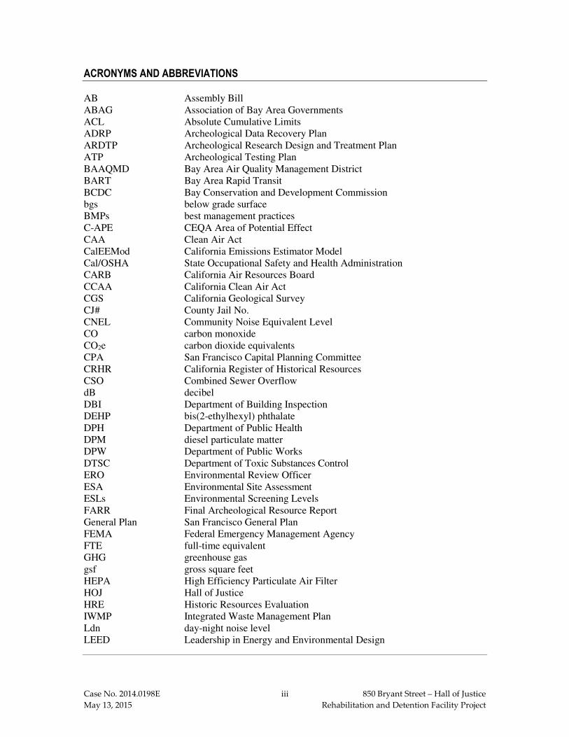
AB Assembly Bill ABAG Association of Bay Area Governments ACL Absolute Cumulative Limits ADRP Archeological Data Recovery Plan ARDTP Archeological Research Design and Treatment Plan ATP Archeological Testing Plan BAAQMD Bay Area Air Quality Management District BART Bay Area Rapid Transit BCDC Bay Conservation and Development Commission bgs below grade surface BMPs best management practices C-APE CEQA Area of Potential Effect CAA Clean Air Act CalEEMod California Emissions Estimator Model Cal/OSHA State Occupational Safety and Health Administration CARB California Air Resources Board CCAA California Clean Air Act CGS California Geological Survey CJ# County Jail No. CNEL Community Noise Equivalent Level CO carbon monoxide CO2e carbon dioxide equivalents CPA San Francisco Capital Planning Committee CRHR California Register of Historical Resources CSO Combined Sewer Overflow dB decibel DBI Department of Building Inspection DEHP bis(2-ethylhexyl) phthalate DPH Department of Public Health DPM diesel particulate matter DPW Department of Public Works DTSC Department of Toxic Substances Control ERO Environmental Review Officer ESA Environmental Site Assessment ESLs Environmental Screening Levels FARR Final Archeological Resource Report General Plan San Francisco General Plan FEMA Federal Emergency Management Agency FTE full-time equivalent GHG greenhouse gas gsf gross square feet HEPA High Efficiency Particulate Air Filter HOJ Hall of Justice HRE Historic Resources Evaluation IWMP Integrated Waste Management Plan Ldn day-night noise level LEED Leadership in Energy and Environmental Design

Case No. 2014.0198E iv 850 Bryant Street – Hall of Justice
May 13, 2015 Rehabilitation and Detention Facility Project
Leq equivalent continuous sound level LUST leaking underground storage tank mgd million gallons per day mg/kg milligram per kilogram mg/L milligram per liter MHHW Mean Higher High Water MLD Most Likely Descendant MLP: maximum load point mph miles per hour MRZ-4 Mineral Resource Zone 4 MTA San Francisco Municipal Transportation Agency MTBE methyl tertiary-butyl ether MTC Metropolitan Transportation Commission MTCO2E Metric ton of carbon dioxide equivalents MUG Mixed Use-General (zoning designation) Muni San Francisco Municipal Railway MUR Mixed Use-Residential (zoning designation) Mw moment magnitude NAHC California State Native American Heritage Commission NAVD88 1988 North American Vertical Datum NCT Neighborhood Commercial Transit (zoning designation) NESHAP National Emissions Standards for Hazardous Air Pollutants NOX oxides of nitrogen NO2 nitrogen dioxide NPDES National Pollutant Discharge Elimination System NRC National Research Council NSR New Source Review NWIC Northwest Information Center OPR State Office of Planning and Research OS open space PAHs polynuclear aromatic hydrocarbons PAR Preliminary Archeological Review PCBs polychlorinated biphenyls PM particulate matter PM2.5 PM composed of particulates at are 10 microns in diameter or less PM10 PM composed of particulates at are 2.5 microns in diameter or less POPOS privately owned public open spaces ppm parts per million PPV peak particle velocity QACL Qualified Archaeological Consultants List RDF Retention and Detention Facility RED Residential Enclave (zoning designation) ROG reactive organic gases RWQCB Bay Area Regional Water Quality Control Board SALI Service/Arts/Light Industrial Zoning District SB Senate Bill SamTrans San Mateo County Transit District SEWPCP Southeast Water Pollution Control Plant sf square feet

Case No. 2014.0198E v 850 Bryant Street – Hall of Justice
May 13, 2015 Rehabilitation and Detention Facility Project
SFBAAB San Francisco Bay Area Air Basin SFCTA San Francisco County Transportation Authority SFFD San Francisco Fire Department sfh square foot hours SFMTA San Francisco Municipal Transportation Agency SFO San Francisco International Airport SFPD San Francisco Police Department SFPL San Francisco Public Library SFPUC San Francisco Public Utilities Commission SFUSD San Francisco Unified School District Sheriff’s Department San Francisco Sheriff’s Department SHR3 Seismic Hazard Rating 3 SO2 sulfur dioxide SMP site mitigation plan SOMA South of Market SoMa South of Market SRO single room occupancy STLC soluble threshold limit concentration SUD Special Use District TAAS Theoretically Available Annual Sunlight TACs toxic air contaminants TASC Transportation Advisory Staff Committee TBACT Best Available Control Technology TCLP toxicity characteristic leaching procedure TDM Transportation Demand Management TEP Transit Effectiveness Project TTLC total threshold limit concentration UMU Urban Mixed Use (zoning designation) U.S. EPA U.S. Environmental Protection Agency USGS United States Geological Survey UST underground storage tank UWMP Urban Water Management Plan VDECS verified diesel emission control strategy VMT vehicle miles traveled WMUG Western SoMa Mixed Use-General (zoning designation) WMUO Western SoMa Mixed Use-Office (zoning designation) WSA Water Supply Assessment


Case No. 2014.0198E 1 850 Bryant Street – Hall of Justice
May 13, 2015 Rehabilitation and Detention Facility Project
Initial Study 850 Bryant Street - Hall of Justice
Rehabilitation and Detention Facility Project Planning Department Case No. 2014.0198E
A. PROJECT DESCRIPTION
Project Location and Existing Project Site Characteristics
The proposed Hall of Justice (HOJ) – Rehabilitation and Detention Facility (RDF) project (herein
referred to as “proposed project”) is located in San Francisco’s South of Market neighborhood, at
the intersection of Bryant and Sixth streets (see Figure 1: Project Location), and consists of eight
parcels: Assessor’s Block 3759, Lots 9 through 12, 14, 43, 45 and a portion of Lot 42, as well as
portions of the Harriet Street and Ahern Way rights-of-way (see Figure 2: Existing Site Plan).
The project site is relatively flat, sloping gently from northwest to southwest.
The western portion of the project site (HOJ site), located at 850 Bryant Street, including a portion
of Lot 042 in Block 3759, is bounded by Harriet Street on the east, Bryant Street on the south, and
Seventh Street on the west. The HOJ site contains an existing eight-story, 105-foot-tall (plus an
additional 12-foot-tall mechanical penthouse), approximately 610,000-gross-square-foot (gsf)
institutional building constructed between 1958 and 1961. The HOJ is eligible for inclusion in the
California Register of Historical Resources (CRHR) under Criterion 1 (Events) as a major legal
and civic institution in San Francisco.1 The existing HOJ serves as one of the primary County Jail
Facilities for the San Francisco Sheriff’s Department (Sheriff’s Department). County Jails No. 3
(CJ#3) and No. 4 (CJ#4) are located on the 6th and 7th floors of the existing HOJ building. Other
existing uses within the HOJ include the justice center for the San Francisco County Superior Court,
the Chief Medical Examiner and morgue, and the operational headquarters for the San Francisco
Police Department.2
Primary pedestrian access into the HOJ building is through the main entrance located on Bryant
Street. Service, loading, and parking access for the HOJ building is from Harriet Street between
Bryant Street and Ahern Way with driveways to the at-grade building service area, the at-grade
surface parking and ambulance loading area, the below-grade basement level of the existing HOJ,
and a secure transport area/sally port for County Jails No. 1 (CJ#1) and No. 2 (CJ#2) at 425 Seventh
Street north of the HOJ site. On the HOJ site, there are existing street trees along Harriet Street
1 San Francisco Planning Department, Preservation Team Review Form, April 3, 2015 (see Appendix A
of this PMND). 2 At the end of March 2015 approximately 250 San Francisco Police Department staff moved from the
HOJ to the newly constructed Public Safety Building at 1251 3rd Street in Mission Bay. Available online at http://sf-police.org/index.aspx?recordid=1145&page=3763. Accessed April 2, 2015.

HUBBELL ST
China Basin St
Nelson Rising LnNelson Rising Ln
Mission Bay Blvd NMission Bay Blvd S
HOOPER ST
BERRY ST
KING ST
MIS
SOU
RI S
T
Texa
s St
MIS
SISS
IPPI
ST
Fifth
St
Fifth
St
Mer
rimac
St
Mer
rimac
St
Indi
ana
St
16TH ST16TH ST
17TH ST17TH ST
19th St19th St
16th St
Mariposa StMariposa St
Mission Bay Blvd NMission Bay Blvd S
7TH ST
7TH ST
5THST5THST
6THST6THST
6THST8THST
6THST9THST
10THST
5THST
4TH ST
4TH ST
3RD ST
HUBBELL ST
A ST
C ST
IRWIN STHOOPER STCHANNEL STBERRY ST
BERRY STKING ST
TOWNSEND ST
BERRY ST
BRANNAN ST
BRYANT ST
BRYANT ST
BRYANT ST
BRYANT ST
HARRISON ST
HARRISON ST
Market
St
Turk St
MISSION ST
HOWARD ST
KING ST
Channel S
t
Channel S
t
Long Bridge S
t
Long Bridge S
t
China Basi
n Channel
OWENS ST
MIS
SOU
RI S
T
Con
nect
icut
St
Con
nect
icut
St
ARKA
NSA
S ST
ARKA
NSA
S ST
Car
olin
a St
Car
olin
a St
DE H
ARO
ST
DE H
ARO
ST
KAN
SAS
STKA
NSA
S ST
UTA
H S
TU
TAH
ST
BRYA
NT
STBR
YAN
T ST
Rhod
e Is
land
St
Rhod
e Is
land
St
Texa
s St
MIS
SISS
IPPI
ST
Penn
sylv
ania
Ave
Penn
sylv
ania
Ave
Indi
ana
St
4th & KingStation4th & KingStation
80
280
101
101
HOJ SITE
PROJECT BUILDING SITE
FEET
N
0 1000
SOURCE: Turnstone Consulting/SWCA
FIGURE 1: PROJECT LOCATIONCase No. 2014.0198E
P a c i f i c
O c e a n
S a n
Fr a n
c i s c oB
ay
101
101
280
80
1
S a n
F r a n c i s c o
PROJECTSITE
PROJECTSITE
Case No. 2014.0198E May 13, 2015
2 850 Bryant Street – Hall of Justice Rehabilitation and Detention Facility Project

7TH ST
8TH ST
6TH ST
TOWNSEND ST
BRYANT S
T
BRANNAN ST
HARRISON ST
FOLSOM ST
HOWARD ST
80Victoria Manalo Draves Park
Gene Friend Recreation Center
Gene Friend Recreation Center
SanFrancisco
FlowerMart
County
Jails
No.1 & N
o. 2
APN 3759/14APN 3759/12
APN 3759/11
APN 3759/10APN 3759/09
APN 3759/43APN 3759/45
APN 3759/42
HOJ Site
Project Building Site
FEET
N
0 1000
SOURCE: Turnstone Consulting/SWCA
FIGURE 2: EXISTING SITE PLANCase No. 2014.0198E
Case No. 2014.0198E May 13, 2015
3 850 Bryant Street – Hall of Justice Rehabilitation and Detention Facility Project

Case No. 2014.0198E 4 850 Bryant Street – Hall of Justice
May 13, 2015 Rehabilitation and Detention Facility Project
between Bryant Street and Ahern Way, along Bryant Street between Harriet and Seventh streets,
and along Seventh Street between Bryant and Harrison streets.
The eastern portion of the project site (project building site) is slightly less than an acre in size
(40,276 square feet [sf]) and encompasses Lots 009 through 012, 014, 043, and 045 in Block 3759.
The project building site is bounded by Ahern Way to the north, Bryant Street to the south, Sixth
Street to the east, and Harriet Street to the west. The project building site contains two vacant lots,
areas of surface parking, and five existing buildings: a one-story, 6,000-gsf office building,
constructed in 1956 (444 Sixth Street); a one-story, 5,100-gsf commercial building, constructed in
1959 (450 Sixth Street); a three-story, 7,150-gsf, 14-unit single room occupancy (SRO3) residential
building with ground-floor retail, constructed in 1916 (480-484 Sixth Street); a three-story,
16,500-gsf office building, constructed in 2003 (800-804 Bryant Street and 498 Sixth Street); and
a one-story, 2,000-gsf McDonald’s restaurant, constructed in 1996 (820 Bryant Street). The
building at 480-484 Sixth Street is a well-preserved, somewhat early example of a multi-family
residential building in the South of Market Area. It is a California Register-eligible property, and
is assigned a Status Code by the San Francisco Planning Department of “3CS,” meaning that it is
eligible for the CRHR as an individual historic resource through survey evaluation.4 The project
building site also includes portions of the Harriet Street and Ahern Way rights-of way. Harriet
Street is a one-way, north-south street with access from Bryant Street. Ahern Way is a two-way,
east-west street with access from Sixth Street. Ahern Way provides access to the ambulance
loading area and the basement level of the existing HOJ on the HOJ site as well as the secure
transport area/sally port for CJ#1 and CJ#2. There are existing street trees adjacent to the project
building site along Sixth Street, between Ahern Way and Bryant Street and along Bryant Street,
between Harriet and Sixth streets. There are existing trees located on the interior of the project
building site in the rear yard of the SRO building at 480-484 Sixth Street.
CJ#1 and CJ#2 are located directly north of the HOJ site at 425 Seventh Street. CJ#1 is an inmate
processing and intake facility. CJ#2 serves as a medium security jail facility, primarily used to
house female inmates. These facilities are located on the northwest portion of Block 3759/Lot 42
not included as part of the HOJ site and are not part the proposed project. However, the basement
level of 425 Seventh Street is shared with the HOJ for below-grade parking and to facilitate the
movement of inmates and staff from the cells and holding area to the HOJ courts.
3 An SRO is a multiple-tenant building that usually houses one or two people in individual rooms
(sometimes two rooms, or two rooms with a bathroom or half bathroom). Tenants of SROs typically share bathrooms and/or kitchens, while some SRO rooms may include kitchenettes, bathrooms, or half-baths. Although many are former hotels, SROs are primarily rented as a permanent residence.
4 VerPlanck Historic Preservation Consulting, Memorandum to Rich Sucre, San Francisco Planning Department, September 22, 2014.

Case No. 2014.0198E 5 850 Bryant Street – Hall of Justice
May 13, 2015 Rehabilitation and Detention Facility Project
The HOJ site and the project building site are well served by public transit. The San Francisco
Municipal Railway (Muni) operates numerous surface buses within one block of the project site
along Fifth, Sixth, Seventh, Eighth, Folsom, Harrison, Bryant, and Brannan streets, including the
8X Bayshore, 8AX/BX Bayshore Expresses, 19 Polk, 27 Bryant, 47 Van Ness, 12 Folsom, and
14X Mission Express routes. Regional transit providers include Golden Gate Transit and San
Mateo County Transit District (SamTrans). Both Golden Gate Transit and SamTrans operate
surface buses within three blocks of the project site – along Mission, Howard, and Folsom streets
and Mission, Ninth, and Tenth streets, respectively.
Existing Zoning on the Project Site
The HOJ site is located within a Public Use (P) Zoning District and a 105-J Height and Bulk
District, and the project building site is within the Service/Arts/Light Industrial (SALI) Zoning
District and a 30-X Height and Bulk District.5 The entire project site is located within the Western
SoMa Special Use District (SUD), which includes zoning controls to address specific land use
issues related to animal service uses, nighttime entertainment uses, and formula retail uses. It is
also within the area covered by the Western SOMA (South of Market) Area Plan of the
San Francisco General Plan.6 The project site is not located within any known or potential historic
district.
Project Characteristics
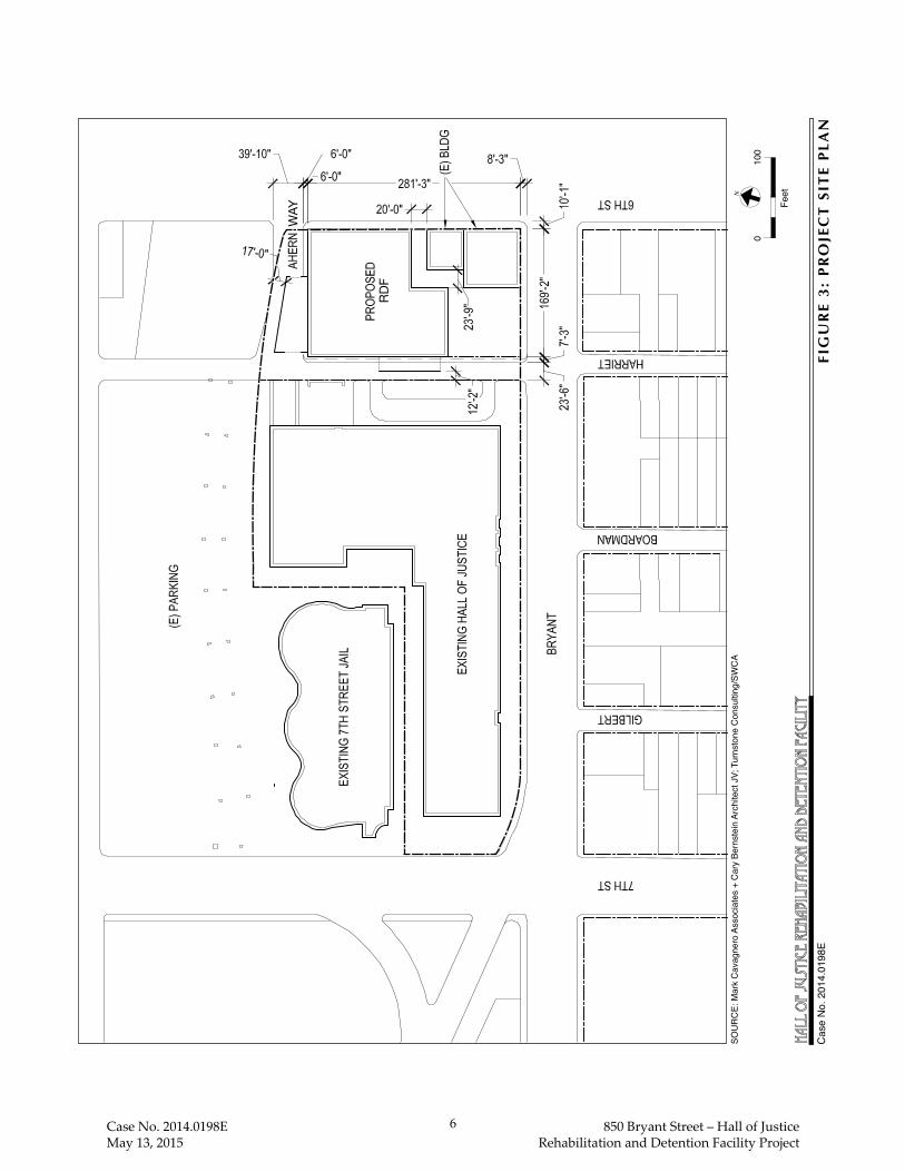
The proposed project calls for the construction of a new, approximately 200,000-gsf, 110-foot-tall
(95 feet tall to the roof top, plus an additional 15-foot-tall mechanical penthouse) building on the
block directly east of the existing HOJ building, in part to provide secure, direct access to the courts
facility located within the HOJ. (See Figure 3: Project Site Plan.) All existing buildings on the
project building site would be demolished with the exception of the SRO building at 480-484 Sixth
Street (Block 3759/Lot 10) and the office building at 800-804 Bryant Street/498 Sixth Street
(Block 3759/Lot 11).
The proposed RDF would replace the existing CJ#3 and CJ#4, currently located on the 6th and
7th floors of the existing HOJ building. The proposed project is a part of a larger program to relocate
City agencies from the seismically deficient HOJ building.7 Once the jail population is relocated
5 The maximum building height is 105 feet on the HOJ site and 30 feet on the project building site. Bulk
controls reduce the size of a building’s floorplates as the building increases in height. Pursuant to Planning Code Section 270(a), the bulk controls in a “J” Bulk District become effective above a building height of 40 feet, and there are no bulk controls in an “X” Bulk District.
6 The Western SoMa Area Plan is also known as the Western SoMa Community Plan. These terms are interchangeable.
7 Future programs to relocate other City agencies or uses from the HOJ building are speculative and therefore not included as part of the proposed project, nor included in environmental analysis of the proposed project.
WAY
RDF
010
0
FeetN
FIG
UR
E 3
: P
RO
JEC
T S
ITE
PL
AN
SOU
RC
E: M
ark
Cav
agne
ro A
ssoc
iate
s +
Car
y Be
rnst
ein
Arch
itect
JV;
Tur
nsto
ne C
onsu
lting
/SW
CA
Cas
e N
o. 2
014.
0198
E
Case No. 2014.0198E May 13, 2015
6 850 Bryant Street – Hall of Justice Rehabilitation and Detention Facility Project

Case No. 2014.0198E 7 850 Bryant Street – Hall of Justice
May 13, 2015 Rehabilitation and Detention Facility Project
from CJ#3 and CJ#4 to the proposed RDF, the 6th and 7th floors of the HOJ building would remain
vacant. The proposed RDF would be constructed as a maximum security facility, compliant with
adult detention facility codes and standards, with a capacity of up to 640 beds, a 30 percent
reduction (265 fewer beds) from the combined capacity in CJ#38 and CJ#4 of 905 beds. The
proposed RDF would also include space for administrative offices, staff support, exercise,
programs and classroom space, and mental and medical health services for the jail population.
The proposed project would include improvements within the Harriet Street and Ahern Way rights-
of-way, and the removal of parking on the west side of Sixth Street along the proposed RDF’s
frontage. A subterranean tunnel would be constructed underneath the Harriet Street roadway and
sidewalks to connect the existing HOJ building to the basement level of the proposed RDF. This
tunnel, subject to San Francisco Municipal Transportation Agency (SFMTA) approval, would be
used to provide secure and direct transport of inmates between the proposed RDF and the existing
HOJ building. As part of the proposed RDF, portions of Harriet Street and Ahern Way would be
reconfigured to accommodate separate and secure areas for service deliveries and jail transport (a
secured loading dock on Harriet Street and a secured, controlled entryway or “sally port” on Ahern
Way, respectively), subject to SFMTA and Department of Public Works (DPW) review and
approval. In addition, both Harriet Street (from Bryant Street to the I-80 overpass) and Ahern Way
(west of Sixth Street) would be closed to through traffic in both directions and only official service
vehicles would be allowed access.
Project Background
In 1992, and again in 2012, DPW conducted seismic studies on the HOJ at 850 Bryant Street and
designated the building with a Seismic Hazard Rating 3 (SHR3), which indicates that the HOJ is
seismically deficient and unlikely to remain operational in the event of a major earthquake.9 The
proposed project is a joint-agency effort between DPW and the Sheriff’s Department to replace
CJ#3 and CJ#4, which are located on the 6th and 7th floors of the seismically deficient HOJ.
The Sheriff’s Department currently operates five separate detention facilities and a secured ward
within the San Francisco General Hospital, at 1001 Potrero Avenue, for inmates who require
hospitalization. CJ#1 and CJ#2 have been operating for nearly 20 years at its current location at
425 Seventh Street, north of the HOJ site. CJ#3 and CJ#4 are located on the 6th and 7th floors of
the existing HOJ building. The newest facility, CJ#5, was constructed in 2004 and is located
8 CJ #3 was vacated in November 2013. Inmates have been temporarily relocated to County Jail #5 in San
Bruno and will eventually transfer to the proposed RDF, once construction is complete. For purposes of this environmental analysis, it is assumed that CJ#3 is still operating on the site.
9 EQA Engineering And Design/AGS Inc., Seismic Assessment of Various City-Owned Buildings
Earthquake Safety Program- Hall of Justice, October 1992, pp. V-VI. A copy of this document is available for review at the San Francisco Planning Department, 1650 Mission Street, Suite 400, in Case File No. 2014.0198E.
Case No. 2014.0198E 8 850 Bryant Street – Hall of Justice
May 13, 2015 Rehabilitation and Detention Facility Project
approximately 15 miles to the south in the City of San Bruno in San Mateo County (1 Moreland
Drive, San Bruno).10 The total bed capacity within the Sheriff’s Department jail system facilities
(CJ#1 through CJ#5) is 2,515 beds.
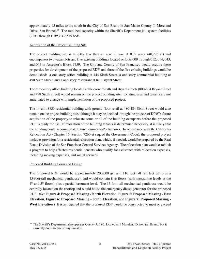
Acquisition of the Project Building Site
The project building site is slightly less than an acre in size at 0.92 acres (40,276 sf) and
encompasses two vacant lots and five existing buildings located on Lots 009 through 012, 014, 043,
and 045 in Assessor’s Block 3759. The City and County of San Francisco would acquire these
properties for development of the proposed RDF, and three of the five existing buildings would be
demolished: a one-story office building at 444 Sixth Street, a one-story commercial building at
450 Sixth Street, and a one-story restaurant at 820 Bryant Street.
The three-story office building located at the corner Sixth and Bryant streets (800-804 Bryant Street
and 498 Sixth Street) would remain on the project building site. Existing uses and tenants are not
anticipated to change with implementation of the proposed project.
The 14-unit SRO residential building with ground-floor retail at 480-484 Sixth Street would also
remain on the project building site, although it may be decided through the process of DPW’s future
acquisition of the property to relocate some or all of the building occupants before the proposed
RDF is ready for use. If relocation of the building tenants is determined necessary, it is likely that
the building could accommodate future commercial/office uses. In accordance with the California
Relocation Act (Chapter 16, Section 7260 et seq. of the Government Code), the proposed project
includes provision for a residential relocation plan, which, if needed, would be prepared by the Real
Estate Division of the San Francisco General Services Agency. The relocation plan would establish
a program to help affected residential tenants who qualify for assistance with relocation expenses,
including moving expenses, and social services.
Proposed Building Form and Design
The proposed RDF would be approximately 200,000 gsf and 110 feet tall (95 feet tall plus a
15-foot-tall mechanical penthouse), and would contain five floors (with mezzanine levels at the
4th and 5th floors) plus a partial basement level. The 15-foot-tall mechanical penthouse would be
centrally located on the rooftop and would house the emergency diesel generator for the proposed
RDF. (See Figure 4: Proposed Massing - North Elevation, Figure 5: Proposed Massing - East
Elevation, Figure 6: Proposed Massing - South Elevation, and Figure 7: Proposed Massing -
West Elevation.) It is anticipated that the proposed RDF would be constructed to meet or exceed
10 The Sheriff’s Department also operates County Jail #6, located at 1 Moreland Drive, San Bruno, but it
currently does not house any inmates.

FIG
UR
E 4
: P
RO
PO
SE
D M
AS
SIN
G -
NO
RT
H E
LE
VA
TIO
N
SOU
RC
E: M
ark
Cav
agne
ro A
ssoc
iate
s +
Car
y Be
rnst
ein
Arch
itect
JV;
Tur
nsto
ne C
onsu
lting
/SW
CA
Cas
e N
o. 2
014.
0198
E
Case No. 2014.0198E May 13, 2015
9 850 Bryant Street – Hall of Justice Rehabilitation and Detention Facility Project

FIG
UR
E 5
: P
RO
PO
SE
D M
AS
SIN
G -
EA
ST
EL
EV
AT
ION
SOU
RC
E: M
ark
Cav
agne
ro A
ssoc
iate
s +
Car
y Be
rnst
ein
Arch
itect
JV;
Tur
nsto
ne C
onsu
lting
/SW
CA
Cas
e N
o. 2
014.
0198
E
Case No. 2014.0198E May 13, 2015
10 850 Bryant Street – Hall of Justice Rehabilitation and Detention Facility Project

FIG
UR
E 6
: P
RO
PO
SE
D M
AS
SIN
G -
SO
UT
H E
LE
VA
TIO
N
SOU
RC
E: M
ark
Cav
agne
ro A
ssoc
iate
s +
Car
y Be
rnst
ein
Arch
itect
JV;
Tur
nsto
ne C
onsu
lting
/SW
CA
Cas
e N
o. 2
014.
0198
E
Case No. 2014.0198E May 13, 2015
11 850 Bryant Street – Hall of Justice Rehabilitation and Detention Facility Project

FIG
UR
E 7
: P
RO
PO
SE
D M
AS
SIN
G -
WE
ST
EL
EV
AT
ION
SOU
RC
E: M
ark
Cav
agne
ro A
ssoc
iate
s +
Car
y Be
rnst
ein
Arch
itect
JV;
Tur
nsto
ne C
onsu
lting
/SW
CA
Cas
e N
o. 2
014.
0198
E
Case No. 2014.0198E May 13, 2015
12 850 Bryant Street – Hall of Justice Rehabilitation and Detention Facility Project

Case No. 2014.0198E 13 850 Bryant Street – Hall of Justice
May 13, 2015 Rehabilitation and Detention Facility Project
basic Leadership in Energy and Environmental Design (LEED) Silver standards or GreenPoint
Rated standards established in the San Francisco Green Building Ordinance with respect to energy
and water use for City-owned buildings. The proposed RDF would include podular housing units
that allow for direct supervision of inmates, increasing the safety of inmates and staff, and efficient
provision of services. Program space for classrooms, computer and vocational training to foster
Sheriff’s Department rehabilitative programs, and medical and mental health units for inmates
would also be constructed, as detailed below by floor level and shown on Figures 8 through 11 on
the following pages.
Ground Floor (First Floor Plan)
The proposed ground floor would include the publicly-accessible lobby, with access from Sixth
Street, and the inmate visiting room. This floor would also provide space for central records,
warrants, and administrative offices, as well as the RDF kitchen, building and laundry services, and
a multi-purpose room. The ground floor would also include an enclosed sally port11 for jail inmate
transport, to be constructed along the north elevation, partially within the Ahern Way right-of-way,
with access onto Ahern Way from Sixth Street. An enclosed service vehicle loading area would be
constructed along the west elevation of the building, partially within the Harriet Street right-of-
way. Direct service access to the service vehicle loading area would be from Harriet Street via
Bryant Street. (See Figure 8: Proposed First Floor Plan.)
Second Floor
The proposed second floor would include two separate 16-cell inmate pods, with room for interior
exercise and classroom space. The floor would also include space for medical and staff-support
services. (See Figure 9: Proposed Second Floor Plan.)
Third Floor
The proposed third floor would include two separate 16-cell inmate pods, with room for interior
exercise and classroom space. The floor would also include staff-support space and central
program space. (See Figure 10: Proposed Third Floor Plan.)
Fourth and Fifth Floors
The proposed fourth and fifth floors would each include three 32-cell inmate pods, one 16-cell
inmate pod, and room for interior exercise and classroom space. Each of these floors would also
contain a mezzanine level with space to allow for additional inmate cells. (See Figure 11:
Proposed Fourth and Fifth Floors Plan.)
11 A sally port is an enclosed, secured, controlled entryway into highly restricted or protected areas, such as
the proposed RDF.

SOURCE: Mark Cavagnero Associates + Cary Bernstein Architect JV; Turnstone Consulting/SWCA
FIGURE 8: PROPOSED FIRST FLOOR PLANCase No. 2014.0198E
FEET
N
0 40
SALLYPORT
AHERN WAY
LOADINGAREA
HAR
RIET
STR
EET
Case No. 2014.0198E May 13, 2015
14 850 Bryant Street – Hall of Justice Rehabilitation and Detention Facility Project
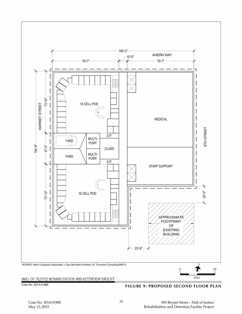
FIGURE 9: PROPOSED SECOND FLOOR PLANCase No. 2014.0198E
FEET
N
0 40SOURCE: Mark Cavagnero Associates + Cary Bernstein Architect JV; Turnstone Consulting/SWCA
AHERN WAY
HAR
RIET
STR
EET
6TH
STR
EET
Case No. 2014.0198E May 13, 2015
15 850 Bryant Street – Hall of Justice Rehabilitation and Detention Facility Project

FIGURE 10: PROPOSED THIRD FLOOR PLANCase No. 2014.0198E
FEET
N
0 40SOURCE: Mark Cavagnero Associates + Cary Bernstein Architect JV; Turnstone Consulting/SWCA
AHERN WAY
HAR
RIET
STR
EET
6TH
STR
EET
Case No. 2014.0198E May 13, 2015
16 850 Bryant Street – Hall of Justice Rehabilitation and Detention Facility Project

FIGURE 11: PROPOSED FOURTH & FIFTH FLOOR PLANCase No. 2014.0198E
FEET
N
0 40SOURCE: Mark Cavagnero Associates + Cary Bernstein Architect JV; Turnstone Consulting/SWCA
AHERN WAY
HAR
RIET
STR
EET
6TH
STR
EET
Case No. 2014.0198E May 13, 2015
17 850 Bryant Street – Hall of Justice Rehabilitation and Detention Facility Project

Case No. 2014.0198E 18 850 Bryant Street – Hall of Justice
May 13, 2015 Rehabilitation and Detention Facility Project
Partial Basement Level
The proposed approximately 28,000-gsf basement level would provide access to a proposed
pedestrian tunnel connecting the proposed RDF to the courtrooms in the existing HOJ building for
inmate transport between the buildings. Space within the basement area would also be designated
for building services, storage, laundry, and mechanical/electrical/plumbing uses. (See Figure 12:
Proposed Basement Level Floor Plan.)
Proposed Right-of-Way Changes
The proposed project would include improvements within the Harriet Street and Ahern Way rights-
of-way. As part of the proposed RDF, portions of Harriet Street and Ahern Way would be
reconfigured to accommodate designated, secure service and jail transport areas (a loading dock on
Harriet Street and a sally port on Ahern Way, respectively) subject to SFMTA and DPW review
and approval. In addition, both Harriet Street (from Bryant to Harrison streets) and Ahern Way
(west of Sixth Street) would be closed to through traffic in both directions and only official service
vehicles would be allowed access.
In addition, a proposed pedestrian tunnel connection would be constructed under the Harriet Street
roadway and sidewalks to connect the proposed RDF with the basement level of the existing HOJ.
The proposed tunnel would be 8 feet wide and 10 feet tall and would be constructed approximately
17 feet below grade. Inmates and in-custody defendants would be transferred between the proposed
RDF and the courts via this tunnel as a secure path of travel. The proposed project also includes
renovations to the existing HOJ basement access point to serve as a secure in-custody corridor for
jail inmate transport. These renovations would include changes to the existing basement parking
access entrance.
Proposed Landscaping
The existing street trees on the HOJ site (along Bryant Street between Harriet and Seventh streets,
on Harriet Street between Bryant Street and Ahern Way, and along Seventh Street between Bryant
Street and the I-80 overpass) and on the project building site (along Bryant Street between Sixth
and Harriet streets, and along Sixth Street between Bryant Street and the I-80 overpass) would
remain. Construction of the proposed RDF would require removal of three interior trees located in
the rear yard of the existing SRO building at 480-484 Sixth Street. The project sponsor would plant
new street trees in compliance with the standards of Planning Code Section 138.1(c)(1) and the
Public Works Code, Article 16. According to Planning Code Section 138.1(c)(1), a total of seven
new street trees would be required along the Sixth Street and Bryant Street frontages. All new
and/or replacement trees on the Sixth Street and Bryant Street frontages would be planted in
accordance with the standards set forth in Planning Code Section 138.1(c)(1) and the Better Streets
Plan. If DPW determines that planting the full complement of required street trees would not be

FIGURE 12: BASEMENT FLOOR PLANCase No. 2014.0198E
FEET
N
0 40SOURCE: Mark Cavagnero Associates + Cary Bernstein Architect JV; Turnstone Consulting/SWCA
AHERN WAY
PROPOSEDTUNNEL TO
HOJ
HAR
RIET
STR
EET
6TH
STR
EET
Case No. 2014.0198E May 13, 2015
19 850 Bryant Street – Hall of Justice Rehabilitation and Detention Facility Project

Case No. 2014.0198E 20 850 Bryant Street – Hall of Justice
May 13, 2015 Rehabilitation and Detention Facility Project
feasible due to site constraints or other reasons, a waiver of this requirement may be requested from
the Zoning Administrator (Planning Code Section138.1(c)(1)(C)(iii)). In this case, an in-lieu street
tree fee would be required pursuant to Planning Code Section428. No additional landscaping is
proposed as part of the project.
Project Construction
Foundation and Excavation
Construction of the proposed RDF would require excavation for the partial basement level and
reinforced concrete mat foundation. Additional excavation would be required to construct the
pedestrian transport tunnel between the proposed RDF and the existing HOJ building. Excavation
depth for both the basement level and tunnel excavation would not exceed 17 feet and would require
approximately 18,000 cubic yards of soil to be removed from the project site.12
Construction Phasing and Duration
The project sponsor estimates that construction of the proposed project would take approximately
30 months to complete, with construction beginning mid-year in 2017 and building occupancy
likely in the fall of 2020.
Project Approvals
The proposed project requires the following approval actions. These approvals may be considered
by City decision-makers in conjunction with the required environmental review, but they may not
be granted until the required environmental review has been completed.
Actions by the Board of Supervisors
• Adoption of ordinances to reclassify the zoning designation of the eastern portion of the project site (project building site) from SALI to P and the height and bulk designations of this portion of the site from 30-X to 95-J.
• Adoption of a resolution to approve purchasing of land and financing of the proposed project through a Certification of Participation.
Actions by the Planning Commission
• Recommendation that the Board of Supervisors adopt ordinances to reclassify the zoning designation of the eastern portion of the project site (project building site) from Service
12 San Francisco Department of Public Works, Geotechnical Investigation Report - Rehabilitation and
Detention Facility, 820 Bryant Street, San Francisco, California, February 23, 2015. A copy of this document is available for review at the San Francisco Planning Department, 1650 Mission Street, Suite 400, in Case File No. 2014.0198E.

Case No. 2014.0198E 21 850 Bryant Street – Hall of Justice
May 13, 2015 Rehabilitation and Detention Facility Project
Arts Light Industrial (SALI) to P and the height and bulk designations of this portion of the site from 30-X to 95-J.
• Approval of a General Plan referral determining that the proposed project, including the proposed legislative amendments, is in conformity with the objectives and policies of the General Plan.
Actions by Other City Departments
• Department of Public Works request for General Plan and Street Vacation Referrals from the Planning Department, and Board of Supervisors approval to vacate thru-traffic on portions of the Harriet Street and Ahern Way rights-of-way. To approve the street vacations, the Department of Public Works requests a referral to the Planning Department which would be required for a formal determination as to whether the proposed project is consistent with the objectives and policies of the General Plan prior to an action by the Board of Supervisors to approve the street vacations.
• Approval of site permit (Planning Department, Department of Building Inspection)
• Approval of grading and building permits (Planning Department and Department of
Building Inspection)
• Approval of project compliance with the Stormwater Control Guidelines (Department of
Public Works)
• Approval of a stormwater control plan (San Francisco Public Utilities Commission)
B. PROJECT SETTING
As previously noted, the project site is located in San Francisco’s South of Market neighborhood,
at the intersection of Bryant and Sixth streets, and consists of eight parcels on Assessor’s
Block 3759, except for a portion of Lot 42, and portions of the Harriet Street and Ahern Way rights-
of-way. The topography of the project site and surrounding area is relatively flat, with a slight
slope from northwest to southwest. The western portion of the project site (HOJ site), located at
850 Bryant Street, is bounded by Harriet Street on the east, Bryant Street on the south, and Seventh
Street on the west. The eastern portion of the project site (project building site) is bounded by
Ahern Way to the north, Sixth Street to the east, Bryant Street to the south, and Harriet Street to
the west. The HOJ site is in a P Zoning District and a 105-J Height and Bulk District, and the
project building site is in a SALI Zoning District and a 30-X Height and Bulk District.13 (See
Figure 13: Existing Zoning District and Figure 14: Existing Height and Bulk Districts.) The
entire project site is within the Western SoMa SUD, the area covered by the South of Market Area
Plan of the San Francisco General Plan as well as the area covered by the Western SoMa
Community Plan. It is not within any known or potential historic preservation district.
13 The maximum building height is 105 feet on the HOJ site and 30 feet on the project building site. Bulk
controls reduce the size of a building’s floorplates as the building increases in height. Pursuant to Planning Code Section 270(a), the bulk controls in a “J” Bulk District become effective above a building height of 40 feet, and there are no bulk controls in an “X” Bulk District.

P
P
UMU
UMUSALI
P
SALI
PUMU
P
UMU
WMUO
MUR
P
P
MURP
P
P
P
P
SALI
SALI
P
MB-RA
P
MUR
RED
P
SALI
P
WMUG
RED
WMUG
SALI
P
UMU
SALI
SALI
P
RED
RED
SALI
MUG
SALI
SALI
WMUG
MUR
SALI
NCT
SALI
NCT
WMUG
NCT
SALI
RED-MX
UMU
WMUG
SALI
SALI
MUGWMUG
MUG
MUG
RED
RED
NCT
RED
MUG
NCT
PDR-1-G
RED-MX
NCT
SALI
NCT
MUG
SALI
SALI
NCT
MUG
MUG
SALI
RED
NCT
NCT
MUG
NCT
NCT
NCT
SALI
RED-MX
SALI
NCT
PNCTMUG
SALI
RED
MUG
PDR-1-G
RED-MX
MUR
P
MUG
SALI
SALI
NCT
SALI
RED-MX
MUG
PDR-1-G
RED
PDR-1-G
WMUG
RED
RED
RED
RED
MUG
SALI
WMUG
RED
MUG
7TH ST
8TH ST
6TH ST
TOWNSEND ST
BRYANT S
T
BRANNAN ST
HARRISON ST
FOLSOM ST
HOWARD ST
80
P
Mixed Use-GeneralSee Mission Bay South Redevelopment PlanSouth Of Market Residential EnclavePublicNeighborhood Commercial TransitProduction, Distribution & Repair -1-GeneralMixed Use-ResidentialUrban Mixed UseResidential Enclave-MixedWSOMA Mixed Use-OfficeService/Arts/Light IndustrialWSOMA Mixed Use-General
HOJ Site
Project Building Site
MUGMB-RA
REDP
NCTPDR-1-G
MURUMU
RED-MXWMUO
SALIWMUG
FEET
N
0 1000
SOURCE: San Francisco Planning Department; Turnstone Consulting/SWCA
FIGURE 13: EXISTING ZONING DISTRICTSCase No. 2014.0198E
Case No. 2014.0198E May 13, 2015
22 850 Bryant Street – Hall of Justice Rehabilitation and Detention Facility Project

68-X
30-X
40-X
68-X
30-X
30-X
105-J
40/55-X
40/55-X
OS
30-X
48-X 65-X
45-X
30-X
85-X
65-X
MB-RA
65-X 30-X
55/65-X
30-X
40-X
48-X
55-X
45-X
45-X
30-X
45-X
30-X
OS
-X
40/55-X
X
85-X
65-X
65-X
40/55-X
40/55-X
65-X45-X
65-X
85-X
45-X
-
85-X
40/55-X
85-X
65-X
55-X
45-X45-X
40-X
45-X
X45-X
40/55-X
45-X
40-X
65-X
45-X
40/55-X
45-X
65-X
40-X
5
85-X
40/55-X
55/65-X
45-X
65-X
85-X
48-X
45-X
45-X
85-X
65-X
85-X
40/55-X
45-X
85-X
40/55-X
48-X
85-X 45-X
65-X
40/55-X
85-X
40/55-X
55-X
55-X
40-X
40/55-X
85-X
40-X
40-X
40-X
85-X
65-X
7TH ST
8TH ST
6TH ST
TOWNSEND ST
BRYANT S
T
BRANNAN ST
HARRISON ST
FOLSOM ST
HOWARD ST
80
105-J105-J
FIGURE 14: EXISTING HEIGHT & BULK DISTRICTSCase No. 2014.0198E
HOJ Site
Project Building Site
HEIGHT AND BULK DISTRICTS
“Numbers” are Height Limits in feet. See Planning Code Section 250 and following.
“Letters” refer to Bulk Limits. See Planning Code Section 270.
“Suffix Numbers” identify districts in which special regulations apply. See Planning Code Sections 263 and following.
00 - Z - 1
“Open Space” DistrictOS
SOURCE: San Francisco Planning Department; Turnstone Consulting/SWCA
Case No. 2014.0198E May 13, 2015
23 850 Bryant Street – Hall of Justice Rehabilitation and Detention Facility Project

Case No. 2014.0198E 24 850 Bryant Street – Hall of Justice
May 13, 2015 Rehabilitation and Detention Facility Project
The blocks to the east of the project site across Sixth Street are zoned SALI and Western SoMa
Mixed Use-Office (WMUO), and the blocks to the south of the project site, across Bryant Street
are zoned SALI and Urban Mixed Use (UMU). The blocks to the west of the project site west of
7th Street are zoned Western SoMa Mixed Use-General (WMUG), Residential Enclave (RED), and
Neighborhood Commercial Transit (NCT). The blocks to the north of the project site are zoned P,
NCT, Mixed Use-General (MUG), and Mixed Use-Residential (MUR). There are two SUDs near
the project site: the South of Market Street Hall of Justice Legal Services SUD on the south side
of Bryant Street across from the project site, and the Youth and Family Zone SUD on the north side
of I-80. The height and bulk districts within three blocks of the project site vary from 30-X to
340-I. The height and bulk controls on the blocks immediately adjacent to the project site include
30-X to the east, 40-X/55-X, and 45-X to the south, 30-X to the west, and OS (Open Space), 45-X,
65-X, and 85-X to the north.
Existing land uses in the project vicinity consist of a mix of residential, retail, office, and light
industrial uses. The scale of development varies from one-story buildings to four- and five-story
buildings. At 105 feet tall, the existing eight-story HOJ building is the tallest building in the project
site vicinity. I-80, the elevated freeway approximately 35 feet above grade, runs northeast-
southwest from The Embarcadero before turning almost due south between Seventh and Eighth
streets west of the project site.
The block east of the project site is occupied by one- and two-story buildings containing retail,
office, and light industrial uses. One of the two-story buildings fronting Sixth Street has two
billboards on its roof, and there are two freestanding billboards further east in the middle of the
block. At the east end of the block near Fifth Street, there are two more roof-mounted billboards
on top of existing one-story buildings.
The block south of the project site is occupied by one- to four-story buildings containing residential,
retail, office, and light industrial uses. This block also contains two surface parking lots and a one-
story parking garage.
The block west of the project site is primarily occupied by the HOJ service station on the north side
of Bryant Street where Police Department and Sheriff’s Department vehicles are fueled and
serviced. Part of this block is occupied by the I-80 off-ramp that touches down at the intersection
of Seventh and Bryant streets.
I-80 is adjacent to and north of the project site. Land uses on the north side of I-80 and across
Harrison Street include residential buildings, retail uses, office uses, light industrial uses (auto
repair facilities, gas stations, and printing shops), surface parking lots, Bessie Carmichael
Elementary School, Victoria Manalo Draves Park, and the Gene Friend Recreation Center.
Case No. 2014.0198E 25 850 Bryant Street – Hall of Justice
May 13, 2015 Rehabilitation and Detention Facility Project
C. COMPATIBILITY WITH EXISTING ZONING AND PLANS
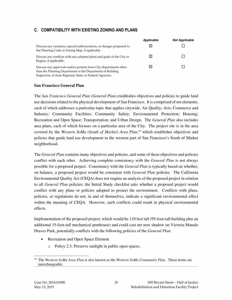
Applicable Not Applicable
Discuss any variances, special authorizations, or changes proposed to
the Planning Code or Zoning Map, if applicable.
Discuss any conflicts with any adopted plans and goals of the City or
Region, if applicable.
Discuss any approvals and/or permits from City departments other
than the Planning Department or the Department of Building
Inspection, or from Regional, State, or Federal Agencies.
San Francisco General Plan
The San Francisco General Plan (General Plan) establishes objectives and policies to guide land
use decisions related to the physical development of San Francisco. It is comprised of ten elements,
each of which addresses a particular topic that applies citywide: Air Quality; Arts; Commerce and
Industry; Community Facilities; Community Safety; Environmental Protection; Housing;
Recreation and Open Space; Transportation; and Urban Design. The General Plan also includes
area plans, each of which focuses on a particular area of the City. The project site is in the area
covered by the Western SoMa (South of Market) Area Plan,14 which establishes objectives and
policies that guide land use development in the western part of San Francisco’s South of Market
neighborhood.
The General Plan contains many objectives and policies, and some of these objectives and policies
conflict with each other. Achieving complete consistency with the General Plan is not always
possible for a proposed project. Consistency with the General Plan is typically based on whether,
on balance, a proposed project would be consistent with General Plan policies. The California
Environmental Quality Act (CEQA) does not require an analysis of the proposed project in relation
to all General Plan policies; the Initial Study checklist asks whether a proposed project would
conflict with any plans or policies adopted to protect the environment. Conflicts with plans,
policies, or regulations do not, in and of themselves, indicate a significant environmental effect
within the meaning of CEQA. However, such conflicts could result in physical environmental
effects.
Implementation of the proposed project, which would be 110 feet tall (95-foot-tall building plus an
additional 15-foot-tall mechanical penthouse) and could cast net new shadow on Victoria Manalo
Draves Park, potentially conflicts with the following policies of the General Plan:
• Recreation and Open Space Element
o Policy 2.3: Preserve sunlight in public open spaces.
14 The Western SoMa Area Plan is also known as the Western SoMa Community Plan. These terms are
interchangeable.
Case No. 2014.0198E 26 850 Bryant Street – Hall of Justice
May 13, 2015 Rehabilitation and Detention Facility Project
• Urban Design Element
o Policy 3.4: Promote building forms that will respect and improve the integrity of open spaces and other public areas.
The physical environmental impacts that could result from these potential conflicts are discussed
in Section E, Evaluation of Environmental Effects, under Section E.8: Wind and Shadow, pp. 135-
149. The consistency of the proposed project with General Plan objectives and policies that do not
relate to physical environmental issues will be considered by City decision‐makers as part of their
deliberations on whether to approve or disapprove the proposed project, and any potential conflicts
identified as part of that process would not alter the physical environmental effects of the proposed
project.
San Francisco Planning Code and Zoning Maps
The San Francisco Planning Code (Planning Code), which incorporates by reference the City’s
Zoning Maps, governs permitted uses, densities, and the configuration of buildings within
San Francisco. Permits to construct new buildings (or to alter or demolish existing ones) may not
be issued unless the proposed project complies with the Planning Code, an exception or variance
is granted pursuant to the provisions of the Planning Code, or legislative amendments to the
Planning Code are included and adopted as part of the proposed project.
Land Use Controls
As shown on Zoning Map Sheet ZN08, the project site is in two different zoning districts: a Public
Use (P) Zoning District and the Service/Arts/Light Industrial (SALI) Zoning District. The HOJ site
is in a P Zoning District, and the project building site is in a SALI Zoning District. Pursuant to
Planning Code Section 234, the P Zoning District applies to “land that is owned by a governmental
agency and in some form of public use, including open space.” Planning Code Sections 234.1
and 234.2 regulate the types of land uses that are principally permitted and conditionally permitted
in the P Zoning District, respectively. The proposed project complies with the land use controls
for a P Zoning District. Pursuant to Planning Code Section 846, the SALI Zoning District “is
largely comprised of low-scale buildings with production, distribution, and repair uses. The district
is designed to protect and facilitate the expansion of existing general commercial, manufacturing,
home and business service, and light industrial activities, with an emphasis on preserving and
expanding arts activities.” Planning Code Sections 846.20 through 846.98 regulate the types of
land uses that are principally permitted, conditionally permitted, or not permitted in the
SALI Zoning District. Government facilities such as the proposed project are not addressed in the
land use controls for the SALI Zoning District. Implementation of the proposed project would
require adoption of a legislative amendment to reclassify the zoning of the project building site
from SALI to P.

Case No. 2014.0198E 27 850 Bryant Street – Hall of Justice
May 13, 2015 Rehabilitation and Detention Facility Project
The project site is in the Western SoMa Special Use District (SUD). Planning Code Sections 803.6
and 823 apply to the Western SoMa SUD. The provisions of Planning Code Section 803.6 are
related to formula retail uses and do not apply to the proposed project. The provisions of Planning
Code Section 823 are related to design standards, building envelope, and specific types of land
uses. Many of the provisions of Planning Code Section 823 are not applicable to the proposed
project, but the proposed project is required to comply with the design policies of the Western SoMa
Design Standards set forth in Planning Code Section 823(b).
Height and Bulk Controls
As shown on Zoning Map Sheet HT08, the project site is in two different height and bulk districts:
105-J and 30-X (see Figure 14 on p. 23). The HOJ site has a 105-foot height limit, and the project
building site has a 30-foot height limit. The maximum building height permitted on the HOJ site
is 105 feet, and the maximum building height permitted on the project building site is 30 feet. Bulk
controls reduce the size of a building’s floorplates as the building increases in height. The HOJ site
is in a “J” Bulk District. Pursuant to Planning Code Section 270(a), the bulk controls in a “J” Bulk
District are effective at and above a building height of 40 feet. Beginning at a building height of
40 feet, the building plan dimensions are limited to a maximum length of 250 feet and a maximum
diagonal dimension of 300 feet. The project building site is in an “X” Bulk District. Pursuant to
Planning Code Section 270(a), there are no bulk controls in an “X” Bulk District. The proposed
project complies with the height and bulk controls for the HOJ site. The proposed project complies
with the bulk controls for the project building site, but it does not comply with the height limit for
the project building site. Implementation of the proposed project would require adoption of a
legislative amendment to reclassify the height and bulk limit of the project building site from
30-X to 95-J.
Proposition M – The Accountable Planning Initiative
In November 1986, the voters of San Francisco approved Proposition M, the Accountable Planning
Initiative, which added Section 101.1 to the Planning Code and established eight Priority Policies.
These policies are (1) preservation and enhancement of neighborhood-serving retail uses and future
opportunities for resident employment in and ownership of such businesses; (2) conservation and
protection of existing housing and neighborhood character to preserve the cultural and economic
diversity of neighborhoods; (3) preservation and enhancement of affordable housing;
(4) discouragement of commuter automobiles that impede Muni transit service or that overburden
streets or neighborhood parking; (5) protection of industrial and service land uses from commercial
office development and enhancement of resident employment and business ownership;
(6) maximization of earthquake preparedness; (7) preservation of landmarks and historic buildings;
and (8) protection of parks and open space and their access to sunlight and vistas.

Case No. 2014.0198E 28 850 Bryant Street – Hall of Justice
May 13, 2015 Rehabilitation and Detention Facility Project
Prior to issuing a permit for any project which requires an Initial Study under CEQA, prior to
issuing a permit for any demolition, conversion, or change of use, and prior to taking any action
which requires a finding of consistency with the General Plan, the City is required to find that the
proposed project or legislation would be consistent with the Priority Policies. The consistency of
the proposed project with the environmental topics associated with the Priority Policies is discussed
in this Initial Study, providing information for use in the Planning Department’s staff reports for
the proposed project. The staff reports and approval motions prepared for the decision-makers will
include a comprehensive project analysis and findings regarding the consistency of the proposed
project with the Priority Policies.
Other Local Plans and Policies
In addition to the General Plan, the Planning Code and Zoning Maps, and the Accountable
Planning Initiative (Proposition M), other local plans and policies that are relevant to the proposed
project are discussed below.
• The San Francisco Sustainability Plan is a blueprint for achieving long-term environmental sustainability by addressing specific environmental issues including, but not limited to, air quality, climate change, energy, ozone depletion, and transportation. The goal of the San Francisco Sustainability Plan is to enable the people of San Francisco to meet their present needs without sacrificing the ability of future generations to meet their own needs.
• The Climate Action Plan for San Francisco: Local Actions to Reduce Greenhouse
Emissions is a local action plan that examines the causes of global climate change and the human activities that contribute to global warming, provides projections of climate change impacts on California and San Francisco based on recent scientific reports, presents estimates of San Francisco’s baseline greenhouse gas emissions inventory and reduction targets, and describes recommended actions for reducing the City’s greenhouse gas emissions.
• The Transit First Policy (City Charter, Section 8A.115) is a set of principles that underscore the City’s commitment to give priority to traveling by transit, bicycle, and on foot over traveling by private automobile. These principles are embodied in the objectives and policies of the Transportation Element of the General Plan. All City boards, commissions, and departments are required by law to implement Transit First principles in conducting the City’s affairs.
• The San Francisco Bicycle Plan is a citywide bicycle transportation plan that identifies short‐term, long‐term, and other minor improvements to San Francisco’s bicycle route network. The overall goal of the San Francisco Bicycle Plan is to make bicycling an integral part of daily life in San Francisco.
• The San Francisco Better Streets Plan consists of illustrative typologies, standards and guidelines for the design of San Francisco’s pedestrian environment, with the central focus of enhancing the livability of the City’s streets.
The proposed project has been reviewed against these local plans and policies and is not anticipated
to be in obvious or substantial conflict with the plans and policies listed above.
Case No. 2014.0198E 29 850 Bryant Street – Hall of Justice
May 13, 2015 Rehabilitation and Detention Facility Project
Regional Plans and Policies
In addition to local plans and policies, there are several regional planning agencies whose
environmental, land use, and transportation plans and policies consider the growth and
development of the nine-county San Francisco Bay Area. Some of these plans and policies are
advisory, and some include specific goals and provisions that must be adhered to when evaluating
a project under CEQA. The regional plans and policies that are relevant to the proposed project
are discussed below.
• Plan Bay Area, prepared by the Association of Bay Area Governments (ABAG) and the Metropolitan Transportation Commission (MTC), is a long-range land use and transportation plan for the nine-county Bay Area that covers the period from 2010 to 2040. Plan Bay Area calls for concentrating housing and job growth around transit corridors, particularly within areas identified by local jurisdictions as Priority Development Areas. In addition, Plan Bay Area specifies strategies and investments for maintaining, managing, and improving the region’s multi-modal transportation network and proposes transportation projects and programs to be implemented with reasonably anticipated revenue. Plan Bay Area was adopted on July 18, 2013.
• ABAG’s Projections 2013 is an advisory policy document that includes population and employment forecasts to assist in the development of local and regional plans and policy documents.
• The MTC’s Transportation 2035 Plan for the San Francisco Bay Area is a policy document that outlines transportation projects for highway, transit, rail, and related uses through 2035 for the nine Bay Area counties.
• The Bay Area Air Quality Management District’s Bay Area 2010 Clean Air Plan updates the Bay Area 2005 Ozone Strategy, in accordance with the requirements of the California Clean Air Act, to implement feasible measures to reduce ozone and provide a control strategy to reduce ozone, particulate matter, air toxics, and greenhouse gases throughout the region.
• The Regional Water Quality Control Board’s Water Quality Control Plan for the San
Francisco Bay Basin is a master water quality control planning document. It designates beneficial uses and water quality objectives for waters of the state, including surface waters and groundwater, and includes implementation programs to achieve water quality objectives.
The proposed project has been reviewed against these regional plans and policies and is not
anticipated to be in obvious or substantial conflict with the regional plans and policies listed above.
Required Project Approvals
A list of required project approvals is provided in Section A, Project Description, pp. 20-21.

Case No. 2014.0198E 30 850 Bryant Street – Hall of Justice
May 13, 2015 Rehabilitation and Detention Facility Project
D. SUMMARY OF ENVIRONMENTAL EFFECTS
The proposed project could potentially affect the environmental factor(s) checked below. The
following pages present a more detailed checklist and discussion of each environmental factor.
Land Use Air Quality Biological Resources
Greenhouse Gas
Emissions Geology and Soils
Hydrology and Water
Quality
Population and Housing Wind and Shadow Hazards/Hazardous
Materials
Cultural and Paleo.
Resources Recreation Mineral/Energy Resources
Transportation and
Circulation
Utilities and Service
Systems
Agricultural and Forest
Resources
Noise Public Services Mandatory Findings of
Significance
This Initial Study examines the proposed project to identify potential effects on the environment.
For each item on the Initial Study checklist, the evaluation has considered the impacts of the
proposed project both individually and cumulatively. All items on the Initial Study Checklist that
have been checked “Less than Significant Impact with Mitigation Incorporated,” “Less than
Significant Impact,” “No Impact” or “Not Applicable,” indicate that, upon evaluation, staff has
determined that the proposed project could not have a significant adverse environmental effect
relating to that issue. A discussion is included for those issues checked “Less than Significant
Impact with Mitigation Incorporated” and “Less than Significant Impact” and for most items
checked with “No Impact” or “Not Applicable.” For all of the items checked “No Impact” or “Not
Applicable” without discussion, the conclusions regarding potential significant adverse
environmental effects are based upon field observation, staff experience and expertise on similar
projects, and/or standard reference material available within the Department, such as the
Department’s Transportation Impact Analysis Guidelines for Environmental Review, or the
California Natural Diversity Database and maps, published by the California Department of Fish
and Wildlife. The items checked above have been determined to be “Less than Significant with
Mitigation Incorporated.”
Senate Bill 743 and Public Resources Code Section 21099
On September 27, 2013, Governor Brown signed Senate Bill (SB) 743, which became effective on
January 1, 2014.15 Among other provisions, SB 743 amended CEQA by adding Public Resources
15 Senate Bill 743 is available online at http://leginfo.legislature.ca.gov/faces/billNavClient.xhtml?
bill_id=201320140SB743. Accessed January 15, 2015.

Case No. 2014.0198E 31 850 Bryant Street – Hall of Justice
May 13, 2015 Rehabilitation and Detention Facility Project
Code Section 21099 regarding the analysis of aesthetics and parking impacts for certain urban infill
projects in transit priority areas.16
Aesthetics and Parking Analysis
Public Resources Code Section 21099(d), effective January 1, 2014, provides that, “aesthetics and
parking impacts of a residential, mixed-use residential, or employment center project on an infill
site located within a transit priority area shall not be considered significant impacts on the
environment.” Accordingly, aesthetics and parking are no longer to be considered in determining
if a project has the potential to result in significant environmental effects for projects that meet all
of the following three criteria:
1) The project is in a transit priority area;
2) The project is on an infill site; and
3) The project is residential, mixed-use residential, or an employment center.
The proposed project meets each of the above three criteria and thus, this Initial Study does not
consider aesthetics and the adequacy of parking in determining the significance of project impacts
under CEQA.17
Public Resources Code Section 21099(e) states that a Lead Agency maintains the authority to
consider aesthetic impacts pursuant to local design review ordinances or other discretionary powers
and that aesthetics impacts do not include impacts on historical or cultural resources. As such,
there will be no change in the Planning Department’s methodology related to design and historic
review.
The Planning Department acknowledges that parking conditions may be of interest to the public
and the decision-makers. Therefore, this Initial Study presents parking demand analysis for
informational purposes and considers any secondary physical impacts associated with constrained
supply (e.g., queuing by drivers waiting for scarce on-site parking spaces that affects the public
right-of-way) as applicable in the transportation analysis in Section E, Evaluation of Environmental
Effects, under Section E.4: Transportation and Circulation, pp. 54-89.
16 A “transit priority area” is defined as an area within ½-mile of an existing or planned major transit stop.
A “major transit stop” is defined in California Public Resources Code Section 21064.3 as a rail transit station, a ferry terminal served by either a bus or rail transit service, or the intersection of two or more major bus routes with a frequency of service interval of 15 minutes or less during the morning and afternoon peak commute periods. A map of San Francisco Transit Priority Areas can be found online at http://sfmea.sfplanning.org/Map%20of%20San%20Francisco%20Transit%20Priority%20Areas.pdf.
17 San Francisco Planning Department, Transit-Oriented Infill Project Eligibility Checklist, Case
No. 2014.0198E, HOJ RDF Replacement Jail Facility Project, January 2015. A copy of this document is available for review at the San Francisco Planning Department, 1650 Mission Street, Suite 400, in Case File No. 2014.0198E.

Case No. 2014.0198E 32 850 Bryant Street – Hall of Justice
May 13, 2015 Rehabilitation and Detention Facility Project
E. EVALUATION OF ENVIRONMENTAL EFFECTS
Topics:
Potentially Significant Impact
Less Than Significant
with Mitigation
Incorporated
Less Than Significant
Impact No
Impact Not
Applicable
1. LAND USE AND LAND USE PLANNING— Would the project:
a) Physically divide an established community?
b) Conflict with any applicable land use plan,
policy, or regulation of an agency with
jurisdiction over the project (including, but not
limited to the general plan, specific plan, local
coastal program, or zoning ordinance) adopted
for the purpose of avoiding or mitigating an
environmental effect?
c) Have a substantial impact upon the existing
character of the vicinity?
Impact LU-1: The proposed project would not physically divide an established community.
(Less than Significant)
The division of an established community typically involves the construction of a physical barrier
to neighborhood access, such as a new freeway, or the removal of a means of access, such as a
bridge or a roadway. The proposed project would construct a new 5-story, 110-foot-tall RDF
(95 foot-tall building plus an additional 15-foot-tall mechanical penthouse) and would not involve
the construction of a physical barrier to neighborhood access nor the removal of an existing means
of access. On the ground floor, the enclosed sally port for jail inmate transport and the secure
service/loading area would partially encroach into the Ahern Way and Harriet Street rights-of-way,
and may remove a portion of the sidewalk along the south side of Ahern Way and a portion of the
sidewalk along the east side of Harriet Street, adjacent to the proposed RDF (see Figure 8 on p. 14).
In addition, these sidewalks would likely be closed for periods of time during project construction;
however, these closures would not temporarily or permanently restrict pedestrian access to the
interior of the project site since the sidewalk along the north side of Ahern Way (within the same
block) would remain open. Also, although portions of the Ahern Way and Harriet Street rights-of-
way would likely be closed for periods of time during project construction, these closures would
be temporary in nature. Furthermore, neither street provides connections to any nearby recreational
or commercial areas, and alternate access along other streets in the area, such as Sixth and Seventh
streets, is available. As described under Impact TR-3 on pp. 72-74, pedestrian volumes on Harriet
Street and Ahern Way were observed to be low, and future pedestrian activity on these sidewalks
would be related primarily to the RDF activities. For these reasons, the proposed project would
not physically divide an established community and impacts are considered less than significant.
No mitigation measures are necessary.

Case No. 2014.0198E 33 850 Bryant Street – Hall of Justice
May 13, 2015 Rehabilitation and Detention Facility Project
Impact LU-2: The proposed project would not conflict with any applicable land use plan,
policy, or regulation of an agency with jurisdiction over the project (including, but not
limited to the general plan, specific plan, local coastal program, or zoning ordinance)
adopted for the purpose of avoiding or mitigating an environmental effect. (Less than
Significant)
Examples of land use plans, policies, and regulations are the Western SoMa Area Plan of the
General Plan, which establishes objectives and policies that guide land use development in the
western part of San Francisco’s South of Market neighborhood, and the Planning Code provisions
that establish what types of land uses are principally permitted, conditionally permitted, or not
permitted on development sites. The proposed project, which consists of the construction of a
rehabilitation and detention facility that would house jail inmates, is generally in conformity with
the objectives and policies of the Western SoMa Area Plan. The project building site is currently
zoned SALI, which does not permit government facilities. As part of the proposed project, the
zoning of the project building site would be reclassified from SALI to P. Upon the adoption of this
reclassification by the San Francisco Board of Supervisors, the proposed project would comply
with the provisions of Planning Code Section 234, which regulate land uses in P Zoning Districts.
This impact would be less than significant, and no mitigation measures are necessary.
As discussed in Section C, Compatibility with Existing Zoning and Plans, pp. 25-26, the proposed
project potentially conflicts with some General Plan policies related to urban design and the
preservation of sunlight on open spaces. Although the height and bulk limitations on the project
site may have been originally adopted for the purpose of avoiding or mitigating physical
environmental impacts of new development, Public Resources Code Section 21099 (which became
effective January 1, 2014) eliminates the analysis of aesthetics from the environmental review
process for infill projects in transit priority zones, such as the proposed project. The topic of
aesthetics may no longer be considered in determining the significance of this project’s physical
environmental effects under CEQA. Therefore, insofar as any impacts resulting from the proposed
project’s conflict with existing height and bulk limitations may be premised on underlying aesthetic
concerns (such as impacts on urban design and visual character), these impacts are not considered
significant impacts under Public Resources Code Section 21099. The proposed project’s conflict
with the existing height and bulk limitations will be analyzed and considered as part of design
review for the proposed project by the decision-makers during their deliberations on the merits of
the proposed project and as part of their actions to approve, modify, or disapprove the proposed
project. The physical environmental impacts that could result from potential conflicts with policies
related to open space are discussed under Section E.8: Wind and Shadow, pp. 140-149.
As discussed in Section C, Compatibility with Existing Zoning and Plans, pp. 28-29, the proposed
project would not conflict with other plans, policies, and regulations adopted for the purpose of
avoiding or mitigating an environmental effect, such as the San Francisco Sustainability Plan, the
Bay Area 2010 Clean Air Plan, and the Water Quality Control Plan for the San Francisco Bay

Case No. 2014.0198E 34 850 Bryant Street – Hall of Justice
May 13, 2015 Rehabilitation and Detention Facility Project
Basin. Thus, environmental plans and policies such as the 2010 Clean Air Plan, that directly
address environmental issues and/or contain targets or standards, must be met in order to preserve
or improve characteristics of the City’s physical environment. The proposed project would not
substantially conflict with any such adopted environmental plan or policy and this impact would
be less than significant. No mitigation measures are necessary.
Impact LU-3: The proposed project would not have a substantial impact upon the existing
character of the vicinity. (Less than Significant)
The existing land use character of the project vicinity consists of a mix of public, office, residential,
retail, open space, and parking uses. The proposed project would introduce a non-industrial public
use, specifically a rehabilitation and detention facility which houses jail inmates, to the project
building site. This non-industrial public use already exists on the HOJ site, i.e., CJ#3 and CJ#4.
The existing facilities on the 6th and 7th floors of the HOJ would be relocated to the proposed RDF.
For these reasons, the proposed project would be compatible with the land use character of the
project vicinity. The proposed project would not introduce any incompatible uses, such as heavy
industrial uses, that would have a substantial impact on the existing character of the project vicinity.
The proposed project would include land uses permitted and already existing within the project
vicinity. Therefore, the proposed project would have a less-than-significant impact on the existing
character of the project’s vicinity. No mitigation measures are necessary.
Reuse options for the 6th and 7th floors of the HOJ building have not been determined as part of the
proposed project. However, any potential reuse would likely be similar to uses that already exist
in the HOJ building, e.g., administrative, office, or records storage, and would be temporary due to
the seismic deficiency of the existing HOJ building. Thus, reuse of this space would have a less-
than-significant indirect land use impact. Further, demolition of the seismically deficient portions
of the HOJ building (i.e., the west wing), if considered in the future, would require separate
environmental review.
Impact C-LU-1: The proposed project, in combination with past, present, and reasonably
foreseeable future projects, would not result in a considerable contribution to a significant
cumulative land use impact. (Less than Significant)
Cumulative development in the project vicinity (within a quarter-mile radius of the project site)
includes the following projects that are either under construction, approved, or for which the
Planning Department has an Environmental Evaluation Application on file:
• Development proposed under the Western SoMa Community Plan and analyzed in the Western SoMa Community Plan, Rezoning of Adjacent Parcels, and 350 Eighth Street
Project EIR (2,883 dwelling units and 6,354 jobs);
• Land use, height limit, and street circulation changes as well as streetscape and open space improvements proposed under the Central SoMA Plan and currently undergoing separate environmental review (up to 5,400 dwelling units and 13,300 jobs);

Case No. 2014.0198E 35 850 Bryant Street – Hall of Justice
May 13, 2015 Rehabilitation and Detention Facility Project
• 345 Sixth Street (89 SRO units and 3,090 gsf of retail space);
• 363 Sixth Street (103 dwelling units);
• 377 Sixth Street (116 dwelling units and 4,820 gsf of retail space);
• 280 Seventh Street (29 dwelling units, 4,000 gsf of retail space);
• 598 Brannan Street (700,460 gsf of office space);
• 190 Russ Street (9 dwelling units); and
• 510-520 Townsend Street (317,160 gsf of office space).
These nearby development projects would not physically divide an established community by
constructing any physical barriers to neighborhood access or removing any means of access. These
nearby development projects are generally in conformity with the objectives and policies of the
Western SoMa Area Plan and would not obviously or substantially conflict with other plans,
policies, or regulations adopted for the purpose of avoiding or mitigating an environmental effect.
The nearby cumulative development would introduce new residential, commercial/retail, and office
uses to the project vicinity. All of these uses currently exist in the project vicinity. The nearby
cumulative development would not introduce any incompatible uses, such as heavy industrial uses,
that would have a substantial impact on the existing character of the project vicinity. For these
reasons, the proposed project would not combine with past, present, and reasonably foreseeable
future projects to create a significant cumulative land use impact.
Topics:
Potentially Significant
Impact
Less Than Significant
with Mitigation
Incorporated
Less Than Significant
Impact No
Impact Not
Applicable
2. POPULATION AND HOUSING— Would the project:
a) Induce substantial population growth in an
area, either directly (for example, by
proposing new homes and businesses) or
indirectly (for example, through extension of
roads or other infrastructure)?
b) Displace substantial numbers of existing
housing units or create demand for additional
housing, necessitating the construction of
replacement housing?
c) Displace substantial numbers of people,
necessitating the construction of replacement
housing elsewhere?
Impact PH‐‐‐‐1: The proposed project would not induce substantial population growth in an
area, either directly or indirectly. (Less than Significant)

Case No. 2014.0198E 36 850 Bryant Street – Hall of Justice
May 13, 2015 Rehabilitation and Detention Facility Project
The proposed project would not include new housing and therefore would not directly induce
population growth on the project site, in the project area, or citywide. The proposed project would
not indirectly increase population through changes or extensions to area roads, utilities, or other
infrastructure. The limited amount of work proposed in the Ahern Way and Harriet Street rights-
of-way would not qualify as a growth-inducing change to the existing roadway network.
Development of the proposed 200,000-gsf RDF would require demolition of three existing one-
story commercial buildings on the eastern portion of the project site (444 Sixth Street, 450 Sixth
Street, and 820 Bryant Street). The proposed project may also include the conversion of the
existing, three-story, 14-unit SRO residential building at 480-484 Sixth Street (with ground-floor
retail) to commercial/office use.
The proposed project would replace the existing 905 beds in CJ#3 and CJ#4, located on the 6th and
7th floors of the HOJ building at 850 Bryant Street, with a new up to 640-bed RDF. With
implementation of the proposed project, employment related to CJ#3 and CJ#4 is expected to
increase from an existing staff of 248 full time equivalent (FTE) employees to 295, an increase of
47 FTE employees. However, demolition of the existing commercial buildings at 444 Sixth Street,
450 Sixth Street, and 820 Bryant Street (a McDonald’s restaurant) for development of the proposed
RDF would result in the displacement of approximately 43 employees, resulting in a net increase
of about 4 employees.18
San Francisco’s overall employment is projected to increase from about 617,420 employees in 2015
to approximately 759,500 in 2040, an increase of about 23 percent over a 25-year period.19 Even
if all of the net new employees associated with the proposed project were conservatively assumed
to be new to San Francisco, the project-related increase of up to 4 net new employees would
represent considerably less than 1 percent (0.003 percent) of the City’s estimated employment
growth between the years 2015 and 2040. This increase in employment would be considered a
less-than-significant impact in the context of total employment in the City and County of San
Francisco. Further, this minor increase in employment would not generate a substantial demand
for additional housing in the context of citywide employment growth.
Therefore, the proposed project would not directly or indirectly induce substantial population
growth or concentration of employment on the project site, in the project area, or citywide that
would cause an adverse physical change to the environment. The impact would be less than
significant and no mitigation measures are necessary.
18 San Francisco Planning Department, Transportation Impact Analysis Guidelines for Environmental
Review, October 2002, Appendix C, Table C-1. An employment factor of 276 gsf/employee is used for office-government administrative uses (444 Sixth Street), an employment factor of 350 gsf/employee is used for general retail uses (450 Sixth Street), and an employment factor of 240 gsf/employee is used for fast food restaurant uses (820 Bryant Street).
19 Association of Bay Area Governments (ABAG), Projections 2013, p. 75.

Case No. 2014.0198E 37 850 Bryant Street – Hall of Justice
May 13, 2015 Rehabilitation and Detention Facility Project
Impact PH‐‐‐‐2: The proposed project would not displace substantial numbers of existing
housing units or create demand for additional housing, necessitating the construction of
replacement housing. (Less than Significant)
As stated in Section A, Project Description, p. 8, the building at 480-484 Sixth Street, a 14-unit
SRO residential building with ground-floor retail, would remain on the project building site.
However, as part of DPW’s acquisition of the parcels on the project building site existing residents
at 480-484 Sixth Street may need to be relocated before the proposed RDF is ready for use, resulting
in the displacement of these residents. No other residences would be affected, and no other
residents would be displaced. Although housing demand at all income levels has outpaced housing
production in the City, the residential displacement of 14 SRO housing units would not be
substantial enough to necessitate the construction of replacement housing. As stated in Section A,
Project Description, p. 8, in accordance with the California Relocation Act (Chapter 16, Section
7260 et seq. of the California Government Code), the proposed project includes a provision for a
residential relocation plan, which, if needed, would be prepared by the Real Estate Division of the
San Francisco General Services Agency. The relocation plan would establish a program to help
affected residential tenants who qualify for assistance with relocation expenses, including moving
expenses, and social services. Therefore, compliance with the California Relocation Act would
address the potential demand for additional housing created by the residential displacement.
Approximately 43 employees at the existing commercial buildings on the eastern portion of the
project site (444 Sixth Street, 450 Sixth Street, and 820 Bryant Street) would be permanently
displaced. The displaced businesses would relocate in the general area or in other parts of the City,
if they so desire. Since the proposed project would not permanently displace any residents (the
relocation plan would ensure that existing residents would receive assistance in finding housing
elsewhere in the City) and the displacement of 43 employees in the project area would not be
substantial, the proposed project would not require the construction of replacement housing
elsewhere. Thus, this impact would be less than significant, and no mitigation is necessary.
Impact PH‐‐‐‐3: The proposed project would not displace substantial numbers of people
necessitating the construction of replacement housing elsewhere. (Less than Significant)
The proposed project could displace 14 SRO housing units with the conversion of the mixed-use
residential building at 480-484 Sixth Street to commercial/office use. The net increase in the
number of employees (approximately four employees) on the project site would not result in a
substantial increase in the demand for housing.
The number of households in San Francisco in 2015 is estimated to be 362,440. This number is
expected to increase to about 447,350 by 2040 (approximately 84,910 new households), an increase

Case No. 2014.0198E 38 850 Bryant Street – Hall of Justice
May 13, 2015 Rehabilitation and Detention Facility Project
of about 23 percent between the years 2015 and 2040.20 According to ABAG Projections 2013,
the City and County of San Francisco has an estimated 1.27 workers per household.21 Based on
this figure and the conservative assumption that all new employees would be new residents in San
Francisco, the proposed project (with an estimated four net new employees) would generate a
potential demand for about three new housing units by 2040. The project employment-related net
new housing units would represent less than 1 percent (0.004 percent) of the City’s estimated
household growth between the years 2015 and 2040. Based upon information in ABAG’s
Projections 2013, the proposed project’s employment-related housing demand for three new
housing units could be accommodated by the projected housing unit growth between 2015 and
2040. Thus, the proposed project’s contribution to citywide housing demand would not be
considered substantial in the context of total housing demand in San Francisco over the same time
period (2015 to 2040). In addition, the actual increase in housing demand due to the proposed
project may likely be lower, because some of the future employees may not be new to San
Francisco. Given all of the above, the proposed project would have a less-than-significant impact
on housing displacement and demand, and would not create substantial demand for additional
housing that would necessitate the construction of replacement housing. No mitigation measures
are necessary.
Although housing demand, in and of itself, is not a physical environmental effect, an imbalance
between local employment and housing can lead to long commutes with associated traffic, noise,
and air quality and greenhouse gas emissions impacts. Traffic, noise, air quality, and greenhouse
gas emissions issues are discussed below under Section E.4: Transportation and Circulation, on
pp. 54-89; Section E.5: Noise, on pp. 89-111; Section E.6: Air Quality, on pp. 112-131; and
Section E.7: Greenhouse Gas Emissions, on pp. 131-135.
Impact C-PH‐‐‐‐1: The proposed project, in combination with past, present, and reasonably
foreseeable future development in the site vicinity, would not result in a considerable
contribution to significant cumulative impacts related to population and housing. (Less
than Significant)
As discussed under Impact C-LU-1 on pp. 34-35, cumulative development in the project vicinity
would include development proposed under the Western SoMa Community Plan, the Central SoMa
Plan, and several proposed mixed-use, residential, and office developments. These reasonably
foreseeable future projects are expected to be developed within an approximately ¼-mile radius of
the project site. Taken together, these projects would add approximately 8,629 residential units
(including 89 SRO units) and 19,654 jobs, approximately 11,910 gsf of retail space, and
approximately 1,017,620 gsf of office space to this area. Thus, the development of these
20 ABAG, Projections 2013, p. 75. 21 ABAG, Projections 2013, p. 74.

Case No. 2014.0198E 39 850 Bryant Street – Hall of Justice
May 13, 2015 Rehabilitation and Detention Facility Project
cumulative projects would add new residential units to the City’s housing stock and generate new
demand for housing, primarily through more intensive development on rezoned parcels.
As discussed under Impact PH-1, the proposed project would not add housing units and would
slightly increase the number of employees on the project site, compared to existing conditions. The
employment increase would not be considered substantial in relation to the overall demand for
housing in the City, because project-related growth in employment (approximately four net new
employees) would not induce substantial population growth or concentration of employment.
Thus, when considered in combination with other projects in the immediate vicinity, the proposed
project’s contribution to cumulative impacts related to the inducement of population growth or
employment concentration in the project area (either directly or indirectly) would not be
considerable.
The proposed project would not involve the removal or displacement of a substantial number of
workers, existing residents, or housing units, nor would it create substantial new employment-
related demand for additional housing that would require construction of replacement housing
elsewhere in the City or Bay Area beyond that which is expected to occur (discussed above under
Impact PH-2). Thus, when considered in combination with other projects in the immediate
vicinity, the proposed project’s contribution to cumulative impacts related to the displacement of
residents or employees in the project area (either directly or indirectly) would not be considerable.
As discussed under Impact PH-2, the proposed project could displace 14 SRO housing units if the
mixed-use residential building at 480-484 Sixth Street were converted to commercial/office use.
In accordance with the California Relocation Act (Chapter 16, Section 7260 et seq. of the
Government Code), the proposed project includes a provision for a residential relocation plan to
assist displaced residents. Furthermore, the proposed project would not displace a substantial
number of employed persons. Except for the proposed project, cumulative development within a
¼-mile radius of the project site would not displace housing units or likely result in a substantial
increase in housing demand in the greater San Francisco area that could not be accommodated by
existing and anticipated housing growth. Thus, when the proposed project is considered in
combination with other cumulative projects in the immediate vicinity, its contribution to cumulative
impacts on the displacement of housing units or people, or its contribution to residential housing
demand would not be considered cumulatively considerable. Therefore, the proposed project’s
impacts on population and housing would be less than significant, and as a result, the proposed
project would not contribute considerably to any potential cumulative effects related to population
and housing.
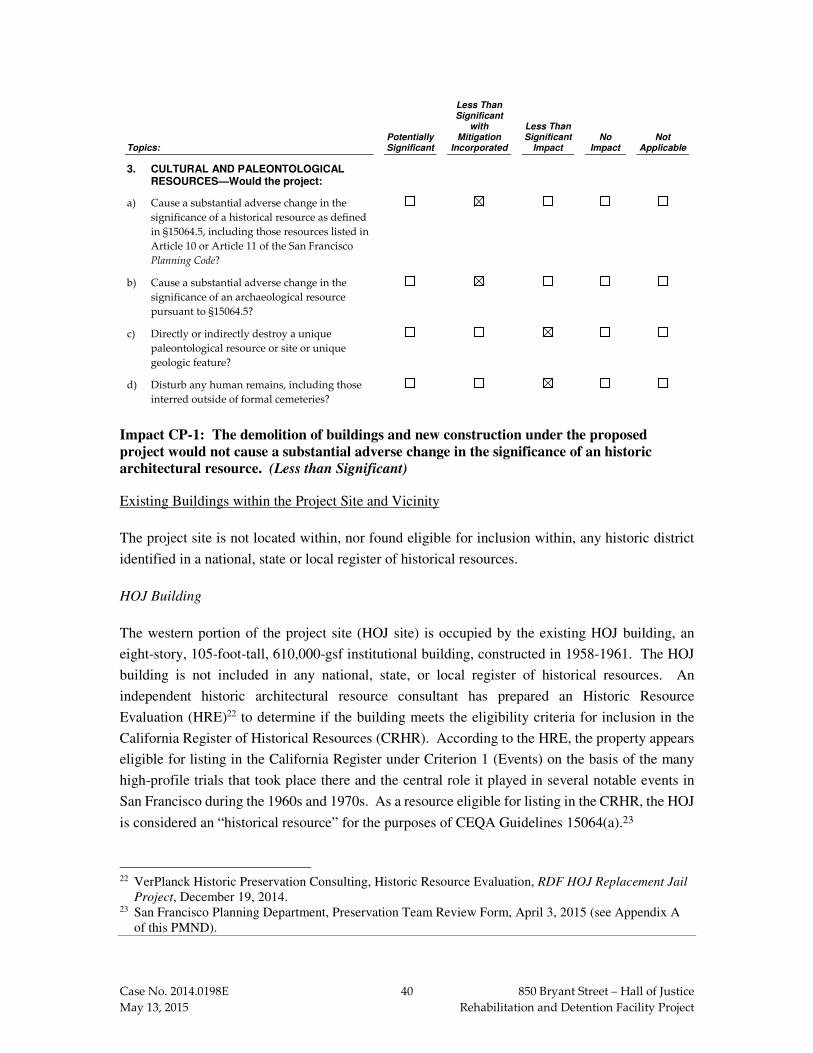
Case No. 2014.0198E 40 850 Bryant Street – Hall of Justice
May 13, 2015 Rehabilitation and Detention Facility Project
Topics: Potentially Significant
Less Than Significant
with Mitigation
Incorporated
Less Than Significant
Impact No
Impact Not
Applicable
3. CULTURAL AND PALEONTOLOGICAL RESOURCES—Would the project:
a) Cause a substantial adverse change in the
significance of a historical resource as defined
in §15064.5, including those resources listed in
Article 10 or Article 11 of the San Francisco
Planning Code?
b) Cause a substantial adverse change in the
significance of an archaeological resource
pursuant to §15064.5?
c) Directly or indirectly destroy a unique
paleontological resource or site or unique
geologic feature?
d) Disturb any human remains, including those
interred outside of formal cemeteries?
Impact CP-1: The demolition of buildings and new construction under the proposed
project would not cause a substantial adverse change in the significance of an historic
architectural resource. (Less than Significant)
Existing Buildings within the Project Site and Vicinity
The project site is not located within, nor found eligible for inclusion within, any historic district
identified in a national, state or local register of historical resources.
HOJ Building
The western portion of the project site (HOJ site) is occupied by the existing HOJ building, an
eight-story, 105-foot-tall, 610,000-gsf institutional building, constructed in 1958-1961. The HOJ
building is not included in any national, state, or local register of historical resources. An
independent historic architectural resource consultant has prepared an Historic Resource
Evaluation (HRE)22 to determine if the building meets the eligibility criteria for inclusion in the
California Register of Historical Resources (CRHR). According to the HRE, the property appears
eligible for listing in the California Register under Criterion 1 (Events) on the basis of the many
high-profile trials that took place there and the central role it played in several notable events in
San Francisco during the 1960s and 1970s. As a resource eligible for listing in the CRHR, the HOJ
is considered an “historical resource” for the purposes of CEQA Guidelines 15064(a).23
22 VerPlanck Historic Preservation Consulting, Historic Resource Evaluation, RDF HOJ Replacement Jail
Project, December 19, 2014. 23 San Francisco Planning Department, Preservation Team Review Form, April 3, 2015 (see Appendix A
of this PMND).

Case No. 2014.0198E 41 850 Bryant Street – Hall of Justice
May 13, 2015 Rehabilitation and Detention Facility Project
The eastern portion of the project site (the project building site) contains two vacant lots and five
existing buildings that are described below.
480-484 Sixth Street
The building at 480-484 Sixth Street is a three-story, 7,150-gsf, 14-unit single room occupancy
(SRO) residential building with retail on the ground floor, constructed in 1916. It is currently rated
as a California Register-eligible property. The San Francisco Planning Department has assigned
the building a Status Code of 3CS, “Appears eligible for CR as an individual property through
survey evaluation.”
450 Sixth Street
The building at 450 Sixth Street is a one-story, 5,100-gsf commercial building, constructed in 1956.
The building is constructed of concrete block with a bowstring truss roof, designed in a utilitarian
“Contractor Modern” mode with minimal ornament. The building is not included in, nor found
eligible for inclusion in, any national, state, or local register of historical resources. The historic
architectural resource consultant has evaluated the building in light of the San Francisco Planning
Department’s historic context statement, San Francisco Modern Architecture and Landscape
Design: 1935-1970, and has concluded that the building appears ineligible for listing in the
California Register and is therefore not an historical resource under CEQA.24
444 Sixth Street
The building at 444 Sixth Street is a one-story, 6,000-gsf office building, constructed in 1959. The
building is constructed of concrete block and has a flat roof, designed in a utilitarian “Contractor
Modern” mode with minimal ornament. The building is not included in, nor found eligible for
inclusion in, any national, state, or local register of historical resources. The historic architectural
resource consultant has evaluated the building in light of the San Francisco Planning Department’s
historic context statement, San Francisco Modern Architecture and Landscape Design: 1935-1970,
and has concluded that the building appears ineligible for listing in the California Register and is
therefore not a historical resource under CEQA.25
800-804 Bryant Street and 820 Bryant Street
The two remaining buildings on the eastern portion of the project site, 800-804 Bryant Street (built
in 2003) and the McDonald’s restaurant at 820 Bryant Street (built in 1996), are less than 50 years
of age. As structures that are less than 50 years of age and for which the City has no information
24 Ibid. 25 VerPlanck Historic Preservation Consulting, Memorandum to Rich Sucre, San Francisco Planning
Department, September 22, 2014.

Case No. 2014.0198E 42 850 Bryant Street – Hall of Justice
May 13, 2015 Rehabilitation and Detention Facility Project
indicating that the structure qualifies as an historical resource, the buildings at 800-804 Bryant
Street and 820 Bryant Street are considered “Category C” properties under the San Francisco
Planning Department’s CEQA Review Procedures for Historic Resources, and are not considered
historical resources for the purposes of CEQA.26
Off-site Buildings in the Vicinity of the Proposed Project
The HRE also identifies a CEQA Area of Potential Effect (C-APE) that includes the project site
and nearby off-site properties: properties on the east side of Sixth Street across from the project
building site; properties at the southeastern corner of Bryant and Sixth streets; and properties along
the south side of Bryant Street between Sixth and Seventh streets. The C-APE was included as part
of a larger comprehensive South of Market Area Historic Resource Survey. Only one off-site
property within the C-APE, an Art Deco style commercial building at 887-891 Bryant Street (built
in 1920) at the southeast corner of Bryant and Seventh streets, was found to meet the criteria for
inclusion within the CRHR. 887-891 Bryant Street is assigned a rating of “5S3, Appears to be
individually eligible for local listing or designation through survey evaluation.”
Impacts of demolition of buildings, new construction, and alterations to historical resources under
the proposed project are described and analyzed below.
Impact of Proposed Demolition of Buildings on the Project Building Site
The proposed project calls for demolition of three buildings on the project building site: the
building at 444 Sixth Street, the building at 450 Sixth Street, and the building at 820 Bryant Street.
As discussed above, these three buildings are not considered individual historical resources for the
purposes of CEQA, nor are they within any historic district. Therefore, demolition of these building
would not have any direct impact on the significance of an historical resource under CEQA. No
alterations are proposed to the SRO building at 480-484 Sixth Street, the only structure on the
project building site that is eligible for the CRHR.
As discussed above, the project site is not located within, nor found eligible for inclusion within,
any historic district identified in a national, state or local register of historical resources. The
individual significance of the HOJ building, the 800-804 Sixth Street building, or the historical
resource at 480-484 Sixth Street within the C-APE, is not premised on their possessing a historical
connection or cohesive visual relationship with any of the buildings that would be demolished
under the proposed project. Therefore, the demolition of buildings under the proposed project
would not impact the significance of an historical resource under CEQA.
26 San Francisco Planning Department, Draft CEQA Review Procedures for Historic Resources, March 31,
2008, pp. 3-8.

Case No. 2014.0198E 43 850 Bryant Street – Hall of Justice
May 13, 2015 Rehabilitation and Detention Facility Project
Impact of the Proposed RDF on the Visual Setting of Historical Resources
The proposed approximately 200,000-gsf, five-story, 110-foot-tall (95 feet tall to the roof top, plus
an additional 15-foot-tall mechanical penthouse) RDF would be constructed in place of the
demolished buildings (444 Sixth Street, 450 Sixth Street, and 820 Bryant Street) and surface
parking lots. The proposed RDF would be contemporary in visual character and would be clad in
glass and metal. The proposed RDF would be separated from the HOJ building by about 95 feet,
consisting of the width of Harriet Street (35 feet) and the setback of the HOJ building from its
eastern property line along Harriet Street (about 60 feet). It would be set back from Bryant Street
by about 96 feet.
As discussed below, although the proposed RDF would change the visual setting of adjacent
historical resources, it would not result in any adverse change in the significance of an historical
resource under CEQA.
On the HOJ Building
The proposed RDF’s separation from the HOJ building would allow the HOJ building to continue
to convey its significance as a singular building. The proposed RDF’s deep setback along Bryant
Street would diminish its visual presence along Bryant Street and its visual impact on the HOJ
building. Physical connection between the proposed RDF and the HOJ building would be below
grade and would not entail any visible exterior changes to the HOJ building. In addition, the
individual significance of the HOJ building is not premised on its possessing a cohesive visual
relationship with surroundings buildings. Rather, the surrounding visual context of the HOJ
building is varied in terms of building height, scale, character, age, architectural style, and
materials.
On the 480-484 Sixth Street Building
The proposed RDF would be approximately three times as tall as the 480-484 Sixth Street building.
The proposed RDF would be separated from the 480-484 Sixth Street building by a setback of
20 feet along the 480-484 Sixth Street building’s northern side lot line wall, and by 23 feet, 9 inches
from its rear wall. The setbacks would minimize physical and visual impacts of the proposed RDF
on the 480-484 Sixth Street building. Although the proposed RDF would transform the existing
visual setting of the 480-484 Sixth Street building, the surrounding visual context is already
characterized by much taller buildings, including the existing HOJ building. In addition, the
individual significance of the 480-484 Sixth Street building is not premised on its possessing a
cohesive visual relationship with surroundings buildings. Rather, the surrounding visual context
of the 480-484 Sixth Street building is varied in terms of building height, scale, character, age,
architectural style, and materials.

Case No. 2014.0198E 44 850 Bryant Street – Hall of Justice
May 13, 2015 Rehabilitation and Detention Facility Project
On the C-APE
As discussed above, the only off-site historical resource within the C-APE is the building at
887-891 Bryant Street (built 1920) at the southeast corner of Bryant and Seventh streets. Visual
interaction between the proposed RDF and the existing 887-891 Bryant Street building at the
opposite end of the Bryant Street block between Sixth and Seventh streets, would be limited by
distance (about 650 feet) and mediated by the intervening HOJ building. Because the proposed
RDF would be set back 96 feet from Bryant Street, there is no direct line of sight between the
proposed RDF and the 887-891 Bryant Street building.
Impacts of Potential Alterations to Historical Resources
The proposed project calls for retention of the HOJ building and the 480-484 Sixth Street building,
each considered an individual historical resource under CEQA. The corner building at 800-804
Bryant Street/498 Sixth Street would also be retained under the proposed project, although it is not
an historical resource under CEQA.
The reallocation of uses within the HOJ building would not call for the removal of any distinctive
character-defining features from the exterior or interior of these buildings. A below-grade tunnel
beneath Harriet Street would be constructed to provide passage between the HOJ building and the
proposed RDF. These alterations would not be visible from the exterior of the building and the
affected below-grade interior spaces are utilitarian and without distinctive historical or architectural
features.
Likewise, the continued use of the 480-484 Sixth Street building as housing, or its potential reuse
as office space, would not require the removal of any distinctive character-defining features from
the exterior or interior of this building.
Conclusion
For these reasons, the proposed demolition of buildings, new construction, and alterations to
historical resources under the proposed project would not result in any adverse change to the
significance of an historic architectural resource under CEQA. Therefore, this impact would be
less than significant. No mitigation measures are necessary.
Impact CP-2: Construction activity under the proposed project could result in damage to
historic architectural resources. (Less than Significant with Mitigation)
The Western SoMa Community Plan, Rezoning of Adjacent Parcels and 350 Eighth Street Project
Final EIR identified a potentially significant impact on historical resources related to construction

Case No. 2014.0198E 45 850 Bryant Street – Hall of Justice
May 13, 2015 Rehabilitation and Detention Facility Project
vibration.27 That EIR concluded that implementation of the following Mitigation Measures
(numbered M-CP-2a and M-CP-2b in this Initial Study) would reduce potential construction
impacts on nearby historic architectural resources to less-than-significant levels. These mitigation
measures are applicable to all construction projects within the Western SoMa Community Plan
Area, like the proposed project.
Mitigation Measure M-CP-2a: Protect Historical Resources from Adjacent Construction
Activities
The project sponsor of a development project in the Draft Plan Area and on the Adjacent Parcels shall consult with Planning Department environmental planning/preservation staff to determine whether adjacent or nearby buildings constitute historical resources that could be adversely affected by construction-generated vibration. For purposes of this measure, nearby historic buildings shall include those within 100 feet of a construction site if pile driving would be used in a subsequent development project; otherwise, it shall include historic buildings within 25 feet if heavy equipment would be used on the subsequent development project. (No measures need be applied if no heavy equipment would be employed.) If one or more historical resources is identified that could be adversely affected, the project sponsor shall incorporate into construction specifications for the proposed project a requirement that the construction contractor(s) use all feasible means to avoid damage to adjacent and nearby historic buildings. Such methods may include maintaining a safe distance between the construction site and the historic buildings (as identified by the Planning Department preservation staff), using construction techniques that reduce vibration, appropriate excavation shoring methods to prevent movement of adjacent structures, and providing adequate security to minimize risks of vandalism and fire.
Mitigation Measure M‐‐‐‐CP‐‐‐‐2b: Construction Monitoring Program for Historical
Resources
For those historical resources identified in Mitigation Measure M‐‐‐‐CP‐‐‐‐2a, and where heavy equipment would be used on a subsequent development project, the project sponsor of such a project shall undertake a monitoring program to minimize damage to adjacent historic buildings and to ensure that any such damage is documented and repaired. The monitoring program, which shall apply within 100 feet where pile driving would be used and within 25 feet otherwise, shall include the following components. Prior to the start of any ground-disturbing activity, the project sponsor shall engage a historic architect or qualified historic preservation professional to undertake a pre-construction survey of historical resource(s) identified by the San Francisco Planning Department within 125 feet of planned construction to document and photograph the buildings of existing conditions. Based on the construction and condition of the resource(s), the consultant shall also establish a maximum vibration level that shall not be exceeded at each building, based on existing condition, character-defining features, soils conditions, and anticipated construction practices (a common standard is 0.2 inch per second, peak particle velocity). To ensure that vibration levels do not exceed the established standard, the project sponsor shall monitor vibration levels at each structure and shall prohibit vibratory construction activities that generate vibration levels in excess of the standard. Should vibration levels be observed in excess of the standard, construction shall be halted and alternative
27 City and County of San Francisco, Western SoMa Community Plan, Rezoning of Adjacent Parcels and
350 Eighth Street Project Final EIR, Case File Nos. 2008.0877E and 2007.1035E, certified December 6, 2012, pp. 4.D.54-4.D.55.

Case No. 2014.0198E 46 850 Bryant Street – Hall of Justice
May 13, 2015 Rehabilitation and Detention Facility Project
construction techniques put in practice, to the extent feasible. (For example, pre-drilled piles could be substituted for driven piles, if feasible based on soils conditions; smaller, lighter equipment might be able to be used in some cases.) The consultant shall conduct regular periodic inspections of each building during ground-disturbing activity on the project site. Should damage to either building occur, the building(s) shall be remediated to its pre-construction condition at the conclusion of ground-disturbing activity on the site.
With implementation of Mitigation Measures M-CP-2a and M-CP-2b, the proposed project
would not expose nearby historic architectural resources to construction vibration levels that are in
excess of standards established by the FTA. Therefore, this impact would be less than significant
with mitigation.
Impact CP-3: Construction activities for the proposed project could cause a substantial
adverse change in the significance of archaeological resources, if such resources are present
within the project site. (Less than Significant with Mitigation)
The proposed project is currently in the preliminary design phase but the most recent project
design28 would include one sub-grade partial basement level resulting in soils disturbance to a depth
of about 17 feet below grade surface (bgs) including additional soils disturbance for a mat
foundation. Additional foundation support in the form of piles or soils improvement is not currently
regarded as warranted. The proposed project also includes the construction of a pedestrian transport
tunnel between the proposed RDF and the basement level of the existing HOJ building, which
would result in soils disturbance to a depth of approximately 17 feet bgs. Construction techniques
necessary for construction of the pedestrian tunnel have not been determined by the project sponsor
and its consultants but could result in soils disturbance to a depth in excess of that required for the
tunnel. The subsurface disturbance resulting from the proposed project may potentially adversely
affect a legally-significant archeological resource.29 This is considered a potentially significant
impact.
The proposed project was subject to Preliminary Archeological Review (PAR) by Planning
Department archeologists with a determination30 that the proposed project has the potential to affect
legally-significant archeological resources.31 The project site is also located within the
Archeological Study Area of an archeological research design and treatment plan (ARDTP)
prepared for Caltrans for the section of I-80 nearest the project site.32 The ARDTP found that the
28 San Francisco Department of Public Works (DPW), Geotechnical Investigation Report - Rehabilitation
and Detention Facility, 820 Bryant Street, San Francisco, California, February 23, 2015. 29 The term “legally-significant archeological resource” is intended to mean an archeological resource that
meets the criterion of an “historical resources” or a “unique archaeological resource” in the CEQA Statutes and Guidelines (CEQA and Guidelines 21083.2(g) and 15064.5(A)(2)).
30 San Francisco Planning Department, Preliminary Archeological Review Log, September 28, 2014. 31 San Francisco Planning Department, Randall Dean to Monica Pereira. September 28, 2014. 32 McIlroy, Jack and Mary Praetzellis (ed.), Vanished Community Archaeological Research Design and
Treatment Plan (ARDTP) for the SF-80 Bayshore Viaduct Seismic Retrofit Project, September, 1997.

Case No. 2014.0198E 47 850 Bryant Street – Hall of Justice
May 13, 2015 Rehabilitation and Detention Facility Project
block containing the project site is sensitive for prehistoric period and Gold Rush Period to later
19th Century archeological resources, especially with respect to an early German community.
Archeological field investigations33 to the north of the project site did not identify prehistoric
deposits but did disclose a National Register-eligible historical archeological feature (artifactual
assemblage within a domestic privy) associated with the household of Charles A.C. Duisenberg
(1869-1906) – a prominent immigrant German family.
The project site borders or straddles the northern edge of Sullivan’s Marsh and was, up until the
early 1850s, located in a willow thicket along the marsh. In geotechnical sampling that has been
conducted within this block there is relatively shallow fill over native sand dune deposits of greater
(but variable) depth over marsh (New Bay Mud/peat) deposits. To the extreme west side of the
block, along 7th Street, about 3 feet of shell deposits were previously found that could be naturally-
occurring shell, but may also be prehistoric shell midden deposits. The National Register-Eligible
Prehistoric Shell Midden Archeological District is located in the area northeast of 5th Street. Sand
dune deposits within the project site could potentially be sensitive for prehistoric archeological
deposits.
The project site was filled-in by the early 1850s and may have included a part of “Russ Gardens,”
the first proprietary park in San Francisco, and created for the local German community residing
in the project vicinity. Through the later 19th century, the project site was characterized by tenement
housing along Harriet Street (also historically known as “Garden Street”). Thus, the project site
also has the potential to contain legally-significant prehistoric deposits and historical archeological
domestic deposits preserved in hollow features such as wells, privies, or trash pits.
Due to the archeological sensitivity of the project site described above, implementation of
Mitigation Measure M-CP-3: Archeological Testing would be included in the proposed project.
Mitigation Measure M-CP-3 would apply to any components of the proposed project resulting in
soils disturbance of ten feet or greater below the ground surface. This mitigation measure requires,
among other things, that the project sponsor prepare an Addendum to the 1997 ARDTP prepared
for the SF-80 Bayshore Viaduct Seismic Retrofit Project.34
Mitigation Measure M-CP-3: Archeological Testing
Based on a reasonable presumption that archeological resources may be present within the project site, the following measures shall be undertaken to avoid any potentially significant adverse effect from the proposed project on buried or submerged historical resources. The project sponsor shall retain the services of an archaeological consultant from the rotational
33 McIlroy, Jack and Mary Praetzellis (ed.), SF-80 Bayshore Viaduct Seismic Retrofit Project Report on
Construction Monitoring, Geoarchaeology, and Technical and Interpretive Studies for Historic
Archaeology, June 2004. 34 McIlroy, Jack & Mary Praetzellis (ed.), SF-80 Bayshore Viaduct Seismic Retrofit Project Report on
Construction Monitoring, Geoarchaeology, and Technical and Interpretive Studies for Historic
Archaeology, June 2004.

Case No. 2014.0198E 48 850 Bryant Street – Hall of Justice
May 13, 2015 Rehabilitation and Detention Facility Project
Department Qualified Archaeological Consultants List (QACL) maintained by the Planning Department archaeologist. The project sponsor shall contact the Department archeologist to obtain the names and contact information for the next three archeological consultants on the QACL. The archeological consultant shall prepare an Addendum to the Vanished Community: Archaeological Research Design and Treatment Plan for the SF-80 Bayshore Viaduct Seismic Retrofit Project (J. McIlroy & M. Praetzellis (ed. 1997).
The Addendum to the ARDTP shall have the following content:
1) Summary: Description of subsurface effect of the proposed project and of previous soils-disturbing activities;
2) Historical Development: If demographic data for the project site is absent in the discussion in the ARDTP, the addendum shall include new demographic data regarding former site occupants;
3) Identification of potential archeological resources: Discussion of any identified potential prehistoric or historical archeological resources;
4) Integrity and Significance: Eligibility of identified expected resources for listing to the CRHR; Identification of applicable Research Themes/Questions (in the ARDTP) that would be addressed by the expected archeological resources that are identified;
5) Impacts of Proposed Project;
6) Potential Soils Hazards: Update discussion for proposed project;
7) Archeological Testing Plan (if archeological testing is determined warranted): the Archeological Testing Plan (ATP) shall include:
A) Proposed archeological testing strategies and their justification
B) Expected archeological resources
C) For historic archeological resources
a) Historic address or other location identification
b) Archeological property type
D) For all archeological resources
a) Estimate depth below the surface
b) Expected integrity
c) Preliminary assessment of eligibility to the CRHR
E) ATP Map
a) Location of expected archeological resources
b) Location of expected project sub-grade impacts
c) Areas of prior soils disturbance
d) Archeological testing locations by type of testing
e) Base map: 1886/7 Sanborn Fire Insurance Co. map
The archeological consultant’s work shall be conducted in accordance with this measure at the direction of the Environmental Review Officer (ERO). All plans and reports prepared by the

Case No. 2014.0198E 49 850 Bryant Street – Hall of Justice
May 13, 2015 Rehabilitation and Detention Facility Project
consultant as specified herein shall be submitted first and directly to the ERO for review and comment, and shall be considered draft reports subject to revision until final approval by the ERO. Archeological monitoring and/or data recovery programs required by this measure could suspend construction of the project for up to a maximum of four weeks. At the direction of the ERO, the suspension of construction can be extended beyond four weeks only if such a suspension is the only feasible means to reduce to a less than significant level potential effects on a significant archeological resource as defined in CEQA Guidelines Sect. 15064.5 (a)(c).
Consultation with Descendant Communities: On discovery of an archeological site35 associated with descendant Native Americans, the Overseas Chinese, or other potentially interested descendant group an appropriate representative36 of the descendant group and the ERO shall be contacted. The representative of the descendant group shall be given the opportunity to monitor archeological field investigations of the site and to offer recommendations to the ERO regarding appropriate archeological treatment of the site, of recovered data from the site, and, if applicable, any interpretative treatment of the associated archeological site. A copy of the Final Archaeological Resources Report shall be provided to the representative of the descendant group.
Archeological Testing Program. The archeological consultant shall prepare and submit to the ERO for review and approval an archeological testing plan (ATP). The archeological testing program shall be conducted in accordance with the approved ATP. The ATP shall identify the property types of the expected archeological resource(s) that potentially could be adversely affected by the proposed project, the testing method to be used, and the locations recommended for testing. The purpose of the archeological testing program will be to determine to the extent possible the presence or absence of archeological resources and to identify and to evaluate whether any archeological resource encountered on the site constitutes an historical resource under CEQA.
At the completion of the archeological testing program, the archeological consultant shall submit a written report of the findings to the ERO. If based on the archeological testing program the archeological consultant finds that significant archeological resources may be present, the ERO in consultation with the archeological consultant shall determine if additional measures are warranted. Additional measures that may be undertaken include additional archeological testing, archeological monitoring, and/or an archeological data recovery program. No archeological data recovery shall be undertaken without the prior approval of the ERO or the Planning Department archeologist. If the ERO determines that a significant archeological resource is present and that the resource could be adversely affected by the proposed project, at the discretion of the project sponsor either:
A) The proposed project shall be re-designed so as to avoid any adverse effect on the significant archeological resource; or
35 The term “archeological site” is intended here to minimally include any archeological deposit, feature,
burial, or evidence of burial. 36 An “appropriate representative” of the descendant group is here defined to mean, in the case of Native
Americans, any individual listed in the current Native American Contact List for the City and County of San Francisco maintained by the California Native American Heritage Commission and in the case of the Overseas Chinese, the Chinese Historical Society of America. An appropriate representative of other descendant groups should be determined in consultation with the San Francisco Planning Department archeologist.

Case No. 2014.0198E 50 850 Bryant Street – Hall of Justice
May 13, 2015 Rehabilitation and Detention Facility Project
B) A data recovery program shall be implemented, unless the ERO determines that the archeological resource is of greater interpretive than research significance and that interpretive use of the resource is feasible.
Archeological Monitoring Program. If the ERO in consultation with the archeological consultant determines that an archeological monitoring program shall be implemented the archeological monitoring program shall minimally include the following provisions:
� The archeological consultant, project sponsor, and ERO shall meet and consult on the scope of the AMP reasonably prior to any project-related soils disturbing activities commencing. The ERO in consultation with the archeological consultant shall determine what project activities shall be archeologically monitored. In most cases, any soils- disturbing activities, such as demolition, foundation removal, excavation, grading, utilities installation, foundation work, driving of piles (foundation, shoring, etc.), site remediation, etc., shall require archeological monitoring because of the risk these activities pose to potential archaeological resources and to their depositional context;
� The archeological consultant shall advise all project contractors to be on the alert for evidence of the presence of the expected resource(s), of how to identify the evidence of the expected resource(s), and of the appropriate protocol in the event of apparent discovery of an archeological resource;
� The archeological monitor(s) shall be present on the project site according to a schedule agreed upon by the archeological consultant and the ERO until the ERO has, in consultation with project archeological consultant, determined that project construction activities could have no effects on significant archeological deposits;
� The archeological monitor shall record and be authorized to collect soil samples and artifactual/ecofactual material as warranted for analysis;
� If an intact archeological deposit is encountered, all soils-disturbing activities in the vicinity of the deposit shall cease. The archeological monitor shall be empowered to temporarily redirect demolition/excavation/pile driving/construction activities and equipment until the deposit is evaluated. If in the case of pile driving activity (foundation, shoring, etc.), the archeological monitor has cause to believe that the pile driving activity may affect an archeological resource, the pile driving activity shall be terminated until an appropriate evaluation of the resource has been made in consultation with the ERO. The archeological consultant shall immediately notify the ERO of the encountered archeological deposit. The archeological consultant shall make a reasonable effort to assess the identity, integrity, and significance of the encountered archeological deposit, and present the findings of this assessment to the ERO.
Whether or not significant archeological resources are encountered, the archeological consultant shall submit a written report of the findings of the monitoring program to the ERO.
Archeological Data Recovery Program. The archeological data recovery program shall be conducted in accord with an archeological data recovery plan (ADRP). The archeological consultant, project sponsor, and ERO shall meet and consult on the scope of the ADRP prior to preparation of a draft ADRP. The archeological consultant shall submit a draft ADRP to the ERO. The ADRP shall identify how the proposed data recovery program will preserve the significant information the archeological resource is expected to contain. That is, the ADRP will identify what scientific/historical research questions are applicable to the expected

Case No. 2014.0198E 51 850 Bryant Street – Hall of Justice
May 13, 2015 Rehabilitation and Detention Facility Project
resource, what data classes the resource is expected to possess, and how the expected data classes would address the applicable research questions. Data recovery, in general, should be limited to the portions of the historical property that could be adversely affected by the proposed project. Destructive data recovery methods shall not be applied to portions of the archeological resources if nondestructive methods are practical.
The scope of the ADRP shall include the following elements:
� Field Methods and Procedures. Descriptions of proposed field strategies, procedures, and operations.
� Cataloguing and Laboratory Analysis. Description of selected cataloguing system and artifact analysis procedures.
� Discard and Deaccession Policy. Description of and rationale for field and post-field discard and deaccession policies.
� Interpretive Program. Consideration of an on-site/off-site public interpretive program during the course of the archeological data recovery program.
� Security Measures. Recommended security measures to protect the archeological resource from vandalism, looting, and non-intentionally damaging activities.
� Final Report. Description of proposed report format and distribution of results.
� Curation. Description of the procedures and recommendations for the curation of any recovered data having potential research value, identification of appropriate curation facilities, and a summary of the accession policies of the curation facilities.
Human Remains and Associated or Unassociated Funerary Objects. The treatment of human remains and of associated or unassociated funerary objects discovered during any soils disturbing activity shall comply with applicable State and Federal laws. This shall include immediate notification of the Coroner of the City and County of San Francisco and in the event of the Coroner’s determination that the human remains are Native American remains, notification of the California State Native American Heritage Commission (NAHC) who shall appoint a Most Likely Descendant (MLD) (Pub. Res. Code Sec. 5097.98). The archeological consultant, project sponsor, ERO, and MLD shall have up to but not beyond six days of discovery to make all reasonable efforts to develop an agreement for the treatment of , human remains and associated or unassociated funerary objects (CEQA Guidelines. Sec. 15064.5(d)) with appropriate dignity. The agreement should take into consideration the appropriate excavation, removal, recordation, analysis, custodianship, curation, and final disposition of the human remains and associated or unassociated funerary objects. Nothing in existing State regulations or in this mitigation measure compels the project sponsor and the ERO to accept recommendations of an MLD. The archeological consultant shall retain possession of any Native American human remains and associated or unassociated burial objects until completion of any scientific analyses of the human remains or objects as specified in the treatment agreement if such as agreement has been made or, otherwise, as determined by the archeological consultant and the ERO.
Final Archeological Resources Report. The archeological consultant shall submit a Draft Final Archeological Resources Report (FARR) to the ERO that evaluates the historical significance of any discovered archeological resource and describes the archeological and historical research methods employed in the archeological testing/monitoring/data recovery program(s) undertaken. Information that may put at risk any archeological resource shall be provided in a separate removable insert within the final report.

Case No. 2014.0198E 52 850 Bryant Street – Hall of Justice
May 13, 2015 Rehabilitation and Detention Facility Project
Once approved by the ERO, copies of the FARR shall be distributed as follows: California Archaeological Site Survey Northwest Information Center (NWIC) shall receive one (1) copy and the ERO shall receive a copy of the transmittal of the FARR to the NWIC. The Environmental Planning division of the Planning Department shall receive one bound, one unbound and one unlocked, searchable PDF copy on CD of the FARR along with copies of any formal site recordation forms (CA DPR 523 series) and/or documentation for nomination to the National Register of Historic Places/California Register of Historical Resources. In instances of high public interest in or the high interpretive value of the resource, the ERO may require a different final report content, format, and distribution than that presented above.
With implementation of Mitigation Measure M-CP-3, to which the project sponsor has agreed,
the proposed project would not result in the loss of legally-significant archeological resources.
Therefore, this impact would be less than significant with mitigation.
Impact CP-4: Construction activities of the proposed project would not affect a unique
paleontological resource or a unique geologic feature. (Less than Significant)
The Western SoMa Community Plan, Rezoning of Adjacent Parcels and 350 Eighth Street Project
Final EIR identified a less-than-significant impact on paleontological resources for projects, like
the proposed project, within the Western SoMa Community Plan Area.37 According to that EIR,
the Western SoMa Community Plan Area is underlain with native Dune sands, the Colma
Formation, or artificial fill associated with previous development (e.g., road bases, foundations,
and previous backfills for underground utilities). Due to their age and origin, these geological
materials have little to no likelihood of containing unique or significant fossils. As such, excavation
within the Western SoMa Community Plan Area would have a low potential for uncovering unique
or significant fossils. Therefore, the impact of the proposed project related to paleontological
resources would be less than significant. No mitigation measures are necessary.
Impact CP-5: Construction activities of the proposed project could disturb human remains,
including those interred outside of formal cemeteries. (Less than Significant)
Archeological materials, including human burials, have been found in the City. Human burials
outside of formal cemeteries often occur in prehistoric archeological contexts. Excavation
associated with new construction activities in the project area may have the potential to disturb
these resources, including Native American burials. Project-specific ground-disturbing activity
could result in direct impacts on previously undiscovered human remains. The treatment of human
remains and of associated or unassociated funerary objects discovered during any soil-disturbing
activities must comply with applicable state laws. This includes immediate notification of the
county coroner and, in the event of the coroner’s determination that the human remains are Native
American, notification of the California Native American Heritage Commission, which shall
37 City and County of San Francisco, Western SoMa Community Plan, Rezoning of Adjacent Parcels and
350 Eighth Street Project Final EIR, Case File Nos. 2008.0877E and 2007.1035E, certified December 6, 2012, p. 4.D.53.
Case No. 2014.0198E 53 850 Bryant Street – Hall of Justice
May 13, 2015 Rehabilitation and Detention Facility Project
appoint a Most Likely Descendant (MLD) (California Public Resources Code Section 5097.98). In
the event of such discovery, the archeological consultant, the San Francisco Planning Department,
and MLD would have up to but not beyond six days of discovery to make all reasonable efforts to
develop an agreement for the treatment of human remains and associated or unassociated funerary
objects with appropriate dignity, in accordance with CEQA Guidelines Section 15064.5(d). The
agreement should take into consideration the appropriate excavation, removal, recordation,
analysis, custodianship, curation, and final disposition of the human remains and associated or
unassociated funerary objects. The Public Resources Code allows 48 hours to reach agreement on
these matters. If the MLD and the other parties do not agree on the reburial method, the project
sponsor must comply with Section 5097.98(b) of the Public Resources Code, which states that the
landowner or his or her authorized representative shall reinter the human remains and items
associated with Native American burials with appropriate dignity on the property in a location not
subject to further subsurface disturbance. Because the potential disturbance to human remains is
governed by state laws and regulations, as described above, compliance with these laws and
regulations would ensure that impacts related to such disturbance of human remains would be less
than significant. No mitigation measures are necessary.
Impact C-CP-1: The proposed project, in combination with past, present, and reasonably
foreseeable future projects in the vicinity, would not result in a considerable contribution to
significant cumulative impacts on cultural resources. (Less than Significant with Mitigation)
As discussed above, although the proposed demolition of three existing buildings on the project
building site and construction of the proposed RDF would change the visual setting of adjacent
historical resources, the proposed project would not result in any adverse change in the significance
of any historic architectural resource under CEQA with implementation of Mitigation Measures
M-CP-2a and M-CP2-b. As such, the proposed project would not contribute to any cumulative
impact on historic architectural resources that could result from past, present, or reasonably
foreseeable future projects in the vicinity of the project site.
As discussed above, the proposed project is unlikely to affect paleontological resources. As such,
the proposed project would not contribute to any cumulative impact on historic paleontological
resources that could result from past, present, or reasonably foreseeable future projects in the
vicinity of the project site.
The significance of impacts on archaeological resources is premised on the potential loss of historic
and scientific information. When considered with other past and proposed projects within San
Francisco and the Bay Area region, the potential disturbance of archaeological resources within the
project site could make a cumulatively considerable contribution to a loss of significant historic
and scientific information about California, Bay Area, and San Francisco history and prehistory.
Implementation of the approved plans for testing, monitoring, and data recovery would preserve
and realize the information potential of archaeological resources if any are encountered. The

Case No. 2014.0198E 54 850 Bryant Street – Hall of Justice
May 13, 2015 Rehabilitation and Detention Facility Project
recovery, documentation, and interpretation of information about archaeological resources that may
be encountered within the project site would enhance knowledge of prehistory and history. This
information would be available to future archaeological studies, contributing to the collective body
of scientific and historic knowledge. With implementation of Mitigation Measure M-CP-3:
Archaeological Testing the proposed project’s contribution to cumulative impacts, if any, would
not be cumulatively considerable. Therefore, any potential contribution to significant cumulative
impacts would not be considerable. No additional mitigation measures are necessary.
Topics:
Potentially Significant
Impact
Less Than Significant
with Mitigation
Incorporated
Less Than Significant
Impact No
Impact Not
Applicable
4. TRANSPORTATION AND CIRCULATION— Would the project:
a) Conflict with an applicable plan, ordinance or
policy establishing measures of effectiveness
for the performance of the circulation system,
taking into account all modes of transportation
including mass transit and non-motorized
travel and relevant components of the
circulation system, including but not limited
to intersections, streets, highways and
freeways, pedestrian and bicycle paths, and
mass transit?
b) Conflict with an applicable congestion
management program, including but not
limited to level of service standards and travel
demand measures, or other standards
established by the county congestion
management agency for designated roads or
highways?
c) Result in a change in air traffic patterns,
including either an increase in traffic levels or
a change in location, that results in substantial
safety risks?
d) Substantially increase hazards due to a design
feature (e.g., sharp curves or dangerous
intersections) or incompatible uses?
e) Result in inadequate emergency access?
f) Conflict with adopted policies, plans, or
programs regarding public transit, bicycle, or
pedestrian facilities, or otherwise decrease the
performance or safety of such facilities?
Due to the nature and scope of the proposed project, implementation of the proposed project does
not have the potential to change air traffic patterns. In addition, the proposed project would not

Case No. 2014.0198E 55 850 Bryant Street – Hall of Justice
May 13, 2015 Rehabilitation and Detention Facility Project
involve the installation of structures that could interfere with air space. Therefore, Topic E.4(c) is
not applicable to the proposed project.
SETTING
Transportation conditions were evaluated for a study area generally bounded by Harrison Street to
the north, Sixth Street to the east, Bryant Street to the south, and Seventh Street to the west (see
Figure 15: Transportation Study Area). In the South of Market area, streets that run in the
northwest/southeast direction are considered north-south streets (e.g., Sixth Street), whereas streets
that run in the southwest/northeast direction are considered east-west streets (e.g., Bryant Street).
Traffic Conditions
The project site is generally bounded by Sixth, Bryant and Seventh streets and the I-80 freeway
structure. The project building site is located on the block bounded by Sixth, Bryant and Harriet
streets, and Ahern Way immediately south of the I-80 freeway. Local vehicular access to and from
the project building site is provided primarily via Bryant and Sixth streets. Sixth Street has two
travel lanes in each direction, while Bryant Street has four eastbound travel lanes. Harriet Street is
one-way northbound, with two travel lanes between Bryant Street and Ahern Way, adjacent to the
project building site. Most other streets in the project vicinity, including Ahern Way, have one
travel lane in each direction. The intersections of Sixth Street/Ahern Way and Harriet Street/Ahern
Way are stop-controlled on the minor approach of Ahern Way eastbound and Harriet Street
northbound.
Regional access to the project site is provided by U.S. 101 and I-280. U.S. 101 connects to I-80,
which connects San Francisco to the East Bay and other locations east via the San Francisco-
Oakland Bay Bridge. U.S. 101 and I-280 serve San Francisco and the South Bay, and U.S. 101
provides access north via the Golden Gate Bridge. Access from I-80 eastbound is via the off-ramp
at Bryant/Seventh streets, and access to I-80 eastbound is via the on-ramp at Bryant/Eighth streets.
Access from I-80 westbound is via the off-ramp at Harrison/Eighth streets, and access to I-80
westbound is via the on-ramp at Harrison/Seventh. The closest access to I-280 is provided via on-
and off-ramps at the intersection of Sixth/Brannan streets.
Harrison Street runs in the east-west direction between The Embarcadero and 13th/Division
streets, operating one-way westbound between Third and Tenth streets. Harrison Street runs in the
north-south direction between 13th/Division and Norwich streets. In the downtown area, Harrison
Street is a primary route to the I-80 freeway, with on-ramps at the First Street and Essex Street
intersections, and to U.S. 101 southbound, with an on-ramp at Fourth Street and another at Seventh
Street. In the San Francisco General Plan, it is a designated Major Arterial in the Congestion
Management Network (between The Embarcadero and Division Street), a Primary Transit
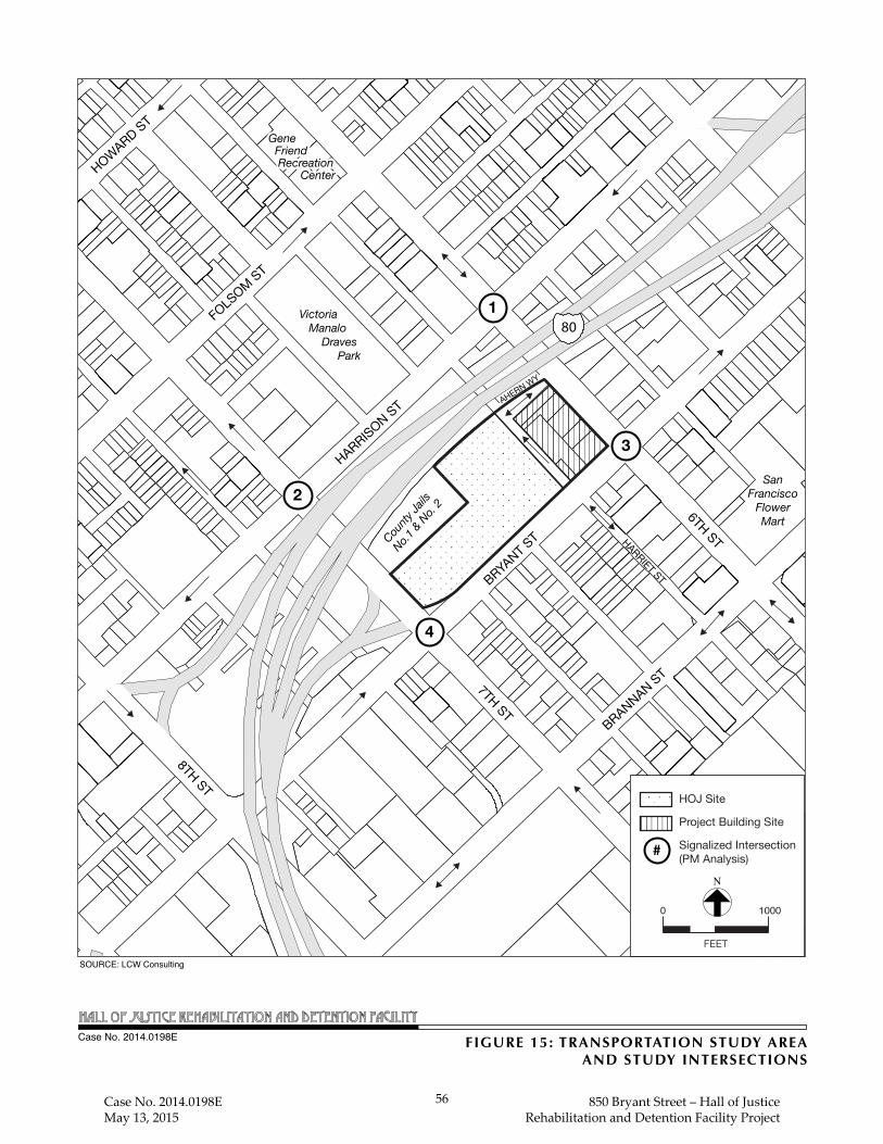
7TH ST
8TH ST
6TH STHARRIET ST
TOWNSEND ST
BRYANT S
T
BRANNAN ST
HARRISON ST
FOLSOM ST
HOWARD ST
80Victoria Manalo Draves Park
Gene Friend Recreation Center
Gene Friend Recreation Center
SanFrancisco
FlowerMart
AHERN WY
1
2
4
3
County
Jails
No.1 & N
o. 2
HOJ Site
Project Building Site
Signalized Intersection (PM Analysis)
FEET
N
0 1000
SOURCE: LCW Consulting
FIGURE 15: TRANSPORTATION STUDY AREAAND STUDY INTERSECTIONS
Case No. 2014.0198E
#
Case No. 2014.0198E May 13, 2015
56 850 Bryant Street – Hall of Justice Rehabilitation and Detention Facility Project

Case No. 2014.0198E 57 850 Bryant Street – Hall of Justice
May 13, 2015 Rehabilitation and Detention Facility Project
Preferential Street (Transit Important Street between Fourth Street and Seventh Street), a Secondary
Transit Preferential Street (between Seventh and 11th streets), and a Neighborhood Commercial
Pedestrian Street (between Fourth and 16th streets). Muni routes 8X Bayshore, 8AX/BX Bayshore
Expresses, 12 Folsom, 27 Bryant, and 47 Van Ness operate along portions of Harrison Street
between Second and 11th streets. Harrison Street, similar to other streets in the area, is classified
as a mixed-use street type under the Better Streets Plan, and sidewalk widths within the study area
are less than the minimum required by the Better Streets Plan (12 feet).38
Bryant Street extends from The Embarcadero in the South of Market area to Precita Avenue in
Peralta Heights. Between The Embarcadero and Second Street, Bryant Street operates two-way in
the east-west direction with two to three lanes. Bryant Street is designated as a Primary Transit
Preferential Street (Transit Important Street between Fourth and Seventh streets) and a Secondary
Transit Preferential Street (between Seventh and Eleventh streets). The 8X Bayshore (between
Seventh and Third streets), 8AX/8BX Bayshore Expresses (between Seventh and Third streets),
27 Bryant (between Division and Fifth streets), and 47 Van Ness (between Division and Fifth
streets) routes run on Bryant Street. Bryant Street is classified as a mixed-use street type under the
Better Streets Plan, and sidewalk widths in front of the existing HOJ building meet the minimum
required by the Better Streets Plan (12 feet) and are narrower elsewhere (8 feet) in the vicinity.
Sixth Street is a north-south roadway between Market Street and Brannan Street. It is a two-way
roadway with two travel lanes in each direction. In the San Francisco General Plan, it is classified
as a Congestion Management Network Major Arterial, a Neighborhood Commercial Street
(between Market and Howard streets), and is part of the MTS network. At Brannan Street, Sixth
Street merges with off- and on-ramps to I-280. Additionally, at the intersection of Sixth Street and
Ahern Way, there is a peak period No Left Turn sign posted in the northbound direction, which
restricts left turns from Sixth Street northbound onto Ahern Way westbound between 3:00 and
7:00 p.m. Muni route 14X Mission Express runs on Sixth Street between Mission and Brannan
streets and 8BX Bayshore Express runs on Sixth Street between Harrison and Brannan streets. The
Sixth Street sidewalk widths are generally less than the minimum required by the Better Streets
Plan (12 feet).
Seventh Street is a principal north-south arterial between Market and 16th streets. Seventh Street
has one-way traffic traveling northbound in four travel lanes. In the San Francisco General Plan,
it is classified as a Congestion Management Network Major Arterial between Market and Bryant
38 The San Francisco Better Streets Plan, which was adopted in 2010, creates a unified set of standards,
guidelines, and implementation strategies to govern how the City designs, builds, and maintains its pedestrian environment. A key goal of the Better Streets Plan is to prioritize the needs of walking, bicycling, transit use, and the use of streets as public spaces for social interaction and community life, following San Francisco’s General Plan, Transit First Policy, and Better Streets Policy. A minimum width of 12 feet and recommended width of 15 feet is specified for a mixed-use street, and a minimum width of 6 feet and recommended width of 9 feet is specified for an alley.

Case No. 2014.0198E 58 850 Bryant Street – Hall of Justice
May 13, 2015 Rehabilitation and Detention Facility Project
streets, and the section between Howard and 16th streets is part of the Metropolitan Transportation
System. Muni route 19 Polk runs on Seventh Street. Seventh Street has a bicycle lane (Class II)
in the northbound direction between Market and 16th streets, part of Bicycle Route 23. The Seventh
Street sidewalk widths are generally less than the minimum required by the Better Streets Plan.
Harriet Street is a north-south alley that runs between Brannan and Harrison streets. Between
Bryant Street and Ahern Way it has two northbound lanes, and on-street commercial loading spaces
and motorcycle parking on the west side of the street.39 Access to the at-grade building services
area of the existing HOJ, the surface parking and ambulance loading area for the Office of the Chief
Medical Examiner, below-grade parking, and the secure transport area/sally port40 for the existing
CJ#1 and CJ#2 is provided from the west side of Harriet Street. Between Ahern Way and Harrison
Street, Harriet Street has one northbound lane with on-street parking on the west side of the street
and curb cuts that provide access to the surface parking lots under the I-80 freeway reserved for
HOJ, Sheriff’s Department and SFPD (San Francisco Police Department) use. The Harriet Street
sidewalk width within the project building site meets the minimum width required by the Better
Streets Plan, six feet for an alley. There is no sidewalk on the west side of Harriet Street between
Bryant Street and Ahern Way (i.e., across the street from the project building site). North of Ahern
Way toward Harrison Street there are 7-foot-wide sidewalks on both sides of Harriet Street.
Ahern Way is an east-west alley that runs two-way between Sixth and Harriet streets. It has one
travel lane in each direction, and on-street parking on both sides of the street. Ahern Way provides
access to the ambulance loading for the Office of the Chief Medical Examiner, the below-grade
parking in the existing HOJ, the secure transport area/sally port for CJ#1 and CJ#2, and the surface
parking lots under the I-80 structure reserved for HOJ, Sheriff’s Department, and SFPD use. Ahern
Way sidewalk widths within the study area meet the minimum required by the Better Streets Plan
(six feet).
Existing traffic conditions for the intersections in the project vicinity were obtained from the
transportation impact analysis being conducted for the Central SoMa Plan Transportation Impact
Study. Table 1: Intersection LOS – Existing Conditions - Weekday P.M. Peak Hour presents
the results of the intersection LOS analysis and corresponding delay at each study intersection for
the weekday p.m. peak hour, as obtained from the transportation impact analysis for the Central
SoMa TIS. The intersections operate at LOS C or better, with the exception of the intersection of
Bryant Street/Sixth Street, which operates at LOS F conditions during the weekday p.m. peak
hour.41
39 While on-street parking is not permitted on the east side of Harriet Street between Bryant Street and
Ahern Way, marked and unmarked official vehicles were observed parking along this street segment. 40 A sally port is an enclosed, secured, controlled entryway into highly restricted or protected areas, such as
the proposed RDF. 41 CHS Consulting Group, Intersection LOS Information, February 20, 2015 (see Appendix B of this
PMND).
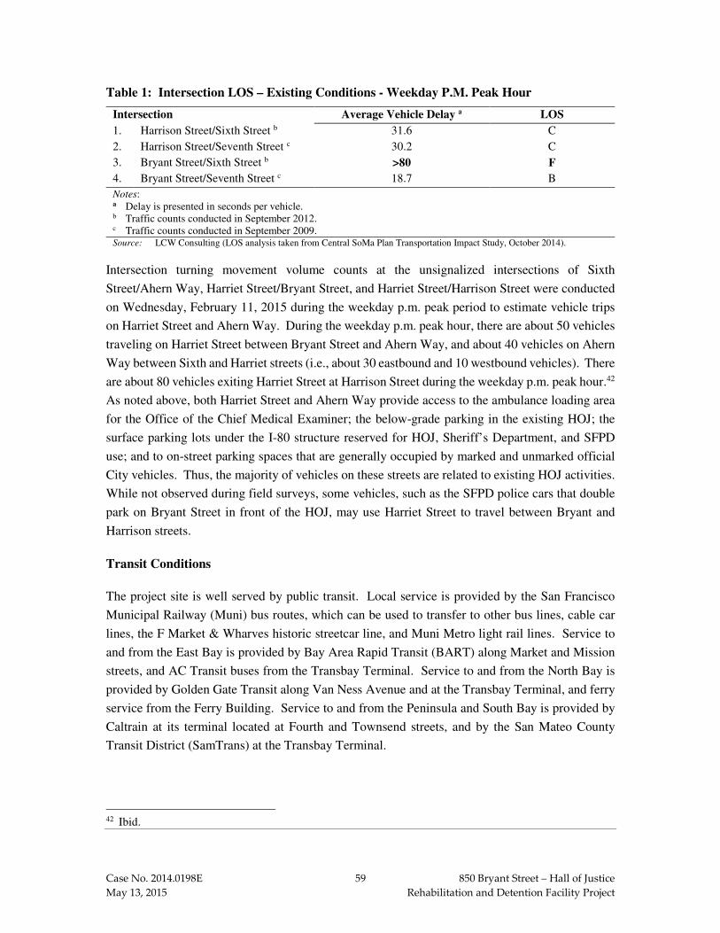
Case No. 2014.0198E 59 850 Bryant Street – Hall of Justice
May 13, 2015 Rehabilitation and Detention Facility Project
Table 1: Intersection LOS – Existing Conditions - Weekday P.M. Peak Hour
Intersection Average Vehicle Delay a LOS
1. Harrison Street/Sixth Street b 31.6 C
2. Harrison Street/Seventh Street c 30.2 C
3. Bryant Street/Sixth Street b >80 F
4. Bryant Street/Seventh Street c 18.7 B
Notes: a Delay is presented in seconds per vehicle. b Traffic counts conducted in September 2012. c Traffic counts conducted in September 2009. Source: LCW Consulting (LOS analysis taken from Central SoMa Plan Transportation Impact Study, October 2014).
Intersection turning movement volume counts at the unsignalized intersections of Sixth
Street/Ahern Way, Harriet Street/Bryant Street, and Harriet Street/Harrison Street were conducted
on Wednesday, February 11, 2015 during the weekday p.m. peak period to estimate vehicle trips
on Harriet Street and Ahern Way. During the weekday p.m. peak hour, there are about 50 vehicles
traveling on Harriet Street between Bryant Street and Ahern Way, and about 40 vehicles on Ahern
Way between Sixth and Harriet streets (i.e., about 30 eastbound and 10 westbound vehicles). There
are about 80 vehicles exiting Harriet Street at Harrison Street during the weekday p.m. peak hour.42
As noted above, both Harriet Street and Ahern Way provide access to the ambulance loading area
for the Office of the Chief Medical Examiner; the below-grade parking in the existing HOJ; the
surface parking lots under the I-80 structure reserved for HOJ, Sheriff’s Department, and SFPD
use; and to on-street parking spaces that are generally occupied by marked and unmarked official
City vehicles. Thus, the majority of vehicles on these streets are related to existing HOJ activities.
While not observed during field surveys, some vehicles, such as the SFPD police cars that double
park on Bryant Street in front of the HOJ, may use Harriet Street to travel between Bryant and
Harrison streets.
Transit Conditions
The project site is well served by public transit. Local service is provided by the San Francisco
Municipal Railway (Muni) bus routes, which can be used to transfer to other bus lines, cable car
lines, the F Market & Wharves historic streetcar line, and Muni Metro light rail lines. Service to
and from the East Bay is provided by Bay Area Rapid Transit (BART) along Market and Mission
streets, and AC Transit buses from the Transbay Terminal. Service to and from the North Bay is
provided by Golden Gate Transit along Van Ness Avenue and at the Transbay Terminal, and ferry
service from the Ferry Building. Service to and from the Peninsula and South Bay is provided by
Caltrain at its terminal located at Fourth and Townsend streets, and by the San Mateo County
Transit District (SamTrans) at the Transbay Terminal.
42 Ibid.

Case No. 2014.0198E 60 850 Bryant Street – Hall of Justice
May 13, 2015 Rehabilitation and Detention Facility Project
Muni operates numerous bus routes in the project vicinity, including the 8X Bayshore and
8AX/BX Bayshore Expresses (Harrison and Bryant streets), 19 Polk (Seventh and Eighth Streets),
27 Bryant (Bryant and Sixth streets), 47 Van Ness (Bryant and Harrison streets), 12 Folsom
(Folsom and Harrison streets), and 14X Mission Express (Sixth Street). The nearest Muni bus
stops to the project site are on Bryant Street, east of Seventh Street, which serve the 27 Bryant and
47 Van Ness routes; Bryant Street, east of Sixth Street, which serve the 8X Bayshore,
8AX/BX Bayshore Expresses, and 47 Van Ness routes; and Sixth Street, north of Bryant Street,
which serve the 14X Mission Express and 27 Bryant routes. Other nearby stops are on Seventh
Street, north of Bryant Street, which serve the 19 Polk route; and Harrison Street, west of Sixth
Street, which serve the 8X Bayshore, 8AX/BX Bayshore Expresses, 12 Folsom, 27 Bryant, and
47 Van Ness routes. Golden Gate Transit operates bus routes within three blocks of the project site
(Mission, Howard, and Folsom streets), as does SamTrans (Mission, Ninth, and Tenth streets).
Table 2: Muni Ridership and Capacity Utilization by Route – Existing Conditions at MLP –
Weekday P.M. Peak Hour presents the ridership and capacity utilization at the maximum load
point (MLP) for the nearby routes during the weekday p.m. peak hour. As noted in Table 2, during
the weekday p.m. peak hour, capacity utilization for all routes serving the project vicinity is less
than Muni’s 85 percent capacity utilization standard.
Table 2: Muni Ridership and Capacity Utilization by Route – Existing Conditions at MLP
– Weekday P.M. Peak Hour
Route
Inbound (towards downtown) Outbound (away from downtown)
Ridership Capacity Capacity
Utilization a Ridership Capacity
Capacity
Utilization a
8X Bayshore 408 752 54% 416 752 55% 8AX Bayshore Express
-- -- -- 472 752 63%
8BX Bayshore Express
-- -- -- 568 752 76%
12 Folsom 135 189 71% 126 189 67% 14X Mission Express
-- -- -- 368 705 52%
19 Polk 172 252 68% 124 252 49% 27 Bryant 160 252 63% 116 252 46% 47 Van Ness 276 378 73% 258 378 68% Note: a Capacity utilization at the maximum load point (MLP). Source: SF Planning Department Memorandum, Transit Data for Transportation Studies, June 2013.
Regional transit operations are evaluated at three regional screenlines (East Bay, North Bay, and
South Bay) for the peak direction of travel and ridership loads, which corresponds with the evening
commute outbound from downtown San Francisco to the region. The analysis is documented in
the San Francisco Planning Department memorandum titled Transit Data for Transportation

Case No. 2014.0198E 61 850 Bryant Street – Hall of Justice
May 13, 2015 Rehabilitation and Detention Facility Project
Impact Studies (June 2013).43 During the weekday p.m. peak hour, all regional transit providers
operate at less than their load factor standard of 100 percent, which indicates that seats are generally
available.
Pedestrian Conditions
Adjacent to the project building site, sidewalk widths are 10 feet on Sixth Street, 8-12 feet on Bryant
Street, 6 feet on Harriet Street,44 and 6 feet on Ahern Way. Most existing sidewalk widths adjacent
to the project building site are less than the recommended sidewalk widths in the Better Streets
Plan (i.e., minimum of 12 feet and recommended of 15 feet for a mixed-use street, and minimum
of 6 feet and recommended of 9 feet for an alley). The sidewalk on Bryant Street meets the Better
Streets Plan minimum requirement of 12 feet for a mixed-use street, while the sidewalks on Ahern
Way and Harriet Street meet the Better Streets Plan minimum requirement of 6 feet for an alley.
Pedestrian crosswalks and pedestrian signals are provided at the signalized intersections in the
project vicinity. A signalized midblock pedestrian crossing is provided across Bryant Street at
Boardman Place (Boardman Place is located between Harriet and Seventh streets). In the vicinity
of the project site, pedestrian volumes are light to moderate throughout the day, with higher
pedestrian volumes on Bryant and Sixth streets. Counts of pedestrians walking on Bryant and on
Sixth streets adjacent to the project building site were conducted in February 2015 during the 12:00
to 2:00 p.m. and 4:00 to 6:00 p.m. peak periods. The peak hour of the weekday midday pedestrian
observations was between 12:00 and 1:00 p.m., and pedestrian volumes were 237 pedestrians per
hour on Sixth Street, and 408 pedestrians per hour on Bryant Street. The peak hour of the p.m.
peak period was between 4:00 and 5:00 p.m., and pedestrian volumes were 132 pedestrians per
hour on Sixth Street, and 212 pedestrians per hour on Bryant Street. Overall, the sidewalks and
crosswalks adjacent to the project site were observed to be operating under satisfactory conditions,
with pedestrians moving at normal walking speeds and with freedom and sufficient space to bypass
other pedestrians.
Bicycle Conditions
San Francisco Bicycle Route facilities in the area include Bicycle Route 23 that runs north along
Seventh Street between Townsend and Market streets as a Class II bicycle lane, and south along
Eighth Street between Market and Townsend streets as a Class II bicycle lane. Bicycle Route 36
runs along Townsend Street between Division Street and The Embarcadero. It is a Class II facility
43 Planning Department Transportation Team, Transit Data for Transportation Impact Studies, Memo to
Planning Department Transportation Consultants, June 21, 2013. A copy of this document is available for review at the San Francisco Planning Department, 1650 Mission Street, Suite 400, in Case File No. 2014.0198E.
44 North of the project building site there are sidewalks on both sides of Harriet Street between Ahern Way and Harrison Street. These sidewalks are approximately 7 feet wide.
Case No. 2014.0198E 62 850 Bryant Street – Hall of Justice
May 13, 2015 Rehabilitation and Detention Facility Project
(signed route with bicycle lane) between Division and Second streets, and as a Class III facility
between Second Street and The Embarcadero (signed route only).
Bicycle volumes on Sixth, Bryant and Harrison Streets were counted during the weekday p.m. peak
period in February 2015. The number of bicyclists was greatest on Harrison Street, with about
30 bicyclists traveling westbound during the weekday p.m. peak hour. During the weekday p.m.
peak hour, there were about 15 bicyclists traveling eastbound on Bryant Street, about 10 bicyclists
traveling southbound on Sixth Street, and 5 bicyclists traveling northbound on Sixth Street.
There are two bicycle parking spaces (i.e., one U-shaped bicycle rack) on Sixth Street between
Ahern Way and Bryant Street, and 16 bicycle parking spaces (i.e., eight U-shaped bicycle racks)
located on the north side of Bryant Street, between Harriet and Seventh streets. The closest Bay
Area Bike Share station is located on Townsend Street between Seventh and Eighth streets
(accommodating 15 bicycles).45
Loading Conditions
On the west side of Sixth Street between Bryant Street and Ahern Way there is one commercial
loading space adjacent to the project site. The southbound curb lane is subject to tow-away
restrictions between 7:00 and 9:00 a.m. and 3:00 and 7:00 p.m. On the west side of Harriet Street
between Bryant Street and Ahern Way there are eight commercial loading spaces (yellow zone)
dedicated for truck loading between 6:00 a.m. and 3:00 p.m., Monday through Friday. Parking is
not permitted within these spaces before 6:00 a.m. or after 3:00 p.m. During field observations, all
on-street commercial loading spaces in the project vicinity were occupied.
On the west side of Harriet Street between Bryant Street and Ahern Way, there is an existing HOJ
building services area with two driveways serving this area, a surface parking/ambulance loading
area for the Office of the Chief Medical Examiner with two driveways serving this area, and an
entry and exit driveway to the below-grade HOJ basement level. On the west side of Harriet Street
at Ahern Way there is a driveway to the secure transport area/sally port for the existing CJ#1 and
CJ#2. The off-street HOJ building services area and surface parking/ambulance loading area are
located within the existing HOJ’s approximately 60-foot-deep setback from Harriet Street. Loading
for the HOJ building takes place on Harriet Street because there is no off-street loading dock. The
on-street loading spaces on the west side of the street are used for freight deliveries. Service and
delivery vehicles park between the two driveways that serve the HOJ building service area and
hand transport boxes to a freight elevator via a pathway in the existing HOJ’s setback area.
45 Bay Area Bike Share is a pilot project in a partnership among local government agencies including the
Air District, San Francisco Municipal Transportation Agency, SamTrans, Caltrain, the County of San Mateo, the San Mateo County Transportation Authority, the city of Redwood City, and the Santa Clara Valley Transportation Authority. Available online at http://www.bayareabikeshare.com/about. Accessed March 31, 2015.

Case No. 2014.0198E 63 850 Bryant Street – Hall of Justice
May 13, 2015 Rehabilitation and Detention Facility Project
Emergency Vehicle Access
Emergency vehicle access to the project building site is primarily from Bryant and Sixth streets,
with secondary access via Harriet Street and Ahern Way. The nearest San Francisco Fire
Department (SFFD) station is Station #8 at 36 Bluxome Street between Fourth and Fifth streets,
about 0.6 miles southeast of the project site.
Parking Conditions
The existing parking conditions were examined within a parking study area generally bounded by
Folsom, Fifth, Brannan, and Seventh streets. On-street parking occupancy conditions were
assessed in March 2015 for the weekday midday (1:00 to 2:00 p.m.) period. Overall, there are
about 1,030 on-street parking spaces within the study area, and weekday midday occupancy is high,
approximately 95 percent.46
On-street parking conditions adjacent to the project building site (i.e., on the block bounded by
Sixth Street, Bryant Street, Harriet Street and Ahern Way) are as follows:
• On the west side of Sixth Street between Bryant Street and Ahern Way, there are 14 parking spaces subject to two-hour time limits between 9 a.m. and 3 p.m. During the field surveys these spaces were about 64 percent occupied during the midday period. The curb lane is subject to tow-away restrictions between 7:00 and 9:00 a.m. and 3:00 and 7:00 p.m.
• On the north side of Bryant Street between Harriet and Sixth streets, there are six short-term metered parking spaces, which were 100 percent occupied during the midday period. West of Harriet Street on-street parking is reserved for police vehicles, and police vehicles were observed to double park on Bryant Street between Harriet and Seventh streets.
• On the east side of Harriet Street between Bryant Street and Ahern Way, there is a No Stopping regulation that is not enforced. During field surveys 11 vehicles were typically parked adjacent to the project building site.
• On the south side of Ahern Way between Sixth and Harriet streets, there are eight unrestricted parking spaces, which were 100 percent occupied during the midday period.
On the west side of Harriet Street between Bryant Street and Ahern Way there are also 10 on-street
motorcycle parking spaces between the two driveways that provide access to the at-grade surface
parking and ambulance loading area on the west side of the street. These spaces were 100 percent
occupied during the midday period.
North of the project building site, there are two off-street surface parking lots under the I-80
structure between Sixth and Seventh Streets that are reserved for HOJ, Sheriff’s Department, and
SFPD use. These surface lots are accessed via driveways on either side of Harriet Street between
46 CHS Consulting Group/Baymetrics, Data Collection, February 11, 2015 (see Appendix C of this
PMND).

Case No. 2014.0198E 64 850 Bryant Street – Hall of Justice
May 13, 2015 Rehabilitation and Detention Facility Project
Ahern Way and Harrison Street. The surface parking lot on the east side of Harriet Street can also
be accessed via Seventh Street.
PROJECT TRAVEL DEMAND
Because the proposed project is a replacement of an existing rehabilitation and detention facility
(CJ#3 and CJ#4), and because the Planning Department’s San Francisco Transportation Impact
Analysis Guidelines for Environmental Review (SF Guidelines) do not include trip generation rates
for rehabilitation and detention facility (RDF) uses, travel demand associated with the proposed
project was based on information from DPW and the Sheriff’s Department on the operating
characteristics of the existing facility, as well as programming projections of the number of
employees and beds for the proposed RDF.
In addition, because with the proposed project all the existing buildings on the block bounded by
Sixth Street, Bryant Street, Harriet Street, and Ahern Way, with the exception of the buildings at
480-484 Sixth Street and 800-804 Bryant Street/498 Sixth Street, would be demolished, a credit
was applied for the uses that would be eliminated. The credit was based on field surveys of persons
and vehicles entering and exiting the buildings. While the 14-unit single room occupancy (SRO)
residential building with ground-floor retail at 480-484 Sixth Street would remain on the project
building site, it may be decided through the process of DPW’s future acquisition of the property to
relocate some or all of the building occupants before the proposed RDF is ready for use. If
relocation of the building tenants is determined necessary, it is likely the building could
accommodate future commercial/office uses. Thus, for purposes of the transportation analysis, it
was assumed (as a worst-case scenario) that the existing residential and restaurant uses within the
building would be relocated, and upon completion of the proposed project, the building would
contain about 4,770 gsf of office uses and 2,380 gsf of ground floor retail uses.47
Proposed RDF. Travel demand for the proposed RDF assumes that the proposed facility would
be fully occupied, and therefore only the net new travel demand associated with an increase in
occupancy over existing conditions was estimated. The net new travel demand to the project area
was estimated based on the increase in the number of occupied beds (current versus maximum
capacity of proposed RDF). Currently about 439 of the 905 beds at the existing CJ#3 and CJ#4
facilities are occupied. In the past both jails operated at approximately 50 to 60 percent occupancy,
or approximately up to 550 beds. The proposed RDF would accommodate 640 beds. Although
this is a reduction from the 905 beds in CJ#3 and CJ#4 and the proposed replacement beds may not
be fully (100 percent) occupied, the travel demand estimates for the project analysis assumed an
increase of 201 inmate beds using the current occupancy of beds in CJ#3 and CJ#4 (i.e., 439 of the
905 beds are currently occupied) and potential full (100 percent) occupancy of the 640 beds. Since
47 LCW Consulting, Hall of Justice Rehabilitation and Detention Facility Project Summary of Daily and
PM Peak Hour Trip Generation, April 9, 2015 (see Appendix D of this PMND).

Case No. 2014.0198E 65 850 Bryant Street – Hall of Justice
May 13, 2015 Rehabilitation and Detention Facility Project
occupancy in the past has been higher, and future occupancy is unknown, this is a conservative
estimate of the weekday travel demand generated by the proposed project, specifically the number
of inmate beds. Inmate visitation occurs on Saturdays, Sundays and holidays, and therefore would
not add travel demand to the weekday p.m. peak hour.
Weekday travel demand was estimated based on the projected increase in the number of employees,
as well as visitation to the facility by lawyers, vendors, and other criminal justice partners. Because
inmates are housed on-site and do not travel to and from the facility on a daily basis, they do not
contribute to the travel demand estimates. Based on the above, the number of employees associated
with the increase in occupancy of 201 inmate beds is projected to increase from 248 to 295 FTE
(an increase of 47 employees). The proposed RDF, similar to existing CJ#3 and CJ#4, would
operate three employee shifts: 11 p.m. to 7 a.m., 7 a.m. to 3 p.m., and 3 p.m. to 11 p.m. Based on
the total existing and projected staffing levels, approximately 22 percent of staff would work the
midnight shift (i.e., between 11 p.m. and 7 a.m.), 48 percent the daytime shift (i.e., between 7 a.m.
and 3 p.m.), and 30 percent the swing shift (i.e., between 3 p.m. and 11 p.m.). Therefore, most of
employee travel demand would occur outside of the p.m. peak period (4 p.m. to 6 p.m.). For daily
travel demand estimation, it was assumed that daytime and swing shift employees would make up
to three trips per day (two to and from work, and about 50 percent also leave the facility once during
the day and swing shifts), while the midnight shift employees would make two trips per day (to and
from work). For the p.m. peak hour travel demand, although most employee trips would occur
outside of the p.m. peak hour, some employees could leave or arrive to work late (after 4 p.m.), and
it was assumed that 25 percent of the day and swing employee arrivals or departures would occur
during the p.m. peak hour. The travel mode of the employee trips was based on information on
employee trips from the SF Guidelines for Superdistrict 1. Although inmate visitation hours are
on weekends and holidays, there are weekday business visitors to the jail, such as lawyers, vendors,
and other criminal justice partners (i.e., business visitation). The current average weekday
visitation rate was not available, although it was reported that such visitation mostly occurs during
the hours of 9:00 a.m. to 4:00 p.m. As a conservative estimate of business visitation, it was
estimated that on average there would be one visitor per every four inmate beds on weekdays (i.e.,
0.5 trips per bed on a daily basis), and that 10 percent of trips would occur during the p.m. peak
hour.
480-484 Sixth Street Reuse. As noted above, the transportation assessment assumes that the
480-484 Sixth Street building, which currently contains 14 SRO units and a restaurant on the
ground floor, could in the future contain about 4,770 gsf of office uses and 2,380 gsf of ground
floor retail (i.e., restaurant uses).48 Travel demand associated with these potential uses was based
48 The 14-unit SRO residential building with ground-floor retail at 480-484 Sixth Street would remain on
the project building site, although it may be decided through the process of DPW’s future acquisition of the property to relocate some or all of the building occupants before the proposed RDF is ready for use.

Case No. 2014.0198E 66 850 Bryant Street – Hall of Justice
May 13, 2015 Rehabilitation and Detention Facility Project
on the trip generation rates in the SF Guidelines for office and restaurant (composite rate) uses, and
mode split for work trips and visitor trips to Superdistrict 1.
Credit to Uses on Project Block that Would Be Eliminated. In order to account for the person
and vehicle trips that would no longer travel to the project site, person and vehicle counts were
conducted in February 2015 at the doorways to buildings and at driveways to the facilities that
would no longer exist. Based on these surveys of the existing land uses, a total of 136 person trips
(58 inbound and 78 outbound) and 82 vehicle trips (34 inbound and 48 outbound) during the
weekday p.m. peak hour would no longer travel to or from the project site. The majority of both
the pedestrian and vehicle trips that would be eliminated were associated with the McDonald’s
restaurant (the McDonald’s restaurant has a parking lot with 21 parking spaces reserved for
McDonald’s customers).
Table 3: Proposed Project Travel Demand by Mode - Weekday P.M. Peak Hour summarizes
the travel demand associated with the proposed project. Taking into consideration the credit for
the existing land uses that would be removed, during the weekday p.m. peak hour, the proposed
RDF would generate 83 net new person trips, the majority from the potential reuse of the 480-484
Sixth Street building as restaurant and office space, and a net decrease of 47 vehicle trips.
Table 3: Proposed Project Travel Demand by Mode - Weekday P.M. Peak Hour
Project Component Person-Trips
Vehicle Trips Auto Transit Walk Othera Total
New Trips RDF Employees 3 5 1 0 9 2 RDF Visitors 3 3 3 1 10 1 480-484 Sixth Street Reuse 72 55 61 12 200 32
Total New Trips 78 63 65 13 219 35
Credit for Existing Uses (49) (35) (43) (9) (136) (82)
Net new Trips 29 28 22 4 83 (47) Note: a Other includes bicycle, taxis, and other modes. Source: SF Guidelines, SF Planning Department, LCW Consulting.
Loading Demand. The proposed 200,000-gsf RDF would replace the existing CJ#3 and CJ#4,
currently located within the existing HOJ building to the west of the project building site. Delivery
information for the existing CJ#4 that is currently occupied was not available, and deliveries were
not observed during the data collection for the transportation analysis.49 However, because
deliveries are currently made to the existing CJ#4 with 439 occupied inmate beds, a substantial
increase in delivery and service vehicle trips for the proposed RDF with a maximum occupancy of
640 inmate beds would not be anticipated.
The proposed project would also eliminate delivery and service vehicle trips to the existing land
uses on the project building site that would be displaced (i.e., the residential and restaurant land
49 CJ#3 was vacated in November 2013.

Case No. 2014.0198E 67 850 Bryant Street – Hall of Justice
May 13, 2015 Rehabilitation and Detention Facility Project
uses within the 480-484 Sixth Street building, and the McDonald’s restaurant), and overall, the
number of delivery and service vehicle trips to the project site would likely decrease.
The delivery/service vehicle demand for the new 200,000-gsf RDF was estimated based on the
methodology and truck trip generation rates presented in the SF Guidelines. The truck trip
generation rate for institutional uses was used for the proposed RDF. As shown in Table 4:
Proposed Project Total Loading Demand, the proposed 200,000-gsf RDF would generate about
20 delivery and service vehicle-trips to the project site per day (with some of those existing
deliveries), which corresponds to a demand for one loading space during the peak and average hour
of loading activities. As indicated above, the project site’s overall loading demand would likely
decrease.
Table 4: Proposed Project Total Loading Demand
Project Component Daily Truck Trip
Generation
Peak Hour
Loading Spaces
Average Hour
Loading Spaces
RDFa 20 1.2 0.9 480-484 Sixth Street Reuse 10 0.6 0.4 Note: a No credit was taken for existing deliveries to the existing CJ#3 and CJ#4 within the HOJ. Source: SF Guidelines, LCW Consulting.
The proposed office and restaurant uses within the 480-484 Sixth Street building would generate
about 10 delivery and service vehicle-trips to the project site per day, which corresponds to a
demand for less than one loading space during the peak and average hour of loading activities. As
stated above, the existing commercial deliveries to the land uses to be eliminated were not counted
or credited. Because the proposed project would reduce the overall amount of commercial space
(i.e., the McDonald’s restaurant and the restaurant at the 480-484 Sixth Street building) at the
project building site, the proposed project would be expected to result in a reduction in the amount
of commercial loading demand related to these uses.
Parking Demand. The parking demand delivery/service vehicle demand was estimated based on
the methodology presented in the SF Guidelines. Parking demand consists of both long-term
demand (typically employees) and short-term demand (typically visitors). For the proposed uses,
the long-term parking demand was derived by estimating the number of net new daytime and swing
shift employees, and applying a trip mode split and average vehicle occupancy from the trip
generation calculations. The short-term parking demand was estimated from the total daily visitor
trips by private auto and an average turnover rate of 5.5 vehicles per space.
Table 5: Proposed Project Net New Parking Demand presents the estimated net new parking
demand for the proposed uses. During the peak midday period, the proposed RDF would generate
a net new parking demand of 10 spaces (nine long-term and one short-term), while the office and
restaurant uses that may replace the residential use in the 480-484 Sixth Street building would
generate a parking demand of 26 spaces (six long-term and 20 short-term). As discussed above,

Case No. 2014.0198E 68 850 Bryant Street – Hall of Justice
May 13, 2015 Rehabilitation and Detention Facility Project
this demand would replace existing parking demand related to the residential and restaurant land
uses that would be removed. Overall, this would result in a decrease in the amount of vehicle trips
to the project area and similarly parking demand would likely be lower than under existing
conditions.
Table 5: Proposed Project Net New Parking Demand
Project Component Long-Term
Parking Spaces
Short-Term
Parking Spaces Total
RDF 9 1 10 480-484 Sixth Street Reuse 6 20 26 Source: SF Guidelines, LCW Consulting.
IMPACTS
Traffic Impacts
Impact TR-1: The proposed project would not cause a substantial increase in traffic that
would cause operating conditions at study intersections, on adjacent streets, or at I-80 on-
ramps and off-ramps in the project vicinity to substantially alter. The proposed project
would not cause major traffic hazards. (Less than Significant)
As presented in Table 3 on p. 66, the proposed project would result in a net-reduction in the number
of vehicle trips traveling to and from the project site during the weekday p.m. peak hour (i.e.,
considering existing land uses, an approximate reduction of 47 vehicles during the weekday p.m.
peak hour). Therefore, the proposed project would not substantially affect the existing LOS
conditions at intersections (presented in Table 1 on p. 59), streets, or freeway on-ramps and off-
ramps in the project vicinity, and would not contribute considerably to the existing LOS E
conditions at the intersection of Sixth Street/Bryant Street during the weekday p.m. peak hour.
As part of the proposed project, portions of Harriet Street and Ahern Way would be reconfigured
to accommodate designated, secure service and jail transport areas constructed as part of the
proposed RDF, subject to SFMTA and DPW review and approval. Specifically, Ahern Way would
be converted from two-way to one-way westbound operation. Harriet Street between Bryant Street
and Ahern Way, and Ahern Way between Sixth and Harriet streets would be closed to through
traffic in both directions, and only HOJ and RDF-related official service vehicles, scheduled
delivery and service vehicles, and emergency response vehicles would be allowed access.50
Additionally, on-street parking on Harriet Street would not be permitted on either side of the street
(a loss of about 22 parking spaces on both sides of the street – on-street parking is currently not
permitted on the east side of the street; however, vehicles were observed parking on this segment
and parking restrictions are not enforced), while on Ahern Way on-street parking would not be
permitted on either side of the street (a loss of about 17 spaces). Between Ahern Way and Harrison
50 The method for restricting and securing access to Harriet Street and Ahern Way adjacent to the project
building site is not currently known, but would be developed in consultation with the SFMTA.

Case No. 2014.0198E 69 850 Bryant Street – Hall of Justice
May 13, 2015 Rehabilitation and Detention Facility Project
Street, Harriet Street has on-street parking for SFPD police vehicles, and provides access to and
from the off-street surface parking lots under the I-80 structure reserved for HOJ and SFPD use.
Harriet Street and Ahern Way also provide access to the secure transport area/sally port for CJ#1
and CJ#2. With the proposed project, vehicular access to Harriet Street and Ahern Way would be
maintained for HOJ and RDF-related vehicles. Vehicular access to the existing HOJ building
services area, the surface parking/ambulance loading area for the Office of the Chief Medical
Examiner, and below-grade parking in the HOJ from the west side of Harriet Street, as well as the
on-street and off-street parking activities on Harriet Street north of Ahern Way would remain. As
currently designed, the proposed project would not change the travel direction of Harriet Street
between Ahern Way and Harrison Street, and therefore vehicles exiting the reserved on-street
parking spaces on Harriet Street between Ahern Way and Harrison Street and the off-street surface
parking lots under the I-80 structure would continue to travel north to Harrison Street (where they
would turn left onto Harrison Street westbound).
Neither the proposed RDF or the reuse of the 480-484 Sixth Street building would include off-
street parking spaces, and therefore, the only vehicle trips accessing the project building site would
include the net new service/loading vehicle trips and jail transport trips to the proposed RDF. Due
to the absence of on-site parking, the proposed access restrictions to Harriet Street and Ahern Way,
the reconfiguration of Ahern Way from two-way to one-way, and the elimination of on-street
parking (about 45 spaces), the proposed project would result in a decrease in the number of vehicles,
particularly non-HOJ-related vehicles, accessing these streets. Some drivers may currently use
Harriet Street to travel from Bryant Street to Harrison Street, and these drivers would no longer be
able to travel on Harriet Street and instead would need to turn northbound prior to Harriet Street
(e.g., at Seventh Street which is one-way northbound), or east of Harriet Street at Sixth Street (two-
way), or other streets. Non-HOJ-related drivers who currently use Ahern Way to travel from Sixth
Street to Harrison Street would no longer be able to travel on Ahern Way, and instead would need
to continue on Sixth Street northbound to Harrison Street, while access to the secure transport
area/sally port for CJ#1 and CJ#2 on the west side of Harriet Street at Ahern Way would be
maintained. As described under existing conditions, traffic counts taken during the p.m. peak hour
indicated that 50 vehicles traveled northbound on Harriet Street, 40 vehicles traveled on Ahern
Way (both directions), and approximately 80 vehicles exited Harriet Street onto Harrison Street.
Given the limited amount of traffic that utilizes Ahern Way and Harriet Street, and that some of
this traffic was likely related to the existing HOJ uses as well as land uses on the project site that
would be removed, this level of traffic diversion to other nearby streets would not be considered
significant. Commercial loading access is addressed further below.
As noted above, the proposed project would alter access to the HOJ and adjacent facilities, and
would implement controlled access on both Harriet Street and Ahern Way adjacent to the project
building site, subject to SFMTA and DPW review and approval. Designated secure service/loading
and sally port areas would be provided on both Ahern Way and Harriet Street, respectively. On

Case No. 2014.0198E 70 850 Bryant Street – Hall of Justice
May 13, 2015 Rehabilitation and Detention Facility Project
Ahern Way a designated secure jail transport area and a bypass lane with a width of 14 to 22 feet
(or more) to the north of the transport area and length of approximately 100 feet could be provided.
On Harriet Street, a narrower 12-foot-wide by 80-foot-long service/loading area is proposed on the
east side of Harriet Street adjacent to the proposed RDF. Adjacent travel lanes would be designed
on the one-way streets to ensure that emergency response and other vehicles would be able to
bypass the proposed sally port and service/loading areas, and that service vehicles would be able
to enter the existing HOJ building services area on Harriet Street. See Figure 8 on p. 14.
The methods by which access to Harriet Street and Ahern Way would be restricted have not yet
been determined by DPW, and would be subject to review and approval by the SFMTA to ensure
that Sheriff’s Department vehicles accessing these streets do not block traffic flow on Sixth or
Bryant streets. On Sixth Street at Ahern Way, KEEP CLEAR is currently striped across the
southbound lanes to facilitate access into and out of Ahern Way, and this striping would remain
with the proposed project. In addition, there is a peak period No Left Turn sign posted in the
northbound direction, which restricts left turns from Sixth Street onto Ahern Way between 3:00
and 7:00 p.m.
Overall, the proposed project would reduce the number of vehicle trips from the project site and
would not substantially affect traffic operations at nearby study intersections, streets, and freeway
on- and off-ramps in the project vicinity. Therefore, project-related impacts on traffic operations
would be less than significant and no mitigation measures are necessary.
While the proposed project’s traffic impacts would be less than significant, Improvement
Measure I-TR-1: Transportation Demand Management Plan may be recommended for
consideration by City decision-makers to further reduce the less-than-significant transportation
impacts.
Improvement Measure I-TR-1: Transportation Demand Management (TDM) Plan
As an improvement measure to reduce vehicle miles traveled (VMT) by the proposed project and to encourage use of alternate modes, the SFDPW could develop and implement a TDM Plan as part of project approval. The following TDM measures have been identified for the proposed project, and are based on the standard Planning Department TDM Program measures:
1. Identify TDM Coordinator
The project sponsor should identify a TDM Coordinator for the project site. The TDM Coordinator would be responsible for the implementation and ongoing operation of all applicable TDM measures described below. The TDM Coordinator could be a brokered service through an existing transportation management association (e.g., the Transportation Management Association of San Francisco, TMASF), or the TDM Coordinator could be a staff member (e.g., DPW or Sheriff’s Department facility manager). The TDM Coordinator would not have to work full-time at the project site. However, the TDM Coordinator should be the single point of contact for all transportation-related questions from facility employees and City (i.e., Planning Department) staff. The TDM Coordinator should provide TDM information to facility employees about the transportation amenities

Case No. 2014.0198E 71 850 Bryant Street – Hall of Justice
May 13, 2015 Rehabilitation and Detention Facility Project
and options available at the project site (e.g., Class 1 bicycle parking spaces) and nearby (e.g., Muni bus routes).
2. Provide TDM Training for the TDM Coordinator
3. Provide Transportation and Trip Planning Information to Facility Employees and Visitors
3a. New-hire packet. Provide a transportation insert in the new-hire packet that includes information on transit service (local and regional, schedules and fares), information on where transit passes could be purchased, information on the 511 Regional Rideshare Program and nearby bike and car share programs, and information on where to find additional web-based alternative transportation materials (e.g., NextMuni phone app). This new-hire packet should be continuously updated as local transportation options change, and the packet should be provided to each new facility employee. Provide Muni maps, San Francisco Bicycle and Pedestrian maps upon request.
3b. Current transportation resources. Maintain an available supply of Muni maps, San Francisco Bicycle and Pedestrian maps, schedules, information and updates, for visitors.
3c. Posted and real-time information. A local map and real-time transit information could be installed on-site in a prominent and visible location, such as within the public lobby of the proposed RDF. The local map should clearly identify transit, bicycle, and key pedestrian routes, and also depict nearby destinations and commercial corridors. Real-time transit information via NextMuni data could be displayed on a digital screen.
4. Annually conduct a City-approved commuter survey to staff and visitors
5. City Access for Data Collection
As part of an ongoing effort to quantify the efficacy of TDM measures, City staff may need to access the project site to perform trip counts, and/or intercept surveys and/or other types of data collection. All on-site activities should be coordinated through the TDM Coordinator. DPW or Sheriff’s Department should assure future access to the site by City staff.
With implementation of Improvement Measure I-TR-1, alternative modes would be encouraged
and the use of single-occupant vehicles would be discouraged to reduce VMT generated by the
proposed project.

Case No. 2014.0198E 72 850 Bryant Street – Hall of Justice
May 13, 2015 Rehabilitation and Detention Facility Project
Transit Impacts
Impact TR-2: The proposed project would not result in a substantial increase in transit
demand that could not be accommodated by adjacent local and regional transit capacity, nor
would it cause a substantial increase in delays or operating costs such that significant adverse
impacts to local or regional transit service could occur. (Less than Significant)
As discussed above and presented in Table 3 on p. 66, the proposed project would result in an
increase of 28 net new transit trips to and from the project site during the weekday p.m. peak hour.
These new transit trips, distributed among the routes serving the project vicinity, would not
substantially change the ridership and capacity utilization of the nearby transit routes. As presented
in Table 2 on p. 60, the existing Muni routes in the project vicinity have available capacity during
the weekday p.m. peak hour. While some existing Muni bus routes run along Bryant Street
(8X Bayshore, 8AX/BX Bayshore Expresses, 27 Bryant, 47 Van Ness) and Sixth Street (14X
Mission Express and 27 Bryant), there are no bus stops directly adjacent to the project building
site, and therefore, vehicle access to the project building site, including the proposed changes to
site circulation via Harriet Street or Ahern Way, would not affect transit operations on other nearby
streets.
A portion of the 28 net new transit trips during the weekday p.m. peak hour would also utilize
regional transit providers. During the weekday p.m. peak hour, the regional screenlines currently
operate at less than the capacity utilization standard, and regional transit routes have capacity to
accommodate additional passengers. Thus, the additional transit trips would not substantially
change the ridership and capacity utilization of the regional screenlines, and would not affect
regional transit service.
Because the proposed project would not substantially affect the capacity utilization of the local and
regional transit routes, and would not affect the operations of the nearby Muni bus routes, the
project-related impacts on transit would be less than significant and no mitigation measures are
necessary.
Pedestrian Impacts
Impact TR-3: The proposed project would not result in a substantial overcrowding on
public sidewalks, nor create potentially hazardous conditions for pedestrians, or otherwise
interfere with pedestrian accessibility on the site and adjoining areas. (Less than
Significant)
As discussed above and presented in Table 3 on p. 66, the proposed project would result in an
increase of 50 net new pedestrian trips (28 transit and 22 walk trips) to and from the project building
site during the weekday p.m. peak hour. Primary public pedestrian access to the proposed RDF
would be on Sixth Street, and therefore the number of pedestrians on Sixth Street would increase
over existing conditions. Pedestrian volumes on Sixth Street between Bryant Street and Ahern

Case No. 2014.0198E 73 850 Bryant Street – Hall of Justice
May 13, 2015 Rehabilitation and Detention Facility Project
Way are low (about 237 pedestrians during the weekday midday peak hour and 130 pedestrians
during the weekday p.m. peak hour), and additional pedestrian trips could be accommodated
without substantially affecting walking conditions. The addition of the net new pedestrian trips to
Bryant and Sixth streets would not substantially change the existing pedestrian conditions on the
adjacent streets.
The proposed project would maintain the east sidewalk on Harriet Street between Bryant Street and
Ahern Way (i.e., adjacent to the project building site) at its current width – 7 feet-3 inches. Future
pedestrian access along Harriet Street and Ahern Way is unclear based on preliminary designs.
Although access could be maintained along these two streets, this analysis assumes access could
be limited to HOJ and RDF traffic. On Harriet Street, pedestrian access on the east sidewalk would
be constrained at the location of the secure loading area outside of the proposed RDF, which would
extend about 12 feet into Harriet Street and extend 80 feet to the north. Similarly, on Ahern Way,
the six-foot-wide sidewalk on the south side of the street would be interrupted by the secure
transport area/sally port, and preliminary designs do not indicate how pedestrians would circumvent
this secure area or the secure area on Harriet Street. Given the restricted secure access of both
Ahern Way and Harriet Street, it is unclear how much general (non-RDF) pedestrian activity would
be permitted or encouraged in the area. Neither street provides sole pedestrian connection to any
nearby recreational or commercial areas, and alternate access along other streets in the area, such
as Sixth and Seventh streets, is available. As described under existing conditions, pedestrian
volumes on Harriet Street and Ahern Way were observed to be low, and pedestrian activity on these
sidewalks would likely decrease, and would be related primarily to the RDF activities.
As described in Section A,Project Description, on p. 18, a subterranean tunnel is proposed
underneath the Harriet Street roadway, sidewalks, and existing driveway to the HOJ building
services area to connect the basement level of the existing HOJ building to the basement level of
the proposed RDF, as shown in Figure 8 on p. 14. This tunnel, subject to SFMTA approval, would
be used to provide secure, direct transport of inmates between the proposed RDF and the courts in
the existing HOJ building. Construction of the proposed subterranean tunnel is discussed further
below.
Overall, the proposed project would likely reduce the amount of pedestrian and vehicle traffic on
Harriet Street and Ahern Way, potentially discouraging or limiting it to HOJ and RDF-related
travel. Instead the proposed project would add pedestrian traffic to Bryant and Sixth streets. These
alterations to pedestrian and vehicle traffic on Ahern Way and Harriet Street, likely unique to this
type of project, would not be considered significant. As indicated above, neither street would be
considered a significant pedestrian connection to areas outside the block, and alternate routes would
be available. Increases in pedestrian traffic on Bryant Street, Sixth Street, and other nearby streets
would not substantially affect the pedestrian conditions on these streets, create potentially
hazardous conditions for pedestrians, or otherwise interfere with pedestrian accessibility to the

Case No. 2014.0198E 74 850 Bryant Street – Hall of Justice
May 13, 2015 Rehabilitation and Detention Facility Project
proposed RDF and adjoining areas. Therefore, the project-related impacts on pedestrians would be
less than significant and no mitigation measures are necessary.
Bicycle Impacts
Impact TR-4: The proposed project would not result in potentially hazardous conditions
for bicyclists, or otherwise substantially interfere with bicycle accessibility to the site and
adjoining areas. (Less than Significant)
The proposed RDF building would include on-site Class 1 bicycle parking spaces and shower and
locker facilities, as well as on-street Class 2 bicycle parking spaces to meet the Planning Code
requirements, although the number and location of these facilities have not been determined at this
time. Similarly, the reuse of the 480-484 Sixth Street building would require the provision of
Class 1 and Class 2 bicycle parking spaces, which would be provided to meet the Planning Code
requirements. Shower and locker facilities would not be required under the Planning Code, as the
occupied floor area of the 480-484 Sixth Street building does not currently exceed 10,000 gsf.
A portion of the net new other trips presented in Table 3 on p. 66 would be bicycle trips (i.e., a
portion of the four net new other trips during the weekday p.m. peak hour), and these trips would
be accommodated on the existing bicycle facilities in the project vicinity.
Although the proposed project would result in an increase in the number of bicycles in the vicinity
of the project site, the increase would not be substantial enough to affect bicycle travel or facilities
in the area. Similarly, the proposed project would result in a reduction of vehicle traffic and would
therefore not result in an increase in potential vehicle-bicycle conflicts. Therefore, proposed project
impacts to bicyclists would be less than significant and no mitigation measures are necessary.
Loading Impacts
Impact TR-5: The loading demand for the proposed project would be accommodated
within the proposed on-site loading facilities, and would not create potentially hazardous
conditions or significant delays for traffic, transit, bicyclists or pedestrians. (Less than
Significant)
Truck deliveries and service vehicles, including trash collection, for the proposed RDF would be
accommodated within the secure loading area along Harriet Street. The loading area would be
approximately 12 feet wide and 80 feet in length, subject to SFMTA review and approval, and
would extend up to 12 feet into the Harriet Street right-of-way (see Figure 8 on p. 14). The loading
demand of less than one loading space during the average and peak hour of loading activities, as
discussed above in the Project Travel Demand section, would be accommodated within this loading
area. On-street parking that currently occurs on the east side of Harriet Street (i.e., the No Stopping
Anytime regulation is not enforced) would be removed, as would the on-street parking on the west
side of the street, in order to provide adequate maneuvering space around the secure loading area.

Case No. 2014.0198E 75 850 Bryant Street – Hall of Justice
May 13, 2015 Rehabilitation and Detention Facility Project
In addition, Harriet Street would be closed to vehicular through traffic; only official service vehicles
and emergency service vehicles would be allowed access, subject to SFMTA and DPW review and
approval.
RDF inmate passenger loading/unloading would be conducted from a secure transport area/sally
port on Ahern Way that would be able to accommodate two inmate transfer vehicles at one time.
Ahern Way between Sixth and Harriet streets would be converted from a two-way to a one-way
westbound street to allow for a bypass lane around the secure transport area/sally port. Ahern Way
would be closed to vehicular though traffic; only official service vehicles and emergency service
vehicles would be allowed access (see Figure 8 on p. 14).
As part of the proposed project, on-street parking would not be permitted adjacent to the proposed
RDF on Sixth Street, and DPW would request that the curb adjacent to the proposed RDF on Sixth
Street be designated either as a red zone or restricted to RDF-use only. This would result in the
elimination of the existing commercial loading space on Sixth Street. As part of the proposed
project, the existing driveway into the McDonald’s parking lot (which is located south of the
proposed RDF on Bryant Street) would be eliminated, and up to two on-street commercial loading
or parking spaces could be provided at this location. As presented in Table 4 on p. 67, the new
office and restaurant uses that may occupy the 480-484 Sixth Street building would result in a
demand for less than one loading space during the peak and average hours of loading activities, and
the demand could be accommodated on-street within the new commercial loading space(s) that
could be striped on Bryant Street or in the remaining parking spaces on Sixth Street between the
480-484 Sixth Street building and Bryant Street.
As described above, on the west side of Harriet Street between Bryant Street and Ahern Way, there
is an existing HOJ building services area with two driveways serving this area, a surface parking
and ambulance loading area for the Office of the Chief Medical Examiner with two driveways
serving this area, and exit and entry driveways to the existing HOJ’s basement level. In addition,
on the west side of Harriet Street at Ahern Way there is a driveway to the secure transport area/sally
port for the existing CJ#1 and CJ#2. The construction of secure service and jail transport areas
within the Harriet Street and Ahern Way roadways would not substantially affect the existing HOJ
building services, parking and ambulance loading areas, or the driveway to the secure transport
area/sally port for CJ#1 and CJ#2, as they would be designed to allow adequate travel lane widths
to accommodate access into and out of these facilities. Harriet Street between Bryant Street and
Ahern Way, and Ahern Way between Sixth and Harriet streets would be closed to non-HOJ and
RDF-related traffic, and only scheduled service and deliveries, and HOJ and RDF-related official
service vehicles (e.g., ambulances, inmate transfer vehicles) would be allowed access, and therefore
access to the existing HOJ building services area, the surface parking/ambulance loading area, and
the HOJ basement level from Harriet Street would be maintained.

Case No. 2014.0198E 76 850 Bryant Street – Hall of Justice
May 13, 2015 Rehabilitation and Detention Facility Project
Because the proposed project loading demand would be accommodated within the proposed secure
service/loading area or the secure jail transport area, or on-street at the Sixth Street curb for the
480-484 Sixth Street building, because existing service and loading activities at the existing HOJ
building would be maintained, and because proposed loading operations would not result in
significant delays affecting traffic, transit, bicycles or pedestrians, the proposed project’s impact
on loading would be less than significant and no mitigation measures are necessary.
While the proposed project’s loading impacts would be less than significant, Improvement
Measure I-TR-2: On-Street Commercial Loading Spaces may be recommended for
consideration by City decision-makers.
Improvement Measure I-TR-2: On-Street Commercial Loading Spaces
As an improvement measure to accommodate commercial loading/unloading activities for the 480-484 Sixth Street building, DPW could replace the existing driveway on Sixth Street that would be eliminated with up to two commercial loading spaces. The commercial loading/unloading spaces would need to be approved at a public hearing through the SFMTA.
Implementation of Improvement Measure I-TR-2 would reduce the less-than-significant loading
impacts.
Emergency Vehicle Access Impacts
Impact TR-6: The proposed project would not result in significant impacts on emergency
vehicle access. (Less than Significant)
Emergency vehicle access to the project block via Bryant and Sixth streets would remain
unchanged from existing conditions, as the proposed project would not change the travel lanes on
these streets. Emergency service providers would continue to be able to pull up to the project block
from both Bryant and Sixth streets. Secondary emergency vehicle access to the existing HOJ
building is also currently provided via Harriet Street and Ahern Way, and with implementation of
the proposed project, both Harriet Street between Bryant Street and Ahern Way, and Ahern Way
between Sixth and Harriet streets would be closed to vehicular through traffic, and only official
service and emergency vehicles would be allowed access, subject to SFMTA and DPW review and
approval. A travel lane would be maintained at the locations of the secure service/loading area on
Harriet Street and secure transport area/sally port on Ahern Way to ensure that emergency vehicles
and other HOJ and RDF-related traffic would be able to travel on these streets. Thus, the proposed
project’s impacts on emergency vehicle access would be less than significant and no mitigation
measures are necessary.
Construction Impacts
Impact TR-7: The proposed project would not result in construction-related transportation
impacts because of their temporary and limited duration. (Less than Significant)
Case No. 2014.0198E 77 850 Bryant Street – Hall of Justice
May 13, 2015 Rehabilitation and Detention Facility Project
Detailed plans for construction of the proposed project have not been developed. The project
sponsor estimates that construction of the proposed project would take approximately 30 months
to complete, with construction beginning mid-year in 2017, and building occupancy in the fall of
2020. Construction-related activities would typically occur Monday through Saturday, between
7:00 a.m. and 8:00 p.m.51 Construction is not anticipated to occur on Sundays or major legal
holidays, but may occur on an as-needed basis. The hours of construction would be stipulated by
the Department of Building Inspection, and the contractor would need to comply with the San
Francisco Noise Ordinance and the City’s Regulations for Working in San Francisco Streets.52
It is anticipated that construction staging would occur primarily on the project building site. It is
not anticipated that sidewalks adjacent to the project building site on Sixth Street or Bryant Street
would need to be closed during building construction. The sidewalk adjacent to the project building
site on Harriet Street would be widened from 4 feet to 7 feet-3 inches, and the sidewalk would be
closed, with pedestrian traffic diverted around the construction area, during construction of the
sidewalk. Similarly, it is anticipated that the sidewalk adjacent to the project building site on Ahern
Way would be closed during a portion of or entire duration of the project construction and
pedestrian traffic diverted around or to the north sidewalk on Ahern Way. Construction of the
subterranean tunnel underneath Harriet Street would likely require closure of Harriet Street for a
portion of the construction period. It is not anticipated that travel lane closures on Sixth or Bryant
streets would be required; however, the construction contractor would be required to coordinate
with the City regarding any temporary travel lane closures in order to minimize the impacts on
traffic. Lane and sidewalk closures or diversions are subject to review and approval by the City’s
Transportation Advisory Staff Committee (TASC), which consists of representatives from the Fire
Department, Police Department, SFMTA Traffic Engineering Division, and DPW.
There are no transit stops adjacent to the project building site, and therefore, project construction
would not substantially affect transit routes on Bryant or Sixth streets. In addition, prior to
construction, the project contractor would be required to coordinate with Muni’s Street Operations
and Special Events Office to coordinate construction activities and reduce any impacts to transit
operations.
Throughout the construction period, there would be a flow of construction-related trucks into and
out of the site. The impact of construction truck traffic would be a temporary lessening of the
capacities of local streets due to the slower movement and larger turning radii of trucks, which may
temporarily affect traffic operations.
51 The San Francisco Noise Control Ordinance (San Francisco Police Code Article 29) permits
construction activities seven days a week, between 7:00 a.m. and 8:00 p.m. Available online at https://www.sfdph.org/dph/EH/Noise/default.asp. Accessed March 19, 2015.
52 Regulations for Working in San Francisco Streets, 8th Edition, January 2012. Available online at http://www.sfmta.com/services/streets-sidewalks/construction-regulations. Accessed March 19, 2015.

Case No. 2014.0198E 78 850 Bryant Street – Hall of Justice
May 13, 2015 Rehabilitation and Detention Facility Project
Construction activities would generate construction worker trips to the building site throughout the
construction period, and the additional workers would result in a temporary increase in the number
of person and vehicle trips traveling to and from the project site. Construction workers who drive
to the site would cause a temporary parking demand, and would likely be accommodated within
off-street facilities, as most on-street parking in the project vicinity is time-limited metered parking.
Overall, the proposed project’s construction-related transportation impacts would be less than
significant and no mitigation measures are necessary.
While the proposed project’s construction-related transportation impacts would be less than
significant, the following improvement measure is recommended for consideration by City decision
makers.
Improvement Measure I-TR-3: Construction Management Plan and Public Updates
Construction Coordination – To reduce potential conflicts between construction activities and pedestrians, bicyclists, transit and vehicles at the project site, the contractor is required to prepare a Construction Management Plan for the project construction period. The project sponsor/construction contractor(s) is also required to meet with DPW, SFMTA, the Fire Department, Muni Operations and other City agencies to coordinate feasible measures to reduce traffic congestion, and other measures to reduce potential traffic, bicycle, and transit disruption and pedestrian circulation effects during construction of the proposed project. This review considers other ongoing construction in the project area.
Construction Truck Traffic Restrictions – To minimize potential for conflicts between construction truck traffic traveling to and from the project building site, and nearby peak period commute traffic, to the extent feasible, the construction contractor shall limit construction truck trips to and from the project building site, as well as staging or unloading of equipment and materials, to between the hours of 9:00 a.m. and 4:00 p.m. The hours of construction truck restrictions would be determined by the SFMTA.
Carpool, Bicycle, Walk and Transit Access for Construction Workers – In addition to required elements of the Construction Management Plan, to minimize parking demand and vehicle trips associated with construction workers, the construction contractor shall include as part of the Construction Management Plan methods to encourage carpooling, bicycle, walk, and transit access to the project site by construction workers (such as providing transit subsidies to construction workers, providing secure bicycle parking spaces, participating in free-to-employee ride matching program from www.511.org, participating in emergency rider home program through the City of San Francisco (www.sferh.org), and providing transit information to construction workers).
Project Construction Updates for Adjacent Businesses and Residents – In addition to required elements of the Construction Management Plan, to minimize construction impacts on access to nearby institutions, businesses and residents, the project sponsor, as part of the Construction Management Plan, shall provide nearby residences and adjacent businesses with regularly-updated information regarding project construction, including construction activities, peak construction vehicle activities (e.g., concrete pours), travel lane closures, parking lane and sidewalk closures. For example, a regular email notice could be distributed by the project sponsor that would provide current construction information of interest to neighbors, as well

Case No. 2014.0198E 79 850 Bryant Street – Hall of Justice
May 13, 2015 Rehabilitation and Detention Facility Project
as contact information for specific construction inquiries or concerns. Similarly, a construction website could be created to provide such construction information.
Implementation of Improvement Measure I-TR-3 would further reduce the magnitude of the
proposed project’s less-than-significant construction-related transportation impacts, and would not
result in any secondary transportation-related impacts.
Parking Information
Senate Bill 743 amended CEQA by adding Public Resources Code §21099 regarding the analysis
of parking impacts for certain urban infill projects in transit priority areas.53 Public Resources Code
§21099(d), effective January 1, 2014, provides that “… parking impacts of a residential, mixed-use
residential, or employment center project on an infill site located within a transit priority area shall
not be considered significant impacts on the environment.” Accordingly, parking is no longer to
be considered in determining if a project has the potential to result in significant environmental
effects for projects that meet all three criteria established in the statute. The proposed project meets
the criteria of an “employment center” in a transit priority area, and thus the transportation impact
analysis does not consider the adequacy of parking in determining the significance of project
impacts under CEQA. However, the Planning Department acknowledges that parking conditions
may be of interest to the public and the decision-makers. Therefore, this section presents parking
information for informational purposes and considers any secondary physical impacts associated
with constrained supply (e.g., queuing by drivers waiting for scarce on-site parking spaces that
affects the public right-of-way) as applicable in the transportation impact analysis.
Neither the proposed RDF nor the reuse of the 480-484 Sixth Street building would include off-
street parking spaces, and the 21 existing parking spaces within the McDonald’s parking lot would
be eliminated. In addition, the proposed reconfiguration of Harriet Street and Ahern Way, subject
to SFMTA and DPW review and approval, would eliminate 45 on-street parking spaces on these
streets. Specifically, on Harriet Street between Bryant Street and Ahern Way a total of 22 parking
spaces would be eliminated from both sides of the street (as noted above, the existing parking
restrictions on the east side of the street are not enforced), while on Ahern Way between Sixth and
Harriet streets a total of 17 parking spaces would be eliminated from both sides of the street. The
ten motorcycle parking spaces on the west side of Harriet Street (near its intersection with Ahern
Way) would also be eliminated. In addition, on-street parking would not be permitted adjacent to
the proposed RDF on Sixth Street. DPW would request that the curb adjacent to the proposed RDF
53 A “transit priority area” is defined as an area within one-half mile of an existing or planned major transit
stop. A “major transit stop” is defined in California Public Resources Code §21064.3 as a rail transit station, a ferry terminal served by either a bus or rail transit service, or the intersection of two or more major bus routes with a frequency of service interval of 15 minutes or less during the morning and afternoon peak commute periods. A map of San Francisco’s Transit Priority Areas is available online at http://sfmea.sfplanning.org/Map%20of%20San%20Francisco%20Transit%20Priority%20Areas.pdf. Accessed March 19, 2015.

Case No. 2014.0198E 80 850 Bryant Street – Hall of Justice
May 13, 2015 Rehabilitation and Detention Facility Project
on Sixth Street (i.e., the curb between Ahern Way and the existing driveway to McDonald’s) be
designated either as a red zone, which would eliminate six on-street parking spaces, including one
commercial loading space, or restricted to RDF-use only. During field surveys on-street parking
spaces on Harriet Street, Ahern Way, and Sixth Street were at or close to 100 percent occupied
throughout the day. It is unclear whether the vehicles parked along Harriet Street, Ahern Way or
Sixth Street were related to existing HOJ or adjacent commercial and office building activity, some
of which would be removed as part of the proposed project. The elimination of the existing
driveways into the project building site on Sixth Street and on Bryant Street would add about four
on-street parking spaces, resulting in a net reduction of 41 on-street parking spaces.
As discussed above, the proposed project would, overall, result in a net reduction in the number of
vehicle trips traveling to and from the project site during the weekday p.m. peak hour (a reduction
of about 47 p.m. peak hour vehicle trips) to the project site, and would result in a decrease in the
associated parking demand. The net new weekday parking demand associated with the new uses
would be 10 spaces for the proposed RDF and 26 for the office/restaurant reuse of 480-484 Sixth
Street (see Table 5 on p. 68). Although not quantified, the proposed project would eliminate
parking demand associated with the existing residential and retail uses at the 480-484 Sixth Street
building, and the McDonald’s restaurant, although the parking demand associated with the
McDonald’s restaurant is primarily accommodated within its 21-space parking lot. In addition, 45
on-street parking spaces would be eliminated on Harriet Street (22 spaces), Ahern Way (17 spaces),
and Sixth Street (6 spaces). HOJ, Sheriff’s Department, and SFPD employees who may have
utilized this on-street parking could be accommodated in the available off-street parking under the
I-80 structure, which extends on both sides of Harriet Street between Sixth and Seventh streets.
Visitors or others that utilize the on-street parking on Harriet Street, Ahern Way, and Sixth Street
would need to be accommodated elsewhere in the project vicinity, either on street or in other off-
street facilities. Access to the off-street surface parking lots under the I-80 structure that are
reserved for HOJ, Sheriff’s Department, and SFPD use, the surface parking area for the Office of
the Chief Medical Examiner, and below-grade parking in the basement level of the HOJ building
would be maintained, as vehicles parked in these facilities would be permitted to access the secure
sections of Harriet Street and Ahern Way.
Overall, off-street and on-street parking occupancy in the project vicinity could increase due to the
proposed elimination of on-street parking spaces. Due to the existing high occupancy of on-street
parking, and likely difficulty in finding parking in the study area, some drivers may park outside
of the study area, switch to transit, carpool, bicycle or other forms of travel.
Cumulative Impacts
This section discusses the cumulative impacts on transportation that could result from the proposed
project, in conjunction with past, present, and reasonably foreseeable future projects. The
geographic context for the analysis of cumulative transportation impacts includes the sidewalks
Case No. 2014.0198E 81 850 Bryant Street – Hall of Justice
May 13, 2015 Rehabilitation and Detention Facility Project
and roadways adjacent to the project site, and the local roadway and transit network in the vicinity
of the project site. The discussion of cumulative transportation impacts assesses the degree to
which the proposed project would affect the transportation network in conjunction with other
reasonably foreseeable projects, including the following:
Central Subway Project.54 The Central Subway Project is the second phase of the Third Street light rail line (i.e., T Third), which opened in 2007. Construction is currently underway, and the Central Subway will extend the T Third line northward from its current terminus at Fourth and King streets to a surface station south of Bryant Street and go underground at a portal under US 101. From there it will continue north to stations at Moscone Center (i.e., on the west side of Fourth Street between Folsom and Clementina streets), Union Square – where it will provide passenger connections to the Powell Street Station and BART – and in Chinatown, where the line will terminate at Stockton and Clay streets.
Construction associated with utility relocation has been completed. Work is underway on the tunnels contract, which consists of 1.5 miles of twin-bore tunnels underneath Fourth Street and Stockton Street, from I-80 to North Beach. Its major components include construction of the TBM launch box and cross passages; construction of an extraction shaft and portal; and monitoring and protection of existing utilities, buildings, and BART tunnels. Construction of the Central Subway is scheduled to be completed in 2017, and revenue service is scheduled for 2019.
San Francisco Bicycle Plan.55 The San Francisco Bicycle Plan includes planned short-term improvements to Bicycle Route 19 on Fifth Street. Fifth Street improvements include the construction of Class II bicycle lanes and Class III bicycle routes in both directions between Market and Townsend streets. Bicycle Plan improvements on Fifth Street would reduce the number of travel lanes and prohibit northbound and southbound left turns, as well as implement other minor changes to lane geometry and on-street parking.
Transit Effectiveness Project.56 The Transit Effectiveness Project (TEP), part of Muni Forward, presents a thorough review of San Francisco’s public transit system, initiated by SFMTA in collaboration with the City Controller’s Office. The TEP is aimed at improving reliability, reducing travel times, providing more frequent service and updating Muni bus routes and rail lines to better match current travel patterns. The Planning Department published a Draft EIR for the TEP Implementation Strategy in July 2013; the Final EIR was certified by the Planning Commission on March 27, 2014. The SFMTA Board of Directors approved the TEP on March 28, 2014. The TEP components will be implemented based on funding and resource availability, and it is anticipated that the first group of service improvements will be implemented in Fiscal Year 2015 and the second group in a subsequent phase. TEP recommendations include new routes and route realignments, increased service frequency and speed on busy routes, and elimination or consolidation of certain routes or route segments with low ridership. The following changes are proposed by the TEP for routes in the vicinity of the project site.
54 SFMTA Central Subway. Available online at http://www.centralsubwaysf.com/content/project-
overview. Accessed April 7, 2015. 55 SFMTA Bicycle Plan. Available online at http://www.sfmta.com/projects-planning/projects/2009-san-
francisco-bicycle-plan. Accessed April 7, 2015. 56 SFMTA Transit Effectiveness Project (TEP). Available online at http://www.sfmta.com/projects-
planning/projects/tep-transit-effectiveness-project. Accessed April 7, 2015.

Case No. 2014.0198E 82 850 Bryant Street – Hall of Justice
May 13, 2015 Rehabilitation and Detention Facility Project
• The 8AX/BX Bayshore Expresses frequencies will increase during the peak periods. Route segment north of Broadway would be eliminated, and segments south of 16th Street would be rerouted.
• A new 11 Downtown Connector will serve SoMa and North Beach, and would run on Harrison and Folsom streets.
• The 12 Folsom-Pacific will be discontinued.
• The 14X Mission Express will have increased service frequency during the peak periods.
• The 19 Polk will run from Seventh and McAllister streets to Polk Street, and from Polk, McAllister, to Hyde Street. With these changes, the 19 Polk will no longer run on Market Street (between Seventh and Ninth streets), Larkin, Eddy or Hyde (between Eddy and McAllister) streets, or on Geary Boulevard (between Larkin and Polk streets).
• A new 27 Folsom line will circulate around downtown, replacing the 12 Folsom in SoMa, and also connecting North Beach with the Montgomery BART/Muni station. Service on Bryant Street will be discontinued.
• The 47 Van Ness route will be realigned. The route will terminate at Van Ness Avenue and North Point Street and will share a terminal with the 49L Van Ness-Mission Limited. A common terminal for both routes serving Van Ness Avenue would improve reliability by allowing line management from a single point; the North Point segment will be covered by new Route 11 Downtown Connector. The midday frequency will change from 10 to 9 minutes, and the proposed route change will coordinate with planned Van Ness BRT project.
Central SoMa Plan.57 The Central SoMa Plan is being developed and analyzed by the San Francisco Planning Department to formalize an integrated community vision for the southern portion of the Central Subway rail corridor. This area is located generally between Townsend and Market streets along Fourth Street, between Second and Sixth streets. The plan’s goal is to integrate transportation and land uses by implementing changes to the allowed land uses and building heights. The plan also includes a strategy for improving the pedestrian experience in this area. The following street network changes are proposed for Harrison and Bryant streets in the vicinity of the project site:
• Bryant Street would be modified between Second and Seventh streets. Between Seventh and Sixth streets, Bryant Street would have four eastbound travel lanes, one eastbound transit-only lane, and parallel parking along the north and south curbs at all times. Sidewalks would remain 8 feet wide.
• Harrison Street would be modified between Second and 11th streets. Currently this section of Harrison Street is configured with five travel lanes in the westbound direction, parallel parking along both the north and south curbs, and 8-foot wide sidewalks. The Central SoMa Plan would reconfigure Harrison Street to include a transit-only lane for the 8X Bayshore, and sidewalks would be widened within the Plan area between Sixth and Second streets. The length of the transit-only lane would vary between the Howard/Folsom One-way and Two-way options. Under the
57 City and County of San Francisco Planning Department, Central SoMa Plan. Available online at
http://www.sf-planning.org/index.aspx?page=2557. Accessed April 7, 2015.

Case No. 2014.0198E 83 850 Bryant Street – Hall of Justice
May 13, 2015 Rehabilitation and Detention Facility Project
Howard/Folsom Two-way Option, Harrison Street between Seventh and Tenth streets would have angled parking and fewer travel lanes. This is elaborated below.
Howard/Folsom One-way Option: Between Sixth and Tenth streets, Harrison Street would have four westbound travel lanes, one westbound transit-only lane, and parallel parking along the north and south curbs at all times. Sidewalks would remain 8 feet wide. At Seventh Street, there would be a transit-only signal phase that would enable the outbound 8X Bayshore bus to turn left onto the southbound US 101 freeway on-ramp from the right lane.
Howard/Folsom Two-way Option: Between Sixth and Seventh streets, Harrison Street would have four westbound travel lanes, one westbound transit-only lane, and parallel parking along the north and south curbs at all times. Sidewalks would remain 8 feet wide. At Seventh Street, there would be a transit-only signal phase that would enable the outbound 8X Bayshore bus to turn left onto the southbound US 101 freeway on-ramp from the right lane.
Cumulative Traffic Impacts
Impact C-TR-1: The proposed project in combination with past, present and reasonably
foreseeable future development would not contribute considerably to significant cumulative
traffic impacts. (Less than Significant)
Future 2040 Cumulative traffic conditions for the intersections in the project vicinity were obtained
from the transportation impact analysis being conducted for the Central SoMa Plan Transportation
Impact Study. The traffic volumes used in the analysis were estimated based on cumulative
development and growth identified by the San Francisco County Transportation Authority
(SFCTA) SF-CHAMP travel demand model, using model output that represents Existing
conditions and model output for 2040 Cumulative conditions. The 2040 Cumulative conditions
assume implementation of the Central SoMa Plan Howard/Folsom One-way Option, where both
streets would retain a one-way configuration (except Folsom Street east of Second Street which
would retain its existing two-way operation).
Table 6: Intersection LOS – Existing and 2040 Cumulative Conditions - Weekday P.M. Peak
Hour presents the 2040 Cumulative intersection operating conditions for the weekday p.m. peak
hour for the four signalized intersections adjacent to the project block. Under 2040 Cumulative
conditions, three of the four intersections would operate at LOS E or LOS F conditions. As noted
in Impact TR-1, the proposed project would result in a net decrease in the number of vehicle trips
traveling to and from the project site; thus it would not contribute to the poor operating conditions
at these three intersections. Therefore, the proposed project would not contribute considerably to
significant cumulative impacts at these intersections.
As described above, as part of the proposed project, portions of Harriet Street and Ahern Way
would be reconfigured to accommodate designated, secure service and jail transport areas
constructed as part of the proposed RDF, subject to SFMTA and DPW review and approval. Harriet
Street between Bryant Street and Ahern Way, and Ahern Way between Sixth and Harriet streets

Case No. 2014.0198E 84 850 Bryant Street – Hall of Justice
May 13, 2015 Rehabilitation and Detention Facility Project
Table 6: Intersection LOS – Existing and 2040 Cumulative Conditions - Weekday P.M.
Peak Hour
Intersection
Existing Conditions 2040 Cumulative Conditions
Average
Vehicle Delay a LOS
Average
Vehicle Delay a LOS
1. Harrison Street/Sixth Street b 31.6 C 66.5 E
2. Harrison Street/Seventh Street c 30.2 C 67.1 E 3. Bryant Street/Sixth Street b >80 F >80 F
4. Bryant Street/Seventh Street c 18.7 B 39.5 D Notes: a Delay is presented in seconds per vehicle. b Traffic counts conducted in September 2012. c Traffic counts conducted in September 2009. Source: LCW Consulting (LOS analysis taken from Central SoMa Plan Transportation Impact Study, October 2014.
would be closed to through traffic in both directions, and only HOJ and RDF-related official service
vehicles, scheduled delivery and service vehicles, and emergency response vehicles would be
allowed access. Non-HOJ related drivers on the portions of Harriet Street and Ahern Way that
would be restricted would need to divert to other streets. Given the limited amount of traffic that
utilizes Ahern Way and Harriet Street, this level of traffic diversion to other nearby streets would
not substantially affect cumulative traffic conditions in the project vicinity.
For the above reasons, the proposed project, in combination with past, present and reasonably
foreseeable development in San Francisco, would result in less-than-significant cumulative traffic
impacts and no mitigation is necessary.
Cumulative Transit Impacts
Impact C-TR-2: The proposed project in combination with past, present and reasonably
foreseeable development would not contribute to significant cumulative transit impacts on
local or regional transit capacity. (Less than Significant)
Future year 2040 Cumulative transit conditions were utilized to assess the cumulative effects of a
proposed project and other development that would occur though the year 2040. Consistent with
San Francisco Planning Department guidance the impact assessment is conducted for the San
Francisco downtown and regional screenlines.58 The 2040 Cumulative transit screenline analysis
accounts for ridership and/or capacity changes associated with the TEP and the Central Subway
Project (which is scheduled to open in 2019), among other transit projects. The 2040 Cumulative
transit screenlines were developed in coordination with SFMTA based on the SFCTA travel
demand model analysis. Forecasted future hourly ridership demand was then compared to expected
hourly capacity, as determined by the likely route and headway changes identified in the TEP to
estimate capacity utilization under 2040 Cumulative conditions. As noted above, the year 2040
58 Planning Department Transportation Team, Regional & Local 2014 Cumulative Transit Screenlines for
Transportation Impact Studies, Memo to Planning Department Transportation Consultants, March 10, 2014. A copy of this document is available for review at the San Francisco Planning Department, 1650 Mission Street, Suite 400, in Case File No. 2014.0198E.
Case No. 2014.0198E 85 850 Bryant Street – Hall of Justice
May 13, 2015 Rehabilitation and Detention Facility Project
Cumulative analysis assumes changes to the capacity of the lines as identified by route changes and
headway changes indicated within the recommended TEP and other transit improvement projects
(such as the Van Ness Avenue Bus Rapid Transit Project).
Under 2040 Cumulative conditions during the weekday p.m. peak hour, the Northwest screenline
is projected to operate at 87 percent capacity utilization, which would be above the SFMTA’s
85 percent capacity utilization standard. All other screenlines would operate below the 85 percent
capacity utilization standard. Five transit corridors within the San Francisco downtown screenlines,
specifically the California, Sutter/Clement and Fulton/Hayes corridors within the Northwest
screenline, and the Mission and San Bruno/Bayshore corridors within the Southeast screenline,
would exceed the 85 percent capacity utilization standard during the weekday p.m. peak hour. The
proposed project would generate 28 net new transit trips during the weekday p.m. peak hour that
would be distributed to both local and regional transit lines in both the peak and non-peak
directions.59 This level of contribution of transit trips would not substantially change the transit
operating conditions for local transit lines, even those operating above SFMTA’s 85 percent
capacity utilization standard. Therefore, the proposed project would result in a less-than-significant
contribution to 2040 Cumulative transit conditions, including to the Northwest and Southeast
screenlines and corridors within these screenlines.
For the regional screenlines, all regional transit service providers are projected to operate below
the capacity utilization standard of 100 percent during the weekday p.m. peak hour.60 As discussed
above, the project would generate 28 net new transit trips to be distributed to both local and regional
transit lines during the weekday p.m. peak hour. This level of transit trips would not substantially
affect cumulative ridership on regional transit service. Therefore, the cumulative impacts to
regional transit would be less than significant and no mitigation is necessary.
Overall, for the above reasons, the proposed project, in combination with past, present and
reasonably foreseeable development in San Francisco, would result in less-than-significant
cumulative transit impacts.
Cumulative Pedestrian Impacts
Impact C-TR-3: The proposed project in combination with past, present and reasonably
foreseeable future development in the project vicinity would not contribute considerably to
any significant cumulative pedestrian impacts. (Less than Significant)
59 During the weekday p.m. peak period the peak direction for transit routes is in the outbound direction
from downtown San Francisco, and in the weekday a.m. peak period it is in the inbound direction towards downtown San Francisco.
60 Planning Department Transportation Team, Regional & Local 2014 Cumulative Transit Screenlines for
Transportation Impact Studies, Memo to Planning Department Transportation Consultants, March 10, 2014. A copy of this document is available for review at the San Francisco Planning Department, 1650 Mission Street, Suite 400, in Case File No. 2014.0198E.

Case No. 2014.0198E 86 850 Bryant Street – Hall of Justice
May 13, 2015 Rehabilitation and Detention Facility Project
Pedestrian circulation impacts by their nature are site-specific and generally do not contribute to
impacts from other development projects. The proposed project would not result in overcrowding
of sidewalks or create new potentially hazardous conditions for pedestrians under existing or
cumulative conditions. Overall, the proposed project would likely reduce the amount of pedestrian
and vehicle traffic travelling on Harriet Street and Ahern Way, potentially discouraging or limiting
it to HOJ and RDF-related travel. Instead, the proposed project would add pedestrians to Bryant
and Sixth streets. Project-related increases in pedestrians on Bryant, Sixth, and other nearby streets
would not substantially affect the pedestrian conditions on these streets, or contribute substantially
to cumulative conditions in the project vicinity. Walk trips may increase between the completion
of the proposed project and the 2040 Cumulative conditions due to development in the area,
although not to the level that would induce overcrowding of sidewalks under the cumulative
conditions. Furthermore, as part of the Central SoMa Plan, the sidewalks on Bryant Street would
be widened between Second and Sixth streets from 8 feet to 15 feet (and would remain 12 feet west
of Sixth Street).
For the above reasons, the proposed project, in combination with past, present and reasonably
foreseeable development in San Francisco, would result in less-than-significant cumulative
pedestrian impacts and no mitigation is necessary.
Cumulative Bicycle Impacts
Impact C-TR-4: The proposed project in combination with past, present and reasonably
foreseeable future development in the project vicinity would not contribute considerably to
any significant cumulative bicycle impacts. (Less than Significant)
The proposed project would not contribute considerably to cumulative bicycle circulation
conditions in the area, although some of the project travel demand would occur by bicycle.
Bicycling trips in the area may increase between the completion of the proposed project and the
cumulative scenario due to general growth in the area. As noted above, under 2040 Cumulative
conditions, there is a projected increase in vehicles at intersections in the vicinity of the proposed
project, which may result in an increase in vehicle-bicycle conflicts at intersections and driveways
in the study area. While there would be a general increase in vehicle traffic that is expected through
the future 2040 Cumulative conditions, the proposed project would not result in an increase in
vehicle trips and therefore would not contribute to any potentially hazardous conditions for
bicycles, or otherwise interfere with bicycle accessibility to the site and adjoining areas. Therefore,
for the above reasons, the proposed project, in combination with past, present and reasonably
foreseeable development in San Francisco, would result in less-than-significant cumulative
impacts on bicyclists and no mitigation is necessary.

Case No. 2014.0198E 87 850 Bryant Street – Hall of Justice
May 13, 2015 Rehabilitation and Detention Facility Project
Cumulative Loading Impacts
Impact C-TR-5: The proposed project in combination with past, present and reasonably
foreseeable future development in the project vicinity would not contribute considerably to
any significant cumulative loading impacts. (Less than Significant)
Loading impacts, like pedestrian impacts, are by their nature localized and site-specific, and would
not contribute to impacts from other development projects near the project building site. Moreover,
the proposed project would not result in loading impacts, as the estimated loading demand would
be met on site within the secure areas on the project building site – a loading area on Harriet Street
and a secure jail transport area (sally port) on Ahern Way – or on street on Sixth Street. As part of
the proposed project, Harriet Street between Bryant Street and Ahern Way, and Ahern Way
between Sixth and Harriet streets would be closed to non-HOJ and RDF-related traffic. Because
scheduled service and deliveries and HOJ and RDF-related official service vehicles (e.g.,
ambulances, inmate transfer vehicles) would be permitted, access to the existing HOJ building
services area, surface parking and ambulance loading area, below-grade parking driveways, and
the driveway to the secure jail transport/sally port for CJ#1 and CJ#2 off Harriet Street, would be
maintained. In addition, Improvement Measure I-TR-2: On-Street Commercial Loading
Spaces would further reduce the proposed project’s less-than-significant impacts related to loading
by ensuring that on-street commercial loading spaces are provided on Sixth Street. Therefore, for
the above reasons, the proposed project, in combination with past, present and reasonably
foreseeable development in San Francisco, would result in less-than-significant cumulative
loading impacts and no mitigation is necessary.
Cumulative Emergency Vehicle Access Impacts
Impact C-TR-6: The proposed project in combination with past, present and reasonably
foreseeable future development in the project vicinity would not contribute considerably to
any significant cumulative emergency vehicle access impacts. (Less than Significant)
The proposed project would not substantially affect cumulative emergency vehicle access
conditions in the area. With implementation of the proposed project, emergency vehicle access to
the project site would be maintained via Sixth and Bryant streets. Emergency vehicles would be
permitted access to Harriet Street and Ahern Way. Therefore, for the above reasons, the proposed
project, in combination with past, present and reasonably foreseeable development in San
Francisco, would result in less-than-significant cumulative emergency vehicle access impacts and
no mitigation is necessary.

Case No. 2014.0198E 88 850 Bryant Street – Hall of Justice
May 13, 2015 Rehabilitation and Detention Facility Project
Cumulative Construction Impacts
Impact C-TR-7: The proposed project in combination with past, present and reasonably
foreseeable future development in the project vicinity would not contribute considerably to
any significant cumulative construction-related transportation impacts. (Less than
Significant)
The construction of the proposed project may overlap with construction of other projects that are
under construction, approved, or for which the Planning Department has an Environmental
Evaluation Application on file, including 350 Eighth Street (under construction), 345 Sixth Street,
363 Sixth Street, 377 Sixth Street, 280 Seventh Street, 598 Brannan Street, 190 Russ Street, and
510-520 Townsend Street, as well as other development projects proposed under the Western SoMa
Community Plan and Central SoMa Plan. Construction activities associated with these projects
would cumulatively affect access, traffic, and pedestrians on streets used as access routes to and
from the project sites (e.g., Bryant Street, I-80 off-ramp and on-ramps). The cumulative impacts
of multiple nearby construction projects would, although potentially disruptive to local traffic, not
be cumulatively considerable, as construction periods would be of temporary duration, and the
proposed project’s construction contractor would be required to coordinate with various City
departments such as SFMTA and DPW through the TASC to develop construction management
plans that would address construction-related vehicle routing and pedestrian movements adjacent
to the construction area for the duration of construction period. In addition, Improvement
Measure I-TR-3: Construction Management Plan and Public Updates, would further reduce
the proposed project’s less-than-significant impacts related to potential conflicts between
construction activities and pedestrians, transit, and autos, including construction truck traffic
management, project construction updates for adjacent businesses and residents, and carpool and
transit access for construction workers. Therefore, for the above reasons, the proposed project, in
combination with past, present and reasonably foreseeable development in San Francisco, would
result in less-than-significant cumulative construction-related transportation impacts and no
mitigation is necessary.
Cumulative Parking Conditions
Senate Bill 743 amended CEQA by adding Public Resources Code §21099 directing that parking
impacts for urban infill projects in transit priority areas shall not parking as a significant impact on
the environment. Therefore, the transportation impact analysis does not consider parking as a
potential impact under CEQA, and the following is provided for informational purposes.
Considering cumulative parking conditions, over time, due to the land use development and
increased density anticipated within the City, parking demand and competition for on- and off-
street parking is likely to increase. Consistent with the City’s Transit First Policy, the City’s Better
Streets Plan and related projects, the proposed project would not provide on-site parking spaces.
In addition, the 21 parking spaces within the existing McDonald’s parking lot would be eliminated,

Case No. 2014.0198E 89 850 Bryant Street – Hall of Justice
May 13, 2015 Rehabilitation and Detention Facility Project
as would the demand associated with this use and other uses on the project building site that would
be eliminated. On Harriet Street, Ahern Way, and Sixth Street, on-street parking on one side (i.e.,
on Sixth Street) or both sides of the street (i.e., on Harriet Street and Ahern Way) would be
prohibited, subject to SFMTA and DPW review and approval, while up to four additional parking
spaces could be provided by eliminating the existing driveways into the project building site on
Bryant and Sixth streets, resulting in a net reduction of 41 on-street parking spaces. In addition, 10
motorcycle parking spaces on the west side of Harriet Street (near its intersection with Ahern Way)
would be eliminated. As under existing conditions, the net new project parking demand, and the
demand associated with the parking spaces that would be eliminated, would need to be
accommodated on-street or within nearby off-street facilities, and area-wide parking occupancy
would increase further. Under cumulative conditions, as under existing conditions, due to the
difficulty in finding on-street parking in the study area, some drivers may park outside of the study
area, switch to transit, car-sharing, carpooling, walking, or bicycling.
Topics:
Potentially Significant
Impact
Less Than Significant
with Mitigation
Incorporated
Less Than Significant
Impact No
Impact Not
Applicable
5. NOISE—Would the project:
a) Result in exposure of persons to or generation
of noise levels in excess of standards
established in the local general plan or noise
ordinance, or applicable standards of other
agencies?
b) Result in exposure of persons to or generation
of excessive groundborne vibration or
groundborne noise levels?
c) Result in a substantial permanent increase in
ambient noise levels in the project vicinity
above levels existing without the project?
d) Result in a substantial temporary or periodic
increase in ambient noise levels in the project
vicinity above levels existing without the
project?
e) For a project located within an airport land
use plan area, or, where such a plan has not
been adopted, in an area within two miles of a
public airport or public use airport, would the
project expose people residing or working in
the area to excessive noise levels?
f) For a project located in the vicinity of a private
airstrip, would the project expose people
residing or working in the project area to
excessive noise levels?
g) Be substantially affected by existing noise
levels?

Case No. 2014.0198E 90 850 Bryant Street – Hall of Justice
May 13, 2015 Rehabilitation and Detention Facility Project
The project site is not located within an airport land use plan area or within two miles of a public
use airport, nor is it within the vicinity of a private airstrip. Therefore, the proposed project would
not expose people residing or working in the area to excessive aviation-related noise levels, and
Topics E.5(e) and E.5(f) are not applicable to the proposed project.
SETTING
Sound Fundamentals
Sound is characterized by various parameters that describe the rate of oscillation (frequency) of
sound waves, the distance between successive troughs or crests in the wave, the speed that it travels,
and the pressure level or energy content of a given sound. The sound pressure level has become
the most common descriptor used to characterize the loudness of an ambient sound, and the decibel
(dB) scale is used to quantify sound intensity. Because sound can vary in intensity by over one
million times within the range of human hearing, a logarithmic loudness scale is used to keep sound
intensity numbers at a convenient and manageable level. Since the human ear is not equally
sensitive to all sound frequencies within the entire spectrum, human response is factored into sound
descriptions in a process called “A-weighting,” expressed as “dBA.” The dBA, or A-weighted
decibel, refers to a scale of noise measurement that approximates the range of sensitivity of the
human ear to sounds of different frequencies. On this scale, the normal range of human hearing
extends from about 0 dBA to about 140 dBA. Except in carefully controlled laboratory
experiments, a change of only 1 dBA in sound level cannot be perceived. Outside of the laboratory,
a 3 dBA change is considered a perceptible difference. A 10 dBA increase in the level of a
continuous noise represents a perceived doubling of loudness.
Noise Descriptors
Noise is generally defined as sound that is loud, disagreeable, unexpected, or unwanted. Sound is
mechanical energy transmitted in the form of a wave by a disturbance or vibration that causes
pressure variation in air the human ear can detect. Variations in noise exposure over time are
typically expressed in terms of a steady‐state energy level (called Leq) that represents the acoustical
energy of a given measurement, or alternatively as a statistical description of what sound level is
exceeded over some fraction (10, 50 or 90 percent) of a given observation period (i.e., L10, L50,
L90). Leq (24) is the steady‐state acoustical energy level measured over a 24‐hour period. Lmax
is the maximum, instantaneous noise level registered during a measurement period. Because
community receptors are more sensitive to unwanted noise intrusion during the evening and at
night, state law requires that, for planning purposes, an artificial dBA increment be added to
evening and nighttime noise levels to form a 24‐hour noise descriptor called the Community Noise
Equivalent Level (CNEL). CNEL adds a 5 dBA penalty during the evening (7 p.m. to 10 p.m.) and
a 10 dBA penalty at night (10 p.m. to 7 a.m.). Another 24‐hour noise descriptor, called the day‐
night noise level (Ldn), is similar to CNEL. Both CNEL and Ldn add a 10 dBA penalty to all

Case No. 2014.0198E 91 850 Bryant Street – Hall of Justice
May 13, 2015 Rehabilitation and Detention Facility Project
nighttime noise levels between 10 p.m. and 7 a.m., but Ldn does not add the evening 5 dBA penalty
between 7 p.m. and 10 p.m. In practice, Ldn and CNEL usually differ by less than 1 dBA at any
given location for transportation noise sources. Table 7: Representative Environmental Noise
Levels presents representative noise sources and their corresponding noise levels in dBA at varying
distances from the noise sources.
Table 7: Representative Environmental Noise Levels
Common Outdoor Activities Noise Level (dBA) Common Indoor Activities
110 Rock Band
Jet Fly-over at 100 feet 100
Gas Lawnmower at 3 feet 90
Diesel Truck going 50 mph at 50 feet Food Blender at 3 feet 80 Garbage Disposal at 3 feet
Noise Urban Area during Daytime Gas Lawnmower at 100 feet 70 Vacuum Cleaner at 10 feet
Commercial Area Normal Speech at 3 feet Heavy Traffic at 300 feet 60
Large Business Office
Quiet Urban Area during Daytime 50 Dishwasher in Next Room
Quiet Urban Area during Nighttime 40 Theater, Large Conference Room
(background) Quiet Suburban Area during Nighttime
30 Library
Quiet Rural Area during Nighttime Bedroom at Night, Concert Hall
(background) 20 Broadcast/Recording Studio
10 0
Source: California Department of Transportation, Technical Noise Supplement to the Traffic Noise Analysis Protocol, September 2013.
Attenuation of Noise
A receptor’s distance from a noise source affects how noise levels attenuate (decrease).
Transportation noise sources tend to be arranged linearly, such that roadway traffic attenuates at a
rate of 3.0 dBA to 4.5 dBA per doubling of distance from the source; on the other hand, point
sources of noise, including stationary, fixed, and idle mobile sources, like idling vehicles or
construction equipment, typically attenuate at a rate of 6.0 dBA to 7.5 dBA per doubling of distance

Case No. 2014.0198E 92 850 Bryant Street – Hall of Justice
May 13, 2015 Rehabilitation and Detention Facility Project
from the source.61 Noise levels can also be attenuated by “shielding” or providing a barrier between
the source and the receptor.
Vibration and Groundborne Noise
Vibration is an oscillatory motion through a solid medium in which the motion’s amplitude can be
described in terms of displacement, velocity, or acceleration. Typically, groundborne vibration
generated by man-made activities attenuates rapidly with distance from the source of the vibration.
Vibration is typically measured by peak particle velocity (PPV) in inches per second (in/sec). With
the exception of long-term occupational exposure, vibration levels rarely affect human health.
Instead, most people consider vibration to be an annoyance that can affect concentration or disturb
sleep. People may tolerate infrequent, short duration vibration levels, but human annoyance to
vibration becomes more pronounced if the vibration is continuous or occurs frequently. High levels
of vibration can damage fragile buildings or interfere with sensitive equipment. According to the
Federal Transit Administration, if groundborne vibration exceeds 0.5 in/sec PPV, it could cause
cosmetic damage to a structure.62
Typical sources of groundborne vibration in San Francisco are large-scale construction projects
that involve pile driving or underground tunneling, and Muni Metro’s light rail vehicles and historic
streetcars. Vibration is also caused by transit vehicles in the subway system under Market Street,
including Muni Metro light rail vehicles and Bay Area Rapid Transit (BART) trains. Because
rubber tires provide vibration isolation, rubber tire vehicles, such as Muni buses, trucks, and
automobiles, rarely create substantial groundborne vibration effects unless there is a discontinuity
or bump in the road that causes the vibration.63
Existing Conditions
Ambient Noise Levels
The project site is bounded by the existing County Jail Facilities in the 425 Seventh Street building
(CJ#1 and CJ#2) and the I-80 freeway on the north, Seventh Street on the west, Sixth Street on the
east, and Bryant Street on the south (see Figure 3 on p. 6). The project site block is bisected by
Harriet Street to form the HOJ site (the western portion of the project site) and the project building
61 The additional 1.5 dBA of attenuation is from ground-effect attenuation that occurs above soft
absorptive ground (such as normal earth and most ground with vegetation). Over hard ground (such as concrete, stone, and very hard-packed earth) these effects do not occur. (U.S. Housing and Urban Development, The Noise Guidebook, 1985, p. 24.)
62 Federal Transit Administration (FTA), Transit Noise and Vibration Impact Assessment, DTA-VA-90-
1003-06, May 2006, p. 12-9. Available online at http://www.fta.dot.gov/documents/FTA_Noise_and_Vibration_Manual.pdf. Accessed February 27, 2015.
63 FTA, Transit Noise and Vibration Impact Assessment, DTA-VA-90-1003-06, May 2006, p. 7-9. Available online at http://www.fta.dot.gov/documents/FTA_Noise_and_Vibration_Manual.pdf. Accessed February 27, 2015.

Case No. 2014.0198E 93 850 Bryant Street – Hall of Justice
May 13, 2015 Rehabilitation and Detention Facility Project
site (the eastern portion of the project site). Harriet Street provides vehicular access to the at-grade
HOJ building services area, the at-grade surface parking/ambulance loading area for the Office of
the Chief Medical Examiner, and sub-surface parking in the HOJ’s below-grade basement level (at
the northeast corner of the HOJ building and Ahern Way). The project site is located in an urban
area where the sound of vehicular traffic (autos, trucks, buses) on the I-80 freeway and adjacent
streets dominates the existing ambient noise environment.
The San Francisco Department of Public Health (DPH) has mapped background noise levels
throughout the City. The San Francisco DPH Background Noise Levels – 2009 map is based on
both a citywide modeling of traffic volumes and on a sample of sound level readings.64 The map
presents background noise levels between a range of 50-55 dBA (Ldn) on the low end to over
70 dBA (Ldn) on the high end. Based on the DPH map, noise levels immediately adjacent to
project site frontages (Sixth, Harriet, Bryant, and Seventh) exceed 70 dBA (Ldn). Consistent with
this mapping, the daytime noise level adjacent to Sixth Street was measured to be 70 dBA (Leq) at
40 feet from the centerline,65 which indicates that the 24-hour Ldn noise level would be above
70 dBA.
Groundborne Vibration
There are no known sources of existing groundborne vibration in the vicinity of the project site.
Ambient Noise Measurements
Noise measurements were collected at the project site (and its immediate vicinity) to characterize
the existing noise environment (see Appendix E of this PMND). Two long-term site-specific noise
measurements were collected for a 48-hour period from Tuesday, September 16, 2014 to Thursday,
September 18, 2014. Measurement #1 was taken on the roof of the CJ#1/CJ#2 building at 134 feet
from the freeway centerline, while Measurement #2 was taken on the roof of the Hall of Justice
(where CJ#3 and CJ#4 are located) at 228 feet from the freeway centerline. Measurement locations
#1 and #2 were five and seven floors above street level, respectively. Measurement locations are
indicated on Figure 16: Noise Measurement Locations. These measurements indicate that
existing noise levels (at or above the freeway elevation) range from 77 to 79 dBA (Ldn) at 228 feet
and 134 feet from the freeway centerline, respectively. The I-80 freeway is elevated in the site
64 San Francisco Planning Department, San Francisco General Plan, Environmental Protection Element,
Map 1: Background Noise Levels – 2009. Available online at http://www.sf-planning.org/ftp/general_plan/images/I6.environmental/ENV_Map1_Background_Noise%20Levels.pdf. Accessed February 22, 2015.
65 This 15-minute short-term noise measurement (S1) was taken mid-day on September 15, 2014.

WAY
RDF
L1
L# S#
L2
S1S2
010
0
FeetN
FIG
UR
E 1
6:
NO
ISE
ME
AS
UR
EM
EN
T L
OC
AT
ION
S
SOU
RC
E: M
ark
Cav
agne
ro A
ssoc
iate
s +
Car
y Be
rnst
ein
Arch
itect
JV;
Tur
nsto
ne C
onsu
lting
/SW
CA
Cas
e N
o. 2
014.
0198
E
Long
-Ter
m N
oise
Mea
sure
men
t Loc
atio
n
Shor
t-Ter
m N
oise
Mea
sure
men
t Loc
atio
n
Case No. 2014.0198E May 13, 2015
94 850 Bryant Street – Hall of Justice Rehabilitation and Detention Facility Project

Case No. 2014.0198E 95 850 Bryant Street – Hall of Justice
May 13, 2015 Rehabilitation and Detention Facility Project
vicinity (approximately 35 feet high) so that freeway noise levels are lower at street level (about
5 to 6 dB less) than on upper floors.66
Existing Sensitive Receptors
Some land uses (and associated users) are considered more sensitive to ambient noise levels than
others due to the types of activities typically involved with the land use and the amount of noise
exposure (in terms of both exposure duration and insulation from noise). In general, occupants of
residences, schools, daycare centers, hospitals, places of worship, and nursing homes are
considered to be sensitive receptors (i.e., persons who are sensitive to noise based on their specific
activities, age, health, etc.). Land uses in the vicinity of the project site include institutional, office,
commercial, industrial, and residential uses. These are described in further detail in Section B,
Project Setting, on pp. 21-24. On the project building site, there is an SRO residential building
located at 480-484 Sixth Street along the eastern project building site boundary. On the HOJ site,
these are existing inmates located in CJ#3 and CJ#4 on the 6th and 7th floors of the HOJ building
(see Table 8: Noise Sensitive Receptors on and in the Vicinity of the Project Site. Off-site
noise‐sensitive receptors in the project vicinity include the existing inmates located in CJ#1 and
CJ#2 along the north boundary of the HOJ site, residences, a pre-K to 5th grade public school, and
a church. There are no daycare facilities, hospitals, skilled nursing facilities, or public libraries in
the project vicinity.
Table 8: Noise Sensitive Receptors on and in the Vicinity of the Project Site
Type of Sensitive Receptor Address Direction from Site
Sensitive Receptors on the Project Site
Residential CJ#3 and CJ#4 6th and 7th floors of HOJ
Residential 480-484 Sixth Street East of HOJ
Sensitive Receptors in Immediate Vicinity of the Project Site
Residential CJ#1 and CJ#2 North of HOJ
Sensitive Receptors 170 Feet or More from Project Site
Residential 318-320 Harriet Street South across Bryant Street
Residential 516 Sixth Street South across Bryant Street
Residential 17-19 Boardman Place South across Bryant Street
Residential 52 Gilbert Street South across Bryant Street
Residential 128 Morris Street Southeast across Bryant Street
Church 345 7th Street approximately 600 feet north (across I-80 freeway)
Bessie Carmichael Elementary School 45 Cleveland Street approximately 470 feet north (across I-80 freeway)
Source: Orion Environmental Associates, 2015
66 Noise measurements collected on-site from 9/16/14 to 9/18/14 indicate that daytime (mid-day) noise
levels on the roof of the HOJ building were approximately 72 dBA (Leq) at approximately 240 feet from the freeway centerline, while a short-term measurement (S2), taken at the site at street level (see Figure 16: Noise Measurement Locations), indicated that the noise level was 66 dBA (Leq) at approximately 270 feet from the freeway centerline.

Case No. 2014.0198E 96 850 Bryant Street – Hall of Justice
May 13, 2015 Rehabilitation and Detention Facility Project
The Environmental Protection Element of the San Francisco General Plan contains Land Use
Compatibility Guidelines for Community Noise for determining the compatibility of various land
uses with different noise levels (see Figure 17: San Francisco Land Use Compatibility Chart
for Community Noise). These guidelines, which are similar to state guidelines set forth by the
Governor’s Office of Planning and Research, indicate maximum acceptable noise levels for various
land uses. For residential land uses, the maximum satisfactory exterior noise level without
incorporating noise insulation features into a project is 60 dBA (Ldn). Where existing noise levels
exceed 65 dBA (Ldn), residential development is generally discouraged. Where exterior noise
levels exceed 60 dBA (Ldn), new residential development must demonstrate, through the
preparation of a detailed noise analysis, how the interior noise standard of 45 dBA (Ldn) would be
met. Interior noise levels in new development can be reduced through the use of noise insulating
windows and by using sound insulation materials in walls and ceilings.
IMPACTS
Impact NO-1: The proposed project would not result in a substantial permanent increase
in ambient noise or vibration levels nor would it permanently expose persons to noise levels
in excess of standards in the San Francisco General Plan and Noise Ordinance (Article 29 of
the Police Code) (Less than Significant)
Noise
The western portion of the project site is developed with the Hall of Justice (HOJ) building
(850 Bryant Street, eight stories high) including CJ#3 and CJ#4 on the 6th and 7th floors of the HOJ
building. The CJ#1/CJ#2 building (425 Seventh Street, five stories high) is located north of the
HOJ site. Off-street parking areas are located on the north side of the CJ#1/CJ#2 building under
the I-80 freeway structure, and east of the HOJ building.
The project building site is fully developed, with five existing buildings that range from one to
three stories tall and two paved vacant lots, and areas of surface parking and driveways serving
some of these buildings. These buildings are currently occupied with commercial uses (450 Sixth
Street, one story tall, and 444 Sixth Street, one story tall), 14 SRO residences with ground floor
retail space (480-484 Sixth Street, three stories tall), office uses (800-804 Bryant Street, three
stories tall), and a McDonald’s restaurant (820 Bryant Street, one story tall). Project
implementation would remove the three one-story commercial buildings and replace them with the
proposed five-story rehabilitation and detention facility (RDF). The three-story SRO residential
building and the three-story office building would be retained. While not part of the proposed
project, the SRO residences could eventually be converted to less noise-sensitive office uses.

Case No. 2014.0198E 97 850 Bryant Street – Hall of Justice
May 13, 2015 Rehabilitation and Detention Facility Project
Figure 17: San Francisco Land Use Compatibility Chart for Community Noise
Land Use Category
Sound Levels and Land Use Consequences
(Ldn Values in dB)
55 60 65 70 75 80 85
Residential – All Dwellings, Group Quarters
Transient Lodging - Motels, Hotels
School Classrooms, Libraries, Churches, Hospitals, Nursing Homes, etc.
Auditoriums, Concert Halls, Amphitheaters, Music Shells
Sports Arenas, Outdoor Spectator Sports
Playgrounds, Parks
Golf Courses, Riding Stables, Water-Based Recreation Areas, Cemeteries
Office Buildings – Personal, Business, and Professional Services
Commercial – Wholesale and Some Retail, Industrial/Manufacturing, Transportation, Communication, and Utilities
Manufacturing – Noise-Sensitive Communications – Noise-Sensitive
Satisfactory, with no special noise insulation requirements.
New construction or development should be undertaken only after a detailed analysis of the noise reduction requirements is made and needed noise insulation features included in the design.
New construction or development should generally be discouraged. If new construction or development does proceed, a detailed analysis of the noise reduction requirements must be made and needed noise insulation features included in the design.
New construction or development should generally not be undertaken.
Source: San Francisco Planning Department, 1996. San Francisco General Plan, adopted on June 27, 1996. Available online at: http://www.sf-planning.org/ftp/General_Plan/I6_Environmental_Protection.htm#ENV_TRA_11. Accessed March 12, 2015.

Case No. 2014.0198E 98 850 Bryant Street – Hall of Justice
May 13, 2015 Rehabilitation and Detention Facility Project
The ambient noise environment at the project site and its vicinity is dominated by traffic-related
noise from the I-80 freeway facility. Existing on-site uses contribute minimally to the ambient
noise levels at the project site because all on-site activities occur within the interiors of on-site
buildings except for off-street parking. Also, there is an emergency generator on the roof of the
CJ#1/CJ#2 building (BAAQMD Site 17675) and a boiler on the roof of the HOJ building
(BAAQMD Site 934). Since these two buildings are the tallest in the project site vicinity, noise
generated by this rooftop equipment does not influence the ambient noise environment in
surrounding areas where buildings are lower, at one to three stories tall. Although many buildings
in the site vicinity have rooftop ventilation equipment, there are no other rooftop emergency
generators in the site vicinity.67
Since project implementation would result in an overall decrease in traffic generated at the project
site, traffic on local streets associated with operation of the proposed RDF would also
proportionately decrease (see Table 3 on p. 66, in Section E.4, Transportation and Circulation).
Project implementation, however, could result in minor changes in the distribution of traffic in the
site vicinity. Operation of the proposed project could increase ambient noise levels in the project
vicinity, primarily as a result of operating proposed rooftop heating and ventilation systems as well
as the emergency generator. This equipment is discussed below. All other project-related activities
would occur within the proposed building’s interior, and they would not increase ambient noise
levels in the project vicinity.
Equipment Noise (Fixed Sources)
The proposed project would include new fixed noise sources that would produce operational noise
on the project site. Operation of this equipment would be subject to the City’s Noise Ordinance
(Article 29 of the San Francisco Police Code), amended in November 2008. Under Section 2909,
stationary sources are not permitted to result in noise levels that exceed the existing ambient noise
level by more than 10 dBA on public property and 5 dBA on residential property. Section 2909
(d) states that no fixed noise source may cause the noise level measured inside any sleeping or
living room in a dwelling unit on residential property to exceed 45 dBA between 10 p.m. and 7 a.m.
or 55 dBA between 7 a.m. and 10 p.m. with windows open, except where building ventilation is
achieved through mechanical systems that allow windows to remain closed.
67 Bay Area Air Quality Management District (BAAQMD), Stationary Source Screening Analysis Tool,
San Francisco, May 2012. Available online at http://www.baaqmd.gov/Home/Divisions/Planning%20and%20Research/CEQA%20GUIDELINES/Tools%20and%20Methodology.aspx. Accessed February 24, 2015. Other stationary sources identified by the BAAQMD in the project vicinity relate to toxic air contaminants related to automotive uses or the police department, and are not major sources of stationary equipment noise.

Case No. 2014.0198E 99 850 Bryant Street – Hall of Justice
May 13, 2015 Rehabilitation and Detention Facility Project
The proposed HVAC equipment and the emergency generator68 would be located on the central
portion of the roof, and the mechanical equipment area would be set back approximately 55 feet
from both the west and east edges of the roof of the new building. Acoustical shielding is proposed
to be provided around this equipment area as necessary for noise control. There is an existing SRO
residential building at 480-484 Sixth Street that is located 20 to 24 feet from the proposed RDF
building. The existing SRO residential building is three stories tall (approximately 35 feet), while
equipment on the roof of the proposed building would be located above a height of approximately
95 feet.69
The proposed 2,000 KW emergency generator is proposed to be equipped with hospital-grade
mufflers. Typically, generators of up to 3,250 KW in sound enclosures can generate noise levels
of approximately 79 dB at 50 feet (Leq). While the precise location of the generator has not been
determined, it is expected that the generator would be located at least 100 feet from the adjacent
SRO residential building (considering the 60-foot height difference and 35 to 40 feet of building
separation/setbacks) and the proposed RDF building itself as well as the proposed mechanical
equipment acoustical enclosure would likely block the line-of-sight between the generator and
adjacent residential building. Therefore, maximum emergency generator noise is conservatively
estimated to be 53 to 58 dB (Leq) at adjacent residences (reference noise level of 73 dB (Leq) at
100 feet70 minus 15 to 20 dB for the building and acoustical equipment enclosure blocking any
direct line-of-sight). Such levels would be well below the ambient daytime noise levels in the
vicinity of this residential building, which is when this generator would be tested (about one hour
per week). Daytime noise levels were measured at 70 dBA (Leq) at the front of this residential
building’s eastern façade (facing Sixth Street) and 66 dBA (Leq) at the rear of this residential
building. HVAC systems typically generate noise levels that are much lower than emergency
generators. Therefore, fixed noise sources would not increase ambient noise levels by more than 1
dB at the adjacent SRO residential building even if this equipment is placed on the southern portion
of the roof of the proposed RDF. Potential increases would be even less if this equipment were
located on the northern portion of the roof, increasing the equipment setback from the adjacent
SRO residential building. When compared to the City’s Noise Ordinance limit of a 10-dB increase
on public property and 5-dB increase on residential property, such an increase would be less than
significant. No mitigation is necessary.
In addition to the proposed emergency generator, there are two other emergency generators on (or
in the immediate vicinity of) the project site: one located over 200 feet to the west on the roof of
the HOJ building and the other located over 300 feet to the west on the roof of the CJ#1/CJ#2
68 Although emergency generators are intended only to be used in periods of power outages, testing of the
emergency generator for approximately one hour per week (50 hours per year) would be required. 69 While the adjacent SRO building is currently in residential use, it may eventually be converted to office
and retail use, which would be less sensitive to noise. This analysis evaluates impacts on residential use of this building, which is the worst-case (maximum) scenario for noise impacts.
70 Kohler Power Systems, Industrial Power, Total System Integration.
Case No. 2014.0198E 100 850 Bryant Street – Hall of Justice
May 13, 2015 Rehabilitation and Detention Facility Project
building. Due to the distances between these noise sources and the proposed project’s emergency
generator (300 to 500 feet), noise from these three generators would not combine to generate higher
noise levels at the closest residential receptors than noise levels estimated for the proposed
emergency generator (exterior noise level of 73 dBA Leq).
With respect to the Noise Ordinance’s interior limits at residential properties specified in
Section 2909 (d), the proposed project’s minimal noise increases associated with operation of fixed
noise sources on the rooftop of the proposed RDF is not expected to cause the interior noise levels
to exceed the 45-dBA and 55-dBA limits at the adjacent SRO residential building, assuming
existing interior noise levels at the adjacent residential building currently comply with this 45-dBA
interior limit (with closed windows). Nevertheless, required compliance with the Noise Ordinance
limits would ensure that the proposed project’s noise impacts from fixed sources would be less
than significant. No mitigation is necessary.
Traffic Noise (Mobile Sources)
As stated above, the project site is located in an area where background traffic noise levels
associated with the freeway and adjacent streets dominate the existing noise environment, and the
existing on-site and off-site noise-sensitive receptors are currently exposed to these elevated noise
levels. According to the San Francisco Planning Department’s Background Noise Levels Map71,
noise levels immediately adjacent to all streets along the project site frontages (Sixth, Seventh, and
Bryant Streets) exceed 70 dBA (Ldn). Project implementation would result in an overall decrease
in vehicle trips generated at the project site. Minor changes in the distribution of traffic in the site
vicinity could also occur with proposed closure of Harriet Street and Ahern Way to through traffic
and addition of service/loading and secure jail transport/sally port facilities on these streets.
However, given the high traffic volumes on streets in the project vicinity, such minor traffic
redistribution effects would not result in a noticeable increase in transportation-related noise.72
Noise Summary and Conclusions
Since the proposed project would result in a net decrease in traffic overall, any minor redistribution
changes in noise levels on roadways in the project vicinity would not be substantial enough to
generate noticeable increases over existing traffic noise levels (existing traffic noise levels along
71 San Francisco Planning Department, San Francisco General Plan, Environmental Protection Element,
Map 1: Background Noise Levels – 2009. Available online at http://www.sf-planning.org/ftp/general_plan/images/I6.environmental/ENV_Map1_Background_Noise%20Levels.pdf. Accessed February 22, 2015.
72 In general, project-related traffic volume increases would need to double existing traffic volumes on the local roadway network to cause a noticeable (3 dBA or greater) increase over existing traffic noise levels and result in a significant traffic noise impact (California Department of Transportation, Technical Noise
Supplement to the Traffic Noise Analysis Protocol, September 2013, p. 2-11.) Available online at http://www.dot.ca.gov/hq/env/noise/pub/TeNS_Sept_2013B.pdf. Accessed March 4, 2015.
Case No. 2014.0198E 101 850 Bryant Street – Hall of Justice
May 13, 2015 Rehabilitation and Detention Facility Project
roads in the project vicinity are already high, over 70 dBA Ldn). Fixed noise sources would not
expose on-site or off-site noise-sensitive receptors to noise levels in excess of standards established
in the Noise Ordinance. When considered in combination with the existing ambient noise
environment, operational noise generated by the proposed project would not result in a substantial
permanent increase in ambient noise levels in the project vicinity above those that currently exist
without the proposed project. Therefore, the proposed project’s operational noise impacts on
existing on-site and off-site noise-sensitive receptors would be less than significant and no
mitigation is necessary.
Groundborne Vibration and Noise
Ground-borne vibration is not a common environmental issue and even operation of large vehicles
(e.g., trucks and buses) do not generally result in perceptible vibration to nearby sensitive receptors.
The proposed project would not introduce new vibration sources. Therefore, long-term vibration
impacts associated with project implementation would be less than significant and no mitigation
is needed.
Impact NO-2: Project demolition and construction would temporarily and periodically
increase ambient noise and vibration in the project vicinity compared to existing conditions.
(Less than Significant with Mitigation)
Construction Noise
Construction noise is regulated by Sections 2907 and 2908 of the City’s Noise Ordinance
(Article 29 of the San Francisco Police Code, revised November 25, 2008). Section 2907 (a)
requires that noise levels from individual pieces of powered construction equipment, other than
impact tools and equipment, not exceed 80 dBA at a distance of 100 feet from the source between
7 a.m. and 8 p.m. Section 2907 (b) requires that the intakes and exhausts of impact tools and
equipment be equipped with mufflers, and that pavement breakers and jackhammers be equipped
with acoustically-attenuating shields or shrouds to the satisfaction of the Director of Public Works
or Building Inspection, as feasible, to best accomplish maximum noise attenuation. Section 2908
prohibits construction work between 8 p.m. and 7 a.m. if the noise would exceed the ambient noise
level by 5 dBA at the project property line, unless a special permit is authorized by the Director of
Public Works. The proposed project would comply with the regulations set forth in the Noise
Ordinance.
Demolition, excavation, and construction activities for the proposed RDF would temporarily
increase ambient noise levels. Construction activities would require the use of heavy trucks,
excavating and grading equipment, material loaders, drill rigs, cranes, concrete breakers, and other
mobile and stationary construction equipment, all of which produce noise as part of their
operations. Construction noise would be temporary and intermittent, and is anticipated throughout
the various construction phases, estimated to last approximately 30 months. The magnitude of the

Case No. 2014.0198E 102 850 Bryant Street – Hall of Justice
May 13, 2015 Rehabilitation and Detention Facility Project
construction noise would fluctuate at any given off-site noise-sensitive receptor depending on the
construction phase, the type of construction activity, the sound level generated by the various pieces
of construction equipment in operation, the duration of the noise, the distance between the noise
source and the off-site noise-sensitive receptor, and the presence or absence of noise barriers
between the noise source and the off-site noise-sensitive receptor. Temporary noise increases could
be considered an annoyance by receptors and would generally be limited to the noisiest phases of
construction such as demolition, excavation, foundation work, and exterior structural work, which
would last approximately 12 to 18 months. Interior improvements and finishing would involve
fewer large pieces of heavy-duty construction equipment, and noise associated with interior
finishing work would be largely contained by the structure’s façade.
Typical construction equipment (without noise controls or features such as mufflers, silencers,
shields, shrouds, ducts and engine enclosures) generates noise ranging from about 70 to 92 dBA at
a distance of 100 feet from the source (see Table 9: Typical Noise Levels of Construction
Equipment [in dBA]). Pile driving, which is the most disruptive activity in terms of construction
noise, would not be required; drilled piles would be used to support the building’s shoring system.
Additional noise-generating construction activities typically include the use of heavy construction
equipment for demolition, earthmoving activities, and materials handling; stationary equipment for
on-site power generation; and impact tools and other equipment for demolition, site preparation,
and shoring activities. A conventional soldier pile and lagging system or interlocking sheet piles
would be used for shoring, and piles would be pre-drilled rather than driven to minimize noise and
vibration effects on the adjacent historic building. Most of the typical types of construction
equipment that could be used at the project building site would be used primarily during the early
stages of construction. As shown in Table 9, noise levels (without controls) generated by most
heavy construction equipment and stationary equipment at a distance of 100 feet from the activity
would generally not exceed the ordinance limit of 80 dBA at 100 feet. Exceptions would be trucks
and derricks, but with implementation of noise controls, noise generated by this equipment would
be reduced to 69 dBA at 100 feet. Section 2907 (b) of the City’s Noise Ordinance requires use of
best practices to achieve maximum noise attenuation on impact equipment, such as rock drills and
jackhammers. With noise controls, such equipment would generate noise levels no greater than
74 dBA at a distance of 100 feet from the activity. Thus, construction equipment noise levels would
not exceed the ordinance limit of 80 dBA at 100 feet from the source with implementation of noise
controls on some equipment.
As discussed above on p. 95 under “Existing Conditions,” on-site and off-site noise-sensitive
receptors are present in an area with elevated ambient noise levels. Project-related construction
activities would temporarily and intermittently contribute to ambient noise levels over the
30 months of construction, with more construction noise generated in the initial 12 to 18 months of
project construction and relatively lower levels of construction noise in the subsequent 12 to

Case No. 2014.0198E 103 850 Bryant Street – Hall of Justice
May 13, 2015 Rehabilitation and Detention Facility Project
Table 9: Typical Noise Levels of Construction Equipment (in dBA)
Equipment
Noise Level at 50 Feet Noise Level at 100 Feet Noise Ordinance
Maximum Noise
Level at 100 feetb
Without
Controls
With
Controlsa
Without
Controls
With
Controlsa
Earthmoving
Front Loaders 79 75 73 69 80 Backhoes 85 75 79 69 80 Dozers 80 75 74 69 80 Tractors 80 75 74 69 80 Graders 85 75 79 69 80 Trucks 91c 75 85 69 80
Materials
Handling
Concrete Mixers 85 75 79 69 80 Concrete Pumps 82 75 76 69 80 Cranes 83 75 77 69 80 Derricks 88 75 82 69 80
Stationary Pumps 76 75 70 69 80 Generators 78 75 72 69 80 Compressors 81 75 75 69 80
Impact Rock Drills 98 80 92 74 d Jack Hammers 88 75 82 69 d Pneumatic Tools 86 80 80 74 d
Other Saws 78 75 72 69 80 Vibrators 76 75 70 69 80 Notes: a “With Controls” means that estimated levels can be obtained by selecting quieter procedures or machines by
implementing noise-control features that do not require major redesign or extreme cost (e.g., improved mufflers, equipment redesign, use of silencers, shields, shrouds, ducts, and engine enclosures).
b Construction noise at a distance of 100 feet from individual pieces of powered construction equipment, other than impact tools and equipment, are not to exceed 80 dBA per Sections 2907 and 2908 of the City’s Noise Ordinance between 7 a.m. and 8 p.m.
c This noise level represents the maximum noise level (Lmax) associated with a single passing truck. d Section 2907 (b) of the City’s Noise Ordinance requires use of best practices to achieve maximum noise
attenuation to the satisfaction of the Director of Public Works or Building Inspection.
Source: U.S. Environmental Protection Agency, 1971
18 months. Construction activities at the project building site would be noticeable to adjacent court
operations (HOJ building), inmates on the 6th and 7th floors of the HOJ building, offices (800-
804 Bryant Street), and residential receptors (480-484 Sixth Street) due to their proximity (20 to
100 feet away from the project building site). On-site court operations and inmates, at 100 feet
from the western project building site boundary, would be subject to maximum noise levels of 69 to
74 dBA (with controls), as indicated in Table 9.
Various industrial and commercial uses located to the east across Sixth Street (off site) would be
subject to similar noise levels. On-site residences and offices are located as close as 20 to 25 feet
from the southern project building site boundary, and they could be subject to maximum noise
levels of 75 to 80 dBA (Lmax) at 25 feet. Such noise levels could be reduced by approximately

Case No. 2014.0198E 104 850 Bryant Street – Hall of Justice
May 13, 2015 Rehabilitation and Detention Facility Project
25 dBA with closed windows, resulting in interior maximum noise levels of 44 to 49 dBA at the
HOJ building to the west and various industrial and commercial uses to the east, as well as 50 to
55 dBA at the adjacent offices and residences to the south. Construction-related noise levels inside
the CJ#1/CJ#2 building would be less than minimum ambient levels (measured at 53 dBA during
the day) because this building is located farther away (about 340 feet), behind the HOJ building,
and noise attenuation features are already incorporated into the building because of its proximity
to the freeway (fixed windows and dual wall design, which provides approximately 30 dBA
attenuation).
Given the proximity of construction activities to adjacent on- and off-site receptors and their
potential exposure to elevated noise levels during construction, the proposed project’s general
contractor shall be required to implement Mitigation Measure M‐‐‐‐NO‐‐‐‐2: General Construction
Noise Control Measures.
Mitigation Measure M-NO-2: General Construction Noise Control Measures
To ensure that project noise from construction activities is minimized to the maximum extent feasible, the project’s construction contractors shall undertake the following:
• The project’s general contractor shall be required to ensure that equipment and trucks used for project construction utilize the best available noise control techniques (e.g., improved mufflers, equipment redesign, use of intake silencers, ducts, engine enclosures and acoustically‐attenuating shields or shrouds, wherever feasible).
• The project’s general contractor shall be required to locate stationary noise sources (such as compressors) as far from adjacent or nearby sensitive receptors as possible, to muffle such noise sources, and to construct barriers around such sources and/or the construction site, which could reduce construction noise by as much as 5 dBA. To further reduce noise, the contractor shall locate stationary equipment in pit areas or excavated areas, if feasible.
• The project’s general contractor shall be required to use impact tools (e.g., jack hammers, pavement breakers, and rock drills) that are hydraulically- or electrically-powered wherever possible to avoid noise associated with compressed air exhaust from pneumatically-powered tools. Where use of pneumatic tools is unavoidable, an exhaust muffler on the compressed air exhaust shall be used, along with external noise jackets on the tools, which could reduce noise levels by as much as 10 dBA.
• The following noise control requirements in specifications provided to construction contractors. Such requirements could include, but not be limited to, performing all work in a manner that minimizes noise disruption to the courts, offices, and various commercial and industrial uses to the extent feasible; use of equipment with effective mufflers; undertaking the most noisy activities during times of least disturbance to surrounding residents and occupants, as feasible; and selecting haul routes that avoid residential buildings inasmuch as such routes are otherwise feasible.
• Prior to the issuance of building permits, along with the submission of construction documents, the project’s general contractor shall submit to the Planning Department and Department of Building Inspection (DBI) a list of measures to respond to and track complaints pertaining to construction noise. These measures shall include (1) a
Case No. 2014.0198E 105 850 Bryant Street – Hall of Justice
May 13, 2015 Rehabilitation and Detention Facility Project
procedure and phone numbers for notifying DBI, the Department of Public Health, and the Police Department (during regular construction hours and off‐hours); (2) a sign posted on‐site describing noise complaint procedures and a complaint hotline number that shall be answered at all times during construction; (3) designation of an on‐site construction complaint and enforcement manager for the project; and (4) notification of Hall of Justice courts and offices on the east side of the building as well as offices and residences within 100 feet of the project construction area at least 30 days in advance of extreme noise-generating activities (defined as activities generating noise levels of 90 dBA or greater) about the estimated duration of the activity.
Therefore, although construction noise may be perceived by some as an occasional annoyance, with
implementation of Mitigation Measure M-NO-2, the proposed project would not expose existing
sensitive receptors to construction noise levels that are in excess of standards established in the
Noise Ordinance. Therefore, this impact would be less than significant with mitigation.
Groundborne Vibration and Noise
Groundborne noise refers to a condition where noise is experienced inside a building or structure
as a result of vibrations produced outside of the building and transmitted as ground vibration
between the source and receiver. Groundborne noise can be problematic in situations where the
primary airborne noise path is blocked, such as in the case of a subway tunnel passing in close
proximity to homes or other noise-sensitive structures. While the proposed project would involve
excavation to a maximum depth of 17 feet, noise- and vibration-generating construction activities
associated with construction of the partial basement level would not involve tunneling or
underground construction, but instead would use techniques that generate airborne noise and
surface vibration. Therefore, impacts related to groundborne noise from construction activities are
expected to be less than significant and no mitigation is necessary.
The proposed project would not involve the types of construction activities that could produce
excessive groundborne vibration, i.e., pile driving for a foundation or the use of explosives for
building demolition. However, construction equipment used for demolition, site preparation, and
shoring activities, such as jackhammers, pavement breakers, and drills, could generate varying
degrees of temporary groundborne vibration, with the highest levels expected in the first 9 months
of construction during the demolition, excavation, and below-grade construction phases. The
proposed project would also require the use of heavy trucks for material deliveries and for off-site
hauling of demolition debris throughout the day and throughout the 30-month construction period.
All construction activities would be conducted between 7 a.m. and 8 p.m. in compliance with
Section 2908 of the City’s Noise Ordinance.

Case No. 2014.0198E 106 850 Bryant Street – Hall of Justice
May 13, 2015 Rehabilitation and Detention Facility Project
Based on significance thresholds recommended by the FTA,73 if groundborne vibration generated
by project-related demolition and construction activities were to exceed 0.5 in/sec PPV, it could
cause cosmetic damage to a structure. If any structure is older (i.e., potentially historic), such as
the SRO residential building (480-484 Sixth Street) or the HOJ building (850 Bryant Street), it
could be more fragile and cosmetic damage could occur at lower vibration levels in excess of
0.2 in/sec PPV if vibration exceeds this level. Typical vibration levels associated with the operation
of various types of construction equipment at 25 feet, some of which are similar to those proposed
to be used for this project, are listed in Table 10: Vibration Levels for Construction Equipment.
Table 10: Vibration Levels for Construction Equipment
Equipment Peak Particle Velocity (PPV) (in/sec)
At 20 Feet1 At 25 Feet1
Caisson Drilling, Large Bulldozer 0.124 0.089
Loaded Trucks 0.106 0.076
Jackhammer 0.049 0.035
Note: 1 Vibration amplitudes for construction equipment assume normal propagation conditions. Source: FTA, 2006
The SRO residential building would be located as close as 20 feet from the project building site.
Based on vibration levels presented in Table 10, vibration levels would not exceed either the
0.2 in/sec PPV significance threshold for fragile structures or 0.5 in/sec for typical structures. The
distance of the proposed RDF excavation, shoring, and foundation work from the HOJ building
would be greater than that between the proposed RDF and the SRO residential building; thus, the
vibration levels at the HOJ would not exceed the thresholds for fragile or typical structures.
Therefore, vibration is expected to be less than significant and no mitigation measures are needed.
However, given the proximity of the SRO residential building and proposed excavation, Mitigation
Measures M-CP-2a and M-CP-2b, included in Section E.3, Cultural and Paleontological
Resources, pp. 45-46, would ensure that construction-related groundborne vibration effects are
maintained at less-than-significant levels.
Impact NO-3: The proposed project’s occupants would be substantially affected by existing
noise levels. (Less than Significant with Mitigation)
The proposed RDF would be located in an area where background noise levels (at or above the
freeway elevation) were found to be 79 dBA (Ldn)74 near the northern façade (closest to the
73 FTA, Transit Noise and Vibration Impact Assessment, DTA-VA-90-1003-06, May 2006, p. 12-9.
Available online at http://www.fta.dot.gov/documents/FTA_Noise_and_Vibration_Manual.pdf. Accessed February 27, 2015.
74 The measured noise level was 78.6 dBA (Ldn) at 134 feet from the freeway centerline and it was adjusted to reflect the noise level at the median setback of 118 feet from the freeway centerline, which corresponds to the proposed RDF’s northern façade.

Case No. 2014.0198E 107 850 Bryant Street – Hall of Justice
May 13, 2015 Rehabilitation and Detention Facility Project
freeway) and 75 dBA (Ldn)75 near the southern façade (mid-block); the street level of the proposed
RDF would be subject to noise levels that are approximately 5 to 6 dBA lower. The San Francisco
land use compatibility guidelines for residential uses (Figure 17 on p. 97) discourage new
residential construction in areas where noise levels exceed 65 dBA (Ldn). The guidelines indicate
that if new construction or development does proceed, a detailed analysis of the noise reduction
requirements must be made and needed noise insulation features must be included in the design in
order to achieve the interior noise standard of 45 dBA (Ldn).
For purposes of this analysis, inmates could reside in the proposed podular housing units for the
duration of their sentence (which could be years), and therefore, the threshold for residential uses
is applied to the cells within the proposed RDF. When compared to the land use compatibility
guidelines, proposed development of jail facilities would be discouraged and a detailed analysis of
noise reduction requirements would be required, a potentially significant noise impact. For
purposes of CEQA, noise measurements were conducted as part of this study in an unoccupied cell
facing the freeway in the CJ#1/CJ#2 building to determine the feasibility of achieving acceptable
interior noise levels of 45 dBA (Ldn). The CJ#1/CJ#2 building’s proximity to the freeway (40 to
55 feet from the edge of the freeway) is similar to the proposed RDF’s proximity to the freeway
(40 to 65 feet from the edge). Therefore, it is expected that development of a new building with a
design that is similar to the CJ#1/CJ#2 building could achieve similar reductions in freeway noise.
The exterior noise measurement (#1) taken on the roof of the CJ#1/CJ#2 building indicated noise
levels of approximately 73 dBA (Leq) at 11:20 a.m., while interior noise levels at approximately
the same proximity to the freeway and the same time of day was 53 dBA (Leq). Although these
measurements only reflect a 20-dBA reduction, noise reductions from the building’s design were
observed to be greater than reflected in the measurement (more likely 30 dBA with fixed windows
and dual wall design). The predominant source of noise within the cell was observed to be the
ventilation system, not freeway noise. No freeway noise was audible even though passing freeway
traffic was visible. Because the interior ventilation system always operates to maintain positive
pressure between cell interiors and adjoining communal space within pods,76 the measurement does
not reflect the maximum reductions actually provided by the building’s design; cells are protected
from freeway noise by two exterior walls with a considerable air space between the two walls.
Therefore, for the proposed RDF, it would be necessary to incorporate noise attenuation measures
in the design of each pod’s ventilation system in addition to incorporating the dual exterior wall
design to reduce interior noise levels within each cell to acceptable levels (45 dBA, Ldn). With
75 The measured noise level was 78.6 dBA (Ldn) at 134 feet from the freeway centerline and it was
adjusted to reflect the noise levels at the median setback of 296 feet from the freeway centerline, which corresponds to the proposed RDF’s southernmost façade.
76 If the measured 53 dBA (Leq) from the ventilation system occurs 24 hours per day from continuous operation of the system, it would result in a 24-hour noise level of 59 dBA (Ldn), which includes a 10-dBA penalty during the nighttime hours.

Case No. 2014.0198E 108 850 Bryant Street – Hall of Justice
May 13, 2015 Rehabilitation and Detention Facility Project
implementation of Mitigation Measure M-NO-3, which requires design and construction in
accordance with the recommendations developed in a site-specific detailed noise analysis, potential
noise impacts on project inmates from freeway noise would be reduced to a less‐‐‐‐than‐‐‐‐significant
level.
In addition to the podular housing units, there would be a variety of other activities and functions
within the proposed RDF including offices, interior exercise areas, and classrooms. The San
Francisco land use compatibility guidelines for school classrooms and office uses (Figure 17)
discourage such uses where noise levels exceed 65 and 73 dBA (Ldn), respectively. However, with
implementation of Mitigation Measure M-NO-3, acceptable interior noise levels for offices and
classrooms (25 dB reductions would provide interior noise levels of 50 to 54 dBA, Ldn) could be
achieved with implementation of noise attenuation measures such as fixed, dual-paned windows.
Mitigation Measure M-NO-3: Incorporate Noise Attenuation Measures to Achieve
Acceptable Interior Noise Levels
Noise attenuation measures shall be incorporated into the building design to ensure that interior noise levels within the podular housing units do not exceed 45 dBA (Ldn) and are maintained
at 50 dBA (Ldn) or below within the building’s classrooms and offices. Noise attenuation
measures that could be incorporated into the building design to ensure that these performance standards can be met include the following:
• Install fixed, double-paned windows,
• Provide air space between exterior wall and interior walls,
• Design ventilation systems (including vents) to achieve interior noise levels of 45 dBA (Ldn), and
• Increase insulation of exterior walls.
With implementation of Mitigation Measure M-NO-3, the proposed project would not expose the
future inmates or workers at the proposed RDF to interior noise levels that are in excess of standards
established in the General Plan. Therefore, this impact would be less than significant with
mitigation.
Impact C-NO-1: Project operational noise from fixed noise sources and from traffic
increases generated by the proposed project, when combined with other past, present, and
reasonably foreseeable future projects in the site’s vicinity and noise from reasonably
foreseeable traffic growth forecast to the year 2040, would not contribute considerably to a
significant cumulative permanent increase in ambient noise levels in the site’s vicinity above
levels existing without the project or cumulative traffic noise increases. (Less than
Significant)
As discussed under Impact C-LU-1 on pp. 34-35, cumulative development in the project vicinity
would include development proposed under the Western SoMa Community Plan, the Central SoMa
Plan, and several mixed-use, residential, and office developments. These reasonably foreseeable
future projects are expected to be developed within an approximately ¼-mile radius of the project

Case No. 2014.0198E 109 850 Bryant Street – Hall of Justice
May 13, 2015 Rehabilitation and Detention Facility Project
site, but identified development projects would be located more than 500 feet from the project
building site. Taken together, these reasonably foreseeable future projects would result in
cumulative noise increases from fixed noise sources in the project vicinity and traffic increases on
the local roadway network.
Fixed Noise Sources
Each reasonably foreseeable future project in the vicinity of the project building site would generate
operational noise and could contribute to an overall increase in ambient noise levels in the project
vicinity. As with the proposed project, the stationary or fixed noise sources included in each of
these future projects analyzed in the cumulative scenario, such as HVAC equipment, emergency
power generators, and other mechanical equipment, would be subject to the Noise Ordinance,
which requires that fixed noise sources not produce a noise level more than 5 dBA above the
ambient noise level at each property boundary. With well over 500 feet between any of the
reasonably foreseeable future projects and the project building site, attenuating at a rate of up to
6 dBA per doubling of distance, ambient noise levels at and adjacent to the project building site
would not be significantly affected by stationary equipment on the sites of the future projects. Thus,
due to the requirements of the Noise Ordinance and the distances between these future projects,
there would be no potential to combine to result in significant cumulative long-term noise impacts
related to fixed noise sources. As discussed in Impact NO-1 on pp. 100-102, project-related fixed
noise sources would be sited in a mechanical penthouse that would provide sufficient acoustical
shielding to achieve compliance with the noise level limits of the Noise Ordinance. Therefore, the
cumulative impact of operational noise related to fixed noise sources would not cause noise-
sensitive receptors to be substantially affected by ambient noise levels, and this cumulative impact
would not be significant.
Mobile Sources
As noted above, traffic noise increases of 3 dBA are barely perceptible to people.77 Therefore,
permanent increases in ambient noise levels of less than 3 dBA are typically considered to be less
than significant because they are generally barely or not perceptible. Existing and future (2040)
traffic volumes were estimated for the major streets in the project vicinity, based on traffic volumes
developed as part of the project’s traffic impact analysis (see Table 11: Cumulative Traffic Noise
Increases). Future (2040) cumulative traffic-related noise levels would increase by less than 3 dB
or less, compared to existing conditions, and thus would not be perceptible. Since the proposed
project would result in a traffic decrease, the proposed project’s contribution to future cumulative
traffic increases would be less than cumulatively considerable. As indicated in Table 11, future
77 California Department of Transportation, Technical Noise Supplement to the Traffic Noise Analysis
Protocol, September 2013, p. 2-44. Available online at http://www.dot.ca.gov/hq/env/noise/pub/TeNS_Sept_2013B.pdf. Accessed March 4, 2015.

Case No. 2014.0198E 110 850 Bryant Street – Hall of Justice
May 13, 2015 Rehabilitation and Detention Facility Project
cumulative noise increases along road segments in the project vicinity would be 2.4 dBA or less.
Such traffic noise increases would be less than significant because they would be barely or not
perceptible to most people in the project vicinity.
Table 11: Cumulative Traffic Noise Increases
Segment Noise Level (CNEL or Ldn)a at 25 feet from centerline, in dBAb
Existing Future (2040) Change from Existing
Sixth Street (North of Harrison) 68.5 69.1 0.6
Sixth Street (South of Harrison) 68.5 68.9 0.4
Sixth Street (North of Bryant) 68.6 69.1 0.4
Sixth Street (South of Bryant) 68.8 69.7 0.9
Seventh Street (North of Harrison) 67.5 68.2 0.8
Seventh Street (South of Harrison) 68.7 69.6 0.9
Seventh Street (North of Bryant) 66.5 68.4 1.9
Seventh Street (South of Bryant) 66.1 67.4 1.3
Harrison Street (West of Seventh) 65.6 66.1 0.4
Harrison Street (East of Seventh) 67.1 67.8 0.7
Harrison Street (West of Sixth) 65.4 65.4 0.0
Harrison Street (East of Sixth) 67.8 68.1 0.3
Bryant Street (West of Seventh) 64.7 66.8 2.1
Bryant Street (East of Seventh) 64.0 65.1 1.0
Bryant Street (West of Sixth) 64.4 66.8 2.4
Bryant Street (East of Sixth) 63.8 66.2 2.4
Notes: Traffic noise modeling was completed using the Federal Highway Administration RD-77-108 model. Assumptions include: 25 mph travel speed on all streets; vehicle mix of 96% autos/3% medium trucks/1% heavy trucks; day-night split: 77% day (7 a.m. to 7 p.m.), 12.7% evening (7 p.m. to 10 p.m.), and 9.6% night (10 p.m. to 7 a.m.) for autos; 87.4% day (7 a.m. to 7 p.m.), 5.1% evening (7 p.m. to 10 p.m.), and 7.5% night (10 p.m. to 7 a.m.) for medium trucks; and 89.1% day (7 a.m. to 7 p.m.), 2.8% evening (7 p.m. to 10 p.m.), and 8.1% night (10 p.m. to 7 a.m.) for heavy trucks. Background noise levels due to traffic on other roadways, such as the I-80 freeway, and non-traffic related activities are not reflected in these noise levels. Noise levels in this table are intended to indicate incremental noise changes due to future growth and project development. Since they do not include background noise levels, they do not necessarily reflect actual noise levels along these roadway segments. Changes between scenarios analyzed may not show change due to rounding in the noise modeling. a CNEL, Community Noise Equivalent Level, is a 24-hour noise descriptor which adds a 5-dBA “penalty” during
the evening hours (7:00 p.m. to 10:00 p.m.) and a 10-dBA penalty during the night hours (10:00 p.m. to 7:00 a.m.) because community receptors are more sensitive to unwanted noise intrusion during the evening and at night. Ldn is a 24-hour noise descriptor that is similar to CNEL, adding only 10-dBA penalty on during the night hours (10:00 p.m. to 7:00 a.m.). For traffic noise, CNEL and Ldn are virtually the same.
b Existing and cumulative noise levels were estimated using existing and cumulative turning movements presented in Section E.4, Transportation, and p.m. peak hour volumes were adjusted to daily volumes using a factor of 10 (i.e., p.m. peak hour volumes are assumed to be 10% of daily trip totals).
Source: Orion Environmental Associates, 2015
In conclusion, project operational noise from fixed and mobile noise sources, in combination with
operational noise from past, present, and reasonably foreseeable future projects in the project
vicinity and cumulative traffic growth to 2040 (inclusive of the reasonably foreseeable future
projects), would not contribute considerably to the long-term exposure of nearby noise-sensitive
receptors to noise levels in excess of applicable noise standards and/or result in substantial
permanent increase in the ambient noise levels in the project vicinity. This cumulative impact
would be less than significant and no mitigation is necessary.
Case No. 2014.0198E 111 850 Bryant Street – Hall of Justice
May 13, 2015 Rehabilitation and Detention Facility Project
Impact C-NO-2: Construction of the proposed project, in combination with other past,
present, and reasonably foreseeable future projects in the site’s vicinity, would not result in
a cumulatively considerable contribution to significant temporary or periodic increases in
ambient noise or vibration levels in the project vicinity above levels existing without the
proposed project. (Less than Significant)
Construction noise is a localized impact that decreases as distance from the source increases and
rapidly attenuates when line-of-sight is blocked by buildings or other intervening features. Of the
cumulative developments listed under Impact C-LU-1 on pp. 34-35 that are within ¼ mile of the
project site, all are located over 1,000 feet from the project site except three (345, 363, and 377 Sixth
Street), which are located over 500 feet from the site. These three development projects would not
contribute to cumulative construction noise in the project vicinity because of their distance from
the project building site and the presence of intervening structures. Most notably, the elevated
I-80 freeway structure is located between the project building site and a number of these future
projects, including the closest ones at 345, 363, and 377 Sixth Street. Given these factors,
construction noise from the proposed project is not expected to combine with construction noise
from any of these other reasonably foreseeable future projects to cumulatively affect noise-sensitive
receptors in the vicinity of the project building site. Construction-related trucks generated by the
proposed project, however, could overlap with construction-related truck traffic generated by other
cumulative development. While such overlap could result in temporary, cumulative increases in
construction-related truck traffic on local truck routes, the project site’s proximity to freeway ramps
would minimize project-related construction truck traffic on local streets in the vicinity of the
project site. In addition, construction trucks associated with all construction projects would be
required to travel on designated truck routes, minimizing potential temporary traffic noise impacts
on noise-sensitive receptors. Therefore, the contribution of the proposed project to cumulative
construction-related truck noise increases along truck routes from concurrent construction activities
would not be considerable; this impact would be less than significant and no mitigation is
necessary.

Case No. 2014.0198E 112 850 Bryant Street – Hall of Justice
May 13, 2015 Rehabilitation and Detention Facility Project
Topics:
Potentially Significant
Impact
Less Than Significant
with Mitigation
Incorporated
Less Than Significant
Impact No
Impact Not
Applicable
6. AIR QUALITY—Would the project:
a) Conflict with or obstruct implementation of
the applicable air quality plan?
b) Violate any air quality standard or contribute
substantially to an existing or projected air
quality violation?
c) Result in a cumulatively considerable net
increase of any criteria pollutant for which the
project region is non-attainment under an
applicable federal, state, or regional ambient
air quality standard (including releasing
emissions which exceed quantitative
thresholds for ozone precursors)?
d) Expose sensitive receptors to substantial
pollutant concentrations?
e) Create objectionable odors affecting a
substantial number of people?
SETTING
Overview
The Bay Area Air Quality Management District (BAAQMD) is the regional agency with
jurisdiction over the nine-county San Francisco Bay Area Air Basin (SFBAAB), which includes
San Francisco, Alameda, Contra Costa, Marin, San Mateo, Santa Clara and Napa counties and
portions of Sonoma and Solano counties. The BAAQMD is responsible for attaining and
maintaining air quality in the SFBAAB within federal and state air quality standards, as established
by the federal Clean Air Act (CAA) and the California Clean Air Act (CCAA), respectively.
Specifically, the BAAQMD has the responsibility to monitor ambient air pollutant levels
throughout the SFBAAB and to develop and implement strategies to attain the applicable federal
and state standards. The CAA and the CCAA require plans to be developed for areas that do not
meet air quality standards, generally. The most recent air quality plan, the 2010 Clean Air Plan,
was adopted by the BAAQMD on September 15, 2010. The 2010 Clean Air Plan updates the Bay
Area 2005 Ozone Strategy in accordance with the requirements of the CCAA to implement all
feasible measures to reduce ozone; provide a control strategy to reduce ozone, particulate matter,
air toxics, and greenhouse gases (GHGs) in a single, integrated plan; and establish emission control
measures to be adopted or implemented. The 2010 Clean Air Plan contains the following primary
goals:
• Attain air quality standards;
• Reduce population exposure and protect public health in the San Francisco Bay Area; and
Case No. 2014.0198E 113 850 Bryant Street – Hall of Justice
May 13, 2015 Rehabilitation and Detention Facility Project
• Reduce GHG emissions and protect the climate.
The 2010 Clean Air Plan represents the most current applicable air quality plan for the SFBAAB.
Consistency with this plan is the basis for determining whether the proposed project would conflict
with or obstruct implementation of air quality plans.
Criteria Air Pollutants
In accordance with the state and federal CAAs, air pollutant standards are identified for the
following six criteria air pollutants: ozone, carbon monoxide (CO), particulate matter (PM),
nitrogen dioxide (NO2), sulfur dioxide (SO2), and lead. These air pollutants are termed criteria air
pollutants because they are regulated by developing specific public health- and welfare-based
criteria as the basis for setting permissible levels. In general, the SFBAAB experiences low
concentrations of most pollutants when compared to federal or state standards. The SFBAAB is
designated as either in attainment78 or unclassified for most criteria pollutants with the exception
of ozone, PM2.5, and PM10, for which these pollutants are designated as non-attainment for either
the state or federal standards. By its very nature, regional air pollution is largely a cumulative
impact in that no single project is sufficient in size to, by itself, result in non-attainment of air
quality standards. Instead, a project’s individual emissions contribute to existing cumulative air
quality impacts. If a project’s contribution to cumulative air quality impacts is considerable, then
the project’s impact on air quality would be considered significant.79
Land use projects may contribute to regional criteria air pollutants during the construction and
operational phases of a project. Table 12: Criteria Air Pollutant Significance Thresholds
identifies air quality significance thresholds. This table is followed by a discussion of each
threshold. Projects that would result in criteria air pollutant emissions below these significance
thresholds would not violate an air quality standard, contribute substantially to an air quality
violation, or result in a cumulatively considerable net increase in criteria air pollutants within the
SFBAAB.
78 “Attainment” status refers to those regions that are meeting federal and/or state standards for a specified
criteria pollutant. “Non-attainment” refers to regions that do not meet federal and/or state standards for a specified criteria pollutant. “Unclassified” refers to regions where there is not enough data to determine the region’s attainment status for a specified criteria air pollutant.
79 Bay Area Air Quality Management District (BAAQMD), California Environmental Quality Act Air
Quality Guidelines, May 2011 (hereinafter “CEQA Air Quality Guidelines”), p. 2-1.

Case No. 2014.0198E 114 850 Bryant Street – Hall of Justice
May 13, 2015 Rehabilitation and Detention Facility Project
Table 12: Criteria Air Pollutant Significance Thresholds
Pollutant
Construction Thresholds Operational Thresholds
Average Daily Emissions
(lbs/day)
Average Daily
Emissions (lbs/day)
Annual Average
Emissions (tons/year)
ROGa 54 54 10 NOx 54 54 10 PM10 82 (exhaust) 82 15 PM2.5 54 (exhaust) 54 10 Fugitive Dust Construction Dust Ordinance or
other Best Management Practices Not Applicable
Note: a ROG = Reactive Organic Gases Source: BAAQMD, 2011
Ozone Precursors
As discussed previously, the SFBAAB is currently designated as non-attainment for ozone and
particulate matter. Ozone is a secondary air pollutant produced in the atmosphere through a
complex series of photochemical reactions involving reactive organic gases (ROG) and oxides of
nitrogen (NOx). The potential for a project to result in a cumulatively considerable net increase in
criteria air pollutants, which may contribute to an existing or projected air quality violation, are
based on the state and federal Clean Air Acts emissions limits for stationary sources. To ensure
that new stationary sources do not cause or contribute to a violation of an air quality standard,
BAAQMD Regulation 2, Rule 2 requires that any new source that emits criteria air pollutants above
a specified emissions limit must offset those emissions. For ozone precursors ROG and NOx, the
offset emissions level is an annual average of 10 tons per year (or 54 pounds [lbs] per day).80 These
levels represent emissions by which new sources are not anticipated to contribute to an air quality
violation or result in a considerable net increase in criteria air pollutants.
Although this regulation applies to new or modified stationary sources, land use development
projects result in ROG and NOx emissions as a result of increases in vehicle trips, architectural
coating and construction activities. Therefore, the above thresholds can be applied to the
construction and operational phases of land use projects, and those projects that result in emissions
below these thresholds would not be considered to contribute to an existing or projected air quality
violation or result in a considerable net increase in ROG and NOx emissions. Due to the temporary
nature of construction activities, only the average daily thresholds are applicable to construction
phase emissions.
80 BAAQMD, Revised Draft Options and Justification Report, California Environmental Quality Act
Thresholds of Significance, October 2009 (hereinafter “Revised Draft Options and Justification
Report”), p. 17.

Case No. 2014.0198E 115 850 Bryant Street – Hall of Justice
May 13, 2015 Rehabilitation and Detention Facility Project
Particulate Matter (PM10 and PM2.5)81
The BAAQMD has not established an offset limit for PM2.5. However, the emissions limit in the
federal New Source Review (NSR) for stationary sources in nonattainment areas is an appropriate
significance threshold. For PM10 and PM2.5, the emissions limit under NSR is 15 tons per year (82
lbs per day) and 10 tons per year (54 lbs per day), respectively. These emissions limits represent
levels at which a source is not expected to have an impact on air quality.82 Similar to ozone
precursor thresholds identified above, land use development projects typically result in particulate
matter emissions as a result of increases in vehicle trips, space heating and natural gas combustion,
landscape maintenance, and construction activities. Therefore, the above thresholds can be applied
to the construction and operational phases of a land use project. Again, because construction
activities are temporary in nature, only the average daily thresholds are applicable to construction-
phase emissions.
Fugitive Dust
Fugitive dust emissions are typically generated during construction phases. Studies have shown
that the application of best management practices (BMPs) at construction sites significantly control
fugitive dust83 and individual measures have been shown to reduce fugitive dust by anywhere from
30 percent to 90 percent.84 The BAAQMD has identified a number of BMPs to control fugitive
dust emissions from construction activities.85 The City’s Construction Dust Control Ordinance
(Ordinance 176-08, effective July 30, 2008) requires a number of measures to control fugitive dust
and the BMPs employed in compliance with the City’s Construction Dust Control Ordinance are
an effective strategy for controlling construction-related fugitive dust.
Other Criteria Pollutants
Regional concentrations of CO in the Bay Area have not exceeded the stat standards in the past 11
years and SO2 concentrations have never exceeded the standards. The primary source of CO
emissions from development projects is vehicle traffic. Construction-related SO2 emissions
represent a negligible portion of the total basin-wide emissions, and construction-related CO
emissions represent less than 5 percent of the Bay Area total basin-wide CO emissions. As
discussed previously, the Bay Area is in attainment for both CO and SO2. Furthermore, the
81 PM10 is often termed “coarse” particulate matter and is made of particulates that are 10 microns or less in
diameter. PM2.5, termed “fine” particulate matter, is composed of particles that are 2.5 microns or less in diameter.
82 BAAQMD, Revised Draft Options and Justification Report, p. 16. 83 Western Regional Air Partnership, WRAP Fugitive Dust Handbook, September 7, 2006, p. 3-16.
Available online at http://www.wrapair.org/forums/dejf/fdh/content/FDHandbook_Rev_06.pdf. Accessed February 26, 2015.
84 BAAQMD, Revised Draft Options and Justification Report, p. 27. 85 BAAQMD, CEQA Air Quality Guidelines, pp. 8-3 to 8-5.

Case No. 2014.0198E 116 850 Bryant Street – Hall of Justice
May 13, 2015 Rehabilitation and Detention Facility Project
BAAQMD has demonstrated, based on modeling, that in order to exceed the California ambient air
quality standard of 9.0 parts per million (ppm) (8-hour average) or 20.0 ppm (1-hour average) for
CO, project traffic in addition to existing traffic would need to exceed 44,000 vehicles per hour at
affected intersections (or 24,000 vehicles per hour where vertical and/or horizontal mixing is
limited). Therefore, given the Bay Area’s attainment status and the limited CO and SO2 emissions
that could result from a development project, development projects would not result in a
cumulatively considerable net increase in CO or SO2, and quantitative analysis is not required.
Local Health Risks and Hazards
In addition to criteria air pollutants, individual projects may emit toxic air contaminants (TACs).
TACs collectively refer to a diverse group of air pollutants that are capable of causing chronic (i.e.,
of long duration) and acute (i.e., severe but short term duration) adverse effects to human health,
including carcinogenic effects. Human health effects of TACs include birth defects, neurological
damage, cancer, and death. There are hundreds of different types of TACs with varying degrees of
toxicity. Individual TACs vary greatly in the health risk they present; at a given level of exposure,
one TAC may pose a hazard that is many times greater than another.
Unlike criteria air pollutants, TACs do not have ambient air quality standards but are regulated by
the BAAQMD using a risk-based approach to determine which sources and pollutants to control as
well as the degree of control. A health risk assessment is an analysis in which human health
exposure to toxic substances is estimated, and considered together with information regarding the
toxic potency of the substances, to provide quantitative estimates of health risks.86
Air pollution does not affect every individual in the population in the same way, and some groups
are more sensitive to adverse health effects than others. Land uses such as residences, schools,
children’s daycare centers, hospitals, and nursing and convalescent homes are considered to be the
most sensitive to poor air quality because the population groups associated with these uses have
increased susceptibility to respiratory distress or, as in the case of residential receptors, their
exposure time is greater than that for other land uses. Therefore, these groups are referred to as
sensitive receptors. Exposure assessment guidance typically assumes that residences would be
exposed to air pollution 24 hours per day, 350 days per year, for 70 years. Therefore, assessments
of air pollutant exposure to residents typically result in the greatest adverse health outcomes of all
population groups.
86 In general, a health risk assessment is required if the BAAQMD concludes that projected emissions of a
specific air toxic compound from a proposed new or modified source suggest a potential public health risk. The applicant is then subject to a health risk assessment for the source in question. Such an assessment generally evaluates chronic, long-term effects, estimating the increased risk of cancer as a result of exposure to one or more TACs.

Case No. 2014.0198E 117 850 Bryant Street – Hall of Justice
May 13, 2015 Rehabilitation and Detention Facility Project
Exposures to fine particulate matter (PM2.5) are strongly associated with mortality, respiratory
diseases and lung development in children, and other endpoints such as hospitalization for
cardiopulmonary disease.87 In addition to PM2.5, diesel particulate matter (DPM) is also of concern.
The California Air Resources Board (ARB) identified DPM as a TAC in 1998, primarily based on
evidence demonstrating cancer effects in humans.88 The estimated cancer risk from exposure to
diesel exhaust is much higher than the risk associated with any other TAC routinely measured in
the region.
In an effort to identify areas of San Francisco most adversely affected by sources of TACs, San
Francisco has partnered with the BAAQMD to conduct a citywide health risk assessment based on
an inventory and assessment of air pollution and exposures from mobile, stationary, and area
sources within San Francisco. Areas with poor air quality, termed the “Air Pollutant Exposure
Zone,” were identified based on health-protective criteria that considers estimated cancer risk,
exposures to fine particulate matter, proximity to freeways, and locations with particularly
vulnerable populations. The project site is located within the Air Pollutant Exposure Zone. Each
Air Pollutant Exposure Zone criterion is discussed below.
Excess Cancer Risk
The above 100 per one million persons (100 excess cancer risk) criterion is based on the United
States Environmental Protection Agency (USEPA) guidance for conducting air toxic analyses and
making risk management decisions at the facility and community-scale level.89 As described by
the BAAQMD, the USEPA considers a cancer risk of 100 per million to be within the “acceptable”
range of cancer risk. Furthermore, in the 1989 preamble to the benzene National Emissions
Standards for Hazardous Air Pollutants (NESHAP) rulemaking,90 the USEPA states that it
“…strives to provide maximum feasible protection against risks to health from hazardous air
pollutants by (1) protecting the greatest number of persons possible to an individual lifetime risk
level no higher than approximately one in one million and (2) limiting to no higher than
approximately one in ten thousand [100 in one million] the estimated risk that a person living near
a plant would have if he or she were exposed to the maximum pollutant concentrations for 70
years.” The 100 per one million excess cancer cases is also consistent with the ambient cancer risk
in the most pristine portions of the Bay Area based on BAAQMD regional modeling.91
87 San Francisco Department of Public Health, Assessment and Mitigation of Air Pollutant Health Effects
from Intra-Urban Roadways: Guidance for Land Use Planning and Environmental Review, May 2008. 88 California Air Resources Board (ARB), Fact Sheet, “The Toxic Air Contaminant Identification Process:
Toxic Air Contaminant Emissions from Diesel-fueled Engines,” October 1998. 89 BAAQMD, Revised Draft Options and Justification Report, p. 67. 90 54 Federal Register 38044, September 14, 1989. 91 BAAQMD, Revised Draft Options and Justification Report, p. 67.

Case No. 2014.0198E 118 850 Bryant Street – Hall of Justice
May 13, 2015 Rehabilitation and Detention Facility Project
Fine Particulate Matter
In April 2011, the USEPA published Policy Assessment for the Particulate Matter Review of the
National Ambient Air Quality Standards. In this document, USEPA staff concludes that the then
current federal annual PM2.5 standard of 15 µg/m3 should be revised to a level within the range of
13 to 11 µg/m3, with evidence strongly supporting a standard within the range of 12 to 11 µg/m3.
Air Pollutant Exposure Zones for San Francisco are based on the health protective PM2.5 standard
of 11 µg/m3, as supported by the USEPA’s Particulate Matter Policy Assessment, although lowered
to 10 µg/m3 to account for uncertainty in accurately predicting air pollutant concentrations using
emissions modeling programs.
Proximity to Freeways
According to the California Air Resources Board, studies have shown an association between the
proximity of sensitive land uses to freeways and a variety of respiratory symptoms, asthma
exacerbation, and decreases in lung function in children. Siting sensitive uses in close proximity
to freeways increases both exposure to air pollution and the potential for adverse health effects. As
evidence shows that sensitive uses in an area within a 500-foot buffer of any freeway are at an
increased health risk from air pollution,92 lots that are within 500 feet of freeways are included in
the Air Pollutant Exposure Zone.
Health Vulnerability Locations
Based on the BAAQMD’s evaluation of health vulnerability in the Bay Area, those zip codes in
the worst quintile of Bay Area Health vulnerability scores as a result of an air pollution-related
causes (94102, 94103, 94105, 94124, and 94130) were afforded additional protection by lowering
the standards for identifying lots in the Air Pollutant Exposure Zone to (1) and excess cancer risk
greater than 90 per one million persons exposed, and/or (2) PM2.5 concentrations in excess of 9
µg/m3.93
The above citywide health risk modeling was also used as the basis in approving a series of
amendments to the San Francisco Building and Health Codes, generally referred to as the Enhanced
Ventilation Required for Urban Infill Sensitive Use Developments, or Health Code Article 38
(Ordinance 224-14, effective December 8, 2014) (Article 38). The purpose of Article 38 is to
protect the public health and welfare by establishing an Air Pollutant Exposure Zone and imposing
an enhanced ventilation requirement for all urban infill sensitive use development within the Air
Pollutant Exposure Zone. In addition, projects within the Air Pollutant Exposure Zone require
92 California Air Resources Board, Air Quality and Land Use Handbook, A Community Health Perspective,
April 2005. Available online at http://www.arb.ca.gov/ch/landuse.htm. Accessed April 7, 2015. 93 San Francisco Planning Department and San Francisco Department of Public Health, 2014 Air Pollutant
Exposure Zone Map (Memo and Map), April 9, 2014. These documents are part of San Francisco Board of Supervisors File No. 14806, Ordinance No. 224-14, Amendment to Health Code Article 38.

Case No. 2014.0198E 119 850 Bryant Street – Hall of Justice
May 13, 2015 Rehabilitation and Detention Facility Project
special consideration to determine whether the project’s activities would add a substantial amount
of emissions to areas already adversely affected by poor air quality.
The Air Pollutant Exposure Zone was also used as the basis in approving a series of amendments
to the San Francisco Environment and Administrative Codes, generally referred to as the Clean
Construction Ordinance, or Environment Code Section 25 (Ordinance 28-15, effective April 19,
2015). The purpose of the Clean Construction Ordinance is to protect the public health, safety and
welfare by requiring contractors on City public works projects to reduce diesel and other particulate
matter emissions generated by construction activities. For projects located within the Air Pollutant
Exposure Zone, like the proposed project, the Ordinance requires equipment to meet or exceed Tier
2 standards for off-road engines and operate with the most effective ARB verified diesel emission
control strategy (VDECS).
IMPACTS
Project-related air quality impacts fall into two categories: short-term impacts from construction
and long-term impacts from project operation. The following addresses construction-related air
quality impacts resulting from the proposed project.
Construction Air Quality Impacts
Impact AQ-1: The proposed project’s construction activities would generate fugitive dust
and criteria air pollutants, but would not violate an air quality standard, contribute
substantially to an existing or projected air quality violation, or result in a cumulatively
considerable net increase in criteria air pollutants. (Less than Significant)
Construction activities (short-term) typically result in emissions of ozone precursors and particulate
matter in the form of dust (fugitive dust) and exhaust (e.g., vehicle tailpipe emissions). Emissions
of ozone precursors and particulate matter are primarily a result of the combustion of fuel from on-
road and off-road vehicles. However, ROGs are also emitted from activities that involve painting,
other types of architectural coatings, or asphalt paving. Implementation of the proposed project
would require demolition of three existing buildings on the project building site. After demolition
is complete, the proposed project would include the construction of an approximately 200,000 gsf
rehabilitation and detention facility (RDF) and subterranean tunnel, the construction of which
would require excavation and off-site transport of approximately 18,000 cubic yards of soil. During
the project’s approximately 30-month construction period, construction activities would have the
potential to result in emissions of ozone precursors and particulate matter, as discussed below.
Fugitive Dust
Project-related demolition, excavation, grading and other construction activities may cause wind-
blown dust that could contribute particulate matter into the local atmosphere. Although there are

Case No. 2014.0198E 120 850 Bryant Street – Hall of Justice
May 13, 2015 Rehabilitation and Detention Facility Project
federal standards for air pollutants and implementation of state and regional air quality control
plans, air pollutants continue to have impacts on human health throughout the country. California
has found that particulate matter exposure can cause health effects at lower levels than national
standards. The current health burden of particulate matter demands that, where possible, public
agencies take feasible available actions to reduce sources of particulate matter exposure.
According to the ARB, reducing particulate matter PM2.5 concentrations to state and federal
standards of 12 µg/m3 from 1998-2000 levels in the San Francisco Bay Area would prevent between
200 and 1,300 premature deaths.94
Dust can be an irritant causing watering eyes or irritation to the lungs, nose and throat. Demolition,
excavation, grading and other construction activities can cause wind-blown dust that adds
particulate matter to the local atmosphere. Depending on exposure, adverse health effects can occur
due to this particulate matter in general and also due to specific contaminants such as lead or
asbestos that may be constituents of soil.
In response, the San Francisco Board of Supervisors approved a series of amendments to the San
Francisco Building and Health Codes generally referred hereto as the Construction Dust Control
Ordinance (Ordinance 176-08, effective July 30, 2008) with the intent of reducing the quantity of
dust generated during site preparation, demolition, and construction work in order to protect the
health of the general public and of onsite workers, minimize public nuisance complaints, and to
avoid orders to stop work by the Department of Building Inspection (DBI).
The Ordinance requires that all site preparation work, demolition, or other construction activities
within San Francisco that have the potential to create dust or to expose or disturb more than 10 cubic
yards or 500 square feet of soil comply with specified dust control measures whether or not the
activity requires a permit from DBI. The Director of DBI may waive this requirement for activities
on sites less than one-half acre that are unlikely to result in any visible wind-blown dust. The
proposed project would not be exempt since it exceeds these criteria with a project building site of
almost 1 acre (40,276 sf), and about 18,000 cubic yards of excavated material would be removed.
In compliance with the Construction Dust Control Ordinance, the project sponsor and the contractor
responsible for construction activities at the project site would be required to use the following
practices to control construction dust on the site or other practices that would result in equivalent
dust control that are acceptable to the Director. Dust suppression activities may include watering
all active construction areas sufficiently to prevent dust from becoming airborne; increased
watering frequency may be necessary whenever wind speeds exceed 15 miles per hour. During
excavation and dirt-moving activities, contractors must wet sweep or vacuum the streets, sidewalks,
94 ARB, Methodology for Estimating Premature Deaths Associated with Long-term Exposure to Fine
Airborne Particulate Matter in California, Staff Report, Table 4c, October 24, 2008.

Case No. 2014.0198E 121 850 Bryant Street – Hall of Justice
May 13, 2015 Rehabilitation and Detention Facility Project
paths and intersections where work is in progress at the end of the workday. Inactive stockpiles
(where no disturbance occurs for more than seven days) greater than 10 cubic yards or 500 square
feet of excavated material, backfill material, import material, gravel, sand, road base, and soil must
be covered with a 10 mil (0.01 inch) polyethylene plastic (or equivalent) tarp, braced down, or use
other equivalent soil stabilization techniques. San Francisco Ordinance 175-91 restricts the use of
potable water for soil compaction and dust control activities undertaken in conjunction with any
construction or demolition project occurring within the boundaries of San Francisco, unless
permission is obtained from the San Francisco Public Utilities Commission (SFPUC). Non-potable
water must be used for soil compaction and dust control activities during project construction and
demolition. The SFPUC operates a recycled water-truck fill station at the Southeast Water
Pollution Control Plant that provides recycled water for these activities at no charge.
For projects over one half-acre, such as the proposed project, the Dust Control Ordinance requires
that the project sponsor submit a Dust Control Plan for approval by the San Francisco Department
of Public Health. DBI will not issue a building permit without written notification from the Director
of Public Health that the applicant has a site-specific Dust Control Plan, unless the Director waives
the requirement. Interior-only tenant improvement projects that are over one-half acre in size that
will not produce exterior visible dust are exempt from the site-specific Dust Control Plan
requirement.
The site-specific Dust Control Plan would require the project sponsor to: submit a map to the
Director of Public Health showing all sensitive receptors within 1,000 feet of the site; wet down
areas of soil at least three times per day; provide an analysis of wind direction and install upwind
and downwind particulate dust monitors; record particulate monitoring results; hire an independent,
third-party to conduct inspections and keep a record of those inspections; establish shut-down
conditions based on wind, soil migration, etc.; establish a hotline for surrounding community
members who may be potentially affected by project-related dust; limit the area subject to
construction activities at any one time; install dust curtains and windbreaks on the property lines,
as necessary; limit the amount of soil in hauling trucks to the size of the truck bed and securing
with a tarpaulin; enforce a 15 mph speed limit for vehicles entering and exiting construction areas;
sweep affected streets with water sweepers at the end of the day; install and utilize wheel washers
to clean truck tires; terminate construction activities when winds exceed 25 miles per hour; apply
soil stabilizers to inactive areas; and sweep off adjacent streets to reduce particulate emissions. The
project sponsor would be required to designate an individual to monitor compliance with these dust
control requirements. Compliance with the regulations and procedures set forth by the San
Francisco Dust Control Ordinance would ensure that potential dust-related air quality impacts
would be reduced to a less-than-significant level and no mitigation is necessary.
Case No. 2014.0198E 122 850 Bryant Street – Hall of Justice
May 13, 2015 Rehabilitation and Detention Facility Project
Criteria Air Pollutants
As discussed above, construction activities would result in emissions of criteria air pollutants
from the use of off- and on-road vehicles and equipment. To assist lead agencies in determining
whether short-term construction-related air pollutant emissions require further analysis as to
whether the project may exceed the criteria air pollutant significance thresholds shown in
Table 12, p. 114, the BAAQMD, in its California Environmental Quality Act Air Quality
Guidelines (May 2011) (CEQA Air Quality Guidelines), developed screening criteria. If a
proposed project meets the screening criteria, then construction of the proposed project would
result in less-than-significant criteria air pollutant impacts. A project that exceeds the screening
criteria may require a detailed air quality assessment to determine whether criteria air pollutant
emissions would exceed significance thresholds. The CEQA Air Quality Guidelines note that the
screening levels are generally representative of new development on greenfield95 sites without
any form of mitigation measures taken into consideration. In addition, the screening criteria do
not account for project design features, attributes, or local development requirements that could
also result in lower emissions.
During the project’s approximately 30-month construction period, project construction would
require demolition, excavation, and a number of off-site construction truck trips to haul away
approximately 18,000 cubic yards of soil and about one-fourth of the demolition materials.96 As
identified in the BAAQMD’s CEQA Air Quality Guidelines, the construction criteria air pollutant
screening size for a wide range of commercial, office, and hospital uses is 277,000 sf,97 which is
the most similar type of construction to the proposed RDF; the proposed RDF would be below this
screening size. Generally, quantification of construction-related criteria air pollutant emissions is
not required. However, excavation and export of approximately 18,000 cubic yards of soil exceeds
the 10,000-cubic-yard import and export screening criterion for construction. Therefore, a
quantitative analysis was conducted.
Construction-related criteria air pollutants generated by the proposed project were quantified using
the California Emissions Estimator Model (CalEEMod).98 The model was developed, including
default data (e.g., emission factors, meteorology, etc.), in collaboration with California air districts’
staff. Default assumptions were used where project-specific information was unknown.
Construction of the proposed project would occur over approximately 30 months. Emissions were
converted from tons/year to pounds (lbs)/day using the estimated construction duration of 640
95 A greenfield site refers to agricultural or forest land or an undeveloped site earmarked for commercial,
residential, or industrial projects. 96 About 75 percent of the demolition materials would not be hauled off-site because these materials are
proposed to be reused on-site. 97 BAAQMD, CEQA Air Quality Guidelines, Table 3-1 - Criteria Air Pollutants and Precursors and GHG
Screening Level Sizes, pp. 3-2 to 3-3. 98 CalEEMod model outputs are provided in Appendix F of this PMND.

Case No. 2014.0198E 123 850 Bryant Street – Hall of Justice
May 13, 2015 Rehabilitation and Detention Facility Project
working days. As shown in Table 13: Estimated Average Daily Construction Emissions,
unmitigated project construction emissions would be below the thresholds of significance for
criteria air pollutants, and would result in a less-than-significant construction criteria air pollutant
impact and no mitigation is necessary.
Table 13: Estimated Average Daily Construction Emissions
Unmitigated Emissions Projected Daily Emissions (Pounds per Day)1
ROG NOX PM10 PM2.5
Project Average Daily Emissions – 2017 1.27 21.18 0.28 0.28
Project Average Daily Emissions – 2018 2.48 22.43 0.46 0.46
Project Average Daily Emissions – 2018 19.42 15.00 0.30 0.29
Significance Threshold 54 54 82 54
Note: 1 Emission factors were generated by CalEEMod model for San Francisco County (see Appendix F). PM10 and
PM2.5 estimates only represent exhaust particulate emissions (not fugitive). The unmitigated emissions assume compliance with the City’s Construction Dust Control Ordinance and Clean Construction Ordinance (Environment Code Section 25 or Ordinance 28-15, effective April 19, 2015), which includes use of U.S. EPA Tier 2 engines and ARB Level 3 Verified Diesel Emissions Control Strategy (VDECS).
Source: Orion Environmental Associates, 2015
Impact AQ-2: The proposed project’s construction activities would generate toxic air
contaminants, including diesel particulate matter, which would expose sensitive receptors to
substantial pollutant concentrations. (Less than Significant)
The project site is located within an Air Pollutant Exposure Zone, as described above. Sensitive
receptors are listed in Table 14: Sensitive Receptors on or in the Vicinity of the Project Site.
Table 14: Sensitive Receptors on or in the Vicinity of the Project Site
Type of Sensitive Receptor Address Direction from Site
Sensitive Receptors on the HOJ Site
Residential CJ#3 and CJ#4 West of proposed RDF
Sensitive Receptors on the Project Building Site
Residential (SRO Building) 480-484 Sixth Street Southeast of proposed RDF
Sensitive Receptors in the immediate vicinity of the Project Building Site
Residential CJ#1 and CJ#2 West of proposed RDF
Sensitive Receptors 170 Feet or More from Project Site
Residential 318-320 Harriet Street South across Bryant Street
Residential 516 Sixth Street South across Bryant Street
Residential 17-19 Boardman Place
South across Bryant Street
Residential 52 Gilbert Street South across Bryant Street
Residential 128 Morris Street Southeast across Bryant Street
Bessie Carmichael Elementary School
45 Cleveland Street approximately 470 feet north (across I-80 freeway)
Source: Orion Environmental Associates, 2015

Case No. 2014.0198E 124 850 Bryant Street – Hall of Justice
May 13, 2015 Rehabilitation and Detention Facility Project
On-site sensitive receptors include the SRO building located at 480-484 Sixth Street (southeast of
the proposed RDF)99 and inmates housed in the CJ#3/CJ#3 on the 6th and 7th floors of the HOJ
building (west of the proposed RDF). Off-site sensitive receptors in the project vicinity include
female inmates housed in the CJ#1/CJ#2 building (west of the proposed RDF), residences to the
south of the site (located 170 feet or more from the project site) and Bessie Carmichael Elementary
School (located about 470 feet north of the project site).
Off-road equipment (which includes construction-related equipment) is a large contributor to DPM
emissions in California, although since 2007, the ARB has found the emissions to be substantially
lower than previously expected.100 Newer and more refined emission inventories have substantially
lowered the estimates of DPM emissions from off-road equipment such that off-road equipment is
now considered the fourth largest source of DPM emissions in California.101 For example, revised
PM emissions (of which DPM is a major component) for the SFBAAB for the year 2010 have
decreased by 83 percent from previous 2010 emissions estimates.102 Approximately half of the
reduction can be attributed to the economic recession and approximately half can be attributed to
updated assumptions independent of the economic recession (e.g., updated methodologies used to
better assess construction emissions).103
Additionally, a number of federal and state regulations are requiring cleaner off-road equipment.
Specifically, both the USEPA and California have set emissions standards for new off-road
equipment engines, ranging from Tier 1 to Tier 4. Tier 1 emission standards were phased in
between 1996 and 2000 and Tier 4 Interim and Final emission standards for all new engines will
be phased in between 2008 and 2015. To meet the Tier 4 emission standards, engine manufacturers
will be required to produce new engines with advanced emission-control technologies. Although
the full benefits of these regulations will not be realized for several years, the USEPA estimates
that by implementing the federal Tier 4 standards, NOx and PM emissions will be reduced by more
than 90 percent.104 Furthermore, California regulations limit maximum idling times to five minutes,
which further reduces public exposure to NOx and PM emissions.105
99 The three-story SRO building is currently in residential use but could eventually be converted to office
uses. 100 ARB, Staff Report: Initial Statement of Reasons for Proposed Rulemaking, Proposed Amendments to
the Regulation for In-Use Off-Road Diesel-Fueled Fleets and the Off-Road Large Spark-Ignition Fleet
Requirements, October 2010, pp. 1 -2 and p. 13 (Figure 4) 101 Ibid, p. 13 (Figure 4). 102 ARB, “In-Use Off-Road Equipment, 2011 Inventory Model.” Available online at http://www.arb.ca
.gov/msei/categories.htm#inuse_or_category. Query accessed April 2, 2012. 103 ARB, Staff Report: Initial Statement of Reasons for Proposed Rulemaking, Proposed Amendments to
the Regulation for In-Use Off-Road Diesel-Fueled Fleets and the Off-Road Large Spark-Ignition Fleet
Requirements, October 2010, p. 2. 104 United States Environmental Protection Agency, “Clean Air Nonroad Diesel Rule: Fact Sheet,”
May 2004. 105 California Code of Regulations, Title 13, Division 3, §2485.

Case No. 2014.0198E 125 850 Bryant Street – Hall of Justice
May 13, 2015 Rehabilitation and Detention Facility Project
In addition, construction activities do not lend themselves to analysis of long-term health risks
because of their temporary and variable nature. As explained in the BAAQMD’s CEQA Air Quality
Guidelines:
“Due to the variable nature of construction activity, the generation of TAC emissions in most cases would be temporary, especially considering the short amount of time such equipment is typically within an influential distance that would result in the exposure of sensitive receptors to substantial concentrations. Concentrations of mobile-source diesel PM emissions are typically reduced by 70 percent at a distance of approximately 500 feet (ARB 2005). In addition, current models and methodologies for conducting health risk assessments are associated with longer-term exposure periods of 9, 40, and 70 years, which do not correlate well with the temporary and highly variable nature of construction activities. This results in difficulties with producing accurate estimates of health risk.”106
Therefore, project-level analyses of construction activities have a tendency to produce
overestimated assessments of long-term health risks. Within Air Pollutant Exposure Zones, as
discussed above on pp. 117-119, additional construction activity may adversely affect populations
that are already at a higher risk for adverse long-term health effects from existing sources of air
pollution.
The proposed project would require construction activities for the approximate 30-month
construction period. Project construction activities would result in short-term emissions of DPM
and other TACs. The project site is located in an area that already experiences poor air quality and
project construction activities would generate additional air pollution, affecting nearby sensitive
receptors and resulting in a significant impact. As described on p. 119, a series of amendments to
the San Francisco Environment and Administrative Codes, generally referred to as the Clean
Construction Ordinance, were recently adopted. For projects located within the Air Pollutant
Exposure Zone, like the proposed project, the Ordinance requires equipment to meet or exceed Tier
2 standards for off-road engines and operate with the most effective ARB-verified diesel emission
control strategy (VDECS). As a result of required compliance with the City’s Clean Construction
Ordinance, the proposed project would have less than significant construction-related air quality
impacts. No mitigation measures are necessary.
Operational Air Quality Impacts
Land use projects typically result in emissions of criteria air pollutants and TACs primarily from
an increase in motor vehicle trips. However, land use projects may also result in criteria air
pollutants and TACs from combustion of natural gas, landscape maintenance, use of consumer
products, and architectural coatings. The following addresses air quality impacts resulting from
operation of the proposed project.
106 BAAQMD, CEQA Air Quality Guidelines, p. 8-6.

Case No. 2014.0198E 126 850 Bryant Street – Hall of Justice
May 13, 2015 Rehabilitation and Detention Facility Project
Impact AQ-3: During project operations, the proposed project would result in emissions of
criteria air pollutants, but not at levels that would violate an air quality standard,
contribute to an existing or projected air quality violation, or result in a cumulatively
considerable net increase in criteria air pollutants. (Less than Significant)
As discussed above in Impact AQ-1, the BAAQMD, in its CEQA Air Quality Guidelines (May
2011), has developed screening criteria to determine whether a project requires an analysis of
project-generated criteria air pollutants. If all the screening criteria are met by a proposed project,
then the lead agency or applicant does not need to perform a detailed air quality assessment.
The proposed project includes the development of an approximately 200,000-gsf, 5-story RDF and
subterranean tunnel connecting to the existing HOJ. While the proposed project would replace the
existing CJ#3 and CJ#4, it would reduce their capacity by 30 percent, and this reduction, along with
demolition of existing uses on the project building site, would result in a net reduction in
approximately 47 weekday p.m. peak hour vehicle trips. Although the proposed project would not
increase criteria air pollutant emissions associated with vehicle traffic (mobile sources), it would
generate on-site area sources (i.e., natural gas combustion for space and water heating, and
combustion of other fuels by building and grounds maintenance equipment), energy usage, and
testing of a backup diesel generator. Operational-related criteria air pollutants generated by the
proposed project were also quantified using CalEEMod (see Appendix F of this PMND). Default
assumptions were used where project-specific information was unknown.
The daily and annual emissions associated with operation of the proposed project are shown in
Table 15: Estimated Daily and Annual Regional Emissions (2020). Table 15 also includes the
thresholds of significance the City utilizes.
As shown in the table, the proposed project would not exceed any of the significance thresholds for
criteria air pollutants, and would result in a less-than-significant impact with respect to criteria air
pollutants.
Impact AQ-4: The proposed project’s operations would generate toxic air contaminants,
including diesel particulate matter, exposing sensitive receptors to substantial air pollutant
concentrations. (Less than Significant with Mitigation)
The project site is within an Air Pollutant Exposure Zone, as described above. Sensitive receptors
on the project site and in its vicinity are listed in Table 14 on p. 123. On-site sensitive receptors
include the SRO building located at 480-484 Sixth Street (southeast of project RDF)107. Off-site
sensitive receptors include the female inmates housed in the CJ#1/CJ#2 building (west of the
proposed RDF), residences to the south of the project site (located 170 feet or more from the project
107 The three-story SRO building is currently in residential use but could eventually be converted to office
and ground-floor retail uses.

Case No. 2014.0198E 127 850 Bryant Street – Hall of Justice
May 13, 2015 Rehabilitation and Detention Facility Project
Table 15: Estimated Daily and Annual Regional Emissions (2020)
Daily Projected Emissions (Pounds per Day)
ROG NOX PM10 PM2.5
Project Area-Source Emissions 5.55 0.00 0.00 0.00
Project Mobile-Source (Vehicle) Emissions1
- - - -
Project Energy Emissions 0.60 5.43 0.41 0.41
Emergency Diesel-Fueled Generator 0.08 4.44 0.08 0.08
Total 6.23 9.87 0.49 0.49
Significance Threshold 54 54 82 54
Annual Projected Emissions (Tons per Year)
ROG NOX PM10 PM2.5
Project Area-Source Emissions 1.01 0.00 0.00 0.00
Project Mobile-Source (Vehicle) Emissions1
- - - -
Project Energy Emissions 0.11 0.99 0.08 0.08
Emergency Diesel-Fueled Generator 0.01 0.81 0.01 0.01
Total 1.13 1.80 0.09 0.09
Significance Threshold 10 10 15 10
Note: 1 Although the traffic impact analysis for this project estimates a reduction in trip generation for the proposed
project, no reduction in mobile source emissions has been included in this analysis in order to reflect a more conservative (worst-case) analysis. Emergency generator emissions assume operation of 50 hours per year for testing.
Source: Orion Environmental Associates, 2015
site across Bryant Street) and Bessie Carmichael Elementary School (located about 470 feet north
of the project site on the other side of the I-80 freeway).
Sources of Toxic Air Contaminants
Vehicle Trips: Individual projects result in emissions of toxic air contaminants primarily as a
result of an increase in vehicle trips. The BAAQMD considers roads with less than 10,000 vehicles
per day “minor, low-impact” sources that do not pose a significant health impact even in
combination with other nearby sources and recommends that these sources be excluded from the
environmental analysis. The proposed project would result in a net reduction in daily vehicle trips
and thus would not result in 10,000 vehicles per day on local roads. Therefore, an assessment of
project-generated TACs resulting from vehicle trips is not required. Traffic from the proposed
project would not generate a substantial amount of TAC emissions that could affect nearby
sensitive receptors.
On-site Diesel Generator: The proposed project would include a backup emergency generator.
Emergency generators are regulated by the BAAQMD through its New Source Review (Regulation
2, Rule 5) permitting process. The project sponsor would be required to obtain applicable permits
to operate an emergency generator from the BAAQMD. Although emergency generators are

Case No. 2014.0198E 128 850 Bryant Street – Hall of Justice
May 13, 2015 Rehabilitation and Detention Facility Project
intended to be used only in periods of power outages, monthly testing of the generator would be
required. The BAAQMD limits testing to no more than 50 hours per year. Additionally, as part of
the permitting process, the BAAQMD would limit the excess cancer risk from any facility to no
more than ten per one million population and would require any source that would result in an
excess cancer risk greater than one per one million population to install Best Available Control
Technology for Toxics (TBACT). However, because the project site is located in an area that
already experiences poor air quality, the proposed emergency back-up generator has the potential
to expose sensitive receptors to substantial concentrations of diesel emissions, a known TAC,
resulting in a significant air quality impact. Implementation of Mitigation Measure M-AQ-4:
Best Available Control Technology for Diesel Generators would reduce the magnitude of this
impact to a less-than-significant level by reducing emissions by 89 to 94 percent compared to
equipment with engines that do not meet any emission standards and without a VDECS. Therefore,
although the proposed project would add a new source of TACs within an area that already
experiences poor air quality, implementation of Mitigation Measure M-AQ-4 would reduce this
impact to a less-than-significant level.
Mitigation Measure M-AQ-4: Best Available Control Technology for Diesel Generators
The project sponsor shall ensure that the backup diesel generator meet or exceed one of the following emission standards for particulate matter: (1) Tier 4 certified engine, or (2) Tier 2 or Tier 3 certified engine that is equipped with a California Air Resources Board (ARB) Level 3 Verified Diesel Emissions Control Strategy (VDECS). A non-verified diesel emission control strategy may be used if the filter has the same particulate matter reduction as the identical ARB verified model and if the Bay Area Air Quality Management District (BAAQMD) approves of its use. The project sponsor shall submit documentation of compliance with the BAAQMD New Source Review permitting process (Regulation 2, Rule 2, and Regulation 2, Rule 5) and the emission standard requirement of this mitigation measure to the Planning Department for review and approval prior to issuance of a permit for a backup diesel generator from any City agency.
Siting Sensitive Land Uses
The proposed project would include development of podular housing units, which is considered a
sensitive land use for purposes of air quality evaluation. For sensitive use projects within the Air
Pollutant Exposure Zone as defined by Article 38, such as the proposed project, Article 38 requires
that the project sponsor submit an Enhanced Ventilation Proposal for approval by the Department
of Public Health (DPH) that achieves protection from PM2.5 equivalent to that associated with a
Minimum Efficiency Reporting Value 13 MERV filtration. DBI will not issue a building permit
without written notification from the Director of Public Health that the applicant has an approved
Enhanced Ventilation Proposal.

Case No. 2014.0198E 129 850 Bryant Street – Hall of Justice
May 13, 2015 Rehabilitation and Detention Facility Project
In compliance with Article 38 of the Health Code, the project sponsor has submitted an initial
application to DPH.108 The regulations and procedures set forth in Article 38 would ensure that
exposure to sensitive receptors would not be significant. Therefore impacts related to siting new
sensitive land uses would be less than significant through compliance with Article 38.
Impact AQ-5: The proposed project would not conflict with, or obstruct implementation of,
the 2010 Clean Air Plan. (Less than Significant)
The most recently adopted air quality plan for the SFBAAB is the 2010 Clean Air Plan (2010 CAP).
The 2010 CAP is a road map that demonstrates how the San Francisco Bay Area will achieve
compliance with the state ozone standards as expeditiously as practicable and how the region will
reduce the transport of ozone and ozone precursors to neighboring air basins. In determining
consistency with the 2010 CAP, this analysis considers whether the project would: (1) support the
primary goals of the 2010 CAP; (2) include applicable control measures from the 2010 CAP; and
(3) avoid disrupting or hindering implementation of control measures identified in the 2010 CAP.
To meet the primary goals, the 2010 CAP recommends specific control measures and actions.
These control measures are grouped into various categories and include stationary and area source
measures, mobile source measures, transportation control measures, land use measures, and energy
and climate measures. The 2010 CAP recognizes that to a great extent, community design dictates
individual travel mode and that a key long-term control strategy to reduce emissions of criteria
pollutants, air toxics, and GHGs from motor vehicles is to channel future Bay Area growth into
vibrant urban communities where goods and services are close at hand, and people have a range of
viable transportation options. To this end, the 2010 CAP includes 55 control measures aimed at
reducing air pollution in the SFBAAB.
The measures most applicable to the proposed project are transportation control measures and
energy and climate control measures. The proposed project’s impacts with respect to GHGs are
discussed in Section E.8, Greenhouse Gas Emissions, which demonstrates that the proposed project
would comply with the applicable provisions of the City’s Greenhouse Gas Reduction Strategy.
The proposed project would replace the existing rehabilitation and detention facilities (CJ#3 and
CJ#4) located on 6th and 7th floors of the existing HOJ with a new 5-story, 200,000 gsf RDF in
immediate proximity to the existing HOJ instead of expanding detention facilities at a more distant
location, thereby avoiding increases in automobile trips and vehicle miles traveled. By replacing
CJ#3 and CJ#4, the proposed project would be more energy efficient, thereby reducing energy-
related criteria pollutant emissions associated with operation of the existing facility. Also, the
project building site is located in proximity to viable transportation options, which would ensure
108 Application to the San Francisco Department of Public Health for Article 38 Compliance Assessment,
dated April 1, 2015. A copy of this document is available for review at the San Francisco Planning Department, 1650 Mission Street, Suite 400, as part of Case File No. 2014.0198E.

Case No. 2014.0198E 130 850 Bryant Street – Hall of Justice
May 13, 2015 Rehabilitation and Detention Facility Project
that visitors and workers could bicycle, walk, or ride transit to and from the project building site
instead of taking trips via private automobile. In addition, the proposed project’s 30 percent
reduction in beds would reduce trip generation potential and therefore, would not increase mobile
source air pollutant emissions. Furthermore, the proposed project would not conflict with plans,
policies, and regulations adopted for the purpose of avoiding or mitigating air quality impacts, such
as the San Francisco Sustainability Plan and the 2010 CAP, as discussed in Section C,
Compatibility with Existing Zoning and Plans.
Examples of projects that could cause the disruption or delay of 2010 CAP control measures are
projects that would preclude the extension of a transit line or bike path, or projects that propose
excessive parking beyond parking requirements. The proposed RDF would retain proximity and
connection to the courts in the existing HOJ, reduce trip generation potential, and also be located
near a concentration of local and regional transit service. It would not preclude the extension of a
transit line or a bike path or any other transit improvement. As such, the proposed project would
avoid disrupting or hindering implementation of control measures identified in the 2010 CAP.
For the reasons described above, the proposed project would not interfere with implementation of
the 2010 CAP, and because the proposed project would be consistent with the applicable air quality
plan that shows how the region will improve ambient air quality and achieve the state and federal
ambient air quality standards, this impact would be less than significant and no mitigation is
needed.
Impact AQ-6: The proposed project would not create objectionable odors that would affect
a substantial number of people. (Less than Significant)
Typical odor sources of concern include wastewater treatment plants, sanitary landfills, transfer
stations, composting facilities, petroleum refineries, asphalt batch plants, chemical manufacturing
facilities, fiberglass manufacturing facilities, auto body shops, rendering plants, and coffee roasting
facilities. During construction, diesel exhaust from construction equipment would generate some
odors, although construction-related odors would be temporary and would not persist upon project
completion. Observation indicates that the project site is not substantially affected by sources of
odors.109 Additionally, the proposed RDF would not include the types of uses that generate
objectionable odors. Therefore, the proposed project would not create significant sources of new
odors and odor impacts would be less than significant.
Cumulative Impacts
Impact C-AQ-1: The proposed project, in combination with past, present, and reasonably
foreseeable future development in the project area, would contribute to cumulative air
quality impacts. (Less than Significant with Mitigation)
109 Orion Environmental Associates, site visit conducted on September 15, 2014.

Case No. 2014.0198E 131 850 Bryant Street – Hall of Justice
May 13, 2015 Rehabilitation and Detention Facility Project
As discussed above on p. 113, regional air pollution is by its very nature largely a cumulative
impact. Emissions from past, present, and future projects contribute to the region’s adverse air
quality on a cumulative basis. No single project by itself would be sufficient in size to result in
regional nonattainment of ambient air quality standards. Instead, a project’s individual emissions
contribute to existing cumulative adverse air quality impacts.110 The project-level thresholds for
criteria air pollutants are based on levels by which new sources are not anticipated to contribute to
an air quality violation or result in a considerable net increase in criteria air pollutants. Therefore,
because the proposed project’s construction (Impact AQ-1) and operational (Impact AQ-3)
emissions would not exceed the project-level thresholds for criteria air pollutants, the proposed
project would not be considered to result in a cumulatively considerable contribution to regional
air quality impacts.
As discussed above, the project site is located in an area that already experiences poor air quality.
The proposed project would replace CJ#3 and CJ#4 in the existing HOJ and relocate inmates to the
proposed RDF. Since the proposed project would result in a 30 percent reduction in the combined
capacity of existing CJ#3 and CJ#4, the proposed project would result in a reduction in the number
of trips generated by the proposed RDF within an area already adversely affected by air quality.
Therefore, the proposed project’s traffic reduction would result in a beneficial contribution to
cumulative health risk impacts on nearby sensitive receptors (no impact). Compliance with the
Clean Construction Ordinance would reduce construction period emissions, and implementation of
Mitigation Measure M-AQ-4, p. 128, which requires best available control technology to limit
emissions from the project’s emergency back-up generator, would reduce operational emissions.
Furthermore, compliance with Article 38 would ensure that new sensitive receptors would not be
exposed to cumulatively significant levels of air pollution. Implementation of these mitigation
measures and adherence to the Clean Construction Ordinance and Article 38 would reduce the
project’s contribution to cumulative air quality impacts to a less-than-significant level.
Topics:
Potentially Significant
Impact
Less Than Significant
with Mitigation
Incorporated
Less Than Significant
Impact No
Impact Not
Applicable
7. GREENHOUSE GAS EMISSIONS— Would the project:
a) Generate greenhouse gas emissions, either
directly or indirectly, that may have a
significant impact on the environment?
b) Conflict with any applicable plan, policy, or
regulation adopted for the purpose of
reducing the emissions of greenhouse gases?
110 BAAQMD, CEQA Air Quality Guidelines, p. 2-1.

Case No. 2014.0198E 132 850 Bryant Street – Hall of Justice
May 13, 2015 Rehabilitation and Detention Facility Project
Greenhouse gas (GHG) emissions and global climate change represent cumulative impacts. GHG
emissions cumulatively contribute to the significant adverse environmental impacts of global
climate change. No single project could generate enough GHG emissions to noticeably change the
global average temperature; instead, the combination of GHG emissions from past, present, and
future projects have contributed and will contribute to global climate change and its associated
environmental impacts.
The Bay Area Air Quality Management District (BAAQMD) has prepared guidelines and
methodologies for analyzing GHGs. These guidelines are consistent with CEQA Guidelines
Sections 15064.4 and 15183.5, which address the analysis and determination of significant impacts
from a proposed project’s GHG emissions. CEQA Guidelines Section 15064.4 allows lead
agencies to rely on a qualitative analysis to describe GHG emissions resulting from a project.
CEQA Guidelines Section 15183.5 allows for public agencies to analyze and mitigate GHG
emissions as part of a larger plan for the reduction of greenhouse gases and describes the required
contents of such a plan. Accordingly, San Francisco has prepared Strategies to Address
Greenhouse Gas Emissions (GHG Reduction Strategy),111 which presents a comprehensive
assessment of policies, programs, and ordinances that collectively represent San Francisco’s
Qualified GHG Reduction Strategy in compliance with CEQA Guidelines. The actions outlined in
the strategy have resulted in a 14.5 percent reduction in GHG emissions in 2010 compared to 1990
levels, exceeding the year 2020 reduction goals outlined in the BAAQMD’s 2010 Clean Air Plan,
Executive Order S-3- 05,112 and Assembly Bill 32 (AB 32) (also known as the Global Warming
Solutions Act).113, 114
Given that the City’s local greenhouse gas reduction targets are more aggressive than the State and
Region’s 2020 GHG reduction targets and are consistent with the long-term 2050 reduction targets,
the City’s Greenhouse Gas Reduction Strategy is consistent with the goals of EO S-3-05, AB 32,
and the Bay Area 2010 Clean Air Plan. Therefore, proposed projects that are consistent with the
City’s Greenhouse Gas Reduction Strategy would be consistent with the goals of
EO S-3-05, AB 32, and the Bay Area 2010 Clean Air Plan, would not conflict with these plans, and
would therefore not exceed San Francisco’s applicable GHG threshold of significance.
111 San Francisco Planning Department, Strategies to Address Greenhouse Gas Emissions in San
Francisco, 2010. The final document is available online at http://sfmea.sfplanning.org/GHG_Reduction_Strategy.pdf. Accessed December 23, 2014.
112 Executive Order S-3-05, sets forth a series of target dates by which statewide emissions of GHGs need to be progressively reduced, as follows: by 2010, reduce GHG emissions to 2000 levels (approximately 457 million MTCO2E); by 2020, reduce emissions to 1990 levels (estimated at 427 million MTCO2E); and by 2050 reduce emissions to 80 percent below 1990 levels (approximately 85 million MTCO2E).
113 San Francisco Department of Environment (DOE), San Francisco Climate Action Strategy, 2013
Update. Available online at http://www.sfenvironment.org/sites/default/files/engagement_files/sfe_cc_ClimateActionStrategyUpdate2013.pdf. Accessed December 23, 2014.
114 The Clean Air Plan, Executive Order S-3-05, and Assembly Bill 32 goals, among others, are to reduce GHGs in the year 2020 to 1990 levels.

Case No. 2014.0198E 133 850 Bryant Street – Hall of Justice
May 13, 2015 Rehabilitation and Detention Facility Project
The following analysis of the proposed project’s impact on climate change focuses on the project’s
contribution to cumulatively significant GHG emissions. Given the analysis is in a cumulative
context, this section does not include an individual project-specific impact statement.
Impact C-GG-1: The proposed project would generate greenhouse gas emissions, but not at
levels that would result in a significant impact on the environment or conflict with any policy,
plan, or regulation adopted for the purpose of reducing greenhouse gas emissions. (Less than
Significant)
Individual projects contribute to the cumulative effects of climate change by directly or indirectly
emitting GHGs during construction and operational phases. Direct operational emissions include
GHG emissions from new vehicle trips and area sources (natural gas combustion). Indirect
emissions include emissions from electricity providers, energy required to pump, treat, and convey
water, and emissions associated with waste removal, disposal, and landfill operations.
The proposed project, which calls for the demolition of three of the five existing buildings on the
project building site and the construction of a new 5-story, 200,000-gsf RDF and a subterranean
tunnel connecting the proposed RDF to the existing HOJ, would result in an incremental decrease
in activity on site. Therefore, implementation of the proposed project would result in a reduction
in vehicle trips (mobile sources) and commercial and office space contributing to annual long-term
decreases in GHGs. Furthermore, future operation of the proposed RDF would be subject to more
stringent resource-efficiency controls, likely resulting in an incremental decrease in energy use,
water use and wastewater treatment, and solid waste disposal. However, demolition and
construction activities would result in temporary increases in GHG emissions.
The proposed project would be subject to and required to comply with several regulations adopted
to reduce GHG emissions as identified in the GHG Reduction Strategy. The regulations that are
applicable to the proposed project include, but are not limited to, the Commuter Benefits Ordinance,
Emergency Ride Home Program, Healthy Air and Clean Transportation Ordinance, Biodiesel for
Municipal Fleets Executive Directive, Clean Construction Ordinance, Street Tree Planting
Requirements for New Construction, Mandatory Recycling and Composting Ordinance, SF Green
Building Requirements for Indoor Water Use Reduction, Energy Performance, Renewable Energy,
and Stormwater Management.
These regulations, as outlined in San Francisco’s Strategies to Address Greenhouse Gas Emissions,
have proven effective as San Francisco’s GHG emissions have measurably reduced when compared
to 1990 emissions levels, demonstrating that the City has met and exceeded
EO S-3-05, AB 32, and the Bay Area 2010 Clean Air Plan GHG reduction goals for the year 2020.
The proposed project was determined to be consistent with San Francisco’s GHG Reduction

Case No. 2014.0198E 134 850 Bryant Street – Hall of Justice
May 13, 2015 Rehabilitation and Detention Facility Project
Strategy.115 Other existing regulations, such as those implemented through AB 32, will continue
to reduce a proposed project’s contribution to climate change. Therefore, the proposed project’s
GHG emissions would not conflict with state, regional, and local GHG reduction plans and
regulations, and thus the proposed project’s contribution to GHG emissions would not be
cumulatively considerable or generate GHG emissions, either directly or indirectly, that would have
a significant impact on the environment. As such, the proposed project would result in a less-than-
significant impact with respect to GHG emissions. No mitigation measures are necessary.
In addition to complying with the City’s regulations, the 2008 Green Building Ordinance requires
that all City Departments prepare an annual department-specific climate action plan. The San
Francisco Department of Public Works (DPW) and the Sheriff’s Department have completed
Climate Action Plans.
DPW builds and maintains the City’s streets; plants and prunes over 40,000 trees; and designs,
constructs, and maintains City buildings and public spaces. DPW owns 681 vehicles and
equipment including cars, sport utility vehicles, light duty pickups, heavy duty pickups, trucks,
light duty vans, heavy duty vans, heavy equipment, and small off-road equipment. The latest
Climate Action Plan for DPW was completed in March 2014.116 It includes operational greenhouse
gas emissions reduction goals that encompass the energy used to power its vehicle fleet and
facilities, and the energy used for the consumption of water (i.e., water pumps), the elimination of
wastewater, and the production and handling of solid waste. These goals have been set in support
of the City’s overall efforts to reduce operational greenhouse gas emissions (as measured in units
of carbon dioxide equivalents [CO2e]) to 20 percent below 1990 levels by 2012, 25 percent from
2005 levels by 2017, 40 percent by 2025 and 80 percent by 2050. DPW’s operational CO2e
reduction goals are measured against their 2008 baseline CO2e emissions level (5,952.57 metric
tons). The goals are as follows: a reduction to 5,357.2 metric tons by 2012 (10 percent); 5,178.62.2
metric tons by 2013 (13 percent); 5,000.05 by 2014 (16 percent); 4,464.33 by 2017 (25 percent),
and 1,190.496 by 2050 (80 percent). Approximately 94 percent of DPW’s CO2e emissions in 2011-
2012 were generated by the use of liquid fuel. In addition to continuing to design, maintain, and
construct projects that meet Leadership in Energy and Environmental Design (LEED) Gold
standards, DPW will focus on strategies to reduce the use of gasoline-powered vehicles and to
transition the vehicle fleet to alternative fuel sources. Among its other practices that support
Citywide efforts to reduce CO2e emissions are carbon sequestration through the enhancement, and
continued maintenance, of the urban forest; continuing efforts to achieve zero waste by 2020; and
115 Compliance Checklist Table for Greenhouse Gas Analysis: Table 2. Municipal Projects, September 23,
2014. A copy of this document is available for review at the San Francisco Planning Department, 1650 Mission Street, Suite 400, in Case File No. 2014.0198E.
116 San Francisco Department of Public Works, Climate Action Plan, Updated March 2014. Available online at http://www.sfenvironment.org/sites/default/files/fliers/files/sfe_cc_2014_dpw_cap_fy1213.pdf. Accessed January 13, 2015.

Case No. 2014.0198E 135 850 Bryant Street – Hall of Justice
May 13, 2015 Rehabilitation and Detention Facility Project
continuing the introduction of sustainable business practices, including the use of sustainable
construction materials and methods.
The Sheriff’s Department provides civil and criminal law enforcement services. The department
operates five county jails as well as a number of other facilities such as the Sheriff’s Training
Facility at 120 14th Street and the Woman’s Resource Center at 935 Bryant Street. The Sheriff’s
Department owns approximately 131 vehicles and equipment including cars, sport utility vehicles,
buses, light duty pickups, heavy duty pickups, large trucks, light duty vans, heavy duty vans, and
heavy equipment. The latest Climate Action Plan for the Sheriff’s Department was completed in
April 2014.117 Similar to other City departments, the department’s contributions to the City’s
overall efforts to reduce operational greenhouse gas emissions are focused on energy used to power
its vehicle fleet and facilities, and the energy used to manage water, wastewater, and solid waste
services. For 2012-2013 the Sheriff’s Department reported a CO2e emissions reduction of 6 percent
(or 203 metric tons) from 2011-2012. This reduction was generated as a result of various facility
improvements to improve energy efficiency and reduce water consumption. Due to the law
enforcement status of a portion of the department’s vehicle fleet, the City’s Healthy Air and Clean
Transportation Ordinance, which promotes reductions in vehicle usage, mandates annual
reductions to the vehicle fleet size, and promotes the transition of vehicle fleets from gasoline to
alternative fuels, is not fully applicable. However, the Sheriff’s Department will continue its
practice of purchasing green vehicles and turning in the oldest cars in the fleet in order to
incrementally reduce CO2e emissions, and will continue outreach efforts in support of the City’s
Transit First Policy. Among its other practices that support citywide efforts to reduce CO2e
emissions are the incorporation of composting into CJ#5 in San Bruno as part of the department-
wide effort of achieving zero waste by 2020 and development of a Green Product Purchasing
Policy.
Topics:
Potentially Significant
Impact
Less Than Significant
with Mitigation
Incorporated
Less Than Significant
Impact No
Impact Not
Applicable
8. WIND AND SHADOW—Would the project:
a) Alter wind in a manner that substantially
affects public areas?
b) Create new shadow in a manner that
substantially affects outdoor recreation
facilities or other public areas?
117 San Francisco Sheriff’s Department, Climate Action Plan, April 8, 2014. Available online at
http://www.sfenvironment.org/sites/default/files/fliers/files/sfe_cc_2014_sfsd_cap_fy1213.pdf. Accessed January 13, 2015.

Case No. 2014.0198E 136 850 Bryant Street – Hall of Justice
May 13, 2015 Rehabilitation and Detention Facility Project
Wind
This subsection discusses the proposed project’s impacts on ground-level wind currents adjacent
to and near the project building site and is based on a screening-level wind assessment prepared by
Rowan, Williams, Davies & Irwin, Inc. (RWDI).118
Impact WS-1: The proposed project would not alter wind in a manner that substantially
affects public areas. (Less than Significant)
Background
The difference in atmospheric pressure between two points on the earth causes air masses to move
from the area of higher pressure to the area of lower pressure. This movement of air masses results
in wind currents. The direction and speed of wind currents can be altered by natural features of the
land or by buildings and structures. Groups of buildings clustered together tend to act as obstacles
that reduce wind speeds; the heights, massing, and orientations or profiles of the buildings are some
of the factors that can affect wind speeds.
When a building is much taller than those around it, rather than a similar height, it can intercept
and redirect winds downward that might otherwise flow overhead. The winds can be directed down
the vertical face of the building to ground level, and these redirected winds can be relatively strong
and relatively turbulent. The massing of a building can affect wind speeds. In general, slab-shaped
buildings have the greatest potential to accelerate ground-level winds, while buildings that have
unusual shapes or are more geometrically complex tend to have lesser effects. The orientation or
profile of a building is another factor that can affect wind speeds. When the wide face of a building,
as opposed to its narrow face, is oriented toward the prevailing wind direction, the building has
more surface area to intercept and redirect winds down to ground level, thus increasing the
probability of strong and turbulent winds at ground level. Sheltering effects on existing and/or
proposed structures occur when an existing and/or proposed structure is located/sited in the
immediate path of the prevailing winds. The degree of the effect is generally attributable to height
differences, proximity, and building form.
The comfort of pedestrians varies under different conditions of sun exposure, temperature, clothing,
and wind speed. Winds up to 4 miles per hour (mph) have no noticeable effect on pedestrian
comfort. With winds from 4 to 8 mph, wind is felt on the face. Winds from 8 to 13 mph will
disturb hair, cause clothing to flap, and extend a light flag mounted on a pole. Winds from 13 to
19 mph will raise loose paper, dust, and dry soil, and will disarrange hair. With winds from 19 to
26 mph, the force of the wind will be felt on the body. With 26- to 34-mph winds, umbrellas are
118 Rowan, Williams, Davies & Irwin, Inc. (RWDI), Rehabilitation and Detention Facility Replacement
Jail Screening Level Wind Analysis, February 25, 2015, (hereinafter “Wind Memo”). See Appendix G of this PMND.

Case No. 2014.0198E 137 850 Bryant Street – Hall of Justice
May 13, 2015 Rehabilitation and Detention Facility Project
used with difficulty, hair is blown straight, walking steadily is difficult, and wind noise is
unpleasant. Winds over 34 mph increase difficulty with balance, and gusts can be hazardous and
can blow people over.
Wind impacts are generally caused by large building masses extending substantially above their
surroundings, and by buildings oriented so that a large wall catches a prevailing wind, particularly
if such a wall includes little or no articulation. In addition, the introduction of new structures can
create shelters from prevailing winds, which could be considered a beneficial effect. Oftentimes
design features that provide sheltering effects are introduced to inform decisions related to the siting
of outdoor open spaces and building access points. Average wind speeds in San Francisco are the
highest in the summer and lowest in winter; however, the strongest peak winds occur in winter.
Throughout the year the highest wind speeds occur in mid‐afternoon and the lowest in the early
morning. Westerly to northwesterly winds are the most frequent and strongest winds during all
seasons. Of the primary wind directions, four have the greatest frequency of occurrence and also
make up the majority of the strong winds that occur: the northwest, west‐northwest, west, and
west‐southwest.
Assessment
The project building site currently contains two vacant lots, areas of surface parking, and five
existing buildings: a one-story, 6,000-gross-square-foot [gsf] office building (444 Sixth Street); a
one‐story, 5,100-gsf commercial building (450 Sixth Street); a three-story, 7,150-gsf residential
building with ground-floor retail (480 - 484 Sixth Street); a three-story, 16,500-gsf office building
(800-804 Bryant Street and 498 Sixth Street); and a one-story, 2,000-gsf McDonald’s restaurant
(820 Bryant Street). Implementation of the proposed project would result in the demolition of three
existing buildings (444 Sixth Street, 450 Sixth Street, and 820 Bryant Street). In their place a new
95-foot-tall (plus an additional 15-foot-tall mechanical penthouse) Rehabilitation and Detention
Facility (RDF) would be constructed directly east of the existing eight-story, 117-foot-tall Hall of
Justice (105-foot-tall building, plus an additional 12-foot-tall mechanical penthouse), located to the
west of the project building site, across Harriet Street.
The scale of development in the vicinity of the project building site varies from one-story buildings
to four- and five-story buildings interspersed with surface parking lots. To the west of and adjacent
to the project building site (and in the direction of the prevailing winds, which come from the west-
southwest through to northwest)119, the existing Hall of Justice (at 117 feet tall) is the tallest
building. To the northwest of and adjacent to the project building site, Interstate-80, the elevated
freeway approximately 35 feet above grade, is also upwind. Further west (beyond the Hall of
Justice) and north (beyond the elevated freeway platforms) the upwind vicinity is characterized
primarily by one‐ to four‐story structures. Dense, tall buildings exist to the distant west along Van
119 RWDI, Wind Memo, p. 7.

Case No. 2014.0198E 138 850 Bryant Street – Hall of Justice
May 13, 2015 Rehabilitation and Detention Facility Project
Ness Avenue, to the northwest along Market Street, and to the north and northeast in the San
Francisco downtown.120 The block east of the project building site is occupied by one- and two-
story buildings. The block south is occupied by one- to four-story buildings.
At the proposed height of 95 feet, the proposed RDF would be tall enough that it could affect
ground-level wind currents adjacent to and near the project building site. The primary areas of
concern are the proposed entrances and sidewalks where visitors and staff would congregate to
access the proposed RDF. Wind conditions with and without the proposed RDF were assessed at
the proposed public entry on Sixth Street; at the service and jail transport entries, which would be
located at the proposed RDF’s southwest and northeast corners, respectively; and along public
sidewalks in the vicinity of the project building site.121
Since the proposed RDF would not be taller than the existing 117-foot-tall Hall of Justice, and due
to the proposed RDF’s sheltering effect from the prevailing wind directions (from the west-
southwest through to northwest), wind conditions near the public entry and along the western
sidewalk on Sixth Street would be acceptable.122 For the same reason, wind conditions on the
sidewalks adjacent to the existing buildings that would remain on the project building site block
(the western sidewalk on Sixth Street and the northern sidewalk on Bryant Street) would also be
acceptable. As compared to existing conditions, ground-level wind speeds at these locations could
potentially decrease because of their location relative to the proposed RDF and the sheltering effect
that it would provide from the prevailing winds.123
At the service and jail transport entries, located along the east side of Harriet Street and the south
side of Ahern Way, respectively, the proposed RDF is expected to generate increased wind speeds
on the Ahern Way and Harriet Street sidewalks adjacent to the proposed RDF. The increased wind
speeds would occur because the prevailing winds would be deflected down and accelerate around
the proposed RDF’s southwest and northeast corners.124 Additionally, the tall metal walls that
would enclose the service entry along the east side of Harriet Street and the sally port at the
northwest corner of the proposed RDF would most likely contribute to the increased wind speeds
along the Ahern Way and Harriet Street sidewalks because they would catch the winds
120 RWDI, Wind Memo, p. 3. 121 RWDI, Wind Memo, p. 7. 122 The wind comfort criteria indicate that wind speeds should not exceed, more than 10% of the time,
11 mph in substantial pedestrian use areas, and 7 mph in public seating areas. The wind hazard criterion requires that buildings not cause equivalent wind speeds to reach or exceed the hazard level of 26 mph as averaged from a single full hour of the year. The wind hazard criterion is based on winds that are measured for one hour and averaged corresponding to a one-minute average of 36 mph, to distinguish between the wind comfort conditions and hazardous winds. The Planning Code defines these wind speeds in terms of equivalent wind speeds, which are average wind speed (mean velocity), adjusted to include the level of gustiness and turbulence.
123 Ibid. 124 RWDI, Wind Memo, pp. 6-7.

Case No. 2014.0198E 139 850 Bryant Street – Hall of Justice
May 13, 2015 Rehabilitation and Detention Facility Project
downwashing off the northern and western façades of the proposed RDF. The service and jail
transport areas and the sidewalks adjacent to them would have limited public use because they are
intended primarily for vehicular ingress and egress. The increased wind speeds at these locations
may exceed the wind comfort criteria from time to time, but are expected to meet the wind hazard
criterion. If feasible, the expected increase in wind speeds in these locations could be limited to a
degree by replacing the proposed solid metal walls with perforated screen walls (approximately
20 to 30 percent porous), which would be more effective than solid walls for wind control, and by
moving the jail transport entry toward the east to be closer to Sixth Street.125 A potential shift from
solid metal walls to perforated screen walls for the service entry and sally port enclosures may not
be feasible for the proposed RDF due to California Building Code requirements for adult detention
facilities.
As a result of the sheltering effect from prevailing winds provided by the proposed RDF, ground-
level wind speeds along the western sidewalk of Sixth Street and northern sidewalk of Bryant Street
adjacent to the proposed RDF and the other existing building on the project building site would be
expected to comply with the wind comfort criteria and would not be expected to result in an
exceedance of the wind hazard criterion. In contrast, the deflection and downwashing of the
prevailing winds by the proposed RDF would result in an increase in ground-level wind speeds
along the Ahern Way and Harriet Street sidewalks and along the eastern sidewalk of Sixth Street.
The increased wind speeds at these locations may exceed the wind comfort criteria intermittently
but would not be expected to be substantial enough to exceed the wind hazard criterion.126
In conclusion, given its size and location, the proposed RDF would not be expected to substantially
affect ground-level winds at its proposed Sixth Street public entry or along the western sidewalk of
Sixth Street and the north sidewalk of Bryant Street. In addition, the proposed RDF would not be
expected to cause hazardous winds to occur along the Ahern Way and Harriet Street sidewalks, the
eastern sidewalk of Sixth Street, or at other public areas. Thus, the proposed project would result
in a less‐‐‐‐than‐‐‐‐significant impact related to wind hazards.
Impact C-WS-1: The proposed project, in combination with past, present, and reasonably
foreseeable future projects, would not result in a cumulative wind impact. (Less than
Significant)
Based on the discussion above, the proposed project, along with other potential and future
development in the vicinity, would not result in a significant wind impact in the project vicinity.
Thus, the proposed project, in combination with cumulative projects considered in this analysis,
would not be expected to contribute considerably to adverse wind effects under cumulative
conditions, and cumulative wind impacts would be less than significant.
125 RWDI, Wind Memo, p. 7. 126 RWDI, Wind Memo, pp. 7-8.

Case No. 2014.0198E 140 850 Bryant Street – Hall of Justice
May 13, 2015 Rehabilitation and Detention Facility Project
Shadow
This subsection discusses the proposed project’s shadow impacts on outdoor recreation facilities
and other public areas.
Impact WS-2: The proposed project would not create new shadow in a manner that
substantially affects outdoor recreation facilities or other public areas. (Less than
Significant)
In 1984, San Francisco voters approved an initiative known as “Proposition K, The Sunlight
Ordinance,” which was codified in 1985 as Planning Code Section 295. Section 295 prohibits the
approval of “any structure that would cast any shade or shadow upon any property under the
jurisdiction of, or designated for acquisition by, the Recreation and Park Commission” unless the
Planning Commission, with review and comment by the Recreation and Park Commission, has
found that the shadows cast by a proposed project would not have an adverse impact on the use of
the property. Section 295 does not apply to structures that do not exceed 40 feet in height. The
period analyzed is from the first hour after sunrise until the last hour before sunset. The Planning
Department generated a shadow fan127 and determined that the proposed 95-foot-tall RDF
(110 foot-tall building including the 15-foot-tall mechanical penthouse) could cast net new shadow
on Victoria Manalo Draves Park, a property under the jurisdiction of the Recreation and Park
Commission (see Figure 18: Preliminary Shadow Fan.)
The 2.52-acre rectangular Victoria Manalo Draves Park is a neighborhood-serving park located on
Assessor’s Block 3754/Lot 016 in a densely developed area of the South of Market neighborhood.
It is located north of the project building site on the north side of Harrison Street and across from
the elevated I-80 freeway platforms, which are approximately 35 feet above street grade. The park
is bounded by Folsom Street to the northwest, Columbia Square Street to the northeast, Harrison
Street to the southeast, and Sherman Street to the southwest. The park is surrounded by a 5- to
10-foot-tall fence and guardrails, with access provided at three points - one at the corner of Folsom
and Columbia Square streets, another at the corner of Cleveland and Sherman streets, and the third
on Columbia Square Street. The park is open from sunrise to sunset, every day of the year. The
southern portion of the park closest to Harrison Street includes a softball field with the diamond
and limited bench seating in player dugouts located in the southwest corner of the park. The
northern portion of the park includes a restroom, two picnic areas, an oval-shaped grass field, two
playground areas, a community garden, a full-length basketball court, and a grassy knoll. This park
is used for passive and active recreation with peak usage on weekends.
127 A shadow fan is a diagram that shows the maximum potential reach of project shadow, without
accounting for intervening buildings that could block the shadow, over the course of an entire year (from one hour after sunrise until one hour before sunset on each day of the year) in relation to the locations of nearby open spaces, recreation facilities, and parks.

029
058
087
01,
160Fe
et
Lege
nd Pro
pose
d B
uild
ing
Sha
dow
Fan
RP
D P
rope
rties
Ope
n S
pace
s
Pub
lic
Priv
ate
FIG
UR
E 1
8:
PR
EL
IMIN
AR
Y S
HA
DO
W F
AN
Cas
e N
o. 2
014.
0198
E
NTi
tle: P
ropo
sed
Reha
bilit
atio
n an
d De
tent
ion
Faci
lity
(110
feet
with
15-
foot
mec
hani
cal p
enth
ouse
)So
urce
: Sa
n Fr
anci
sco
Plan
ning
Dep
artm
ent
Case No. 2014.0198E May 13, 2015
141 850 Bryant Street – Hall of Justice Rehabilitation and Detention Facility Project

Case No. 2014.0198E 142 850 Bryant Street – Hall of Justice
May 13, 2015 Rehabilitation and Detention Facility Project
In order to implement Section 295 and Proposition K, the Planning Commission and Recreation
and Park Commission in 1989 jointly adopted a memorandum establishing qualitative criteria for
evaluating shadow impacts as well as Absolute Cumulative Limits (ACL) for certain parks. ACLs
are “shadow” budgets that establish absolute cumulative limits for additional shadows expressed
as a percentage of Theoretically Available Annual Sunlight (TAAS) on a park with no adjacent
structures present.128 To date, ACL standards have been established for fourteen downtown parks.
An ACL standard has not been adopted for the Victoria Manalo Draves Park. Where an ACL has
not been adopted for a park, the Planning Commission’s decision on whether a structure has a
significant impact on property under the jurisdiction of the Recreation and Park Commission is
based on a review of qualitative and quantitative factors. In accordance with the
1989 Memorandum, large parks (more than 2 acres) such as Victoria Manalo Draves Park, that are
shadowed less than 20 percent of the time during the year are allowed an additional 1.0 percent of
shadow, if the specific shadow effects meet additional qualitative criteria.
The 1989 Memorandum sets forth qualitative criteria to determine when a shadow would be
significant as well as information on how to quantitatively measure shadow impacts. Qualitatively,
shadow impacts are evaluated based on (1) existing shadow profiles, (2) important times of day,
(3) important seasons in the year, (4) location of the new shadow, (5) size and duration of new
shadows, and (6) public good served by buildings casting a new shadow. Quantitatively, new
shadows are to be measured by the additional annual amount of shadow-square foot-hours as a
percent of TAAS.
Under existing conditions, Victoria Manalo Draves Park is shadowed by existing buildings at
various times throughout the day and throughout the year. In general, during the fall, spring and
summer, the northern and eastern portions of the park are generally shadowed in the morning,
changing to shadows in the northern and western portions in the late afternoon/evening, and
generally in full sunlight during midday. During the winter, shadows generally cover the southern
portion of the park during winter mornings, the western portion in the late afternoon/evening, and
the park is mostly sunny throughout the midday. Victoria Manalo Draves Park receives about
409,342,836 square-foot-hours (sfh) of TAAS. About 27,152,546 sfh (6.63 percent) of the TAAS
are used up by shadows from existing buildings.
With implementation of the proposed project, the shadow load on Victoria Manalo Draves Park
would increase from about 27,152,546 sfh per year to about 27,259,056 sfh.129 On an annual basis,
the proposed RDF would result in 106,510 sfh of net new project shadow, which is about
0.03 percent of the TAAS on Victoria Manalo Draves Park. Compared to existing conditions, the
128 TAAS is the amount of sunlight theoretically available on an open space, annually, if there were no
shadows from existing or proposed buildings, structures, or vegetation. 129 PreVision Design, Shadow Calculations and Shadow Graphics for Rehabilitation and Detention
Facility Project, (hereinafter “Shadow Study”) May 8, 2015. See Appendix H of this PMND.

Case No. 2014.0198E 143 850 Bryant Street – Hall of Justice
May 13, 2015 Rehabilitation and Detention Facility Project
total shadow on the park would increase from about 6.63 percent of the TAAS without the proposed
project to about 6.66 percent with implementation of the proposed project.
The proposed RDF would cast net new shadow on Victoria Manalo Draves Park at certain times of
day throughout the year. Net new project shadow would begin and end early in the morning (by
8:15 a.m. at the latest) during the spring (between February 3 and April 25) and fall (August 17 and
November 7). In terms of area (square footage), the maximum net new project shadow would occur
on March 8 and October 4 (see Figure 19: Maximum Net New Project Shadow
(March 8/October 4). At approximately 8:08 a.m. on March 8 and October 4, the net new project
shadow would cover an area of about 10,954 sf, affecting the southeast end of the park, which
includes the softball field and a portion of the diamond and dugout seating. On those days, the net
new project shadow would reach its maximum daily duration of about 35 minutes. No net new
project shadow would fall on Victoria Manalo Draves Park during the summer and winter.
Net new project shadow on Victoria Manalo Draves Park that could occur on the four representative
days of the year (the spring equinox, the summer solstice, the autumn equinox, and the winter
solstice) is also considered (see Figure 20: Net New Project Shadow on Representative Days
[One Hour after Sunrise]).130 On March 23, the net new project shadow on Victoria Manalo
Draves Park would occur from approximately 7:56 a.m. until approximately 8:15 a.m. and would
fall on the southeast end of park. During this time of day this part of the park is not used; however,
dog walkers have been observed using the outfield. After 8:15 a.m., the proposed RDF would not
cast any net new shadow on any portion of the park. The shadow patterns that would occur on
September 20 would be the same as the shadow patterns that would occur on March 23. On June 21
and December 20, the proposed RDF would not cast any net new shadow on Victoria Manalo
Draves Park.
Under existing conditions, Victoria Manalo Draves Park is already shadowed at certain times of
day throughout the year by existing or proposed buildings, structures, or vegetation. As described
above, on an annual basis, net new project shadow is about 0.03 percent of the TAAS with the
shadow on Victoria Manalo Draves Park increasing from about 6.63 percent without the proposed
project to about 6.66 percent with the proposed project. An increase of 0.03 percent would be
within the potentially permissible amount allowed on a park over 2 acres in size that is shaded less
than 20 percent of the time, i.e. 1.0 percent. Furthermore, the net new project shadow would not
substantially affect use of the softball field because it would be transitory in nature, the early
morning shadow does not coincide with typical weekend start times for organized sports or
weekday start times for Bessie Carmichael Elementary school or summer camps, and the softball
130 The times of day and the days of the year discussed in this Preliminary Mitigated Negative Declaration
are representative samples of each season. They are not the only times of day or days of the year when existing or net new project shadow would reach Victoria Manalo Draves Park.

P R EVI S I O N D E S I G N | H O J R D F S H A D O W A N A LY S I S R E P O R T | M AY 8 T H , 2 01 5 PAGE 63
1
2
3
1
2
4
Cumulative Projects
1 280 7th Street
2 190 Russ Street
3 345 6th Street
4 363 6th Street
RPD Parks
1 VMD Park (Baseball Field)
2 Gene Friend Rec Center
Proposed projectExisting (current) shadingNew shading by proposed projectShadow profiles of cumulative projects
8:08 AMDates of Maximum ShadingMarch 8 / October 4
hall of justice Adult Detention FacilityE1 1E1.1 Shadow Profiles on the date of maximum shading
P R EVI S I O N D E S I G N | H O J R D F S H A D O W A N A LY S I S R E P O R T | M AY 8 T H , 2 01 5 PAGE 64
1
2
3
1
2
4
Cumulative Projects
1 280 7th Street
2 190 Russ Street
3 345 6th Street
4 363 6th Street
RPD Parks
1 VMD Park (Baseball Field)
2 Gene Friend Rec Center
Proposed projectExisting (current) shadingNew shading by proposed projectShadow profiles of cumulative projects
8:15 AMDates of Maximum ShadingMarch 8 / October 4
hall of justice Adult Detention FacilityE1 2E1.2 Shadow Profiles on the date of maximum shading
P R EVI S I O N D E S I G N | H O J R D F S H A D O W A N A LY S I S R E P O R T | M AY 8 T H , 2 01 5 PAGE 65
1
2
3
1
2
4
Cumulative Projects
1 280 7th Street
2 190 Russ Street
3 345 6th Street
4 363 6th Street
RPD Parks
1 VMD Park (Baseball Field)
2 Gene Friend Rec Center
Proposed projectExisting (current) shadingNew shading by proposed projectShadow profiles of cumulative projects
8:30 AMDates of Maximum ShadingMarch 8 / October 4
hall of justice Adult Detention FacilityE1 3E1.3 Shadow Profiles on the date of maximum shading
P R EVI S I O N D E S I G N | H O J R D F S H A D O W A N A LY S I S R E P O R T | M AY 8 T H , 2 01 5 PAGE 63
1
2
3
1
2
4
Cumulative Projects
1 280 7th Street
2 190 Russ Street
3 345 6th Street
4 363 6th Street
RPD Parks
1 VMD Park (Baseball Field)
2 Gene Friend Rec Center
Proposed projectExisting (current) shadingNew shading by proposed projectShadow profiles of cumulative projects
8:08 AMDates of Maximum ShadingMarch 8 / October 4
hall of justice Adult Detention FacilityE1 1E1.1 Shadow Profiles on the date of maximum shading
8:08 am
8:15 am
8:30 amSOURCE: Prevision Design
FIGURE 19: MAXIMUM NET NEW PROJECT SHADOW(MARCH 8/OCTOBER 4)
Case No. 2014.0198E
NORTH
Case No. 2014.0198E May 13, 2015
144 850 Bryant Street – Hall of Justice Rehabilitation and Detention Facility Project

P R EVI S I O N D E S I G N | H O J R D F S H A D O W A N A LY S I S R E P O R T | M AY 8 T H , 2 01 5 PAGE 23
1
2
3
1
2
4
Cumulative Projects
1 280 7th Street
2 190 Russ Street
3 345 6th Street
4 363 6th Street
RPD Parks
1 VMD Park (Baseball Field)
2 Gene Friend Rec Center
Proposed projectExisting (current) shadingNew shading by proposed projectShadow profiles of cumulative projects
6:48 AMSummer SolsticeJune 21
hall of justice Adult Detention FacilityB1 1B1.1 Shadow Profiles on the Summer Solstice
P R EVI S I O N D E S I G N | H O J R D F S H A D O W A N A LY S I S R E P O R T | M AY 8 T H , 2 01 5 PAGE 39
1
2
3
1
2
4
Cumulative Projects
1 280 7th Street
2 190 Russ Street
3 345 6th Street
4 363 6th Street
RPD Parks
1 VMD Park (Baseball Field)
2 Gene Friend Rec Center
Proposed projectExisting (current) shadingNew shading by proposed projectShadow profiles of cumulative projects
7:58 AMVernal/Autumnal EquinoxMarch 20 / September 22
hall of justice Adult Detention FacilityC1 1C1.1 Shadow Profiles on Vernal/Autumnal Equinox
P R EVI S I O N D E S I G N | H O J R D F S H A D O W A N A LY S I S R E P O R T | M AY 8 T H , 2 01 5 PAGE 53
1
2
3
1
2
4
Cumulative Projects
1 280 7th Street
2 190 Russ Street
3 345 6th Street
4 363 6th Street
RPD Parks
1 VMD Park (Baseball Field)
2 Gene Friend Rec Center
Proposed projectExisting (current) shadingNew shading by proposed projectShadow profiles of cumulative projects
8:22 AMWinter SolsticeDecember 21
hall of justice Adult Detention FacilityD1 1D1.1 Shadow Profiles on the Winter Solstice
P R EVI S I O N D E S I G N | H O J R D F S H A D O W A N A LY S I S R E P O R T | M AY 8 T H , 2 01 5 PAGE 63
1
2
3
1
2
4
Cumulative Projects
1 280 7th Street
2 190 Russ Street
3 345 6th Street
4 363 6th Street
RPD Parks
1 VMD Park (Baseball Field)
2 Gene Friend Rec Center
Proposed projectExisting (current) shadingNew shading by proposed projectShadow profiles of cumulative projects
8:08 AMDates of Maximum ShadingMarch 8 / October 4
hall of justice Adult Detention FacilityE1 1E1.1 Shadow Profiles on the date of maximum shading
Summer Solstice June 21 - 6:48 am
Vernal/Autumnal Equinox March 20/September 22 - 7:58 am
Winter Solstice December 21 - 8:22 amSOURCE: Prevision Design
FIGURE 20: NET NEW PROJECT SHADOW ONREPRESENTATIVE DAYS [ONE HOUR AFTER SUNRISE]
Case No. 2014.0198E
NORTH
Case No. 2014.0198E May 13, 2015
145 850 Bryant Street – Hall of Justice Rehabilitation and Detention Facility Project

Case No. 2014.0198E 146 850 Bryant Street – Hall of Justice
May 13, 2015 Rehabilitation and Detention Facility Project
field can continue to be used for active recreation even if shadowed during the early morning. For
these reasons, the proposed project would not create new shadow in a manner that substantially
affects Victoria Manalo Draves Park.
The Bessie Carmichael Elementary School is located west of Victoria Manalo Draves Park across
Sherman Street between Cleveland and Harrison streets and includes play structures and multi-
purpose hard courts. The Bessie Carmichael Elementary School participates in the Office of the
Mayor’s Shared Schoolyard Project, which allows local residents access to the playgrounds and
other school-owned recreational facilities during non-school hours.131 During the weekdays this
school playground is used exclusively by the Bessie Carmichael Elementary School students;
however, it is accessible to the public on weekends from 9 am to 4 pm. The playground is
surrounded on three sides by the two-story school building. The proposed RDF would not cast any
net new shadow on this school playground. Therefore, the proposed project would have no shadow
impact on this school playground.
The proposed project would cast net new shadow on nearby sidewalks at certain times of the day
throughout the year. In general, the net new project shadow would fall on sidewalks to the west of
the project site in the morning, to the north during the middle of the day, and to the east in the late
afternoon and early evening. The affected sidewalks include, but are not limited to, those along
Sixth, Bryant, Harriet, and Harrison streets. Many of the sidewalks in the project vicinity are
already shadowed for much of the day due to the densely developed multi-story buildings, and net
new project shadow would be transitory in nature and would not substantially affect the use of the
sidewalks. The proposed project would not increase the amount of shadow on nearby sidewalks
above levels that are common and generally expected in densely developed urban environments.
Overall, the proposed project would not create new shadow in a manner that substantially affects
nearby sidewalks.
As shown on the Planning Department’s shadow fan, the proposed project’s shadow would not
extend further north than Folsom Street or further east then Fifth Street at any time during the year.
There are no privately owned public open spaces (POPOS) that are within reach of the proposed
project’s shadow, because POPOS are concentrated in the downtown core, north of Folsom Street
and east of Fifth Street.132 The proposed project would have no shadow impact on POPOS.
131 This project opens up the yards of selected schools in each San Francisco Supervisorial District where it
will serve the community’s need for more open space. Available online at http://www.sfmayor.org/index.aspx?page=198. Accessed March 2, 2015.
132 San Francisco Urban Planning + Research Association, Secrets of San Francisco: A Guide to Privately
Owned Public Open Spaces, January 1, 2009. Available online at http://www.spur.org/publications/spur-report/2009-01-01/secrets-san-francisco. Accessed February 27, 2015.

Case No. 2014.0198E 147 850 Bryant Street – Hall of Justice
May 13, 2015 Rehabilitation and Detention Facility Project
For these reasons, the proposed project would not create new shadow in a manner that substantially
affects outdoor recreation facilities or other public areas. This impact would be less than
significant, and no mitigation measures are necessary.
Impact C-WS-2: The proposed project, in combination with past, present, and reasonably
foreseeable future projects, would not result in a cumulative shadow impact. (Less than
Significant)
The proposed project, along with other approved and reasonably foreseeable future projects near
the project site, would result in net new shadow on Victoria Manalo Draves Park. Reasonably
foreseeable future projects in the vicinity of Victoria Manalo Draves Park are located at 190 Russ
Street (north of the park across Folsom Street); 280 Seventh Street (northwest of the park across
Folsom Street on the west side of Seventh Street); and 345 Sixth Street and 363 Sixth Street (all
east of the park across Sixth Street between Harrison and Folsom streets). Other reasonably
foreseeable future projects that were considered in the cumulative shadow analysis include
350 Eighth Street and 598 Brannan Street. However, based on the distance of these project sites
from Victoria Manalo Draves Park and the proposed building heights, it was determined that
shadow from the proposed buildings would not reach the park.133 As part of the environmental
screening that would be undertaken for each of these reasonably foreseeable future projects,
shadow impacts would be assessed, and future projects would need to comply with the design
requirements of Planning Code Sections 295 and other controls to avoid substantial net new shading
of public open space.
The proposed projects at 345 Sixth Street and 363 Sixth Street (arrayed along the east side of Sixth
Street) and at 280 Seventh Street would not cast net new shadow on Victoria Manalo Draves Park
due to the orientation of the proposed buildings and the height of existing buildings between the
proposed buildings and the park. The proposed building at 190 Russ Street (approximately 79 feet
tall including the 15-foot-tall elevator penthouse) would cast net new shadow on the northern
portion of Victoria Manalo Draves Park from late June until late August. The maximum duration
of the net new shadow would occur on June 21 and would last approximately 50 minutes (between
6:45 pm and one hour before sunset). The net new shadow cast by this project would occur only
on the northern side of the park, shading portions of the basketball court, main entrance, and grassy
areas; however, none of these areas would be shaded by the proposed RDF. In addition, the shadow
impact analysis of height limit increases proposed for parcels in Eastern SoMa, as designated in the
Eastern Neighborhoods Community Planning process, included an analysis of height limit
increases on parcels near Victoria Manalo Draves Park.134 The analysis focused on three height
133 Shadow Study. 134 San Francisco Planning Department, Eastern Neighborhoods Rezoning and Area Plans Final EIR,
August 7, 2008, pp. 392-398. Available online at http://www.sf-planning.org/Modules/ShowDocument.aspx?documentid=4005. Accessed May 8, 2015.

Case No. 2014.0198E 148 850 Bryant Street – Hall of Justice
May 13, 2015 Rehabilitation and Detention Facility Project
limit increase options (Options A through C).135 Under the worst case scenario for each, the Eastern
Neighborhoods Rezoning and Area Plans Final EIR determined that significant and unavoidable
shadow impacts on Victoria Manalo Draves Park would only occur under Option C, would occur
during the summer solstice (when the proposed project does not cast any shadow on the park), and
would be limited to the north portion of the park (beyond the extent of the proposed project’s
shadow on the park).
When compared to the shadows that would be cast by nearby cumulative development projects,
including potential shadows from height limit increases on parcels in Eastern SoMA, the proposed
RDF would cast net new shadow on a different area of Victoria Manalo Draves Park and on
different sidewalks at different times of day and different times of the year. As discussed under
Impact WS-2, Victoria Manalo Draves Park is already shadowed at certain times of day throughout
the year. Net new shadow cast on Victoria Manalo Draves Park by cumulative development would
not affect the use of the softball field because the net new shadow would not reach that portion of
the park. However, net new shadow on the northern portion of Victoria Manalo Draves Park
generated by cumulative development could exceed levels that are common and generally expected
in a densely developed urban environment.136
As described above, net new project shadow that would be cast by the proposed RDF would fall
on the southeastern corner of Victoria Manalo Draves Park and would not combine with net new
project shadow from cumulative development, which would be located on the northern portion of
the park beyond the extent of the shadow from the proposed RDF. Thus, the proposed project
would not have a cumulatively considerable contribution to any significant cumulative shadow
impacts on Victoria Manalo Draves Park.
The sidewalks in the project vicinity are already shadowed for much of the day by densely
developed, multi-story buildings. Although implementation of the proposed project and nearby
cumulative development projects would add net new shadow to the sidewalks in the project
vicinity, these shadows would be transitory in nature, would not substantially affect the use of the
sidewalks, and would not increase shadows above levels that are common and generally expected
in a densely developed urban environment.
Given the distance from the nearby cumulative development projects to the downtown core, it is
unlikely that any of the nearby cumulative development projects would cast net new shadow on
POPOS. In the event that there is a cumulative shadow impact on POPOS, the proposed project
135 Under Options A and B, height limits would not change, except that the height limit on one parcel near
the southern corner of the park would increase from 50 to 55 feet. Under Option C, in addition to this five-foot height increase at the southern corner, the height limits on both sides of Folsom Street would rise from 40 to 85 feet.
136 San Francisco Planning Department, Eastern Neighborhoods Rezoning and Area Plans Final EIR, August 7, 2008, pp. 397-398. Available online at http://www.sf-planning.org/Modules/ShowDocument.aspx?documentid=4005. Accessed May 8, 2015.

Case No. 2014.0198E 149 850 Bryant Street – Hall of Justice
May 13, 2015 Rehabilitation and Detention Facility Project
would not make a cumulatively considerable contribution to this impact. As discussed under
Impact WS-2, shadow from the proposed project would not reach any POPOS.
For these reasons, the proposed project would not combine with past, present, and reasonably
foreseeable future projects in the project vicinity to create a significant cumulative shadow impact.
Topics:
Potentially Significant
Impact
Less Than Significant
with Mitigation
Incorporated
Less Than Significant
Impact No
Impact Not
Applicable
9. RECREATION—Would the project:
a) Increase the use of existing neighborhood and
regional parks or other recreational facilities
such that substantial physical deterioration of
the facilities would occur or be accelerated?
b) Include recreational facilities or require the
construction or expansion of recreational
facilities that might have an adverse physical
effect on the environment?
c) Physically degrade existing recreational
resources?
Impact RE-1: The proposed project would not increase use of existing neighborhood parks
and/or other recreational facilities such that substantial physical deterioration or physical
degradation of existing recreational resources would occur or be accelerated, nor would it
include or result in the need for the expansion or construction of additional recreational
facilities. (Less than Significant)
The proposed project includes the construction of a 200,000-gsf RDF to house inmates and provide
a variety of support programs including space to engage in recreation and exercise. Recreational
space for inmates would be provided at each of the inmate pods located on floors 2 through 5 (see
Figures 9 through 11 on pp. 15-17). As described under Section E.2: Population and Housing,
p. 36, the proposed project would result in a net increase of 47 full-time equivalent (FTE)
employees, from 248 employees under existing conditions to 295 employees with the proposed
project. However, the proposed project also includes demolition of three existing buildings on the
project building site, which would result in the displacement of approximately 43 employees.
Therefore, when job growth and displacement are considered together there would be an overall
net increase of four employees on site. While the jail inmates would reside in the proposed RDF,
the proposed project would not include typical residential uses on-site.
The San Francisco Recreation and Park Department operates the 2.52-acre Victoria Manalo Draves
Park located on Harrison Street between Columbia Square and Sherman streets, as well as the
1.02-acre Gene Friend Recreation Center located on Folsom Street between Harriet and Sixth
streets. Both of these recreational facilities are located within two blocks northwest (or ¼-mile

Case No. 2014.0198E 150 850 Bryant Street – Hall of Justice
May 13, 2015 Rehabilitation and Detention Facility Project
radius) of the project site (to the north on the opposite side of the elevated Interstate-80 Freeway)
and are accessible by walking, bicycling, or transit. The Victoria Manalo Draves Park includes a
softball field, a basketball court, two playgrounds, a picnic area, a community garden, and grass
fields. The Gene Friend Recreation Center includes a full indoor gymnasium, activity room, weight
room, lockers, auditorium, outdoor basketball court, playground with sand pit, and lawn area.
The San Francisco Unified School District’s (SFUSD’s) Bessie Carmichael School (Pre K-5)
located at 375 Seventh Street is adjacent to Victoria Manalo Draves Park and is two blocks
northwest of the project site. This SFUSD property includes one playground on Sherman Street
between Cleveland and Harrison streets. The Bessie Carmichael Elementary School participates
in the Office of the Mayor’s Shared Schoolyard Project, which allows local residents access to the
playgrounds and other school-owned recreational facilities during non-school hours.137 This
playground is accessed by the public via Sherman Street between Cleveland and Harrison streets
from 9 A.M. to 4 P.M. on weekends. Other park and open space properties such as the Howard-
Langton Mini Park (three blocks northwest of the project site) and Mission Creek Park in Mission
Bay (three blocks south of the project site) are located more than a ¼-mile from the project site.
The proposed project would not create demand for off-site recreational facilities, as the inmate
population of the HOJ does not have access to nearby recreation facilities.
With a net increase of four employees (all of whom are assumed to be new to San Francisco), the
proposed project would generate new households who would in turn generate an incremental
increase in the demand for parks and open spaces in various San Francisco neighborhoods. As
described in Section E.2: Population and Housing, the new residential households generated by
the proposed project would comprise a small fraction of the expected increase in the residential
households of San Francisco between 2015 and 2040 (less than 0.004 percent). Therefore, the
resulting impacts on parks, open spaces, and other recreation facilities from residential demand
generated by project-related employment growth would be minimal. The demand for recreational
facilities would continue to be accommodated by existing parks and open spaces in the vicinity of
the project site, including the Victoria Manalo Draves Park and the Gene Friend Recreation Center,
as well as other nearby facilities. As a result, the proposed project would not contribute to the
physical deterioration or degradation of existing neighborhood and regional parks or other
recreational facilities. Additionally, with a minimal increase in the overall demand for parks and
open spaces, the construction of new recreational facilities or the expansion of existing recreational
facilities, which would, in turn, have an adverse physical effect on the environment, would not be
necessary.
137 This project opens up the yards of selected schools in each San Francisco Supervisorial District where it
will serve the community’s need for more open space. Available online at http://www.sfmayor.org/index.aspx?page=198. Accessed December 1, 2014.

Case No. 2014.0198E 151 850 Bryant Street – Hall of Justice
May 13, 2015 Rehabilitation and Detention Facility Project
In conclusion, project-related impacts on park and recreational facilities would be less than
significant, and no mitigation measures are necessary.
Impact C-RE-1: The proposed project, in combination with other past, present, or
reasonably foreseeable projects, would not result in a cumulatively considerable
contribution to significant cumulative impacts on recreational resources leading to their
physical deterioration or physical degradation nor would it contribute to a cumulative
demand for recreational facilities that would result in the construction or expansion of
recreational facilities causing physical effects on the environment. (Less than Significant)
As previously described, the use of neighborhood and/or regional parks or other recreational
resources in the project area and/or citywide would not increase with development of the proposed
RDF. Additionally, the expected decrease in the average daily population, i.e., the number of staff,
visitors, etc. on the project site, would not result in the need for new and/or expanded neighborhood
parks which would result in physical effects on the environment. The reasonably foreseeable future
projects within an approximately ¼-mile radius of the project site would result in the development
of approximately 2,883 residential units and approximately 6,354 new jobs (Western SoMa
Community Plan, Rezoning of Adjacent Parcels, and 350 Eighth Street Project EIR); up to
5,400 residential units and up to 13,300 new jobs (Central SoMa Plan); 29 dwelling units and
4,000 gsf of retail space (280 Seventh Street); 89 SRO units and 3,090 gsf of retail space (345 Sixth
Street); 103 dwelling units (363 Sixth Street); 116 dwelling units and 4,820 gsf of retail space
(377 Sixth Street); approximately 700,460 gsf of office space (598 Brannan Street); 9 residential
units (190 Russ Street); and approximately 317,160 gsf of office space (510-520 Townsend Street).
Each of the projects identified above would be required to comply with Planning Code open space
requirements. In addition, the Central SoMa Plan includes provisions for the development of new
parks and open space in this area of the City. The proposed project, in combination with other past,
present, and reasonably foreseeable future projects, would not result in a cumulatively considerable
impact on recreational facilities.
The cumulative projects, in combination with the proposed project, would not increase use of
existing neighborhood and/or regional parks or other recreational facilities such that substantial
physical deterioration or physical degradation of existing recreational facilities would occur.
Neither would they require the construction or expansion of recreational facilities that would, in
turn, have an adverse physical effect on the environment. Overall, the proposed project, alone or
in combination with nearby residential and commercial projects, would not contribute to, or result
in, cumulatively considerable impacts on recreational resources, and no mitigation measures are
necessary.

Case No. 2014.0198E 152 850 Bryant Street – Hall of Justice
May 13, 2015 Rehabilitation and Detention Facility Project
Topics:
Potentially Significant
Impact
Less Than Significant
with Mitigation
Incorporated
Less Than Significant
Impact No
Impact Not
Applicable
10. UTILITIES AND SERVICE SYSTEMS— Would the project:
a) Exceed wastewater treatment requirements of
the applicable Regional Water Quality
Control Board?
b) Require or result in the construction of new
water or wastewater treatment facilities or
expansion of existing facilities, the
construction of which could cause significant
environmental effects?
c) Require or result in the construction of new
storm water drainage facilities or expansion
of existing facilities, the construction of which
could cause significant environmental effects?
d) Have sufficient water supply available to
serve the project from existing entitlements
and resources, or require new or expanded
water supply resources or entitlements?
e) Result in a determination by the wastewater
treatment provider that would serve the
project that it has inadequate capacity to
serve the project’s projected demand in
addition to the provider’s existing
commitments?
f) Be served by a landfill with sufficient
permitted capacity to accommodate the
project’s solid waste disposal needs?
g) Comply with federal, state, and local statutes
and regulations related to solid waste?
Impact UT-1: Implementation of the proposed project would not exceed wastewater
treatment requirements of the applicable Regional Water Quality Control Board, would not
exceed the capacity of the wastewater treatment provider that would serve the project, and
would not require the construction of new or expansion of existing wastewater treatment or
stormwater drainage facilities. (Less than Significant)
Project-related wastewater and stormwater would flow to the City’s combined stormwater/sewer
system and would be treated to standards contained in the City’s National Pollutant Discharge
Elimination System (NPDES) Permit for the Southeast Water Pollution Control Plant prior to
discharge into San Francisco Bay. The NPDES standards are set and regulated by the San Francisco
Bay Area Regional Water Quality Control Board (RWQCB). Therefore, the proposed project
would not conflict with RWQCB requirements.
Implementation of the proposed project would result in an approximately 30 percent reduction to
the inmate population. The proposed RDF would be constructed with a capacity of up to 640 beds,

Case No. 2014.0198E 153 850 Bryant Street – Hall of Justice
May 13, 2015 Rehabilitation and Detention Facility Project
265 fewer beds than the combined capacity in the existing CJ#3 and CJ#4, which the proposed
project would replace. Although employment related to the proposed RDF is expected to increase
by up to 47 employees, the demolition of existing on-site commercial buildings (and the associated
job displacement) would result in an overall increase of approximately four employees. Therefore,
implementation of the proposed project would result in an incremental decrease in wastewater
flows from the project site even when the net increase in the number of employees on site is
considered. In addition, the proposed project would incorporate water-efficient fixtures, as required
by Title 24 of the California Code of Regulations and the San Francisco Green Building Ordinance.
Compliance with these regulations would reduce wastewater flows and the amount of potable water
used for building functions. The San Francisco Public Utilities Commission’s (SFPUC’s)
infrastructure capacity plans account for projected population and employment growth. The
incorporation of water-efficient fixtures into new development is also accounted for by the SFPUC,
because widespread adoption can lead to more efficient use of existing capacity. For these reasons,
any changes to wastewater flows that could result from demand generated by inmates, staff,
visitors, and other users associated with the proposed project would not require the construction of
new or expansion of existing wastewater treatment facilities.
Implementation of the proposed project would not result in an increase in impervious surfaces.
Compliance with the City’s Stormwater Management Ordinance (Ordinance No. 83-10) requires
the proposed project to maintain, reduce, or eliminate the existing volume and rate of stormwater
runoff discharged from the project site. To achieve this objective, the proposed project would
implement and install appropriate stormwater management systems that retain runoff on site,
promote stormwater reuse, and limit (or eliminate altogether) site discharges from entering the
City’s combined stormwater/sewer system. This, in turn, would limit the incremental demand on
both the collection system and wastewater facilities resulting from stormwater discharges and
would minimize the potential for upsizing or constructing new facilities. For these reasons, the
proposed project would not substantially increase the demand for wastewater or stormwater
treatment.
As discussed above, implementation of the proposed project would not exceed wastewater
treatment requirements of the applicable RWQCB, would not exceed the capacity of the wastewater
treatment provider that would serve the project, and would not require the construction of new or
expansion of existing wastewater treatment or stormwater drainage facilities. Therefore, the
proposed project would result in a less-than-significant impact related to wastewater and
stormwater treatment. No mitigation measures are necessary.
Impact UT-2: The SFPUC has sufficient water supply available to serve the proposed
project from existing entitlements and resources and would not require new or expanded
water supply resources or entitlements. (Less than Significant)

Case No. 2014.0198E 154 850 Bryant Street – Hall of Justice
May 13, 2015 Rehabilitation and Detention Facility Project
The SFPUC provides an average of approximately 265 million gallons of water per day to
approximately 2.5 million people in San Francisco, Santa Clara, Alameda, San Mateo, and
Tuolumne counties.138 Implementation of the proposed project, which consists of construction of
a new 200,000-gsf RDF, would incrementally increase the demand for water in San Francisco.
Under Senate Bill 610 and Senate Bill 221.45, all large-scale projects in California subject to CEQA
are required to obtain an assessment from a regional or local jurisdiction water agency to determine
if a long-term water supply is available to satisfy project-generated water demand. Under Senate
Bill 610, a Water Supply Assessment (WSA) is required if a proposed project is subject to CEQA
in an Environmental Impact Report or Negative Declaration and falls within any of the following
categories: (1) a residential development of more than 500 dwelling units; (2) a shopping center or
business employing more than 1,000 persons or having more than 500,000 sf of floor space; (3) a
commercial office building employing more than 1,000 persons or having more than 250,000 sf of
floor space; (4) a hotel or motel with more than 500 rooms; (5) an industrial or manufacturing
establishment housing more than 1,000 persons or having more than 650,000 sf or 40 acres; (6) a
mixed-use project containing any of the foregoing; or (7) any other project that would have water
demand at least equal to a 500-dwelling-unit project. The proposed project would not exceed any
of these thresholds and therefore is not required to prepare a WSA.
In June 2011, the SFPUC adopted a resolution finding that the SFPUC’s 2010 Urban Water
Management Plan (2010 UWMP) adequately fulfills the requirements of the water assessment for
urban water suppliers. The 2010 UWMP uses year 2035 growth projections prepared by the
Planning Department and ABAG to estimate future water demand. The proposed project is within
the demand projections of the 2010 UWMP and would not exceed the water supply projections.
The total amount of water demand would not be expected to increase at the project site primarily
due to a 30 percent reduction in the inmate population on the project site and a negligible increase
in on-site employment (four new employees). The proposed RDF would be designed to incorporate
water-efficient fixtures as required by Title 24 of the California Code of Regulations and the City’s
Green Building Ordinance. Because the water demand could be accommodated by existing and
planned water supply anticipated under the 2010 UWMP, the proposed project would not result in
a substantial increase in water use that could not be served from existing water supply entitlements
and resources. In addition, the proposed project would include water conservation devices such as
low-flow showerheads and low-flush toilets. For these reasons, there would be sufficient water
supply available to serve the proposed project from existing water supply entitlements and
138 San Francisco Public Utilities Commission, 2010 Urban Water Management Plan for the City and
County of San Francisco, adopted June 2011 (hereinafter “2010 UWMP”), pp. 7, 14, 22-25. Available online at http://www.sfwater.org/Modules/ShowDocument.aspx?documentID=1055. Accessed December 23, 2014.

Case No. 2014.0198E 155 850 Bryant Street – Hall of Justice
May 13, 2015 Rehabilitation and Detention Facility Project
resources, and new or expanded resources or entitlements would not be required. The proposed
project would result in a less-than-significant impact and no mitigation measures are necessary.
Impact UT-3: The proposed project would be served by a landfill with sufficient permitted
capacity. (Less than Significant)
San Francisco uses a three-cart collection program: residents and businesses sort solid waste into
recyclables, compostable items such as food scraps and yard trimmings, and garbage. The City’s
Mandatory Recycling and Composting Ordinance (Ordinance 100-09) requires everyone in San
Francisco to separate their refuse into recyclables, compostables, and trash. Recology (formerly
Norcal Waste Systems, Inc.) provides solid waste collection, recycling, and disposal services for
residential and commercial garbage, recycling, and composting in San Francisco through its
subsidiaries – San Francisco Recycling and Disposal, Golden Gate Disposal and Recycling, and
Sunset Scavenger. Materials collected are hauled to the Recology transfer station/recycling center
at 501 Tunnel Avenue, near the southeastern city limit, for sorting and subsequent transportation
to other facilities. Recyclable materials are taken to Recology’s Pier 96 facility, where they are
separated into commodities (e.g., aluminum, glass, and paper) and transported to other users for
reprocessing. Compostables (e.g., food waste, plant trimmings, soiled paper) are transferred to a
Recology composting facility in Solano County, where they are converted to soil amendment and
compost. The remaining material that cannot otherwise be reprocessed (“trash”) is transported to
Altamont Landfill east of Livermore in Alameda County.
The Altamont Landfill has a permitted maximum daily disposal capacity of 11,500 tons per day, a
maximum permitted capacity of 62 million cubic yards, a remaining permitted capacity of
46 million cubic yards (or 74 percent of its permitted capacity), and has an estimated closure date
of January 1, 2025.139 In 2013 approximately 1.45 million tons of waste was transported to
Altamont Landfill.140 In 2013, San Francisco generated approximately 476,424 tons of solid waste
and sent approximately 372,205 tons to the Altamont Landfill, about 26 percent of the total volume
of waste received at that facility.141
In 1988, San Francisco contracted for the disposal of 15 million tons of solid waste at the Altamont
Landfill. The City contract with the Altamont Landfill expires in 2015. Through August 1, 2009,
the City had used approximately 12.5 million tons of this contract capacity. The City projects that
139 California Department of Resources Recycling and Recovery (CalRecycle), Facility/Site Summary
Details: Altamont Landfill & Resource Recovery (01-AA-0009). Available online at http://www.calrecycle.ca.gov/SWFacilities/Directory/01-AA-0009/Detail/. Accessed January 13, 2015.
140 CalRecycle, 2013 Landfill Summary Tonnage Report. Available online at http://www.calrecycle.ca.gov/SWFacilities/Landfills/tonnages. Accessed January 13, 2015.
141 CalRecycle, Jurisdiction Diversion/Disposal Rate Detail. Available online at http://www.calrecycle.ca.gov/LGCentral/Reports/Viewer.aspx?P=OriginJurisdictionIDs%3d438%26ReportYear%3d2013%26ReportName%3dReportEDRSJurisDisposalByFacility. Accessed January 13, 2015.

Case No. 2014.0198E 156 850 Bryant Street – Hall of Justice
May 13, 2015 Rehabilitation and Detention Facility Project
the remaining contract capacity will be reached no sooner than 2016.142 In 2009, the City
announced that it could award its landfill disposal contract to a Recology subsidiary for shipment
of solid waste by truck and rail to the Recology Ostrom Road Landfill in Yuba County. This facility
has an expected closure date of 2066 with a total design capacity of over 41 million cubic yards.143
Recycling, composting, and waste reduction are expected to increasingly divert waste from the
landfill, per California and local requirements. The City was required by the State’s Integrated
Waste Management Act (AB 939) to divert 50 percent of its waste stream from landfill disposal by
2000. The City met this threshold in 2003 and has since increased it to 69 percent in 2005 and
70 percent in 2006. San Francisco exceeded its goal to divert 75 percent of its waste by 2010 and
will implement new strategies to meet its zero waste goal by 2020.144 The ultimate determination
with respect to future landfill contracting will be made by the Board of Supervisors on the basis of
solid waste planning efforts being undertaken by the City’s Department of the Environment.145 In
2012, the target disposal rate for San Francisco residents and employees was
6.6 pounds/resident/day and 10.6 pounds/employee/day. Both of these targeted disposal rates were
met in 2012 (the most recent year reported), with San Francisco generating about
2.9 pounds/resident/day and about 4.2 pounds/per employee/per day.146
Regardless of whether San Francisco renews its contract with the Altamont Landfill, switches to
the Ostrom Road Landfill, or selects another facility, the proposed project would be subject to the
City’s Mandatory Recycling and Composting Ordinance, which requires the separation of refuse
into recyclables, compostables, and trash, thereby minimizing solid waste disposal and maximizing
recycling and composting. Although the proposed project could incrementally increase total waste
generation from the City by increasing employment and visitation at the RDF, the increasing rate
of diversion through recycling and other methods would result in a decreasing share of total waste
142 San Francisco Planning Department, Agreement for Disposal of San Francisco Municipal Solid Waste
at Recology Hay Road Landfill in Solano County, Case No. 2014.0653E, Preliminary Negative Declaration, March 4, 2015. Available online at http://sfmea.sfplanning.org/2014.0653E_PND.pdf. Accessed April 6, 2015.
143 San Francisco is currently participating as a responsible agency in the environmental review process that Yuba County has begun for the Recology Ostrom Road Green Rail and Permit Amendment Project and to conduct CEQA review of San Francisco’s proposal to enter into one or more new agreements with Recology. On March 28, 2013, Yuba County and San Francisco entered into a Cooperative Agreement to designate Yuba County as the lead agency for this project and to outline their cooperative efforts concerning environmental review.
144 San Francisco Department of the Environment, Zero Waste Program, “San Francisco Sets North American Record for Recycling and Composting with 80 Percent Diversion Rate.” Available online at http://www.sfenvironment.org/news/press-release/mayor-lee-announces-san-francisco-reaches-80-percent-landfill-waste-diversion-leads-all-cities-in-north-america. Accessed January 13, 2015.
145 San Francisco Department of the Environment, Zero Waste Policy. Available online at http://www.sfenvironment.org/zero-waste/policy. Accessed January 13, 2015.
146 CalRecycle, Jurisdiction Diversion/Disposal Rate Detail. Available online at http://www.calrecycle.ca.gov/LGCentral/reports/diversionprogram/JurisdictionDiversionDetail.aspx?JurisdictionID=438&Year=2012. Accessed January 13, 2015. These data do not provide separate averages for residential and non-residential generation, but merely different metrics for averaging overall citywide waste generation.

Case No. 2014.0198E 157 850 Bryant Street – Hall of Justice
May 13, 2015 Rehabilitation and Detention Facility Project
that requires deposition into the landfill. Given this, and given the existing and potential future
long-term capacity available at the applicable landfill(s), the solid waste generated by the proposed
project during operation would not result in the landfill exceeding its permitted capacity, and the
proposed project would result in a less-than-significant solid waste generation impact.
As described in the Section A, Project Description, p. 20, construction activities would result in an
estimated 18,000 cubic yards of excess soils from the excavation activities at the location of
proposed RDF building and the subterranean tunnel connecting the proposed RDF to the HOJ.
Excavated soil would be would be taken to an appropriate facility for recycling, reuse, or disposal.
The proposed project would be subject to the City’s Construction and Demolition Debris Recovery
Ordinance, which requires all construction and demolition debris to be transported to a registered
facility that can divert a minimum of 65 percent of the material from landfills. The Altamont
Landfill and Corinda Los Trancos Landfill are registered facilities available to accept waste from
San Francisco that could accept excess soils generated during construction. The Corinda Los
Trancos Landfill has a permitted maximum daily disposal capacity of 3,598 tons of waste per day,
a maximum permitted capacity of 69 million cubic yards, a remaining capacity of approximately
26.9 million cubic yards (or 39 percent of its permitted capacity), and has an estimated closure date
of January 1, 2018. In 2013, San Francisco sent approximately 34,393 tons to the Corinda Los
Trancos Landfill.147 Because the proposed project would be consistent with City ordinances and
because the local landfills would have sufficient capacity to accept the remaining construction
waste, the proposed project would be served by landfills with sufficient permitted capacity to
accommodate the project’s solid waste disposal needs. The proposed project would result in a less-
than-significant impact, and no mitigation measures are necessary.
Impact UT-5: Construction and operation of the proposed project would follow all
applicable statutes and regulations related to solid waste. (No Impact)
The California Integrated Waste Management Act of 1989 (AB 939) requires municipalities to
adopt an Integrated Waste Management Plan (IWMP) to establish objectives, policies, and
programs relative to waste disposal, management, source reduction, and recycling. Reports filed
by the San Francisco Department of the Environment show that the City generated approximately
870,000 tons of waste material in 2000. By 2010, that figured decreased to approximately 455,000
tons. Waste diverted from landfills is defined as recycled or composted. San Francisco has a goal
of 75 percent landfill diversion by 2010, and 100 percent by 2020.148 As of 2012, 80 percent of
147 CalRecycle, Jurisdiction Diversion/Disposal Rate Detail. Available online at http://www.calrecycle
.ca.gov/LGCentral/Reports/Viewer.aspx?P=OriginJurisdictionIDs%3d438%26ReportYear%3d2013%26ReportName%3dReportEDRSJurisDisposalByFacility. Accessed January 13, 2015.
148 San Francisco Department of the Environment, Zero Waste FAQ. Available online at http://www.sfenvironment.org/zerowaste/overview/zero-waste-faq. Accessed January 13, 2015.

Case No. 2014.0198E 158 850 Bryant Street – Hall of Justice
May 13, 2015 Rehabilitation and Detention Facility Project
San Francisco’s solid waste was being diverted from landfills, indicating that San Francisco met
the 2010 diversion target.149
The San Francisco Construction and Demolition Ordinance (Ordinance No. 27-06) requires a
minimum of 65 percent of all construction and demolition debris to be recycled and diverted from
landfills. Furthermore, the proposed project would be required to comply with the City’s Ordinance
100-09, the Mandatory Recycling and Composting Ordinance, which requires separation of refuse
into recyclables, compostables, and trash.
As discussed in Section E.15: Hazards and Hazardous Materials, soils from excavation activities,
as well as building materials (e.g., fluorescent lights), could be classified as a California hazardous
waste. Accordingly, the proposed project would be required to follow state and federal regulations
for the disposal of hazardous wastes, and hazardous wastes would be transported to a permitted
disposal or recycling facility.
The proposed project would comply with all applicable local, state, and federal laws and regulations
pertaining to solid waste, and there would be no impact.
Impact C-UT-1: The proposed project, in combination with past, present, and reasonably
foreseeable future projects, would not result in a cumulative impact on utilities and service
systems. (Less than Significant)
Cumulative development in the project vicinity would result in an intensification of land uses, a
cumulative increase in water consumption, and a cumulative increase in wastewater and solid waste
generation. The SFPUC has accounted for such growth in its service projections, and the City has
implemented various programs to divert 80 percent of its solid waste from landfills. Nearby
cumulative development projects would be subject to the same water conservation, wastewater
discharge, recycling and composting, and construction demolition and debris ordinances applicable
to the proposed project. Compliance with these ordinances would reduce the effects of nearby
cumulative development projects to less-than-significant levels. No other development in the
project vicinity would contribute substantially to utilities and service systems cumulative effects.
For these reasons, the proposed project would not combine with past, present, and reasonably
foreseeable future projects in the project vicinity to create a significant cumulative impact on
utilities and service systems.
149 San Francisco Department of the Environment, Zero Waste Program, “San Francisco Sets North
American Record for Recycling and Composting with 80 Percent Diversion Rate.” Available online at http://www.sfenvironment.org/news/press-release/mayor-lee-announces-san-francisco-reaches-80-percent-landfill-waste-diversion-leads-all-cities-in-north-america. Accessed January 13, 2015.

Case No. 2014.0198E 159 850 Bryant Street – Hall of Justice
May 13, 2015 Rehabilitation and Detention Facility Project
Topics:
Potentially Significant
Impact
Less Than Significant
with Mitigation
Incorporated
Less Than Significant
Impact No
Impact Not
Applicable
11. PUBLIC SERVICES— Would the project:
a) Result in substantial adverse physical
impacts associated with the provision of, or
the need for, new or physically altered
governmental facilities, the construction of
which could cause significant environmental
impacts, in order to maintain acceptable
service ratios, response times, or other
performance objectives for any public
services such as fire protection, police
protection, schools, parks, or other services?
The project site is located within an urban area that is fully-served by existing public services,
including fire protection, police protection, public schools, parks, and other services. Project-
related impacts on parks and other recreational facilities are discussed under Section E.9:
Recreation, on pp. 149-151. The proposed project would increase the intensity of development on
the site. Three of the five existing buildings on the project building site would be demolished and
replaced with the proposed 200,000-gsf, 5-story, 95-foot-tall (plus a 15-foot-tall mechanical
penthouse) RDF with one partial basement level.
Impact PS-1: The proposed project would not result in substantial adverse physical
impacts associated with the provision of police protection, fire protection, schools, and
library services in order to maintain acceptable service ratios, response times, or other
performance objectives. (Less than Significant)
Police Protection Services
The Sheriff's Department provides services at the existing HOJ and CJ#1 and CJ#2 and is organized
into the Custody Operations, Administration and Programs, and Field Operations divisions.
Among its various responsibilities is the operation of six County Jails, the Hospital Ward, the
Classification Unit, the Sheriff’s Training Facility at 120 14th Street, the Woman’s Resource Center
at 935 Bryant Street, and the various Jail Programs as well as the provision of services such as
mutual aid to outside law enforcement agencies. The Sheriff’s Department would continue to
provide services in the proposed RDF, similar to the services provided in CJ#3 and CJ#4. The
replacement of CJ#3 and CJ#4 with the proposed RDF would ensure the safety of existing and
future inmates and would allow for more efficient and modern provision of medical, recreational,
and visitation services to inmates. Implementation of the proposed project would improve
operations of the County Jail system.
The San Francisco Police Department (SFPD), currently headquartered within the existing HOJ
building at 850 Bryant Street, provides police protection in the City and County of San Francisco.

Case No. 2014.0198E 160 850 Bryant Street – Hall of Justice
May 13, 2015 Rehabilitation and Detention Facility Project
The SFPD divides the City into two divisions, Metro and Golden Gate, each of which is divided
into five districts.150 The project site is located within the Southern Police District, which is made
up of South of Market, Embarcadero, and China Basin areas.151 The Southern Station, formerly
located at 850 Bryant Street but recently relocated to Mission Bay, is part of the Metro Division
and has jurisdiction over the project site. It is staffed by approximately 154 officers.152 According
to the SFPD Crime Maps, the most reported crimes in a 0.5-mile radius of the project site are
assault/battery and burglary. Other frequently reported crimes in the area include noise nuisance,
fraud, driving under the influence, vehicle theft, robbery, theft/larceny, vandalism and brandishing
of weapons. These crime data statistics are based on reports taken from a 6-month time period
from June 15, 2014 through December 12, 2014.153
Development of the project site would replace three existing buildings with the proposed five-story
RDF. The proposed project would not induce population growth on the project site, in the project
area, or citywide through the construction of housing. The proposed project would not generate a
demand for new or physically altered police facilities or increased staffing needs, nor would it affect
the SFPD’s ability to meet its response time goals. Therefore, the proposed project would have a
less-than-significant impact on police protection services. No mitigation is necessary.
Fire Protection and Emergency Services
The San Francisco Fire Department (SFFD), with headquarters located at 698 Second Street,
provides fire suppression services and unified emergency medical services and transport, including
basic life support and advanced life support services, in the City and County of San Francisco. The
SFFD provides about 80 percent of the ambulance response.154 Several privately operated
ambulance companies are also authorized to provide basic life support and advanced life support
services in San Francisco.155
The SFFD fire suppression companies have three divisions: the Airport Division (serving the San
Francisco International Airport only) and Divisions 2 and 3 (serving the rest of San Francisco).
150 San Francisco Police Department (SFPD), Operations. Available online at http://sf-police.org/
index.aspx?page=23. Accessed December 12, 2014. 151 SFPD, Police District Maps. Available online at http://sf-police.org/Modules/ShowDocument.aspx
?documentid=12225. Accessed December 12, 2014. 152 The Public Safety Strategies Group, San Francisco Police Department District Station Boundaries
Analysis Final Report, May 13, 2008, pp. D4. Available online at http://sf-police.org/Modules/ShowDocument.aspx?documentid=14683. Accessed December 12, 2014.
153 SFPD, SFPD CrimeMAPS. Available online at http://www.sf-police.org/index.aspx?page=1618. Accessed December 12, 2014.
154 San Francisco Fire Department (SFFD), Learn More about the EMS Division. Prior to April 2008 the SFFD was the exclusive provider of EMS services. Available online at http://www.sf-fire.org/index.aspx?page=1017. Accessed December 12, 2014.
155 San Francisco Department of Emergency Management, EMS System Providers. Available online at http://www.sfdem.org/index.aspx?page=183. Accessed December 12, 2014.

Case No. 2014.0198E 161 850 Bryant Street – Hall of Justice
May 13, 2015 Rehabilitation and Detention Facility Project
Division 2 is divided into four battalions, and Division 3 is divided into five battalions. The SFFD
has 43 active fire stations located throughout the Division 2 and 3 service areas. SFFD resources
include 43 engine companies, 19 truck companies, 19 ambulances, 2 heavy rescue squad units, 2
fire boats, and multiple special purpose units. The SFFD employs 1,512 persons, including both
uniformed and non-uniformed personnel.156
The project site is located within the Division 3 service area, which extends from approximately
Market Street on the north to the southern border of the City, including Treasure Island/Yerba
Buena Island and the Hunter’s Point Naval Shipyard. Division 3 provides fire protection services
for a variety of land uses, including an area of the City with a large concentration of industrial land
uses. The project site is located within the First Alarm area157 for Fire Station #1, located at 935
Folsom Street, approximately 0.4 mile north of the project site. Other fire stations in the vicinity
include Station #8 at 36 Bluxome Street (about 0.6 mile east) and Station #29 at 299 Vermont Street
(about 0.8 mile south).158
The proposed project would result in a net increase of up to four employees (Sheriff’s staff) and an
approximately 30 percent reduction to the inmate population on the project site. In addition, the
proposed five-story RDF would be required to comply with all regulations of the San Francisco
Fire Code that establish requirements for fire safety and fire prevention, such as the provision of
state-mandated smoke alarms, fire extinguishers, appropriate building access, and emergency
response notification systems. With implementation of the proposed project, the number of fire
suppression and emergency medical service calls received from the project area would not be
expected to substantially change in comparison to existing conditions. As a result, the proposed
project would not generate new demand for SFFD services. Therefore, the proposed project would
have a less-than-significant impact on fire protection and emergency medical services. No
mitigation is necessary.
Public Schools
The proposed project would not include residential uses and would not introduce new school-age
children to the project site. Therefore, the proposed project would not contribute to increases to
the City’s student population served by the San Francisco Unified School District (SFUSD). As a
result, the proposed project would have no impact on schools. No mitigation is necessary.
156 SFFD, Departmental Climate Action Plan Fiscal Year 2012-2013, April 11, 2014, p. 3. Available
online at http://www.sf-fire.org/modules/showdocument.aspx?documentid=3640. Accessed January 14, 2015.
157 The First Alarm area is the geographic area in which a station is responsible for arriving first in the case of an emergency.
158 SFFD, SFFD Fire Station Locations. Available online at http://38.106.4.187/index.aspx?page=176#divisions. Accessed December 23, 2014.

Case No. 2014.0198E 162 850 Bryant Street – Hall of Justice
May 13, 2015 Rehabilitation and Detention Facility Project
Libraries
The proposed project would not include residential uses and would not introduce new residents to
the project site, which drives the demand for library services. Therefore, the proposed project
would not contribute to increase demand on existing San Francisco Public Library (SFPL) facilities.
As a result, the proposed project would have no impact on SFPL facilities. No mitigation would
be necessary.
Impact C-PS-1: The proposed project, in combination with other past, present or
reasonably foreseeable future projects, would not result in a cumulatively considerable
contribution to significant cumulative impacts on public services. (Less than Significant)
Cumulative development in the project vicinity (including the proposed project) would result in an
intensification of land uses and a cumulative increase in the demand for fire protection and police
protection. However, the proposed project would introduce non-industrial public uses to the project
site with the development of the proposed RDF and would not change the demand for schools or
libraries. Further, the SFFD, SFPD, SFUSD, SFPL, and other City agencies have accounted for
growth in providing public services to the residents of San Francisco. Nearby cumulative
development projects would be subject to private development impact fees such as school impact
fees for residential and commercial projects or transit impact development fees that are not
applicable to the proposed project. Compliance with these requirements would partially offset the
demand for those public services generated by reasonably foreseeable development in the project
vicinity and would reduce the effects of nearby development projects to less-than-significant levels.
Due to the unique nature of the proposed project (the replacement of existing County detention
facilities), the proposed project would not combine with past, present, and reasonably foreseeable
future projects in the project vicinity to create a cumulative impact. Thus, the proposed project
would not result in a cumulatively considerable impact on public services. No mitigation is
necessary. Refer to Section E.9: Recreation, on p. 151 for a discussion of cumulative impacts on
park services.
Topics:
Potentially Significant
Impact
Less Than Significant
with Mitigation
Incorporated
Less Than Significant
Impact No
Impact Not
Applicable
12. BIOLOGICAL RESOURCES— Would the project:
a) Have a substantial adverse effect, either
directly or through habitat modifications, on
any species identified as a candidate,
sensitive, or special-status species in local or
regional plans, policies, or regulations, or by
the California Department of Fish and Game
or U.S. Fish and Wildlife Service?

Case No. 2014.0198E 163 850 Bryant Street – Hall of Justice
May 13, 2015 Rehabilitation and Detention Facility Project
Topics:
Potentially Significant
Impact
Less Than Significant
with Mitigation
Incorporated
Less Than Significant
Impact No
Impact Not
Applicable
b) Have a substantial adverse effect on any
riparian habitat or other sensitive natural
community identified in local or regional
plans, policies, regulations or by the
California Department of Fish and Game or
U.S. Fish and Wildlife Service?
c) Have a substantial adverse effect on federally
protected wetlands as defined by Section 404
of the Clean Water Act (including, but not
limited to, marsh, vernal pool, coastal, etc.)
through direct removal, filling, hydrological
interruption, or other means?
d) Interfere substantially with the movement of
any native resident or migratory fish or
wildlife species or with established native
resident or migratory wildlife corridors, or
impede the use of native wildlife nursery
sites?
e) Conflict with any local policies or ordinances
protecting biological resources, such as a tree
preservation policy or ordinance?
f) Conflict with the provisions of an adopted
Habitat Conservation Plan, Natural
Community Conservation Plan, or other
approved local, regional, or state habitat
conservation plan?
The project site is not within an area covered by an adopted Habitat Conservation Plan, Natural
Community Conservation Plan, or other approved local, state, or regional habitat conservation plan.
Implementation of the proposed project would not conflict with the provision of any such plan.
Therefore, Topic E.12(f) is not applicable to the proposed project.
Impact BI-1: The proposed project would not have a substantial adverse effect, either
directly or through habitat modifications, on any species identified as a candidate, sensitive,
or special-status species in local or regional plans, policies, or regulations or by the
California Department of Fish and Wildlife or U.S. Fish and Wildlife Service and would not
have a substantial adverse effect on any riparian habitat or other sensitive naturals
community identified in local or regional plans, policies, or regulations or by the California
Department of Fish and Wildlife or U.S. Fish and Wildlife Service. (No Impact)
The project building site contains existing buildings, surface parking, and vacant, paved lots, and
is located within a built urban environment. The project building site and the vicinity do not include
any candidate, sensitive, or special-status species, any riparian habitat, or other sensitive natural
community identified in local or regional plans, policies, or regulations or by the California
Department of Fish and Wildlife or U.S. Fish and Wildlife Service. Implementation of the

Case No. 2014.0198E 164 850 Bryant Street – Hall of Justice
May 13, 2015 Rehabilitation and Detention Facility Project
proposed project would not modify any natural habitat and would have no impact on any candidate,
sensitive, or special-status species, any riparian habitat, or other sensitive natural community. No
mitigation measures would be necessary.
Impact BI-2: The proposed project would not have a substantial adverse effect on federally
protected wetlands as defined by Section 404 of the Clean Water Act (including, but not
limited to, marsh, vernal pool, coastal, etc.) through direct removal, filling, hydrological
interruption, or other means. (No Impact)
The project building site includes existing buildings, surface parking, and vacant, paved lots, and
is located within a built urban environment. The project building site and the vicinity do not include
any federally protected wetlands, as defined by Section 404 of the Clean Water Act.
Implementation of the proposed project would have no impact on wetlands. No mitigation
measures would be necessary.
Impact BI-3: The proposed project would not interfere substantially with the movement of
any native resident or migratory fish or wildlife species or with established native resident
or migratory wildlife corridors, or impede the use of native wildlife nursery sites. (Less
than Significant)
San Francisco is located within the Pacific Flyway, a major north-south route of travel for migratory
birds along the western portion of the Americas, extending from Alaska to Patagonia, Argentina.
Every year, migratory birds travel some or all of this distance in the spring and autumn, following
food sources, heading to and from breeding grounds, or traveling to and from overwintering sites.
High-rise buildings are potential obstacles that can injure or kill birds in the event of a collision,
and bird strikes are a leading cause of worldwide declines in bird populations.
Planning Code Section 139, Standards for Bird-Safe Buildings, establishes building design
standards to reduce avian mortality rates associated with bird strikes. This ordinance focuses on
location-specific hazards and building feature-related hazards. Location‐specific hazards apply to
buildings in, or within 300 feet of and having a direct line of sight to, an Urban Bird Refuge, which
is defined as an open space “two acres and larger dominated by vegetation, including vegetated
landscaping, forest, meadows, grassland, or wetlands, or open water.” The project building site is
not in or within 300 feet of an Urban Bird Refuge, so the standards related to location-specific
hazards are not applicable to the proposed project. Feature-related hazards, which can occur on
buildings anywhere in San Francisco, are defined as freestanding glass walls, wind barriers,
skywalks, balconies, and greenhouses on rooftops that have unbroken glazed segments of 24 sf or
larger. The proposed project would comply with the feature-related standards of Planning Code
Section 139 by using bird-safe glazing treatment on 100 percent of any feature-related hazards.
Because the proposed project would be subject to and would comply with City-adopted regulations
for bird-safe buildings, the proposed project would not interfere substantially with the movement
of any native resident or migratory wildlife species or with established native resident or migratory

Case No. 2014.0198E 165 850 Bryant Street – Hall of Justice
May 13, 2015 Rehabilitation and Detention Facility Project
wildlife corridors. This impact would be less-than-significant, and no mitigation measures would
be necessary.
Impact BI-4: The proposed project would not conflict with any local policies or ordinances
protecting biological resources, such as a tree preservation policy or ordinance. (Less than
Significant)
There are three existing trees, as well as other ornamental vegetation, on the interior of the project
building site (in the rear yard of the SRO building at 480-484 Sixth Street and the McDonald’s
parking lot) that would need to be removed as part of the proposed project. There are also ten
existing street trees adjacent to the project building site along Sixth Street between Ahern Way
and Bryant Street (four), and along Bryant Street between Harriet and Sixth streets (six). On the
HOJ site, there are two existing street trees along Harriet Street between Bryant Street and Ahern
Way, 16 existing trees along Bryant Street between Harriet and Seventh streets, and four existing
street trees along Seventh Street, between Bryant and Harrison streets. These existing street trees
would remain. Implementation of the proposed project would include planting up to a total of
seven new street trees along Sixth and Bryant streets in compliance with the standards of
Planning Code Section 138.1(c)(1) and the Public Works Code, Article 16. As a result, the
proposed project would not conflict with any local policies or ordinances that protect biological
resources. This impact would be less than significant, and no mitigation measures are necessary.
Impact C-BI-1: The proposed project, in combination with past, present, and reasonably
foreseeable future projects, would not result in a cumulative impact related to biological
resources. (Less than Significant)
Reasonably foreseeable future projects in the vicinity of the project site include several high-rise
structures (e.g., 598 Brannan Street, 350 Eighth Street, and 377 Sixth Street) that could result in
the injury or death of birds in the event of a collision. In addition, nearby cumulative
development could result in the removal of existing street trees or other vegetation. Nearby
cumulative development would be subject to the same bird-safe building and urban forestry
ordinances applicable to the proposed project. Compliance with these ordinances would reduce
the effects of nearby cumulative development to less-than-significant levels, as for the proposed
project. For these reasons, the proposed project would not combine with past, present, and
reasonably foreseeable future projects in the project vicinity to create a significant cumulative
impact related to biological resources.

Case No. 2014.0198E 166 850 Bryant Street – Hall of Justice
May 13, 2015 Rehabilitation and Detention Facility Project
Topics:
Potentially Significant
Impact
Less Than Significant
with Mitigation
Incorporated
Less Than Significant
Impact No
Impact Not
Applicable
13. GEOLOGY AND SOILS— Would the project:
a) Expose people or structures to potential
substantial adverse effects, including the risk
of loss, injury, or death involving:
i) Rupture of a known earthquake fault, as
delineated on the most recent Alquist-
Priolo Earthquake Fault Zoning Map
issued by the State Geologist for the area
or based on other substantial evidence
of a known fault? (Refer to Division of
Mines and Geology Special
Publication 42.)
ii) Strong seismic ground shaking?
iii) Seismic-related ground failure,
including liquefaction?
iv) Landslides?
b) Result in substantial soil erosion or the loss of
topsoil?
c) Be located on geologic unit or soil that is
unstable, or that would become unstable as a
result of the project, and potentially result in
on- or off-site landslide, lateral spreading,
subsidence, liquefaction, or collapse?
d) Be located on expansive soil, as defined in
Table 18-1-B of the Uniform Building Code,
creating substantial risks to life or property?
e) Have soils incapable of adequately
supporting the use of septic tanks or
alternative wastewater disposal systems
where sewers are not available for the
disposal of wastewater?
f) Change substantially the topography or any
unique geologic or physical features of the
site?
The proposed project would connect to the combined sewer system, which is the wastewater
conveyance system for San Francisco, and would not use septic tanks or alternate on-site
wastewater disposal systems. Therefore, Topic E.13(e) is not applicable.
The project building site is generally flat, with no unique topographic, geologic, or physical
features. Construction of the proposed RDF would not substantially alter the topography of the
site. Therefore, there is no impact related to Topic E.13(f).

Case No. 2014.0198E 167 850 Bryant Street – Hall of Justice
May 13, 2015 Rehabilitation and Detention Facility Project
A Geotechnical Investigation Report (Geotechnical Report) was prepared for the proposed project,
and the results are summarized below.159
Potential seismic impacts related to the proposed project include seismically-induced ground
shaking, as well as liquefaction and related ground failures that could damage structures at the
project site. Construction-related impacts include potential erosion, excavation instability, and
settlement from excavation dewatering. A design-level geotechnical investigation, required as part
of the building permit process administered by the San Francisco Department of Building
Inspection (DBI), would determine the final features to be included in the proposed project to avoid
or withstand seismic and geologic effects.
The project building site is relatively level and is immediately underlain by artificial fill materials,
interbedded sands, possible Colma Formation (late Pleistocene), Old Bay Mud (late Pleistocene),
and Franciscan Complex bedrock (Jurassic and Cretaceous). Young Bay Mud, which is typically
encountered along the Bay shore, was not encountered during the geotechnical investigation of the
project site. The geotechnical data report for the proposed project (Appendix A of the Geotechnical
Report) describes the geologic materials beneath the project building site as follows (from youngest
to oldest):
• Artificial fill at the project site ranges in thickness from 7 to 10 feet, and consists of loose sands. In some locations the fill contains debris consisting of fragments of brick, concrete, asphalt, glass, and traces of organic materials. A one-foot-thick layer of peat was encountered beneath the artificial fill in one boring.
• Approximately 23 to 33 feet of medium dense to very dense sand with silt materials are encountered below the artificial fill materials.
• Approximately 5 to 10 feet of soft to medium stiff clay underlies the sands and is in turn underlain by approximately 22 feet of stiff to very stiff clay.
• Approximately 30 to 50 feet of dense to very dense sands underlie the clay layers.
• Approximately 40 feet of very stiff to hard clays underlie the dense sands to at least 135 feet below ground surface, the maximum depth explored.
San Francisco is underlain by sedimentary and volcanic rocks of the Franciscan Complex. In the
vicinity of the project site the Franciscan Complex generally consists of shale, sandstone, and chert.
Bedrock was not encountered within a depth of 135 feet below ground surface at the project
building site, but available geotechnical data suggests that Franciscan Formation bedrock is
expected at a depth of 200 feet or more.
159 San Francisco Department of Public Works (DPW), Geotechnical Investigation Report - Rehabilitation
and Detention Facility, 820 Bryant Street, San Francisco, California, February 23, 2015 (hereinafter “Geotechnical Report”). A copy of this document is available for review at the San Francisco Planning Department, 1650 Mission Street, Suite 400, in Case File No. 2014.0198E.

Case No. 2014.0198E 168 850 Bryant Street – Hall of Justice
May 13, 2015 Rehabilitation and Detention Facility Project
The depth to groundwater at the project building site is about 8 feet below ground surface.160 These
groundwater levels could be affected by changes in precipitation and temperature, as well as by
construction-related dewatering systems in the project vicinity. During preparation of the
geotechnical data report (Appendix A of the Geotechnical Report), running water was observed in
two soil borings, indicating that the groundwater could be locally confined by peat deposits.
Therefore, construction dewatering of the excavated basement and tunnel areas would likely be
required.
Impact GE‐‐‐‐1: The proposed project would not expose people or structures to potential
substantial adverse effects, including the risk of loss, injury, or death involving rupture of a
known earthquake fault, seismic ground shaking, seismically induced ground failure, or
landslides. (Less than Significant)
Impacts Related to Fault Rupture
The Alquist-Priolo Earthquake Fault Zoning Act’s main purpose is to prevent the construction of
buildings used for human occupancy on the surface trace of active faults. The project building site
is not located within an Alquist-Priolo Earthquake Fault Zone as established by the California
Geological Survey (CGS), and no known active or potentially active faults cross the project
building site or the immediate vicinity.161 Therefore, the potential for surface fault rupture is low,
and this impact would be less than significant, and no mitigation is necessary.
Impacts Related to Ground Shaking
Like the rest of the San Francisco Bay Area, the project building site would be subject to ground
shaking in the event of an earthquake on one of the regional faults. The intensity of seismic shaking,
or strong ground motion, at the project building site would be dependent on the distance between
the site and the epicenter of the earthquake, the magnitude of the earthquake, and the geologic
conditions underlying and surrounding the site. Earthquakes occurring on faults closest to the
project building site would most likely generate the largest ground motions. The intensity of
earthquake-induced ground motions can be described in terms of “peak ground acceleration,”
which is represented as a fraction of the acceleration of gravity (g).162
The United States Geological Survey (USGS) estimates that there is a 63 percent probability of a
strong earthquake (Moment magnitude163 [Mw] 6.7 or higher) occurring in the San Francisco Bay
160 Geotechnical Report, p. 5. 161 Geotechnical Report, p. 6. 162 Acceleration of gravity (g) = 980 centimeters per second squared. 1.0 g of acceleration is a rate of
increase in speed equivalent to a car traveling 328 feet from rest in 4.5 seconds. 163 An earthquake is classified by the amount of energy released, expressed as the magnitude of the
earthquake. Traditionally, magnitudes have been quantified using the Richter scale. However,

Case No. 2014.0198E 169 850 Bryant Street – Hall of Justice
May 13, 2015 Rehabilitation and Detention Facility Project
region during the 30‐year period between 2007 and 2036.164 The faults that would be capable of
causing strong ground shaking at the project building site are the San Andreas Fault, located within
8 miles; the Hayward Fault, located within 10 miles; the San Gregorio Fault, located within
11 miles; and the Calaveras and Rodgers Creek faults, both located more than 21 miles away.165
The Geotechnical Report concludes that the largest reasonable earthquake that could affect the
project building site is a 7.9 Mw earthquake occurring on the San Andreas Fault. This earthquake
could result in a peak ground acceleration of 0.71g at the project site. This value represents an
extreme shaking level using the Modified Mercalli Intensity scale.166
Incorporation of appropriate engineering and design features in accordance with the San Francisco
Building Code, subject to review by DBI as part of the building permit approval process, would
ensure that (1) the structure would not suffer substantial damage, (2) substantial debris such as
building exterior finishes or windows would not separate from the building, (3) building occupants
would be able to safely vacate the building following an earthquake, and (4) pedestrians and other
bystanders would not be injured. While some damage could occur, building occupants could
reoccupy the building after an earthquake, following completion of any necessary repairs.
Further, as described in Section A, Project Description, p. 7, the existing HOJ building has been
designated with a Seismic Hazard Rating 3 (SHR3), which indicates that the building is seismically
deficient and unlikely to remain operational in the event of a major earthquake.167 Extensive
damage to the existing HOJ building would be debilitating to the functionality of the City’s justice
system. Because the proposed RDF would be constructed in accordance with the most current
Building Code requirements for seismic safety, it would be less likely to sustain severe damage in
the event of a major earthquake, and the amount of time needed to implement any repairs to the
building would likely be reduced. This would be a substantial improvement over existing
seismologists now use a moment magnitude (Mw) scale because it provides a more accurate measurement of the size of major and great earthquakes.
164 U.S. Geologic Survey (USGS), The Uniform California Earthquake Rupture Forecast, Version 2 (UCERF 2), by the Working Group on California Earthquake Probabilities, Open File Report 2007-1437, 2008. A copy of this document is available for review at the San Francisco Planning Department, 1650 Mission Street, Suite 400, in Case File No. 2014.0198E.
165 Distances obtained from Appendix A (Table 2 on page 8) of the Geotechnical Report. 166 The Modified Mercalli Intensity scale estimates the intensity of shaking from an earthquake at a
specific location or over a specific area by considering its effects on people, objects, and buildings. At high intensities, earthquake shaking damages buildings. The severity of the damage depends on the building type, the age of the building, and the quality of the construction. Buildings built to older building codes can be more severely damaged than recently constructed buildings using newer codes.
167 EQA Engineering And Design/AGS Inc., Seismic Assessment of Various City-Owned Buildings
Earthquake Safety Program- Hall of Justice, October 1992, pp. V-VI. A copy of this document is available for review at the San Francisco Planning Department, 1650 Mission Street, Suite 400, in Case File No. 2014.0198E.

Case No. 2014.0198E 170 850 Bryant Street – Hall of Justice
May 13, 2015 Rehabilitation and Detention Facility Project
conditions. Therefore, impacts related to ground shaking would be less than significant, and no
mitigation is necessary.
Impacts Related to Liquefaction, Lateral Spreading, and Seismic Settlement
Liquefaction is a phenomenon in which saturated granular sediments temporarily lose their shear
strength during periods of earthquake-induced, strong ground shaking. The susceptibility of a site
to liquefaction is a function of the depth, density, and water content of the granular sediments and
the magnitude of earthquakes likely to affect the site. Saturated, unconsolidated silts, sands, silty
sands, and gravels within 50 feet of the ground surface are most susceptible to liquefaction. The
primary liquefaction-related phenomena include vertical settlement168 and lateral spreading.169
The project building site is located in an area of liquefaction potential as identified in the Seismic
Hazards Zone Map for the City and County of San Francisco,170 and the Geotechnical Report
identified liquefiable materials at the project building site. In its current condition, the project
building site could therefore be subject to both liquefaction and earthquake-induced settlement due
to the presence of shallow groundwater and the loose sands that make up the artificial fill materials.
However, the proposed RDF would not be susceptible to liquefaction or settlement-related damage
because the existing liquefiable soil would be removed to a depth of 17 feet and the proposed mat
foundation would be supported on a medium dense to very dense sand subgrade that has low
liquefaction potential.171 Adjacent roadways, sidewalks, and utilities that are supported within the
artificial fill and underlying sands could experience damage as a result of liquefaction. To address
this, the Geotechnical Report recommends flexible connections for all utilities to prevent breakage
due to differential settlement.
The potential for lateral displacement is low because the project building site is located in a developed
flat area of the South of Market area of San Francisco and there are no nearby exposed slopes or
stream banks that could be susceptible to lateral displacement.
168 During an earthquake, settlement can occur as a result of the relatively rapid rearrangement,
compaction, and settling of subsurface materials (particularly loose, non-compacted, and variable sandy sediments). Settlement can occur both uniformly and differentially (i.e., where adjoining areas settle at different rates). Areas are susceptible to differential settlement if underlain by compressible sediments, such as poorly engineered artificial fill or bay mud.
169 Of the liquefaction hazards, lateral spreading generally causes the most damage. This is a phenomenon in which large blocks of intact, non-liquefied soil move downslope on a liquefied substrate that covers a large area.
170 California Geological Survey, Seismic Hazards Zonation Program, City and County of San Francisco Quadrangle, November 17, 2000. Available online at http://gmw.consrv.ca.gov/shmp/download/pdf/ozn_sf.pdf. Accessed October 31, 2014. A copy of this document is available for review at the San Francisco Planning Department, 1650 Mission Street, Suite 400, in Case File No. 2014.0198E.
171 Geotechnical Report, p. 6.

Case No. 2014.0198E 171 850 Bryant Street – Hall of Justice
May 13, 2015 Rehabilitation and Detention Facility Project
The project sponsor would be required to prepare a site-specific, design-level geotechnical report
pursuant to the State Seismic Hazards Mapping Act, and to address the potential for liquefaction
and earthquake-induced settlement, and to develop specific design elements to be included in the
proposed project’s design to avoid adverse effects related to these phenomena. The report would
assess the nature and severity of the hazard(s) on the site and recommend project design, soil
improvement requirements, and construction features that would reduce the identified hazard(s).
The building plans and design-level geotechnical report would be submitted as part of the building
permit application and reviewed by DBI to ensure compliance with all San Francisco Building
Code provisions regarding structural safety.
Further, as discussed above and in Section A, Project Description, p. 7, the existing HOJ building
has a seismic rating of SHR3, which indicates that the building is seismically deficient and unlikely
to remain operational in the event of a major earthquake. This extensive damage would be
debilitating to the functionality of the City’s justice system. Construction of the new facilities
would minimize liquefaction-related damage to the rehabilitation and detention facilities in the
event of a major earthquake and would reduce the amount of time needed to implement any repairs.
This would be a substantial improvement over existing conditions. Therefore, impacts related to
liquefaction, earthquake-induced settlement, and lateral spreading would be less than significant,
and no mitigation is necessary.
Impacts Related to Seismically Induced Landslides
The project building site is relatively flat and does not include any areas of mapped earthquake-
induced landslide susceptibility identified by the California Department of Conservation under the
Seismic Hazards Mapping Act of 1990.172 Therefore, there would be no impact related to
earthquake-induced landslides, and no mitigation would be necessary.
Impact GE‐‐‐‐2: The proposed project would not result in substantial soil erosion or the loss
of topsoil. (Less than Significant)
Soil movement during excavation for the proposed RDF foundation and basement, underground
tunnel, and utilities installation and relocation could create the potential for wind- and water-borne
soil erosion. However, the construction contractor would be required to obtain a Construction Site
Runoff Control Permit and implement an Erosion and Sediment Control Plan for construction
activities, in accordance with Article 4.2 of the San Francisco Public Works Code, Section 146, to
address sediment‐laden construction‐site stormwater runoff, as discussed in Section E.14:
Hydrology and Water Quality. The San Francisco Public Utilities Commission (SFPUC) must
172 California Department of Conservation, Division of Mines and Geology, State of California Seismic
Hazard Zones, City and County of San Francisco, Official Map, November 17, 2000. A copy of this document is available for public review at the San Francisco Planning Department, 1650 Mission Street, Suite 400, in Case File No. 2014.0198E.

Case No. 2014.0198E 172 850 Bryant Street – Hall of Justice
May 13, 2015 Rehabilitation and Detention Facility Project
review and approve the erosion and sediment control plan prior to the plan’s implementation, and
the SFPUC would inspect the project building site periodically to ensure compliance with the plan.
Therefore, impacts related to soil erosion would be less than significant, and no mitigation
measures are necessary.
The project building site is built out and covered with impervious surfaces, including the existing
HOJ building on the HOJ site and the five existing buildings and the parking areas on the project
building site. Previous construction of these structures would have involved removal of any top
soil (a fertile soil horizon that typically contains a seed base). Therefore, there would be no impact
related to loss of top soil, and no mitigation would be necessary.
Impact GE‐‐‐‐3: The proposed project would not be located on a geologic unit or soil that is
unstable, or that would become unstable as a result of the project construction or
potentially result in on- or off-site landslides, lateral spreading, subsidence, liquefaction, or
collapse. (Less than Significant)
Ground settlement could result from excavation for construction of the proposed RDF and
underground tunnel, and construction dewatering. These potential effects are described below,
followed by DBI procedures that are in place to ensure that unstable conditions do not result.
Permanent dewatering would not be required because the proposed below-ground structures would
be waterproofed and drainage would be provided. The structures would also be designed to resist
uplift due to buoyancy. Heave from pile driving would not occur because any piles, if needed,
would be pre-drilled.
Impacts Related to Excavation
Construction of the proposed RDF and underground tunnel would require excavation up to a depth
of approximately 17 feet below ground surface, and excavation would also be required for utilities
installation and relocation. Excavations would be conducted adjacent to the residential building
located at 480-484 Sixth Street and the office building located at 800-804 Bryant Street, as well as
Sixth, Bryant, and Harriet streets and Ahern Way. Settlement and potentially collapse could occur
if the structures and the excavation sidewalls were not adequately supported during construction.
Shoring systems such as soldier beams,173 interlocking sheet piles,174 or jet grouting175 would be
required to provide the necessary support, and the adjoining structures may need to be underpinned
as well. Further, DPW, as developer of the project site, would be required to implement a
monitoring program, featuring use of an inclinometer, to monitor for movement at the face of the
173 A soldier beam system uses piles and lagging to retain soil behind the lagging. Soldier beam refers to
the pile. 174 Interlocking sheet piles are typically installed 10 feet past the bottom of a planned excavation to ensure
groundwater cutoff and provide basal stability for the bottom of the excavation. For the depth of the excavation, support can be provided by internal struts or bracing.
175 A jet grout shoring system includes overlapping grout columns for excavation support. Typically, the jet grout columns are reinforced with steel beams on alternating column locations.

Case No. 2014.0198E 173 850 Bryant Street – Hall of Justice
May 13, 2015 Rehabilitation and Detention Facility Project
excavations. The monitoring program would include a baseline survey and frequent surveying of
the excavation as construction progresses to evaluate the effects of construction and ensure that the
soil and existing walls do not become unstable.
Impacts Related to Construction-Related Dewatering
The 17-foot excavation depth would extend up to approximately 9 feet below the anticipated
groundwater levels. Therefore, there is the potential for substantial water inflow into the excavated
areas during construction. Without an adequate groundwater control program during construction,
groundwater could also intrude into the existing HOJ where the underground corridor would
connect to the basement. Dewatering would be required to maintain the groundwater level beneath
the depth of excavation and could potentially result in settlement of adjacent structures, including
buildings, sidewalks, streets, and utilities. To prevent adverse settlement during construction, a
site-specific dewatering plan would be necessary. This plan may include the installation of a water-
tight shoring system such as interlocked sheet piles or jet grouting to minimize the flow of
groundwater into the excavation once the shoring system is installed, therefore reducing the risk of
settlement in adjacent areas. The site-specific dewatering plan would be reviewed and approved
by the San Francisco Public Utilities Commission and the San Francisco Department of Public
Health.
DBI Requirements and Significance Conclusion
DBI would require a detailed geotechnical report to address potential settlement and subsidence
impacts of excavation and dewatering and would ensure that these effects are appropriately
addressed in accordance with Chapter 33 of the San Francisco Building Code. DBI would also
require that the report include a determination as to whether a lateral movement and settlement
survey should be done to monitor any movement or settlement of surrounding buildings and
adjacent streets during construction. If a monitoring survey were recommended, DBI would require
that a Special Inspector be retained by the project sponsor to perform this monitoring. Groundwater
observation wells could be required to monitor potential settlement and subsidence during
dewatering. If, in the judgment of the Special Inspector, unacceptable movement were to occur,
corrective actions would be used to halt this settlement. Groundwater recharge could be used to
halt settlement due to dewatering. Further, the final building plans would be reviewed by DBI,
which would determine if additional site-specific reports would be required.
With implementation of the recommendations provided in the detailed geotechnical study, subject
to review and approval by DBI, and monitoring by a DBI Special Inspector (if required), impacts
related to the potential for settlement and subsidence due to construction on soil that is unstable, or
could become unstable as a result of the project, would be less than significant. No mitigation is
necessary.

Case No. 2014.0198E 174 850 Bryant Street – Hall of Justice
May 13, 2015 Rehabilitation and Detention Facility Project
Impact GE‐‐‐‐4: The proposed project would not create substantial risks to life or property as
a result of being located on expansive soil. (Less than Significant)
The presence of expansive soils is not expected because the artificial fill and sands beneath the
project area do not contain high proportions of clay particles that can shrink or swell with changes
in moisture content and thus would not be expansive. The clay deposits beneath the project site are
generally below the groundwater table and are permanently saturated. Therefore, impacts related
to expansive soils would be less than significant, and no mitigation is necessary.
Impact C-GE-1: The proposed project, in combination with other past, present or
reasonably foreseeable future projects in the site vicinity, would not result in a cumulatively
considerable contribution to cumulative impacts related to geologic hazards. (Less than
Significant)
Geological impacts are generally site-specific and the proposed project would not have the potential
to have cumulative effects with other projects. Geological effects as a result of construction of the
proposed project are usually restricted to the immediate vicinity, and geologic impacts resulting
from the proposed project are limited to seismic effects and the potential for creating an unstable
geologic unit. Seismic effects could occur in the project vicinity, including the Financial District
and South of Market area. Therefore, these areas are considered the geographic scope for seismic
effects. The creation of unstable geologic units is a local effect; therefore, the geographic scope
for this cumulative impact is limited to the project area and immediate vicinity.
Seismic Safety
Several projects in the vicinity of the proposed RDF listed under Impact C-LU-1, pp. 34-35, would
contribute to an increase in the number of persons potentially exposed to seismic risks in the South
of Market and greater downtown San Francisco areas, which could result in a potential cumulative
impact. However, as noted in Impact GE-1, the project site is not subject to fault rupture because
there are no known earthquake faults that cross the project site or the immediate vicinity of the
project site. The proposed project and any reasonably foreseeable future development within the
vicinity of the project site would be subject to very strong or more extreme ground shaking and
could experience liquefaction effects in the event of an earthquake on a nearby fault. However, the
proposed RDF and all new buildings in San Francisco would be constructed in accordance with the
most current Building Code requirements for seismic safety, providing for increased life-safety
protection of residents and workers. Implementation of these requirements would ensure that
potential cumulative impacts related to seismic safety would be less than significant. Therefore the
proposed project would not contribute considerably to a significant cumulative impact.
Unstable Geologic Unit
As discussed in Impact GE-3, implementation of the proposed project could result in ground
settlement from construction dewatering as well as from excavation for construction of the
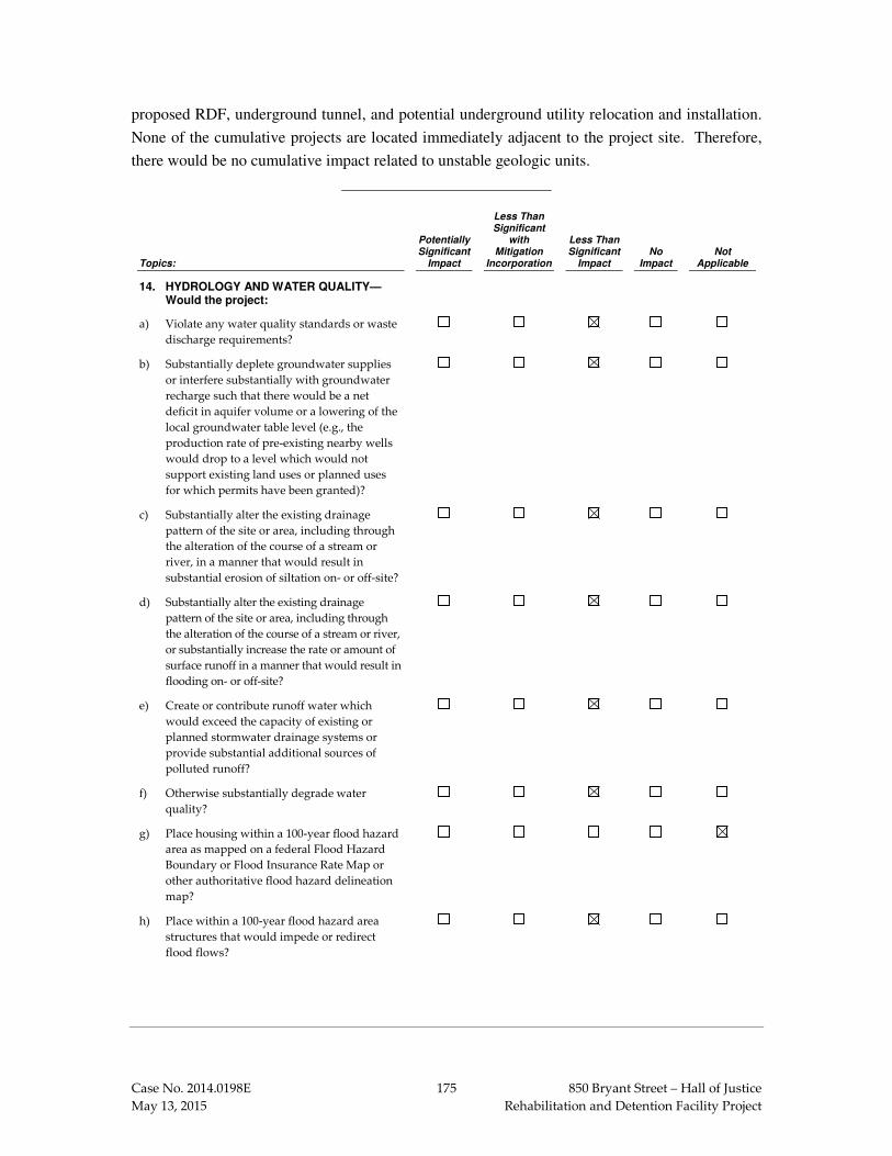
Case No. 2014.0198E 175 850 Bryant Street – Hall of Justice
May 13, 2015 Rehabilitation and Detention Facility Project
proposed RDF, underground tunnel, and potential underground utility relocation and installation.
None of the cumulative projects are located immediately adjacent to the project site. Therefore,
there would be no cumulative impact related to unstable geologic units.
Topics:
Potentially Significant
Impact
Less Than Significant
with Mitigation
Incorporation
Less Than Significant
Impact No
Impact Not
Applicable
14. HYDROLOGY AND WATER QUALITY— Would the project:
a) Violate any water quality standards or waste
discharge requirements?
b) Substantially deplete groundwater supplies
or interfere substantially with groundwater
recharge such that there would be a net
deficit in aquifer volume or a lowering of the
local groundwater table level (e.g., the
production rate of pre-existing nearby wells
would drop to a level which would not
support existing land uses or planned uses
for which permits have been granted)?
c) Substantially alter the existing drainage
pattern of the site or area, including through
the alteration of the course of a stream or
river, in a manner that would result in
substantial erosion of siltation on- or off-site?
d) Substantially alter the existing drainage
pattern of the site or area, including through
the alteration of the course of a stream or river,
or substantially increase the rate or amount of
surface runoff in a manner that would result in
flooding on- or off-site?
e) Create or contribute runoff water which
would exceed the capacity of existing or
planned stormwater drainage systems or
provide substantial additional sources of
polluted runoff?
f) Otherwise substantially degrade water
quality?
g) Place housing within a 100-year flood hazard
area as mapped on a federal Flood Hazard
Boundary or Flood Insurance Rate Map or
other authoritative flood hazard delineation
map?
h) Place within a 100-year flood hazard area
structures that would impede or redirect
flood flows?

Case No. 2014.0198E 176 850 Bryant Street – Hall of Justice
May 13, 2015 Rehabilitation and Detention Facility Project
Topics:
Potentially Significant
Impact
Less Than Significant
with Mitigation
Incorporation
Less Than Significant
Impact No
Impact Not
Applicable
i) Expose people or structures to a significant
risk of loss, injury or death involving
flooding, including flooding as a result of the
failure of a levee or dam?
j) Expose people or structures to a significant
risk of loss, injury or death involving
inundation by seiche, tsunami, or mudflow?
The proposed project does not include the construction of housing. Therefore, Topic E.14(g) is not
applicable.
The project site is not located on or near a slope that could be subject to mudflow. Based on the
state’s official tsunami inundation maps, the project site is not located within a tsunami inundation
zone.176 Therefore, there is no impact related to Topic E.14(j).
Impact HY-1: The proposed project would not violate any water quality standards or
waste discharge requirements or otherwise substantially degrade water quality and runoff
from the proposed project would not exceed the capacity of a storm drain system or provide
a substantial source of stormwater pollutants. (Less than Significant)
As discussed in the impact analyses below, the proposed project would not result in water quality
impacts as a result of construction‐related stormwater discharges, construction‐related dewatering,
or post-construction-related stormwater discharges because these discharges would be managed in
accordance with existing San Francisco regulations, described below. Once constructed, the
proposed project would change the quantity of stormwater and wastewater discharged to the
combined sewer but would not have an effect on the frequency or duration of combined sewer
discharges as also discussed below.
Description of Combined Sewer System
The proposed project is located in the Eastern Basin of the City’s combined sewer system, within
the Channel sub-basin. Combined stormwater and wastewater flows from this basin are transported
to the Southeast Water Pollution Control Plant (SEWPCP) which treats up to 150 million gallons
176 California Emergency Management Agency, California Geological Survey, University of Southern
California. Tsunami Inundation Map for Emergency Planning, San Francisco North Quadrangle/San Francisco South Quadrangle (SF Bay), June 15, 2009. A copy of this document is available for review at the San Francisco Planning Department, 1650 Mission Street, Suite 400, in Case File No. 2014.0198E.

Case No. 2014.0198E 177 850 Bryant Street – Hall of Justice
May 13, 2015 Rehabilitation and Detention Facility Project
per day (mgd) of wastewater to a secondary level.177 During dry weather, wastewater flows consist
mainly of municipal and industrial sanitary sewage and wastewater, and the annual average
wastewater flow during dry weather is 60 mgd.178 The average dry weather design flow capacity
of the SEWPCP is 84.5 mgd; therefore the existing flows are about 71 percent of the treatment
capacity and all dry weather wastewater flow is treated to a secondary level at the SEWPCP. The
treated wastewater is then discharged to the Bay through the deep water outfall at Pier 80, located
immediately to the north of the Islais Creek Channel.
During wet weather (generally October through April), the combined sewer and stormwater system
collects large volumes of stormwater runoff in addition to municipal and industrial sanitary sewage
and wastewater, and the combined wastewater and stormwater flow is conveyed to treatment
facilities before eventual discharge to the Bay. Depending on the amount of rainfall, wet weather
flows are treated to varying levels before discharge to the Bay. Up to 150 mgd of wet weather
flows receive secondary treatment at the SEWPCP. The SEWPCP can also treat up to an additional
100 mgd to a primary treatment standard plus disinfection. Treated wet weather discharges of up
to 250 mgd from the SEWPCP occur through the Pier 80 outfall directly to the Bay or through the
Quint Street outfall to Islais Creek Channel on the south bank of Islais Creek. Only wastewater
treated to a secondary level is discharged at the Quint Street outfall.
Flows in excess of the treatment capacity are conveyed to storage and transport boxes which
provide “flow-through treatment” to remove settleable solids and floatable materials, which is
similar to primary treatment. The excess flows are then eventually discharged through 29 combined
sewer discharge structures located along the City’s bayside waterfront from the Marina Green to
Candlestick Point. All discharges from the combined sewer system to the Bay, through either the
primary outfalls or the combined sewer discharge structures, are operated in compliance with the
federal Clean Water Act and the State’s Porter-Cologne Water Quality Control Act through a
permit issued by the California Regional Water Quality Control Board, San Francisco Bay Region
(RWQCB) which incorporates the requirements of the federal Combined Sewer Overflow (CSO)
Control Policy.
177 Secondary treatment is the treatment of wastewater or sewage involving removal of organic matter
using biological and chemical processes. This is a higher level of treatment than primary treatment, which is removal of floating and settleable solids using physical operations such as screening and sedimentation. Secondary treatment is less intensive than tertiary treatment, in which additional chemical and biological treatment processes are used to remove additional compounds that may be required for discharge or reuse purposes.
178 San Francisco Water Power Sewer, San Francisco’s Wastewater Treatment Facilities, June 2014. A copy of this document is available for review at the San Francisco Planning Department, 1650 Mission Street, Suite 400, in Case File No. 2014.0198E.

Case No. 2014.0198E 178 850 Bryant Street – Hall of Justice
May 13, 2015 Rehabilitation and Detention Facility Project
Impacts from Construction-Related Stormwater Runoff
Soil movement for foundation excavation, underground tunnel, and utilities installation and
relocation could create the potential for wind- and water-borne soil erosion. In addition, without
proper handling methods, stormwater runoff from temporary on‐site use and storage of vehicles,
fuels, wastes, and other hazardous materials could carry pollutants to the combined sewer system.
However, the project sponsor’s construction contractor would be required to obtain a Construction
Site Runoff Control Permit and implement an Erosion and Sediment Control Plan for construction
activities, in accordance with Construction Site Runoff requirements of Article 4.2 of the San
Francisco Public Works Code, Section 146. This permit is required for any project that includes
any land disturbing activities such as building demolition, clearing, grading, grubbing, filling,
stockpiling, excavating, and transporting soil. The permit specifically requires easements for
drainage facilities; provision of adequate dust controls in conformance with applicable air pollution
laws and regulations; and improvement of any existing grading, ground surface, or site drainage to
meet the requirements of Article 4.2.
The application for the permit must also include an Erosion and Sediment Control Plan that
provides a vicinity map showing the location of the site in relationship to the surrounding area’s
water courses, water bodies, and other significant geographic features; a site survey; suitable
contours for the existing and proposed topography, area drainage, proposed construction and
sequencing; proposed drainage channels; proposed erosion and sediment controls; dewatering
controls, where applicable; soil stabilization measures, where applicable; maintenance controls;
sampling, monitoring, and reporting schedules; and any other information deemed necessary by the
SFPUC. A building permit cannot be issued until a Construction Site Runoff Control Permit has
been issued.
Under the Construction Site Runoff Control Permit, the project sponsor would be required to
conduct daily inspections and maintenance of all erosion and sediment controls and must provide
inspection and maintenance information to the SFPUC. The SFPUC would also conduct periodic
inspections of the project site to ensure compliance with the plan. The project sponsor would be
required to notify the SFPUC at least two days prior to the start of construction, completed
installation of erosion and sediment control measures, completion of final grading, and project
completion. At the SFPUC’s discretion, sampling, metering, and monitoring may also be required.
Implementation of the Construction Site Runoff requirements of Article 4.2 of the San Francisco
Public Works Code would ensure that water quality impacts related to violation of water quality
standards or degradation of water quality due to discharge of construction‐related stormwater
runoff would be less than significant. No mitigation measures are necessary.

Case No. 2014.0198E 179 850 Bryant Street – Hall of Justice
May 13, 2015 Rehabilitation and Detention Facility Project
Impacts from Construction-Related Dewatering
As noted in Section E.13, Geology and Soils, p. 173, the 17-foot excavation depth would extend
approximately 9 feet below the anticipated groundwater levels. Therefore, there is the potential for
water inflow into the excavations during construction. If the groundwater produced during
dewatering contained contaminants or excessive sediment, discharge of the groundwater into the
combined sewer system could potentially degrade water quality.
Groundwater produced during construction-related dewatering would be discharged to the City’s
combined sewer system in accordance with a permit issued by the Wastewater Enterprise
Collection System Division of the SFPUC pursuant to Article 4.1 of the San Francisco Public
Works Code, as supplemented by Order No. 158170, which regulates the quantity and quality of
discharges to the combined sewer system. This permit would contain appropriate discharge
standards and may require installation of meters to measure the volume of the discharge. Although
the groundwater could contain contaminants related to past site activities – as discussed below on
pp. 197-205 in Section E.15, Hazards and Hazardous Materials – as well as sediment and suspended
solids, the groundwater would be treated as necessary to meet permit requirements prior to
discharge. With discharge to the combined sewer system in accordance with regulatory
requirements, water quality impacts related to a violation of water quality standards or degradation
of water quality due to discharge of groundwater during groundwater dewatering would be less
than significant. No mitigation measures are necessary.
Impacts Related to Combined Sewer Overflows During Operation
As discussed above, the volume of wet weather flows in the Eastern Drainage Basin varies due to
the addition of stormwater during wet weather (generally October through April). When the
increased flows exceed the 400 million gallon per day treatment capacity of the eastside wet
weather facilities, the excess flows are discharged through 29 combined sewer discharge structures
located along the City’s bayside waterfront from the Marina Green to Candlestick Point after
receiving the equivalent of primary treatment. The combined sewer discharge structures associated
with the Channel sub-basin discharge to Lower San Francisco Bay and Mission Creek.
An increase in the volume of combined sewer discharges could be a concern because the RWQCB
has designated both Lower San Francisco Bay and Mission Creek as impaired water bodies under
Section 303(d) of the Clean Water Act, which indicates water quality standards are not expected to
be met after implementation of technology-based effluent limitations, and because combined sewer
discharges contain pollutants for which these water bodies are impaired. Two aspects of the project
in combination could result in long-term changes in the flows to the City’s combined sewer system
in the Channel sub-basin, including changes in the amount of wastewater generation and changes

Case No. 2014.0198E 180 850 Bryant Street – Hall of Justice
May 13, 2015 Rehabilitation and Detention Facility Project
in stormwater runoff volumes and rates. The effects of these factors on the combined sewer system
are closely related, and the combined effect on the volume and/or frequency of combined sewer
discharges to the Bay is discussed below.
Changes in Wastewater Flows
As described in Section A, Project Description on pp. 5-7, the proposed project would decrease the
number of beds from 905 to 640, a reduction of 265 inmates. While the number of employees
would increase by about 47 people, demolition of the existing commercial buildings at 444 Sixth
Street, 450 Sixth Street, and 820 Bryant Street (a McDonald’s restaurant) for development of the
proposed RDF would result in the displacement of approximately 43 employees, resulting in a net
increase of about 4 employees. However, any increase in wastewater production by these
employees would be offset by the reduction in the number of inmates. In addition, as described
below on p. 212, in Section E.16, Mineral and Energy Resources, the proposed project would be
required to implement the 2014 San Francisco Building Code requirements for the use of water-
conserving fixtures, which would reduce the amount of wastewater produced. These factors would
result in a corresponding reduction in wastewater generation. Therefore, year-round wastewater
discharges to the combined sewer system would be reduced under the proposed project and would
be within the existing dry weather capacity of the SEWPCP.
Changes in Stormwater Runoff
The project site is almost entirely covered by impervious surfaces and would continue to be under
the proposed project. In accordance with San Francisco’s Stormwater Ordinance (Article 4.2 of
the San Francisco Public Works Code, Section 147) and Stormwater Design Guidelines, the project
sponsor would be required to achieve the standards specified in LEED® SS6.1 (Stormwater Design:
Quantity Control) to minimize the flow and volume of stormwater into the combined sewer system.
For the project site, this standard specifies that the project sponsor must implement a stormwater
management plan that results in a 25 percent decrease in the peak rate and total volume of
stormwater runoff from the two-year 24-hour design storm, compared to existing conditions.
Accordingly, the project sponsor would be required to incorporate low-impact design techniques
into the design and to implement stormwater best management practices (BMPs) to reduce the flow
rate and volume of stormwater entering the combined sewer system. The project sponsor could
achieve the necessary reduction in stormwater flows primarily by collecting and treating
stormwater runoff for on-site reuse. Capturing the rainwater for reuse could also reduce the amount
of stormwater pollutants that would otherwise be discharged to the combined sewer system.
The Stormwater Control Plan for the proposed project would describe the rainwater collection
system and any other BMPs that would be implemented to achieve the specified reduction in

Case No. 2014.0198E 181 850 Bryant Street – Hall of Justice
May 13, 2015 Rehabilitation and Detention Facility Project
stormwater flows as well as a plan for post-construction operation and maintenance of the BMPs.
Specifically, the plan must include the following elements:
• Site characterization,
• Design and development goals,
• Site plan,
• Site design,
• Source controls,
• Treatment BMPs,
• Comparison of design to established goals, and
• Operations and maintenance plan
The Stormwater Control Plan must be reviewed and stamped by a licensed landscape architect,
architect, or engineer. The SFPUC would review the plan and certify compliance with the
Stormwater Design Guidelines, and would inspect stormwater BMPs once they are constructed.
Any issues noted by the inspection must be corrected before the Certificate of Occupancy can be
issued for the building. Following occupancy, the owner would be responsible for completing an
annual self-certification inspection, and must submit completed checklists and maintenance logs
for the year to the SFPUC. In addition, the SFPUC would inspect all stormwater BMPs every third
year and any issues identified by either inspection must be resolved before the SFPUC could renew
the certificate of compliance.
With implementation of stormwater control measures as required by San Francisco’s Stormwater
Ordinance (Article 4.2 of the San Francisco Public Works Code, Section 147) and Stormwater
Design Guidelines, implementation of the proposed project would contribute to a decrease in the
rate and volume of stormwater flows from the project site relative to existing conditions.
Net Impact on Combined Sewer Discharges
As discussed above, both wastewater and stormwater flows to the combined sewer system would
be reduced under the proposed project compared to existing conditions. Therefore, implementation
of the proposed project would result in less-than-significant water quality impacts related to
violation of water quality standards or degradation of water quality associated with changes in
combined sewer discharges into the Bay.

Case No. 2014.0198E 182 850 Bryant Street – Hall of Justice
May 13, 2015 Rehabilitation and Detention Facility Project
Exceedance of Storm System Capacity and Additional Sources of Polluted Runoff
Stormwater runoff in an urban location, such as the project building site, is a known source of
pollution. Runoff from the project building site may contain polynuclear aromatic hydrocarbons179
(PAHs) from vehicle emissions; heavy metals, such as copper from brake pad wear and zinc from
tire wear; dioxins as products of combustion; and mercury resulting from atmospheric deposition.
All of these materials, and others, may be deposited on paved surfaces and rooftops as fine airborne
particles, thus yielding stormwater runoff pollution that is unrelated to use of the proposed RDF.
In addition, during operations the proposed project could contribute specific pollutants including
sediments, nutrients, oil and grease, organics, and trash that can be washed into the combined sewer
system. These pollutants can all affect water quality.
However, as discussed above, in accordance with the San Francisco’s Stormwater Ordinance and
the Stormwater Design Guidelines, the peak rate and volume of stormwater discharged from the
site would be reduced by 25 percent relative to existing conditions. Further, reuse of rainwater as
a stormwater control BMP could also reduce the amount of stormwater pollutants discharged to the
combined sewer system. Therefore, the proposed project would not contribute runoff water that
would exceed the capacity of an existing or planned stormwater drainage system or provide
substantial additional sources of polluted runoff, and impacts related to these topics would be less
than significant. No mitigation is necessary.
Impact HY-2: The proposed project would not substantially deplete groundwater supplies
or interfere with groundwater recharge such that there would be a net deficit in aquifer
volume or a lowering of the local groundwater table. (Less than Significant)
The proposed project is located within the Downtown San Francisco Groundwater Basin.
Implementation of the proposed project would not result in depletion of groundwater resources in
this basin because, other than temporary pumping of groundwater during construction-related
dewatering, the proposed project would not involve the use or extraction of groundwater. Rather,
potable water for the proposed project would be provided by the SFPUC regional water system.
Construction-related dewatering would not deplete groundwater supplies because it would only be
conducted on a short-term basis and the Downtown San Francisco Groundwater Basin is not used
as a potable water supply and there are no plans for development of this basin for groundwater
production.
179 Polynuclear aromatic hydrocarbons (PAHs) are group of chemicals that are formed during the
incomplete burning of coal, oil, gas, wood, garbage, or other organic substances, such as tobacco and charbroiled meat. PAHs usually occur naturally, but they can be manufactured. A few PAHs are used in medicines and to make dyes, plastics, and pesticides. Others are contained in asphalt used in road construction. They can also be found in substances such as crude oil, coal, coal tar pitch, creosote, and roofing tar. They are found throughout the environment in the air, water, and soil. They can occur in the air, as vapors or attached to dust or ash particles, or as solids in soil or sediment.

Case No. 2014.0198E 183 850 Bryant Street – Hall of Justice
May 13, 2015 Rehabilitation and Detention Facility Project
Project implementation would not interfere with groundwater recharge because the project site is
almost completely covered with impervious surfaces under existing conditions and would continue
to be under the proposed project. Given that groundwater is not used as a potable water supply,
there are no plans for development of the basin for groundwater production, and there would be no
net increase in impervious surfaces, impacts related to the depletion of groundwater resources and
interference with groundwater recharge would be less than significant. No mitigation is necessary.
Impact HY-3: The proposed project would not substantially alter the existing drainage
pattern of the site or area, including through the alteration of the course of a stream or
river, in a manner that would result in substantial erosion, siltation, or flooding on- or off-
site. (Less than Significant)
The project site does not include any existing streams or water course that could be altered or
diverted, and there are no surface impoundments, wetlands, natural catch basins, or settling ponds
within the project site. Therefore, there would be no impact related to alteration of drainage
patterns by altering the course of a stream in a manner that would cause erosion or flooding on or
off-site.
Currently, surface water runoff from the project site is conveyed to the combined sewer system.
Although the project site is located in an area of sewer-related flooding identified by the SFPUC
(see Impact HY-5), the proposed project would implement stormwater control BMPs such as
rainwater capture and reuse on-site to comply with stormwater volume and flow rate reductions
required by San Francisco’s Stormwater Design Guidelines as discussed in Impact HY-1.
Compliance with the Stormwater Design Guidelines would reduce the quantity and rate of
stormwater runoff to the City’s combined sewer system, decreasing the potential for on- and off-
site erosion and flooding, and would result in a less-than-significant impact. No mitigation is
necessary.
Impact HY‐‐‐‐4: Operation of the proposed project would not expose people or structures to a
significant risk of loss, injury, or death involving flooding. (Less than Significant with
Mitigation)
Some low lying areas along San Francisco’s Bay shoreline are subject to flooding during periods
of extreme high tides, storm surge and waves, although these occurrences are relatively rare in San
Francisco compared to areas prone to hurricanes or other major coastal storms or to developed areas
near or below sea level. In 2008, the City and County of San Francisco adopted interim flood maps
depicting the 100-year flood zone along the City’s Bay shoreline. The 100-year flood zone
represents areas that are subject to flooding once every 100 years on average or that have a 1-
percent chance of flooding in any single year. Flooding in these areas has the potential to damage
buildings and infrastructure. The proposed project is not located within a 100-year flood zone

Case No. 2014.0198E 184 850 Bryant Street – Hall of Justice
May 13, 2015 Rehabilitation and Detention Facility Project
identified on the City’s interim flood maps.180 Therefore, this section discusses the potential for
increased flooding in the future as a result of sea level rise along with factors contributing to coastal
flooding.
Factors Contributing to Coastal Flooding
Coastal areas are vulnerable to periodic flooding due to storm surge, extreme tides, and waves.
Rising sea level due to climate change has the potential to increase the frequency, severity, and
extent of flooding in coastal areas. These factors are described below.
Storm Surge. Storm surge occurs when persistent high winds and changes in air pressure push water
towards the shore, which can raise the water level near the shoreline by several feet and may persist
for several days. Along San Francisco’s bay shoreline, storm surge typically raises the surface water
elevation 2 to 3 feet during major winter storms several times a year. Extreme high tides in
combination with storm surge can cause inundation of low-lying roads, boardwalks, and promenades;
can exacerbate coastal flooding; and can interfere with stormwater and sewer outfalls.
The degree of storm surge depends on the severity of the storm as well as tidal levels at the time of
the storm and is characterized using a return period which represents the expected frequency of a
storm event occurring based on historical information. A one-year storm surge is expected to occur
each year while a 100-year storm surge (which represents more extreme conditions) has a one
percent chance of occurring in any year.
Tides. Diurnal (twice daily) high tides along San Francisco’s bay shoreline typically range from
approximately 5 to 7 feet based on the 1988 North American Vertical Datum (NAVD88), though
annual maximum tides may exceed 7 feet. The twice yearly extreme high and low tides are called
“king tides.” These occur each year during the winter and summer when the earth, moon and sun
are aligned, and may be amplified by winter weather. King tides and other high tides can result in
temporary inundation of low-lying roads, boardwalks, and waterfront promenades. The
Embarcadero waterfront (Pier 14) and the Marina area in San Francisco experience inundation
under current king tide conditions.181
Waves. Waves and wave run-up primarily affect a narrow band along the shoreline where wave
energy can damage structures and overtop both natural embankments and shoreline protection
structures such as seawalls and levees. The influence of waves diminishes inland as wave energy
dissipates. In addition, the Pacific Ocean waves, which are generally larger than those originating
180 City and County of San Francisco, San Francisco Interim Floodplain Map, Northeast. Final Draft, July
2008. A copy of this document is available for review at the San Francisco Planning Department, 1650 Mission Street, Suite 400, in Case File No. 2014.0198E.
181 San Francisco Water Power Sewer. Climate Stressors and Impact: Bayside Sea Level Rise Mapping,
Final Technical Memorandum. June 2014. A copy of this document is available for review at the San Francisco Planning Department, 1650 Mission Street, Suite 400, in Case File No. 2014.0198E.

Case No. 2014.0198E 185 850 Bryant Street – Hall of Justice
May 13, 2015 Rehabilitation and Detention Facility Project
in the Bay, are substantially dampened along the Bay shoreline due to transformation processes
within San Francisco Bay.
Sea Level Rise. Seas are rising globally due to climate change, and are expected to continue to
rise at an accelerating rate for the foreseeable future. The sea level at the San Francisco tidal gauge
has risen 8 inches over the past century.
The National Research Council’s (NRC’s) 2012 report, Sea Level Rise for the Coasts of California,
Oregon, and Washington: Past, Present, and Future (the NRC Report) provides a scientific review
of sea level rise for the West Coast and provides the most recent regional sea level rise predictions
for 2030, 2050, and 2100, relative to the year 2000 sea level.182 In this report, the NRC projects
that sea levels in the San Francisco Bay area will rise 11 inches by 2050 and 36 inches by 2100 as
presented in Table 16. As presented in the NRC Report, these sea level rise projections represent
likely sea level rise values based on the current understanding of global climate change and
assuming a moderate level of greenhouse gas (GHG) emissions183 and extrapolation of continued
accelerating land ice melt patterns, plus or minus one standard deviation.184
Table 16: Sea Level Rise Estimates for San Francisco Bay Relative to the Year 2000
Year Projection
2030 6 ± 2 inches
2050 11 ± 4 inches
2100 36 ± 10 inches Source: National Research Council, 2012
The estimates represent the permanent increase in Mean Sea Level and the associated average daily
high tide conditions (represented by Mean Higher High Water, or MHHW)185 that could result from
182 National Research Council, Sea-Level Rise for the Coasts of California, Oregon, and Washington: Past,
Present, and Future. Washington, DC: The National Academies Press, 2012. Available online at http://www.nap.edu/catalog.php?record_id=13389. Accessed October 1, 2014.
183 Future emissions of greenhouse gases depend on a collection of human decisions at local, regional, national, and international levels as well as potential unknown technological developments. For this reason, future changes in greenhouse gas emissions cannot be accurately estimated, and a range of emissions levels is considered in the NRC Report. Estimates of sea level rise relative to thermal expansion of the oceans were formulated using the mid-level, or moderate level, of predicted changes in greenhouse gas emissions (from a combination of fossil and non-fossil fuels), as well as an assumption of high economic growth; this represents scenario “A1B” as described by the Intergovernmental Panel on Climate Change (IPCC).
184 One standard deviation roughly corresponds to a 15 percent/85 percent confidence interval, meaning that there is approximately 15 percent chance the value will exceed the high-end projection (8 inches for the 2030 example) and a 15 percent chance the value will be lower than the low-end projection (4 inches in 2030).
185 Mean higher high water is the higher of each day’s two high tides averaged over time.

Case No. 2014.0198E 186 850 Bryant Street – Hall of Justice
May 13, 2015 Rehabilitation and Detention Facility Project
sea level rise; they do not take into account storm surge, extreme tides, or waves which can result
in water levels that are temporarily higher than MHHW as discussed above.
In March 2013, the California Ocean Protection Council updated its 2010 statewide sea level rise
guidance to adopt the NRC Report as the current, best available science on sea level rise for
California.186 The California Coastal Commission supports the use of the NRC Report as the best
science currently available in its 2013 Draft Sea-Level Rise Policy Guidance, which also emphasizes
the importance of regularly updating sea level rise projections as the science continues to advance.187
The San Francisco Bay Conservation and Development Commission (BCDC) also considers the
NRC Report to be the best available science-based prediction of sea level rise for San Francisco Bay.
Accordingly, this Initial Study considers the NRC Report to be the best science currently available
on sea level rise affecting San Francisco for both CEQA and planning purposes.
Although the NRC Report provides the best available sea level rise projections for San Francisco
Bay at this time, scientific uncertainty remains regarding the rate and magnitude of sea level rise.
Sea level rise projections beyond 2050 are highly dependent on assumptions regarding future global
GHG emissions and future changes in the rate of land ice melting. As a result of the uncertainties
inherent in these assumptions, the range of sea level rise predictions becomes substantially broader
beyond 2050 (see Table 16). In recognition of this uncertainty, the State of California Sea-Level
Rise Guidance recommends an adaptive management approach for development in areas that may
be subject to sea level rise beyond 2050.
Sea Level Rise Inundation Mapping
The SFPUC, as part of the planning for its Sewer System Improvement Project, has developed a
series of maps representing areas of inundation along both the Bay and Ocean shoreline of San
Francisco. These maps use a 1-meter horizontal grid resolution188 based on the 2010/2011
California Coastal Mapping Program LiDAR.189 The inundation maps leverage data from the
Federal Emergency Management Agency’s (FEMA’s) California Coastal Mapping and Analysis
186 State of California Sea-Level Rise Guidance Document. Developed by the Coastal and Ocean Working
Group of the California Climate Action Team (CO-CAT), with science support provided by the Ocean Protection Council’s Science Advisory Team and the California Ocean Science Trust. March 2013 Update. Available online at http://www.opc.ca.gov/webmaster/ftp/pdf/docs/2013_SLR_Guidance_Update_FINAL1.pdf. Accessed April 15, 2015.
187 California Coastal Commission Draft Sea Level Rise Policy Guidance, Public Review Draft, October 14, 2013. Available online at http://www.coastal.ca.gov/climate/SLRguidance.html. Accessed April 15, 2015.
188 The horizontal grid resolution of a digital elevation model defines the scale of the features that are modeled; this is generally the minimum resolution necessary to depict levees, berms, and other topographic features important to diverting floodwaters.
189 LiDAR (Light Detection and Ranging) is a remote sensing technology that measures distance by illuminating a target with a laser and analyzing the reflected light. LIDAR is commonly used to create high-resolution terrain models, topography data sets, and topographic maps.

Case No. 2014.0198E 187 850 Bryant Street – Hall of Justice
May 13, 2015 Rehabilitation and Detention Facility Project
Project, which includes detailed coastal engineering analyses and mapping of the San Francisco
Bay shoreline.
The SFPUC inundation maps evaluate scenarios that represent the NRC projections of sea level
rise in combination with the effects of storm surge. They represent permanent inundation that could
occur as a result of total water level rises (over and above year 2000 MHHW) based on daily tidal
fluctuations as well as temporary, short-term inundation that could occur as a result of 1-year,
2-year, 5-year, 25-year, 50-year, and 100-year storm surges. Flooding as a result of storm surge
would occur on a temporary basis, during and immediately after a storm event or extreme tide.
The scenarios used in the analysis for this Initial Study are representative of inundation that could
occur by the year 2050 and the year 2100 based on the NRC’s projected level of sea level rise and
considering a 100-year storm surge:
• MHHW plus 12 inches of sea level rise (representative of NRC’s projected sea level rise by 2050);
• MHHW plus 36 inches of sea level rise (representative of NRC’s projected sea level rise by 2100),
• MHHW plus 52 inches of sea level rise (representative of NRC’s projected sea level rise by the year 2050 in combination with a 100-year storm surge), and
• MHHW plus 77 inches of sea level rise (representative of NRC’s projected sea level rise by the year 2100 in combination with a 100-year storm surge).
The SFPUC cautions that its maps represent a “do nothing” scenario, in which no measures are
taken to prevent future flooding and no area-wide measures such as waterfront protection structures
are constructed. In the event that the City undertakes area-wide measures to protect against
inundation in the future, the mapping would need to be revised to reflect the modified inundation
areas with construction of these measures.
The SFPUC inundation maps indicate that the project site would not be inundated with a water
level rise of 12 inches, which is expected by 2050, even when the effects of 100-year storm surge
are considered.190 In addition, the project building site would not be inundated with 36 inches of
water level rise which is expected by 2100; however, when the effects of a 100-year storm surge
are considered under this scenario, the flood elevation would be approximately 13 feet NAVD88
and portions of the project building site could be temporarily inundated at depths of up to 2 feet.
However, as previously noted, this flooding scenario is based on 2010/2011 topographic conditions
and assumes that no site-specific flood protection measures such as filling to raise the grade of low
190 San Francisco Water Power Sewer, Climate Stressors and Impact: Bayside Sea Level Rise Mapping,
Final Technical Memorandum and associated maps, June 2014. A copy of this document is available for review at the San Francisco Planning Department, 1650 Mission Street, Suite 400, in Case File No. 2014.0198E.

Case No. 2014.0198E 188 850 Bryant Street – Hall of Justice
May 13, 2015 Rehabilitation and Detention Facility Project
lying areas or area-wide measures such as construction of berms, levees or seawalls would be
implemented to protect the project site or surrounding area during the intervening period. As such,
it is likely that the actual flood zone would be different by 2100 than what is currently used for
inundation mapping by the SFPUC, and the actual flood zone would include only those areas of
the site with ground elevations below the flood elevation of 1.5 feet SFD (13 feet NAVD88) that
are not protected by area-wide flood protection measures.
Planning for Sea Level Rise in San Francisco
The City has convened an inter-agency Climate Adaptation Working Group to identify ways to
make sure that it is prepared to adapt to effects of sea level rise. Participating agencies include the
Department of the Environment, SFPUC, Planning Department, City Administrator’s office, Port
of San Francisco (Port), San Francisco International Airport (SFO), Department of Public Works
(DPW), Municipal Transportation Agency (SFMTA), Department of Public Health (DPH), and
Department of Recreation and Parks. The working group is focusing its effort on the City’s most
imminent adaptation concerns, including sea level rise along Ocean Beach and shores, flooding
from storm surge and extreme rain events, an increased likelihood of extreme heat, and decreased
fog that supports redwoods and local ecosystems. To address sea level rise and flooding, the
working group is focusing on efforts to improve the existing coastal flood protection infrastructure
in time to prevent significant flooding impacts from sea level rise. The working group will establish
requirements addressing proper flood insurance for structures in low lying areas, flood-resilient
construction of new developments within inundation areas, and a low-carbon footprint for new
developments. The working group is also assessing the use of natural solutions such as wetlands
to protect the shoreline. The SFPUC is also addressing sea level rise as part of its Sewer System
Improvement Program, and is conducting a detailed analysis of the potential for new and existing
combined sewer infrastructure to be affected by sea level rise.191 Accordingly, all new facilities
will be built using a climate change criterion so the combined sewer system will be better able to
respond to rising sea levels. Because rising sea levels and storm surge could potentially inundate
the combined sewer system and exacerbate existing flooding from the sewer system, or cause new
flooding, the SFPUC is also evaluating alternatives such as the installation of backflow preventers
on the combined sewer discharge structures to restrict the intrusion of Bay water into the combined
sewer system.
San Francisco Sea Level Rise Guidance
On September 22, 2014, the City’s Capital Planning Committee (CPC) adopted the Guidance for
Incorporating Sea Level Rise into Capital Planning in San Francisco: Assessing Vulnerability and
191 San Francisco Water Power Sewer, Bayside Drainage Basin Urban Watershed Opportunities, Final
Draft Technical Memorandum, July, 2014.

Case No. 2014.0198E 189 850 Bryant Street – Hall of Justice
May 13, 2015 Rehabilitation and Detention Facility Project
Risk to Support Adaptation, which was prepared by an inter-agency committee including the CPC,
SFPUC, Port, SFO, DPW, SFMTA, and the Planning Department.192 Accordingly, the City’s
capital planning program now requires the preparation of project-level sea level rise vulnerability
and risk assessments for all City capital projects with a cost of $5 million or more that are located
in areas potentially vulnerable to future flooding due to sea level rise.
The guidance presents a framework for incorporating sea level rise into the planning of capital
projects implemented by the City and selecting appropriate adaptation measures based on site-
specific information. The planning process described in the guidance includes six primary steps:
• Review sea level rise science,
• Assess vulnerability,
• Assess risk,
• Plan for adaptation,
• Implement adaptation measures, and
• Monitor.
As of September 2014, the City considers the NRC report as the best available science on sea level
rise in California. However, the guidance acknowledges that the science of sea level rise is
continually advancing and projections of sea level rise may need to be updated at some point to
reflect the most updated science. Sea level rise inundation maps prepared by the SFPUC, described
above, are considered the most up-to-date maps and take into account both water level rises and
the temporary effects of storm surge along the shoreline. The guidance states that the review of
available sea level science should determine whether the project site could be subject to flooding
during the lifespan of the project.
For those City-sponsored capital projects that cost $5 million or more that could be flooded during
their lifespan, the guidance specifies the need to conduct a vulnerability assessment based on the
degree of flooding that could occur, the sensitivity of the project to sea level rise, and the adaptive
capacity of the project site and design (the ability to adjust to sea level rise impacts without the
need for substantial intervention or modification). The risk assessment takes into consideration the
likelihood that the project could be adversely affected by sea level rise and the related consequences
of flooding. The need to prepare an adaptation plan is specified for projects that are found to be
vulnerable to sea level rise and have a potential for substantial consequences. The plan should
focus on those aspects of the project that have the greatest consequences if flooded. It should
192 City and County of San Francisco Sea Level Rise Committee, Guidance for Incorporating Sea Level
Rise into Capital Planning in San Francisco: Assessing Vulnerability and Risk to Support Adaptation. September 22, 2011. Available online at http://onesanfrancisco.org/wp-content/uploads/San%20Francisco%20SLR%20Guidance%20Adopted%209.22.14%2012182014.pdf. Accessed February 5, 2015.

Case No. 2014.0198E 190 850 Bryant Street – Hall of Justice
May 13, 2015 Rehabilitation and Detention Facility Project
include clear accountability and trigger points for bringing adaptation strategies online as well as a
well-defined process to ensure that milestones are being met and the latest science is being
considered.
The City’s sea level rise guidance document also acknowledges that there is some flexibility in
how to plan for adaptations, and it may not always be feasible or cost effective to design and build
for long-term potential sea level rise scenarios that are of a highly uncertain nature, such as an
upper end of the NRC report range for the year 2100 (66-inches of sea level rise). In this case, a
project could be designed and constructed to be resilient to the likely mid-century sea level rise
(11± 4 inches by 2050). An alternative approach would be to build a project to be resilient to the
likely sea level rise by 2100 (36 inches), while including adaptive capacity to be resilient to the
upper range of sea level rise estimates for 2100 (66 inches).
Impact Conclusion
Under CEQA, the City considers city-sponsored projects that could be vulnerable to 100-year
flooding in combination with sea level rise during their lifespan to have a significant risk related to
flooding. As described above, the SFPUC inundation maps indicate that the project site would not
be flooded with water level rises of 12 inches, which is expected by 2050, even when the effects of
100-year storm surge are considered. In addition, the project site would not be flooded with
36 inches of water level rise which is expected by 2100; however, when the effects of 100-year
storm surge are considered under this scenario, the flood level would be approximately 13 feet
NAVD88 and portions of the project building site could be temporarily flooded at depths of up to
2 feet.
Estimates of sea level rise are less certain after 2050. However, this mapping indicates that the
project building site could be temporarily flooded as a result of sea level rise during the life of the
project, including the basement and first floor of the proposed RDF and the pedestrian tunnel
connection from the proposed RDF to the courtrooms in the existing HOJ building. The basement
would provide access to the underground pedestrian tunnel and would also include uses such as
building services, storage, laundry, and mechanical/electrical/plumbing uses. The first floor would
include a public lobby, inmate visiting room, administrative offices, storage of central records and
warrants, the kitchen, building and laundry services, and a multi-purpose room. While San
Francisco’s Floodplain Management Ordinance (Chapter 2A, Article XX, Sections 2A.280 through
2A.285 of the San Francisco Administrative Code) specifies construction standards for projects
located in existing flood zones, these standards do not apply to future flood zones that could occur
as a result of sea level rise.
As indicated in the analysis above, the proposed project could be temporarily flooded after 2050 as
a result of future sea level rise and a 100-year storm surge. As such, the proposed project would
be designed and constructed with flood-resistant building standards or, in some cases, designed to

Case No. 2014.0198E 191 850 Bryant Street – Hall of Justice
May 13, 2015 Rehabilitation and Detention Facility Project
be capable of adapting to meet these standards when needed in the future in recognition of future
flood hazards due to sea level rise.
Further, prior to final design of the proposed project, the project sponsor would ensure that the
structures conform to flood resiliency standards of the San Francisco’s Floodplain Management
requirements (Chapter 2A, Article XX, Sections 2A.280 through 2A.285 of the San Francisco
Administrative Code). For building sites in flood prone areas, Section 2A.283 (b)(1) specifically
requires that:
• The building must be adequately anchored to prevent flotation, collapse, or lateral movement.
• The building must be constructed with materials and utility equipment that is resistant to flood damage, and with methods and practices that minimize flood damage.
• Electrical, heating, ventilation, plumbing, and air conditioning equipment must be designed or located to prevent water from entering or accumulating within the components during flooding.
• All water supply and sanitary sewage systems must be designed to minimize or eliminate infiltration of flood waters into the system as well as discharges from the systems into floodwaters.
Additional strategies would include providing features such as the ability to relocate mechanical
equipment above the flood elevation, providing extra room height to allow for raising the floor
level in the future, provisions for installation of flood gates to prevent intrusion of flood waters
into below ground features, and providing pumping capacity to provide flood relief in the future
among others.
While the project site could be temporarily flooded at depths of up to 2.5 feet with 36 inches of sea
level rise in combination with 100-year storm surge by 2100, the project would be designed and
constructed to resist flood damage and provide for the safety of employees, occupants, and visitors
in the event of flooding. Therefore, impacts related to flooding would be less than significant.
The project site is not located in an area subject to reservoir inundation hazards.193 Therefore, there
is no impact related to flooding as the result of failure of a levee or dam.
193 San Francisco Department of Emergency Management, City and County of San Francisco Hazard
Mitigation Plan, November 4, 2014, pp. 53-55 and Appendix C: Map C-14. A copy of this document is available for review at the San Francisco Planning Department, 1650 Mission Street, Suite 400, in Case File No. 2014.0198E.

Case No. 2014.0198E 192 850 Bryant Street – Hall of Justice
May 13, 2015 Rehabilitation and Detention Facility Project
Impact HY-5: The proposed project would not expose people or structures to substantial
risk of loss due to existing flooding risks. (Less than Significant)
The project site is located within an area of sewer-related flooding identified by the SFPUC.194
Therefore, runoff from the project area could contribute to sewer backups or flooding from the
sewer in the project area. Accordingly, the project sponsor would be referred to the SFPUC at the
beginning of the permit process to determine whether the proposed project would result in ground
level flooding during storms. If so, the project sponsor would be required to comply with SFPUC
requirements for projects in flood‐prone zones as part of the permit approval process. These
measures could include actions such as providing a pump station for the sewage flow, raising the
elevation of entryways, providing special sidewalk construction, and constructing deep gutters,
among others. Implementation of SFPUC requirements as part of the permit approval process
would ensure that the proposed project would not result in flood hazards that would endanger
people or result in structural damage. Therefore, impacts related to exposure of people and
structures to flooding risks would be less than significant, and no mitigation is necessary.
Impact C-HY-1: The proposed project, in combination with past, present, and reasonably
foreseeable future projects in the site vicinity, would not result in a considerable
contribution to significant cumulative impacts on hydrology and water quality. (Less than
Significant)
Impacts resulting from the proposed project are limited to potential water quality impacts on the
Eastern Drainage Basin of the combined sewer system and lower San Francisco Bay as well as
adverse effects on groundwater resources of the Downtown Groundwater Basin. Therefore, the
geographic scope of potential cumulative impacts on water quality encompasses the Eastern
Drainage Basin of the combined sewer system, lower San Francisco Bay and the Downtown
Groundwater Basin.
Water Quality Standards, Degradation of Water Quality, and Storm Sewer Capacity
Erosion and Use of Hazardous Materials during Construction and Groundwater Dewatering
Discharges
Similar to the analysis presented in Impact HY-1, construction activities associated with
construction of individual development projects such as the new office buildings at 598 Brannan
Street and 510-520 Townsend Street listed under Impact C-LU-1 on pp. 34-35 could degrade water
quality as a result of increased soil erosion and associated sedimentation as well as from a potential
accidental release of hazardous materials. Discharges of dewatering effluent from excavated areas
could also adversely affect water quality. However, as for the proposed project, discharges from
194 San Francisco Planning Department, Planning Director Bulletin No. 4, Review of Project Identified in
Areas Prone to Flooding. A copy of this document is available for review at the San Francisco Planning Department, 1650 Mission Street, Suite 400, in Case File No. 2014.0198E.

Case No. 2014.0198E 193 850 Bryant Street – Hall of Justice
May 13, 2015 Rehabilitation and Detention Facility Project
these reasonably foreseeable future projects would flow into San Francisco’s combined sewer
system and would be subject to the requirements of Articles 4.1 and 4.2 of the San Francisco Public
Works Code (supplemented by SFDPW Order No. 158170), which incorporate and implement the
SFPUC’s NPDES permit for discharges from the combined sewer system and would ensure
compliance with water quality objectives. Therefore, cumulative impacts related to violation of
water quality standards and degradation of water quality during construction would be less than
significant, and no mitigation is necessary.
Combined Sewer Overflows During Operation and Storm Sewer Capacity
As discussed in Impact HY-1, implementation of the proposed project would result in less
wastewater discharged to the combined sewer system. The stormwater runoff peak rate and total
discharge volume would also be reduced by implementation of stormwater control measures in
compliance with San Francisco’s Stormwater Ordinance and Stormwater Design Guidelines. Other
reasonably foreseeable future projects in the project vicinity such as the new office buildings at
598 Brannan Street and 510-520 Townsend Street listed under Impact C-LU-1 on pp. 34-35 would
also be required to minimize wastewater flows and reduce stormwater flows in accordance with the
same regulatory requirements. The net effect of the cumulative development on combined sewer
discharges would depend on the relative changes in wastewater and stormwater flows. However,
the proposed project would not have a cumulatively considerable contribution to any increase in
combined sewer discharges because of the net decrease in wastewater and stormwater flows that
would be achieved. Similarly, the proposed project would not have a cumulatively considerable
contribution regarding additional sources of stormwater pollutants because the proposed project
would implement stormwater control measures that reuse some rainwater on site in accordance
with regulatory requirements. This would result in a reduction in stormwater pollutants discharge
to the combined sewer system. Therefore, the proposed project’s contribution to combined sewer
overflows, exceedance of combined sewer capacity, and additional sources of stormwater
pollutants during operation of the proposed project would not be cumulatively considerable (less
than significant).
Depletion of Groundwater Resources
The proposed project and many of the cumulative projects would require groundwater dewatering
during construction and potentially during operation. Groundwater pumping under the proposed
project in combination with other groundwater pumping in the vicinity could result in a
cumulatively significant impact from the depletion of groundwater resources. However, as
discussed in Impact HY-2, construction dewatering would occur on a short-term temporary basis.
The Downtown San Francisco Groundwater Basin is not used as a potable water supply, and there
are no plans for development of this basin for groundwater production. Therefore, the proposed
project would not contribute considerably to significant cumulative impacts related to groundwater
depletion.

Case No. 2014.0198E 194 850 Bryant Street – Hall of Justice
May 13, 2015 Rehabilitation and Detention Facility Project
Flooding
As discussed in Impact HY-4, the project site is located within an area of sewer-related flooding
identified by the SFPUC,195 and runoff from the project site could contribute to sewer backups or
flooding from the sewer in the project area. However, the proposed project and other reasonably
foreseeable future projects within the area of sewer-related flooding would be required to
implement SFPUC requirements for projects in flood‐prone zones as part of the permit approval
process. Because implementation of these requirements would ensure that none of the reasonably
foreseeable future projects would result in flood hazards that would endanger people or result in
structural damage, cumulative impacts related to exposure of people and structures to flood risks
would be less than significant.
Future Flooding due to Sea Level Rise
As described above, the City’s Bay shoreline will be subject to an increased risk of flooding in the
future due to sea level rise. Accordingly, the geographic scope for impacts related to flood risk
includes those areas in the project vicinity that could be subject to flooding caused by sea level rise
by 2100. Past, present and reasonably foreseeable future development in such areas could expose
people or structures to a cumulatively significant risk of loss, injury or death due to flooding.
However, as described in Impact HY-4, the proposed project’s impact would be less-than-
significant given that the proposed project would incorporate flood resilient design in accordance
with San Francisco’s Floodplain Management Ordinance (Chapter 2A, Article XX,
Sections 2A.280 through 2A.285 of the San Francisco Administrative Code). Therefore, the
proposed project’s contribution to cumulative impacts related to future flood hazard risks due to
sea level rise would not be considerable and no mitigation is necessary.
As detailed above under Impacts HY-1, HY-2, HY-3, HY-4, and HY-5 the proposed project
would have less-than-significant hydrology and water quality impacts and its contribution to
cumulative impacts related to violations of water quality standards; the degradation of water
quality; increased demand on the capacity of the combined sewer system; the depletion of
groundwater resources; localized flooding; and future flooding as a result of sea level rise would
be less than significant.
195 San Francisco Planning Department, Planning Director Bulletin No. 4, Review of Project Identified in
Areas Prone to Flooding. A copy of this document is available for review at the San Francisco Planning Department, 1650 Mission Street, Suite 400, in Case File No. 2014.0198E.

Case No. 2014.0198E 195 850 Bryant Street – Hall of Justice
May 13, 2015 Rehabilitation and Detention Facility Project
Topics:
Potentially Significant
Impact
Less Than Significant
with Mitigation
Incorporated
Less Than Significant
Impact No
Impact Not
Applicable
15. HAZARDS AND HAZARDOUS MATERIALS— Would the project:
a) Create a significant hazard to the public or
the environment through the routine
transport, use, or disposal of hazardous
materials?
b) Create a significant hazard to the public or
the environment through reasonably
foreseeable upset and accident conditions
involving the release of hazardous materials
into the environment?
c) Emit hazardous emissions or handle
hazardous or acutely hazardous materials,
substances, or waste within one-quarter mile
of an existing or proposed school?
d) Be located on a site which is included on a list
of hazardous materials sites compiled
pursuant to Government Code Section
65962.5 and, as a result, would it create a
significant hazard to the public or the
environment?
e) For a project located within an airport land
use plan or, where such a plan has not been
adopted, within two miles of a public airport
or public use airport, would the project result
in a safety hazard for people residing or
working in the project area?
f) For a project within the vicinity of a private
airstrip, would the project result in a safety
hazard for people residing or working in the
project area?
g) Impair implementation of or physically
interfere with an adopted emergency
response plan or emergency evacuation plan?
h) Expose people or structures to a significant
risk of loss, injury or death involving fires?
The proposed project would not be located within an airport land use plan, within two miles of a
public or public use airport, or in the vicinity of a private airstrip. Therefore, Topics E.15(e) and
E.15(f) are not applicable.

Case No. 2014.0198E 196 850 Bryant Street – Hall of Justice
May 13, 2015 Rehabilitation and Detention Facility Project
Impact HZ-1: The proposed project would not create a significant hazard to the public or
the environment through the routine transport, use, or disposal of hazardous materials.
(Less than Significant)
Regulatory Framework for Hazardous Materials Handling
Two articles of the San Francisco Health Code implemented by the DPH address the handling of
hazardous materials and hazardous wastes:
• Article 21 of the San Francisco Health Code provides for safe handling of hazardous materials in the City. It requires any person or business that handles, sells, stores, or otherwise uses specified quantities of to keep a current certificate of registration and to implement a hazardous materials business plan. A special permit is required for underground storage tanks (USTs). This article also incorporates state tank regulations.
• Article 22 of the San Francisco Health Code provides for safe handling of hazardous wastes in the City. It authorizes DPH to implement the state hazardous waste regulations, including authority to conduct inspections and document compliance.
Impacts Related to Hazardous Materials Use
Operation and maintenance of the existing HOJ involves the use of common types of hazardous
materials, such as cleaners, disinfectants, and chemical agents required to maintain the sanitation of
detention areas, bathrooms, and food preparation areas. These commercial products are labeled to
inform users of potential risks and to instruct them in appropriate handling procedures. Various
chemicals are also used for building maintenance, including motor oil, thinner, diesel oil, refrigeration
oil, vacuum pump oil, greases, refrigerants, corrosion inhibitors, biocides, oxygen scavengers, water
treatment chemicals for boiler water and cooling water, and compressed gasses.196 The existing HOJ
also has two 8,000-gallon USTs for diesel storage. The facility manifests hazardous wastes for off-
site disposal.
The proposed RDF would include the use of the same types of common hazardous materials and
generate the same types of hazardous wastes. To ensure the safe handling of these materials, the
project sponsor would continue to comply with the requirements of the City’s hazardous materials
and waste handling requirements specified in Articles 21 and 22 of the San Francisco Health Code.
In accordance with these articles, the facility’s Certificate of Registration and Hazardous Materials
Business Plan on file with the DPH would be revised to reflect any increased quantities of
hazardous materials used. The Hazardous Materials Business Plan includes chemical inventories,
a program for reducing the use of hazardous materials and generation of hazardous wastes, site
layouts, a program and implementation plan for training all new employees and annual training for
196 City and County of San Francisco Environmental Health Management, Hazardous Materials and Waste
Program, Application and Invoice and Disclosure Form for Hazardous Chemical Materials. September 1, 2014. A copy of this document is available for review at the San Francisco Planning Department, 1650 Mission Street, Suite 400, in Case File No. 2014.0198E.

Case No. 2014.0198E 197 850 Bryant Street – Hall of Justice
May 13, 2015 Rehabilitation and Detention Facility Project
all employees, and emergency response procedures and plans which provide for safe handling of
hazardous materials, and also allow emergency responders to safely respond to a chemical
emergency at the facility, if one were to occur.
Compliance with the San Francisco Health Code, which incorporates state and federal requirements,
would minimize potential exposure of site personnel and the public to any accidental releases of
hazardous materials or waste and would also protect against potential environmental contamination.
In addition, transportation of hazardous materials is well regulated by the California Highway Patrol
and the California Department of Transportation. Therefore, the potential impacts related to the
routine use, transport, and disposal of hazardous materials associated with implementation of the
proposed project would be less than significant. No mitigation is necessary.
Impact HZ-2: The proposed project would be constructed on a site identified on a list of
hazardous materials sites compiled pursuant to Government Code Section 65962.5 but
activities would not expose workers and the public to adverse effects from release of
hazardous materials during construction or operation of the project. (Less than Significant)
Based on historic land uses and existing contamination at the site and vicinity (discussed below)
and the potential presence of earthquake fill, workers and the public could be exposed to hazardous
material during construction, and previously unidentified USTs may be encountered during
excavation. Soil and groundwater could also require special handling/disposal procedures.
Following construction, workers could potentially be exposed to any hazardous materials left in
place. Site conditions related to the potential presence of hazardous materials and previously
identified USTs are described below, along with the attendant regulatory requirements that would
ensure workers, site occupants and visitors, and the public do not experience adverse effects related
to hazardous materials exposure.
Existing Conditions
Previous Site Uses
The project site was developed prior to 1895 and has a history of industrial and commercial land
uses.197 Based on Sanborn Maps reviewed for the Phase I Environmental Site Assessment (ESA)
completed for the proposed project, historic land uses at the site and in the immediate vicinity since
1913 that could have involved the use of hazardous materials include a fixture shop, a paint and oil
storage facility, a construction supply store, an automobile service station, and a variety of
commercial uses. The existing HOJ building was constructed in 1959-1961.
197 AEW Engineering, Inc., Final Limited Phase I Environmental Site Assessment Report, Hall of Justice
Replacement Project, San Francisco, California, April 2014. A copy of this document is available for review at the San Francisco Planning Department, 1650 Mission Street, Suite 400, in Case File No. 2014.0198E.

Case No. 2014.0198E 198 850 Bryant Street – Hall of Justice
May 13, 2015 Rehabilitation and Detention Facility Project
Artificial Fill
As discussed in Section E.13: Geology and Soils, artificial fill at the project site ranges in thickness
from 7 to 10 feet, and consists of loose sands. In some locations the fill contains debris consisting
of fragments of brick, concrete, asphalt, glass, and traces of organic materials. Because fill
materials in San Francisco commonly include industrial refuse and building debris from the
1906 earthquake, these materials commonly contain polynuclear aromatic hydrocarbons (PAHs),
heavy metals, oil and grease, and volatile organic compounds.198
Regulatory Standards for Evaluation of Soil and Groundwater Quality
For this analysis, the soil and groundwater analytical results are evaluated under the following
criteria that are applicable to the disposal of the soil and potential health risks associated with
exposure to the soil and groundwater:
• Hazardous waste criteria adopted by the State of California (Title 22 of the California
Code of Regulations, Section 66261.20, et seq.). In accordance with these criteria, excavated soil would be classified as a hazardous waste if it contains a specified chemical at a total concentration greater than the State total threshold limit concentration (TTLC); a soluble concentration greater than the State soluble threshold limit concentration (STLC); a soluble concentration greater than federal toxicity regulatory levels using a test method called the toxicity characteristic leaching procedure (TCLP); or specified carcinogenic substances at a single or combined concentration of 0.001 percent.
• Environmental screening levels published by the Regional Water Quality Control Board.199 Environmental Screening Levels (ESLs) are conservative estimates of safe levels of a chemical that a person could be exposed to in soil. If the concentration of a chemical in the soil is below the ESL, then it can be assumed that the chemical would not pose a health risk to a person. Because construction workers, site workers, and residents would experience different exposures to soil, there are different ESLs for each of these receptors. In general, residents would be expected to have the longest exposure to soil and therefore residential ESLs are generally lower than construction or site worker screening levels, and are the most stringent of the three criteria. Groundwater ESLs have also been established for the evaluation of the potential for vapor intrusion into buildings completed within or near the water table.
Typically, a site can be suitable for unrestricted land uses if the chemical concentrations in soil and groundwater are less than the residential ESL, but land use restrictions can be imposed on a property if the chemical concentrations exceed the commercial ESL, or another less stringent requirement. Therefore, the discussion of analytical results below
198 Volatile organic compounds are emitted as gases from certain solids or liquids, such as paints and
lacquers, paint strippers, cleaning supplies, pesticides, building materials and furnishings, or office equipment (i.e., copiers and printers, correction fluids and carbonless copy paper, graphics and craft materials including glues and adhesives, permanent markers, and photographic solutions).
199 California Regional Water Quality Control Board (RWQCB), San Francisco Bay Region. Update to Environmental Screening Levels. Interim final, December 23, 2013. A copy of this document is available for review at the San Francisco Planning Department, 1650 Mission Street, Suite 400, in Case File No. 2014.0198E.

Case No. 2014.0198E 199 850 Bryant Street – Hall of Justice
May 13, 2015 Rehabilitation and Detention Facility Project
compares available results to the residential ESL. In addition, these screening levels are based on conservative exposure assumptions, and it is possible that a more detailed risk assessment using project-specific exposure assumptions would identify a higher concentration that would be safe for a specific site based on site-specific conditions and use.
Previous Underground Storage Tank Closures
Three USTs were closed in place at the existing HOJ in 1999: two 10,000-gallon fuel oil tanks and
one 4,000-gallon diesel tank.200 Based on site characterization information presented in the case
closure report, benzene, toluene, ethylbenzene, and xylenes were not detected in soil or groundwater
at the site, but total extractable petroleum hydrocarbons were detected at a maximum concentration
of 250 milligram per kilogram (mg/kg) in the soil and 340 milligram per liter (mg/L) in the
groundwater. However, the Remedial Action Completion Certificates for the UST abandonment does
not include a description of the location of these tanks and the DPW maintenance department does
not have a record of these tanks.
In 1994, three 5,000-gallon gasoline USTs and one 550-gallon waste oil UST were removed from a
previous auto service station at 800 Bryant Street, located at the eastern corner of Bryant and Sixth
streets at the location of the existing office building constructed in 2003 (adjacent to the proposed
building site).201 Soil from the underground tank excavations was aerated on site. Soil remaining in
the excavations contained detectable levels of total petroleum hydrocarbons as diesel (7 mg/kg), total
petroleum hydrocarbons as gasoline (13mg/kg), toluene (0.0051 mg/kg), ethylbenzene (0.049
mg/kg), and xylenes (0.13 mg/kg). Lead was detected at a maximum concentration of 47 mg/kg.
Cadmium, chromium, lead, nickel, and zinc were also detected in soil samples from the waste oil tank
excavation. At the time of case closure, site groundwater included detectable levels of gasoline and
its components, including total petroleum hydrocarbons as gasoline (7 mg/L), benzene (0.22 mg/L),
toluene (0.093 mg/L), ethylbenzene (0.01 mg/L), xylenes (0.066 mg/L), and methyl tertiary-butyl
ether (MTBE, 0.95 mg/L). The soil concentrations are all below residential ESLs and hazardous
waste criteria and none of the groundwater concentrations exceed ESLs for vapor intrusion.
Further, the petroleum concentrations have likely decreased since 1994 due to naturally occurring
processes.
200 San Francisco Department of Public Health. Remedial Action Completion Certification, Underground
Storage Tank (UST) Case, Hall of Justice, 850 Bryant Street, San Francisco, LOP Case Number: 10843. August 2, 2005. A copy of this document is available for review at the San Francisco Planning Department, 1650 Mission Street, Suite 400, in Case File No. 2014.0198E.
201 San Francisco Department of Public Health. Remedial Action Completion Certification, Underground Storage Tank Closure, Auto Symphony, 800 Bryant Street, San Francisco. LOP Site Number 10229. November 17, 1997. A copy of this document is available for review at the San Francisco Planning Department, 1650 Mission Street, Suite 400, in Case File No. 2014.0198E.

Case No. 2014.0198E 200 850 Bryant Street – Hall of Justice
May 13, 2015 Rehabilitation and Detention Facility Project
Environmental Database Review
As summarized in the Phase I ESA, the McDonald’s property at 820 Bryant Street is listed in several
environmental databases. Located at the northeastern corner of Bryant and Harriet streets, this ½-
acre site formally included the Construction Device Company hardware store as well as a parking lot
used by the San Francisco Police Department. An environmental investigation conducted in 1994
encountered primarily artificial fill with lead concentrations up to 3,500 mg/kg. The average lead
concentration was 600 mg/kg. Both the maximum and average lead concentrations exceed the
residential ESL of 80 mg/kg and the commercial ESL of 320 mg/kg. The maximum lead
concentration is greater than the TTLC of 1,000 mg/kg for the classification of hazardous wastes, but
the average lead concentration is below this value. Lead was not detected in grab groundwater
samples from the property. Soluble lead concentrations in the excavated soil exceeded the STLC of
5.0 mg/L for lead but not the TCLP.202
Prior to California Department of Toxic Substances Control (DTSC) involvement, approximately
1,277 cubic yards of soil was excavated for construction of a McDonald’s restaurant in 1994, and
about 250 cubic yards of the excavated material was used in the backfill around the building
foundation. An additional 350 cubic yards of soil were excavated for installation of site utilities.203
Following surface grading, the site was paved with 5-inch-thick reinforced concrete, which restricts
contact with soil containing lead that remains on site. Landscaped areas were lined with plastic and
backfilled with clean soil and excess irrigation water is directed to the sanitary sewer system rather
than being infiltrated. Because the soluble lead concentrations in the excavated soil exceeded the
STLC for lead but not the TCLP, the excavated soil was classified as a hazardous waste under
California law, but not under federal law.
The property owner registered a deed restriction with the DTSC in 1996 documenting the cap
installation and specifying monitoring requirements as well as requirements for notifying the DTSC
regarding subsurface work and change of ownership. The DTSC also inspects the cap annually and
has found the cap to be in good condition. Under existing conditions, the cap and drainage installation
prevent human exposure to lead remaining in place, and prevent infiltration of landscape and
stormwater through the contaminated soil. However, changes in land use that involve removing or
disturbing the cap would require further evaluation of potential human health and environmental risks
to determine appropriate methods for remediating the soil and/or groundwater to limit human health
risks as well as appropriate methods for managing excavated soil and groundwater produced during
construction. The existing deed restriction would also require revision.
202 Levine Fricke, Implementation Report for Environmental Services Conducted at McDonald’s
Corporation, 820 Bryant Street, San Francisco, California. December 15, 1995. 203 Ibid.

Case No. 2014.0198E 201 850 Bryant Street – Hall of Justice
May 13, 2015 Rehabilitation and Detention Facility Project
Surrounding Sites
The environmental database review identified an open leaking UST site at 840 Harrison Street,
approximately 0.28 mile northeast of the project site. Two USTs were removed from that site in
1990, including a 550-gallon UST removed from beneath the sidewalk on Clara Street and a 4,000-
gallon gasoline UST removed from inside a building near Harrison Street. Extensive excavation
was conducted to remove soil contamination observed in the tank excavations, and floating product
was identified on the groundwater in the excavation for the 4,000-gallon UST. At completion of
the site remediation, free product was observed on the groundwater in one of the three on-site
monitoring wells. Based on the proximity to the Bay, groundwater flow directions are likely tidally
influenced. The Phase I ESA for the proposed project reports that historical groundwater flow
directions in the vicinity of 840 Bryant Street are reported to be to the northeast, northwest, and
south. In 2012, the environmental consultant for the 840 Bryant Street project concluded that the
hydrocarbon concentrations in the groundwater substantially attenuated within 80 feet of the source
area. In April 2014, the DPH approved plans to further remediate that site, including use of vacuum
extraction to remove hydrocarbons and addition of a bioorganic catalyst to promote breakdown of
remaining hydrocarbons. Based on the distance from the project site, the 840 Harrison Street site
is not expected to have affected groundwater quality at the project site. However, the Phase I ESA
for the proposed project recommended sampling to confirm this conclusion.
The Phase I ESA concluded that none of the other sites identified by the environmental database
review in the vicinity of the project site would have the potential to affect soil or groundwater quality
at the project site. However, there is the potential for regional degradation of groundwater quality
given that there are four sites identified in the RESPONSE database within a 1-mile radius of the
project site (this database is the state equivalent of the federal National Priorities List database); 44
sites identified in the California ENVIROSTOR database within a 1-mile radius of the project site
(this database includes sites with known contamination, or sites for which there may be a reason to
investigate further); 166 sites identified in the LUST database within ½ mile (this database includes
sites with leaking underground storage tanks [LUSTs]); 51 historic dry cleaning facilities located
within ¼ mile; and 122 historic gasoline service stations within ¼ mile. As indicated by the
identification of approximately 33 historic UST sites within ¼ mile of the project site, USTs have
commonly been used in the area. Many of these tanks may have been abandoned when they were no
longer in use, before regulations requiring unused UST removal were implemented; therefore, many
previously unidentified USTs in the project vicinity may have been left in place.
Regulatory Requirements
Maher Program
Article 22A of the San Francisco Health Code (also known as the Maher Ordinance) previously
required site assessments and cleanup of sites located bayward of the historic high tide line, but no

Case No. 2014.0198E 202 850 Bryant Street – Hall of Justice
May 13, 2015 Rehabilitation and Detention Facility Project
similar regulatory requirement applied to sites that were not bayward of the historic high tideline.
To address this, the Western SoMa Community Plan EIR included Mitigation Measure M-HZ-3:
Site Assessment and Corrective Action, which requires a site assessment and corrective action for
sites that are not located bayward of the historical high tide line. However, subsequent to
publication of the EIR, the San Francisco Board of Supervisors amended Article 22A, which is
administered and overseen by the DPH. These amendments became effective August 24, 2013.
The amended Article 22A requires, prior to issuance of a building permit, that the project sponsor
retain the services of a qualified professional to prepare a Phase I ESA that meets the requirements
of San Francisco Health Code Section 22.A.6. The Phase I ESA determines the potential for site
contamination and level of exposure risk associated with the project. Based on that information,
the project sponsor may be required to conduct soil and/or groundwater sampling and analysis.
Where such analysis reveals the presence of hazardous substances in excess of state or federal
standards, the project sponsor is required to submit a site mitigation plan (SMP) to DPH or other
appropriate state or federal agency(ies), and to remediate any site contamination in accordance with
an approved SMP prior to the issuance of any building permit. For departments, boards,
commissions and agencies of the City and County of San Francisco that authorize construction or
improvements on land under their jurisdiction where no building or grading permit is required, the
ordinance requires protocols be developed between that entity and DPH that will achieve the
environmental and public health and safety goals of Article 22A.
Article 22A of the San Francisco Health Code applies to any site identified within the Maher area
as well as any site that is:
• on a lot either currently or previously either zoned for or permitted for industrial use;
• within 150 feet of any of the elevated portions of U.S. Highway 101, Interstate 80 or Interstate 280;
• on a lot known or suspected by DPH to contain hazardous substances in the soil and/or groundwater; or
• on a lot known or suspected by DPH to contain or to be within 100 feet of a UST.
The project would be subject to Article 22A because it is located on a site that has been permitted
for an industrial use, is within 150 feet of an elevated portion of Interstate 80, is known to contain
hazardous substances in the soil, and is known to contain an underground storage tank.
Underground Storage Tank Closure
Article 21 of the San Francisco Health Code addresses closure of USTs. To close a UST, a closure
plan must be prepared that identifies how the underground tank will be removed and appropriately
disposed of. The plan must be submitted to DPH for approval prior to closure. This article also
requires that soil from the UST excavation, and possibly the groundwater, be sampled. Upon

Case No. 2014.0198E 203 850 Bryant Street – Hall of Justice
May 13, 2015 Rehabilitation and Detention Facility Project
completion of closure, a final report documenting UST removal activities and any residual
contamination left in place must be submitted to DPH. Upon approval of this report, DPH would
issue a Certificate of Completion. If a release were indicated, the site owner would be required to
assess the extent of any contamination and conduct a site remediation, as needed, in compliance
with the DPH Local Oversight Program requirements. The DPH could approve abandonment of
the UST in place if removal were infeasible.
Impacts Related to Exposure to Hazardous Materials in Soil and Groundwater
Construction within Contaminated Materials
As discussed above, the McDonald’s property at 820 Bryant Street is located within the project
building site. Soil historically excavated from this site contained lead concentrations in excess of
the ESL for residential exposure. The elevated lead levels are associated with fill materials used at
the site, and therefore it is likely that excavation for the proposed project would encounter soil with
similar lead concentrations. In addition, excavation for construction of the proposed project could
encounter other contaminants based on the proximity to the LUST site at 840 Harrison Street, and
the proposed project would involve removal of the concrete cap used at the McDonald’s property
to prevent exposure to known contaminants in the soil. Contaminants could also be present at the
other properties that would be acquired for the proposed project. Therefore, construction workers,
future site occupants, and the public could be exposed to lead or other contaminants in the soil
during construction without implementation of appropriate measures.
The project is subject to the Maher Ordinance, which is administered and overseen by DPH. This
ordinance requires the project sponsor to retain the services of a qualified professional to prepare a
Phase I ESA that meets the requirements of Health Code Section 22.A.6. The existing Phase I ESA
would meet that requirement.
In compliance with Article 22A, the project sponsor would next submit a Maher Application to
DPH along with the Phase I ESA prior to construction. Based on information provided with the
application, the project sponsor may be required to conduct soil and/or groundwater sampling and
analysis. If the analysis reveals the presence of hazardous substances in excess of state or federal
standards, the project sponsor would be required to submit an SMP to the DPH or other appropriate
state or federal agency(ies), and to remediate any site contamination in accordance with an
approved SMP. In addition, the project sponsor would be required to contact the DTSC regarding
change in ownership of the McDonald’s property and removal of the cap. The project sponsor
would then need to coordinate with the DTSC and also implement appropriate measures in
accordance with the approved SMP to control exposure to contaminated soil during construction
and once the project is constructed. Thus, the proposed project would not result in a significant
hazard to the public or environment from site contamination, and the proposed project would have
a less than significant impact related to construction within contaminated materials. With

Case No. 2014.0198E 204 850 Bryant Street – Hall of Justice
May 13, 2015 Rehabilitation and Detention Facility Project
implementation of the regulatory requirements of the amended Article 22A, implementation of the
mitigation measure included in the Western SoMa Community Plan EIR, Mitigation Measure M-
HZ-3: Site Assessment and Corrective Action, is not necessary to reduce this impact to a less-than-
significant level; the mitigation measure does not apply to the proposed project.
Closure of Previously Unidentified USTs
As discussed above, there is a high potential to encounter previously unidentified USTs at the
project site based on the identification of 33 historic UST sites within ¼ mile of the project site,
122 historic gasoline service stations within ¼ mile, and 166 sites with leaking underground storage
tanks within ½ mile. Without proper precautions, workers and the public could be exposed to
petroleum products potentially remaining in the USTs or in the surrounding soil.
If a previously unidentified UST were encountered, the project sponsor would be required to close
the UST in accordance with Article 21 of the San Francisco Health Code. This article would require
a closure plan identifying appropriate requirements for disposition of any remaining hazardous
materials in the tank and the tank itself. The closure plan would be submitted to the City for
approval prior to removal of the UST. Soil from the UST excavation, and possibly the groundwater,
would also be sampled in accordance with Article 21. Upon completion of closure, a release or
contamination report would be submitted to DPH if a release were indicated on the basis of visual
observations or sampling, and a final report documenting tank removal activities and any residual
contamination left in place would be submitted to DPH. Upon approval of this report, DPH would
issue a Certificate of Completion. If a release were indicated, the project sponsor would be required
to submit a corrective action plan, including a community health and safety plan, to DPH and the
RWQCB, and remediation would be required in accordance with federal, state and local
regulations. Alternatively, the tank could be abandoned in place if removal were infeasible.
Implementation of the measures required in accordance with Article 21 of the San Francisco Health
Code would ensure that hazardous materials impacts associated with encountering previously
unidentified USTs would be less than significant. No mitigation is necessary.
Disposal of Contaminated Materials
As discussed above, soil previously excavated from the McDonald’s site contained lead at
concentrations greater than the TTLC and STLC which are used for the classification of hazardous
wastes. The elevated lead levels are associated with the fill materials at the site, and therefore it is
likely that at least some of the soil excavated for the project building site could also be classified
as a hazardous waste. Further, if previously unidentified USTs are encountered, the tanks and
associated soil would require off-site disposal. However, as the generator of the hazardous wastes,
the project sponsor would be required to follow state and federal regulations for manifesting the
wastes, using licensed waste haulers, and disposing the materials at a permitted disposal or

Case No. 2014.0198E 205 850 Bryant Street – Hall of Justice
May 13, 2015 Rehabilitation and Detention Facility Project
recycling facility. With compliance with these regulatory requirements, impacts related to disposal
of hazardous wastes would be less than significant, and no mitigation is necessary.
Disposal of Groundwater Produced During Dewatering
As noted in Section E.13: Geology and Soils, the depth to groundwater at the project site is about
8 feet below ground surface. This groundwater could potentially contain contaminants as a result
of lead identified in soils at the McDonald’s property and previous USTs at and near the existing
HOJ, described above. However, during construction of the proposed RDF, groundwater produced
by dewatering would be discharged to the combined sewer system in compliance with Article 4.1
of the San Francisco Public Works Code as supplemented by Order No. 158170, which specifies
conditions and criteria for discharge of groundwater (see Section E.14: Hydrology and Water
Quality for additional discussion of Article 4.1 and Order No. 158170). This article also prohibits
discharge of hazardous wastes into the combined sewer system. The discharged water would have
to be sampled and tested during dewatering to demonstrate that discharge limitations are met. If
the groundwater does not meet discharge requirements, on‐site pretreatment may be required before
discharge to the sewer system. If standards could not be met with on‐site treatment, off‐site disposal
by a certified waste hauler would be required. Impacts related to discharge of the groundwater
produced during construction-related dewatering would be less than significant with compliance
with the specified discharge limitations. No mitigation is necessary.
Impact HZ‐‐‐‐3: Demolition and reconfiguration of the existing buildings would not expose
workers and the public to hazardous building materials including asbestos‐‐‐‐containing
materials, lead‐‐‐‐based paint, polychlorinated biphenyls (PCBs), bis (2‐‐‐‐ethylhexyl) phthalate
(DEHP), and mercury, or result in a release of these materials into the environment during
construction. (Less than Significant)
Construction of the proposed RDF would require demolition and removal of the office building
constructed in 1956 (444 Sixth Street), the commercial building constructed in 1959 (450 Sixth
Street), and the McDonald’s restaurant constructed in 1996 (820 Bryant Street). In addition,
connection of the proposed underground tunnel to the existing HOJ, constructed in 1958-1961,
would involve reconfiguration of a portion of the basement in the HOJ. Based on their ages, the
buildings could contain hazardous building materials such as asbestos-containing materials and
lead-based paint. Although these materials were banned from use in the 1970’s, their use was
continued until existing stocks were used up and they could be present in some buildings
constructed after the 1970’s. Other hazardous building materials that could be present in all of the
buildings include electrical equipment containing PCBs; fluorescent light ballasts containing PCBs
or bis (2-ethylhexyl) phthalate (DEHP); and fluorescent light tubes containing mercury vapors.
If these materials were present, workers and the public could be exposed to hazardous building
materials if they were not abated prior to demolition or renovation. However, as discussed below,
there is a well-established regulatory framework for the abatement of these materials, and impacts

Case No. 2014.0198E 206 850 Bryant Street – Hall of Justice
May 13, 2015 Rehabilitation and Detention Facility Project
related to exposure to hazardous building materials would be less than significant with compliance
with regulatory requirements as discussed below.
Asbestos-Containing Materials
Section 19827.5 of the California Health and Safety Code requires that local agencies not issue
demolition or alteration permits until an applicant has demonstrated compliance with notification
requirements under applicable federal regulations regarding hazardous air pollutants, including
asbestos. The Bay Area Air Quality Management District (BAAQMD) is vested by the California
legislature with authority to regulate airborne pollutants, including asbestos, through both
inspection and law enforcement, and is to be notified of any demolition or renovation project that
involves the removal of 100 square feet or more of asbestos-containing materials 10 days in
advance of the work.
Notification includes the names and addresses of operations and persons responsible; a description
and location of the structure to be demolished/altered including size, age, and prior use; the
approximate amount of friable asbestos that would be removed or disturbed; the scheduled starting
and completion dates of demolition or abatement; the nature of the planned work and methods to
be employed; the procedures to be employed to meet BAAQMD requirements; and the name and
location of the waste disposal site to be used. Approved methods for control of asbestos-containing
materials during abatement include adequate wetting of all asbestos-containing materials and
providing containment with a negative air pressure ventilation system to prevent migration of
asbestos-containing materials. BAAQMD randomly inspects asbestos removal operations. In
addition, BAAQMD will inspect any removal operation when a complaint has been received.
The local office of the State Occupational Safety and Health Administration (Cal/OSHA) must be
notified of asbestos abatement to be carried out. Asbestos abatement contractors must follow state
regulations contained in 8CCR1529 and 8CCR341.6 through 341.17 where there is asbestos-related
work involving 100 square feet or more of asbestos-containing material. Asbestos removal
contractors must be certified as such by the Contractors Licensing Board of the State of California.
The owner of the property where abatement is to occur must have a Hazardous Waste Generator
Number assigned by and registered with the Office of the California Department of Health Services
in Sacramento. The contractor and hauler of the material are required to file a Hazardous Waste
Manifest which details the hauling of the material from the site and the disposal of it. Pursuant to
California law, the DBI would not issue the required permit until the applicant has complied with
the notice and abatement requirements described above.
Accordingly, the project sponsor would ensure that all buildings that would be demolished or
altered are surveyed for asbestos-containing materials prior to demolition or alteration, and would
provide BAAQMD with notification of any planned demolition or renovation activities a minimum
of 10 days prior to these activities. The project sponsor would retain a certified asbestos removal

Case No. 2014.0198E 207 850 Bryant Street – Hall of Justice
May 13, 2015 Rehabilitation and Detention Facility Project
contractor to completely remove all asbestos-containing materials prior to demolition or renovation
using BAAQMD-approved methods, and would also retain a licensed waste hauler to legally
dispose of the removed materials. Implementation of the required procedures in accordance with
the legal requirements described above, already established as a part of the permit review process,
would ensure that any potential impacts due to demolition or renovation of structures with asbestos-
containing materials would be less than significant. No mitigation is necessary.
Lead-Based Paint
Title 17 of the California Code of Regulations, Section 35033 defines lead-based paint as paint that
contains 1.0 milligram of lead per square centimeter of paint, or 5,000 mg/kg of lead. Section 3426
of the San Francisco Building Code, Work Practices for Lead-Based Paint on Pre-1979 Buildings
and Steel Structures, applies to the exterior of all buildings on which original construction was
completed prior to 1979 (which are assumed to have lead-based paint on their surfaces, unless
demonstrated otherwise through laboratory analysis) and to any steel structures with lead-based
paint. This section of the Building Code applies only to the interior of residential buildings, hotels,
and childcare centers, and would therefore not apply to the demolition of existing buildings or
reconfiguration of a portion of the basement level of the existing HOJ under the proposed project.
Section 3426 of the San Francisco Building Code requires specific notification and work standards,
and identifies prohibited work methods and penalties. (The reader may be familiar with notices
commonly placed on residential and other buildings in San Francisco that are undergoing re-
painting. Generally affixed to a drape that covers all or portions of a building, these notices are a
required part of the Section 3426 notification procedure.) The notification requirements include
notification of DBI and posting of required signs. Prior to the commencement of work, the
responsible party must provide written notice to the Director of DBI of the address and location of
the project; the scope of work, including specific location; methods and tools to be used; the
approximate age of the structure; anticipated job start and completion dates for the work; whether
the building is residential or nonresidential, owner-occupied or rental property; the dates by which
the responsible party has fulfilled or will fulfill any tenant or adjacent property notification
requirements; and the name, address, telephone number, and pager number of the party who will
perform the work. The responsible party must also post notices informing the public and adjacent
property owners of the work and also restricting public access to the work area, or provide specific
notice to adjacent property owners. Section 3426 also contains provisions regarding inspection and
sampling for compliance by DBI, enforcement, and penalties for non-compliance with the
requirements of the ordinance.
The specified performance standards include establishment of containment barriers at least as
effective at protecting human health and the environment as those in the U.S. Department of
Housing and Urban Development Guidelines (the most recent Guidelines for Evaluation and
Control of Lead-Based Paint Hazards), and identification of practices that may not be used in

Case No. 2014.0198E 208 850 Bryant Street – Hall of Justice
May 13, 2015 Rehabilitation and Detention Facility Project
disturbance or removal of lead-based paint. Any person performing work subject to the ordinance
shall, to the maximum extent possible, protect the ground from contamination during exterior work
and make all reasonable efforts to prevent migration of lead paint contaminants beyond
containment barriers during the course of the work. Clean-up standards require the removal of
visible work debris, including the use of a High Efficiency Particulate Air Filter (HEPA) vacuum
following interior work.
If lead-based paint is present in the sections of the existing HOJ that would be reconfigured for
connection to the underground tunnel, the reconfiguration would be subject to the Cal/OSHA Lead
in Construction Standard (8 CCR Section 1532.1). This standard requires development and
implementation of a lead compliance plan when materials containing lead would be disturbed
during construction. The plan must describe activities that could emit lead, methods that will be
used to comply with the standard, safe work practices, and a plan to protect workers from exposure
to lead during construction activities. Cal/OSHA would require 24-hour notification if more than
100 square feet of materials containing lead would be disturbed
Implementation of procedures required by Section 3426 the San Francisco Building Code and Lead
in Construction Standard (8 CCR Section 1532.1) would ensure that potential impacts of demolition
or reconfiguration of structures with lead-based paint would be less than significant. No
mitigation is necessary.
Other Hazardous Building Materials
Other hazardous building materials that could be present within the buildings to be demolished or
reconfigured include electrical transformers that could contain PCBs, fluorescent light ballasts that
could contain PCBs or DEHP, and fluorescent light tubes that could contain mercury vapors.
Under the Toxic Substance Control Act, the U.S. Environmental Protection Agency (U.S. EPA)
began to impose bans on PCB manufacturing and sales and on most PCB uses in 1978; however,
some electrical transformers still in use today use oils that contain PCBs. The Toxic Substance
Control Act requires incineration or an alternative destruction method for oils containing PCB
concentrations greater than 50 parts per million and requires that free liquids be drained from
electrical equipment prior to disposal, and that the liquids are appropriately disposed of. In
California, PCB wastes are regulated as hazardous waste if the PCB concentration exceeds 50 parts
per million or the soluble concentration exceeds 5 parts per million as oily liquid.
Most fluorescent light ballasts manufactured before 1978 contain PCBs in their capacitor and
potting material. Ballasts manufactured after January 1, 1978, do not contain PCBs and should be
labeled as such on the ballast. Approved disposal methods for PCB‐containing ballasts depend on
the condition of the ballast and the PCB content of the potting material and capacitor oil. If the
PCB concentration of the potting material is less than 50 ppm and the ballast contains a small,

Case No. 2014.0198E 209 850 Bryant Street – Hall of Justice
May 13, 2015 Rehabilitation and Detention Facility Project
intact, non‐leaking capacitor, the ballast may be disposed of at a municipal landfill. In general, all
leaking ballasts and ballasts containing potting material with PCB concentrations greater than or
equal to 50 ppm must be incinerated or destroyed by alternative methods, disposed of in a hazardous
waste landfill, or decontaminated using approved methods.
Between 1979 and the early 1990s, DEHP was used in place of PCB as a dielectric fluid in some
fluorescent light ballasts and other electrical equipment.204 DEHP is classified as a probable human
carcinogen by the United States Department of Health and Human Services and as a hazardous
substance by the U.S. EPA. Because of this, ballasts containing DEHP must be legally disposed
of or recycled and are commonly handled in the same manner as PCB ballasts.
Spent fluorescent lamps and tubes commonly contain mercury vapors and are considered a
hazardous waste in California (22 CCR 66261.50) because they contain mercury. Because they are
considered a hazardous waste, all fluorescent lamps and tubes must be recycled or taken to a
universal waste handler.
The Western SoMa Community Plan EIR included Mitigation Measure M-HZ-2: Hazardous
Building Materials Abatement, which requires project sponsors to ensure that any equipment or
fixtures containing PCBs or mercury are removed and properly disposed of according to applicable
federal, state, and local laws. However, since publication of that EIR, understanding of applicable
laws and regulations has become more commonplace and mitigation is not necessary. Therefore,
this impact would be less than significant because any electrical transformers that contain PCBs,
fluorescent light ballasts that contain PCBs or DEHP, and fluorescent light tubes would be removed
and disposed of in accordance with the established regulatory framework described above.
Implementation of Mitigation Measure M-HZ-2 from the Western SoMa Community Plan EIR is
no longer necessary to reduce this impact to a less-than-significant level.
Impact HZ-4: The proposed project would not emit hazardous emissions or handle acutely
hazardous materials, substances, or waste within a quarter-mile of a school. (Less than
Significant)
Bessie Carmichael Elementary School and Pre-Kindergarten program (375 Seventh Street) are
located within one-quarter mile of the project site, approximately 0.1 mile to the northwest.
The State of California defines extremely hazardous materials in Section 25532 (2)(g) of the Health
and Safety Code. However, construction of the proposed project would use only common
hazardous materials such as paints, solvents, cements, adhesives, and petroleum products (such as
asphalt, oil, and fuel), and none of these materials is considered extremely hazardous. Further,
operation of the proposed RDF would not involve the use of extremely hazardous materials.
204 Green Lights Recycling, Inc., “Ballasts”. Available online at http://glrnow.com/ballasts/. Accessed
April 3, 2015.

Case No. 2014.0198E 210 850 Bryant Street – Hall of Justice
May 13, 2015 Rehabilitation and Detention Facility Project
Therefore, there would be no impact associated with the use of extremely hazardous materials
within one‐quarter mile of a school.
Hazardous air emissions are toxic air contaminants (TACs) identified by the California Air
Resources Board (CARB) and the BAAQMD. Project operation would not result in generation of
substantial pollutant concentrations or otherwise result in air quality impacts. Impacts associated
with TACs that may be emitted during construction are discussed in Section E.6: Air Quality.
Therefore, impacts associated with the hazardous emissions within one‐quarter mile of a school
would be less than significant, and no mitigation is necessary.
Impact HZ-5: The proposed project would not impair or interfere with implementation of
an adopted emergency response or evacuation plan or expose people to a significant risk of
loss, injury, or death involving fires. (Less than Significant)
As described in Section A, Project Description, pp. 5-7, the proposed project would have a capacity
of up to 640 beds, 265 fewer beds than in the existing CJ#3 and CJ#4. The number of employees
associated with the proposed RDF would increase by about 47. However, the occupants of the
business that would be demolished on the building site block, including McDonald’s restaurant
customers, would no longer travel to the project site. Therefore, there would be a decrease in traffic
resulting from trips to and from the project site, and project-related traffic would not contribute to
congestion if an emergency evacuation of the greater Downtown or South of Market areas were
required. Similarly, the proposed project would not interfere with the City’s Emergency Response
Plan, prepared by the Department of Emergency Management as part of the City’s Emergency
Management Program, which includes plans for hazard mitigation and disaster preparedness and
recovery.205 Further, the proposed project would comply with the applicable requirements of the
San Francisco Fire Code for fire safety. Therefore, impacts related to interference with emergency
response or evacuation plans and fire safety would be less than significant, and no mitigation is
necessary.
Impact C-HZ-1: The proposed project, in combination with other past, present or
reasonably foreseeable future projects in the site vicinity, would not result in a considerable
contribution to significant cumulative impacts related to hazards and hazardous materials.
(Less than Significant)
Hazardous materials impacts related to implementation of the proposed project could result from
use of hazardous materials, conducting construction activities within potentially contaminated soil
and groundwater, and demolition of structures that contain hazardous building materials. These
impacts would be primarily restricted to the project site and immediate vicinity; therefore, the
205 San Francisco Department of Emergency Management, City and County of San Francisco Emergency
Response Plan, December 2009. Available online at http://www.sfdem.org/Modules/ShowDocument.aspx?documentid=1154. Accessed November 14, 2014.

Case No. 2014.0198E 211 850 Bryant Street – Hall of Justice
May 13, 2015 Rehabilitation and Detention Facility Project
geographic scope for cumulative impacts related to hazards includes the project site and immediate
vicinity.
As discussed above, all of the potential impacts that could arise with the construction and operation
of the proposed project would be less than significant with implementation of regulatory
requirements. All cumulative development in San Francisco would be subject to the same
regulatory framework as the proposed project, and these existing regulations would serve to avoid
any significant cumulative impacts. Any impacts of cumulative development, such as those related
to hazardous building materials in structures or soil contamination, would be investigated and, as
necessary, abated on a project‐by‐project basis. Therefore, no significant cumulative impacts are
anticipated, and the proposed project would therefore not have a cumulatively considerable
contribution to any such cumulative impacts.
Topics:
Potentially Significant
Impact
Less Than Significant
with Mitigation
Incorporated
Less Than Significant
Impact No
Impact Not
Applicable
16. MINERAL AND ENERGY RESOURCES—Would the project:
a) Result in the loss of availability of a known
mineral resource that would be of value to
the region and the residents of the state?
b) Result in the loss of availability of a locally-
important mineral resource recovery site
delineated on a local general plan, specific
plan or other land use plan?
c) Encourage activities which result in the use of
large amounts of fuel, water, or energy, or
use these in a wasteful manner?
Impact ME-1: The proposed project would not result in the loss of availability of a known
mineral resource or a locally‐‐‐‐important mineral resource recovery site. (No Impact)
All land in the City and County of San Francisco, including the project site, is designated Mineral
Resource Zone 4 (MRZ-4) by the California Division of Mines and Geology (CDMG) under the
Surface Mining and Reclamation Act of 1975.206 This designation signifies that there is inadequate
information available for assignment to any other MRZ, and the project site is not a designated area
of significant mineral deposits. Since the project site does not contain any known mineral
resources, the proposed project would not result in the loss of availability of a known mineral
resource that would be of value to the region and the residents of the state. Implementation of the
proposed project would not result in the loss of a locally-important mineral resource recovery site
206 California Division of Mines and Geology, Open File Report 96-03, 1996 and Special Report 146
Parts I and II, 1986.

Case No. 2014.0198E 212 850 Bryant Street – Hall of Justice
May 13, 2015 Rehabilitation and Detention Facility Project
because there are none delineated in the San Francisco General Plan or other land use plan.
Therefore, there would be no impact on mineral resources, and no mitigation would be necessary.
Impact ME-2: The proposed project would consume additional energy, but not in large
amounts or in a wasteful manner. (Less than Significant)
In California, energy consumption in buildings is regulated by Title 24 of the California Code of
Regulations. Title 24 includes standards that regulate energy consumption for the heating, cooling,
ventilation, and lighting of residential and nonresidential buildings. In San Francisco,
documentation demonstrating compliance with Title 24 standards is required to be submitted with
a building permit application. Compliance with Title 24 standards is enforced by the San Francisco
Department of Building Inspection. It is anticipated that the proposed RDF would be constructed
to meet or exceed basic LEED Silver or GreenPoint Rated standards established in the San
Francisco Green Building Ordinance with respect to energy and water use for City-owned
buildings. Thus, the proposed project would comply with or exceed the standards of Title 24 and
would comply with the requirements of the San Francisco Green Building Ordinance, minimizing
the amount of fuel, water, or energy used. The proposed project would not encourage activities
that result in the use of large amounts of fuel, water, or energy, or use them in a wasteful manner.
The proposed project would involve the demolition of three of the five existing buildings on the
project building site. A 200,000-gsf, 95-foot-tall (plus a 15-foot-tall mechanical penthouse), five-
story RDF with a partial basement level would be constructed in their place. Demolition and
construction activities would require electricity to operate air compressors, hand tools, mobile
project offices, and lighting. The proposed project would also include construction of a
subterranean tunnel connecting the proposed RDF with the existing HOJ building. Construction
vehicles and equipment would primarily use diesel fuel, and construction workers would use
gasoline and diesel to commute. The construction activities would not result in demand for
electricity or fuels greater than that for any other similar project in the region. Given this, the
construction-related energy use associated with the proposed project would not be large or wasteful.
Therefore, the construction-related impacts on energy resources would be less than significant,
and no mitigation is necessary.
Impact C-ME-1: The proposed project, in combination with past, present, and reasonably
foreseeable future projects, would not result in a significant cumulative impact on mineral
and energy resources. (No Impact)
As discussed above, San Francisco is not a designated area of significant mineral deposits and does
not have locally important mineral resource recovery sites. Implementation of nearby development
projects would not affect any operational mineral resource recovery sites. In addition, nearby
development projects would be subject to the same energy conservation, water conservation,
recycling and composting, and construction demolition and debris ordinances applicable to the
proposed project. Compliance with these ordinances would ensure that the effects of nearby

Case No. 2014.0198E 213 850 Bryant Street – Hall of Justice
May 13, 2015 Rehabilitation and Detention Facility Project
development projects would be reduced to less-than-significant levels, and no significant
cumulative impacts on mineral or energy resources would occur. For these reasons, the proposed
project would not contribute considerably to a significant cumulative impact on mineral and energy
resources in combination with other reasonably foreseeable development in the project vicinity.
Topics:
Potentially Significant
Impact
Less Than Significant
with Mitigation
Incorporated
Less Than Significant
Impact No
Impact Not
Applicable
17. AGRICULTURE AND FOREST RESOURCES: In determining whether impacts to agricultural resources are
significant environmental effects, lead agencies may refer to the California Agricultural Land Evaluation and Site
Assessment Model (1997) prepared by the California Dept. of Conservation as an optional model to use in assessing
impacts on agriculture and farmland. In determining whether impacts to forest resources, including timberland, are
significant environmental effects, lead agencies may refer to information compiled by the California Department of
Forestry and Fire Protection regarding the state’s inventory of forest land, including the Forest and Range Assessment
Project and the Forest Legacy Assessment project; and forest carbon measurement methodology provided in Forest
Protocols adopted by the California Air Resources Board. —Would the project
a) Convert Prime Farmland, Unique Farmland,
or Farmland of Statewide Importance, as
shown on the maps prepared pursuant to the
Farmland Mapping and Monitoring Program
of the California Resources Agency, to non-
agricultural use?
b) Conflict with existing zoning for agricultural
use, or a Williamson Act contract?
c) Conflict with existing zoning for, or cause
rezoning of, forest land (as defined in Public
Resources Code Section 12220(g)) or
timberland (as defined by Public Resources
Code Section 4526)?
d) Result in the loss of forest land or conversion
of forest land to non-forest use?
e) Involve other changes in the existing
environment which, due to their location or
nature, could result in conversion of
Farmland to non-agricultural use or forest
land to non-forest use?
The project site is located within a developed and urbanized area of San Francisco. The project
site does not contain agricultural uses, and it is not zoned for such uses. The California Department
of Conservation’s Farmland Mapping and Monitoring Program identifies the project site as Urban
and Built-Up Land, which is defined as “... land [that] is used for residential, industrial, commercial,
institutional, public administrative purposes, railroad and other transportation yards, cemeteries,
airports, golf courses, sanitary landfills, sewage treatment, water control structures, and other

Case No. 2014.0198E 214 850 Bryant Street – Hall of Justice
May 13, 2015 Rehabilitation and Detention Facility Project
developed purposes.”207 Implementation of the proposed project would not convert farmland to
non-agricultural use and would not conflict with existing zoning for agricultural use or an existing
Williamson Act contract.
The project site does not contain forest land or timberland, and it is not zoned for such uses. Forest
land is defined as “land that can support 10-percent native tree cover of any species, including
hardwoods, under natural conditions, and that allows for management of one or more forest
resources, including timber, aesthetics, fish and wildlife, biodiversity, water quality, recreation, and
other public benefits” (Public Resources Code § 12220(g)). Timberland is defined as “land, other
than land owned by the federal government and land designated by the board (State Board of
Forestry and Fire Protection) as experimental forest land, which is available for, and capable of,
growing a crop of trees of any commercial species uses to produce lumber and other forest products,
including Christmas trees. Commercial species shall be determined by the board on a district basis
after consultation with the district committees and others” (Government Code § 51104(g)).
Implementation of the proposed project would not conflict with existing zoning for forest use or
timberland and would not result in the loss or conversion of forest land or timberland to non-forest
use.
Therefore, Topics E.17(a), (b), (c), (d), and (e) are not applicable to the proposed project.
Topics:
Potentially Significant
Impact
Less Than Significant
with Mitigation
Incorporated
Less Than Significant
Impact No
Impact Not
Applicable
18. MANDATORY FINDINGS OF SIGNIFICANCE—Would the project:
a) Have the potential to degrade the quality of
the environment, substantially reduce the
habitat of a fish or wildlife species, cause a
fish or wildlife population to drop below self-
sustaining levels, threaten to eliminate a plant
or animal community, reduce the number or
restrict the range of a rare or endangered
plant or animal, or eliminate important
examples of the major periods of California
history or prehistory?
207 California Department of Conservation, San Francisco Bay Area Important Farmland 2010. Available
online at ftp://ftp.consrv.ca.gov/pub/dlrp/FMMP/pdf/regional/2010/bay_area_fmmp2010.pdf. Accessed on December 5, 2014.

Case No. 2014.0198E 215 850 Bryant Street – Hall of Justice
May 13, 2015 Rehabilitation and Detention Facility Project
Topics:
Potentially Significant
Impact
Less Than Significant
with Mitigation
Incorporated
Less Than Significant
Impact No
Impact Not
Applicable
b) Have impacts that would be individually
limited, but cumulatively considerable?
(“Cumulatively considerable” means that the
incremental effects of a project are
considerable when viewed in connection with
the effects of past projects, the effects of other
current projects, and the effects of probable
future projects.)
c) Have environmental effects that would cause
substantial adverse effects on human beings,
either directly or indirectly?
As described in Section E.3, Cultural and Paleontological Resources, the construction activities
associated with the proposed project could result in a substantial adverse change in the
significance of historical architectural and archeological resources. In addition, the proposed
project could disturb human remains. Implementation of Mitigation Measures M-CP-2a,
M-CP-2b, and M-CP-3 would reduce the impacts to less-than-significant levels. Therefore, the
proposed project would not result in a significant impact through the elimination of important
examples of major periods of California history or prehistory.
The proposed project has the potential to result in significant noise and air quality impacts to
sensitive receptors on and off site. Any potential adverse noise and air quality effects to sensitive
receptors from the proposed project would be reduced to less-than-significant levels by
implementation of the proposed mitigation measures, which address construction noise
(Mitigation Measures M-NO-2), operational noise (Mitigation Measures M-NO-3), and diesel
generator emissions (Mitigation Measures M-AQ-4). Therefore, the proposed project would not
result in a significant noise or air quality impacts.
Both long-term and short-term environmental effects associated with the proposed project would
be less than significant, as discussed under each environmental topic. Each environmental topic
area includes an analysis of cumulative impacts based on land use projections, compliance with
adopted plans, statutes, and ordinances, and currently proposed projects. No significant
cumulative impacts from the proposed project have been identified.
Mitigation measures are discussed in greater detail below.

Case No. 2014.0198E 216 850 Bryant Street – Hall of Justice
May 13, 2015 Rehabilitation and Detention Facility Project
F. MITIGATION MEASURES AND IMPROVEMENT MEASURES
Mitigation Measures
Mitigation Measure M-CP-2a: Protect Historical Resources from Adjacent Construction
Activities
The project sponsor of a development project in the Draft Plan Area and on the Adjacent Parcels shall consult with Planning Department environmental planning/preservation staff to determine whether adjacent or nearby buildings constitute historical resources that could be adversely affected by construction-generated vibration. For purposes of this measure, nearby historic buildings shall include those within 100 feet of a construction site if pile driving would be used in a subsequent development project; otherwise, it shall include historic buildings within 25 feet if heavy equipment would be used on the subsequent development project. (No measures need be applied if no heavy equipment would be employed.) If one or more historical resources is identified that could be adversely affected, the project sponsor shall incorporate into construction specifications for the proposed project a requirement that the construction contractor(s) use all feasible means to avoid damage to adjacent and nearby historic buildings. Such methods may include maintaining a safe distance between the construction site and the historic buildings (as identified by the Planning Department preservation staff), using construction techniques that reduce vibration, appropriate excavation shoring methods to prevent movement of adjacent structures, and providing adequate security to minimize risks of vandalism and fire.
Mitigation Measure M‐‐‐‐CP‐‐‐‐2b: Construction Monitoring Program for Historical
Resources
For those historical resources identified in Mitigation Measure M‐‐‐‐CP‐‐‐‐2a, and where heavy equipment would be used on a subsequent development project, the project sponsor of such a project shall undertake a monitoring program to minimize damage to adjacent historic buildings and to ensure that any such damage is documented and repaired. The monitoring program, which shall apply within 100 feet where pile driving would be used and within 25 feet otherwise, shall include the following components. Prior to the start of any ground-disturbing activity, the project sponsor shall engage a historic architect or qualified historic preservation professional to undertake a pre-construction survey of historical resource(s) identified by the San Francisco Planning Department within 125 feet of planned construction to document and photograph the buildings of existing conditions. Based on the construction and condition of the resource(s), the consultant shall also establish a maximum vibration level that shall not be exceeded at each building, based on existing condition, character-defining features, soils conditions, and anticipated construction practices (a common standard is 0.2 inch per second, peak particle velocity). To ensure that vibration levels do not exceed the established standard, the project sponsor shall monitor vibration levels at each structure and shall prohibit vibratory construction activities that generate vibration levels in excess of the standard. Should vibration levels be observed in excess of the standard, construction shall be halted and alternative construction techniques put in practice, to the extent feasible. (For example, pre-drilled piles could be substituted for driven piles, if feasible based on soils conditions; smaller, lighter equipment might be able to be used in some cases.) The consultant shall conduct regular periodic inspections of each building during ground-disturbing activity on the project site. Should damage to either building occur, the building(s) shall be remediated to its pre-construction condition at the conclusion of ground-disturbing activity on the site.

Case No. 2014.0198E 217 850 Bryant Street – Hall of Justice
May 13, 2015 Rehabilitation and Detention Facility Project
Mitigation Measure M-CP-3: Archeological Testing
Based on a reasonable presumption that archeological resources may be present within the project site, the following measures shall be undertaken to avoid any potentially significant adverse effect from the proposed project on buried or submerged historical resources. The project sponsor shall retain the services of an archaeological consultant from the rotational Department Qualified Archaeological Consultants List (QACL) maintained by the Planning Department archaeologist. The project sponsor shall contact the Department archeologist to obtain the names and contact information for the next three archeological consultants on the QACL. The archeological consultant shall prepare an Addendum to the Vanished Community: Archaeological Research Design and Treatment Plan for the SF-80 Bayshore Viaduct Seismic Retrofit Project (J. McIlroy & M. Praetzellis (ed. 1997).
The Addendum to the ARDTP shall have the following content:
a) Summary: Description of subsurface effect of the proposed project and of previous soils-disturbing activities;
b) Historical Development: If demographic data for the project site is absent in the discussion in the ARDTP, the addendum shall include new demographic data regarding former site occupants;
c) Identification of potential archeological resources: Discussion of any identified potential prehistoric or historical archeological resources;
d) Integrity and Significance: Eligibility of identified expected resources for listing to the CRHR; Identification of applicable Research Themes/Questions (in the ARDTP) that would be addressed by the expected archeological resources that are identified;
e) Impacts of Proposed Project;
f) Potential Soils Hazards: Update discussion for proposed project;
g) Archeological Testing Plan (if archeological testing is determined warranted): the Archeological Testing Plan (ATP) shall include:
A) Proposed archeological testing strategies and their justification
B) Expected archeological resources
C) For historic archeological resources
a) Historic address or other location identification
b) Archeological property type
D) For all archeological resources
a) Estimate depth below the surface
b) Expected integrity
c) Preliminary assessment of eligibility to the CRHR
E) ATP Map
a) Location of expected archeological resources
b) Location of expected project sub-grade impacts
c) Areas of prior soils disturbance

Case No. 2014.0198E 218 850 Bryant Street – Hall of Justice
May 13, 2015 Rehabilitation and Detention Facility Project
d) Archeological testing locations by type of testing
e) Base map: 1886/7 Sanborn Fire Insurance Co. map
The archeological consultant’s work shall be conducted in accordance with this measure at the direction of the Environmental Review Officer (ERO). All plans and reports prepared by the consultant as specified herein shall be submitted first and directly to the ERO for review and comment, and shall be considered draft reports subject to revision until final approval by the ERO. Archeological monitoring and/or data recovery programs required by this measure could suspend construction of the project for up to a maximum of four weeks. At the direction of the ERO, the suspension of construction can be extended beyond four weeks only if such a suspension is the only feasible means to reduce to a less than significant level potential effects on a significant archeological resource as defined in CEQA Guidelines Sect. 15064.5 (a)(c).
Consultation with Descendant Communities: On discovery of an archeological site208 associated with descendant Native Americans, the Overseas Chinese, or other potentially interested descendant group an appropriate representative209 of the descendant group and the ERO shall be contacted. The representative of the descendant group shall be given the opportunity to monitor archeological field investigations of the site and to offer recommendations to the ERO regarding appropriate archeological treatment of the site, of recovered data from the site, and, if applicable, any interpretative treatment of the associated archeological site. A copy of the Final Archaeological Resources Report shall be provided to the representative of the descendant group.
Archeological Testing Program. The archeological consultant shall prepare and submit to the ERO for review and approval an archeological testing plan (ATP). The archeological testing program shall be conducted in accordance with the approved ATP. The ATP shall identify the property types of the expected archeological resource(s) that potentially could be adversely affected by the proposed project, the testing method to be used, and the locations recommended for testing. The purpose of the archeological testing program will be to determine to the extent possible the presence or absence of archeological resources and to identify and to evaluate whether any archeological resource encountered on the site constitutes an historical resource under CEQA.
At the completion of the archeological testing program, the archeological consultant shall submit a written report of the findings to the ERO. If based on the archeological testing program the archeological consultant finds that significant archeological resources may be present, the ERO in consultation with the archeological consultant shall determine if additional measures are warranted. Additional measures that may be undertaken include additional archeological testing, archeological monitoring, and/or an archeological data recovery program. No archeological data recovery shall be undertaken without the prior approval of the ERO or the Planning Department archeologist. If the ERO determines that a significant
208 The term “archeological site” is intended here to minimally include any archeological deposit, feature,
burial, or evidence of burial. 209 An “appropriate representative” of the descendant group is here defined to mean, in the case of Native
Americans, any individual listed in the current Native American Contact List for the City and County of San Francisco maintained by the California Native American Heritage Commission and in the case of the Overseas Chinese, the Chinese Historical Society of America. An appropriate representative of other descendant groups should be determined in consultation with the San Francisco Planning Department archeologist.

Case No. 2014.0198E 219 850 Bryant Street – Hall of Justice
May 13, 2015 Rehabilitation and Detention Facility Project
archeological resource is present and that the resource could be adversely affected by the proposed project, at the discretion of the project sponsor either:
A) The proposed project shall be re-designed so as to avoid any adverse effect on the significant archeological resource; or
B) A data recovery program shall be implemented, unless the ERO determines that the archeological resource is of greater interpretive than research significance and that interpretive use of the resource is feasible.
Archeological Monitoring Program. If the ERO in consultation with the archeological consultant determines that an archeological monitoring program shall be implemented the archeological monitoring program shall minimally include the following provisions:
� The archeological consultant, project sponsor, and ERO shall meet and consult on the scope of the AMP reasonably prior to any project-related soils disturbing activities commencing. The ERO in consultation with the archeological consultant shall determine what project activities shall be archeologically monitored. In most cases, any soils- disturbing activities, such as demolition, foundation removal, excavation, grading, utilities installation, foundation work, driving of piles (foundation, shoring, etc.), site remediation, etc., shall require archeological monitoring because of the risk these activities pose to potential archaeological resources and to their depositional context;
� The archeological consultant shall advise all project contractors to be on the alert for evidence of the presence of the expected resource(s), of how to identify the evidence of the expected resource(s), and of the appropriate protocol in the event of apparent discovery of an archeological resource;
� The archeological monitor(s) shall be present on the project site according to a schedule agreed upon by the archeological consultant and the ERO until the ERO has, in consultation with project archeological consultant, determined that project construction activities could have no effects on significant archeological deposits;
� The archeological monitor shall record and be authorized to collect soil samples and artifactual/ecofactual material as warranted for analysis;
� If an intact archeological deposit is encountered, all soils-disturbing activities in the vicinity of the deposit shall cease. The archeological monitor shall be empowered to temporarily redirect demolition/excavation/pile driving/construction activities and equipment until the deposit is evaluated. If in the case of pile driving activity (foundation, shoring, etc.), the archeological monitor has cause to believe that the pile driving activity may affect an archeological resource, the pile driving activity shall be terminated until an appropriate evaluation of the resource has been made in consultation with the ERO. The archeological consultant shall immediately notify the ERO of the encountered archeological deposit. The archeological consultant shall make a reasonable effort to assess the identity, integrity, and significance of the encountered archeological deposit, and present the findings of this assessment to the ERO.
Whether or not significant archeological resources are encountered, the archeological consultant shall submit a written report of the findings of the monitoring program to the ERO.
Archeological Data Recovery Program. The archeological data recovery program shall be conducted in accord with an archeological data recovery plan (ADRP). The archeological

Case No. 2014.0198E 220 850 Bryant Street – Hall of Justice
May 13, 2015 Rehabilitation and Detention Facility Project
consultant, project sponsor, and ERO shall meet and consult on the scope of the ADRP prior to preparation of a draft ADRP. The archeological consultant shall submit a draft ADRP to the ERO. The ADRP shall identify how the proposed data recovery program will preserve the significant information the archeological resource is expected to contain. That is, the ADRP will identify what scientific/historical research questions are applicable to the expected resource, what data classes the resource is expected to possess, and how the expected data classes would address the applicable research questions. Data recovery, in general, should be limited to the portions of the historical property that could be adversely affected by the proposed project. Destructive data recovery methods shall not be applied to portions of the archeological resources if nondestructive methods are practical.
The scope of the ADRP shall include the following elements:
� Field Methods and Procedures. Descriptions of proposed field strategies, procedures, and operations.
� Cataloguing and Laboratory Analysis. Description of selected cataloguing system and artifact analysis procedures.
� Discard and Deaccession Policy. Description of and rationale for field and post-field discard and deaccession policies.
� Interpretive Program. Consideration of an on-site/off-site public interpretive program during the course of the archeological data recovery program.
� Security Measures. Recommended security measures to protect the archeological resource from vandalism, looting, and non-intentionally damaging activities.
� Final Report. Description of proposed report format and distribution of results.
� Curation. Description of the procedures and recommendations for the curation of any recovered data having potential research value, identification of appropriate curation facilities, and a summary of the accession policies of the curation facilities.
Human Remains and Associated or Unassociated Funerary Objects. The treatment of human remains and of associated or unassociated funerary objects discovered during any soils disturbing activity shall comply with applicable State and Federal laws. This shall include immediate notification of the Coroner of the City and County of San Francisco and in the event of the Coroner’s determination that the human remains are Native American remains, notification of the California State Native American Heritage Commission (NAHC) who shall appoint a Most Likely Descendant (MLD) (Pub. Res. Code Sec. 5097.98). The archeological consultant, project sponsor, ERO, and MLD shall have up to but not beyond six days of discovery to make all reasonable efforts to develop an agreement for the treatment of , human remains and associated or unassociated funerary objects (CEQA Guidelines. Sec. 15064.5(d)) with appropriate dignity. The agreement should take into consideration the appropriate excavation, removal, recordation, analysis, custodianship, curation, and final disposition of the human remains and associated or unassociated funerary objects. Nothing in existing State regulations or in this mitigation measure compels the project sponsor and the ERO to accept recommendations of an MLD. The archeological consultant shall retain possession of any Native American human remains and associated or unassociated burial objects until completion of any scientific analyses of the human remains or objects as specified in the treatment agreement if such as agreement has been made or, otherwise, as determined by the archeological consultant and the ERO.
Final Archeological Resources Report. The archeological consultant shall submit a Draft Final Archeological Resources Report (FARR) to the ERO that evaluates the historical significance

Case No. 2014.0198E 221 850 Bryant Street – Hall of Justice
May 13, 2015 Rehabilitation and Detention Facility Project
of any discovered archeological resource and describes the archeological and historical research methods employed in the archeological testing/monitoring/data recovery program(s) undertaken. Information that may put at risk any archeological resource shall be provided in a separate removable insert within the final report.
Once approved by the ERO, copies of the FARR shall be distributed as follows: California Archaeological Site Survey Northwest Information Center (NWIC) shall receive one (1) copy and the ERO shall receive a copy of the transmittal of the FARR to the NWIC. The Environmental Planning division of the Planning Department shall receive one bound, one unbound and one unlocked, searchable PDF copy on CD of the FARR along with copies of any formal site recordation forms (CA DPR 523 series) and/or documentation for nomination to the National Register of Historic Places/California Register of Historical Resources. In instances of high public interest in or the high interpretive value of the resource, the ERO may require a different final report content, format, and distribution than that presented above.
Mitigation Measure M-NO-2: General Construction Noise Control Measures
To ensure that project noise from construction activities is minimized to the maximum extent feasible, the project’s construction contractors shall undertake the following:
• The project’s general contractor shall be required to ensure that equipment and trucks used for project construction utilize the best available noise control techniques (e.g., improved mufflers, equipment redesign, use of intake silencers, ducts, engine enclosures and acoustically‐attenuating shields or shrouds, wherever feasible).
• The project’s general contractor shall be required to locate stationary noise sources (such as compressors) as far from adjacent or nearby sensitive receptors as possible, to muffle such noise sources, and to construct barriers around such sources and/or the construction site, which could reduce construction noise by as much as 5 dBA. To further reduce noise, the contractor shall locate stationary equipment in pit areas or excavated areas, if feasible.
• The project’s general contractor shall be required to use impact tools (e.g., jack hammers, pavement breakers, and rock drills) that are hydraulically- or electrically-powered wherever possible to avoid noise associated with compressed air exhaust from pneumatically-powered tools. Where use of pneumatic tools is unavoidable, an exhaust muffler on the compressed air exhaust shall be used, along with external noise jackets on the tools, which could reduce noise levels by as much as 10 dBA.
• The following noise control requirements in specifications provided to construction contractors. Such requirements could include, but not be limited to, performing all work in a manner that minimizes noise disruption to the courts, offices, and various commercial and industrial uses to the extent feasible; use of equipment with effective mufflers; undertaking the most noisy activities during times of least disturbance to surrounding residents and occupants, as feasible; and selecting haul routes that avoid residential buildings inasmuch as such routes are otherwise feasible.
Prior to the issuance of building permits, along with the submission of construction documents, the project’s general contractor shall submit to the Planning Department and Department of Building Inspection (DBI) a list of measures to respond to and track complaints pertaining to construction noise. These measures shall include (1) a procedure and phone numbers for notifying DBI, the Department of Public Health, and the Police Department (during regular construction hours and off‐hours); (2) a sign posted on‐site describing noise complaint

Case No. 2014.0198E 222 850 Bryant Street – Hall of Justice
May 13, 2015 Rehabilitation and Detention Facility Project
procedures and a complaint hotline number that shall be answered at all times during construction; (3) designation of an on‐site construction complaint and enforcement manager for the project; and (4) notification of Hall of Justice courts and offices on the east side of the building as well as offices and residences within 100 feet of the project construction area at least 30 days in advance of extreme noise-generating activities (defined as activities generating noise levels of 90 dBA or greater) about the estimated duration of the activity.
Mitigation Measure M-NO-3: Incorporate Noise Attenuation Measures to Achieve
Acceptable Interior Noise Levels
Noise attenuation measures shall be incorporated into the building design to ensure that interior noise levels within the podular housing units do not exceed 45 dBA (Ldn) and are maintained
at 50 dBA (Ldn) or below within the building’s classrooms and offices. Noise attenuation
measures that could be incorporated into the building design to ensure that these performance standards can be met include the following:
• Install fixed, double-paned windows,
• Provide air space between exterior wall and interior walls,
• Design ventilation systems (including vents) to achieve interior noise levels of 45 dBA (Ldn), and
• Increase insulation of exterior walls.
Mitigation Measure M-AQ-4: Best Available Control Technology for Diesel Generators
The project sponsor shall ensure that the backup diesel generator meet or exceed one of the following emission standards for particulate matter: (1) Tier 4 certified engine, or (2) Tier 2 or Tier 3 certified engine that is equipped with a California Air Resources Board (ARB) Level 3 Verified Diesel Emissions Control Strategy (VDECS). A non-verified diesel emission control strategy may be used if the filter has the same particulate matter reduction as the identical ARB verified model and if the Bay Area Air Quality Management District (BAAQMD) approves of its use. The project sponsor shall submit documentation of compliance with the BAAQMD New Source Review permitting process (Regulation 2, Rule 2, and Regulation 2, Rule 5) and the emission standard requirement of this mitigation measure to the Planning Department for review and approval prior to issuance of a permit for a backup diesel generator from any City agency.
Improvement Measures
Improvement Measure I-TR-1: Transportation Demand Management (TDM) Plan
As an improvement measure to reduce vehicle miles traveled (VMT) by the proposed project and to encourage use of alternate modes, the SFDPW could develop and implement a TDM Plan as part of project approval. The following TDM measures have been identified for the proposed project, and are based on the standard Planning Department TDM Program measures:
1. Identify TDM Coordinator
The project sponsor should identify a TDM Coordinator for the project site. The TDM Coordinator would be responsible for the implementation and ongoing operation of all applicable TDM measures described below. The TDM Coordinator could be a brokered service through an existing transportation management association (e.g., the Transportation

Case No. 2014.0198E 223 850 Bryant Street – Hall of Justice
May 13, 2015 Rehabilitation and Detention Facility Project
Management Association of San Francisco, TMASF), or the TDM Coordinator could be a staff member (e.g., DPW or Sheriff’s Department facility manager). The TDM Coordinator would not have to work full-time at the project site. However, the TDM Coordinator should be the single point of contact for all transportation-related questions from facility employees and City (i.e., Planning Department) staff. The TDM Coordinator should provide TDM information to facility employees about the transportation amenities and options available at the project site (e.g., Class 1 bicycle parking spaces) and nearby (e.g., Muni bus routes).
2. Provide TDM Training for the TDM Coordinator
3. Provide Transportation and Trip Planning Information to Facility Employees and Visitors
3a. New-hire packet. Provide a transportation insert in the new-hire packet that includes information on transit service (local and regional, schedules and fares), information on where transit passes could be purchased, information on the 511 Regional Rideshare Program and nearby bike and car share programs, and information on where to find additional web-based alternative transportation materials (e.g., NextMuni phone app). This new-hire packet should be continuously updated as local transportation options change, and the packet should be provided to each new facility employee. Provide Muni maps, San Francisco Bicycle and Pedestrian maps upon request.
3b. Current transportation resources. Maintain an available supply of Muni maps, San Francisco Bicycle and Pedestrian maps, schedules, information and updates, for visitors.
3c. Posted and real-time information. A local map and real-time transit information could be installed on-site in a prominent and visible location, such as within the public lobby of the proposed RDF. The local map should clearly identify transit, bicycle, and key pedestrian routes, and also depict nearby destinations and commercial corridors. Real-time transit information via NextMuni data could be displayed on a digital screen.
4. Annually conduct a City-approved commuter survey of staff and visitors
5. City Access for Data Collection
As part of an ongoing effort to quantify the efficacy of TDM measures, City staff may need to access the project site to perform trip counts, and/or intercept surveys and/or other types of data collection. All on-site activities should be coordinated through the TDM Coordinator. DPW or Sheriff’s Department should assure future access to the site by City staff.
Improvement Measure I-TR-2: On-Street Commercial Loading Spaces
As an improvement measure to accommodate commercial loading/unloading activities for the 480-484 Sixth Street building, DPW could replace the existing driveway on Sixth Street that would be eliminated with up to two commercial loading spaces. The commercial loading/unloading spaces would need to be approved at a public hearing through the SFMTA.
Improvement Measure I-TR-3: Construction Management Plan and Public Updates
Construction Coordination – To reduce potential conflicts between construction activities and pedestrians, bicyclists, transit and vehicles at the project site, the contractor is required to

Case No. 2014.0198E 224 850 Bryant Street – Hall of Justice
May 13, 2015 Rehabilitation and Detention Facility Project
prepare a Construction Management Plan for the project construction period. The project sponsor/construction contractor(s) is also required to meet with DPW, SFMTA, the Fire Department, Muni Operations and other City agencies to coordinate feasible measures to reduce traffic congestion, and other measures to reduce potential traffic, bicycle, and transit disruption and pedestrian circulation effects during construction of the proposed project. This review considers other ongoing construction in the project area.
Construction Truck Traffic Restrictions – To minimize potential for conflicts between construction truck traffic traveling to and from the project building site, and nearby peak period commute traffic, to the extent feasible, the construction contractor shall limit construction truck trips to and from the project building site, as well as staging or unloading of equipment and materials, to between the hours of 9:00 a.m. and 4:00 p.m. The hours of construction truck restrictions would be determined by the SFMTA.
Carpool, Bicycle, Walk and Transit Access for Construction Workers – In addition to required elements of the Construction Management Plan, to minimize parking demand and vehicle trips associated with construction workers, the construction contractor shall include as part of the Construction Management Plan methods to encourage carpooling, bicycle, walk, and transit access to the project site by construction workers (such as providing transit subsidies to construction workers, providing secure bicycle parking spaces, participating in free-to-employee ride matching program from www.511.org, participating in emergency rider home program through the City of San Francisco (www.sferh.org), and providing transit information to construction workers).
Project Construction Updates for Adjacent Businesses and Residents – In addition to required elements of the Construction Management Plan, to minimize construction impacts on access to nearby institutions, businesses and residents, the project sponsor, as part of the Construction Management Plan, shall provide nearby residences and adjacent businesses with regularly-updated information regarding project construction, including construction activities, peak construction vehicle activities (e.g., concrete pours), travel lane closures, parking lane and sidewalk closures. For example, a regular email notice could be distributed by the project sponsor that would provide current construction information of interest to neighbors, as well as contact information for specific construction inquiries or concerns. Similarly, a construction website could be created to provide such construction information.
G. PUBLIC NOTICE AND COMMENT
On March 9, 2015, the Planning Department mailed a Notification of Project Receiving
Environmental Review to owners of properties within 300 feet of the project site, adjacent
occupants, and neighborhood groups. During the public review and comment period, the Planning
Department received 59 comment letters from interested parties. The comment letters are available
for review at the Planning Department offices in Case File No. 2014.0198E.
The Planning Department has considered the comments made by the public in preparation of this
Preliminary Mitigated Negative Declaration. Comments are summarized below and references to
where the comments are addressed in the Preliminary Mitigated Negative Declaration are provided.

Case No. 2014.0198E 225 850 Bryant Street – Hall of Justice
May 13, 2015 Rehabilitation and Detention Facility Project
Transportation and Circulation
A comment was received from the California Department of Transportation stating that the
environmental review should include an analysis of the proposed project on state highway facilities
in the project vicinity. Impacts related to state highway facilities (including on- and off-ramps and
Interstate 80) are addressed in Section E.4, Transportation and Circulation, on pp. 68-71.
Another commenter expressed concern with traffic impacts during and following construction,
including the proposed reconfiguration of Harriet Street and Ahern Way. Construction- and
operation-related transportation and circulation impacts are discussed in Section E.4,
Transportation and Circulation, on pp. 54-89.
Alternatives
A comment suggested that a modification of the San Francisco County Jail #5 - San Bruno Complex
and No Project should be considered as alternatives to the proposed project. Per CEQA, an Initial
Study or Preliminary Mitigated Negative Declaration only requires the analysis of the proposed
project. However, if an Initial Study or Preliminary Mitigated Negative Declaration reveals that a
proposed project would have significant adverse effects on the environment that cannot be
mitigated, an Environmental Impact Report, along with a range of reasonable alternatives including
an analysis of a No Project alternative, would be required. The project sponsor considered
expanding facilities at the San Bruno Jail site, but rejected that option because of the requirement
to transport inmates to and from courts and other facilities in San Francisco on a daily basis, among
other reasons.
Comments Expressing Concern Over Transparency
A majority of the commenters were concerned that the preliminary technical background studies
had not been made available to the public. The technical background studies have been available
for review at the Planning Department as they were completed, and are included in the project file
and available for review by the public. The technical background studies have also been attached
to this Preliminary Mitigated Negative Declaration and appendices. Upon completion, the
Preliminary Mitigated Negative Declaration and its appendices will be posted to the Planning
Department’s website. The public will have the opportunity to review and comment on the
Preliminary Mitigated Negative Declaration during the 20 day public review period. Any written
comments received during that period will be considered by the Planning Department. Based on
these comments, the Preliminary Mitigated Negative Declaration will be revised and City decision-
makers will consider the Preliminary Mitigated Negative Declaration along with public comments
and any necessary changes to the CEQA determination will be made at that time.

Case No. 2014.0198E 226 850 Bryant Street – Hall of Justice
May 13, 2015 Rehabilitation and Detention Facility Project
Comments Expressing the Need for an Environmental Impact Report
A majority of the comments focused on the need for a comprehensive analysis of the proposed
project’s physical environmental impacts, and that the analysis should not be limited to traffic, air,
and light. The commenters expressed a desire for a comprehensive Environmental Impact Report
that addresses all environmental topics. The Preliminary Mitigated Negative Declaration has been
prepared in accordance with CEQA and CEQA Guidelines. The Preliminary Mitigated Negative
Declaration provides a project-specific analysis of the physical environmental impacts of
construction and operation of the proposed project, and the proposed project’s contribution to
cumulative impacts from reasonably foreseeable future projects in the project site vicinity and the
City as a whole. The document provides a discussion of the proposed project’s potential impacts
under all environmental topics in the City’s CEQA Checklist. As the PMND analysis did not find
any significant unavoidable impacts as a result of the proposed project, it was determined that an
EIR was not required per CEQA. The Preliminary Mitigated Negative Declaration has been posted
to the Planning Department’s website, and the public will have the opportunity to review and
comment on the Preliminary Mitigated Negative Declaration during the 20-day public review
period. Those comments will be considered by decision-makers and any necessary changes to the
Preliminary Mitigated Negative Declaration and/or the CEQA determination will be made.
Comments Expressing Concern with Social and Economic Benefits of a Replacement Jail
A commenter expressed concerns that the proposed rehabilitation and detention facility would not
be the best use of urban land and/or city resources. The comments raise economic issues and do
not raise any specific environmental issues that require discussion in the Preliminary Mitigated
Negative Declaration. Such comments may be considered by the decision-makers as part of their
decision to approve, modify, or disapprove the proposed project. This consideration is carried out
independent of the environmental review process.
The commenter also questions whether the demolition of CJ#3 and CJ#4 would contribute to urban
decay. The proposed project does not include demolition of any part of the HOJ. Even if the 6th
and 7th floors of the west wing of the HOJ were to remain vacant for an extended period after
inmates were relocated to the proposed RDF, the other floors of that wing would continue in use.
No “urban decay” would be expected to result from maintaining two vacant floors of a multi-story
civic building.

H. DETERMINATION
On the basis of this Initial Study:
Eli I find that the proposed project COULD NOT have a significant effect on the environment, and a NEGATIVE DECLARATION will be prepared.
I find that although the proposed project could have a significant effect on the environment, there will not be a significant effect in this case because revisions in the project have been made by or agreed to by the project proponent. A MITIGATED NEGATIVE DECLARATION will be prepared.
I find that the proposed project MAY have a significant effect on the environment, and an ENVIRONMENTAL IMPACT REPORT is required.
LI I find that the proposed project MAY have a "potentially significant impact" or "potentially significant unless mitigated" impact on the environment, but at least one effect 1) has been adequately analyzed in an earlier document pursuant to applicable legal standards, and 2) has been addressed by mitigation measures based on the earlier analysis as described on attached sheets. An ENVIRONMENTAL IMPACT REPORT is required, but it must analyze only the effects that remain to be addressed.
LI I find that although the proposed project could have a significant effect on the environment, because all potentially significant effects (a) have been analyzed adequately in an earlier EIR or NEGATIVE DECLARATION pursuant to applicable standards, and (b) have been avoided or mitigated pursuant to that earlier EIR or NEGATIVE DECLARATION, including revisions or mitigation measures that are imposed upon the propos project, no further environmental documentation is required.
Sarah B. Jones V Environmental Review Officer for
R.4UJohn Rahaim
DATE / /
Director of Planning
Case No. 2014.0198E 227 850 Bryant Street - Hall of Justice May 13, 2015 Rehabilitation and Detention Facility Project

Case No. 2014.0198E 228 850 Bryant Street – Hall of Justice
May 13, 2015 Rehabilitation and Detention Facility Project
I. INITIAL STUDY PREPARERS
Planning Department, City and County of San Francisco
Environmental Planning Division 1650 Mission Street, Suite 400 San Francisco, CA 94103
Environmental Review Officer: Sarah B. Jones Senior Environmental Planner: Joy Navarrete Environmental Coordinator: Christopher Espiritu Transportation Coordinator: Susan Mickelsen Historic Preservation Specialist: Richard Sucre
CONSULTANTS
Turnstone Consulting, a Division of SWCA 330 Townsend Street, Suite 216 San Francisco, CA 94107 Principal in Charge: Barbara W. Sahm
Project Manager: Julie Tilley Barlow, AICP Deputy Project Manager Peter Mye
Michael Kometani Elizabeth Haines Zhamal Zhanybek Kyzy Ian Todd Juliana Lehnen
Orion Environmental Associates 211 Sutter Street, #803 San Francisco, CA 94108 Principal Joyce Hsiao Senior Geologist Mary Lucas McDonald Senior Associate Valerie Geier LCW Consulting 3990 20th Street San Francisco, CA 94114
Principal Consultant: Luba C. Wyznyckyj, AICP CHS Consulting Group 130 Sutter Street, Suite 468 San Francisco, CA 94104 Peter Costa
PreVision 1067 Market Street, Suite 4006 San Francisco, CA 94103 Adam Phillips Rowan William Davis (RWDI) 650 Woodlawn Road West Guelph, Ontario, Canada N1K 1B8 Dan Bacon

Case No. 2014.0198E 229 850 Bryant Street – Hall of Justice
May 13, 2015 Rehabilitation and Detention Facility Project
PROJECT SPONSORS
San Francisco Department of Public Works Building, Design and Construction, Project Management City and County of San Francisco 30 Van Ness Street, Suite 4100 San Francisco, CA 94102
Project Manager Jumoke Akin-Taylor, PMP, Assoc. DBIA, LEED-GA
City and County of San Francisco Sheriff’s Department Sheriff’s Bureau of Building Services 425 7th Street San Francisco, CA 94103 Dan Santizo, Facilities Maintenance
Manager and RDF Project Liaison