preliminary site investigation report
TRANSCRIPT

Transpower Ltd
Appendix J
Preliminary Site Investigation Report
Tonkin & Taylor Ltd | 105 Carlton Gore Rd, Newmarket, Auckland 1023, New Zealand
PO Box 5271, Wellesley St, Auckland 1141 P +64-9-355 6000 F +64-9-307 0265 E [email protected]
Job No: 26752.2220
8 August 2017
Transpower New Zealand Limited
96 The Terrace
PO Box 1021
Wellington 6140
Attention: Kelly Parekowhai
Dear Kelly,
Preliminary Site Investigation -
Mount Manganui A & B 110kV Transmission Line Realignment
In accordance with our proposal of 8 June 2017, Tonkin & Taylor Limited (T+T) has undertaken a
Preliminary Site Investigation (PSI) to assess the potential for historical and current onsite activities
to have resulted in onsite ground contamination along the alignment of the HAI-MTM A and B
transmission lines located between Matapihi and Maungatapu and identify whether contaminated
land consent is required under the NES Transmission1 or under the Bay of Plenty Regional Plan
(BOPRP) for earthworks associated with the proposed foundation refurbishment/ replacement
works.
1 Background
We understand proposed works will involve relocation of a number of structures and one tower
located along the HAI-MTM A transmission line to the same general alignment as the HAI MTM B
line, and replacement of a number of structures along the HAI MTM B transmission line. Physical
work involves disturbance of soil to establish new tower foundations and to remove existing tower
foundations and support structures. The location of the current and proposed transmission
structures are illustrated in the site location plans included at Appendix A.
The NES Transmission applies to the proposed works as they involve upgrading of an existing
transmission line. However, we also note that Regulation 4(2)(f) states that “these regulation do not
apply to earthworks to the extent that they are subject to a regional rule”. Accordingly, Rule 35 of
the BOPRP applies.
As per Tanspower’s position, while consenting requirements of the NES Soil2 have not been
considered further, this PSI has been prepared in accordance with the requirements of the NES Soil
and as outlined in the MfE’s CLMGs3. If the Bay of Plenty Regional Council (BOPRC) reaches a
different conclusion our contaminated land recommendations would apply equally to any consent
1 Resource Management (National Environmental Standards for Electricity Transmission Activities) Regulation 20092 Resource Management (National Environmental Standards for Assessing and Managing Contaminants in Soil to Protect
Human Health) Regulation 20113 Ministry for the Environment, 2011: Contaminated Land Management Guideline No. 1 “Reporting on Contaminated Sites
in New Zealand.

2
Tonkin & Taylor Ltd
Preliminary Site Investigation -
Mount Manganui A & B 110kV Transmission Line Realignment
Transpower New Zealand Limited
8 August 2017
Job No: 26752.222
issued under the NES Soil. The persons undertaking, managing reviewing and certifying this PSI are
suitably qualified and experienced practitioners as defined in the NES Soil Users Guide4.
1.1 Objective and scope of works
The objective of this PSI is to assess the potential for historical and current activities to have resulted
in ground contamination on the land underlying the structure foundations and establish whether the
proposed foundation refurbishment works will meet the permitted activity requirements relating to
contaminated land under the BOPRP, if not, identify those structures where a resource consent is
likely to be required prior to commencing works.
To achieve this objective, the following scope of works was undertaken:
• Review available historical aerial photographs to identify potential HAIL5 activities;
• Review of Bay of Plenty Site Land Use Register (HAIL activities) for records of possible
historical contamination;
• Undertake a brief site inspection of each transmission structure; and
• Assess each structure site against the relevant provisions of the BOPRP to confirm whether
the works require contaminated land related consent.
2 Site description
2.1 Site identification
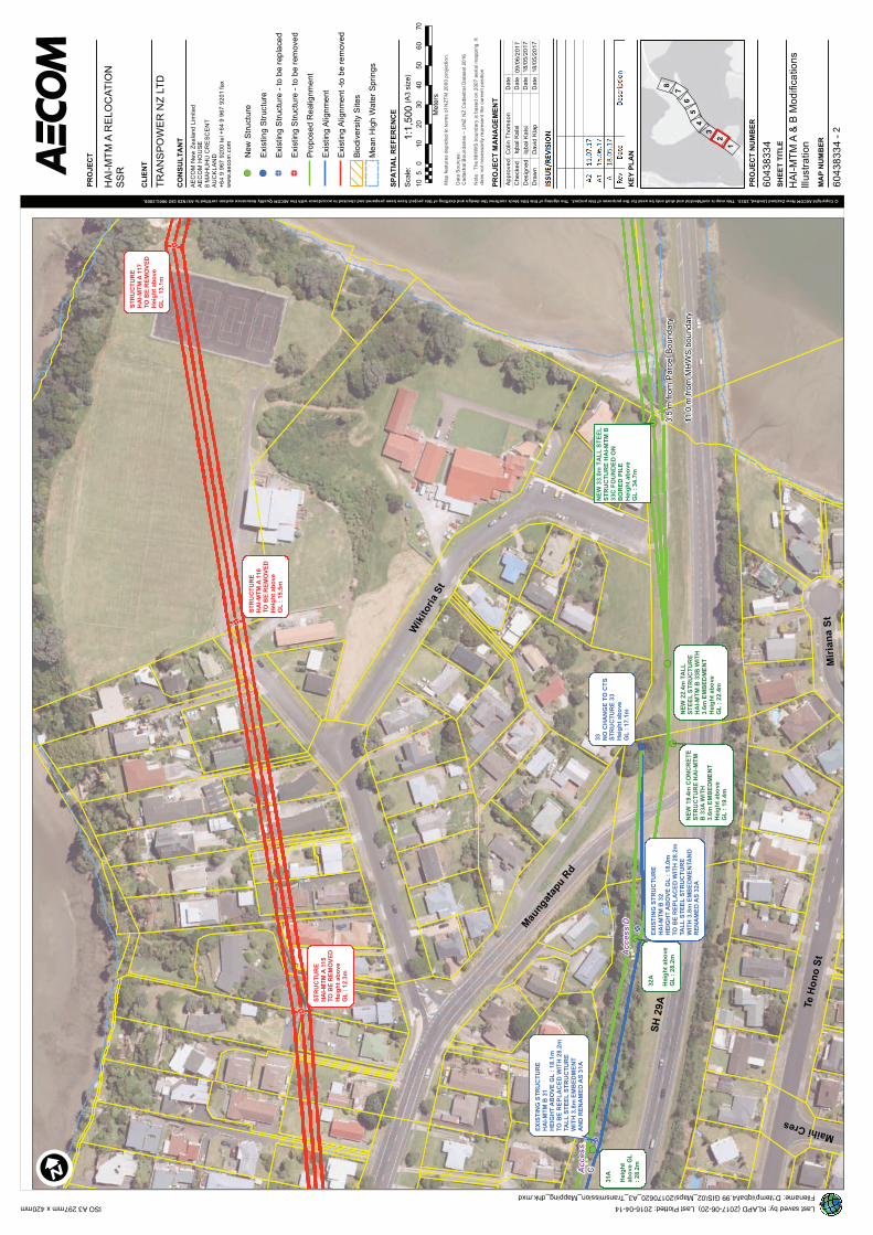
The tower foundations to be replaced (HAI-MTM Line A and Line B) are located between the suburbs
of Matapihi and Maungatapu, generally adjacent to State Highway 29A (refer Figures in Appendix A).
2.2 Existing layout and surrounding land uses
The structures6 are located on land where there are four primary land uses – horticultural, road
reserve, residential and recreational.
• Line A Structures 120-127 and Line B Structures 48A, 48C-48E and 127A are located within
land primarily used for growing kiwifruit, the land is generally flat with established shelterbelts
surrounding each block;
• The majority of structures located along Line B are adjacent to the road reserve of SH29A, this
area is typically flat and in pastoral use;
• Three of the structures located along Line A (113A-115) are within residential properties, with
two are positioned adjacent to Ariki Park sports fields and tennis courts; and
• Line A Tower 118 is located within the Tauranga Harbour approximately 190 m from the
coastline.
4 Ministry for the Environment. 2012: Users’ Guide: National Environmental Standard for Assessing and Managing
Contaminants in Soil to Protect Human Health. Wellington: Ministry for the Environment.5 Hazardous Activities and Industry List6 Structure numbers are based on plans provided by Transpower – HAI-MTM A Relocation SSR, revision A2, dated 11 July
2017.

3
Tonkin & Taylor Ltd
Preliminary Site Investigation -
Mount Manganui A & B 110kV Transmission Line Realignment
Transpower New Zealand Limited
8 August 2017
Job No: 26752.222
2.3 Site geology and hydrogeology
Published geology of the Tauranga area7 indicates both transmission lines and associated structures
are underlain by quaternary alluvium deposits of the Tauranga Group. These sediments generally
comprise light brown mudstones and sandstones and weather to form in-situ silts and clays.
Based on the transmission lines proximity to the coast, groundwater is anticipated to occur relatively
close to ground surface (less than 5 m below ground level) and predicted to flow in a north-easterly
direction towards the Tauranga Harbour.
3 Site history and consenting assessment
In order to assess the works against contaminated land rules in the BOPRP, we have undertaken a
review of available Council information including reviewing historic aerial photographs and a BOPRC
site contamination enquiry. The review has identified there are a number of transmission tower
sites which have the potential to contain fill materials but this does not necessarily trigger the
requirement for a consent under the contaminated land rules of the BOPRP.
A summary of relevant information from these records and a contaminated land consent assessment
is presented in Appendix B and summary is provided below and in Table 3.1 below:
• Fourteen (14) sites were assessed a having either a low or moderate potential for
contamination, based on evidence on the BOPRC Selected Land Use Register, Tauranga City
Council aerial photographs, and based on our inspection showing evidence of HAIL activities
(orchards or significantly filled ground) on or immediately surrounding the site of the tower.
Accordingly, these sites are considered to have the potential to be contaminated and,
therefore, require resource consent under Rule 35 of the BOPRP as a restricted discretionary
activity;
• Seven (7) of the sites, located in Line B, were assessed as having negligible potential for
contamination and, therefore, do not require a contaminated land consent under Rule 35 of
the BOPRP;
• Twenty nine (29) structures have a low potential for contamination (i.e. where there has been
minor surface disturbance and low level adjacent site activity). These site are considered
unlikely to pose a risk to human health or the environment and, therefore, do not require a
contaminated land consent under Rule 35 of the BOPRP. The BoP specific Site Management
Plan (SMP)8 will be appropriate for use on these sites; and
• Tower 118 is located within the Tauranga Harbour. We understand from Transpower that this
structure is proposed to be removed with little disturbance to the underlying material and
therefore no consent for contaminated soil is likely to be required. Furthermore, sampling of
the sediment in the Tauranga Harbour has been undertaken by BOPRC which shows that
metal and hydrocarbon concentrations are generally below the ANZECC interim sediment
quality guidelines.
7 Leonard, G.S.; Begg, J.G.; Wilson, C.J.N. (compilers) 2010: Geology of the Rotorua area. Scale 1:250,000. Institute of
Geological & Nuclear Sciences geological map 5.8 T+T, 2017: Site Management Plan for ground contamination, Small scale works – Bay of Plenty Region.

4
Tonkin & Taylor Ltd
Preliminary Site Investigation -
Mount Manganui A & B 110kV Transmission Line Realignment
Transpower New Zealand Limited
8 August 2017
Job No: 26752.222
Table 3.1: Summary of potential for contamination and tower consenting requirements
Potential for
contamination
Consent requirement Structures
Negligible Do not require consent under
BOPRP Rule 35
• Line B Structures 28A, 29A, 30A, 31A, 32A, 33A,
33B
Low Do not require consent under
BOPRP Rule 35 but
recommend controls (SMP) in
place
• Line A Structures 113A, 114, 115, 116, 117
• Line B Structures 33C, 33D, 43A, 47, 48, 49A, 50,
33D, 38A, 39, 39A, 40A, 41A, 42A, 43B, 44C, 44B,
45A, 47A, 48A, 48B, 48E, 51, 128
Moderate Restricted Discretionary
consent required
(BOPRP Rule 35)
• Line A Structures 119, 120, 121, 122, 123, 124,
125, 126 and 127
• Line B Structures Structures33E, 48C, 48D, 48E
and 127A
4 Works requirements
For structures where the site is not potentially contaminated, the works should be undertaken in
accordance with standard earthworks controls. For the 29 structures (refer Table 3.1) where there
has been minor soil disturbance in the past, on or adjacent to the land, it would be prudent for the
Transpower generic SMP for “small scale works within the Bay of Plenty region”9 to be provided to
the Contractors in the event that visual or olfactory evidence of contamination is identified during
the works.
For the 14 sites where some degree of contamination is likely present, the key issues for the
refurbishment/replacement works are potential for:
• Skin contact and ingestion of contaminated soil by workers;
• Discharges such as dust that may affect adjacent site workers, neighbouring residents and the
general public;
• Discharges that may affect the environment, in particular surface water, sediment and dust;
and
• Inappropriate disposal of surplus soil offsite.
For these 14 sites a works specific SMP will be required to support application for consent under
Rule 35 of the BOPRC. We suggest the SMP is based on the requirements of the Transpower generic
SMP for the BoP region, but with works specific information around the nature of the works.
5
Tonkin & Taylor Ltd
Preliminary Site Investigation -
Mount Manganui A & B 110kV Transmission Line Realignment
Transpower New Zealand Limited
8 August 2017
Job No: 26752.222
5 Conclusions
Based on our review there are 14 sites where a contaminated land consent is required under Rule 35
the BOPRP. The balance of sites are not considered to require contaminated land related resource
consents under the BOPRP.
To ensure best practice is followed, contractors undertaking works on the 29 structures where there
has historically been some land modification but no potentially contaminating activities/HAIL
activities (refer Table 3.1), should be provided with the Transpower generic SMP.
A works specific SMP will be required to support a resource consent application for the 14 tower
sites where consent is required under Rule 35 of the BOPRP.
6 Applicability
This report has been prepared for the exclusive use of our client, Transpower New Zealand Limited,
with respect to the particular brief given to us and it may not be relied upon in other contexts or for
any other purpose, or by any person other than our client, without our prior written agreement.
Tonkin & Taylor Ltd
Environmental and Engineering Consultants
Report prepared by: Authorised for Tonkin & Taylor Ltd by:
.......................................................... ...........................….......…...............
Rachel Pickett Shannon Richardson
Contaminated Land Specialist Project Director
Report certified by a suitably qualified and experienced practitioner as prescribed under the NES Soil
Users Guide (April 2012).
..........................................................
Wendi Williamson
Senior Contaminated Land Specialistrcp
p:\26752\26752.2220 (hairini transmission line)\issued documents\psi final\170808_rcp_psi_final v1.docx
.......................................................... .............................................................................................................................................................................….….….….….….….….….….….......…..........
......................................................

Appendix A: Site Location Plan
HA
I-M
TM
A A
ND
B M
OD
IFIC
AT
ION
S I
LL
US
TR
AT
ION
Cli
en
t N
am
e:
Tra
nsp
ow
er
NZ
LT
D
Pro
ject
Nam
e:
HA
I-M
TM
A R
EL
OC
AT
ION
SS
R
Pro
ject
No
: 6
0438334
XY
XY
Z
28
(L
HS
)2
8A
18
80
44
3.5
58
20
99
4.3
18
80
43
9.4
58
20
99
1.4
53
.9
28
(R
HS
)2
8B
18
80
44
6.9
58
20
99
0.7
18
80
44
3.4
58
20
98
7.0
53
.9
28
TN
EW
TE
MP
OR
AR
Y P
OL
E1
88
04
36
.75
82
10
01
.75
3.9
19
.4T
YP
E 1
0Y
ES
NE
W 2
3m
TP
15
0 H
S C
ON
CR
ET
E P
OL
E C
AR
RY
ING
BO
TH
CIR
CU
ITS
NO
29
29
AP
OL
E R
EP
LA
CE
ME
NT
18
80
53
6.7
58
21
07
6.4
16
.31
88
05
40
.75
82
10
79
.45
5.6
28
.2T
YP
E 1
41
1.9
YE
S5
.0P
OL
E R
EP
LA
CE
D W
ITH
32
m S
TE
EL
PO
LE
AN
D IN
ST
AL
L S
EC
ON
D C
IRC
UIT
. N
EW
PO
LE
MO
VE
D 5
m
TO
WA
RD
S H
AI T
O A
LL
OW
FO
R IN
ST
AL
LA
TIO
N W
OR
KS
.Y
ES
30
30
AP
OL
E R
EP
LA
CE
ME
NT
18
80
64
5.0
58
21
15
8.9
17
.21
88
06
41
.05
82
11
55
.95
2.3
28
.2T
YP
E 1
41
1.0
YE
S5
.0P
OL
E R
EP
LA
CE
D W
ITH
32
m S
TE
EL
PO
LE
AN
D IN
ST
AL
L S
EC
ON
D C
IRC
UIT
. N
EW
PO
LE
MO
VE
D 5
m
TO
WA
RD
S H
AI T
O A
LL
OW
FO
R IN
ST
AL
LA
TIO
N W
OR
KS
.Y
ES
31
31
AP
OL
E R
EP
LA
CE
ME
NT
18
80
73
5.0
58
21
23
7.7
18
.11
88
07
31
.25
82
12
34
.44
4.1
28
.2T
YP
E 1
41
0.2
YE
S5
.0P
OL
E R
EP
LA
CE
D W
ITH
32
m S
TE
EL
PO
LE
AN
D IN
ST
AL
L S
EC
ON
D C
IRC
UIT
. N
EW
PO
LE
MO
VE
D 5
m
TO
WA
RD
S H
AI T
O A
LL
OW
FO
R IN
ST
AL
LA
TIO
N W
OR
KS
.Y
ES
32
32
AP
OL
E R
EP
LA
CE
ME
NT
18
80
81
0.7
58
21
31
7.5
18
.01
88
08
07
.35
82
13
13
.94
1.6
28
.2T
YP
E 1
41
0.2
YE
S5
.0P
OL
E R
EP
LA
CE
D W
ITH
32
m S
TE
EL
PO
LE
AN
D IN
ST
AL
L S
EC
ON
D C
IRC
UIT
. N
EW
PO
LE
MO
VE
D 5
m
TO
WA
RD
S H
AI T
O A
LL
OW
FO
R IN
ST
AL
LA
TIO
N W
OR
KS
.Y
ES
33
NO
CH
AN
GE
18
80
86
2.0
58
21
39
4.7
17
.1C
TS
0.0
YE
SE
XIS
TIN
G C
TS
PO
LE
RE
MA
INS
UN
CH
AN
GE
DN
O
33
AN
EW
PO
LE
18
80
87
6.4
58
21
38
7.5
38
.71
9.4
TY
PE
14
MO
D_
SC
19
.4Y
ES
NE
W 2
3m
TP
15
0 H
S C
ON
CR
ET
E P
OL
E A
ND
SE
CO
ND
CIR
CU
IT IN
ST
AL
LE
DY
ES
33
BN
EW
PO
LE
18
80
89
5.9
58
21
42
3.5
36
.32
2.4
TY
PE
10
22
.4Y
ES
NE
W 2
6m
ST
EE
L P
OL
E C
AR
RY
ING
SIN
GL
E C
IRC
UIT
YE
S
33
CN
EW
PO
LE
18
80
95
5.4
58
21
53
1.1
32
.83
4.7
TY
PE
16
MO
D_
EC
S3
4.7
YE
SP
OL
E L
EN
GT
H 3
3.0
m,
VE
RT
ICA
L L
INE
PO
ST
LE
NG
TH
= 1
.4m
, F
OU
ND
AT
ION
UP
ST
AN
D =
0.3
m,
ST
RU
CT
UR
E
TO
TA
L H
EIG
HT
AB
OV
E G
L =
34
.7m
. S
TR
UC
TU
RE
HE
IGH
T A
BO
VE
MS
L =
36
.9m
.Y
ES
33
DN
EW
PO
LE
18
81
24
9.5
58
22
12
9.1
32
.24
6.8
TY
PE
16
MO
D_
EC
S4
6.8
YE
SP
OL
E L
EN
GT
H 4
5.1
m,
VE
RT
ICA
L L
INE
PO
ST
LE
NG
TH
= 1
.4m
, F
OU
ND
AT
ION
UP
ST
AN
D =
0.3
m,
ST
RU
CT
UR
E
TO
AT
L H
EIG
HT
AB
OV
E G
L =
46
.8m
. S
TR
UC
TU
RE
HE
IGH
T A
BO
VE
MS
L =
48
.4m
.Y
ES
33
EN
EW
PO
LE
18
81
36
3.7
58
22
25
4.1
53
.42
4.0
TY
PE
10
24
.0Y
ES
INS
TA
LL
NE
W 2
4m
ST
EE
L P
OL
E C
AR
RY
ING
SIN
GL
E C
IRC
UIT
YE
S
34
NO
CH
AN
GE
18
81
27
5.9
58
22
12
7.8
16
.8C
TS
0.0
YE
SE
XIS
TIN
G C
TS
PO
LE
RE
MA
INS
UN
CH
AN
GE
DN
O
35
NO
CH
AN
GE
18
81
33
7.2
58
22
19
8.1
16
.9T
YP
E 1
4M
OD
_S
C0
.0Y
ES
EX
IST
ING
PO
LE
RE
MA
INS
UN
CH
AN
GE
DN
O
36
NO
CH
AN
GE
18
81
37
7.4
58
22
24
7.2
16
.9T
YP
E 1
4M
OD
_S
C0
.0Y
ES
EX
IST
ING
PO
LE
RE
MA
IN U
NC
HA
NG
ED
NO
37
NO
CH
AN
GE
18
81
43
5.7
58
22
29
4.7
15
.6T
YP
E 1
40
.0Y
ES
EX
IST
ING
PO
LE
WIT
H 2
ND
CIR
CU
IT IN
ST
AL
LE
DY
ES
38
NO
CH
AN
GE
18
81
50
9.3
58
22
32
6.5
15
.6T
YP
E 1
40
.0Y
ES
EX
IST
ING
PO
LE
WIT
H 2
ND
CIR
CU
IT IN
ST
AL
LE
DY
ES
39
38
AP
OL
E R
EP
LA
CE
ME
NT
18
81
59
4.9
58
22
35
6.9
15
.61
88
16
58
.65
82
23
69
.05
0.2
19
.4T
YP
E 1
43
.9Y
ES
64
.8N
EW
23
m T
P1
50
HS
CO
NC
RE
TE
PO
LE
CA
RR
YIN
G B
OT
H C
IRC
UIT
SY
ES
39
AN
EW
PO
LE
18
81
65
8.6
58
22
36
9.0
50
.21
9.4
TY
PE
14
19
.4Y
ES
NE
W 2
3m
TP
15
0 H
S C
ON
CR
ET
E P
OL
E C
AR
RY
ING
BO
TH
CIR
CU
ITS
YE
S
40
NO
CH
AN
GE
18
81
72
7.5
58
22
38
2.1
19
.4T
YP
E 1
40
.0Y
ES
EX
IST
ING
PO
LE
WIT
H 2
ND
CIR
CU
IT IN
ST
AL
LE
DY
ES
40
AN
EW
PO
LE
18
81
83
0.3
58
22
39
8.4
50
.51
9.4
TY
PE
14
19
.4Y
ES
NE
W 2
3m
TP
15
0 H
S C
ON
CR
ET
E P
OL
E C
AR
RY
ING
BO
TH
CIR
CU
ITS
YE
S
41
NO
CH
AN
GE
18
81
88
0.9
58
22
40
6.4
16
.9T
YP
E 1
40
.0Y
ES
EX
IST
ING
PO
LE
WIT
H 2
ND
CIR
CU
IT IN
ST
AL
LE
DY
ES
41
AN
EW
PO
LE
18
81
93
2.0
58
22
42
0.1
50
.41
9.4
TY
PE
14
19
.4Y
ES
NE
W 2
3m
TP
15
0 H
S C
ON
CR
ET
E P
OL
E C
AR
RY
ING
BO
TH
CIR
CU
ITS
YE
S
42
NO
CH
AN
GE
18
81
97
8.0
58
22
43
3.0
15
.6T
YP
E 1
40
.0Y
ES
EX
IST
ING
PO
LE
WIT
H 2
ND
CIR
CU
IT IN
ST
AL
LE
DY
ES
42
AN
EW
PO
LE
18
82
02
2.7
58
22
45
0.7
49
.51
9.4
TY
PE
14
19
.4Y
ES
NE
W 2
3m
TP
15
0 H
S C
ON
CR
ET
E P
OL
E C
AR
RY
ING
BO
TH
CIR
CU
ITS
YE
S
43
A4
3B
PO
LE
RE
PL
AC
EM
EN
T1
88
20
69
.45
82
24
69
.81
6.9
18
82
07
3.8
58
22
47
2.3
49
.01
9.4
TY
PE
14
2.6
YE
S5
.0P
OL
E R
EP
LA
CE
D W
ITH
23
m T
P1
50
CO
NC
RE
TE
HS
PO
LE
AN
D IN
ST
AL
L S
EC
ON
D C
IRC
UIT
. N
EW
PO
LE
MO
VE
D 5
m T
OW
AR
DS
HA
I T
O A
LL
OW
FO
R IN
ST
AL
LA
TIO
N W
OR
KS
.Y
ES
43
CN
EW
PO
LE
18
82
11
6.6
58
22
49
5.6
48
.61
9.4
TY
PE
14
19
.4Y
ES
NE
W 2
3m
TP
15
0 H
S C
ON
CR
ET
E P
OL
E C
AR
RY
ING
BO
TH
CIR
CU
ITS
YE
S
44
AN
O C
HA
NG
E1
88
21
58
.15
82
25
19
.01
8.2
TY
PE
14
0.0
YE
SE
XIS
TIN
G P
OL
E W
ITH
2N
D C
IRC
UIT
IN
ST
AL
LE
DY
ES
44
BN
EW
PO
LE
18
82
20
6.9
58
22
55
0.7
47
.91
9.4
TY
PE
14
19
.4Y
ES
NE
W 2
3m
TP
15
0 H
S C
ON
CR
ET
E P
OL
E C
AR
RY
ING
BO
TH
CIR
CU
ITS
YE
S
45
NO
CH
AN
GE
18
82
24
3.9
58
22
57
5.3
18
.2T
YP
E 1
40
.0Y
ES
EX
IST
ING
PO
LE
WIT
H 2
ND
CIR
CU
IT IN
ST
AL
LE
DY
ES
45
AN
EW
PO
LE
18
82
28
1.3
58
22
60
6.8
47
.71
9.4
TY
PE
14
19
.4Y
ES
NE
W 2
3m
TP
15
0 H
S C
ON
CR
ET
E P
OL
E C
AR
RY
ING
SIN
GL
E C
IRC
UIT
SY
ES
46
NO
CH
AN
GE
18
82
31
9.9
58
22
64
0.6
18
.2T
YP
E 1
40
.0Y
ES
EX
IST
ING
PO
LE
WIT
H 2
ND
CIR
CU
IT IN
ST
AL
LE
DY
ES
47
47
AP
OL
E R
EP
LA
CE
ME
NT
18
82
41
3.9
58
22
73
0.8
19
.41
88
24
03
.95
82
27
21
.24
8.1
22
.8T
YP
E 1
43
.4Y
ES
13
.8P
OL
E R
EP
LA
CE
D W
ITH
26
m S
TE
EL
PO
LE
AN
D IN
ST
AL
L S
EC
ON
D C
IRC
UIT
. N
EW
PO
LE
MO
VE
D 1
3.8
m
TO
WA
RD
S H
AI T
O A
LL
OW
FO
R IN
ST
AL
LA
TIO
N W
OR
KS
.Y
ES
48
48
AP
OL
E R
EP
LA
CE
ME
NT
18
82
52
6.7
58
22
82
9.9
19
.41
88
25
10
.05
82
28
27
.34
6.1
22
.8T
YP
E 1
03
.4Y
ES
16
.8P
OL
E 4
8 R
EP
LA
CE
D W
ITH
A 2
6.0
m T
AL
L S
TE
EL
PO
LE
, C
AR
RY
ING
ON
E C
IRC
UIT
YE
S
48
BN
EW
PO
LE
18
82
51
3.5
58
22
82
3.4
46
.12
2.8
TY
PE
10
22
.8Y
ES
NE
W 2
6m
ST
EE
L P
OL
E C
AR
RY
ING
SIN
GL
E C
IRC
UIT
YE
S
49
A4
8C
PO
LE
RE
PL
AC
EM
EN
T1
88
26
19
.25
82
29
28
.51
9.0
18
82
60
2.2
58
22
92
4.2
43
.72
8.7
TY
PE
16
9.7
YE
S1
7.5
PO
LE
RE
PL
AC
ED
WIT
H 3
2.0
m S
TE
EL
PO
LE
CA
RR
YIN
G B
OT
H C
IRC
UIT
S.
YE
S
50
48
DP
OL
E R
EP
LA
CE
ME
NT
18
82
73
3.2
58
23
05
7.7
15
.21
88
26
74
.55
82
30
24
.54
0.9
26
.2T
YP
E 1
61
1.0
YE
S6
7.4
PO
LE
RE
PL
AC
ED
WIT
H 3
0.0
m S
TE
EL
PO
LE
CA
RR
YIN
G B
OT
H C
IRC
UIT
S.
YE
S
48
EN
EW
PO
LE
18
82
70
7.3
58
23
10
2.4
38
.92
2.8
TY
PE
14
22
.8Y
ES
NE
W 2
6m
ST
EE
L P
OL
E C
AR
RY
ING
DO
UB
LE
CIR
CU
ITY
ES
51
48
FP
OL
E R
EP
LA
CE
ME
NT
18
82
74
7.3
58
23
19
8.8
17
.81
88
27
44
.45
82
31
99
.23
6.6
21
.8T
YP
E 1
04
.0Y
ES
3.0
NE
W 2
6m
ST
EE
L P
OL
E C
AR
RY
ING
SIN
GL
E C
IRC
UIT
- 1
.0m
AD
DE
D IN
TO
TH
E S
TA
ND
AR
D 3
.2m
EM
BE
DM
EN
T
BR
ING
ING
TH
E T
OT
AL
EM
BE
DM
EN
T T
O 4
.2m
NO
12
7A
NE
W P
OL
E1
88
27
37
.05
82
32
26
.13
6.1
19
.4T
YP
E 1
61
9.4
YE
SN
EW
TW
IN 2
3m
TP
15
0 H
S C
ON
CR
ET
E P
OL
E C
AR
RY
ING
SIN
GL
E C
IRC
UIT
YE
S
12
81
28
AP
OL
E R
EP
LA
CE
ME
NT
18
82
75
2.5
58
23
49
5.4
12
.61
88
27
51
.35
82
34
92
.63
3.4
11
.2T
YP
E 1
6-1
.4Y
ES
3.1
PO
LE
RE
PL
AC
ED
WIT
H 1
8.5
m T
P1
50
CO
NC
RE
TE
HS
PO
LE
AN
D IN
ST
AL
L S
EC
ON
D C
IRC
UIT
. N
EW
PO
LE
MO
VE
D 3
m T
OW
AR
DS
HA
I T
O A
LL
OW
FO
R IN
ST
AL
LA
TIO
N W
OR
KS
.Y
ES
11
3A
PO
LE
RE
MO
VA
L1
88
04
99
.05
82
10
97
.81
6.0
-16
.0E
XIS
TIN
G P
OL
E T
O B
E R
EM
OV
ED
. E
XIS
TIN
G H
EIG
HT
AB
OV
E G
L =
16
mN
O
11
4P
OL
E R
EM
OV
AL
18
80
51
4.9
58
21
12
7.7
16
.3-1
6.3
EX
IST
ING
PO
LE
TO
BE
RE
MO
VE
D.
EX
IST
ING
HE
IGH
T A
BO
VE
GL
= 1
6.3
mN
O
11
5P
OL
E R
EM
OV
AL
18
80
64
3.9
58
21
37
3.2
12
.3-1
2.3
EX
IST
ING
PO
LE
TO
BE
RE
MO
VE
D.
EX
IST
ING
HE
IGH
T A
BO
VE
GL
= 1
2.3
mN
O
11
6P
OL
E R
EM
OV
AL
18
80
72
1.2
58
21
55
9.1
15
.5-1
5.5
EX
IST
ING
PO
LE
TO
BE
RE
MO
VE
D.
EX
IST
ING
HE
IGH
T A
BO
VE
GL
= 1
5.5
mN
O
11
7P
OL
E R
EM
OV
AL
18
80
79
6.8
58
21
73
7.8
13
.1-1
3.1
EX
IST
ING
PO
LE
TO
BE
RE
MO
VE
D.
EX
IST
ING
HE
IGH
T A
BO
VE
GL
= 1
3.1
mN
O
11
8P
OL
E R
EM
OV
AL
18
81
08
5.7
58
22
01
2.8
31
.0-3
1.0
EX
IST
ING
PO
LE
TO
BE
RE
MO
VE
D.
EX
IST
ING
HE
IGH
T A
BO
VE
GL
= 3
1m
NO
NE
W P
OL
E
ID
YE
ST
WIN
PO
LE
RE
PL
AC
ED
WIT
H T
WIN
PO
LE
18
.22
5.5
TW
IN T
YP
E
10
M0
D_
P
RA
DIA
L D
IST
AN
CE
FR
OM
EX
IST
ING
ST
RU
CT
UR
E
WH
ER
E A
PP
LIC
AB
LE
(m
)
5.0
ST
RU
CT
UR
E H
EIG
HT
FU
LL
Y
CO
MP
LIE
S
WIT
H T
AU
RA
NG
A
AIR
PO
RT
HE
IGH
T
RE
ST
RIC
TIO
NS
YE
S
RE
QU
IRE
DE
EP
INS
UL
AT
ED
EA
RT
H
NE
W P
OL
E C
OO
RD
INA
TE
SC
HA
NG
E IN
HE
IGH
T
(m)
EX
IST
ING
PO
LE
CO
OR
DIN
AT
ES
PO
LE
NO
PR
OP
OS
ED
WO
RK
ON
PO
LE
EX
IST
ING
PO
LE
HE
IGH
T
AB
OV
E G
L
(m)
NE
W P
OL
E
HE
IGH
T A
BO
VE
GL
(m)
DE
SC
RIP
TIO
N O
F W
OR
KS
TY
PE
7.3
PO
LE
LE
NG
TH
25
.5m
, F
OU
ND
AT
ION
UP
ST
AN
D =
0.5
m,
ST
RU
CT
UR
E T
OT
AL
HE
IGH
T A
BO
VE
GL
= 2
6.0
m.
ST
RU
CT
UR
E H
EIG
HT
AB
OV
E M
SL
= 4
9.3
m.
SU
MM
AR
Y
Revis
ion 3
.9 1
1/0
7/2
017
\\N
ZW
LG
1F
P001\P
roje
cts
\604X
\60438334\4
. T
ech w
ork
Are
a\4
.4 E
nvironm
ent\
Pole
Changes S
chedule
Rev 3
.9.x
lsx
Page 1
of
2
Date
: 11/0
7/2
017

HA
I-M
TM
A A
ND
B M
OD
IFIC
AT
ION
S I
LL
US
TR
AT
ION
Cli
en
t N
am
e:
Tra
nsp
ow
er
NZ
LT
D
Pro
ject
Nam
e:
HA
I-M
TM
A R
EL
OC
AT
ION
SS
R
Pro
ject
No
: 6
0438334
XY
XY
Z
NE
W P
OL
E
ID
RA
DIA
L D
IST
AN
CE
FR
OM
EX
IST
ING
ST
RU
CT
UR
E
WH
ER
E A
PP
LIC
AB
LE
(m
)
ST
RU
CT
UR
E H
EIG
HT
FU
LL
Y
CO
MP
LIE
S
WIT
H T
AU
RA
NG
A
AIR
PO
RT
HE
IGH
T
RE
ST
RIC
TIO
NS
RE
QU
IRE
DE
EP
INS
UL
AT
ED
EA
RT
H
NE
W P
OL
E C
OO
RD
INA
TE
SC
HA
NG
E IN
HE
IGH
T
(m)
EX
IST
ING
PO
LE
CO
OR
DIN
AT
ES
PO
LE
NO
PR
OP
OS
ED
WO
RK
ON
PO
LE
EX
IST
ING
PO
LE
HE
IGH
T
AB
OV
E G
L
(m)
NE
W P
OL
E
HE
IGH
T A
BO
VE
GL
(m)
DE
SC
RIP
TIO
N O
F W
OR
KS
TY
PE
11
9P
OL
E R
EM
OV
AL
18
81
39
8.0
58
22
31
0.5
13
.1-1
3.1
EX
IST
ING
PO
LE
TO
BE
RE
MO
VE
D.
EX
IST
ING
HE
IGH
T A
BO
VE
GL
= 1
3.1
mN
O
12
0P
OL
E R
EM
OV
AL
18
81
57
0.1
58
22
41
8.6
19
.2-1
9.2
EX
IST
ING
PO
LE
TO
BE
RE
MO
VE
D.
EX
IST
ING
HE
IGH
T A
BO
VE
GL
= 1
9.2
mN
O
12
1P
OL
E R
EM
OV
AL
18
81
77
0.7
58
22
54
4.3
16
.4-1
6.4
EX
IST
ING
PO
LE
TO
BE
RE
MO
VE
D.
EX
IST
ING
HE
IGH
T A
BO
VE
GL
= 1
6.4
mN
O
12
2P
OL
E R
EM
OV
AL
18
81
93
4.8
58
22
64
7.4
15
.0-1
5.0
EX
IST
ING
PO
LE
TO
BE
RE
MO
VE
D.
EX
IST
ING
HE
IGH
T A
BO
VE
GL
= 1
5m
NO
12
3P
OL
E R
EM
OV
AL
18
82
07
1.4
58
22
73
3.4
15
.0-1
5.0
EX
IST
ING
PO
LE
TO
BE
RE
MO
VE
D.
EX
IST
ING
HE
IGH
T A
BO
VE
GL
= 1
5m
NO
12
4P
OL
E R
EM
OV
AL
18
82
23
7.7
58
22
83
7.7
15
.4-1
5.4
EX
IST
ING
PO
LE
TO
BE
RE
MO
VE
D.
EX
IST
ING
HE
IGH
T A
BO
VE
GL
= 1
5.4
mN
O
12
5P
OL
E R
EM
OV
AL
18
82
39
4.4
58
22
93
6.4
13
.7-1
3.7
EX
IST
ING
PO
LE
TO
BE
RE
MO
VE
D.
EX
IST
ING
HE
IGH
T A
BO
VE
GL
= 1
3.7
mN
O
12
6P
OL
E R
EM
OV
AL
18
82
55
2.0
58
23
03
5.2
15
.6-1
5.6
EX
IST
ING
PO
LE
TO
BE
RE
MO
VE
D.
EX
IST
ING
HE
IGH
T A
BO
VE
GL
= 1
5.6
mN
O
12
7P
OL
E R
EM
OV
AL
18
82
64
9.4
58
23
25
8.4
16
.1-1
6.1
EX
IST
ING
PO
LE
TO
BE
RE
MO
VE
D.
EX
IST
ING
HE
IGH
T A
BO
VE
GL
= 1
6.1
mN
O
NO
TE
:
1S
HA
DE
D C
EL
LS
IN
DIC
AT
E E
XIS
TIN
G S
TR
UC
TU
RE
S R
EM
AIN
ING
UN
CH
AN
GE
D.
2T
HE
HE
IGH
TS
SP
EC
IFIE
D F
OR
33
C A
ND
33
D A
RE
TO
TH
E C
ON
DU
CT
OR
AT
TA
CH
ME
NT
PO
INT
AT
TH
E T
OP
OF
TH
E V
ER
TIC
AL
LIN
E P
OS
T (
VL
P)
INS
UL
AT
OR
FO
R T
HE
MID
PH
AS
E
TW
IN T
YP
E 1
0M
OD
_T
T
RA
NP
OS
ITIO
N S
TR
UC
TU
RE
TW
IN T
YP
E 1
4M
OD
_S
C
TW
IN T
YP
E 1
4
TY
PE
10
TY
PE
16
CT
S
CA
BL
E T
ER
MIN
AT
ION
ST
RU
CT
UR
E
TW
IN T
YP
E 1
6M
OD
_E
CS
E
ST
UA
RY
CR
OS
SIN
G S
TR
UC
TU
RE
SU
MM
AR
Y
Revis
ion 3
.9 1
1/0
7/2
017
\\N
ZW
LG
1F
P001\P
roje
cts
\604X
\60438334\4
. T
ech w
ork
Are
a\4
.4 E
nvironm
ent\
Pole
Changes S
chedule
Rev 3
.9.x
lsx
Page 2
of
2
Date
: 11/0
7/2
017

A Rev
Descrip
tio
nD
ate
© Copyright AECOM New Zealand Limited, 2015. This map is confidential and shall only be used for the purposes of this project. The signing of this title block confirms the design and drafting of this project have been prepared and checked in accordance with the AECOM Quality Assurance system certified to AS/NZS ISO 9001:2008.
Dra
wn
Desig
ne
d
Che
cke
d
Ap
pro
ve
dD
ate
David
Kla
p
Iqb
al K
als
i
Scale
:(A
3 s
ize)
Filename: D:\temp\iqbal\4.99 GIS\02_Maps\20170620_A3_Transmission_Mapping_dhk.mxd
ISO A3 297mm x 420mm
PR
OJE
CT
CL
IEN
T
CO
NS
UL
TA
NT
TR
AN
SP
OW
ER
NZ
LT
D
AE
CO
M N
ew
Ze
ala
nd
Lim
ite
dA
EC
OM
HO
US
E
8 M
AH
UH
U C
RE
SC
EN
T
AU
CK
LA
ND
+6
4 9
967
92
00
te
l +
64 9
96
7 9
20
1 f
ax
ww
w.a
eco
m.c
om
MA
P N
UM
BE
R
60
43
83
34
-
SH
EE
T T
ITL
E
PR
OJE
CT
NU
MB
ER
60
43
83
34
KE
Y P
LA
N
PR
OJE
CT
MA
NA
GE
ME
NT
ISS
UE
/RE
VIS
ION
Last saved by: KLAPD (2017-06-20) Last Plotted: 2016-04-14
18
.05
.17
.
Date
Date
Date
18
/05
/20
17
18
/05
/20
17
Map
fea
ture
s d
ep
icte
d in t
erm
s o
f N
ZT
M 2
00
0 p
roje
ctio
n.
Data
So
urc
es:
Cad
astr
al B
oun
dari
es –
LIN
Z N
Z C
ada
str
al D
ata
set
20
16
Note
: T
he
MH
WS
bou
nd
ary
is b
ase
d o
n 2
00
7 a
eri
al m
app
ing
. It
do
es n
ot n
ecessa
rily
re
pre
se
nt
the
curr
ent
positio
n.
SP
AT
IAL
RE
FE
RE
NC
E
!(
!(
!(
!>
!>
!>
!>
!>
!>
ST
RU
CT
UR
EH
AI-
MT
M A
11
3A
TO
BE
RE
MO
VE
DH
eig
ht
ab
ov
eG
L :
16
.0m
ST
RU
CT
UR
EH
AI-
MT
M A
11
4T
O B
E R
EM
OV
ED
Heig
ht
ab
ov
eG
L :
16
.3m
Te Wati St
Taipari St
Ma
un
ga
tap
u R
d
Te
Ho
no
St
SH
29
A
Acc
es
s A
Acc
es
s
B
EX
IST
ING
TY
PE
18
CO
NC
RE
TE
ST
RU
CT
UR
E 2
8H
EIG
HT
AB
OV
E G
L :
18
.2M
TO
BE
RE
PL
AC
ED
WIT
HT
WIN
AR
ML
ES
S 2
5.5
m S
TE
EL
TA
LL
ST
EE
L S
TR
UC
TU
RE
AN
D R
EN
AM
ED
AS
28
A
EX
IST
ING
ST
RU
CT
UR
EH
AI-
MT
M B
29
HE
IGH
T A
BO
VE
GL
: 1
6.3
MT
O B
E R
EP
LA
CE
D W
ITH
28
.2m
ST
EE
L T
AL
L S
TR
UC
TU
RE
WIT
H3.8
m E
MB
ED
ME
NT
AN
DR
EN
AM
ED
AS
29
A
EX
IST
ING
ST
RU
CT
UR
EH
AI-
MT
M B
30
HE
IGH
T A
BO
VE
GL
: 1
7.2
MT
O B
E R
EP
LA
CE
D W
ITH
28
.2m
TA
LL
ST
EE
L S
TR
UC
TU
RE
WIT
H 3
.8m
EM
BE
DM
EN
TA
ND
RE
NA
ME
D A
S 3
0A
TE
MP
OR
AR
Y1
9.4
MS
TR
UC
TU
RE
28
T-
TY
PE
10
CO
NC
RE
TE
ST
RU
CT
UR
E W
ITH
ST
AN
DA
RD
EM
BE
DM
EN
T
29
A
Heig
ht
ab
ove
GL
: 2
8.2
m
30
A
Heig
ht
ab
ove
GL
: 2
8.2
m
28
A
Heig
ht
ab
ov
e G
L:
25
.5m
I
10
010
20
30
40
50
60
70
5
Me
ters
1:1
,50
0
1
7
1
56
2
8
3
4
! (N
ew
Str
uctu
re
! (E
xis
tin
g S
tructu
re
! >E
xis
tin
g S
tructu
re -
to
be r
ep
lace
d
! >E
xis
tin
g S
tructu
re -
to
be r
em
ove
d
Pro
pose
d R
ealig
nm
ent
Exis
tin
g A
lign
me
nt
Exis
tin
g A
lign
me
nt
-to
be r
em
oved
Bio
div
ers
ity S
ites
Me
an
Hig
h W
ate
r S
pri
ng
s
HA
I-M
TM
A R
EL
OC
AT
ION
SS
R
HA
I-M
TM
A &
B M
od
ific
atio
ns
Illu
str
atio
n
A1
15
.06
.17
Iqb
al K
als
i09
/06
/20
17
Colin T
hom
so
n
ST
RU
CT
UR
ESm
m
m
m
EX
IST
ING
TY
PE
18
CO
NC
RE
TE
ST
RU
CT
UR
E 2
8H
EIG
HT
AB
OV
E G
L:
18.2
mT
O B
E R
EP
LA
CE
D W
ITH
TW
IN A
RM
LE
SS
25.5
mT
AL
L S
TE
EL
ST
RU
CT
UR
ES
AN
D R
EN
AM
ED
AS
28A
(LH
S)
AN
D 2
8B
(R
HS
)
28A
(L
HS
) A
ND
28B
(RH
S)
Heig
ht
ab
ove
GL
: 25.5
m
A Rev
Descrip
tio
nD
ate
© Copyright AECOM New Zealand Limited, 2015. This map is confidential and shall only be used for the purposes of this project. The signing of this title block confirms the design and drafting of this project have been prepared and checked in accordance with the AECOM Quality Assurance system certified to AS/NZS ISO 9001:2008.
Dra
wn
Desig
ne
d
Che
cke
d
Ap
pro
ve
dD
ate
David
Kla
p
Iqb
al K
als
i
Scale
:(A
3 s
ize)
Filename: D:\temp\iqbal\4.99 GIS\02_Maps\20170620_A3_Transmission_Mapping_dhk.mxd
ISO A3 297mm x 420mm
PR
OJE
CT
CL
IEN
T
CO
NS
UL
TA
NT
TR
AN
SP
OW
ER
NZ
LT
D
AE
CO
M N
ew
Ze
ala
nd
Lim
ite
dA
EC
OM
HO
US
E
8 M
AH
UH
U C
RE
SC
EN
T
AU
CK
LA
ND
+6
4 9
967
92
00
te
l +
64 9
96
7 9
20
1 f
ax
ww
w.a
eco
m.c
om
MA
P N
UM
BE
R
60
43
83
34
-
SH
EE
T T
ITL
E
PR
OJE
CT
NU
MB
ER
60
43
83
34
KE
Y P
LA
N
PR
OJE
CT
MA
NA
GE
ME
NT
ISS
UE
/RE
VIS
ION
Last saved by: KLAPD (2017-06-20) Last Plotted: 2016-04-14
18
.05
.17
.
Date
Date
Date
18
/05
/20
17
18
/05
/20
17
Map
fea
ture
s d
ep
icte
d in t
erm
s o
f N
ZT
M 2
00
0 p
roje
ctio
n.
Data
So
urc
es:
Cad
astr
al B
oun
dari
es –
LIN
Z N
Z C
ada
str
al D
ata
set
20
16
Note
: T
he
MH
WS
bou
nd
ary
is b
ase
d o
n 2
00
7 a
eri
al m
app
ing
. It
do
es n
ot n
ecessa
rily
re
pre
se
nt
the
curr
ent
positio
n.
SP
AT
IAL
RE
FE
RE
NC
E
!
!(
!(
!(
!(
!(
!(
!>
!>
!>
!>
!>
33
NO
CH
AN
GE
TO
CT
SS
TR
UC
TU
RE
33
Heig
ht
ab
ove
GL
: 1
7.1
m
ST
RU
CT
UR
EH
AI-
MT
M A
11
5T
O B
E R
EM
OV
ED
Heig
ht
ab
ov
eG
L :
12
.3m
ST
RU
CT
UR
EH
AI-
MT
M A
11
6T
O B
E R
EM
OV
ED
Heig
ht
ab
ov
eG
L :
15
.5m
ST
RU
CT
UR
EH
AI-
MT
M A
11
7T
O B
E R
EM
OV
ED
Heig
ht
ab
ov
eG
L :
13
.1m
Maihi Cres
Mir
ian
a S
t
Te H
on
o S
t
Wik
itori
a S
t
Mau
ngat
apu R
d
SH
29A
Acc
es
s
C
Acc
es
s D
31
A
Heig
ht
ab
ov
e G
L:
28
.2m
32
A
Heig
ht
ab
ove
GL
: 2
8.2
m
NE
W 1
9.4
m C
ON
CR
ET
ES
TR
UC
TU
RE
HA
I-M
TM
B 3
3A
WIT
H3.6
m E
MB
ED
ME
NT
Heig
ht
ab
ove
GL
: 1
9.4
m
NE
W 2
2.4
m T
AL
LS
TE
EL
ST
RU
CT
UR
EH
AI-
MT
M B
33
B W
ITH
3.6
m E
MB
ED
ME
NT
Heig
ht
ab
ove
GL
: 2
2.4
m
NE
W 3
3m
TA
LL
ST
EE
LS
TR
UC
TU
RE
HA
I-M
TM
B 3
3C
FO
UN
DE
DO
N B
OR
ED
PIL
EH
eig
ht
ab
ove
GL
: 3
4.4
m
EX
IST
ING
ST
RU
CT
UR
EH
AI-
MT
M B
31
HE
IGH
T A
BO
VE
GL
: 1
8.1
MT
O B
E R
EP
LA
CE
D W
ITH
28
.2m
TA
LL
ST
EE
L S
TR
UC
TU
RE
WIT
H 3
.8m
EM
BE
DM
EN
TA
ND
RE
NA
ME
D A
S 3
1A
EX
IST
ING
ST
RU
CT
UR
EH
AI-
MT
M B
32
HE
IGH
T A
BO
VE
GL
: 1
8.0
MT
O B
E R
EP
LA
CE
D W
ITH
28
.2m
TA
LL
ST
EE
L S
TR
UC
TU
RE
WIT
H 3
.8m
EM
BE
DM
EN
TA
ND
RE
NA
ME
D A
S 3
2A
3.5
m fro
m P
arc
el B
ou
nd
ary
11.0
m f
rom
MH
WS
bo
und
ary
I
10
010
20
30
40
50
60
70
5
Me
ters
1:1
,50
0
2
7
1
56
2
8
3
4
! (N
ew
Str
uctu
re
! (E
xis
tin
g S
tructu
re
! >E
xis
tin
g S
tructu
re -
to
be r
ep
lace
d
! >E
xis
tin
g S
tructu
re -
to
be r
em
ove
d
Pro
pose
d R
ealig
nm
ent
Exis
tin
g A
lign
me
nt
Exis
tin
g A
lign
me
nt
-to
be r
em
oved
Bio
div
ers
ity S
ites
Me
an
Hig
h W
ate
r S
pri
ng
s
HA
I-M
TM
A R
EL
OC
AT
ION
SS
R
HA
I-M
TM
A &
B M
od
ific
atio
ns
Illu
str
atio
n
A1
15
.06
.17
Iqb
al K
als
i09
/06
/20
17
Colin T
hom
so
n
m
m
NE
W 3
3.0
m T
AL
L S
TE
EL
ST
RU
CT
UR
E H
AI-
MT
M B
33C
FO
UN
DE
D O
NB
OR
ED
PIL
EH
eig
ht
ab
ove
GL
: 3
4.7
m

A Rev
Descrip
tio
nD
ate
© Copyright AECOM New Zealand Limited, 2015. This map is confidential and shall only be used for the purposes of this project. The signing of this title block confirms the design and drafting of this project have been prepared and checked in accordance with the AECOM Quality Assurance system certified to AS/NZS ISO 9001:2008.
Dra
wn
Desig
ne
d
Che
cke
d
Ap
pro
ve
dD
ate
David
Kla
p
Iqb
al K
als
i
Scale
:(A
3 s
ize)
Filename: D:\temp\iqbal\4.99 GIS\02_Maps\20170620_A3_Transmission_Mapping_dhk.mxd
ISO A3 297mm x 420mm
PR
OJE
CT
CL
IEN
T
CO
NS
UL
TA
NT
TR
AN
SP
OW
ER
NZ
LT
D
AE
CO
M N
ew
Ze
ala
nd
Lim
ite
dA
EC
OM
HO
US
E
8 M
AH
UH
U C
RE
SC
EN
T
AU
CK
LA
ND
+6
4 9
967
92
00
te
l +
64 9
96
7 9
20
1 f
ax
ww
w.a
eco
m.c
om
MA
P N
UM
BE
R
60
43
83
34
-
SH
EE
T T
ITL
E
PR
OJE
CT
NU
MB
ER
60
43
83
34
KE
Y P
LA
N
PR
OJE
CT
MA
NA
GE
ME
NT
ISS
UE
/RE
VIS
ION
Last saved by: KLAPD (2017-06-20) Last Plotted: 2016-04-14
18
.05
.17
.
Date
Date
Date
18
/05
/20
17
18
/05
/20
17
Map
fea
ture
s d
ep
icte
d in t
erm
s o
f N
ZT
M 2
00
0 p
roje
ctio
n.
Data
So
urc
es:
Cad
astr
al B
oun
dari
es –
LIN
Z N
Z C
ada
str
al D
ata
set
20
16
Note
: T
he
MH
WS
bou
nd
ary
is b
ase
d o
n 2
00
7 a
eri
al m
app
ing
. It
do
es n
ot n
ecessa
rily
re
pre
se
nt
the
curr
ent
positio
n.
SP
AT
IAL
RE
FE
RE
NC
E
!>
TO
WE
R H
AI-
MT
MA
11
8 T
OB
E R
EM
OV
ED
Heig
ht
ab
ov
eG
L :
31.0
m
SH
29
A
I
10
010
20
30
40
50
60
70
5
Me
ters
1:1
,50
0
3
7
1
56
2
8
3
4
! (N
ew
Str
uctu
re
! (E
xis
tin
g S
tructu
re
! >E
xis
tin
g S
tructu
re -
to
be r
ep
lace
d
! >E
xis
tin
g S
tructu
re -
to
be r
em
ove
d
Pro
pose
d R
ealig
nm
ent
Exis
tin
g A
lign
me
nt
Exis
tin
g A
lign
me
nt
-to
be r
em
oved
Bio
div
ers
ity S
ites
Me
an
Hig
h W
ate
r S
pri
ng
s
HA
I-M
TM
A R
EL
OC
AT
ION
SS
R
HA
I-M
TM
A &
B M
od
ific
atio
ns
Illu
str
atio
n
A1
15
.06
.17
Iqb
al K
als
i09
/06
/20
17
Colin T
hom
so
n
A Rev
Descrip
tio
nD
ate
© Copyright AECOM New Zealand Limited, 2015. This map is confidential and shall only be used for the purposes of this project. The signing of this title block confirms the design and drafting of this project have been prepared and checked in accordance with the AECOM Quality Assurance system certified to AS/NZS ISO 9001:2008.
Dra
wn
Desig
ne
d
Che
cke
d
Ap
pro
ve
dD
ate
David
Kla
p
Iqb
al K
als
i
Scale
:(A
3 s
ize)
Filename: D:\temp\iqbal\4.99 GIS\02_Maps\20170620_A3_Transmission_Mapping_dhk.mxd
ISO A3 297mm x 420mm
PR
OJE
CT
CL
IEN
T
CO
NS
UL
TA
NT
TR
AN
SP
OW
ER
NZ
LT
D
AE
CO
M N
ew
Ze
ala
nd
Lim
ite
dA
EC
OM
HO
US
E
8 M
AH
UH
U C
RE
SC
EN
T
AU
CK
LA
ND
+6
4 9
967
92
00
te
l +
64 9
96
7 9
20
1 f
ax
ww
w.a
eco
m.c
om
MA
P N
UM
BE
R
60
43
83
34
-
SH
EE
T T
ITL
E
PR
OJE
CT
NU
MB
ER
60
43
83
34
KE
Y P
LA
N
PR
OJE
CT
MA
NA
GE
ME
NT
ISS
UE
/RE
VIS
ION
Last saved by: KLAPD (2017-06-20) Last Plotted: 2016-04-14
18
.05
.17
.
Date
Date
Date
18
/05
/20
17
18
/05
/20
17
Map
fea
ture
s d
ep
icte
d in t
erm
s o
f N
ZT
M 2
00
0 p
roje
ctio
n.
Data
So
urc
es:
Cad
astr
al B
oun
dari
es –
LIN
Z N
Z C
ada
str
al D
ata
set
20
16
Note
: T
he
MH
WS
bou
nd
ary
is b
ase
d o
n 2
00
7 a
eri
al m
app
ing
. It
do
es n
ot n
ecessa
rily
re
pre
se
nt
the
curr
ent
positio
n.
SP
AT
IAL
RE
FE
RE
NC
E
!!(
!(
!(
!(
!(
!(!(
!(
!>
34
NO
CH
AN
GE
TO
CT
SS
TR
UC
TU
RE
34
Heig
ht
ab
ove
GL
: 1
6.8
m
35
NO
CH
AN
GE
TO
ST
RU
CT
UR
E35
Heig
ht
ab
ove
GL
: 1
6.9
m
36
NO
CH
AN
GE
TO
ST
RU
CT
UR
E36
Heig
ht
ab
ove
GL
: 1
6.9
m
37
NO
CH
AN
GE
RE
QU
IRE
DT
O S
TR
UC
TU
RE
37
Heig
ht
ab
ove
GL
: 1
5.6
m
38
NO
CH
AN
GE
RE
QU
IRE
DT
O S
TR
UC
TU
RE
38
Heig
ht
ab
ove
GL
: 1
5.6
m
ST
RU
CT
UR
E H
AI-
MT
M A
11
9 T
O B
E R
EM
OV
ED
Heig
ht
ab
ov
eG
L :
13
.1m
Puw
hari
ki
Rd
SH
29
A
Acc
es
s F
Acc
es
s E
NE
W 4
5.1
m T
AL
L S
TE
EL
ST
RU
CT
UR
E H
AI-
MT
M B
33
DF
OU
ND
ED
ON
BO
RE
D P
ILE
Heig
ht
ab
ove
GL
: 4
6.5
m
NE
W 2
4.0
m T
AL
L S
TE
EL
ST
RU
CT
UR
E H
AI-
MT
M B
33
EF
OU
ND
ED
ON
BA
SE
PL
AT
EH
eig
ht
ab
ov
e G
L :
24
.0m
13
.9 m
fro
m P
arc
el B
oun
dary
30
.2 m
fro
m M
HW
S b
oun
dary
I
10
010
20
30
40
50
60
70
5
Me
ters
1:1
,50
0
4
7
1
56
2
8
3
4
! (N
ew
Str
uctu
re
! (E
xis
tin
g S
tructu
re
! >E
xis
tin
g S
tructu
re -
to
be r
ep
lace
d
! >E
xis
tin
g S
tructu
re -
to
be r
em
ove
d
Pro
pose
d R
ealig
nm
ent
Exis
tin
g A
lign
me
nt
Exis
tin
g A
lign
me
nt
-to
be r
em
oved
Bio
div
ers
ity S
ites
Me
an
Hig
h W
ate
r S
pri
ng
s
HA
I-M
TM
A R
EL
OC
AT
ION
SS
R
HA
I-M
TM
A &
B M
od
ific
atio
ns
Illu
str
atio
n
A1
15
.06
.17
Iqb
al K
als
i09
/06
/20
17
Colin T
hom
so
n
NE
W 4
5.1
m T
AL
L S
TE
EL
ST
RU
CT
UR
EH
AI-
MT
M B
33D
FO
UN
DE
D O
N B
OR
ED
PIL
EH
eig
ht
ab
ove
GL
: 4
6.8
m

A Rev
Descrip
tio
nD
ate
© Copyright AECOM New Zealand Limited, 2015. This map is confidential and shall only be used for the purposes of this project. The signing of this title block confirms the design and drafting of this project have been prepared and checked in accordance with the AECOM Quality Assurance system certified to AS/NZS ISO 9001:2008.
Dra
wn
Desig
ne
d
Che
cke
d
Ap
pro
ve
dD
ate
David
Kla
p
Iqb
al K
als
i
Scale
:(A
3 s
ize)
Filename: D:\temp\iqbal\4.99 GIS\02_Maps\20170620_A3_Transmission_Mapping_dhk.mxd
ISO A3 297mm x 420mm
PR
OJE
CT
CL
IEN
T
CO
NS
UL
TA
NT
TR
AN
SP
OW
ER
NZ
LT
D
AE
CO
M N
ew
Ze
ala
nd
Lim
ite
dA
EC
OM
HO
US
E
8 M
AH
UH
U C
RE
SC
EN
T
AU
CK
LA
ND
+6
4 9
967
92
00
te
l +
64 9
96
7 9
20
1 f
ax
ww
w.a
eco
m.c
om
MA
P N
UM
BE
R
60
43
83
34
-
SH
EE
T T
ITL
E
PR
OJE
CT
NU
MB
ER
60
43
83
34
KE
Y P
LA
N
PR
OJE
CT
MA
NA
GE
ME
NT
ISS
UE
/RE
VIS
ION
Last saved by: KLAPD (2017-06-20) Last Plotted: 2016-04-14
18
.05
.17
.
Date
Date
Date
18
/05
/20
17
18
/05
/20
17
Map
fea
ture
s d
ep
icte
d in t
erm
s o
f N
ZT
M 2
00
0 p
roje
ctio
n.
Data
So
urc
es:
Cad
astr
al B
oun
dari
es –
LIN
Z N
Z C
ada
str
al D
ata
set
20
16
Note
: T
he
MH
WS
bou
nd
ary
is b
ase
d o
n 2
00
7 a
eri
al m
app
ing
. It
do
es n
ot n
ecessa
rily
re
pre
se
nt
the
curr
ent
positio
n.
SP
AT
IAL
RE
FE
RE
NC
E
!(
!(
!(
!(
!(
!(
!(
!(
!>!>
!>
!>
40
NO
CH
AN
GE
RE
QU
IRE
DT
O S
TR
UC
TU
RE
40
Heig
ht
ab
ove
GL
: 1
9.4
m
41
NO
CH
AN
GE
RE
QU
IRE
DT
O S
TR
UC
TU
RE
41
Heig
ht
ab
ove
GL
: 1
6.9
m42
NO
CH
AN
GE
RE
QU
IRE
DT
O S
TR
UC
TU
RE
42
Heig
ht
ab
ove
GL
: 1
5.6
m
ST
RU
CT
UR
E 3
9T
O B
E R
EM
OV
ED
Heig
ht
ab
ove
GL
: 1
5.6
m
ST
RU
CT
UR
EH
AI-
MT
M A
12
0T
O B
E R
EM
OV
ED
Heig
ht
ab
ove
GL
: 1
9.2
m
ST
RU
CT
UR
EH
AI-
MT
M A
12
1T
O B
E R
EM
OV
ED
Heig
ht
ab
ove
GL
: 1
6.4
m
ST
RU
CT
UR
EH
AI-
MT
M A
12
2T
O B
E R
EM
OV
ED
Heig
ht
ab
ove
GL
: 1
5.0
m
SH
29A
ST
RU
CT
UR
E 3
8A
- N
EW
19
.4m
TA
LL
CO
NC
RE
TE
ST
RU
CT
UR
E W
ITH
3.6
m E
MB
ED
ME
NT
Heig
ht
ab
ove
GL
: 1
9.4
m
ST
RU
CT
UR
E 3
9A
- N
EW
19
.4m
TA
LL
CO
NC
RE
TE
ST
RU
CT
UR
E W
ITH
3.6
m E
MB
ED
ME
NT
Heig
ht
ab
ove
GL
: 1
9.4
m
ST
RU
CT
UR
E 4
0A
- N
EW
19
.4m
TA
LL
CO
NC
RE
TE
ST
RU
CT
UR
E W
ITH
3.6
m E
MB
ED
ME
NT
Heig
ht
ab
ove
GL
: 1
9.4
mS
TR
UC
TU
RE
41
A -
NE
W19
.4m
TA
LL
CO
NC
RE
TE
ST
RU
CT
UR
E W
ITH
3.6
m E
MB
ED
ME
NT
Heig
ht
ab
ove
GL
: 1
9.4
m
ST
RU
CT
UR
E 4
2A
- N
EW
19
.4m
TA
LL
CO
NC
RE
TE
ST
RU
CT
UR
E W
ITH
3.6
m E
MB
ED
ME
NT
Heig
ht
ab
ove
GL
: 1
9.4
m
I
10
010
20
30
40
50
60
70
5
Me
ters
1:1
,50
0
5
7
1
56
2
8
3
4
! (N
ew
Str
uctu
re
! (E
xis
tin
g S
tructu
re
! >E
xis
tin
g S
tructu
re -
to
be r
ep
lace
d
! >E
xis
tin
g S
tructu
re -
to
be r
em
ove
d
Pro
pose
d R
ealig
nm
ent
Exis
tin
g A
lign
me
nt
Exis
tin
g A
lign
me
nt
-to
be r
em
oved
Bio
div
ers
ity S
ites
Me
an
Hig
h W
ate
r S
pri
ng
s
HA
I-M
TM
A R
EL
OC
AT
ION
SS
R
HA
I-M
TM
A &
B M
od
ific
atio
ns
Illu
str
atio
n
A1
15
.06
.17
Iqb
al K
als
i09
/06
/20
17
Colin T
hom
so
n
EX
IST
ING
ST
RU
CT
UR
EH
AI-
MT
M B
39 H
EIG
HT
AB
OV
E G
L :
15.6
m T
O B
ER
EP
LA
CE
D W
ITH
19.4
m T
AL
LC
ON
CR
ET
E S
TR
UC
TU
RE
WIT
H3.6
m E
MB
ED
ME
NT
AN
DR
EN
AM
NE
D A
S 3
8A
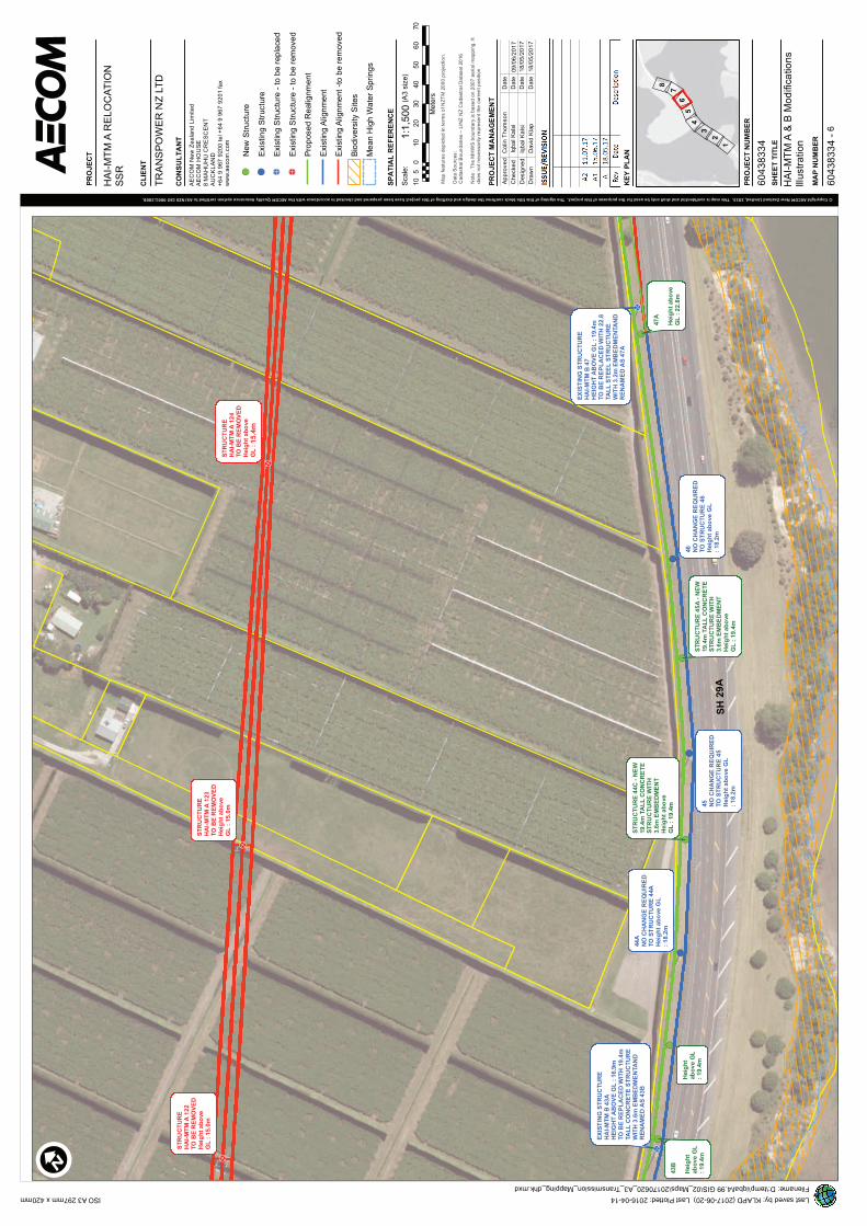
A Rev
Descrip
tio
nD
ate
© Copyright AECOM New Zealand Limited, 2015. This map is confidential and shall only be used for the purposes of this project. The signing of this title block confirms the design and drafting of this project have been prepared and checked in accordance with the AECOM Quality Assurance system certified to AS/NZS ISO 9001:2008.
Dra
wn
Desig
ne
d
Che
cke
d
Ap
pro
ve
dD
ate
David
Kla
p
Iqb
al K
als
i
Scale
:(A
3 s
ize)
Filename: D:\temp\iqbal\4.99 GIS\02_Maps\20170620_A3_Transmission_Mapping_dhk.mxd
ISO A3 297mm x 420mm
PR
OJE
CT
CL
IEN
T
CO
NS
UL
TA
NT
TR
AN
SP
OW
ER
NZ
LT
D
AE
CO
M N
ew
Ze
ala
nd
Lim
ite
dA
EC
OM
HO
US
E
8 M
AH
UH
U C
RE
SC
EN
T
AU
CK
LA
ND
+6
4 9
967
92
00
te
l +
64 9
96
7 9
20
1 f
ax
ww
w.a
eco
m.c
om
MA
P N
UM
BE
R
60
43
83
34
-
SH
EE
T T
ITL
E
PR
OJE
CT
NU
MB
ER
60
43
83
34
KE
Y P
LA
N
PR
OJE
CT
MA
NA
GE
ME
NT
ISS
UE
/RE
VIS
ION
Last saved by: KLAPD (2017-06-20) Last Plotted: 2016-04-14
18
.05
.17
.
Date
Date
Date
18
/05
/20
17
18
/05
/20
17
Map
fea
ture
s d
ep
icte
d in t
erm
s o
f N
ZT
M 2
00
0 p
roje
ctio
n.
Data
So
urc
es:
Cad
astr
al B
oun
dari
es –
LIN
Z N
Z C
ada
str
al D
ata
set
20
16
Note
: T
he
MH
WS
bou
nd
ary
is b
ase
d o
n 2
00
7 a
eri
al m
app
ing
. It
do
es n
ot n
ecessa
rily
re
pre
se
nt
the
curr
ent
positio
n.
SP
AT
IAL
RE
FE
RE
NC
E
!(
!(
!(
!(!(
!(
!(
!(
!>
!>
!>
!>
!>
44
AN
O C
HA
NG
E R
EQ
UIR
ED
TO
ST
RU
CT
UR
E 4
4A
Heig
ht
ab
ove
GL
: 1
8.2
m
45
NO
CH
AN
GE
RE
QU
IRE
DT
O S
TR
UC
TU
RE
45
Heig
ht
ab
ove
GL
: 1
8.2
m
46
NO
CH
AN
GE
RE
QU
IRE
DT
O S
TR
UC
TU
RE
46
Heig
ht
ab
ove
GL
: 1
8.2
m
ST
RU
CT
UR
EH
AI-
MT
M A
12
2T
O B
E R
EM
OV
ED
Heig
ht
ab
ove
GL
: 1
5.0
m
ST
RU
CT
UR
EH
AI-
MT
M A
12
3T
O B
E R
EM
OV
ED
Heig
ht
ab
ove
GL
: 1
5.0
mS
TR
UC
TU
RE
HA
I-M
TM
A 1
24
TO
BE
RE
MO
VE
DH
eig
ht
ab
ove
GL
: 6
3.3
m
SH
29
A
Heig
ht
ab
ov
e G
L:
19
.4m
ST
RU
CT
UR
E 4
4C
- N
EW
19
.4m
TA
LL
CO
NC
RE
TE
ST
RU
CT
UR
E W
ITH
3.6
m E
MB
ED
ME
NT
Heig
ht
ab
ove
GL
: 1
9.4
m
ST
RU
CT
UR
E 4
5A
- N
EW
19
.4m
TA
LL
CO
NC
RE
TE
ST
RU
CT
UR
E W
ITH
3.6
m E
MB
ED
ME
NT
Heig
ht
ab
ove
GL
: 1
9.4
m
EX
IST
ING
ST
RU
CT
UR
EH
AI-
MT
M B
43
AH
EIG
HT
AB
OV
E G
L :
16
.9M
TO
BE
RE
PL
AC
ED
WIT
H 1
9.4
mTA
LL
CO
NC
RE
TE
ST
RU
CT
UR
EW
ITH
3.6
m E
MB
ED
ME
NTA
ND
RE
NA
ME
D A
S 4
3B
EX
IST
ING
ST
RU
CT
UR
EH
AI-
MT
M B
47
HE
IGH
T A
BO
VE
GL
: 1
9.4
MT
O B
E R
EP
LA
CE
D W
ITH
22
.8TA
LL
ST
EE
L S
TR
UC
TU
RE
WIT
H 3
.2m
EM
BE
DM
EN
TA
ND
RE
NA
ME
D A
S 4
7A
43
B
Heig
ht
ab
ov
e G
L:
19
.4m
47
A
Heig
ht
ab
ove
GL
: 2
2.8
m
I
10
010
20
30
40
50
60
70
5
Me
ters
1:1
,50
0
6
7
1
56
2
8
3
4
! (N
ew
Str
uctu
re
! (E
xis
tin
g S
tructu
re
! >E
xis
tin
g S
tructu
re -
to
be r
ep
lace
d
! >E
xis
tin
g S
tructu
re -
to
be r
em
ove
d
Pro
pose
d R
ealig
nm
ent
Exis
tin
g A
lign
me
nt
Exis
tin
g A
lign
me
nt
-to
be r
em
oved
Bio
div
ers
ity S
ites
Me
an
Hig
h W
ate
r S
pri
ng
s
HA
I-M
TM
A R
EL
OC
AT
ION
SS
R
HA
I-M
TM
A &
B M
od
ific
atio
ns
Illu
str
atio
n
A1
15
.06
.17
Iqb
al K
als
i09
/06
/20
17
Colin T
hom
so
n
15.4
m
m
m

A Rev
Descrip
tio
nD
ate
© Copyright AECOM New Zealand Limited, 2015. This map is confidential and shall only be used for the purposes of this project. The signing of this title block confirms the design and drafting of this project have been prepared and checked in accordance with the AECOM Quality Assurance system certified to AS/NZS ISO 9001:2008.
Dra
wn
Desig
ne
d
Che
cke
d
Ap
pro
ve
dD
ate
David
Kla
p
Iqb
al K
als
i
Scale
:(A
3 s
ize)
Filename: D:\temp\iqbal\4.99 GIS\02_Maps\20170620_A3_Transmission_Mapping_dhk.mxd
ISO A3 297mm x 420mm
PR
OJE
CT
CL
IEN
T
CO
NS
UL
TA
NT
TR
AN
SP
OW
ER
NZ
LT
D
AE
CO
M N
ew
Ze
ala
nd
Lim
ite
dA
EC
OM
HO
US
E
8 M
AH
UH
U C
RE
SC
EN
T
AU
CK
LA
ND
+6
4 9
967
92
00
te
l +
64 9
96
7 9
20
1 f
ax
ww
w.a
eco
m.c
om
MA
P N
UM
BE
R
60
43
83
34
-
SH
EE
T T
ITL
E
PR
OJE
CT
NU
MB
ER
60
43
83
34
KE
Y P
LA
N
PR
OJE
CT
MA
NA
GE
ME
NT
ISS
UE
/RE
VIS
ION
Last saved by: KLAPD (2017-06-20) Last Plotted: 2016-04-14
18
.05
.17
.
Date
Date
Date
18
/05
/20
17
18
/05
/20
17
Map
fea
ture
s d
ep
icte
d in t
erm
s o
f N
ZT
M 2
00
0 p
roje
ctio
n.
Data
So
urc
es:
Cad
astr
al B
oun
dari
es –
LIN
Z N
Z C
ada
str
al D
ata
set
20
16
Note
: T
he
MH
WS
bou
nd
ary
is b
ase
d o
n 2
00
7 a
eri
al m
app
ing
. It
do
es n
ot n
ecessa
rily
re
pre
se
nt
the
curr
ent
positio
n.
SP
AT
IAL
RE
FE
RE
NC
E
!(!(
!(
!(
!(
!>
!>
!>
!>
!>
ST
RU
CT
UR
EH
AI-
MT
M A
12
5T
O B
E R
EM
OV
ED
Heig
ht
ab
ove
GL
: 5
9.5
m
ST
RU
CT
UR
EH
AI-
MT
M A
12
6T
O B
E R
EM
OV
ED
Heig
ht
ab
ove
GL
: 1
5.6
m
ST
RU
CT
UR
E 4
9A
TO
BE
RE
MO
VE
DH
eig
ht
ab
ove
GL
: 1
9.0
m
ST
RU
CT
UR
EH
AI-
MT
M 5
0 T
OB
E R
EM
OV
ED
Heig
ht
ab
ove
GL
: 1
5.2
m
Mata
pih
i R
d
SH
29
A
Acc
es
s I
Acc
es
s H
Acc
es
s G
48
B
Heig
ht
ab
ov
e G
L:
21
.0m
EX
IST
ING
ST
RU
CT
UR
EH
AI-
MT
M B
48
HE
IGH
T A
BO
VE
GL
: 1
9.4
MT
O B
E R
EP
LA
CE
D W
ITH
22
.8TA
LL
ST
EE
L S
TR
UC
TU
RE
WIT
H 3
.2m
EM
BE
DM
EN
TA
ND
RE
NA
ME
D A
S 4
8B
ST
RU
CT
UR
E 4
8A
- N
EW
22
.8m
TA
LL
ST
EE
LS
TR
UC
TU
RE
WIT
H3.2
m E
MB
ED
ME
NT
Heig
ht
ab
ove
GL
: 2
2.8
mS
TR
UC
TU
RE
48
C -
NE
W28
.2m
TA
LL
ST
EE
LS
TR
UC
TU
RE
WIT
H3.8
m E
MB
ED
ME
NT
Heig
ht
ab
ove
GL
: 2
8.2
m
ST
RU
CT
UR
E 4
8D
- N
EW
26
.2m
TA
LL
ST
EE
LS
TR
UC
TU
RE
WIT
H3.2
m E
MB
ED
ME
NT
Heig
ht
ab
ove
GL
: 2
6.2
m
ST
RU
CT
UR
E 4
8E
- N
EW
22
.8m
TA
LL
ST
EE
LS
TR
UC
TU
RE
WIT
H3.2
m E
MB
ED
ME
NT
Heig
ht
ab
ove
GL
: 2
2.8
m
I
10
010
20
30
40
50
60
70
5
Me
ters
1:1
,50
0
7
7
1
56
2
8
3
4
! (N
ew
Str
uctu
re
! (E
xis
tin
g S
tructu
re
! >E
xis
tin
g S
tructu
re -
to
be r
ep
lace
d
! >E
xis
tin
g S
tructu
re -
to
be r
em
ove
d
Pro
pose
d R
ealig
nm
ent
Exis
tin
g A
lign
me
nt
Exis
tin
g A
lign
me
nt
-to
be r
em
oved
Bio
div
ers
ity S
ites
Me
an
Hig
h W
ate
r S
pri
ng
s
HA
I-M
TM
A R
EL
OC
AT
ION
SS
R
HA
I-M
TM
A &
B M
od
ific
atio
ns
Illu
str
atio
n
A1
15
.06
.17
Iqb
al K
als
i09
/06
/20
17
Colin T
hom
so
n
13.7
m
ST
RU
CT
UR
ES
EX
IST
ING
ST
RU
CT
UR
EH
AI-
MT
M B
48 H
EIG
HT
AB
OV
E G
L :
19.4
m T
O B
ER
EP
LA
CE
D W
ITH
22.8
m T
AL
LS
TE
EL
ST
RU
CT
UR
E W
ITH
3.2
mE
MB
ED
ME
NT
AN
D R
EN
AM
NE
DA
S 4
8A
ST
RU
CT
UR
E 4
8B
- N
EW
22.8
mT
AL
L S
TE
EL
ST
RU
CT
UR
EW
ITH
3.2
m E
MB
ED
ME
NT
Heig
ht
ab
ove G
L :
22.8
m
48A
Heig
ht
ab
ove
GL
: 2
2.8
EX
IST
ING
ST
RU
CT
UR
EH
AI-
MT
M B
49A
HE
IGH
TA
BO
VE
GL
: 1
9.0
m T
O B
ER
EP
LA
CE
D W
ITH
28.2
m T
AL
LS
TE
EL
ST
RU
CT
UR
E W
ITH
3.8
mE
MB
ED
ME
NT
AN
D R
EN
AM
NE
DA
S 4
8C
EX
IST
ING
ST
RU
CT
UR
EH
AI-
MT
M B
50 H
EIG
HT
AB
OV
E G
L :
15.2
m T
O B
ER
EP
LA
CE
D W
ITH
26.2
m T
AL
LS
TE
EL
ST
RU
CT
UR
E W
ITH
3.8
mE
MB
ED
ME
NT
AN
D R
EN
AM
NE
DA
S 4
8D

A Rev
Descrip
tio
nD
ate
© Copyright AECOM New Zealand Limited, 2015. This map is confidential and shall only be used for the purposes of this project. The signing of this title block confirms the design and drafting of this project have been prepared and checked in accordance with the AECOM Quality Assurance system certified to AS/NZS ISO 9001:2008.
Dra
wn
Desig
ne
d
Che
cke
d
Ap
pro
ve
dD
ate
David
Kla
p
Iqb
al K
als
i
Scale
:(A
3 s
ize)
Filename: D:\temp\iqbal\4.99 GIS\02_Maps\20170620_A3_Transmission_Mapping_dhk.mxd
ISO A3 297mm x 420mm
PR
OJE
CT
CL
IEN
T
CO
NS
UL
TA
NT
TR
AN
SP
OW
ER
NZ
LT
D
AE
CO
M N
ew
Ze
ala
nd
Lim
ite
dA
EC
OM
HO
US
E
8 M
AH
UH
U C
RE
SC
EN
T
AU
CK
LA
ND
+6
4 9
967
92
00
te
l +
64 9
96
7 9
20
1 f
ax
ww
w.a
eco
m.c
om
MA
P N
UM
BE
R
60
43
83
34
-
SH
EE
T T
ITL
E
PR
OJE
CT
NU
MB
ER
60
43
83
34
KE
Y P
LA
N
PR
OJE
CT
MA
NA
GE
ME
NT
ISS
UE
/RE
VIS
ION
Last saved by: KLAPD (2017-06-20) Last Plotted: 2016-04-14
18
.05
.17
.
Date
Date
Date
18
/05
/20
17
18
/05
/20
17
Map
fea
ture
s d
ep
icte
d in t
erm
s o
f N
ZT
M 2
00
0 p
roje
ctio
n.
Data
So
urc
es:
Cad
astr
al B
oun
dari
es –
LIN
Z N
Z C
ada
str
al D
ata
set
20
16
Note
: T
he
MH
WS
bou
nd
ary
is b
ase
d o
n 2
00
7 a
eri
al m
app
ing
. It
do
es n
ot n
ecessa
rily
re
pre
se
nt
the
curr
ent
positio
n.
SP
AT
IAL
RE
FE
RE
NC
E
!(
!(
!(
!(
!(
!(
!(
!>
!>
!>
52
NO
CH
AN
GE
TO
ST
RU
CT
UR
E52
Heig
ht
ab
ove
GL
: 1
8.2
m
53
NO
CH
AN
GE
TO
ST
RU
CT
UR
E 5
3H
eig
ht
ab
ove
GL
: 1
8.2
m
54
AN
O C
HA
NG
E T
O S
TR
UC
TU
RE
54
AH
eig
ht
ab
ove
GL
: 1
8.3
m
55
NO
CH
AN
GE
TO
ST
RU
CT
UR
E 5
5H
eig
ht
ab
ove
GL
: 1
7.5
m
PO
LE
HA
I-M
TM
A 1
27
TO
BE
RE
MO
VE
DH
eig
ht
ab
ove
GL
: 1
6.1
m
SH
29A
Acc
es
s J
Acc
es
s K
PO
LE
12
7A
- N
EW
TW
IN19
.4m
TA
LL
CO
NC
RE
TE
PO
LE
ST
RU
CT
UR
E W
ITH
3.6
m E
MB
ED
ME
NT
Heig
ht
ab
ove
GL
: 1
9.4
m
48
FH
eig
ht
ab
ov
e G
L:
22
.8m
EX
IST
ING
ST
RU
CT
UR
EH
AI-
MT
M A
128
HE
IGH
T A
BO
VE
GL
: 1
2.6
MT
O B
E R
EP
LA
CE
D W
ITH
NE
W T
WIN
11
.2m
TA
LL
CO
NC
RE
TE
ST
RU
CT
UR
E W
ITH
4.3
m E
MB
ED
ME
NT
AS
12
8A
EX
IST
ING
ST
RU
CT
UR
EH
AI-
MT
M B
51
HE
IGH
T A
BO
VE
GL
: 1
7.8
MT
O B
E R
EP
LA
CE
D W
ITH
21
.8TA
LL
ST
EE
L S
TR
UC
TU
RE
WIT
H 4
.2m
EM
BE
DM
EN
TA
ND
RE
NA
ME
D A
S 4
8F
12
8A
Heig
ht
ab
ov
e G
L:
11
.2m
I
10
010
20
30
40
50
60
70
5
Me
ters
1:1
,50
0
8
7
1
56
2
8
3
4
! (N
ew
Str
uctu
re
! (E
xis
tin
g S
tructu
re
! >E
xis
tin
g S
tructu
re -
to
be r
ep
lace
d
! >E
xis
tin
g S
tructu
re -
to
be r
em
ove
d
Pro
pose
d R
ealig
nm
ent
Exis
tin
g A
lign
me
nt
Exis
tin
g A
lign
me
nt
-to
be r
em
oved
Bio
div
ers
ity S
ites
Me
an
Hig
h W
ate
r S
pri
ng
s
HA
I-M
TM
A R
EL
OC
AT
ION
SS
R
HA
I-M
TM
A &
B M
od
ific
atio
ns
Illu
str
atio
n
A1
15
.06
.17
Iqb
al K
als
i09
/06
/20
17
Colin T
hom
so
n
m
m
EM
BE
DM
EN
T A
ND
52
52
52
52
54A
54A
18.3
m
EX
IST
ING
ST
RU
CT
UR
EH
AI-
MT
M A
128 H
EIG
HT
AB
OV
E G
L :
12.6
m T
O B
ER
EP
LA
CE
D W
ITH
TW
IN 1
1.2
mT
AL
L C
ON
CR
ET
E S
TR
UC
TU
RE
SW
ITH
4.3
m E
MB
ED
ME
NT
AN
DR
EN
AM
NE
D A
S 1
28A

Appendix B: Summary of historical information
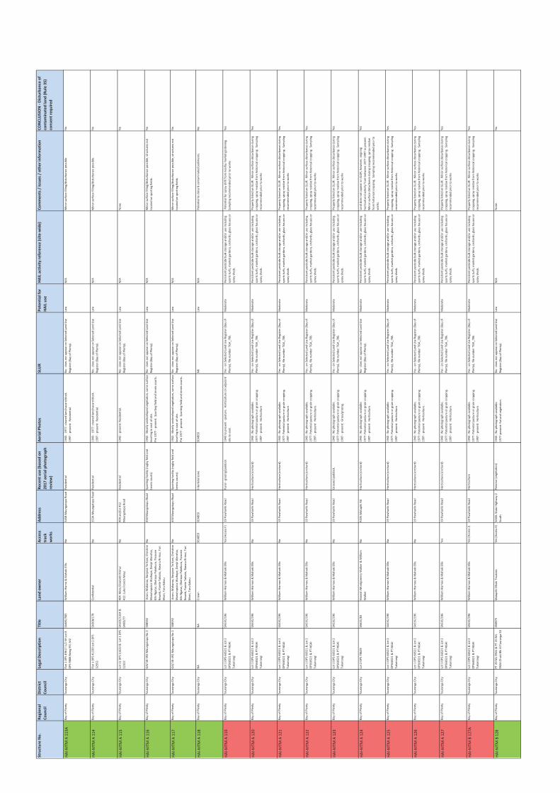
Str
uct
ure
No
.R
eg
ion
al
Co
un
cil
Dis
tric
t
Co
un
cil
Leg
al
De
scri
pti
on
Tit
leLa
nd
ow
ne
rA
cce
ss
tra
ck
wo
rks
Ad
dre
ssR
ece
nt
use
(b
ase
d o
n
20
17
ae
ria
l p
ho
tog
rap
h
rev
iew
)
Ae
ria
l P
ho
tos
SLU
RP
ote
nti
al
for
HA
IL u
se
HA
IL a
ctiv
ity
re
fere
nce
(si
te-w
ide
)C
om
me
nts
/ i
ssu
es
/ o
the
r in
form
ati
on
CO
NC
LUS
ION
- D
istu
rba
nce
of
con
tam
ina
ted
la
nd
(R
ule
35
)
con
sen
t re
qu
ire
d
HA
I-M
TM
A 1
13
AB
ay
of
Ple
nty
Ta
ura
ng
a C
ity
Fla
t 1
DP
S 4
96
17
1/2
SH
Lo
t 8
DP
S 9
88
8 B
ein
g 9
51
M2
SA
48
C/5
83
Wil
lia
m H
iam
o &
Ma
ha
ki
Ell
isN
o3
45
B M
au
ng
ata
pu
Ro
ad
Re
sid
en
tia
l1
94
3-
19
77
: cl
ea
red
la
nd
/va
can
t b
lock
.
19
97
- p
rese
nt:
R
esi
de
nti
al.
No
- d
oe
s n
ot
ap
pe
ar
on
Se
lect
ed
La
nd
Use
Re
gis
ter
(Ba
y o
f P
len
ty).
Low
N/A
Min
or
surf
ace
fil
lin
g/d
istu
rba
nce
po
ssib
le.
No
HA
I-M
TM
A 1
14
Ba
y o
f P
len
tyT
au
ran
ga
Cit
yF
lat
1 D
PS
41
33
9 L
ot
2 D
PS
32
55
2
SA
36
B/1
78
Co
nfi
de
nti
al
No
35
3A
Ma
un
ga
tap
u R
oa
dR
esi
de
nti
al
19
43
- 1
97
7:
cle
are
d l
an
d/v
aca
nt
blo
ck.
19
97
- p
rese
nt:
R
esi
de
nti
al.
No
- d
oe
s n
ot
ap
pe
ar
on
Se
lect
ed
La
nd
Use
Re
gis
ter
(Ba
y o
f P
len
ty).
Low
N/A
Min
or
surf
ace
fil
lin
g/d
istu
rba
nce
po
ssib
le.
No
HA
I-M
TM
A 1
15
Ba
y o
f P
len
tyT
au
ran
ga
Cit
yLo
t 1
1 D
PS
11
63
3 &
Lo
t 1
DP
S
12
32
2
SA
10
C/1
33
4 &
SA
9D
/77
40
4:
Ma
ry E
liza
be
th R
irin
ui
41
2:
Luk
e F
ran
cis
Me
ys
No
40
4 a
nd
/or
41
2
Ma
un
ga
tap
u R
oa
d
Re
sid
en
tia
l1
94
2 -
pre
sen
t: R
esi
de
nti
al.
No
- d
oe
s n
ot
ap
pe
ar
on
Se
lect
ed
La
nd
Use
Re
gis
ter
(Ba
y o
f P
len
ty).
Low
N/A
No
ne
.N
o
HA
I-M
TM
A 1
16
Ba
y o
f P
len
tyT
au
ran
ga
Cit
yG
AZ
58
-49
2 M
au
ng
ata
pu
No
25
08
59
2 A
na
ru W
ah
aro
a,
Bo
nje
an
Te
Ka
ni,
Ch
rist
ine
Ma
nu
ho
pu
kia
Wa
iho
pe
, D
ery
k W
ero
hia
,
Kih
i N
ga
tai,
Ok
eto
pa
Pu
ke
ku
ra,
Pa
rao
ne
Re
we
ti,
Pa
rete
Ta
ika
to,
Riw
aru
Rir
inu
i, T
ari
Mo
iri,
Ta
ru K
ak
au
No
45
0 M
au
ng
ata
pu
Ro
ad
Sp
ort
ing
fa
cili
ty (
rug
by
fie
ld a
nd
ten
nis
co
urt
s)
19
42
: M
ost
ly u
nd
ev
elo
pe
d v
eg
eta
tio
n,
som
e s
urf
ace
lev
ell
ing
in
ea
st o
f si
te.
Pre
19
77
- p
rese
nt:
S
po
rtin
g f
ield
an
d t
en
nis
co
urt
s.
No
- d
oe
s n
ot
ap
pe
ar
on
Se
lect
ed
La
nd
Use
Re
gis
ter
(Ba
y o
f P
len
ty).
Low
N/A
Min
or
surf
ace
fil
lin
g/d
istu
rba
nce
po
ssib
le,
stru
ctu
res
no
t
loca
ted
on
sp
ort
ing
fie
lds.
No
HA
I-M
TM
A 1
17
Ba
y o
f P
len
tyT
au
ran
ga
Cit
yG
AZ
58
-49
2 M
au
ng
ata
pu
No
25
08
59
2 A
na
ru W
ah
aro
a,
Bo
nje
an
Te
Ka
ni,
Ch
rist
ine
Ma
nu
ho
pu
kia
Wa
iho
pe
, D
ery
k W
ero
hia
,
Kih
i N
ga
tai,
Ok
eto
pa
Pu
ke
ku
ra,
Pa
rao
ne
Re
we
ti,
Pa
rete
Ta
ika
to,
Riw
aru
Rir
inu
i, T
ari
Mo
iri,
Ta
ru K
ak
au
No
45
0 M
au
ng
ata
pu
Ro
ad
Sp
ort
ing
fa
cili
ty (
rug
by
fie
ld a
nd
ten
nis
co
urt
s)
19
42
: M
ost
ly u
nd
ev
elo
pe
d v
eg
eta
tio
n,
som
e s
urf
ace
lev
ell
ing
in
ea
st o
f si
te.
Pre
19
77
- p
rese
nt:
S
po
rtin
g f
ield
an
d t
en
nis
co
urt
s.
No
- d
oe
s n
ot
ap
pe
ar
on
Se
lect
ed
La
nd
Use
Re
gis
ter
(Ba
y o
f P
len
ty).
Low
N/A
Min
or
surf
ace
fil
lin
g/d
istu
rba
nce
po
ssib
le,
stru
ctu
res
no
t
loca
ted
on
sp
ort
ing
fie
lds.
No
HA
I-M
TM
A 1
18
Ba
y o
f P
len
tyT
au
ran
ga
Cit
yN
AN
AC
row
nS
EA
BE
DS
EA
BE
DIn
tert
ida
l zo
ne
.S
EA
BE
DN
KLo
wN
/AP
ote
nti
al
to d
istu
rb c
on
tam
ina
ted
se
dim
en
ts.
No
HA
I-M
TM
A 1
19
Ba
y o
f P
len
tyT
au
ran
ga
Cit
yLo
t 1
DP
S 6
65
21
& L
ot
2
DP
S6
65
21
& P
T N
GA
I
Tu
ka
ira
ng
i
SA
53
C/1
96
Wil
lia
m H
iam
oe
& M
ah
ak
i E
llis
Ye
s (A
cce
ss F
)1
9 P
uw
ha
rik
i R
oa
dR
ura
l -
gra
zin
g/p
ad
do
ck1
94
3 t
o p
rese
nt
- p
ast
ure
. H
ort
icu
ltu
re o
n a
dja
cen
t
site
to
ea
st.
Ye
s -
on
Se
lect
ed
La
nd
Use
Re
gis
ter
(Ba
y o
f
Ple
nty
), f
ile
nu
mb
er
TG
A_
70
6.
Mo
de
rate
Pe
rsis
ten
t p
est
icid
e b
ulk
sto
rag
e a
nd
/or
use
in
clu
din
g
spo
rts
turf
s, m
ark
et
ga
rde
ns,
orc
ha
rds,
gla
ss h
ou
ses
or
spra
y s
he
ds.
Po
ten
tia
l fo
r sp
ray
dri
ft f
rom
ne
arb
y m
ark
et
ga
rde
nin
g.
Sa
mp
lin
g r
eco
mm
en
de
d p
rio
r to
wo
rks
Ye
s
HA
I-M
TM
A 1
20
Ba
y o
f P
len
tyT
au
ran
ga
Cit
yLo
t 1
DP
S 6
65
21
& L
ot
2
DP
S6
65
21
& P
T N
GA
I
Tu
ka
ira
ng
i
SA
53
C/1
96
Wil
lia
m H
iam
oe
& M
ah
ak
i E
llis
No
19
Pu
wh
ari
ki
Ro
ad
Ho
rtic
ult
ure
(o
rch
ard
)1
94
3 :
No
ph
oto
gra
ph
av
ail
ab
le.
19
77
: P
ote
nti
al
pa
stu
re o
r g
rain
cro
pp
ing
.
19
97
- p
rese
nt:
H
ort
icu
ltu
re.
Ye
s -
on
Se
lect
ed
La
nd
Use
Re
gis
ter
(Ba
y o
f
Ple
nty
), f
ile
nu
mb
er
TG
A_
70
6.
Mo
de
rate
Pe
rsis
ten
t p
est
icid
e b
ulk
sto
rag
e a
nd
/or
use
in
clu
din
g
spo
rts
turf
s, m
ark
et
ga
rde
ns,
orc
ha
rds,
gla
ss h
ou
ses
or
spra
y s
he
ds.
Pro
pe
rty
lis
ted
on
SLU
R.
Min
or
surf
ace
dis
turb
an
ce d
uri
ng
cro
pp
ing
, sp
ray
re
sid
ue
fro
m h
isto
rica
l cr
op
pin
g.
Sa
mp
lin
g
reco
mm
en
de
d p
rio
r to
wo
rks
Ye
s
HA
I-M
TM
A 1
21
Ba
y o
f P
len
tyT
au
ran
ga
Cit
yLo
t 1
DP
S 6
65
21
& L
ot
2
DP
S6
65
21
& P
T N
GA
I
Tu
ka
ira
ng
i
SA
53
C/1
96
Wil
lia
m H
iam
oe
& M
ah
ak
i E
llis
No
19
Pu
wh
ari
ki
Ro
ad
Ho
rtic
ult
ure
(o
rch
ard
)1
94
3 :
No
ph
oto
gra
ph
av
ail
ab
le.
19
77
: P
ote
nti
al
pa
stu
re o
r g
rain
cro
pp
ing
.
19
97
- p
rese
nt:
H
ort
icu
ltu
re.
Ye
s -
on
Se
lect
ed
La
nd
Use
Re
gis
ter
(Ba
y o
f
Ple
nty
), f
ile
nu
mb
er
TG
A_
70
6.
Mo
de
rate
Pe
rsis
ten
t p
est
icid
e b
ulk
sto
rag
e a
nd
/or
use
in
clu
din
g
spo
rts
turf
s, m
ark
et
ga
rde
ns,
orc
ha
rds,
gla
ss h
ou
ses
or
spra
y s
he
ds.
Pro
pe
rty
lis
ted
on
SLU
R.
Min
or
surf
ace
dis
turb
an
ce d
uri
ng
cro
pp
ing
, sp
ray
re
sid
ue
fro
m h
isto
rica
l cr
op
pin
g.
Sa
mp
lin
g
reco
mm
en
de
d p
rio
r to
wo
rks
Ye
s
HA
I-M
TM
A 1
22
Ba
y o
f P
len
tyT
au
ran
ga
Cit
yLo
t 1
DP
S 6
65
21
& L
ot
2
DP
S6
65
21
& P
T N
GA
I
Tu
ka
ira
ng
i
SA
53
C/1
96
Wil
lia
m H
iam
oe
& M
ah
ak
i E
llis
No
19
Pu
wh
ari
ki
Ro
ad
Ho
rtic
ult
ure
(o
rch
ard
)1
94
3 :
No
ph
oto
gra
ph
av
ail
ab
le.
19
77
: P
ote
nti
al
pa
stu
re o
r g
rain
cro
pp
ing
.
19
97
- p
rese
nt:
H
ort
icu
ltu
re.
Ye
s -
on
Se
lect
ed
La
nd
Use
Re
gis
ter
(Ba
y o
f
Ple
nty
), f
ile
nu
mb
er
TG
A_
70
6.
Mo
de
rate
Pe
rsis
ten
t p
est
icid
e b
ulk
sto
rag
e a
nd
/or
use
in
clu
din
g
spo
rts
turf
s, m
ark
et
ga
rde
ns,
orc
ha
rds,
gla
ss h
ou
ses
or
spra
y s
he
ds.
Pro
pe
rty
lis
ted
on
SLU
R.
Min
or
surf
ace
dis
turb
an
ce d
uri
ng
cro
pp
ing
, sp
ray
re
sid
ue
fro
m h
isto
rica
l cr
op
pin
g.
Sa
mp
lin
g
reco
mm
en
de
d p
rio
r to
wo
rks
Ye
s
HA
I-M
TM
A 1
23
Ba
y o
f P
len
tyT
au
ran
ga
Cit
yLo
t 1
DP
S 6
65
21
& L
ot
2
DP
S6
65
21
& P
T N
GA
I
Tu
ka
ira
ng
i
SA
53
C/1
96
Wil
lia
m H
iam
oe
& M
ah
ak
i E
llis
No
19
Pu
wh
ari
ki
Ro
ad
Gra
sse
d p
ad
do
ck.
19
43
: N
o p
ho
tog
rap
h a
va
ila
ble
.
19
77
: P
ote
nti
al
pa
stu
re o
r g
rain
cro
pp
ing
.
19
97
- p
rese
nt:
G
rass
/gra
zin
g.
Ye
s -
on
Se
lect
ed
La
nd
Use
Re
gis
ter
(Ba
y o
f
Ple
nty
), f
ile
nu
mb
er
TG
A_
70
6.
Mo
de
rate
Pe
rsis
ten
t p
est
icid
e b
ulk
sto
rag
e a
nd
/or
use
in
clu
din
g
spo
rts
turf
s, m
ark
et
ga
rde
ns,
orc
ha
rds,
gla
ss h
ou
ses
or
spra
y s
he
ds.
Pro
pe
rty
lis
ted
on
SLU
R.
Min
or
surf
ace
dis
turb
an
ce d
uri
ng
cro
pp
ing
, sp
ray
re
sid
ue
fro
m h
isto
rica
l cr
op
pin
g.
Sa
mp
lin
g
reco
mm
en
de
d p
rio
r to
wo
rks
Ye
s
HA
I-M
TM
A 1
24
Ba
y o
f P
len
tyT
au
ran
ga
Cit
yLo
t 2
DP
S 7
86
29
SA
62
C/8
3H
an
na
h M
on
tgo
me
ry W
alk
er
& W
illi
am
Wa
lke
r
No
R3
35
Ma
tap
ihi
Rd
Ho
rtic
ult
ure
(o
rch
ard
)1
94
3 :
No
ph
oto
gra
ph
av
ail
ab
le.
19
77
: P
ote
nti
al
pa
stu
re o
r g
rain
cro
pp
ing
.
19
97
- p
rese
nt:
H
ort
icu
ltu
re.
No
- d
oe
s n
ot
ap
pe
ar
on
Se
lect
ed
La
nd
Use
Re
gis
ter
(Ba
y o
f P
len
ty).
Mo
de
rate
Pe
rsis
ten
t p
est
icid
e b
ulk
sto
rag
e a
nd
/or
use
in
clu
din
g
spo
rts
turf
s, m
ark
et
ga
rde
ns,
orc
ha
rds,
gla
ss h
ou
ses
or
spra
y s
he
ds.
Lan
d d
oe
s n
ot
ap
pe
ar
on
SLU
R,
ho
we
ve
r, o
ng
oin
g
ho
rtic
ult
ura
l a
ctiv
ity
fro
m b
etw
ee
n 1
97
7-1
99
7 t
o p
rese
nt.
Min
or
surf
ace
dis
turb
an
ce d
uri
ng
cro
pp
ing
, sp
ray
re
sid
ue
fro
m h
isto
rica
l cr
op
pin
g.
Sa
mp
lin
g r
eco
mm
en
de
d p
rio
r to
wo
rks.
Ye
s
HA
I-M
TM
A 1
25
Ba
y o
f P
len
tyT
au
ran
ga
Cit
yLo
t 1
DP
S 6
65
21
& L
ot
2
DP
S6
65
21
& P
T N
GA
I
Tu
ka
ira
ng
i
SA
53
C/1
96
Wil
lia
m H
iam
oe
& M
ah
ak
i E
llis
No
19
Pu
wh
ari
ki
Ro
ad
Ho
rtic
ult
ure
(o
rch
ard
)1
94
3 :
No
ph
oto
gra
ph
av
ail
ab
le.
19
77
: P
ote
nti
al
pa
stu
re o
r g
rain
cro
pp
ing
.
19
97
- p
rese
nt:
H
ort
icu
ltu
re.
Ye
s -
on
Se
lect
ed
La
nd
Use
Re
gis
ter
(Ba
y o
f
Ple
nty
), f
ile
nu
mb
er
TG
A_
70
6.
Mo
de
rate
Pe
rsis
ten
t p
est
icid
e b
ulk
sto
rag
e a
nd
/or
use
in
clu
din
g
spo
rts
turf
s, m
ark
et
ga
rde
ns,
orc
ha
rds,
gla
ss h
ou
ses
or
spra
y s
he
ds.
Pro
pe
rty
lis
ted
on
SLU
R.
Min
or
surf
ace
dis
turb
an
ce d
uri
ng
cro
pp
ing
, sp
ray
re
sid
ue
fro
m h
isto
rica
l cr
op
pin
g.
Sa
mp
lin
g
reco
mm
en
de
d p
rio
r to
wo
rks
Ye
s
HA
I-M
TM
A 1
26
Ba
y o
f P
len
tyT
au
ran
ga
Cit
yLo
t 1
DP
S 6
65
21
& L
ot
2
DP
S6
65
21
& P
T N
GA
I
Tu
ka
ira
ng
i
SA
53
C/1
96
Wil
lia
m H
iam
oe
& M
ah
ak
i E
llis
No
19
Pu
wh
ari
ki
Ro
ad
Ho
rtic
ult
ure
(o
rch
ard
)1
94
3 :
No
ph
oto
gra
ph
av
ail
ab
le.
19
77
: P
ote
nti
al
pa
stu
re o
r g
rain
cro
pp
ing
.
19
97
- p
rese
nt:
H
ort
icu
ltu
re.
Ye
s -
on
Se
lect
ed
La
nd
Use
Re
gis
ter
(Ba
y o
f
Ple
nty
), f
ile
nu
mb
er
TG
A_
70
6.
Mo
de
rate
Pe
rsis
ten
t p
est
icid
e b
ulk
sto
rag
e a
nd
/or
use
in
clu
din
g
spo
rts
turf
s, m
ark
et
ga
rde
ns,
orc
ha
rds,
gla
ss h
ou
ses
or
spra
y s
he
ds.
Pro
pe
rty
lis
ted
on
SLU
R.
Min
or
surf
ace
dis
turb
an
ce d
uri
ng
cro
pp
ing
, sp
ray
re
sid
ue
fro
m h
isto
rica
l cr
op
pin
g.
Sa
mp
lin
g
reco
mm
en
de
d p
rio
r to
wo
rks
Ye
s
HA
I-M
TM
A 1
27
Ba
y o
f P
len
tyT
au
ran
ga
Cit
yLo
t 1
DP
S 6
65
21
& L
ot
2
DP
S6
65
21
& P
T N
GA
I
Tu
ka
ira
ng
i
SA
53
C/1
96
Wil
lia
m H
iam
oe
& M
ah
ak
i E
llis
Ye
s1
9 P
uw
ha
rik
i R
oa
dH
ort
icu
ltu
re (
orc
ha
rd)
19
43
: N
o p
ho
tog
rap
h a
va
ila
ble
.
19
77
: P
ote
nti
al
pa
stu
re o
r g
rain
cro
pp
ing
.
19
97
- p
rese
nt:
H
ort
icu
ltu
re.
Ye
s -
on
Se
lect
ed
La
nd
Use
Re
gis
ter
(Ba
y o
f
Ple
nty
), f
ile
nu
mb
er
TG
A_
70
6.
Mo
de
rate
Pe
rsis
ten
t p
est
icid
e b
ulk
sto
rag
e a
nd
/or
use
in
clu
din
g
spo
rts
turf
s, m
ark
et
ga
rde
ns,
orc
ha
rds,
gla
ss h
ou
ses
or
spra
y s
he
ds.
Pro
pe
rty
lis
ted
on
SLU
R.
Min
or
surf
ace
dis
turb
an
ce d
uri
ng
cro
pp
ing
, sp
ray
re
sid
ue
fro
m h
isto
rica
l cr
op
pin
g.
Sa
mp
lin
g
reco
mm
en
de
d p
rio
r to
wo
rks
Ye
s
HA
I-M
TM
B 1
27
AB
ay
of
Ple
nty
Ta
ura
ng
a C
ity
Lot
1 D
PS
66
52
1 &
Lo
t 2
DP
S6
65
21
& P
T N
GA
I
Tu
ka
ira
ng
i
SA
53
C/1
96
Wil
lia
m H
iam
oe
& M
ah
ak
i E
llis
Ye
s (A
cce
ss J
)1
9 P
uw
ha
rik
i R
oa
dH
ort
icu
ltu
re1
94
3 :
No
ph
oto
gra
ph
av
ail
ab
le.
19
77
: P
ote
nti
al
pa
stu
re o
r g
rain
cro
pp
ing
.
19
97
- p
rese
nt:
H
ort
icu
ltu
re.
Ye
s -
on
Se
lect
ed
La
nd
Use
Re
gis
ter
(Ba
y o
f
Ple
nty
), f
ile
nu
mb
er
TG
A_
70
6.
Mo
de
rate
Pe
rsis
ten
t p
est
icid
e b
ulk
sto
rag
e a
nd
/or
use
in
clu
din
g
spo
rts
turf
s, m
ark
et
ga
rde
ns,
orc
ha
rds,
gla
ss h
ou
ses
or
spra
y s
he
ds.
Pro
pe
rty
lis
ted
on
SLU
R.
Min
or
surf
ace
dis
turb
an
ce d
uri
ng
cro
pp
ing
, sp
ray
re
sid
ue
fro
m h
isto
rica
l cr
op
pin
g.
Sa
mp
lin
g
reco
mm
en
de
d p
rio
r to
wo
rks
Ye
s
HA
I-M
TM
B 1
28
Ba
y o
f P
len
tyT
au
ran
ga
Cit
yP
T 2
D M
L 9
92
4 &
PT
2D
ML
99
24
Oh
uk
i B
lk X
I T
au
ran
ga
SD
45
08
75
Ma
tap
ihi
Oh
uk
i T
rust
ee
sY
es
(Acc
ess
K)
50
43
L S
tate
Hig
hw
ay
2
So
uth
Re
serv
e (
ve
ge
tati
on
)1
94
3 :
No
ph
oto
gra
ph
av
ail
ab
le.
19
77
-pre
sen
t: N
atu
ral
ve
ge
tati
on
.
No
- d
oe
s n
ot
ap
pe
ar
on
Se
lect
ed
La
nd
Use
Re
gis
ter
(Ba
y o
f P
len
ty).
Low
N/A
No
ne
.N
o

Str
uct
ure
No
.R
eg
ion
al
Co
un
cil
Dis
tric
t
Co
un
cil
Leg
al
De
scri
pti
on
Tit
leLa
nd
ow
ne
rA
cce
ss
tra
ck
wo
rks
Ad
dre
ssR
ece
nt
use
(b
ase
d o
n
20
17
ae
ria
l p
ho
tog
rap
h
rev
iew
)
Ae
ria
l P
ho
tos
SLU
RP
ote
nti
al
for
HA
IL u
se
HA
IL a
ctiv
ity
re
fere
nce
(si
te-w
ide
)C
om
me
nts
/ i
ssu
es
/ o
the
r in
form
ati
on
CO
NC
LUS
ION
- D
istu
rba
nce
of
con
tam
ina
ted
la
nd
(R
ule
35
)
con
sen
t re
qu
ire
d
HA
I-M
TM
B 2
8A
Ba
y o
f P
len
tyT
au
ran
ga
Cit
yN
KN
KN
ew
Ze
ala
nd
Tra
nsp
ort
Ag
en
cyN
oS
tate
Hig
hw
ay
29
A r
oa
d
rese
rve
Ro
ad
re
serv
e1
94
3:
Pa
stu
re.
19
77
: A
rea
po
ssib
ly c
ut
for
ea
sem
en
t. N
o s
tru
ctu
res
vis
ible
. S
urr
ou
nd
ing
la
nd
re
sid
en
tia
l d
ev
elo
pm
en
t.
19
97
- p
rese
nt:
Hig
hw
ay
ro
ad
sid
e r
ese
rve
, d
istu
rbe
d
gro
un
d.
NK
Ne
gli
gib
leN
/AP
ote
nti
al
dis
turb
ed
na
tura
l m
ate
ria
l/o
ve
rbu
rde
n f
rom
con
stru
ctio
n o
f S
tate
Hig
hw
ay
29
A.
Pre
vio
us
use
pa
stu
re.
No
HA
I-M
TM
B 2
9A
Ba
y o
f P
len
tyT
au
ran
ga
Cit
yN
KN
KN
ew
Ze
ala
nd
Tra
nsp
ort
Ag
en
cyN
oS
tate
Hig
hw
ay
29
A r
oa
d
rese
rve
Ro
ad
re
serv
e1
94
3:
Pa
stu
re.
19
77
: A
rea
po
ssib
ly c
ut
for
ea
sem
en
t. N
o s
tru
ctu
res
vis
ible
. S
urr
ou
nd
ing
la
nd
re
sid
en
tia
l d
ev
elo
pm
en
t.
19
97
- p
rese
nt:
Hig
hw
ay
ro
ad
sid
e r
ese
rve
, d
istu
rbe
d
gro
un
d.
NK
Ne
gli
gib
leN
/AP
ote
nti
al
dis
turb
ed
na
tura
l m
ate
ria
l/o
ve
rbu
rde
n f
rom
con
stru
ctio
n o
f S
tate
Hig
hw
ay
29
A.
Pre
vio
us
use
pa
stu
re.
No
HA
I-M
TM
B 3
0A
Ba
y o
f P
len
tyT
au
ran
ga
Cit
yN
KN
KN
ew
Ze
ala
nd
Tra
nsp
ort
Ag
en
cyN
oS
tate
Hig
hw
ay
29
A r
oa
d
rese
rve
Ro
ad
re
serv
e1
94
3:
Pa
stu
re.
19
77
: A
rea
po
ssib
ly c
ut
for
ea
sem
en
t. N
o s
tru
ctu
res
vis
ible
. S
urr
ou
nd
ing
la
nd
re
sid
en
tia
l d
ev
elo
pm
en
t.
19
97
- p
rese
nt:
Hig
hw
ay
ro
ad
sid
e r
ese
rve
, d
istu
rbe
d
gro
un
d.
NK
Ne
gli
gib
leN
/AP
ote
nti
al
dis
turb
ed
na
tura
l m
ate
ria
l/o
ve
rbu
rde
n f
rom
con
stru
ctio
n o
f S
tate
Hig
hw
ay
29
A.
Pre
vio
us
use
pa
stu
re.
No
HA
I-M
TM
B 3
1A
Ba
y o
f P
len
tyT
au
ran
ga
Cit
yN
KN
KN
ew
Ze
ala
nd
Tra
nsp
ort
Ag
en
cyN
oS
tate
Hig
hw
ay
29
A r
oa
d
rese
rve
Ro
ad
re
serv
e1
94
3:
Pa
stu
re.
19
77
: A
rea
po
ssib
ly c
ut
for
ea
sem
en
t. N
o s
tru
ctu
res
vis
ible
. S
urr
ou
nd
ing
la
nd
re
sid
en
tia
l d
ev
elo
pm
en
t.
19
97
- p
rese
nt:
Hig
hw
ay
ro
ad
sid
e r
ese
rve
, d
istu
rbe
d
gro
un
d.
Str
uct
ure
am
on
g p
lan
ted
tre
es
(re
ve
ge
tati
on
be
twe
en
19
77
an
d 1
99
2).
NK
Ne
gli
gib
leN
/AP
ote
nti
al
dis
turb
ed
na
tura
l m
ate
ria
l/o
ve
rbu
rde
n f
rom
con
stru
ctio
n o
f S
tate
Hig
hw
ay
29
A.
Pre
vio
us
use
pa
stu
re.
No
HA
I-M
TM
B 3
2A
Ba
y o
f P
len
tyT
au
ran
ga
Cit
yN
KN
KN
ew
Ze
ala
nd
Tra
nsp
ort
Ag
en
cyN
oS
tate
Hig
hw
ay
29
A r
oa
d
rese
rve
Ro
ad
re
serv
e1
94
3:
Pa
stu
re.
19
77
: A
rea
po
ssib
ly c
ut
for
ea
sem
en
t. N
o s
tru
ctu
res
vis
ible
. S
urr
ou
nd
ing
la
nd
re
sid
en
tia
l d
ev
elo
pm
en
t.
19
97
- p
rese
nt:
Hig
hw
ay
ro
ad
sid
e r
ese
rve
, d
istu
rbe
d
gro
un
d.
Str
uct
ure
am
on
g p
lan
ted
tre
es
(re
ve
ge
tati
on
be
twe
en
19
77
an
d 1
99
2).
NK
Ne
gli
gib
leN
/AP
ote
nti
al
dis
turb
ed
na
tura
l m
ate
ria
l/o
ve
rbu
rde
n f
rom
con
stru
ctio
n o
f S
tate
Hig
hw
ay
29
A.
Pre
vio
us
use
pa
stu
re.
No
HA
I-M
TM
B 3
3A
Ba
y o
f P
len
tyT
au
ran
ga
Cit
yN
KN
KN
ew
Ze
ala
nd
Tra
nsp
ort
Ag
en
cyN
oS
tate
Hig
hw
ay
29
A r
oa
d
rese
rve
Ro
ad
re
serv
e1
94
3:
Pa
stu
re.
19
77
: A
rea
po
ssib
ly c
ut
for
ea
sem
en
t. N
o s
tru
ctu
res
vis
ible
. S
urr
ou
nd
ing
la
nd
re
sid
en
tia
l d
ev
elo
pm
en
t.
19
97
- p
rese
nt:
Hig
hw
ay
ro
ad
sid
e r
ese
rve
, d
istu
rbe
d
gro
un
d.
NK
Ne
gli
gib
leN
/AP
ote
nti
al
dis
turb
ed
na
tura
l m
ate
ria
l/o
ve
rbu
rde
n f
rom
con
stru
ctio
n o
f S
tate
Hig
hw
ay
29
A.
Pre
vio
us
use
pa
stu
re.
No
HA
I-M
TM
B 3
3B
Ba
y o
f P
len
tyT
au
ran
ga
Cit
yN
KN
KN
ew
Ze
ala
nd
Tra
nsp
ort
Ag
en
cyN
oS
tate
Hig
hw
ay
29
A r
oa
d
rese
rve
Ro
ad
re
serv
e1
94
3:
Pa
stu
re.
19
77
: A
rea
po
ssib
ly c
ut
for
ea
sem
en
t. N
o s
tru
ctu
res
vis
ible
. S
urr
ou
nd
ing
la
nd
re
sid
en
tia
l d
ev
elo
pm
en
t.
19
97
- p
rese
nt:
Hig
hw
ay
ro
ad
sid
e r
ese
rve
, d
istu
rbe
d
gro
un
d.
NK
Ne
gli
gib
leN
/AP
ote
nti
al
dis
turb
ed
na
tura
l m
ate
ria
l/o
ve
rbu
rde
n f
rom
con
stru
ctio
n o
f S
tate
Hig
hw
ay
29
A.
Pre
vio
us
use
pa
stu
re.
No
HA
I-M
TM
B 3
3C
Ba
y o
f P
len
tyT
au
ran
ga
Cit
yN
KN
KN
ew
Ze
ala
nd
Tra
nsp
ort
Ag
en
cyN
oS
tate
Hig
hw
ay
29
A r
oa
d
rese
rve
Ro
ad
re
serv
e1
94
0:
Re
serv
e a
lon
g c
ree
k l
ine
.
19
77
: A
dja
cen
t to
ne
w b
rid
ge
.
19
97
- 2
00
7:
Ro
ad
wa
y a
cce
ss t
o w
ate
r n
ext
to
bri
dg
e.
20
17
: P
av
em
en
t u
pg
rad
ed
.
NK
Low
N/A
Po
ten
tia
l d
istu
rbe
d n
atu
ral
ma
teri
al/
ov
erb
urd
en
fro
m
con
stru
ctio
n o
f S
tate
Hig
hw
ay
29
A a
nd
co
nst
ruct
ion
of
bri
dg
e/f
illi
ng
of
cre
ek
re
serv
e f
or
lev
ell
ing
.
No
HA
I-M
TM
B 3
3D
Ba
y o
f P
len
tyT
au
ran
ga
Cit
yP
T T
E N
GA
IO N
o 1
Blk
XI
Ta
ura
ng
a S
D
45
60
72
Ma
tap
ihi
Oh
uk
i T
rust
ee
sY
es
(Acc
ess
E)
29
00
L S
tate
Hig
hw
ay
2
So
uth
Ru
ral
- h
ors
e p
ad
do
ck.
19
43
to
20
07
: P
ast
ure
.
20
07
to
cu
rre
nt:
Ho
rse
pa
dd
ock
.
No
- d
oe
s n
ot
ap
pe
ar
on
Se
lect
ed
La
nd
Use
Re
gis
ter
(Ba
y o
f P
len
ty).
Low
N/A
No
ne
.N
o
HA
I-M
TM
B 3
3E
Ba
y o
f P
len
tyT
au
ran
ga
Cit
yLo
t 1
DP
S 6
65
21
& L
ot
2
DP
S6
65
21
& P
T N
GA
I
Tu
ka
ira
ng
i
SA
53
C/1
96
Wil
lia
m H
iam
oe
& M
ah
ak
i E
llis
No
19
Pu
wh
ari
ki
Ro
ad
Ru
ral
- g
razi
ng
/pa
dd
ock
19
43
- p
rese
nt:
pa
stu
re.
Ye
s -
on
Se
lect
ed
La
nd
Use
Re
gis
ter
(Ba
y o
f
Ple
nty
), f
ile
nu
mb
er
TG
A_
70
6.
Low
- m
od
era
teN
/ALo
cate
d d
ire
ctly
ad
jace
nt
to h
ort
icu
ltu
ral
lan
d u
se,
po
ten
tia
l
for
spra
y d
rift
an
d l
iste
d o
n S
LUR
Ye
s
HA
I-M
TM
B 3
8A
Ba
y o
f P
len
tyT
au
ran
ga
Cit
yN
KN
KN
ew
Ze
ala
nd
Tra
nsp
ort
Ag
en
cyN
oS
tate
Hig
hw
ay
29
A r
oa
d
rese
rve
Ro
ad
re
serv
e1
94
3 :
No
ph
oto
gra
ph
av
ail
ab
le.
19
77
-pre
sen
t:
Ro
ad
sid
e r
ese
rve
.
NK
Low
N/A
Po
ten
tia
l d
istu
rbe
d n
atu
ral
ma
teri
al/
ov
erb
urd
en
fro
m
con
stru
ctio
n o
f S
tate
Hig
hw
ay
29
A.
Pre
vio
us
use
pa
stu
re.
So
me
po
ten
tia
l fo
r sp
ray
dri
ft f
rom
ad
jace
nt
site
, h
ow
ev
er
larg
e h
ed
ge
row
s b
ord
eri
ng
cro
pp
ing
an
d d
rift
lik
ely
to
be
min
ima
l.
No
HA
I-M
TM
B 3
9B
ay
of
Ple
nty
Ta
ura
ng
a C
ity
NK
NK
Ne
w Z
ea
lan
d T
ran
spo
rt A
ge
ncy
No
Sta
te H
igh
wa
y 2
9A
ro
ad
rese
rve
Ro
ad
re
serv
e1
94
3 :
No
ph
oto
gra
ph
av
ail
ab
le.
19
77
-pre
sen
t:
Ro
ad
sid
e r
ese
rve
.
NK
Low
N/A
Po
ten
tia
l d
istu
rbe
d n
atu
ral
ma
teri
al/
ov
erb
urd
en
fro
m
con
stru
ctio
n o
f S
tate
Hig
hw
ay
29
A.
Pre
vio
us
use
pa
stu
re.
So
me
po
ten
tia
l fo
r sp
ray
dri
ft f
rom
ad
jace
nt
site
, h
ow
ev
er
larg
e h
ed
ge
row
s b
ord
eri
ng
cro
pp
ing
an
d d
rift
lik
ely
to
be
min
ima
l.
No
HA
I-M
TM
B 3
9A
Ba
y o
f P
len
tyT
au
ran
ga
Cit
yN
KN
KN
ew
Ze
ala
nd
Tra
nsp
ort
Ag
en
cyN
oS
tate
Hig
hw
ay
29
A r
oa
d
rese
rve
Ro
ad
re
serv
e1
94
3 :
No
ph
oto
gra
ph
av
ail
ab
le.
19
77
-pre
sen
t:
Ro
ad
sid
e r
ese
rve
.
NK
Low
N/A
Po
ten
tia
l d
istu
rbe
d n
atu
ral
ma
teri
al/
ov
erb
urd
en
fro
m
con
stru
ctio
n o
f S
tate
Hig
hw
ay
29
A.
Pre
vio
us
use
pa
stu
re.
So
me
po
ten
tia
l fo
r sp
ray
dri
ft f
rom
ad
jace
nt
site
, h
ow
ev
er
larg
e h
ed
ge
row
s b
ord
eri
ng
cro
pp
ing
an
d d
rift
lik
ely
to
be
min
ima
l.
No
HA
I-M
TM
B 4
0A
Ba
y o
f P
len
tyT
au
ran
ga
Cit
yN
KN
KN
ew
Ze
ala
nd
Tra
nsp
ort
Ag
en
cyN
oS
tate
Hig
hw
ay
29
A r
oa
d
rese
rve
Ro
ad
re
serv
e1
94
3 :
No
ph
oto
gra
ph
av
ail
ab
le.
19
77
-pre
sen
t:
Ro
ad
sid
e r
ese
rve
.
NK
Low
N/A
Po
ten
tia
l d
istu
rbe
d n
atu
ral
ma
teri
al/
ov
erb
urd
en
fro
m
con
stru
ctio
n o
f S
tate
Hig
hw
ay
29
A.
Pre
vio
us
use
pa
stu
re.
So
me
po
ten
tia
l fo
r sp
ray
dri
ft f
rom
ad
jace
nt
site
, h
ow
ev
er
larg
e h
ed
ge
row
s b
ord
eri
ng
cro
pp
ing
an
d d
rift
lik
ely
to
be
min
ima
l.
No
HA
I-M
TM
B 4
1A
Ba
y o
f P
len
tyT
au
ran
ga
Cit
yN
KN
KN
ew
Ze
ala
nd
Tra
nsp
ort
Ag
en
cyN
oS
tate
Hig
hw
ay
29
A r
oa
d
rese
rve
Ro
ad
re
serv
e1
94
3 :
No
ph
oto
gra
ph
av
ail
ab
le.
19
77
-pre
sen
t:
Ro
ad
sid
e r
ese
rve
.
NK
Low
N/A
Po
ten
tia
l d
istu
rbe
d n
atu
ral
ma
teri
al/
ov
erb
urd
en
fro
m
con
stru
ctio
n o
f S
tate
Hig
hw
ay
29
A.
Pre
vio
us
use
pa
stu
re.
So
me
po
ten
tia
l fo
r sp
ray
dri
ft f
rom
ad
jace
nt
site
, h
ow
ev
er
larg
e h
ed
ge
row
s b
ord
eri
ng
cro
pp
ing
an
d d
rift
lik
ely
to
be
min
ima
l.
No
HA
I-M
TM
B 4
2A
Ba
y o
f P
len
tyT
au
ran
ga
Cit
yN
KN
KN
ew
Ze
ala
nd
Tra
nsp
ort
Ag
en
cyN
oS
tate
Hig
hw
ay
29
A r
oa
d
rese
rve
Ro
ad
re
serv
e1
94
3 :
No
ph
oto
gra
ph
av
ail
ab
le.
19
77
-pre
sen
t:
Ro
ad
sid
e r
ese
rve
.
NK
Low
N/A
Po
ten
tia
l d
istu
rbe
d n
atu
ral
ma
teri
al/
ov
erb
urd
en
fro
m
con
stru
ctio
n o
f S
tate
Hig
hw
ay
29
A.
Pre
vio
us
use
pa
stu
re.
So
me
po
ten
tia
l fo
r sp
ray
dri
ft f
rom
ad
jace
nt
site
, h
ow
ev
er
larg
e h
ed
ge
row
s b
ord
eri
ng
cro
pp
ing
an
d d
rift
lik
ely
to
be
min
ima
l.
No
HA
I-M
TM
B 4
3A
Ba
y o
f P
len
tyT
au
ran
ga
Cit
yN
KN
KN
ew
Ze
ala
nd
Tra
nsp
ort
Ag
en
cyN
oS
tate
Hig
hw
ay
29
A r
oa
d
rese
rve
Ro
ad
re
serv
e1
94
3 :
No
ph
oto
gra
ph
av
ail
ab
le.
19
77
-pre
sen
t:
Ro
ad
sid
e r
ese
rve
.
NK
Low
N/A
Po
ten
tia
l d
istu
rbe
d n
atu
ral
ma
teri
al/
ov
erb
urd
en
fro
m
con
stru
ctio
n o
f S
tate
Hig
hw
ay
29
A.
Pre
vio
us
use
pa
stu
re.
So
me
po
ten
tia
l fo
r sp
ray
dri
ft f
rom
ad
jace
nt
site
, h
ow
ev
er
larg
e h
ed
ge
row
s b
ord
eri
ng
cro
pp
ing
an
d d
rift
lik
ely
to
be
min
ima
l.
No

Str
uct
ure
No
.R
eg
ion
al
Co
un
cil
Dis
tric
t
Co
un
cil
Leg
al
De
scri
pti
on
Tit
leLa
nd
ow
ne
rA
cce
ss
tra
ck
wo
rks
Ad
dre
ssR
ece
nt
use
(b
ase
d o
n
20
17
ae
ria
l p
ho
tog
rap
h
rev
iew
)
Ae
ria
l P
ho
tos
SLU
RP
ote
nti
al
for
HA
IL u
se
HA
IL a
ctiv
ity
re
fere
nce
(si
te-w
ide
)C
om
me
nts
/ i
ssu
es
/ o
the
r in
form
ati
on
CO
NC
LUS
ION
- D
istu
rba
nce
of
con
tam
ina
ted
la
nd
(R
ule
35
)
con
sen
t re
qu
ire
d
HA
I-M
TM
B 4
3B
Ba
y o
f P
len
tyT
au
ran
ga
Cit
yN
KN
KN
ew
Ze
ala
nd
Tra
nsp
ort
Ag
en
cyN
oS
tate
Hig
hw
ay
29
A r
oa
d
rese
rve
Ro
ad
re
serv
e1
94
3 :
No
ph
oto
gra
ph
av
ail
ab
le.
19
77
-pre
sen
t:
Ro
ad
sid
e r
ese
rve
.
NK
Low
N/A
Po
ten
tia
l d
istu
rbe
d n
atu
ral
ma
teri
al/
ov
erb
urd
en
fro
m
con
stru
ctio
n o
f S
tate
Hig
hw
ay
29
A.
Pre
vio
us
use
pa
stu
re.
So
me
po
ten
tia
l fo
r sp
ray
dri
ft f
rom
ad
jace
nt
site
, h
ow
ev
er
larg
e h
ed
ge
row
s b
ord
eri
ng
cro
pp
ing
an
d d
rift
lik
ely
to
be
min
ima
l.
No
HA
I-M
TM
B 4
4C
Ba
y o
f P
len
tyT
au
ran
ga
Cit
yN
KN
KN
ew
Ze
ala
nd
Tra
nsp
ort
Ag
en
cyN
oS
tate
Hig
hw
ay
29
A r
oa
d
rese
rve
Ro
ad
re
serv
e1
94
3 :
No
ph
oto
gra
ph
av
ail
ab
le.
19
77
:-p
rese
nt:
R
oa
dsi
de
re
serv
e.
NK
Low
N/A
Po
ten
tia
l d
istu
rbe
d n
atu
ral
ma
teri
al/
ov
erb
urd
en
fro
m
con
stru
ctio
n o
f S
tate
Hig
hw
ay
29
A.
Pre
vio
us
use
pa
stu
re.
So
me
po
ten
tia
l fo
r sp
ray
dri
ft f
rom
ad
jace
nt
site
, h
ow
ev
er
larg
e h
ed
ge
row
s b
ord
eri
ng
cro
pp
ing
an
d d
rift
lik
ely
to
be
min
ima
l.
No
HA
I-M
TM
B 4
5A
Ba
y o
f P
len
tyT
au
ran
ga
Cit
yN
KN
KN
ew
Ze
ala
nd
Tra
nsp
ort
Ag
en
cyN
oS
tate
Hig
hw
ay
29
A r
oa
d
rese
rve
Ro
ad
re
serv
e1
94
3 :
No
ph
oto
gra
ph
av
ail
ab
le.
19
77
:-p
rese
nt:
R
oa
dsi
de
re
serv
e.
NK
Low
N/A
Po
ten
tia
l d
istu
rbe
d n
atu
ral
ma
teri
al/
ov
erb
urd
en
fro
m
con
stru
ctio
n o
f S
tate
Hig
hw
ay
29
A.
Pre
vio
us
use
pa
stu
re.
So
me
po
ten
tia
l fo
r sp
ray
dri
ft f
rom
ad
jace
nt
site
, h
ow
ev
er
larg
e h
ed
ge
row
s b
ord
eri
ng
cro
pp
ing
an
d d
rift
lik
ely
to
be
min
ima
l.
No
HA
I-M
TM
B 4
7B
ay
of
Ple
nty
Ta
ura
ng
a C
ity
NK
NK
Ne
w Z
ea
lan
d T
ran
spo
rt A
ge
ncy
No
Sta
te H
igh
wa
y 2
9A
ro
ad
rese
rve
Ro
ad
re
serv
e1
94
3 :
No
ph
oto
gra
ph
av
ail
ab
le.
19
77
-pre
sen
t:
Ro
ad
sid
e r
ese
rve
.
NK
Low
N/A
Po
ten
tia
l d
istu
rbe
d n
atu
ral
ma
teri
al/
ov
erb
urd
en
fro
m
con
stru
ctio
n o
f S
tate
Hig
hw
ay
29
A.
Pre
vio
us
use
pa
stu
re.
So
me
po
ten
tia
l fo
r sp
ray
dri
ft f
rom
ad
jace
nt
site
, h
ow
ev
er
larg
e h
ed
ge
row
s b
ord
eri
ng
cro
pp
ing
an
d d
rift
lik
ely
to
be
min
ima
l.
No
HA
I-M
TM
B 4
7A
Ba
y o
f P
len
tyT
au
ran
ga
Cit
yN
KN
KN
ew
Ze
ala
nd
Tra
nsp
ort
Ag
en
cyN
oS
tate
Hig
hw
ay
29
A r
oa
d
rese
rve
Ro
ad
re
serv
e1
94
3 :
No
ph
oto
gra
ph
av
ail
ab
le.
19
77
:-p
rese
nt:
R
oa
dsi
de
re
serv
e.
NK
Low
N/A
Po
ten
tia
l d
istu
rbe
d n
atu
ral
ma
teri
al/
ov
erb
urd
en
fro
m
con
stru
ctio
n o
f S
tate
Hig
hw
ay
29
A.
Pre
vio
us
use
pa
stu
re.
So
me
po
ten
tia
l fo
r sp
ray
dri
ft f
rom
ad
jace
nt
site
, h
ow
ev
er
larg
e h
ed
ge
row
s b
ord
eri
ng
cro
pp
ing
an
d d
rift
lik
ely
to
be
min
ima
l.
No
HA
I-M
TM
B 4
8B
ay
of
Ple
nty
Ta
ura
ng
a C
ity
NK
NK
Ne
w Z
ea
lan
d T
ran
spo
rt A
ge
ncy
No
Sta
te H
igh
wa
y 2
9A
ro
ad
rese
rve
Ro
ad
re
serv
e1
94
3 :
No
ph
oto
gra
ph
av
ail
ab
le.
19
77
-pre
sen
t:
Ro
ad
sid
e r
ese
rve
.
NK
Low
N/A
Po
ten
tia
l d
istu
rbe
d n
atu
ral
ma
teri
al/
ov
erb
urd
en
fro
m
con
stru
ctio
n o
f S
tate
Hig
hw
ay
29
A.
Pre
vio
us
use
pa
stu
re.
So
me
po
ten
tia
l fo
r sp
ray
dri
ft f
rom
ad
jace
nt
site
, h
ow
ev
er
larg
e h
ed
ge
row
s b
ord
eri
ng
cro
pp
ing
an
d d
rift
lik
ely
to
be
min
ima
l.
No
HA
I-M
TM
B 4
8A
Ba
y o
f P
len
tyT
au
ran
ga
Cit
yN
KN
KN
ew
Ze
ala
nd
Tra
nsp
ort
Ag
en
cyN
oS
tate
Hig
hw
ay
29
A r
oa
d
rese
rve
Ro
ad
re
serv
e1
94
3 :
No
ph
oto
gra
ph
av
ail
ab
le.
19
77
-pre
sen
t:
Ro
ad
sid
e r
ese
rve
.
NK
Low
N/A
Po
ten
tia
l d
istu
rbe
d n
atu
ral
ma
teri
al/
ov
erb
urd
en
fro
m
con
stru
ctio
n o
f S
tate
Hig
hw
ay
29
A.
Pre
vio
us
use
pa
stu
re.
So
me
po
ten
tia
l fo
r sp
ray
dri
ft f
rom
ad
jace
nt
site
, h
ow
ev
er
larg
e h
ed
ge
row
s b
ord
eri
ng
cro
pp
ing
an
d d
rift
lik
ely
to
be
min
ima
l.
No
HA
I-M
TM
B 4
8B
Ba
y o
f P
len
tyT
au
ran
ga
Cit
yN
KN
KN
ew
Ze
ala
nd
Tra
nsp
ort
Ag
en
cyN
oS
tate
Hig
hw
ay
29
A r
oa
d
rese
rve
Ro
ad
re
serv
e1
94
3 :
No
ph
oto
gra
ph
av
ail
ab
le.
19
77
:-p
rese
nt:
R
oa
dsi
de
re
serv
e.
NK
Low
N/A
Po
ten
tia
l d
istu
rbe
d n
atu
ral
ma
teri
al/
ov
erb
urd
en
fro
m
con
stru
ctio
n o
f S
tate
Hig
hw
ay
29
A.
Pre
vio
us
use
pa
stu
re.
So
me
po
ten
tia
l fo
r sp
ray
dri
ft f
rom
ad
jace
nt
site
, h
ow
ev
er
larg
e h
ed
ge
row
s b
ord
eri
ng
cro
pp
ing
an
d d
rift
lik
ely
to
be
min
ima
l.
No
HA
I-M
TM
B 4
8C
Ba
y o
f P
len
tyT
au
ran
ga
Cit
yLo
t 1
DP
S 6
65
21
& L
ot
2
DP
S6
65
21
& P
T N
GA
I
Tu
ka
ira
ng
i
SA
53
C/1
96
Wil
lia
m H
iam
oe
& M
ah
ak
i E
llis
Ye
s (A
cce
ss G
)1
9 P
uw
ha
rik
i R
oa
dH
ort
icu
ltu
re1
94
3 :
No
ph
oto
gra
ph
av
ail
ab
le.
19
77
: P
ote
nti
al
pa
stu
re o
r g
rain
cro
pp
ing
.
19
97
- p
rese
nt:
H
ort
icu
ltu
re.
Ye
s -
on
Se
lect
ed
La
nd
Use
Re
gis
ter
(Ba
y o
f
Ple
nty
), f
ile
nu
mb
er
TG
A_
70
6.
Mo
de
rate
Pe
rsis
ten
t p
est
icid
e b
ulk
sto
rag
e a
nd
/or
use
in
clu
din
g
spo
rts
turf
s, m
ark
et
ga
rde
ns,
orc
ha
rds,
gla
ss h
ou
ses
or
spra
y s
he
ds.
Pro
pe
rty
lis
ted
on
SLU
R.
Min
or
surf
ace
dis
turb
an
ce d
uri
ng
cro
pp
ing
, sp
ray
re
sid
ue
fro
m h
isto
rica
l cr
op
pin
g.
Sa
mp
lin
g
reco
mm
en
de
d p
rio
r to
wo
rks
Ye
s
HA
I-M
TM
B 4
8D
Ba
y o
f P
len
tyT
au
ran
ga
Cit
yLo
t 1
DP
S 6
65
21
& L
ot
2
DP
S6
65
21
& P
T N
GA
I
Tu
ka
ira
ng
i
SA
53
C/1
96
Wil
lia
m H
iam
oe
& M
ah
ak
i E
llis
Ye
s (A
cce
ss H
)1
9 P
uw
ha
rik
i R
oa
dH
ort
icu
ltu
re1
94
3 :
No
ph
oto
gra
ph
av
ail
ab
le.
19
77
: P
ote
nti
al
pa
stu
re o
r g
rain
cro
pp
ing
.
19
97
- p
rese
nt:
H
ort
icu
ltu
re.
Ye
s -
on
Se
lect
ed
La
nd
Use
Re
gis
ter
(Ba
y o
f
Ple
nty
), f
ile
nu
mb
er
TG
A_
70
6.
Mo
de
rate
Pe
rsis
ten
t p
est
icid
e b
ulk
sto
rag
e a
nd
/or
use
in
clu
din
g
spo
rts
turf
s, m
ark
et
ga
rde
ns,
orc
ha
rds,
gla
ss h
ou
ses
or
spra
y s
he
ds.
Pro
pe
rty
lis
ted
on
SLU
R.
Min
or
surf
ace
dis
turb
an
ce d
uri
ng
cro
pp
ing
, sp
ray
re
sid
ue
fro
m h
isto
rica
l cr
op
pin
g.
Sa
mp
lin
g
reco
mm
en
de
d p
rio
r to
wo
rks
Ye
s
HA
I-M
TM
B 4
8E
Ba
y o
f P
len
tyT
au
ran
ga
Cit
yLo
t 1
DP
S 6
65
21
& L
ot
2
DP
S6
65
21
& P
T N
GA
I
Tu
ka
ira
ng
i
SA
53
C/1
96
Wil
lia
m H
iam
oe
& M
ah
ak
i E
llis
Ye
s (A
cce
ss I
)1
9 P
uw
ha
rik
i R
oa
dH
ort
icu
ltu
re1
94
3 :
No
ph
oto
gra
ph
av
ail
ab
le.
19
77
: P
ote
nti
al
pa
stu
re o
r g
rain
cro
pp
ing
.
19
97
- p
rese
nt:
H
ort
icu
ltu
re.
Ye
s -
on
Se
lect
ed
La
nd
Use
Re
gis
ter
(Ba
y o
f
Ple
nty
), f
ile
nu
mb
er
TG
A_
70
6.
Mo
de
rate
Pe
rsis
ten
t p
est
icid
e b
ulk
sto
rag
e a
nd
/or
use
in
clu
din
g
spo
rts
turf
s, m
ark
et
ga
rde
ns,
orc
ha
rds,
gla
ss h
ou
ses
or
spra
y s
he
ds.
Pro
pe
rty
lis
ted
on
SLU
R.
Min
or
surf
ace
dis
turb
an
ce d
uri
ng
cro
pp
ing
, sp
ray
re
sid
ue
fro
m h
isto
rica
l cr
op
pin
g.
Sa
mp
lin
g
reco
mm
en
de
d p
rio
r to
wo
rks
Ye
s
HA
I-M
TM
B 5
1B
ay
of
Ple
nty
Ta
ura
ng
a C
ity
NK
NK
Ne
w Z
ea
lan
d T
ran
spo
rt A
ge
ncy
No
Sta
te H
igh
wa
y 2
9A
ro
ad
rese
rve
Ro
ad
re
serv
e1
94
3 :
No
ph
oto
gra
ph
av
ail
ab
le.
19
77
:-p
rese
nt:
R
oa
dsi
de
re
serv
e.
NK
Low
N/A
Po
ten
tia
l d
istu
rbe
d n
atu
ral
ma
teri
al/
ov
erb
urd
en
fro
m
con
stru
ctio
n o
f S
tate
Hig
hw
ay
29
A.
Pre
vio
us
use
pa
stu
re.
So
me
po
ten
tia
l fo
r sp
ray
dri
ft f
rom
ad
jace
nt
site
, h
ow
ev
er
larg
e h
ed
ge
row
s b
ord
eri
ng
cro
pp
ing
an
d d
rift
lik
ely
to
be
min
ima
l.
No
HA
I-M
TM
B 4
9A
Ba
y o
f P
len
tyT
au
ran
ga
Cit
yN
KN
KN
ew
Ze
ala
nd
Tra
nsp
ort
Ag
en
cyN
oS
tate
Hig
hw
ay
29
A r
oa
d
rese
rve
Un
de
ve
lop
ed
(v
eg
eta
tio
n c
ov
er)
19
43
: N
o p
ho
tog
rap
h a
va
ila
ble
.
19
77
-pre
sen
t:
Ro
ad
sid
e r
ese
rve
.
NK
Low
N/A
Po
ten
tia
l d
istu
rbe
d n
atu
ral
ma
teri
al/
ov
erb
urd
en
fro
m
con
stru
ctio
n o
f S
tate
Hig
hw
ay
29
A.
Pre
vio
us
use
pa
stu
re.
So
me
po
ten
tia
l fo
r sp
ray
dri
ft f
rom
ad
jace
nt
site
, h
ow
ev
er
larg
e h
ed
ge
row
s b
ord
eri
ng
cro
pp
ing
an
d d
rift
lik
ely
to
be
min
ima
l.
No
HA
I-M
TM
B 5
0B
ay
of
Ple
nty
Ta
ura
ng
a C
ity
NK
NK
Ne
w Z
ea
lan
d T
ran
spo
rt A
ge
ncy
No
Sta
te H
igh
wa
y 2
9A
ro
ad
rese
rve
Ro
ad
re
serv
e1
94
3 :
No
ph
oto
gra
ph
av
ail
ab
le.
19
77
-pre
sen
t:
Ro
ad
sid
e r
ese
rve
.
NK
Low
N/A
Po
ten
tia
l d
istu
rbe
d n
atu
ral
ma
teri
al/
ov
erb
urd
en
fro
m
con
stru
ctio
n o
f S
tate
Hig
hw
ay
29
A.
Pre
vio
us
use
pa
stu
re.
Po
ten
tia
l fo
r sp
ray
dri
ft f
rom
ad
jace
nt
ho
rtic
ult
ure
.
No
No
tes:
Str
uct
ure
nu
mb
ers
ba
sed
on
pla
ns
HA
I-M
TM
A R
elo
cati
on
SS
R R
evi
sio
n A
2,
da
ted
11
-Ju
l-2
01
7
NK
: N
ot
kn
ow
n
N/A
: N
ot
ap
plic
ab
le
Legend
Consent not required under Rule 35 BOPRP
Restricted Discretionary Activity consent required (Rule 35 BOPRP)

Appendix C: Additional information
• Site contamination enquiry

Objective ID:
Your Ref: Our Ref: TGA_706
23 June 2017 James Allison Tonkin & Taylor 105 Carlton Gore Road Auckland Sent via e-mail attachment Dear James
Site contamination enquiry – 19 Puwhariki Road, Tauranga
In response to your enquiry regarding the above site, the Bay of Plenty Regional Council advises that it holds information on the Selected Land Use Register relating to Hazardous Activities and Industry List (HAIL) activity. The file number is TGA_706.
We recommend you also contact the Tauranga City Council, which may hold additional information about this site that we are unaware of.
If you wish to discuss the matter further, please contact me on 0800 884 881 extension 9453.
Yours faithfully
Emma Joss Regulatory Compliance Team Leader for Group Manager Regulatory Services
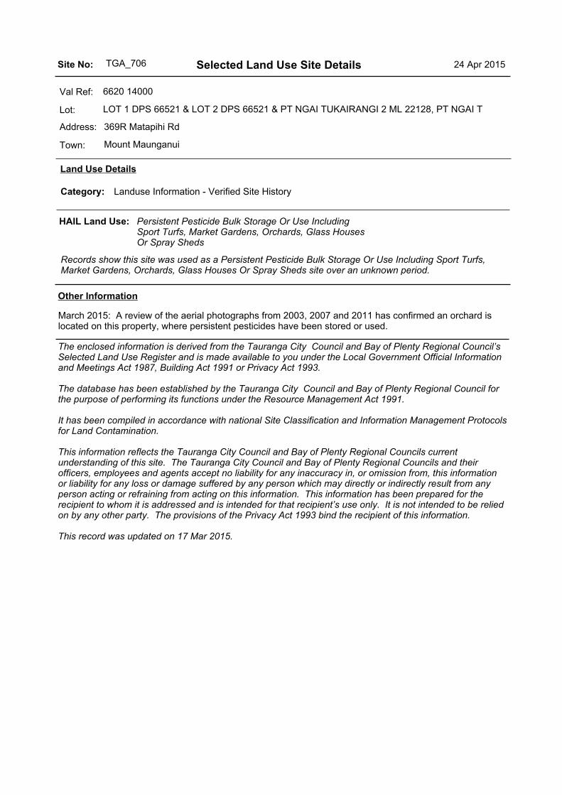
369R Matapihi Rd
6620 14000
LOT 1 DPS 66521 & LOT 2 DPS 66521 & PT NGAI TUKAIRANGI 2 ML 22128, PT NGAI T
Mount Maunganui
Val Ref:
Lot:
Address:
Town:
HAIL Land Use: Persistent Pesticide Bulk Storage Or Use Including Sport Turfs, Market Gardens, Orchards, Glass Houses Or Spray Sheds
Records show this site was used as a Persistent Pesticide Bulk Storage Or Use Including Sport Turfs, Market Gardens, Orchards, Glass Houses Or Spray Sheds site over an unknown period.
Land Use Details
Landuse Information - Verified Site HistoryCategory:
March 2015: A review of the aerial photographs from 2003, 2007 and 2011 has confirmed an orchard is located on this property, where persistent pesticides have been stored or used.
The enclosed information is derived from the Tauranga City Council and Bay of Plenty Regional Council’s Selected Land Use Register and is made available to you under the Local Government Official Information and Meetings Act 1987, Building Act 1991 or Privacy Act 1993.
The database has been established by the Tauranga City Council and Bay of Plenty Regional Council for the purpose of performing its functions under the Resource Management Act 1991.
It has been compiled in accordance with national Site Classification and Information Management Protocols for Land Contamination.
This information reflects the Tauranga City Council and Bay of Plenty Regional Councils current understanding of this site. The Tauranga City Council and Bay of Plenty Regional Councils and their officers, employees and agents accept no liability for any inaccuracy in, or omission from, this information or liability for any loss or damage suffered by any person which may directly or indirectly result from any person acting or refraining from acting on this information. This information has been prepared for the recipient to whom it is addressed and is intended for that recipient’s use only. It is not intended to be relied on by any other party. The provisions of the Privacy Act 1993 bind the recipient of this information.
This record was updated on 17 Mar 2015.
Other Information
Selected Land Use Site DetailsTGA_706Site No: 24 Apr 2015

Objective ID:
Your Ref: Our Ref: 4.01104
23 June 2017 James Allison Tonkin & Taylor 105 Carlton Gore Road Auckland Sent via e-mail attachment Dear James
Site contamination enquiry – 345, 353A, 404 & 412 Maungatapu Road and 2900L and 5043L State Highway 2 South, Tauranga
In response to your enquiry regarding the above sites, we advise that we were unable to locate any information on our register regarding Hazardous Activities and Industry List (HAIL) activity or contamination.
A HAIL activity is a past or present activity occurring on site that has the potential to cause contamination (e.g. service station, timber treatment site, horticultural site, automotive dismantlers etc). The list of HAIL activities was compiled by the Ministry for the Environment (MfE). Please view their web site for further information.
The Bay of Plenty Regional Council has not yet assessed every site in the region where a hazardous activity is, or has taken place. Therefore there is a possibility that a HAIL activity may have occurred or is occurring on the site.
If you are concerned that a HAIL activity may have taken place, the cautious way to proceed would be to undertake an independent audit of the site.
We recommend you also contact the Tauranga City Council, which may hold additional information about this site that we are unaware of.
If you wish to discuss the matter further, please contact me on 0800 884 881 extension 9453.
Yours faithfully
Emma Joss Regulatory Compliance Team Leader for Group Manager Regulatory Services