preliminary wqmp study 0010 7-22-2013
TRANSCRIPT


Table of Contents SECTION 1 Introduction and Project Description ......................................................................................... 3
1.1 Project Information ....................................................................................................................... 3
1.2 Permits .......................................................................................................................................... 3
1.3 Project Description ........................................................................................................................ 3
1.4 Site Description ........................................................................................................................... 10
SECTION 2 Pollutants of Concern and Hydrologic Conditions of Concern .................................................. 11
2.1 Pollutants Of Concern ................................................................................................................. 11
2.2 Hydrologic Conditions Of Concern .............................................................................................. 12
SECTION 3 Best Management Practice Selection Process .......................................................................... 13
3.1 Site Design BMPs ......................................................................................................................... 13
3.2 Source Control BMPs ................................................................................................................... 13
3.3 Treatment Control BMPs ............................................................................................................ 15
3.4 BMP Design Criteria .................................................................................................................... 15
SECTION 4 Operations and Maintenance ................................................................................................... 16
4.1 Operations and Maintenance ..................................................................................................... 16
SECTION 5 Funding ...................................................................................................................................... 17
5.1 Funding ........................................................................................................................................ 17
SECTION 6 WQMP Certification .................................................................................................................. 18
6.1 Certification ................................................................................................................................. 18
List of Tables Table 1: WQMP Project Categories .............................................................................................................. 2
Table 2: Pollutant of Concern Summary Table .......................................................................................... 11
Table 3: Treatment Control BMP Categories ............................................................................................. 15
List of Figures Figure 1: Site Vicinity Map ........................................................................................................................... 8
Figure 2: Developed Conditions Site Plan .................................................................................................... 9

List of Attachments Attachment A‐1 ‐ Maintenance Mechanisms
Attachment A‐2 ‐ Water Quality Management Plan and Stormwater BMP Transfer Access and
Maintenance Agreement
Attachment B Table B‐1: 303(d) List of Impaired Water Bodies Table B‐2: C Values Based on Impervious/Pervious Area Ratios
Attachment C ‐ Pollutants of Concern Attachment D ‐ Flow and Volume Based BMP Design Calculations Attachment E ‐ Source Control BMP Descriptions
1
PRELIMINARY WATER QUALITY MANAGEMENT PLAN (WQMP)
PROJECT SITE INFORMATION
Name of Project: _Loma Linda University Medical Center: Campus Transformation Project _______
Project Location: _Loma Linda, California 92354 _________________________________
Size of Significant Re‐Development on an Already Developed Site (in feet2
): _610,000a ___
Size of New Development (in feet2
): 49,000b _________________________________
Number of Home Subdivisions: _N/A ______________________________________
SIC Codes: _8068 General Medical or Hospital _____________________________
Erosive Site Conditions: __None ___________________________________________
Natural Slope More Than 25%?: __None ____________________________________
Notes: a Approximate redevelopment area based on planning level documents. Actual redevelopment area to be confirmed during final engineering/construction permit processing. b Approximate development area based on planning level documents for future electrical substation only.Actual development area to be confirmed during final engineering/construction permit processing.
2
WATER QUALITY MANAGEMENT PLAN (WQMP)
Check the appropriate project category below:
Table 1: Project Categories
X
1. All significant re‐development projects. Significant re‐development is defined as the addition or creation of 5,000 or more square feet of impervious surface on an already developed site. This includes, but is not limited to, additional buildings and/or structures, extension of existing footprint of a building, construction of parking lots, etc. Where redevelopment results in an increase of less than fifty percent of the impervious surfaces of a previously existing development, and the existing development was not subject to SUSMPs, the design standards apply only to the addition, and not the entire development. When the redevelopment results in an increase of more than fifty percent of the impervious surfaces, then a WQMP is required for the entire development (new and existing).
2. Home subdivisions of 10 units or more. This includes single family residences, multi‐family residence, condominiums, apartments, etc.
X
3. Industrial/commercial developments of 100,000 square feet or more. Commercial developments include non‐residential developments such as hospitals, educational institutions, recreational facilities, mini‐malls, hotels, office buildings, warehouses, and light industrial facilities.
4. Automotive repair shops (with SIC codes 5013, 5014, 5541, 7532‐ 7534, 7536‐7539).
5. Restaurants where the land area of development is 5,000 square feet or more.
6. Hillside developments of 10,000 square feet or more which are located on areas with known erosive soil conditions or where the natural slope is twenty‐five percent or more.
7. Developments of 2,500 square feet of impervious surface or more adjacent to (within 200 feet) or discharging directly into environmentally sensitive areas such as areas designated in the Ocean Plan as areas of special biological significance or waterbodies listed on the CWA Section 303(d) list of impaired waters.
X
8. Parking lots of 5,000 square feet or more exposed to storm water. Parking lot is defined as land area or facility for the temporary storage of motor vehicles.
The project does not fall into any of the categories described above. (If the project requires a precise plan of development [e.g. all commercial or industrial projects, residential projects of less than 10 dwelling units, and all other land development projects with potential for significant adverse water quality impacts] or subdivision of land, it is defined as a Non‐Category Project.)

3
SECTION 1 Introduction and Project Description 1.1 Project Information Name of project owner: Loma Linda University Adventist Health Sciences Center Address of project owner: P.O. Box 2000, Loma Linda, California 92354 Telephone for project owner: (909) 558‐4000 Project site address: 11234 Anderson St, Loma Linda, California 92354
1.2 Permits This preliminary report is in support of the Loma Linda University Medical Center Campus Transformation project and associated Environmental Impact Report (EIR). All permits will be applied for and acquired during the final engineering phases of the project.
1.3 Project Description The proposed Campus Transformation Project represents a multi‐phased upgrade of LLUMC’s
facilities. The Proposed Project includes a Master Plan that provides for modernization of
existing facilities including a new central plant with utility upgrades, a new dedicated electrical
substation, construction of a new research building, an addition to the dental school, a new
parking structure for patients and visitors, and a replacement of the main hospital structure in
response to California’s SB 1953 Hospital Seismic Safety Act mandate.
Proposed facilities and improvements associated with the Master Plan include: 1) a six‐story,
approximately 250,000 square‐foot, 760‐space patient and visitor parking structure; 2) a
twelve‐story, approximately 732,000 square‐foot hospital with 464 beds to replace seismically‐
noncompliant existing hospital tower, and 80 parking spaces; 3) an approximate 50,000 square‐
foot central utility plant; 4) an approximate 14,000 square‐foot Southern California Edison (SCE)
off‐site electrical substation; 5) a two‐story, approximately 9,000 square‐foot addition to the
existing dental school; 6) a four‐story approximately 90,000 square‐foot research building; and
7) tenant improvements and adaptive reuse of the vacated portions of the existing hospital.
The proposed new hospital would consist of acute care hospital space, some of which will
remain as shell space for future build out. The facility will have shared and support services
located in the first three levels of a shared podium, with two bed towers above serving separate
pediatric and adult populations. The new hospital would provide for the relocation and
decommissioning of the existing acute care services in seismically non‐compliant structures. The
new building would include approximately 464 patient beds, new Pediatric and Adult
Emergency Departments, Perioperative Suites, Imaging Departments, and other support service
departments. The total licensed capacity of the Medical Center would decrease from the
current license of 719 beds to a total of approximately 650 beds. Upon completion of the new
building and surrounding site, all inpatient functions will transfer to the new adjacent location.

4
The new parking structure would be located on the northwest corner of Barton Road and
Campus Street. The 1.9‐acre site is currently developed with 83 surface parking spaces.
Improvements would include a new access point on Barton Road and removal of the 83 surface
parking spaces. The new hospital would be located on the Project site off of Anderson Street
between Barton Road and Prospect Avenue. The area for the new hospital is currently
developed with 550 surface parking spaces. Improvements at the site would include two new
access points on Barton Road and two new road alignments on Anderson Street at Prospect
Avenue and Starr Street. The new central utility plant would be located on the Project site off of
Anderson Street between Stewart Street and the Union Pacific Railroad. The area proposed for
the central utility plant is currently developed with 40 surface parking spaces and a 10,000
square‐foot Housekeeping Building (formerly the Radiation Safety Building), which would be
demolished to allow for construction of the central utility plant. A new SCE electrical substation
would be needed to serve the Proposed Project and would be located on a 1.3‐acre City Park
site located on Anderson Street just north of the UPRR.
The 8,900‐square foot dental school addition would occur on the north side of the existing
School of Dentistry (Prince Hall) located at 11029 University Avenue. Approximately 3,000
square feet of the existing building will need to be remodeled to accommodate the addition.
The addition will be designed to complement the existing architecture and fit appropriately up
to the cul‐de‐sac.
A new 90,000‐square‐foot research facility is proposed on or near the site of Risley Hall, an
existing laboratory and classroom building. The new facility will provide expanded laboratory
and research office space as well as space for new high‐tech research modalities to allow for
increased interdisciplinary research. The facility is planned to be a three to four‐story structural
steel building approximately 50 feet in height.
The Proposed Project would occur within two phases over an approximate 10‐year period. A
description of Phases 1 and 2 is provided herein.
PHASE 1: New Parking Structure, Make Ready, Hospital Tower, and SCE Substation
New Patient and Visitor Parking Structure: In order to maintain operations during the
construction of the new hospital, a six‐level, 720‐space parking structure would be constructed
east of Campus Street adjacent to the existing hospital’s South Tower to replace the existing
surface lots on the site of the new hospital. Construction of the parking structure would require
the demolition of approximately 83 surface parking stalls currently dedicated to hospital
administration. Modifications to site access, circulation and various landscaping improvements
are proposed. A new access point from Barton Road is also proposed for the parking structure.
5
On‐site make ready work: Site clearing and excavation for the new hospital footprint would
include temporary relocation and rerouting of various underground utilities. As these utilities
serve the existing acute care buildings, a building permit from Office of Statewide Health
Planning and Development (OSHPD) would be required. West of Anderson Street and north of
Barton Road the new hospital footprint would result in the demolition of approximately 550
surface parking spaces and require a new site access point to align with Prospect Avenue.
Modifications to site access, circulation and various landscaping improvements are also
proposed.
New Hospital: Proposed construction includes a 732,000 square‐foot acute care hospital, with
portions to remain as shell space for future build out. The hospital would have support services
located in the first three levels of a shared podium, with bed towers above serving separate
pediatric and adult populations. The new hospital would provide for the relocation and
decommissioning of the existing acute care services that are currently in existing buildings that
SB1953 will deem as seismically non‐compliant structures starting in the year 2020. The new
building will include approximately 464 private patient bedrooms, new pediatric and adult
emergency departments, perioperative suites, imaging departments, and other support
services. The total licensed capacity of the facility will decrease from the current license of 719
beds to 650 beds.
New Electrical Substation ‐ To support the Proposed Project a new connection to the power
grid would be required with Southern California Edison (SCE). The hospital would require a
redundant connection from the Cardiff and San Bernardino services areas (both support 66kV
systems). Easements would be required on several properties to allow for the connection.
Upon completion of the new substation, the existing substation, located adjacent to the
campus’s existing Central Utilities Plant (CUP), would be decommissioned. LLUM is currently
evaluating service options with SCE under a Method of Service (MOS) study; all options would
occur at the existing 1.3‐acre City Park located north of the Union Pacific Railroad.
PHASE 2: New Central Utility Plant, Existing Hospital Adaptive Re‐use, New Research building,
and Dental School addition
Central Utility Plant: The existing central utility plant and co‐generation plant/chiller building,
located west of Anderson Street and south of University Avenue, serves the campus and the
existing hospital with efficient and centralized power and other utilities. A new 34,000‐square
foot plant is proposed in order to: respond to SB 1953 mandates, modernize obsolete and
antiquated utility services, avoid disruption to ongoing patient care activities, and allow for
increased future capacity. Construction of the new CUP would occur near the thermal energy
storage tank, located east of Anderson Street and just south of the Union Pacific Railroad tracks.
Construction activities would require the removal of the existing 10,000‐square foot

6
Housekeeping Building (formerly the Radiation Safety Building) and 40 surface parking spaces.
The new single‐story central utilities plant and co‐generation/chiller building would house six (6)
chillers, four (4) co‐generation gas turbines, and a mezzanine. A new 4,000‐square foot cooling
yard is proposed for the containment of eight (8) cooling towers. Upon completion of the new
plant, the existing plant would be decommissioned. Due to cost constraints, the existing plant
may only be renovated with expanded services provided at the new hospital.
Re‐use of the existing Hospital ‐ Towers A & C: The decommissioning and relocation of acute
services would allow for the adaptive reuse of approximately 400,000‐square feet within the
existing hospital’s A and C towers. The new uses are anticipated to be split between existing
support spaces, continuing outpatient services and possible future educational services.
Construction activities are anticipated to include demolition required for seismic separation.
Modifications to site access, circulation and various landscaping improvements are also
proposed.
Research Building: In an effort to build on Loma Linda University’s notable history of pioneering
medical research, a new research facility is proposed on campus that would transform the
University’s ability to provide interdisciplinary and translational research in a single facility. This
transformational research is vital to this vision and will ensure a continuation of groundbreaking
studies that will save lives and improve the quality of life and provision of healthcare.
The proposed facility would be located on or near the site of Risley Hall, an existing laboratory
and classroom building. The new facility would provide expanded laboratory and research office
space as well as space for new high‐tech research modalities to allow for increased
interdisciplinary research.
The proposed 3‐4 story (approximately 50 feet in height) 90,000 square‐foot facility would
complement the architecture of existing buildings located within the northern campus area.
Structures within this area include facilities built between the 1930’s and the 1980’s. Utility
services would be provided from either the proposed or renovated CUP through the existing
utility tunnel.
Dental School Addition: The proposed addition would be constructed on the north side of the
School of Dentistry (Prince Hall). The proposed expansion would create an additional 4,450
square feet on each of two floors for a total added floor area of 8,900 square feet.
The first floor of the addition would provide additional reception, administration and consultant
space and an expanded and reconfigured waiting area for the Surgery Center for Dentistry. The
second floor would add a resident’s lounge, support staff space and offices as well as expanded
clinical dentistry space for several specialties.

7
Approximately 3,000 square feet of the existing building would be remodeled to accommodate
the addition. The structural system for the addition would be structural steel with a concrete
slab on metal deck. The addition would be designed to complement the existing architecture
and fit appropriately up to the cul‐de‐sac. Like the existing structure, the roof would be flat.
Utility services would be provided from the Central Utility Plant through the tunnel.
8
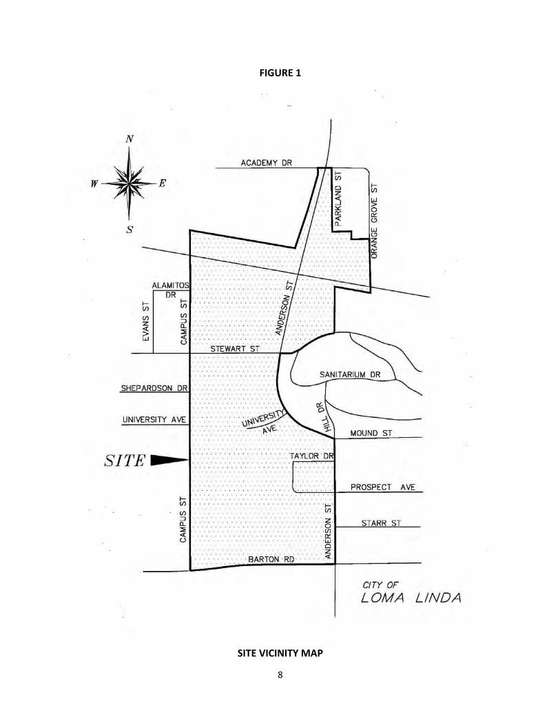
FIGURE 1
SITE VICINITY MAP
9
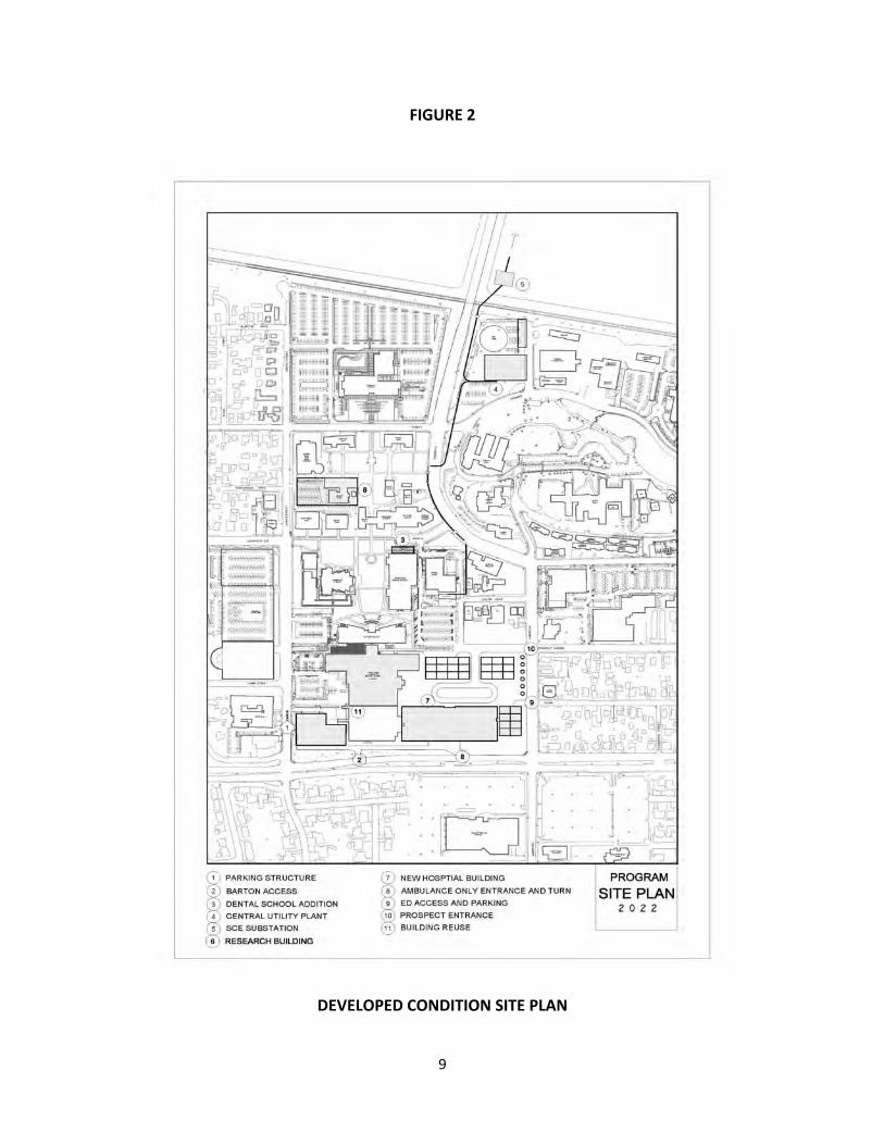
FIGURE 2
DEVELOPED CONDITION SITE PLAN

10
1.4 Site Description
The proposed project consists of a number of new building projects developed over a period of time. The proposed improvements within the project area include a: new patient and visitor parking structure, on‐site make ready work including the easterly entry drive realignment and handicap parking lot and the demolition of existing parking in the area of the new hospital tower, new hospital tower (including the decommissioning of a portion of the existing hospital, the emergency department Barton Road access, underground parking structure along Anderson adjacent to the new hospital,), new Southern California Edison electrical substation, new or renovated central utility plant, new research building, and dental school addition. In addition to these projects, the proposed work may also include the demolition and/or revisions of miscellaneous onsite public and private roadway improvements within Taylor Street, Taylor Court, and Prospect Avenue (i.e. driveways, street lights, water and sewer services, etc.) and possible offsite road improvements, as may be included in the project’s traffic study. The campus improvements also include the proton re‐feed, utility make ready, demolition/removal of a portion of the existing housing/structures located adjacent to Prospect Avenue, west of Anderson Street, and trailer relocation projects. Finally, the proposed projects may include the demolition of the existing Housekeeping Building (formerly the Radiation Safety Building) located north of Stewart Street and east of Anderson Street. This demolition is part of one of two alternatives identified for the Central Utility Plant project. The proposed projects will be designed to include pervious surfaces greater than or equal to the existing condition to maintain consistency with the pre‐developed condition. Runoff from the developed condition will also be conveyed to both public and private on‐site storm drain facilities consistent with the existing condition. The proposed projects may include changes to the existing storm drain facilities (i.e. existing private storm drains in conflict with the proposed buildings will be relocated or additional private storm drain as required to support the proposed buildings will be incorporated into the project design). However, the public drainage facilities, as documented on the City’s website and described above, are not anticipated to be changed significantly. Storm water will be collected in the onsite private and public storm drain systems. Storm water is conveyed in the underground systems north and northwest toward the point of confluence or study point. This project study point is located at the confluence of two existing drainage channels just south of Academy Street. From there storm water flows north in an unlined channel where it discharges into the San Timoteo Creek. The San Timoteo Creek is a concrete lined channel that flows from the southeast to the northwest. This creek crosses under Interstate 10 and flows northwest and discharges into the Santa Ana River. The Santa Ana River flows west/southwest towards the Prado Flood Control Basin. According to the Santa Ana Hydrologic Basin Planning Area Map, the project is located within the undefined sub‐area 801.14 of the Santa Ana River Hydrologic Unit 801. There are not any pre‐existing water quality problems that have been identified for this sub‐area.

11
SECTION 2 Pollutants of Concern and Hydrologic Conditions of Concern
2.1 Pollutants of Concern
Table 2‐1 of the San Bernardino County Water Quality Management Plan Guidance identifies general pollutant categories that are either expected or potential pollutants for general project categories. The LLUMC Transformation Project is categorized under the Industrial/Commercial Re‐Development (>100,000 ft2) and Parking Lots (>5,000 ft2) land uses.
According to 2010 Santa Ana Region 303(d) List of Impaired Water Quality Segments (See Attachment B), pollutants of concern in the downstream segments of Reach 3 & 4 of the Santa Ana River include Bacteria, Copper (wet season only) and Lead.
The table below following is a list of expected and potential pollutants for the project.
Table 2: Pollutant of Concern Summary Table
Pollutant Type Expected Potential Listed for Receiving Water
Bacteria/Virus X X
Heavy Metals X X
Nutrients X
Pesticides X
Organic Compounds X
Sediments X
Trash & Debris X
Oxygen Demanding Substances
X
Oil & Grease X
Other—specify pollutant(s):
Refer to Attachment C for a description of each pollutant type.

12
2.2 Hydrologic Conditions Of Concern
All Category projects must identify any hydrologic condition of concern (HCOC) that will be caused by the project, and implement Site Design, Source Control, and/or Treatment Control BMPs to address identified impacts.
1. Determine if the project will create a Hydrologic Condition of Concern. Check “yes” or “no” as
applicable and proceed to the appropriate section as outlined below. Yes No
A. All downstream conveyance channels, that will receive runoff from the project, are engineered,
hardened (concrete, riprap or other), and regularly maintained to ensure design flow capacity, and no sensitive stream habitat areas will be affected. Engineered, hardened, and maintained channels include channel reaches that have been fully and properly approved (including CEQA review, and permitting by USACOE, RWQCB and California Dept. of Fish & Game) by June 1, 2004 for construction and hardening to achieve design capacity, whether construction of the channels is complete. Discharge from the project will be in full compliance with Agency requirements for connections and discharges to the MS4, including both quality and quantity requirements, and the project will be permitted by the Agency for the connection or discharge to the MS4.
X
B. Project runoff rates, volumes, velocities, and flow duration for the post‐development condition
will not exceed those of the pre‐development condition for 1‐year, 2‐year and 5‐year frequency storm events. This condition will be substantiated with hydrologic modeling methods that are acceptable to the Agency, to the U.S. Army Corps of Engineers (USACOE), and to local watershed authorities. See method described below in Parts B1‐ B3.
X
C. Can the conditions in part A or B above be demonstrated for the project? X
Note: This redevelopment project is expected to reduce peak runoffs rates, volumes, velocities and durations discharging from the property by implementing additional pervious surfaces, site and source control BMPs and LID design practices. This intent will be evaluated in detail during the final engineering when a future, detailed WQMP is prepared for each project phase. If the detailed calculations during final engineering identify any increase in peak runoff rates, volumes, velocities or durations, the project will implement measures to mitigate this increase as required by the City of Loma Linda.
13
SECTION 3 Best Management Practice Selection Process
3.1 Site Design BMPs
It is anticipated that the following site design BMP’s will be implemented to the maximum extent practicable. This approach will be analyzed and confirmed during the final engineering process.
Minimize Stormwater Runoff, Minimize Project’s Impervious Footprint, and Conserve Natural Areas
Minimize Directly Connected Impervious Areas
3.2 Source Control BMPs
It is anticipated that some number of the following source control BMP’s will be implemented to the maximum extent practicable. This approach will be analyzed and confirmed during the final engineering process. Refer to Attachment E for a description of each source control BMP.
Education of Property Owners Trash Storage Areas and Litter Control (SD‐32)
Roof Runoff Controls (SD‐11)
Activity Restrictions Wash Water Controls for Food Preparation Areas
Efficient Irrigation (SD‐12)
Spill Contingency Plan Air/Water Supply Area Drainage
Protect Slopes and Channels
Employee Training/Education Program
Common Areas Catch Basin Inspection
Storm Drain Signage (SD‐13)
Street Sweeping Private Street and Parking Lots
Landscape Planning (SD‐10)
Pervious Pavement (SD‐20)
Inlet Trash Racks Alternative Building Materials (SD‐21)
The following is a list of source control BMPs that may not be implemented with the project along with a justification of why. This approach will be confirmed during the final engineering process.
Hillside Landscaping: There is no proposed hillside disturbance or landscaping associated with this project.
Energy Dissipaters: Project outflows discharge directly to a concrete lined channel and no energy dissipater is required.

14
Fueling Areas (SD‐30): There are no Fueling Areas associated with this project.
Maintenance Bays and Docks (SD‐31): There are no Maintenance Bays or Docks
proposed as part of this project.
Vehicle Washing Areas (SD‐33): There are no Vehicle Washing Areas proposed
as part of this project.
Outdoor Material Storage Areas (SD‐34): There are no Outdoor Material Storage
Areas proposed as part of this project.
Outdoor Work Areas (SD‐35): There are no Outdoor Work Areas proposed as
part of this project.
Outdoor Processing Areas (SD‐26): There are no Outdoor Processing Areas
proposed as part of this project.
Wash Water Controls for Food Preparation Areas: There are no Food Preparation
Areas proposed as part of this project.

15
3.3 Treatment Control BMPs
The following matrix identifies pollutants of concern associated with the project along with potential Treatment Control BMPs. The final selection of Treatment Control BMPs, their location and sizing will be determined during final engineering and grading permit and/or building permit issuance.
3.4 BMP Design Criteria
One or more of the following Treatment Control BMPS will be designed during final engineering according the applicable Flow or Volume based requirements. Refer to Attachment D for BMP sizing and design criteria.
Pollutant of Concern
Table 3: Treatment Control BMP Categories
Biofilters Detention Basins(2)
Infiltration Basins(3)
Wet Ponds or Wetlands
Filtration Water Quality Inlets
Hydrodynamic Separator Systems (4)
Manufactured/ Proprietary Devices
Sediment/ Turbidity
H/M M H/M H/M H/M L H/M (L for turbidity)
U
Yes/No? Yes Yes Yes Yes Yes Yes Yes Yes Nutrients L M H/M H/M L/M L L U
Yes/No? Yes Yes Yes Yes Yes Yes Yes Yes Organic Compounds
U U U U H/M L L U
Yes/No? Yes Yes Yes Yes Yes Yes Yes Yes Trash & Debris L M U U H/M M H/M U
Yes/No? Yes Yes Yes Yes Yes Yes Yes Yes Oxygen Demanding
L M H/M H/M H/M L L U
Substances Yes/No? Yes Yes Yes Yes Yes Yes Yes Yes Bacteria & Viruses
U U H/M U H/M L L U
Yes/No? Yes Yes Yes Yes Yes Yes Yes Yes Oils & Grease H/M M U U H/M M L/M U
Yes/No? Yes Yes Yes Yes Yes Yes Yes Yes Pesticides (non‐soil bound)
U U U U U L L U
Yes/No? Yes Yes Yes Yes Yes Yes Yes Yes Metals H/M M H H H L L U
Yes/No? Yes Yes Yes Yes Yes Yes Yes Yes

16
SECTION 4 Operations and Maintenance
4.1 Operations and Maintenance
Final operation and maintenance requirements will be developed for all Source Control, Site Design and Treatment Control BMPs selected during final engineering. The Loma Linda University Adventist Health Sciences Center shall be responsible for the operation and maintenance of the BMPs located on private property and a Water Quality Management Plan and Stormwater BMP Transfer, Access and Maintenance Agreement will be implemented (refer to Attachment A‐1).

17
SECTION 5 Funding
5.1 Funding
Loma Linda University Adventist Health Sciences Center will be the responsible funding source for all Treatment Control BMPs operation and maintenance located on private property.

18
SECTION 6 WQMP Certification
6.1 Certification
This Preliminary Water Quality Management Plan has been prepared for Loma Linda University Adventist Health Sciences Center by Kettler Leweck Engineering. It is intended to comply with the requirements of the City of Loma Linda for the Campus Transformation Project and associated Environmental Impact Report). The undersigned is aware that Best Management Practices (BMPs) are enforceable pursuant to the City’s Water Quality Ordinance. The undersigned, while it owns the subject property, is responsible for the implementation of the provisions of this plan and will ensure that this plan is amended as appropriate to reflect up‐to‐date conditions on the site consistent with San Bernardino County’s Municipal Stormwater Management Program and the intent of the NPDES Permit for San Bernardino County and the incorporated cities of San Bernardino County within the Santa Ana Region. Once the undersigned transfers its interest in the property, its successors in interest and the city/county shall be notified of the transfer. The new owner will be informed of its responsibility under this WQMP. A copy of the approved WQMP shall be available on the subject site in perpetuity.
I certify under a penalty of law that the provisions (implementation, operation, maintenance, and funding) of the WQMP have been accepted and that the plan will be transferred to future successors. _____________________________ _____________________________ Applicant’s Signature Date _____________________________ _________ ___________________ Applicant’s Name Applicant’s Telephone Number

Attachment A‐1 Maintenance Mechanisms A‐1.1 The Agency shall not accept stormwater structural BMPs as meeting the WQMP requirements standard, unless an O&M Plan is prepared (see WQMP Section 2.6) and a mechanism is in place that will ensure ongoing long‐term maintenance of all structural and non‐structural BMPs. This mechanism can be provided by the Agency or by the project proponent. As part of project review, if a project proponent is required to include interim or permanent structural and non‐structural BMPs in project plans, and if the Agency does not provide a mechanism for BMP maintenance, the Agency shall require that the applicant provide verification of maintenance requirements through such means as may be appropriate, at the discretion of the Agency, including, but not limited to covenants, legal agreements, maintenance agreements, conditional use permits and/or funding arrangements (OC 2003) A‐1.2 Maintenance Mechanisms
1. Public entity maintenance: The Agency may approve a public or acceptable quasipublic entity (e.g., the County Flood Control District, or annex to an existing assessment district, an existing utility district, a state or federal resource agency, or a conservation conservancy) to assume responsibility for operation, maintenance, repair and replacement of the BMP. Unless otherwise acceptable to individual Agencies, public entity maintenance agreements shall ensure estimated costs are front‐funded or reliably guaranteed, (e.g., through a trust fund, assessment district fees, bond, letter of credit or similar means). In addition, the Permittees may seek protection from liability by appropriate releases and indemnities. The Agency shall have the authority to approve stormwater BMPs proposed for transfer to any other public entity within its jurisdiction before installation. The Permittee shall be involved in the negotiation of maintenance requirements with any other public entities accepting maintenance responsibilities within their respective jurisdictions; and in negotiations with the resource agencies responsible for issuing permits for the construction and/or maintenance of the facilities. The Agency must be identified as a third party beneficiary empowered to enforce any such maintenance agreement within their respective jurisdictions.
2. Project proponent agreement to maintain stormwater BMPs: The Agency may enter into a contract with the project proponent obliging the project proponent to maintain, repair and replace the stormwater BMP as necessary into perpetuity. Security or a funding mechanism with a “no sunset” clause may be required.
3. Assessment districts: The Agency may approve an Assessment District or other funding
mechanism created by the project proponent to provide funds for stormwater BMP maintenance, repair and replacement on an ongoing basis. Any agreement with such a District shall be subject to the Public Entity Maintenance Provisions above.
4. Lease provisions: In those cases where the Agency holds title to the land in question, and
the land is being leased to another party for private or public use, the Agency may assure stormwater BMP maintenance, repair and replacement through conditions in the lease.

5. Conditional use permits: For discretionary projects only, the Agency may assure
maintenance of stormwater BMPs through the inclusion of maintenance conditions in the conditional use permit. Security may be required.
6. Alternative mechanisms: The Agency may accept alternative maintenance mechanisms if
such mechanisms are as protective as those listed above.

Attachment A‐2 Water Quality Management Plan and Stormwater BMP Transfer, Access and Maintenance Agreement (adapted from documents from the Ventura County Stormwater Management Program). Recorded at the request of:
City of ________________________________________________________
After recording, return to:
City of ________________________________________________________
City Clerk _____________________________________________________
Water Quality Management Plan and Stormwater BMP Transfer, Access and Maintenance Agreement
OWNER: ____________________________________________________
PROPERTY ADDRESS: ________________________________________
________________________________________
APN: ________________________________________________________
THIS AGREEMENT is made and entered into in
___________________________, California, this _______ day of
__________________ , by and between
_______________________________________________, herein after
referred to as “Owner” and the CITY OF _____________________________, a municipal corporation, located in the County of San Bernardino, State of California hereinafter referred to as “CITY”; WHEREAS, the Owner owns real property (“Property”) in the City of ________________________, County of San Bernardino, State of California, more specifically described in Exhibit “A” and depicted in Exhibit “B”, each of which exhibits is attached hereto and incorporated herein by this reference; WHEREAS, at the time of initial approval of development project known as

________________________________________ within the Property described herein, the City required the project to employ Best Management Practices, hereinafter referred to as “BMPs,” to minimize pollutants in urban runoff; WHEREAS, the Owner has chosen to install and/or implement BMPs as described in the Water Quality Management Plan, on file with the City, hereinafter referred to as “WQMP”, to minimize pollutants in urban runoff and to minimize other adverse impacts of urban runoff; WHEREAS, said WQMP has been certified by the Owner and reviewed and approved by the City; WHEREAS, said BMPs, with installation and/or implementation on private property and draining only private property, are part of a private facility with all maintenance or replacement, therefore, the sole responsibility of the Owner in accordance with the terms of this Agreement; WHEREAS, the Owner is aware that periodic and continuous maintenance, including, but not necessarily limited to, filter material replacement and sediment removal, is required to assure peak performance of all BMPs in the WQMP and that, furthermore, such maintenance activity will require compliance with all Local, State, or Federal laws and regulations, including those pertaining to confined space and waste disposal methods, in effect at the time such maintenance occurs; NOW THEREFORE, it is mutually stipulated and agreed as follows:
1. Owner hereby provides the City of City’s designee complete access, of any duration, to the BMPs and their immediate vicinity at any time, upon reasonable notice, or in the event of emergency, as determined by City’s Director of Public Works no advance notice, for the purpose of inspection, sampling, testing of the Device, and in case of emergency, to undertake all necessary repairs or other preventative measures at owner’s expense as provided in paragraph 3 below. City shall make every effort at all times to minimize or avoid interference with Owner’s use of the Property
2. Owner shall use its best efforts diligently to maintain all BMPs in a manner assuring peak performance at all times. All reasonable precautions shall be exercised by Owner and Owner’s representative or contractor in the removal and extraction of any material(s) from the BMPs and the ultimate disposal of the material(s) in a manner consistent with all relevant laws and regulations in effect at the time. As may be requested from time to time by the City, the Owner shall provide the City with documentation identifying the material(s) removed, the quantity, and disposal destination.
3. In the event Owner, or its successors or assigns, fails to accomplish the necessary maintenance contemplated by this Agreement, within five (5) days of being given

written notice by the City, the City is hereby authorized to cause any maintenance necessary to be done and charge the entire cost and expense to the Owner or Owner’s successors or assigns, including administrative costs, attorneys fees and interest thereon at the maximum rate authorized by the Civil Code from the date of the notice of expense until paid in full. 4. The City may require the owner to post security in form and for a time period
satisfactory to the city to guarantee the performance of the obligations state herein. Should the Owner fail to perform the obligations under the Agreement, the City may, in the case of a cash bond, act for the Owner using the proceeds from it, or in the case of a surety bond, require the sureties to perform the obligations of the Agreement. As an additional remedy, the Director may withdraw any previous stormwater‐related approval with respect to the property on which BMPs have been installed and/or implemented until such time as Owner repays to City its reasonable costs incurred in accordance with paragraph 3 above.
5. This agreement shall be recorded in the Office of the Recorder of San Bernardino County, California, at the expense of the Owner and shall constitute notice to all successors and assigns of the title to said Property of the obligation herein set forth, and also a lien in such amount as will fully reimburse the City, including interest as herein above set forth, subject to foreclosure in event of default in payment.
6. In event of legal action occasioned by any default or action of the Owner, or its successors or assigns, then the Owner and its successors or assigns agree(s) to pay all costs incurred by the City in enforcing the terms of this Agreement, including reasonable attorney’s fees and costs, and that the same shall become a part of the lien against said Property.
7. It is the intent of the parties hereto that burdens and benefits herein undertaken shall
constitute covenants that run with said Property and constitute a lien there against.
8. The obligations herein undertaken shall be binding upon the heirs, successors, executors, administrators and assigns of the parties hereto. The term “Owner” shall include not only the present Owner, but also its heirs, successors, executors, administrators, and assigns. Owner shall notify any successor to title of all or part of the Property about the existence of this Agreement. Owner shall provide such notice prior to such successor obtaining an interest in all or part of the Property. Owner shall provide a copy of such notice to the City at the same time such notice is provided to the successor.
9. Time is of the essence in the performance of this Agreement.

10. Any notice to a party required or called for in this Agreement shall be served in person, or by deposit in the U.S. Mail, first class postage prepaid, to the address set forth below. Notice(s) shall be deemed effective upon receipt, or seventy‐two (72) hours after deposit in the U.S. Mail, whichever is earlier. A party may change a notice address only by providing written notice thereof to the other party

Attachment B: Tables
Table B‐1 303(d) List of Impaired Water Bodies
Waterbody
Pollutant
Bacteria Indicators/ Pathogens
Metals Nutrients Organic Enrichment
Sedimentation /Siltation
Suspended Solids
Big Bear Lake X X X Canyon Lake (Railroad Canyon Reservoir) X
X
Chino Creek Reach 1 X X
Chino Creek Reach 2 X Cucamonga Creek, Valley Reach X
Grout Creek X X
Knickerbocker Creek X X
Lytle Creek X
Mill Creek (Prado Area) X X X
Mill Creek Reach 1 X
Mill Creek Reach 2 X
Mountain Home Creek X Mountain Home Creek, East Fork X
Prado Park Lake X X
Rathbone (Rathbun Creek) X X
Santa Ana River, Reach 3 X
Santa Ana River, Reach 4 X
Summit Creek X NOTES: 1) Summary of the 2002 303(d) Listed Water Bodies and Associated Pollutants of Concern from RWQCB Region 8. Check for updated lists from the RWQCB. 2) Chlorides, pesticides, salinity, total dissolved solids (TDS), toxicity, and trash are listed impairments within the 303(d) table, however, they are not impairments in the above waterbodies.
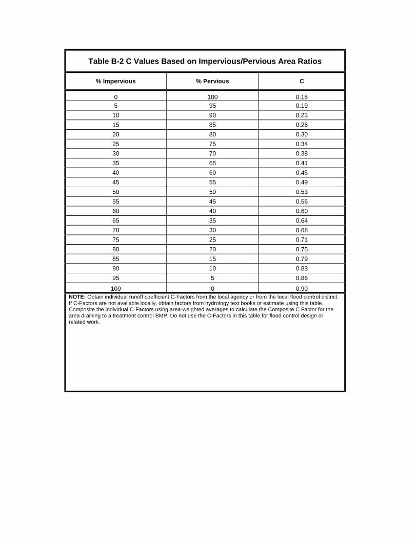
Table B-2 C Values Based on Impervious/Pervious Area Ratios
% Impervious % Pervious C
0 100 0.15 5 95 0.19
10 90 0.23
15 85 0.26
20 80 0.30
25 75 0.34
30 70 0.38
35 65 0.41
40 60 0.45
45 55 0.49
50 50 0.53
55 45 0.56
60 40 0.60
65 35 0.64
70 30 0.68
75 25 0.71
80 20 0.75
85 15 0.79
90 10 0.83
95 5 0.86
100 0 0.90 NOTE: Obtain individual runoff coefficient C-Factors from the local agency or from the local flood control district. If C-Factors are not available locally, obtain factors from hydrology text books or estimate using this table. Composite the individual C-Factors using area-weighted averages to calculate the Composite C Factor for the area draining to a treatment control BMP. Do not use the C-Factors in this table for flood control design or related work.

Attachment C Pollutants of Concern

Pollutants of Concern
Bacteria and Viruses – Bacteria and Viruses are ubiquitous microorganisms that thrive under certain environmental conditions. Their proliferation is typically cause by the transport of animal or human fecal wastes from the watershed. Water, containing excessive bacteria and viruses, can alter the aquatic habitat and create a harmful environment for humans and aquatic life. Also, the decomposition of excess organic waste causes increased growth of undesirable organisms in the water.
Metals – The primary source of metal pollution in stormwater is typically commercially available metals and metal products. Metals of concern include cadmium, chromium, copper, lead, mercury, and zinc. Lead and chromium have been used as corrosion inhibitors in primer coatings and cooling tower systems. Metals are also raw material components in non-metal products such as fuels, adhesives, paints, and other coatings. At low concentrations naturally occurring in soil, metals may not be toxic. However, at higher concentrations, certain metals can be toxic to aquatic life. Humans can be impacted from contaminated groundwater resources, and bioaccumulation of metals in fish and shellfish. Environmental concerns, regarding the potential for release of metals to the environment, have already led to restricted metal usage in certain applications (OC 2003).
Nutrients – Nutrients are inorganic substances, such as nitrogen and phosphorus. Excessive discharge of nutrients to water bodies and streams causes eutrophication, where aquatic plants and algae growth can lead to excessive decay of organic matter in the water body, loss of oxygen in the water, release of toxins in sediment, and the eventual death of aquatic organisms. Primary sources of nutrients in urban runoff are fertilizers and eroded soils.
Pesticides -- Pesticides (including herbicides) are chemical compounds commonly used to control nuisance growth or prevalence of organisms. Relatively low levels of the active component of pesticides can result in conditions of aquatic toxicity. Excessive or improper application of a pesticide may result in runoff containing toxic levels of its active ingredient (OC 2003).
Organic Compounds – Organic compounds are carbon-based. Commercially available or naturally occurring organic compounds are found in pesticides, solvents, and hydrocarbons. Organic compounds can, at certain concentrations, indirectly or directly constitute a hazard to life or health. When rinsing off objects, toxic levels of solvents and cleaning compounds can be discharged to storm drains. Dirt, grease, and grime retained in the cleaning fluid or rinse water may also adsorb levels of organic compounds that are harmful or hazardous to aquatic life (OC 2003).
Sediments – Sediments are solid materials that are eroded from the land surface. Sediments can increase turbidity, clog fish gills, reduce spawning habitat, lower young aquatic organisms survival rates, smother bottom dwelling organisms, and suppress aquatic vegetation growth.
Trash and Debris – Trash (such as paper, plastic, polystyrene packing foam, and aluminum materials) and biodegradable organic matter (such as leaves, grass cuttings, and food waste) are general waste products on the landscape. The presence of trash and debris may have a significant impact on the recreational value of a water body and aquatic habitat. Trash impacts water quality by increasing biochemical oxygen demand.
Oxygen-Demanding Substances – This category includes biodegradable organic material as well as chemicals that react with dissolved oxygen in water to form other compounds. Proteins, carbohydrates, and fats are examples of biodegradable organic compounds. Compounds such as ammonia and hydrogen sulfide are examples of oxygen-demanding compounds. The oxygen demand of a substance can lead to depletion of dissolved oxygen in a water body and possibly the development of septic conditions. A reduction of dissolved oxygen is detrimental to aquatic life and can generate hazardous compounds such as hydrogen sulfides.
Oil and Grease – Oil and grease in water bodies decreases the aesthetic value of the water body, as well as the water quality. Primary sources of oil and grease are petroleum hydrocarbon products, motor products from leaking vehicles, esters, oils, fats, waxes, and high molecular-weight fatty acids.

Attachment D Flow‐ and Volume‐Based BMP Design Calculations
INSTRUCTIONS FOR ESTIMATING VOLUME‐ AND FLOW‐BASED BMP DESIGN RUNOFF QUANTITIES4
1) Identify the “BMP Drainage Area” that drains to the proposed BMP element. This includes all areas that will drain to the proposed BMP element, including pervious areas, impervious areas, and off‐site areas, whether or not they are directly or indirectly connected to the BMP element. Calculate the BMP Drainage Area (A) in acres.
2) Outline the Drainage Area on the NOAA Atlas 14 Precipitation Depths (2‐year 1‐ hour Rainfall) map (Figure D‐1).
3) Determine the area‐averaged 2‐year 1‐hour rainfall value for the Drainage Area outlined above.
A. Flow‐Based BMP Design
1) Calculate the composite runoff coefficient, CBMP, as defined in part A.2, above. 2) Determine which Region the BMP Drainage Area is located in (Valley, Mountain or
Desert). 3) Determine BMP design rainfall intensity, IBMP, by multiplying the area‐averaged 2‐year
1‐hour value from the NOAA Atlas 14 map by the appropriate regression coefficient from Table D‐1 (“I”), and then multiplying by the safety factor specified in the criteria—usually a factor of 2.
4) Calculate the target BMP flow rate, Q, by using the following formula (see Table D2 below for limitations on the use of this formula):
Q = CBMP· IBMP · A
where: Q = flow in ft3
/s IBMP = BMP design rainfall intensity, in inches/hour A =
Drainage Area in acres CBMP = composite runoff coefficient
4 Rainfall analysis to develop regression coefficients in Table D‐1 and modifications to the NOAA Atlas 14 map were conducted by: Hromadka II, T.V., Professor Emeritus, Department of Mathematics, California State University, Fullerton, and Adjunct Professor, Department of Mathematical Sciences, United States Military Academy, West Point, NY Laton, W.R , Assistant Professor, Department of Geological Sciences, California State University, Fullerton Picciuto J.A.., Assistant Professor, Department of Mathematical Sciences, United States Military Academy, West Point, NY With assistance from: Rene Perez, M.S. Candidate, Department of Geological Sciences, California State University, Fullerton, and Jim Friel, Ph.D. Professor Emeritus, Department of Mathematics, California State University, Fullerton Reported as follows:
1. Hromadka II, T.V., Laton, W.R., and Picciuto J.A., 2005. Estimating Runoff Quantities for Flow and Volume‐based BMP Design. Final Report to the San Bernardino County Flood Control District.
2. Laton, W.R., Hromadka II, T.V., and Picciuto J.A., 2005. Estimating Runoff Quantities for Flow and Volume‐based BMP Design (submitted). Journal of the American Water Resources Association.

Table D‐1: Regression Coefficients for Intensity (I) and 6‐hour mean storm rainfall (P6).
Quantity Valley 85% upper confidence limit
Mountain 85% upper confidence
limit
Desert 85% upper confidence limit
I 0.2787 0.3614 0.3250
P6 1.4807 1.9090 1.2371 Table D‐2: Use of the flow‐based formula for BMP Design (CASQA 2003).
Composite Runoff Coefficient, “C”
BMP Drainage Area (Acres)
0.00 to 0.25 0.26 to 0.50 0.51 to 0.75 0.76 to 1.00
0 to 25 Caution Yes Yes Yes
26 to 50 High Caution Caution Yes Yes
51 to 75 Not Recommended
High Caution Caution Yes
76 to 100 Not Recommended
High Caution Caution Yes
If the flow‐based BMP formula use case, as determined by Table D‐2, shows “Caution,” “High Caution,” or “Not Recommended,” considering the project’s characteristics, then he project proponent must calculate the BMP design flow using the unit hydrograph method, as specified in the most current version of the San Bernardino County Hydrology Manual, using the design storm pattern with rainfall return frequency such that the peak one hour rainfall depth equals the 85th‐percentile 1‐hour rainfall multiplied by two.

B. Volume-Based BMP Design
1. Calculate the “Watershed Imperviousness Ratio”, i, which is equal to the percent of impervious area in the BMP Drainage Area divided by 100.
2. Calculate the composite runoff coefficient CBMP for the Drainage Area above using the following equation:
CBMP = 0.858i3 – 0.78i2 + 0.774i + 0.04
where: CBMP = composite runoff coefficient; and, i = watershed imperviousness ratio.
3. Determine which Region the Drainage Area is located in (Valley, Mountain or
Desert).
4. Determine the area-averaged “6-hour Mean Storm Rainfall”, P6, for the Drainage Area. This is calculated by multiplying the area averaged 2-year 1-hour value by the appropriate regression coefficient from Table 1.
5. Determine the appropriate drawdown time. Use the regression constant a =1.582 for 24 hours and a = 1.963 for 48 hours.
Note: Regression constants are provided for both 24 hour and 48 hour drawdown times; however, 48 hour drawdown times should be used in most areas of California. Drawdown times in excess of 48 hours should be used with caution as vector breeding can be a problem after water has stood in excess of 72 hours. (Use of the 24 hour drawdown time should be limited to drainage areas with coarse soils that readily settle and to watersheds where warming may be detrimental to downstream fisheries.)
6. Calculate the “Maximized Detention Volume”, P0, using the following equation:
P0 = a · CBMP · P6
where: P0 = Maximized Detention Volume, in inches a = 1.582 for 24 hour and a = 1.963 for 48 hour drawdown, CBMP = composite runoff coefficient; and, P6 = 6-hour Mean Storm Rainfall, in inches
6. Calculate the “Target Capture Volume”, V0, using the following equation:
V0 = (P0 · A) / 12
where: V0 = Target Capture Volume, in acre-feet P0 = Maximized Detention Volume, in inches; and, A = BMP Drainage Area, in acres

Attachment E Source Control BMP Descriptions Routine Non‐Structural BMPS Education for Property Owners, Tenants, and Occupants For developments with no Property Owners Association (POA)5 or POAs of less than fifty (50) dwelling units, practical information materials will be provided to the first residents/occupants/tenants. These materials shall include general good housekeeping practices that contribute to protection of stormwater quality, and BMPs that eliminate or reduce pollution during property improvements (concrete work, pool installation, etc). These materials will be made available by the Agency, and nominal fees to recover the cost of printing may be required by the Agency. The developer shall request these materials in writing at least 30 days prior to intended distribution and shall then be responsible for their timely distribution at the time of occupancy. For developments with POA or residential projects of more than fifty (50) dwelling units, project conditions of approval will require that the POA provide environmental awareness education materials. The project proponent shall provide the educational materials to residents in cases where there is no POA, and until a POA is formed in other cases. These materials must contain the information required for developments of less than fifty (50) dwellings, plus describe the use of chemicals (including household type) that should be limited to the property, with no discharge of specified wastes via hosing or other direct discharge to gutters, catch basins, and storm drains. These materials will be made available by the Agency, may be attached to the WQMP template, and nominal fees to recover the cost of printing may be required by the Agency. The developer shall request these materials in writing at least 30 days prior to intended distribution and shall then be responsible for their timely distribution at the time of occupancy. Activity Restrictions If a POA is formed, conditions, covenants, and restrictions shall be required for the purpose of water quality protection. Alternatively, use restrictions may be developed by a building operator through lease terms, or other mechanisms. Pesticide application in common areas must be performed by an applicator certified by the California Department of Pesticide Regulation. Spill Contingency Plan A “Spill Contingency Plan” (Business Emergency/Contingency Plan Guidelines and Forms) shall be provided in accordance with Section 6.95 of the California Health and Safety Code. Employee Training/Education Program For developments where people will be employed to perform activities that may impact water quality, BMP training and education programs must be provided. Materials based upon
information provided through the Area‐wide Stormwater Program Public Education Program may be used. Training and education program commitments may be conveyed, for development that is constructed for an unspecified use, to a POA or development purchaser. Street Sweeping Private Streets and Parking Lots For residential developments with POAs and privately owned streets and parking lots, the streets and parking lots must be swept at least twice annually, prior to the storm season in the late summer or early fall, to reduce the amount of sediment, garden waste, and trash entering the storm drain systems. Privately owned streets and parking lots in commercial, industrial, and institutional zones, and along designated truck routes, must be swept at least once each quarter. Street sweeping requirements apply to streets where there is sufficient curb and gutter to justify street sweeping. Common Area Catch Basin Inspection Drainage facilities (inlets, open channels and basins) must be inspected annually, in the late summer or early fall, and cleaned as needed, or if accumulated sediment/debris fills 25% or more of the sediment/debris storage capacity of the facility. The party responsible for post‐construction operation and maintenance of drainage facilities shall evaluate all portions of the drainage facilities annually to determine the adequacy of the inspection and maintenance frequency, and report the evaluation findings to the Agency. Routine Structural BMPs Landscape Planning Landscape planning should couple consideration of land suitability for urban uses with consideration of community goals and projected growth. Project plan designs should conserve natural areas to the extent possible, maximize natural water storage and infiltration opportunities, and protect slopes and channels. Plants should be grouped with similar water requirements in order to reduce excess irrigation runoff and promote surface filtration. Landscaping shall correlate to the climate, soil, related natural resources and existing vegetation of the site, as well as the type of development proposed. Ongoing maintenance consistent with County Administrative Design Guidelines (available at: http://www.co.sanbernardino. ca.us/landuseservices/Informational%20Handouts/Administative%20Design%20Guidelines‐Jan%202002.pdf) or local equivalent, plus fertilizer and pesticide usage consistent with the instructions contained on product labels and with the regulations administered by the State Department of Pesticide Regulation shall be implemented. Hillside Landscaping Hillside areas that are disturbed by project development shall be landscaped with deep‐rooted, drought‐tolerant plant species selected for erosion control, satisfactory to the Agency (OC 2003). Roof Runoff Controls

Residential and commercial sites must be designed to contain and infiltrate roof runoff, or direct roof runoff to vegetative swales or buffer areas. Efficient Irrigation Irrigation methods should be utilized to minimize runoff of excess irrigation water across impervious surfaces and into the stormwater conveyance system. Such measures include employing rain‐triggered shutoff devices to eliminate or reduce irrigation during and immediately after precipitation, using mulches (such as wood chips) to minimize sediment in runoff and to maintain soil infiltration capacity, and coordinating design of the irrigation system and landscape to minimize overspray and runoff. Irrigation systems should consider the use of flow reducers or shutoff valves triggered by a pressure drop to control water loss in the event of broken sprinkler heads or water supply lines. Water conservation devices such as programmable irrigation timers and soil moisture sensors should also be considered. Protect Slopes and Channels (OC 2003) Project plans shall include Source‐Control BMPs to decrease the potential for erosion of slopes and/or channels, consistent with local codes and ordinances, and with approval of all agencies with jurisdiction (e.g., USACOE, RWQCB, and CDFG). The following design principles shall be considered, and implemented where determined to be applicable and feasible by the Agency: 1. Convey runoff safely from the tops of slopes. 2. Avoid disturbing steep or unstable slopes. 3. Avoid disturbing natural channels. 4. Install permanent stabilization BMPs on disturbed slopes as quickly as possible. 5. Vegetate slopes with native or drought‐tolerant vegetation. 6. Control and treat flows in landscaping and/or other controls prior to reaching natural drainage systems. 7. Install permanent stabilization BMPs in channel crossings a quickly as possible, and ensure that increases in runoff velocity and frequency caused by the project do not excessively erode the channel. 8. Install energy dissipators, such as riprap, at the outlets of new storm drains, culverts, conduits or channels that enter unlined channels in accordance with applicable specifications to minimize erosion. Energy dissipators shall be installed in such a way as to minimize impacts to receiving waters. 9. Onsite conveyance channels should be lined, where appropriate, to reduce erosion caused by increased flow velocity due to increases in tributary impervious area. The first choice for linings should be grass or some other vegetative surface, since these materials not only reduce runoff velocities, but also provide water quality benefits from filtration and infiltration. If velocities in the channel are large enough to erode grass or other vegetative linings, riprap, concrete soil cement, or geo‐grid stabilization may be substituted or used in combination with grass or other vegetation stabilization. 10. Other design principles that are comparable and equally effective. Storm Drain Signage

Signage such as notices regarding discharge prohibitions at storm drain inlets to eliminate or reduce dumping and littering are required. The phrase “No Dumping – Flows to Creek,” or an equally effective phrase as approved by the NPDES General Committee, must be stenciled on catch basins (inlets) to alert the public as to the destination of pollutants discharged into storm drains. This signage must be maintained and a party responsible for maintenance should be identified in the WQMP. Inlet Trash Racks Where appropriate to reduce intake and transport through the storm drain system of large floatable debris, trash racks shall be provided where drainage from open areas enters storm drains. Energy Dissipator Energy dissipators such as riprap or other effective materials must be installed at the outlets of new storm drains that enter unlined channels in accordance with applicable Agency specifications, and shall be installed in such a way as to minimize impacts to receiving waters. Other methods of managing flow velocity and volume must be considered. A useful reference for alternative methods is: “A Primer on Stream and River Protection for the Regulator and Program Manager,” by Ann L. Riley, San Francisco Regional Board. The Primer can be accessed on the internet at www.swrcb.ca.gov/rwqcb2/Agenda/04‐16‐03/Stream%20Protection%20Circular.pdf. Trash Storage Areas and Litter Control Trash container (dumpster) areas shall have drainage from adjoining roofs and pavements diverted around the area(s). Dumpsters shall be leak proof and have attached workable covers. Trash area drains, if any, must not be allowed to discharge offsite, or be connected to the municipal storm drain system. For trash container areas associated with fuel dispensing, vehicle repair/maintenance, and industry, grade and pave the area to eliminate or reduce run‐on of storm water to the maximum extent practicable. Trash compactors shall be roofed and set on a concrete pad. The pad shall be a minimum of one foot larger all around than the trash compactor and sloped to drain to a sanitary sewer line. For developments with POAs, the POA must be required to implement trash management and litter control procedures in the common areas aimed at reducing pollution of stormwater. The POAs may contract with their landscape maintenance firms to provide this service during regularly scheduled maintenance, which should consist of litter patrol, proper disposal of pet litter, emptying of trash receptacles in common areas, and noting trash disposal violations by homeowners or businesses and reporting the violations to the Association. BMPs Applicable to Individual Project Features Fueling Areas Areas used for fuel dispensing shall be paved with Portland cement concrete (or; equivalent smooth, impervious surface) with a 2% to 4% slope to eliminate or reduce ponding, and must be separated from the rest of the site by a grade break that eliminates or reduces run‐on of stormwater. Concrete surfacing must extend a minimum of 6.5 feet from the corner of each
fuel dispenser, or the length at which the hose and nozzle assembly may be operated plus one foot, whichever is less. The fuel dispensing area shall be graded and constructed as to eliminate or reduce stormwater flow through the concrete fueling area. Spilled material within the fuel dispensing area must be prohibited from draining to the street or storm drain system, or offsite. Spills must be immediately cleaned up in accordance with a Spill Contingency Plan. All fuel dispensing areas are to have a canopy structure, and the canopy’s minimum dimensions must be equal to or greater than the area within the grade break or the fuel dispensing area, as defined above. Canopy roof downspouts are to be routed to eliminate or reduce drainage across the concrete fueling area. The fueling area shall drain to the project’s Treatment Control BMP(s) prior to discharging to the municipal storm drain system, or offsite (OC 2003). Air/Water Supply Area Drainage Areas used for air/water supply must be graded and constructed so as to contain spilled material for cleanup. Maintenance Bays and Docks Loading docks must be kept in a clean and orderly condition through a regular program of sweeping, litter control, and immediate cleanup of spills and broken containers. Polluted material or wash waters shall not be allowed to discharge into a storm drain. Loading dock areas should be covered, or drainage should be designed to preclude urban run‐on and runoff. Direct connections into storm drains from depressed loading docks (truck wells) are prohibited. Below‐grade loading docks from grocery stores and warehouse/distribution centers of fresh food items should drain through water quality inlets, or to and engineered infiltration system, or an equally effective alternative reviewed and approved by the Agency. Vehicle Washing Areas In multi‐family developments with 10 or more dwelling units, where car washing or rinsing is not specifically prohibited via CC&Rs or other acceptable means, and in developments having a common parking area where car washing or rinsing is not specifically prohibited via CC&Rs or other acceptable means, a designated car provided for common usage. Wash and rinse waters from this area must either be directed to the sanitary sewer (with prior approval of the sewering agency), to an engineered filtration system, or an equally effective alternative reviewed and approved by the Agency. For businesses where washing or rinsing of vehicles or equipment without steam cleaning occurs, provide wash racks connected to the sewer in accordance with agency guidelines and with the prior approval of the sewering agency (Note: discharge monitoring may be required by the sewering agency). Surface runoff and roof drains shall be directed away from these wash racks. Where steam cleaning occurs, provide wash racks connected to the sewer in accordance with agency guidelines and with the prior approval of the sewering agency, and/or structurally contain (with a cover to restrict the entry of stormwater during rain events) runoff from such areas onsite for commercial waste removal. Outdoor Material Storage Areas

Where plans propose outdoor storage containers for oils, fuels, solvents, coolants, wastes, and other chemicals, the areas where these materials are to be used or stored must be protected by secondary containment structures such as a low containment berm, dike, or curb, designed to the satisfaction of the approving Agency. For commercial outdoor vehicle and equipment salvage yards, and commercial outdoor recycling facilities, the entire facility must comply with the NPDES General Industrial Activities Storm Water Permit. Piles of materials or products that are stored outside and that have the potential to cause pollutant discharges shall be protected from rainfall, runoff, run‐on, and wind erosion. Outdoor Work Areas Where vehicle or equipment repair/maintenance occurs, impermeable berms, trench drains, or containment structures shall be provided around repair bays to eliminate or reduce spilled materials and wash‐down waters from entering the storm drain system. Surface runoff or roof drains shall be directed away from these spill containment structures. Sidewalls and canopies may be used to meet this requirement. Outdoor Processing Areas Where wet material processing occurs (e.g., electroplating), secondary containment structures shall be provided to hold spills resulting from accidents, leaking tanks or equipment, or any other releases (Note: If these are plumbed to the sanitary sewer, the structures and plumbing shall be in accordance with State and local spill containment and reporting requirements and have the prior approval of the sewering agency). Outdoor process equipment operations such as rock grinding or crushing, painting or coating, grinding or sanding, degreasing or parts cleaning, landfills, waste piles, and wastewater and solid waste treatment and disposal, and other operations determined to be a potential threat to water quality by the permittees shall adhere to the following requirements: 1. Cover or enclose areas that would be sources of pollutants, or slope the area toward a sump that will provide infiltration or evaporation with no discharge; or, if there are no other alternatives, discharge of non‐stormwater flow to the sanitary sewer may be considered only when allowed by the local sewering agency through a permitted connection. 2. Grade or berm area to prevent run‐on from surrounding areas. 3. Installation of storm drains in areas of equipment repair is prohibited. 4. Other comparable or equally effective features that prevent unpermitted discharges to the municipal storm drain system. Wash Water Controls for Food Preparation Areas Food establishments (per State Health and Safety Code 27520) shall have contained areas, floor sink(s) and/or mop sink(s) with sanitary sewer connections for cleaning of kitchen floor mats and for disposal of wash waters containing kitchen and food wastes. The contained area shall also be covered to eliminate or reduce entry of stormwater. Adequate signs shall be provided and appropriately placed, that state the prohibition of discharging washwater to the storm drain system (OC 2003).

Alternate Material BMPs Pervious Pavement A pervious (porous) surface such as grass, modular pavers, or porous asphalt or concrete, must be used where appropriate (light vehicle loading areas) to reduce runoff. Alternative Building Materials Materials used to reduce potential sources of pollutants in stormwater runoff by eliminating compounds that can leach into runoff and reducing the need for pesticides, paints, and other materials are encouraged to be used.