preparation of a medium term investment plan (mtip)...
TRANSCRIPT

Preparation of a Medium Term Investment Plan (MTIP) and Prefeasibility Studies (PFS) for Integrated Environmental and Infastructure Improvements for Slums in Vijayawada, India
May 2013 Executive Summary Prepared by CDM Smith

Cities Development Initiative for Asia P a g e | 2
i. Executive Summary A. Overview 1. CDIA is an Asia-wide regional initiative jointly supported by the Asian Development Bank (ADB), the German Ministry for Economic Cooperation and Development (BMZ), the Swedish International Development Cooperation Agency (Sida) and the Spanish Government, designed to support cities in ADB’s developing member countries in strengthening the links between their urban planning and urban infrastructure investment programs and projects, and to facilitate that identified projects will be subjected to pre-feasibility studies, feasibility studies, and will be financed and implemented accordingly. Vijayawada Municipal Corporation (VMC) has been identified as one of the cities in India, in close partnership with the Ministry of Urban Development, Government of India for the assistance of the Cities Development Initiative for Asia (CDIA) to undertake Pre-Feasibility Study (PFS) for two sectors namely: (i) Transport; and (ii) Slum Infrastructure. This assignment for both the sectors has been undertaken in two phases consisting of the development of an integrated Medium Term Investment Plan (MTIP - Phase 1) and follow-on Pre-feasibility Studies (PFS – Phase 2). This is the Pre-Feasibility Study (PFS) Report for Slum Infrastructure and outlines the technical, financial, social and environmental feasibility of prioritized projects. The Report follows the approach and methodology that was established in the Inception Report and assessment undertaken during Medium Term Investment Plan (interim) stage. The PFS report incorporates the concerns and suggestions expressed by various stakeholders during formal workshops, meeting, and various individual discussions and interviews. B. MTIP Assessment-Infrastructure GAPs 2. Slums concentrate a majority of urban poor population. As per Vijayawada Municipal Corporation (VMC) records, there are 111 notified slums in the city. These slums occupy 16 percent of the total city’s area and comprise close to 27 percent of the city’s total population. In absolute numbers, as per Census 2011, approximately 284,599 persons live in 111 notified slums. 3. The rapid growth of urban population poses serious challenges in terms of provision of basic minimum services. While with existing institutional capacity and limited financial resources, local bodies struggle to provide universal provision of basic services, slums remains second priority considering associated issues of haphazard development and land tenure. However, in Vijayawada is it seen that slums has given equal precedence with city level infrastructure through implementation of various externally, centrally and state funded grant programmes. A key among these include DFID funded Vijayawada Slum Improvement Project (VJSIP, 1990-98) and ongoing Jawaharlal Nehru National Urban Renewal Mission (JNNURM). The assessment of these programmers during Inception/Interim-MTIP stage had revealed that, over the period, slum household’s access to basic services has been improved considerably by the VMC. 4. For more than 20 years VMC is investing considerably for basic infrastructure improvement in its slums. However, some infrastructure GAPs still needs to be addressed to achieve at least 90 percent of service coverage that is well networked with city level infrastructure. During Medium Term Investment Plan (MTIP) the following were identified as key infrastructure GAPs based on the review of ongoing/completed works under JNNURM, sites visits and consultations with the VMC officials.

Cities Development Initiative for Asia P a g e | 3
4.1 Drainage. Vijayawada city is crisscrossed by water channels such as Budameru drain that flows north-east in the northern part of the city, three irrigation canals namely Eluru, Ryves and Bandar, and River Krishna that flows in south. All these water channels contribute in draining the surface run off from the city; however due to water channels, mainly River Krishna and Budameru drain, flooding is a regular phenomenon in the city. Irrigation department is responsible for constructing bunds and diversion canals to avoid flooding; however VMC also bears equal responsibility of constructing adequate drainage infrastructure to efficiently manage surface run off and avoid flooding of low lying areas. Considering this, expansion of roadside storm water drains that are networked with construction of new major/outfall drains was proposed to avoid flooding of low lying areas/slums.
4.2 Water Supply and Sewerage. Water supply and sewerage are considered as priority sectors over any other basic infrastructure service and it is mandatory to achieve its 100 percent coverage under JNNURM. This coverage specified is maximum achievable and in many cities including Vijayawada it may not be possible to reach out to entire population due to topography and other socio-economic constraints1. In VMC, JNNURM has achieved considerable coverage however there are still minor gaps at the city and slum level which are required to be addressed with additional investments. Considering this, expansion of services in slums to achieve at least 90 percent coverage was proposed where it is physically possible.
4.3 Roads. Construction of pucca roads, including re-instatement of roads damaged during laying of infrastructure was proposed
C. Project Prioritization for PFS 5. Project identified as a part of the MTIP indicates a broad wish list of services that will be required to achieve 100 percent infrastructure coverage for Vijayawada slums. To shortlist and identify highly prioritized projects among these for PFS, a consultative and participatory approach was adopted with various stakeholders/VMC. To prioritize projects, a detailed questionnaire checklist based on the CDIA’s City Infrastructure Investment Programming and Prioritization (CIIPP) toolkit was developed. Stakeholders were asked to fill best possible answers in critical areas of Project Necessity, Stakeholder Support, Environment/Social Impacts, Financial Feasibility, Institutional Capacity and Project Risks based on which MTIP projects were given weighted scores and ranked. The final sectoral ranking of the prioritization exercise (Figure 1) indicate that none of the infrastructure sector was highly preferred above the other though water supply was ranked highest while drainage infrastructure was ranked lowest. Considering this, it was discussed with the VMC officials and CDIA that an integrated infrastructure package for selected slums (that get affected by Krishna River and Budameru Drain floods) can be chosen for PFS.
1 Very poor households may not afford individual service connections. In such cases, VMC need to consider public water
supply through either stand posts, hand pumps etc.

Cities Development Initiative for Asia P a g e | 4
D. PFS Slum Package 6. Krishna River and Budameru Drain both causes flooding in Vijayawada City. Among these two, the later cause maximum flood hazards to slum households. Though adjoining areas also gets affected, slums get water logged for longer time as they are located in low lying areas and many houses are constructed below road level. During MTIP, a rapid assessment based on secondary data was undertaken to understand the Budameru Drain and Krishna River flood affected area/slums. This assessment revealed that there are around 42 slums comprising approximately 87,597 population that fall in Budameru drain flood affected area while there are around 3-4 slums comprising around 5,000-6,000 population that fall in Krishna River flood plains. In slums that get affected by Krishna River flood, it was noticed that, only part of the slum which is encroached on flood plains/river bed (area between the bund and the River) is affected by floods. VMC has proposed relocation of houses that fall in this area which is actually an encroachment on natural waterways. Considering this, Krishna River flood affected slums are not included under PFS. 7. During the PFS stage, this information was validated through detailed discussions with VMC and other relevant officials (Irrigation and Revenue Department) and field visits. These discussions and sites visits revealed that though there are many slums that fall in Budameru flood affected zone, not all gets affected by floods. This is mainly because the location/topography of many slums allows quick and natural discharge of excess flood water. Also, recent roadside drainage improvements under JNNURM in many slums have improved this situation further. Hence, among 42 slums that were identified as a part of PFS, only 11 slums get periodically water logged due to Budameru Drain floods as are located in low lying areas or adjacent to the drain and have inadequate roadside drainage facilities. Among these 11 slums, Ambedkar Nagar Canal Hutting slum is proposed for relocation and relocation activities have been already initiated while NSC Bose Nagar is sanctioned under RAY programme for complete in-situ redevelopment. The PFS hence will deal with integrated infrastructure improvement of the remaining nine slums that get periodically affected by Budameru Drain floods.

Cities Development Initiative for Asia P a g e | 5
Table 2: Slums located in Low Lying Areas and Affected due to Budameru Drain Floods Sl. Drainage Based on MTIP Assessment PFS Assessment No Problems
1 Water Urmila Subba Rao Nagar, Joji Nagar, Whynchpet Slums selected for
logging due Hill area, Abothu Appanna Pakalu, Whynchpet rly PFS to less outlet station, Chinthala malapalli, NSC Bose Nagar, LBS
capacity and Nagar, Prakash Nagar, Rajiv Nagar, Vaddera 1. Devi Nagar drainage colony, Sundaraiah Nagar, P.S. Nagar behind 2. K.L.Rao Nagar chocking Burma Colony, Pittingle Pet, Varalakshmi Nagar 3. LBS Nagar (16 slums) 4. Sundaraiah Nagar
2 Budameru RTC Work Shop Road, (Rama Nagar), Sanjay 5. Vaddera Colony in river/canal Gandhi Labour Colony, Urmila Subba Rao Nagar, 23rd Dvn floods Nandamuri Taraka Rama Nagar, NSC Bose Nagar 6. Urmila Subba Rao (Kandrika), Rajiv Nagar Colony, Joji Nagar Colony, Nagar Sundaraiah Nagar, K.L.Rao Nagar, Vaddera 7. New Rajarajeswari Colony in 23rd Dvn, Raja Rajeswaripet, Vaddera Pet Colony, Rajiv Nagar Extn., Budameru Flood Bank 8. Rajarajeswari Pet (Rama Krishna Puram), VAMBAY Colony, Devi 9. Joji Nagar Nagar, P.S.Nagar behind Burma Colony, East Of
K.L.Rao Road In 23rd Dvn., Prakash Nagar, Slum excluded from
Nandamuri Basavataraka Nagar, Santhi Nagar,
PFS
(Payakapuram), New Ayodhya Nagar Donka,
Singhnagar road side hutting, Yerukala Area Near 10. Ambedkar Nagar U.P.School, New Raja Rajeswaripet, Area near Canal Hutting
Block No.1 & 2 (Singh Nagar), T.Subba Raju
11. NSC Bose Nagar Nagar, Cement Factory Hutting, Rajeev Nagar
Katta, Area near Block No.37 & 40 (Singh Nagar),
LBS Nagar (Payakapuram2)(42 slums)
Source: Analysis and Field Visits. Slum Profiles and Subproject Technical Descriptions 8. To verify the infrastructure status and understand household’s concerns and priorities for the basic infrastructure services, primary survey was conducted in selected nine slums. A detailed questionnaire checklist was developed to undertake the surveys and each road was mapped for its infrastructure availability. A random sample household survey covered approximately one-two percent of households in each slum. The results of the slum and household survey are furnished in following Table 3.
2 The names provided in brackets refer to the area/locality where they are located for their easy reference

Cities Development Initiative for Asia P a g e | 6

Cities Development Initiative for Asia P a g e | 7

Cities Development Initiative for Asia P a g e | 8

Cities Development Initiative for Asia P a g e | 9
E. Proposed Sub-projects 9. A majority of the on-site (within slum) infrastructure is proposed in the sector of roadside/storm water drainage that will help to address the current flooding issues of selected nine slums (Table 4). In addition to these, proposed off-site infrastructure (on slum periphery) will network slum level infrastructure with city level infrastructure (Table 5). Table 4: Proposed Sectoral Sub-projects (on-site)
Sl. Slum Name Drainage Water Supply Sewerage Roads
No. Length in Meters
1 Devi Nagar 9,145 - - -
2 K.L.Rao Nagar 1,867 - - -
3 LBS Nagar (Payakapuram) 11,498 170 - 1,100
4 Sundaraiah Nagar 11,831 1,045 8,050 3,484
5 Vaddera Colony, 23rd
Dvn 3,533 - - - 6 Urmila Subba Rao Nagar 432 - - -
7 New Raja Rajeswari Pet 5,360 2,000 - -
8 Raja Rajeswari Pet 3,905 2,262 630 2,000
9 Joji Nagar Colony 1,107 300 - -
Total 48,678 5,777 8,680 6,584
Source: Field Visits/Surveys and Discussions with VMC
Table 5: Proposed Sectoral Sub-projects (off-site)
Item Details
Construction/Strengthening of Outfall Drains Length in Meters
1 Construction of storm water drain from Urmila nagar culvert to Budameru
700.00 channel.
2 Construction of out fall drain from Banka Kamaraju street to Ambedkar
800.00 Nagar at K.L. Rao nagar.
Construction of storm water drain along Railway track from RR Peta
3 railway level crossing to Budameru Bridge. Mentioned in Disaster
1,200.00 Management. Construction of outfall drain from Old Raja Rajeswari pet
Beeruvala company to Budameru. (under implementation)
Total 2,700.00
Construction/Strengthening of Major Drains Length in Meters
1 Construction of Drain along Bund at Ayodhya Nagar Construction of drain 690.00
2 in Madhura Nagar and Pasupu Thota area Refurbishment of storm water 2,000.00
3 drain in Sanjay Gandhi colony road from
620.00 Ambedkar road to RTC work shop road
4 Construction of drain in Gulabi Thota Area 1,000.00
5 Construction of storm water drain in Western side of Urmila Nagar main
950.00 road
Total 5,260.00
Water Supply-Elevated Service Reservoirs (ELSRs) Capacity in KL
1 Construction of 1500 KL capacity ELSR at Urmila Subbarao nagar. 1,500
2 Construction of 1500 KL ELSR at Raja Rajeswaripet slum 1,500
Total 3,000
Water Supply-Gravity and Pumping Mains Length in Meters
1 Providing 350mm dia DI pumping main from HB colony to Urmila
1.50 Subbarao Nagar.
2 Providing 800mm dia DI gravity main from Old R.R.Pet Ramp to
2.00 Budameru via New R.R.Pet

Cities Development Initiative for Asia P a g e | 10
Total 3.50
Water Supply-Distribution Lines Length in Km
E-8
F. PROJECT BENEFITS AND IMPACTS 10. Infrastructure projects brings various benefits to the people and the environment as improve environmental quality and overall quality of life of the people that lead to positive social/gender impacts and poverty reduction. The PFS subprojects are designed that they maximize environmental and social benefits:
10.1 Project extends or improves service delivery to previously un-served or under-served areas, particularly for the poor;
10.2 Project improves environmental quality of life in flood affected area through provision of drainage infrastructure and leads to sustained poverty reduction through demonstrable health and livelihood benefits;
10.3 Project brings down opportunity cost involved through provision of improved water supply and sewerage infrastructure that empowers and leads to demonstrable improvement in quality of life for women; and
10.4 Project enables participation of community (especially poor communities) in planning, construction, and Operation and Maintenance (O&M).
11. Proposed PFS investments in roads and drainage infrastructure will substantially improve the draining capacity at local level thereby reducing water stagnation and related livelihood and health hazards. Quick discharge of flood water through proposed adequate networking of roadside drainage, outfall and main drains will help to maintain the environmental quality in flood affected areas. Estimates of flood rescue operations for the year 2009 and 2011 indicate that VMC has incurred expenses of approximately six million and 3 million respectively. This however does not include the expenditure on restoring environmental infrastructure. It is assumed that propos PFS investments at least 30 percent of such expenditure on rescue operation and on restoration of infrastructure can be saved. 12. A close to 8,000 households residing in nine selected slums will be benefited through proposed various infrastructure improvements and from flood effects. Approximately around 5,000 households will be directly benefitted while the remaining will receive benefits from improvement and networking of slum level infrastructure with city level infrastructure. These proposed improvements will bring in direct positive benefits on flood affected households as will incur no/minimal livelihood losses and health hazards. In addition, proposed investments in sectors of water supply and sewerage will bring down opportunity cost that poor households incur in absence of reliable service3. Women are primarily involved in water collection and improvement in current water service levels will have direct positive impacts on women. 13. In addition to positive impacts on the people and the environment, during implementation, construction activities of proposed subprojects may also envisage adverse impacts. However, these impacts are of temporary nature and will be mitigated by taking adequate precautionary measures in line with the national/funding agencies safeguard policies/guidelines.
3 It was noticed during the slum surveys that households incur expenditure on water pums, own bores etc. to meet the daily
water needs as the current service is unrealiable with water pressure problems and inadequate supply.

Cities Development Initiative for Asia P a g e | 11
G. PROJECT BUDGET AND FINANCING 14. A total Project capital/civil cost of proposed subprojects is estimated at around INR 794 million (~USD 16 million) (Table 6 and Table 7). Table 6: Proposed Sectoral Sub-project Capital Costs for On-site Infrastructure
Slum
Drainag Water Sewera Street
Slum Name Roads Lightin Total Code e Supply ge g
In. INR Million
1 Devi Nagar 32.0 - - - 1.9 33.9
2 K.L.Rao Nagar 6.5 - - - 0.6 7.1
3 LBS Nagar 40.2 0.3 - 4.3 1.9 46.7
4 Sundaraiah Nagar 41.4 24.2 43.7 11.8 2.9 124.0
5 Vaddera Colony 12.4 - - - 0.8 13.1
6 Urmila Subba Rao Nagar 1.5 - - - 1.3 2.8
7 New Raja Rajeswaripet 18.8 148.8 - - 4.0 171.5
8 Raja Rajeswaripet 13.7 69.4 2.0 4.7 3.7 93.5
9 Joji Nagar Colony 3.9 0.5 - - 0.4 4.7
Total 170.4 243.2 45.7 20.8 17.3 497.4 Source: Assessment
Table 7: Proposed Sectoral Sub-project Capital Costs (Total)
Infrastructure On-site Infrastructure Off-site infrastructure Total
In. INR Million
Drainage 170.4 96.4 266.7
Water Supply 243.2 186.2 429.4
Sewerage 45.7 13.5 59.2
Roads 20.8 - 20.8
Street Lighting 17.3 - 17.3
Total 497.4 296.0 793.5 Source: Assessment
15. VMC jurisdiction is currently divided into three circles for easy planning and implementation. Considering this, the PFS investments are also divided into a total of two packages. Package-I will include three slums that fall under Circle-I (K.L.Rao Nagar, Urmila Subba Rao Nagar, and Joji Nagar Colony) and total civil cost of Package-I is estimated at INR 120 million (~ USD 3 million). Package-II will include the remaining six slums that fall under Circle-II (Devi Nagar, LBS Nagar, Sundaraiah Nagar, Vaddera Colony, New Raja Rajeswaripet, and Raja Rajeswaripet) and a total civil cost of Package-II is estimated at INR 675 million (~ USD 13 million). A total Project cost including project preparatory and implementation costs is estimated at around INR 1,050 million (~ USD 21 million). These also include Land acquisition and resettlement & rehabilitation (LA and R&R) and climate change costs. 16. A detailed assessment of VMC’s municipal finance was undertaken to understand project funding capacity of the VMC. Based on the assessment of finance of the local body, the borrowing capacity of VMC is INR 2,499 million. The total project cost is within the borrowing capacity and hence VMC can implement all identified projects. Though it is difficult to explore Public-Private-Partnership (PPP) approach for slum infrastructure, following funding options have been identified.

Cities Development Initiative for Asia P a g e | 12
16.1 Government Support. It would be ideal for VMC, if the proposed investments are fully funded by State and Central Governments. VMC is part of Phase I of the JNNURM program. As part of this program the corporation is eligible for 70% grant (50% - GOI, 20% - GOAP) and 30% own contribution. In addition, GOI is implementing a slum improvement program as a sub component called Basic Services for Urban Poor (BSUP) as part of JNNURM. The BSUP program will fund slum improvement projects which includes providing basic infrastructure for slums as well as providing housing facilities for people fall in Below Poverty Line (BPL) category in urban area. The funding pattern for BSUP is 50% GOI grant and balance 50% by State/ULB/Parastatal share, including Beneficiary contribution. This is one of the better financing options for VMC, if (i) the corporation can maintain its status in the Phase II of the GOI program, that is, it remains eligible for funding, and (ii) provided funds are available since it must compete with other ULB’s for funding. 16.2 Domestic Financial Institutions. Urban local bodies such as VMC have access to funds from state level development financial institutions. One such institution in the state is Andhra Pradesh Urban Finance Infrastructure Development Corporation Limited (APUFIDC) a public sector financial company. APUFIDC is a state level nodal agency for central and state schemes and can also fund projects from its own resources or from the resources raised from other sources. In general the domestic financial institution may not fund purely for slum projects, but if it is part of the overall development then there are possibilities for getting funds from this source. However, VMC must compete with other ULB in AP for a limited amount of funds. In addition to APUFIDC, there are other private sector financial institutions such as IL&FS, HUDCO would be interested to fund the urban infrastructure project, but the cost of funds would be more than 12%.
16.3 International Financial Institutions. Though the domestic financial institutions are available, there are several advantages to accessing international financial institutions such as (i) lower cost funds, (ii) longer tenor, (iii) longer and (iii) access to new technology and institutional capacity augmentation program through international organizations. The disadvantage is that each international organizational has its own administrative system to manage the loan or grant. As discussed in the interim report, VMC can follow mixed approach for better access of funds. Hence two options are proposed with combination of more than one available facility for VMC.
• Combination of Government subsidy or grant and domestic financial
institution • Combination of Multilateral and Government subsidy or grant
17. In all options, VMC has to make its own contribution at-least to an extent of 10% of the project cost. H. PROJECT IMPLEMENTATION 18. It is estimated that approximately four years will be required for the implementation of projects and related activities identified under the PFS (Table 8).

Cities Development Initiative for Asia P a g e | 13
I. WAY FORWARD 19. In summary, the PFS has proposed integrated infrastructure improvement in sectors of water supply, sewerage, drainage, roads and street lighting for a total of nine slums that fall in Budameru Drain flood affected area. To implement the selected package a detailed feasibility study for a total of 40 man months spread over one year will be required as a next stage of this PFS study.

Preparation of a Medium Term Investment Plan (MTIP) and Prefeasibility Studies (PFS) for Integrated Traffic and Transportation Operational Investment and Management Plan
Vijayawada, India
May 2013 Executive Summary Prepared by CDM Smith

Cities Development Initiative for Asia P a g e | 2
i. Executive Summary A. Background Study Background and Objective 1. This report presents the results and recommendations of an urban transport Pre-Feasibility Study (PFS) conducted for the city of Vijayawada in collaboration with the Vijayawada Municipal Corporation (VMC) and the Cities Development Initiative for Asia (CDIA). 2. CDIA is a regional initiative established in 2007 by the Asian Development Bank and the Government of Germany, with additional core funding support of the governments of Sweden, Austria and Spain and the Shanghai Municipal Government. The Initiative provides assistance to medium-sized Asian cities to bridge the gap between their development plans and the implementation of their infrastructure investments. CDIA uses a demand driven approach to support the identification and development of urban investment projects in the framework of existing city development plans that emphasize environmental sustainability, pro-poor development, good governance and climate change. 3. Urban transport is one among the three components of the study; the other two are the revision of CDP and the infrastructure improvement for slums. PFS projects have been selected from a list of a preferred short to medium term projects through a prioritization process relying largely on stakeholder inputs. These proposed transport projects have been further developed and analyzed as two investment packages to the pre-feasibility level. 4. The study consists of two phases. Phase 1 deal with the development of a Medium Term Investment Plan (MTIP). Phase 2 covers follow-on Pre-Feasibility Studies (PFS) for the preferred investment programme aimed at interesting potential domestic and international financial institutions or private sector investors to participate in the programme. Vijayawada City 5. Study area covers Vijayawada City, one of the smaller metropolitan cities in India, located in the State of Andhra Pradesh. The city has a population of 1.04 million (2011) and occupies an area of 61.88 sq kms. Since it is located at the junction of major rail and road networks, it serves as the economic center for coastal region of the state and acts as a major regional commercial hub. The study area is shown in Figure 1.

Cities Development Initiative for Asia P a g e | 3
6. Vijayawada city has traditionally been the main agricultural market as well as a commercial centre to a host of wholesale and retail activities in southeastern Andhra Pradesh. Strategic Setting Economy of the City 7. All these city’s economic activities generate a GDP for Vijayawada of about $3 billion (Rs. 16, 06,500 crore) in 2010. It is projected to grow to $17 billion (Rs. 91,03,500 crore) by 2025. 8. Agricultural commodities produced in hinterland finds its market in Vijayawada both for local consumption and export. It is a major trading center for processed Virginia Tobacco, cotton, turmeric and mangoes. Consumer goods, textiles, automobiles, industrial products are also traded in significant volumes in this area. The tertiary sector provides employment for 70% of the work force 9. Agro based industrial activity located in the city include solvent extract plants, rice mills, oil and dal mills etc. The city has more than 2,500 of these small scale industries.The industrial and other economic activities have diversified over the past few decades and have resulted in an influx of workers and a consequent growth in population. 10. There are two industrial estates in the area: one in Auto Nagar (340 acres) and the other in Kondapalli (450 acres), 16 km away from the city. Together both these estates are major industrial destinations and close to 2,500 enterprises operate in them providing substantial employment. Besides logistic hub for the storage and bottling of petroleum products, Kondapalli also houses Vijayawada Thermal Power Project (VTPP), a 768 MW gas-based LANCO power plant and Andhra Pradesh Heavy Machinery & Engineering Limited (APHMEL) factory. The second largest wagon workshop of Indian railways is at Rayanapadu situated between Kondapalli and Vijayawada. City Development Patterns 11. In the early 50’s, the city was mostly confined in the area between the Indrakiladri Hills, then started expanding eastward along the Bandar Road (former NH5) and thereafter along Eluru Road. With the setting up of Auto Nagar Industrial Estate and residential developments such as Vidyadharapuram, Bhavani Puram and HB Colony the development of the city spread towards the east. The Lanco thermal power plant (1980) and the residential township on the west along the NH-9 increased the city limits to the west. 12. Historically, the railway line acted as a barrier to the development of the northern region and Krishna River in the south limited the city’s growth in that direction. Thus the city’s growth has been mainly in the east –west direction as shown in Figure 2

Cities Development Initiative for Asia P a g e | 4
Growth Potential of the City 13. The strategic location near the coast, and its location as a hub on the national highway and rail networks, lower labor costs, access to power and water resources, proximity to an airport, presence of good educational institutions and proximity to the hinterland, and a substantial industrial base offers Vijayawada a variety of opportunities for future economic development. A large portion of the state GDP already comes from the Vijayawada region. The state government is investing heavily in the region to transform it into an IT and industrial hub for Andhra Pradesh. Vijayawada is being touted 14. as potential hub for manufacturing activities1. To support the potential economic opportunities significant industrial and other developments are proposed in the region by the state and national governments:
14.1. Apparel Park (1,000 acres) is located within 25 km of the city; 14.2. L&T Hitech City Limited, a joint venture between private sector and the
Andhra Pradesh State Government (GoAP), is proposed as an IT/ITES SEZ Project spread over 30 acres of land opposite to Gannavaram airport.
14.3. IT park with an area of 40 acres is being developed by VGTM-UDA in Mangalagiri;
14.4. GoAP has plans to create a Mega Manufacturing and Investment Hub (MMIH) and an Industrial Corridor (IC), similar to the Mumbai - Delhi corridor.
14.5. State government is proposing the Hyderabad-Vijayawada-Visakhapatnam Growth Corridor (HVVGC) to give thrust to industrial growth.
15. Besides industrial and commercial growth, the city sees some potential for tourism development which has been neglected.
1 (http://cii.in/PressreleasesDetail.aspx?enc=Rfr1Vsv+F7a9Ff7/lRGKxg==).

Cities Development Initiative for Asia P a g e | 5
16. In summary, there is a considerable potential for development in Vijayawada and the surrounding region; it is important for the city to provide an environment conducive to this growth. In part this can be addressed by having more efficient city service through improving transportation infrastructure. Not only does this improve the economic base of the city, but it enhances the social wellbeing of its citizens. As described below, the proposed programme does both. Report Structure The Pre-Feasibility Report on which this Executive Summary is based is structured as follows: A. Executive Summary B. Volume 1: Main Report
Section 1 - Overview of the study Section 2 - Development Issues Section 3 – Short listing of Projects Section 4 - Development Impacts Section 5 - Economic Analysis Section 6 - Municipal Finance and Funding Options Section 7 - Implementation Arrangements and Action Plan Section 8- Marketing Strategy
C. Volume 2: Pre Feasibility Report
Section 1 – Pre Feasibility Study for Package 1 Section 2 – Pre Feasibility Study for Package 2
D. Volume 3: Annexure
Annexure 1.1 ‐ Service Level Benchmarking and Gap Assessment Annexure 1.2 ‐ Notes of the Steering Committee Meeting held on 18.10.2012
Annexure 1.3 ‐ Prioritization Methodology for Transport Sector Annexure 1.4 ‐ Notes of the Project Prioritization Workshop held on 11.02.2013
Annexure 1.5 ‐ Notes of the Steering Committee Meeting held on 01.03.2013 Annexure 1.6 - Notes of the Steering Committee Meeting held on 23.04.2013
Annexure 2.1 ‐ Traffic Data Collection & Analysis Annexure 2.2 ‐ Notes on Road Safety
Annexure 2.3 ‐ Rate and Quantity Analysis B. The Proposed Urban Transport Programme Assessment of Transport Needs Vijayawada’s Urban Transport System 17. Road Transport System: With the evolution of the city, the road network did not expand as rapidly as it should have; as a consequence road space occupies only 16% of the total land use area, which is below the standard norms of 25%. The length of all the city’s roads is about 1,200 km. The main features of the arterial network are shown in Table 1. Traffic levels of the 2 National Highways (NH 5 and 9) are quite high. In addition, the city is criss crossed by an extensive rail network and 2 major canal networks. To the south, the Krishna River limits the boundary of the city to the south.

Cities Development Initiative for Asia P a g e | 6
18. Parking facilities are largely limited to the curb side. Both paid and free parking are used. There is a wide acceptance to paid parking. There are ten major intersections of which few are signalized2. 19. There exists a large number of road & rail and road & canal crossings as shown in Figure 3. They tend to impede the flow of road traffic to channelize traffic creating bottlenecks. Pedestrians are the most neglected group of travellers in the city. Many roads do not have any sidewalks and when they do the pathway is obstructed. Consequently, pedestrians are forced to share the roadway with motorized traffic; a very unsafe situation. As a result, accident levels in the city are quite high at over 300 fatalities a year. 20. Public Transport System: Public transport is provided by a state transport company (APSRTC). Although the service covers 117 routes; its coverage of the city is incomplete and new routes need to be added. 21. The main issues facing the city’s transport system are:
21.1. Congestion due to a lack of road capacity that does not keep pace with the growth of traffic and numerous road rail and canal crossings that often act as bottlenecks;
21.2. Poor traffic management due to limited usage of signals; 21.3. High accident rates due to poor road conditions, driver discipline, and
enforcement and a lack of adequate sidewalks.
2 Few have signals but they are not in use

Cities Development Initiative for Asia P a g e | 7
Transport Gap Assessment 22. Using the Service Level Benchmarks set by the Ministry of Urban Development, the city’s transport system was evaluated. Of the 10 service level benchmarks, the performance levels indicate that the city needs considerable improvement in road capacity and in facilities for pedestrians, parking and non-motorized transport (cycles) as shown in the Table 2. Intelligent Traffic Systems (ITS) are nearly non-existent.

Cities Development Initiative for Asia P a g e | 8
23. The results of the gap assessment confirmed the Consultant’s observations in the field. The main gaps cover the following areas of:
23.1. Traffic management and safety; 23.2. Public transport; 23.3. Road capacity; 23.4. Transport infrastructure serving other modes of transport such as non-
motorized transport and pedestrians. Medium Term Investment Plan (MTIP) and Project Selection for PFS 24. The gap assessment set the stage for the development of the MTIP and the selection of projects for PFS. 25. A three step process was used as shown in the following flow chart Figure 4. Firstly, all relevant transport projects were identified from previous studies, meetings with key stakeholders, and the Consultant’s observations that met the above criteria. Secondly, a short list of projects was selected for the MTIP after having been screened. Thirdly, through a workshop undertaken with the VMC’s technical staff, integrated packages of urban transport projects was prioritized and identified for PFS. A final step was the endorsement of the recommendations of the workshop by the Steering Committee. 26. The MTIP covers a period of 5 years and requires that the feasibility study, design, financing, tendering and construction be completed within that timeframe. While there are many desirable projects which require a long period gestation, they are not included in the MTIP. As shown in Table 3, the MTIP included the following projects in 5 categories: i) non-motorized traffic, ii) road safety, iii) infrastructure for public transport, iv) provision of parking facilities; v) road capacity improvements.
27. The MTIP covers a period of 5 years and requires that the feasibility study, design, financing, tendering and construction be completed within that timeframe. While there are many desirable projects which require a long period gestation, they are not included in the

Cities Development Initiative for Asia P a g e | 9
MTIP. As shown in Table 3, the MTIP included the following projects in 5 categories: i) non-motorized traffic, ii) road safety, iii) infrastructure for public transport, iv) provision of parking facilities; v) road capacity improvements.
28. A workshop was held to prioritize the projects from the MTIP and then to select candidate projects for PFS. The VMC technical staff with the Consultant acting as facilitator selected two packages of projects that would relieve peak hour traffic jams on two of the more congested corridors in the city:
28.1. The East West Corridor between Police Control Room junction to Auto Naga Gate along Gopal Reddy Road;

Cities Development Initiative for Asia P a g e | 10
28.2. The North South Corridor between RTO Junction and Kandrika Road Junction along Bhagat Singh Road;
29. Shortly afterwards, a second Steering Committee Meeting was held to endorse these recommendations. During the meeting, VMC Commissioner suggested an alternative to the North South Corridor, i.e. the development of the BRTS Feeder route for better ridership. This will help to relieve congestion on the existing N-S corridor. Roadway capacity improvements of the N-S corridor (2nd package) would require extensive land acquisition which could delay the project for years. Alternative route would require only limited land acquisition in a low density corridor. As a result, the recommended packages as shown in Figure 5 for PFS include: 30. The East West Corridor improvements, which included grade separated interchanges, pedestrian facilities, accident black spot rectification, relocation of bus stops, provision of bus bays etc. The East West Corridor package connects Police Control Room Junction to Auto Nagar Gate via Red Circle, Siddhartha College, Executive Club and Panta Kaluva Junctions. This corridor will also provide additional connectivity between the center of the city and the eastern industrial wards of the city. 31. Development of the BRTS Feeder Route focuses on creating new road capacity along a north south axis which includes Road over Bridge (ROB) across railway lines, additional bridge across canal, a flyover at BRTS junction and upgrading a section of earthen road into a 2 lane paved urban road. It begins at the Rhyves Canal Bridge and crosses the BRTS corridor and heads in the northwesterly direction crossing two railway lines and ends at the Kandrika Road. The corridor connects to two bridges crossing two canals which are now under construction. One of its main functions will be to accommodate traffic that is diverted from the congested North South Corridor. The upgraded portion of the road passes through a very poorly served area of the city in which there are no paved roads. It is anticipated that traffic growth might be quite high. Eventually, the road should be upgraded to four lanes as a staged project which would require that additional right of way be acquired now.
Cities Development Initiative for Asia P a g e | 11
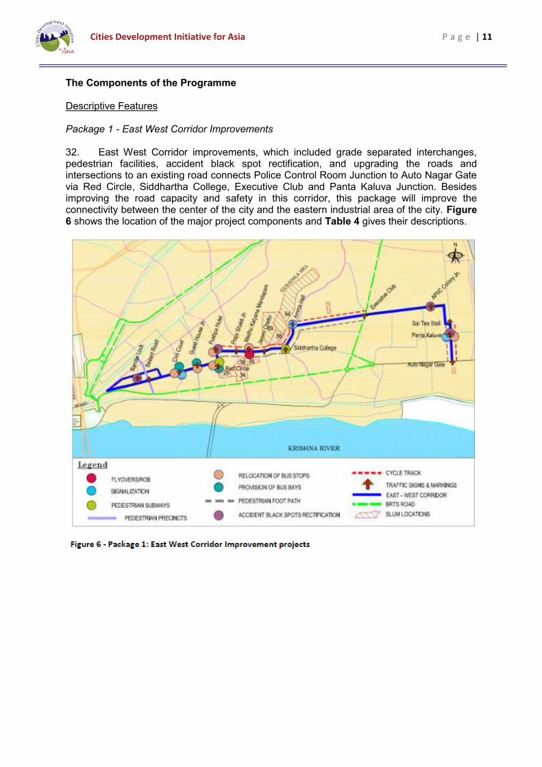
The Components of the Programme Descriptive Features Package 1 - East West Corridor Improvements 32. East West Corridor improvements, which included grade separated interchanges, pedestrian facilities, accident black spot rectification, and upgrading the roads and intersections to an existing road connects Police Control Room Junction to Auto Nagar Gate via Red Circle, Siddhartha College, Executive Club and Panta Kaluva Junction. Besides improving the road capacity and safety in this corridor, this package will improve the connectivity between the center of the city and the eastern industrial area of the city. Figure 6 shows the location of the major project components and Table 4 gives their descriptions.

Cities Development Initiative for Asia P a g e | 12

Cities Development Initiative for Asia P a g e | 13
33. Figure 7 shows the present volume to capacity (v/c) ratio which is on a higher side and this corridor will be congested in another five years i.e. by 2018, if no improvements are planned.
Package 2: Development of the BRTS Feeder Route Project Components 34. The Bhagat Singh Road through Ajith Singh Nagar to the north is already congested with one railway level crossing, two narrow canal crossings and restricted road width; any additional traffic growth in the northern districts of the city traveling to the center of the city is restricted to this road. The development of the BRTS feeder route aims at providing an alternate route to relieve traffic on Bhagat Singh Road by diverting it to the proposed project road. It offers a direct and alternative link to the city centre for traffic coming from the northern areas of the city; by extending it, it will eventually connect to the Ring Road. It is possible that once the proposed National Highway Bypass is completed, this corridor can act as the connecting link between city and bypass. 35. The project makes considerable use of existing infrastructure along the route. Since considerable growth potential exists along this corridor, it is proposed to construct 2 lanes initially and make it to four lanes in stages for the missing links, which are at present earthen roads (2.2 km). Whereas the Right of Way should be acquired for four lanes and reserved for future use. The grade separations (i.e. the ROB’s and canal crossings) should be four lanes. Figure 8 shows the location of the project components and described in Table 5.

Cities Development Initiative for Asia P a g e | 14

Cities Development Initiative for Asia P a g e | 15
Costs 36. Programme capital costs are based on recently completed projects obtained from VMC. From this data, unit costs for major civil works components are estimated. To these costs cover the following additional items:
36.1. Environmental and climate change mitigation costs not included in the civil works;
36.2. Land acquisition costs using local prices; 36.3. Resettlement; 36.4. Feasibility study (EIA, EMP, and other supporting studies) 36.5. Design and construction supervision; 36.6. Project management including operation of the PIU; 36.7. Capacity building and technical assistance; 36.8. Contingencies.
37. The programme costs are estimated below in Table 6.
C. Programme Justification Strategic Context 38. The vision of National Urban Transport Policy – 2008 is to make Indian cities; (i) the most livable in the world; (ii) enable them to become the “engines of economic growth” that power India’s development in the 21st century: (iii) allow the cities to evolve into an urban form that is best suited for the unique geography of their locations and (iv) are best placed to support the main social and economic activities that take place in the city. 39. The gap analysis indicates that there is a considerable room for improving the transport system in VMC to achieve the vision described above. The major roads in the city

Cities Development Initiative for Asia P a g e | 16
have received national and state support. Most of the shortcomings in the network are those roads that remain VMC’s responsibility due to lack of adequate funds. 40. There is a shortfall in road capacity on the more heavily travel routes in the city that do not fall under the purview of either the state or national governments highway programme. The proposed packages makes VMC largely responsible for the implementation of the programme except for the Road over Bridges (ROB) projects, which is a shared responsibility with Indian Railways, As a consequence, roads managed entirely by the city have been neglected and have not received adequate capital funding. In addition, the BRTS Feeder Route is targeting less developed areas of the city that have been isolated by the combination of topography, railway infrastructure and the canals. 41. The proposed investments will benefit all road users in VMC in terms of higher speeds and levels of service quality, reduced travel time, increased fuel efficiency, reduced wear & tear for vehicles and improved safety measures which in turn will reduce accidents. In addition, they will improve public transport and pedestrian and non-motorized transport accessibility and safety reducing the disparities between areas of the city. Consequently, they will improve productivity of the residents of the city and make the city more attractive for investors. Economic Viability 42. The economic benefit cost analysis compares the benefits derived from the project with the capital costs and operating and maintenance costs over the life of the projects. Benefits considered include i) savings in vehicle operating costs and ii) savings in travel time for passengers and cargoes. With the assumption that proposed project interventions will increase the travel speeds in the project corridors, consideration is given to estimating the difference in travel speed under ‘with’ and ‘without’ project scenarios to estimate VOC and time savings. They are the quantifiable benefits estimated for the PFS; non-quantifiable benefits comprise reduction in traffic accidents, reduction in emissions, improvements to health and welfare, and improved accessibility for pedestrians and cyclists. 43. The financial costs are adjusted to reflect import duties, taxes and shadow price of unskilled and skilled labor. The economic opportunity cost of capital (EOCC) is taken as 12%. The analysis period is taken as 24 years. 44. Two indices of economic viability of the investments are the Economic Internal Rate of Return (EIRR) and Economic Net Present Value (ENPV). They are indicated in Table 7.

Cities Development Initiative for Asia P a g e | 17
45. Sensitive analysis tests the robustness of the results of the economic analysis by varying the main economic parameters (costs and benefits). Except for the combination of all tests, the EIRRs are greater than 12% EOCC, which indicate an economically strong programme. The results of sensitivity analysis are shown in Table 8.
Financial Viability (with caveats) 46. Based on either the Financial Internal Rate of Return (FIRR) or Financial Net Present Value (FNPV), a financial rate of return analysis cannot be prepared because there is no revenue generating activity associated with the programme. Consequently, the financial analysis is undertaken from the perspective of the determining how to best finance the project and to what extent VMC can do so from its own resources. The first task was to review the financial accounts of VMC and then to prepare forecasts. While the financial data

Cities Development Initiative for Asia P a g e | 18
for the most recent years is not complete3, forecasts of revenues and expenses were made with a number of caveats. 47. Funding options for the city were reviewed; they include: 48. PPP: The programme does not lend itself to public private partnership; in part this is due to a lack of an easily identifiable revenue source for the investor. 49. National and State Government Funding: For VMC, the simplest and most cost effective method is to fund the proposed transport investments by grants from State and Central Governments. VMC is part of Phase I of the JNNURM program. As part of this program the corporation is eligible to receive grants covering 70% (50% - GOI, 20% - GOAP) of the project cost. This requires that VMC finance the balance of 30% by its own resources. In addition, VMC has to bear the cost of land acquisition. 50. GOI is also implementing a slum improvement program as a subcomponent of the JNNURM called Basic Services for Urban Poor (BSUP) as part. The BSUP program will fund slum improvement projects which provide basic infrastructure for slums and housing facilities for people who fall in Below Poverty Line (BPL) category. The funding pattern for BSUP is 50% GOI grant and balance 50% by State/ULB/Parastatal share, and Beneficiary contribution are encouraged. For VMC tapping the JNNURM program is one of the better options to fund both packages. This requires that (i) the corporation can maintain its status in the Phase II of the JNNURM program, that is, it remains eligible for funding, and (ii) funds are available since VMC must compete with other ULB’s for funding. 51. Financial Institutions: Urban local bodies such as VMC have access to funds from state level development financial institutions. One such institution in the state is Andhra Pradesh Urban Finance Infrastructure Development Corporation Limited (APUFIDC) a public sector financial company. APUFIDC is a state level nodal agency for central and state schemes and can also fund projects from its own resources or from the resources raised from other sources. In general the domestic financial institution will fund infrastructure projects such as transportation, solid waste, water supply schemes, etc. but may not fund purely for slum improvement projects. 52. International Financial Institutions (IFI): Though the domestic financial institutions are available, there are several advantages to accessing international financial institutions such as (i) lower cost funds, (ii) longer tenor, (iii) access to technical assistance and to institutional capacity building. The disadvantage is that each international organizational has its own administrative system to manage the loan or grant, finding the financing is not straight forward since it must go through the central government administration and therefore it can be time consuming with potential and unaccounted delays. 53. VMC can follow a mixed approach for better access to funds by combining governmental grants with funds from either a domestic or an international financial institution. In all cases, VMC would have to fund the land acquisition and resettlement costs. 54. Two program funding options are evaluated based this approach:
Option 1: GoI/GoAP = 70%; Domestic Financial Institutions = 20% and VMC = 10% plus the land acquisition and
3 A public accounting firm has been hired to review VMC accounts. Their assignment is still on-going.

Cities Development Initiative for Asia P a g e | 19
Option 2: GoI/GoAP = 20%; International Financial Institutions = 70% and VMC = 10% plus the land acquisition.
55. Not too surprisingly, the financial analysis indicates that Option 1 with the large percentage of grant funding by the GoI/GoAP is the preferred alternative. Without external funding, VMC would have great difficulty funding the programme from its own resources. Environmental & Climate Change 56. The proposed project is likely to have several positive impacts by way of improving the existing traffic and transport infrastructure to optimize the road speed (avoid traffic congestions, vehicle idling and consequential reduction in emissions and noise), encouraging the NMT (switching to environmental friendlier transport), and improving the road safety, all of which will essentially contribute positively to the overall city environment. During the construction of the above listed projects, negative environmental impacts will occur. Their severity will depend on the location, design and construction activities involved. Identification of potentially negative impacts and integrating appropriate mitigation measures is essential to enhance net positive impacts on the project. 57. Regulatory Framework: Indian law and policies of various multilateral and bilateral funding agencies (ADB, GIZ, KfW, World Bank,etc,.) require that the environmental impacts of development projects are identified and assessed as part of the planning and design process and that action is taken to reduce those impacts to acceptable levels. This is done through the environmental assessment process, which has become an integral part of lending operations and project development and implementation worldwide. 58. From the national perspective, projects are categorised as A or B depending on the scale of the project and the nature of its impacts. Category A projects require an Environmental Clearance(EC) from the national Ministry of Environment and Forests (MoEF). Due to the nature and scale of programme, none of the proposed projects are likely to attract the EIA Notification, 2006 and since all the projects are likely to be classified as Category B, Environmental Clearance from MoEF will not be required B category. 59. However category B projects require environmental clearance from the State Environment Impact Assessment Authority (SEIAA). The State level Expert Appraisal Committee (EAC) categorises a project as either B1 (requiring EIA study) or B2 (requiring no EIA study), and prepares ToR for B1 projects within 60 days. On completion of the study and review of the report by the EAC, the SEIAA issues the EC based on the EAC recommendation. The investments proposed under the PFS do not attract EIA Notification, 2006, and therefore do not require EIA study and/or Environmental Clearance from MoEF. However, these investments will require, limited environmental assessment study as per the Environmental Safeguard Policies of most of the multilateral funding agencies like ADB, World Bank. 60. Based on ADB’s Environmental Assessment Guidelines and with the limited potential environmental impacts, the projects in the proposed programme can be classified as Category B indicating some but limited adverse environmental impacts. This will require preparation of Initial Environmental Examination (IEE) which will determine if an Enviornmental Impact Assessment (EIA) report during feasibility and detailed design phase is required. There will be a need to prepare an Environmental Management Plan to minimize and to monitor the adverse impacts during construction. The IEE/EIA should include an Environmental Management Plan, specifying mitigation measures for each of the identifed nagative impacts, delegating responsibilities to project authorities, and costs of implementation.

Cities Development Initiative for Asia P a g e | 20
61. Environmental Impacts: Most of the adverse environmental impacts identified are associated with construction activities that disrupt existing traffic, cause dust, vibration and noise, adversely impact public and worker safety, increase flooding and water logging in surrounding areas during the rainy season, increase structural risk to surrounding buildings or transport infrastructure, and obstruct waterways. These impacts can be mitigated by good design, implementation of the Environmental Management Plan during construction and to incorporate mitigation measures as part of the contract documents. 62. No long term adverse impacts have been identified. Once completed, the main long term environmental benefit of the programme will be reduced air and noise pollution. 63. Climate Change: Many aspects of the proposed projects will reduce Green House Gases as shown in Table 9. Although there has been no study of risk and vulnerability of Vijayawada City to climate change, Table 10 attempts to identify the climate vulnerability and the necessary adoption measures

Cities Development Initiative for Asia P a g e | 21

Cities Development Initiative for Asia P a g e | 22
Social, Poverty and Gender Impacts Beneficiaries 64. In general, the beneficiaries of this investment proposal are all the citizens of Vijayawada and visitors to the city. In particular for the East West Corridor, the principle beneficiaries are the road users using the road on a daily or occasional basis. Moreover the corridor connects the centre of the city and the industrial area to the east providing easier access between them. The BRTS Feeder Route helps to relieve congestion and to provide access to the poorly served northern areas of the city and to the Inner Ring Road. Both benefit commuters by providing greater economic opportunities through access to future growth areas within the city. 65. Many of the beneficiaries will be poor and vulnerable and student population since improved safety through the provision of cycle lanes, sidewalks, better located bus stops and better traffic control through signalization largely benefit them. Road accidents disproportionally affect the poor and low income inhabitants of the city because they are forced to walk in trafficked areas mixing with motorized vehicles due to a lack of adequate sidewalks or proper road crossings. Once injured, they have limited capacity to pay for their medical bills, and at the same time, they often loose their employment. Sidewalks and cycle lanes give the poor and low income greater accessibility to public transport and expand their employment opportunities.

Cities Development Initiative for Asia P a g e | 23
Social benefits include improved access for vehicular and pedestrian traffic, reduced road accidents, time savings especially for commuters, and improved safety. As shown in Table 11, most social impacts are positive.
66. The proposed project components will not create clearly identifiable negative social impacts on the local population with the exception of land acquisition. A limited area of land will need to be acquired to facilitate the design and construction of the proposed infrastructure for both packages. These impacts are summarized in Table 12. The proposed private land acquisition envisages displacement of buildings and structures occupied by private individuals and associated loss of livelihood. These impacts have to be mitigated with appropriate Resettlement Policy Frameworks (RPF), which will be prepared in the next stage of the project studies when the designs are at a more advanced stage.

Cities Development Initiative for Asia P a g e | 24
67. As to poverty alleviation and gender issues, any improvement to public transport facilities and the urban/pedestrian environment will almost certainly have a positive impact on all members of the communities involved, including those from the poorest households - increasing the accessibility to employment opportunities, markets and other public services (schools, clincs, hospital and etc.) in the city. The development of the BRTS Feeder Route will be able to serve slums with a paved road that will give their residents greater employment opportunities. 68. The transport sector provides an example of a nontraditional channel to promote social, economic, and gender equity. Access to transportation on safe roads has a direct impact on the economic standing and quality of life in communities living and the well being of each individual. With safe and secure sidewalks, it is possible to travel on foot longer distances to make use of improved, safe and secure transport service especially for school children and women. Similarly, the planned bus stops and bays provide safe refuge for passengers as they mount and descend from a bus. 69. Community services that depend on good transport infrastructure (ambulance, police and social services) are more able to better serve slum and low income areas.

Cities Development Initiative for Asia P a g e | 25
D. Summary and the Way Forward Summary 70. The programme consists of two packages of projects:
70.1. The East West Corridor Improvements which is an integrated programme to improve capacity, safety and accessibility at a cost of 763.76 million INR including Land acquisition or 13.89 million USD and
70.2. The Development of the BRTS Feeder Route which would improve capacity by extending the road network at a cost of 1911.60 million INR including land acquisition or 34.76 million US$.
Strong support by VMC 71. Consultations with VMC and other key stakeholders indicate strong support for the programme presented above. It achieves the goals of investing in more road capacity for the city to reduce congestion and of improving traffic safety for all modes of urban transport (vehicles, NMT, and pedestrians). Both packages will provide improved connectivity within the city. 72. Support for the programme comes from:
72.1. Firstly, the programme was developed mainly by the VMC with the Consultant acting as a technical facilitator. Thus, the programme reflects the city’s requirements for transport improvements and is not imposed.
72.2. Secondly, the Steering Committee Meeting reviewed and approved the
conclusions of the PFS presented by Consultant. All that remains is for the city to begin the long process of implementing the project.
Strong Justification for the Programme 73. The East West Corridor Improvements upgrades an existing road that will reduce congestion and improve safety and improve access between the central commercial area and the western industrialized area of the city. The Development of the BRTS Feeder Route will be able to relieve congestion on major corridor and provide alternative route between the center of the city and the northern residential areas.
73.1. Meets the strategic requirements of the city: The gap analysis indicates that here is a need for more road capacity on the more congested routes in the city. Except for the Road over Bridges (ROB) projects, the VMC is largely responsible for the implementation of the proposed programme. The major roads in the city have received national and state support. As a consequence, roads managed entirely by the city have been neglected and have not received sufficient capital investment to keep pace with the growth of the city.
73.2. Economic viability: With an economic cost of capital of 12%, the EIRR’s are reasonably robust at 18.65% and 29.74% for Packages 1 and 2, respectively. Only vehicle operating costs and time savings were quantified. Other benefits such as reduction in accidents and emissions will be considered in the feasibility study.
73.3. Financial viability: Since none of the projects generate revenues, the determination of the FIRR and FNPV is not possible. The financial analysis looks at the capacity of the city to fund the projects from its own resources.

Cities Development Initiative for Asia P a g e | 26
Two options were reviewed: one with only domestic funding through GoAP and GoI grants and the second with IFI funding. Of the two alternatives, domestic funding is more attractive.
73.4. Environmental and climate change impacts: From the initial review of the
programme, the nature and scale of the individual project components will not attract the EIA Notification 2006. The initial environmental analysis indicates that none of the projects require environmental clearances from the GoI. However, at the state level an Environmental Impact Assessment (EIA) may be required by APEIAA. If the programme is partially funded by an IFI, there will probably be a need for an EIA meeting its requirements.
73.5. These outstanding issues will have to be taken up during the feasibility study.
Mitigate measures will be recommended to minimize the short term and long term adverse impacts. Once completed, the main environmental benefit of the project will be to reduce air and noise pollution.
73.6. Similarly, the main advantage of the programme from the perspective of
climate change is the reduction in GHG emissions or emission savings to the tune of 60.21 tonnes/day. Most of the climate change risks can be mitigated through the design of the different components of each project.
73.7. Social, Poverty and Gender Impacts: Once implemented, most social
impacts are positive for the programme; they include easier access, reduced accidents, time savings and improved safety benefiting the poor and women. The main adverse social impact involves land acquisition for both packages. While the land take for Package 2 (5.26 ha) is much larger than Package 1 (2.44 ha) the number of affected persons is much greater for Package 1 (1007 versus 399). A Resettlement Policy Framework (RPF) will be prepared in the next stage of the project.
73.8. The proposed improvements envisioned under the programme will have a
positive impact upon the poor by providing improved public transport facilities, sidewalks and other safety measures. These benefits from the projects include a more welcoming environment for woman.
Way Forward
74. With the completed PFS, VMC will be facing the challenge of implementing the programme over the next 5 years. VMC will need to do the following in order to expedite the implementation of the programme:
74.1. It is imperative that VMC has capital account statements for the last three fiscal years. Due to the delays in obtaining them, it is equally important that these results are endorsed by an accredited national accounting firm4. They are needed if VMC is to receive funding from national programmes such as Phase II JNNURM and Basic Services for Urban Poor (BSUP). Both programmes are competitive and in this context VMC must present a mature image. Likewise, International Financial Institutions (IFI) do their own financial due diligence of the organizations which they fund and require that the urban institutions they deal with are financially robust.
4 VMC has hired an accounting firm to do this.

Cities Development Initiative for Asia P a g e | 27
74.2. A consultant needs to be recruited and employed to prepare the feasibility study, compliance documentation (social and environmental studies to support the implementation of the projects), the detailed designs and contract documents. It is recommended that a single consultant be selected for both packages. The terms of reference (TOR) for these consulting services are found in Section -7 of Volume -1. Tendering for these services is expected to take 6 months.
74.3. The first steps to begin the land acquisition should be taken as early as
possible. Only as the detailed design progresses are the precise requirements known, and in some cases the designs may need to be modified to avoid some areas. Land acquisition is a long lead time item and will require public participation, and meetings with affected persons.
Land acquisition raises concerns among various sectors of society causing long delays. A good public relations programme in support of the programme by VMC will help to make these challenges less formidable.
74.4. Financing the programme will require considerable effort on the part of VMC;
it will need to identify the funding sources and then satisfy the regulatory and other requirements to achieve positive outcomes. In the case of JNNURM, VMC will have to present a strong case in support of the programme since Phase 2 is reported to have stringent requirements.
To begin, VMC may have to fund the initial program activities to ensure a rapid start and maintain the momentum created with the preparation of the PFS. This will require:
74.4.1. Initial budget allotments for consulting services and other startup
costs and 74.4.2. This will have to be followed by budget allotments for land
acquisition and resettlement.
Besides considering state and central government grants, the VMC should identify potential International Financial Institutions (IFI) or bilateral donors who may be interested in funding the programme. This will not be an easy task since it falls outside the corporation’s normal practices and experiences. CDIA and other institutions might help to facilitate this process.
If an IFI becomes involved, its compliance requirements are quite rigorous and considerable management time will be absorbed in the process of satisfying them. In technical areas, the design consultant could facilitate this process.
74.5. Depending upon the conditions of the loan agreement and the practices of the
IFI, a Project Implementation (PIU) will need to be established in order to oversee the management of the programme including its design and construction, its procurement and contract administration and its accounting and finances. See Figure 9.

Cities Development Initiative for Asia P a g e | 28
Because of the IFI compliance requirements, the PIU will function to a large degree independently of VMC management structure. However, even without IFI financing, a PIU is also very useful modality for the implementation of a large and many faceted programme.
74.6. With the designs nearly completed and the funding assured, the procurement
of a construction supervision consultant should begin. The construction supervision consultant should be ready to begin work either before or during the tendering of the construction contracts for both packages. This allows some overlap between the design and construction supervision consultants.
74.7. The procurement of the construction contractors’ services can begin when the
land acquisition is near complete. Ideally, construction should not commence until all the land required for the project components is free and clear. Many construction projects have had considerable delays and cost overruns because they began prior to having the land free of all encumbrances. Thus, the tendering should be timed when the land acquisition activities are nearly finished.
74.8. Once the construction contracts are awarded the day to day management of
these contracts will be done by the PIU with the assistance of the construction supervision consultants.
75. The above steps are summarized in Figure 10. It shows that construction activities should be completed by the second quarter of 2017 assuming that it will take 2 years to complete the construction of each package. The estimated duration from start to completion is around 4.5 years. Key to achieving this schedule is completing the land acquisition and resettlement over a period of slightly more than 2 years.

Cities Development Initiative for Asia P a g e | 29