prepared by m. sarazin, eso · capped above by a cold top. ... to 18 months. 8 ... site is better...
TRANSCRIPT

1
Climatology of ParanalPrepared byM. Sarazin, ESO

2
Climatology of Paranal
• The Main Climate Actors• The Main Parameters• And their Climatology

3
Main Climate Actors
•Bolivian High•El Nino Southern Oscillation•South American Monsoon•Pacific Decadal Oscillation (?)•Global Warming (no)

4
Main Climate Actors1-The Bolivian High
The Bolivian high is characterized by a warm core below about 150 mb,capped above by a cold top.
The warm temperatures extend from the surface and maximize at around 300 mb.
M. Beniston, P. Casals & M. Sarazin; Perturbations to astronomical observations at the European Southern Observatory's very large telescope site in Paranal, Chile: analyses of climatological causes; Theoretical and Applied Meteorology, Volume 73 Issue 3-4 (2002) pp 133-150

5
Main Climate Actors 2-South American Monsoon System (SAMS)
also called “Bolivian Winter”Over 60% of the annual precipitation of the Andes is concentrated in the austral summer (DJF) in the form of intensive convective rainstorms along the plateau, when easterly flow prevails over the central Andes allowing moisture transport from the interior of the continent up to the Altiplano.

6
Main Climate Actors3- El Niño/Southern Oscillation (ENSO):
• El Niño/Southern Oscillation (ENSO): The term for the coupled ocean-atmosphere interactions in the tropical Pacific characterized by episodes of anomalous high sea surface temperatures in the equatorial and tropical eastern Pacific; associated with large scale swings in surface air pressure between the western and eastern tropical Pacific. These episodes recur at irregularly spaced intervals (2-7 years) and may persist for as long as 2 years (Niño=warmer water, Niña=colder water).

7
Main Climate Actors4- Pacific Decadal Oscillation (PDO):
• The "Pacific Decadal Oscillation" (PDO) is a long-lived El Niño-like pattern of Pacific climate variability. While the two climate oscillations have similar spatial climate fingerprints, they have very different behavior in time. Two main characteristics distinguish PDO from El Niño/Southern Oscillation (ENSO): first, 20th century PDO "events" persisted for 20-to-30 years, while typical ENSO events persisted for 6 to 18 months

8
Main Parameters
•Seeing•Coherence Time•Precipitable Water Vapor
•Cloudiness: Observatory night reports

9
Main ParametersThe Seeing
The seeingis measuredby dedicatedInstruments:
DIMM since 1988MASS since 2003
2004-09-25

10
Main ParametersThe Seeing
The seeingis measuredby dedicatedInstruments:
DIMM since 1988MASS since 2003
2004-10-15

11
Main ParametersThe Seeing
The seeing measured by DIMM compares well with UT4 active optics spot size

12
Main ParametersThe Seeing
Comparison with FORS Image QualityBecause its diameter is comparable to the finite outer scale of the turbulence, the
site is better for a VLT than predicted by DIMM by about 10% in the visible
FORS data, Roberto Mignani, ESO

13
Main ParametersThe Seeing
Comparison with ISAAC image quality
for a VLT, the site is better than predicted by DIMM by up to 30% in the IR
ISAAC data, Wolfgang Hummel, ESO

14
Main ParameterThe turbulence Coherence Time, Tau0
(adaptive optics, VLTI fringe tracker)
The wavefront velocity is estimated from 200mb and ground wind velocityV0fit= Max(Vground, 0.4 V200mb )
(systematic trend observed during Paranal and Gemini balloon campaigns)
First light of SinfoniBonnet et al, The Messenger 117
Tau0=0.31 r0/ V0

15
Main Parameters CLOUDS and RECIPITABLE WATER VAPOR
(Andre Erasmus, SAAO, South-Africa)Infra-red Window Channel and Water Vapour Channel at 11:45UT
on October 25, 2000Infra-Red Window (10.7µm) Water Vapor (6.7µm)
GOES Meteorological Satellites
16
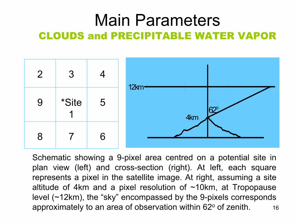
Main ParametersCLOUDS and PRECIPITABLE WATER VAPOR
Schematic showing a 9-pixel area centred on a potential site in plan view (left) and cross-section (right). At left, each square represents a pixel in the satellite image. At right, assuming a site altitude of 4km and a pixel resolution of ~10km, at Tropopause level (~12km), the “sky” encompassed by the 9-pixels corresponds approximately to an area of observation within 62o of zenith.
62o
4km
12km
678
5*Site1
9
432

17
Main Parameters PRECIPITABLE WATER VAPOR
PWV (mm) statistics for Paranal (January - August 1998) and Chajnantor (January - September 1999) for satellite and ground-
based site monitor measurements of PWV
2.161.265.217.273rd Quartile0.770.723.664.05Median0.400.472.412.571st Quartile0.260.301.701.8310th percentile
24 hrsDayNightDayPeriod
Site MonitorSatelliteSite MonitorSatelliteSensorChajnantorParanalSite
Conclusion: The satellite-derived PWV for daytime hours gives a reliable and accurate absolute humidity measurement that is representative of daytime and nighttime moisture conditions

18
Main ParametersPRECIPITABLE WATER VAPOR
Precipitable water vapor content of the atmosphere (ppwH2O) multiplied by the airmass of the standard star observation versus sensitivity. Data are shown whenever available during TIMMI2 operations in year: 2001 – 2004.R. Siebenmorgen, ESO
19
Climatology of
•Cloud Cover ( )•Seeing ( )•Turbulence Coherence Time•Precipitable Water Vapor•Boundary Layer Flow

20
Climatology ofThe Cloud Cover
Paranalphotometric night monthly fraction
Long term degradation?
Coupling with El Nino?

21
Climatology ofThe Cloud Cover
Paranalphotometric night monthly fraction
Long term degradation(Bolivian High moving South)
Coupling with El Nino

22
Climatology ofThe Cloud Cover
La Sillaphotometric night monthly fraction
Long term improvement
(Polar low moving South)
Coupling with El Nino

23
Climatology ofThe Cloud Cover
Paranal photometric night monthly fraction
Long term degradation(Bolivian High moving South)
Coupling with El Nino

24
Climatology ofThe Cloud Cover
Paranal-La Silladifferential
photometric night monthly fraction

25
Climatology ofThe Seeing
Paranal & La Sillaseeing
Long term degradation?
Coupling with El Nino?

26
Climatology ofThe Seeing
Paranal seeingduring
the VLT life
Monthly Average0.91”
Monthly Median0.81” (0.66)5 percentile0.47” (0.38)

27
Climatology ofThe Seeing
Paranal seeing
Long term degradation
+Coupling with El
Nino

28
Climatology ofThe Seeing
Paranal & La Sillaseeing
Long term degradation
+Coupling with El
Nino

29
Climatology ofThe turbulence Coherence Time, Tau0
Tau0=0.31 r0/ V0
Paranal Wind at 200mb
No long term climatic trend

30
Climatology ofThe turbulence Coherence Time, Tau0
Tau0=0.31 r0/ V0
Paranal Wind at 200mb
No long term climatic trend
No coupling with el-nino

31
Climatology ofThe turbulence Coherence Time, Tau0
Tau0=0.31 r0/ V0
Paranal yearly wind vertical
profile
The strong seasonal trends of Tau0 are due to Jet Stream variability

32
Climatology ofThe turbulence Coherence Time, Tau0
Tau0=0.31 r0/ V0
Paranal
Median tau0 reaches 5ms in
summer, below 3ms the rest of the
year
80% of the dark time larger than
3ms in J-FM, only 40% in J-J-A-S

33
Climatology ofPrecipitable Water Vapor
Paranal & La Silla3-hourly
PWV

34
Climatology ofPrecipitable Water Vapor
Paranal & La Silla3-hourly
PWV
Winter is two times dryer than
Summer

35
Looking for long term trends• The mechanism of the degradation of the seeing at Paranal is not
global but selective: the superb seeing conditions from the sea breeze (N-Westerly wind) are progressively replaced by turbulent boundary layer flow from the land (N-Easterly wind)
• This effect is amplified by the presence of other summits upwind
Study Boundary Layer Climatology

36
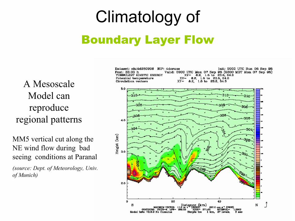
Climatology ofBoundary Layer Flow
A MesoscaleModel can reproduce
regional patterns
MM5 analysis of the wind trajectories during bad seeing conditions at Paranal(source: Dept. of Meteorology, Univ. of Munich)
37
Climatology ofBoundary Layer Flow
A MesoscaleModel can reproduce
regional patterns
MM5 vertical cut along the NE wind flow during bad seeing conditions at Paranal(source: Dept. of Meteorology, Univ. of Munich)

Climatology ofBoundary Layer Flow (NCAR-NCEP re-analysis)

39
Climatology ofBoundary Layer Flow
ParanalWind Velocity at
700mb
Long term trend
El-Nino anti-coupling?

40
Climatology of ParanalTwo lines of sight which make all the difference