preparing for the moon - history home 10-20-2008_part 2.pdfpreparing for the moon ... before...
TRANSCRIPT

Chapter 4
PREPARING FOR THE MOON
Despite the significant progress made during Project Mercury, in 1963 the United States still trailed (and trailed badly) the Soviet Union in terms of flight hours spent in space. The six Mercury missions flown between May 1961 and May 1963 had only accumulated a total of 53 hours in space. Thirty-four came on Mercury Atlas 9, Gordon Cooper’s 22-orbit program finale. Of the six flights, two were suborbital. In contrast, Soviet Vostok cosmonauts had accumulated a total of 382 hours in space on six missions. Valentina Tereshkova, a 25-year-old textile worker from Yaroslavl who became the first woman in space in June 1963 on Vostok 6, was in orbit 17 hours longer than all the American astronauts put together.
It was clear by now that space had become the new global high ground for ideology and Cold War international prestige. “Now let the other countries try to catch us. Let the capitalist countries catch up with our country which has blazed the trail into outer space,” was the unabashed challenge from Soviet Premier Nikita S. Khrushchev upon Gagarin’s triumphant return from space.1

106 “Read You Loud and Clear!”
A week after the Gagarin flight, in a White House correspondence dated 20 April 1961, President John F. Kennedy gave Vice President Lyndon B. Johnson a directive. It had a definite sense of urgency. The President wrote:
I would like, for you as Chairman of the Space Council, to be in charge of making an overall survey of where we stand in space. Do we have a chance of beating the Soviets by putting a laboratory in space, or by a trip around the Moon, or by a rocket to land on the Moon, or by a rocket to go to the Moon and back with a man? Is there any other space program which promises dramatic results in which we could win?2
Kennedy wanted results. Even more so, he wanted something dramatic, something that would capture the imagination of Americans everywhere to allow the U.S. to regain, in no uncertain terms, the upper hand in space.
To answer the President’s directive, Johnson and Dr. Jerome Wiesner, Kennedy’s science advisor, turned to NASA. Anticipating this, the Agency’s top management triad of James E. Webb, the new Kennedy-appointed Administrator, Deputy Administrator Hugh L. Dryden and Associate Administrator Robert C. Seamans, Jr. had been working to prioritize a list of Agency objectives since the previous fall. To this end, they commissioned a study on 6 January 1961, chaired by George M. Low of the Manned Lunar Landing Task Group, to determine the technical, schedule, and cost requirements of a human lunar program. Table 4-1 lists the conclusions reached by the Low study.
Spurred on by these generally encouraging findings, Kennedy went forth with the commitment before a joint session of Congress on 25 May 1961, of “achieving the goal before the decade is out, of landing a man on the Moon and returning him safely to the Earth.” This was a bold move by a young President who had been in office for just five months. While the
Table 4-1: Results of the Low Study on a Manned Lunar Program3
Mission Spacecraft Launch Vehicle Date
Earth Orbiting 1 Man, Short Duration
Mercury Atlas 1961
Earth Orbiting 3 Men, Long Duration
Apollo “A” Saturn C-1 1965
Circumlunar, Lunar Orbit 3 Men
Apollo “B” Saturn C-2 1967
Manned Lunar Landing Orbital Operations Direct Approach
Apollo “B” Apollo “B”
Saturn C-2 Nova
1968–1969 1970–1971

107 Chapter 4 \ Preparing For The Moon
the Gemini spacecraft was basically a two-seat version of the Mercury capsule. It did,
however, have an equipment section which enabled it to stay in space for up to two
weeks. Gemini allowed NaSa to gain the necessary experiences and man-hours in
space needed before an attempt to the Moon was possible. here, astronauts James
McDivitt and ed White train for their Gemini 4 mission in May of 1965.
(NaSa Image Number GpN-2000-001018)

108 “Read You Loud and Clear!”
technical basis for his decision came from the NASA study, Kennedy felt that this gamble was one in which the United States had a chance to win and that it was sufficiently bold and dramatic enough to invigorate the nation and place America once again on the world center stage.
Before astronauts could fly to the Moon, many questions still had to be answered. For instance, what features of the Mercury spacecraft needed to be improved? Can a spacecraft be made with greater endurance so it can orbit Earth longer to find out the physiological affects of long-duration missions required to travel to the Moon and back? Can two spacecraft rendezvous and dock in space? Can astronauts work effectively outside the protection of his spacecraft? Even though America had decided to go to the Moon, NASA was not yet ready. To bridge the rather significant technology gap between Mercury and the emerging Apollo program, the Agency endorsed plans for a two-person spacecraft program called Mercury Mark II in December of 1961. The following spring, the name was changed and the program was officially christened Project Gemini—after the twin gods of Greek mythology— befitting of NASA’s new two-person spacecraft.4
GSFC engineers made their first presentation to the newly formed Manned Spacecraft Center (MSC) on the outskirts of Houston in the first week of June 1962. The topic was technical requirements they would like to see implemented in a Gemini network. These included:
Unification of all command, telemetry, and radio signals onto a single carrier frequency.
Conversion from analog to the newer and much more bandwidth efficient Pulse Code Modulation (PCM) digital telemetry.
Use of two acquisition aids at each tracking station (one for the Gemini spacecraft and one for the unmanned Agena docking target) and the ability to slave the radar to either vehicle.
Modification of network station computers to accommodate processing both command uplink and telemetry downlink.5
Consumed with their primary job of developing the new two-seat Gemini spacecraft, MSC was lukewarm to the proposed changes. In their mind, they were just too much of a departure from what had just been done successfully on Mercury. Houston’s thinking was correct. The Goddard suggestions, taken collectively, did in fact represent a major change in the way tracking and data acquisition would be done. The proposed technique was a harbinger of the (Unified S-Band) system that would later be used on the Apollo spacecraft. USB was revolutionary in its time, enabling spacecraft command, telemetry,

109 Chapter 4 \ Preparing For The Moon
voice, and television to all be transmitted using a single, combined data link. The technique was not entirely new, however, to NASA as the DSN had used USB since 1958.
The proposed changes broke ground with the conservative reliance on time-tested technologies such as analog telemetry, which had been in use since the 1940s. By the mid-1960s, digital systems had been under research at the White Sands Missile Range for some time. NASA had even tried it experimentally at the Bermuda Station on the final Mercury mission. After initial discussions, Houston agreed to make the switch to PCM telemetry but objected to the others on the grounds that complete dependence upon a single TT&C link could lead to total mission failure if just part of the system failed.
Most of the Goddard proposals were in effect rejected. Despite this initial disagreement, GSFC knew what they had and was convinced it would work. The two NASA Centers held a series of technical interchange meetings and working groups to discuss the changes over the next 12 months, with Greenbelt making its case for the new tracking and communication technique. By June 1963, Houston was persuaded for the most part, agreeing to the proposed changes but with one important stipulation: that computers at network stations be employed only for telemetry processing but not for commanding. The idea was to preclude inadvertent or erroneous commands from being uplinked to the spacecraft in the event of a computer anomaly.6
One Gemini guideline that had a significant effect upon the MSFN was the relaxation of the 10-minute “dead-time”, which was now relaxed to one primary ground contact per orbit. Astronaut performance and the Mercury spacecraft had shown that having the ability to remotely send commands to the spacecraft from every network outpost, while nice, did not turn out to be the necessary requirement that it was thought to be. With this decision, the MSFN no longer had to spread its valuable resources equally over the globe. It could now concentrate on a limited number of primary sites supplemented with a number of secondary stations. In this arrangement, primary stations were those that had command uplink capability in addition to voice, radar and telemetry while secondary stations did not have command capability.7
Another change in network philosophy was network centralization in terms of mission control and mission computing. Back before John Glenn’s first orbital flight, many had simply presumed, even at Goddard, that some of the communication links between Mission Control and the tracking stations would be lost, at least intermittently. But this did not turn out to be the case at all as Mercury proved that reliable network communications were the rule, not the exception. NASA then had the confidence to remove flight controllers from the network stations and centralize all control activities at the new MCC in Houston. As a precaution, Capcoms remained at a few of the primary

110 “Read You Loud and Clear!”
ground stations where there was still lingering skepticism on the part of MSC about the reliability of communications.
At least this was the official position coming out of Houston. It was well known within NASA circles that such assignments were a way for Donald K. “Deke” Slayton, head of Flight Crew Operations at MSC, to give his astronauts some much needed rest and relaxation at attractive places. As former Flight Director Eugene F.Kranz put it,“Slayton would send astronauts out at the very last moment to all of the sites that were generally good locations to go to—Bermuda, Hawaii, California,Australia.”8 This was generally not a problem for those working at the station, except when the astronaut crossed the line and began “throwing his weight around” as happened when Pete Conrad showed up in Australia on Gemini 3 saying that Slayton wanted him to be in charge during the mission.
The other network centralization implemented by GSFC involved the computer system. On Project Mercury, computing was performed in Greenbelt, Maryland. The only other network computers were at the Florida launch site itself and at Bermuda. This architecture—identical to what was used on Mercury—continued through the first Gemini mission (Gemini 3) in March 1965. As preliminary telemetry processing plans were first being laid for Gemini, this was the computing baseline computer that engineers worked from. A rather limited architecture, it was capable of processing and sending only four groups of spacecraft health and status parameters back to the MCC for monitoring and evaluation. To meet the increased data requirements of the more complex Gemini spacecraft, the MSFN now had two UNIVAC 1218 computers installed at each primary outpost. Additional submarine (oceanfloor) cables were also laid to meet the increased data flow demands. These improvements had the aggregate effect of greatly improving real-time data decommutation and processing allowing much more spacecraft information to now be sent to Mission Control than was possible on Mercury. Former MSC network chief Lyn Dunseith captured it succinctly when he said, “Voice, telemetry, command, and tracking data acquired by the Goddard managed communications and tracking network represented some of the most critical information available to the flight controllers at their display consoles”9
As network changes continued and Gemini missions took place, Houston gained more and more confidence in the network. Take the role of computers. Two U1218 computers were originally set up in dual redundant mode, operating in parallel to process telemetry data. As they began demonstrating their reliability and as spacecraft TT&C burdens increased, MSC relented, finally agreeing to let computers handle both telemetry and command (“fire retro rockets,” “turn on telemetry transmitters,” “ring astro alarm,” etc.). The digital processing capability of the U1218s made a dramatic jump during Gemini, increasing from 2 input/output lines to 32, with transmission rates reaching the then state-of-the-art 50,000 bits-per-second.

111 Chapter 4 \ Preparing For The Moon
the now famous Mission Control Center at the Manned Spacecraft Center (MSC) in
houston, officially assumed mission network operations beginning with the third piloted
Gemini flight (Gemini 5) in august of 1965. two identical Mission Operations Control
rooms, or MOCr, were located on the second and third floors of Building 30 on the
grounds of MSC. In 1996, the Department of Interior designated NaSa’s Mission Control
Center as a National historical Landmark. pictured here is Mission Control during
Gemini 5. (NaSa Image Number GpN-2000-001405)
Eventually, one computer was tasked entirely to telemetry while the other to commands.10
Project Mercury had shown mission control and mission computing to be so inter-related that the Office of Tracking and Data Acquisition at NASA Headquarters decided that they should be best managed by the same Center. Since the MCC was going to be at the MSC, the MSFN computing system was reassigned to Houston. Gemini 4 in June of 1965 marked GSFC’s finale as the primary computing center for NASA human spaceflight. On this flight, MSC computers were placed in a so-called “ghost mode” where they were checked out and accepted in preparation for its upcoming assumption of primary computing duties. When Gemini 5 left the launch pad on 21 August 1965, the MSC in Houston officially took over the mission computing function from Goddard. From that point on, the GSFC system was relegated to a backup role and employed mainly for network development, testing, and mission simulations, a role it performed until the end of Apollo.11
Mercury flights had been very basic, limited to circular, low-Earth orbits of less than 320 kilometers (200 miles) in altitude. Gemini, though, would fly many high apogee elliptical orbits, some as far as 1,600 kilometers

112 “Read You Loud and Clear!”
(1,000 miles). To improve tracking at these altitudes, RCA FPQ-6 skin-track C-band radars were added to the network. One of the most accurate and powerful tracking radars of the time, the FPQ-6 had an output power of 2.8 megawatts and was effective out to 60,000 kilometers (37,000 miles). All equipment was housed in a two story building. Its operation was fairly simple. It could be operated from a single console by two or three technicians depending on the tracking mode used. A team of at least seven people was required, however, for maintenance of the equipment. The reflector was an 8.8-meter (29-foot) dish and the combined weight of the moving parts and hydraulic drive was over 30 tons, controllable using a small joystick on the control console. For rigidity and stability, the antenna tower foundation extended nearly 10 meters (30 feet) underground.12 The older VERLORT and FPS-16 radars used on Mercury were kept in service. This provided redundancy so that, in the event of spacecraft beacon failure, the MSFN could still skin-track. With these combined capabilities, the potential for any tracking losses or blackouts was greatly reduced, if not eliminated altogether.13
Lighter TELTRAC telemetry antennas and associated telemetry equipment were also installed across the MSFN to serve as acquisition aid for simultaneous tracking of both the Gemini and the unmanned Agena docking target during rendezvous missions. A major objective of Project Gemini was to demonstrate and test-out the rendezvous procedures being developed for the upcoming Apollo lunar missions.These missions required the Command Module (CM) and the Lunar Module (LM) to rendezvous with each other as the latter returned from the surface. On Gemini, the unmanned Agena spacecraft served as a surrogate rendezvous and docking target. For command uplink, the network continued to rely on FRW-2 UHF transmitters using 10 kilowatt high-power amplifiers.14
Communications between the MCC and the ground stations also became much more efficient during Gemini. Air-to-ground voice transmissions, in particular, garnered special attention. Former Project Gemini Director at NASA Headquarters, William C. Schneider, recalled that
Early in Project Gemini . . . we found that voice communications from the spacecraft left much to be desired.A near-perfect mission received bad notices because the people on Earth couldn’t hear what was happening.So we went to work to fine-tune the system to be ready for the more advanced Gemini and Apollo flights.15
This is true even today. Despite crystal clear digital videos from space, the quality of voice transmissions—which is limited by the microphones worn by the astronauts—still leaves room for improvement.
The first stations to transmit telemetry back to Houston were Bermuda and the early-ops sites downrange of the Kennedy Space Center (KSC) at Grand Bahama, Grand Turk, and Antigua. When Houston supported its first mission in

113 Chapter 4 \ Preparing For The Moon
June 1965, the telemetry transmission rate from Bermuda to Houston was 2,400 bits-per-second (2.4-kbps). Commands could be sent from the MCC to remote ground stations in one of two ways. In one method, used for routine or so-called housekeeping commands, Mission Control teletyped the command sequences prior to a scheduled pass over a given site which were then stored at the station. Later on as the orbiting spacecraft passed over the station, an onsite technician would uplink them up to the craft. For more urgent matters, Houston could send command messages over the 2.4-kbps master circuit to KSC for immediate relay via dedicated government priority “T-1” landlines and submarine cables to the next MSFN station in the spacecraft’s ground track.
Communications between Houston and NASA tracking ships were enhanced whenever possible by collocating NASA vessels with Navy communication ships. This provided a network of UHF daisy-chain, relay points from sea-to-land and vice versa. The Coastal Sentry Quebec, a converted Class 1 World War II freighter, was usually situated in the Western Pacific covering the South Pacific gap between Australia and Hawaii. The Air Force Eastern Test Range and Western Test range operated the Rose Knot Victor and Range Tracker, which were moved around in the South Pacific, Atlantic, or Indian Oceans depending on a specific mission’s requirement.16
One final measure of the increasing capability of the ground communication network was at GSFC itself, where the SCAMA (Switching, Conferencing, and Monitoring Arrangement) was updated. SCAMA was the telephone switchboard at the Center that handled all voice communications from around the world. In the early days of Project Mercury, it could simultaneously conference only 10 worldwide voice circuits. This number jumped
Wives of Gemini 4
astronauts James a.
McDivitt and edward
h. White talk with their
husbands in orbit from
the new Mission Control
Center at the Manned
Spacecraft Center on
3 June 1965. patricia
White is on the left, and
patricia McDivitt is on
the right. (NaSa Image
Number S65-28922)

114 “Read You Loud and Clear!”
Table 4-2 The Manned Space Flight Network in the Mid-1960s17
Station (location) Abbreviation Network Role* Ownership**
North America
Canaveral (Kennedy Space Center, Florida) CNV Primary NASA
Texas (Corpus Christi, Texas) TEX Primary NASA
Eglin (Florida) EGL Secondary DOD
Goddard Space Flight Center(Greenbelt, Maryland)
GSFC Secondary NASA
Guaymas (Mexico) GYM Primary NASA
Houston (Texas) HOU Primary NASA
California (Point Arguello, California) CAL Primary DOD
Wallops (Wallops Island, Virginia) WLP Secondary NASA
White Sands (New Mexico) WHS Secondary NASA
Atlantic
Antigua (British West Indies) ANT Secondary DOD
Ascension (Ascension Island, United Kingdom) ASC Secondary DOD
Bermuda (United Kingdom) BDA Primary NASA
Grand Bahama (British West Indies) GBI Secondary DOD
Grand Canary (Spain) CYI Primary NASA
Grand Turk (British West Indies) GTK Secondary DOD
Africa
Kano (Nigeria) KNO Secondary NASA
Pretoria (South Africa) PRE Secondary DOD
Tananarive (Malagasy Republic) TAN Secondary NASA
Australia
Carnarvon (Western Australia) CRO Primary WRE
Perth (Western Australia) MUC Secondary WRE
Woomera (South Australia) WOM Secondary WREPacifi cCanton (Kiribati Republic) CTN Secondary NASA
Hawaii (Kauai, Hawaii) HAW Primary NASAShipsCoastal Sentry Quebec CSQ Primary NASA
Range Tracker RTK Secondary DOD
Rose Knot Victor RKV Primary DOD

Chapter 4 \ Preparing For The Moon 115
Remarks
Launch Control Center
Located at the abandoned Rodd Naval Auxiliary Air Station; an original Mercury station
Located at the Air Force Eglin Gulf Test Range 50 miles northwest of Panama City, FL; an original Mercury station
Overall network responsibility; development and test facility
Located in northwest Mexico on the shores of the Gulf of California; an original Mercury station
Manned spacefl ight Mission Control Center
Located some 40 miles north of Santa Barbara, part of the Navy Pacifi c Missile Range; an original Mercury station
Training and test facility just off the shores of Virginia
Located on the grounds of the Army’s White Sands Missile Range near Alamogordo; an original Mercury station
Air Force ETR station
Air Force ETR station
Go/No-Go decision site; an original Mercury station
Air Force ETR radar site
Located 120 miles off the African coast; critical abort tracking site; an original Mercury station
Air Force ETR radar site
Original Mercury station in west-central Africa
Air Force ETR station
Replaced the Zanzibar Station; last land site before crossing the Indian Ocean to Australia
Collocated with the NASA STADAN site
The original Mercury site at Muchea was used until Perth became operational; call sign was retained
Original Mercury station; collocated with STADAN site
Original Mercury station
Original Mercury station
Usually stationed in the western Pacifi c near Japan
Usually stationed in the central Pacifi c near Midway Island
Usually stationed in the south Pacifi c off the South American coast
*Primary stations were those that could uplink system commands to the spacecraft. Secondary stations were those used primarily for radar and telemetry downlink. All had UHF air-to-ground voice capability.**DOD: Department of Defense; NASA: National Aeronautics and Space Administration; WRE: Weapons Research Establishment, Australian Department of Supply

116 “Read You Loud and Clear!”
to 220 when the Mercury Space Flight Network became the Manned Space Flight Network for Project Gemini.18
From mid-1963 into the spring of 1964, a number of tracking stations were added. Overall, the MSFN expanded from 14 land stations to 23 (9 primary, 14 secondary) plus an additional Navy ship. As before, coordination with the DOD played a central role in this evolvement; DOD support was just as essential for Gemini as it had been for Mercury, the STADAN and Minitrack. By the time Project Gemini came around, coordination between the two departments at the working level was well established. The Air Force, in particular, remained a key player in the MSFN, providing support via the Eastern and Western Test Ranges. The network for manned spaceflight tracking was indeed a well-balanced, well-orchestrated effort between NASA and the DOD, with the latter even assuming primary station responsibilities at some places. Table 4-2 summarizes some key characteristics of NASA’s Manned Space Flight Network as it appeared in 1965 and 1966 when America flew 20 astronauts into space. (Also see Appendix 1.)
★ ★ ★
Network expansion in the mid-1960s was not designed merely to meet Project Gemini requirements. It prepared the MSFN for the soon to come, and the ultimate goal, of Apollo flights to the Moon. Since Apollo would be progressively more complex—first Earth orbit missions followed by circumlunar and finally lunar landing flights—network complexity also increased incrementally. Augmentation to many existing stations, along with new stations with totally new capabilities, was necessary. Several new sites around the world were founded during 1964. One of them was on Ascension Island, the network’s most isolated location.
Located just south of the Equator in the Atlantic some halfway between South America and Africa, the desolate 88-square-kilometer (34- square mile) island was originally discovered by the Portuguese on Ascension Day in 1501. Due to its remote location, it remained unoccupied until 1815, when it was garrisoned by the British Navy in an effort to prevent any attempt to snatch Napoleon Bonaparte from St. Helena some 11,000 kilometers (6,850 miles) to the south. At the turn of the century, the British Cable and Wireless Company set up a relay station on the island for telegraph cables that ran between Britain to Cape Town and South America. Little activity took place on the island after that until the Second World War, when it took on more importance, becoming a key refueling base for cargo planes of the Cannonball Express which the militarized Pan Am crews flew, rushing high priority supplies between Miami, Florida and Karachi, India. “If you can’t go to the Moon, the next best place is Ascension Island,” was ironically the airline’s advertising catch phrase in those days.19

117 Chapter 4 \ Preparing For The Moon
Ascension Island emerged as a key network location during Apollo network planning in 1964. From August 1964 to July 1965, Ed Buckley initiated a series of technical notes and memorandums to Bob Seamans and GSFC and KSC Center Directors Harry J. Goett and Albert F. Siepert, pushing to establish Ascension and Antigua in time to support Apollo. A feasibility study was conducted. It concluded that the various program requirements in the planned Apollo (and Deep Space) missions confirmed the necessity of putting a station in the middle of the South Atlantic. Voicing their support, the JPL in Pasadena also independently concluded that flights of certain lunar exploratory probes would have to be delayed until this station came on line.20
In August of that year, the U.S. approached the British government with a proposal to add a spaceflight tracking station on the island to support both piloted and unpiloted missions. No difficulties were expected as Ascension already played host to a U.S. Air Force radar installation. The island was also the mid-Atlantic relay point for data coming from and going to Africa via cable. An agreement was reached three months later between the two governments paving the way for NASA to establish a MSFN station on the dormant volcanic island.
To minimize construction and operating costs, as well as potential interference to existing and future facilities, island assets supporting the DSN and those for Apollo were consolidated into a single complex at a desolate area on the southeast side of the island aptly named Devil’s Ashpit. Engineers chose Devil’s Ashpit as it was in a very RF quiet location, being separated from the Air Force Eastern Test Range radar site and two British ground stations by the 859-meter (2,819-foot) Green Mountain. All community support and common use facilities such as barracks, the mess hall and recreational facilities for the men stationed there were integrated with the existing Air Force station already on the island.
Under this arrangement, NASA operated and maintained all its technical facilities on Ascension while the Air Force provided logistical support to NASA. (A very similar agreement between the DOD and NASA was reached for operations on Antigua in the Eastern Caribbean.) Transportation of supplies was mostly provided by the Air Force Military Airlift Command. Potable drinking water was always a concern on the remote island. To alleviate this burden, a 144,000-liter-per-day (36,000-gallon-per-day) fresh water desalinization plant was one of the first facilities constructed on the island.21
Civil engineering upgrades (road work, ground preparation, power) at Devil’s Ashpit began in late 1964, first on the Deep Space side followed by the Apollo side. Construction followed in February 1965 on the Deep Space 9-meter (30-foot) antenna and its 55-square-meter (600-square-foot) air conditioned service building. It was operational six months later. This was soon followed by another 9-meter antenna, this one for Apollo, with its own 37- square-meter (400-square) foot air conditioned service building. This power

118 “Read You Loud and Clear!”
ful system was to be used specifically for high gain USB communications with the spacecraft (2.1 GHz operating frequency with a +43 dB antenna gain) with a 10 kilowatt command transmitter—sufficient for sending commands to the Apollo spacecraft in the near-Earth portions of its journey.22
By January 1966, construction was finished for the most part, in time to support mission AS-201 on 26 February, the first test flight of the Saturn 1B launch vehicle. Not as large as its “big brother” the Saturn V, at 68.3 meters (224 feet) the Saturn 1B was still by far the most massive launch vehicle NASA had ever flown, capable of delivering 18,600 kilograms (41,000 pounds) into low-Earth orbit. In addition to the large tracking antennas, a 30-meter (100-foot) free-standing collimation tower with a 9.3-square meter (100-square foot) air conditioned service building was added to support the autotracking antennas. NASA did not skimp in establishing the Ascension Station, spending some $10.8 million in 1965. When it was all done, Ascension (ACN) proved to be a state-of-the-art, full service station, with operations conducted at a brand new 1,330-square meter (14,300-square foot) air conditioned operations building. Rounding out the facilities on MSFN side was a 185-square meter (2,000-square foot) storage building and a 2,500-kilowatt power plant.23
With the rapid buildup on the island came traffic problems, which NASA had anticipated. At the request of the representative of the local British government on Ascension, the Agency constructed access roads on a new southern route to the station from the airport. The route traversed the south facing slopes of Green Mountain allowing traffic to bypass the area around Two Boats Village in the more heavily populated central part of the island.
NASA began bringing the Ascension Station online in the spring of 1965, phasing in approximately 10 people each month. ACN was exercised as a secondary tracking station during Project Gemini in preparation for its fulltime role on Apollo. By the following March, some 110 station workers were on the island. Due to its remote location and sustainment cost, normally half of the contingent assigned to Ascension was transient personnel who was on the island only during actual missions. The station was unique as it was the only “singlesonly” outpost in the network. The prime contractor Bendix apparently thought its remote location and harsh living conditions would pose a hardship, and so company employees were not allowed to bring their families.24
A particular concern on Apollo was the launch phase of its trajectory. Attenuation of communication signals by the Saturn V rocket plume placed some limitations on the spacecraft’s S-band antenna. USB stations, therefore, had to be placed closer together than first planned. The problem was not only one of needing to be geographically positioned correctly to see the vehicle from the ground, but also one of being able to maintain a reliable, low bit-error rate and continuous telemetry link between the two. To meet this Atlantic Ocean Area support requirement, NASA had to have a string

119 Chapter 4 \ Preparing For The Moon
the volcanic landscape of ascension Island is clearly evident in this photograph taken
by the Ikonos satellite on 24 February 2003. the island is less than 14 kilometers (9
miles) wide. the MSFN apollo station was located on the eastern side of the island,
just to the right of the center, large cloud cover on this picture. (From the NaSa earth
Observatory Data & Images archive)
of stations along the ground track at the Cape, Bermuda, Grand Bahama, Antigua, Grand Canary, and Ascension. This chain of stations was needed so as to provide communications coverage for the range of launch azimuths (the direction a rocket is launched with respect to true North) being planned to accommodate the various lunar landing sites. For instance, for launches of 72º, Cape Canaveral, Grand Bahama, Bermuda, and Grand Canary provided support. For the more southerly launch angle of 108º, Cape Canaveral, Grand

120 “Read You Loud and Clear!”
Bahama, Antigua, and Ascension provided support. For launches in between, a combination of these sites was used.25
In the summer of 1965, NASA approached the United Kingdom to discuss adding stations on Antigua and Grand Bahama Island. Diplomacy was once again the key. Paving the way for formal negotiations between the two governments, the senior British representative to the Air Force Eastern Test Range at Cape Canaveral, who had earlier arranged for and participated in the site surveys of Antigua and Grand Bahama Island with NASA officials, had earlier (informally) acquainted the British Colonial Office of the proposed NASA needs on these two territories. This preliminary work greatly expedited formal negotiations with the London Embassy when the time came. The selection of these two islands was by no means arbitrary and was the end result of surveys conducted on several South Caribbean islands including Barbados, Saint Incia, and Eleuthera by joint NASA and Air Force teams.26
Antigua, a 280-square kilometer (108-square mile) island in the British West Indies, already had an Air Force ground station which at the time was being used by NASA as a secondary station for voice communications with the Gemini spacecraft. The Antiguan government enthusiastically embraced the idea of establishing a “Moon Station” on their island. The rare opportunity to play host to one of the tracking stations for Apollo with its publicity and potential economic fallout were just too good to pass up. This enthusiasm was shown by the actions that quickly followed the initial discussions.
On 20 July 1966 (exactly three years to the day before the Apollo 11 lunar landing), Chief Minister Bird of Antigua signed an agreement with NASA making available a 168-acre plot of land near Dow Hill for NASA to construct a station. Since approximately one-third of this land was privately owned at the time, the Antiguans agreed to negotiate the purchase of this land from the island owners and finance it themselves. NASA would pay the Antiguan government a bargain sum of $336,000 ($2,000 per acre) plus interest over the next eight years under the agreement, as long as NASA guaranteed full payment even if the station were to be abandoned prior to 1974.27
NASA, at its own expense, widened and paved the roads needed to access the station from the airport, the existing Air Force base and from the local municipalities. In this mutually beneficial arrangement, rights-of-way and easements needed for widening the roads and for installing communication lines were furnished by the Antiguans at no cost to NASA. It was estimated by the Office of Tracking and Data Acquisition that about half a million dollars of road improvements were made on the island in 1966.
As soon as the roads were completed, a single 9-meter (30-foot) USB antenna system was constructed at Dow Hill near the Shirley Heights region on the southern tip of the island. Logistics and site support were provided by the U.S. Air Force. All the personnel support facilities such as barracks, mess hall and recreation for the new NASA station were integrated into

121 Chapter 4 \ Preparing For The Moon
the existing Air Force base, as was done on Ascension Island. As a further sign of interagency cooperation and cost savings, site construction was managed for NASA by the U.S. Navy Bureau of Yards and Docks under a continuing arrangement with the Air Force Eastern Test Range. It did not take long for Antigua to become operational in May of 1967. The station reached its peak of operations two years later with 92 people, mainly Bendix and its subcontractors, assigned to the island.28
The complexity of NASA’s working relationship with other U.S. government agencies increased as the MSFN expanded. Take Canton Island in the Kiribatis. Prior to NASA assuming responsibility for Canton, three American agencies used the island under an agreement with the Kiribati government. The Federal Aviation Administration (FAA) had 50 people on the island to provide refueling and communication services. Meanwhile, the United States Navy had 26 people on the island assigned to the Pacific Missile Range. In addition, there were six people who worked for the Weather Bureau. After the completion of Mercury Atlas 9 in May of 1963, a two year period of relative inactivity in human spaceflight ensued. Still, NASA’s expenditures on Canton were $1.2 million a year even though there were no missions to support.29
Original plans had called for NASA to operate Canton only through the first three Gemini flights, or about the middle of 1965. But during this hiatus in missions, the role of Canton was reevaluated by OTDA. Meanwhile, the FAA officially notified NASA in early 1964 of its intention to withdraw operations from the island. Up until that point, NASA was fully prepared to continue supporting Canton. With this sudden withdrawal, OTDA now felt like the FAA had suddenly left it “under the gun” to make a decision as to whether or not the Agency was going to continue supporting work on the island. OTDA needed additional time to consider the alternatives. In particular, it wanted to know whether the two other agencies, namely, DOD and the Weather Bureau, still had any requirements for the island.
In a meeting held at the Department of Commerce on 31 July 1964, the various stakeholders of Canton laid out each of their agency’s position for the island. NASA had two requirements. One was for tracking and data acquisition on the first orbit after launch. Canton, as a secondary station, had only voice and telemetry. But it would be decisive in the event of a first orbit abort. Under the planned trajectories for Gemini and early Apollo, Canton was the last ground station that would be in contact with the spacecraft before retrofire sequence had to be carried out.
The second NASA requirement was one that was still several years away. Apollo reentry in the Pacific Ocean could be either in the Northern or Southern Hemisphere. Canton Island was ideally situated, being just to the south in one case and just north in the other. In other words, at this stage in Apollo planning, it appeared that Canton would be a key weather observa

122 “Read You Loud and Clear!”
tion site for both Pacific reentry areas. But in 1964, this requirement was still several years in the future, and it was difficult to justify NASA expenditures to keep a site operational to meet a possible future requirement that was perhaps as far as five years away.
At this meeting, the DOD indicated they really no longer had any need for Canton that was directly related to defense. It had two positions, though, both based on an unwritten, good-faith commitment specifically to support NASA. The first was the Navy’s original plan to support the Agency for one more year, until July 1965. The Navy was prepared to honor this commitment using remaining FAA funds available for base support through fiscal year 1965. The Air Force then “volunteered” to pick up the support after 30 June if NASA still had a requirement, but would do so only on a fully cost reimbursable basis from NASA since they no longer had a specific requirement for Canton. It was further made clear that NASA would have to let the Air Force know within the next 30 days whether Canton would be needed so that they could make appropriate budgetary plans.
The Weather Bureau’s position was that Canton Island was the only equatorial site it had which possessed a full weather balloon observation capability to above 30 kilometers (100,000 feet). It was therefore extremely important for meteorological research purposes as well as providing data for storms moving northward towards Hawaii and southward towards American Samoa. Even though this presented a very important (almost mandatory) requirement to the Weather Bureau, they made it clear to the other stakeholders that the bureau would be forced to reconsider this requirement if it were required to fully support the island on its own. The bureau’s conclusion was essentially that they would be willing to pay its pro rata share of cost, provided “it didn’t cost too much.”30
The final arrangement reached between the agencies was for one single agency to manage and fund both the technical and administrative support on Canton, coordinating the latter with other interested stakeholders. NASA, with the most at stake, ended up assuming the lead role. In a letter written on 21 January 1965 to James Webb, Ed Buckley recommended this action, specifically pointed out that Bendix is also the major support contractor to the other agencies on Canton. To this end, he suggested that Headquarters could easily arrange to amend the Bendix contract to include Canton without significant change in technical personnel.31 Many FAA government workers were also receptive to on-the-job transfer to contractor employment status. Jurisdiction and logistical responsibility on Canton began to transition from the DOD to NASA with the launch of the first crewed Gemini flight in March of 1965. This transition was complete by the time the second Gemini mission took place in June. DOD operations on Canton, along with what was left of the FAA, were completely phased out.

123 Chapter 4 \ Preparing For The Moon
But it turned out that NASA was not to keep Canton open very long either. In November 1966, after Gemini 12 splashed down bringing the program to a successful conclusion, the Office of Tracking and Data Acquisition and the Office of Manned Space Flight jointly conducted a thorough review of MSFN requirements. Their conclusion was that future requirements in the mid-Pacific could be met more flexibly and effectively by one of the Apollo reentry ships. One important reason was that a ship could provide S-band support, something that the Canton Island ground station could not.
With its fate sealed, a step-by-step phase out of the station followed. Canton Island ceased participation in all network activities by July 1967. An advance notice was given by the State Department to the British government followed by a final meeting held at the Department of the Interior on 10 August. It was verified then that no other U.S. government agency was interested in assuming responsibilities for the island. This was soon followed by a FAA Notice to Airmen that, except for emergencies, the Canton Island Airport would be closed to all traffic on 1 September.
Station staff was immediately reduced and preparations initiated for assuming a caretaker status until a complete evacuation of the station could take place. By September 1967, the approximately $3.2 million of NASA equipment invested in the station had been removed and reassigned to other stations. Contractors and their families left the island. The final inspection flight left Canton on 20 December 1967, ferrying out the remaining few facility support workers, along with a handful of Standard Oil engineers and geologists who had remained on the island to finish out their scientific research.
Such joint and sometimes convoluted decisions were not uncommon since NASA (a civilian organization) and the DOD (a military organization) both had—and continue to have—a stake in the frontier of space. They generally served each other’s interests well. Issues relating to the sharing of cost and resources could be found simmering but were often easily settled with the stroke of a pen. They ranged from the trivial such as funding of recreational facilities to who would provide office equipment, to the more serious requirements of cooperative use of water production, transportation, station operations, and maintenance costs.
In the summer of 1965, for instance, a dispute over who should pay the cost of running the power generation equipment on Ascension Island had gotten quite bitter with neither the onsite DOD official nor the NASA Station Director budging an inch. To break the stalemate, Ed Buckley recommended that the KSC make available $58,500 to Patrick Air Force Base to run the power plant.32 Some of these conflicts could have been perceived as perhaps a bit petty by those looking in from the outside. But for the people stationed at remote locations, these otherwise “petty” issues could directly affect everyday quality of life where access to resources could not always be taken for granted.

124 “Read You Loud and Clear!”
Senior management on both sides back in the States was often called on to keep such issues from escalating.
While interagency problems were one thing, strife between collocated STADAN, MSFN, and DSN personnel was a different matter all together. It had the potential to not only be ugly but also impact the ability of a station to perform its mission. A case in point was Ascension Island in 1967. As the MSFN started operations, a lack of cooperation began to develop between Bendix contractors working the manned spaceflight system and those working the unmanned planetary Deep Space program. This refusal to coordinate their efforts eventually led to the Goddard side of the house failing to adequately provide their assistance to help maintain and support the DSN antenna. The condition deteriorated to the point where Ascension was faced with the problem of having to refurbish the antenna which had become severely corroded. Most of the metal had to be refinished and the electrical wiring replaced.
In the spring of 1967, James Bavely, Chief of Network Operations at the Office of Tracking and Data Acquisition, directed E. J. Stockwell and a representative from Goddard to the island to get first hand information on the problem. The detrimental effect on station maintenance eventually got to the point where installation of a radome to protect the antenna was considered. However, with the need at the time to use MASERs to support Deep Space missions, the real possibility existed of burning a hole in the radome. A solution would have been to remove the radome during a mission and then replace it afterwards. The alternative (and the one eventually implemented) was much more attractive: proper preventative maintenance through better cooperation among those working the two networks on the island.33
While this was happening, one of the most volatile episodes to befall the network played out halfway across the world on the eastern shores of Africa. The MSFN station in Tananarive, Madagascar was one in which the beginning and end were tied to the political unrest and instability of not one but two governments. Unfavorable circumstances surrounding the government of the host country have, on just a handful of occasions, led to station closures. These included, for example, Cuba (see Chapter 2) and South Africa (see Chapter 6). None, though, were as severe and dangerous as what happened in East Africa in 1963 and 1964, where the disruption impacted operations for both the MSFN and STADAN.
Just off the eastern coast of Africa some 5º south of the Equator is the island of Zanzibar. Its written history dates back to the Persian empire of the sixteenth century. Occupying a prominent spot along the east African shipping lanes, the control of Zanzibar was the object of multiple conflicts that occurred amongst various ruling sultans in the 1800s. The British Empire with its powerful Navy was also gradually taking over offshore islands in the area during this time. In 1890, the island became a protectorate of the United

125 Chapter 4 \ Preparing For The Moon
Kingdom, anchoring the Commonwealth’s very important Bombay-Zanzibar shipping route to the Far East.
Zanzibar was needed to provide spacecraft coverage after loss-of-signal at Kano, Nigeria. It was also the last land station to see a spacecraft before it crossed the Indian Ocean. Despite some mistrust on the part of the local British client Sultan, on 14 October 1960, the United States signed an agreement with the United Kingdom to place a NASA station on the island. With the completion of stations in Kano and Zanzibar in 1961, the MSFN was essentially finished. The Zanzibar Station was located about 16 kilometers (10 miles) east of Stone Town near the village of Tunguu. Assigned in a totally foreign environment, the Americans, to their delight, were well received by the local villagers. Technicians and their families blended in as just another minority group in the ethnically diverse region. The staff usually lived in Stone Town with their families when they were not at the station supporting a mission.
Although the station successfully supported all four Mercury orbital flights without major disruption, it could not avoid operating under a continuous umbrella of scrutiny from the local authority. Zanzibar, in the early 1960s, was a highly unstable country of some 300,000 people, ripe for strife with factions like the proindependence Afro-Shirazi Party and the Ittihad ul’Umma, pro-Peking, pro-communist party that favored Chinese expansion into East Africa, all trying to seize power. Tensions had reached the point by 1963 where NASA was realistically concerned and keenly aware that hostilities could erupt with little or no warning. In July 1963, less than two months after the conclusion of Project Mercury, the State Department issued a memorandum warning of imminent potential riots in Zanzibar pending the outcome of national elections. In a Confidential letter (since declassified) to Goddard Center Director Harry Goett foreshadowing things to come, NASA Headquarters recommended that station personnel, as a precaution, formulate 1) an emergency escape plan, and 2) a plan to reduce staffing of the station to a caretaker status that could be implemented by no later than 3 July, when elections were slated to begin.34
A period of political unrest did follow the elections but station personnel did not have to implement their evacuation plan, at least not yet. But the situation deteriorated rapidly soon thereafter. By year’s end, the British, who had dealt with over 70 years of factions and strife on the east African colony, finally granted Zanzibar its independence, establishing it as a constitutional monarchy on 19 December 1963. This state of independence was short lived, though, as the ruling Sultan was overthrown less than a month later in a bloody military coup instituted by the Afro-Shirazi Party. The new socialist regime then went on to merge with the neighboring mainland state of Tanganyika to form the country of Tanzania.
Meanwhile, the original tracking network agreement had expired in July 1963 after the last Mercury mission. NASA was literally in the midst

126 “Read You Loud and Clear!”
Letter of gratitude from Bendix to NaSa on successfully navigating the circumstances
of what could have been a tragedy in Zanzibar. From a station safety standpoint, this
was probably the most tense moment in the history of the Goddard networks.35 (Folder
Number 8824, NaSa historical reference Collection, NaSa history Division, NaSa
headquarters, Washington DC)

127 Chapter 4 \ Preparing For The Moon
of negotiating a renewal with the Sultan when the revolt happened. With safety of Americans now at stake, NASA Associate Administrator Robert C. Seamans ordered the immediate evacuation of the station on 14 January 1964. The three dependents of Station Director Tom Spencer (Spencer himself was away on business in Malagasy at the time), along with eight Bendix workers and their 18 dependents were evacuated out of the country by the U.S. Navy as a destroyer stood by on alert offshore.36
The drama of these events (coming on the heels of Gordon Cooper’s triumphant 24-hours in space just six months earlier) was well publicized in the United States.The behind-the-scene (and, some would later say, heroic) diplomatic intervention of State Department officials in Zanzibar to buy more time making possible a rescue mission and to keep the events from escalating into an international incident was critical, the importance of which cannot be overstated. In letters of appreciation to Secretary of the Navy Paul H. Nitze and Secretary of State Dean Rusk, NASA Administrator James E.Webb officially recognized the cooperative efforts of their departments, and credited several individuals by name, especially mentioning on-the-spot actions of Charge d’Affaires Fredrick Picard, in resolving this incident as successfully as possible without tragedy.37
After the station staff was safely home, L. F. Griffin, then President of Bendix Field Engineering Corporation, expressed his appreciation and gratitude in a letter to the space agency, personally thanking Buckley “in behalf of our people.”
But after the staff were evacuated, there still remained the question of what to do with the approximately $3 million worth of communications equipment that was abandoned. The new Zanzibari President Abeid Amani Karume, who had originally given the United States a 60-day window to remove the assets, withdrew that offer and demanded in a meeting with Frank C. Carlucci, the new Charge d’Affaires, that the U.S. completely rid all station equipment from the country by the end of that April. (It was thought at the time that President Karume did this as a reprisal to statements made by William H. Attwood, U.S. Ambassador to Kenya, that communist China was turning Zanzibar into “a kind of non-African state” to be used as a staging area for their base of operations against other governments in Africa.) Also to be dismantled as an adjunct to the Zanzibar tracking station was a nearby communication facility that relayed data to Kano, Nigeria, for transatlantic communications to Florida and Houston via cable.38
While the State Department deemed it necessary to physically remove station assets in the interest of preserving national security, NASA’s position was somewhat different. Norm Brockett, the Director of Network Operations and Facilities, thought that the actual reuse value of the equipment was fairly negligible when compared with the risk to Americans who would have to be flown back into Zanzibar, tear down, load the hardware, and then be flown back out again. (A team of 19 workers were, in fact, standing by in neighboring Nairobi for just this purpose.) With NASA making it quite clear

128 “Read You Loud and Clear!”
that any effort to remove station equipment would be carried out only because it was the desire of the State Department to do so, no attempt was ever made. President Karume’s deadline came and went. No retrieval team was sent and the station was eventually abandoned in place.39
NASA’s official stance at the time was that the loss of Zanzibar would have no real effect on future plans for Gemini and Apollo. These programs would stay the course. But the Office of Manned Space Flight had in the meantime placed a requirement on Gemini for voice communication and telemetry in that geographical area: on at least 50 percent of the orbits, Zanzibar was the last station just before the astronauts fired retrorockets for deorbit and reentry.
To meet this strictly technical requirement, a couple of contingency plans were considered, both involving the use of tracking ships. One was to move the Indian Ocean Ship Coastal Sentry Quebec farther west. The OTDA quickly eliminated this option, though, since it would have left an unacceptably large void over the Indian Ocean prior to acquisition-of-signal at Carnarvon, Western Australia. OTDA also looked into what it would take to acquire and configure another ship off the coast of east Africa. It was also quickly determined, however, that this could not be done in time for the first crewed Gemini flight, at the time scheduled for October of 1964. (It had already been postponed from April. Gemini 3 eventually flew in March 1965.) Fiscal constraint was also a factor as the annual cost to operate a ship was expensive, over twice that of a land station. NASA had to find a more permanent solution.
A few locations were considered where a transportable system could be emplaced, such as in Southern Rhodesia (Zimbabwe) or in South Africa, where there was already a DSN and STADAN site. Yet another possibility was the Malagasy Republic on the island of Madagascar. Just three months earlier on 19 December 1963, the U.S. had entered into a 10-year agreement for the installation of a transportable STADAN station outside the port city of Majunga in northwest Madagascar. The two countries had reached the agreement in accordance with the spirit of a United Nations resolution calling for the application of results of space research to benefit all peoples. In addition to generating much needed weather forecasts, especially during hurricane season, the station would provide jobs for some 200 local residents in nontechnical positions for handling day-to-day maintenance work. 40
Initial equipment consisting of five 30-foot trailers—one each housing a 136.2 KHz and 400 MHz telemetry receiver—were set up at Majunga. More equipment soon began arriving from the Australian sites of Muchea and Woomera, which were phased out at the conclusion of Project Mercury. A MPS26 radar was temporarily deployed prior to the addition of a FPQ-6 radar. All together, NASA spent some $600,000 in additional funds to finish-out a transportable station in the east Africa region to replace the one lost at Zanzibar.41

129 Chapter 4 \ Preparing For The Moon
In the summer of 1964, as it became apparent that the first mission of the new Gemini spacecraft was not going to occur until the following year, Goddard officials began giving thought to moving the station to a more permanent establishment. In September, construction began at Imerintsiatosika, 24 kilometers (15 miles) outside the capital city of Tananarive (now Antananarivo) in the central High Plateau region of the island. By the time the move was completed, American staff at Tananarive had increased from 21 to 58. As a transportable STADAN site, the station had been one of the simplest in the network, requiring only 18 Bendix and Motorola contractors along with three GSFC-assigned supervisors. These requirements were further reduced in between missions when it was routinely reduced to caretaker status, requiring only an American representative onsite to supervise the Malagasy nationals employed to take care of day-to-day maintenance. By the time Tananarive ramped up to support Gemini 3 on 23 March 1965, such down times were a thing of the past as 44 fulltime American contractor employees along with 13 trained Malagasy nationals were reporting to the NASA Station Director.42
The disruptive environment that plagued the station at Zanzibar was a sharp contrast to what NASA experienced on the island of Guam. The Agency’s work on the island would turn out to be one of the most amicable and long lasting in the history of the NASA networks, one that continues to this day. It began in the spring of 1964 as OTDA began looking at new locations for the Apollo network. To support lunar flights, several new capabilities were required:
Tracking and data acquisition for Apollo rendezvous tests in Earth orbit
Establishing the spacecraft orbit in preparation for and to make the go/no-go decision for Trans-Lunar Injection (TLI)
Continuous voice and telemetry contact during the critical lunar injection phase
Continuation of coverage during premidcourse flight to confirm the “go” status of the lunar mission on the outbound trajectory
NASA needed a ground station to provide coverage in the broad ocean area between loss-of-signal at Australia (Honeysuckle Creek) and acquisition-of-signal in Hawaii. After looking at trajectory ground tracks, mission planners determined that the Mariana Islands afforded the best geographical location from which the Apollo requirements could be met in the Pacific. Site survey teams were sent to Saipan, Tinian, and Guam in April 1964. They found that although suitable geographic locations existed on each of these

130 “Read You Loud and Clear!”
islands, Guam was the best for several reasons. First, an international ocean cable between the island and the U.S. had just recently been put into service. Second, radio noise in the southern part of the island was virtually nonexistent (a very RF quiet, -87.5 dB per square meter). Third, Guam already had an established and well used logistics pipeline to the United States. Finally, it did not hurt that the proposed site was on a private parcel of land owned by U.S. citizens that could be leased.
Located in a large, flat valley some 25 kilometers (16 miles) southeast of the capital city Agana (Hagatna), the Guam MSFN station occupied an area known as Dandan, which means “to knock at the door” in the native Chamorro language. The 550-square kilometer (212-square mile) island is some 6,500 kilometers (4,000 miles) west of Hawaii. It is today one of five well traveled insular areas of the United States (the other four being American Samoa, Northern Mariana Islands, Puerto Rico, and the Virgin Islands). The origin of its once primitive habitat is, surprisingly, completely obscure. The ancient inhabitants left no decipherable records. Latte stones found upon the arrival of European discoverers were so ancient that neither their origin nor their true purpose is known.
Spain first laid formal claim to Guam in 1565, 44 years after its discovery by Ferdinand Magellan, but actual occupation of the island did not begin to take place until 1668, when Padre Luis de Sanvitores led a group of missionaries onto the island. Spanish rule ended in 1898, following the Spanish-American War when Spain ceded Guam and the Philippines to the United States. President McKinley then placed the administration of the island in the hands of the Navy and for expediency, appointed the Naval Station Commander as the governor. The island fell to the Japanese in World War II and became the scene of some of the fiercest battles of the war. It was recaptured in the summer of 1944 when U.S. marines once again raised the Stars and Stripes over the island in its island-hopping campaign towards Tokyo. Five years after the war, Congress passed an act making Guamanians citizens of the United States, giving Guam self-government under a U.S.-appointed civilian governor.
One factor that made Guam very attractive besides its excellent geographical location was the unabashed enthusiasm of the host. Manuel Flores Leon Guerrero, the 50-year old American appointed Governor of Guam, made it no secret to the survey delegation that there was no better place in the Pacific to locate the first new Apollo tracking station than on his island. Affable and gregarious, Guerrero proactively campaigned for the proposed station, taking a very personal and active interest in the whole affair. He personally entertained the survey team and hosted a reception at the gubernatorial mansion so that NASA officials could meet face-to-face the leading citizens and merchants of Guam. He then volunteered the services of the government of Guam to aid the Americans in any way possible.

131 Chapter 4 \ Preparing For The Moon
Two areas of vital importance to NASA were specifically addressed by Guerrero. First, he offered to secure or aid in securing the land necessary for the Apollo station. To this end, he offered to buy the necessary land in the name of the government of Guam and lease it to NASA. But if that did not work, he offered to negotiate for the direct lease to NASA by the owner, and if needed, to negotiate for the purchase of the land by NASA. As eventually implemented, land was leased by the owners to NASA.43 The second issue pertained to the island’s support of the NASA contractor employees who would be stationed on Guam. He felt certain that private enterprises would be up to the economic challenge of providing housing and community services that would be needed, offering his personal commitment to stimulate the private sector.
Two months after the survey team’s return from Guam, Governor Guerrero personally visited Ed Buckley in Washington to again express his government’s eagerness for a Guam station.The campaigning paid off. On 10 June 1964, the position of the OTDA was put forth in a letter to Hugh Dryden. In the letter, Buckley wrote,“The interest and support by the government of Guam will facilitate an early decision probably this week on the final site selection in southern Guam,” and recommended the obligation of $170,000 in advanced funds to the Bureau of Yards and Boats to begin design of the Dandan site.44
Construction of the Guam Station began in January 1965. There was pressure to get the station operational, not only due to the pace of the Apollo schedule but also because there was fear on the part of the Agency that the DOD might, in some way, lay claim to the job first. In 1965, the Air Force was also building its own ground station on Guam (on the north part of the island, not the south where NASA was). Charles Force, Guam’s first Station Director, said there was a feeling that “if NASA got its Guam station up first, then [we] would have the role supporting the manned missions, whereas if [we] didn’t put one there, then the Air Force would have that role, and NASA didn’t want the Air Force to have a key NASA station.”45 That fear may have driven the pace of construction as the station was completely done by September 1966. (As for the DOD station, it too became operational but was used strictly for its own purposes.)
Guam’s capabilities were second to none, including its centerpiece, a USB 9-meter antenna system that provided telemetry, tracking, commanding, and voice communications to the Apollo spacecraft. Backup TT&C functions in the VHF range were accomplished using TELTRAC, SATAN, and Satellite Command Antenna on Medium Pedestal (SCAMP). The Dandan site had a large central operations building and a “diner”.46 A NASCOM Switching Center to handle Pacific circuits was later added on the south side of the building. Three other structures housed water, fire, power, flammable storage, and automotive equipment. The collimation tower and other support equipment buildings were located on a hill about three kilometers (two miles) from the main operations building (see figure on next page). As the station

132 “Read You Loud and Clear!”
the Guam apollo Station had as its centerpiece a 9-meter USB antenna used to com
municate with the apollo spacecraft during the near-earth and trans-lunar portions of
the mission. the station was one of the longest lived in the network, operating for over

133 Chapter 4 \ Preparing For The Moon
two decades, from 1967 to 1989. (Folder Number 8813, NaSa historical reference
Collection, NaSa history Division, NaSa headquarters, Washington DC)

134 “Read You Loud and Clear!”
neared completion, it was integrated without delay into the manned network towards the end of Gemini, checked out and declared operational in March 1967, in time to support the historic (unmanned) first flight of the Saturn V on Apollo 4.
Like Bermuda five years earlier, the Guamanians were very proud of their station. NASA had the very active support of the community in that regard, from the Governor down. Force recalled a story as the station was about to open:
When the station became operational, I decided it would be appropriate to have a dedication ceremony for the station, so I tried to get somebody from NASA Headquarters to participate. They declined. . . . [Apparently] Guam wasn’t high enough up on their priority list for whatever reasons that they were going to participate. But when I called the Governor’s office, they were out there with ‘bells on’ immediately and everything.We did have a very nice dedication ceremony. The Navy, who had physically constructed the station, heavily participated as did the government of Guam.
Station Director Charles Force welcomes dignitaries and guests to the Guam Station
dedication ceremony on 21 January 1967. Seated to his right are Jose a. Leon Guerrero
and a. W. Baumgartner, Bishop of Guam; to his left are Governor and Mrs. Guerrero;
Marilyn Force, president of the apollo Wives Club; and Cdr. eugene pickett, Officer In
Charge of Construction, USN; who oversaw the station construction for NaSa and pre
sented a symbolic key to the facilities. (photograph courtesy of Charles Force)

135 Chapter 4 \ Preparing For The Moon
We had a lot of good local publicity.That was the first time I think it dawned on the local people that they had a future role in that station, and from there on out, we had very popular support.47
A bronze plaque at the station’s main entrance proclaimed:
This Apollo Tracking and Data Acquisition Facility, established by the Goddard Space Flight Center of the National Aeronautics and Space Administration, is hereby dedicated to providing exemplary support for the peaceful exploration of Space as mankind, using his God given powers, ventures forth to other celestial bodies in his continuing search for knowledge48
Guam was significant in that it was the first station built from the ground up specifically for Apollo. Though it had to endure its fair share of typhoons—being located in the middle of the Western Pacific typhoon alley—the station went on to support all six Moon landings as well as Apollo 13, Skylab, Apollo-Soyuz, and the Space Shuttle until 1989, plus numerous scientific satellite programs. Following a 10-year hiatus in the 1990s, NASA once again chose Guam, this time as host to the overseas ground terminal for the TDRSS (see Chapter 7). The establishment of the original tracking station is still considered one of Guam’s crowning achievements and a source of pride for the Guamanians.
One of the existing stations overhauled during Gemini in preparation for the coming lunar landing program was Bermuda. As on Mercury and Gemini, Bermuda was a critical station immediately after launch and would now monitor the ascent of the Saturn V into orbit. First of the downrange stations to electronically see the rocket, Bermuda provided the critical go/ no-go data to Mission Control for flight continuation or abort decision making. It was located in the right place, enabling one to observe a large portion of the S-II second stage burn and most of the S-IVB third stage burn at high elevation angles.
Apollo presented several first time technical challenges to the network. Saturn launches out of KSC with azimuths between 72 to 90º required the addition of a C-band radar capability on Bermuda to meet Houston’s flight mission rules for acquisition of data needed to evaluate the spacecraft while it was in Earth “parking orbit” prior to the TLI burn. These evaluations served three primary purposes: guidance system analysis, propulsion system analysis, and overall malfunction analysis of the Apollo spacecraft prior to committing it on a trajectory to the Moon.
On 8 April 1965, Goddard awarded RCA a $4.6 million contract to provide an Apollo tracking and data acquisition system on Bermuda. The company was to install its most sophisticated long range radar, the FPQ-6, on

136 “Read You Loud and Clear!”
Cooper’s Island. This C-Band system was state of the art for its time, accurate to within two meters (six feet) at 48,000 kilometers (30,000 miles). The previous system on Bermuda, the RCA FPS-16, tracked only to an accuracy of 5 meters (15 feet) at 800 kilometers (500 miles). It was kept as a backup. Bermuda was the second “Q-6” in the MSFN, the first having been installed earlier in Carnarvon, Australia to support Gemini and the early Saturn booster development tests.49
On 10 March 1965, Ed Buckley submitted a $1.6 million request to James Webb to consolidate and upgrade the existing MSFN facility on Bermuda to meet the combined requirements for projects Gemini and Apollo. This much needed upgrade was designed to put under one roof, the various telemetry facilities located in prefabricated metal structures and in trailers scattered about Town Hill and Cooper’s Island. The corrosive effect of sea salt spray and moisture had over the years taken its toll, making a facility construction project imperative if NASA were to entertain any thought of continued operations on the island.
The upgrade was very thorough. It included an air conditioned, 1,100-square meter (12,000-square foot) Operations Building along with a 300-square meter (3,200-square foot) Generator Building to house the diesel generator. Adjacent to the USB antenna was a windowless 45-square meter (500-square foot) building housing the hydro-mechanical equipment to point the massive antenna. Concrete foundations were also dug for the 9-meter (30foot) dish and the collimation tower. Extensive cabling between the existing Tracking and Communications Building and the new Operations Building were installed; an existing microwave terminal was relocated. Maintenance and administration staff increased by 30 percent. Twenty-six additional technicians were soon added as the site ramped up to support Gemini and Apollo. Once the Cooper’s Island upgrade was complete, the old telemetry site at Town Hill was dismantled.50
By far the biggest change in gearing up for Apollo was the use of USB. It affected, rather extensively, network operations. Adding to the complexity was that some USB stations had dual capability and could support two spacecraft—the Apollo Command/Service Module (CSM) and the Lunar Module (LM), for example—simultaneously if they were in the antenna beam. Others were “single” and could handle only one spacecraft at a time. To illustrate the complexity of network planning during this time, one can look at how USB capability was added at Grand Bahama and Grand Turk.
The first thing that GSFC and MSC did was to correlate USB antenna patterns with trajectories to arrive at a preliminary set of ground station locations. This was done for Apollo even before the first Gemini mission took place. The result of this preliminary investigation, along with a later GSFC/ KSC meeting held on 1 September 1964, was presented to the 11th Manned Spaceflight Instrumentation and Communications Panel in October 1964.

137 Chapter 4 \ Preparing For The Moon
These studies showed that because of a severe antenna pattern pull towards the rear of the launch vehicle, a serious gap in Apollo Saturn V command coverage would be encountered somewhere between the Merritt Island Launch Area (MILA, just downrange of the launch point) and at Bermuda or Antigua—which one depending on the actual launch azimuth. The immediate recommendation of the panel was that alternate locations at MILA and Cape Kennedy be considered for a USB site. Houston also suggested that additional stations at Grand Bahama, Grand Turk, and Vero Beach be considered. Their priorities were to be made mandatory, highly desirable, and desirable. But since abort requirements and antenna configurations used in the studies were new and still evolving at the time, the panel also recommended that more analysis be performed. To this end, a new subpanel was formed. The mission of this Subpanel on Launch Area Instrumentation was to make a comprehensive assessment of additional coverage requirements that were still needed. W. F. Varson from GSFC was appointed chairman of this subpanel.51
Its first meeting was held on 22 October 1964. At the end of the day, Varson’s team had reached three conclusions: 1) The need to select a generally southern MILA location for the launch area USB station; 2) Continuous coverage from launch to Grand Bahama Island was probably not going to be feasible and that a station at Vero Beach would have to be considered if continuous coverage were to be made mandatory; and 3) Further analysis was again still necessary prior to committing to building a station at Vero Beach. The next meeting of the subpanel (now redesignated the “USB Implementation Subpanel”) was held at Greenbelt on 10 November 1964. There, a more definitive plan of action began to materialize. The panel gave the go-ahead for a transportable USB system to be placed at MILA. It also made the very key decision that the three stages of the Saturn V launch vehicle would not require continuous coverage from launch to orbit, but that additional coverage for the Apollo spacecraft itself (the CSM) would be required to close a two to three minute gap between the Cape and Bermuda. It was concluded at this meeting that this additional requirement could be met by placing a transportable system on Grand Bahama supplemented with a planned Air Force USB station on Grand Turk. This action essentially took Vero Beach out of the picture.
An all-hands meeting took place 10 days later, this time with Varson’s panel meeting with Major General Samuel C. Phillips, then the Director of the Apollo Program. Solutions for USB coverage were presented advocating the emplacement of a station on Grand Bahama and possibly one on Grand Turk. The panel also recommended that any site selected between Cape Canaveral and Bermuda—to ensure link closure immediately down-range of the launch area—be transportable so as to accommodate various launch azimuths. Based on these recommendations, it appeared that Grand Bahama would definitely be needed but that the probability of a station on Grand Turk was still “5050” at best. Despite this uncertainty regarding Grand Turk, launch area abort

138 “Read You Loud and Clear!”
a gathering of NaSa Station Directors at GSFC in early 1967. Front row (left to right): Bill
Wood (head of the MSFN Operations Branch), Walt LaFleur (StaDIr Bermuda), Bryan
Lowe (StaDIr honeysuckle), Don Gray (honeysuckle), tecwyn roberts (Chief of the
Manned Flight Operations Division), Virgil true (StaDIr hawaii), Dale Call, unidentified;
Second row: unidentified, Jack Dowling (StaDIr MILa), George Fariss (StaDIr Gold
stone), Fred healey (assistant StaDIr Bermuda), Charles Force (StaDIr Guam), Dan
hunter (assistant StaDIr Madrid), Chuck Jackson (Chief of the Logistics Management
Office); Back row: Larry Odenthal (StaDIr Grand Bahama), Lewis Wainright (StaDIr
Carnarvon), Otto Womack (StaDIr Guaymas), hank Schultz, (StaDIr Corpus Christi),
Otto thiele, (NaSa representative on the Vanguard), Bill easter, Joe Garvey, (StaDIr
antigua), Chuck rouillier (StaDIr Grand Canary). (NaSa Image Number G-68-206)
coverage was considered sufficiently critical that steps had to be taken so as to prepare a location on the island should it be called on. The fiscal year 1965 budget process was already well underway by this time and the Air Force in the mean time decided not to put its own USB system on Grand Turk. The Agency thus decided that the best approach was to request FY 1966 funds be allocated for transportable systems on both Grand Bahama and Grand Turk.
But the Grand Turk issue was still up in the air as late as March 1965. Engineering analysis continued at GSFC and MSC, but no definite conclusions were reached. The analysis was not easy since uncertainties still existed in the Apollo spacecraft antenna patterns and in the predicted magnitude of the Saturn V booster plume attenuation. A progress report was submitted to the 12th Manned Spaceflight Instrumentation and Communications Panel

139 Chapter 4 \ Preparing For The Moon
Gemini 5 is launched
from Launch Complex 19
atop its titan II booster
for an 8 day mission, 21
august 1965. at launch,
the vehicle stood 33
meters (109 feet) tall and
weighed 154,200 kilo
grams (340,000 pounds).
although Gemini carried
a crew of two, the entire
vehicle was not greatly
bigger than the single-
seat Mercury atlas, which
stood 29 meters (94.3 feet)
and weighed 117,930 kilo
grams (260,000 pounds)
at launch. (NaSa Image
Number 65p-0160)
on 25 February. Varson felt that conclusions one way or the other regarding Grand Turk could be reached by the end of March and recommended that the Apollo Program Office be briefed as soon as his team was ready. A month later, the panel was ready with its decision.
The final conclusion of the Varson subpanel was presented to Phillips on 1 April. It recommended that a single USB transportable system be stationed at Grand Bahama with the capability to support a single spacecraft. The Grand Turk USB site, which throughout this process had consistently been deemed secondary and needed only for contingencies, was duly eliminated.52
In addition to augmenting early-ops operations in the Caribbean, the Guaymas Station in Mexico was also upgraded to accommodate a 9-meter (30-foot) USB single spacecraft system (one transmitter, two receivers). The

140 “Read You Loud and Clear!”
United States had renegotiated with Mexico City when Project Mercury ended in May 1963 to expand the station for tracking of unmanned science satellites. International goodwill between the two governments was further promoted as the United States and Mexico agreed upon other areas of scientific cooperation, in particular, meteorological sounding rocket programs. Just three weeks before Gemini 3 on 4 March 1965, an agreement was reached to extend operations at Guaymas to the year 1970. Over the next two years, upgrades were done to bring the station in line with the other primary sites to enable simultaneous tracking of both the Gemini spacecraft and the Agena rendezvous target.53
Construction began in the fall of 1965 and the upgraded Guaymas station was declared fully operational by GSFC in the spring of 1967. The $5 million expansion was a rather large project that necessitated the facility grounds to increase dramatically, from 30 to 114 acres. This was needed to ensure a noninterfering perimeter and to eliminate potential obstructions and personnel trespasses into the antenna beam—a real hazard when the antenna was transmitting. Strict perimeter control was required since the antenna would be, for the most part, operating at low elevation pointing angles from its location in northwest Mexico.54
As the first Apollo flight drew near and tracking stations were geared up, these foreign outposts began to take on more and more visibility on the international scene. The one person in charge of a station was the Station Director, or STADIR. As his title suggests, the STADIR was the person ultimately responsible for the everyday operations of a tracking station. But running the station turned out to be only one part of the job. The STADIR of a foreign station had another big responsibility: act as a spokesman for NASA. This “other duty as assigned” made publicly representing NASA a routine part of the job. In this regard, overseas NASA STADIRs were part of the Embassy staff, subject to direction from the Ambassador.
In the 1960s, the world was watching as America prepared to send men to the Moon. NASA was fully aware that the country’s prestige (and Cold War standing in the international community) rested on the outcome. As Project Gemini continued to pioneer a series of American space firsts, international interest in the U.S. space program was intense. How a station was run could play a key role in influencing the public opinion in that country, being that it was often the most visible (and sometimes only) evidence of the space agency on foreign turf. Every local government, in addition, wanted reassurance that they were playing an important part in going to the Moon. This was especially important at locations where American sentiment may not have been at the best.
Sometimes a STADIR asked for guidance from GSFC management or Headquarters on handling of public affairs; sometimes they were just directed as to what to say. Other times, it was a little of both, as illustrated

141 Chapter 4 \ Preparing For The Moon
by the following letter from Ed Buckley to Morton Berndt, the Guaymas STADIR in 1965, on how he should convey the importance of the station to the local press (the word “Guaymas” appears four times in the statement; the word “important” six):
If it should prove necessary during the coming missions to explain the importance of the Guaymas Station to the press, I suggest that you speak along the following lines:
It is important to recognize that the data from the spacecraft systems and the astronaut’s performance during every orbit passing Guaymas is a very important piece of information to the overall conduct of the flight. The Guaymas site is a very important part of the network from a standpoint of operational control, and the information to be gathered from this site during all periods of the operation is very important to the overall program. Guaymas is used in many ways such as the place where important retrofire information is obtained and initial contact with the North American continent after long periods of silence from the spacecraft while over the Pacific.We should never lose sight of the importance of Guaymas to the conduct of the manned space flight operation.55
By 1967, the MSFN had matured into a sprawling but centralized structure, an interconnected framework of over two dozen ground stations spanning three continents. It supported 10 very successful Gemini flights from March 1965 to November 1966. These missions produced a series of impressive firsts: NASA’s first two-person spaceflight (Gemini 3); America’s first extravehicular activity (EVA) or spacewalk (Gemini 4); the world’s first spacecraft rendezvous (Gemini 6 and 7); the first docking (Gemini 8); and the highest apogee orbit to date of 1,370 kilometers (850 miles) above the surface of Earth (Gemini 11).56
The record was indeed impressive. By the end of the program, the United States had leapfrogged the Soviet Union in almost every aspect of human spaceflight. Americans had flown into space 16 times, accumulating over 1,000 hours in mission time (Gemini 7 alone completed a two-week marathon, 220 orbit flight). In sharp contrast, the Soviet pace slowed considerably after Tereshkova’s Vostok 6. Only two Voskhod (USSR’s two-person craft) flights took place during this time, bringing the Soviet time spent in space to 432 hours.57
The bridge to the Moon had been built. President Kennedy’s goal of placing an American on the lunar surface by 1970 now seemed much more achievable.
NASA’s tracking network was ready.

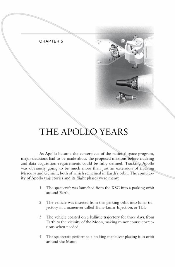
Chapter 5
THE APOLLO YEARS
As Apollo became the centerpiece of the national space program, major decisions had to be made about the proposed missions before tracking and data acquisition requirements could be fully defined. Tracking Apollo was obviously going to be much more than just an extension of tracking Mercury and Gemini, both of which remained in Earth’s orbit. The complexity of Apollo trajectories and its flight phases were many:
1 The spacecraft was launched from the KSC into a parking orbit around Earth.
2 The vehicle was inserted from this parking orbit into lunar trajectory in a maneuver called Trans-Lunar Injection, or TLI.
3 The vehicle coasted on a ballistic trajectory for three days, from Earth to the vicinity of the Moon, making minor course corrections when needed.
4 The spacecraft performed a braking maneuver placing it in orbit around the Moon.

144 “Read You Loud and Clear!”
5 A Lunar Module (LM) separated from the Command/Service Module (CSM) to descend to the lunar surface.
6 After exploring the surface, the Ascent Stage of the LM lifted-off from the Moon and rendezvoused with the CSM in lunar orbit.
7 The LM was jettisoned after which the CSM performed a burn to insert it into an Earth-bound trajectory in a maneuver called Trans-Earth Injection, or TEI.
8 The vehicle coasted in a ballistic trajectory for two days back to Earth, making minor course corrections when needed.
9 The CM reentered Earth’s atmosphere along a narrow corridor at 40,000 kilometers (25,000 miles) per hour.
10 The Command Module parachuted to a predetermined splashdown location in the Pacific Ocean.1
Many of the fundamental steps outlined above required capabilities well beyond the Mercury and Gemini configurations of the MSFN. Tracking and communicating with a spacecraft a quarter of a million miles away posed many new and different challenges for the network. For instance, ground stations required new equipment to expand into a USB system where tracking, telemetry, and command used a single carrier frequency. More powerful 26-meter (85-foot) dish antennas such as those used by the DSN to communicate with planetary space probes were added to meet the much more demanding range and data requirements.These were supplemented with 12-meter (40-foot) antennas to provide wider beamwidth coverage across this vast distance. The GRARR system was added to track the Apollo spacecraft while it was out of radar range. Rounding out the changes were new ground stations along with a contingent of ships and planes to fill coverage gaps and meet data relay requirements.2
Studies for the Apollo network began at Goddard in early 1962 in the TDSD. TDSD originally envisioned a network based on the emerging Mercury and Gemini MSFN stations, supplemented by STADAN sites. In this early plan, MSFN radars would be used for low-Earth orbit support of the Apollo spacecraft prior to the Trans-Lunar Injection (TLI) burn committing it on a trajectory to the Moon. The existing sites were prepared to handle this role, a role that was very similar to that of Projects Mercury and Gemini. This ostensibly made sense as technical and cost considerations both advocated that an Apollo network be built around the existing Gemini network of radar stations. In this way, the Apollo network would not have to be built from scratch.

145 Chapter 5 \ the Apollo Years
this vintage 1964 drawing shows the relative sizes of the Mercury, Gemini and apollo
spacecraft, as well as the atlas, titan and Saturn V used to launch them. the combined
weight of the apollo Command Module, Service Module and Lunar Module at launch
was 47,630 kilograms (105,000 pounds). By comparison, typical weight of the Mercury
capsule was only 1,950 kilograms (4,300 pounds) and the Gemini 3,760 kilograms (8,300
pounds). (NaSa Image Number S64-22331)
Augmentation of the Gemini network with range and range rate equipment along with the use of large S-band antennas for portions of the mission away from Earth were well understood early on in these Goddard trade studies. Table 5-1 shows the original Apollo network as envisioned in 1962.
This plan called for three block upgrades to bring the network up to its final form to support the original Apollo timetable. The so-called “1B Network” would have been used to support early test flights of the Apollo spacecraft in low-Earth orbit launched on the Saturn 1B rocket (missions AS-111 through AS-114). This first iteration would have essentially used the primary MSFN Gemini sites to provide radar tracking and TT&C support. The “V Network” would have been an interim block upgrade to support Earth orbit and high apogee missions of the Apollo spacecraft launched on the massive Saturn V launch vehicle (missions AS-201 through AS-205). Apollo Ships would have started joining the network along with an upgrade of the

” ”
146 “Read You Loud and Clear!”
Table 5-1: Apollo Network as First Proposed in 1962
Station
Earth Orbit Missions (Early) The “Ib Network
Earth Orbit Missions (Late) The “V Network Lunar Missions
Coastal Sentry Quebec s
Grand Canary Island s
Bermuda s s s
Cape Canaveral s s s
Carnarvon s s s
Guaymas s s
Hawaii s s s
White Sands s s
Madagascar s s
Apollo Ship 1 (Atlantic) s s
Antigua s
Canberra s
Houston s
Palermo s
Apollo Ship 2 (Indian) s
Apollo Ship 3 (Indian) s
Apollo Ship 4 (Pacific) s
Apollo Ship 5 (Pacific) s
Madagascar site for full global USB capability. A third and final block upgrade completing the Apollo network would have added four more ships, airplanes, a USB site on Antigua, plus three 26-meter USB facilities to be located in Houston, Texas; Canberra, Australia; and Palermo, Sicily.3
As it turned out, but for use of existing MSFN radar sites, the first incarnation of the actual Apollo network bore little resemblance to what was first proposed. By the fall of 1962, TDSD had decided against using STADAN stations for Apollo, opting instead to collocate with major DSN sites. This rather significant decision was based on a combination of factors: 1) The requirement to have a backup for the 26-meter USB antenna; 2) Similar requirements for long range spacecraft communications on Apollo and deep space missions; and 3) STADAN scheduling concerns. The STADAN was fully occupied with its mission of supporting unmanned application and science satellites, the number of which NASA continually added into Earth orbit.
Early planning had pinpointed fairly well the necessary primary ground stations for the near-Earth phases of Apollo missions. Secondary sites were added as planning progressed. Twelve-meter telemetry antennas at exist
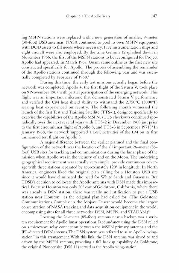
147 Chapter 5 \ the Apollo Years
ing MSFN stations were replaced with a new generation of smaller, 9-meter (30-foot) USB antennas. NASA continued to pool its own MSFN equipment with DOD assets to fill needs where necessary. Five instrumentation ships and eight aircraft were also employed. By the time Gemini 12 splashed down in November 1966, the first of the MSFN stations to be reconfigured for Project Apollo had appeared. In March 1967, Guam came online as the first new site constructed specifically for Apollo. The process of assembling the remainder of the Apollo stations continued through the following year and was essentially completed by February of 1968.4
During this time, the early test missions actually began before the network was completed. Apollo 4, the first flight of the Saturn V, took place on 9 November 1967 with partial participation of the emerging network. This flight was an important milestone that demonstrated Saturn V performance and verified the CM heat shield ability to withstand the 2,750ºC (5000ºF) searing heat experienced on reentry. The following month witnessed the launch of the first Test and Training Satellite (TTS-1), designed specifically to exercise the capabilities of the Apollo MSFN. (TTS checkouts continued sporadically over the next several years with TTS-2 in December 1968 just prior to the first circumlunar flight of Apollo 8, and TTS-3 in September 1971.)5 In January 1968, the network supported TT&C activities of the LM on its first unmanned test flight on Apollo 5.
A major difference between the earlier planned and the final configuration of the network was the location of the all important 26-meter (85foot) USB sites for tracking and communications during the lunar phase of the mission when Apollo was in the vicinity of and on the Moon. The underlying geographical requirement was actually very simple: provide continuous coverage with three stations separated by approximately 120º in longitude. In North America, engineers liked the original plan calling for a Houston USB site since it would have eliminated the need for White Sands and Guaymas. But TDSD’s decision to collocate the Apollo antenna with DSN made this impractical. Because Houston was only 20º east of Goldstone, California, where there was already a DSN station, there was really no justification to put a USB station near Houston—as the original plan had called for. (The Goldstone Communications Complex in the Mojave Desert would become the largest concentration of NASA tracking and data acquisition equipment in the world, encompassing sites for all three networks: DSN, MSFN, and STADAN.)6
Locating the 26-meter (85-foot) antenna near a backup was a written requirement for Apollo lunar operations. Redundancy using the DSN relied on a microwave relay connection between the MSFN primary antenna and the JPL-directed DSN antenna.The DSN system was referred to as an Apollo “wing-station” in this arrangement.With this link, the DSN antenna was slaved to and driven by the MSFN antenna, providing a full backup capability. At Goldstone, the original Pioneer site (DSS 11) served as the Apollo wing-station.

148 “Read You Loud and Clear!”
In the Southern Hemisphere, the proposed Canberra, Australia station (Honeysuckle Creek) was kept as in the original plan and collocated near the Tidbinbilla DSN wing-station some 30 kilometers (20 miles) away. That left a third site which had to be in the European area. Factors such as cost of operations, ease of accessibility, topology, and as always, cooperation of the foreign government involved, all went into the decision. On 28 January 1964, the United States and Spain reached an agreement to put the third 26-meter (85-foot) MSFN station at Fresnedillas some 50 kilometers (30 miles) west of Madrid, again located near a DSN site that was then being built (the Robledo DSN Station).
These, the three most powerful primary stations, were joined in the network by 11 other ground locations also classified as primary but featuring
aerial view of the apollo Station at honeysuckle Creek, australia with its 26-meter
(85-foot) Unified S-Band antenna. at the upper left are the diesel fuel tanks for the
power generators. Because of its remote location in a national forest, this crucial apollo
Station was run entirely off generator power. (Un-numbered photograph, Box 18, NaSa
australian Operations Office, Yarralumla, aCt)

149 Chapter 5 \ the Apollo Years
the smaller 9-meter antennas. In February 1965, Goddard awarded the Dallas Division of the Collins Radio Company $2.74 million to install the USB systems at the three sites. It was the follow-on to the $20 million contract that Collins received the previous year to install the 9-meter (30-foot) systems.7
The Apollo 26-meter diameter tracking antenna was quite large, the biggest of its kind in the Goddard networks—only the 70, 64, and 34-meter (230, 210, and 111-foot) dishes of the DSN were bigger. A novel sight is seeing these big dishes move, almost effortlessly, as they tracked an object across the sky. Much of this had to do with how well the weight of the antennas was balanced. Its ability to move smoothly and point accurately to within 1/100th of a degree directly affected how well it could stay tracked—or autotrack—on a spacecraft. These antennas were moved using gear-box mechanisms (gimbals) driven by hydraulic servos. With the large dish carefully balanced using counterweights, relatively low torque electric motors could be used to drive even the largest antennas. Most of today’s modern tracking antennas allow for rotation in all three axes. In the 1960s, however, systems could move only in two axes. Many, like the MSFN 26-meter antenna, had a so-called ‘X-Y mount’ where an X-axis gear wheel drove the antenna in the north-south direction while the Y-axis gear wheel (mounted above the X-axis) drove the antenna in the east-west direction. This design allowed horizon-to-horizon tracking as the antenna could be pointed on the horizon in any direction to pick up a spacecraft ascending into view. These largest of the MSFN antennas could move at a good pace, tracking a spacecraft at rates of up to three degrees per second in both axes.8
In addition to DSN, several STADAN and DOD stations were also assigned to support Apollo in a backup or standby capacity. Three STADAN stations in the Southern Hemisphere—Lima, South Africa, and Tananarive— were tasked as needed. But it was the Air Force that furnished the majority of the supplemental stations, some of which were also located near MSFN sites. These were mainly radar sites in the Eastern Test Range; none were involved in USB operations. Across the network, different stations had different jobs. For example, the three 26 meters provided coverage for operations in the lunar vicinity and for EVA while the astronauts were on the lunar surface. The 9-meter antennas monitored the spacecraft during its transit to and from the Moon. Bermuda continued in its familiar role as the go/no-go decision site. Stations like Carnarvon and Hawaii were critical for near-Earth portions of a mission, both during outward bound (TLI) and when returning from the Moon and reentry. Grand Bahama, Antigua, and Ascension monitored, respectively, the early (S-IC first stage) and late (S-II and S-IVB second and third stages) phases of the Saturn V’s powered flight into orbit.9
★ ★ ★

150 “Read You Loud and Clear!”
the station on the desolate outskirts of the town of Carnarvon (CrO) was located 960
kilometers (600 miles) north of perth, the largest city in Western australia. the township
derived its name from Lord Carnarvon, a former Secretary of State for Colonies in Britain.
the NaSa station was a popular tourist attraction along with Carnarvon’s “Blows”, natu
ral hole formations in the rocky australian coastline that, due to high pressure caused by
pounding seas, caused water to shoot up like fountains. CrO was operational from 1964
to 1974. (photograph courtesy of CSIrO)
Range instrumented ships had been an integral part of the manned network since Project Mercury. Ships have the distinct advantage over land stations because of their mobility; their big disadvantage is the higher operating cost (about twice that of land stations). Early network plans in 1962 had called for five Apollo Instrumentation Ships (AIS), two to be assigned to the Indian Ocean, two to the Pacific, and one to the Atlantic. By early 1966, however, Goddard had refined the plan so as to accommodate several Apollo mission profiles to where three TLI insertion ships were needed, one each for the Atlantic, Pacific, and Indian Oceans. In addition, two reentry ships were to be stationed in the Pacific. The five ships assigned to the Apollo network replaced the three that had been in service from the Mercury years, including the aging Coastal Sentry Quebec and Rose Knot Victor. In October 1968, just prior to Apollo 7 (the first human flight of the new Block II CSM), NASA returned the Watertown—one of its two reentry ships—back to the U.S. Navy.

151 Chapter 5 \ the Apollo Years
TDSD evidently felt confident that it had adequate coverage in the Pacific with Guam, Hawaii, plus the Huntsville, to the point that a second ship was really not necessary.
This contingent of ships was the AIS fleet as deployed through Apollo 11. They had the obvious advantage over their land counterparts in that they were able to change their area of coverage from mission to mission depending on what was needed. On Apollo 8—the historic first human circumlunar flight—for instance, one insertion ship (Vanguard) was stationed in the Atlantic and one was in the Indian Ocean (Mercury). The third insertion ship (Redstone) along with the reentry ship (Huntsville) took up positions in the Pacific.10
Apollo was launched from the Kennedy Space Center at azimuths between 72 and 108°, depending on the particular mission (90° is a launch due east). Culminating the boost phase was the first burn of the S-IVB third stage of the Saturn V launch vehicle to provide the necessary impulse to insert the spacecraft into Earth orbit. As early as 1964, the OTDA had imposed the requirement for continuous two-way voice communications, reception of telemetry, command capability, and tracking during ascent into Earth orbit. The primary use of the tracking data was to verify that a proper parking orbit had been achieved, while command uplink and telemetry downlink were requirements for flight control operations to evaluate the health and status of the spacecraft and astronauts.
Since the third stage burn occurred about 2,250 kilometers (1,400 miles) downrange of the Cape, it was outside the coverage area of the Bermuda Station, and for most launch azimuths, also outside that of the Antigua Station. It was thus necessary to have a station farther downrange in the mid-Atlantic that was east of both of these islands. The ideal spot for such a station was at 24° North by 48° West. Unfortunately, no island or suitable land mass exists in the immediate vicinity of that location. Therefore, a ship was needed.11
While the first burn of the S-IVB got Apollo into Earth orbit, it could not yet begin the trek to the Moon. That was done with the TLI, a second burn of the S-IVB, raising the velocity of the spacecraft by some 3,550 meters per second (11,700 feet-per-second) to attain escape velocity. TLI was one of the most critical events of a flight, one that had to be monitored reliably. Once the burn was completed, the spacecraft was committed on a trajectory to the Moon and the three astronauts would not be able to return to Earth for at least four days—even on a so-called “free-return trajectory” where the spacecraft made a giant “figure 8” around the Moon and coasted back to Earth without making any additional engine burns.
Apollo mission requirements at the time called for tracking to begin no later than seven minutes after the end of the TLI burn to provide Mission Control with the necessary attitude data to make the important go/no-go decision on “transposition and docking”—a tricky maneuver in which the CSM travels a short distance away from the LM, turns around, docks with it

152 “Read You Loud and Clear!”
and then pulls the LM out of the adaptor housing and away from the spent SIVB third stage. In a 1964 memorandum from the OTDA to Donald Crabill of the Bureau of the Budget, Gerald Truszynski pointed out that while the South Africa and Madagascar stations could provide post injection coverage in that area, it would only be partial and would not be as complete compared to a ship stationed in the Indian Ocean.12 Truszynski also pointed out two other factors favoring a sea-based solution. First, a ship was already being planned to alleviate coverage gaps on non-Apollo missions. Second, the State Department did a study on the long term political stability of South Africa which “did not assure retention of a critical major Apollo support station in the time period required.”13
The return phase of Apollo also required some special coverage planning. As the CM reentered the atmosphere at the end of a mission, it could, by rolling the craft, control its lift-to-drag ratio making it possible for landing to occur in a fairly long corridor 2,200 to 9,250 kilometers (1,200 to 5,000 nautical miles) downrange from the point where it first entered the atmosphere. To pinpoint the expected splashdown location, network engineers had determined that a tracking contact of approximately three minutes in duration had to be made starting at the end of the initial telemetry blackout period. With the blackout window spanning 370 to 1,850 kilometers (200 to 1,000 nautical miles) downrange of the initial entry point, coverage had to be available out to 3,330 kilometers (1,800 nautical miles) from the point where the CM first entered the atmosphere in order to meet the three minute requirement.14
That was not the only factor. Depending on the mission, Apollo splashdown could occur either in the northern recovery area in the vicinity of Hawaii or in a southern area near Samoa. This left a lot of ocean to be covered. While there were islands in the western Pacific which could have been used as land stations, a total of seven sites would have been needed just to meet this three minute requirement, a requirement that could be met by using just three ships.
From an overall cost standpoint, though, it turned out that there was actually very little difference between using ships versus using land stations to cover post-injection, insertion, and reentry tracking. Here’s why: Of the proposed five ships, OTDA had determined that all but one could have been replaced by land stations given the proper political environment. These four ships could have been substituted with eight new ground stations. In 1964, each new station cost about $12 million to build. Thus, the initial investment for land stations would have been in the neighborhood of $96 million. From NASA’s experience with the Navy, the cost of obtaining and refurbishing four ships would have amounted to $98 million. Hence, there was only a two percent difference between the two solutions in terms of initial cost investment. As for annual operating cost, the rule of thumb was that a ship cost twice as

153 Chapter 5 \ the Apollo Years
much to operate as a land station. There was thus little difference in operating four ships versus eight land stations.15
With one of those rare occasions when cost was not a major player, OTDA went ahead with the ship-based solution based on the technical advantages:
Position of the ships may be changed to meet requirements of individual missions whereas land locations were fixed.
It was only necessary to maintain four communication links back to the United States instead eight, thereby reducing mission complexity.
To implement this solution, NASA acquired three “19-class” T-2 tankers and converted them into highly instrumented vessels equivalent in many respects to a primary ground station. Each ship possessed the same C-band radar and the same 9-meter USB antenna common to the Apollo prime stations.16
The three ships, the Mercury, Redstone, and Vanguard, provided the network with the required flexibility to support various launch azimuths, Earth orbit insertion points and differing TLI points—all mission dependent parameters. In this way, all critical flight phases were covered and tracking gaps reduced.
These ships were large—a necessity, serving as stable platforms under severe sea states. The Vanguard, for instance, measured 181 meters (595 feet) in length with a 23-meter (75-foot) beam. It had a cruising speed of 26 kilometers per hour (14 knots) and a dash speed of 31.5 kilometers per hour (17 knots). These were tracking stations in every respect, capable of remaining at sea for two months, supporting a full Military Sea Transport Service crew and more than 200 field technicians. With enough electricity to supply a town of 5,000 people, they were equipped with facilities such as a store, barbershop, weight room, and a movie lounge. There was a hospital on board as well.
Serving as reentry ships in the Pacific were the Huntsville and Watertown. Being converted World War II “Victory” ships, these were somewhat smaller than the three insertion ships, measuring 139 meters (455 feet) long by 19 meters (62 feet) wide. They could accommodate 130 technicians and carried the same range of TT&C hardware as their larger counterparts, with the exception of a smaller, 3.6-meter (12-foot) diameter USB antenna.17
Taking these old World War II ships out of mothballs and retrofitting them into the space age was, as one can imagine, no simple job. Such an undertaking presented many technical challenges which NASA was not at liberty, in this case, to work out by itself. This was because as a part of the FY 1964 congressional action on NASA funding, Congress had instructed the space agency and the Department of Defense to work together and pool resources for the expressed purpose of acquiring range instrumentation ships.

154 “Read You Loud and Clear!”
a converted Navy tanker, the Vanguard was one of the so-called “insertion ships” that
tracked and communicated with the apollo spacecraft as it performed the trans-Lunar
Injection burn, sending astronauts on their way to the Moon. (Folder 8788, NaSa
historical reference Collection, NaSa history Division, NaSa headquarters,
Washington DC)
Congress knew this was not going to be an easy task, as both organizations— one civilian, the other military—needed to determine what was the best method of meeting joint ship requirements and to establish rules of operations. One thing was clear. Since these were going to be sea faring vessels, the DOD would have the lead responsibility for them.
To execute this agreement, the DOD established an Instrumentation Ships Project Office responsible for procuring and modifying the ships. The office was run by the Navy with representatives from both the Air Force and NASA. It quickly drew up specifications and bidding plans for the ships such that by September 1964, a competitive contract had been let. A $77.5 million fixed-price contract was awarded to the General Dynamics Corporation to convert and instrument three ships taken out of storage. Part of the work included installing, checking out, and integrating some $35 million worth of government furnished range instrumentation equipment onboard the vessels.18
From day one, the delivery timetable for the ships was inextricably tied to the development schedule of the Saturn IB and Saturn V launch vehicles. In order to support the flight test schedule, the original delivery dates
155 Chapter 5 \ the Apollo Years
planned for the three ships were for April, July and October of 1966. In late 1965, a requirement was added to install satellite communication terminals on the ships to ensure that communications between the ships and the Mission Control Center in Houston would not be at risk. To accommodate this new requirement, General Dynamics slipped the delivery by several months, to July and December of 1966 and January 1967.
As the first ship (Vanguard) approached completion and sea trials were being conducted in June of 1966, a number of technical problems began to surface. Many of these were of the type that could not have been detected until the complete system was tested at sea when the full dynamic effects of rough seas and high winds were combined. But however formidable, these problems were within the scope of the contract and were therefore, General Dynamic’s responsibility to correct. Fixes proved inadequate and the delivery schedule suffered, slipping on a month-by-month basis. Listed is a sampling of the technical problems that arose, and their solution:
The 9-meter diameter telemetry antenna did not operate satisfactorily over the entire required frequency range (from VHF to S-band).The antenna feed had to be redesigned and reinstalled.
The same telemetry antenna also had a serious vibration problem. This was corrected after much engineering analysis by structurally stiffening the dish and by installing an electrical filter that eliminated spurious signals (RF noise) from the antenna drive mechanism.
The command uplink antenna was simply too dynamically unstable in high wind conditions. It was completely redesigned to improve its aerodynamics and to make it smaller and lighter so as to improve servo drive response.
The high frequency radio transmitting antennas—three on each ship—could not operate at full power because of electrical insulation problems.These had to be redesigned and replaced.
The servo drive system for the satellite communications antenna, along with the antenna feed itself, did not perform according to specifications.The sensitivity was too low because of the poor quality of the antenna sub-reflector surface. These problems were rectified through redesign and remanufacturing of the hardware.19
As it became evident that these problems were impacting ship delivery, NASA sharply increased its day-to-day workings with the Navy and with General Dynamics. Managers from Goddard and Headquarters

156 “Read You Loud and Clear!”
even went directly to top General Dynamics management, requesting them to bring the strongest possible management effort to bear on these problems so as to ensure adequate and timely solutions. Subcontractor problems were also uncovered. General Dynamics in turn, as part of their increased effort, brought in special consultants from outside the company and from academia. An MIT professor, for instance, was brought in to tackle the difficulties with excessive antenna vibrations.
NASA had to walk a fine line. Since the contract for the AIS was actually a Navy contract executed by its Instrumentation Ships Project Office, its actions with General Dynamics had to always be taken in full coordination with that office. The Navy cooperated and responded to NASA, passing its own rather strong terms down to its contractors. The strong management tactics worked. General Dynamics responded to the government pressure by instituting more frequent and detailed top-level management reviews of the project. They also assigned a senior company official at the vice president level to work full-time overseeing the project, this in addition to the Program Manager already assigned. The company also tightened up scheduling control over Bendix, their main subcontractor, and instituted bi-weekly senior management reviews attended by the President and Vice President of General Dynamics Electronics as well as the Executive Group Vice President from their Headquarters.20
Results were slow at first. For a few months, there seemed to be little progress. The pace eventually picked up, though, and much time was made up in the last few months of the delivery schedule. A limited ship capability was finally fielded in the fall of 1967 just in time to support the November launch of the first uncrewed Saturn V on Apollo 4. By the time the first crewed flight of the huge launch vehicle took place in December of the following year (Apollo 8), the AIS fleet was ready and at full strength.
In 1964, the OTDA had estimated the initial investment for the five ship AIS fleet at $98 million. The actual price tag, however, turned out to be $186.6 million, almost twice as much as predicted. On top of that, the annual cost of operating the ships had, by 1969, reached $5 million for each of the three insertion ships and $3.5 million apiece for the smaller Huntsville and Watertown.21 In a cost saving move, NASA returned the USNS Watertown back to the Navy after the launch of the ATS-D satellite in August of that year. This raised concern within Congress, some thinking that the space agency was putting cost ahead of safety.
In reality, this move was based on changes in mission requirements that had been taking place. In the early stages of Apollo planning, reentry in either the Northern or the Southern Hemisphere was simultaneously considered to accommodate maximum flexibility in lunar mission planning, particularly for variable times of stay and departure from the Moon. As NASA progressed through the early Apollo/Saturn V development flights, it became evident to mission planners that a preselection of the return flight trajectory
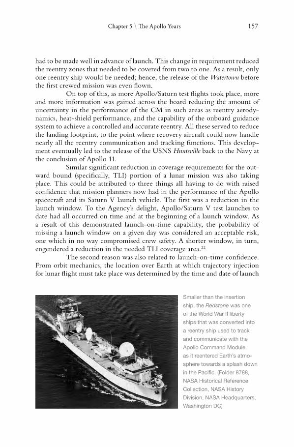
157 Chapter 5 \ the Apollo Years
had to be made well in advance of launch. This change in requirement reduced the reentry zones that needed to be covered from two to one. As a result, only one reentry ship would be needed; hence, the release of the Watertown before the first crewed mission was even flown.
On top of this, as more Apollo/Saturn test flights took place, more and more information was gained across the board reducing the amount of uncertainty in the performance of the CM in such areas as reentry aerodynamics, heat-shield performance, and the capability of the onboard guidance system to achieve a controlled and accurate reentry. All these served to reduce the landing footprint, to the point where recovery aircraft could now handle nearly all the reentry communication and tracking functions. This development eventually led to the release of the USNS Huntsville back to the Navy at the conclusion of Apollo 11.
Similar significant reduction in coverage requirements for the outward bound (specifically, TLI) portion of a lunar mission was also taking place. This could be attributed to three things all having to do with raised confidence that mission planners now had in the performance of the Apollo spacecraft and its Saturn V launch vehicle. The first was a reduction in the launch window. To the Agency’s delight, Apollo/Saturn V test launches to date had all occurred on time and at the beginning of a launch window. As a result of this demonstrated launch-on-time capability, the probability of missing a launch window on a given day was considered an acceptable risk, one which in no way compromised crew safety. A shorter window, in turn, engendered a reduction in the needed TLI coverage area.22
The second reason was also related to launch-on-time confidence. From orbit mechanics, the location over Earth at which trajectory injection for lunar flight must take place was determined by the time and date of launch
Smaller than the insertion
ship, the Redstone was one
of the World War II liberty
ships that was converted into
a reentry ship used to track
and communicate with the
apollo Command Module
as it reentered earth’s atmo
sphere towards a splash down
in the pacific. (Folder 8788,
NaSa historical reference
Collection, NaSa history
Division, NaSa headquarters,
Washington DC)

158 “Read You Loud and Clear!”
and the relative positions of Earth and its Moon. In NASA’s planning for missions through the first lunar landing—to ensure the maximum number of chances for a launch—mission planners planned for a wide spread of launch azimuths, which meant that the TLI burn could take place anywhere over a wide geographical area. With the now reduced spread of launch azimuths, this coverage area could also be reduced.23
Finally, battery lifetime of the tracking beacon aboard the S-IVB third stage had been extended by nearly 50 percent since the first Saturn V launch on Apollo 4, 9 November 1967. This had ramifications to network requirements because after the TLI burn, the Apollo spacecraft, still attached to the burnt-out S-IVB, must be precisely tracked in preparation for transposition and docking. With the increased third stage beacon life, considerably more time was now available for the ground to perform this track, to the point where engineers could afford to wait until a land station came into view. Ship requirement for TLI tracking could thus be alleviated.24
All these factors allowed injection tracking to now be done by the Apollo land stations supplemented with a small number of instrumented aircraft. The net effect of these developments enabled the network to eventually relinquish two of the three injection tracking ships—the Redstone and the Mercury—starting with Apollo 12. It thus left the Vanguard as the only remaining Apollo ship operating after Apollo 11. At $6 million a year, it was the most expensive to operate, but was well used, supporting not only human space missions but also NASA projects such as the Pioneer deep space probes. TT&C equipment from the ships was returned to the MSFN equipment pool and redistributed for use at ground stations and on aircraft.25
★ ★ ★
In addition to the instrumentation ships, eight Apollo Range Instrumentation Aircraft, or ARIA, served the network as airborne communication points relaying voice transmissions between the spacecraft and Houston. These aircraft were deployed—either in the Pacific or in the Atlantic depending on the relative positions of the Moon with respect to Earth— during each mission launch window. Without the vantage point of these airborne platforms flying some 10,500 meters (35,000 feet) above the ocean, as many as 20 to 30 relay ships would have been required just to relay communications between the spacecraft and ground stations.26
But even from their birds-eye vantage point, eight ARIAs were still needed to provide coverage in the Pacific and four in the Atlantic. NASA had originally planned on a fleet of 12 aircraft. In 1964, an Office of Manned Space Flight study concluded that a reduction in the area coverage per Apollo mission could be tolerated within the so-called “delta-V budget” of the spacecraft. What this meant was that, based on the propulsion capability

159 Chapter 5 \ the Apollo Years
(limitation) of the Saturn V launch vehicle then under development, the location where injection into lunar trajectory could take place on a given mission had to be either over the Pacific or the Atlantic, but not both. The TLI area thus had to be designated well in advance of a particular mission, as well as the reentry area. Mission coverage requirements, therefore, changed from two-ocean support to single-ocean support and the number of ARIAs reduced from 12 to 8 (6 for primary mission support, 2 for backup) for Pacific operations and down to 4 for Atlantic support. This amounted to a savings of $32.4 million.27
As Apollo preparations matured over the next three years, GSFC and MSC began to see that this reduction in the ARIA fleet was going to present coverage limitations. On some flights, it was inevitable that lunar trajectory injection was going to shift to a different location as the launch window progressed. If a launch were delayed and it became necessary to move to the other ocean, the entire mission timeline would then have to be adjusted since it took approximately 60 hours to reposition the fleet of aircraft from one ocean theater to the other. This was yet another seemingly simple but important reason why NASA always wanted Apollo Moon missions to take place as early as possible in a given launch window.28
The ARIAs were converted C-135A cargo airframes that NASA acquired on long term loan from the Air Force. They were heavily instrumented. Externally, the most obvious difference in the aircraft from regular C-135s was a large bulbous nose—a 3-meter (10-foot) radome that housed the world’s largest airborne steerable antenna at the time. The antenna itself was a 2-meter (7-foot) S-band parabolic dish used for telemetry and voice. In addition to the “droop snoot” nose as it soon came to be known, the ARIA—designated the EC-135N—had a probe antenna on each wing tip that was used to enhance high frequency radio transmission and reception. A high frequency trailing wire antenna was added to the bottom of the fuselage. The aircraft was also heavily modified inside the fuselage to accommodate the suite of core electronics and facilities were added for eight more crew members.29
ARIA capabilities normally consisted of the following:
For telemetry reception and recording: single USB link, an S-band Pulse Code Modulation link, 6 VHF links.
Telemetry was usually recorded live and then “dumped” over the first available Apollo site (ship or ground station) for transmission to Houston.
USB and VHF voice reception and recording for real-time spacecraft/MCC voice relay.
Two-way, 100 words-per-minute teletype.30

160 “Read You Loud and Clear!”
the apollo range Instrumentation aircraft (arIa) served as airborne relay points
between the apollo spacecraft and the rest of the network. about the size of a 707
jetliner, NaSa borrowed these converted air Force C-135a cargo airplanes to sup
port launch and reentry communications during the apollo years. (Folder 8788,
NaSa historical reference Collection, NaSa history Division, NaSa headquarters,
Washington DC)
ARIAs had a nominal crew of 16. They were based at Patrick Air Force Base and flew out several days prior to a launch to their forward station in the mission operations area: Hickam Air Force Base in Hawaii or Ascension Island in the Atlantic.31 Then on the day of the mission, the plane would fly to its assigned airspace to support launch or recovery.
Just as NASA had an agreement with the Air Force for launch support at Cape Canaveral, it had a similar agreement for the ARIA. Under a 10 November 1965 NASA-DOD cost sharing memorandum of agreement, the National Range Division (NRD) of the Air Force Systems Command (AFSC) had overall responsibility for the ARIA project. NASA provided the specifications and labor for its equipment and instrumentation needs while the Air Force provided structural modifications and the general onboard range equipment. There was a further breakdown of labor since, another division within AFSC (the Electronic Systems Division,or ESD),was responsible for the detailed

161 Chapter 5 \ the Apollo Years
Definition and Acquisition Phases of the project. Management and engineering change control was thus maintained by NASA and NRD through representation in the ESD project office and an ARIA Project Configuration Control Board.
In this somewhat convoluted arrangement, the Air Force NRD operated, maintained and provided logistical support for the aircraft for NASA. Scheduling and aircraft availability was maintained through a senior-level joint NASA/DOD panel.32 GSFC was the executing agent in administering and managing the NASA portion of the ARIA program. To this end, it was responsible for three things: 1) generate the necessary specifications for the communications equipment needed for Apollo; 2) ensure that the ARIA met overall Apollo requirements; and 3) integrate these aircraft into the MSFN.33
To modify the aircraft, the Air Force contracted Douglas Aircraft Company of Tulsa, Oklahoma, to serve as prime contractor with BFEC as their subcontractor. In this arrangement, Douglas was responsible for modifying the airframe while Bendix was responsible for supplying the generic and Apollo-specific suite of range instrumentation equipment to be installed on the aircraft. Contractor work during Apollo was driven by a tight schedule and ARIA was no exception. To meet delivery milestones, ESD issued the Douglas team with a fixed price contract heavy on delivery and performance incentives. While the target cost was $27.2 million, the contract could be worth well over $30 million if all the incentives were awarded. The first ARIA—scheduled for delivery in the first-quarter of 1966—was delayed and finally delivered to the Air Force near the end of the year, just in time to pass its first live test on Gemini 12 in November 1966.34
The remaining seven ARIAs trickled in throughout 1967 and into the following January. At its peak, Douglas (later McDonnell-Douglas after its 1967 merger with the McDonnell Aircraft Corporation) had over 300 people working on the ARIA program at its Tulsa plant.35 After Apollo concluded in 1975, the word “Apollo” was changed to “Advanced” and the Air Force fleet of aircraft continued serving under the ARIA name, successfully supporting a host of NASA satellite launches, Skylab and planetary probes such as Viking and Voyager. Over the next 30 years, the DOD has maintained ownership of the aircraft which have been used primarily to support military ballistic missile testing activities.
In all its years of near flawless service, there was only one major accident. But it was tragic. On the morning of 6 May 1981, one of the planes— ARIA 328—took off from Wright-Patterson Air Force Base in Fairborn, Ohio, on a training mission. All 21 onboard perished just an hour later in a horrific crash. Among those killed were three civilians, two of whom were wives of crew members who were on the flight as part of a program for them to become more familiar with their husbands’ work. Today, a living memorial dedicated to those who perished resides near the place where ARIA 328 took off that ill-fated morning. A bronze plaque, along with 21 flowering

-
’ ’ ’ -
162 “Read You Loud and Clear!”
Table 5-2: The Manned Space Flight Network as Implemented for Apollo*38
Station Abbre viation
USB Antenna 12
C Band Radar
VHF TM Downlink
UHF CMD Uplink Other
Primary Stations Antigua ANT • • •
Ascension ACN • •
Bermuda BDA • • • •
Canberra HSK •
Carnarvon CRO • • • •
Corpus Christi TEX • • •
Goldstone GDS •
Grand Bahama GBM • • •
Grand Canary CYI • • • •
Guam GWM • • •
Guaymas GYM • • •
Hawaii HAW • • • •
Madrid MAD •
Merritt Island MIL • • •Ships and Aircraft** Huntsville HTV • • • •
Mercury MER • • • •
Redstone RED • • • •
Vanguard VAN • • •
Watertown WTN • • • •
Aircraft (8)*** ARIA •
crab apple trees, each symbolizing a lost soul, rests in the memorial garden at the United States Air Force Museum in Dayton, Ohio.37 On 24 August 2001, the last ARIA flight landed at Edwards Air Force Base to bring the airborne tracking program to an end.
Besides ground stations, the AIS and the ARIA, NASA added a fourth tracking element during Apollo. This one was in space. To further cut down on potential communication gaps, the Agency called on the services of two communication satellites operated by the International Telecommunications Satellite Consortium, or Intelsat. One was the Intelsat Atlantic satellite, located in geosynchronous orbit at 6º west longitude off the coast of Africa. From this vantage point, it could provide communication relay for the Indian Ocean ship (usually the Mercury), the Ascension Island Station, the Atlantic Ocean ship (usually the Vanguard), and the Canary Island
-30’ ’ 85’
-

-
’ ’ ’-
163 Chapter 5 \ the Apollo Years
Station Abbre viation
USB Antenna 12 85 30
C Band Radar
VHF TM Downlink
UHF CMD Uplink Other
NASA Support Stations Canberra (DSN) CNBX •
Goldstone (DSN) GDSX •
Lima (STADAN) LIMA •
Madrid (DSN) MADX •
Pretoria (STADAN) PRE •
Tananarive (STADAN) TAN •
White Sands (MSFN/DOD)
WHS •
Woomera (MFSN) WOM •DOD Support Stations Antigua ANT •
Ascension ASC •
Cape Canaveral CNV •
Grand Bahama GBI •
Merritt Island MLA •
Patrick AFB PAT •
Vandenberg AFB CAL •
*Nominal configuration 1968-1972 **The Huntsville and Mercury were usually stationed in the Pacifi c to monitor orbit injection, reentry and recovery. The Redstone was usually on station in the Indian Ocean with the Vanguard in the Atlantic. The Watertown was deployed only for the early developmental flights and was removed from service in October 1968 prior to the first human flight (Apollo 7). ***Eight Apollo Range Instrumentation Aircraft were used as communication relays to support operations in areas where there were no grounds stations, especially during reentry and landing.
Station. The other was the Intelsat Pacific satellite, located at approximately 5° west of the international dateline over the Kiribatis in the mid-Pacific. It served the Australian stations, Guam and Hawaii as well as the Pacific ships Huntsville and Redstone. Eventually, reliance on Intelsat for communications relay would free up the ARIA to focus on real time USB support.38
Table 5-2 summarizes the Apollo Network as it was eventually established in 1968 (also see map in Appendix 1). This was essentially the configuration used throughout the lunar landing program, with ships, aircraft, and satellites being augmented on a mission by mission basis.
★ ★ ★
- -’ ’ ’

164 “Read You Loud and Clear!”
As the MSFN was being modified for Apollo, centralization, network communications and the ability to make decisions at remote ground stations were again topics that came to the forefront. In the Mercury days, the network had flight controllers and a Capcom at all of the prime stations mainly because worldwide, real-time communications were still in its infancy. Thus each primary site had the means to make critical decisions and to execute command instructions in the case of a communications failure. In addition, Bermuda had a computer of its own, to help make the vital go/ no-go decision should communication with the main computing center at Goddard be severed.
On Apollo, GSFC, MSC, and Headquarters jointly agreed to use computers at outlying network stations. This was a radical move and a fundamental change away from what had been done up until then. The decision was not reached without controversy. Network philosophy had always been that ground stations would transmit raw, unprocessed (or slightly processed) data back to a central computing center—first located at Goddard and later moved to Houston. The expansion of NASCOM had made this possible. With Apollo, however, data rates increased several-fold over Gemini, and live television (a high bandwidth item) was added.39
To handle these faster processing requirements, 14 land stations were each fitted with two Univac 642B data processing computers to support both telemetry and command.40 (Two units were needed to allow for simultaneous tasking of telemetry and command.) The old Gemini sites that had been equipped with the aging Univac 1218s were upgraded. But the increased real-time flow of information led to a buffering problem: the outlying sites could receive far more data from the Apollo spacecraft than could be transmitted in real time to Houston over NASCOM, which could still only handle a maximum traffic rate of 2.4 kilobits-per-second (kbps). This had potentially crippling consequences. Network engineers at Goddard devised a solution which was to essentially compress each station’s aggregate data link into discrete 2.4 kbps frames or packets grouped into specific data types. By doing so, flight controllers in Houston could remotely select and query telemetry information of their choosing for review. Even though flight control consoles were installed on AISs and at some ground stations, they became unnecessary once the buffering problem was solved. These remote flight consoles were never used on a mission since controllers could review data and issue commands to the spacecraft from the MCC in Houston.41
To fully appreciate the complexity of network operations during Apollo, it is important to look at the level of teamwork that went into running the MSFN. Even though the MCC had control of the spacecraft from the ground during a mission, smooth network operations required coordination (and cooperation) between the two primary NASA centers involved: GSFC and the MSC. Before the actual mission, Greenbelt acted as the manager of

165 Chapter 5 \ the Apollo Years
network activities, preparing equipment and personnel across the network for readiness. It had the final say in pronouncing the network ready (green) or not (red). Once a mission began, though, Houston assumed control. Goddard continued in a support role to ensure overall network viability, monitoring the activities of the ground stations, ships, and aircraft for the duration of the flight. At his console in the MCC Mission Operations Control Room (the famous “Front Room” familiar to the world), the Network Controller (NC)—along with his contingent of support staff in the “unseen” Back Room—monitored network operations, maintaining contact with two key Goddard figures, namely the Network Operations Manager and his boss, the Network Director.42
Perhaps the most elegant achievement in terms of communications technology on Apollo was the use of USB. The use of a unified carrier yielded immediate benefits for the spacecraft, saving the space, weight, and power needed to accommodate other subsystems. Furthermore, communications at S-band (1550 to 5200 MHz) were much more powerful, accommodating more data than possible at the lower frequencies. But most importantly, it had the range to reach the Moon. Two competing USB systems were actually available for Project Apollo. One, under development by GSFC, was essentially an extension of the GRARR, used to support STADAN for NASA’s science satellites. The other was a JPL product originally intended for deep space use. NASA would select the JPL system but modified it for Apollo. Even with this new capability, the MSFN still kept most of the pre-USB equipment operational, the majority of stations—both old and new—still fielding VHF hardware for backup.
NASA was sending men to the Moon, but like any other television or radio station, it still had to ask for permission in order to transmit at certain frequencies. Throughout Apollo, the International Communication Union granted the MSFN transmission only on a secondary basis. What this meant was that NASA was legally required to shut down if its transmissions interfered with other authorized users. But the Agency could not complain of interference from these primary users. Sure enough, the frequency range of the Apollo USB system did overlap with the band then assigned to commercial television broadcasting. GSFC and Headquarters identified and addressed this issue early on in the planning of the Apollo network and all conflicts were successfully resolved before flights took place. No significant frequency interference problems ever developed during the 15 times that Apollo flew.43
★ ★ ★
By the spring of 1967, with the final USB upgrade at Guaymas completed, the MSFN was ready to support the first human flight of the new
166 “Read You Loud and Clear!”
Apollo spacecraft. In preparation for sending men to the Moon, the GSFC had in three years established seven new ground stations and extensively modified seven others. It had now been over a year since Americans last flew in space and President Kennedy’s commitment of a Moon landing before the end of the decade was fast approaching; “Go Fever” was in full swing.
Then tragedy struck. On the evening of 27 January 1967 during a “plugs out” launch
pad countdown test at the KSC, a fire erupted in the pure oxygen atmosphere inside the Apollo Saturn 204 CM, killing astronauts Virgil I. Grissom, Edward H. White, II and Roger B. Chaffee. Super-heated flames consumed the spacecraft within 20 seconds. Grissom, White, and Chaffee didn’t stand a chance. Countdown tests involved the network stations, and Apollo 1 was no different. Shock and grief quickly spread to the stations. Overseas, where the local populace took pride in hosting “their” ground station as part of the American space program felt the sadness. Official statements of condolences poured in from around the world. On Guam, its 9th legislature passed Resolution Number 118, officially expressing the grief of the Guamanians. The Honorable E. S. Terlaje, Acting Legislative Secretary, requested NASA send copies of the Resolution to the families of the three astronauts, which James Webb did.44
The Fire, as it simply came to be known, severely impacted all aspects of Apollo. Foremost were program timeline and flight schedule. Instead of the first flight taking placing in early 1967, it was delayed for over 18 months, eventually to October of the following year. Despite this deadly setback, uncrewed launches testing the CSM, Lunar Module, and the Saturn V launch vehicle continued as NASA endeavored to recover and rebuild the program.
In the revised timetable, NASA defined seven flights (missions A through G) designed to incrementally lead to a Moon landing (the G mission) by 1970. In the fall of 1967, the giant Saturn V launch vehicle developed by the MSFC was ready for its first all-up test. On the morning of 9 November, the Apollo network was put to the test for the first time, tracking the Saturn V stack on its maiden flight. Apollo 4 was sent into a high apogee (18,079 kilometer, 11,234 mile) elliptical orbit around Earth. At the conclusion of the flight, the Service Module pointed towards Earth and fired its 20,500 pound (91,200 newton) thrust engine to accelerate the spacecraft to a velocity of 40,200 kilometers (25,000 miles) per hour, replicating return and reentry from a lunar mission.
Telemetry received onboard the Huntsville and at the Hawaii Station showed no degradation in the cabin environment, verifying the design of the CM heat shield to withstand the 2,760°C (5,000°F) temperature of reentry. This was a significant step in the program since the ability of the ablative shield to protect a returning spacecraft at such velocities was largely unknown at the time. Guided by terminal tracking data from the network, the USS Bennington successfully recovered the Command Module

167 Chapter 5 \ the Apollo Years
astronauts (left to right) Gus Grissom, ed White and roger Chaffee stand for photogra
phers in front of Launch Complex 34 housing their apollo 1 Saturn 1B vehicle. ten days
after this photograph was taken, the crew perished in a pad fire. (NaSa Image Number
GrN-2000-000618)
west of the Hawaiian Islands some nine hours after launch. Technically, programmatically and—perhaps most importantly—psychologically, Apollo 4 (the “A” mission) was an important and successful event, especially in light of the number of firsts it tackled. For the tracking network, it was the first shake-down of the MSFN for Apollo. The fact that everything worked so well with so little trouble gave NASA much needed confidence and a giant psychological boost. As Apollo Program Director Samuel Phillips phrased it, “Apollo [was] on the way to the Moon.”45
Apollo 4 was followed in January 1968 by Apollo 5, which flew for the first time the LM made by the Grumman Aircraft Engineering Corporation. The spacecraft was put through its paces using command uplinks from the ground, successfully demonstrating system performance including critical restarts of the LM ascent and descent stage engines. At one point, Houston sent a “switch-off” signal to the guidance computer and flew the LM

168 “Read You Loud and Clear!”
a view of the apollo 16 Lunar Module Orion shows the location of the 0.6 meter (2 foot)
S-band antenna near the top of the ascent Module. During their post mission press con
ference, the crew called attention to the steerable antenna which was frozen along a yaw
axis during much of the flight. also visible to the left of the S-band dish antenna are the
VhF and eVa antennas. this photograph was taken by lunar module pilot Charles M.
Duke, Jr. during the mission’s first extravehicular activity on 21 april 1972. (NaSa Image
SaS16-113-18334)
in real time from the ground through a series of simulated landing maneuvers using only command uplinks.46
The next flight test was Apollo 6, the final uncrewed flight test of the Apollo program, on 4 April. Two minutes into that mission, telemetry received at Bermuda indicated thrust fluctuations of the S-IC first stage engines that caused the entire rocket stack to bounce like a giant pogo stick for approximately 30 seconds. During the “pogo”, telemetry also showed low- frequency oscillations reached as high as ±0.6 g inside the CM, exceeding the design criteria of ±0.25 g stipulated for human flight.47 (This was a flight rule

169 Chapter 5 \ the Apollo Years
protruding from the back of the
apollo Service Module was the
spacecraft’s autotracking S-band
antenna. It was a “quad-feed”
system meaning that the system
actually consisted of four antennas.
Signal strengths of the four were
compared so as to allow tracking
of the antenna beam to the earth
ground station that the spacecraft
was communicating with. In this
way, the ground station “drove” the
antenna on the spacecraft to keep
it always precisely pointed. Shown
is the apollo 16 CSM Casper as
seen from LM Orion. (NaSa Image
Number aS16-113-18282)
carried over from Project Gemini. This oscillation level should not be confused with Apollo launch or reentry loads, which could exceed 8 g and which the spacecraft was designed to take.) After the first stage burnt out and was jettisoned, the five Rocktedyne J-2 engines of the S-II second stage came to life.
As acquisition-of-signal occurred over Antigua, telemetry indicated that two of the engines had shut down prematurely. To compensate, the onboard Instrumentation Unit automatically directed the other three engines to fire longer as flight controllers monitored the situation. Even with the extended burn time, the second stage did not reach the desired altitude and velocity before its fuel ran out. Now in order to reach the planned speed, the single S-IVB third stage engine had to burn quite a bit longer than planned. After its shutdown, an orbit determination was made from state vectors received at the Caribbean stations which showed Apollo 6 in a severely lopsided 177 by 367-kilometer (110 by 228-mile) elliptical orbit rather than the desired 257-kilometer (160-mile) circular orbit.48
MCC evaluated the situation and decided to continue into the next phase of the flight, a restart of the S-IVB engine to simulate the TLI burn. Command uplinks to the vehicle went unheeded, however. This was verified by telemetry received onboard the Vanguard that the simulated TLI burn did not in fact take place. As an alternative, Houston jettisoned the S-IVB and instead commanded the Service Module engine to fire for over seven minutes (which exceeded lunar mission requirements) to simulate the injection burn. The Vanguard tracked the CSM out to 22,200 kilometers (13,800 miles)

170 “Read You Loud and Clear!”
where it was turned around and plunged back into the atmosphere for another reentry test. Because of the extended burn by the Service Propulsion System, Houston expected that the Service Module would not have enough fuel to accelerate the CM to the desired velocity. Network tracking verified this, showing the CM reentering at 35,900 kilometers (22,300 miles) per hour, some 4,500 kilometers per hour (2,800 mph) less than planned.49
The period from fall 1968 to the end of 1972 marked the apex of the program, a time in which nine missions were flown to the Moon, landing 12 men on its surface. On 11 October 1968, Apollo 7 was launched with America’s first three-person crew: Walter M. Schirra, Jr., Commander; Donn F. Eisele, CSM Pilot; and R. Walter Cunningham, LM Pilot (even though there was no LM). For nearly 11 days, the MSFN tracked the spacecraft as it made 163 orbits around Earth in an engineering flight test to demonstrate the space-worthiness of the new Block II CM, a totally redesigned spacecraft following The Fire. One improvement was a new hatch that could now be opened in just three seconds.
Among the spacecraft’s equipment and communication technologies tested was the transmission of live television from the spacecraft, a first for the manned network.50 The idea of live television had been a topic of debate ever since September 1963, when NASA first directed North American Aviation to install a portable camera in the Block I CM. With weight a constant concern, many engineers viewed the television camera only as a nicety. On occasions when pounds, even ounces, were being shaved from the CM, the camera was usually among the first items to go.
Despite the insistence of most engineers that it was not needed— and the ambivalence of the test-pilot oriented crews—there were those who persistently argued for its inclusion. NASA personnel in Public Affairs, for instance Julian W. Scheer at Headquarters and Paul P. Haney at the MSC, naturally favored the use of television. There were also managers closer to the program who agreed with them. For example, in the spring of 1964, William A. Lee, a MSC engineering manager, wrote to George Low of the Apollo Spacecraft Program Office:
I take typewriter in hand to plead once more for including in-flight TV. . . . Since [it] has little or no engineering value, the weight penalty must be assessed against a different set of standards. . . . One [objective] of the Apollo Program is to impress the world with our space supremacy. It may be assumed that the first attempt to land on the Moon will have generated a high degree of interest around the world. . . . A large portion of the civilized world will be at their TV sets wondering whether the attempt will succeed or fail.The question before the house is whether the public will receive their report of this climactic moment visually or by voice alone.51

171 Chapter 5 \ the Apollo Years
apollo 7 became the world’s high
est television broadcasting studio
in October 1968. the inclusion of
television on NaSa spaceflights
was not reached at in a cavalier
way and was due in no small part
to the Space race atmosphere
of the Cold War. this picture was
from the crew’s television trans
mission on the third day of the
mission. On the left is CSM pilot
Donn eisele; Commander Wally
Schirra is on the right. (NaSa
Image Number S68-50713)
With emphasis on its civilian nature and Kennedy’s decision to play out the Moon race on world center-stage, NASA could not avoid the debate. Over the next several years, it continued with persuasive arguments for the case of live television being weighed against technical and operational considerations. Finally, in April of 1968 with the first Block II CSM (CSM-101) ready to be accepted, television became part of Apollo (and, as it turns out, all future NASA human spaceflights) when Samuel Phillips directed George Low to proceed with a camera on Apollo 7.52 It turned out that television broadcasts on the mission were a huge success, both for NASA public relations and as a technical milestone for the MSFN. The astronauts used television to show (in black and white) views of Earth outside their windows, the uniqueness of working and living in the weightlessness of space, and tours of the new Apollo spacecraft. Lasting seven to eleven minutes each, the broadcasts came to be called “The Wally, Walt and Donn Show,” even garnering a special Emmy Award from the Academy of Television Arts and Sciences the following year.53
The success of Apollo 7 was followed two months later by what would be the first complete test of the entire Apollo Network. Launched on 21 December 1968, Apollo 8 made the first lunar voyage, carrying astronauts Frank Borman, James A. Lovell, Jr., and William A. Anders to the Moon on a six-day circumlunar flight that culminated with 10 orbits around the Moon. At 10:47 a.m. EST, Capcom Michael Collins relayed through the Hawaii Station, “All right, you are go for TLI,” sending men on escape velocity away from Earth for the first time. The mission provided the first true use of the network’s large 26-meter (85-feet) USB antennas on an actual human flight; previous activities had involved only system checkouts using Pioneer space probes as TTS.

172 “Read You Loud and Clear!”
It also marked a change in the way NASA tracked spacecraft. During Mercury, Gemini and on Apollo 7, communication with the spacecraft was not continuous as the stations could not possibly cover all ground track locations around the globe. However, as Apollo 8 left the confines of Earth towards the Moon, tracking and data acquisition, ironically, became continuous. This somewhat counter-intuitive phenomenon can be explained by simple geometry. As the distance between a spacecraft and Earth increased, the field-of-view required to see it decreased. Also, as a spacecraft sped away from Earth, its motion would appear to an observer on the ground to become more and more stationary. Now instead of the spacecraft racing across the sky in a fast-moving arc, as it would when orbiting Earth, it now traveled on a line (or more precisely, a very shallow arc) slowly away from the observer. As the spacecraft traveled farther and farther away, eventually only a single ground station facing the Moon was needed to communicate with it.
Due to curvature of Earth, the Moon can only be seen comfortably (that is, above the horizon at a fairly high elevation pointing angle) at any one time from locations within a 120° longitude range. Therefore, the three stations 120° apart at Goldstone, Honeysuckle Creek, and Madrid provided continuous coverage to the spacecraft as Earth rotated over a 24-hour period. The only time loss-of-signal occurred on an Apollo mission was when the spacecraft’s orbit took it behind the Moon and for those five minutes at the end of the mission during atmospheric reentry when super-heated plasma induced RF transmission black-out.
As successful as live television was on Apollo 7, it paled in comparison to what took place from lunar orbit on Christmas Eve 1968. As a spellbound world glued their eyes to their television sets, the first live images of our planet and lunar landscape as seen by men from the Moon were transmitted from a quarter of a million miles away to the Madrid Station at Fresnedillas, Spain.54 In a telecast that would forever be etched in the memory of those who were there, black and white images of the Moon and Earth—primitive by today’s standards of brilliant high definition television (HDTV)—were shown as each astronaut took turns reading the Creation account from the first 10 verses of the Book of Genesis. As the crew completed their next to last orbit around the Moon, flight controllers—choking back tears by now—looked on as Commander Frank Borman closed the live broadcast with a farewell that reached over a billion people around the world, “We close with good night, good luck, a Merry Christmas and God bless all of you—all of you on the good Earth.”55
Borman later admitted that he and his crew had not wanted to carry a television camera. Technical reasons aside, they knew that whatever they showed and said from lunar orbit was going to be seen and heard by a whole lot of people. Not a poetic man, Borman, as mission commander, had worried about this the most.

173 Chapter 5 \ the Apollo Years
I said ‘no’ a lot, and the nice thing about it was that NASA gave the commander enough prerogative that they backed him up. I was overruled on one thing and that was because management was a lot smarter than I was. I didn’t want to take the damn television camera with me.And they said, ‘Let’s take it,’ and they were right. . . . It turned out to be so important because we could share what we saw with the world. It weighed 12 pounds [5.4 kilograms].We were cutting out everything, even down to the extra meals, which weighed 16 ounces [0.5 kilograms] or something like that. But I was very short sighted there, and NASA was right.56
By including the camera, it made the experience very real to those watching on Earth. “It didn’t add a dangerous amount of weight and the camera achieved the purpose for which it was intended: to give all Americans a real feeling for the mission and what it was accomplishing.”57 As it turned out, their broadcast was indeed seen by a worldwide audience, from the Americas to Europe (including East Berlin), parts of Asia and Africa, and even Moscow. Despite some protesting the religious nature of the message, Apollo 8’s Christmas Eve broadcast would endure to become one of the most iconic moments in space exploration history.
Having successfully demonstrated the network’s 26-meter (85foot) USB systems, the next mission Apollo 9, went back to again exercise and check out the near-Earth portion of the network. The flight was the first for the LM, the first piloted spacecraft designed exclusively for flying in the airlessness of space. The flight tested, for the first time, MSFN capability to simultaneously track and communicate with both the CSM and the LM. LM USB equipment such as dual-redundant transceivers, the audio center, pulse-code telemetry, central timing, biomedical channels and television were thoroughly tested during this 10-day Earth orbit mission. Communication links between the LM, CSM, and the MSFN ground stations as well as the extravehicular mobility unit (the moonwalk spacesuits) were demonstrated.
After 151 revolutions, Gumdrop splashed down on 13 March 1969 near the reentry ship Huntsville and was recovered by the carrier USS Guadalcanal.58 Black and white television had worked so well on Apollo 7 through 9 that on the next flight, NASA decided to install a color system in the Apollo 10 CM. Space television had actually come quite far in a short amount of time. During the early Apollo missions, the TV used a slow-scan, black and white camera that was originally intended for development by RCA but, due to procurement delays, was eventually supplied by the MSC as government furnished equipment. That camera yielded a poorly defined, erratically moving image which MSFN stations converted into a standard commercial broadcast format (which after conversion, still exhibited uneven motions). These previous missions had shown to network engineers that there was actually sufficient

174 “Read You Loud and Clear!”
margin in transmission bandwidth that good quality, color television could be attempted in real time.
Weighing “only” 5.4 kilograms (12 pounds), the new Westinghouse color camera could be handheld or bracket-mounted. Its scan rate was at the commercial 30 frames per second, 525 scan lines per frame with a resolution of 200 TV lines at the standard screen aspect ratio of 4:3.59 What viewers experienced on the ground was a fairly good picture obtained by superimposing the color signals with the imaging (pixel) data. A 7.6-centimeter (3-inch) black-and-white video monitor could even be Velcro-mounted on the camera (or at various locations inside the CM) to aide the crew in focus and exposure adjustment. By Apollo 14, color television capability had been extended from the CM to the LM and onto the lunar surface.
As soon as Apollo 10 splashed down on 26 May bringing to an end the dress rehearsal for the first lunar landing attempt (the G mission), all eyes were on Apollo 11. The historic launch took place before an estimated crowd of one million people on the morning of 16 July 1969. Onboard were Neil A. Armstrong, Commander; Michael Collins, Command Module Pilot; and Edwin E. “Buzz” Aldrin, Lunar Module Pilot. A decade of preparation had been directed toward this mission, and the MSFN now had the responsibility of tracking the three on the greatest voyage ever taken. NASA has flown over 100 more human space missions since Apollo 11 (many much more complex). But historians and grade-schoolers alike still (understandably) look back on this epochal mission as the Agency’s high point.
During a visit to the United States in October 1968, John Bolton, Director of Parkes Observatory in western New South Wales, Australia, was approached by Covington’s team to consider the possibility of making their 64-meter (210-foot) radio astronomy telescope available to support the historic mission. Although several factors played into this, the driving requirement came down to the fact that Kraft and his team at Houston lacked confidence in the S-band directional antenna of the LM. Specifically, trajectory of the LM on its descent down to the surface was such that after it emerged from behind the Moon, there was a critical but very short period of time to make a “bailout” decision. If the directional antenna was not performing properly, the signal from the lower-gain (much less powerful) VHF omni-directional antenna would be marginal at best using the network’s 26-meter (85-foot) antennas.60
The way the MSFN stations were spaced also played into this. First, the flight plan had the landing of the Lunar Module Eagle taking place towards the end of the viewing window at Goldstone and the beginning of the window at Canberra, Australia. If landing somehow got pushed beyond the Canberra window, however, then Parkes—located some three hours drive west of Canberra—would provide that extra margin to capture the signals. The mission timeline also first drafted by Houston had Armstrong and Aldrin performing the EVA shortly upon landing, with Goldstone being the prime

175 Chapter 5 \ the Apollo Years
tracking site, and with it, television responsibilities. Honeysuckle Creek, near Canberra, was to track Collins and the Command Module Columbia in lunar orbit. In this scenario, the Moon was not due to rise at Parkes until 1:02 pm local Australian time, by which time most, if not all, of the moonwalk would have been completed. Thus, Parkes Observatory was relegated to serve as backup for both the landing and the EVA. To facilitate this setup, the radio telescope would be linked via microwave to Canberra.61
This scenario changed about two months before the mission when Flight Operations in Houston decided that, to give the astronauts a better chance to acclimate to the Moon’s 1/6th gravity, a sleep period would be allowed before commencing the EVA. Thus, the new plan had the moonwalk starting about 10 hours after landing, which was some 20 minutes after the Moon had set at Goldstone. In the South Pacific, however, the Moon would be high overhead over Parkes. Because of this, Parkes was redesignated the prime site for receiving the EVA telemetry.62
But things changed again. By happenstance, on 17 July—one day after the launch—a fire broke out in the power supply at Tidbinbilla (Canberra) which severely damaged the transmitter on its 26-meter antenna. Despite some quick repair work, GSFC would not take the risk and switched the station’s role with Honeysuckle Creek. Thus, the latter would now be the prime station to support lunar EVA, including reception of the crucial bio-medical telemetry from Armstrong’s and Aldrin’s Portable Life Support System (PLSS) backpacks. This was the top telemetry priority. The 26-meter antenna at nearby Tidbinbilla would be trained on Columbia instead.63
“Houston, Tranquility Base here. THE EAGLE HAS LANDED.” The words were said at 4:18 pm EDT on Sunday afternoon 20 July 1969 by Armstrong as Apollo 11 landed on the pristine surface of the Sea of Tranquility. With all LM systems checking out fine and the crew’s adrenalin pumping, it would have been incredibly anticlimactic (and probably a little unrealistic) to expect Armstrong and Aldrin to simply just go to sleep for six hours. They had, after all, just landed on the Moon! After discussions with Mission Control, Armstrong exercised his command prerogative and decided to forego the rest period and begin EVA preparations immediately. This began a chain of events from a network perspective that would ultimately decide how telemetry was received and how the world would see humankind’s first steps on the Moon.
By skipping the rest period, the EVA would begin five hours before the Moon was to rise at Parkes. However, Goldstone was in a good position. For a while, it seemed as if the Apollo Station in California would have the responsibility of televising the historic first moonwalk as originally planned. But delays kept dragging on as Armstrong and Aldrin prepared for their EVA inside the cramped quarters of the LM. By the time they were ready to egress the ship, moonrise had occurred at both Parkes and Honeysuckle.

176 “Read You Loud and Clear!”
While this was going on, a violent wind squall happened to hit the telescope at Parkes while the dish was in its most vulnerable position, pointed at the horizon awaiting moonrise. In this “zero-elevation” position, the face of the dish caught the full force of the two, 112 kilometers-per-hour (70 mph) gusts, subjecting the large antenna to 10 times the force that it was considered safe to withstand. Other structures were also batted around in the swirling winds and the weather remained bad. But in a stroke of good fortune, the winds abated just as the Moon broke horizon at Parkes.64
So, because the sleep period was skipped and EVA preparations took longer than expected, no less than three tracking stations—Goldstone, Honeysuckle Creek, Parkes—received telemetry of the incredible first steps on the Moon. Although this was a good thing (plenty of redundancy), it also engendered a dilemma: Which of these TV signals would the world see?
In Australia, signals from both Honeysuckle and Parkes were sent to Sydney by microwave links, where a NASA officer selected between the two to forward on to Houston via the NASCOM. Since moonrise occurred at Parkes just as the EVA was getting underway, the telescope was at a very low elevation angle. As a result, it had to use its less sensitive “off-axis” detector and the received signal strengths were very poor. Antenna elevation angle at Honeysuckle was higher and the resulting signal was better. This meant that its signals were passed on to Mission Control. There, a controller then selected between the Goldstone and the Honeysuckle TV signal. This selected signal (ostensibly the best of the three) was then sent to a media pool television monitor. But this was still not the TV picture that the world saw; there was one more step. The image displayed on this NASA monitor was then filmed lived by a media pool camera for transmission to individual domestic and international TV networks. As a result, what people saw in their homes that evening was of slightly lower quality than what flight controllers and VIPs saw inside Mission Control.65
During the first nine minutes of the broadcast, NASA alternated between TV from Goldstone and Honeysuckle, searching for the best one. Neither was very good as they both came from 26-meter antennas (as opposed to the 64-meter dish at Parkes). Because of this, they could only accommodate blurry images using what was called ‘slow-scan television’—a picture transmission method used mainly by amateur radio operators to transmit and receive black and white pictures. There was one more thing. Not only was the TV picture grainy and blurry, it was upside-down!
This was because as Armstrong began his 2.4-meter (8-foot) descent down the ladder, he pulled a D-ring which dropped open the Modular Equipment Stowage Assembly (MESA) containing the television camera. Due to the way the camera had to be mounted, however, when the MESA dropped opened, it was upside-down. Avoiding what could have been a major embarrassment forever recorded, technicians at the stations quickly flipped an incon

177 Chapter 5 \ the Apollo Years
at top is the slow-scan television image from honeysuckle Creek of armstrong plac
ing his left foot onto the surface of the Moon. twenty minutes later when aldrin came
down the ladder, coverage had switched to the 210-foot (64-meter) radio telescope at
the parkes Observatory. the image improved noticeably. the lower picture shows aldrin
checking his jump back up the ladder before stepping onto the surface. Note armstrong
is overexposed in the background from where he stood and took pictures of his crew-
mate’s climb down to the surface. (Scans courtesy of John Saxon. also available at
http://www.honeysucklecreek.net/msfn_missions/Apollo_11_mission/index.html )

178 “Read You Loud and Clear!”
spicuous toggle switch called the ‘Scanner Converter Reversing Switch’, just in time to see Armstrong’s final descent down the ladder. Although NASA initially began the telecast with Goldstone, by the time Armstrong reached the foot of the ladder, Mission Control had switched to the transmission from Honeysuckle Creek. In this circuitous way, the Australian station was bestowed the privilege of transmitting to the world Armstrong’s “one small step.”66
In a little known vignette of history, the way the camera was mounted in the MESA and the way the compartment dropped opened caused the camera to be slightly tilted with respect to the true horizontal-axis of the LM. What this meant was that an even more harrowing appearance was added to Armstrong’s already dramatic climb down the ladder. In reality, although the incline of the ladder was indeed quite precipitous at 65º, it was not as steep as seen on TV, which gave the illusion like it was almost vertical.67
Eight minutes and fifty-one seconds into the broadcast, the Moon had risen sufficiently high over Parkes that the telescope could now capture lunar transmissions with its main detector. Normal television scans rates could now be accommodated and the picture quality improved. Houston quickly switched to Parkes. Thus, the world saw Buzz Aldrin’s descent down the ladder much clearer than his commander’s 20 minutes earlier. NASA stayed with the Parkes television for the remainder of the two and a half hour telecast.68
Twelve hours later, the Madrid Station tracked Eagle as it lifted off the surface of the Moon to successfully rendezvous and dock with Columbia. After rejoining Collins, Apollo 11 made its critical TEI burn for home. On the morning of 24 July 1968, humankind’s first journey to the surface of the Moon came to an end as Hawaii and the Huntsville tracked Columbia to a perfect splashdown less than five kilometers (three miles) from the recovery ship USS Hornet.
Ozzie Covington, who had been so instrumental in smoothing the lines of communications between Houston and Goddard, would recall years later the almost surreal feeling after it was all over.
When we finally landed on the Moon on July 20 1969, I was grateful that our cooperative efforts had paid off. However, during the event, I was in the Mission Control Center in Houston. Some of the data from the lunar excursion module became sporadic and I really became uptight. NASA Administrator Thomas O. Paine happened to stand nearby and noticed my nervousness. He urged me to take it easy. We had come this far and would make it fine, he assured me.Well, we did!69
This sense of tension followed by great relief was echoed by Bill Wood, who by then was the head of the Manned Network. On Apollo 11, he spent the entire eight days at the GSFC Network Control Center, working, eating, and sleeping there. “When I eventually got home,”Wood said, “there was a big sign

179 Chapter 5 \ the Apollo Years
armstrong’s photographic
counterpart to the television
image of aldrin descend
ing the ladder as seen in the
previous figure. (NaSa Image
Number MSFC-6900937)
‘Welcome’ greeting me. However, [by then] I was emotionally exhausted and it took me quite a while to really comprehend as to what had happened, even though for years, I had been deeply involved in preparing for this event.”70
As someone in the “trenches” at the field station, Mike Dinn, who was Deputy Director in charge of Operations at Honeysuckle, framed the accomplishment of the historic mission in a somewhat different perspective. To him, Apollo 11 was a simulation that went well. “The station had reached a point of capability whereby it was comfortable not only with a nominal mission, but comfortable that the station could cope with just about anything nonstandard,” said Dinn.
We had thought through and tried to simulate as many different things as could happen, and so I was comfortable with it. You knew you had the next pass to cope with. Every pass was crucial and critical, even though it might have ended up routine and nothing happened.You had to be, almost, literally on your toes, organized and prepared and staffed to cope with any anomaly. I was also comfortable with the management aspects of it. It was a very good operational philosophy that Chris Kraft had brought whereby everybody in the organization knew the success of the mission depended on them doing their bit properly and correctly, and that the person in the next station was going to do his bit correctly.We were all so busy that it took all your effort and energy to do your part well.And so it was very satisfying and rewarding that we didn’t

180 “Read You Loud and Clear!”
have Goddard and Houston micromanaging—in great contrast to later years.71
As somewhat of a reality check, Dinn told his shift that morning (Australian time) that the most important data coming from the Moon that day was not going to be television but the bio-medical telemetry of Armstrong and Aldrin. Said Dinn:
If you’re there doing a job, you should be concentrating on the job at hand and the data at hand. . . .The luxury of ‘whooping it up’ doesn’t fit in there.That is the least time you’d be whooping it up is when something critical just occurred. After Apollo 11 landed, you heard Gene Kranz say something like ‘Right, we’ve got to stay or no-stay’.There wasn’t time there to be whooping it up. I fully recognize this doesn’t fit in with what the colloquial media, books, and the like want to say. But I’m afraid that’s what it was.Yes, we were pleased and satisfied with what we achieved,but we were only a small cog in the machine. And yes, we’d done our bit well, but we weren’t as tested as we were in simulations. I used to say that a nominal Apollo mission used about 5 percent of our capability because we had lots of redundancies. . . .When it came down to it, there was an enormous amount of onboard redundancies.They didn’t need the network all the time . . . and to me, that wasn’t a negative; that was a positive. It showed a lot of clever, intelligent, management and design of the mission and the hardware.You had so much redundancy and so many backups and so many options. They were all designed into the mission planning.Yes, there was satisfaction. It was the culmination of what we had trained for, and everybody performed.The satisfaction for me was to help bring the station from this state of not being very competent to one of the best in the network, as Bill Wood told me years later.72
The greatest challenge for the network during the Apollo years occurred in April 1970 when the flight of Apollo 13 had to be aborted as the spacecraft approached the Moon. Fifty-six hours into the mission with the spacecraft some 322,000 kilometers (200,000 miles) from Earth, damaged wires and insulation inside the Number 2 oxygen tank caused it to explode during a routine tank “stir”. The explosion ruptured a line and damaged a valve in the Number 1 oxygen tank, causing it to also lose oxygen. The entire Service Module oxygen supply boiled away in less than three hours, which led to the loss of water, electrical power and use of the Service Propulsion System.
With the lunar landing now scrubbed, the mission turned into a race against time, one of saving the crew before all the life-support consum

181 Chapter 5 \ the Apollo Years
ables expired. Astronauts James Lovell, John L. “Jack” Swigert, Jr., and Fred W. Haise, Jr. quickly powered up the Lunar Module, still attached to the CSM, as a lifeboat. All spacecraft systems except for life support were turned off to save power. Only a low power transmission link tethered the crippled spacecraft to Mission Control. Robert L. Owen, the MSFN Associate Chief for Network Engineering at Goddard during the mission, recalled the network improvising and adapting in real time to the situation.
There was a transponder on board the S-IVB (third-stage of the Saturn launch vehicle) which operated on exactly the same frequency as the transponder on the LM. In our planning, we had never considered powering up the Lunar Module until after the S-IVB had expired. However, when the power failure forced our astronauts to get out of the CM into the LM, we faced the problem of having the S-IVB floating nearby, utilizing the same communication frequencies. This was no good, and we quickly had to work out a scheme which would enable us to capture the signal from the Lunar Module. Eventually, the S-IVB crashed into the Moon, but in the meantime, we had to have reliable communications.We succeeded by working out a configuration we had never anticipated. Apollo 13 presented us with a frightening situation, which luckily, we were able to meet.73
To save power, telemetry had to be transmitted back to Earth using low power transmitters on the LM. Here, the 64-meter radio telescope at Parkes Observatory once again entered the picture. Originally, the Moon was too far north to be seen very well from the observatory and the telescope was not scheduled to support Apollo 13. But as soon as the accident occurred, NASA quickly recognized that Parkes could and would in fact be needed to track the failing spacecraft on its altered free-return trajectory.
The Australians, led by observatory director John Bolton, immediately began to prepare the station. While astronomy equipment was carried down a ladder from the antenna pedestal, the NASA antenna feed was taken up in a lift, installed and checked out at the center of the dish. In a job that usually took one week, the facility was reconfigured in 10 hours after receiving the go-ahead from Goddard.74 Since Parkes was not slated to support this mission, microwave links which had been established for Apollo 11 and 12 were not operational when the emergency occurred. With urgency, a team of engineers from Honeysuckle and Tidbinbilla arrived at Parkes within hours to reestablish the links to Sydney before the next pass of the spacecraft.
Parkes’s inclusion was critical owing to the interference of the S-IVB as the 26-meter (85-foot) antenna did not have a narrow enough beamwidth to discriminate between the Saturn third stage and the LM Odyssey. When

182 “Read You Loud and Clear!”
Parkes moved out of view, the 64-meter (210-foot) dish at Goldstone was able to do the same, and together, the two were able to track and communicate with Apollo 13, saving the flight from turning into a disaster. From a Mission Control perspective, it was NASA’s finest moment.75
Eighty-seven hours after the explosion, Apollo 13 splashed down southeast of American Samoa with Lovell, Swigert and Haise safely strapped into their couches to bring to an end the only aborted lunar mission of the entire program. In retrospect, Apollo 13 represented a constructive failure that highlighted not only the coordination and preparation of network engineers at GSFC and stations around the world, but also the teamwork and cooperation between the various NASA centers and, more broadly, with the space agency’s international partners.76
Lyn Dunseith, Director of the Data Systems and Analysis Directorate at the JSC recalled years later that:
Throughout the entire program, Goddard provided us with the data we so critically needed.The quality of this support is best evident by the lack of a crisis in a crisis situation, such as the ill-fated Apollo 13 mission. Even during the flight, we had command and voice capability to handle a very serious condition. Our astronauts returned safely thanks in large measure to superb communications and tracking capabilities provided by the Goddard team. Its members are as much a part of manned space flight as anyone in Houston or at the Cape.77
Moon landings continued to unfold after Apollo 13, becoming more ambitious and complex with each mission. Scientific exploration of our nearest neighbor began in earnest on Apollo 12 and moved forward until Apollo 17 concluded the program. Compared to the life and death drama of Apollo 13, these missions went relatively smooth, though not totally trouble free. On Apollo 14, for instance, a malfunctioning abort switch gave flight controllers real trouble. The MSFN enabled Houston to send commands to reprogram the computers aboard the LM directing it to ignore that particular signal. Without this capability, the mission would have had to be aborted since the crew would not have been able to separate from the CM and a lunar landing would not have been possible. Former Flight Director Chris Kraft would say that, “On virtually every flight, the network and its people, while in the background, were ‘under the gun’. We relied on them in every critical situation.”78
These landings left Apollo Lunar Surface Experiments Packages (ALSEP) in five geographical locations across the lunar surface. ALSEPs were a combination of experiments which the astronauts deployed at a site sufficiently far from the LM to collect lunar surface experimental data. There was a central processing station to which all of the peripheral experiment and the

183 Chapter 5 \ the Apollo Years
Radioisotope Thermoelectric Generator (RTG) were attached. The ASLEPs provided power and data with network stations through its own transmitter and antenna. With several packages in place, these ALSEPs, connected as a network, returned more data than any could on its own.
Take the seismometer network emplaced by Apollo 12, 14, 15, and 16. It enabled the location of impacts and moonquakes to be determined very precisely. The network of three Lunar Surface Magnetometers enabled the
apollo 15 Lunar Module pilot James B. Irwin loads-up the “rover”, Lunar roving Vehicle,
with tools and equipment in preparation for the first lunar extravehicular activity at the
hadley-apennine landing site on 31 July 1971. a portion of the Lunar Module Falcon is vis
ible on the left. St. George crater is about five kilometers (three miles) in the background.
Clearly seen is the one-meter (three-foot) steerable Unified S-Band (USB) antenna of the
rover through which houston could remotely control the vehicle if needed. this photograph
was taken by Mission Commander David r. Scott. (NaSa Image Number aS15-86-11602)

184 “Read You Loud and Clear!”
study of solar wind plasma movement by tracing its magnetic field. Closing out the program, Apollo 17 carried an enhanced package of surface experiments. With nuclear power from the RTGs, ALSEP transmissions were received by NASA’s Spaceflight Tracking and Data Network for years after the last astronauts had left the Moon.79
Having surpassed President Kennedy’s goal of landing a man on the Moon and returning him safely to Earth by the end of 1969, the final three Apollo flights that took place between July 1971 and December 1972 were conducted with scientific exploration in mind. The last of the Apollo lunar flights (the so-called “J-missions” with their emphasis on science), featured the Lunar Roving Vehicle (LRV), a 210-kilogram (460-pound) battery-powered car manufactured by Boeing-Delco. It was essentially an all-terrain vehicle designed to operate in the low-gravity, vacuum, dusty environment of the Moon. The Rover could carry 490 kilograms (1,080 pounds)—allowing for 180 kilograms (400 pounds) for each astronaut, his suit and the portable life-support system—a total distance of 92 kilometers (57 miles) to survey and sample considerable stretches of the terrain.80
Communicating with the rover posed a number of new challenges to the MSFN. For example, incorporating it into the television transmission scheme created a special set of problems. One issue in particular was how to control the motion of the LRV color television camera. Houston’s method of operating the camera was to issue start/stop commands relayed through the network computers at the respective ground station. There was, however, a time lag of 2.5 seconds in the time it took to start and stop the rover camera from the time a command was issued at the MCC. This meant that if the Flight Controller operating the camera wanted to turn it by 5°, the “Stop” command would have to be dispatched before the “Start” command reached the Moon! To compensate, network engineers designed a fix to the ground station computers that staggered start/stop commands thereby allowing the camera to function without having to modify its control format.
Another potential obstacle to successful LRV television transmissions stemmed from voice and telemetry sub-carrier interference into the video portion of the rover’s USB signal. Because the telemetry transmission spectrum overlapped the voice and video data frequencies, the interference left annoying herringbone patterns on TV. To solve this problem, engineers from GSFC, Johns Hopkins University’s Applied Physics Laboratory, and the Goldstone Communication Complex produced a band-pass filter that removed the interference while preserving the video transmission to produce crystal clear images from the rover camera the quality of which would not be surpassed until HDTV became available 25 years later on the Space Shuttle and International Space Station.81
Introduction of the rover also increased the number of transmission sources that the network had to keep track of.The MSFN now had to synchronize

185 Chapter 5 \ the Apollo Years
all the activities of the Command Module orbiting the Moon, the Lunar Module parked on the surface, the LRV moving around on the surface, and finally, the two astronauts who may each be walking around in different directions. Keeping track of just where the rover was with respect to the LM was obviously important. Needless to say, a more reliable technique was needed than to simply allow the astronauts to visually follow their tracks back to the LM.
The solution—a rather novel one devised by Goddard engineers— was to pinpoint the rover’s position with respect to the LM by extracting differential Doppler data from the two separate S-band transmissions coming, respectively, from the LM and the rover. By observing the Doppler shift, the network could precisely track the rover to provide the necessary navigation data. Mission Control then passed the data to the astronauts who then charted their course, enabling them to venture great distances, even after losing sight of the LM.
Proper coordination of lunar surface activities also required communication between the two astronauts on the surface and the CM Pilot in orbit. Support from MSFN stations was needed since direct line-of-site communications between the two lunar parties was limited to a brief overhead pass on each orbit. Since the ground network could see the CM for just about 50 percent of each orbit and because it was in continuous contact with the astronauts on the surface, MSFN stations served as relay points between the two parties. In this way, real-time voice communications between the surface and the orbiting CM were made possible for about half the time that the astronauts spent on the Moon.
When the Apollo 17 CM America splashed down on 17 December 1972, it marked the end of the first epic journeys to the Moon, a lasting tribute to the 400,000 men and women whose skill and determination placed 12 Americans on the surface of our nearest celestial neighbor. The tremendous sense of pride and accomplishment that came with Apollo deeply affected those who worked on the program, some, on a very personal level.
Robert Barnes, who first worked with Ozzie Covington at White Sands and later joined him in Greenbelt, saw the potential of the MSFN to accomplish something rather unique, something historical. Reflecting years later, Barnes said:
My own involvement with this activity lasted 20 years, more or less, and it was not unlike having a front seat on a roller coaster: you wonder why in hell you got on, but somehow, would not have wanted to miss a chance for such a spectacular ride! With NASA, each of us saw a chance to fulfill a dream. However, in retrospect it must be concluded that all dreams were not the same. Certainly the work that led ultimately to the communications support of Apollo satisfied a host of dreams and was the work of a very dedicated

186 “Read You Loud and Clear!”
group of people. It stands as an accomplishment for which each member can be justly proud.82
Lyn Dunseith, whose team was instrumental in integrating the Goddard network with the MCC, reflected:
It is fortunate that the computer and communications technology kept pace with the needs of the space program. Indeed this program greatly accelerated the state of the art. Surely, without these tools and the men operating them, we would not have been able to get to the Moon.When we finally landed there and returned our astronauts safely to Earth, I could not fully compre-
Skylab consisted of four major modules: the Orbital Workshop, airlock Module,
Multiple Docking adaptor and apollo telescope Mount (atM). the Orbital Workshop
was a converted S-IVB third stage of a Saturn V. the atM could not be accessed from
the rest of the space station and a spacewalk was required to reach it. Launched in
1973, three crews visited the station between May 1973 and February 1974. Skylab
remained in orbit until 1979. (NaSa Image Number MSFC-72-SL-7200-110)

187 Chapter 5 \ the Apollo Years
hend what actually had occurred. It really seemed incredulous. For months after Apollo 11, I was somewhat in a daze and found it difficult to believe that we had made that lunar landing, even though I had been personally involved in this dramatic event. . . .Yes, I have the book with all the equations and procedures, but I still find it difficult to believe, as I now look at the Moon, that men actually walked and worked there! It was incomprehensible.83
Even before these dramatic flights took place to the Moon, NASA was already thinking about what would be next. Beginning in 1964, exploratory studies were initiated under various names such as Extended Apollo (Apollo-X) and Apollo Extension System (AES) to investigate options for space projects that would come after the lunar missions. The next year, these initiatives were consolidated under the Apollo Applications Program (AAP), which by 1966, had narrowed the scope of the potential projects down to one of Earth orbit application; namely, a space station.
NASA had originally planned 20 Apollo missions. But on 2 September 1970, Administrator Thomas Paine announced that due to a $42.1 million congressional cut in FY 1971 NASA appropriations, Apollo 15 and 19 were to be canceled; the remaining missions were redesignated Apollo 14 through 17. This disappointing cut left space-qualified hardware, which had already been made, immediately available for an AAP, specifically, an Orbital Workshop for a space station. On 17 February 1970, the NASA Project Designation Committee officially designated the project Skylab.84
Network response was required from the start, as Skylab encountered a number of difficulties. On 14 May 1973, the first two stages of a Saturn V launch vehicle placed America’s first space station into low-Earth orbit. At over 86 metric tons, Skylab was at the time the most massive object ever successfully delivered into space. But this almost did not happen.
Sixty-three seconds after liftoff while the first stage was still burning, a crucial micrometeoroid shield on the exterior of the Orbital Workshop designed to protect Skylab from harsh solar heating and micro-impacts, was torn away by aerodynamic forces, carrying with it one of the station’s two solar panels. Even the second solar array, as it turned out, did not fully open upon reaching orbit. The overheated and underpowered space station seemed doomed as NASA scrambled to decide whether or not to even attempt launching a crew to inhabit Skylab.
Over the next week, engineers at Goddard, Houston, and Marshall poured over telemetry that revealed the health and status and the extent of damage to the station. Houston remotely maneuvered the massive spacecraft via a series of command uplinks into a position which minimized excessive solar heating. Having bought some time, engineers poured over the telemetry data to come up with the appropriate fixes. A solar shield was taken up with

188 “Read You Loud and Clear!”
the first launch of Skylab astronauts on 25 May. Upon reaching the station, Commander Charles “Pete” Conrad, Jr. and his crew (Paul J. Weitz, Pilot and Joseph P. Kerwin, Science Pilot) found that although metal surfaces were hot to the touch, internal conditions were much better than expected. The team lost no time deploying the parasol heat shield which produced a rapid drop in temperature and a spacewalk was done to fully release the stuck solar panel. By the fourth day, conditions had improved dramatically to the point where the three were able to settle into their flight plan. (Kerwin later served as the NASA Headquarter’s OTDA Representative in Australia from 1982 to 1984).85
The project pushed network requirements to new heights. Skylab and its numerous scientific activities created a flood of telemetry that threatened to overwhelm the NASCOM circuits connecting the ground stations to Mission Control. It was the familiar problem of the difference in the data-capturing capability of the sites (now able to receive telemetry at a rate of 250,000 bits-per-second) and the NASCOM line transmission rates (still at a much slower 19,200 bits-per-second). Although 19.2 Kpbs reflected improvement over the recently concluded Apollo lunar flights, ways had to be found to accommodate the discrepancy linking the network stations to Houston. To this end, GSFC network engineers designed a data compression software that enabled each station computer to interrogate and filter-out redundancies and static data that, for instance, had not changed from previous downlinks. The station could then pass on only new or changed (dynamic) data. The modification worked well and was efficient in providing the MCC with all its data need without introducing a time lag.
Even with constant improvements like this, the network was not immune to occasional “glitches.” The fixes were usually simple though. On Skylab 2, the ship Vanguard picked up and transmitted to the crew interference sound bursts coming from cars and fishing boats near the port at Mar del Plata, Argentina. The solution on that particular day was simple: take the Vanguard further out to sea.86
As a true testament to the value of humans in space, Skylab overcame its somewhat inauspicious start to serve as home for three crews, each on progressively longer durations: 28 days for the first mission, 59 for the second and a then record-breaking 84 days for the third. The last group returned to Earth on 8 February 1974. Even though the last crew left the station in 1974, network activities continued on Skylab until, quite literally, its last day in orbit. For several years after the last crew had left the station, commands were uplinked so as to maintain the spacecraft’s orbit in hopes of preserving it long enough so that one of the early Space Shuttle flights could boost it into a higher and more stable orbit. But when the first Shuttle mission was delayed into 1981, it was apparent to NASA that Skylab was not going to survive its slowly decaying orbit. Like it or not, Skylab was coming down.

189 Chapter 5 \ the Apollo Years
With its fate sealed, NASA had to make sure that it would reenter the atmosphere without scattering debris in populated areas.Thus prior to reentry, the station’s drag characteristics were altered by uplinking commands that changed its attitude in an attempt to place the impact in the south Atlantic or Indian Oceans. Skylab finally reentered on 12 July 1979, but it ended up scattering debris over Western Australia.A post-mission review of the telemetry showed that incorrect breakup altitude prediction,uncertainties in the ballistic coefficient and atmospheric density caused the impact area to shift downrange to Australia. The reentry demonstrated just how difficult it really is to perform a controlled reentry, even with good telemetry and an active command capability.87
Ed Lawless, who was the NASCOM Voice Network Manager, was in the Goddard Control Center when Skylab reentered. In an interview in 1989, he recalled:
We did a lot of special tracking to make sure we had very good numbers on where it would most likely reenter at the time it was going to happen. . . .We knew that it had come down in the Australia area, and we had just started taking all the circuits down. I had broken the circuits to NASA Headquarters and all of a sudden the network got a telephone call in from our switching center in Australia.They had a pilot on the line with a very vivid description of the reentry.88
Henry Iuliano, who headed Goddard’s Network Operations on Skylab, gave a vivid description of the pilot’s encounter:
The pilot was 100 miles [160 kilometers] east of Perth, flying at 28,000 feet [8,500 meters]. He said he saw this aircraft coming at him [and] thought it was a new type of aircraft that looked like blue metallic steel. It was about 5° above the horizon slightly off to his left, and as it approached him, it turned from steel blue to gray. Then the pilot realized it was turning red, that this was the Skylab. It began to break up in large pieces, with a tail at least 100 miles [160 kilometers] long of smaller pieces behind it, and it disappeared behind to his right 7° below the horizon. From the looks of the path, he estimated that it landed about 300 miles [480 kilometers] in back of him somewhere near Alice Springs, and that’s exactly where most of the parts were found! Just before we heard the pilot’s report, when Skylab went by the Ascension Island tracking station, they were still receiving telemetry data.They gave us a reading and said it was in a stable condition—actually flying! Instead of tumbling like we thought it would, it was actually flying at 66,000 feet [20,000 meters] and still giving good telemetry. Somewhere

190 “Read You Loud and Clear!”
between Ascension and Carnarvon,Australia, when the pilot saw it, was when it began to break up.89
East-West rivalry had led to the United States planting six flags on the Moon, but it also prevented and forestalled any effort for human space cooperation between the U.S. and the Soviet Union. Without being overly dramatic, imagine a spacecraft stranded in orbit unable to return to Earth. Its crew may be injured or in peril as oxygen slowly runs out. What were the chances of another country sending up a rescue team to bring them home? Unlike today, only two countries possessed that capability in the 1970s.
At a meeting with veteran Soviet space scientist Anatoly Blagonravov in New York in April of 1970, NASA administrator Thomas Paine raised the idea of linking the Apollo and Soyuz spacecraft on a joint mission. The idea interested the Soviets enough that the two countries reached an agreement on 28 October 1970 to conduct a joint study of a US/USSR rendezvous mission. The official intent of such a mission was to create a space rescue capability that would be available to aid astronauts who might become stranded in Earth orbit. These discussions culminated nearly two years later on 24 May 1972 when—with great satisfaction to the international community at large—U.S. President Richard M. Nixon and USSR Prime Minister Alexey N. Kosygin signed a space pact officially endorsing the project. This first-ever international space mission was officially named the Apollo-Soyuz Test Project, or ASTP, on 30 June.90
ASTP was based on a 17-point technical agreement negotiated in Moscow on 4 through 6 April 1972. This agreement highlighted the level of international cooperation—with clear requirements on network activities— needed to make the project work. Joint requirements included:
1 Control of the flight of the Apollo-type spacecraft will be accomplished by the American Control Center and that of the Soyuz by the Soviet Control Center, with sufficient communication channels between centers for proper coordination.
2 In the course of control, decisions concerning questions affecting joint elements of the flight program, including countdown coordination, will be made after consultation with the control center of the other country.
Joint elements of the flight will be conducted according to coordinated and approved mission documentation, including contingency plans.
3
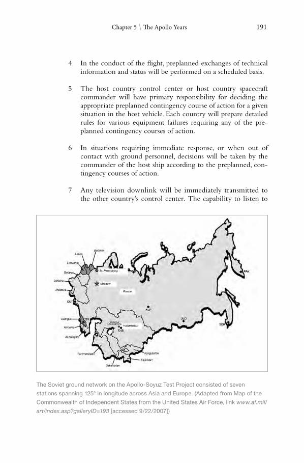
191
4
Chapter 5 \ the Apollo Years
In the conduct of the flight, preplanned exchanges of technical information and status will be performed on a scheduled basis.
5 The host country control center or host country spacecraft commander will have primary responsibility for deciding the appropriate preplanned contingency course of action for a given situation in the host vehicle. Each country will prepare detailed rules for various equipment failures requiring any of the pre-planned contingency courses of action.
6 In situations requiring immediate response, or when out of contact with ground personnel, decisions will be taken by the commander of the host ship according to the preplanned, contingency courses of action.
7 Any television downlink will be immediately transmitted to the other country’s control center. The capability to listen to
the Soviet ground network on the apollo-Soyuz test project consisted of seven
stations spanning 125° in longitude across asia and europe. (adapted from Map of the
Commonwealth of Independent States from the United States air Force, link www.af.mil/
art/index.asp?galleryID=193 [accessed 9/22/2007])

192 “Read You Loud and Clear!”
the voice communications between the vehicles and the ground will be available to the other country’s control center on a pre-planned basis, and upon joint consent, as further required or deemed desirable.
8 Both sides will continue to consider techniques for providing additional information and background to the other country’s control center personnel to assist in mutual understanding (including the placement of representatives in each others control centers).
9 As a minimum, flight crews should be trained in the other country’s language well enough to understand it and act in response as appropriate to establish voice communications regarding normal and contingency courses of action.
10 A public information plan will be developed which takes into account the obligation and practices of both sides.91
Apollo-Soyuz presented a new challenge to the GSFC tracking and communications team. The challenge was one of providing links between two orbiting spacecraft with two control centers with two entirely different protocols. The mission was unique in that the NASA network had to, for the first time, function in coordination with a Soviet network. Each had its own communications protocol which now had to “talk to each other.” Arrangements reached between the two sides stipulated that each control center could receive all voice and television communications transmitted to either spacecraft. Either crew could be contacted by voice from any station, whether American or Soviet.
Some 2,300 men and women at field stations and 500 at Goddard were assigned to the mission (more than that assigned to the later Apollo flights). The NASA stations that supported ASTP were a subset of the 9-meter USB sites that supported the lunar missions, plus a handful of STADAN sites:
Ascension (ACN)Bermuda (BDA)Guam (GWM)Hawaii (HAW)Madrid (MAD)Newfoundland (NFL)Orroral (ORR)Quito (QUI)Rosman (ROS)Santiago (AGO)

193 Chapter 5 \ the Apollo Years
Coverage from Orroral, Quito, Rosman and Santiago indicated the considerable progress that was made in the early 1970s in drawing on STADAN stations to assist in human spaceflight operations. In addition to the land stations, the venerable Vanguard was stationed off the Argentine coast near Mar del Plata. Three ARIA aircraft also supported launch and reentry operations in the Indian Ocean and South Pacific, taking off from airbases in South Africa and Australia.
The Soviet network consisted of seven stations stretched across the vast expanse of the USSR. In addition, the Soviets deployed two ships, the Korolev (ASK), positioned off Canada, and the Gagarin (KYG), near Chile. The Soviet stations were:
Dzhusaly, Kazakhstan (DJS) Eupatoria, Ukraine (EUT) Kolpashevo, Russia (KLP) Petropavlovsk-Kamchatskaya, Russia (PPK) Tbilisi, Georgia (TBL) Ulan-Ude, Russia (ULD) Ussuriysk, Russia (SDK)92
It was during ASTP that a new dimension in space tracking and data acquisition was added. In a harbinger of things soon to come, NASA added for the first time, a specific space element to the network. The newly developed Applications Technology Satellite-6 (ATS-6), made by Fairchild, was used to relay communications from the orbiting spacecraft to ground stations. This increased coverage dramatically, from approximately 17 percent to 60 percent (an increase from 15 to 52 minutes) of each 87 minute orbit.
ATS-6 was the second generation of the GSFC Applications Technology Satellite program. Its predecessors, ATS-1 through 5 launched between 1966 and 1969, were the first generation in the series. Originally designated ATS-F, the program had included a second, very similar satellite called ATS-G, but it was canceled for budgetary reasons. Eight of the experiments on ATS-6 were explicitly designed for communications relay studies to prepare for the next generation TDRSS.
But use of ATS-6 on Apollo-Soyuz was not orginally planned. Bill Wood explained.
We at Goddard were very reluctant to commit the use of the ATS except on the basis of a test and not to meet ASTP requirements.This was another example of the camel’s nose in the tent. The very nature of the ATS was as a test program.The closer we got to launch, the more important it seemed to get.We wound up putting a lot of effort into putting equipment in Spain to interface with ATS.Thank goodness it worked, but I for one was nervous.93

194 “Read You Loud and Clear!”
At nearly 1,360 kilograms (3,000 pounds) with a span of over 15 meters (50 feet), ATS-6 was quite the imposing bird. It included a 9-meter (30-foot) diameter parabolic antenna, an Earth-viewing module located at the focus of the parabola and two solar arrays for power. Not only big, it was also quite complicated for its time. All the communication experiment was located in a section of the Earth-viewing module with feeds for the large antenna mounted on top of the module and Earth-pointing ancillary antennas populating the bottom side of the satellite.94
Launched out of the Kennedy Space Center atop a Titan III-C on 30 May 1974, GSFC had a list of performance objectives that they wanted to see from the satellite:
Demonstrate the feasibility of using a nine meter diameter, deployable, steerable, high-gain antenna with good RF performance in the 6.5 GHz range.
Provide spacecraft fine pointing to within ±0.1° accuracy.
Demonstrate precision interferometer attitude measuring technology.
Provide an Earth-facing, stable spacecraft at geosynchronous altitude for experiments to be selected by NASA Headquarters.
Originally placed in geosynchronous orbit at 94ºW over the Galapagos Islands, the big satellite was immediately used to test operational compatibility with the network ground stations. In June 1975, Goddard controllers, transmitting through Rosman, commanded the satellite to 35ºE over Lake Victoria, Africa, to support the Indian government’s Satellite Instructional Television Experiment (SITE). From this vantage point, ATS-6 could also participate in “millimeter-wave” communication experiments with several European ground terminals as well as relay ASTP data to ground receiving stations.
To do this, it pointed its antenna towards the horizon and generated a signal for the Apollo spacecraft to lock onto as it moved into view. Upon establishing contact, Apollo transmitted telemetry, voice and television to the satellite. ATS-6 then relayed the signals to a 30-meter (100-foot) antenna at the Buitrago ground station outside Madrid. Madrid then acted as the ground terminal, relaying the spacecraft’s data via commercial Intelsat to the United States.95 After supporting ASTP and the one-year Indian experiment, it was slowly moved by a series of ground commands to the Western hemisphere where it was stationed at 140ºW over the Pacific until it was deactivated in July 1979. During its final trek as it was being repositioned in July 1976, ATS6 demonstrated the social benefits possible of data relay by providing tempo

195 Chapter 5 \ the Apollo Years
rary (and goodwill) communication services while passing over 27 countries on the way to its final destination.
Engineers and scientists at Goddard conducted a series of space communication experiments using ATS-6 in its five year life. One of them, the “ATS-F Tracking and Data Relay Experiment,” designed by F. O. “Fritz” von Bun and exercised in conjunction with a Nimbus weather satellite, was designed specifically as proof-of-concept testing for the upcoming TDRSS (see Chapter 7). ATS-6 also relayed television signals to remote areas of Alaska, the Rocky Mountains and the Appalachians. This operation, beginning in August 1974, brought live, public education television programming to those areas of the United States for the first time.96
★ ★ ★
Although preparations leading up to ASTP broke new ground in terms of cooperation between the two countries, the Soviets still found it difficult to break with their veil of secrecy. On 2 December 1974, seven months before the scheduled launch of ASTP, Soyuz 16 was launched from the Baikonur Cosmodrome—completely unannounced. NASA had known that a dress rehearsal was coming, but only when the Soyuz spacecraft reached orbit did Moscow bother to inform the Americans that it was in fact already underway! The Agency was able to put the mission to some use through a quickly organized, 15-hour joint tracking exercise at the behest of the Soviet Union. This even included a simulated launch so that the Soyuz crew had something to “aim” at in a mock rendezvous. Data recorded by NASA ground stations were relayed to Goddard and, after the mission, compared to data received by Soviet stations during the same time period. This comparison merely verified what NASA already knew: the network was ready for the mission.97
All this took place in the Cold War. The United States had just pulled out of an unpopular war in Southeast Asia, one which pitted the country face-to-face against communism half a world away. It had cost 50,000 American lives. While U.S. preparations for the mission were done in the open, Soviet preparations, although more open, were still for the most part veiled in secrecy (as Soyuz 16 so clearly illustrated). It was not surprising, then, that NASA went about preparations for the mission with a certain sense of trepidation. While international cooperation was what ASTP was all about, NASA kept finding itself in situations asking “How does one cooperate without giving away too much from a technology standpoint.”
A case in point was the technology needed to physically dock the Apollo with the Soyuz. The two not only had different docking mechanisms but also different atmospheres inside the spacecraft (Apollo operated at a cabin pressure of about 0.3 atmospheres while Soyuz operated at 1 atmosphere, or standard sea-level). The technology imbalance led to the U.S. developing with

196 “Read You Loud and Clear!”
help of the Soviet Union, the Docking Module, the central, critical piece of equipment without which the mission could not have succeeded. The Docking Module turned out to be purely U.S. technology in the end. Technology, however, was not the only thing that changed hands during preparations for ASTP. There was also a language barrier. While it is well known that both flight crews had to learn each other’s language during training, what is lesser known was that there were actually classes conducted in Russian at the GSFC to train the network engineers who would be communicating with their counterpart in the Soviet Union. The direction from NASA management was, “If we’re going to deal, we have to learn to speak the language.”98
At 1220 hour GMT, 15 July 1975, Commander Aleksei A. Leonov and Flight Engineer Valeri N. Kubasov blasted off aboard Soyuz 19. It was the first time that a Soviet space launch was seen live on television by its own people and others around the globe. The communication link traveled in a circuitous route: Moscow to Helsinki, Stockholm, Copenhagen, Prague, Hamburg, Frankfurt, and then to a Comsat ground station at Raisting, near Munich, West Germany. From there it was sent via the Comsat satellite to the United States. The routing was requested by the Soviets since an AT&T ground station planned for this flight was not finished in time. According to Charles J. Goodman, Goddard’s technical manager for television on ASTP, the routing involved some seven relay points on both the East and the West. It also required conversion of signals from the Russian color system protocol (SECAM III) to the European PAL color system and finally to American standards National Television System Committee (NTSC).99
Despite the complexity, communications never showed any noticeable degradation. “Just about everybody broke his back to help make it happen,” Goodman remembered. “We had some 50 hours of virtually flawless television transmission. Our arrangements began on November 25, 1974 and everything was in place for the launch some eight months later.”100 Goodman specifically pointed out a first-rate relationship with the European Broadcast Union headquarters in Brussels, Belgium, and its technical personnel. Apollo-Soyuz was seen by more people in more countries than even Apollo 11.
Seven and a half hours later, Commander Thomas P. Stafford, CM Pilot Vance D. Brand and Docking Module Pilot Donald K. “Deke” Slayton were launched atop a Saturn IB rocket from pad 39B at the Kennedy Space Center. After a series of orbital maneuvers—the most complex of its kind during the Apollo era in which the American CSM chased the Soyuz—the two spacecraft began station keeping at 1551 hour GMT on 17 July. They docked 24 minutes later. After Slayton and Stafford equalized the atmosphere inside the Docking Module with that of the Soyuz, the hatches were opened and the now celebrated “space handshake” between the two mission Commanders was televised live to the world.

197 Chapter 5 \ the Apollo Years
Over the next two days, the crews exchanged mementos and conducted (token) zero-g science experiments; a second docking was also performed. They also exchanged cuisines, with the Soviets offering a choice of hot soups from the different peoples of the USSR—Ukrainian beetroot and cabbage soup, a piquant Georgian mutton broth and Russian sorrel and spinach soup. In return, their western colleagues offered up such delicacies as applesauce, spaghetti, apricot pudding, and bacon squares.101 After two days, the two vehicles undocked for the final time. After a fly around photography experiment in which the Soyuz was used to block out the Sun simulating an artificial solar eclipse, the two spacecraft went their separate way. Two days later, Leonov and Kubasov de-orbited their spacecraft, bringing it back to Kazakhstan on 21 July. As with the launch six days earlier, their landing and recovery was seen by a live television audience for the first time. Apollo stayed in orbit for another three and a half days, splashing down four and a half miles from the recovery ship New Orleans near Hawaii on the afternoon of 24 July to bring to an end the first international space venture and the final Apollo splashdown.102
Chris Kraft would reflect years later on the uniqueness of the ASTP experience and what each side was able to learn from the other:
Getting to know the Russian management approaches, their thoughts and objectives, both in a national and personal sense, was an extremely interesting experience. The Russians are very different and their motivation is certainly not the same as ours. Their pride is very important and their engineering skills are very good. They are just as smart as we are. They did a superb job of building parts of the machinery and in the planning. They needed a great deal of help from us particularly in getting the job done within the management confines that existed in the Soviet Union. Here they needed help, and they told us so. Certainly the Russians do not do things in a manner even closely resembling our approaches. They are more secretive and I am not sure that we really learned how they do things internally. For instance, I do not remember ever having seen an organizational diagram. It was a long and protracted process. In the beginning, I thought a joint project might just not be possible. There was a great lack of credibility and trust between us and our ability to communicate. But slowly, primarily due to the tremendous efforts Glynn S. Lunney, the American Technical Director for the mission and his Russian counterpart, Professor Konstantin Davydovich Bushuyev, their associates and the respective space crews, we found a way to get things on the right track. They deserve all the credit for this. It was a fantastic achievement for both sides when we finally flew this mission.103

198 “Read You Loud and Clear!”
The Apollo-Soyuz Test Project stood as a symbol of the Nixon-Ford era of détente. This atmosphere of cooperation was short lived however. Soviet-American relations soon deteriorated, reaching a new low in 1979 after the invasion of Afghanistan. Cooperation in space exploration turned tepid and would stay dormant for the next two decades. For the balance of the 1970s, human spaceflight practically disappeared from the American public’s eyes. While atmospheric Approach and Landing Tests of the developing Space Shuttle were conducted as the new decade approached, NASA would not return a person into space until 1981. In a way, Apollo Soyuz marked the swansong for the first era of human space presence, one driven by the intense rivalry between the two Cold War superpowers. How fitting then that this era, which began in 1961 with Alan Shepard’s 15 minute response to Gagarin’s flight, concluded with a handshake in space between those same superpowers.
NASA’s Spaceflight Tracking and Data Network stood out during this time to make possible this success story and America’s victory in the space race. The role it played led to a much deserved recognition by Congress when in September 1974, the House declared that
After completing an investigation which took nearly a year, it [has] concluded that the Tracking and Data Acquisition Program is being managed and operated in an effective and efficient manner. The people working in the program—both government and contractor, both U.S. and foreign—are doing an excellent job, and are to be commended for their contributions to the success of the U.S. space program.
As one committee member put it,“They are the unsung heroes of the space program.”104
Noel W. Hinners, who retired as Director of the Goddard Space Flight Center in 1989, echoed this sentiment when he recalled the uniqueness of the time and place that was the Space Race, and how NASA’s tracking and communication networks met the challenge. “There was a unique contest: the dream of man’s quest to explore space and the harsh technical realities which had to be faced if these dreams were to come true. The area of space tracking, communications and data acquisition from orbiting satellites and eventually from the Moon and beyond, was an important part of this odyssey. A dedicated team of men and women, both in and out of government, helped to make these dreams a reality. They were the first generation of ‘space trackers’ whose electronic links tethered the spacecraft to its controllers and scientists. The Goddard Space Flight Center, as a member of the NASA-industry team, [was] proud to have contributed to these expeditions in space.”105

Chapter 6
ERA OF CHANGE
NASA’s annual budget was $330 million in 1959. Just six years later, it had ballooned to $5.25 billion. 1 Over the next seven years, however, even as the space agency was putting 12 men on the Moon and busy pushing the envelope in launching a plethora of new generation of space probes, science satellites and application spacecraft, it saw its funding gradually being cut. By 1974, it had bottomed out at $3 billion.2 In the FY 1973 NASA budget hearings, Gerald M. Truszynski, Associate Administrator for the OTDA, announced plans by the space agency to merge the STADAN and the MSFN into a single, more streamlined network.
Networks were developed under a certain sense of urgency in the early years of the space program. The need to respond to the Soviet Union and to put the American space effort on the fast track sometimes took priority over such matters as coordination of effort and minimizing of cost. It was, after all, a time of pioneering work with many unknowns. By the early 1970s, while the major emphasis on meeting program requirements had not diminished, coordination of these requirements, economic efficiency, and tighter management controls were being given a much higher priority. This fundamental shift to the pragmatic was felt—and felt hard—by those running its spaceflight tracking networks. As one NASA manager recalled, “There wasn’t as much

200 “Read You Loud and Clear!”
money there, wasn’t as much activity, [and we began] closing Apollo tracking stations, cleaning up after Apollo.”3
It was in this atmosphere of renewed fiscal awareness that NASA merged the two networks to form what would be called the Spaceflight Tracking and Data Network, or STDN. There were also other reasons besides budget for a network consolidation. With the decline in scheduled human space activities after Apollo, the argument for a separate, manned-flight network became less compelling. For the engineers, technicians, managers and even the astronauts—the very men and women who had just put Americans on the Moon—there was a definite sense of let-down when it dawned on them that what seemed like an adventure which had just begun was now suddenly over. Bill Watson, the Program Executive at Headquarters who today oversees NASA’s Ground Network, was fresh out of school and just starting his career at the time. Reflecting back, Watson said:
There was a sense of what’s next, what we should do next after Skylab and Apollo-Soyuz. It was hard for guys to get excited about scientific, robotic satellites to the extent that they were excited about the manned flights.There was a large hiatus there until the Shuttle program came along, and . . . a lot of folks left the program during that gap.4
The numbers reflect this. In 1970, the Agency’s fulltime, civilian workforce stood at 31,223. By 1979, this had dropped to 22,633, a reduction of almost 30 percent. NASA cut its workforce by 7 percent in 1972 alone.5
Besides fiscal constraint and the rescoping of the Agency’s mission, there were also good technical reasons for merging the networks. Both the STADAN and the MSFN were growing increasingly sophisticated. The clear separation of crewed versus uncrewed requirements that had so differentiated the two were becoming more nebulous due to the increasing number of high eccentricity (highly elliptical), high apogee observation satellites being launched. This new class of satellites had much in common from a tracking standpoint with an Apollo spacecraft traveling to and from the Moon. Meanwhile, network managers at Goddard thought that implementing the USB concept throughout the STADAN could serve as the common bond needed for a single, overarching, near-Earth network. All these factors served to provide Truszynski and his office with good reasons to merge the capabilities of the two networks. NASA’s thinking was that, with a leaner network, fewer stations could actually provide a more flexible capability to support its upcoming workload for all near-Earth missions, both robotic and piloted.6
Network engineers understood that the existing geographical distribution of the stations could effectively be modified into a configuration that would be able to handle the total mix of missions which NASA at the time

201 Chapter 6 \ Era of Change
foresaw for the latter half of the 1970s. Before this transition, there were 25 stations (19 STADAN and 6 NASA-owned, primary MSFN sites) spread over five continents (see maps in Appendix 1). The continual operation and maintenance of so many stations were, not surprisingly, expensive and required a great deal of manpower.
As of the mid-1960s, satellites were carrying much more powerful beacons so that telemetry—and not tracking—was now the pacing item. Technology was also advancing such that having fewer but better instrumented stations was now possible. Bill Wood, at the time Chief of the Manned Flight Operations Division and later Associate Director for Network Operations at Goddard, said of the change:
As the Apollo program began to wind-down, we realized that both manned and unmanned tracking functions had to be consolidated. It simply became too impractical and too costly to maintain separate networks. . . .This was the time to change from the old to prepare for the future—Skylab, Apollo-Soyuz, Space Shuttle and the many unmanned missions also being planned.7
At the Directorate level of Goddard, the organization was reworked starting in January of 1971. Ozzie Covington now consolidated all network activities under him including the field stations, the Network Operations Control Center (NOCC), and communications. Under Jack Mengel were all the Project Operation Control Centers, data processing, and the large computers at the Center.
To implement the change, Goddard made sure that several requirements, both new and old, were going to be met. First, the high data rate, real-time TT&C capability of the manned network were retained since they matched well with the increasingly more complex satellite requirements that were then coming online. Many of the satellites were, in fact, approaching the complexity of and taking on the characteristics of human missions in terms of requirements for command and control, downlink data rates, and the higher operating frequencies at the S-band. Foremost among this new generation were “mega” satellites such as the Earth Resource Technology remote sensing satellite (ERTS), the High Energy Astronomy Observers (HEAO), and the International Ultraviolet Explorer (IUE). On the IUE, for example, the onboard telescope had to be moved at regular intervals by means of ground commands emanating from the GSFC. In general, telemetry rates were pushing state-of-the-art capabilities at 150,000 bits per second.8
When ERTS-A was launched on 23 July 1972, it was actually supported by the MSFN. Thus, there was an increased need in the unmanned spacecraft community for the type of technical capabilities which already existed in the MSFN. By 1974, work was well underway to modify the telem

202 “Read You Loud and Clear!”
technicians check out earth resource technology Satellite ertS-a at the General
electric Company astro-Space Division in princeton, New Jersey in 1972. Launched atop
a Delta 900 launch vehicle from Vandenberg air Force Base in July of that year, ertS-a
was the first in the series of Landsat remote sensing satellites, one of the most successful
earth resource application programs ever. Downlinking its data to the Goddard Space
Flight Center at a rate of 15 megabits-per-second, ertS-a was designed to last one year
but was not deactivated until 2 January 1978. (photo courtesy of the United States
Geological Survey)

203 Chapter 6 \ Era of Change
etry and command processing systems at the existing MSFN sites for compatibility to support science spacecraft. At the same time, however, NASA still had many of the less complex spacecraft such as the old Explorer series, which was still returning a healthy amount of data. These were generally the smaller, spin-stabilized satellites which could not accommodate the newer and larger, high-gain, directional antennas, and therefore, still had to operate at the lower VHF frequencies.
With this wide spectrum of needs, NASA required the full range of capabilities offered by both networks. Apollo just came to an end; the time was right for such a merger. By the end of 1974, the number of ground stations (STADAN and MSFN) had dropped to 17. Two years later, it went to 15. Of the eight ARIA, only four were now available for NASA support, the others having reverted back to the Air Force full time. Four of the five AIS were retired in 1969, leaving the Vanguard as the only network vessel to remain in service (it too retired in 1978).9 Indeed, once the transition to the newly organized STDN was complete in 1976, network operations quickly became more standardized. NASA began to see greater returns from the slimmer network, all the while reducing the manpower needed for operations, logistics, and most importantly, cost.
While NASA did not present the consolidation of the STADAN and the MSFN to Congress until 1973, phase-down activities had already been taking place for some time. The first round of phase outs involved the STADAN stations at Blossom Point, Maryland; East Grand Forks, Minnesota; and Woomera, Australia in 1966. This was followed by shutdown of the temporary sites at Darwin and Cooby Creek in Australia; Lima, Peru (transferred to that country’s university); and at Mojave, California in 1969 (the remnant of the old San Diego Minitrack station which had moved to Goldstone). A year later, St. John’s, Newfoundland, on the eastern-most point of Canada, was shut down for good as was Fort Myers, Florida in 1972. By the time the STDN consolidation occurred, STADAN had, in fact, already streamlined down to nine stations (plus the NTTF in Greenbelt).
On the MSFN side, downsizing began soon after Apollo 11 when requirements for Apollo were carefully reevaluated by Headquarter’s Office of Manned Space Flight. With little fanfare, NASA soon began reducing the number of MSFN stations as well, beginning with the shutdown of Antigua in the South Caribbean Sea on 15 August 1970. The Agency had determined that limitations on launch azimuth angles for flights following Apollo 13 would not require data from Antigua and that no increase in risk to mission success would be incurred as a result of the shutdown. In the words of a NASA spokesman, Antigua was simply the victim of “reduced requirements for NASA’s worldwide tracking system.”10
The station had a 9-meter (30-foot) USB system as its centerpiece. After Apollo 11, it was almost immediately relegated to a caretaker

204 “Read You Loud and Clear!”
status with the 17 Bendix employees and 11 Antiguans put on standby status.11 Most of the equipment was transferred to other facilities in the MSFN. Although human spaceflight requirements for Antigua were soon deleted all together, the requirement to support other NASA launches out of the KSC still remained and the station stayed open at a reduced level. But the writing was on the wall. Soon thereafter, NASA pulled out of Antigua. The Air Force Eastern Test Range station on Antigua agreed to provide services to NASA as needed—on a cost reimbursable basis.12
The review board also showed that either the Corpus Christi Station in Texas or the Guaymas Station in Mexico could be closed. Had all factors basically been equal (including politics), the decision would have come down to fiscal considerations; that is, which one would yield the most cost savings. But Texas had one thing going for it that Guaymas did not. Due to its desirable location to support Earth resource satellites, it was the logical choice to remain open. By utilizing USB equipment from Guaymas, the station would be able to support both crewed and uncrewed programs. Because of this, the decision was made to keep Texas operational and close Guaymas. A meeting was held in Mexico City on 16 June 1970 with Mexican space officials, the U.S. Ambassador, and Gerald Truszynski discussing plans on how best to phase out the station. This was followed by a second meeting two months later in which it was agreed upon that NASA would remove two of the three major station systems for relocation to other parts of the network. The third system would be left in Guaymas to support Mexican space activities and programs of mutual interest to the Mexican science community and the United States.13
This was a good way to close a station. In addition to promoting goodwill between the two neighboring governments, the Mexican National Commission for Outer Space (CNEE) and NASA were, at the time, cooperating on two scientific projects. One was to develop a system using weather data acquired from U.S. satellites by using automatic picture transmission equipment. The other was to develop capabilities and applications for Earth observations using advanced airborne remote sensing instruments. The two countries were also completing plans for a cooperative project involving meteorological sounding rockets. After details of the agreement were ironed out, joint press announcements officially closing Guaymas were released by both governments on 12 November 1970.
By the following February, NASA’s withdrawal from the station was complete. This brought to an end a decade of association during which America blazed a pioneering trail into space. From John Glenn’s first flight into orbit to Apollo 11, Guaymas was there. Commenting on the legacy of the station, Dr. George M. Low, then Acting NASA Administrator, noted most fondly that the “cooperative establishment and operation of the station over the 10 most exciting years in space exploration stood as a tribute to the

205 Chapter 6 \ Era of Change
friendship and understanding between the two countries.”14 In particular, he singled out members of the Mexico-U.S. Commission for Space Observations who first laid the groundwork in 1959 to make Guaymas possible, specifically recognizing: Hugh Dryden, Chris Kraft (Director of Flight Operations at the Manned Spacecraft Center), Ralph Cushman (Special Assistant, Office of the Administrator), and Dr. Eugenio Mendez Docurro (Secretary of Communications and Transport, Av. Universidad Xola). This was quite the fitting tribute to a decade which saw the sleepy little railroad town of Empalme, Sonora (12 miles outside the actual city of Guaymas) thrusted into the international space forefront to become, even today over 30 years later, a source of pride for the Mexican people.
As the transition took place, plans regarding which stations to keep and which to close could change quickly, and often did. Take Canary Island, for instance. In the summer of 1973, NASA Headquarters proposed a five-year extension to the Spanish government that the station be kept open until 1978, when NASA’s TDRSS was then scheduled to become operational.15 The station seemed safe for another five years. Several requirements still needed support including telemetry reception from the Apollo Lunar Surface Experiment Packages that had been left on the Moon by the astronauts and the upcoming Apollo-Soyuz Test Project that would take place in 1975. Ironically though, it was this same requirement to support ASTP that ended up providing the impetus needed to shut down Canary Island.
This twist of fate came about due to the requirement for live television, a critical requirement on the highly publicized ASTP. It had been anticipated (correctly) by NASA that this particular mission, as the first international human spaceflight between the two Cold War rivals, would draw worldwide interest not seen since that of Apollo 11 five years earlier. As early planning requirements for extensive real-time coverage were being developed ( jointly by the ASTP Program Office in Washington DC and Moscow), it became apparent to both that this requirement was not going to be met effectively using existing MSFN capabilities. Something better was needed. The Agency would use the ATS-6 to directly receive television signals from the Apollo spacecraft and then retransmit them to a ground station in Spain, rather than depending on the ground stations alone.
Fallout from this decision on Canary Island came quickly. On 22 January 1975, Truszynski sent a letter to the Director General of the Madrid Station (of which the Canary Island station was a part of ) that NASA has “regretfully come to the conclusion that both near and long term data acquisition requirements do not support the continuation of the Canary Island station and would desire to close the station as soon as possible.”16 Canary Island’s fate was officially sealed two days later by a notification from Truszynski to NASA’s Assistant Administrator for International Affairs that services on Canary Island were no longer needed and that the State Department was
206 “Read You Loud and Clear!”
requested to take appropriate actions as soon as possible to shut down the station. Thus, Canary Island went from being a crucial land station in the eastern Atlantic to “not necessary” in the span of not even a single mission. In a way, it was a harbinger of things to come as ATS-6 tested out the new concept of space communications, one that would rely almost exclusively on space-based satellites to do the job that ground stations once did.
★ ★ ★
Soon after Apollo 11, the Guam and Hawaii stations took center stage in a budget fight between the Bureau of the Budget and NASA. During the FY 1971 budget process, the Budget Bureau notified NASA that Guam and Hawaii were going to be phased out and their operations transferred to the DOD satellite control station on their respective island. Each year, with a few exceptions, every department and agency of the federal government has to negotiate the “necessary evil” of the budget process; NASA was no exception. While budget negotiations were an annual ritual, what the Bureau was telling NASA in this instance was considered by the space agency as being somewhat “out-of-line.” The Budget Bureau’s position was that NASA should shut down these stations, but that in order to “alleviate to the extent possible impact on mission support,” the DOD would “give the NASA manned missions highest priority in workload allocation.”17
In November 1969, Administrator Thomas Paine rejected this proposal outright, making it clear that this was indeed an assumption of fait accompli, one not based on any DOD-NASA discussion after it was proposed at the start of the budget process. A paper was drafted explaining why NASA believed that any such consolidation would be neither operationally feasible nor cost effective. NASA’s viewpoint was based in part on a preliminary joint NASA-DOD sponsored study to evaluate the merit of consolidating the NASA and DOD network facilities on Guam and Hawaii. No long-term operational costs were identified which would have offset the substantial immediate cost of modifying and relocating the equipment and expansion of facilities required to handle the high-priority functions of both agencies. Before sending this paper to the Budget Bureau, Paine confirmed that “responsible officials in the Air Force agree with us that the conclusions of this study are still valid.”18
This did not end the matter however. Three months later, the Bureau of the Budget once again informed NASA that the Guam and Hawaii stations were to be phased out. This time, in a strongly worded letter to Robert P. Mayo, Director of the Bureau of the Budget, Paine voiced the Agency’s concern that they now appeared to be under direction, without prior consultation, to take an action which was operationally and economically unsound in the view of both NASA and the U.S. Air Force. Since he was at the time accompanying the Apollo 11 crew in the “Giant Leap” victory tour in the Far

207 Chapter 6 \ Era of Change
Gerald M. truszynski (far left) rose through the ranks to become NaSa’s associate
administrator for tracking and Data acquisition from 1968–1978. this picture shows
truszynski when he was head of the Instrumentation Division participating in the 27 January
1953 ground breaking ceremony of the NaCa high-Speed Flight research Station (which
became the Dryden Flight research Center) on the northwest edge of rogers Dry Lake in
the Mojave Desert. pictured with truszynski were Joseph Vensel, head of the Operations
Branch; Walt Williams, head of the Station, scooping the first shovelful of dirt; Marion Kent,
head of personnel; and California state official arthur Samet. (NaSa Image Number e-980)
East, Paine volunteered to change his travel plans so that he could personally look into the situation at the NASA and Air Force stations in Hawaii on his return. In the meantime, he directed Truszynski and his office to review again the requirements on both islands with DOD officials. Drawing a line in the sand, Paine concluded his letter to Mayo in no uncertain terms, saying, “Unless new information is developed in my visit or in the review, I will then formally reopen this matter with you, and if necessary, the President.”19

208 “Read You Loud and Clear!”
Guam and Hawaii went on to survive that year’s budget process. In fact, both stations went on to become among the longest-serving STDN sites, remaining operational for another 19 years, finally closing in 1989.
As NASA stations began to close around the globe, none was more of a political target than the Johannesburg Station in the Republic of South Africa. This was one of the few communication complexes where the DSN and the STADAN shared a location. Roots of the DSN go back to the late 1950s. As the United States moved from the realm of Earth-orbiting satellites to begin sending probes to the Moon and beyond, a “World Net” was established by the DOD’s Advanced Research Projects Office. This World Net formed the nucleus of what would go on to become the DSN. In order to maintain continuous coverage of space probes departing the planet as Earth rotates, three sites are needed, each situated about 120º apart. The DOD— and later NASA—had placed the first two sites at Goldstone, California and Woomera, Australia. Completing the World Net was the construction of a third station in the country of South Africa, where a government-owned, 4,000 acre grassland valley near the Hartebeestpoort Dam 65 kilometers (40 miles) north of Johannesburg was provided.20 The station became operational in June of 1961.
To meet tracking requirements in the Southern Hemisphere, a $5 million expansion at the Johannesburg complex was done three years later that brought the number of stations to three. One was run by the U.S. Air Force to control its satellites. Due to its obvious military nature, the station was staffed entirely with Americans. The other was a NASA satellite tracking station. The remaining site, for all intents and purposes, was part of the NASA station but was operated for the Smithsonian Institute, its roots dating back to the IGY and Minitrack.21 Unlike the Air Force, NASA staffed these two stations with South African workers and normally only had a U.S. liaison officer present onsite. Under a 1960 agreement with the space agency, the National Institute for Telecommunications Research, a part of South Africa’s Council for Scientific and Industrial Research (CSIR), had full responsibility for management of the station which they operated so as to meet NASA’s technical requirements. The station was fairly extensive. At its peak, the NASA side of Johannesburg employed some 280 South Africans of whom about one in five were black.22
Even as NASA began working with the South African government to establish stations there, the potential fallout from that country’s racial segregationist policies was not lost on many in the United States. NASA was fully aware that an agreement with a government espousing such policies could become a political flashpoint. But at the same time, it could not just discard the technical merit of such a location. Here’s why: for optimal coverage of interplanetary probes launched on trajectories from Florida, an antenna was best placed as far south as possible, preferably deep in the Southern Hemisphere. The Republic of South Africa, being on the very southern tip of the conti

209 Chapter 6 \ Era of Change
nent, was ideal. As unfavorable as the South African political climate was, it was actually the most democratic and most stable government accessible to the United States on the continent at the time. To keep its options open, even as negotiations were being held with South Africa, NASA still looked at other locations, particularly those in southern Europe. These, in order of preference, were Sicily, Sardinia, south Spain, and south Portugal. Headquarters also looked into a possible cooperative arrangement with France, which at the time was considering the purchase of a 26-meter (85-foot) antenna from the Collins Radio Company to build a ground station of its own on the Normandy peninsula.23
These were more than just cursory looks. Site survey teams consisting of members from Headquarters and the Jet Propulsion Laboratory were sent to all these locations as NASA wrestled with whether or not to proceed with South Africa. In the end, it was decided that the geographical location, along with the country’s already robust scientific community and the expressed enthusiasm of the South Africans, best advocated putting stations there.
It did not take long for tensions to arise. Accusations centering on the station started to surface even back in 1962, that South Africa might be putting pressure on the U.S. government for NASA to adopt a segregationist policy there. This was a serious concern, so much so that Associate Administrator Edmond Buckley wanted an early evaluation of the matter by asking the State Department to look into the situation.24 Time did not assuage the tension between the two governments, though. In fact, things only got worse. The situation came to an early head when in May 1965, the United States asked South Africa for permission to have a squadron of advance-planes from the aircraft carrier USS Independence land at airports when the ship was scheduled to dock at Capetown. The government granted the Americans permission, provided the planes’ crews were white. Up until then, American planes had often landed at South Africa airports and on occasion, there had been mixed-race crews including blacks. However, never before had the South Africans explicitly asked for all-white crews.25 This caught the State Department totally off guard. In an attempt to clarify the meaning of the South African response, the United States asked if this was a condition or a suggestion. If it was a condition, South Africa was told it would not be accepted. If it was a suggestion, no guarantees could be given. With no clear response from the South African government and not wanting to escalate the already well publicized series of events, the USS Independence, in the end, skirted the issue by bypassing Capetown altogether.
American resolve was further tested just a month later when, for the first time, pressure to actually shut down the station officially came from the South African government. This time, Premier Hendrik F. Verwoerd announced in a press release that he had told the United States it cannot employ “negro scientists in the South African stations,” and that his govern

210 “Read You Loud and Clear!”
ment “would not admit American negroes if they were assigned to work at the tracking stations.”26 Verwoerd’s comments on the tracking station staff seemed to most observers at the time to have been a condition, deliberately made, so as to provoke an American response. An opinion editorial came out that same week in the South African Sunday Times declaring that the United States would have to decide whether it can “afford morally” to overlook Dr. Verwoerd’s remarks. The irony was that just three years earlier when South Africa’s role in NASA’s tracking network was being heralded, the same newspaper headlined “South Africa has Important Part in U.S. Moon-Shot.”27
On the other side of the Atlantic, the station became a major target of blacks and liberal politicians who protested that the United States should not be putting money into a country with whose racial policies we do not agree. Into the 1970s, numerous congressional inquiries and hearings before the House Subcommittee on Aeronautics and Space Technology were conducted. Led mainly by prominent liberal members of the Democratic Party, these hearings aimed to determine just what exactly NASA was doing in South Africa. To that end, they looked at what the United States was doing to improve the working and living conditions and opportunities for black South Africans employed at Johannesburg. NASA administrators from Headquarters also answered questions before the House Committee on Foreign Affairs regarding the specific racial breakdown of employees, salary breakdown by race, wage practices, and NASA’s hiring practices of Black Africans. (The irony was that NASA did not do any hiring in South Africa. CSIR hired African employees from an agricultural group resident in the area of the station while whites were hired through normal CSIR employment channels for technical assignment.)28
As hearings progressed through the mid-1960s to the mid-1970s, the issue intensified to the point where heightened scrutiny was placed on even the smallest of details, such as educational assistance, Christmas bonuses paid to whites versus negros, eating facilities and provisions for medical services. On one side of the aisle, members of the House Congressional Black Caucus, led by Representative Charles B. Rangel of New York, viewed the station as an egregious symbol of American acquiescence to apartheid. Others in Congress, led by Representative Olin E. Teague of Texas, Chairman of the House Space Committee, argued that the station was really South African, not American, since NASA did not employ any Americans in South Africa. Information gathered by NASA at the behest of Representative Charles C. Diggs of Michigan showed that, whereas blacks held about 25 percent of the jobs at the station, they received only about 5 percent of the wages paid by NASA through CSIR. In 1972, after returning from a visit to the site, Diggs reported that black employees were barred not only from the station cafeteria but from most of the technical and all of the supervisory jobs and from the technical training programs. Representative Rangel charged that gross disparities existed between fringe benefits given to white and black employ

211 Chapter 6 \ Era of Change
ees, benefits such as sick leave, vacation time, and medical benefits. To support his case, Rangel presented numbers showing that the highest paid black employee—a “skilled laboratory assistant”—earned $2,005 per year, just barely more than the lowest paid white employee—a “raw trainee”—who earned $1,930 a year.29
Even when there was good news for NASA regarding South Africa, it was tainted by what could only be called handwriting on the wall. In May of 1973, a House bill that would have cut $3 million of NASA funding for stations in South Africa was defeated. However, in defeat, more votes than ever before (104 to 294) were rallied. That same month, Massachusetts Senator Edward M. Kennedy introduced an amendment to cut off funds for the station, an amendment he later withdrew but only after the Senate Space Committee’s new chairman, Utah’s Frank E. Moss, promised to look fully into the matter in the fall session. According to Moss, the unconditional shutdown of the station would have meant that another station would have to immediately be established elsewhere. If this had to be done, the replacement cost would have amounted to around $35 million, something that would have been difficult to justify on the bill that late in the budget process.30
Throughout this debate, NASA consistently countered that local improvement programs which accompanied the stations were in fact making a difference. For example, the United States was, at the time, providing approximately $109,000 a year (1973 dollars) on improvement programs for the black station community. Among them was the building of houses for the African staff, at the rate of one completed every two months, and the construction of an elementary school. By 1974, 18 new houses had been constructed plus the school. Under the agreement between NASA and CSIR, the South Africans provided the initial construction funds which were then reimbursed by the United States upon completion. NASA also operated a small medical facility onsite, the services of which were made available to the Black African staff and their families. Although it was only staffed part time—a nurse was on duty three days a week and a doctor visited once a week—it was, nevertheless, one of the very few modern medical facilities in the Hartebeestpoort area that provided services to the black community, and as such, was well used. However, station critics in Congress regarded these improvements as merely cosmetic, noting that South Africa seemed not to think the station important enough to its own interests to justify making exceptions to the rules of apartheid. “The system is so unyielding,” said an aide to Charles Rangel, “that if the U.S. had forced the point, South Africa would have just kicked the station out.”31
As things turned out, Senator Kennedy did not have to wait until the fall session. After more than a decade of defending the station, on 10 July 1973, Administrator James C. Fletcher announced that it would begin pulling out of South Africa the following summer and would withdraw U.S. support entirely by late 1975. The phase-out would be done in two stages, starting first with the

212 “Read You Loud and Clear!”
DSN side in June of 1974 followed by the STADAN side after completion of the near-Earth phase of the Viking Mars missions.32 The decision to phase out Johannesburg did not, however, signal the immediate cessation of all NASA activities in South Africa, just its tracking stations. Meteorological data collection as part of NASA’s worldwide program to conduct high altitude air sampling in all hemispheres continued. Data analysis for the LANDSAT-2 satellite (in which the U.S. was one of roughly 50 countries involved) and lunar sample analysis continued for years thereafter, some even to this day.
As NASA pulled out of Johannesburg—and other stations for that matter—what to do with the equipment and hardware usually came down to two options: 1); Remove all or part of it at the Agency’s own expense, with the implied, parallel responsibility to restore the site to its original condition; or 2); Dispose of the property, all or part of it, within the host country in accordance with arrangements agreed to beforehand by the two governments. In South Africa, the cost to dismantle the Deep Space portion (DSS-51) would have amounted to $643,500 with an additional storage cost of $11,060 (1975 dollars).33 Based on this estimate, NASA determined that its real property interests at the tracking station constituted foreign excess property which had essentially no commercial value. Eventually, it was concluded to be in the best interest of the U.S. government to either donate or abandon in place the property to the South Africans. In doing so, it was mutually understood that the assets would be relinquished with the provision that no further U.S. obligation or liability remained. NASA, in essence, washed its hands of South Africa.34
Nevertheless, finger-pointing continued. Noting that the Agency had previously closed down two similar tracking stations in just the past year—Fort Myers, Florida, and Woomera, Australia—the Agency said that the South Africa decision was based entirely on technical requirements and was in no way a response to political pressure. Critics in Congress disagreed. “Frankly,” said a spokesman for Senator Moss, “I think they just saw the handwriting on the wall, the message being that the station was becoming an embarrassment.” Moss himself later released a statement praising NASA for its decision to pull out, adding “Apartheid has always been repugnant to me.”35
In reality, NASA began planning phase out activities for the station as early as 1971. Its official position was that there would be an absence of requirements for long-period, near-Earth, Southern Hemisphere coverage after Viking left for Mars in 1975. Following that, deep space requirements could be handled by the DSN stations at Canberra, Goldstone, and Madrid. With this plan in mind, discussions were held with CSIR in August of that year to give them as much time as possible to work out staffing plans. A concern at the time for both countries’ space programs was to not just abandon the station but rather, retain enough competent staff through the transition period as it moved from being a jointly sponsored site to one that was fully South African.

213 Chapter 6 \ Era of Change
In the phase out discussions with CSIR, the fate and future of the Black African staff were, in fact, discussed at length, down to the number of Black Africans which might remain employed after NASA relinquished funding. There was particular concern on NASA’s part that Black African staff would be declared “redundant” and whether they would be treated equitably relative to the white staff. At Headquarters, Gerald Truszynski, in his discussions with Dr. Frank Hewitt of CSIR, felt that the South Africans appreciated the American position, with Hewitt saying he “reflected a genuine concern for the future of this group.”36
A legacy of these discussions was that it led the South Africans to implement several policy changes with regards to Black station staff members. One had to do with the pension they were receiving. At the time, the Black African staff members were covered by a different benefits plan that was generally (and obviously) inferior to that of the white staff. This “Provident Fund Plan” was soon changed so that the same formula was used in calculating the pension for all staff members. In addition, after these changes were made, CSIR allowed the Black African staff who were declared “redundant” to, where appropriate, continue occupying their houses, thereby enabling them to look for other employment before moving their families off the station site. Arrangements were also made for CSIR to provide a vigorous outplacement service and reemployment counseling. On the other hand, the one service which the South Africans did not continue after NASA ceased its funding was the secondary school bursary program which the Agency had started. CSIR deemed this to be outside of their normal responsibility and charter as they had many Blacks employed in their agency’s other activities who were not receiving any educational assistance.
In the end, two-thirds of the Black staff (39 out of 59) were released after NASA pulled out of Johannesburg.37
★ ★ ★
As a principal site in the Southern Hemisphere, Tananarive (TAN) had been busy, supporting a host of science satellites as well as all the Gemini, Apollo and Skylab missions. The routine began to change in 1972 when the Malagasy government underwent a series of political upheavals. In May of that year, the president of the ruling Social Democratic Party, which had been in power since Madagascar first gained independence from France in 1960, resigned under political pressure. The unrest continued over the next three years, culminating with the brutal assassination of the military dictator which put the country under martial law in February of 1975. Before long, a new Marxist regime was formed under the leadership of a 38-year-old revolutionary named Didier Ratsiraka. Under President Ratsiraka, known in the region as the “Red Admiral,” the government became highly centralized and com

214 “Read You Loud and Clear!”
mitted to revolutionary socialistic ideals. (These policies did not change until the 1990s only after the formation of new political parties.)
One of the first foreign policy changes that Ratsiraka made was to impose a rent on the United States for operating a NASA ground station in his country. In the original memorandum 20 years earlier which both countries signed establishing a site near Majunga, it was agreed upon that there would be no exchange of funds and no rent exacted for use of land. But now, Ratsiraka was demanding $1 million per year, retroactive to 1963 on back taxes. This was a demand that the United States obviously could not agree to.
Negotiations were conducted but to no avail. A few weeks later, the Supreme Council of Revolution of the Malagasy Republic forced the station closed. This action came upon NASA unexpectedly. During that time, GSFC was still improving on the station and in the process of adding a Unified S-band antenna.Under the guise of avoiding “possible maneuvers of sabotage,”President Ratsiraka immediately placed it under military control. The Station Director and Bendix workers with their families were allowed to evacuate, but all equipment had to be left behind.At the time of closure, there were the two Goddard appointed NASA employees and 50 Bendix workers, along with their dependents—148 rather apprehensive Americans total—at the station.38
With the abrupt shut down, Goddard had to make some quick changes in order that support for Apollo-Soyuz, which was to launch the very next day, would not be disrupted. They improvised by tasking the geosynchronous ATS-6 to serve as a data link. Workload from other satellites was shifted to other stations. ARIA instrumentation aircraft and the Vanguard were repositioned to help support other launch activities out of the Eastern and Western Test Ranges. These changes resulted in some temporary scheduling problems but otherwise proved adequate and Apollo-Soyuz went on to be an unparalleled success.
Over the course of the next five years, the Malagasy government periodically allowed NASA back into the country to remove equipment. On 3 April 1980, the last of the remaining hardware that NASA still wanted was removed from Tananarive. By diplomatic note, the remaining U.S. property was turned over to Madagascar the next day. This note, which was actually received by the U.S. Embassy the previous October, expressed essentially an agreement on the list of equipment NASA would remove and the monetary settlement. The removal process, in effect, was the final act that brought to an end five years of negotiations by the State Department to repatriate NASA equipment following the forced closure of the station.39 Besides the stress and disruption experienced by the staff and their families, the closure also had an effect on NASA in terms of operating cost. After Tananarive was shut down, the Vanguard was called on to fulfill some of its requirements. In the mid1970s, the annual cost to operate a tracking ship was quite high, about $6

215 Chapter 6 \ Era of Change
million per year. By contrast, a land station like Tananarive cost around $2.8 million, or less than half that of a ship.40
★ ★ ★
One of the first actions in the reorganization for STDN took place at the Goddard Space Flight Center where management of both networks was consolidated as early as May of 1971. Two new directorates, the Mission and Data Operations (M&DO) Directorate and the Networks Directorate (ND), replaced the Tracking and Data Systems (T&DS) and Manned Flight Support (MFS) Directorates. In this new arrangement, divisions within the M&DO managed the data processing activities and the computing requirements of the network. The ND became responsible for operation of all the STDN elements, from NASCOM to the ground stations and the satellites. In a harbinger of things to come in the 1990s, it was at this time that the Networks Directorate formed the Network Office for International Operations, which allowed GSFC to start handling some of the foreign policy work that up until then had rested exclusively in the domain of NASA Headquarters in Washington, DC. This move seemingly made sense at the time, coinciding with preparations for Apollo-Soyuz which demanded a lot of technical interaction with Soviet Union network engineers at the working level.
Although STDN was considered a new network (or at least a greatly retooled old network), much of the way in which it was run continued as before, including usage of acronyms—a well known hallmark of NASA. The MCC in Houston continued to serve as the focal point during human space missions with the responsibility of directing all ground stations when a flight was in progress. Meanwhile, the NOCC (Network Operations Control Center) in Greenbelt continued in its role of controlling the network including overseeing all network preparations leading up to the launch of a human space mission.
In this capacity, NOCC engineers monitored console displays and established direct voice links amongst all the mission elements such as the launch site at the Cape, the network ground stations and the appropriate Project Operations Control Center (POCC). These POCCs that began emerging during the previous decade were essentially individual operation control centers at the GSFC that were built to specifically control certain types of satellites such as the Applications Technology Satellite (ATSOCC) or the Orbital Astronomical Observatory (OAOOCC). Not to be left out were the multimission “umbrella” centers such as the Multisatellite Operations Control Center (MSOCC) and the Mission Operations Control Center (MISSOC) that scheduled network support for all classes of satellites and assigned each station a weekly list of satellites that were to be monitored.

216 “Read You Loud and Clear!”
To accommodate the data downlink from the new generation of satellites that were now nothing short of orbiting laboratories, Goddard enhanced the STDN with increasing centralized capabilities. A typical change was the greater reliance on electronic data transfer methods in the late 1970s with the implementation of systems such as the Telemetry Online Processing System (TELOPS), that eliminated the need to ship magnetic tapes from the field stations. Raw data was, instead, transmitted over communication lines to a dedicated storage system at GSFC.
The POCC themselves also continued to acquire improved technology, permitting scientists stationed at Goddard to manipulate the orbits and attitudes of satellites with greater ease. Take for example, as a progenitor of touch-screen technology, a scientist seated at the IUE Operations Center. This person could, by simply pointing a light-pen at a specified portion of a video display, swing the IUE telescope around to look at another part of the
the Goddard Space Flight Center has been home to many project Operations Control
Centers over the years. Shown here is the Space telescope Operations Center where
commands to the hubble Space telescope (hSt) originate and where its systems are
monitored. the picture was taken in December 1999 as engineers monitored activities
during the telescope’s third repair mission. today, command and control of the hSt is
done mostly from the Space telescope Science Institute in nearby Baltimore. (Image
courtesy of NaSa, available at http://hubblesite.org/gallery/spacecraft/01/)

217 Chapter 6 \ Era of Change
sky. In a move exemplifying NASA’s continual effort to obtain ever better quality videos, scientists supporting Earth resource and remote sensing satellites also received a special Image Processing Facility (IPF) at Goddard that provided video and pictures that were continuously corrected for distortions introduced by spacecraft equipment or during transmission—a progenitor to today’s high definition television transmissions.41
Stations reported back each week to the MISSOC on the performance of their satellite coverage. To measure performance, matrices were set up and grades given on how well stations were doing their jobs, whether excellent, good or poor. The success rate for each station was measured by how many passes were supported and how much low bit-error data was captured. This was then compared to how much could have been or should have been captured. The focus was primarily on the amount of data captured on satellite passes and not on cost of operations. This may not have been the best way to gauge how well a station did. Former Quito Station Director Charles Force said, “I thought at the time that was a mistake. You need to have some kind of a balance between how much you are spending and how well you are doing the job. But it was totally focused on how well the job was being done.”42
The system was also not without its flaws. Force remembered an example that always puzzled him:
It was my first exposure to performance evaluation using a matrix and what I learned from that personally, was that you have to be very certain the matrix measures what you want. One example I remember. If a satellite came over the horizon and the station was tracking it and the receiver failed, and they start losing data, they would then be scored down so [that] if they got the receiver up before the end of the pass and covered the balance of the pass, they got a lower score than if they didn’t get the receiver back up.
In other words, the station would actually get penalized if it successfully recovered from the receiver failure than if it hadn’t. “That was the system,” said Force. “That was idiotic why it was set up that way. I have no idea because I was not in on the early days of the STADAN.”43
While the original STADAN side of the house relied on these metrics to grade the performance of its stations, no such matrix was used on the MSFN side of the house. This apparent dichotomy in the way the two networks operated prior to their merger can, in large part, be traced back to the way the two networks came about—and the competition that followed. For years, while both the STADAN and the MSFN were run by Goddard, they were separate, up through the directorate level. Specifically, “Code 800” ran the MSFN while “Code 500” ran the STADAN.

218 “Read You Loud and Clear!”
From the onset, there were cultural differences, and with it, friction. Some would go so far as to call it jealousy. While Code 500 dated back to Jack Mengel and the team that created Minitrack, Code 800’s heritage was basically an offshoot of Langley—a lot of the people actually came over to Goddard from Langley. Because of this, the two networks had different heritages and different cultures in everything from the way they operated to how people were used in the field. STADAN stations, for example, were generally more “remote” in the way they operated in the sense that data was gathered and sent back to Goddard where it was then assimilated and processed. Thus, there was a lot of effort by technicians and engineers physically at GSFC running the computers. Unlike today where desktop and notebook computers can be found in every office, this way of centralization made sense at a time when mainframe computers were required to do the massive calculations. These mainframes were expensive, to put it mildly, and required a fair amount of maintenance. Therefore, the STADAN had a lot higher percentage of its technical expertise stationed at Goddard in proportion to the field. This was exactly the opposite of the MSFN, that had more computational capability in the field and, therefore, had more of its share of expertise assigned to the field.
There has been the conception throughout the years that by nature of its mission, the MSFN was somehow more glamorous and had a higher profile (public exposure) than the STADAN, and therefore, got more attention and resources. This was, in all likelihood, exactly what happened. It was an undeniable fact that the MSFN received more attention than the STADAN in the one area where it most mattered: funding. In 1968, for example, two-thirds of the budget for Goddard’s tracking operations went to the MFSN whereas one-third went to the STADAN.44
It’s been said that where the money lies, so lies the priority. This apparent inequity was well recognized and unfortunately, resented within the STADAN system. An “us-and-them” attitude developed in many circles. As Force put it, “They didn’t talk to each other that much.”45 The presence of this “sibling rivalry” is probably not too surprising considering the diversity of the people and their talent that was (and is) the Goddard family.
The years have shown that while such differences and strong feelings existed, they were worked out and the STDN moved on. The network that came out of it was a far better and more efficient network than before. Force would later say compellingly of the big picture, “The people did work together [and] the job was done successfully. There were an awful lot of good people that did work together and there was an awful lot done right and successful.”46 Indeed, the ensuing three decades have proven that.
By 1975, the merging of STADAN and MSFN was complete. Table 6-1 is a glance of the reorganized network in the mid-1970s.
Over time, these sites adjusted to the changing demands of the integrated network to support tracking of both human spaceflight missions

219 C
hapter 6 \ Era of Change
Table 6-1: Ground Stations of the Spacefl ight Tracking and Data Network in 197547
Station (Location) CallSign
LatitudeLongitude
YearEstablished Year Phased Out
OriginalNetwork Primary Capabilities
North AmericaAlaska (near Fairbanks) ALASKA 64˚59’N
147˚31’W 1962 1984 (Transferred to NOAA) STADAN GRARR, MOTS*, SATAN
40, 45, and 85-ft dish antennas
Goldstone (Mojave Desert, California) GDS 35˚20’N116˚54’W
1967 1985 (Turned over to DSN and re-designated as DSS 16 & 17)
MSFN and STADAN
30 and 85-ft USB
Merritt Island (Kennedy Space Center, Florida)
MILA 28˚25’N80˚40’W
1966 Still operating MSFN 30-ft USBC-band radar
Network Test and Training Facility(Goddard Space Flight Center, Maryland)
NTTF 38˚59’N76˚51’W
1966 1986 (Transferred to Wallops)
MSFN andSTADAN
30 and 59-ft antennas
Rosman (North Carolina) ROSMAN 35˚12’N82˚52’W
1963 1981 (Transferred to DOD) STADAN Two 85-ft antennasGRARR; three SATANs, MOTSATS telemetry and command
White Sands (New Mexico) WHS 32˚21’N106˚22’W
1961 Transformed into TDRSS ground terminals
MSFN C-band radarVHF voice
Pacifi cGuam GWM 13˚18’N
144˚44’E 1966 1989 MSFN 30-ft USB
Hawaii (Kokee Park, Kauai) HAW 22˚07’N157˚40’W
1961 1989 MSFN Two yagi command14-ft antennasC-band radar30-ft USB
* While the MOTS cameras remained at the stations, they were no longer required for calibration after phaseout of Minitrack. continued on the next pageThey continued to be tracking devices for geodetic research, photographing the Pageos spacecraft in the mid-1960’s. By the 1970’s, MOTS was no longer an operational network.
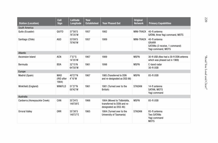
220 “R
ead You Loud and Clear!”
Station (Location) CallSign
LatitudeLongitude
YearEstablished Year Phased Out
OriginalNetwork Primary Capabilities
South AmericaQuito (Ecuador) QUITO 37˚00’S
78˚35’W 1957 1982 MINI-TRACK 40-ft antenna
SATAN, three Yagi command, MOTS
Santiago (Chile) AGO 33˚09’S70˚40’W
1957 1989 MINI-TRACK 40-ft antennaGRARRSATANs (2 receive, 1 command)Yagi command, MOTS
AtlanticAscension Island ACN 7˚57’S
14˚35’W 1967 1989 MSFN 30-ft USB (Also had a 30-ft DSN antenna
which was phased out in 1969)
Bermuda BDA 32˚15’N64˚50’W
1961 1998 MSFN C-band radar30-ft USB
EuropeMadrid (Spain) MAD
(RID after 1984)
40˚27’N4˚10’W
1967 1985 (Transferred to DSN and re-designated as DSS 66)
MSFN 85-ft USB
Winkfi eld (England) WNKFLD 51˚27’N00˚42’W
1961 1981 (Turned over to the British)
STADAN 14-ft antennaSATAN, MOTSYagi command
AustraliaCanberra (Honeysuckle Creek) CAN 35˚24’S
148˚59’E 1966 1984 (Moved to Tidbinbilla,
transferred to DSN and redesignated as DSS 46)
MSFN 85-ft USB
Orroral Valley ORR 35˚38’S148˚57’E
1965 1984 (Turned over to the University of Tasmania)
STADAN 85-ft antennaTwo SATANsYagi commandMOTS

221 Chapter 6 \ Era of Change
a “Spanish Watchman” on the hills overlooking NaSa’s Madrid Spaceflight tracking and
Data Network Station and its prominent 26 meter (85 foot) Unified S-band antenna. the
station at Fresnedillas, some 50 kilometers(30 miles) west of the city of Madrid, was the
NaSa ground station that tracked Eagle to the lunar surface on the historic flight of
apollo 11. the station was phased out and transferred to the nearby Deep Space
Network site at robledo in 1985. (photo courtesy of Larry haug and Colin Mackellar.)
and applications satellites. From a purely technical standpoint, the augmentation of former STADAN stations with Unified S-band hardware was the biggest single improvement that NASA took to provide a common capability across the STDN stations. By the mid-1970s, this had been done at the Goldstone Apollo site (1972), Fairbanks (1974), Orroral Valley (1974), and Santiago (1974).
★ ★ ★
How busy a station was depended on how many spacecraft it was assigned to track. It was not necessarily true that the largest and best-equipped stations were the busiest. It all depended on where a particular ground station was located. For example, it may not be surprising that Fairbanks, Rosman,

222 “Read You Loud and Clear!”
Canberra, and Goldstone—all home to one or more 26-meter (85-foot) antenna—were normally on four-shift, 24/7 operations. Contrast that with the Madrid Station at Fresnedillas. It was also among the best-equipped stations in the network boasting its own 26-meter system, but it only operated on a two-shift basis. Moreover, older stations like Quito, Santiago, and Winkfield—which could all trace their roots back to the old Minitrack days— still operated on four shifts, even well into the 1970s.
This variation in scheduling of workload had everything to do with the numbers and types of Earth science satellites that a station was called on to monitor. When one talked about the largest number of different satellites that a given station supported, Johannesburg and Orroral immediately came to mind. Each monitored 30 or more satellites in the mid-1970s. Fairbanks and Winkfield were not far behind at 24 and 22, respectively. Overall, NASA’s STDN provided coverage to some 50 different satellites in the 1970s.48 In December 1975, the GSFC made a familiar move by awarding Bendix a two year, $104 million contract—with provisions for three additional one-year extensions—to continue its role as the prime operator of the network into the decade of the 1980s and the age of the Space Shuttle.49
Even though American human space presence clearly saw a period of quiescence in the mid to late 1970s, science and application satellite activities continued to flourish. One area of research in which Goddard satellites and the STDN played a leading role was in tectonics—the study of the structural deformation of Earth’s crust. On 4 May 1976, LAGEOS 1−the LAser GEOdynamics Satellite−was launched on a 50-year, high inclination Earth- orbit mission to study the geophysical behavior of our planet. The idea behind the mission was that long term data received from the satellite could be used to monitor the motion of Earth’s tectonic plates, for example, and to measure the gravitational field and nutation (wobble) in the axis of rotation.50
In this activity, the exact position of the STDN on the surface of Earth was itself a piece of scientific data. Most tracking is done under the presumption that the location of the ground station is known and that tracking determines where the satellite is with respect to the ground station. In laser tectonics, the logic is reversed: the location of the satellite is known. What is desired is the exact location of the ground station. The LAGEOS satellites, covered with tiny “retroflectors,” reflect laser beams transmitted from various ground stations. Covering the two-foot spherical satellite were 426 cube-corner reflectors made of fused silica glass and the heat tolerant element of germanium. By measuring the time between transmission of the beam and reception of the reflected signal from the satellite, stations on Earth can thus precisely measure the distance between themselves and the satellite. The accuracy obtained is extremely high, with distance measurements correct to within one to three centimeters, or about an inch.51

223 Chapter 6 \ Era of Change
To return the laser data to Earth, Goddard Space Flight Center came up with the Goddard Laser Tracking Network, or GLTN, in 1975. The GLTN functioned as somewhat of a “mini network,” same as the STDN but using laser instead of radio frequency signals—essentially an optical system. A laser at a GLTN station would emit a beam to the satellite which would then be reflected and returned to the station. The interval between the start of the transmission and the receipt of the return signal was recorded at the GTLN station and multiplied by the speed of light to obtain the precise distance between the station and the satellite. In this way, ever subtle changes over time in the satellite-to-station distance painted a picture of motion in Earth’s tectonic plates. As a result, significant information concerning fault line movements and the dynamics of earthquakes, for example, could be deduced.
Because of tectonic science requirements, the design of GLTN stations also had to emphasize mobility. During the 1970s, most of these sites were configured into Mobile Laser Ranging Systems (MOBLAS), with each MOBLAS housing the required hardware in three instrumentation vans. By the end of the decade, the pace of laser ranging activities had picked up to where MOBLAS units had been deployed to diverse locations such as Bear Lake, Utah; Quincy and San Diego, California; and places in Australia and around the Pacific and Indian Oceans. A fixed site, meanwhile, operated on the grounds of Goddard in Greenbelt, Maryland. Like its STDN counterpart the Network Training and Test Facility, this fixed station essentially acted as a test site for development of additional MOBLAS units. To achieve even more mobility, Goddard engineers soon developed a second generation system called the Transportable Laser Ranging System, or TLRS. Instead of large instrumentation vans, the TLRS consisted of relatively small, box-like transportable units that were readily borne by trucks and aircraft. Their performance was even better than that of the MOBLAS. By 1990, these laser tracking systems had achieved astonishing ranging accuracies, down to the sub-centimeter level, a must for measuring the slow and virtually indiscernible movement of Earth’s crust over time. The work continues today with the MOBLAS and the TLRS terminals still operating at Goddard. 52
★ ★ ★
In 1977, the NASA began a series of low altitude, atmospheric glide tests of the Space Shuttle. These Approach and Landing Tests (ALT) took place at the Dryden Flight Research Center near Edwards Air Force Base, California from February through November. The ALT was the first step in the flight qualification of the Shuttle Orbiter, verifying its flight worthiness as it glided to a landing after returning from orbit. Testing began with three ground taxi runs of the Shuttle Enterprise mounted atop a Boeing 747 Shuttle Carrier Aircraft—a highly modified Boeing 747-100—to determine loads,

224 “Read You Loud and Clear!”
control characteristics, steering and braking of the mated vehicles. This was followed by eight so-called “captive-flights” of the Enterprise (five uncrewed, the last three crewed) attached to the 747 to evaluate the structural integrity and aerodynamic performance of the mated pair in the air. Five free-flights of the Orbiter concluded the test program.
To support the ALT, Goddard set up a special mobile telemetry station in 1975 at Buckhorn Lake (a dry lake) on a hill overlooking the landing strip. Buckhorn (BUC) was a fairly simple ground station, with transportable equipment consisting of two 4.3-meter (14-foot) antennas and C-band radar, equipment in part used previously at Grand Bahama during Apollo. Trailers housed UHF air-to-ground voice and S-band telemetry equipment. After supporting the ALT and seven Shuttle orbital missions, Buckhorn was closed-out in 1983 following the STS-8 night landing. One of its 4.3-meter antennas was permanently transferred to the nearby Dryden Flight Research Facility while the other hardware was put back into the STDN equipment pool.
Three and a half years after ALT ended, the STDN tracked the first Space Shuttle into orbit. After a six year hiatus, America finally returned to space, this time ushering in a new era in space transportation with the launch of the Shuttle Columbia on STS-1 the morning of 12 April 1981. As Commander John W. Young and Pilot Robert L. Crippen lifted off from pad 39A at the KSC, long-time Flight Director Christopher Kraft called it the most tense moment in all his years at Mission Control. Never before had NASA flown a crew on the very first launch attempt of a new rocket. Boosted by the largest solid rocket motors ever made, the entire Shuttle stack cleared the launch tower within seconds, a surprise to those at Mission Control who remembered the painstakingly slow liftoff of the mammoth Saturn V just a decade earlier.
The 2,500 men and women of Goddard’s STDN had prepared six years for the launch.53 Even though in the eyes of the public, little activity had come from the space agency since the mid-1970s, it was quite a different story behind the scenes. Much had improved. Station equipment had been upgraded to accommodate the new multi-channel S- and Ku-band communication system of the Shuttle. Telemetry rates from tracking stations had increased to 128,000 bits per second (128 kbps) in real time versus the 14 to 21 kbps of the 1960s. Telemetry streams were transmitted to the JSC in real time on three 56 kbps circuits.54 A key communication change was the implementation of S-band air-to-ground voice circuits in addition to UHF radio capability. The Shuttle continued to use the UHF air-to-ground voice system but the USB system of tracking, telemetry, and command developed for Apollo was now expanded to include two-way voice. This required the development and installation of equipment to digitize and multiplex voice on the command channel and de-multiplex voice from the telemetry channel. Voice was now multiplexed with commands for uplink and downlinked with telemetry. The

225 Chapter 6 \ Era of Change
links were then de-multiplexed, converted to analog voice and redirected to the MCC in Houston. The more than two million circuit miles of NASCOM lines continued to be upgraded, relying on domestic and international land lines, submarine cables, commercial satellites, and microwave radio systems (not unlike relaying of cell phone signals today) to interconnect the overseas stations with the launch facility at Kennedy and the MCC in Houston.55
In contrast to earlier human space missions when the need for voice contacts steadily declined, the Space Shuttle program imposed a goal of 30 percent voice contact on each orbit to monitor things like critical ascent and reentry events, payload delivery tasks and on-orbit crew science activities. Studies done in the late 1970s, however, showed the STDN could provide voice support for only about 23 percent of the time. Gaps in voice coverage had to be addressed. As with earlier renditions of the network, international cooperation once again held the key.
the Dakar Station in Senegal on the western most point of the african continent looking
towards the atlantic was an ideal location to track the Shuttle’s ascent into orbit on east
ern launch azimuths. the arid setting was typical of west africa as were the facilities.
Clearly visible are the 4.2-meter (14-foot) USB antenna on the right and the quad-helix
command antenna on the left. During Shuttle missions, DKr was staffed by about a
dozen NaSa contractors and Senegal workers. (photo courtesy of Gary Schulz)

226 “Read You Loud and Clear!”
Discussions and diplomatic negotiations resulted in new stations at several important locations, each equipped with UHF air-to-ground voice systems to fill coverage gaps. As B. Harry McKeehan, former Chief of International Operations at Goddard who spearheaded many of these talks put it, “These countries gave us their full support,” even in places such as Pakistan, where NASA operated a Landsat station near the industry center of Rawalpindi.56 In June 1982, a station was added in Dakar (DKR), Senegal—the western most point of Africa—to support the Shuttle’s Orbital Maneuvering System first burn (OMS-1), a critical event in the ascent to orbit timeline where a decision as whether or not to continue onto orbit or to initiate the Abort-Once-Around (AOA) sequence had to be made. DKR also provided an additional contact point for each orbit once the Shuttle was safely in orbit. In addition, Dakar served as the early Transatlantic Abort (TAL) landing site.
Also established in Africa was the Botswana Station (BOT) at Gaborone. Also called Kgale, it was added in 1981 primarily to cover the OMS-2 circularization burn. Since the Johannesburg Station was closed-out in 1975, Botswana assumed many of the functions formerly handled by the South Africa station. In the archipelagos of Seychelles, NASA called on the Air Force, tasking their 18-meter (60-foot) antenna to serve as the Indian Ocean Station (IOS) some 1,100 kilometers (700 miles) northeast of the Madagascar coastline.57 Yarragadee (YAR) in Western Australia, was added in 1980—just prior to the launch of STS-1—to provide coverage for the Shuttle’s deorbit burn and reentry.58
Rounding out the changes to the STDN required for Shuttle support was a 4.3-meter (14-foot) antenna atop the 1,980-meter (6,500-foot) Tula Peak (TULA) in 1979. Situated on the grounds of Holloman Air Force Base just outside the gates of White Sands Missile Range, New Mexico, TULA alleviated the approximate, 10-minute communications gap during each Shuttle orbit over the southern United States.59
By July of 1982, the STDN reached its zenith in terms of the number of ground stations (20 stations). For Shuttle support, it had acquired new outposts in the United States, Africa, the Indian Ocean and Australia. Network engineers had greatly enhanced its capabilities by incorporating the latest data processing and transmission innovations of the 1970s. The result was an unprecedented network with 10-fold increase in telemetry and data handling capacity over that of Apollo just a decade ago.
Despite the tide of innovation and streamlining that went into the leaner and more efficient STDN of the 1980s, NASA could not totally offset the rising cost of station operations. The network remained manpower intensive. This made operations highly susceptible to inflation, not only in the U.S., but even more so overseas, where the impact of wage escalation was even more stifling. Remote, often isolated locations were especially burdensome on cost, staffing and maintenance. Spiraling cost at certain loca

227 Chapter 6 \ Era of Change
tions—particularly Spain, Australia, Goldstone and Alaska—could no longer be ignored. The prime culprit—wage increases—had led to a 15 to 20 percent jump in operating cost at Madrid and the Australian stations, and increases of 13 and 25 percent, respectively, at Goldstone and Fairbanks. This equated to a 6 percent across the board cost increase over the entire network. While this was not huge, in the cost-conscious days following Apollo, and with double digit inflation of the late 1970s, it was enough for the space agency to begin closing down more ground stations.60
One of them was Rosman in North Carolina. Among the best-equipped of the original STADAN sites, Rosman had been supporting ATS-6 which was no longer operating by December of 1979, and the OAO which had completed its mission in November 1980. Although NASA pulled out of Rosman in January 1981, five years earlier it had been the target of a well-publicized (at least among the locals working there), rumored-closing. The 1976 events did not stem from technical reasons though. That year, a labor dispute arose between employees of Bendix and their company with respect to a collective bargaining agreement.
What happened was this: the station employees, who were represented by the International Brotherhood of Electrical Workers (IBEW), on 25 February of that year commenced negotiations with Bendix on their labor agreement which was soon to expire. But despite numerous meetings, an agreement could not be reached and so the union went on strike. While labor disputes were not uncommon, this strike caught the attention of the local North Carolina residents who began to feel that NASA may be thinking of closing down “their” station because of the dispute. Although the Agency really had no such intentions and (by law) had to leave IBEW and Bendix to work out their differences, state and U.S. representatives from North Carolina soon, perhaps in somewhat of a panic, got into the fray and began questioning NASA on its “true intentions.”
Only after an official letter from NASA Headquarters was sent to Congressman Roy A. Taylor clarifying the Agency’s position that the strike would not affect the status of the station did the rumors begin to fade. In the end, the dispute was resolved when IBEW accepted a new labor offer from BFEC which included a 15 percent wage increase—not bad considering that the average wage settlement for all major collective bargaining agreements negotiated in the U.S. during the first quarter of 1976 was just 8.8 percent.61
Six years later, though, dwindling pass requirements did cause NASA to really leave Rosman. But instead of just shutting it down, the DOD received authorization from Congress to assume operations of the tracking facility. As for the workers, all 119 Bendix employees assigned to the station were offered jobs elsewhere within the company. Some remained, others did not. Of the 119, 30 transferred to other Bendix locations while 34 were

228 “Read You Loud and Clear!”
retained by the DOD at Rosman. Fifty-five others declined to accept employment elsewhere and were terminated.62
Like Rosman, other stations were also reassigned, either within NASA or to another agency. In 1974, the NTTF became part of the operational network—Greenbelt or BLT—and expanded to take on responsibilities for NASA’s IUE. This ended in 1986 when the Center decided, after the deactivation of IUE, to align all support activities at Wallops Island off the coast of Virginia. With the decision made, the 12-meter (40-foot) antenna used on IUE was given to the nearby United States Naval Academy and the 9- meter (30-foot) USB system moved to Wallops. Following this decision, this rather unique facility reverted back to its original role of serving the network as a test bed and training center.63
Another case in point was in Alaska after LANDSAT-3 went inoperative in 1983. On 30 September 1984, NASA operations at Fairbanks, Alaska ceased when it granted the National Oceanic and Atmospheric Administration (NOAA) a temporary-use permit to operate the station to track weather satellites. The polar orbiting Landsat was by now using TDRS-1 for support and Goddard no longer had any pressing requirements for Alaska. Being in Alaska, the station was one of the most expensive stations to operate. NASA nevertheless continued to provide operations and maintenance support to NOAA for the next four years (at a cost of $1,920,000) until a permanent transfer was finally granted by the Bureau of Land Management.64
In 1985, Alaska’s remaining 26-meter (85-foot) antenna was transferred to the Jet Propulsion Laboratory for continued support on Nimbus and the Dynamic Explorer satellites. At the time of the station’s closing, NASA had invested $12 million of capital equipment in Alaska which, after transferring to NOAA, brought to an end 26 years of NASA operations there.65 The Agency’s absence from the state, however, would be rather short-lived as it would soon return to the area, this time to conduct scientific research activities which continue to this day.
Other sites were closed out in a more permanent way. In November 1981, one of the most venerable stations in the network came to an end. During STS-2, the second flight of the Shuttle Columbia, the Quito Station in Ecuador was shut down as planned. Fiscal belt-tightening and steep foreign inflation rates often overpowered the international cooperation value of keeping an overseas station open. (Another consideration was the balance between international cooperation and the desire for more “U.S. territory-based solutions.”) One of the original Minitrack sites, the station was located near Mount Cotopaxi, the highest active volcano in the world, 56 kilometers (35 miles) south of the Ecuadorian capital and had served faithfully as a key Southern Hemisphere station dating all the way back to 1957 and Sputnik. Bendix had operated Quito, along with the Ecuadorian Services Company

229 Chapter 6 \ Era of Change
(ESCO) who provided subcontractor services, since 1961. Closing it saved NASA an estimated $4 million annually.66
Quito exemplified the “international value” of a NASA overseas station. It showed how the seed of a NASA station in a foreign country germinated to become a technological national resource for that country, a resource that endures to this day. Ecuador’s main product is agriculture. In the late 1950s, there was an economic need for companies willing to enter into other fields such as technology and oil. In 1960, a group of Ecuadorian executives—visionaries in hindsight—led by Carlos H. “Polo” Cadena founded ESCO. BFEC soon awarded ESCO a subcontract to help operate the Quito STADAN station.
The station grew as NASA grew. It upgraded from Minitrack to a three-link station in the mid-1960s. The compliment of Ecuadorian nationals bloomed from 50 to 220. With the consolidation of STDN, it expanded from supporting only application satellites to human spaceflight support on ASTP continuing on to the Space Shuttle. This was a giant step forward for an overseas station, one that required a dynamic and joint managerial effort by Bendix and ESCO. A transition from American station staff to Ecuadorians took place and Goddard implemented its training and certification program with outstanding results. Cadena himself was a strong proponent of “station nationalization” and firmly believed that it was in the best interest of his employees.67
The Ecuadorian government had designated the Esceula Politecnica Nacional as NASA’s cooperating agency, responsible for facilitating and monitoring the Agency’s activities in that country. In the early 1970s, its Director, José Rubén Orellana, expressed dissatisfaction with NASA’s integration of Ecuadorian nationals into the station staff, as provided for in the international agreement. In response, NASA brought in new station management: Charles Force was transferred from Guam while Bendix named Cliff Benson as their new Senior Manager. They quickly determined that Orellana’s charges were valid and moved aggressively to remedy the situation. Over the next two years, over 50 Bendix personnel were replaced with Ecuadorian nationals. The willingness with which people like BFEC Logistics Supervisor Harry Bailey trained Fabian Mosquera as his replacement, for example—not knowing where he himself would go next—was impressive! A year or so later even Benson himself was replaced with a national: Julio Torres. Open animosity, while it did exist, was infrequent as Bendix management understood their role and made every effort to place their workers in other positions with other parts of the company. While operational performance of the station had previously been quite good, it improved even more under the new personnel, and operations costs were simultaneously reduced.68 In 22 years, Quito provided over half a million hours (578,160 hours to be exact) of direct mission support, one of the highest in the STDN. Numerous performance awards were bestowed by both NASA and Bendix.69

230 “Read You Loud and Clear!”
a panoramic view of the Quito Station in 1973. the station was located at 3,650 me
ters (12,000 feet) elevation 69 kilometers (43 miles) south of the equator, at the base of
Mount Cotopaxi. a herd of llamas that frequented the station is slightly visible grazing
just left of the 12-meter (40-foot) USB antenna. the deactivated Minitrack antenna is
visible in the background between the two larger buildings. the photograph is unusual
because Cotopaxi is cloud-free, and because of the rare vantage point—from the top of
a communications tower along the nearby pan american highway that was accessible
only by climbing 30 meters (100 feet) up an open ladder. (photograph by Charles Force)
At 7:04 a.m. local time on 14 November 1981, as astronauts Joe H. Engle and Richard H. Truly passed over Mount Cotopaxi for the final time, they expressed their appreciation to the 75 station employees. Words of bittersweet thankfulness also went to the Quito crew from a host of Agency officials, including: Robert E. “Ed” Smylie, NASA’s Associate Administrator for Tracking and Data Systems; John H. McElroy, Deputy Director of the Goddard Center; Richard S. Sade, NASA’s Director of Networks; Mike Stevens, the Shuttle Network Manager; Walt LaFleur, Deputy Director of Networks; and Daniel A. Spintman, Chief of the Goddard Network Operations Division.70
The last formal agreement with Ecuador came on 4 December. On that day, the State Department authorized the U.S. Embassy to exchange

231 Chapter 6 \ Era of Change
as large as the 26-meter (85-foot) antennas of the StDN were, they were dwarfed by the
70-meter (230-foot) dishes that the DSN uses to communicate with spacecraft at the outer
reaches of the Solar System. this photographic rendering drives home the size of these
dishes at Canberra, Goldstone and Madrid. (photograph courtesy of NaSa)
notes with Quito extending the agreement for another six months to allow NASA to perform “cleanup work” completely closing-out the station. Station equipment was transferred to Dakar, Senegal, which at the time was just being established as the Transatlantic Abort emergency landing site for the Space Shuttle. On 1 July 1982, the facility was transferred to the government of Ecuador who, in turn, assigned the CLIRSEN agency the responsibility for its operations. It has been used since to support Earth science data acquisition and regional land management and development. A number of nationals who started at the Quito Station have gone on to play an important role in the industrial development of Ecuador.71
Also closed during this time, with no fanfare, was the small station atop Tula Peak near Alamogordo, New Mexico. Its relatively light work

232 “Read You Loud and Clear!”
load allowed it to be phased out and its responsibilities reassigned to other STDN sites. From a scheduling perspective, its impact was small, less than 5 percent coverage for most scientific application satellites. The loss to Space Shuttle support was even less at 3 percent and none involved mandatory or mission critical events. TULA had only been operational for less than three years but closing it would save the Agency half a million dollars a year. Just four and a half months after its closing, however, Tula Peak had to be quickly reactivated—literally overnight—to support a contingency landing of the Shuttle Columbia at White Sands. Due to wet ground conditions at Edwards in California, STS-3 was diverted to New Mexico (the KSC was still unavailable for Shuttle landings in 1982). Getting TULA up and running in just over 24 hours was a rather impressive feat of logistics and field engineering, a feat that once again demonstrated the “badgeless” teamwork of those who made the STDN possible.72
This steady phase out of the ground network continued through the 1980s. In 1981, NASA transferred ownership of its only station in England—the Winkfield Station at Berkshire—to the British, who having operated it since its establishment in 1961, continued to use it for radio research. Also realized in the big picture was the long-planned consolidation in 1985 of STDN stations at California, Australia, and Spain with their DSN counterparts. Under the reorganization, STDN capabilities were retained but now as part of the DSN. They would still be used to support the Agency’s near-Earth and highly elliptical orbiting spacecraft but would be run out of the Jet Propulsion Laboratory. The thinking was that by combining the capabilities in each geographical location, more efficient use of the facilities could be realized.
First to be realigned was Goldstone. Of all the ground stations at Goldstone, only one, the Apollo Station (GDS) built in 1967, was originally part of the STDN; all others were original DSN equipment.To meet tracking requirements on the Apollo program, DSN assets were used as a wing-station, modified for USB operations and tasked to support the primary Apollo antenna. At Goldstone, the wing-station was the Pioneer Station (DSS-11), the first of the DSN sites constructed back in 1958 (it is now a National Historical Landmark). In general, a wing-station was not as well equipped as its STDN counterpart, but it provided the redundant systems (transmitters and receivers) that were needed under Apollo mission rules.This was a technically sound requirement. At lunar distances, the very narrow beamwidth of the 26-meter (85-foot) antennas (0.43º) meant that one was needed to track the Command/Service Module circling the Moon while the other was needed to focus on the Lunar Module as it made its way down and back up from the lunar surface. Under the Goldstone consolidation,Apollo GDS was reassigned to the JPL and redesignated DSS-16.A smaller 9-meter (30-foot) USB antenna was also transferred, redesignated DSS-17.73
An essentially parallel move was made in Spain at the Madrid Station (originally abbreviation MAD, which was changed to RID in 1984) built in

233 Chapter 6 \ Era of Change
1965 at Fresnedillas 50 kilometers (30 miles) west of the capital city. The station had operated under bilateral agreements signed by the U.S. and Spain on 29 January 1964 and 11 October 1965 to establish mutual cooperation in the scientific investigation of outer space. There, the 26-meter (85-foot) STDN antenna used on Apollo was moved to Robledo by GSFC workers, placed under the auspices of JPL and redesignated DSS-66 as part of the Madrid Deep Space Communication Complex (MDSCC). Like Goldstone, MAD also had a wing-station assigned to it during Apollo. DSS-61 was just eight kilometers (five miles) away at Robledo de Chavela. It was modified for USB operations. In 1971, MDSCC became one of the first NASA tracking facilities to be turned over completely to a foreign government. Under the agreement, INTA, the Spanish National Institute of Aerospace Technology, today operates Madrid on behalf of NASA.74
Finally, the STDN stations half a world away in Australia were phased out. Today, mobs of wild kangaroos freely roam the abandoned grounds of Orroral Valley where one of the busiest stations once stood. ORR as it was
abandoned in 1985, site of the Orroral Valley Station is today home to hundreds of kan
garoos and their joeys in the serene valley. Shown here are remnants of where the main
Operations Building used to be. (photograph by the author)

234 “Read You Loud and Clear!”
In this picture from early april 1970, former honeysuckle Operations Coordinator John
Saxon (left) and Deputy Station Director Mike Dinn man the Ops console during pre-mis
sion simulations for apollo 13. Saxon holds the distinction of being the only person to
have talked with an astronaut on the Moon from the Southern hemisphere. During the
apollo 16 eVa, an earthquake knocked out the Los angeles NaSCOM node which caused
Mission Control in houston to temporarily go off the air. Since hSK was in communica
tion with the crew at the time, Saxon chatted with Mission Commander John Young
as houston slowly got back on the air. the two agreed to share a toast if they should
ever meet. they finally did—22 years later when the former mission commander visited
australia in 1994 to commemorate the 25th anniversary of the first Moon landing. (“Long
time Between Drinks,” Canberra Chronicle, 16 July 1994. photograph courtesy of Colin
Mackellar, www.honeysucklecreek.net/people/at_work.html )
known, located 58 kilometers (36 miles) southwest of Canberra, was established as a STADAN facility in 1965. It was used mainly to support science and application satellites until its closure in 1985. In addition to its 26-meter (85-foot) antenna, ORR also had the Minitrack and the old Smithsonian Baker-Nunn optical cameras transferred from Island Lagoon, Woomera. In 1984, NASA shutdown the station and the USB antenna was donated to the University of Tasmania. The next year, it was moved to Mount Pleasant, east

235 Chapter 6 \ Era of Change
of Hobart, Tasmania, where it stands today. The Baker-Nunn camera was also donated, but to the University of New South Wales. The remaining Minitrack control equipment was handed over to the Commonwealth Department of Territories and was used for a while by the Australian Department of Transport and Communications for monitoring small satellites.75
Goddard had also put in a laser ranging facility at the station in 1972 for geodetic research which was operated on behalf of NASA by the Australian Land Information Survey Group (now called Geoscience Australia) from 1975. This laser tracking facility operated at Orroral until 1998 when it was shut down and the equipment moved back to the United States. Continuing the work started at Orroral, a new laser ranging facility was established at Mount Stromlo, near the Australian Capital in 1998, wholly operated by Australia. But five years later, a devastating wildfire erupted in the hills surrounding Canberra which reached the outskirts of the city and destroyed the facility (as well as over 500 homes). A replacement facility was built in mid-2004 which continues to operate today.76
Just a few miles north of Orroral on Apollo Road was Honeysuckle Creek (HSK), perhaps the most historical of all the Australian sites because of its unique role on Apollo 11. In November 1981 after the second flight of the Space Shuttle, HSK closed its doors and simply faded away. Hamish Lindsay, who worked the consoles at the station, said in his book that “There were no farewells, no speeches, no parties, no wakes. All the equipment was removed, we pulled the last of the cables out, and walked out the door. During its short but glorious life, Honeysuckle Creek distinguished itself as a top station around the world in two completely different spheres as a Manned Space Flight Station and then as a Deep Space Station DSS.”77
NASA transferred the HSK antenna to the Canberra DSN station at nearby Tidbinbilla where it has served as DSS-46 since 1983. Planned for phase-out in the coming years, the fate of the “old Honeysuckle antenna” as it is affectionately called, is nebulous. Those who worked at Honeysuckle would hate to see this piece of history simply scrapped. To this end, space enthusiasts, former station workers, and local residents in the area have banded together to form an ad hoc, private, “Save the Antenna” campaign. Their hope is that perhaps one day the historic antenna which received telemetry and video of mankind’s first steps on the Moon will be restored, maybe even to stand once again at its original location in the hills of Namadgi National Park. Whether or not there will be a concerted effort by NASA or the Australian space agency CSIRO to preserve the legendary antenna in some way remains to be seen.
From a goodwill perspective, the closing of Guam was perhaps the most difficult. If ever there was a station outside of the 50 united states that could be called family, it was Guam. From the time of its ground breaking in 1966 to the later operation of the TDRSS ground node on the island, the Guamanians consistently strived for that close association with NASA,
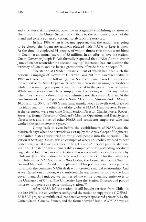
236 “Read You Loud and Clear!”
and vice versa. An important objective in originally establishing a station on Guam was for the United States to contribute to the economic growth of the island and to serve as an educational catalyst on the territory.
In late 1988 when it became apparent that the station was going to be closed, the Guam government pleaded with NASA to keep it open. At the time, it employed 91 people, of whom almost two-thirds were hired in Guam, at an annual payroll of $3 million. In an effort to save the station, Guam Governor Joseph F. Ada formally requested that NASA Administrator James Fletcher reconsider the decision, saying “the station has lent luster to the territory of Guam and has been a great source of pride for our people.”78
The station at Dandan, establishment of which had been such the personal campaign of Governor Guerrero, was put into caretaker status in 1989 and closed out the following year. Some equipment was left in place at the request of the State Department, who was interested in using the facilities, while the remaining equipment was transferred to the government of Guam. While many stations may have simply ceased operating without any fanfare when they were shut down, this was definitely not the case at Dandan. At the conclusion of the final pass of the Solar Maximum Mission (Solar Max) at 10:30 a.m. on 30 June 1989 Guam time, simultaneous farewells took place on the island and on the other side of the globe at NASA Headquarters. Present at the ceremony were one time Guam Station Director Charles Force; Robert Spearing, former Director of Goddard’s Mission Operations and Data Systems Directorate; and a host of other NASA and contractor employees who had worked the station over the years.79
Going back to even before the establishment of NASA and the Minitrack days when the network was set up by the Army Corps of Engineers, the United States always tried to bring local people into the operation. The station at Santiago, Chile, was an example of where this policy worked to near perfection, even if it were at times the target of anti-American political demonstrations. The station was a remarkable example of the long-standing goodwill engendered by the networks’ activities. It was eventually operated entirely by Chileans. (Even the Station Director was Chilean, working for the University of Chile under NASA contract.) Wes Bodin, the former Associate Chief for Ground Network at Goddard, explained. “This policy created a cooperative spirit with the countries NASA dealt with, created a mutual relationship. And as we phased out a station, we transferred the equipment in total to the local government. At Santiago, we transferred the entire operating entity over to the University of Chile. The University kept the Station Director and part of his crew to operate as a space tracking station.”80
After NASA left the station, it still bought services from Chile. In the late 1980s, the university reconfigured the station to support the COSPASSARSAT project, a multilateral, cooperative project sponsored primarily by the United States, Canada, France, and the former Soviet Union. (COSPAS was an

237 Chapter 6 \ Era of Change
acronym for the Russian phrase “Cosmicheskaya Sistyema Poiska Avariynich Sudov” meaning “Space System for the Search of Vessels in Distress” while SARSAT stood for “Search And Rescue Satellite-Aided Tracking.”) The program used satellites to help search and rescue efforts by detecting signals emitted by airplanes, boats, and others in distress. Even today, the European Space Agency (ESA) and the National Space Development Agency of Japan (NASDA) continue to use such services provided by the Santiago Station.81
The year 1989 also saw the end of NASA operations on Ascension Island. The most isolated location in the network, Ascension ended up as one of the longest serving stations, operating without interruption for close to 25 years.82 This streak was nearly broken, however, in 1982. From March to June of that year, the United Kingdom and Argentina engaged in a military conflict over the Falkland Islands to the south. During this brief but intense conflict, Ascension Island was used by the British for logistical support and as a result, commercial communications on and off the island were heavily disrupted. Fortunately for NASA, technical support was able to continue for the most part as the Agency maintained its own communication lines on and off the island for direct mission support. But the situation was not without its share of tense moments. Even though military action took place almost 10,000 kilometers (6,200 miles) to the south and Bendix workers on Ascension were at no time in any real danger, concerned family members back in the U.S. nevertheless had plenty of difficulty placing commercial telephone calls to their loved ones. Much of the problem was resolved when the company made available special circuits, routing telephone traffic through its headquarters in Columbia, Maryland to reach their families.83
Seven years later, operations at Ascension would be interrupted, this time for good.While the technical reasons to shut down Ascension Island were clear, how to close the site and what to do with it afterwards were not as obvious. Here, international cooperation with the international space community once again came to the forefront.What happened was that a series of events occurred as NASA was deciding to phase out the station, events that ended up involving three parties: the island government on Ascension, NASA, and the Europeans. Before the Challenger Space Shuttle accident in 1986 broke NASA’s stride in constructing its Tracking and Data Relay Satellite System, or TDRSS, the space agency had planned to transfer ACN to the Air Force’s Eastern Space and Missile Center (ESMC) when NASA operations ceased there in October of 1985.
To this effect, in a memorandum of understanding between GSFC Director Noel Hinners and the ESMC commander, authority and terms of the transfer were laid out in which Goddard had the responsibility to provide logistical support to ESMC for supplies and materials. Conversely, ESMC was to reimburse Goddard for contractor support provided to them during this transition period. But by 1986 when it was evident that TDRSS was going to be delayed, NASA quickly extended its agreement with British Cable and Wireless, who

238 “Read You Loud and Clear!”
provided the only way to transmit wideband data off the island. (The Air Force station,ASC, did not rely on cables but rather used high frequency radio transmissions to the Eastern Test Range as their primary communications link.)
Although the commercialization of space would not reach a full swing until the following decade, even in the 1980s it was not difficult to see that a fundamental shift in the space landscape was already taking place.This change was the movement of space from the realm of government sponsorship to commercial commodity.With the Reagan administration being a strong proponent of privatization, as the nation’s space agency, this paradigm shift was not lost on NASA. In fact, the Agency had already been operating from Ascension for a few years under an agreement with the Europeans.
During this time, U.S. dealings on the island, in the words of French program officials, “has been excellent.”84 For it to work, international cooperation had to have flexibility, and on occasion, some good fortune. A case in point was the handling of coverage for Ariane’s 9 November 1985 launch, which happened to coincide with Shuttle mission STS-51A. The ESA Ariane carried the GTE Spacenet 2 and the European Marecs B2 satellites while the Shuttle mission included deploying two satellites and the recovery of Westar 6 and Palapa-B2. The Shuttle launch was originally planned for 7 November and would have required Ascension Island tracking support two days later for satellite retrieval operations. It ended up, however, being delayed 24 hours causing Ascension support for the Westar and Palapa recovery to now occur on the 10th. So, because of the Shuttle delay—not an unusual occurrence—the station was now free to cover Ariane without conflict.
But according to NASA mission rules, Ascension Island was not available for Ariane support for a 48-hour period before and after a Shuttle launch, and for a similar period before and after a scheduled landing. In practice, though, flexibility in scheduling was not uncommon so as to accommodate international partners’ needs. Commenting on the series of events during STS-51A in 1984, Clet Yven, a Station Chief for the French Centre National d’Etudes Spatiales CNES said:
What we have seen in practice is that Ascension Island availability is handled on a case-by-case basis, and the periods blocked against our use depend upon the mission.They [NASA] have demonstrated excellent flexibility and have said they could free their facilities for short periods in certain cases, even when there may be general scheduling conflicts with Shuttle missions.85
Hence, private commercial space launch industry officials were at the time especially concerned that the station closings (not just Ascension but the others as well) would leave them without the ability to receive data from their boosters. It was logical for the United States to consider commercializing some

239 Chapter 6 \ Era of Change
sites. In discussing the fate of the Ascension Station with NASA Headquarters, it was the perspective of the Office of General Counsel that “commercialization is feasible and would be consistent with other efforts to commercialize the space industry.”86 Such an arrangement could generally benefit everyone involved. In addition to the potential financial gain to the commercial operator, such an arrangement would also address these concerns, keeping the station operational while providing a continued source of revenue to benefit the local economy.
Recognizing the Europeans’ need for downrange launch support out of Kourou, French Guiana, officials from NASA and CNES met at the KSC in January of 1986. On the day of the Challenger launch, David W. Harris, at the time Manager of Space Network Operations at GSFC, happened to be leading a contingent from Goddard to discuss with CNES these issues. Breaking the meeting to view the launch—in one of those moments indelibly etched in one’s memory—the team immediately recognized the horror of the situation. Still numb from what they just witnessed, the group disbanded that morning and agreed to reconvene at a later date.87
Three long years would pass before the group met again on 12 January 1989 to finish their talks. NASA already had plans to transfer the facility to the Air Force ESMC at the end of the fiscal year under an existing memorandum of understanding with the DOD. Under the proposed agreement with ESA, the Europeans would in turn install their own equipment on Ascension by March of 1990, to be operated by British Cable and Wireless personnel. The station was perfect for ESA since from its spaceport at Kourou, equatorial launches of the Ariane rocket flew almost directly over the island. Therefore, ESA requested that NASA continue operating the Ascension Station just a little bit longer, on a monthly reimbursable basis, until April 1990, when their equipment would be installed and become operational.88
Thereafter, ESA would assume full operations on its own to provide tracking services to its international customers.
An agreement was thus signed on 21 February 1989, extending NASA operations on the island on a cost reimbursable basis, one that would have ESA pay NASA $283,000 per month to keep the station open.89 As for the facilities that ESA did not want to use, NASA was requested by the Island Administrator to restore the site to its preexisting condition. In this cleanup, the Operations Building was transferred to the Ascension government for use by the local community. All other buildings were demolished and the rubble hauled off. A significant restoration effort was the cleaning out of Devil’s Ashpit which had been used as a trash pit for a quarter-century. As one can imagine, this was no easy task since The Ashpit was quite large—30 meters deep by 40 meters wide by 90 meters long (100 by 125 by 300 feet)—with sheer, fragile walls. The cleanup took a year.90
In this rapid succession of station closings, perhaps no other group of people was more affected on a day-to-day basis than the contractors and their

240 “Read You Loud and Clear!”
families. In 1989, BFEC for example, employed over 300 people at Ascension, Dakar, Guam, Hawaii, Santiago and Yarragardee, a good portion of whom had established families at these remote outposts (except for Ascension, which was “singles only”).91 This meant that by shutting down these stations, a few thousand people were going to be uprooted, some from the only homes they knew. Of course, there were some places where it was easier to leave than others.
Take Ascension versus Hawaii, for instance. While it may not have been all that difficult for folks to walk away from a place called Devil’s Ashpit— recall that “If you can’t go to the Moon, the next best place is Ascension Island!”—it was quite a different story for those who were stationed in the tropical settings of Hawaii. Located on a 25-acre site at Kokee State Park, the Hawaii Station was near Waimea Canyon on the west side of Kauai—one of the most scenic sights in the world. Since its establishment in 1961, the station had supported every U.S. human spaceflight with the exception of the first two suborbital Mercury missions. With its lush, green settings and surrounding hillside, the area is often used for motion picture and television location shots. Thus, it was not surprising that once assigned to Hawaii, one usually stayed in Hawaii.
Many of the employees at Kokee had been there for 20 years or more and had established roots there. When NASA announced that the site would be shut down at the end of the fiscal year on 30 September 1989, most of those at the station were offered positions elsewhere by Bendix. Few wanted to leave though. In the end however, with limited job opportunities on the island for skilled technicians, most took the offers and reluctantly left the island. Those who did not left the company. After 29 years of service which saw the station track John Glenn around Earth and bring back 27 astronauts from the Moon, much of the land was returned to the state of Hawaii. The station was turned over to the U.S. Navy’s Pacific Missile Range. The 9-meter (30-foot) USB antenna system continued to be used for years on the Goddard Crustal Dynamics Project and is still being operated for science—tracking radio stars and studying plate tectonics by the University of Hawaii.
Finally, Botswana, Dakar and Yarragardee—the early UHF air-toground Shuttle voice stations—were closed in 1986, 1995, and 1991, respectively. Hardware from these stations were transferred to other STDN sites or mostly just donated to the host country. In the case of Botswana, the legacy of having hosted a “space station” in their country was preserved as NASA donated the surplus equipment to the Botswana National Museum, who made an exhibit commemorating their involvement and contribution to the success of the early Shuttle flights.92
★ ★ ★
241 Chapter 6 \ Era of Change
It was clear by the end of the 1980s that the era of NASA’s worldwide, ground-based network had come to an end. Goddard’s once sprawling STDN had been reduced by over 75 percent. Deemphasis had come a long way in just a few years. If one were to ask what the largest structures ever assembled on the face of Earth are, answers might range from the Great Wall of China to the Great Pyramids of Giza. From an infrastructure point of view, NASA’s family of tracking networks—NASCOM, Minitrack, STADAN, MSFN, STDN, as well as the DSN—put together comprised one of the most wide-reaching infrastructures of the twentieth century, a true testament to the men and women who engineered it, built it, and made it work. Eventually though, technology and better access into space would supersede the need for such an extensive ground network. Instead of being tied to the surface of Earth, this new kind of network would now literally be based in space. It would change the STDN from a network using many ground stations into one using only a handful of satellites called the Tracking and Data Relay Satellite System, or TDRSS. TDRSS would enable Earth orbiting spacecraft such as the Hubble Space Telescope, the Space Shuttle and the International Space Station, to continuously communicate with control centers on the ground without an elaborate and expensive network of stations.
This fundamental change in spaceflight communications from primarily a ground-based network to a space-based network was something that NASA had in fact been working on since the early 1970s.
In other words, the revolutionary change to this new kind of network did not take place overnight.
