presentation for norcoast final conference, haarlem… · presentation for norcoast final...
TRANSCRIPT

PRESENTATION FOR NORCOAST FINAL CONFERENCE, HAARLEM, 22ND MAY, 2000,BY COLIN WISHART, HIGHLAND COUNCIL, SCOTLAND
THE CHALLENGE: KEY COASTAL PLANNING ISSUES IN THE NORTH SEA REGION
INTRODUCTION
Good morning, ladies and gentlemen...
Two years ago I was just a lonely coastal planner working in aregion with a lot of coast but on the edge of Europe. I couldpeep over Hadrian’s wall to see what the English were up tobut when I looked out over the North Sea it was difficult for meto project beyond that big empty horizon.
A year ago, thanks to Norcoast, I found myself much less lonely - Ihad found there were other coastal planners "out there" trying to fixthings as well. Mind you, they weren't always trying to fix the samethings or in the same way.
Whereas I worried about fish farms, they were worried aboutwindfarms. Whereas I worried about coastal villages being turnedinto seasonal holiday cottages they worried about seasonal holiday cottages turning into villages (?!). Someof them had problems with their land falling into the sea in big chunks while others had problems becausetheir land was rising out of the sea ! And of course the Dutch, being the Dutch, wanted to build completelynew chunks of land out in the sea (and they even wanted to build an airport on one of them) !
But the laments I heard from my counterparts on the other side of the North Sea were often very similar tothose on my side. They too sometimes had no planning powers below low water mark...or they had scope toadvise but no powers to implement...there was sectoral thinking and a lack of integration in the marinearea....Familiar problems.
So we all had a good grumble about it... and that was the Norcoast Phase 1 report !
At that time a year ago I stood in a similar position to where I amright now, on the conference stage in Aalborg, knowing about theother partners' concerns but not having seen the cause of them onthe ground. Today however, my colleagues and I on the projectgroup can say we've "done the round" of the North Sea coast in allits guises (in the hands-on phase of the project) and we'd like toshare some of that experience with you.

I'd like to start off by saying a little about the scope ofcoastal planning and the factors which determine the rangeof coastal issues around the North Sea.
I'll then give you a flavour of the issues themselves in a bitmore depth - to set the scene for the presentations later ofour draft recommendations and the workshops.
Finally I'll try to draw some conclusions and mention someof the trends which are pushing coastal planning up thepolicy agenda and influencing the form that it takes.
If there's one key theme underlying this presentation, it's this: that the development of coastal planning inEurope will come from helping to solve real coastal planning problems. This is the challenge..
SCOPE OF COASTAL PLANNING
What qualifies as coastal ? There are at least two dimensions tothis.
Does this qualify as coastal ? Oilfields like this are serviced fromthe coast and physically connected to it by pipelines…. This infact is almost halfway between the Shetland Islands and Norway- 120 miles from the nearest land. At this distance out it's anational issue.
But we have a producing oilfield off the east coast of Highlandthat's visible from the shore. Yet in the UK at least this stilldoesn't come within the scope of the regional planning system.
The oil-related activity here obviously qualifies as coastal. But youdon't see places like this all along the east coast of Scotland - onlycertain places. So detailed local coastal plans aren't neededeverywhere. This means we should target the areas where ICZM canmake a difference.
The second dimension - which we have hardly begun to think aboutnow but which may concern us more in the future is the vertical one [imaghow deep ? Both Norway and Scotland have some very deep water closepresent few people can access but this may not always be the case.
e of submersible on overhead] - to their western shores which at

What qualifies as coastal zone management ? ICZM is not a new discipline or a universal solution. It'sthe new dimension of the spatial planning system. Not everyone likes the idea of the spatial planning systemextending offshore... But it's the form of planning and the approach to planning which is required to addresscoastal and marine issues.
This may be quite simple, like a plan to guide the location of fishfarms in a Scottish sea loch.
Or it might be multi-sectoral inscope like this Norwegian coastalplan which maps priority locationsfor a whole range of activities ininshore waters.
It could be a shoreline management plan based on modeling of coastaldynamics - for example to stabilise part of the Dutch or English coastline,or to deal with the consequences of dredging in one of the Germanestuaries.
It could also be a plan designed todeliver improved coastal waterquality by dealing with pollution fromthe land nearby, like here in NorthJutland.
These examples all qualify as coastal zone management.
It's not easy to define where "ordinary" planning stops and CZM
begins because there's a continuissues and wholly marine ones. essentially terrestrial - like controon the coast - the pressure is thsea and what the coastal environum between wholly terrestrialSome coastal issues arel of holiday home developmentere because of proximity to thement has to offer.

Some coastal issues are essentially marine –like management of inshore fisheries or the routeing of marine traffic.
But the classic coastal zone management issues –like intensive aquaculture, or port development, involve closeinteraction between the dry side and the wet side andpressures on both the terrestrial and marine environments.
WHAT FACTORS DETERMINE THE RANGE OF COASTALISSUES AROUND THE NORTH SEA ?
When people talk about the North Sea, the words "cold" and"grey" often spring to mind. But its coasts and communities areactually quite diverse in character and that's reflected in therange of issues here.
Physical factors are perhaps the most important and it's notjust a case of highland and lowland.
The degree of coastal indentation is very important because it createsopportunities for shelter and allows a wider range of activities to takeplace in the marine area. The more activities there are competing forspace in inshore waters, the stronger the case for marine zoningpolicies. The west coasts of Norway, Scotland, and Sweden are thebest examples of this.
Relative relief (that's not the relief you'll feel when thispresentation is over (!)) is the extent to which the coast is hillyor low-lying and this determines the need or otherwise forcoastal defence, the locations which are feasible for buildingand coastal transport patterns. Again Norway is an example atone end of the spectrum where settlement tends to cling to thecoast and marine transport is important because of thesteepness of the interior.

The Netherlands is at the other extreme - building barriers against the seafor survival.
Geology plays an important part indeciding where coastal erosion is anissue. I come from a hard rock area(which may account for theHighlanders' taste in music !) soerosion isn't really a problem, whereas Jerry and John come from a softrock area where it is.But the other side of the coin is deposition. Not far from where there is
active erosion of a soft coastline that destroys property you will find beaches and possibly dune systems thatattract tourist income and tourism development pressure. This is in North Jutland where the coast isretreating at 10m per year in places.
Most of the Norcoast regions have island archipelagoes –like the Friesian Islands, the Norwegian skerries, and the Hebrides.This implies scattered communities and demands for ferry links,causeways and bridges which often need careful cost/benefit analysis.We heard all about this in Hordaland where there are proposals for amajor strategic coastal road route which could substitute for variousferry crossings but possibly at a high environmental price.
Water depths inshore - Where the waters close inshore aresheltered and relatively deep a whole range of marine uses maycompete for space including some heavy duty ones like oilrigfabrication and military training. This is on the north coast ofHighland.
Where inshore waters have a high degree of enclosure and areshallow, like the fjords of North Jutland, coastal water quality canbecome a problem even if point-source pollution is well controlled.
Tidal range is one of the more subtle influences on coastalissues. This is an old fish trap in Highland - a feature whichmany people would drive past without even noticing or knowingwhat it was. But such a structure probably wouldn't work inseveral of the Norcoast regions because their tidal range is solow. Where the range is relatively high and combines withvaried topography, like in Highland or Suffolk, it makes forgreater biodiversity and wildlife interest round the coast. Largeintertidal areas in the estuaries attract nature conservationdesignations and these can conflict with aspirations for
economic development - a good case for coastal zone management. Low tidal range can also increase therisk of water quality problems in shallow coastal lagoons.

Sea level change is becoming of more concern to the coastal land areaswhich are very gradually sinking because global warming and climatechange may speed the process up. It adds to the pressure for coastaldefence or managed retreat strategies. But in some areas like here inVästra Götaland the land is rising relative to the sea so some coastallagoons are getting shallower and moreprone to nutrient enrichment.
But it's not just the physical type of coyour coastal issues. It's also where yThe areas closer to the centre of the Bremerhaven here, see the most prescale infrastructure on the coast and the more peripheral coastal areas naagainst land-based industry. Howevefrom the fisheries sector and from tou
The third strand is socio-economic and cultural. Standards of living aroundsimilar, but there are some strong cultural differences. The extent to which pcommunities or is centralised influences patterns of land and seabed ownersresponsiveness of the coastal planning system to local circumstance. Norwaterms of local empowerment and this is reflected in the verydispersed pattern of settlement. Almost everywhere that it ispossible to build on the coast, you find houses in Norway andsmall farms abound. Scotland and England have systems whichtend to favour the upper tiers of society and government and thisresults in more nucleated patterns of settlement on the coast. Italso results in the situation where much of the foreshore and all ofthe seabed out to the territorial limit belongs to the Crown Estaterather than to the elected Government.
Less tangible culturastandards, civic pridtrends also have a rothings to talk about ibecause you risk hufactors can make thecommunity which thrchange and one whiitself. This picture wacertainly one of the marchitecture that the
I won't tell you where this picture was taken but it's not that farfrom where I live. No prizes for design here !
ast you have that determinesou are in the spatial economy.European economy, likessure for development of largenature often has to give way. Inture stands a better chancer it comes under more pressurerism.
the North Sea are broadlyower is devolved to localhip, settlement, and they and Sweden score highly in
l factors, like aesthetice, or responsiveness to marketle. Though these can be difficult
n an international seminarrting someone's feelings ! These difference between a coastalives and adapts successfully toch may struggle to redefines taken in Marstrand, Sweden -ost elegant places for coastal
Project Group visited.

WHAT DO WE THINK ARE THE KEY ISSUES ? AND HOW WELL SET UP ARE WE TO DEAL WITHTHEM IN THE DIFFERENT COUNTRIES ?
I’ll take these from the terrestrial side and moveoutwards.
Holiday houses and the pressures on the coast fromtourism is an issue which particularly concerns VästraGötaland, North Jutland, North Holland, and Suffolk. At itsmost simple, it involves heavy pressure to build holidayhouses or other tourist facilities like hotels, campsites,and amusement parks on or near the coast. Often theseare in sensitive landscapes and habitats like dunesystems or in sensitive cultural environments like thetraditional coastal villages in Suffolk or villages likeLökken, here in North Jutland. The holiday houses or tourist facilities may be designed to meet a veryseasonal demand but the local residents may feel swamped by them and have to live with the consequencesall year. Villages may “lose their soul” and the tax base required to sustain local services if many houses arebought up by outsiders for use as second homes.
This is an issue which stems largely from domestic tourismpressures, though as mobility increases within Europe, it isbecoming more common for second home buyers to comefrom another nearby country. It’s also a problem which can becompounded if the original tourist market moves elsewhereleaving the community with a residue of out-moded facilities.
A range of responses are possible, the simplest being planningrestrictions on the building of non-essential development withina given distance of the sea or restricting the amount of time inthe year that a holiday house can be occupied. Other responses can be aimed at making the indigenouscommunity less reliant on tourism for income, or focussing on the greener, quality end of the tourism market.The trick however, is to spot this issue coming in advance. Once the trend has started it’s difficult to stop.
The reverse process – where coastal holiday homes areconverted to permanent residences - can also be perceived as aproblem, like here in the Kungälv district of Sweden. This can putpressure on limited water supplies and make local servicesexpensive to provide because permanent communities were neverplanned for this remote location.
The short term answer here again may be temporal restrictions onthe occupation of holiday houses. But the longer term solutionwould appear to be stronger regional planning. Maybe also the
county council concerned has to “bite the bullet” and accept that, with more people working from home andteleworking, more people want to move out of the city permanently and into the countryside.

Moving down to the edge of the sea, one of the keyissues, in Suffolk and Lower Saxony particularly, but alsoto a lesser extent in all the Norcoast regions, is portdevelopment and shipping. We could include coastal oroffshore airport development in this category also,because of the plans we were told about for expansion ofSchiphol, possibly onto an artificial island site in the NorthSea. The bigger the ships (and this one is well-named)the bigger the port it requires.
Here the essential issue is that concentration of shipping andtraffic on a small number of very large North Sea ports (and thegeneral increase in air traffic) is putting great pressure on theirimmediate surroundings. This is both in terms of onshore trafficimpacts which we saw at Felixstowe, and on the nature interestnearby.
This nature interest could be on the land side, or (more likely)in the coastal marshes and the inter-tidal area. Strongcompetitive pressures and rivalry between ports is driving this
expansion. And the harbour areas are often not subject to full democratic planning control because of theirstrategic importance. But at the same time, the EU Habitats Directive is starting to bite on some of theirexpansion plans as nature designations (especially for the bird interest on large areas of inter-tidal mudflats)become more widespread.
So the forces for ever-greater port expansion, which includes estuary dredging and land reclamation, and theforces for nature conservation are on a collision course. The only reconciliation may be throughcompensation and how do you put a price on nature ?
We heard all about this when we visited the estuaries of the Jadeand the Weser in north Germany, where the port authorities haveplans to deepen the main shipping channels. This could affect thenatural dynamics of the estuary and adversely affect the mudflatsof the coastal national park.
The answer would seem to lie partly in the need for national andEuropean-wide port and airport development strategies. But intaking a European perspective, you have to bear in mind that thereare issues of national prestige associated with these big ports.Partly also the answer could come from including harbour areaswithin the normal planning system so they aren’t seen as “a lawunto themselves”.
Ports aren’t the only industrial presence on the coast, of course.There’s a wide range of commercial activities that need a coastallocation, like oil rig construction here on the Moray Firth inScotland. The amount of land and foreshore used by the heavierindustries can be quite substantial as you can see. They can alsoinvolve land reclamation. But even a build-up of lighter industriescan have a cumulative impact on landscape values and wildlife

assets. Again this tends to become an issue most often on the large estuaries because so many people liveand work there and because they are important places for migrating birds. The EU Habitats and BirdsDirectives have been applied in these areas with vigour and sometimes, it has to be said, with a lack oftransparency and flexibility. So the nature conservationists and business interests need to talk to each otherto avoid relationships becoming strained. One way to facilitate this is through a voluntary coastal partnership.
We have in the audience the Vice Chairman and the Secretary of the Moray Firth partnership so if you wouldlike more details of how this mechanism works, I’m sure they would be happy to do a sales job on you ! Wemay also have people involved in the Waddensee initiative who can do likewise.
Another factor in the Moray Firth equation is the presence of a local population of dolphins. This species hasresulted in a large part of the estuary being proposed by the Government as a marine Special Area forConservation under the Natura 2000 initiative. Protecting this group of 100 or so dolphins is likely to involvetightening up on waste discharges into the sea and tightening up on some of the wildlife boat tour operatorswho make money out of them. Neither of these moves will be popular with the businesses concerned. Itcould even – God forbid (!) – affect the local malt whisky distillery which discharges a certain amount ofcopper into the sea from its stills. This is another area where the voluntary partnership can help to “smooththe path”.
It’s not just the estuaries which are affected by industrythough, and sometimes there can be a clash between theold wave and new wave industries on the coast. This drydock was built for making oil rigs on the west coast ofHighland in the 1970’s. It’s lain empty since the 1980’s butnow another company is proposing to use it again as aservice base for oilfields in the Atlantic. The trouble is, sinceit was first used, the newer industry of aquaculture hasestablished itself in this area and the fish farmers are nowlooking for stringent controls on the proposed developmentto ensure that their businesses are not threatened.
However, the Council can’t attach conditions to its planning consent that involve the offshore area because itsplanning powers don’t go offshore. There’s also doubt as to who exactly is responsible for control of pollutionfrom mobile offshore structures like oil rigs. This sort of thing probably wouldn’t be a problem somewhere likeSweden and an EU recommendation that planning powers should cover at least part of the inshore marinearea as well might help countries like Scotland to catch up.
The west Highland coast doesn’t have any coastal partnerships at present though it has had an embryonicone in the recent past and one may well rise again. What has tended to work against this approach here hasbeen the geography of the area. Like the Norwegian west coast it is highly fragmented – people may beprepared to get involved in a management initiative for their own sea loch or fjord but it is more difficult to getthem interested in a wider-ranging coastal strategy because the communities are so scattered. Perhaps thesame is true in the Friesian islands where some people feel that the trilateral Waddensee initiative is toobiased towards nature conservation rather than development and operates at too high a level ?
Coastal defence and shoreline management is of concern to the lower-lying and faster-eroding partnerregions of Norcoast – North Holland, Lower Saxony, Suffolk, and Denmark. This picture was taken on thenorth coast of Germany west of Wilhelmshaven, and when you compare it with some of the Scandinavianand Highland pictures I’ve shown, it emphasises what a diverse group we are round the North Sea.
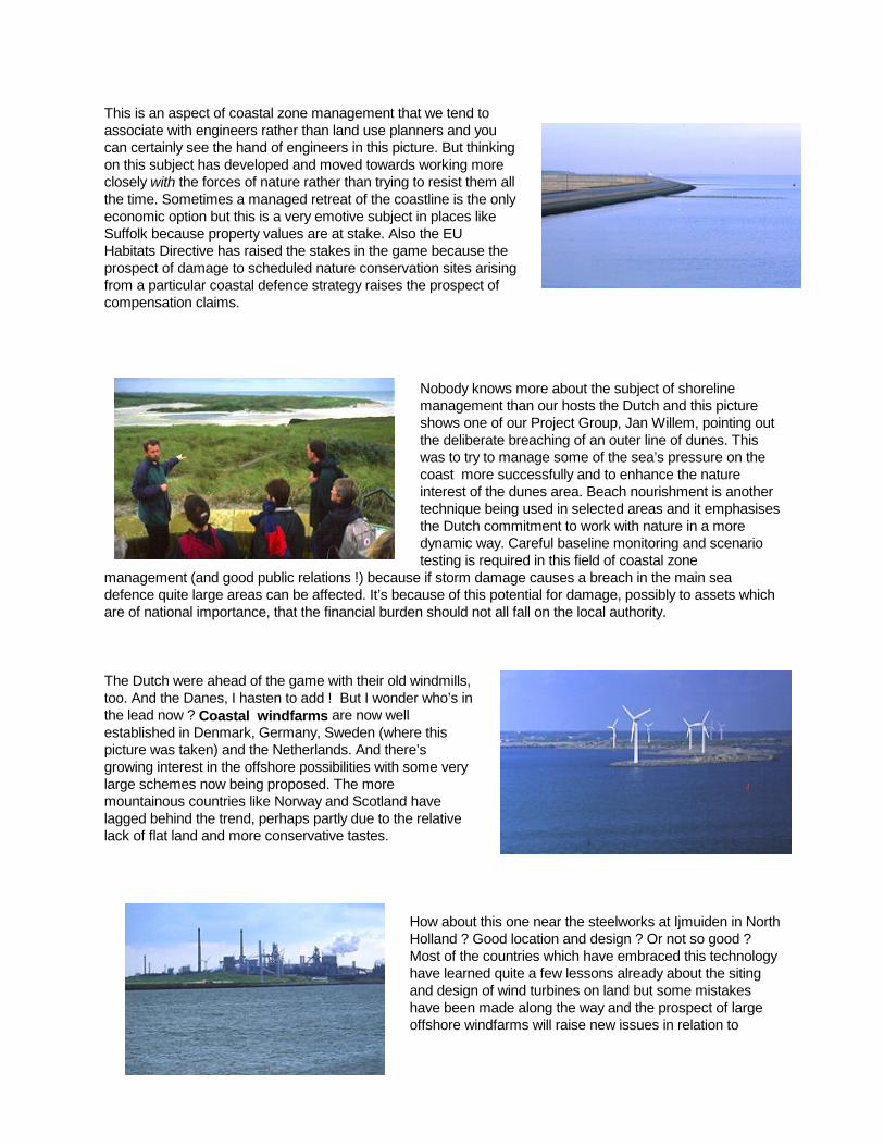
This is an aspect of coastal zone management that we tend toassociate with engineers rather than land use planners and youcan certainly see the hand of engineers in this picture. But thinkingon this subject has developed and moved towards working moreclosely with the forces of nature rather than trying to resist them allthe time. Sometimes a managed retreat of the coastline is the onlyeconomic option but this is a very emotive subject in places likeSuffolk because property values are at stake. Also the EUHabitats Directive has raised the stakes in the game because theprospect of damage to scheduled nature conservation sites arisingfrom a particular coastal defence strategy raises the prospect ofcompensation claims.
Nobody knows more about the subject of shorelinemanagement than our hosts the Dutch and this pictureshows one of our Project Group, Jan Willem, pointing outthe deliberate breaching of an outer line of dunes. Thiswas to try to manage some of the sea’s pressure on thecoast more successfully and to enhance the natureinterest of the dunes area. Beach nourishment is anothertechnique being used in selected areas and it emphasisesthe Dutch commitment to work with nature in a moredynamic way. Careful baseline monitoring and scenariotesting is required in this field of coastal zone
management (and good public relations !) because if storm damage causes a breach in the main seadefence quite large areas can be affected. It’s because of this potential for damage, possibly to assets whichare of national importance, that the financial burden should not all fall on the local authority.
The Dutch were ahead of the game with their old windmills,too. And the Danes, I hasten to add ! But I wonder who’s inthe lead now ? Coastal windfarms are now wellestablished in Denmark, Germany, Sweden (where thispicture was taken) and the Netherlands. And there’sgrowing interest in the offshore possibilities with some verylarge schemes now being proposed. The moremountainous countries like Norway and Scotland havelagged behind the trend, perhaps partly due to the relativelack of flat land and more conservative tastes.
How about thHolland ? GoMost of the cohave learnedand design ofhave been moffshore wind
is one near the steelworks at Ijmuiden in Northod location and design ? Or not so good ?untries which have embraced this technology
quite a few lessons already about the siting wind turbines on land but some mistakesade along the way and the prospect of largefarms will raise new issues in relation to

coastal landscape qualities, navigation, and possibly birdlife. Inareas like Lower Saxony with extensive areas of protected mudflats fringing its shores, there’s also the question of findingroutes for the cables which will be needed to bring the powerashore.
Much of the mapping of search areas with windfarm potentialhas been done, at least on the landward side. But most countriesneed to develop their strategic policy guidelines further to takeaccount of the offshore potential. If it’s left up to municipalities tosort this out themselves, then the overall pattern of developmentmay become haphazard and local communities might besubjected to unreasonable commercial pressure.
How many wind turbines on the coast is enough ? This is a particulaLimfjord in North Jutland.
And this brings me neatly to the next key issue: coastal water qualian issue most acutely felt in parts of Denmark, where we heard abothe marine ecosystem of one of the shallow and confined fjords due
which is encoVästra Götalaboth cases thrun-off from acoast, where productivity thlivestock rearin the Netherl
Poor coastal and shellfish blue mussel f
due to this form of diffuse pollution, though this is not a heavily popucoastal water quality is whether or not you can safely eat the shellfislong term decline in the quality of coastal waters of our more populagone on so long now that it’s simply taken for granted and regarded objective comparisons of coastal water quality over longer periods ocomparisons between different countries around the North Sea are dmethods and quality criteria.
The key to dealing with the issue in rural areas would appear to be efinancial incentives for farmers to use less intensive techniques. In mmore rigorous application of the “polluter pays principle”. In either caplanning in the coastal zone should take a measure of responsibilityequipped with the statutory tools to back this up.
Mariculture is an Scotland because waters are well suisome fish farming.in the rural coastal1980’s – creating nlocal skills and it prfishermen to divers
rly large windfarm that we saw on the
ty in shallow enclosed sea areas. This isut some instances of virtual collapse in to nutrient enrichment. It’s a problemuntered in some coastal lagoons ofnd also, in a somewhat milder form. Inis is due to the cumulative effect ofgricultural land, sometimes far from thefarmers are under pressure to maximiserough use of fertiliser or intensiveing. Perhaps intensive bulb-growing hereands may have a similar effect ?
water quality is bad news for fishermenfarmers. We heard for example how theishery in the Limfjord here has declinedlated area. Perhaps the ultimate test forh from a given area. On this basis, theted estuaries is something which hasas too costly to fix. Unfortunately,f time are hampered by lack of data. Andifficult because of variations in survey
ffective catchment management andore urbanised coastal areas it would be
se the authority responsible for spatial for coastal water quality and be
issue of particular interest to Norway andtheir indented coastlines and cleanted to its development. Sweden also has It’s been an important force for change areas of these countries since the earlyew jobs in remote areas which build onovides an opportunity for crofters andify. It’s also one of the industries that has

really pushed the case for ICZM forward in the north of Europe because it straddles the land/sea divide andimpacts on both.
Also licences for fish farms were given out rather too freely in the early days. The downside of fish farming, ifit’s not carefully controlled, is that it can change the landscape character of an area, it can affect coastalwater quality and shellfish nearby, and it may damage local stocks of native fish because of theconcentrations of parasites which it attracts and because of escapes of farmed fish. The industry is stillheavily geared towards producing salmon, and is trying to counter falling prices for this product by larger andlarger scale production – which is of course self-defeating in the long term. But they have little choice untildiversification into other species is possible or the consumer decides that she will only buy “organic” salmonfrom environmentally friendly farms.
Opposition to the expansion of salmon farms in Scotland from sport fishing interests has reached acrescendo in recent years because they see it as destroying their native stocks of salmon and sea trout.Interestingly, this hasn’t been so much the case in Norway, but you have to remember that the geographiesof the two countries are a bit different – Norway has many more offshore islands outside the mouths of itsfjords which give sheltered sites and good water flushing. In Scotland, if you move out of the sea lochs to getbetter flushing and to get away from the wild salmon rivers, it is often too exposed.
Shellfish farming (mainly mussels) is one alternative to salmonfarming but the profit margins aren’t good enough to attract bigcompanies and if you move up to large scale production it canhave adverse impacts on landscape and navigation as well. I’mcurrently working on a plan for this loch and interestingly boththe local shellfish growers and the general public seem to haveagreed that “enough is enough” and they don’t want any moreshellfish farms here. It often seems that the local communitieshave a clearer idea of what they want with aquaculture than thenational government does !
Inshore fisheries management is an issue of particular concern and also to an extent Sweden. But is fisheries management a coadimension, and spatial policies can help, then I would say it is. Of cspatial policies are being used, but is the spatial dimension of polic
Norway andoffshore it mScotland wesome very lissued centgrounds theabout wherecrude and ais likely to btrawling fleecan trawl cl
in Highland, where this picture was taken,stal planning issue ? If it has a spatialourse it has a spatial dimension andy as well developed as it could be ? In Sweden with their coastal plans which go
ay be. But in Scotland I think not. In have quota and licences allocated toarge areas of sea. These licences are alsorally - often a long way from the fishingmselves. On this basis, the information catches come from is likely to be veryccountability for safeguarding local stockse weak - particularly among the nomadict which can operate far from home and
ose in to the shore in many areas.

Surely quota allocation in inshore waters should be based on a finer-grained system of management areasthan in distant offshore waters ? And surely licences should be granted by the local communities with thegreatest vested interest in stock conservation and enhancement ? But if this is a coastal planning issue, whyaren't planners being asked to help solve it as part of a multidisciplinary approach ?
This little village of creel fishermen on Loch Torridon in Highland,which the Project Group visited, has been at war with thetrawlers and the Government for years – putting physicalobstacles in the path of the trawlers and trying to make theGovernment turn a half-yearly ban on trawl fishing into an allyear-round ban….
This is an example of a vigorous but frustrated local communitytaking the law into its own hands because fishery policyconceived only internationally and nationally is not sensitiveenough to local circumstance. It’s also an example of an areawhere coastal zone management, developed at a local level,could help to clarify the cost-benefit implications and environmental this loch’s marine resources and help reconcile some of the warring
These are a flavour of the main coastal planning issues which we endetails of the others I would refer you to the separate reports of the "which have been prepared. I'll turn briefly now to the main structurasome broader conclusions.
STRUCTURAL ISSUES WITHIN THE PLANNING AND ADMINIST
One of the key differences between the Norcoast partnerregions is in the offshore extent of their statutoryplanning powers. You can get an impression of this fromthe diagram in the draft report around page 32. Scotland,England, and Denmark have no statutory powers below theshoreline, whereas Norway and Sweden have the mostgenerous provision in that their Local Plans can reach outto the outmost skerries or 12 nautical miles respectively.The Netherlands and Germany are more of a half-wayhouse. This is an obvious subject of frustration for thecountries without offshore planning powers because eachcould put it to good use - control and development ofaquaculture installations and some oil-related industry inScotland's case, and offshore windfarms in all three.
However it's the very lack of these powers which has encouraged arthe estuaries, to improvise and develop the voluntary approach with lessons in itself.
trade-offs which would make the most of factions.
countered in the Norcoast project. Forhands-on" study visits to each regionl issues we identified before drawing
RATIVE SYSTEMS
eas of Scotland and England, particularlysuch vigour and this has provided

Sectoralism and lack of integration was noted in all the partner regions, particularly with respect to themarine area. There are often cultural reasons behind this - the fishing community being a particularly "hardnut to crack" because of its long tradition of independence and freedom of movement. Merging centralgovernment departments together or changing their names to make them seem more integrated isn't thewhole answer here. The answer lies most likely in the sectors speaking to each other and working together tosolve specific problems. Voluntary coastal partnerships can help here.
There's also sometimes a lack of vertical integration between tiers of government if one level's role isprimarily advisory, like the county level in Sweden, and the lower level has a high degree of autonomy.
To help us break down some of the sectoral barriers there's a need for clear leadership in developingCZM - at all levels but perhaps most obviously at national level. In Scotland, Highland Council feels in somerespects like it's pioneering - but on a shoestring budget. The county level increasingly has the will to deliverCZM on a systematic basis but it needs the resources.
Communities like Austevoll in Hordaland have shown what municipalities can do with a little encouragementfrom above by producing state-of-the art coastal plans at local level.
National coastal fora are a relatively new phenomenon but they're potentially an important force. They couldhelp co-ordinate the development of CZM in the different parts of their countries, obtain more consistency infunding for local initiatives, and help implement EU policy in this field.
When I first became involved with Norcoast I tended to think that the voluntary approach being developed inthe UK was very much second best compared with having statutory planning powers offshore like Swedenand Norway. Now I'm not quite so strong in that view. There's no substitute for real powers to control certaintypes of development offshore when you have the democratic mandate to do so. But voluntary partnershipson estuaries like the Moray Firth have made some coastal interests more conducive to the integratedapproach because the partnerships do it in an inclusive, non-threatening way. This can build synergy but ittakes time. Perhaps in some areas like the estuaries of Lower Saxony this mechanism could help to takesome of the heat out of the debate over deeper dredging and port expansion for bigger ships. We might thensee fewer public demonstrations on the dyke ?
LONG-TERM TRENDS RELEVANT TO THIS DEBATE
I've covered a lot of ground here and you're probably asexhausted as I am. So in drawing this to a close I'd like tostep back for a minute and take stock of the context inwhich CZM is evolving.

20 or 30 years down the line from here, do you see the coastal zone manager of the future standing in a loftyperch like this - controlling the activities in a totally integrated coastal zone ? Or do you see a picture ofcontinued improvisation - a mosaic with bright spots and dark spots in it ? I think there are a number of broadtrends that have been working in favour of CZM.
Society's needs change - the sea no longer belongsjust to sailors and fishermen. Fish farming and marinenature conservation have also staked a claim. Windand tidal power are next.
We see a continuing process of democratisation - ofknowledge and of governments because they have tocater for a more sophisticated public. This means anew type of planning - more participative and moreintegrated - which puts greater stress oncommunication, networking, and compromise. Thenature of the coastal environment itself also pushes us
in this direction because of the sea’s open-ness to external influences. We need to be the same – flexible,multi-disciplinary, and innovative. Some forms of sectoral management (be it fisheries management, marinetraffic management or whatever) will always be necessary. But on their own they are not enough. Theyneglect the bigger picture.
Our perceptions of the sea are gradually changing. Maybenot so much here in the Netherlands because of thecontinuing flood risk, but in other areas and in a globalsense. The sea used to be regarded as nothing more thana hostile, unknown, infinite environment where fishermenexploited it as best they could. Increasingly it is seen as anarea of opportunity and discovery, known and studied inparts, a finite rather than infinite resource for which weshare a responsibility.
Our technical capabilities are are now so efficient that they resources (like fishing). But wneed to keep a close eye on tsector. The sea is the new deexpanding as our knowledge grows.
The physical environment itselike here in North Jutland havclimate change adds another coastal defence in some areacommercial fish stocks.
All in all there is increasinginteraction - more use being mof inshore waters - more presa growing range of uses, an
increasingly dense network of shipping routes, pipelines, andsubmarine cables) this needs closer management at local, natiand international level.
increasing all the time. The primary industriescan easily put excessive pressure on naturalholly new activities are now possible. Wehe leading edge industries in the marinevelopmental frontier and our horizons areof it and our technical ability to master it
lf is changing. People in fast eroding arease always known this but sea level rise anddimension - increasing the importance ofs, and influencing the distribution of some
adesure,
onal,

Conclusion
The scope of CZM is wide and getting wider. We need to identify priority subjects and priority areas bothwithin our countries and at European level to make best use of resources.
The North Sea has a diverse range of coastal types and issues. The EU can put this to its advantage interms of exchange of experience within the community and beyond the community.
So over to you. What do you think about issues we've presented ? Have we focussed on the right ones ?What do you feel the different levels of government and the private sector can contribute ? What about therole of planners and other professions in this ? I hope we have some good discussions in the afternoon.
Finally let's not forget that the coast is more than just aphysical resource or a sphere of influence to be haggledover. It's often a magical place...and we all need a placeto dream.