presented to the land records council 2011. intent: in accordance with section 59.72 (3m) create a...
TRANSCRIPT

LAND RECORDS IN DOUGLAS COUNTY
Presented to the Land Records Council 2011

Land Records Council
Intent: In accordance with Section 59.72 (3m) create a Land Information Council of not less than eight members to advise the County Board on matter related to the Land Records Modernization plan.
Required Members:
1. Board Member – John Robinson (DC Zoning Committee, DC Forestry Committee, former DC Chair)
2. Register of Deeds – Gayle Wahner, DC ROD
3. Treasurer – Linda Helenius, DC Treasurer
4. Real Property Listers – Becky Nordskog, DC RPL & Brad Theien, City Assessor
Other Members:
1. Land Information Representative – Jon Fiskness (COS GIS Coordinator)
2. Realtor – Maria Letsos – (Realtor, Duluth Area Association of Realtors)
3. Public Safety Representative – Dave Sletten (DC Emergency Mgmt Planner)
4. County Surveyor Ben Klitzke – (DC County Surveyor/LIO)
5. Tom Bridge – Superior City Councilor

Land Records Council Roles and Responsibilities
59.72(3m)(b) (b) The land information council shall review
the priorities, needs, policies, and expenditures of a land information office established by the board under sub. (3) and advise the county on matters affecting the land information office.

Land Records Process
Land Records Council
Zoning Board
Douglas County Board

Zoning BoardRoles and Responsibilities
The statutory role of the Zoning Committee is within Section 59.69 (2) Wis. Stats., granting counties the authority to regulate land use by the adoption of a zoning ordinance, and Section 236.10 (1) (b) 3. Wis. Stats., describing the local “planning agency” role in the subdivision plat approval process. The Douglas County Subdivision Ordinance 8.1 describes the role of the Zoning Committee regarding plat approval. The committee provides legislative oversight of the Zoning and Land Information Department.

Land Records (Bud’s) Wheel
Forestry
PublicWorks
Zoning
Appraisers
Registerof
Deeds
Realtors
LawEnforcement
PropertyOwners
GISStaff
CommercialUsers
State/Federal
EMS
Surveyors
Assessors
County Clerk
Land Records
/GIS

Land Records System
PROPERTYTAX
LISTER
COUNTYSURVEYOR
REGISTEROF
DEEDS
GISTECHNICIANS
Register of Deeds
Recording of Documents
CSM’s & Plats
County Surveyor
Technical Advice
Archive Survey Documents
Property Lister
Update Tax Roll to reflect values & changes
GIS Technicians
Maintain Mapping System
Create Custom Map Products

Current Land Records Organization

Land Records Recorded Deed Process
ROD
PropertyLister
GIS
Web
SDE

Land Records CSM Review Process
Zoning
PropertyLister
Surveyor
Zoning Final Approval
ROD
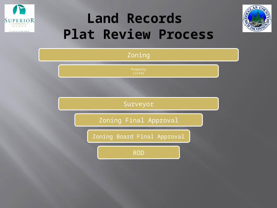
Land Records Plat Review Process
Zoning
PropertyLister
Surveyor
Zoning Final Approval
Zoning Board Final Approval
ROD

Land Records Staff
DC Zoning Administrator Steve Rannenberg
COS Assessor Brad Theien
DC Surveyor and Land Information Officer Ben Klitzke
COS GIS Coordinator Jon Fiskness
DC GIS Technicians Dan Martin and Randy Jones

Land Records Information
Currently maintain all GIS data 500+ data sets and counting Maintain COSDC Mapping Site for public use Maintain data download location on COS web
site Currently maintain 48089 (1/6/11) Land
Records (parcels) in Douglas County Data is updated on a daily basis whenever
possible and pushed to the COSDC mapping site every 24 hours

Land Records Support
Currently maintain 150+ users with GIS data, Pictometry & software ESRI ELA Licensing 2 Servers and multiple off-site locations
WWTP, City Garage, Highway Dept, Forestry Dept, Landfill Web based mapping site LUG Support
Pictometry and data Data sharing agreements GIS Day in November Step by Step tutorials Platbook Production

2010 Land Records Accomplishments
Remonumentation Funding and Township completed Linear Transportation Network nearly complete Cemetery Inventory and Modernization Project – 1 Complete Cemetery GIS Day – 75 + participants COS Landfill Mapping Geospatial Data Available Online (Reduced work on data Requests) Upper St. Croix Flood Impact Mapping Digital Floodplain Modernization Winneboujou Club Mapping Project WLIA Award for Local Government Cooperation Staff member on WIGICC Staff member on the Douglas County Leadership Group Zoning Board using GIS/Pictometry at monthly meetings Computer upgrades for GIS Staff Staff presentations at Pictometry Annual Conference, Futureview 150 GIS Users in COSDC ESRI ELA negotiated for an additional 3 years at the same cost ADC WebGuide Extreme Conversion Staff participation in EWUG, MNGISLIS, WLIA, NMNGIS Pictometry data to Local Units of Government Staff members with Pictometry Certification Parcels updated on a daily basis on web site Server planning with NWRPC GIS Software installed at the Highway Dept, Adopt a Highway data being developed Presentations to (K-12) schools in Duluth and Superior on GIS

2011 Land Records Budget
Internal Service Fund – Douglas County Revenues Sources Retained Fees WLIO Grant Program
COS Assessor COS IT

Land Records Council Decisions
Chair of the Council = County Board Rep How often do should the Council meet? Majority Quorum Land Records Council page
http://www.ci.superior.wi.us/index.aspx?nid=150
Other considerations?