prezentare in profil turistic a sitului...
TRANSCRIPT

TOURIST PROFILE PRESENTATION OF PRAVETS ARHAEOLOGICAL SITE
General view of Pravets location
A. GENERAL CONSIDERATIONS ON THE TOURIST PRESENTATION OF THE SIGHT.
General view of Pravets location
A.1. VALUE OF THE IDENTIFICATION OF THE PRESENTATION RESOURCES.
Research of the material elements from the field
A.1.a. INVENTORY AND PLANNING OF THE PRESENTATION RESOURCES.
= for the capitalization to the benefit of thematic tourism of Pravets archaeological site it is extremely important to make a preliminary inventory of its resources, followed by the data planning and classifying them on topics of diversified interest: =depositary of significant values of culture and civilization, Pravets archaeological site offers a usual multi- layer structure, with time-line from the most ancient times until the recent past;=although the effective demonstration is still tributary to the long term scientific research within the area of the archaeological site, there can be assumed a pre-history for this, because the geographic position of the site, its connections on the horizontal and vertical of the area it occupies, its obvious strategic observation role and the well structured defensive character , recommend it to the use since the most ancient times;=there is certain evidence of the location usage by the Thracians, at least to the purpose dedicated to the cult and its mysteries. According to the evidence identified in the field by the specialists, Pravets site was intended for a sanctuary whose relics have been lingering in the middle of the ruins until today;= the Roman period in the Balkans invests Pravtes site with the important watch role over the Roman roads from the neighboring valley, the ancient fortification being integrated into a similar military construction chain , part of the huge Balkan defensive system , conceived against the Barbarian intrusion. Obviously, there are Several more such fortification chains with defensive and protection role of the Roman roads, but Pravtes site remains as a model among the similar locations, by the rich inventory of constructions and artifacts in the region;=The Middle-Ages are weakly represented on the site, but certified within the chain of fortresses to which it belongs, being thus logical the architectural usage (and even modification) of the site throughout the ages, according to the needs and vulnerability of the respective epoch;=definitely, the site benefits from a long history, which can be presented to the thematic tourist in all its splendor.
Studying the constructions from the archaeological site
A.1.b. INVENTORY OF THE VULNERABILITIES GENERATED BY THE PRESENTATION RESOURCES.
Identifying the vulnerabilities from the site
=the very multitude of epochs comprised within the site, the definite probability of some natural or man induced modifications to its structure and architecture, can generate presentation difficulties and assessment ambivalences;=the site has not been systematically researched from the archaeological point of view, hence the lot prominences of its ruins, difficult to relate to a common and especially precise image;=there are missing important sections to identify the access routes (the Roman road, the North-West gate), there are also missing the base perimeters of the site (sections from the Northern defensive wall), and wide areas from the site are only presumed and covered in materials from the previous diggings (South –East gate);=in other words, the archaeological site is in full exploitation and systematization of the already made works, there is plenty of free space for big scientific surprises which might alter the already established routes for its visiting;
1

=there have been lingering structures of vital importance yet undiscovered (water source- the cisterns for collecting pluvial water), it is temporary abandoned the identification of the North-West gate and its role, there are constructions without door (cellars) or parallel walls apparently without any purpose, counter-excavation debatable by their reduced dimensions, bricks in insufficient numbers and of an ambiguous quality for a certain assignation for their use, the lack of roof tiles and artifacts (pottery and coins) with a great risk of having been imported from other locations, without being able to define the site as such. These scientific difficulties make even more difficult the tourist profile presentation of a location instable as certainty and display; =the access route to the site is represented by levels of different comfort, varying from paved road to trail, there are missing the guide marks and the associated warning of a historical monument, as well as other non-verbal communication elements with the tourists;=Pravets site is a wild site, which can not be visited in the present, found in full archaeological exploitation, lacking the facilities, definite objectives and tourist warnings of any kind
A.1.c. PRESENTATION RESOURCES LENDING THEMSELVES TO VERBAL COMMUNICATION.
Assessment of the North-West area of the site
=at the assumed (Borovets History Museum) starting point (as “tourist waybills”) there is the possibility of a presentation within its precincts, by one of the museum specialists, as well as direct/phone contact of a guide for the trail to the site, in order to complete the non-verbal communications that can be met on way there and within the very site area. There is the advantage of visualizing the artifacts saved from the site and scientifically classified, of presenting thematic films, replicas and reconstructions, of informing the unadvised tourist on the special historical value of the sight to be visited. =the verbal presentation can be continued on the way to the site , emphasizing the special aspects of ethnography (exemplifications in determined locations, complementary to the main objective- the site ), of environment (the exceptional natural aspect of the valley bordered by wooded mountains) and of history (time-line), plus references to the geographical and historical context in which the site is placed, as well as data regarding its inherent and context value. =the advantage of verbal communication is the possibility to modulate it according to the tourist’s disposition and focus, to promote the objectives of secondary interest covered on the trail, to establish an inter activity beneficial to the tourist and his need of information and mystery; =having the experience of the trail, the guide can recommend adjustments/ halts to rest, sightseeing and recreation, can offer options to diversify the visit (secondary sights situated near the main trail) and can even recommend the justified extension/prolonging of it; =at the site level, the guide can animate personalized work-shops, can react to the tourist’s questionnaire, as well as ensure the cognitive and physical comfort of the visitor protected as such; =apart from the programming of tourist groups, made by accessing an especially designed site, the accessing of the guide can be made occasionally at Borovets museum or by direct phone call , distinctively applied complementary by non-verbal communication.
A.1.d. PRESENTATION RESOURCES LENDING THEMSELVES TO NON-VERBAL COMMUNICATION.
Finger post of access to the site in the Bulgarian language (only!)
=primarily it is necessary to integrate the archaeological site from Pravets into a local tourist circuit and maybe – strategically speaking!- into a regional one at least, compensating thus the scarce amount of data provided by the by the site portfolio and the shortcomings of a fragmentary presentation; =the starting point of the visit is placed at a distance of approximately 10 km from the site, logically established within Borovets history museum area, where one can identify the tourist’s interest in accessing the archaeological site , as well as his “fueling” with preliminary data which classify the archaeological site as tourist interest location.=from the starting point, followed by the detachment point (junction)from the main road of the secondary paved road and the initiating point of the foot trail, begun from the secondary road climbing the wooded slope, it is possible to place static posts and maps , including synthetic information on the location targeted by the route;=there are obviously! necessary minimal arrangements to this purpose, mainly subordinated to the natural environment conservation where the site is situated, an environment of an exquisite scenic beauty.
2

We consider the preservation of the foot trail as an additional background factor of the site. =today’s total lack of facilities (rest areas, sanitations, dressing station, info-point, sightseeing areas) significantly reduces the tourist’s appetite of visiting Pravets archaeological site, fully justified by the absence of minimum tourist comfort. =on the other hand, it is necessary to integrate the site visiting into similar locations from the military defensive chain to which it belongs (Chertigrad, Ostrom, Bozhenishki Urvich and even Kale/Elen Pelin) in order tot complete the real and 3d historical image from which the major tourist importance of the site derives. =obviously, the fortification (among the described four) similar to the Pravets site selected for thoroughness and comparison, must benefit from the same facilities as the main site;=at the proper site , it is compulsory designating an closed access circuit, punctuated by elements significant for the tourist, local facilities and explanatory guide marks for each established interest point , including the protection of the areas still archaeologically active in exploitation.
A.1.d. GUIDE OF GOOD PRACTICES IN IDENTIFYING THE RESOURCES.
assessments of the interest points in the archaeological site =identifying all the secondary and main sights lending themselves to be accessed by the thematic tourist (Borovets museum, ethnographic presentations, mountainous route to the site , the archaeological site as a whole, the natural area neighboring the site, historical similarities on the horizontal and vertical of the site, the valley protected by the fortifications or the fortifications from the defensive chain to which it belongs), such as integrating these objects in a diversified and attractive, with extending and thoroughness possibilities;=the non/verbal presentations must be strictly selected , benefiting from qualification and communication abilities, completely dedicated to the tourist comfort and without altering the “purity” of the accessed environment (exterior rustic furniture, guide marks/maps with an adapted aspect, placement in the landscape);=it is necessary a thorough documentation of each relevant information, pictorial assertion or selected material evidence, training the tourist in order to discover and enjoy it (the modern principle of “touch me!”= “taste me!”= “smell me!”), avoiding the monotony and repetition, of boredom and bad jokes;=on one hand the visiting offer is fixed and situated within the checked information, on the other hand the tourist has the flexibility of his education and knowledge; from this potential conflict there can arise ambiguities, coming from the information input according to the necessities and permanent measurement of communication efficiency; =the presented vulnerabilities (still unclear data, assessments with unclear, debatable or waiting for thorough researches) must not be discovered by the tourist with disappointment, must be previously assumed by the guide as a fact, subject to the investigation dynamics of the site, with perspective on its elucidation;=the time allotted for each sight individually varies according to its informative patrimony and is subordinated to the total amount of time allotted to the visit, thus preventing the superficiality of the visit or its prolonging beyond the tourist’s capacity of endurance /adaptation;
A.2. PRESENTATION STRUCTURE ACCORDING TO THE NEEDS OF THEMATIC/CONVENTIONAL TOURISM .
assessments at the “drain holes!” of the North-West defensive wall
A.2.a. QUALIFICATIONS NECESSARY TO A THEMATIC PRESENTATION.
recording some artifacts from the field in the presence of Borovets museum specialists
=editing non/verbal communications involves building a qualified team in the fields of history, inter human communication, and promotion and marketing of a sight. Pravets site fully requires knowledge of ancient archaeology, architecture of patrimony/restoration, as well as the pedagogical ability to transmit the information, most of the times lacking the quality due to the insufficiency of the collected data until the present; =the list of qualification contains historians, archaeologists, geologists, biologists, military experts/historians, cartographers and – especially – communication experts ; starting from the data base about the site and its surroundings/connections , there can be edited texts, images, films: flexible and
3

conceived in a modular way, destined to express the portfolio values, the concealments of the material flaws and the establishment of an efficient management of the presentation; =the designated guide is neither tributary to the preconceptions and scientific circumspections (defining the site as “a fortification of Roman type” is deeply disappointing by the simplicity of the statement!) and –certainly!- nor the exuberance without justification , causing ambiguities or suspicions; =definitely there must be understood that Pravets site is “alive”, in the sense that there will always appear discoveries which can substantially modify the historical, architectural image and its time-line; editing non-verbal communication must take this risk into account, by achieving a flexible and modular concept, by which there can be replaced outdated texts/images with the latest up-dates, offering thus quality and freshness to the presentation;=definitely, there must be understood that Pravets CANNOT be visited at the moment, at least in the conventional meaning of thematic tourism, severely lacking vital chapters (access route, facilities, signs and guiding marks, systematizing the site, protecting the areas in exploitation, identifying the already discovered areas, vertical/horizontal interconnection with similar locations or other tourist offers, such as harmonizing the objectives on the route); Presenting such an objective is delicate, and could have compromised at any moment its tourist future by superficiality, ambiguity, monotony or lack of organization; hence the necessity of adapting the actual presentation to the real state of facts, but also its preventive assumption in front of the competent tourist, willing of comfort and show.
A.2.b. PRESENTING THE SITE RESOURCES.
Studying the geological elements from the North precints of the site
=by “site resources” we mean that al these unique/multiple material elements (altar/bricks) , isolated or part of ensembles (rocks/walls), constituted themselves in distinctive structures or complex buildings/ defensive systems), coming under the artifact category (pottery/ metallic objects/tools) and others, all of an attributed archaeological value, lending itself to a tourist presentation, as well as their proper/ contextual scientific interpretation; =the list of site resources, that is the structure, comprises exquisite values , such as: “the gates” of the fortification (South-East and North-West), the surface of the Thracian sanctuary (in the site center), the defensive walls (South-West), external North-West wall (which presents a round! corner ), the “drain holes” from the defensive Western wall, the foundation lacking doors from the Western half of the North-West area, as well as locations where there have been found exquisite artifacts (coins, fragments of Greek pottery and provision clay jars); =other accessible secondary sights within the site can be highlighted in the context of its value : general view over the valley, protected in the antiquity by the Roman fortress, but also the general view of the mountainous chains which constituted fortification points from the Roman defensive chains; the aspect of field adaptation to the designing and execution of the Roman fortification, by molding the structure according on the relief, the pragmatic usage of natural rocks, embedded into the walls, types of used materials and their periodicity , emphasizing the “limescale level” of the site , solving the level difference by optimizing the height of the defensive walls, types of binder from the structure of inner/exterior walls, versions of the present vegetation, water sources, supplying, sewage, or using the wood in the structure of ancient constructions; =we reiterate the necessity of listing the selected sights, their presentation, followed by functional interpretations , of context or speculative (balanced!), based on logics and scientific accuracy , but presented in accessible and attractive terms, with the support of non-verbal elements from each place subject to the presentation.
A.2.c. PRESENTATION OF THE RESOURCES SURROUNDING THE SITE OR SIMILAR TO IT.
Examining the defensive wall from the North-West of the fortification, subjacent to it
= Pravets archaeological site has also numerous presentation resources, exterior to the proper site, their systematizing and eligibility being a necessity of the inbuilt presentation of the site in thematic tourist profile; =thus, the museum from Borovets has a special role in familiarizing the tourist with the main objective (site) and the most reliable information source for him;
4

= Borovets location lends itself to organizing an ethnographic event (handicraft, traditions, folk costumes, exhibitions, dances, specific rural gastronomy), individual or integrated in the visiting program of the site (organized groups, previously programmed);=the main and secondary (asphalted), during its coverage, is a good opportunity to present the valley and mountainous chains which argues the role of the Roman military defensive chains from the Balkans; =the foot trail allows a segment of mountain hike to the tourist’s benefit;=the access route specific to the site (Roman road) can be partially emphasized and commented on adequately;=the “arrow clearing” (fight, warehouse?), remnants of civil settlements(!) from the South-East of the site, geological structures from its North (there can be justified the previous tectonic movements, responsible for the modification of the site structure, by the different orientation of their cleavage lines) are secondary objectives which can enrich its presentation;=optionally , visiting at least one more fortification from the defensive chain is an asset earned by the tourist; =the tumulus from the area, the possibility of discovering a necropolis (cave!) subscribe to the color and mystery desire of the tourist, whoever he may be as education and spirit.
A.2.d. OTHER PRESENTATION OPTIONS AND DIVERSIFICATION OF THE PRESENTATION.
permananet exhibition of Borovets museum
A.2.e. GUIDE OF GOOD PRACTICES IN CONSTITUTING THE PRESENTATION STRUCTURE OF THE SITE.
=the presentation structure of Pravets archaeological site is built on tree levels, thus:a. exclusive presentation of the archaeological site, with already mentioned elements;b. presenting the historical and geographical context the site belongs to (the Roman fortified
defensive chain the site is part of );c. presenting some values additional to the main objective (museum, ethnographic area,
mountainous tourism);=on all the presentation levels there is considered implicit the existence of non/verbal presentation/ communication forms, selected and adequately edited ; =the presentation structure is based on:
a. scientific information, demonstrated and emphasized about the site , as well as connected, interpreted and scientifically displayed information accessible to the thematic tourist;
b. balanced speculations about the site time-line, suggestively and attractively developed;c. Borovets museum’s position by which the preciseness of the presented data is certified ;d. contributions of the local administrative authority, directly interested in promoting the local
values – ethnographic, natural and historical – coming under the archaeological site presentation;
e. non/verbal promotion of the site, including a dedicated site.=from the practical point of view, the selection criteria of the presentation structure are based on:
a. selection of the facts and their scientific processing adapted tot the popular presentation;b. managing the facts according to the site time-line;c. applying the inter-activity principles;d. making a flexible and modular presentation “menu” .
Researching the ancient Roman road from the South of the site
A.3. REQUIREMENTS AND NEEDS OF THEMATIC/CONVENTIONAL TOURISM AND WAYS TO MEET THESE REQUIREMENTS
Main natural access route to the archaeological site
A.3.a. REQUIREMENTS OF THEMATIC TOURISM AND HOW TO MEET THEM.
=Thematic tourism, specialized branch of general tourism, has peculiarities and – especially! – requirements which are really hard to meet. But, once these requirements met, the touristic sight becomes , actually, accessible to any form of tourism:
5
a. the need of objective – is the tourist object feature of answering the desire of education, knowledge and relaxation of the tourist dedicated by his profession, hobby or curiosity to a certain specialty. Pravets site has to offer to this extent , by its multi-layer structure, the whole historical range of a time travel;
b. the need for novelty can be represented by the offer of systematizing the data or their up-date, or , frequently, by their presence in an assimilatory and pleasant way;
c. the need for mystery – time travel has the advantage of drawing the period before and after the investigated historical lapse of time. Pravets site fully allows pertinent hypotheses about the pre-history of the place and “filling” the lapses of time yet to clarify ;
d. the need for color – the thematic tourist wants, complementary to the followed purpose ,to benefit from multi – role offers, some simply relaxing, others genuine tests/invitations for future hobbies. Pravets site offers the possibility to apply mountain hike, to take part in culture and ethnographic tradition events, to expend the dimensions of the main sight by its connections;
e. the need to certify – which validates the information and clarifies one’s own ambiguities. The presence of Borovets museum can also solve this desideratum;
f. the need to access – the thematic tourist must be helped to select Pravets site as a valuable offer for his field of interest; promoting via-internet (dedicated site) and an optimal non/verbal presentation answer the desideratum ;
Natural road passable towards Pravets archaeological site
A.3.b. THE NEDS OF THE THEMATIC TOURIST AND MEETING THEM.
the access to the archaeological site from the South
=the thematic tourist is a special person with a minimal information luggage already acquired , and a training (more or less valuable) in the field he has developed a special hobby.The thematic tourist has multiple needs, some common to any tourist, others personalized on the tourist branch he belongs to, such as:
a. general needs :-the need of guidance – in the present Pravets site does not answer this need in any way, requiring thus sub-sequential projects of non/verbal communication and guidance development within the site and its surroundings;-the need of documentation – met by the Borovets museum and specialists;-the need for facilities – today Pravets site does not answer this need in any way, requiring thus sub-sequential projects of ensuring the facilities , in full concord, as well as ensuring the environment protection-the need of a cost-benefit balance favorable to the tourist endeavor – for the present Pravets site has a great unexploited touristic potential ;
b. special needs :-the need of cementing the knowledge -Pravets site can practically argue, on the field eren , important periods from mankind’s history;-the need for novelty – at least under the aspect of interpretation and detailing some architecture, history and geology elements, Pravets site draws the thematic tourist’s attention onto enough novelties in order to justify its appeal ;- the need for satisfaction-Pravets site is a “vivid” site (in full archaeological exploitation), as well as a “wild” site ( unvisited yet). Therefore it offers the thematic tourist the role of an explorer, extremely appealing and lacking the risks of a true exploration. Pravets site represents more than a documentary on historical topic and less than an uncomfortable scientific research on virgin ground .
A.3.c. ELEMENTS ADDED FROM THE CONVENTIONAL TOURISM SPHERE.
conventional tourism on the access way towards the archaeological site
=considered as such, thematic tourism is difficult and little feasible. Including in a project of thematic tourism the elements already checked on the profile market of the conventional tourism can guarantee the success of the project.Definitely, for the tourist there is a critical need for diversity and spiritual interest, needs to which the thematic tourism answers strictly punctual and – hereon – excessively!
6

=examples of elements added to Pravets tourist project from the conventional tourism sphere: the cultural offer of handicraft shopping, corroborated with inter-active presence at
ethnographic events (festival, exhibition, presentation); the offer of a small town, with tourist sights of average level and quality/quantity
(Borovets museum, local City hall , central park, hotel, lake); the natural offer for mountain tourism, due to the fortunate coincidence placed along the
route towards the archaeological site; the extended offer of visiting several historical sights (the local chain of ancient
fortifications ); the documentation offer , with the help of the future info-point, with a rich reference
inventory (maps, folders , DVDs/CDs, films, souvenirs); the offer of complex and complete touristic model (history, culture/traditions,
environment/real time documentations;=compensation the possible drawbacks in the complete touristic offer , depends on the facilities, designed and achieved at the place and time when they can become a necessity.
A.3.d. THE GLOBAL SATISFACTION OF THE TOURIST BY THE COMPLETE AND COMPLEX PRESENTATION OF THE SIGHT.
landscape splendor of the access to the archaeological site
=generally speaking, a too loaded touristic offer can lead to inevitable loses of interest and address; as opposed to this , a poor offer can induce monotony and lack of interest. Pravets site has multiple offers, unequally measured yet,, from different touristic registers;=the issue is identifying the moment of maximum satisfaction for the tourist. Taking into Aaccount that the archaeological site is the main sight of the touristic project, it is essential the tourist’s mood the moment he actually leaves the site (meditative, interested, excited or bored).In reaching an optimal satisfaction level, what matters the most is the archaeological site presentation and its significance.The other touristic offers are meant only to ensure the maintenance of the main sight at high levels in the assessment of the thematic tourist.=the global satisfaction of the thematic tourist can be achieved at Pravets by:
ensuring the comfort throughout the entire visit (transportation programming , accommodation, meal , guidance, presentations/simulations, an as wide as possible range of touristic sights in the offer);
ensuring a touristic presentation on the sight as closely as possible to its promotion politics and as far as possible from the boring lecturing of a purely scientific documentation ;
attracting the tourists in attractive interactive work-shops, inducing some assessments and conclusions apparently due to their own analysis/synthesis capacity;
compensating the deficiencies in the punctual offer(weak points) by using the excess of punctual offer ( from the strong points), in order to achieve a final balance of satisfaction and interest;
appeal to creativity, spatiality and mystery (common to many similar sights).
A.3.e. GUIDE OF GOOD PRACTICES TO MEET THE THEMATIC/CONVENTIONAL TOURIST’S NEEDS.
The adjustment halt on the way to the site
=harmonizing visiting time as compared to the significance of each individual sight;=overlapping visiting periods as to render a balanced variation of the presentation;=presenting Pravets site a as hard to get favor, in spite of some restrictions imposed on by its preservation ( vivid and wild site , still found in exploitation -reservation?); this type of presentation can reduce more of the site vulnerabilities , in the sense that the issued related to the logics of presentation and the little amount of necessary data for an optimal historical reconstruction can be put to the account of the evolution in the site dynamics , a process still in progress;=the tight, harmonious and optimally balanced corroboration of all the factors already mentioned (facilities, multiple offers , non/verbal inter-active presentations, friendly documentations , kaleidoscopic rolling of offers ), in the geometric point of maximum interest: the tourist!= among the practice of conventional tourism , the facilities are :
7

of orientation, of trail and explanation; of transportation; of ensuring an optimal visiting route; of relaxation, sanitation and rest; of managing emergencies, special needs, the unexpected; of managing the presentation as related to the tourist’s reaction.
=management of crisis of any kind (excessive fatigue , boredom, ethanol intoxication, difficult personalities); these will be preventively solved with diplomacy, efficiency and firmness. The guide does not present the sight but communicate with the tourist to this purpose .=Pravets site is difficult to assimilate, it does not have a monumental character , but can be evocative by mixing the presentation with the tourist’s predisposition to imagination and creativity.
A.4. MODERN PRINCIPLES IN THE TOURISTIC PRESENTATION OF THE SIGHT.
A happy thematic tourist
=visiting and presenting the archaeological site as a time travel, populating the site with suggestions of characters who once belonged to the people living in it( Thracians , Romans, inhabitants/ occasional visitors of the place);=placing the weight center of the presentation on the archaeological site animation , in spite of the dull and static appearance , characteristic to these sights.The tourist must feel the roar of those epic times, to fearfully scrutinize the horizon as if waiting for the invading armies, to be tense because of the mystery of the forest surrounding the fortress and to look for his place in the resistance victory against the invasion or in the tragic abandonment of the defeated .=placing in key points on the route of some concrete material elements , which suggest presences and activities long ago covered with the dust of history ( an ancient carriage partially loaded with fire wood or rocks or sacks , a camp with stone hearth and pottery scattered all around , an arrow stabbed in a tree trunk or a section of ancient road in full repairing process) can erase the border between the fantastic and the real , to the benefit of an as suggestive as possible presentation;=crossing the site in now a remote area from the group of visitors, by a Roman/Thracian soldier (silent, rash, fulfilling a trivial task – carrying water, wood, or patrolling), only visually interacting with the tourists , can generate a benefic shock of the place authentication and its mission at the chosen historical moment.=the careful placing of objects having the role of souvenir/ bonus for the tourists found in the site (fragments of Latin scrolls, ceramics/wood replicas, small domestic tools) can satisfy the need of collecting, common to many tourists and can complete the authenticity air of the site;=there is also the possibility of an audio reconstruction of ancient tunes, shouts, alarms or calls, carefully dissimulated among the site structures and skillfully handled by the guide;=in the ethnographic area, participating in the preparation of a traditional dish, trying on a modern folk costume or even ancient , the attempt of pottery , weaving, spinning or axe carving, leave unforgettable memories…=the dance/music is a bond for everything, attracting the tourist in such activities promotes the culture and civilization of an entire country;=presenting a reconstructed model or a replica, along with the fragmentary original discovered by the specialists, constitutes itself as surprising supplement of non-verbal communciation.
A.4.a. TAKING OVER THE CONVENTIONAL ELEMENTS IN THE TOURISTIC PRESENTATION.
The forest hiding Pravets site
=in the conventional way, the presentation of Pravets site can be made in two circumstances:1. isolated tourist or small/occasional group of tourists:
-accessing the site on the basis of conventional signaling and of the associated guide marks;-visiting the site following an internal/inner route marked by non-verbal presentation for each significant landmark selected for the presentation;- possible extension of the visit at Borovets museum as to complete the data already acquired on the site.2. organized and programmed group by the competent thematic tourists :- at Borovets museum – under the guide’s leadership, a preliminary presentation of the site will be made;-the trip to the site according to the guide’s indications, along the route connected to the environment and placing the site within its context;
8

- static presentation of the site, according to the landmarks designated as relevant, comments, questions, answers;-optionally visiting the sights of secondary interests.
A.4.b. PRINCIPLES OF ANIMATING THE SITE.
Exhibit from Borovets museum
obeying the historical truth ; using some materils adapted to the outer conditions; using at least three foreign languages in editing the explanatory texts editing maps, images or simplified sketches according to the requirements ‘ presentation for
each individual topic protecting all non/verbal communication forms; adapting the presentation and animation model to the environment and the historical period
to which it addresses; the structure of the animation elements must obey the non intrusion principle and the
integrity of those who come into contact with them; the density of the site animation must not become a majority weight in its presence; the trip segments introduced in the site animation must be separated by explicit “gates”; the non verbal communication elements must be easily identifies, explicitly, created in vivid
colors, of contrast, ergonomically placed on the visiting trail;; the verbal presentation must be clear in short sentences, accessible and complete indicating
the topics it refers to. We do not recommend the presentation by written document or audio CD for each participant.
The scale models, the replicas and the reconstruction props to benefit from the a genuine aspect, faithfully reproduced , naturally placed, being able to be assimilated by the tourist as part of the site presentation;
The persons involved in the site animation (actors, volunteers) must not interact with the tourists not to alter the authentic message sent;
A.4.c. NON VERBAL PRESENTATION OF THE SITE .
Main entrance of Borovets museum
=based on the prior assessment and practice in the field , we consider as compulsory drawing up any public text in at least three foreign languages (English, French and German) and definitely Bulgarian;=the explanatory text for each landmark must be selected in order to respect the elaboration algorithm (denominating landmark, dating , role, brief description, contexts,etc), having aside an evocative sketch of the landmark (frame, plan) ;=the explanatory maps must present a suggestive design , “Medieval map ” type, even bas-relief in vivid conventional color;=tracing the trail elements can be made in ecological paint in the archaeologically charted area of the site, or non invasive applied on the site structures in the form of arrows or other conventional signs (danger! Warning! Turn!);=epoch replicas, made of light materials , ecological, obeying the historical truth, will be placed within the view range of the tourists without the need of leaving the trail recommended for visiting;= the costumes of the volunteers involved in authentication actions of the site (the Thracians, the Romans, the locals) must avoid ridiculous improvising , resistant to repeated uses and simplified as suggestively as possible;=the non verbal presentation of the site is structured on four levels;
Non verbal presentation of orientation:-consists in edited texts of adjusting the trail and suggestive signs added n the plate (direction, location, crossing time, facilities);-also consists in texts of presentation and identification of sights of interests, situated on the visiting trail (location of Borovets museum, crossing through the “gates” segmenting the trail-urban, ethnographic, mountain, historical, site entrances and locations adjacent to the site) ;
Non verbal explanatory presentation -consists in maps , sketches , plans, images, related to a site or landmark selected for the presentation, as well as the suggestive figure of the approached topic;
9

-also consists in board reconstructions for the important sights (archaeological map of the sight, satellite images of the sight in the context of similar vicinities, segments or ensembles of constructions , walls, other arrangements ) -also consists in suggestive images symbolizing facilities (relaxation, sanitation, car park, first aid )- also consists of warnings about the special locations simply detailed (panoramic points of the landscape, panoramic points of the archaeological sight, points dedicated to taking photos/ special films.
Non verval presentation for promotion-consists in the visiting offer for sights secondary to the visiting of the sight and contains elements for their promotion (hotel, restaurant, museum, City Hall, lake, park) and contains data of identification, trail and main qualities which recommend the location to the tourist;- also consists in promoting the site project contacts (internet site, e-mail, phone and contact persons, entities involved in the project, useful links)
Presenting some replicas, reconstruction and adequate simulations:-consists in making replicas, optimally placed , in order to achieve an atmosphere specific to the site (ancient carriages, ancient fences, hearths, traces of domestic and military activities of the epoch );-also consists in reconstructions of important sights (buildings, fortifications, supply and consolidation works, temporary structures of protection and storage )-also consists in non in non interactive simulations with the group of tourists (patrols, guard posts, current activities from the epoch)
A.4.d. VERBAL PRESENTATION OF THE SITE.
Explanation on the artifacts still found on the archaeological site
A.4.e. INTERACTIONS ,NOVELTIES , SIMULATIONS IN THE SITE PRESENTATION.
The thematic tourist will always try to understand the site visted
=the non verbal animation of Pravets site also presents modern elements, some even non conventional, such as:
Interactions of the tourist with the group guide, with the site itself and the participating tourists :-there can be achieved verbal games (general knowledge test about the segmentary history of the site, with the guide as moderator and specific simplified questionnaires, subsequently studied in order to find out the weight center of the presentation for the future tourists;)
Interactions with the site within the non verbal presentation:-accumulating vouchers for each visited sight/ landmark with compensations of presentation bonuses or other offers (promotional maps, flyers, magnetic logo)
Promotion games of the site:-puzzles, PC games with the 3D image of the time line identified on the site.=simulations of strategy in order to protect and use the former Roman fortress can be practiced among/between the gropups of tourists organized in opponent teams on a given topic , practiced in Borovets Museum , carefully monitored by the specialists (there would not be for the first time when amateurs have significant contributions in a given field)=the difficulty of conceiving a flexible model of presentation which can be adapted to the latest scientific discoveries in Pravets site area (the site is “alive” in full exploitation !) can be solved by their separate and sincerely assumed presentation, even if they modify previous concepts about the structure and use of the site throughout the time.
A.5. UNCONVENTIONAL SITUATIONS GENERATED BY CIRCUMSTANCES .
Pravets site is still difficult to assimilate by the thematic tourist
=Pravets site has many vulnerabilities which can constitute themselves as obstacles against its visiting and promotion :
The access way is long and of poor quality; There are missing points of real interest complementary to the site (apart from the Borovets
museum, all the other “attractions” are merely theoretical , of perspective) The site is not even a model of systematic exploitation , not finished and lending itself to visiting; The site structure is under way of being clarified
10
The facilities of any kind are missing=thus, Pravets site remains only a challenge for the thematic tourist, requiring multiple contributions regarding restoration, accessibility and promotion=the tourist can find himself in the situation of accepting the greatest vulnerability of the site (its “wilderness”), as gained asset, which remains as a final and cheap solution for visiting and promoting the site;=on the other hand, Pravets site can be saved to the benefit of the thematic tourist, by its greatest quality: it is a real model (example) of the components of the defensive chains from the Balkans erected by the Romans on the path of the Barbarians. Thus , by the conjugated effort of several municipalities (which possess similar structures/sights) , Pravets site can be integrated into a touristic circuit of “safari” type, which would allow, with few allotted resources , a full and complex image on the historical period when the site was active from the strategic/military point of view; =such an approach , pressures the verbal presentation of the site, in the sense that only a competent and dedicated guide can bring back the glory and significance of long gone times for the thematic tourist;=there would also be the solution of integrating Pravets site into a specialized tourism circuit, although the lack of systematization will not be easily accepted by the specialists coming here.
A.5.a. IMPACT ON THE COMPETENT THEMATIC TOURIST.
Assuming the role of specialist, a challenge or a disadvantage ?
=the concept of the “thematic tourist”, involves from his part, apart from the natural passion/dedication for a given field (archaeology, history) and a knowledge “luggage” of variable sizes and qualities regarding it. The thematic tourist comes to the site in order to complete his knowledge, verify the ones already acquired and sometimes in order tot amaze his colleagues with his “specialization”. He is careful, involved, asks questions and emits hypotheses , completes the guide and presents in a personal manners the accessed landmarks. He is – by far !- the most difficult tourist , especially if his interventions are pertinent and can endanger the course of presentation or – at least!- its intricacy. = although he knows the site non intrusion principle assumed by the tourist, the thematic tourist can make intrusions in his presentation with effects similar to the intervention in the site:
He can overreact with demanding details , some of them definitely exceeding the structure of a touristic presentation. The guide/specialist must answer carefully to these challenges, keeping the rhythm and presentation plan. Pravets site lends itself to many interpretations for the tourists(prehistory of the site, filling the time lapses when the site did not justify its use by the humans, the Middle-Ages period reflected in the site) , therefore there can easily geneate vulnerabilities of verbal presentation;
He can make statements unjustified but logical, some of them even bold or contrary to the common scientific sense, or produce exclusively assumed by his creative imagination. If “proto archaeology “ were anarchic, destructive, and interpreted imaginatively/ affectively/objectively, the “classical ” archaeology tributary to the specific dogma, to exclusivism and even to a somewhat arrogance, “modern archaeology” goes beyond the research area and can friendly explain his results to those who obviously ! indirectly assures the resources . So the guide/specialist will amiably manage the involvement crises of the thematic tourist, at least for pragmatic reasons, if not of sincere acceptance of his zeal;
Pravets site is a shock for the thematic tourist , being difficult to systemize , assimilate and abstracting, situation in which the non verbal presentation of the site requires an unwanted decisive role in promoting the site.
A.5.b. IMPACT ON THE INTERACTIVE THEMATIC TOURIST.
The thematic tourist has a lot of questions to ask…
=definitely, the thematic tourist has multiple needs, hard to satisfy=among these , the need of inter activity may be satisfied on Pravets site, in the easiest , cheapest and most complete manner, as follows:
Regardless the quality/quantity of assumed knowledge “luggage” , the thematic tourist can be considered a potential contributor of the site systematizing, in all means (archaeological, touristic, of promotion) of this term
11
The “games” the starting/initial point (Pravets museum), on the route to the site and the site itself can generate ideas/solutions/ improvements in all the sequences included in the “systematizing” term. The tourist can be trained in solving some “enigmas”, such as:
-the role of the tectonic movements noticed in the area, in modifying the presumed locations (Roman road, Thracian necropolis, access to the site)- justifying big quantities of construction material missing from the site inventory (stone, bricks, tiles)-assuming the role of refuge point for the civilian population adjacent to the site during the military crises (siege )-solutions to ensure the drinking water on the site during its functionality -the military forces presumed to have occupied the site during peace/war;- the presumed capacity of the fortress to ensure the survival in case of crisis (would this have been an option abandoning this? )-the defensive role of the massive exterior walls of the fortress (Barbarians, Thracians, locals?)
A.5.c.JUSTIFYING /UNCLEAR ELEMENTS OF THE SITE WITHIN ITS PRESENTATION.
“the round corner” from the North-West of the site remains a challenge for the tourist
Overlapping the plan of a typical Roman fortification onto the one of a mountainous Roman fortification represents a major error which must be corrected by explaining the architecture “adapting” a mountainous fortification to the challenges of relief where it had been built by the ancients
Consequently , the term of “gates” has other roles than the ones strategically established during the early Roman period, in the plain locations from Moesia or even Barbaria!
The drinking water source of Pravets fortress is definitely rain and nothing else can replace it ! The role of the “gate” already identified by the specialists depends – to a great extend- on the
identification of the Roman access road to the fortification The lack of tiles , bricks and other materials can be explained by their dismantling by the locals in
different epochs (there would be necessary a specialty foray to identify some Roman elements in the structures of some civilian buildings from the villages around Pravets site )
There must definitely separate the authentic structures of defensive stonework or the inner structures of the site of “reconstruction” of any type, applied over them, by persistent colorful markings (it would be a real surprise to be able to solve the mystery of the “round corner” from the North-West defensive wall of the fortress!)
The role of refuge in case of military crisis of the fortress must be reanalyzed to the benefit of historical truth
The “towers” of Pravets Roman fortress can be justified- especially!- by the necessity of using them as monitoring/watch point over the valley adjacent to the site
A.5.d. DIFICULTY TO INTEGRATE THE INFORMATION CONTAINED IN THE PRESENTATION.
GPS mapping of the landmarks on the site
=usually , a presentation has a very simple algorithm: The name of the place, its location, touristic relevance ; Brief description of the location, its dividing into periods, the assumed role, the lived events; Presenting a visiting route of the location, with halts in selected landmarks; Conclusions , questions, answers, promotion;
=Pravets site presents obvious difficulties of being part of an algorithm , so it requires its modification, such as:
Preliminarily informing the tourist about the fact that the site is in full exploitation process, therefore the possibility of solving some firm conclusions about it:
Avoiding on the course of presentation , the ambiguous landmarks which are to be identified or archaeologically exploited ;
Assuming controversies constructively, friendly and sincerely!=Pravets site has not got yet scientific arguments about the site prehistory and the middle-ages period, as compared to their presence in the neighboring locations of the site. Fragmenting the scientific data,(partly due to the lack of systematizing in its archaeological research !) does not allow its fluent, harmonious presentation. Consequently, there must be decide the strategy of this presentation:
12
There are presented “parts of information” , carefully “glued” with hypotheses/speculations There are presented only the individual landmarks (such as “this is a fortification of Roman
type!” ) without integrating them in a comprehensive exploitation of their role and division into periods
There are presented fragments of scientific information/assessments/certifications emphasizing the flexible, dynamic, surprising but also relevant character of continuing the archaeological exploitation of the site
We consider this last version optimal, out of respect for the scientific research, the quality of the information addressed to the thematic tourist, and especially out of respect for history! A.5.e. HARMONIZING THE INFORMATION, THEIR EDUCATIONAL ROLE AND CREDIBILITY.
Modern processing of Pravets site in view of its restoration
= Pravets site is a real model of the cult location in Thracia= Pravets site is a model of fortification integrated into a defensive chain\=Pravets site is a model of medieval location during period of military crisis=Pravets site is a model of complex of architecture specific to several historical periods\=Pravets site is a model of adapting the purpose to the environment=Pravets site is a model of survival in harsh environmental conditions=Pravets site is a model of historical interpretation in the context of significant/similar vicinities=Pravets site is a model of potential for the thematic tourism, skillfully diversified with complementary offers from the field of cultural, mountainous and entertaining tourism=Pravets site is a model of challenge for promoting the Bulgarian national cultural patrimony =Pravets site is a cooperation model among archaeologist/specialists, patrimony architects and specialists in the assessment and touristic promotion of the site=Pravets site is a model of transforming an ensemble of objectives difficulties into a complex advantage.
B. GENERAL VULNERABILITES WITHIN THE TOURISTICAL PRESENTATION OF A SIGHT.
the specialist’s continuous search of scientific truth
B.1. DEFICITARY IDENTIFICATION OF THE SIGHT RESOURCES, LACK OF NECESSARY QUALIFICATIONS, ABILITY TO COMMUNICATE AND INTERACT.
Looking for the traces of the Roman road on the road towards Pravets fortress
B.1.a. CONSEQUENCES OF DEFICITARY IDENTIFICATION OF THE SIGHT RESOURCES.
map-drawing measurements fore the “drain holes”
=according to the specialists’ accounts, the site has been randomly approached, at first there has been looked for a supposedly main gate of the former Roman fortification in the North-West area of the site, and after the failure of this intervention, there has been decided on approaching the South-East corner of the site, where there has been emphasizes a gate, subsequently blocked in the access area of the site with a temporary warehouse of construction materials (stones); =the emphasizing of some exterior walls has been made on segments, even attempting to roughly reconstruct the wall by applying stones without binding material, maybe even modifying it (see “the round corner” of the external wall from the North-West of the site!); = there has not been made any section through the segment of Roman road identified in the South area of the site, which would have allowed the division into periods of the access way, according to the pattern in which this one was built;= the uncovering of several interior structures on the site (infrastructures) has not been made until the limestone level of the site;=identifying some holes contained in the exterior walls has been labeled as “drain holes” for the excess of pluvial water , although these holes do not cross it and are placed above the limestone level of the site which are not useful to the presumed purpose;=the lack on the site of the marking of its grid sections, usually used in the systematic archaeological research;
13

=there have not been made geological examinations of the site area in order to assess the dislocation effects of the structure by a previous tectonic movement (covering and even displacing the Roman road), the crumbling of some stonework elements, the removal of some structures(stones) from the North area of the site, a possible cult place (necropolis) of the ancient Thracians;
=there are great amounts of construction materials crumbled on the mountainside (rocks), possibly dislocated even by the intervention in the site , which are difficult to relocate on the former locations because of their scattering; = on the site there can still be identified pottery fragments (some of them have been found on the very access route, probably lost during the transfer to Borovets museum, still unharvested and unclassified ).
B.1.b. CONSEQUENCES OF CLASSIFICATION DEFIC IN PRESENTING THE SITE.
“the drain holes” are studied to clarify their real purpose
=obviously, there is a significant deficit in the technique of approaching the site.=obviously, the reconstruction of the architecture/ structure of the site is made more difficult by its initial approach technique.=obviously, these deficiencies will negatively reflect onto the touristic presentation and site promotion, as follows:
It is difficult to explain to a tourist (especially competently thematic) what you have not clearly identified by scientific research;
It is difficult to create a 3D/virtual reconstruction of the site , given the fact that for the Roman period (for example) there can be considered at least two time reference points which have marked the site structure (early and late). Several structures seem be have been reused to erect others -new-! a common practice in ancient settlements;
attributing controversial roles to material elements already identified on the site (drain holes, buttresses), can create confusions to the thematic tourist and even his disappointment ( for example: the presence of buttresses on the exterior stonework structures is relatively rare in similar site! Anyway, the structure and their uniqueness does not render the credibility of identification!);
it is difficult to establish an internal visiting trail of the site , by the monotonous rewinding of some partially uncovered structures, without an evident identity and logics in their placing ;
it is difficult to have a harmonious presentation of a fragmented ensemble .
B.1.c. ABILITTY TO COMMUNICATE IN THE SITE PRESENTATION.
the specialist’s authorized explanations to the thematic tourist
=the ability to communicate/ present Pravets site to the benefit of the thematic tourist is an essential condition for both types of communication/ presentation, as follows:
the verbal communication (presentation) of Pravets site has several imperatives to follow :-describing the archaeological site as one in full exploitation , therefore predictable to offer supplementary data or even contrary to those already assumed after the researches made until the given moment;-describing the site structures only according to some accepted data (used construction materials, bindings, positioning, using the field subjacent to the infrastructure; only as a consequence of scientific evidence there can be attributed ancient roles and functions for structures beyond all ambiguities to this extend (Thracian sanctuary);-the attempt of systematizing the site presentation (tributary to its scientific systematizing ) can be achieved in general chapters, unanimously accepted (exterior walls, gates, interior constructions, significant vicinities).
The non verbal communication has the same requirements:-the signaling of the landmarks on the external route of the site must contain precise orientation and presentation data, avoiding extravagant denominations/definitions (see Beglik Tas site);-the reconstruction maps of the site or of some unique landmarks must be clearly separated in the components genuinely/ presumably rated and in a simplified manner and integrated in the draft of the general ensemble , justifying the route as a significant selection of sights , thus avoiding their obvious lack of harmony, as part of a historical ensemble.-Pravets site strikingly resembles Ulpia Oescus site, where we identify area intensely archaeologically exploited and already systematized , and “wild” areas where there can be still found a chaos of artifacts/
14
structures difficult to understand even by the competent tourist. Therefore, the non-verbal presentation of the site must assume its division into sectors, in the context of a majority still found in exploitation and systematization ;
B.1.d. INTERACTIVE PRESENTATION.
the permanent dialogue with the tourists, as part of the inter-active presentation
=we consider to be modern and useful attributing both types of signalization / presentation from Pravets archaeological site an important inter-active role, the safest way to check the interception of information, its branding in the thematic tourist’s mind and adjusting the presentation according to his reactions;=thus within the verbal communication, one can appeal to an interactive dialogue of the type :
The guide asks ,the tourist answers:-“why do you think this difficult mountainous location was chosen for a fortification?”-“why do you think this location was chosen as Thracian sanctuary?”-“what can be the reasons for inhabiting the site by the civilians ?”-“how would you siege the fortress in the easiest and most efficient way?”
The guide partially states a truth , the tourist completes :-“this roman fortification had the important role of….( watching the roman roads from the valley surrounding the fortification)”-“identifying an earthquake in the site history could have…(modified the site structures)”-“a defensive fortification chain in the Roman period was conceived against…(the Barbarians, migratory populations).
The guide can intentionally make a wrong statement, corrected by the tourist(checking his attention and focus):
-this defensive chain was conceived in the Roman period against the Greeks ( the Barbarians)-all fortification “gates” had the same role – trade access to the precincts ( “the Roman gates usually has different roles according to their size and location”)=the non-verbal communication also benefits from inter-activity:
The orientation panels in the site or vicinity can contain confirmation vouchers of the site which benefit at the staring point (Pravets museum) from presentation bonuses (films, CDs/DVDs) numerical codes with the same role .
There can be made panels with presentation text on one side and the explanation for the questions on the back, to check the tourist’s reaction to the given issue in the original text;
Positioning the orientation panels in the field can be conceived so that its correct placing depend on the introduction of a counter which is to be fixed on its support, a counter received by the tourist only at the staring point ( Pravets museum);
The marking of the site visiting route can be made in different colors/ markers , according to the importance of the landmark which is to be visited , thus giving the tourist the personal choice ( green= main route, blue= major sight as importance , yellow=secondary sight);
The work-shops (subsequently detailed ) are the object of an important segment of practicing inter-activity on Pravets archaeological site;
Inter-active games (subsequently detailed)s are part of the site interactive presentation .
B.1.e. ADAPTING TO THE UNFORESEEN.
Pravets site is still open to many important discoveries
Subsequent scientific discoveries on Pravets archaeological site , by the systematic activity of authorized specialists( on whom we count as predictability after the site assessment) can dramatically modify the initial concept and consequently the site presentation in tourist profile;
The scientific reconsidering of the elements already identified in the field, may have the same effects;
Applying systematic archaeological research may have the same effects; Thorough research of the caves from the west area of the site, of the group of dislocated rocks
from the North, as well as the division of the Roman road segment already identified may have the same effect;
Integrating Pravets site in similar locations from the defensive chain it belongs to may have the same effect;
Undoubtedly identifying the drinking water source from the former fortress may have the same effect;
15

Uncovering the limestone level of the site may have the same effect; Identifying the role of holes in the external North-west wall of the site may have the same effect ; The thoroughgoing study of the “arrows’ clearing” may have the same effect; The geo-magnetic scanning of Pravets site may have the same effects;
It is compulsory vital adapting the present image of Pravets archaeological site to all scientific novelties , predictably to be identified according to the above mentioned list(not only these ones ), assuming them as an earned good, without professional vanities or prejudices , as well as their immediate use to the benefit of the thematic tourist, even if they will be defined as ambiguities or an earned good.
B.2. MONOTONY OF THE UNIQUE SIGHT IN THE EFFICIENCY OF THE TOURISTIC PRESENTATION
the hill of Pravets fortress, a wild and unarranged placeB.2.a. FACTORS WHICH PRODUCE THE MONOTONY OF THE SIGHT.
“a typically Roman settlement!”(!!!)
The present route which connects the starting point(Pravets museum) to the archaeological site;
The present disorder state of the site in its exploitation profile; The present wooded route to the site which sets aside -in the present!-some interesting
elements for the thematic tourist (general view onto the valley surrounding the site, the Roman road to the site, geological aspects which suggest the earthquake which probably modified the site structures, the present quality and difficulty of the mountainous access road to the site);
Presenting the landmarks on the site in an uncertain controversial way or- even worse- the lack of any acceptable definition at all;
The lack- for the moment- of any form of non/verbal presentation of the site; The uniqueness of the object , in spite of its multi-layered structure;
B.2.b. OVERADDED FACTORS WHICH GENERATE THE MONOTONY OF THE SIGHT.
desolate aspect of Pravets site
=being a military body of small size, Pravets fortress does not benefit from the polymorphic aspect of the typically civilian Roman settlements (colony, rustic villa), so that there are missing , by the initial destination of the location, elements which really delight the thematic tourist (basilica, temples, baths, towers);=being a small military body having the “check-point” or “statio” role , Pravets site does not benefit from the presence of some special structures, characteristic to the great fortresses/ roman camps of the epoch( the main gate with its towers, systematizing the Roman soldiers’ dwellings, evacuation and water supply tunnels, precinct earthwork wall);=related Pravets fortress to Trayanova Vrata/Ihtiman fortress or to the ones from Sucidava/Celei/Corabia-Romania is not in favor of the referred site;=in other words, the site is an agglomeration (more or less structured in walls, infrastructures) of rocks, without any other special element , rather unsystematized, difficult to access, assimilate and integrate in a 3d image of the site;=the difficult trail to cover can add the tourist’s fatigue and discomfort if it is covered only for the purpose of accessing the site , hence the need to fragment the route by various spaces (documentation, ethnography, trip),separated by suggestive “gates”;=the assumed portfolio of the thematic tourist can be assessed as rich enough (the heritage of Roman sites in Bulgaria is huge: Sofia , Stara Zagora, Plovdiv, Ahtopol, Sozopol, Oryahovo,Nicopole,Ghighen,Vidin,Ihtiman etc-etc), so that the only chance for Pravets site to become eligible for the interest of the thematic tourist is its most valuable asset: a model of Roman fortification as part of a defensive chain in the Balkans , to which there can be added another model ( the object of the present paper) a model of complete and complex touristic presentation, retorted to any of the above mentioned locations.
B.2.c. THE IMPACTUL OF THE SITE MONOTONY IN THE EFFICIENCY OF THE TOURISTIC PRESENTATION.
16

Pravets site offers only structures of a small military body
B.2.d. METHS TO FIGHT MONOTONY.
the exquisite natural surrounding protecting Pravets site
The preliminary presence from the starting point (“gate one”=THE GATE OF THE BULGARIAN HOSPITALITY) of the route to the site ( Borovets museum), to which there can be added a rich “menu” of local offers, proper to Borovets town (the ethnographic fair/ handicraft/ crafts/ Bulgarian folk dances and traditions, the lake, the park, and other sights), can be continued on the route (“gate two”= THE GATE OF THE ENDLESS VALLEY), where there is the huge valley surrounding the site, the double mountainous chains which border it, the small settlements scattered in the valley and the perceptions of the ancient crossings of the valley towards the East, the Mediterranean or far North by the ancient armies, trade caravans or aimless wanderers.
There follows the passing through “gate three”= THE GATE OF THE ENCHANTED FOREST, confined to the exquisite natural landscape covering the hill of the Roman fortress, and later, through “gate four”= THE GATE OF THE ANCIENT TIME , through which the vary site is accessed; By ensuring the cooperation with the local administrative units (neighboring municipalities,
which have on their territory other similar fortifications from the defensive chain of Pravets fortress (Chertigrad, Ostrum, Urvich or evenKale/Elin Pelin), there can be also created “gate five”= THE GATE OF THE CHAINED CITIES;
The enigmatic surroundings of Pravets site (“the arrows’ clearing”, ruins of some civilian constructions exterior to the site and adjacent geological formations can be, on the way back, important thematic halts for the tired tourist “fed up with” the made visit;
It is important to emphasize that the unit measure of the effect produced on the thematic tourist by Pravets site is the mood in which he ends his visit(if at the beginning he is curious and forbearing, later interested and involved, it matters the most that in the end he wishes , from the bottom of his heart, to come back in Pravets, the place where he found what he needed to be fully satisfied !);
The guide’s non-intrusion, as well as ability to communicate and suggest, also matter decisively in the verbal presentation of the site.
B.2.e. PRELIMINARY PRESENTATION OF THE SITE, A NECESSARY STAGE.
Borovets museum, excelent documentation and information point of the thematic tourist
=Borovets museum is well structured, modern, with optimal facilities for the tourists/visitors, with a mini conference hall( lectures, films, workshops), it has a specialized staff of dedicated and solidly trained personnel , it has an optimal location in town, easily accessible, it can be integrated in the “gate one”
context(THE GATE OF THE BULGARIAN HOSPITALITY) with the adjacent esplanade as ethnographic event( fair, exhibition, folk traditions),and it is strongly related to the archaeological
exploitation of Pravets site;=the museum is accessible to the individual tourist or in organized groups , with / without previous programming.The museum program is important because many tourists access the touristic sights at the weekend when unfortunately some Bulgarian museums are closed, while the Romanian museums are closed for visiting on Mondays, with reduced possibilities of being visited by the tourists and free for visiting at the weekend
B.3. ERRONEOUS EXPLOITATIONS OF THE ALREADY OBTAINED DATA.
the draft of Pravets site has many “white spots”. Too many!
B.3.a. DISTINGUISHING THE VALUE OF THE SIGHT.
one road , one sight
=Pravets site is the type of singular site, even if it has –as we have mentioned- the value of a model for the Roman fortification type it belongs to as defensive chain, even if it has the Thracian sanctuary identified
17

on its area, even if , on its area, it is assumed the existence of a site from the Middle-Ages. A unique location confines the tourist’s possibility of “changing” the location and ,at the same time, the interception angle of the informative- touristic data;=out of the natural desire to bring forward Pravets site the best ,to the benefit of the competent or occasional tourist, we suggest its segmenting in three distinctive sectors, as follows:
The proper site , which also allows its presentations on at least three display levels (Thracian, Roman and Medieval) on a unique route/circuit, emphasizing the multi-layer structure of the site;
The archaeological extension of the proper site to the complex of civilian settlements exterior to it, among which at least some have been already identified;
“the exterior circle” of the site presentation can also incorporate other landmarks, still fragmented, such as “the arrow’s clearing”, the Roman road and the geological formations from the North of the site(the necropolis?).
=conceived as a whole , or as “menu” with modular potions at the tourist’s disposal, the three touristic presentation levels can add complexity and systematization to the archaeological site, achieving more than a general and clear presentation;=on the other hand, we definitely state that Pravets archaeological site must be presented as an exceptional sample in the historical sense of presentation of a fortification of Roman type specialized in monitoring /watching the great roman roads crossing the valley surrounding the site, as part of the Roman roads network all over the Roman empire.
B.3.b. NEGATIVE ANSWERS AND THEIR CONSEQUENCES.
not all the questions received the wanted answer
=because from Pravets archaeological site presentation there has been –implicitly- attempting to make an animation model of a historical sight which can be applied to other similar objectives, then the quality of the site presentation must -definitely - exclude negative sentences:
From the non/verbal presentation of the site there must be excluded the words “we do not know /yet!”, “we have not discovered/yet!” , these must be replaced with expressions such as: “this hypothesis is on the way to be verified” , or “according to the already obtained data, this fact is to be clarified, according to future researches” , or “the scientific exploitation of the site still continues, being open eve to surprising results”;
The avoidance of negative type answers can be achieved very easily by assuming from the very beginning of the vulnerabilities/ mysteries/ uncertainties found on the site, with the justification of their inventory meant to elucidate and display the results, while they are being obtained;
B.3.c. FETISHIZING THE SCIENTIFIC ELEMENT TO THE DETRIMENT OF PROMOTION.
=obviously, characteristic to the scientific exploitation of archaeological sites, the priorities are the specialized work on the site, the systematizing and display of the data and material values obtained in museums or specialization papers;= the main drawback of this fact is the (even thematic) tourist’s exclusion from assimilating the scientific information in a form which obeys the scientific truth, but also the adapted interception of the data. The (even thematic) tourist is not necessarily archaeologist or historian, he can be - frequently- a person with an acceptable level of knowledge/education dedicated to history, in an accessible form of assimilating it.
Many times have I realized (during press conferences on the site, the officials’ presentations in front of historical monument, didactic presentations for students/pupils) that the specialists become terribly boring by using strictly specialized terms, formulae so cautious that they become confusing and disappointing.
It is to be understood and accepted the specialist’s desire of not being involved in venturesome statements, which may later ridicule him under the infamy of the community of field specialists .
But it can be as well understood the mission of a guide (many times recruited , as a supplementary “job” task, among the ranks specialists/archaeologists/historians) to “translate” so that anyone can understand the hermetically scientific data in assimilable, logical and suggestive form, especially in the approach of touristic presentation or of promoting the sight .
18

the simple revealing of the material scientific truth does not exclude its historical interpretation
B.3.d. THE REFUSAL OF TIME-LINE INTEGRATION OF THE SIGHT.
satellite map of the fortified Roman defensive chain
=there are more types of connections (on the horizontal –vertical and in time) for Pravets archaeological site and it falls to a complete animation of the site to account them, such as:
Connection (horisontal) with fortifications similar to this structure (Chertigrad, Ostrum, Urvich or even Kale/Elin Pelin), a field in which there can be assessed and presented standardizations for the planning and achievement of some Roman constructions(apart from the pragmatism, standardization is one of the main characteristics of the Roman period, especially in the field of civilian and military constructions of the epoch);
Connection (vertical) with types of defensive chains in the Roman Empire with direct reference to the Balkans area;
Connection (in time) with the periods of existence of Pravets location(Thracian, Roman and medieval, to which there can be also added the presumed pre-history of the site, as well as the civilian identifications of the site exploitation, between the mentioned periods ).
=almost absent from the present presentations of the archaeological site, these elements important for the site animation will be prevalently included in a modern presentation, on all levels:
The verbal presentation will follow in time the course of the location development, will emphasize its integration into similar locations as architecture, purpose , will record similar strategies all over the Empire;
The non-verbal presentation will be based on the 3D animated reconstruction of the location according to the “lego” principle, respectively there first appears the initial mountain, then the Thracian sanctuary , later the Roman fortress and finally the presumed Middle-Ages settlement;
The inter-active presentation will establish the tourist’s involvement in games specific tot the described epochs(sieges, military and civilian encounters, models of ancient life, construction and defense techniques).
B.3.e. DOUBTS CREATED BY THE PRESENTER .
“round corner” from the North-West wall of Pravets fortress
Supplying several identification solutions for the presented landmark, by the guide to the tourist’s benefit, can create ambiguities regarding the integration of details into a coherent ensemble (for example one can not state that the walls are supported by buttresses, as long as it is identified only one, illogically placed to support a wall (North, internal) fixed in the rocky soil and which, on top of that , is undersized that it creates the feeling that the wall supports the buttress and not that the latter keeps the vertical of the wall! The buttress barycenter does not apply vectorially on the support surface of the wall, the buttress having the purpose of “ornament”, which is unacceptable for the tourist!). Such a landmark can be included in the presentation as a structure under way of identification , or part of a more complex one, or it is -simply!- preferable to be eluded rather than give rise to puzzlements and ambiguities;
The width of the already identified “gate” in the South-East part of the site must be corroborated with the access slope in the site ( easily to establish according to the present and visible rocky terrain, with the axis of the access Roman road to the fortification, with possible dislocations produced by the already proven tectonic movements in the area and – especially! – with static/dynamic prints of its use by the people, animals and means of transportation (see the gate from the South-West of the Roman fortification of Sucidava/Romania and Bargala/FYROM site).
The tourist can very easily accept that certain landmarks on the archaeological site are still under the uncertainty of their classification, subject to the dynamics of continuous research of the (vast!) area covered in ruins, earth and rocks) , but there can not be accepted the doubt expressed by the specialist, to whom it confers „a priori!” scientific abilities and undeniably intelligent processing.The rocks used as beam over the holes from the North-West external wall (the presumed “drain holes on pluvial water”!) must be looked for and presented as construction techniques and at the level of other ancient constructions from the site, although the predominance of the uncovered infrastructures from the site inventory renders this endeavor difficult, if not impossible.
19

B.4. AVOIDING SIMPLICITY AS AMBIGUITIES SOURCE.
it is not a simple road, it is the road of history towards its deeds!
B.4.a. EDUCATIONAL ROLE OF THE SITE PRESENTATION .
removing the fog of the past time away from the artifacts
complex animation of Pravets archaeological site has the purpose of authenticating the perennial values of identified culture and civilization (until the today) on the present Bulgarian territory;
as educational means, presenting a historical monument places the visitor in the subconscious of a relationship of transfer of the culture and civilization values at the end of whose initial beginning loses itself in time and whose time tends towards its remote future;
the visitor can perceive admiration, respect and interest for the abilities processed in the past epochs, but he can also consider it as his personal duty of their present-day confirmation. He can get the conviction that the world did not appear only at the same time with it, but that this one will go on existing long time after his biological disappearance ;
the prejudice of assessing the progress only through its existence contemporary with the assessor can favor the shock of a discovery of similarities placed far, far away in time (thus, the fact that the ancient Romans knew and put into practice fanning, mortar reinforced with brick fragments, axis orientation constructions or their modulation according to the chosen terrain, pluvial draining, collecting water in tanks, floor heating, using “batardou”- provisory dam = it is amazing by the continuity of their application even today!). The fact that the pre-Roman civilizations the Thracians) were practicing a complex cult and a terrestrial and spiritual philosophy very developed and accepted in an extended area(can we relate Kazanlak to Pravets?) also proves the universality of the historical values identified until today in the Bulgarian territory.
The educational role of the animation of Pravets site is primary , by this there are displayed exquisite past values, awareness and satisfactions of being the result of a quality evolution and the duty of continuing this “road”, on his own!
B.4.b. EXCESS OF SIMPLIFICATION/EXAGGERATION AND ITS CONSEQUENCES.
Measurements on the access way to the site
=the theoretical information excess can weaken the tourist’s focus, and the material presentation of a landmark with the promise of its subsequent explanation can generate confusions. The verbal presentation of Pravets site will be made –as far as possible! – only “putting the hand ” on the presented landmark or its replica;=the exaggerate dramatization of the significance of the presented landmark , adding mystery , enigmas or – even worse!- speculations, can generate confusions and subsequent disappointments. The non-verbal presentation of Pravets site will be made based on the historical truth, established by the specialists archaeologists/ historians, and the suppositions, assumptions or extrapolations will be distinctly labeled as such!=simplifying the verbal presentation of Pravets sight, displaying information of general descriptive character, the scarce presentation (generated by the professional prudence) can create monotony, lack of interest or diminishing the tourist’s, especially the thematic tourist’s, desire of coming back to the site. The presentation of Pravets site will be based on inter-activity, its permanent adjustment to the tourist’s reactivity.In the location of Bran castle from Romania, the legend of the Wallachian vampire Dracula has long surpassed the intrinsic value of the presentation of the proper castle. Introducing a historical monument into the legend is the dream of any touristic promotion, and from here to the name of “brand” it takes only a step! And if at Trayanova Vrata it is possible the summation of a siege against the city garrison, to which we can add an ambush from the part of the besieged ones by using the secret tunnel near the “porta dextra”, and if at the Roman amphitheater from Plovdiv there can be directed ancient theater plays and even fight simulations between gladiators, all these opportunities are missing from Pravets!We consider that the efficient animation of Pravets site can benefit from the creation of a legend of Thracian ritual addressed to the sanctuary(complementary with coronation rituals, even departures to the battle or matrimonials), and from the point of view of the Roman period the achievement of the changing
20

of the guards (see Buckingham palace/England) may be a solution, along with the “siege state” of the fortress.
B.4.c. SIMPLIFICATION AS AMBIGUITIES SOURCE.
not every rock is only a rock!
We have already mentioned that the presentation simplified at the maximum disappoints the audience and disqualifies the presenter from his quality of competent tourist guide.We have assisted to presentations long expected and with high stake for the investors (the case of the Roman site from Cioroiu Nou, Dolj district, Romania)when the chief archaeologist of the site firmly concluded to the non-specialized assistance, but waiting for a preliminary feasibility study, that :”this is a settlement of Roman type!”. This statement was to tax the site for introducing it as a brand in the touristic circuit, to darken its touristic future and deeply disappoint de ones present. When there is the assumption that the site is the long searched for Roman capital of the province of Dacia Malvensis, or the area in which , in full 3rd century, there took place the famous battle of Aquae, against the Carps, or at least!- a typical model of “statio” in the plain of Oltenia, one does not have the right to destroy the touristic future of the site in favor of a selfish professional prudence , with catastrophic effects.
B.4.d. PERCENTAGE OF DETAILS AND THEIR EFFECTS TO THE BENEFIT OF PRESENTATION.
The summation of details can describe the whole!
The structure of the Roman road segment already identified can support its division into periods, especially by a transversal section, made by the specialists, which can be –later- used in the animation of Pravets site!
The binder used to bond the stonework elements (mud,cement) can define certain periods but also the purpose of the respective construction;
The lack of a door on the infrastructure can define a cellar or warehouse for food, wine, perishable products;
The bricks identified on the site can prove their origin from the civilian/local production units, but also their destination for the small size works, but definitely not “slabs” for the access way (they are too frail to repeatedly support average weights!);
The parallel walls separated by very small distances can define structures from different periods and vicinities of some rooms/passages inside a single building;
Placing the fortress in “amphitheater” is an example of adapting a construction to the geography of the chosen location;
Including the rocks from the original relief in the wall structure is another example of using the field in order to achieve these structures;
“the drain holes” can be considered holes to anchor the exterior wooden lugs (patrolling or watch flooring), the distances between them being immobile, the height– at the limestone level- acceptable for the intended purpose and their use indisputable;
If the already identified “gate” is placed beyond the inherent flatness of the precincts wall, in a niche made in the wall, then this manner lends itself to be defined as “early Vauban” and many others similar, with the role of defensive control of the access.
B.4.e. ATTENTION AND FOCUS DIAGRAM AND ITS EFFECTS.
the attractiveness of the presented landmarks, a safe recipe of success!
=the thematic tourist’s focus will be placed on the diagram made by the verbal presentation of the site, in other words , it depends on the guide’s offer capacity and the way to achieve this offer;=the abuse of simultaneous presentations can unstabilize the tourist’s attention and focus.For example it is not advisable to present the role and description of a defensive external wall at the same time with the detailing of the manner in which the binding was used and applied on the structure ( there are areas on the external side of the North-West defensive wall covering even the rocks from the structure, not only binding them , as for the rest of the wall, immediately under the “drain holes”=plaster?)=decreasing the tourist’s focus(boredom? indifference? disappointment?) affects the presentation harmony, its duration and effect. For Pravets site it is recommended a presentation in short sentences, scientifically assumed and with balanced interpretations and speculations, where the need arises;
21

=the tourist’s focus to intercept and assimilate the information will depend, along with the factors already established( the novelty of the message, surprising by message , integrated displays),in the case of Pravets site, on their “authenticity” as well:
The pragmatic austerity of a military structure of small sizes; The impact on multi-role structures ( defensive wall + patrolling watch area + part of a precinct
constructions); The careful and logical justification of each landmark ( can the already discovered “gate” be an
evacuation way of the fortress in case of major crisis -siege?); The placement in “amphitheater” of the fortress is just an adaptation to the relief or – more than
this- an earned asset?
B.5. DEFICIENCIES OF SIGNALING AND NON-VERBAL EXPLANATION OF THE SIGHT.
there is the possibility of involuntary deviation from the route to the site
B.5.a. IDENTIFICATION, SIGNALS, GUIDEWAYS.
today, without a guide, the site is difficult to find!
On the route of Pravets site there must be placed ALL guidance forms, conventionally accepted , for the moment they are totally missing! From the very starting point, at the junctions to the site, at the beginning of an area difficult to access, in the presence of the facilities on the route, there are compulsory texts + explanatory maps, in several messages, which must contain guiding indications, crossing times, recommendations specific to the place. These non-verbal guidance forms must benefit from visibility, environment and vandalism , easily assimilable editing ,clear and synthetic , with promotion “logo”, obsessively included (the shape of a fortress on the mountain top, possible brand for the site).
B.5.b. EXPLANATORY MAPS AND SKETCHES .
satellite image with the main defensive chains from the North of Pravets site, including the Danubian protection against the Barbarian intrusion. These defensive chains use the advantage of mountainous chains
where they are placed and they protect the main Roman roads, cut through the wide valleys from the mountains.
B.5.c. REPLICA-RECONSTUCTIONS.
satellite image of Pravets archaeological site, overwhelmed by forest vegetation
B.5.d. COMPULSORY TEXTES INCLUDED IN THE VERBAL PRESENTATION.BOROVETS/BULGARIA 2013 PROJECT
LIST OF LINKED FORTRESS WATCHING THE COMMERCIAL ROAD BETWEEN BOTEVGRAD AND ETROPOLE SINCE OLD TIMES
NR FORTRESS LOCATION GPS Nº GPS Eº ALT m
PERIOD REASONS
OTHERS
01 BOZHENSHKI URVICH
BOJENITSA
The fortress is accessible from north, from the village of Bojenitsa
Bojenitsa Village is located 12 km northeast
42.991994
23.8225 456 V-VI century
Its peak was during the XIII-XIV century, when the external wall was built
the site
22

from Botevgrad.
was inhabited as early as prehistoric times
02 BOROVETS is situated on the crest of Mount Golyam Borovets 4 kilometers north of village of Razliv
The fortress is situated at Goliam Borovets peak, in the folds of Stara Planina Mountain. It is located in the area between the Pravets region villages of Razliv and Praveshka Lakavitsa
42.945538
23.878929
742 Borovets was used during the Antiquity and Middle Ages
pieces of Thracian ceramics from the 4th century BC.
The fortress served an important strategic purpose. Its location enabled visual contact with other major fortifications in the region among which Ourvich, Ostroma and Chertigrad. All of these fortifications were constructed to protect important roads passing through the area.
experts believe that a Thracian settlement used to exist in the area
03 OSTROM OSIKOVITSA 42.893889
23.990278
847 V-VI centuries
Part of the defense system STARA PLANINA
Controls the road between BOTEVGRAD to ETROPLOE
23

04 CHERTIGRAD
situated some 3 km northeast from the village of Yamna, in the region of Etropole
42.852985
24.142005
1100
the fortress was build during IV-III century and was the last Thracian fortification in these lands
In the eastern part of Chertigrad, a sanctuary dedicated to the cult to the Sun has been discovered
05 KALE 42.528972
23.532444
V-VI centuries
Part of defende system from balcans
B.5.e. OTHER WAYS AND MEANS OF COMMUNICATION SUBSCRIBED TO THE PRESENTATION.
main Roman roads from the Balkan peninsula
the immediate achievement ,on clip-board, of some maps and structure explanations, cu washable marker, especially in the location of the starting point (Borovets museum);
the use of a dismantling model (of “lego” type) to prove the multi-layer structure of Pravets archaeological site and its time-line;
achieving a3D maps of the site, in the context of the general ensemble, at the starting point, in suggestive colors and simplified models, of the type “medieval map”, centrally and accessibly/visibly placed (in the conference hall of Borovets museum);
animating the presentation by overlapping some transparent boards, with different drawings (on the satellite map of the area the identified Roman roads from the area are applied, then their support fortifications and -finally- the strategic arrows of the Barbarian crossing the Balkans);
presenting computer animated films about the evolution of the site and its possible connections with similar sights from the area (angle modifications for spatiality, placing symbolic landmarks and designating the military, access relations and their importance);
achieving a cardboard/wood “cake” (game!) symbolizing the historical structure of the site, in which the “cherry” may be represented by a part fixing the ensemble, each “floor” annotated and suggestively colored according to the presented epoch.
24

C. GENERAL PRESENTATION OF PRAVETS ARHAEOLOGICAL SITE.
Pravets archaeological site (South-East)
C.1. PRESENTATION OF THE HISTORICAL CONTEXT.
artifacts remaining on Pravets site
C.1.a. PREHISTORY OF PRAVETS SITE.
closed caves in Pravets area
There must be a very strong reason recommending the use of Pravets location as habitable (in the civilian, military or occasional sense).The perspective generated by the height of the site over the wide valley between the two mountainous chains, can be an advantage known by Man since the most ancient times .The isolation of the location and the difficult access qualify it for refuge, shelter, inhabiting base , or even military watch (later) of the area.The lack of drinking water, other than the pluvial water, may have in store the site for much more organized civilizations than the stone one, capable of building such vital facilities.Pravets site pre-history remains a challenge for specialists, especially under the conditions imposed on by its present research strategy.
C.1.b. THRACIAN PERIOAD IN PRAVETS AREA.
the central area of the site, dedicated to the Thracian sanctuary
there is credible and already proven the habitation of the site by the Thracians , may it be in the restricted sense of using the location for cult related purposes - sanctuary!The presence, signaled by the specialists, of a tumulus in the relative vicinity of the site ( whose section emphasizes the dislocations produced by the old tectonic movements in the area), the geological structure of the mountain (massive rocks with cleat lines changed by the earthquake, fissure caves, some even closed by rocks which seem imported there!), can not exclude attributing the existence of a necropolis in the site, atleast dedicated to the political personalities of the time, which remains to be proven, but it may be used as promoting legend of the sight, obviously under the profile specialists’ censorship !
C.1.c. THE EARLY AND LATE ROMAN PERIOD IN PRAVETS AREA.
The true development of Pravets site takes place during the Roman period.Justifying the Romans’ presence in this place is obvious : monitoring the main Roman road from the valley neighboring the site, thus preventing the Barbarian attacks or any other intrusions into the depths of the empire.Skillfully using the mountainous chains fanking the roman roads from the wide valleys of the Balkans, the Romans planted fortifications in the passes (Ihtiman) or in places with wide opening over the valley (Kale), Pravets site being part of the last category mentioned here.According to the practical experience in the profile study, initially this “check-point” or “statio” would have been singular and only after the military situation demands it, there can appear similar structures, chained ,placed according to the same algorithm , allover the Balkans’ area: fortifications “of mountain tops”, connected by narrow roads, on the crest or at the foot of the forest , with reduced military forces (frontier guards!), with the possibility of signaling the enemy’s presence (fire-smoke?) and with the possibility of support/ retreat based on bigger independent Roman military bodies (Elin Pelin-Sofia?).There are recorded several defensive chains, creating throughout the times under the progression of the (especially) Barbarian threat, which start with the natural border of the Danube and go downwards in waves, overlapping the parallel mountainous chains going towards the South, protecting the vast ancient roads network to the south, East and West.
25

Possible restructurings of the site would have taken place even during the Roman period (initially its architectural nucleus expanded as reply to the important acquired role , then restraining its use – according to the decay of its strategic role), hence the possibility of pragmatic modifications of the initial structures, creating and uncovering others, according to the necessities .
constructions in the North-West area of the site
C.1.d. THE MEDIEVAL PERIOD IN PRAVETS AREA.
According to specialists, on Pravets site there have not been (yet) identified structures or artifacts belonging to the Middle-Ages. But the presence of this type of evidence on two of the four fortifications from the chain Pravets is part of, leads to the credible hypothesis of a limited use of the site ,during this period, also for signaling or watch.There should also be admitted occasional inhabiting of the site, as refuge in crisi periods or as military control point of its surrounding area.
Artifacts from different epochs, identified on the site
C.1.e. MODERN PERIOADA IN PRAVETS AREA.
modern research of Pravets archaeological site Many site structures have dislocated because of the already proven tectonic movements from the
area, or because of other opportunistic activities in the location or surroundings ( see the civilian structures outside the site);
Many structures of the site have been dislocated by abandonment and aging , and others have been uncovered and reused according to the necessities or exported in the neighboring settlements (this fact must be carefully checked , for confirmation see the case of the Roman fortification from Dolni Vadin, near Oryahovo!).
C.2. PRAVETS ARHAEOLOGICAL SITE STRUCTURE.
a modern architect facing the ancient architects…
C.2.a. THE ASSUMED DEFINING OF PRAVETS SITE STRUCTURE.
Pravets fortification towering above the surrounding valley
Pravets location had been inhabited since the most ancient times until relatively recently, having the purpose of a cult place, later of watch military fortification, then of refuge or even civilian inhabiting, and finally abandoned because of the difficult conditions of access and survival from the area, as well as of the changing of historical circumstances, which lead to the decay of its strategic role of protection and guard. This offers Pravets site the complexity necessary classifying it as an important sight of touristic interest.
C.2.b. PREHISTORY OF PRAVETS SITE.
copper deposits, a reason for the appearance of the site?
=near Beglik Tash site, the specialists have confirmed to us the assumption of the existence of a mining excavations for copper, in the relative vicinity of the site;=in the “clough” of the mountains surrounded by Bargala(FYROM) roman site we have discovered an ancient mine for gold exploitation (hypothesis still under work!) , but which can justify the presence of Bargala fortress and its special richness;=South-East to the fortifications chain of Pravets type there is a great mining surface excavation, still for copper;The - confirmed!- presence of the mineral resources in the proximity of the old sites might lead to the idea that one created the other: the mine determined the appearance of the location, or at least was an encouraging factor , which justifies the emplacement (along with the strategic military opportunity of watch/taxation of the ancient trade roads)?
26

C.2.c. PERIOADELE ROMANE ALE SITULUI PRAVETS.
the map of the Roman roads from the Balkans overlapping the map of the military chains of strategic defensive fortifications from the area (the connection of the relief is evocative and suggestive: mountain for
the fortifications chains, respectively wide valleys for the commercial roads)
We attribute the Roman presence at Pravets site several reasons which justify this: The watch role of the main roads from the area; The administration and/or taxation of the commercial roads from the area; The watch and signaling role for the inimical/Barbarian intrusion in the area; The limited role of military intervention in case of inimical intrusion in the area; The military strategic role of multiple protection against the Barbarian intrusions in the Balkans; The role of administering the mining exploitations from the area.
C.2.d. THE MIDDLE-AGES IN PRAVETS SITE STRUCTURE.
Lime deposit (lime chest) on Pravets site
Only presumed by extrapolation, the Middle-ages are present in Pravets site, justified by: Isolated position of the site, favorable for refuge in case of crisi or ambush base for plunderers
(outlaws); Watch place for inimical intrusions; Occasional inhabiting of the site , generated by civilian needs ; Hideout .
C.2.e. NECROPOLISES , TOMBS ,TUMULS IN THE AREA OF PRAVETS SITE.
It has already been signaled by the specialists at least one tumulus in the relative vicinity of Pravets site;
There is the possibility (still unproven) of a necropolis near the site, according to the logics of its role of ancient cult location;
“the arrows’ clearing” possible deposit or the scene of an ambush/conflict, can also nearby house the victims’ tombs, possibly but not proven yet;
The rocky area from the West and North of the site is ideal for inhumations, but profoundly modified by the old earthquake and – anyway- insufficiently researched by the specialists until today.
where are the old tombs?
C.3. CONNECTIONS AND SIMILARITIES IN THE BALKANS.
C.3.a. RESOURCES, DEFENSIVE CHAINS AND ROMAN ROADS IN THE BALKANS.
the fortification chain of Pravets type keep watch over the nearby wide valley
South of the Danube, the mountainous chains lodge important mineral resources, useful in any epoch in order to satisfy the military and economic needs of the exploiters of these resources ;
The Barbarian invasions South of the Danube have the purpose of plundering the exquisite economic resources of the Roman Empire;
The control over the ancient commercial roads or their protection, including their taxation was a permanent desideratum for “anyone”.
C.3.b. BARBARIA FACING MOESIA.
The Roman invasion North of the Danube lasted for about 150 de ani, followed by a well protected by waves of defensive fortifications within the Empire.The legendary richness of the Empire justified all the Barbarian raids which followed there retreats , and to which the Romans always tried to face.The contrast between Barbaria (Dacia) and Moesia is based on the very difference of stability of the Empire in the two regions, comparatively emphasized by the proportion of urban, military and road
27

investments. South of the Danube there can be easily assessed the complexity of power and richness of the Roman Empire, thus:
C.3.c. IHTIMAN,”TRAYANOVA VRATA”.
the superb Roman fortification for monitoring the mountain pass, in contrast to the austerity and pragmatic functionality of Pravets fortification
C.3.d. KAZANLAK AND THE VALLEY OF THE THRACIAN KINGS.
An individual tomb or a opportunistic “lodger” near an older “mastaba”?
C.3.e. BEGLIK TASH.
pre- history, in all its splendor, near – naturally- a copper mine!
C.4. VALUABLE ELEMENTS OF PRAVETS ARCHAEOLOGICAL SITE.
assessing Pravets archaeologic site, in view to animate the site in occasional and thematic profile
C.4.a. THE ROLE OF ROMAN CHECK-POINT.
satellite map of Pravets site, over the wide valley it towers
The exquisite assignment to Pravets site of the role of cult location for the ancient Thracians (sanctuary), it is impressive the positioning of the Roman fortification over the wide neighboring valley, where the ancient commercial road was crossing. The monitoring perspective widens on tens of kilometers, having the possibility of a signaling real time, in case of an unexpected military crisis, more than that , the “chain” and even “face to face” positioning of the fortifications shows what concern/fear the Romans had facing the Barbarian danger, but also what powerful commercial interests were even superior this fear. It would be interesting an economic assessment for the military-defensive investment from the Balkans, in order to quantify the extend of its justification, a very interesting result for the thematic tourists who can hardly assimilate the up-dated price of a complete military rigging for a high quality Roman soldier equipment (150,000 USD) , investment recovered multiplied by the respective soldier’s use on the battle field on three continents
C.4.b. DEFENSIVE CHAINS INCLUDING PRAVETS SITE.
=Pravets fortification is an (non singular) example of (mountain) crest fortification with the role of military watch over the neighboring valley.Starting from West to East, following the mountainous chain that it houses, a second chain, this time made of fortified structures, skillfully moulds and uses the best watch positioning crests , for which they had been achieved: Botevgrad-Etropole road;=Urvich, then Pravets, later Ostrom and (for now) Chertigrad are landmarks of the military Roman strategy in the Balkans;=the Danubian chain (Drobeta /Pontes, Hinova, Izvorul Frumos, Gogosu, Orlea/ Dolni Vadin, Desa/ Ratiaria, Celei/ Oescus) is followed by the parallel lines from the Balkans , using the high terrain to place the fortifications and the wide adjacent valleys to cut the great commercial roads ;=for the touristic promotion of Pravets site , this model of defensive chain fortification , typical as placement, structure and complex utility, represents a strong point, impossible to miss.
the fortification chain is parallel to the main road from its adjacent valley
C.4.c. THRACIAN STRUCTURES IN THE SITE.
Pravets archaeological site center
Few archaeological sites are structured only on one or two levels; which was it will be , what was it was. The present villages have underneath their inhabiting levels which can start with polished
28

stone age, a modern town includes a (at least one) medieval city, and , and Pravets site makes no exception ;
Certifying the site as Thracian sanctuary is another important target of thematic tourism, being supported by relief, circumstances and scientific extrapolations, including strong material evidence ;
Decisive part of the place history, the Thracians are admired, respected and …looked for by the thematic tourists , allover the present Bulgarian territory.
C.4.d. ROMAN STRUCTURES ON THE SITE.
Is it the floor or “lime chest”? The specialist will help us !
The South-East “gate” is typically Roman (but it can also be a “niche gate” with monitored access through the side structures of early Vauban type, with the wooden gate inside the exterior defensive wall, and not aligned with it);
The external defensive wall is massive, made of rocks bound by an enduring binder, with an impressive thickness and depth of the infrastructure , capable of supporting patrolling passages or wooden superstructures of the palisade type. It is unclear if this wall was built against some organized military sieges or against tribal guerilla attacks of the locals (the Thracians?). We do not have a height calculation for the wall to show the offered protection to the benefit of a human target on the central plateau of the fortress, in the case of an isolated attack from the forest, committed by an inimical masked fighter (archer).
Building infrastructures from the interior of the site, even if the binder differs, adapted to resources (mud, mortar);
Typically Roman pottery fragments and bricks, although not of the best quality. The inventory of coins may be imported , as well as the Greek ceramics discovered on the site;
In the site inventory there have not been presented Roman weapons, significant adornments or handicraft and agricultural tools, so important for a complete and complex touristic presentation of the site. The presence of some ancient manufactured nails is of secondary importance.
From the inventory there are missing the drinking water source and the roof of the interior buildings, the “gate” opposed to the already discovered one and the tower/ towers of the fortifications.
C.4.e. OTHER EVOCATIVE STRUCTURES FROM THE SITE INVENTORY.
the architect interprets the “drain holes” from the external North-West wall
There is the possibility of a unique Roman access road to the site, split near the fortification, a branch for each gate;
There is the possibility that the “drain holes” are pockets for wooden beams supporting an external roof or a patrolling flooring;
There is the possibility that the tanks collecting the pluvial water are placed at the internal base of the defensive walls, the lowest level curvature of the fortification ;
There is the possibility of the existence of a main “gate” (access for people, animals and carriages) in the North part of the external wall, dislocated and crumbled on the hill slope);
C.5. SPECULATIONS AND HYPOTHESES IN FAVOUR OF PROMOTING THE SITE, OTHER USEFUL INFORMATION.
C.5.a. 3 D TIME-LINE ON THE EVOLUTION OF PRAVETS SITE.
roman roads map
Pravest location was discovered and used since the oldest times, probably since stone age and was definitely used by the Thracians as cult halidom (sanctuary) or even necropolis.The Romans built Pravets fortification as part of a defensive chain of fortifications oriented against the Barbarian invasions, of watch, protection and taxation of the Roman roads from the Balkans .The Middle-ages was occasionally present in the fortification as refuge or hideout.The fortification location was kept watch over by several civilian settlements at the foot of the hill .
29
The mineral source relatively close to Pravets fortified chain had been exploited since the oldest times and protected as such.
C.5.b. THRACIAN SANCTUARY AND NECROPOLIS IN PRAVETS.
The Thracian sanctuary was flanked by a necropolis and the priests’ houses serving it.
C.5.c. THE DYNAMICS OF THE ROMAN FORTIFICATION FROM PRAVETS.
Floor or “lime chest”? “The lime chest”!
The Roman period of Pravets location starts with a fortification part of an extended defensive chain from the Balkans area and is constantly fortified , as the Barbarian danger increases. The fortress watches over the mineral resources from the area, the commercial roads and displacement of military/ inimical troops. Once with the fall of the Empire, the fortification loses its strategic role and is uncovered or occasionally used by the locals
C.5.d. THE RISE AND FALL OF PRAVETS FORTIFICATION.
the huge North-West external wall
Initially conceived as protection and monitoring fortress, Pravets fortification becomes an important military point in the defensive chain of the Balkans, under the threat of the Barbarian invasion;
Under the protection of the fortification, there appeared civilian settlements and the possibility of using the fortification as refuge by the civilians during the periods of military crisis ;
Fortification’s communications / signaling with military units from the same defensive chain are complex with the possibility to connect with its parallel defensive chain, on the other slope of the valley;
The fall of the empire under multiple internal and external aggressions declines the fortification from its strategic role, then determines its abandonment because of the difficult maintenance and uselessness of its defensive position .
C.5.e. THE MIDDLE-AGES IN PRAVETS.
pottery fragments on Pravets site
The site is occasionally accessed, in search of construction materials and recovery; The site is occasionally inhabited during military crisis periods ; The site is take over by outlaws gangs as refuge place and hideout; The site is occasionally used by the locals for short periods of time, incidentally ; Eventually Pravets is completely abandoned because of the survival difficulties from the area.
Inhabited since the oldest times until the Middle-Ages, Pravets location had known a moment of military glory during the Roman period of its existence .Pravets Roman fortification is and can be promoted as a model of strategic Roman military defensive concept .The fortification is austere, ergonomically conceived by the exploitation of the local resources, it is based on an efficient project, made by the military architects of the time .The site can be animated to the benefit of the thematic tourist.
D. VULNERABILITIES IN ASSESSING PRAVETS ARHAEOLOGICAL SITE.
Panorama of the valley adjacent to Pravets archaeological site
D.1. POOR EXPLOITATION OF THE SITE AND THE PREDICTIBILITY OF THIS EXPLOITATION .
Pravets: ruins, rocks, stones, walls…
30

D.1.a. HISTORY OF THE EXPLOITATION OF PRAVETS SITE.
overlapping of transparent maps of Pravets site
among other methods used in the assessment of archaeological sites, we also use the overlapping of transparent maps/documents/plans, such as :
THE METHOD TO IDENTIFY DETAILS AND GENERAL VIEW OF A HISTORICAL SITE
1.PRELIMINARY NOTES:
=in accordance with the protocol of this method, it is followed to use types of information to obtain a better evaluation over a historical site, as:
a. =a PLAN of the site, made by specialists or by own measurements using GPS points in main places of the site, completed with measurements in the field(this PLAN should be converted in „jpg” image to be used by the soft;
=or another satellite map from another site with similarities to be identified using over-write process ;
b. a SATELLITE MAP of the site, using a PC program for it, where can be seen the site in according with GPS points fixe don the field or coming from other resources as an internet file of the site;
c. a RAPORT MADE by the team from the field, which describes the site, its details, draft maps, detailed map, list with GPS points of the main structures included in the site, pictures, specialists’ reports, other data about;
d. a FILE about the site, completed by different sources as Museums, specialists, reports, presentations of the site ,maps etc.
2.TOOLS :
a. a PROGRAM to obtain a satellite map of the site, also a soft to over-write a plan of the site over the image of the satellite map. This program is powered by GOOGLE EARTH v.5 and is able to do both task in the same frame in according with its settings; b. a GPS tool which can be included in the soft of a digital camera(NIKON ) or a GARMIN GPS tool; c. a PICASA v.5 program powered also by GOOGLE for pictures, a complete one; d. a SCANNER to can copy and covert documents, plans or others in pictures, as a printer/scanner CANON MP 280.
3.STEPS:
a. using GOOGLE EARTH program, to obtain the best satellite view over the searched site, in according with the file of it, especially with the list of GPS point found on the field of it; this image can be saved in a program file ,named as LOCATIONS;
b. an image with the converted image(jpg) of a plan of the site or another satellite image coming from another site, having similarities with the searched one; c. using GOOGLE EARTH program, first satellite map of the searched site(a.) is fixed on the desktop, then, using the program setting it is easy to apply the second image(b.) of the specialists’ plan or satellite image from another site, and to adjust it(using virtual setting of the program) to be the best over-written over the first image(should be set the transparency of the second image, to be able to easily work by moving it, according to at least 10 marker point chosen from the first image; then, this final image can be saved and used in the archive of the program.
4.COMMENTS:
=in this way there can be seen the contexts of the main site with the others around or can be fixed on a better map all details of the site;
31

=also, if one of the site(the searched one) is still in work and the other one(similar) has already been finished, there can be made a prediction over future discoveries on the searched one, this can be made only on Romans site in which the ancient architects were using STANDARD methods to make its project.
We also rely a lot on the evidence/ accounts presented by the specialists.From the already gathered data , the archaeological research was initiated in the North-West corner , where it was supposed to be a “gate” probably the main one, of access into the fortification. The fact that this “gate” has not been identified lead to the decision of approaching the “gate” as secondary, hypothetically but logically placed on the site diameter, in its South-East corner. The secondary “gate” was discovered, and the researches have taken place according to similar principles, in favor of their systematization. There have been practiced conventional and modern archaeological techniques (laser scanning), except for the cross-cut sectioning of the Roman road, of geo-magnetic scanning of the site, the study of the bones found on the site, its satellite research and counseling a geologist concerning the impact of the previous tectonic movements and the structure of the rocky massif on which the site is built, including its display in the North as well as West area of the site.
D.1.b. THE SYSTHEMATICS OF PRAVETS SITE EXPLOITATION.
Model de systhematic archaeological exploitation in one of the great archaeological sites from Oltenia(Cioroiu Nou) lead by a chief-archaeologist with the rank of expert in the Roman period, arh.dr.exp. Dorel Petrus Bondoc-Oltenia Museum, Craiova, Romania..There has been charted an oriented grid in the East-West axis, later there have been dug cases delimitated by marks, later being removed and the site being displayed as such, today being totally visited by the thematic tourists there has also been made the geo-magnetic scanning of the siteand overplapping transparent satellite maps similar to the sites of Hyeres/France and Corbridge/England
D.1.c. PERSPECTIVES OF SCIENTIFIC EXPLOITATION OF PRAVETS SITE.
2012 plan of archaeological research of Pravets archaeological site center
identifying the precincts wall all over its length , even if it presents important uncovering in the North and East of the site;
identifying the Roman roads of acess to the site , including their division them into sectors; identifying the civilian constructions exterior to the site from its east area; identifying the “gate” from the North of the site, still considered “the main gate”; clarifying the role of the “drain holes” from the external North-West wall of the site; displaying the limestone level of the site, especially in its center ; extending the research in the “arrows’ clearing ”; the research of the villages neighboring the site for the civilian use of some important building
materials from the archaeological site, including artifacts ; identifying the storage tanks of pluvial water; geological assessment and geo-magnetic scanning of the archaeological site, as well as the
inventory of bone fragments discovered on the site; looking for the Thracian(?)necropolis in the North or West (rocks!) of the site.
D.1.d. IMPERATIVES OF PRAVETS SITE EXPLOITATION.
2012 plan of archaeological exploitation of Pravets site
dividing the archaeological site into periods; identifying the structures belonging to the site , as well as its external ones; identifying the access routes towards and into Pravets fortification; systematic specialty research!!! geo-magnetic scanning of the site; delimiting the periods of the site and marking the original limit, under the remade one! Assessing the fortifications from the defensive chain Pravets fortification belongs to.
D.1.e. ASSESSING PRAVETS SITE.
32
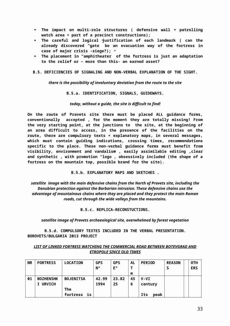
the specialist’s explanations are absolutely necessary for the tourist in order to understand the site Pravets archaeological site is placed on top of a hill, part of the mountain chain surrounding the valley adjacent to the site.Pravets site had been inhabited since the oldest times and until the recent past.The site is part of a similar fortification chain, with defensive role, similar to other defensive Roman fortifications chains placed on the East-West mountain range delimiting wide valleys in the Balkans, where there had been practiced the ancient commercial roads with the Orient, the Mediterranean and the North of Europe. The site is situated at about 10 km away from Borovets town, where the local museum is open (it has a visiting program at the weekends ?) , which scientifically manages the site.The road is partially in good condition, but it is made , on the mountain slope, of a mere foot trail.There are no facilities of any kind within the site area. There is no drinking water source on the site.The site can not be visited and it presents the risks of assessment ambiguities or even accident.The road to the site is superficially marked and there are no guide marks or non-verbal presentation of the site elements.There are no structures to avoid accidents (accidental falls) on an unstable and rough relief.The archaeological site is unsystematically exploited, it has a multi layer structure, it is exploited only to a small extend and it presents multiple dating and classification uncertainties regarding the already discovered elements. There are important landmarks on the site which are only presumed , or only on the way of being identified.The site animation starts from scrap and it is wanted a universally applied model for sites similar as algorithm. There are important landmarks on the site which are only presumed , or just under way of being identified .
D.2. IDENTIFICATION ERRORS AND UNCERTAIMTIES OF THE ARCHAEOLOGICAL SITE.
The South-West corner of Pravets site
D.2.a. PREHISTORY OF PRAVETS SITE.
huge rocks in the North of the site, probably dislocated by old tectonic movementsthe “offer” of Pravets location is a special one: excellent observation point, isolated place, lending itself to fortification, skillfully masked by the forest vegetation, signaling connections at great distances, solid structure of the mountainous massif, rich sources of construction materials around. All these can presume the sit inhabitation since the oldest times, with the purpose of shelter, refuge, cult place or provisory military camp.
D.2.b. THE THRACIANS FROM PRAVETS.
the center of the archaeological site, where there have been emphasized Thracian ruins (sanctuary)
According to the evidence proved by the specialists, the Thracians have attributed Pravets location a special place, meant for the cult- sanctuary!On the site there have been emphasized structures specific to this religious practice and we assume the existence in the area of a Thracian necropolis , or even older, in the West or North of the site.
D.2.c. THE ROMANS FROM PRAVETS.
the external walls of Pravets Roman fortification (North-West)
The Romans fortified Pravets location, integrated it into a defensive chain of protecting the mineral sources (probably!), of the commercial roads from the vicinity and as military watch point against the Barbarian invasions, later leaving the fortress after the decay of its strategic and military role.
D.2.d. THE MIDDLE-AGES IN PRAVETS.
material of archaeological interest under way of classification and scientific assessment
33

Some fortifications from the defensive chain Pravets fortification is part of , have allowed the definite identification of their inhabiting during the Middle-Ages. Although this evidence is still missing from Pravets site, we can presume the use of the location as a temporary refuge place, shelter or hideout, which explains the “spareness” of evidence.
D.2.e. THE LOCALS AROUND PRAVETS-ULUI.
thick forest vegetation around Pravets site
There have been civilian settlements around Pravets site, obviously, since the oldest times, which must be thoroughly studied in order to discover connections with the site. We consider plausible that the locals must have used the site as refuge or temporary shelter, or as source of construction materials for their own houses, which remains to be proven.
D.3. CIRCUMSTANTIAL DIFICULTIES , UNSATISFIED REQUIREMENTS .
Assessment of the elements of touristic interest on Pravets site
D.3.a. POTTERY , COINS AND WEAPONS FROM PRAVETS AREA.
any artifact can have scientific value….
=the pottery discovered until now on Pravets site is in accordance with the site’s division into periods by the specialists, except for the Middle-ages, where evidence is still being looked for;=the Greek pottery (fragments) identified on the site is - definitely!- of import, without a special value in defining the site;=the coins identified on the site are qualitatively and qualitatively insufficient to describe the site evolution =the weapons identified (“the arrows’ clearing”) are also insufficient .
D.3.b. CONSTRUCTION TECHNIQUES AT PRAVETS.
“lime chest” remnants , according to the specialists
=the main construction material at Pravets site was the local stone, rudimentary disrupted, of unequal sizes, but of good quality.=the binder was diverse (mortar, earth/ clay) adapted to the offered local resources .=the bricks are scarce, the tiles are missing, and the use of wood - presumed!
D.3.c. ARHITECTURE ELEMENTS AT PRAVETS.
Studying the site….
Virtually there have been designed solid structures, with thick walls, incorporating the rocks from the site, relief adaptation and obeying the elements destined for each structure.As well as general plan , the site is an adaptation to circumstances, with a built precincts, surrounded with defensive wall.
D.3.d. ANCIENT FACILITIES AT PRAVETS.
assessing “the drain holes”(!!!)
The storage tanks for pluvial water have not been yet discovered ! “the drain holes” for pluvial water can also be interpreted as wooden beam support ; The central infrastructure without doors can be a warehouse of perishablke materials ( food); The exterior site structures can be warehouses, cattle pen, civilian shelters.
D.3.e. ROADS AND “GATES” AT PRAVETS.
measurements on the access roads to the site
34

The site has at least TWO “gates”, one of which having been already discovered (South-East); The site has at least one access road, possibly split towards the TWO “gates”; It is necessary to identify the main Roman road from the valley adjacent to the site; It is necessary to identify the “crest” road (possibly!) connecting the fortifications.
D.4. THE COSTS/PROFIT BALANCE IN THE TOURISTIC PRESENTATION OF THE SITE.
establishing and annotating the GPS route towards Pravets site
D.4.a. DEFINING THE IMPORTANCE OF PRAVETS SITE.
satellite map of Pravets site in the context of the valley monitored by the fortification
Pravets archaeological site is a typical example of Roman fortification of small sizes, placed in a mountainous range, part of a defensive chain of fortifications in the Balkans, having the role of protecting the mineral resources from the area, the ancient commercial roads (including their taxation!) and of signaling the inimical military invasions ;
The archaeological site is in full archaeological exploitation , partially investigated, being thus a “vivid” site in “wild” state, eligible to the thematic tourism presentation;
Placing the site in an exceptional natural surrounding increases the scientific value of the site and offers alternatives for the historical tourism on the site.
D.4.b. PRESUMED “COSTS” OF PROFITABILITY OF PRAVETS SITE.
studying the small deposit of identified bricks on the archaeological site
=in order to be accessed by the tourists, Pravets archaeological site must be urgently systematized, and this endeavor requires important material, time, personnel resources;=the site requires the regulation of the access road, endeavor which requires significant material resources;=continuing (unavoidably!) the scientific research at the archaeological site requires significant material, personnel and planning resources;=connecting the site with the starting point, the neighboring municipalities (having similar sights) and with historical sights similar to it also depends on great material, design and achievement resources ;=endowing the route and the site with essential touristic facilities involves significant material resources ;=the site animation requires great design, achievement and location resources, including resources of promoting the site.We estimate the minimum necessary of resources to rehabilite Pravets archaeological site to 1,000,000 euro!
D.4.c. THE PRESUMED “PROFIT” OF CAPITALIZING PRAVETS SITE.
Achieving a universally applicable model of systematic scientific research ; Achieving a portfolio of exquisite scientific discoveries, part of the National Cultural Bulgarian
Patrimony; Developing Borovets history museum to national dimensions; Promoting ethnographic, culture, civilization and local traditions values; Capitalizing the natural environment to the benefit of mountain tourism ; Creating a cooperation model between the municipalities with similar/identical potential to the
benefit of regional development of the area; Absorption of European funds to the benefit of rehabilitation, promotion and capitalization of the
Local Cultural Patrimony; Creating a universally applicable animation model of an archaeological site- historical
monument; Developing inter/national thematic tourism, educational and recreation tourism , source of local
and regional economic development; Creating new working places and opportunities to capitalize the local potential.
scanning Pravets site
35

D.4.d. THE PURPOSE OF PROMOTING PRAVETS SITE.
general satellite map of Pravets site
Placing an important touristic brand on the map of Bulgaria; Attributing the eligibility sight in the absorption of European funds; Presenting a model of systematic archaeological research; Presenting a model of regional cooperation in order to capitalize the historical potential of the
region; Presenting an animation model for a touristic sight to the benefit of thematic tourism; Attracting incomes from tourism and services to the benefit of local community;
D.4.e. CONNECTING PRAVETS SITE TO BOROVETS LOCATION.
the modern and equipped buildingof Borovets museum
Assigning Borovets history museum as starting point for the organized and planned groups of thematic tourists is based on:
The museum manages Pravets archaeological site; The museum has qualified, competent, dedicated and involved in the field personnel; The museum already has the necessary equipment for a previous complete presentation; The museum can place itself centrally in the “menu” of complementary offers ; The museum has proven preoccupation in researching Pravets site until now.
D.5. OMITTED METHODS AND ASSUMED RISK.
View from the inside of Borovets museum
D.5.a. SATTELITE STUDY OF PRAVETS SITE.
generala satellite map of Pravets site
It can emphasize ensemble aspects and details from the satellite perspective, very important in order to complete the data about the site (location, vicinities);
Ofera posibilitatea unor masuratori precise si stocarea optima a datelor obtinute Este o metoda precisa,facila si sugestiva de cercetare si promovare a sitului.
D.5.b. GEO-MAGNETIC SCANNING OF PRAVETS SITE.
geo-magnetic scanning = very valuable for the research of archaeological sites
It is a modern and efficient method of non-invasive archaeological research ; It is a precise method of assessing the structures still undiscovered on the site ; It can decisively influence the planning of the archaeological research and can justify the
opportunity and volume of this research by conventional methods; It can generate a map of the site, using comparatively advantageous economic resources It preserves the covered structure of the archaeological site, but allows its knowledge.
D.5.c. DETECTION OF METALS FROM PRAVETS AREA.
Examples of metal detectors
The authorized , legal and competent use of metal detectors can emphasize artifacts important to define the site and – especially!- for its division into periods;From our practice, using metal detectors must be made under the authorities’ control, because there may be the possibility of some important, undeclared discoveries.
D.5.d. GEOLOGICAL ANALYSES IN PRAVETS AREA.
natural profile in the rock on whichPravets site is situated
36

The geologists can identify specific structures important for the site ( fissure caves with cult role, monumental rocks, traces of tectonic movements, rectified rocks).
D.5.e. SECTIONS IN THE SITE STRUCTURES.
Measurements and GPS mappings on the access road to the site
The already identified Roman road segment definitely must be analyzed also from the point of view of a cross-cut section in it, capable to offer other important data regarding it’s the division into periods of the site ;
It is also recommended to practice cross-cut sections in ALL access roads to the site, among which some lend themselves to be ancient Roman roads covered and dislocated by tectonic movements or by earth flows, already demonstrated within the site;
A section in the presumed location of the “gate” from the North of the site could clarify its existence and importance or – at least!- the near wall structure under the limestone level of the site and even under the wall infrastructure ( we are looking for the potential evidence of some structures, older, reused, typical for the multi-layer sites , such as Pravets archaeological site;
A probing dig in the “arrows’ clearing” can clarify its role as weapons warehouse/hideout or battle filed for an ambush;
A probing dig, decided upon only in cooperation with the geologist, in the North or West of the site, in the very heart of the displayed rocky massif, could clarify the possibility of the existence of a Thracian necropolis or even older in this place.
Moreover , it is possible a section at the level of one of the buildings exterior to the site, to emphasize its purpose and the potential artifacts that could be still there;
A section of the area “in front” of the external North-West wall (the one with the “round corner” and the “drain holes” present here) , could display the complexity of the role that wall had , that we consider simply exquisite from the archaeological point of view.
E. PRESENTATION STRUCTURE OF PRAVETS SITE IN TOURISM PROFILE.
each archaeological landmark has its own story
E.1. ELEMENTS OF TOURISTIC INTEREST IN THE AREA OF THE ARCHAEOLOGICAL SITE.
massive walls, solid stairs, stones all around
E.1.a. PRAVETS ARCHAEOLOGICAL SITE.
The “gate” in the South-East of the site, ancient access road into the fortification, possibly connected to the already identified ancient (Roman) road antic(roman)
The stonework structures/the infrastructures at the left of the South-East “gate”, in the West area of the site, their impressive size, the strange parallelism of some infrastructures separated by narrow spaces, integrating the rocky support of the mountain into the structure of the buildings on the site;
(optionally) the stonework structures at the left of the South-East “gate”, now being scientifically exploited, identifying some structures in the depths of the Eastern area of the site still scientifically unprocessed, the deposit of Roman bricks identified on the site and their purpose in achieving the access road or the floor inside a privileged dwelling;
The site center displays a fragment of the Thracian structures already identified on the site, differentiated by the structural context of Roman type by the means of achieving the infrastructures and the used binder;
Still in the center there is situated the infrastructure of a building lacking the door (probably covered with a wooden floor, with the entrance in its superior part), meant for depositing perishable food resources;
in the West of the central area there can still identify the place of the discovery of big clay pots having the obvious role of preserving provisions;
the North-West area of the site , the inferior level curvature of the plateau, where there are emphasized the massive defensive walls , on whose external side there are holes lending themselves to wooden beams or even drain holes to evacuate the excess of pluvial water ;
37

(optionally) the possible positioning of the North “gate” of the site with opening to the access road to the site , profoundly modified by landsfalls and tectonic movements;
(optionally) in the Eastern external area of the archaeological site , on its inferior level curvature, the tourist is presented the dislocated infrastructures of some buildings whose role was of warehouse or dwelling, frequently discovered adjacently to some ancient fortifications;
in the Northern area of the site there is displayed the integration of the rocky support of the mountain into the internal walls structure and even the presence of a buttress to stabilize the wall;
thus the site is accessed by the branching of Roman road found on the superior level curvature, through the already identified “gate”, it covers the western area of the site, then the plateau center of the fortification, goes down on the inferior level curvature from the North-east of the site and exits from the site through its presumed North “gate”, on the Northern access road, inferior branch of the main road to the site, deeply modified by landfalls and tectonic movements.
attempt of assimilating the site structure
E.1.b. ACCESS WAYS TO PRAVETS SITE.
steps towards the unknown
=from the main road covering the valley adjacent to the site, from Borovets location , splits into a secondary road , in a relatively good condition, which goes to the East at the foot of the mountainous massif on which the site is placed. In full ascent of the secondary road, from which a forest road separates still to the East, a road accessible to vehicles, leading towards North, to the hill of the archaeological site. At the organizing point of the game location , the forest road is replaced by foot trail , accessible to spoecial vehicles or animal drawn, avoiding the site on the crest to the left of the mountain, through the West of the site, then it climbs with difficulty through the areas dislocated by landfalls and earthquake, through massive rocks, as well as numerous stones detached from the stonework structure of the fortification. This road goes further the site, to the North, then comes back to the site, as foot trail, covers the North area of the site, through massive rocks and accesses the site through a still unidentified “gate”.=on the very same above mentioned road, at the West of the site and at the point of maximum closeness to its western side, a wild shortcut to the site splits, suddenly ascending, ending in the already identified segment of Roman road, from where one can easily access the South-East “gate” of the site, covered by the building materials crumbled on the site and the archaeological excavations from the area.=of the entirely described route, the forest road accessing the site starting from the secondary asphalted road, is graveled and stabilized for off road and animal drawn vehicles, but only on its eastern branch, accessing the site from the south, there can be identified remnants of the Roman road, with an average length of 120 cm, made of stabilized stones and even repaired where the road started to fall towards the West, on the steep slope of the hill. =the route to the site is therefore made of the asphalted main road from Borovets, crossing the valley towards North, then its secondary branch, still asphalted (leading to a special location from the area!), then the forest road branch aiming to the North, avoiding to the east and continues at the game cabin, from were it turns into foot trail, avoiding the site at the west of the hill, but splitting in the closest point to the site by a difficult shortcut cutting across the identified Roman road segment, enters the South-East “gate” of the site and exits at its North, through a foot trail dislocated by landfalls and earthquakes, going down at the West of the site until the splitting point of the foot trail mentioned above, later integrating into a road common with the segment initially described, towards Borovets location, the ending/beginning point of the thematic trip.
E.1.c. STARTING POINT-BOROVETS.
the museum similar to a house…
=Borovets history museum is a modern building , situated in the city center and flanked by the organized esplanade ,lending itself to events ( folk fairs, handicraft exhibitions, local traditional shows) with an impact on the touristic presentation;=the museum has modern facilities , well preserved to the visitors’ benefit, and it has a good visiting inner circuit and a body of showcases as central core, around which it revolves the inner visiting circuit of the museum;
38

=at the entrance there is a point of reception, identification and specific activities of the museum, to its left an area of protocol, relaxation, study, to the right the toilets and at the center the proper access into the museum; =after covering the inner route of accessing the museum permanent exhibition , there can be used a mini conference hall, comfortable and integrated into the visiting circuit of the museum, where there can be heard professional presentations or watch thematic films=the exhibits are well selected, mixed with explicit texts, maps and reconstruction sketches;=centrally, in the permanent exhibition there are placed funerary replicas and suggestive reconstructions; =right at the museum exterior there is a car park and the starting point for the access road to Pravets archaeological site;The museum requires a visiting program at the weekend and presenting the exhibits in foreign languages (at least! Bulgarian, English, German, French).
E.1.d. ALTE SITURI VICINALE SITULUI DE LA PRAVETS.
defensive strategies in the Balkans
subjacent site to Pravets archaeological site there is the building complex of civilian purpose ( warehouse, shelter, dwelling) from the exterior Eastern part of the site, on the inferior level curvature , still being archaeologically researched ;
subjacent site to Pravets archaeological site, at its external Northern part, containing the access road modified to the North “gate” and the complex of dislocated rocks, lending itself for necropolis, still being researched;
the tumulus relatively close to the site , whose archaeological section verifies the seismic antecedents of the area;
subjacent site to Pravets archaeological site , at the foot of the mountain, to the south, on the place where the site is located, conventionally named “the arrows’ clearing” (weapon warehouse, fight, ambush?);
fortification chain on the placement direction of the mountainous massif where Pravets archaeological site is placed, made of similar fortifications(Chertigrad,Ostrum si Urvich),part of the Balkans defensive chain;
fortification from the mountainous chain, at the West, opposite Pravets (Kale/Elin Pelin), the material evidence of the multiple defensive chains of fortifications from the Balkans;
main Roman road (presumed !) in the valley adjacent to the site, to its West, for the Botevgrad-Etropole route;
mining surface excavation (copper) at the South-West of the site, relatively close to it, possible reason for placing these military protection structures of the mineral resources and commercial/military roads in the area, as well as of signaling the inimical/Barbarian invasions.
E.1.e. NECROPOLIS ,TUMULI AND CIVILIAN SETTLEMENTS IN PRAVETS AREA.
unnatural rocks placements in the North of the site
tumulus relatively close to Pravets site , certifying the tectonic movements from the area; fissure caves on the western slope of the mountain where Pravets site is located, some apparently
artificially closed, for the protection of the tomb(?!); area of stony massif dislocated after landfalls or earthquake in the North of the Pravets site ,
lending itself for a necropolis, still being researched .
The presence of a necropolis in the area of a Thracian sanctuary would be logically justified , but it has not been confirmed by the specialists yet .The presence of a tumulus in the relative vicinity of Pravets site can support this hypothesis.
E.2. ELEMENTS OF INTEREST IN THE GEOGRAPHICAL AREA OF PRAVETS ARCHAEOLOGICAL SITE.
Pravets area can still hide many scientific surprises
E.2.a. THE VALLEY WATCHED BY PRAVETS FORTIFICATION.
39

The valley and its guardian – Pravets fortress!
From the relief point of view, the Balkans are segmented by long mountain ranges, on the East-West direction, delimiting between them wide valleys with the same geographical orientation ;
Since the oldest times these geographical facilities have been identified, used and developed on two levels:
=the inferior level, where the proper road was situated , with the commercial, military or mixed destination;=the superior level, where there were situated the fortified point of watching, monitoring, checking, taxating and protecting the traffic on the adjacent main road;
The Roman Empire had a wide network of roads of all types ( commercial, military, imperial and mixed ), connecting the vital centers of the Empire with its provinces or making the junction with similar roads from Asia, Africa and Europe;
The valley adjacent to Pravets site houses a main Roman road connected to the Mediterranean, Asia and the North of Europe, destined to the reckonable commercial exchanges, the circulation of military troops and – not lastly!- capitalizing the mineral resources from the relative vicinity of the fortified defensive chain.
The valley presented and still presents many civilian settlements, having favorable conditions to their development. Hence the possibility of refuge for the civilian population from the valley at the shelter of the Roman fortifications on the crest or (likely!) even inside them.
E.2.b. THE MOUNTAIN RANGE WHERE PRAVETS FORTIFICATION IS SITUATED.
a Roman road at the foot of the mountain
The mountains from the Balkans were an obstacle in the path of the Barbarian invasion and the narrow passages were guarded by Roman fortification of Ihtiman type;
These mountains were also allowing placing on the crests the multi purpose fortified defensive chains, including the role of signaling the danger identified in the valley;
These mountains represent a huge source of building materials (stone, wood), as well as important mineral resources, so necessary for the Empire;
The positioning of these mountain ranges in parallel rows, East-West oriented, allowed the strategy of creating some successive defensive chains preserving the Romans’ presence in the area, even under the devastating impact of the Barbarian invasions from the North of the Danube.
These important geographical elements can and must be used in the touristic presentation of Pravets site, integrating part of the system .
E.2.c. THE MOUNTAINOUS AREA ADJACENT TO PRAVETS SITE.
a country of mountains, a mountain of history!
Pravets archaeological site is situated on a rocky massif, covered in a thin earth layer and a rich forest vegetation.Knowing the Romans’ preference for wide spaces, one can not exclude that in the antiquity , the mountain slopes must have been artificially deforested, to expand the watch area, obtaining building material (wood) and using the wood as heating source inside the fortification.The forest present today in the area lends itself to mountain tourism and even some sport activities (backpacking, hunting) .The mountain offers special watch points, in all directions.This mountain is integrated into mountainous ranges, the source of development for mountain, historical and game tourism, according to the tourist’s options.
E.2.d. MODIFICATIONS IN THE GEOLOGICAL STRUCTURE OF PRAVETS AREA.
dislocated rocks in the North of Pravets site
40

The rocky massif where Pravets site is situated is full of fissures and landfalls, only partially stabilized by the thick mountain forest;
There appear small fissure caves or chaotic piles of instable rocks , ready to tumble down into the valley;
The multi-layer structure of the rocks has most diverse spatial orientations, proving a very powerful earthquake, determining the position changes, the dislocations or even their fragmentations;
Obviously, these rocks were the main source of achieving the Roman fortification, of the Roman roads or – in the broader sense- the valuable mineral source (copper)
There is (still unverified) hypothesis of sheltering ,at the foot of the rocks or in the small caves, a small pre-roman necropolis, possible supplementary attraction for the thematic tourist.
E.2.e. FAUNA AND FLORA OF PRAVETS AREA.
the last guardian from Pravets
The natural landscape from the area of Pravets site is ideal for mountain tourism, but also for including recreation and rest moments on the historical visiting route of the site;
The thick forest, the hoarse grass, luxuriant bushes and the moss/lichens grown on the massive rocks, create an unforgettable scenery .
It is an adequate location for small and average game, with all the annoying presence of bugs (mosquitoes, bumblebees, wasps) , potential danger for the incompetent tourist;
We have noticed only vividly colored lizards and no snakes around; A merely landscape requirement id regularizing the wild and anarchic forest from Pravets site
area, forbidding fire , as well as controlled deforestation and parceling allowing the site exploitation and display.
E.3. ELEMENTS OF INTEREST OUTSIDE THE ARCHAEOLOGICAL SITE, COMPLETIONS OF ITS VALUE.
anxiously waiting for meeting the site
E.3.a. ANCIENT AND MODERN ACCESS ROUTES PRAVETS AREA.
GPS route of Pravets site assessment
=the GPS route made for exploring Pravets area emphasizes at the South the presence of the common forest road , its branching into two other access routes to the site, corresponding the access “gates” and the thorough researches outside the site in order to identify new archaeological formations; =particularly interesting is the route segment on the North-West axis on the right of the map that we assume , with a great probability, as the only Roman route to access the site, possibly prolonged downwards and researched by the specialists in order to be confirmed. This segment is actually contained by the already identified roman road!
E.3.b. GEOLOGICAL STRUCTURES ADJACENT TO PRAVETS SITE.
rocks crumbled on the steep slope
It is absolutely compulsory the geologists’ expertise in order to characterize the geological structure of Pravets location and signaling by the specialists of the possible anomalies (caves, seismic dislocations, cleats, raw human processing ).
E.3.c. SIMILAR FORTIFICATIONS CLOSE OR COMPLEMENTARY TO PRAVETS SITE.
the south of the Danube is full of defensive Roman structures organized in defensive chains
E.3.d. CIVILIAN SETTLEMENTS IN THE SITE AREA.
game cabin in Pravets area
41
in the area there were and are present mountain civilian settlements (villages) , isolated (hunting?) cabins and remnants of their activities (pastures, forest exploitations).There are presumed and even partially identified old civilian settlements in Pravets site area, especially at the foot of the hill where the site is situated.Preliminarily to the achievement of the site animation, there must be established with the help of Borovets museum specialists if these settlements imported building materials from the site or if there is scientific evidence of the existence of ancient settlements, in order to be added to the “great” circuit of the touristic road on the site, according to their touristic or historical importance
E.3.e. MOUNTAIN TOURISM.
descending towards the inferior structures of the archaeological site
The advantages of mountain tourism are obvious for any tourist; starting with the simple spending of his free time in a colorful, intensely oxygenated scenery, favorable to moderate physical effort, up to mountain routes meant for extreme sports, skiing, sledging, paragliding – all offer , individually or complementarily to accessing another type of touristic sight (ethnographic, historical), a chance to the benefit of occasional or organized tourism, favoring the appearance of touristic contractors and the economic development of the respective area.
Pravets site is situated in a geographical position favoring simple mountain tourism, in the form of mountain trip, visualizing the panoramas from several points on the site, as well as the possible participation in halts of adjustment, recreation, recovery and catering, with or without traditional/ethnographic profile.
On any of the proposed routes for accessing the archaeological site =the “small” route of direct access to the archaeological site , by which the forest is crossed from the Western slope, with adjustment point at the game cabin at the foot of the hill; =the “average” route expanding the visulizing of the area to significant vicinities of the site; =the “big” route including the historical sights similar to the site, situated on the same mountain range ( from Chertigrad to Urvich), maybe even Kale, there can be applied mountain tourism elements (from the systematizing of the site animation point of view, this form of mountain toruism is included in the “GATE OF THE ENCHANTED FOREST”, the route allowing visualizing the forest, local flora and fauna, the geological formations present on the area , even some locations of archaeological interest (“the arrows’ clearing”) );
Along with historical and ethnographic tourism, mountain tourism is already accepted part of capitalizing Pravets touristic project, subsumed to the assigned touristic sight.
E.4. NON-VERBAL PRESENTATION OF THE ARCHAEOLOGICAL SITE.
Western panorama of the site
E.4.a. SIGNALING, GUIDANCE AND MAPS ON THE ACCESS ROUTE.
the road winding through the forests and rocks
today , the route between Borovets-Pravets and the archaeological site has no optimal guidance of presentation form for the site.Along the entire stages of the route, we come up with non-verbal presentation forms for the site, guidance forms and unconventional animation(replicas, simulations, games).All these animation forms are addressed to the tourist in:
Several foreign languages; Present contact data ,including emergency calls (in the case of an accident!); They have simplified and suggestive character , resistant to the environment and vandalism
impact.“THE GATE OF BULGARIAN HOSPITALITY”(including the museum, ethnographic fair and the handicraft exhibition + lake/park/hotel/restaurant) is richly signaled by:
General map of the area marking the touristic sight, especially the main one – Pravets archaeological site;
42

The map of the thematic route connecting Borovets (stating point) to Pravets site, including the three proposed levels (small-average-big!) for the route, with the special signaling of the archaeological site ;
The facilities map for tourists (parking ,sanitations, phone/internet access); Complex presentation (text + image ) of Borovets museum; Presenting the ethnographic fair and handicraft exhibition ; anti-vandalism rules, support contacts, transportation routes .
The ethnographic fair/handicraft exhibition, bi-annual event organized by the local administration, can involve the tourist in specific folk games, preparing the food, creating hand-made products, trying on costumes and practicing local traditions.The museum can organize ( apart from the classical exhibits presentation),thematic conferences, films, leaflets, DVDs/CDs about history , especially by the activity program of the museum at the weekends.
E.4.b. SIGNALS, GUIDINGS AND MAPS AT PRAVETS SITE.
a site abounding in various structures
signaling/guidance/identification/presentation points of general/individual/personalized character of Pravets archaeological site:
=at the starting point, near Borovets museum;=at the access point at the means of transportation station for the site;=at the starting point of the forest road ( including all junctions of the main road/ secondary road + secondary road/forest road + forest road/foot trail );=at the entrance through the “gates” ; THE ENDLESS VALLEY + THE ENCHANTED FOREST + OF PAST TIME and (optionally) at the CHAINED CITIES;=at the “arrows’ clearing”;=at the already identified Roman road sector in the South of the site;=at the civilian ruins outside the site, to its East;=at the already discovered “gate” from the South-East of the site;=at the stonework structures from the East of the site, immediately to the left (interior) of the South “gate”;=at the bricks deposit, superior to the stonework structures at the east of the site;=at the ruins of the Thracian wall from the site center;=at the doorless infrastructure fat the site center;=at the place of identifying the clay jars with the role of provisions warehouse from the center-East;=at the buttress from the North of the site;=at the inferior external wall at the North-West of the site;=at the “drain holes” from the external North-west wall;=at the assumed “gate” in the North of the site;=at the beginning if the foot trail from the North of the site.
maps and other signals:=at the starting point(Borovets)=at the entrance of the site through the South-east “gate” ;=in the site center, near the Thracian sanctuary;=on the inferior defensive level from the North-West of the site.
Detailed or inter-active texts(with the explanation on the back!):=at the starting point(Borovets museum);=at the entrance and exist of the site;=in the site center.
E.4.c. REPLICAS,SIMULATIONS AND RECONSTRUCTIONS.
REPLICAS:
Ancient carriage, full of building materials, at the already identified Roman road sector, at its repairing stage + pile of rocks and stuffing material for its repairing;
The hearth at the level of the buildings outside the site, at the east, on the slope; The wooden gate , at the level of the South-East “gate” of the fortification; Big jar/s to deposit provisions , at the location of the discovery of the authentic one in the
center-left of the site;
43
The lime chest and building materials immediately to the left after entering the site through the South-East “gate”;
The wooden palisade on the exterior wall of the inferior defensive level from the North-west of the site;
Fire wood faggots – scattered on the route and on the site; Wooden turret / tower to watch the valley and fire signaling of the danger, at the West of the site,
inside it. Roman flags on the fortification exterior walls;
RECONSTRUCTIONS :
The patrolling flooring supported by wooden beams inside the defensive wall in the North-West of the site, at the “drain holes” level;
The cult item in the altar of the Thracian sanctuary, similar to the original model found at Borovets museum;
The floor made of massive wood with the access hatch vertically to the stairs over the doorless infrastructure from the center-left of the site;
The stairs made of massive wood to climb onto the coping of the defensive wall at the inferior level at the North-West of the site;
The hearth with trivets at the site (randomly)+Roman clay jar near the hearth.
SIMULATIONS:
Roman patrol ranging along the interior defensive walls; Roman soldiers eating, resting around the hearth ; Thracian rider patrolling, at the foot of the hill on the foot trail .
the North-East of the site, the inferior landing
E.4.d. INTERACTIVE WORKSHOPS.
a corner with problems in the North-West of the site
WORKSHOPS at Borovets museum: Primary processing of an artifact discovered on the archaeological site; Reconstructing a fragmented pottery artifact ; Drawing and sizing an artifact; Assessing an artifact.
WORKSHOPS at the ethnographical fair at the starting point : Bulgarian folk dances; Wedding entourage or another ethnographical local custom; Trying on local folk costumes.
WORKSHOPS at the handicraft exhibition: Pottery wheel/ loom/ chisel/axe wood carving; Decorating by cuts, painting, adding material on a handicraft item.
Game WORKSHOPS: Presenting and testing game equipment ( without fire weapons!); Game meals at the cabin.
Historical WORKSHOPS at Pravets site : Military patrol on the site perimeter, watching the valley, checking the gates; Funerary Thracian ritual(!).
E.4.e. SOUVENIRS DEPOSITS TO THE TOURISTS’ BENEFIT.
each fragment may have its own value
there can be built a deposit of materials having no archaeological value, made of pottery fragments, brick or stone crumbs, which can be accessed by the tourists who are allowed to reasonably keep some artifacts as souvenirs.
44

At the starting point (Borovets museum) there can be created a selling point with souvenirs, replicas and promotional materials.
E.5. VERBAL PRESENTATION OF THE ARCHAEOLOGICAL SITE .
exemplary cooperation among archaeologists, architects and site promoters
E.5.a. VERBAL PRESENTATION STRUCTURE OF PRAVETS SITE.
Touch me! Taste me! Smell me!
VERBAL ANIMATION OF THE SITE:
THE GATE OF BULGARIAN HOSPITALITY General character presentation at the starting point level:
= site name, structure and history;=the division into periods of the site;=the site archaeological research and the results of this research;=site importance, its historical connections, its value as touristic sight.
Borovets history museum presentation:=role and importance of the history museum;=museum involvement in the scientific research of Pravets archaeological site;=processing and displaying the site artifacts;=documentation of the archaeological site films, leaflets, maps).
The ethnographical fair and handicraft exhibition presentation :=folk traditions and their local sources;=explaining the structure and significance of the folk dance;=perennial techniques in the Bulgarian folk crafts;=explaining the local folk costume structure
THE GATE OF THE ENDLESS VALLEY Presenting the route to the site :
=relief elements present on the route to the site;=correlating the relief with the history of the archaeological site;=mineral resources in the area, possibly establishing the presence of the Roman fortifications;=the role of the relief in developing a local civilization, of occupation and intrusion within the area .
THE GATE OF THE ENCHANTED FOREST Presenting the natural scenery surrounding the site:
=structure of the natural scenery where Pravets site is situated (fauna and flora);=game resources of the natural scenery from the site;= geological structure of the area and its changes;= touristic resources of Pravets natural area.
THE GATE OF PASSED TIME Archaeological site presentation
= topographical and geographical location data of the archaeological site;=dividing into periods the site and describing each period proven to have existed on the site;=significant archaeological site landmarks presentation ;=construction techniques on the site and adapting them to the local resources, technical solutions;=facilities offered by the site, in each epoch from its historical structure;=vicinities and connection of Pravets site;=the site perspectives from the scientific and touristical point of view .
+(optionally) THE GATE OF THE CHAINED CITIES Expending the “average” to the “big” route according to the option of the tourist group (tumulus,
similar fortifications ,copper mine)
E.5.b. WEIGHT CENTERS AND FOCUS ON PRAVETS SITE PRESENTATION.
45

the archaeologist and the curios tourist
Favoring the multiple strategic role of the fortification by the surrounding relief elements; Inventory of the local resources and their use in Pravets location; Integrating Pravets site into the defensive Roman chains from the Balkans; Standardizations and algorithms in the architecture, construction and use of Pravets fortification; Adapting to resources on Pravets site; the multi-layer structure of the archaeological site and its particularization; Pravets site time-line and its particularization ; The importance of Pravets archaeological site; Ancient roads and their importance; their protection, watch and taxation.
E.5.c. SURPRIZE ELEMENTS ON PRAVETS ARCHAEOLOGICAL SITE .
Measurements on the access road
Is it a roman fortification or a city? How many access Roman roads are in the fortification? How many fortifications are on the site? How many “gates” does the fortification have, where are they and what was their purpose? Where is the drinking water source from the site? How was made the access between the fortifications from the defensive chain? Was there a necropolis near the site? Where are the Middle-Ages on Pravets site? How can the fortification be besieged and to what purpose ? Where is the ancient bricks factory? Where is the roof of the buildings on the site? Was the fortification functional throughout the entire year ? Were the refugees accepted inside the fortification? Where are the traces from the limestone level? Were there buttresses? Was the slope forest permanently there and why? Was there a pre-history of the site? What qualifies the site for the permanent human presence since the most ancient times?
These “surprises” can receive scientific answers in the shortest time, by the systematically continuing the archaeological research on the site.Avoiding the approach of these aspects from the part of the thematic tourist, they can be assumed with balanced scientific speculative role, skillfully clarified in the verbal presentation of the site or even asserted as challenge inventory, waiting for an answer from the specialists .
E.5.d. INTER-ACTIVE PREZENTATION OF THE SITE.
the specialist’s description can clarify the structure
Some non-verbal signalings frontally present a text/image and questionnaires whose answer can be accessed by the tourist on the back of the post
Some non-verbal signalings of touristic landmarks have displayed a numeric code which offers supplementary vouchers to the tourists, turned into thematic bonuses (DVDs, CDs, flyers, maps) at the starting point;
Turistul va fi incurajat sa atinga exponatele,sa le examineze sumar si precaut,sa poate realiza schite/fotografii si masuratori comparative ale acestora;
The tourist will fill in , at the end of the visit, a feed-back questionnaire concerning the quality of presentation, accessed sight, comfort offered by the facilities, his intention of coming back and comments/suggestions/personal criticisms ;
Defining some structures will be initially left to the motivated assessment of the thematic tourist and only later justifiably corrected by the guide;
The balance of the dialogue in the verbal presentation will be of a majority; For any question of the tourist, this must also offer a hypothetic motivated answer;
46

The tourist will be trained in simulations (patrolling,watch and daily activities)
E.5.e. QUESTIONS AND ANSWERS, PREVENTIVE STATEMENTS (examples !).(of the type : “the guide asks, the tourist answers!”)
Was there preferable a siege to abandoning the fortification by its garrison? How could the defensive chain react at the moment of a Barbarian invasion? How could be noticed the displacement of a big inimical military body through the valley? Was the fortification abandoned and for what reasons? Why was the Thracian sanctuary located on the mountain/hill? How was the stone necessary for building the fortification obtained? What differentiates the Roman “field” fortifications from those placed on the hill/mountains or in
the passes? Which could be the roles of a Roman fortification in a defensive chain ? What is missing from the present archaeological inventory of Pravets site? Which are the advantages of Pravets location for the Thracians/Romans/medieval people and…
contemporaries?
any detail has a meaning
F. DETAILS AND JUSTIFICATIONS IN THE TOURISTIC PRESENTATION OF PRAVETS SITE.
F.1. USING THE VULNERABILITIES TO THE BENEFIT OF PRESENTATION.
F.1.a. LISTING THE VULNERABILITIES FROM PRAVETS SITE.
PERMANENT VULNERABILITIES:
Pravets archaeological site isolation; Difficult access to Pravets archaeological site ; Lack of drinking water source ; Structural monotony of the archaeological site; Relatively high cost for capitalizing the archaeological site in the thematic tourism profile ; Controversial motivation for the touristic capitalization of Pravets archaeological site, especially
compared to other similar historical monuments; Relatively high cost of the complete scientific exploitation of the archaeological site .
TEMPORARY VULNERABILITIES:
Lack of all facilities for tourism; Lack of signaling and guidance on the route to the archaeological site; Lack of protection in case of accidents; Lack of authorized restaurants and reconstructions on the archaeological site Lack of non/verbal presentation for Pravets site; Lack of systematizing the archaeological site; Lack of touristic services by specialized operatives (transportation, accommodation, meals,
recreation, promotion); The project of touristic capitalization starts from scrap ; Lack of possibilities for emergency phone calls; Total lack of collecting garbage; Borovets museum working program at the weekend; Lack of complementary touristic offers; Lack of toruistic promotion of the archaeological site ; Necessity to continue the scientific exploitation of the archaeological site; Lack of transportation means to the archaeological site; Lack of modern scientific processing of archaeological site; Lack of connecting the site with similar neighboring historical sights; Precarious identification of some landmarks on the archaeological site; Lack of private partners for the public project of including the site into the inter/national
touristic cicuit;
47

Lack of cooperatiom with neighboring municipalities which have similar sites, capable of connecting with Pravets archaeological site.
CONJUNCTURE VULNERABILITIES;
Accessing the site only during meteorological conditions; High cost of accessing the site by the occasional tourist ; Synchronizing the GATE OF THE BULGARIAN HOSPITALITY with the touristic activity on
the archaeological site; Unbalancing the ratio costs/benefits in the case of the “big” touristic route ; Difficulty to integrate the visiting of the site into a regional touristic circuit.
F.1.b. VULNERABILITATIIES CONVERSION TO THE BENEFIT OF PRESENTATION.
The strategy of presentation and touristic promotion of Pravets archaeological site must be based on as many real tourist offers as possible, whose summation effect can induce an increased value of the sight touristic attractiveness;
It is compulsory to segment the touristic route into several “gates” thus achieving the diversification of the offer, avoiding the obvious monotony and thematic singularity of the promoted sight;
Fighting the thematic monotony of the presented sight by diversifying the touristic offer in complementary profiles: ethnographical, mountain tourism, museum, urban tourism;
The justified attributing of attractiveness terms for the archaeological site, such as;=the site is “alive” , in full archaeological exploitation;=the site is “wild”, respectively in raw state as structure , landscape context , isolation;= the site is – definitely! – a model/example of mountain fortification from a Roman defensive chain, characteristic to and defining for the Balkans;=the site is part of an exceptional network: Roman defensive chains in the Balkans ;=the site is multi-layered, allowing the time-line and it has its own rich history to display; =the site presents legends and mysteries, as supplementary attractiveness factor.
Attributing European funds to touristically capitalize Pravets archaeological site may co-interest the already eligible municipalities for an ample partnership in a similar but extended project ;
The lack of facilities and services may attract specialized private partners.
F.1.c. APPEAL TO CONTEXTS AND PROBABILITIES.
CONTEXTS:
The context of placing Pravets archaeological site in an accessible Roman defensive chain is the strong point of justifying the touristic capitalization of the site, in thematic profile;
The context of placing Pravets archaeological site in an exquisite natural scenery is also a strong point in its eligibility as important touristic sight ;
The context of an assumed common effort of several neighboring municipalities eligible on the project may confer Pravets archaeological site the anticipated touristic brand.
PROBABILITIES:
The probability of the touristic integration of Pravets archaeological sitewith local or scarce resources is virtually null!
The probability of success in capitalizing Pravets archaeological site by allotting some European resources and by public/private partnerships vitally depends on the achievement of a realistic and thorough feasibility study (there are more touristic sights rehabilitated with significant resources which remain empty because of the touristic addressability, ignored or concealed in an incorrect feasibility study )
The probability of reversing the list of touristic priorities for Pravets archaeological site depends on the way in which THE GATE OF THE BULGARIAN HOSPITALITY will be organized and achieved, which can overshadow the main touristic sight to its favor
The probability of a successful project in presenting/promoting Pravets archaeological site, as an important sight on the touristic map of Bulgaria, depends on the elements over-added to the site animation:
48

=segmenting the route by thematic “gates”, as independent touristic offers; =attributing the “back-ground” position for the scientific research of the archaeological site , in favor of displaying its animation; =including into the animation all the modern means, already confirmed as feasibility in the great thematic touristic sights (see Xanten model!).
F.1.d. ANSWER BY QUESTION.
There are universal/ unique answers to any question related to the verbal presentation of a historical sight in front of the thematic tourist:
=what else could that be? =this is a hypothesis under of of being clarified! =have you got already an answer to your question.? =how much is it prejudice and how much is it real interest in your question.? =could we develop the topic later? =is this a constructive question?
The main vulnerability at Pravets archaeological site is the perfectible answer to the thematic tourist’s questions. This requires the approach of the verbal presentation of the site as a display (conventionally assumed from the very beginning !) of its historical values, even if they are under way of being clarified. At the same time, placing into context the site presentation (geographic, historical, ambiental) may attenuate the thin structure of an expected scientific answer;
If the animation of a historical sight is efficient, then this must benefit from a real and valuable sublayer of the animation, represented by material/spiritual elements of an intrinsic scientific value, over which adding the animation confers only the assimilation of the information and a positive reaction concerning it. A too “thick” promotion layer, over a modest subject may “crack” any time and compromise the presentation. Pravets archaeological site possess a portfolio of exquisite subjects, ignored until today as touristic animation on the site. Hence, the perfectible character of the intended animation, which must be adjusted “on the run”, especially by the visitor’s feed-back and his reaction to the presentation made.
F.1.e. HONESTLY ASSUMING THE SITE VULNERABILITIES.
There have been already known some “iron” principles of promoting a subject: =the scarce physical charm can be compensated by the charm of a special character; =appreciating a characteristic depends on the assessor’s subjectivism. This subjectivism can be influenced to the benefit of a positive appraisal; =an extended and polychromic offer can blur the imperfections of each individual subject; =many assessments depend on the assessment angle!
The real vulnerabilities of Pravets archaeological site can be constructively managed by an adequate animation, as follows :
=the long, monotonous and difficult access to the site can be covered by the touristic offer of the thematic “gates” segmenting the route to the sight ; =the presence of replicas and field simulations , at the site level and in its immediate vicinities, may complete a suggestively historic picture for the thematic tourist’s perception; =the abundance of non-verbal presentations of the site, the modern concept for their editing and the judicious field location, may be an earned asset! =ensuring the cooperation with Borovets museum specialists is absolutely necessary for the commonly assumed success;
=cooperating with the local administrative authorities (not only from Borovets/ Pravets) is also necessary.
Honestly assuming Pravets site vulnerabilities is the first condition for the ambitious project of efficient animation of the site.
F.2. THE CONTROVERSY OF A PRESENTATION BAZED ON PROMOTION TO THE DETRIMENT OF SCIENTIFIC ACCURACY .
F.2.a. draft- SCIENTIFIC PRESENTATION OF THE SITE.
Pravets archaeological site is in the vicinity of Borovets town, where the history museum and the specialists involved in the site archaeological exploitation work.
49

The site is accessible and can be visited to the extend in which some facilities are partially achieved, and others will be made with local resources or European funds. The site is placed on a mountain top, in an exceptionally natural scenery.The site has proven its inhabiting since the oldest times until relatively recently, representing an excellent observation point over the adjacent valleys and mountain ranges, the relative closeness to important mineral resources, and a safe place – by its isolation and the difficult access to the location, as well as an important strategic point of monitoring the main access routes from the adjacent valley.The use of the location is presumed to have been used since pre-history, but the first certain evidence places the role of the site as Thracian cult place, by the presence of sanctuary. During the Roman period, the site was used for building a Roman fortification as part of one of the defensive chains from the Balkans, with the role of protection and watch of the main Roman road from the valley adjacent to the site, probably of taxation of the commercial traffic on this route , of observation and signaling the hostile military presence of the Barbarians in the area, as well as a refuge place for the inhabitants of the civilian settlements from the fortification vicinity.There are clues and extrapolations regarding the temporary inhabiting of the site during the Middle-Ages, probably as refuge or temporary shelter.Many of the building materials from the site had been reused or vandalized by the civilian population neighboring the site, after the decay of strategic role it had during the Roman period. The fortification is practically, situated on a small plateau, on top of the wooded mountain , and is surrounded by a massive defensive wall, presenting two access gates, one of which having already been confirmed by the specialists in the South of the site. On the access route to the site there has been identified a segment of Roman road.Inside the site there have been emphasized several structures, among which the infrastructures of several ancient buildings with various purposed, made of and adapted to the local stone resource and different binder , also adapted to local resources. Outside the site, in the east of the site, there have been identified the infrastructures of civilian buildings , used as shelter or warehouse.On the site there have been emphasized coins, various pottery – complete or fragmentary, or building materials – bricks, lime chests.The site is still under archaeological exploitation.The site presents structure modifications because of vandalizing, landfalls and tectonic movements, making thus the systematizing of the thorough research more difficult. The site is a model/example of Roman fortification from a defensive chain from the 5th century.In the same defensive wall there have been already identified three other similar fortifications, with placement and role similar to the site.Other discoveries outside the site have been incidental and are still under the specialists’ assessment.The main artifacts identified on the site are to be found in Borovets museum where they are rehabilitated and displayed in its permanent exhibition.
F.2.b. draft-PROMOTION PRESENTATION OF THE SITE.
According to the legend, when the world was made , the Balkans frowned their foreheads under the burning sun of the Mediterranean. Thus, there appeared on this forehead long wooded mountain ranges and wide valleys, containing rivers and animals and people.And from the dug holes deeply into the gorges of the valleys, the copper giants were born, who chose the mountain peaks for shelter and watch.The valiant Thracians climbed the high and mighty peaks and, in altars, dedicated their endless faith and respect to the gods . And , in the valleys, the passing of time hewed never ending roads , beaten by the sandals of the Roman cohorts, by the wooden carts wheels and horses’ hoofs. And near the rivers, there slowly appeared rivers of merchandise and shields, guarded by swords and iron spears!From somewhere, far away, crossing the blue Danube, swirls of smoke were announcing mortal dangers: the Barbarian roller was coming, on small and fast horses, leaving behind sadness and ruins. Then the people remembered about the copper giants and climbed on top of the mountains, and carved into their stone and settled there cities to face the enemy and defend their subjects. And these stone cities remained, erected on and from the very mountain, as protection and refuge, for eternity. And time went on, polishing the rocks and crumbling the walls. And the people of the Middle-Ages seldom climbed to the forgotten cities and only for a short while.
50

And today one can still see, may it be bird on the sky, the lazy round dance of the ruins, vainly waiting for the shining steel weapons from the armies in the valley. The forest is rustling in the warm wind, the grass is fighting to cross the crumbled boulders, the stone of the city partboils in the sun, and the fugitive clouds caress the Balkans of long ago , with other people and other appearances. Maybe only at night , and this just at Full Moon, on the place of the time forgotten city, there still slowly passes, tired and aimless, the last Roman soldier from Pravets, still looking for a lonely visitor, to whom he could tell the Story! Stranger, are you that visitor?
F.2.c. THE HARMONY OF THE SCIENTIFIC INFORMATION IN RELATION TO ITS PROMOTION.
For Pravets archaeological site it requires, in order to achieve a quality site animation to the benefit of thematic tourism, scientific truth, product of Borovets museum specialists’ activities, a truth systematized, as complete as possible, and well justified, as a starting point;
This scientific truth allows placing the non-verbal animation of the site at the right place, under the adequate form and –especially!- correlated to the topic it refers to.
Communicating the scientific information can be made in at least four ways:=summarily, synthetically , lapidary, briefly;=extended presentation abounding in scientific data and terms, chronologically ranged and with descriptions based on size, structure and purpose;=open to hypotheses, interpretations or scientific speculations, with prudence and stinginess;=harmoniously woven with the interactive presence of the public , based on dialogue and the public’s involvement.
As Pravets archaeological site is still looking for its scientific identity and the explanation of this identity, the presentation, animation and site promotion will be based on TELLING ITS STORY, obeying the scientific foundation of the elements of this story!
F.2.d. ADDITIONAL ELEMENTS TO THE SITE PRESENTATION.
Explanatory texts, situated near carefully selected landmarks, with serious definitions (others than at Beglik Tash!);
Simplified maps, placed in key points containing , according to the tourist’s perception, the accessed sight in the context of its vicinity and correlation;
Faithfully made replicas must be accessible in the locations lacking archaeological landmarks, completing thus their understanding and role;
The simulations must have the print of a conventional reality, creating a suggestive atmosphere, along with markings and replicas and the site itself, a reality oppourtune to assimilating the message sent by the site!
Reaffirming : what matters enormously is the mood in which the tourist ENDS his visit to the archaeological site , after experiencing – in turns- expectation, interest, and fatigue, getting to want to come back at least once!
F.2.e. SOLUTION OF AN OPTIMAL PRESENTATION OF THE SITE.
By using the scientific truth, or the friendly conceived markings, the systematizing of the site as such, the faithful and evocative replicas , the pleasantly surprising simulations and the inter active verbal presentation, by intertwining all these forms of displaying the archaeological site, there can be achieved a successful animation of a barren , scanty, monotonous site dedicated only to the specialists !
F.3. THE NECESSITY OF APPLYING NON- CONVENTIONAL PRINCIPLES IN THE TOURISTICAL PRESENTATION OF PRAVETS SITE.
F.3.a. INTERACTIVE PRESENTATION.
The inter active presentation is a relatively modern concept , definitely superior to a didactical , conventional presentation, capable of adjusting itself to the audience’s capacity of assimilating the presentation, because it is based on their feed back. Interactivity is recommended to all animation types on Pravets site , as follows:
51

In the verbal presentation of the site there predominates the dialogue, switching the roles guide-tourist, encouraging hypotheses and using knowledge already acquired by the passionate tourist;
In the non verbal presentation there are used boards with explanatory texts and solutions edited on their back, with numerical codes placed on the boards, close to some touristic landmarks, as well as certifying these codes back at the starting point, by giving promotion bonuses, by integrating the tourist into patrolling simulations or daily activities of the epoch:
In other segments of the route to the site, there predominates the tourist’s integration into folk dances and games, into his participation to making some handicraft products or his involvement in Bulgarian folk customs, traditions and rituals;
The final questionnaire, filled in by the tourist, may adjust some of the presentation terms, in the sense to adapt it to the tourist’s need of being informed.
We recommend that the promotion Internet web-site also has a forum, carefully managed and chaired, in order to capitalize the commentaries made on the project.
F.3.b. LOGICAL AND TRI-DIMENSIONAL PRESENTATION.
Along with the systematizing of scientific knowledge , the logics of understanding a fact or the logics of its presentation, is essential in communicating with the thematic tourist;
For example, it is a logical correlation of the geographical circumstances of Pravest site location and the historical circumstances determining it: the place is isolated , it benefits from a difficult access and a good panoramic perspective over the adjacent valley, by its altitude, and it has rich resources of building materials , to maintain the fire, it is visible from far, therefore is completely qualified for a defensive chain fortification, even in modern times ont only antiquity.
At the same time it is logical that the width of a wall suggest a tall or fortified wall for defensive purpose;
Integrating the rocky sublayer into a wall structure is logical and ergonomic as well. It is logical to differentiate, at least by altitude, a cult place from some civilian settlement Integrating Pravets site into the mountainous fortifications chain (Chertigrad, Ostrum, Urvich) is
logical, and connecting it with similarities placed on the neighboring mountain ranges (Kale), confers tri-dimensionality to this ancient defensive strategy.
F.3.c. COMPLEMENTARY WORKSHOPS.
Components, role and wearing a Bulgarian regional folk costume ; Making on the potters’ wheel a simple ceramics object; Simple carving ( axe or chisel) of a rustic furniture item; Preparing a simple culinary traditional dish (salad!); Assimilating and explaining some simple steps from a Bulgarian folk dance ; Actor in a Bulgarian folk ceremony (wedding); Making a wall fragment from stone, mortar and wood; Cold and hot beating of metals; Painting and decorating a ceramics or wood element.
F.3.d. DEMONSTRATING THE STATEMENTS AND STIMULATING THE CONCLUSIONS.
The safest way to convince the tourist about the credibility of the statements from the verbal presentation consists of:
Accessing a truthful replica of the presented subject, such as the replica of the royal tomb from (here, at Pravets site, the replica of an access gate into the fortress can offer concrete details about its role, structure and resistance to the environment, military crisis or regular transit. At Sucidava/RO site there are sliding gates in the vertical ditch dug in the stone wall which contains more complex gates , such as the ones from Bargala/FYROM site.
Integrating the tourist in the simulation of a Roman patrol, having to obey the orders and requirements of this routine military activity.
The above mentioned participation of the tourist in various ethnographic activities may familiarize him with the complexity, pragmatism and ergonomics of rural life.
F.3.e. THE CREATIVE-IMAGINATIVE FACTOR FROM THE STRUCTURE OF A PRESENTATION.
52

The balanced imagination matching the certified historical fact/object represents an permanent “ingredient” from the promotion of a touristic sight.Basically, presenting an ancient ceramics jar may be accompanied by the listing of its functions, purpose and possible content.The static presentation of an ancient weapon can be complemented by the cautious demonstration of its use on the battle field. Displaying an ancient adornment may lend itself to the description of the social status of the ancient beneficiary, the vestiary context for displaying it, and even its mystical or traditional significance , price, means of achieving it, especially time line!( the Thracian fertility bracelets present in the permanent exhibition of Borovets museum do not benefit from a complex presentation, that they fully deserve!)
F.4. REAL AND SURREAL IN THE TOURISTIC PRESENTATION OF PRAVETS SITE.
F.4.a. ELEMENTS OF REAL PRESENTATION OF THE SITULUI.
The identified Roman road segment in the South of the site; The Southern access “gate” in the fortification; The complex of stone wall structures from the West of the site, immediately to the left , after the
access through the Southern “gate”; the remnants of the lime chest identified at this level; The deposit of Roman bricks, on the superior level curvature, in front of the Southern gate; Civilian (!) ruins outside the fortification at the East of the site Thracian stonework structure from the aria of the Thracian sanctuary from the site center The door/lintel less infrastructure from the West -center of the site The buttress from the North-center of the site; integrating the rocky plateau into the wall
structure, at the same accessing level; The defensive wall from the North-west of the site, the inferior level curvature; the holes made in
the external façade of the defensive wall; Models of binder to fortify the stones in the wall from the site center; Ceramics fragments still present on the site ; Building stones dislocated from the original structure;
F.4.b. SPECULATIVE PRESENTATION ELEMENTS OF THE SITE
The ambiguous role of the “drain holes” from the interior defensive wall from the North –west of the site, possible place to fix some wooden beams to support a later roof or a patrolling flooring , exterior to the fortress;
The role of the “round corner” from the inferior defensive wall from the North-East of the fortification, possible reconstruction error or pre eliminating the existence of a gate;
Validating the identified buttress from the North of the site, possible mere wall intersection; The assumed “gate” from the North of the site (at least access road, given the fact that the
Northern defensive wall is plunging onto the Northern slope of the hill ), dismantled and dislocated by the roots of a tree grown in this very place;
The use and origin of the Roman bricks found on the site;
F.4.c. EXPOSURES AND REVELATIONS IN THE SITE PRESENTATION.
Accessing Pravets site can be assimilated to a “safari” due to the difficult access, the isolation of the place, the “wilderness” of the natural scenery surrounding the site, as well as the “purity” of display of this “vivid” archaeological site in full archaeological exploitation, but also the specific military! austerity proven by the project/plan and structures of the site;
Discovering drinking water on the site can certify or not the permanence of the fortification functionality during a year (winter!)
Another hypotheses are still under way of being scientifically verified and are not the object of this paper.
F.4.d. OFFICIALS ,OFFICIOUS AND CONFIDENCES IN THE SITE PRESENTATION .
Officially , Pravets archaeological site is a historical monument of local interest.In fact, by displaying a special fortification model belonging to a Roman military defensive chain ,
Pravets site can be classified as a historical monument of –at least!- national interest!
53

F.4.e. TARGET OF THE SITE PRESENTATION.
= INTEGRATATED AND CONNECTED PRESENTATION OF A HISTORICAL MONUMENT;=ACHIEVING AN ANIMATION MODEL, UNIVERSALLY APPLICABLE;=EDUCATION OF THE YOUNG GENERATION;=GENERARATING IN TH EAREA OF TOURISTIC SERVICES AND OFFERS;=ACHIEVING A COMPLEX TOURISTIC COMPLEMENTARY TO THE SIGHT ;=EXTRAPOLATION OF THE SIGHT AT REGIONAL LEVEL, MODEL OF COOPERATION BETWEEN MUNICIPALITIES;=EDUCATION AND QUALITY INFORMATION FOR THE THEMATIC TOURIST.
F.5. THE ROLE OF MYSTERY IN THE TOURISTICAL PRESENTATION OF THE SITE, HYPOTHESES AND SPECULATIONS IN ITS FAVOR.
F.5.a. ASSUMING THE MYSTERY IN THE STRUCTURE OF THE SITE PRESENTATION.
We have presented above an exemplifying draft of promotional message with the LEGEND!We consider pertinent to introduce the MYSTERY factor into the animation of Pravets
archaeological sit in order to increase the site attractiveness.Thus, we may also include in the verbal presentation of Pravets site the MYSTERY of the site
attractiveness for the Thracians, who decide the placing in the area of a sanctuary , without justifying the choice of this location and not another, among the many similar mountain peaks, among which some present even Roman defensive fortifications, identical to Pravets.
As any other mystery , this may also remain unsolved, temporarily, but also attractive for the thematic tourist!
F.5.b. LIST OF PRAVETS MYSTERIES.
Assessing the ENIGMAS of Pravets archaeological site , their list may be an exotic detail in the verbal presentation of the site:
Where did the Romans bathe? How did the Roman soldiers from the fortified garrison warm up during winter? What purpose did the Roman bricks found on the site serve to? What did the mountain, where the fortification is placed, look like during the Roman period? Despite the obviously scarce provisions and water supplies, did the Romans accept civilian refugees
inside the fortification? Was there a “crest” road connecting the fortifications from the defensive chain? Whom were the high thick exterior walls of the Roman fortification built against? How did the Roman garrison abandon the fortification in case of a military crisis? How could the Barbarians attack/siege the Roman fortification and to what purpose? Where was the numerous Roman military body, on whom the fortified defensive chain beloged to,
posted? How was the maintenance of the Roman troop and fortification ensured? Were there “Ley lines”(1922-Alferd Watkins) for the Thracian sanctuaries from the present day
Bulgaria?
F.5.c. LIST OF HYPOTHESES AND SPECULATIONS ABOUT PRAVETS SITE.
Concerning Pravets archaeological site, there are few speculative elements regarding the division into periods and displaying of its structure.
The specialists act cautiously, only based on scientific evidence, materially justified, and leave little room for fantasy or unjustified enthusiasm.
This is the reason why we mention that the archaeological exploitation of the site will take many years from now on, great material, human and logistics resources, until the getting of a systematized, complete and complex result.
There must be avoided the topic pressure or shooting , just for the sake of the show, action which can remove from the site those tourists dedicated to the historical truth, which can not accept complementing the historical truth with other touristic offers, but which can not overshadow the importance of the sight- historical monument as such!
54

F.5.d. THE ROLE OF MYSTERY IN PRESENTING A TOURISTIC SIGHT.
If it had been intended a sight dedicated to touristic entertainment, there could have been built, with fewer material efforts than the ones presumed for the touristic capitalizingof the site, a replica of the Disney type in the car park of Borovets museum, surrounded by all the ingredients of a simple entertainment park. Paradoxically, the very capitalization of Pravets site can generate great touristic incomes (including the expected and assumed educational role), even by the AUTHENTIC HISTORY displayed on the site, and the place of the complementary activities can be situated with good results within the space of theBULGARIAN HOSPITALITY or ENCHANTED FOREST GATE.Proportioning the site animation by maintaining a stable ratio between the site display and other touristic offers, is a condition in order to ensure the success of this project.
F.5.e. THE BALANCED ASSUMPTION OF MYSTERY IN PRESENTING A TOURISTIC SIGHT
The historical monument Bran Castle/RO is worldwide known in touristic profile more as the dwelling of the vampire, than the history of the valuable castle. The desperate promotion, which has nothing to do with tradition, history and civilization values of the inhabitants of Transylvania, overshadows , for the sake of the substantial incomes, the true and amazing historical value of the castle.
Promotion poster for Bran Castle/RO
Rehabilitating Sozopol fortifications with cafes and restaurants within the precincts wall , with ramparts for small soldiers , with hospitable towers in front of a supposed besiege , with an width of the defensive wall that can be seen even from the Moon, overshadows the truly valuable landmarks of the sight, and this must be assumed as a concept error!
Sozopol-history becomes salad
Dosing the mystery in the animation of the historical monuments is a test that can be successfully passed:
Plovidv Roman amphitheater
G. SOLUTIONS , OPPORTUNITIES AND EXTENSIONS IN THE TOURIST PROMOTION OF PRAVETS SITE.
G.1. ESTABLISHNG THE DIRECT ROUTE AND ITS OPTIONS G.1.a. GENERAL ROUTE TO PRAVETS SITE.
The general route between the starting point (Borovets museum) and Pravets archaeological site is segmented , for the above mentioned reasons , into the next segments, separated by thematic “gates”, thus:
=THE BULGARIAN HOSPITALITY GATE is placed in the central area of the Borovets town and contains , in nearby interior/exterior spaces, more facilities and touristic attractions, defined as complementary to the main touristic site – Pravets archaeological site: - Borovets history museum can be used as touristic information point for the thematic tourist and the verbal and non-verbal presentation of Pravets archaeological site; -the car park from the immediate vicinity of the museum, which can be considered as access point of the transportation operative for the main touristic sight: -the esplanade from the immediate vicinity of the museum, where there is enough space for organizing/deploying ethnographical events: =the regional folk ethnographical fair; =the inter active folk handicraft and crafts exhibition;-complementarily , there can be accessed other touristic sights/facilities: park, lake, hotels, restaurants, shops;=THE GATE OF THE ENDLESS VALLEY contains the route through the wide valley, on the main road Borovets-Pravets, ensured by the private transportation operative, within which the tourist benefits from a verbal presentation in the natural surrounding , as well as other information of general character about the history of the place;
55

=THE GATE OF THE ENCHANTED FOREST starts at the same time with the forest road, branch of the asphalted secondary road, which comes from the main asphalted road of the valley and continues until the foot of the hill where the archaeological site is situated. On this road segment, the thematic tourist is surrounded by an exceptional natural environment around the main touristic sight, but he has the opportunity of a game halt at the cabin on the route , with game offers and multiple facilities; =THE GATE OF TIME PASSED is open to the foot trail towards the archaeological site, crosses “the arrows’ clearing” and over the already identified Roman road sector , reaches the archaeological site and contains the visiting of the very archaeological site;=optionally, THE GATE OF THE CHAINED CITIES expands the above described route to the neighboring defensive fortifications (Ostrum,Chertigrad si Urvich), the copper mine from the remote South-East of Pravets site and even Kale(Elen Pelin) fortification as an example of the existence of several roman defensive chains in the Balkans (by cooperation between municipalities !)
Therefore, the touristic route contains a common body (THE GATE OF THE BULGARIAN HOSPITALITY + THE GATE OF THE ENDLESS VALLEY) from which , according to the option of the organized, programmed and thematic touristic group there can be accessed:
The “small” route represented by THE GATE OF THE ENCHANTED FOREST + THE GATE OF THE TIME PASSED , valid even for the occasional tourists, unorganized in programmed groups or special tourists (officials!) The “average” route where, through the same GATES there can be also accessed the vicinity of the site (“the arrows’ clearing”, the civilian structures outside the site, the rocky massif from the North and West and even the civilian locations at the foot of the hill);
The “big” route , which adds to this modular and flexible concept of establishing the route THE GATE OF THE CHAINED CITIES (similar fortifications neighboring or opposite Pravets site, the copper mine)
G.1.b. THE ROMAN ROUTE AND ITS VERSIONS .
The field show that the ancient Roman road starts from the wide valley adjacent to Pravets site , reaches the foot of the hill where the archaeological site is located and splits into a superior branch – Eastern (where there has already identified an authentic segment of Roman road ), which accesses the South-eastern of the fortification, as well as superior branch, avoiding the site to the West , where it accesses the hypothetical “gate” from its North-West. It remains to be also identified the existence of a “crest” road connecting the defensive fortifications from the same mountain range (Chertigrad-Pravets-Ostrum-Urvich).Satellite data also show the possibility that, starting with the presumed “gate” from the North-West of the fortification , there could have begun a direct road coming down steeply the mountain slope of the site towards the wide valley adjacent to it, which remains to scientifically demonstrate.We consider possible the existence of a “crest” road , logically to be ergonomic, and useful from the strategic point of view, insufficiently researched until the present.
G.1.c. MODERN ROUTE AND THE OVERLAPPING REPORTS WITH OTHER ROUTES.
The modern route connecting the starting point from Borovets to Pravets archaeological site is made of the main asphalted road between Borovets and Pravets, through the wide valley adjacent to the archaeological site and its branch, still asphalted, which accesses the mountain massif to the East, towards the hill where the site is situated.From here, the road is ensured by a forest road and a foot trail, partially accessible to “off road” vehicles.Considering: =the limited material resources allotted for the modernizing of the entire route; =the necessity to respect the environment , as well as the opportunity of using the natural surrounding to complete the touristic offer for visiting the site natural
We recommend modernizing (and marking!) the asphalted roads and –only!- regulating the natural roads by ballasting, controlled deforestation, placing facilities.
G.1.d. OPTIMAL ROAD TO ACCESS THE SITE.
The asphalted road Borovets-Pravets and the secondary asphalted one requires only minor repairs , regulations and placing markings and touristic facilities.
56

Both mountain routes to the site present numerous difficulties (road narrowing and major dips , unstable shortcuts, rocks crumbling and the danger of landfalls from the slope) Other access ways are still under identification by the specialists.The most favorable seems the access road from the east, which includes the already identified Roman road segment , but which requires numerous structure arrangements, route, facilities, markings, although it seems the best access route to the site.
G.1.e. DURATION OF BOROVETS-PRAVETS TOURISTIC CIRCUITULUI.
Touristic space of the BULGARIAN HOSPITALITY= 2 hours ,estimated ; Road space of THE ENDLESS VALLEY =1/2 hour , estimated; Road space ENCHANTED FOREST =1 hour,estimated; Road space TIME PASSED =2 hours, estimated; Optional space THE CHAINED CITIES =3 hours, estimated.
The estimated duration also includes accessing the offers, services and tourist facilities located on the road segments listed above.
The totally estimated duration of the road is about minimum 6 hours and maximum of 10 , for the extended version of the route, with everything included !
The totally estimated length of the route is minimum 20 km and maximum 40 km.
G.2. SEGMENTING THE ROUTE THROUGH “GATES” DEFINING THE TOURISTIC OFFER.
G.2.a. THE ROLE OF THE “GATES” IN THE SITE PRESENTATION .
Taking into account fighting the structural monotony of Pravets archaeological site and its reduced importance in the profile of national touristic market, there has been decided segmenting the route to the site into spaces delimited by thematic “GATES”, which can diversify the touristic offer and develop the restrained opportunity of visiting the archaeological site to a flexible, modular and adjustable visiting program, according to the tourists’ options, and their material, time resources and mood.
G.2.b. THE “GATE” OF THE BULGARIAN HOSPITALITY.
Contains touristic sights -directly connected to visiting Pravets archaeological site – Pravets history museum; -facilities and touristic services absolutely necessary – car park, hotels, restaurants and shops; -touristic complementarities which diversify the main touristic offer – the ethnography fair and the interactive handicraft and crafts exhibition; -other local touristic offers :lake, park.
G.2.c. THE “GATE” OF THE ENDLESS VALLEY” .
It is represented by the route by car/ on foot between Borovets-Pravets-sit, possibly to be expanded at the level of “average” , respectively “big” route.
On this route, the transportation operative can explain and promote the covered geographical space , can continue offering general/preliminary data about the archaeological site, or can apply other touristical promotions in which it is involved .
Still on the route there can be performed songs, games, jokes, even watch thematic films on the bus/minibus.
G.2.d. THE “GATE” OF THE ENCHANTED FOREST.
It displays the exceptional charm of the natural scenery where Pravets archaeological site is located.
It favors panoramic view of the landscape, admiring the stony massif, of the forests and pastures from the mountainous massif of the site.
It allows the visualizing of the “arrows’ clearing” and of the identified Roman Road;
57

It allows accessing the rest, recreation, and game tasting point, placed at the foot of the hill.
G.2.e. THE “GATE” OF TIME PASSED.
It opens the visiting space of the main touristi sight – Pravets archaeological site, as well as its immediate or remote vicinities (see expanding the route to remote locations from the main site – similar fortifications neighboring or opposite, the copper mine, accessed by the “gate” of THE CHAINED CITIES)
G.3. EXTENSIONS OF THE TOURISTIC PRESENTATION , ACCENTUATING THE MULTI-OPTIONAL CHARACTER OF THE PRESENTATION.
G.3.a. THE NECESSITT OF A DIVERSIFIED TOURISTIC “MENU”.
From the practice of international Thematic tourism there has resulted the necessity of complementing the existence of a historical sight open to the thematic tourism with multiple options in order to increase the quantity and quality of this offer.
Pravets archaeological site indeed requires these complementarities, because It is a relatively isolated , difficult to access site ; It has not been integrated yet into a touristic circuit; It is an austere monotonous still in scientific exploitation; It is unsystemized
G.3.b. THE “MENU” LIST OF THE PRESENTATION OF THE ASSUMED SIGHT
OBIECTIVES/ HISTORICAL LANDMARKS “the arrows’clearing” The already identified Roman road segment The civilian ruins inside the site , to the east The South-East “gate” The stonework structures from the West of the site The Thracian structures from the site center The doorless infrastructure from the site center The defensive wall from the North-West of the site The stonework structure from the North-West of the site
OBIECTIVES/ NATURAL LANDMARKS: The valley adjacent to the site and the chains from its crests; The natural area at the foot of the hill where the site is situated; The natural area where the foot trail to the site is located ; The natural area including the rocky massif from the North of the site
OBIECTIVES /LANDMARKS FROM THE FIELD OF SERVICIES AND FACILITATIES: Car parks at the staring point, at the junction of the modern secondary road with the forest road
and at the foot of the hill where the site is placed; Points for recreation, panoramic view, sanitation and phone contact, on the route and within the
site area; Points of marking, guidance, information, situated at the starting point , on the route and in the
immediate vicinity of each historical landmark;
OBIECTIVES / COMPLEMENTARY TOURISTIC LANDMARKS: Borovets museum; The lake and park from Borovets; The ethnographic fair, the handicraft and crafts exhibition; Hotels ,restaurants,shops from Borovets.
G.3.c. LIST OF THE EXTENSIONS TO THE TOURISTIC PRESENTATION .
HISTORICAL SIGHTS : The fortifications from the Roman defensive chain containing Pravets fortifications:
-Chertigrad;
58

-Ostrum; -Urvich.
The fortifications from the parallel defensive chain from the South of the defensive wall containing Pravets fortification:
-Kale(Elen Pelin).
ALTE RELATED SIGHTS : -the copper mine from the South-East far from Pravets site . -the civilian settlements from the area of Pravets site , as there are being identified interesting elements that are to be contained within their area.
G.3.d. THE MULTI-OPTIONAL PRINCIPLE IN THE TOURISTIC PRESENTATION OT A TOURISTIC SIGHT.
There are individual touristic sights(Ihtiman!),constituting themselves as target for tourists, but there can also appear in their vicinity, souvenirs shops, accommodation and meal offers, and regular facilities for the tourists.
There are touristis sights geographically grouped (Plovdiv!),where the flow of tourists increases and who benefit from the same services and touristic facilities as the individual sights.
There are touristis sights lending themselves to visits ( small or broadened!)in touristic circuit, where the capitalization in touristic profile reaches the maximum exploitation parameters(Burgas-Sozopol-Ahtopol);
At Pravets site these structures are practically! invented – respectively a diversified “menu”, integrated into a flexible and modular cicuit, connected on the horizontal and vertical of the place, with great opportunities of becoming a regional/national brand, according to the dedication of its managers and the way they decide to cooperate constructively and complementarily to the success of the project.
G.3.e. THE EXCESS OF TOURISTIC OFFERS VERSUS THE PRESENTATION OF A UNIQUE SIGHT.
Obviously it is preferable for the thematic tourist to have the possibility to choose, advised or not, among a rich touristic offer, those sights corresponding his time and material resources, his mood and openness to information and presentation.
On the other hand, maintaining a rich offer on the “waiting list” at the tourist’s disposal, consumes resources and is not feasible, especially from the economic point of view.
In the case of Pravets site, it is compulsory maintaining the archaeological site vistable, at least from May until, at least, September , and the organizing of the fair at the optimal moment for maximum accessing ,probably at the junction of spring with summer
Similarly , for other secondary sights, their functioning will depend on the practice of functioning of the project, so that , only after a year-or two years of
It is important the fact that the program of Borovets museum should be permissive at the weekend, when the tourist have more chances to reach the sight .
G.4. DIRECT PRESENTATION OF PRAVETS SITE IN STIINTIFIC PROFILE.
G.4.a. THE NECESSITY AND REQUIREMENTS OF THE PRESENTATION IN THE TOURISTIC PROFILE TURISTIC OF AN ARCHAEOLOGICAL SITE.
The animation of Pravets archaeological site will be made to the benefit of thematic tourists and not specialists coming here for an experience exchange !
The animation of Pravets archaeological site will contain ALL forms of animation practiced nowadays on the international sights, such as :
MARKINGS AND GUIDANCE : Marking the route to the site; Marking each touristic landmark individually, inter actively conceived (on both sides!); Guiding the tourist to the site and other sights secondary to this ;
MAPS AND EXPLANTORY SKETCHES : The general map of the route to the site, placed at the starting point; The map of each “gate” individually , with the positioning of the touristic offers for each offer
individually;
59

The map of each individual sight;EXPLANTORY BOARDS DEDICATED TO EACH INDIVIDUAL LANDMARK:
Sketch +text+figure,for each individual landmark;PRESENTATION FILMS:
Animation of the archaeological site history; Reconstructing 3D the archaeological site structure; Reconstructing structures found on the archaeological site; Promotional presentation of the animation project of the archaeological site;
EXPLANATORY AND PROMOTIONAL FLYERS AND LEAFLETS: Flyers for each individual touristic landmark; Leaflets to promote the entire touristic offer of the project; Leaflets of the private partners involved in the touristic capitalization of the site ;
VERBAL PRESENTATIONS FOR EACH TOPIC INDIVIDUALLY:TOURISTIC LANDMARKS REPLICAS:
Replica of the wooden Roman gate of the fortification; Replica of the Thracian sanctuary; Replica of patrolling flooring , of wood with beams; Replica of floor with access hatch into the cellar ;
SIMULATIONS OF ACTIVITIES FROM THE EPOCH Thracian ritual at the sanctuary/temple; Safety patrol of the fortification; Panorama of the valley/ opposite mountains as military watch; Repairing the roman access road into the fortification; Thracian scout on mission at the foot of the hill;
AREAS OF INTER-ACTIVE RELAXATION ON THE ROAD: The adjustment camp in the “arrows’ clearing” Ancient meal on the location of the Roman fortification;
WORK-SHOPS: Executing military orders of the epoch; Building a Roman wall fragment with the construction materials from the area; Performing daily epoch activities inside the fortress;
OTHER ANIMATION FORMS: “the gates” which open the thematic segments of the route (OF HOSPITALITY, VALLEY,
FOREST, TIME);
G.4.b. VULNERABILITIES OF THE SCIENTIFIC PRESENTATION OF PRAVETS SITE .
The main vulnerability of a scientific presentation of Pravets archaeological site is its descriptive monotony, the numerous missing parts under way of clarifying and the lack of precise scientific identifications for many of the landmarks identified on the site and around it.
Many promotions of historical monuments have failed in other locations, even better placed than Pravests, dedicated to the accessing of some resources from the part of private investors, or dedicate to groups of tourists arrived for the information and also for relaxation, by the dry , arrogant, hermetic and completely lacking suggestiveness presentations.
The specialist researches the site in scientific profile, signals and publishes the results of this research . in the animation profile, the archaeological site, the specialist has the role of advisor and censor , ensuring the accuracy of scientific information selected for the presentation.
The rest belongs to the touristic promoter , good at communication, specialized in all animation forms of the site , creative, imaginative, dedicated – probably from the private sector of the partnership in order to promote and capitalize the site.
G.4.c. THE OPPORTUNITY OF SCIENTIFIC PRESENTATION OF PRAVETS SITE.
The scientific presentation of Pravets archaeological site is competent for : The group of specialists accessing the site in order to obtain a professional experience exchange
with local specialists or , assess the structured and systematized model of the site; The group of experts in communication and animation of the historical monuments assigned as
sight of tourist interest , for documentation purpose The groups of private partners, in order to obtain some real data about the value of the sight
nominated to the project of touristic capitalization;
60

For such special cases, the animation forms of the site can be summed up to verbal specialty guidance + the use of explanatory markers to define the landmarks identified on the site .
G.4.d. FACILITATING THE SCIENTIFIC COMMUNICATION AND ITS ADVANTAGES.
The dissemination of the scientific information about Pravets archaeological site can be made by publishing ,on a web site dedicated to the archaeological site, in a special folder, all the scientific results obtained by the specialists during the site exploitation , in real time with the achievement of the scientific communication.
For reasons of professional probity, there will be accepted comments of the web forum related with the published materials from the special folder from the site map.
G.4.e. PRIORITIZING THE PRESENTATION MANNER OF PRAVETS SITE .
The site animation is dedicated mainly to the making of a clear aspect of the structures from the archaeological site, humanized, vivid, acceptable as real and functional, dynamic and 3D. The tourist must perceive a fresh familiar air, of recently passed generation. The tourist must be protected from the dust of history which overshadows the details of the landmarks and attributes an unpleasant smell of mould. The site is alive and not a cemetery full of mummified structures!
The second priority of the site animation consists in delivering the scientific information to the tourist in an acceptable and accessible manner, creatively and 3d . if you explain something to someone, that “someone” must understand. And if he understands logically will not forget and will accept the information as naturally incorporated into his personal experience.
Thirdly, the site animation must satisfy the desire of fantastic, legend and surreal in the archaeological site perception.
The natural desire of show of the tourist must also be satisfied at Pravets archaeological site.
G.5. THE INTERACTIVE, IMPERATIVE CHARACTER OF THE MODERN PRESENTATION OF THE SIGHT.
G.5.a. THE IMPORTANCE OF THE INTERACTIVE CHARACTER OF THE SIGHT PRESENTATION .
If the thematic tourist is only fueled with information, this passivity of intercepting the presentation can generate boredom and monotony.
If the tourist merely condescendingly assists at the presentation, he risks of not having the necessary ability of mentally engraving the received information.
On the other hand, the structural monotony of Pravets archaeological site potentiates by itself these risks.
Introducing inter activity within the animation of the site is an imperative which can save the quality of a thorough but dull presentation and may project the tourist’s interest to the highest levels.
As virtually integrated part into the animation, the tourist can feel, in the most serious way possible, that the site is not a pile of rocks, hermetically interpreted by the specialists and dedicated to a restrained group of spectators. He may perceive the presented landmarks as real, living, amazingly present into his modern life, even after the passing of thousands of years since their creation.
G.5.b. INTERACTIVITATY PRINCIPLES APPLIED TO PRAVETS SITE.
TOUCH ME!, TASTE ME!, SMELL ME!
G.5.c. USEFUL WORK-SHOPS FOR THE PRESENTATION OF PRAVETS SITE .
Detecting the presence of the Barbarian scout in the North-West exterior of the fortification, in the forest;
Building a wall fortification of stone and clay; Repairing a hypothetical Roman road segment; Stone processing and transportation in the fortification of the Western slope of the
exterior wall;
61

Observing human displacements on the main road in the wide valley, close to the fortification .
G.5.d. SIMULATIONS AT PRAVETS SITE.
Resting moment in the camp, in the presence of the Thracian rider, in the “arrows’ clearing”; Patrol and watch on the fortification perimeter together with Roman soldiers ; Static battle scenes with Roman soldiers from the fortification patrol (taking pictures is
allowed !); Checking the military access through the South-East “gate” of the fortification ; The archaeological unveiling of a structure from the archaeological site
G.5.e. GAMES AND RELAXATION IN PRAVETS SITE PRESENTATION.
The game of dice and of nine men’s morris practiced with the soldiers from the Roman patrol of the fortification;
The battle equipment from the “stand” in case of a military alarm on the fortification ; Panoramic watch over the valley and mountain range, at the orders of the roman patrol from the
fortification; Handling a roman shield for defensive purpose ; battle positions of shield fight.
H. CONCLUSIONS, STREAMLINE PROPOSALS, PERSPECTIVES
H.1. THE OPPORTUNITY OF INCLUDING PRAVETS ARCHAEOLOGICAL SITE IN THE INTER / NATIONAL ROUND TRIP
Pravets archaeological site has the scientific importance of a local historic monument. The site is difficult to acces, it’s not systematised through specialized research, doesn’t have any benefit in tourist profile, has no non/verbal or conventional animation, the investment effort on the site is significant, the site is still under construction and requires clarification of the already identified highlights.
The site is difficult to organize, the space is limited, material resources are also limited, intervention capacity on site is reduced, the imperative of environmental protection can be an obstacle in the tourist exploitation of the site.
On a national priorities list, Pravets site qualifies after the high places, being dedicated almost exclusively to thematic tourism;
Pravets site’s promotion into inter / national tourist circuit is a complex, ambitious and hard to achieve effort, for this obstacles in development of the site and in access roads to the site must be overcome, including in terms of facilities, implementation of site animation. with a role somewhat compensatory of the difficulties already mentioned above, there is also the possibility of a surprisingly change of the site’s structure concept by subsequent scientific discoveries, difficult to adapt to an already functional presentation / promotion concept (in the future!)
The structuralmonotonyof the site, the absence of spectacular landmarks of past eras, the military austerity (natural austerity!) of the location, its desperate ergonomics to match the terrain, local resources and purpose, all this make the site of Pravets rather an example of survival than one of development and interest;
At the edge of an impish critical evaluation, we can say that the Pravets site is sad, gray, boring, wearying and unattractive, at least compared to other archaeological sites in Bulgaria and beyond: Ihtiman, Barga (FYROM), Dolni Vadim, Sucidava (RO), many others..
Pravets site is a challenge in its tourist essence and potential and the answer to this should be well considered!
H.2. OPPORTUNITIES/VULNERABILITIES SCALE IN TOURIST PRESENTATION OF PRAVETS
ARCHAEOLOGICAL SITE
Listed above were plenty of characterizations that are just as many counter-arguments for the inclusion of the site in a feasible and special tourist circuit.
62

But, devoted to complete truth, we must also mention here the strengths of the archaeological site, to balance a sober estimate of the weighing, with a role in the final decision on the future of this archaeological site.And so, valuable for the site’s portfolio are:
Pravets location meets all the conditions - of isolation, elevation, protection and mystery - that a place of worship has – the Thracin sanctuary; Pravets Location has the untained genuine, wild, brutal and natural portfolio of a mountain settlements, as few are today, free of modern human intrusion; In Pravets one can feel the explosive summer of hills’ and mountains’ vegetation but also you can presume the fury of the winters that are overwhelmed by the blizzard, when the fortress – nevertheless! - functioned! The rain, the sun filtered through the trees, the snow sprawling over rocks, the strong winds that made the trees shake are part of the Pravets site, its naturalcontext which gives charm and attractiveness; Pravets site is an authentic example of defensive military fortification chain, and all the difficulties of accessing the Site, the isolation and discomfort or the repeal of luxury in favor of undertaking its strategic purpose become suddenly qualities that can not be overlooked; Pravets site is a genius model of roman architects and constructors, by adapting to the terrain, obsessive use of local resources, by judicious distribution of structures in the area and within the fortress; The mountain that plays host to Pravets site has a typical semblance for mountain tourism, hunting adventures and exceptional panning of adjacent valleys and mountains, The possibility that Pravets site can be additionaly contended by visiting the fortifications of the same strategicly defensive chain another advntage for tourism promotion; The segmentation of the path towards the sit in theme "gates is not invented or "draw on" but it’s required as an complexation opportunity of the touring "menu" allotted to Pravets’ site, The close relationship between the museum of Pravets and the archaeological site allows complementary presentations or even promotions, all in te benefit of the theme tourist.
H.3. STEPS AND TARGETS IN THE PRESENTATION OF THE ARCHAEOLOGICAL SITE
Inventory of the Pravets site’s assigned landmarks; Prioritization and ranking the landmarks in the area of Pravets site; Completion of preliminary steps, regardless of the selection that’s made:
-Rehabilitation of site’s access route;-Creating vital tourist facilities (bathroom, drinking water source) on the route to the site and in the site itself;-Archaeological systematisation of Pravets site - absolutely!-The achievement of an effective guide on the way to the site.
The segmentation of the landmarks and their inclusion in themed "gates"; Development of each themed "gate” based on a project and a feasibility study; Adapting the start point (Museum of Pravets) to the requirements of thematic tourism, having as convergence point the Pravets site; Making non-verbal presentation of Pravets site for it’s evocative landmarks Making concept, editing and dissemination of oral presentation of Pravets site for evocative bench marks for the archaeological site; Development of unconventional presentation types (replicas, simulations,interactive game) for the most evocative parts for the archaeological site; Providing globbing and modular flexibility of the site’s presentation, depending on the high probability that surprising results of scientific research appear underway on the site.
H.4. MAJOR EXIGENCIES IN THE TOURIST PRESENTATION OF THE SITE
Integrating objectives and tourism landmarks inthree round trips about which the tourist can decide according to the time, resources and the interest for to visit:
-The "small" route, exclusively dedicated to the site or starting point;-The „medium” route, that follows the path of the four thematic "gates”, integrated and harmonic proportioned, depending on the importance of presentation portfolios;-The "great" route which, besides the things mentioned above, may include visiting at least one of the chain’s fortifications, the tumulus that’s relatively neighboring the site and even the copper mining operation in the valley;
63

-The three routes have different difficulty degrees of presentation and accessing, but also great opportunities of knowing several tourist attractions during the same theme trip, not only the archaeological site itself;
Making an algorithm for the non/verbal presentation, after a carefully designed model:-using the suggestive name of the presented landmark;-dating the objective, its periodization or tim-line placement;-the role assigned to the item, as such;-brief description of the item / objective, avoiding technical terms;-the context in wich the marker / target can be placed;-sketch of the item / objective;--logo or identification, or evocative or conventional sign for defining the landmark.
Non-conventional animation of the site must not cover highlighting its intrinsic value:- the dissemination of static replicain the decor needs to be reduced in number, placed in places of high visibility where their vandalizing is impossible;-Dynamic simulations will have acceptable periodicity, a route outside physical interaction with the group of tourists and a simple visual explanation message.
The route established in the archaeological site will protect its active exploitation area, and also those parts that may be subject to contention or confuzion;
Complementary offers to the „great” route will permanently refer to/promote the central objective of the tourist project: the Pravets archaeological site; The systematization of the site, of the access way and the institution of a three levels route, adequate animated, these too are demandings of the presentation of Pravets site
H.5. USING THE DEFICIENCIES FOR THE BENEFIT OF TOURIST PRESENTATION
The structural monotony of the site can be attributed to the austerity in the design and construction of Roman fortifications, based on efficiency, standardization and ergonomics; The distance between the site and the starting point can be used to benefit detailing the history and its significance; The difficulty of the mountain paths can lead to a pleasant walk through the woods, with the opportunity of presenting the ancient path towards the site and vintage replicas placed on the route; The peristentce of scientific doubt or lack of logicly presumed marks can be eluded by excluding from the presentation or by "ab initio" assuming them as hypothesis or scientific speculations, pure and simple!- folders on the anvil, pending elucidation; Defective systematization of the site may be an example of the overcamed difficulties of the scientific research or of archaeological exploitation strategy of the site by priority steps, designed to establish the scientific offer and its value.
I. SIGNIFICANT APPENDIXES FOR THE DOCUMENT.
THE ARCHIVE OF THE APPENDIXES IS PRESENTED ON ELECTRONIC PROP-DVD
I.1. THE FIRST AND THE SECOND ASSESSMENT OF PRAVETS ARCHAEOLOGICAL SITE.
I.2. SATELLITE MAPS AND GPS COORDINATES RESULTED FROM THE ASSESSMENT.
I.3. IMAGISTICALLY MOTIVATED HYPOTHESES ON FUTURE IMPROVEMENTS OF THE PRESENTATION.
I.4.HISTORICAL CONTEXT OF THE SITE, AS EXPLANATION OF ITS PRESENCE WITHIN THE AREA.
I.5. OTHER SIGNIFICANT DATA.
PRAVETS/BULGARIA ANCIENT SITE-preliminary evaluation-
VULNERABILITIES OF THE PRAVETS SITE
No. Vulnerability/details Solutions to fix it
64

01 The research over the site has not finished yet, more than this there can take many years to end it(at least 10!),so it is possible to discover after a while details of the site which can entirely change its visiting-concept , or-worse!-to show a different image of its time-line.
Usually, when a site is very important by itself or can be improved as a tourist target, can be made a geo-magnetic research to see what is deeper, under present level of the site, to know better what can be expected to be found there.
02 There have not been established the levels of the site time-line yet by the specialist (each period individually with its own changes)in order to be able to integrate this time-line in link to be visited
In such of cases, there is made a 3D simulation on computer, as a „Lego” game, to be able to build, first the mountain, after this Thracian period of the site, than The Roman period and since The Middle-Ages as well, using different colors for them, to be able to analyze the structure and time-line of the site, also the changes made by inhabitants, time and wars over them.
03 To be kept in mind: there are three levels for each type of target like this, which seems that is not ready until now, as: 1.the unknown archaeological structure of the site(see above!), from which there can arise a lot of problems; 2.the context of the site ,using similarities from nearby or even from far–away , to be able to improve the value of the site, according to the others like this one; 3.to prevent, for tourists to be offered to them only one or two types of targets to be visited, because usually they need a „menu” as large as it can be ,with objectives visited in one trip.
1. there can be made a geo-magnetic research to see what goes deeper2. there should be searched for the other sites as this one in the area around, also to establish connections among them . Until now, we have discovered not only one fortress in the area, but 5 like the sample (see the file about!), connected to that, as a defense system against the Barbarians in the Balkan area, in the 5th Roman period. This point of view should be searched deeper, before starting any kind of project on the site;3.until now, we have identified only few options as an alternative to visit the site, or to be continued with it, such as:=the historical museum form PRAVETS village, at about 10 km distance from the site;=the natural area around the site with beautiful hills, forests and landscapes over the entire valley;=potential local traditions, hand-made activities, popular dances and songs, representing the Bulgarian area around;=more than one site to be visited than the main one(see similar fortresses from the area, not too far one from the other one, which can give to dedicated tourists an integrated idea about the subject!);
04 The area of the site is very isolated, without any facility for the tourists(as parking area, food and rest areas, water source,
All such needs can be made only using the site opportunities, to
65

toilets, camping place, medical assistance-point for the case of incidents etc.) ,in a word there are there only stones and the forest, nothing more.
protect its historical area, also to be able to be easily accessed by the tourists and to give them entire security (against storms, fire, rain, also phone access) and pleasure (tables with texts and images, indicators for the chosen roads, general and local maps everywhere, replicas) to visit the site;
05 The way to the site is in very bad condition. About 60% of it(for about 10km long), there is a good road, as a main one, another 20% is a secondary road, also in enough good conditions, but the last 20% are almost wild, to be used only as a foot-road, climbing very brutally the mountain to the site.
There should be made a new road, completed with facilities as rest areas, rescue areas (phone), water source and good signs to be followed, also should be chosen a secondary road also, as a foot-road one ,for those tourists which whish to make a walk until to the site, at least in the last part of the main road.
06 There are no verbal or non-verbal animations of the site, even less than this there are no non-verbal signs to present, to protect and to promote the area, until now.
The first rule is to know what about we are talking, what should be made , first of all, a complete evaluation of the site and areas around, having in mind all the above written!Usually, in case of rare tourists, there is used a guide which can be called from a presented phone number or there can be used a suggestive map of the area with distances and running-time included.
07 Errors to evaluate the site:1.until now, there are still not integrated in the view of the site the period context of it, also the fortress just nearby of it, even those have the same period to be build and for the same reasons;2.until now there have not discovered yet the water source in the area of the site (natural water source or water coming from the rain, snow etc);3.there are few rules to build a fortress, which seems to be NOT known by those who are working there, such as:=each fortress should has at least two gates(one as a main gate, the second as escape gate);=logically, those two gates should be placed in opposite corners of the site, so-if you find one you can predict where the other one should be;=the ancient road has not been marked yet, so is hard to understand which are the main or secondary gate, also what type of data are coming from the dimensions and the structure of the roads (carriages or horses or soldiers only, cut trees, stones , water(?), food, weapons- to be transported to/from the fortress);=it seems to be two ways to understand the ancient road, or it climbs directly the mountain to the main gate of the fortress ,or is a link of roads following the tops of the mountains(more secure and easy to be followed),to let each fortress part of the defense-line to help each-other or to be in touch, in any case;
66

=making an inventory of the walls discovered until now, there are already few interesting details to become vulnerabilities for the future o the site, even for the specialists from there, such as:1.there is an external stone-wall in North-West of the fortress with a corner half-round, which can means not as specialists believe that was made like this because of economy of materials(!!!),than is like this to let carriages to be able to “take” the curve, through the gate, being in the most optimal place to search for the main gate “as ancient Roman road shadow shows us from the satellite, also is opposite to the already discovered gate, is also looking over the valley (facing the enemy!);2. however,to link the stones there were used different types of mold (clay, conventional mold or with bricks-pieces included)-which can mean different period of time or different destination of the buildings, should be kept in mind that, because there were long periods of times applied over the site(Thracian, Roman, the Middle-Ages), there can be a structure from the same period, just removed or rebuilt for new destination, as the Romans were usually doing, so a good image of the site can be made only if has already been discovered the most part of it;3.the dimensions of the external walls can be justified as to be against armies(even is hard to believe that an entire army will climb the mountain to destroy a simple military-check-point),or are made against the wild-tribes around, to stop them, or it can be made from a period of time in which there were not made so powerful weapons and assault tools, an earlier Roman period;4.the still missing water source can be the key of site, because can be a “finger-print” of the period in which it was made, so it can be a priority to search for it, even if we believe that there should be more than one, also working only with rain-water;5. few foundation seems to be very strange, because those have dimensions not in harmony with a normal building(as a sample, in the area from South-East of the fortress, there is a strange space, very long, but not very large, as two walls built too closer to be useful without a special reason. Due to this fact, it is not only there met, there should be another key to understand the site.
1.better to study the reasons to built round corner, also to search at least for another one, also to try to justify it with better reasons than economy in a place where there was made no economy to make it a real fortress.2.those few bricks already found on the site, come from only one area, they are not stamped, they are of bad quality way(locals?) there are only a few and not very strongly made. This is a way to say that entire fortress was made following the local resources as the form of the mountain there are stones included inside the buildings),also the priority was utility and not luxury, a normal, small, poor check-point (wondering if its historical importance can justify investments there, maybe only in connection with the similar ones around).3.the time-line of the site shows a type of „cake” site, having more than one level of civilization here, which is normal for a lot of others sites. Maybe it is better to be sure that the time-line keeps included ALL periods of time of the site, as a sample can be the question: what was the “contribution” of the locals in the maintenance of the site, also maybe is useful to integrate it with civilians facilities which should be located around the mountain protected by the fortress.4. if the water-source was represented by a storage for rain water, this one could have been only in lower part of the fortress so that the rain could be collected from a larger area (see vulnerability no.5, those too closer walls describing a “room” located in down part of fortress , at least placed in two different and opposite places, just near the
67

inside part of the external walls, can answer this question!5. not everything which is “rare” is also “special” ,it can be only a try to follow the circumstances, using a modified project. Too closer walls rooms can show a simple up-date of an usual project of them, even it there is missing the special mold used for water storage water-tanks in ancient times. Even a type of clay (“marna”?)can stop water to escape from a water-tank), even has a lower quality in front of special roman mold.
08 The real function of the fortress seems that it must have been part of regional defense system, during ancient Roman times. A problem is what was there before the fortress? This answer is important for future tourist projects applied to the site or , anyway, can be important for its reconstruction. Moreover, what was there after the Roman period?
According to the latest evaluations of the specialists, there was a Thracian sanctuary, a good reason to improve the quality of the site with a Thracian period included in its presentation. We strongly believe that the duty of fortress during the Middle-Ages is also important for the future of site. This should be fixed, as well.
09 According to the specialists, there are holes in down part of the walls, to let rain-water get down to the valley and to not be kept inside the fortress. Can there be another reason to be found to such evaluation?
The Romans were very realistic people. They were using each piece of everything, recycling everything, making a type of economy by giving new utilities to old things as broken bronze pieces, broken pieces from the bricks etc. having in mind such of behavior, why did they waste water coming from rain and not keep it, at least for toilet, or washing or for other reasons. We propose to make a map of those rain-water ways, to see where they were coming from, which area is covered by their collecting properties, also where they were going: just down-stairs or should there be another un-discovered water tank a leat far-away from the fortress?
10 The specialists have a theory according to which, in ancient times there were no trees covering the mountain , which can be in accordance with the Roman strategy to see the enemy from far-away, also to be protected against a spy/patrol, coming from under the protection of the forest. Also, was found no shadow from a fire over the mountain which can mean that was no such of strategy to destroy the fortress, using a huge fire of fortress around it. Moreover, it seems that one of most important duty of the fortress was to protect inside it the people from the villages around in war danger coming over them.
=it is hard to believe that the missing forest, with about 2000 years ago can be real, can be searched very easy, making a section inside the today forests („carote”?), to see is this un-usual fact is true or not;=to put a long huge fire around the fortress can be true, but there should exist a strong reason to do it, even this. So, for what was made this fortress finally, is it
68

important or just part of a strategy? By this answer the entire budget of the project is pending=we do not believe that in case of danger the Romans could have been so generous to accept inside the fortress people from the villages outside of it. Having limited resources of water and food to share with them. Also we do not believe that, in case of danger the locals intend to go(even accepted) inside the fortress, and not to got o hide in the hills around, knowing that the fortress is the subject of a military attack and thru this a real danger for them (see the victory against the Romans at Trayanova vratsa, a stronger fortress than. So, we believe that this theory should be justified better or to be replaced with another one: in case of danger even Romans from inside were refugee far away from there as in many bigger catrums was!
*all those vulnerabilities, from which a lot of them can be deleted by specialists, but if only one is true can change the future of the site, to modify the real image of the site, to make bad surprises to specialists and tourists also, this being our main target to prevent to be.
J. PRESENTATION RESEMBLANSES AND POSSIBILITIES OF THEIR EXTRAPOLATION.
an example of the extraordinary restoratio: Plovdiv, Bulgaria
J.1. Model "GORNA MALINA".
a lake in the middle of a field, now – an overnight famous recreation center
MODEL DEFINITION.
Gorna Malina is - now! - a well-known location in Bulgaria, known as a complete and high quality tourism objective. not too far away from Sofia, towards west, in a small municipality, in the periphery, laid a desolate typical plain landscape: large lands covered with wild vegetation with a small lake in the middle. Occasionally, the small lake was visited by anglers, but the lack of any real tourist systematized facilities stoped tourists to access the location. From local government initiative, the area that encompases the lake and an adjacent strip of land was leased to a private entity, with obviously outstanding clauses:
Site administration bya single transferee,who shares the dividends of the tourist business with the community that owns the location; Maintaining a strict rule of strict architecture and landscape:a single theme (rustic)and adaptation of any project on the site to this theme.
Initially, after the transfer, the area was poorly perimetered and the acces of anglers tourists was allowed, for a very small fee, throughout a calendar day.
69

Fast, appeared a very diversified outdoor furniture, rural type (tables, chairs, swings, benches), skillfully disseminated throughout the area surrounding the lake. Large rural wooden pavilions were built, with a dining room on the ground floor and one or two levels for hosting guests during nighttime. Each had its own music-listening device and a telephone connected to the central catering. They offer comfort, prompt service and great privacy. There were "places" for amateur fishing in the best area of the lake. On the lake there is an area dedicated to swimming but also some leisure boats. At the entrance of the location a large playground for children was booked, interactive replicas (pirate ship, magic castle). In another area, a roomy pontoon / restaurant and a guest house with all modern facilities were built . They raised small hotel complexes, Dutch windmills style, with floor (storey). The total investment on the site became huge, number of tourists taking advantage of free recreation but also excellent service - it too! - has become drilled high. Gorna Malina recovery remains an example of a poorly heritage through the cooperation of local authorities, private viewing and flexible creative Initiative, with the benefit-undeniable!- of Bulgarian tourist industry!
THE APPLICATION OF GORNA MALINA MODEL ON PRAVETS SITE
The Pravets site has a not very rich portfolio, but well located and with certain tourist potential. Through a carefully constructed public-private partnership, you can assign sections of the animation and the investors interested in promoting archaeological site, as follows:
Route segments separated by suggestive and symbolic "gates" may be entrusted for administration to private entities:
Bulgarian hospitality GATE, including the starting point (the museum from Borovets, local traditions and crafts fair and other local tourist interest = park, hotel, restaurant, lake, can be managed by local government or private entity which assumes realised revenues from fairs and exhibitions, presentation of Borovets and other related catalog of this presentation; No end valley GATE may be entrusted to a tourist transport operator to use including traditional means of transport to the site and back (carts, shayes, open top buses), also assuming the guide on this segment of the route; Enchanted forest GATE can be assumed by a private specialist in mountain tourism, the road through the forest that surrounds the site being "garnished" with hard to refuse travel offers: hunting bite in green grass, landscape view and panorama display of the valley and adjacent mountains, hunting stories and even tourist attraction in ecological environmental Past time GATE is done in cooperation with specialists from Pravets museum and includes verbal and non-verbal presentation of the archaeological site, displaying suggestive replicas and simulations of historical presence on the site. This simple and attractive plan can be expanded to the surrounding municipalities, as their involvement in the Pravets project grows and also the contribution made to heritage tourism opportunities of the interested. It starts from an untapped potential and can reach a public-private partnership model in the development of local tourism.
"XANTEN" MODEL.
systematization and presentation of Xanten model is unique in Europe
MODEL DEFINITION.
German city of Xanten benefits from the presence of a roman archaeological site. Based on this, the local government in cooperation with private initiative complementary to the project, developed on location Xanten a highly diversified complex of sights on an unique theme, high quality and tailored services to its portfolio and its initial built-in fact-project:
The archaeological site itself has an exceptional protection and restoration, benefits of a very good non / verbal presentation and has joined a sytematized and attractive museum; Xanten is full of tourist offers complementary to the main objective (places of worship, restaurants, cafes, hotels and secondary tourist interest objectives; There are fabulous replicas in Xanten area (porta principalis, amphitheatres, temples) with exquisite fidelity of execution;
70

They practice small units Roman pageants, lower foot and cavalry, battles between gladiators and sports competitions of the era; There are tents with armorers, jewelers, stylists / hairdressers, tailors, chefs and shoemakers which enables tourists to take part in inter-active Roman food preparation or manufacture of military sandals of the era, and test result. Visitors can dress up different (senators, noble ladies, minstrels, galdiator, soldiers) or-just!-Tour of these wonders, excited! Xanten project has its own web site to promote, it needs bootable programming packages designed to become absolutely mandatory!
Xanten project became industry, one with strong inter-active, educational and tourism character.
AFFIXING XANTEN MODEL ON PRAVETS SITE.
Pravets archaeological site can benefit of sections of Xanten project, tailored to the scale, potential and resources of the site, as follows:
visit of the archaeological site on a modern concept that is easy to assimilate (to enter the "gate" to the southeast, then to the left – masonry structures are to visit, then access the site center, then descends northwest where is the external wall and returns to the first point of the path from the north, among the rocks = short route!) Along with several genuine parts replicas can be made of light and resistant material, defining thesite (secondary "gate", Romanian building, Dacian sanctuary and defense wall); Along the way we can set today’s replicas of the era (carriage to stop, campfire); Site animation can be completed with roman patrols (which DOES NOT interact with the tourists!) Thracian priests, Thracian warriors and medieval civilians; In acceptable places small kitchens or evocative era craft workshops can be accomodated.
It is really unbelievable how much the interweaving between the historical trut, it’s scientific certification and the creativity of its popularization matters!
"CIOROIU NOU" MODEL
former agricultural land in Oltenia elevated to major tourist attraction
MODEL DEFINITION.
Cioroiu Nou archaeological site is in the middle of Oltenia plain, Romania, and was a common land, researched for a long time by specialists, only for the benefit of literature. It is a roman type location, in which were highlighted so far, Legion VII Claudia thermals foundations, a fortification of earth, reinforced with wooden palisade, several civil and military constructions, a hospital, defense trench and rampart grounds. There are several hypothesys assigning the site with the name of Malva, capital of Dacia Malvensis, or a simple II-IIIrd century "statio", or even the place of the epic battles between roman emperor Filip Arabul and Ivth Legion Flavia with Carpii, battle in wich he was fully winner. With a special scientific contribution, by the international value of the foreman - arh.exp.dr.Dorel Petrus Bondoc, also with a systematic archaeological research (enriched with geo-magnetic scans, aerial and sattelite photographs) and also with an attempt of restoration / protection – that can be improved -, the site displays a typical Dacia Felix roman location, under roman dominion, at north of the Danube. Here, the private investor added, under the supervision of specialists and through a public-private long term partnership with Olteneia Museum from Craiova, a faithful replica of a wooden Roman watchtower, a wooden palisade placed on a reconstituted ancient fortification’s wave of earth segment, a replica of a section of the bridge built by Caesar The Emperor over the Rhin River in Germany campaign, a large number of bookmarks, texts and guidelines written under non-verbal communication. The site is promoted on the Internet and is visited by students, casual or official tourists, being considered a regional model to exploit the local cultural heritage.
APPLYING CIOROIU NOU MODEL ON THE SITE OF PRAVETS
Application of systematic archaeological research on Pravets site;
71

Making a public-private partnership (including civil society profile) for the qualification of Pravets site in the thematic tourism circuit, at least at a national level; Creating suggestive replicas and interactive presentations on the site or in the nearby area / route (Roman patrols,wooden gates, wooden bridges, a Ballista); Promoting the site on the Internet using dedicated website; Connecting the site with similar locations (see Cioroiu Nou versus Hyeres / France and Corbridge / England); ssumption of all the hypothesis about the origin and structure of the site, under scientific censorship; Assuming site’s vulnerabilities (isolation, disorganization, obscure pints) as a matter of fact, as an already won good, the site being "alive", on the anvil; The linkage of the site with neighboring similarities and complementarities (ex. Cioroiu Nou versus Lipovu and Rudari quarries, "Magurile insirate" funeral archaeological site in the area of Baile Ionele / Urzicuta Lake and also the Iron Age fortress at Giurgita.
"GRUITA" MODEL
Ruins of the most beautiful church in Oltenia are waiting for their end
MODEL DEFINITION
Gruita Church- "at the crosses" - in Romania / Oltenia - Goiesti is an eighteenth-century monument, located on a hard to access plane, abandoned and claimed, in danger of imminent collapse. The church is painted, with an exceptional level of execution, coloration and quality of materials and models, unfortunately exposed to the weather elements and the passing of time. There is a charming legend attributing the church rise to a modest shepherd, following a mystic dream, with help from small local noblemen. There is a huge cultural heritage abandoned inside the ruins: five huge hardwooded crosses (most are over 6 meters long) made from former tree trunks that have witnessed the mystical vision, covered with Cyrillic texts and plant ornaments. The monument is not marked and is not protected from vandalism, there is imminent danger of collapse and destruction of heritage frescoes and crosses inside. Civil society and local government made great efforts to save the monument, with the support of Bulgarian historical monuments restoration experts, but the results are still awaited, and the church slowly disappears -permanently!
APPLYING THE GRUITA MODEL ON THE SITE OF PRAVETS
The imperative of Pravets site’s restoration, ignored in Gruita, can have negative consequences for the site: its deterioration and exclusion from tourism industry domain; The l egend the objective is as persistent as the historical value of the target itself (the church Gruita, defying the imminent danger of a catastrophe by collapse / implosion, believers gather and celebrate the Christian cult regularly, even inside the devastated ruins).
Pravets site does not have a legend yet, but one can be conceived, rooted in local traditions and legends, for the benefit of tourism promotion of the site;
No effort is too large for the protection, restoration and promotion of the historic monument.Pravets site is worth the effort, along with Ratiaria, Nicopole, Dolni Vadin and even Ulpia Oescus! Trayanova Vrata is already saved!
"BARGALA" MODEL
Bargala entirely justifies the pride to honoring its past with resource and dedication
MODEL DEFINITION.
In East FYROM, strategically placed in the glen of mountains, crossed by a mountain stream, close to Karbinci municipality, Bargala archaeological site is a huge opportunity for the international theme tourism, being strongly supported with material sacrifices by Macedonians. The immense historical value of Bargala byzantine fortress, the already impressive number of discovered basilicas (six!, one of which is still in operation!) , the necropolis (three!), the episcopal palace, the villa
72

rustica, the defensive walls with towers and massive gates, an impressive main gate, craft workshops, warehouses, bathrooms, hot springs, esplanades, roads and -possibly- the nearby of an old exploited mine (gold?) that can justify Bargala’s opulence and presence, the integrationof the fortress in a huge fortified defensive chain oriented towards the plain between the mountains, which is crossed by ancient trade routes, it all advocates for a high magnitude objective (monumental complex) to be placed on the international thematic tourism map! Authorities’ effort is impressive (an access road to the site was built, a parking lot and even a vital facilities motel) and also the effort of the Museum of Stip (through its specialists dedicated to Bragala!) to continue scientific exploitation of the vast archaeological site, but - especially!- the effort for faithful restoration of the already discovered structures of the site. Perhaps only Plovdiv (NOT Sozopol!) archaeological site can compete with Bargala in terms of dedication, ambition, investment and effort, through the results that are truly outstanding!
THE APPLICATION OF BARGALA MODEL TO PRAVETS SITE.
Reconstruction and professional protection of the site; Facilitating the tourist access by multiple convenient travel and accommodation access; Improveble nonverbal presentation items and guide to / on site items; The dimension of the investment, based on national and local resources, including the assignment of the research and restauration to dedicated specialists; Special conditions of mass accommodation and recreation in site for specialists, similar to those in Ulpia Oescus / Bulgaria; Flexibility in accepting any support from anyone, for a common goal: good capitalization of cultural and tourist potential of the target; Enthusiastic involvement of central and local authorities, as well as specialists, in a conjoint and synchronized effort; Approaching beautiful natural context (mountainous!) in site’s tourism promotion and enhancement.
As Bargala, Pravets site is "alive", in full archaeological research and restoration process, both simultaneously!
73