prince rupert harbor archaeology
DESCRIPTION
Published for the Port of Prince Rupert October 2004TRANSCRIPT
Preliminary Review of Archaiological SitesIn the Fairview Terminal Area.
West Side of Kaien Island, prince Rupert Harbour,British Columbia
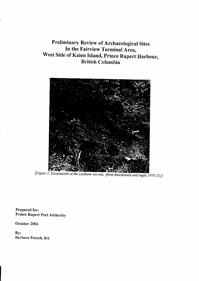
[Fi gu r e ] : Excav a t i ons at I h" r n n "-i, "ffi Fiiffffiffiii o ra h g t i s r 9 7 6 : 2 I ) J
Prepared for:Prince Rupert Port Authority
October 2004
By:Barbara Petzelt, BA
Archaeology of Fairview Terminal Area, prince Rupert, B.C.
l. Table ofContents2. List ofFigures3. Executive Summary4. Study Area5. Methodology of Documentary Research6. Archaeology and Tsimshian Cultural Background7. Archaeology of F'airview Area
r. GbTo-l0i i . GbTo-lIi i i . GbTo-l2rv. GbTo-l3v. GbTo-33vi. GbTo-36vii. GbTo-37viii. GbTo-49ix. GbTo-53x. GbTo-54xr. GbTo-55
8. Recommendations9. BibliographyI 0. WebsitesI 1. Appendix I : Fairview Area Archaeological Sites Database
Paoe 1
Page 3Pxoc 7
Page 4Page 4Page 8Page 9Page 9Page 9Page 9Page 9Page 10Page l0Page 10Page 1 1Page 1 1Page I 1Page 12Page l2Page 23Page23
Page IPage 7Page 8Page 8Page l0Page 1 IPage 12
Figure IFigure 2Frgure 3Figure 4Figure 5Figure 6Figure 7
Excavalions at the Lachane wet-silcSome ofthe winter villages located around the prince Rupert HarbourA Tsimshian Vi l lageWestern Kaien Island Archaeological SitesLachane Site Excavation in 1973Canoe Runs at GbTo-55GbTo-S4 Facins north
Archaeology of Fairview Terminal Arca, prince Rupert, B.C.
Executive SummarvIn doing a pre-field documentary overview of the Port ofPrince Rupert Fairview Terminal Facility areaon the west side of Kaien Island, eleven previously recorded archaeological sites have been identifiedl9T ulliollg.haeological references. These previously recorded arc-haeologrcal sites are: GbTo-10,991*11'Gbro-l2, Gbro-13, Gbro-33 (Lachane site), cbro-36 @aldwin siti;, ctro-:2, Gbro-53,GbTo-54, GbTo-55, and GbTo-49. A brief description ofthese sites is includei in the Archaeology ofFairview Area section ofthis report and in Appendix l: Fairview fuea Archaeological Sites Database,A general description ofthe study area, methodo.logy use in preparing this report,irchaeologrcal andTsimshian cultural history are also included in this report. An annotated bibiiograptry ofsources citedin this report along with other references that may provide more information onthl area is localed atthe end of this paper. A list of informative websites is also included as further information sources.Based on this preliminary report, it is recommended that a full Archaeological Impact Assessment beconducted prior to any further development ofthe port facilities.
Study AreaThe study area is ilom the Port of Prince Rupert Fairview Terminal Facility and Fairview docks southto Casey Point on the west side ofKaien Island. This area encompasses the proposed expansion ofthePort ofPrince Rupert facilities. The Prince Rupert Harbour area is within the traditionaitenitory of thecoast Tsimshian First Nation communities of Metlakatla and Lax Kwa'AIaams.
This area falls within the Hecate Lowlands Ecosection and the Coastal Westem Hemlock very werhypermarine Biogeoclimatic Zone (cwHvh) Drainage patterns in the area tend to be poorlydeveloped with many small streams that flow directly-inio the sea. These streams often are not to belonger than a kilometre. The climate in the Prince Rupert area is influenced by the Coast Mountains,warm off shore ocean current, westerly prevailing winds, and the warm moist pacific air. fhese fbctorscombined create the relatively warm and wet weither conditions and mild winters for which the princeRupert area is known (Archei and Friesen 2002; Tamblyn and Hom 2001).
The flora and fauna btotic zones represented in the study area are the Coast Littoral Biotic Zone and theCoast Forest Biotic Zone The Coast Littoral Zone extends from the shallow offshore waters that coverthe continental shelf to the intertidal areas. In this zone eelgrass, seaweeds, kelps, porpoises, dolphins,orcas, sea lions, seals, various w_aterfowl and other birds, ,u-rron species, herring'and lther fishspecies, butter clam, littleneck cram, horse clam, basket cockle, bay mussel, cariiornia musser,bamaclcs, limpets, chitons, sea urchins, and sea cucumber occur. l he Coast Forest Zone covers thelower slopes of mountains from the timberline to sea level. Flora in this zone include westem hemlock,Sitka spruce, westem red cedar, red and Sitka alder, northern black cottonwood, salal, bunchberry, wldlily of the valley, mosses, fems, salmonberry, thimbleberry, wild rose, and at higher eievations,mountain iemlock, silver fir, and yellow cedar. Fauna in ihe Coast Forest Biotl Zone include Sitkadeer, wolf, mink, marten, short-tailed weasel, red squirrel, fisher, bea'er, muskrat, river otrer,porcupine, black bear, and frogs/toads (Archer and Friesen 2002, Tarnblyn and Horn 2001).
The last major glaciation began aboul 25,000 years ago and reached its climax around 14,5000 yearsago During that period a continental ice sheet "ou"r"d th" Prince Rupert area. The ice sireet began torecede around 1.4,000 years ago when the clirnate started to warrn. By about r2,700 years ago theHecate Lowlands were rce-free and the lowcr Skeena valrey was cleai by uuou io,zdo years ago(Archer and Friescn 2002).
Archaeology of Fairview Terminal Area, prince Rupert, B.C.During theseperiods ofglaciation and deglaciation sea levels tend to fluctuate. The extent ofthefl ucluations.depends upon local conditioni such as the thickness ofthe ice cover, isostatic depressionand rebound, eustatic sea level changes (fall and rise), and local tectonic activity'not related to theglaciation lsostatic depression/rebound is the effect on the land due to the weight ofthe ice shcet andthe.release ofthat weight due to glacial retreat. Eustatic sea level rise occurs w-hen water that was tiedup in glaciers is released into the sea due to glacial melting (Fladmark 1986; Archer and Fries en 2002).
when the glaciers first began to retreat the land that was beneath the ice was depressed under theweight ofthe ice and sea levels were high, approximately l35m higher than present in the princeRupert area As the land rebounded during G deglaciation the relitive sea ievels dropped qurctty.The most dramatic changes likely o..u.r.d *itnirithe first 500 years ofdeglaciation.
'tiy auout r,oooyears ago sea levels were about 10- l 5m higher than present. Sea levers weie appro*in,ut"ty z-:.higher than present between 5,000-2,000 yea.s ugo. ln the prince Rupert Harbour archaeorogicalevidence suggests that sea levels have been relatively stable for the last 5,000 years in that First Nafionshave inhabited the region for at least 5,000 years. t'o date, sites older than ca. 5,000 years old have not
9-:l^1"^:lt*ll the Pnnce RupertHarbour area. A mitigating factor in this i, ttrat ani coustatarcnaeologrcal sttes tn the Prince Rupert Harbour area older than 5,000 years will likely be found eitherwell above the modem seal level or iubmerged and accessible only by d.ivers and submersibles andresearch has not been conducted in trying to locate ancient shorerinei in the ."gion. s"u"iutarchaeological sites in the Prince Rupert Harbour area have deposits that extend as much as lm belowthe modem_sea levels suggesting thai occupation in the area began between 7,soo-s,so0O fears ago(Ames and Maschner I 999). By 5,000 yeais ago the climate, flora and fauna in the itrince Rupert areawas essentially the same as more recent times (Fladmark 19g6; Archer and Friesen 2002).
Methodologv of Documcntary ResearchThe research for this report began with a preliminary review ofthe bibliography of archaeologicalreports available from the Heritage Resource centei and the BC Archaeoiogy prr*i"g ""a AssessmentBranch (formerly known as the. Archaeology Branch). A list ofreferences that may pertain to the studyarea was compiled from this bibliography and a number of archaeological publicaiions that the authorhad on hand Some ofthese reports a;d publications were reviewed a'nd the inlormation pertinent tothis preliminary report is synthesized witirin.
Archaeological site locationar information was obtained from the Archaeology planning and3:^,.:::T,.1BlTch
and compiled in the form of a database of recorded u."lru'rofolical lites in therarrvlew area (trom fairview to Casey Point). The database is included as Appeniix 1 ofthis report.Note that the site locations and access descriptions information contained within the database rssensitive and should be kept confidential. this is in order to protect the archaeological sites fromlooting and vandalism. For more informalion on this and the Heritage conservation Act refer 10 thgArchaeology Planning and Assessmenl Branch website (see rrst at the end of this report),
ha stmArchaeological sites in Canada are assigned sitc numbers consisting offour upper and lower caseletters and a.number through what is called the Borden System ln thrs system, Canada is divided intoa grtd of main map units that are 2" latitude and 4' longitude Latitude coordinates are assrgned acapital letter from A-U from south^to north and longitrides are assigned a capital letter from A-v fromeast to west These map units are further divided into l0' sub-uniti that are assigneJio*", "ar" t"tt"rr,
Archaeology of Fairview Terminal Area, prince Rupert, B.C.also from south to north and east to west to correspond to latitudes and longitudes. The numerrcportion ofthe site number conesponds to the ordei in which the site was reiorded in relation to otherarchaeological sites in its vicinity (within the site's 10' x 10'sub-unit). Therefore. Borden Numbersare a sequence offour letters and a number that relate to the sites' geographic cooidinates and the ordertn which the site was recorded within its map sub-unit; where the first iwo Ietters refer to the site,slatitude and the last two letters refer to the longitudinal position (Fladmark l97g). For example, GbTo-33 was the 33'd archaeological site recorded wrthin the GbTo sui-unit' of the Borden System sitedesgnation'GT main map unit'. Archaeological sites on the west side of Kaien Island, Digby Islandand-the. southemmost portion of the Tsimsean Peninsula have Borden Number designations of GbTowhile sites on the north and east side of Kaien Island, and Ridley Island have GbTridesignations.Temporary site numbers are often used when recording a newly located archaeological site until thefinal site numbers are assigned_by the provincial agenJy in chaige of maintaining a'record ofarchaeological sites (Provincial Ministry,Museumfuniversity). Thi. ir to p,.u.ni one number frombeing assigned to more than one site. only excavated archalological sites are given names. Theexcavating archaeologist assigns a name either after the site's priperty o*n.r, i lundr.up" feature, orsome other such convention (Fladmark 1978). For exampte ttri uest-tnown aictraeotojiiat site in thePrince Rupert Harbour is the Boardwalk site, GbTo-31. beorge MacDonald of the Nalional Museumof Man origrnally excavated it in the 1970s. The most recent excavation occurred during the summerof2004 by Gary Coupland ofthe University ofToronto (Coupland 2004 personal communication).The B^orden numbers assigned to the recorded archaeological sites within the Fairview Termlnal areaare referenced throughout this report.
As of2002, there were 176 archaeological sites recorded in the prince Rupert area. Most ofthesearchaeological sites relate to aboriginal occupation .while comparatively few sites relate to non-aboriginal historic sites/events in the Prince Rupert area (Archir and Fii esen 2o02). Archaeologicalresearch inthe Prince Rup€rt area began in 1907 with Harlan I Smith, Phillip Drucker also suweyedthe area in 1938 The first major-systematic, archaeological investigations of the prince Rupert Harbourbegan in 1966 with the National Museum of Man Prince Rupert Ffurbour prehistory project headed byGeorge F. MacDonald and Richard Inglis (MacDonald and Inglis 1976; Archer udFriesen 2002;Fladmark^I986)- other major surveys and excavations were conduct.d in th" area during the last 20years by Gary coupland from the university ofroronto, and David Archer from the Nojhwestcommuniq' college Prince Rupert (Matson and couprand 1995; Archer and Friesen 2002).
The Prince Rupert Harbour area is one ofthe oldest continuously occupied regions in North America.The oldest cultural deposits date to circa 5,500 years ago. The majority ofthJrecorded archaeologicalsltes are sltuated on the narrow coastal plain. Village sites tend tobe located near extensive clam-flatsand are j ust back of an abrupt embankment above tie high tide mark. Food pro."rrint ,1t". are locatednear close to areas where there were or are and abundanie ofa particular food r"so*"le such as salmon,eulachon, hening, shellfish, sea mammals, seaweed, bird's eggs, and forest resources. Foodgathering/gocessing camps were.occ''pied by relatively few people for a short period of time(seasonally) therefore archaeological deposits at these;ite types are generally not as extensrve asvillage sites. Village sites wereinhabited by large numbers-or peopt! for longer periods of time(MacDonald and Inglis 1976). One characteristic ofvillage sites in the princi Rupert Harbour area rsthat the deposits generally consist oflarge accumulations -of
clam and musscl shei mixed wtth woodash, charcoal' and other camp refuse and debris (Fladmark l9g6). Vilrage sites are arso oftenassoclated wrth rows ofcanoe runs and in some cases they are also assoJiated with petroglyphs. Canoeruns are,linear rock alignmenls locatcd in the intertidal zone in front of a village pcfundicular to thewaler where the beach was cleared to facilitate the landing ofcanoes. petrogllphs are pictures carved
Archaeology of Fairview Terminal Area, prince Rupert, B.C.into.rock - ln the Prince Rupert Harbour area, petroglyphs are often located in the intertidal zone onsmall boulders.
According to Tsimshian oral histories or adaawks the Prince Rupert Harbour area is part ofthe CoastTsimshian (Metlakatla and Lax Kwa'Alaams) traditional territo;ies since prehislory. This is supportedby the archaeological record, which shows that the area was inhabited continuously for at least 5,000years One of the Tsimshian adaawks states that the Tsimshian abandoned the prince Rupert I{arbourarea for a period because of Tlingit raids and occupation. According to MacDonald and Inglis (1976),there is-no
9irect archaeological evidence that this occurred. Ifthe ilingit ever inhabited the princeRupert Harbour there would have been a marked shift in artifact twes fJund at sites in the area. Tlingitartifact types are quite differenl from those made and used by the coast Tsimshian, the origrnal11]t1uita1ts,oi
th. l1l.^" Ruperr Harbour. However, Ames and Maschner (1999) write thar there is aclear penod ctrca 2,000 years ago when village sites around the harbour were not utilized. They
suggest that this is either due to Tlingit invasions or it represents a period ofabandonment due to theover utilization ofresources because ofan increase in populatrons.
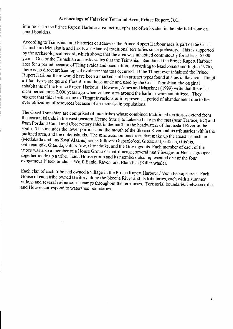
The Coast Tsimshian are comprised ofnine tribes whose combined traditional territories extend fromthe coastal islands in the west (eastern Hecate Strait) to Lakelse Lake in the east (near Tenace, BC) andfrom Portland Canal and observatory Inlet in the north to the headwaters ofthe Ecstall River ln thesouth This includes the lower portions and the mouth of the Skeena River and its tributaries wthin theoutlined area, and the outer islands. The nine autonomous tribes that make up the Coast Tsimshian(Metlakatla and Lax Kwa'Araams) are as follows: Gispaxlo'ots, Gitsaxlaal, ditraan, Gits'iis,Gitnaxangiik, Gilando, Gitutsa'aw, Gitnadoiks, and th; Gitwilgyoots. Each membei of each of thefiibes was also a member ofaHouse Group or matrilineage; several matrilineages or Houses groupedtogether made up a tribe. Each House group and its memLers also represented
"one of the four
exogamous P'teex or clans: Wolf, Eagle, Raven, and Blackfish (Killei whale).
Each clan of each tribe had owned a village in the Prince Rupert Harbour / venn passage area. EachHouse of each tribe owned territory along the Skeena River ind its tributarjes, each witi a summervillage and several resource-use camps throughout the territories. Tenitorial ioundaries between tribesand Houses correspond to watershed boundaries.
Archaeology of Fairview Terminal Area, prince Rupert, B.C.
'*" 4
>Y'r \ \
ror'.9tn G.lrep (cturhr6)
Ftgtre 2: Somc.of thc winrer villages located ariiii the prince fftlfrr based on ethnographici,Jomratiott collecred by Marius Earbeau and rlihiam Beynon. 6r'i uocDonau and cove rggT.xiii)
The Coast Tsimshian traditionally relied on the natural resources abundant on their coastal and riverinetemtones. In the winter the people inhabited their wrnter villages throughout the Venn passage andKaien island, when the main subsistence gathering focus was on marine life such as shellfish andvarious coaslal fishes: halibut, snapper, octopi, etc-. In February and March the people moved to theirooligan fishing grounds in the Portland Canal / Observatory Iniet areas. Ooligans ;ere caught, dried orsmoked, or rendered into the oil commonly called OoliganGrease. The drieiooligans and the ooligangrease were also traded with inland and other coastal tribes that did not have ur."rl, to sucn resotuces.From there the people either moved back to their winter villages or on to their early spring seaweedgathering camps on the outer coast. This was when red laver seaweed was gatherei und &ieO fo,,t-olt-utpjigl throughout the year or for trade with neighbouring tribal groups such as the Gitksan.Halibut fishing also occurred at this time. During late spring and early summer the Coast Tsimshianpeople moved to their'summer/fall fishing and hunting teniLries along the Skeena River and its lowertributaries. During the summer and autumn the propG fi.h"d for the dlfferent species of sarmon,hunted deer,-mountain goat, moose, bears, etc, tiapped fur bearing animals sucrr as mink, marten, etc,and gathered various plants for food, materials and medicines. Before the onset of winter the peopleretumed to their winter villages in the prince Rupert Harbour area.
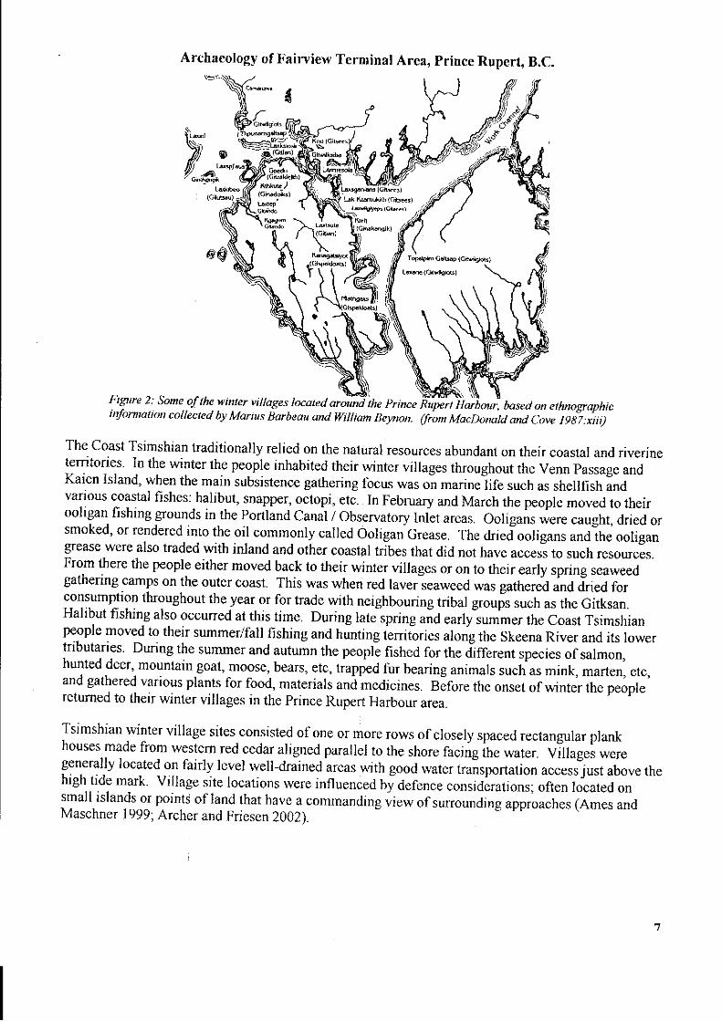
Tsimshian winter village sites consisted ofone or more rows ofclosely spaced rectangular prankhouses made from westem red cedar aligned parallel to the shore facing itre water. Villages were9:1"T1ly located on fairly level well-drained areas with good water traisportation accessjust above thehigh..t1d9 mark. Village site locations were inJluenced bi defence considerations; often lo"cated onsmall islands or points of land that have a commanding view ofsurrounding approaches (Ames andMaschner 1999; Archer and Friesen 2002)_
I
Archaeologyof l'airview Terniinal Area, Prince Rupert, B.C.
illage sites. canoe ru'o qre arso evideit in yroit of thi vilage. photo by E. Dossetter t aai'fri uritxr"uand hglis 1976:14)
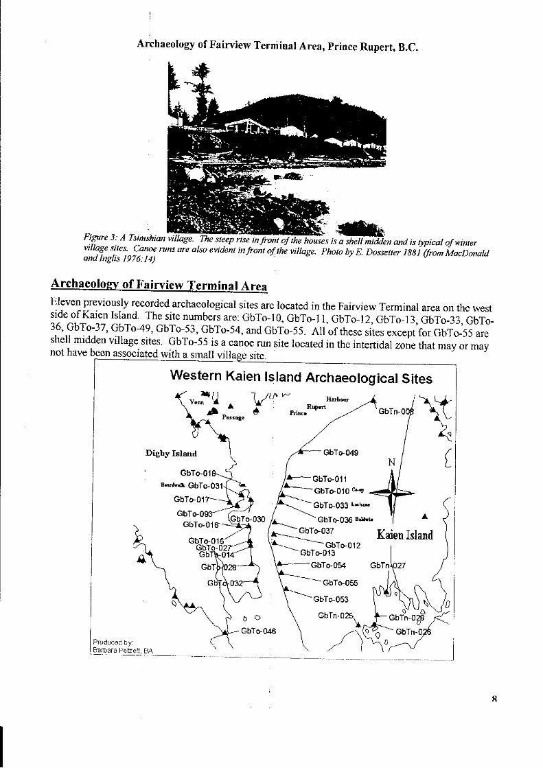
Eleven previously recorded archaeological sites are located in the Fairview Terminal area on the westside ofKaien Island. The site numbers are: Gbro-l0, Gbro-l1, Gbro-l2, Gbro-13, Gbro-33, Gbro-36, Gbro-37, Gbro49, Gbro-53, GbTo-54, and Gbro-55 All ofthese sites except for Gbro-55 are:i:l*f*:-":*t:,sites
GbTo-55.is a.canoe run sire located in the intertidat zone that may or may
Archaeologv of tr'airview Terminal Area
not have been associated with a small villase site.
Digby Island
GbTo-01B..rr'& cblo-031
GbTo-01
GbTGbTo"01
Pmducsd by:Barbafa P€Eelt, BA
Western Kaien lsland Archaeological Sitesr / lu " * I rA Y9'-**""** \ \ *
\ ({ \ /
?r
: -"":t11_
^_^ Kaienlsland..- cbTo-012GbTo-013
GbTo-049
a=- GbTo-oliGbTo-010 c.?
cbTe033 L_ri&
GbTc036 Bdn !.
GbTo-054 GbT
GbTo-055
GbTo-053
AIrchacology of Fairview Terminal Area, prince Rupert, B.C.
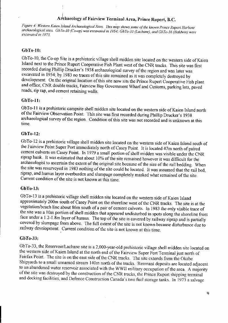
Figtre 4: Weslern Kaien Island Archaectlogical Sites. 'fhis m:ap shov,s some ofthe lorcv,n prince lltper! Harboularchaeological sites. Gb'fo-|0 (Co-op) was excavated h t95t: GbTo_33 (^aihane), and GbTo-36 iBaltlvinl nereexcq\1dled in 1973.
GbTo-l0:
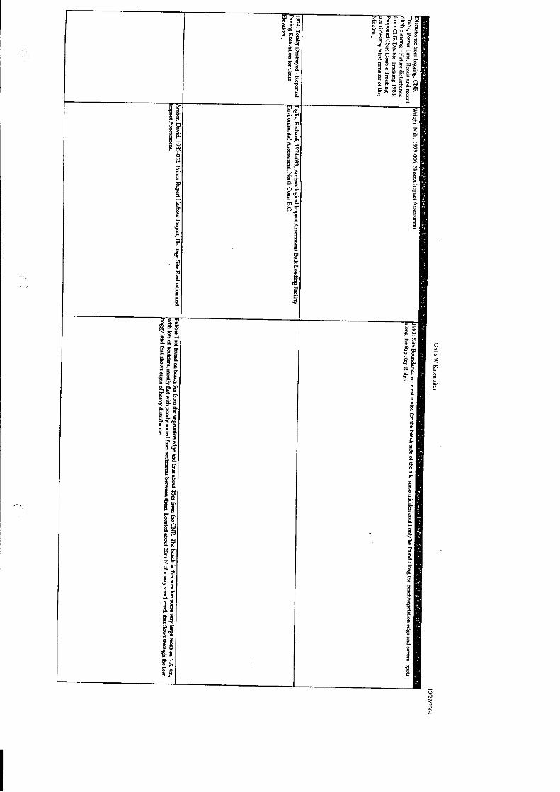
GbTo-10, the Co-op Site is a prehistoric village shell midden srte located on the westem side of KaienIsland- next to the Prince Rupert Cooperative Fish Plant west of the CNR tracks. This site was firstrecorded during Phillip Drucker's 1938 archaeological survey ofthe region and was later wasexcavated in 1954; by 1983 no traces ofthis site remained a, it was coipletely destroyed bydevelopment On the original location ofthis site now sits the Prince Rupert Cooperaiive lrsh plantand office' cNR double tracks, Fairview Bay Govemment wharl and customs, parking lots, pavedroads, rip rap, and cement retainins walls.
GbTo-l1:
GbTo-l I is a prehistoric campsite shell midden site located on the westem side of Kaien Island northofthe Fairview observation Point. This site was first recorded during phillip Drucker's 193garchaeological survey ofthe region. Conditron of this site was not recorded and ls unknown at thlstlme.
GbTo-12:
GbTo-12 is a prehistoric village shell midden site located on the westem side of Kaien Island south ofthe Fairview Point Super Port immediately nortlr of Casey Point. It is located 47m north of pairedcement culverts on Casey Point. In 1979 a small portion of shcll midden was visible under the CNRriprap bank. It was estimated that about 10% of tire site remarned however it was difficult tbr thearchaeologist to ascertain the extent ofthe original site because ofthe size of the rail beddrng. Whenthe site was resurveyed in 1983 nothing ofthe site could be located. It was assumed that the rail bed,nprap, and humus.layer overburden and slumpage completely masked what remained of the site.Cunent condition of the site is not known at tiris time.
'
GbTo-13:
GbTo-l3 is a prehistoric village shell midden site located on the westem side of Kaien Islandapproxirnately 200m south ofCasey Point on the shoreline west ofthe CNR tracks. The srte is at thevegetation /beach line about 86m south ofa pair of cement culverts. In 1983 the only visible trace ofthe site was a l0m portion ofshell midden tiat appeared undisturbed in spots alongihe shoreline frontface under a-1.2-1.8m layer ofhumus. The top oiihe site is covered by railway riprap and rs partiallycovered by slumpage from above. The full extent ofthe site is not known becausi disturbance due torailway development. current condition ofthe site is not known at this time.
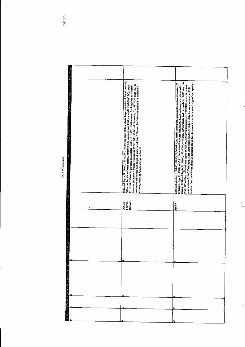
GbTo-33:
GbTo-33, the Reservoir,4-achane site is a 2,000-year-old prehistoric village shell midden site located onthe westem side of Kaien Island at the north end ofthe Fiirview Super P6rt Terminal just north ofl'airfax Point. The site is on the east side of the CNR tracks. The site extends from the OkabeShipyards to a small unnamed stream 140m north ofthe lracks. Remnant deposits are located adjacenlto an abandoned rvater reservoir associated with the WWll military occupation of the area. A mijorityofthe stte wa-s destroyed by the construction oflhe CNR tracks, tlre Prinie Rupert shipping termrnaland docking facilities, and Defence Construction Canada's two fucl storage tanks. In'i973 a salvase
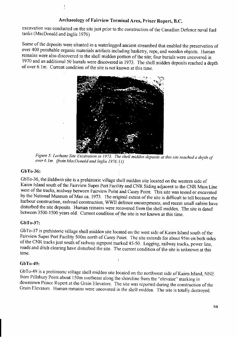
Archaeology of Fairview Terminal Area, prince Rupert, B.C.excavatlon was conducted on the site just prior to the construction of the Canadian Defence naval fueltanks (MacDonald and Inglis I 976)
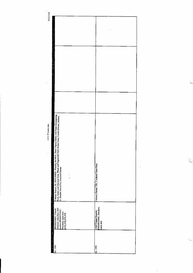
Sone of the deposits were situated in a waterlogged ancient streambed that enabled the preservation ofover 400 perishable organic materials artifacts including basketry, rope, and wooden objects. Humanrematns were also discovered in the shell midden portion ofthe iite; iour burials were u-ncovered in1970 and an additional 50 burials were discovered in 1973. The shell midden deposits reached a depthofover 6.1m. Current condition ofthe site is not known at this time.
Figure 5: Lochane Site Excavation_ in lCzl. fnishei miaaeiEposrts at nis site reached a dcpth oJ'over 6.1m. (from MacDonald and Inglis t976: l l)
GbTo-36:
GbTo-36, the Baldwin site is a prehistoric village shell midden site located on the western sjde ofKaien Island south of the Fairview Super Port Facility and CNR Siding adjacent to the CNR Main LinelvesJ of the tracks, midway between Fairview Point and Casey Point. Thii site was tested or excavatedby the National Museum ofMan ca. 1973. The original extent ofthe site is difficult to tell because theharbour construction, railroad construction, WWII defence encampments, and recent small cabins havedisturbed the site deposits. Human remains were recovered from the shell midden. The site is datedbetween 3500-1500 years old. cu.ent condition of the site is not known at this time.
GbTo-37:
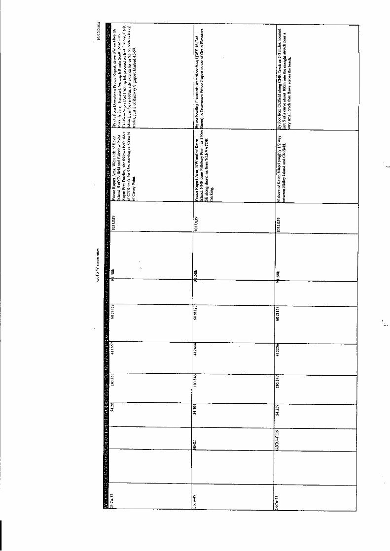
GbTo-37 is prehistoric village shell midden site located on the west side of Kaien Island south oftheFairview Super Port Facility 500m north of Casey Point. The site extends for about 95m on both sidesofthe cNR tracksjust south ofrailway signpost marked 45-50. Logging, railway tracks, power line,roads and ditch clearing have disturbed the site. The current condition of the sit; is unknown at thistlme.
GbTo-49:
9bT":1.? is a prehistoric village shell midden site located on the northwest srde of Kaien Island, NNEfrom Pillsbury Point about l50m southeast along the shorerine from the ..elevator,, marking rn{owntgwn Prince Rupert at the Grain Elevators. The site was reported during the construclion ofthecrain Elevators. Human retnains were uncovered in the shell midden. 'fhe
,it" i, totully destroved.
' to
Arbhaeology of Fairview Terminal Area, prince Rupert, B.C,GbTo-53:
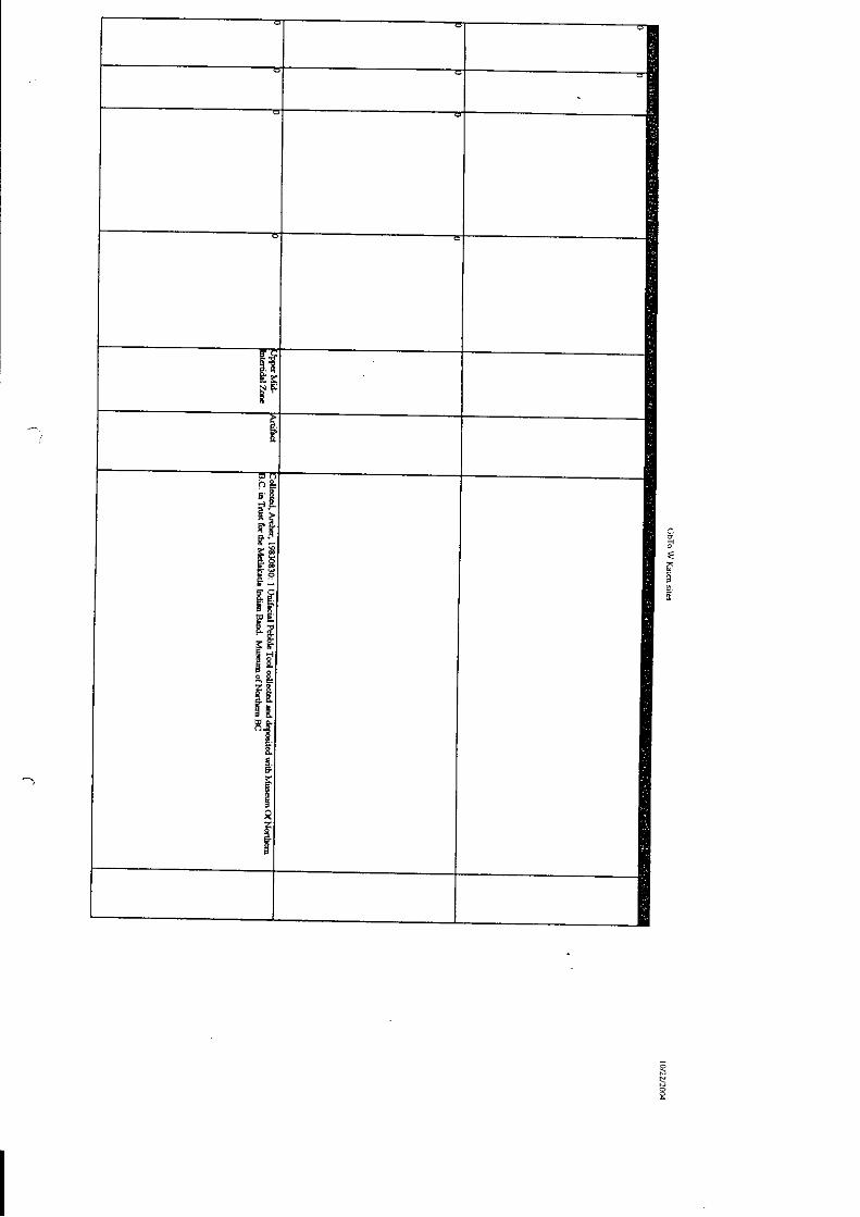
GbTo-53 is located on the west side ofKaien lsland about 2-3 miles south ofthe Fairview Super portFacility along the railway tracks, about l00m into a straight stretch south oia curve near a snrallunnamed creek that flows across the beach. The site is where a prehistoric stone tool was found on thebeach side of the CNR Tracks about 5m from the vegetation edge. The artilact is in the Museum ofNorthem British Columbia.
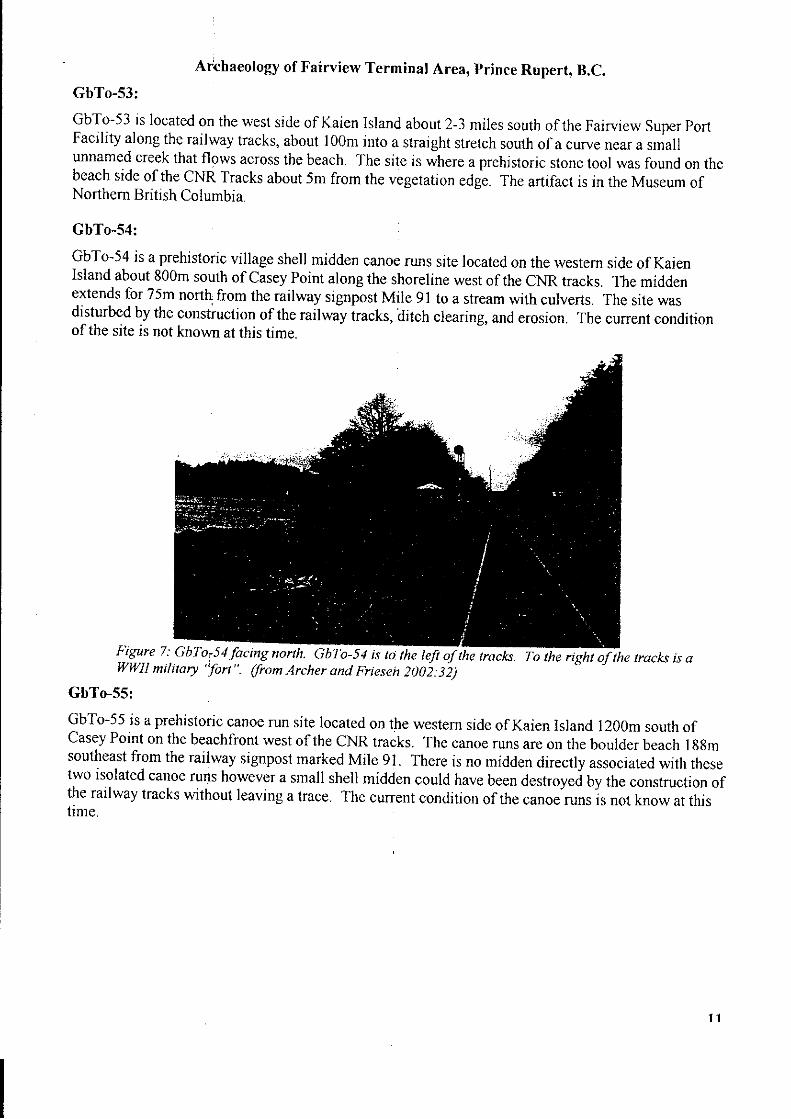
GbTo-54:
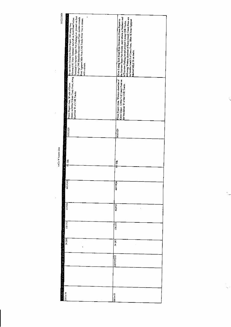
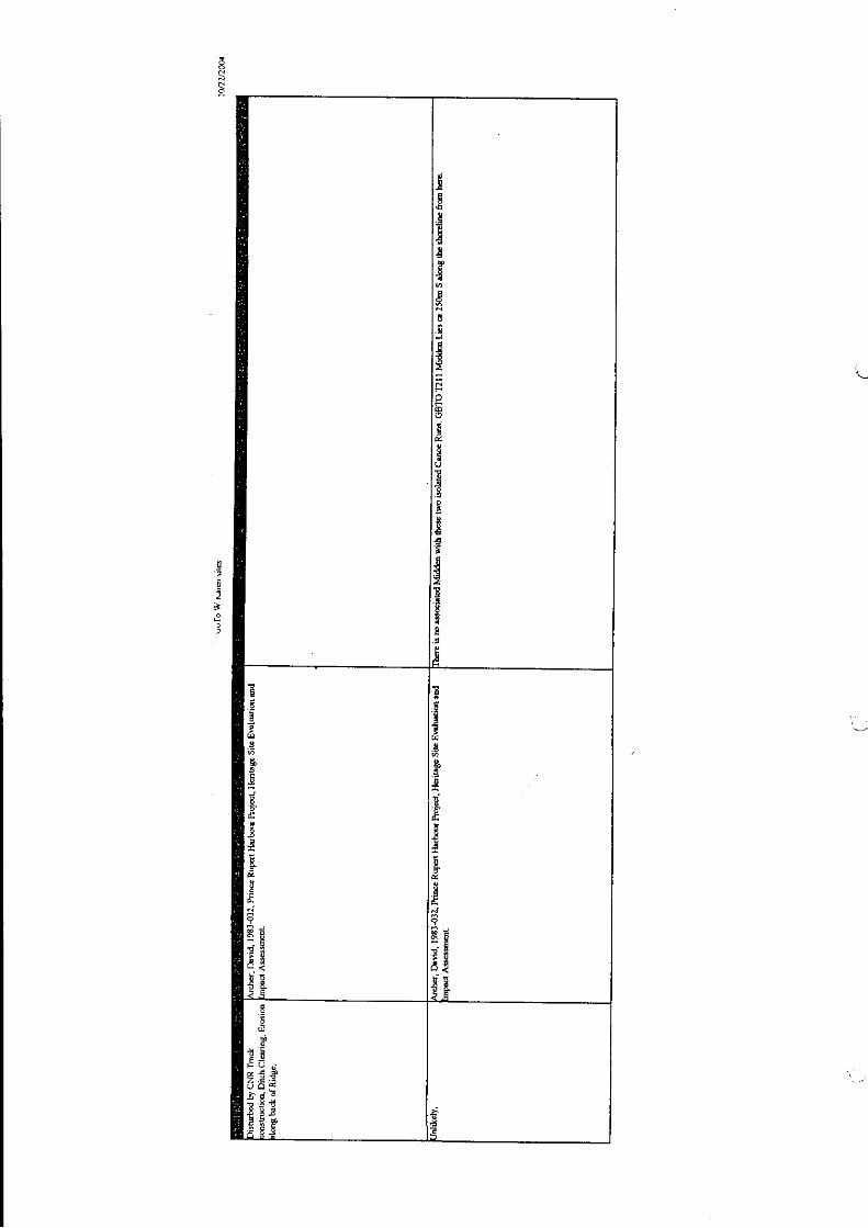
GbTo-54 is a prehistoric village shell midden canoe runs site located on the westem side of KaienIsland about 800m south of Casey Point along the shoreline west of the CNR tracks. The middenextends lor 75m north from the railway signpost Mile 91 to a stream wilh culverts. The site wasdisturbed by the construction of ttre railwa], iracks, ilitch cleanng, and erosion. The current conditionof the site is not known at this time.
ljyyz;.curors-4facingnorrh. ctro_s,tisrcni"tettoJtneiita.ii*eifi@heftacksisqWWII military "fort". (from Archer and Frieseh ZOfi:i)
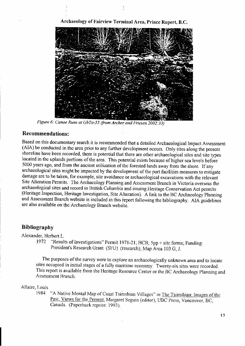
GbTo-SS:
GbTo-55 is a prehistoric canoe run site located on the western side of Kaien Island 1200m south ofCasey Point on the beachfront west ofthe CNR tracks. The canoe runs are on the boulder beach lggmsoutheast from the railway signpost marked Mile 91. There is no midden directly associated with thesetwo isolated canoe runs however a small shell midden could have been destroyed by the construction ofthe railway tracks without leaving a trace. The current condition ofthe canoe runs is not know at thistlme.
t l
;
Arcbaeology of Fairview Terminal Area, Prince Rupert, B.C.
Recommendations:Based on this documentary search it is recommended that a detailed Archaeological Impact Assessment(AIA) be conducted in the area prior to any further development occurs. Only sites along the presentshoreline have been recorded, there is potential that there ire other archaeological sites ana siie typeslocaled in the uplands portions ofthe area. This potential exists because ofhigher sea levels befoie5000 years ago, and from the ancient utilization ofthe forested lands away from the shore. Ifanyarchaeological sites might be impacted by the development ofthe port fa;ilities measures to mitigatedamage are to be taken, for example, site avoidance or archaeological excavations with the relevantSite Alteration Permits. The Archaeology Planning and Assessment Branch in Victoria overseas thearchaeological sites and record in British Columbia and issuing Heritage Conservation Act permrts(Heritage Inspection, Heritage lnvestigation, Site Alteration). e tint to ttt" BC Archaeology planningand Assessment Branch website is included in this ieport following the bibliography. AIA guidelinesare also available on the Archaeology Branch website.
Figure 6:
BibliographyAlexander, Herbert L.
1972 "Results of Investigations" permitPresident's Research Grant (SFU)
1971-21; HCB; 5pp + site forms; Funding:(tesearch); Map Area 103 G, J.
The purposes ofthe suwey were to explore an archaeologically unknown area and to locatesites occupied in initial stages of a fully maritime economy. Twenty-six sites were recorded.This report is available from the Heritage Resource Centei or the Bb Archaeology planning andAssessment Branch.
AIlaire, Louis1984 "A Native Mental Map of Coast Tsimshian Villages" tn The f simshian: lmages of the
Past. views lor the Present, Margarel seguin (cditor), lrBC press, Vancouvei, BC,Canada. (Paperback reprint: 1993).
Canoe Runs at GbTo-55 (rom Archer and Friesen 2002:33)
11,
Archaeology of Fairview Terminal Area, prince Rupcrt, B.C.
In this article, the author provides a spatial analysis of Tsimshian villages based on theTsimshian oral tradition in which the tribes host a supernatural potlatch "io honour the WaterBeings", collected by Frarz Boas in 1916. Altaire argues that the oral tradition represents acognitive or mental map that is essentially geographic, however not in a graphic sense butliterary. Cognitive maps reflects how particular groups ofpeople perceive t-heir environmentand how they are distributed over it with regards to their "cultural values and economicconditions". The author goes on to show that this particular oral tradition represents a cognitivemap ofthe Coast Tsimshian tribes or villages and their interethnic relations with each othir.This is demonstrated on page 88 on a graphic map that shows that Kaien Island belongs to theGitwilgiots tribe. This paper is part of an anthology edited by Margaret Seguin and is availablein bookstores or at the Museum of Northem BC sift shoo.
Ames, Kenneth M.1981 "The Evolution of social Ranking on the Northwest coast of North America" in
American Antiouity 46 (4): pg 789-805; Funding: N/A (research).
A review of materials lrom excavated coastal sites (primarily in B,C.) suggesls that rankingoccuned on the coast between 2000 and 3000 years ago. An explanation oflhe process thatgave rise to this phenomenon is offered. This paper is available at the Heritage ResourceCenter.
Ames, Kenneth M. and Herbert D.G. Maschner1999 Thames and
Hudson, London, England.
This book is available in bookstores.
Archer, David J.W.1983 "Prince Rupert Harbour Project preliminary Impact Assessment Report" permit
1982-33; HCB; lTpp; Funding: NMM @fA); Map Area 103 J.
Designed to compile a comprehensive inventory of heritage sites within designed impactzones, transect andjudgemental surface inspection identified l6 new sites and relocated 10others. Large shell middens, petroglyphs and CMTs reported. This report is available at theHeritage Resource center or ihe BC Archaeology planning and Assessment Branch.
1984 '?rince Rupert Harbour Project Heritage Site Evaluation and Impact Assessment"Permit 1983-35; HCB;264pp; Funding: HMM (EIA); Map nrei 103 I, J.
A number ofprojects in the Prince Rupert harbour and region were conducled and somemlnor test excavatlon conducted. A road conidor between Prince Rupert and Grassy Pointyielded one site; Ridley and Lelu Island yielded l l sites (all modified trees); a rail routebetween Terrace and Port Edward yielded 39 new sites and 9 previously recorded sires; surveyof Kaien Island yielded 12 new sites and l7 known sites; and survev of Metlakatla reserve landsresulted in l7 new sites and 30 previously known sites. This."pon it availahtc at the HeritageResource Center or the BC Archaeology planning and Assessrnent Branch.
1 1
Archaeology of Fairview Terniinal Area, prince Rupcrt, B.C.
1990 "The North coast Heritage Inventory project: A Report on the l9g9 Field Season"Permit 1989-47; 64pp; Ministry Library; Funding: B.C. Heritage Trust; Employmentand Immigration Canada; Metlakatla Band; University of Calgary; Map Areal03 J.
During the summer of 1989 a small-scale archaeological survey was conducted near the cityof Prince Rupert on the north coast of British Columbia. The survey covered Can Islet,Tsimpsean Peninsula from Obsewation Point to Ryan Point, Tuck Inlet and the north shore ofPrince Rupert Harbour. Nine new sites were found: six small shell middens, one medium sizedshell midden, and two large shell middens. some time was also devoted to upgrading theinformation on sites recorded before 1980. In all, eight sites were mapped anJdescribed. Thisreport is available at the Heritage Resource Center or the BC Archaeolosv Plannins andAssessment Branch.
1991 "The North coast Heritage Inventory project: A Report on the 1990 Field Season"Permit 1990-66; 278pp including site forms; Ministry Library; Funding: Ministries ofTourism and Social Services and Housing; Map Area 103 J.
During the summer and fall of 1990 an archaeological survey was conducted near the city ofPrince Rupert on the north coast of British Columbia. The suwev covered Kitson Island. thesouth sides of Smith Island and DeHorsey Island. and the west side of Tsimpscan peninsulafrom Ryan Point to Jap Point. Three new sites were found; all of them sheli middens and alllocated on the west side of Tsimpsean Peninsula. The rest of the field season was devoted torecording sites found at the end ofthe previous season and to updating sites recorded before1980. In all,38 sites were mapped and described. This report is available at the Hel1ngeResource Center or the BC Archaeology planning and Asslssment Branch.
1998 "Early Holocene Landscapes on the North Coast ofB.C." Paper Presented at the 3l"tAnnual Meeting canadian Archaeological Association, victona. BC, May 6-1 0, l99g;Department of Antkopology and sociology, Northwest community co ege, princeRupert, BC, Canada.
This paper presents evidence of raised beach deposits near Port Simpson, Venn passage,Dodge Island, Ridley Island, and in the city ofPrince Rupert on the souihwest side of Kaienlsland (near Fairview). The Kaien Island raised beach shell deposit dates ro about 12,000 yearsBP and suggests that the sea level was about l3m higher than present. This report is availibleat the Heritage Resource center or the BC Archaeology planning and Assessment Branch.
Archer, David J.W. and David E. Friesen2002 "An Archaeological Overview Assessment of the Digby Island / Tsimsean peninsula
Access Project (Phase 1)" prepared for Stevens Engineering Ltd., David Archer andDavid Friesen Heritage Consultants, prince Rupert, BC, Canada.
Archaeological sites GbTo-12, 13,54, and 55, on the west side of Kaien Island, are referencedin this report- 'I'his report is available at the Heritage Resource Center or the BC ArchaeologyPlanning and Assessment Branch.
1 4
Archaeology of Fairview Terminal Area, prince Rupert, B.C.
Borden. Charles E.1979 "Peopling and Early culh'es of the pacific Norrhwest" rn Science 203 (43 g4): pg
963-970 (8pp); Funding: N/A research); Map 103 K, J, c, C, B, 104 c, 93 D, 92 B, C,G, F, I , M,
This paper offers an altemate explanation ofthe peopling ofthe pacific Northwest byexamining evidence in support ofthe idea that people moved into the area via a corridor on thewest, rather than east side of the RocLl Mountains. This report is available at the HeritageResource Center or the BC Archaeology planning and Assessment Branch.
Carlson, Roy L.1976 "Prehistory of the Northwest Coast" ln Indian Art Traditions of the Northwest Coast,
Roy L. carlson (editor), pages r3-22, Archaeorogy press, Department ofArchaeology,Simon Fraser University, Bumaby, BC, Canada.
- Based on an 1976 symposium, this paper presents a synthesis of North-west coast prehistoryfrom southeast Alaska to the lnwer Columbia River. This paper is part of a book edited byRoy Carlson and is available in bookstores or through the Simon Friser University ArchaeologyDepartment.
Cybulski, Jerome S.1972 "Analysis of Skeletal Remains From the prince Rupert Harbour Area of B. c." in
Canadian Archaeolosical Association Bulletin 4: pg g7-90; Funding: NMM (EIA); MapArea 103 J.
Objectives ofanalysis ofthe buried remains of70 individuats recovered from several sitesare outlined. This report is available at the l{eritage Resource Center or the BC ArchaeologvPlanning and Assessment Branch.
1974 "Tooth Wear and Material Culture: Precontact Patterns in the Tsimshian Area,8.C." inSvesis 7: pg 31-35; Funding: NMM (research); Map Area 103 J.
Dental wear pattems from excavated sites in the prince Rupert harbour show tooth wearrelated to the art of weaving (A.D.I 100-1750) and to the use of labrets (500 B.C.-A_D.500).This report is available at the Heritage Resource Center or the BC Archaeology planning andAssessment Branch.
1978 "Modified Human Bones and Skulls From prince Rupert Harbour, 8.C.,' incanadian Joumal ofArchaeology 2. pg15-32 (r8pp); Funding: NMM (research); MapArea 103 J.
Report provides a descriptive summary ofthe analysis of modified human skulls and bonesfound at Prince Rupert harbour. Most of the artifacts (25 in all) may be indicative of ritualism,and, perhaps Shamanism. 1'his report is available at the Heritage Resource Center or the BCArchaeology Planning and Assessment Branch.
1 5
Alchaeology of Fairview Terminal Area, Prince Rupert, B.C,
1986 "Physical Anthropology and Paleopathology" in Handbook of North American lndians"Volume MI: Northwest Coast; Non-permit; HCB; 26 pp.
First part ofthe article focuses on morphological and biological elements concerned with thegenetics, adaptations and origins ofNorthwest Coast Indians. Second part treats pattems ofhealth, disease and injury in the early historic period and especially prehistory. Paleopathologyconsiders skeletal remains and data from early historic data, discusses disease, stature andcephalic rndices. This paper is part of a bodk edited by Wayne Suttles and is available inbookstores.
Drucker, Philip1943 "Archaeological survey on the Northern Northwest coast" ln Bureau of American
Ethnoloe.v Bulletin 133: pg 17-132; Funding. National Research Council; Map Area 92I, M,93 D, 103, A, G, H, J,
Designed to summarize and discuss the results of a survey of archaeological museumcollections of artifacts from regions formerly occupied by Coast Tsimshian and Kwakiutlpeoples and an archaeological survey of 1938 in the area. This report is available at theHeritage Resource Center or the BC Archaeology planning and Assessment Branch.
1974 "Archaeological survey on the northern Northwest Coast.', MS; BCpM.
This report is available at the Heritage Resource Center or the BC Archaeology Planning andAssessment Branch.
Pladmark, K. R.1975 "Archaeology ofthe Northem coast ofBritish colurnbia" rn Handbook ofNorth
American Indians" Vol. VII Northwest Coast, Wayne Suttles editor; SmithsonianInstitute; USA; 19pp; Map Area t 03.
This research paper interprets the prehistory ofthe north coast region from the eueenCharlotte Islands to the mid-Skeena and Nass Rivers and from Portland Canal to DouglasChannel offering a regional chronology and interpretation. This paper is part of a book editedby Wayne Suttles and is available in bookstores.
1978 A Guide to Basic Archaeological Field Procedures, Department ofArchaeology SimonFraser University Publication No. 4, Department of Archaeology, Simon FraserUniversity, Bumaby, BC, Canada.
This provides a good description of archaeological site number desigrations and fieldprocedures. This guidebook is available through the Simon Fraser University Archaeologyl)epartment.
1979 "Routes: Alternate Migration Corridors for Early Man in North America." in AmericanAntiquitv 44 ( 1) . pg 55-69; Fundrng. N/A (research).
t 6
Archaeology of Fairview Terminal Area, prince Rupert, B.C.
Palaeoenvironmental and archaeological data suggest that a chain ofsea- level refugiaaround the North Pacific coast could provide an altemative route to the interior ice-free conidorand that early maritime-adapted cultures could represent an early migration ofman to the Newworld. This report is available at the Heritage Resource center or th; BC ArchaeologyPlanning and Assessment Branch.
1986 British columbia prehistory; National Museums of canada, ottawa, ontario, canada.
This book is available in bookstores.
Hanson, Gordon1973 "An Archaeological and Historic Site Reconnaissance ofthe Proposed C. N. Rail Line:
Terrace to Mile 75 " permit 1973_29;HCB; lOpp + site forms; Funding: C.N. Rail(EIA); Map Area 103 I, p.
. _Desig''ed to identify, and evaluate heritage sites within a proposed c.N. Rail right-of-way,judgemental inventory located 13 sites. This report is availible at the Heritage RJsource Centeror the BC Archaeology planning and Assessment Branch.
I Ioover, Alan L.1982 "A Selection of publications on the Indians of B.c." 50pp; Map: B.c., Funding:
unknown.
Designed to provide a bibliography ofpublications, which have been written about the Indiansin B. C, including articles from periodicals, films, and children's books. This report is availableat tle Heritage Resource center or the BC Archaeology planning and Assessment Branch.
Inglis, Richard1972 "Archaeological Project in Prince Rupe( H arbow 1972" tn Canadian Archaeological
Association Bulletin 4: pg 101- 105; Map Area 103 J.
This report is available at the Heritage Resource Center or the BC Archaeology planning andAsscssment Branch.
l9T2 " Archaeological Project in the Prince Rupert Harbour lgT2: preliminary Report for theArchaeological Suwey of Canada.,, permit 19"12_4: IfCB, gpp * upp"ndi..s; Funding:OFY; National Film Board, Map Area 103 J.
combined film-making and archaeological project. objectives included finishing oftheexcavation ofa house feature (GbTo-34) started in 1971. Researcher concludes tlhat the projectadded a great deal of infonnation to present knowledge about the Coast Tsimshian Thij reiortts available at the Heritage Resourge Center or the BC Archaeology Planning and AssessmentBranch.
1 1
Archaeology of Fairview Terrninal Area, prince Rupert, B.C.
1973 "A Preliminary Report on the Salvage Excavations of rwo Shell Middens in the princeRupert llarbour, B.C. GbTo 33136" Permit 1973-7;HCB;7pp + maps and diagrams;Funding: National Harbours Board (ElA); Map Area 103 J.
Designed to conduct salvage excavations ofGbTo-33 and 36 - two shell middens threatenedwith destruction by harbour development. This report is available at the Heritage ResourceCenter or the BC Archaeology Planning and Assessment Branch.
1973 "conhact salvage 1973: A Preliminary Report on the salvage Excavation ofrwo ShellMiddens in the Prince Rupert Harbow B. c. (Gbro 33136)" rn canadian ArchaeologicalAssociation Bulletin 5 : pg 140-144; Map Area 1 03 J.
This report is available at the Heritage Resource center or the BC Archaeology planning andAssessment Branch.
1974 "Archaeological Impact Study: Bulk-Loading Facility Environmental Assessment NorthCoast B. C." Permit 1974-33; HCB: 45pp + appendices; Funding: NMM (EIA); MapArea 103 J.
The study was undertaken to inventory and evaluate heritage resources within an g00 sq.1i]9 area to assess requirements for preservation or salvage in conjunction wrth development ofbulk loading facilities in Prince Rupert harbour. Judgemental coaitally oriented survey over a29 day period resulting in the recording of 123 new site localities. This report is available at theHeritage Resource center or the BC Archaeology planning and Assessment Branch.
1976 "'Wet Site Distribution - the Northern Case, GbTo 33 _the Lachane Site.', i/, The
of North America, D.(research); Map Area
Croes editor, NMM-MS 50: pg 158-185; Funding: NMM103 J.
Techniques and artifacts recovered are described from excavations at GbTo-33, the mostnortherly water satuated site thus far excavated. Over 400 perishable artifacts were recovereddating between 1600 and 2500 years B.P. lhis report is available at the Heritage ResourceCenter or the BC Archaeology planning and Assessment Branch.
Inglis, Richard and G.F. MacDonald1975 "5000 Years of History on the West Coast" in Canadian Geographic Journal 91 (6): pg
32-37 (6pp); Funding: unknown; Map Area 103 G, H, I, J.
This report provides a brief introduction to the prehistory, ethnography and history oftheregron occupied by the coast Tsimshian people. This report is available at the HeritageResource Center or the BC Archaeology planning and Assessment Branch.
Inglis, Richard I., and G. F. MacDonald (eds.)
1 R
Alchaeology of Fairview Terminal Area, prince Rupert, B.C.
1979 "Skeena River Prehistory." NMM-MS paper 87: pg l-17; Funding: NMM (research);Map Area 103 I, J.
An overview of ethnography, history and previous research in the Skeena River area ispresented. This report is available at the Heritage Resource Center or the BC ArchaeologyPlanning and Assessment Branch.
Jones, Laurie1981 Heritage Inventory: A Preliminary Survey of Pre-1940 Buildings in Prince Rupert, B. C.
(2 vol.),338pp; Funding: unknown; Map Area 103 J.
This was designed to provide a preliminary inventory ofbuildings constructed in Prince Rupertbefore 1940 Eight hundred seven buildings are included, 595 having been positively dated.This report is available at the Heritage Resource Center or the BC Archaeology Planning andAssessment Branch.
Keddie, Grant R.1981 "The Use and Distribution of l,abrets on the North Pacific Rim" in Svesis 14: pg 59-80;
Funding: N/A (research).
This paper defines and categorizes labrets and indicates their distribution. It also synthesizestheir history on the basis of archaeological and ethnographic studies. This report is available atthe Heritage Resource center or the BC Archaeology plinning and Assessment Branch.
Kimble, Kathy1978 "Report ofthe Skeena Regional Archaeological Impact Survey." permit 197g-7; HCB;
16pp; Funding: HCB @IA); Map Area 103 93 K, L, 103 I, J.
A number of refenals were examined resulting in the location or revisiting of33 sites.Refenals in the Prince Rupert area included the Heilbroner Industrial Estate on the east coast ofKaien Island (pg 7); a squatter settled at phillips cove on a shell midden (pg 8); c N. Railnprap along the Skeena and Prince Rupert Harbour (pg 9); and a gravel quarry at Laurier cove(pg 1 0). This report is available at the Heritage Resource center or the BC ArchaeologyPlanning and Assessment Branch.
Large, R. Geddes1996 The Skeena: River of Destinv; sixth edition, Heritage House publishing company
Limited, Museum of Northem British Columbia, prince Rupert, BC, Cinada.
The author of this book, Dr. R.G. Large was a long time resident and serviced northern BCincluding the coast and the Skeena watershed. His book is a history of the Skeena Riverwatershed, coastal and interior sections. The book was originally published in 1958; this copyis the sixth edition. It contains information on the river itselfand ihe sunounding lands, thenative peoples, and the early 'non-native' explorations ofthe region. He discussJs theestablishment ofthe various Hudson Bay Company trading forts and the missionization ofthe
l q
I
Archaeology of Fairview Terminal Area, Prince Rupert, B.C.
natives inthe area. Dr. Large included a history of the towns and cities ofHazelton, Tenace,Kitimat, Port Essington, and Prince Rupert. He also discussed the history ofthe transportationsystems ofthe area, including the railroad, and mentions some ofthe industries that takeadvantage ofthe resources in the Skeena region. This book is available in bookstores.
MacDonald, George F.1967 "Archaeological Reconnaissance in the Tsimshian Area, B. C." Permit 1967-3;HCB
(Paper presented to SAA); 15pp; Funding: National Museum (research); Map Area 93M. 103 I. J.
Valleys of the Skeena, Bulkley, and Kispiox were srweyed and a number of sites wererecorded, some related to named tribal groups. A "sizeable" test excavation was made at GbTo-23. This report is available at the Heritage Resource Center or the BC Archaeology Planningand Assessment Branch.
1968 "Preliminary Culture Sequences From the Coast Tsimshian Area, B.C." Permiti968-13; HCB; 25pp (incomplete); Funding: National Museum (research); Map Area103 F, I, J.
Excavations were conducted at six sites (Prince Rupert Harbour, Queen Charlotte Island,Skeena River, Bulkley River). Shell midden sites are divided into three horizons based onartifact typology and other factors creating a rough 5000-year sequence for the area. This reportis available at the Heritage Resource Center or the BC Archaeology Planning and AssessmentBranch.
1976 "Prehistoric Art of the Northem Northwest Coast" in Indian Art Traditions of theNorthwest Coast, Roy L. Carlson (editor), pages 99-120, Archaeology Press,Department ofArchaeology, Simon Fraser University, Bumaby, BC, Canada.
In this article, MacDonald uses evidence from the Prince Rupert Harbour archaeologicalsites to show the stylistic development ofnorthwest coast art. He outlines some of the majortrends in the artistic styles found on some ofthe artifacts recovered from Prince Rupert Harboursites. Some of the artifacts discussed were recovered from the Lachane and Baldwin sites:GbTo-33 and GbTo-36 respectively. This paper is partofabook edited by Roy Carlson and isavailable in bookstores or through the Simon Fraser University Archaeology Department.
MacDonald, George F. ard Johl J. Cove (eds.)1987 Tsimshian Narratives l: Tricksters. Shamans and Heroes, collected by Marius Barbeau
and William Beynon, Canadian Museum of Civilization Mercury Series DirectoratePaper No.3, Directorate, Canadian Museum of Civilization, Ottawa, Ontario, Canada.
The introduction, written by MacDonald and Cove, contains some ethnographic informationon the Tsimshian (Tsimshian, Gitksan, and Nisga'a), including a map of some of the villagesand Grease Trails. The Laxane (Lachane) site on Kaien Island is shown on the map (page xiii)as belonging to the Gitwilgiots lribe. This book is avarlable in bookstores.
MacDonald, George F. and Richard Inglis
Archaeology of Fairview Terminal Area, Prince Rupert, B.C.
1976 The Dig; Archaeological Survey of Canada, National Museum of Man, NationalMuseums of Canada, Ottawa, Ontario, Canada.
This book is available in bookstores.
l98i "Ar Overview of the North Coast Prehistory Project, 1966-1980" ln Fraements ofthePast: B.C.'s Archaeoloe.v in the 1970's, K. Fladmark editor, B. C. Studies 48: pg37-63(27pp); Iunding: unknown; Map 103 H, I, J.
This report is a descriptive summary ofwork conducted ffom 1966-1980 in the areas ofB. C.traditionally occupied by the Haida and Tsimshian peoples. During the survey,265 sites havebeen located. Excavation has been undertaken at 18 sites. This report is available at theHeritage Resource Center or the BC Archaeology Planning and Assessment Branch.
Matson, R.G. and Gary Coupland1995 The Prehistorv of the Northwest Coast; Academic Press Inc., A division of Harcourt
Brace & Company, San Diego, California, USA.
Thrs book is available in bookstores.
May, Joyce1979 "Archaeological Investigations at GbTn- 19, Ridley Island: A Shell Midden in the Prince
Rupert Harbour Area, B. C." Permit 1978-25; HCB; l97pp, Funding: NMM; NationalHarbows Board (ElA); Map Area 103 J.
Test excavations were conducted at GbTn-I9 prior to development at a bulk loading iacility.The site had been largely disturbed by previous construction activity and dates received afterthe report was produced indicated serious disturbance ofthe excavated deposits as well,negating most ofthe conclusions reached in the report (Dates of upper most componentspredated lower components by 3000 years). Winter occupation is supposed at the site. Apreponderance of salmon was note4 though land and sea mammal (and birds to a lesser degree)were also present. This report is available at the Heritage Resource Center or the BCArchaeology Planning and Assessment Branch.
Simonsen, Bjom O.t987 "Archaeological Salvage Excavations and Construction Monitoring at the Lachane Site
(GbTo-33), Prince Rupert, British Columbia: Preliminary report." Non-permit; HCB;2lpp. + Appendix; Funding: Defence Construction Canada (EIA); Map Area 103 J.
Monitoring and salvage excavation at GbTo-33 were conducted prior and during construction offuel storage tanks. Although analysis has not yet been undertaken preliminary examinationsuggests that one area was occupied during Period I (AD 500-AD 1830). Another area appearsto date to the oldest known occupation level in Prince Rupert Harbour, or Period Ilt (3000 BC -1500 BC). A number ofhuman burial features were also encountered. This report is availableat the Heritage Resource Center or the BC Archaeology Planning and Assessment Branch.
),1
Archaeology of Fairview Terminal Area, prince Rupert, B.C.i988 "Final Report on Archaeological Salvage Excavations and Construction Monitoring at
the Lachane Site (GbTo 33), prince Rupert, B. C.', Non_permit; 37pp + 3 appendicis;Funding: Defence Construction Canada; Map Area 103 J.
The 1987 Lachane Site archaeological project (May 30 - June 13, 1987) consisted ofan impactassessment and construction monitoring ofthe last remaining deposits at GbTo-33 (FairviewPoint, Kaien Island, Prince Rupert). This site was threatened with destruction from theinstallation ofa fuel storage facility by Defence Construction Canada. Evidence suggests thatthis.site was occupied during the Middle period (3500 - 1500 B.p.) of the prince RupertHarbour cultural sequence. Prehistoric inhabitants exploited a wide varietv ofshellfish (clams.cockles' mussels, and possible bamacles). There was also a heavy dependence on salmon andland mammals, such as deer, while abundant dog skeletal remains attest to use as pets or food.Sea mammals were of lesser importance. This report is available at the Heritage ResourceCenter or the BC Archaeology planning and Asseisment Branch.
1988 "Archaeological Test Excavations and Impact Assessment at Sites GbTo-36 and 37,Fairview Terminal, Kaien Island, prince Rupert, B. C." Non_permit; HCB; lTpp;Funding: Port ofPrince Rupert; Map Area 103 J.
A-detailed archaeological impact assessment and site evaluation project was canied out (April13- 18' 1987) in areas within the impact zone of the proposed port faiility expansion- Most ofthe archaeological deposits at Gbro-36 are previously disturbld and only constructronmonitoring in the northwest quadrant of the site is recommended. There will be no rmpact toarchaeological deposits at GbTo-37 as a result ofexpansion ofthe Fairview Terminal rockquarry' and no further work is recommended at this site. This report is available at the HeritageResource Center or the BC Archaeology planning and Assessment Branch.
Tamblyn, Greg C. and Hannah Hom2001 "Cunent Conditions Report: North Coast Land and Resource Manasement plan"- prince
Rupert Interagency Management Commiftee, Smithers. BC, Canadal
This report provides general background information on all aspects ofthe North Coast Landand Resource Management Plan (NCLRMP) area that was to be used as a baseline prior to thestart of the NCLRMP discussions. This report is available on the NCLRMP websiti or throughthe Ministry of Sustainable Resource Manasement.
:
Winram, Pat, and Jean Williams1976 "Ftnal Report: Drcpt of Highways Archaeorogrcar survey #2 - North (May 1-August 3r,
1976)" Permit 1916-7-;HCB;35pp + surnrnary; Funding: BC Dept. oiHighways @fe;;Map92G, O,93 B, c, p, A, K, L, J, 103 I, J
DesiS'ned to locate and record prehistoric or historic sites threatened by proposed highwayconstructlon One hundred eightyJbur sites were located. One Highways refenal in princeRupert (L-4094 Fairview Bay-7h Street) was surveyed and found not to b" in conflict wrtharchaeological sites. Two other Prince Rupert refenals were not suweyed during the 1976 fieldseason (L-139 Fairview Bay-Prince Rupert, and L-4013 Prince Rupe rt-iialloway"Raords). This
').?.
Archaeology of Fairview Terminal Area, prince Rupert, B,C.report ls available at the Heritage Resource center or the BC Archaeology planning andAssessment Branch,
Wright, M. J.1979 "skeena Impact Assessment." permit r9i9-6;HCB;86pp.;Funding: HCB (ErA), Map
Area 93 L, M, 103.
This project was designed to locate sites in conflict with a variety of deveropments.FiftY-seven govemment refenals were examined resulting in the location of a riumber orsites.Gbro-l2, 13, and 36 were remapped because they were to be impacted by the expansion oftheFairview installation. All three olthese sites are ihell midden siies. rnt'r"port i, auailable atthe Heritage Resource center or the BC Archaeorogy planning and Assessment Branch.
Wetrsiteswebsites where more information on prince Rupert Harbour area archaeorogy, archaeorogicalguidelines and legislation, and Tsimshian culture, can be found:P BC Archaeology Plarning and Assessment Branch, victoria, BC (Archaeology Branch):htto://srmwww. gov.bc.ca./arch,/
) Royal British columbia Museum, Victoria, BC: htto://wu"w.rovalbcmuseum.bc.calF Brjtish columbia provincial Archives, Victoria, BC: http:i/search.bcarchives. sov.bc.ca./sn-l9A'39CFibsearch
) Canadian Museum of Civilization, Ottawa, Ontario: htto.//www.civilization.ca,/> Department of Canadian Heritage, Ottawa, Ontario: http://www.pch.gc.ca./index e.cfm) Culture Canada Canadian Archaeology:
Canadian Archaeology Association: http://w.'l't canadianarchaeoloev.com.ftome.lassoNCLRMP (Cultural Heritage Chapter):The Map Place: http:
Heritage Resource Center (Victoria)
{Double click icon to u,e* rneiat;i;fi
).1

g:. g i
9fTr i {i ? a
fd
:;i
F a
ilrgEi; r : { ! '
ii$eEi ; i I Ff[[€i
IF
I
,I
A FT
5 {3 >
A <H E
{ g i* gI
i Ei[i[3 iEgF I E . F YS E E 3 E
FIFfAEEFT*T i � ' r E ?r i I r ]E[${3H ! i r tI N " ;
?IA
t
; 3 d
i 6 i{ s ;+ i ?
F : €
r € o s5E
,
fii€
! ;i ^ E
: r
;7
EI
E
E_3
:65g
E
.E
a8F
6E
6
a
2
EZ.B
a
I
E
:
E,t9
8
n
nP
I
.E
d
.E
!
I
a
t
5
F
3
3
€
?
g. t
t
t
i
i
{
d
.9 :
r , !a tt :
g 9
t {! Z
8 F€ 9
. r 64 ZI o
! x. , 9
g 4E d? :€ t
E
i
ts.+
IE
5
!
It
.j
I
E
P
!
I
Ia
i
],1I,l*
n
I
Fd
ta
.E
It$
a
c
r
F
6
;,ge_d
n
&,cI'i
8sS
EE.t'
F u E+ ? t s
r ! ;
F e t r i4 ! ! 5! i € I; x i te i z 26 J I E
E ' E E E; .€ � I ge
f o e F :: B g [ :Bd ; i i7 : 5 ! o. ! i i : be r r . ' E
E; ; ; f_ i ? " d F i: : . l E 5 ;
FEI * :E; ? i i : Ef , E $ e ! :- r g . e F - d . t; : i 3 ; :5 5 6 e i 5E 5 s ! i E{ r i : E a. f t - - = - 8 l : r" : : ; -bgE + t { 5 er9 3 ! i t
55i
E.
6
l € i ;l i t ;M il ? i Il c i sl t : ;t s f &l i5 st : E 3
l i s l< ! l9 ; 9
o E U
u ; ! Et { 5 !s ! ; :
? n d : q
t *
I t
l ;
l a *12 v)
l R Xt 8 il { It E ' ;t E ! t
I t 6
t ! r
l d FI . l ct l E
t : ;l € bl l {l q I
l 6 =t : ot t 5l > rt . c rI E !
H Pl y I
l {7 Pg i
. ; t
R !
iF6
;
E
P N
- 8
o . 2
EE{F
t38
a
- . E
o 6
I Ei 5
; EE , b
T R
I E
9 EE b
3 :
a
F
It
!P
*6
eI
ejd
5s2
s_E':
E
E & ! ; i i E; e ! 5 i 9j , : i s i !! j ; f I id F 2 5 : ;' " a Z L E E! ,! Pg E +d : ; ! E E5 : 3 t i :iE i i i s ,: . & F a ! s ii i ,EllZiE i ; E i 5 i
" € c f
ieriiia?{€3I& : T E : :
! ir:El; E . f r F rEt . i l i B€i{Enrss:3ig*:
: f sr l i ii i : E E , ! !
#EiE;iiE t E Y : 8 b^ ? ; : ; g ; ?
is{liBiE e i l i ? rs i t F i i i
5iiifii,l r s
d-n 'i 3 t
F ; . E
E .
E CgTY ? e i
; F? i: i 3 E[ ! E ;d . . : ;
#t+
4 l z* q gE : ]i i a
; E IE ] Ei i E
$ E i Ed i d :
l ? u €E + f :
3
g
9
c rd !
!
E g!l I
g;3
E.5
J
t
p
tscn.c
8 ?
! :
-E
e 3
r - F
. 5 :? g
1 E ,
! : {
j r , t
I t I< -.E6 f ;< 5 9
: t o
_,tr x
i _a,?; : E4 F E
5 l - E$.i E; ; :
$an i
1 1
{ 1
. 8 6P 5
3
{
J
s
i
t
:IT
.i
:
T
-l
t
i
-t' h: i t E
e 8 I !E : d ;F ; * g4 t a z
? ; - E dE - 5 ' ba e z 2f { F ;"i i :,"; ! . 1 I
1 1 : - t !
{ r ? : EE i i E ;I r i t ;t r a : F- : F i j i i
! ; E O J.b- ! €: s* E s 8 E -
!r933F n i r ?: ; i ; g
a 3
i ,.!
E NI P
E F
; F
: ;
F
t {. + €E !
t c
t !
2 E! eE q3 e
ce . l
r i
! . :
i 5
: ?
6 ' 6s l
... I
&
{ F
* !
9 :
: E
ez -! ri t- 6 ;
; :
i - 6
-EEE
=d
ttr
d,
8
g
z?
E
EE
l bl ;- . ' l ?t r
l !a 1
. a t
6 r
t r i
5 !E i
; 7> E
. E {
t , q
r3
E :6 nJ E
i , E €
iii$s;;fiSiigtii$iiE
iiii{iftJ
:
io_
ES
.!I;.f
l s:
:al d .I Et 7t €
l -
It at ;I E
l 6
l E - 6 'l ! 2
g :
9 : :
- i t
B E
i :e 2
z 9
Ea
R
9
E
ad
d
T2
?i
5
g
d
z
I
2
aa
x
e lo {
44"
! d" !EF ;: r
!- {.2; r "
a &
6 1
{
.!
t'
i
>;*
a
3
z
6' ;
6
9
d
2
E
{E
n'
:
,q
t *E €
I
v:
t
'a
b
iEI
&.
6
?
5
&,
Ea
is
T
. 5
;6
a
2
€d
3
8
:r
!
5
6
s-
:E2]
,
8
S
Eq.5
E
l l . r ' ! -
liiii;l : * iHs113*; it i i ; Esl;?ti{;B:*g€;ri{iliiiriE€iiiE d : l ! ?; l $ ; $ :SFTd E;g ; i i l ;
ItitXrel g ? t r 8 E
|!gi$:il ! t : t d E
N ? t d r r
fis{iiI ! I t r i ;_ri 3 ! : r ?
iis?Eiq;i!{ io " t i : 8 E
$r{!ii
zi'3; t z E P1 5 € ; -. E " ; : I Ti i 8 . 8 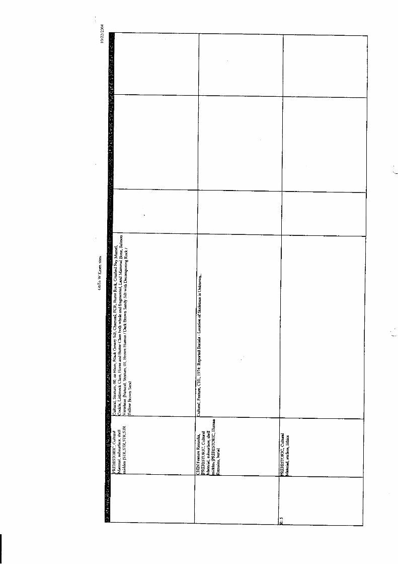
8'
dt
a
6
d
E
EE.5: :E , '
i . i
- t 3
E T
_ t s
: ?-'. u
aI
E
Ei,
EI,,
E
cqs:
€
3
git
F*
&
I
I
I
i
F
2q
gF6 E
B i
zgq
n*
fr'g
FFI
G
€E.
!
u
t
F
G
RetE,Ii
; r :& s EE r r
F t !t r . I
€ [ s3 t fg *rF l rF*{
F !T € '[ . F
: z7 6
! ! lE z lI i l: ! tE T Iz ! le , : l
! ; l8 g l[ f l 1r € lP F It € l; I A lI t r l
l l x l5Fl
7 9i E '
5 T
3g
I3 ll lt l; l
t
3
3
q
ll
zI
1 c! i
: >
?,'
e6
idc
I
F
I
E
E A
E , F
T
6
3
3 Et ;
t r r! :
t
6
.ltI
aB
t 9 !
t $ { i. t a A
e l E '6 g a
l r nE.9 E
i r . f
r t ;3 ' ! t :
-c
J S
&;a
6
n3
€
.E
< !
t_!
I
2
T3
6
P.
I
I=3
r !
9 4
> l
S Et =
; 3
6 5
6 >
-,. F
3
Ica
!,E,)e
I
E.J
F
I
J
€
I
6
6
qd7aE
I
F ;
' ; 8, 9
b
F
a
Bsl
Eo
6
',pE2;e