principles of structural geology on rocky planets
TRANSCRIPT

ARTICLE
Principles of structural geology on rocky planets1
Christian Klimczak, Paul K. Byrne, A.M. Celâl Sengör, and Sean C. Solomon
Abstract: Although Earth is the only known planet on which plate tectonics operates, many small- and large-scale tectoniclandforms indicate that deformational processes also occur on the other rocky planets. Although the mechanisms of deforma-tion differ on Mercury, Venus, and Mars, the surface manifestations of their tectonics are frequently very similar to those foundon Earth. Furthermore, tectonic processes invoked to explain deformation on Earth before the recognition of horizontalmobility of tectonic plates remain relevant for the other rocky planets. These connections highlight the importance of drawinganalogies between the rocky planets for characterizing deformation of their lithospheres and for describing, applying appro-priate nomenclature, and understanding the formation of their resulting tectonic structures. Here we characterize and comparethe lithospheres of the rocky planets, describe structures of interest and where we study them, provide examples of how historicviews on geology are applicable to planetary tectonics, and then apply these concepts to Mercury, Venus, and Mars.
Key words: planetary tectonics, planetary geology, Mercury, Venus, Mars.
Résumé : Bien que la Terre soit la seule planète connue sur laquelle il y a une tectonique des plaques, de nombreuses formes derelief tectoniques de petite et grande envergure indiquent que des processus de déformation se produisent également surd’autres planètes rocheuses. Si les mécanismes de déformation sur Mercure, Vénus et Mars diffèrent, les manifestations ensurface de leurs tectoniques respectives sont souvent très semblables à celles observées sur la Terre. En outre, des processustectoniques invoqués pour expliquer la déformation sur la Terre avant la reconnaissance de la mobilité horizontale de plaquestectoniques revêtent toujours une pertinence pour les autres planètes rocheuses. Ces connexions soulignent l’importanced’établir des analogies entre les planètes rocheuses pour caractériser la déformation de leurs lithosphères et pour décrire, enappliquant la bonne nomenclature, et comprendre la formation des structures tectoniques en résultant. Nous caractérisons etcomparons les lithosphères des planètes rocheuses, décrivons les structures d’intérêt et les lieux où elles sont étudiées, etprésentons des exemples d’application de notions historiques à la tectonique planétaire pour ensuite appliquer ces concepts àMercure, Vénus et Mars. [Traduit par la Rédaction]
Mots-clés : tectonique des planètes, géologie des planètes, Mercure, Vénus, Mars.
IntroductionWithout a theoretical framework, such as the plate tectonicmodels, of the spatial relations of rock bodies to one anotherin an orogenic belt, however wrong they may be, objectivecriticism, fruitful deductions, and new observations wouldbecome difficult to make. Identifying terranes without im-mediate hypothetical interpretations diminishes testability(because tectonic analysis would be reduced to irrefutablesingular existential statements) and therefore objectivity. Iconclude that the terrane concept is therefore a less objec-tive approach to orogeny than the simplistic models it criti-cizes and must inevitably lead to scientific sterility, as didthe Alpine nappe concept before 1950. I argue for a method-ology of tectonic analysis that starts with models aboutspatial relations of rock bodies and leads to piecemeal im-provements by critical observations, a method that led to thediscoveries of Alpine structure and evolution and also to platetectonics. (A.M. Celâl Sengör, Lithotectonic terranes and theplate tectonic theory of orogeny: a critique of the principles ofterrane analysis, 1990).
This argument by Sengör (1990a) — on the utility of the conceptof terranes in the study of orogenic belts — could not be morefitting to many concepts and methods used in planetary structuralgeology and tectonics that have prevailed to the present.
The idea that similar processes generate similar outcomes un-derpins the principle of uniformitarianism that has made the riseof modern geology possible. However, uniformitarianism wasoriginally invoked to explain structures that are now geologicallyinert. On Earth, there was no question that a given process createdsimilar results everywhere. Curiously, this obvious point has of-ten been overlooked in the justified excitement arising from thestudy of geological structures on other worlds. As space explora-tion revealed to us alien planetary surfaces, new designationswere invented to catalogue the structures seen thereon. This ap-proach was particularly true for the many shortening structuresdiscovered on the rocky planets. Although the diversity and vari-ability of structural styles and architecture of shortening struc-tures on Earth are well documented, the nomenclature forextraterrestrial shortening landforms was established with no re-gard to testable descriptions clearly related to crustal shortening
Received 11 April 2019. Accepted 25 June 2019.
C. Klimczak. Department of Geology, University of Georgia, Athens, GA 30602, USA.P.K. Byrne. Department of Marine, Earth, and Atmospheric Sciences, North Carolina State University, Raleigh, NC 27695, USA.A.M.C. Sengör. Department of Geology, Faculty of Mines and the Eurasia Institute of Earth Sciences, Istanbul Technical University, 34469 Maslak,Istanbul, Turkey.S.C. Solomon. Lamont-Doherty Earth Observatory, Columbia University, Palisades, NY 10964, USA.Corresponding author: Christian Klimczak (email: [email protected]).1This paper is part of a Special Issue entitled “Understanding tectonic processes and their consequences: a tribute to A.M. Celâl Sengör”.Copyright remains with the author(s) or their institution(s). Permission for reuse (free in most cases) can be obtained from RightsLink.
1437
Can. J. Earth Sci. 56: 1437–1457 (2019) dx.doi.org/10.1139/cjes-2019-0065 Published at www.nrcresearchpress.com/cjes on 9 July 2019.
Can
. J. E
arth
Sci
. Dow
nloa
ded
from
ww
w.n
rcre
sear
chpr
ess.
com
by
173.
93.2
40.1
11 o
n 08
/11/
20Fo
r pe
rson
al u
se o
nly.

that were developed for Earth. Hence, comprehensive analogiesbetween thrust systems on ours and other rocky worlds cannotbe fully drawn in planetary structural geology.
Comparative geology as a method to study planets has longbeen known. Comparative earth science had been practiced eversince Aristotle, Dikaiarchos, Eratosthenes, and Strabo began de-scribing the morphological features of our planet in terms ofexplanatory geological models, but the honor of systematizingcomparative earth sciences, geography, and geology clearly be-long to the two co-founders of modern geography, Carl Ritter andAlexander von Humboldt. Alexander von Humboldt combined hisobservations in Latin America with those in the Canary Islands,Europe, and western and central Asia to characterize the world’slarge tectonic features such as oceans, mountain belts, and largebasins (such as the West Siberian or North Caspian) and to unitetheir description in one common terminology. His publicationson global stratigraphy (von Humboldt 1823a) and on mountainranges and volcanoes (von Humboldt 1823b, 1831, 1843) wereaimed toward that end. Carl Ritter took a more systematic ap-proach and compared the large-scale features of Asia among eachother and helped to establish and expand von Humboldt’s terminol-ogy in his monumental (if unfinished) “The General and Compar-ative Geography,” of which only 19 volumes were published,covering Africa and almost the whole of Asia (see Richter 1983).Both von Humboldt and Ritter were aided by Leopold von Buch’searlier publications (von Buch 1810, 1824) on the isostatic rise ofScandinavia, the mountains of central Europe, and the volcanoesof the Canary Islands. When these authors’ explanatory theorieswere refuted, a good part of their descriptive terminology sur-vived into the time of the development of models involving sub-stantial horizontal motions (e.g., Élie de Beaumont 1829–1830,1852; Suess 1868, 1875, 1883, 1885, 1888, 1901, 1909a, 1909b), and thenew terminology, much enriched through the first three decadesof the twentieth century (e.g., Argand 1911, 1912, 1924, 1926, 1934;Kober 1921, 1931, 1942; Stille 1924, 1940; Staub 1924, 1928; Bucher1933), proved extremely helpful in describing and interpretingthe large-scale structural features of our planet. However, afterWorld War II, that terminology and hypothetical world view oftectonics gradually fell into desuetude, largely because of theswitch of the international scientific language from French andGerman to English alone and the rise of an unwelcome diffidencetowards theorizing in geology. By the time of the advent of platetectonics theory, beginning with J. Tuzo Wilson’s epoch-makingpaper of 1965 (Wilson 1965), much of the older, rich, and veryapposite terminology had been forgotten. Consequently, suchstudies, for reasons mentioned above, have been ignored in theplanetary science community.
In this paper, we elaborate on some widely accepted principlesand techniques of structural geology devised by the Earth tectoniccommunity that can be readily applied to the study of planetarytectonics, but which have not yet found widespread use for worldsbeyond our own. Likewise, some forgotten principles and tech-niques developed for Earth prior to the wide scientific acceptanceof plate tectonics find applicability on one-plate planets (i.e., thosewith a single, continuous lithospheric shell) such as Mercury andMars. Of course, comparative planetary geology must account fordifferences between Earth and other planets, such as the presenceof water, which affects mineralogical and rheological aspects oftectonic processes, as well as other foundational differences, in-cluding planetary size, internal constitution, and thermal struc-ture. With these differences in mind, we show with a series ofexamples that analogies between tectonics on Earth and tectonicson other rocky planets, as well as among the rocky planets them-selves, can be made and testable interpretations of landforms canbe formulated.
General problems with practices in planetary tectonics are notlimited only to the description of landforms without an associatedinterpretation, but also include a lack of widely accepted and
practiced standards for tectonic mapping across the community,the introduction of new terms to describe and interpret structuresor processes when relevant terminology is already established forsuch structures or processes on Earth, and the introduction ofcountless schemes of classifications and categorizations of mor-phological variations of one landform type on a single planetarybody. In particular, the lack of standards and resulting inconsis-tencies across tectonic mapping within the planetary tectonicscommunity has led to a range of maps and related analyses rang-ing from too conservative to over-interpreted. Furthermore, theinterpretations of the origin and formation of planetary tectonicstructures that introduces sets of new terms separate from theestablished structural descriptions not only serve to disconnecttwo communities in one scientific field, but also fail to recognizea wide selection of terrestrial analogue sites for planetary tectonicstructure.
Planetary tectonic landforms and processes can be better un-derstood at Earth analogue field sites, and can be described assuch with the terminology and techniques traditionally used instructural geology and tectonics on Earth, particularly becauseearly principles developed prior to the recognition of plate tecton-ics are well suited and still relevant for planets with no platetectonics. At the same time, planetary processes inform our un-derstanding of Earth’s geologic history in the context of prevalenttectonic styles both prior to and during the era of modern-dayplate tectonics. With ongoing advancements in technology, dataproducts, and visualization across the fields of structural andplanetary geology (Huntington and Klepeis 2018), the increasingvolume of science collaborations and communications requiresshared understanding and use of existing standard terms andlanguage in structural geology.
The categorization of tectonic landforms on the basis of mor-phological characteristics is a common method to attempt tosystematize findings in planetary tectonics (e.g., Dzurisin 1978;Watters et al. 2009), with categories frequently established bydrawing arrows on images pointing to the tectonic structures thatbest fit the category. This method, however, can be problematicfor interpretations when the categorization is carried out withoutplacing landforms into their broader tectonic context. Indeed,without doing so, we encounter again the problem that analogiesbetween multiple sets of structures cannot be properly drawnwhen criteria are inconsistently applied or are too narrow to cap-ture the natural variability of tectonic structures and processes, orwhen structures occur on a morphological continuum and nosingle criterion (or set of criteria) can describe and fully distin-guish between discrete landforms. The latter point is highlightedin Hans Cloos’ well-drawn series of block diagrams (Cloos 1936)that showcase spatial connections of structure types on Earth(Fig. 1). The diagrams capture the thinking of the time prior to thediscovery of plate tectonics, in that a genetic continuum of moun-tain ranges exists within a tectonic setting dominated by globalcontraction — a process later found to have governed tectonics onMercury, the Moon, and Mars (e.g., Solomon 1977).
In this paper, we present a comparison of general lithosphericstructures, and we highlight the rheological properties of theterrestrial planets that are important for understanding their tec-tonics. We then describe a series of structures of interest andimportance to the study of tectonics on Earth in map and (or)cross-sectional view. The list of structures discussed in this writ-ing is by no means exhaustive, but rather is intended to highlighthow our understanding of such structures on Earth can be appliedto select tectonic settings on Mercury, Venus, and Mars.
The lithospheres of the terrestrial planetsComparative planetary tectonic analysis must start by under-
standing the differences among and similarities between thestructures of the planetary lithospheres, i.e., the outermost shell
1438 Can. J. Earth Sci. Vol. 56, 2019
Published by NRC Research Press
Can
. J. E
arth
Sci
. Dow
nloa
ded
from
ww
w.n
rcre
sear
chpr
ess.
com
by
173.
93.2
40.1
11 o
n 08
/11/
20Fo
r pe
rson
al u
se o
nly.

of the solid planet that carries a long-term record of its deforma-tion. While planetary crusts and mantles are distinguished bychemical composition, the term “lithosphere” refers to a planet’smechanically strong outer shell, in which stresses can build up tothe point that tectonic processes come into play. Planetary litho-spheres are frequently characterized by their “elastic thickness,”which describes the effective thickness of the lithosphere that cansupport stresses elastically over geological time scales. Althoughthis concept is of importance for geophysical characterization ofelastic (recoverable) responses to tectonic stresses in lithospheres,our focus on geologic structures involving jointing, faulting, andfolding relies on plastic (permanent) lithospheric deformation.The lithospheric structure of a planet involves both brittle andductile behaviors and is determined by the deformational andstrength properties of the rocks forming the lithosphere. Thesefactors govern the size and style of fault zones, the support oftopography and thus the size and shape of tectonic landforms,and the magnitude of stresses needed to drive plastic deforma-tion.
A lithosphere includes both brittle and ductile regimes, inwhich deformation is accommodated by localized fracturingprocesses and distributed plastic flow, respectively. Brittle defor-mation can occur in the coldest regions of each layer in the litho-sphere. The brittle strength of the lithosphere, a measure of theamount of stress that can be withstood by the lithosphere withoutfailure, is dominated by the frictional properties of the rock vol-ume and the surface gravitational acceleration of the planet. Un-der the assumption that brittle lithospheres generally containfractures of all orientations, stresses there must overcome thefrictional resistance to sliding for rock failure to occur along afracture plane of optimal orientation (e.g., Byerlee 1978). Byerlee’slaw and the Mohr–Coulomb criterion (e.g., Handin 1969) are bothused to assess lithospheric strength to describe to first order thelinear increases with depth in peak stresses. Byerlee’s law, in par-ticular, is widely used in planetary tectonics to characterize thefrictional resistance to sliding in lithospheres for intermediate-and high-pressure conditions (Brace and Kohlstedt 1980). Thestrengths of brittle portions of lithospheres are mostly insensitiveto mineralogy or temperature.
At depth, where temperatures are sufficiently high to activateplastic deformation micromechanisms, such as dislocation creepor diffusion creep (e.g., Passchier and Trouw 2005), rocks behavein a ductile manner via plastic flow (e.g., Kohlstedt and Mackwell2010). Ductile strength is strongly dependent on temperature,pressure, mineralogy, the type of rheological processes activated,grain size, melt fraction, the presence or absence of water, and
strain rate (e.g., Kohlstedt et al. 1995), resulting in marked de-creases with increasing depth. Ductile strength models are sensi-tive to the thermal gradient and are often assumed to be governedby a constant strain rate, a uniform lateral distribution of defor-mation, and a flow law inferred from laboratory measurements ofmaterial of a single mineralogy, typically the one displaying theweakest rheology. None of these simplifying assumptions is likelyto be strictly correct, but together they permit approximations toactual behavior that have been widely applied.
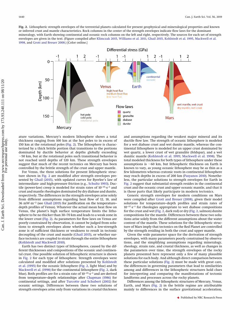
Combining brittle and ductile strength models provides an ap-proximate profile of strength versus depth, or strength envelope,that defines the entire lithosphere. Strength envelopes are usefulfor estimating total lithospheric thickness, the depth interval ofthe transition from brittle to ductile deformation, and the stressesat any depth within the lithosphere that are required for defor-mation to occur — and so they are invaluable for comparativetectonics of the rocky planets. Figure 2 shows a compilation ofpossible model solutions of strength envelopes for the modernlithospheres of the four inner solar system planets. Differentialstresses are the difference between horizontal and vertical prin-cipal stresses, and their positive and negative values (with com-pression here defined as positive) correspond to lithosphericstrength in tectonic regimes undergoing shortening and exten-sion, respectively. In addition to the information about the litho-sphere contained in each individual strength envelope, theirpresentation as a group allows comparisons to be drawn betweenthem that have implications for the nature and expression oftectonics on each of these planets.
Three possible lithospheric structures are shown for Mercury(Fig. 2). Brittle portions of the strength envelopes are modifiedfrom Klimczak (2015), and the ductile behavior is shown for flowlaws of dry diabase (crust) and dunite (mantle) with a strain rate of10−19·s−1 described by thermally activated power-law relations be-tween differential stress and strain from the nominal tempera-ture structure of Mercury modeled by Williams et al. (2011). Allenvelopes are plotted for a crustal thickness of 40 km, consistentwith Mercury’s gravity and topography (Padovan et al. 2015). Thecontrasting strength envelopes arise from insolation-driven dif-ferences in the upper parts of temperature–depth profiles of theplanet (Williams et al. 2011) associated with surface temperaturevariations (Vasavada et al. 1999) that result from the planet’s3:2 spin–orbit resonance. The surface temperatures are lowest(147 °K) at the rotational poles, the highest surface temperatures(427 °K) are at equatorial hot poles located at 0° and 180°E, andintermediate surface temperatures (324 °K) are at the equatorialcold poles at 90° and 270°E. On the basis of these regional temper-
Fig. 1. Series of block diagrams, from Cloos (1936), showing a continuum of structures that could exist within a tectonic setting dominated byglobal contraction. This figure is in the public domain.
Klimczak et al. 1439
Published by NRC Research Press
Can
. J. E
arth
Sci
. Dow
nloa
ded
from
ww
w.n
rcre
sear
chpr
ess.
com
by
173.
93.2
40.1
11 o
n 08
/11/
20Fo
r pe
rson
al u
se o
nly.
ature variations, Mercury’s modern lithosphere shows a totalthickness ranging from 100 km at the hot poles to in excess of150 km at the rotational poles (Fig. 2). The lithosphere is charac-terized by a thick brittle portion that transitions to the portionsdominated by ductile behavior at depths globally exceeding�50 km, but at the rotational poles such transitional behavior isnot reached until depths of 120 km. These strength envelopessuggest that much of the recent tectonics on Mercury has beencontrolled by the brittle strength of the crust and upper mantle.
For Venus, the three solutions for present lithospheric struc-ture shown in Fig. 2 are modified after strength envelopes pre-sented by Ghail (2015), with updated curves for Byerlee’s law ofintermediate- and high-pressure friction (e.g., Schultz 1993). Duc-tile (power-law) creep is modeled for strain rates of 10−15·s−1 andcrust and mantle rheologies dominated by dry diabase and dunite,respectively. The differences in the strength envelopes arise solelyfrom different assumptions regarding heat flow of 12, 18, and36 mW·m−2 (see Ghail (2015) for justification on the temperature–depth profiles of Venus). Whatever the actual mean heat flow onVenus, the planet’s high surface temperature limits the litho-sphere to be no thicker than 30–70 km and leads to a weak zone inthe lower crust (Fig. 2). As parameters for flow laws on Venus arepoorly constrained by observation, it cannot be judged from solu-tions to strength envelopes alone whether such a low-strengthzone is of sufficient thickness or weakness to result in tectonicdecoupling of the crust and mantle (Ghail 2015), or whether sur-face tectonics are coupled to strain through the entire lithosphere(Kohlstedt and Mackwell 2010).
Earth has two distinct types of lithospheres, caused by the dif-ferent thicknesses and compositions of the oceanic and continen-tal crust. One possible solution of lithospheric structure is shownin Fig. 2 for each type of lithosphere. Strength envelopes werecalculated and modified after solutions presented by Kohlstedtet al. (1995) for the oceanic lithosphere (Fig. 2, light blue) and byMackwell et al. (1998) for the continental lithosphere (Fig. 2, darkblue). Both profiles are for a strain rate of 10−15·s−1 and are derivedfrom temperature–depth relationships after Chapman (1986) forcontinental settings, and after Turcotte and Schubert (2002) foroceanic settings. Differences between these two solutions ofstrength envelopes arise only from variations in crustal thickness
and assumptions regarding the weakest major mineral and itsductile flow law. The strength of oceanic lithosphere is modeledfor a wet diabase crust and wet dunite mantle, whereas the con-tinental lithosphere is modeled for an upper crust dominated bywet quartz, a lower crust of wet granulite (feldspar), and a wetdunitic mantle (Kohlstedt et al. 1995; Mackwell et al. 1998). Thetotal modeled thickness for both types of lithosphere under theseassumptions is �60 km, but lithospheric thickness on Earth isknown to vary, as young oceanic lithosphere may be as thin as afew kilometres whereas cratonic roots in continental lithospheremay reach depths in excess of 200 km (Pasyanos 2010). Nonethe-less, the particular solutions to strength envelopes for Earth inFig. 2 suggest that substantial strength resides in the continentalcrust and the oceanic crust and upper oceanic mantle, and that itis those parts that likely participate in modern tectonics.
Generic strength envelopes for modern conditions on Marswere compiled after Grott and Breuer (2008), given their modelsolutions for temperature–depth profiles and strain rates of10−17·s−1 for rheologies appropriate to wet diabase compositionsfor the crust and wet (Fig. 2, dark red) or dry (Fig. 2, salmon) dunitecompositions for the mantle. Differences between these two solu-tions arise solely from the different assumptions about the watercontent of the mantle. These solutions for the lithospheric struc-ture of Mars imply that tectonics on the Red Planet are controlledby the strength residing in both the crust and upper mantle.
Given the wide parameter space for the derivation of strengthenvelopes, with many parameters poorly constrained by observa-tions, and the simplifying assumptions regarding mineralogy,rheology, strain rate, and crustal thickness, as well as changes inthe parameters over time, the strength envelopes of the rockyplanets presented here represent only a few of many plausiblesolutions for each body. And although direct comparison betweenthese particular solutions (Fig. 2) must be made with great care,the differences in governing parameters that lead to similaritiesamong and differences in the lithospheric structures hold cluesfor interpreting and comparing the manifestations of tectoniclandforms and processes across the rocky planets.
Differences among the lithospheric structures of Mercury, Venus,Earth, and Mars (Fig. 2) in the brittle regime are attributablemainly to differences in the surface gravitational acceleration,
Fig. 2. Lithospheric strength envelopes of the terrestrial planets calculated for present geophysical and mineralogical properties and knownor inferred crust and mantle characteristics. Rock columns in the center of the strength envelopes indicate flow laws for the dominantmineralogy, with Earth showing continental and oceanic rock columns on the left and right, respectively. The sources for each set of strengthenvelopes are given in the text. (Figure compiled after Klimczak 2015, Williams et al. 2011, Ghail 2015, Kohlstedt et al. 1995, Mackwell et al.1998, and Grott and Breuer 2008.) [Color online.]
1440 Can. J. Earth Sci. Vol. 56, 2019
Published by NRC Research Press
Can
. J. E
arth
Sci
. Dow
nloa
ded
from
ww
w.n
rcre
sear
chpr
ess.
com
by
173.
93.2
40.1
11 o
n 08
/11/
20Fo
r pe
rson
al u
se o
nly.

and in the ductile regime to differences in surface temperature,heat flow, crustal thickness, crustal and mantle rheologies, strainrates, and the state of hydration of the crust and mantle. Thisgenerality underscores the recognition that any study of compar-ative planetary tectonics must take these factors into account, butlikewise that differences in the manifestations of tectonic defor-mation may serve to illuminate the influence of such parameterson the lithospheres of the rocky planets. Of course, the litho-spheric strength envelopes in Fig. 2 are shown for present condi-tions, and tectonic landforms formed earlier in geological historymust be put into the context of the lithospheric structure at thetime of their formation (e.g., when higher heat flux would makefor thinner lithosphere than today). This temporal aspect is keyfor understanding how modern lithospheric structures and theirassociated tectonic processes serve as analogues to ancient litho-spheric structures and their governing processes.
Even so, commonalities in lithospheric structure can be drawnbetween pairs of planets and among all rocky planets. For allrocky planets, at least the uppermost portions of their crust —and for Mercury, Earth, and Mars also the lower portions of thecrust and perhaps even the uppermost mantle — behave in abrittle manner, such that brittle processes involving jointing andfaulting would dominate the surface expressions of tectonic land-forms. Furthermore, the compiled solutions to strength enve-lopes suggest that both Mars and Mercury may have substantiallythicker modern lithospheres (and thicker brittle portions) thanEarth or Venus, implying that recent faulting and seismicity aregenerally expected to extend to greater depths (aside from seis-micity associated with lithospheric subduction on Earth). In con-trast, the thinner lithospheres (and thinner brittle portions) onEarth and Venus allow for a wider diversity of long- and medium-wavelength tectonic phenomena, such as flexural responses tolithospheric loads, and perhaps the great horizontal mobility ofplates on Earth (and, to a lesser extent, lithospheric blocks onVenus).
Structures of interestThe study of structural geology and tectonics in the planetary
sciences relies on remotely sensed images, topography, and otherdata acquired from flybys or from orbit, as well as more spatiallylimited in situ data from landers or rovers. Interpretation of struc-
tures is based on recognition of geomorphologic characteristics,such as positive- or negative-relief landforms or diagnostic mappatterns. In this section, we summarize geometric properties ofimportant structures and discuss how they are observed, mapped,and interpreted.
FoldsFolds are formed when initially homoclinal structures —
structures with constant attitude — are distorted, or folded, intocurved structures (Fig. 3). Tectonic folding occurs both in the brit-tle and ductile regimes and is thus accommodated by brittle andductile deformation mechanisms. In the brittle regime, folding isaccommodated by the flexure of geologic units that produces andutilizes fractures of multiple orientations. In the ductile regime,folding is accommodated by plastic deformation, i.e., flow, of therock volume. There are many details on geometry, mechanisms,and processes involved in folding, and they depend on a widerange of factors, including the orientation of stresses with respectto, and the rheological properties of, the folded geologic units.Here we focus on those terms and characteristics of folds that areimportant for the recognition and description of folds on plane-tary surfaces, particularly where in situ and (or) cross-sectionalobservations are not available.
A fold consists of a hinge connecting two limbs. The hinge is alinear structure that coincides with the axis along which maxi-mum curvature occurs, whereas the limbs tend to be planar struc-tures. If the hinge line is not curved, it is also commonly referredto as the fold axis. Hinges do not necessarily coincide with foldcrests. Limbs dipping toward the hinge form troughs, or syn-forms, and limbs dipping away the hinge form ridges, or anti-forms; when the facing direction, i.e., upward direction at thetime of folding, is known, synforms and antiforms are referred toas synclines and anticlines, respectively (Fig. 3). Folds with onlyone limb are generally referred to as monoclines. On structuralmaps, ridges are indicated with lines following the hinge thathave arrows or triangles pointing away from the hinge, whereastroughs are mapped with lines following the hinge that havearrows or triangles pointing toward the hinge (Fig. 3). Monoclinesare shown with lines following the hinge that have one arrowindicating the dip direction of the limb.
Fig. 3. Annotated diagram of upright folds, showing the geometry of an anticline–syncline pair and their respective map symbologies. Aseries of anticlines at the bottom of the diagram indicates different fold tightness, from gentle or open, to tight and isoclinal shapes. [Coloronline.]
Klimczak et al. 1441
Published by NRC Research Press
Can
. J. E
arth
Sci
. Dow
nloa
ded
from
ww
w.n
rcre
sear
chpr
ess.
com
by
173.
93.2
40.1
11 o
n 08
/11/
20Fo
r pe
rson
al u
se o
nly.

The degree of folding, i.e., the amount of distortion or curvatureof the folded rock volume, is generally categorized in terms of thefold tightness. Limbs at angles to one another between 180° and70° make gentle to open folds, whereas interlimb angles smallerthan 70° produce tight folds. Folds with limbs that are nearlyparallel are referred to as isoclinal folds (Fig. 3).
All the folds shown in Fig. 3 are symmetric: that is, the limbshave similar dip but antithetic (i.e., opposite) dip directions. Incontrast, asymmetric folds have limbs that show substantial dif-ferences in dip angles and with dip directions antithetic or evensynthetic to one another. Fold asymmetry leads to inclined oroverturned folds that have an upper and lower limb and an in-clined axial plane. The direction of fold overturning has beenreferred to as vergence since Stille’s suggestion in 1930 (Stille1930). Fold vergence is an indication of the direction of tectonictransport.
Folds are best studied in cross sections perpendicular to theirhinge lines, which can be difficult to discern on Mercury, Venus,or even Mars, where a fold has yet to be discovered in rover im-ages. On planetary surfaces for which our understanding of tec-tonic structures involving folding is mostly informed by imageand topographic data sets, careful inspection of morphologic sig-
natures of folds and their interpretation as ridges and troughsform the primary means by which they are characterized. Al-though folds develop in a variety of tectonic settings, they areperhaps most easily recognized on planetary surfaces when theyform in association with faults to form fault-related folds, histor-ically termed “faultfolds” (Holmes 1876) or “Bruchfalten” (Suess1885), which include fault propagation folds, displacement-gradientfolds, and drag folds (see next section).
FaultsFaults are planar structural discontinuities along which shear
displacement is localized (Schultz and Fossen 2008). In the brittleregime, displacement is accommodated by frictional sliding,whereas deformation along faults that penetrate into the ductileregime is accommodated by plastic deformational micromecha-nisms that form shear zones and mylonites (e.g., Cowie et al. 2013).The amount of shear displacement, or offset (Fig. 4), is usually theresult of multiple faulting events along the fault surface. Thedirection of slip with respect to the orientation of the fault surfacegives rise to a kinematic classification of faults into two end-member models: dip-slip faults (Figs. 4A–4C) and strike-slip faults(Fig. 4D).
Fig. 4. Annotated block diagrams of fault types showing the offsets (red double arrows), fault planes (white planes), possible fault-relatedfolding, and direction of tectonic transport (red bold arrows) for individual fault blocks, as well as map symbology. (A) Normal fault,(B) high-angle thrust fault, (C) thrust fault, and (D) strike-slip fault. [Color online.]
1442 Can. J. Earth Sci. Vol. 56, 2019
Published by NRC Research Press
Can
. J. E
arth
Sci
. Dow
nloa
ded
from
ww
w.n
rcre
sear
chpr
ess.
com
by
173.
93.2
40.1
11 o
n 08
/11/
20Fo
r pe
rson
al u
se o
nly.
Dip-slip faults are faults with generally inclined fault planes,where the offset occurs along the axis of the dip of the fault plane.If the rock volume above the fault plane (the hanging wall) movesdownward with respect to the rock volume beneath the faultplane (the footwall), the fault is referred to as a normal fault(Fig. 4A); structures showing upward displacements of the hang-ing wall relative to the footwall are referred to as thrust faults(Figs. 4B–4C). Strike-slip faults are those faults for which offsetsare horizontal, in the direction of the strike of the fault (Fig. 4D);on any inclined plane, this lateral displacement can occur with aleft-lateral or right-lateral sense of shear, termed sinistral anddextral, respectively. In contrast to these end-members, most faultingis observed to display a combination of along-dip and along-strike slip (i.e., oblique slip) on surfaces that range from near-horizontal to vertical (Angelier 1994).
Frictional properties of rock masses show that certain fractureplanes are always oriented more favorably for frictional slidingthan others when subject to tectonic stresses (e.g., Zoback 2007).This situation leads to characteristic fault orientations relativeto the major tectonic stress axes (i.e., the principal stresses). Basalts,which make up much of the brittle portion of the terrestrial oce-anic lithosphere (Fig. 2), show optimal orientations for frictionalsliding at angles acute to the maximum principal stress (Jaegeret al. 2007), so normal faults are predicted (and are widely found)to form with dip angles (as measured from horizontal) of �60°,thrust faults with dip angles of �30°, and strike-slip faults withvertical dip angles. Although assumptions for typical frictionalproperties of basaltic rock masses and resultant fault orientationsare good first-order approximations for planetary fault analogues,many exceptions, such as low-angle normal faults with dip anglesless than �45° (Wernicke 1995), and high-angle thrust faults withdip angles exceeding 45° (e.g., Sibson 1990; Fig. 4C), are observedon Earth.
Many maps published in the planetary science literature showfaults as plain lines without using specific symbols for fault types.However, fault symbols and map notations of linear structures ingeneral contain information on strike, length, and segmentationand, when used properly, should also provide information on thedip direction and direction of tectonic transport. Generally, faultsshould be mapped using lines with thicknesses greater than thosefor geologic contacts. Normal faults are usually further specifiedwith solid rectangular boxes on the hanging wall (i.e., down-thrown) side of the mapped line (Fig. 4A), but other notations suchas hachures or, mainly in the United States, ball and bar symbols,are used, too. Thrust faults are indicated with a triangular symbolon the hanging wall (i.e., upthrown) side of the mapped line(Fig. 4B). Strike-slip faults are generally indicated by half arrowsthat show the direction of relative movement of the blocks(Fig. 4D). Oblique faults are indicated on maps by decompositionof the slip vector into their dip-slip and strike-slip componentsand using both appropriate dip-slip and strike-slip symbols toindicate the overall kinematics of this type of fault.
Representations of faults and folds on planetary surfaces
A guide to recognizing fault-related landforms on planetarysurfaces
In contrast to Earth, there has been no major erosional levelingon Mercury, Venus, or Mars, and so faulting is manifest, and canbe recognized, by distinct landforms. Figure 5 displays examplesof landforms associated with each of the fault types from Mars,but similar landforms are reported from Mercury (Byrne et al.2018) and Venus (Solomon et al. 1992). Recognition of fault-relatedlandforms relies on knowledge of relief and thus can be challeng-ing where topographic information is not available or of insuffi-cient resolution. In such cases, recognition of landforms relies oninterpretation of shadows and detection of diagnostic map pat-terns of faults on image data sets.
Planetary normal faults, like those on Earth, often form gra-bens; in the absence of substantial erosion and (or) burial by sed-imentary infill, they are apparent on a planetary surface as lineartopographic lows (troughs) formed by the down-dropping of acrustal block along two steeply dipping, bounding, antithetic nor-mal faults (Fig. 5A). In addition to this distinctive topographicexpression, interactions between overlapping normal fault seg-ments lead to relay ramps, which are diagnostic of normal fault-ing. On large normal faults, isostatic adjustments and mechanicalresponses of the rock volume surrounding the faults produce gen-tle synclinal flexures in the footwall (termed footwall uplift) and agentle anticlinal flexure in the hanging wall, forming footwallsynclines and hanging wall (or rollover) anticlines, respectively(see Buck 1988), which may be observable only in topographic dataacquired at high spatial and vertical resolution. Drag folding mayalso be observed where faults are exposed in cross section, such asin outcrops on Earth, and can show gentle anticlines in the foot-wall and gentle synclines in the hanging wall (Fig. 4A).
Planetary thrust faults produce characteristic positive-relieflandforms, often generically termed “lobate scarps”, “high-reliefridges”, or “wrinkle ridges” (see discussion in next section). Thecorresponding landforms produce symmetric or asymmetricridges. Surface-breaking thrust faults (Fig. 5B) generally produceasymmetric landforms, with one steep-sloped cliff facing the di-rection of tectonic transport and a gentler slope dipping in thesame direction as the underlying fault plane (e.g., Schultz 2000;Schultz et al. 2010). Blind thrust faults have landforms with eitherasymmetric or symmetric ridges with crowning folds. These land-forms are widely interpreted as fault-related folds that formed asa consequence of accumulation and variations in slip along thefault. The folding geometry in the hanging walls of thrust faults ishighly variable, depending on the structural style of faulting, butfolds may be tight and can involve overturning of the steeper ofthe two-fold limbs (Fig. 4C). In some cases, thrust faulting mightalso be accommodated without major folding, such that theircorresponding landforms form simply from the tilt and transla-tion of the hanging wall rock mass above that of the footwall.
Strike-slip faults have very subtle expressions on planetary sur-faces and therefore are among the most difficult structures todetect without those structural tools available to a geologist onEarth. For small offsets or a lack of pronounced offset markers,such faults may be recognized only from very small topographicdifferences between the fault blocks, as is the case for most of theexample shown in Fig. 5C. However, fault segmentation or suddenchanges (bends) in fault strike produce negative-relief pull-apartbasins (Fig. 6A) or positive-relief push-up ridges (Fig. 6B), and thoselandforms can facilitate the recognition and interpretation ofstrike-slip structures.
Characterizing shortening structures in planetary tectonicsThe formation of fault-related landforms involves folding, and
thus interpretation and proper mapping of such landformsshould consider both faults and folds. Thrust faulting, in particu-lar, produces a wide variety of fold shapes and patterns. For thisreason, thrust-fault-related landforms have generally not beendescribed as such on the rocky planets but instead have beencategorized by the terms mentioned above (i.e., wrinkle ridges,high-relief ridges, or lobate scarps) on Mercury (e.g., Strom et al.1975; Dzurisin 1978), Venus (e.g., Kreslavsky and Basilevsky 1998;Bilotti and Suppe 1999), and Mars (e.g., Watters 1993; Golombeket al. 2001; Mueller and Golombek 2004; Mueller et al. 2014).
First observed and described on the Moon (e.g., Bryan 1973;Masursky et al. 1978), the landforms termed “wrinkle ridges” aremanifest as broad, steep-sided but low-relief arches that aremostly symmetric in cross section and may have crenulatedcrests. A characteristic property of wrinkle ridges is the substan-tial morphological variation along strike, with changes to width,height, and landform symmetry often observed (see summary by
Klimczak et al. 1443
Published by NRC Research Press
Can
. J. E
arth
Sci
. Dow
nloa
ded
from
ww
w.n
rcre
sear
chpr
ess.
com
by
173.
93.2
40.1
11 o
n 08
/11/
20Fo
r pe
rson
al u
se o
nly.

Schultz (2000)). These structures are commonly found on allrocky planets (e.g., Bryan 1973; Dzurisin 1978; Kreslavsky andBasilevsky 1998; Mueller and Golombek 2004). As noted by Byrneet al. (2018), landforms proposed as analogues to wrinkle ridgeshave been described at numerous sites on Earth, including Alge-ria, Australia, and the United States (e.g., Plescia and Golombek1986; Watters 1989, 1988), and in each case they feature distortion(including folding) of the hanging wall of thrust faults. No consen-sus on the orientation and depth of the underlying faults and thekinematics of fault-related folding of wrinkle ridges has beenreached in the planetary tectonics community (e.g., Plescia andGolombek 1986; Watters 1988, 1991; Golombek et al. 1991; Plescia1991, 1993; Schultz and Tanaka 1994; Zuber 1995; Schultz 2000;Mueller and Golombek 2004). The steep escarpments that bound
wrinkle ridges can themselves be regarded as monoclines, suchthat where they occur, two opposite-facing ridge-bounding scarpsare essentially paired monoclines. Accordingly, where wrinkleridges have steep sides, they, too, can be said to have vergence (cf.Byrne et al. 2018).
As suggested by their name, high-relief ridges tend to showgreater relief than wrinkle ridges, but they have also been notedto be generally symmetric in cross section (Watters et al. 2001).The term has been applied to a set of positive-relief landforms onMercury but has rarely been applied to any other planetary body.Although considerable along-strike changes in size and shape areless commonly seen for that category of landform, some varia-tions in width, height, or vergence occur (Watters et al. 2001).
Fig. 5. Examples of landforms on Mars formed by different types of faulting, with corresponding map interpretations. (A) Segmentednormal faults that are part of Claritas Fossae form a series of grabens. (B) Segmented thrust faults form the 540 km long and topographicallypronounced Bosporos Rupes thrust-fault-related landform. Black arrows point to fault splays. (C) Subtle topographic expression of aright-lateral strike-slip fault (Okubo and Schultz 2006), showing examples of push-up ridges and small pull-apart basins (shown in Fig. 6 ingreater detail). [Color online.]
1444 Can. J. Earth Sci. Vol. 56, 2019
Published by NRC Research Press
Can
. J. E
arth
Sci
. Dow
nloa
ded
from
ww
w.n
rcre
sear
chpr
ess.
com
by
173.
93.2
40.1
11 o
n 08
/11/
20Fo
r pe
rson
al u
se o
nly.

In contrast to the mostly symmetrical cross sections of wrinkleand high-relief ridges, lobate scarps are commonly described ashighly asymmetric in transverse view, with steep slopes on oneside and gentle backslopes on the other. In map view, they haverelatively steep and long escarpments that typically trace abroadly lobate fault surface break, although some lobate scarps,such as Beagle Rupes on Mercury, have strongly arcuate forms(Rothery and Massironi 2010). Many such structures show smaller,subordinate scarps along their leading edges (Fig. 5B) that havepreviously been described using generic terms (Watters 1988) assecond- and third-order ridges, but Klimczak et al. (2018) appliedgeologic nomenclature to describe them as minor thrust faultsand fault splays.
As upthrust volumes of rock, then, lobate scarps are the foldedor tilted portions of the rock mass in the hanging walls atop thrustfaults. With fault nomenclature, many lobate scarps are thereforefault-propagation or fault-bend folds, which together may beclassed as “fault displacement-gradient folds” (Wickham 1995). Onthe basis of the shape of this landform alone, lobate scarps areasymmetric hanging-wall anticlines or monoclines. The foldingand tilting of the rock mass in the hanging wall of the thrust faultis accommodated by brittle deformation as outer-arc extension(Figs. 7A, 7B) along the fold hinges, manifest as joints and narrowgrabens along the crests of scarps (Fig. 7). That such structures arereported for the Moon (Watters and Nimmo 2010), Mercury (Byrneet al. 2018; Fig. 7C), and Mars (Mueller and Golombek 2004) showsthat this mechanism commonly accompanies the growth of theselandforms, which, in turn, implies that hanging walls of planetarythrust faults are highly fractured. Such deformation may lead todifferences in the mechanical properties of the rock volumes be-tween the hanging wall and footwall, and these differences mayneed to be considered when attempting to derive model age datesfor thrust faults from the areal density of proximal impact craters.The asymmetry of lobate scarps likely reflects the vergence of thehanging-wall anticline, which in turn gives the direction of tec-tonic transport along the underlying fault (e.g., Byrne et al. 2014).
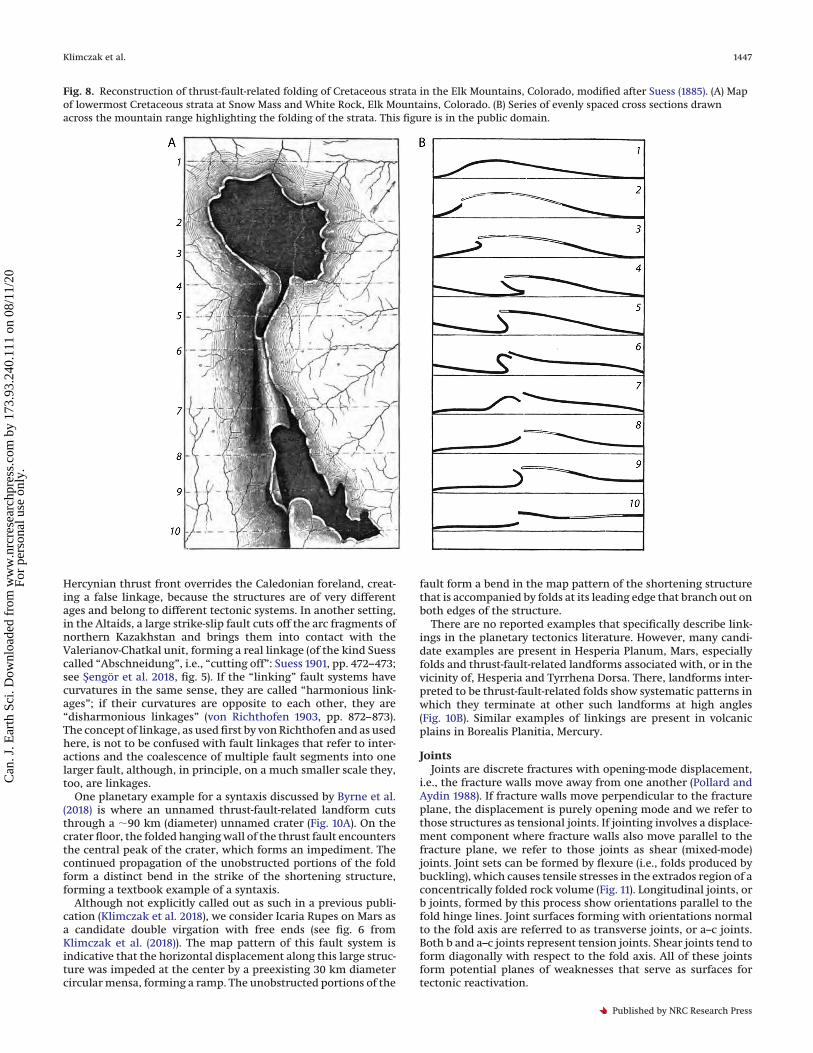
Despite the large number of studies characterizing the mor-phology and comparing positive-relief landforms on other rockybodies to shortening structures on Earth, the generic terms“lobate scarp” or “wrinkle ridge”, which lack any hypotheticalinterpretation, persist in the planetary tectonics literature. Fur-thermore, the morphology of shortening landforms on the rockyplanets is sufficiently variable that no single set of quantitativemorphological criteria exists by which such landforms can begrouped into one of these end-member cases. Many examples oflobate scarps with morphological characteristics matching thosedescribed for wrinkle ridges, and vice versa, or where one land-form transitions into another, show that this categorization is nothelpful for understanding the fault and fold architectures and thetectonic processes involved in forming them. Byrne et al. (2018)presented an extensive list of structures on Mercury that showsufficient morphologic complexities that the classification intoone distinct group breaks down, but such lists are not limited toMercury, and examples abound on the Moon, Venus, Mars, and, ofcourse, Earth. In fact, that shortening structures show a widevariation of fold geometry within the same structure has longbeen recognized on Earth. Reconstruction of fold geometry pre-served in Cretaceous strata along the Elk Mountains (Colorado,USA), for instance, was carried out by Holmes as early as 1874(Holmes 1876; Suess 1885). A series of profiles across the Elk Moun-tains (Fig. 8) highlights the variability of fold shapes along a singlestructure, where anticlinal geometries range from gentle andbroad to tight and overturned in a single system.
A classification scheme for shortening structures based only onmorphology, and with no interpretation tied to it, cannot capturethe broad morphological variations of these landforms and is thusof little help in understanding the tectonic style and geometry ofassociated faults and folds. Instead, careful structural mappingand descriptions and compilation of observations should be fol-lowed by an interpretation that provides testable hypotheses forthe shortening landforms in the local, regional, or global geologiccontext of their planet (e.g., Klimczak et al. 2018). Techniques assimple as the Holmesian method (Holmes 1876) of drawing pro-files across shortening landforms (Fig. 8) are eminently usefulapproaches for facilitating and encouraging scientific interpreta-tion of and debate about extraterrestrial structures.
Patterns of shortening landforms on planetary surfacesMap patterns of landforms involving both faults and folds can
be indicative or diagnostic of tectonic styles and the subsurfacearchitecture of deformation. This topic is particularly relevant to
Fig. 6. Mars Reconnaissance Orbiter Context Camera (CTX) imagesof strike-slip fault landforms (from fault in Fig. 5C). (A) Right bend inthe strike of the right-lateral fault caused a pull-apart basin to form.(B) A left step between two en echelon right-lateral fault segmentsproduced a push-up ridge.
Klimczak et al. 1445
Published by NRC Research Press
Can
. J. E
arth
Sci
. Dow
nloa
ded
from
ww
w.n
rcre
sear
chpr
ess.
com
by
173.
93.2
40.1
11 o
n 08
/11/
20Fo
r pe
rson
al u
se o
nly.

bodies featuring a history of global contraction in response tosecular cooling of the interior, including Mercury, Mars, and theMoon. (As an aside, the term “contraction” is used here only for anoverall decrease in the volume of a planetary body, whereas theresulting structures, thrust faults and folds, are termed “shorten-ing structures”, referring to a decrease in surface length in onehorizontal dimension.) Many different patterns of thrust faultsand associated folds exist on these rocky bodies (e.g., Byrne et al.2014, 2015; Klimczak et al. 2018; Crane and Klimczak 2019), butfrequently individual features have been described with genericterms, without context to other structures, or without taking ter-restrial analogues into consideration. For example, interactions ofthrust faults and associated folds with obstacles in the lithosphereor with each other, such as mechanical contrasts between geo-logic units that can function as detachment horizons, give riseto complex tectonic systems, including syntaxes, virgations, andlinking (Fig. 9). Such tectonic structures are reported and de-scribed across Earth, but they are largely unknown in the planetarytectonics community, and thus they have not been recognized ordescribed, and the most appropriate terminology has not been ap-plied.
A syntaxis is a convergence of mountain ranges, which on therocky planets are landforms produced by folds, toward a singlepoint with a sharp deflection of the trend lines of structures onboth sides (Fig. 9A). The points themselves are typically obstaclesof some kind, such as mechanically strong and coherent volumesof rock, massifs, or the central peaks of impact craters. Prominentexamples on Earth are found in the Himalaya (Suess 1885) andinclude the Hazara and the Assam syntaxes and the Nanga Parbatsyntaxes in India.
Virgations are fan-shaped branching of a series of folds (Fig. 9B)that are also frequently accompanied by fractures. Virgations typ-ically occur at the end of folded structures and usually in associa-tion with one or more obstacles. If only one end of the folded
structure shows a virgation, we refer to such a structure as asimple virgation (as shown in Fig. 9B), but if both ends show thefan-shaped branching of folds, the structure is a double virgation.Double virgations may occur around a single obstacle and so pos-sess free ends, but they may also occur around multiple obstaclesand so possess forced ends. Prominent examples on Earth arefound in the northern Tien-Shan, Kyrgyzstan, which at its westernextent shows a virgation formed by the Chu-Iliiskii, Karatau, andChatkal’skii ranges, as well as the Gissar-Alai Range, Tajikistan,which shows a virgation on its western termination branchinginto the Nuratau Range and the ranges of the Tadzhik depressionand the Darvaza.
A pattern is referred to as “linking” when a fault system eitherabuts against another such system or is overridden by anotherfault and both fault systems were formed by the same tectonicevent. This type of fault interaction was first named “Kettung” byvon Richthofen (1903, pp. 872 ff.) on the basis of examples inwestern Pacific magmatic arcs (Fig. 9C). Suess originally calledsuch an interaction “Abschneidung” in the eastern Himalaya, butlater, in deference to his deceased friend, started using “Kettung”(Suess 1909a, p. 578; variously rendered into English as “linking”(in Hertha Sollas’ translation as edited by her father W.J. Sollas:Suess 1909b, p. 503) or “linkage” (Bucher 1933, p. 81, fig. 18c) and intoFrench as “enchaînement” (Suess 1918, p. 1369)). von Richthofen(1903) recognized two main types: an arc linkage from the side(“flankenständige Bogenkettung”; p. 873) and another arc linkagetermed, by von Richthofen, “retroimpounded arc linkage” (“rück-gestaute Bogenkettung”; p. 874). Of these, the latter is really adouble-sided virgation with free ends, and so we no longer con-sider it here and confine the term “linkage” to the first kind, bestillustrated by the overriding of the Izu-Bonin arc by the Honshuarc at the Fossa Magna. There, one major subduction zone, i.e., ahuge thrust fault system, overrides another one. On a smallerscale, in southern England and Wales and in southern Ireland, the
Fig. 7. Formation of crestal grabens atop the hanging wall anticlines of thrust faults. As thrust faults accumulate slip (A), outer-arc extensionleads to joints and small grabens (B). An example of crestal grabens on Mercury is shown in an image mosaic (top) and map interpretation(bottom) in (C). [Color online.]
1446 Can. J. Earth Sci. Vol. 56, 2019
Published by NRC Research Press
Can
. J. E
arth
Sci
. Dow
nloa
ded
from
ww
w.n
rcre
sear
chpr
ess.
com
by
173.
93.2
40.1
11 o
n 08
/11/
20Fo
r pe
rson
al u
se o
nly.
Hercynian thrust front overrides the Caledonian foreland, creat-ing a false linkage, because the structures are of very differentages and belong to different tectonic systems. In another setting,in the Altaids, a large strike-slip fault cuts off the arc fragments ofnorthern Kazakhstan and brings them into contact with theValerianov-Chatkal unit, forming a real linkage (of the kind Suesscalled “Abschneidung”, i.e., “cutting off”: Suess 1901, pp. 472–473;see Sengör et al. 2018, fig. 5). If the “linking” fault systems havecurvatures in the same sense, they are called “harmonious link-ages”; if their curvatures are opposite to each other, they are“disharmonious linkages” (von Richthofen 1903, pp. 872–873).The concept of linkage, as used first by von Richthofen and as usedhere, is not to be confused with fault linkages that refer to inter-actions and the coalescence of multiple fault segments into onelarger fault, although, in principle, on a much smaller scale they,too, are linkages.
One planetary example for a syntaxis discussed by Byrne et al.(2018) is where an unnamed thrust-fault-related landform cutsthrough a �90 km (diameter) unnamed crater (Fig. 10A). On thecrater floor, the folded hanging wall of the thrust fault encountersthe central peak of the crater, which forms an impediment. Thecontinued propagation of the unobstructed portions of the foldform a distinct bend in the strike of the shortening structure,forming a textbook example of a syntaxis.
Although not explicitly called out as such in a previous publi-cation (Klimczak et al. 2018), we consider Icaria Rupes on Mars asa candidate double virgation with free ends (see fig. 6 fromKlimczak et al. (2018)). The map pattern of this fault system isindicative that the horizontal displacement along this large struc-ture was impeded at the center by a preexisting 30 km diametercircular mensa, forming a ramp. The unobstructed portions of the
fault form a bend in the map pattern of the shortening structurethat is accompanied by folds at its leading edge that branch out onboth edges of the structure.
There are no reported examples that specifically describe link-ings in the planetary tectonics literature. However, many candi-date examples are present in Hesperia Planum, Mars, especiallyfolds and thrust-fault-related landforms associated with, or in thevicinity of, Hesperia and Tyrrhena Dorsa. There, landforms inter-preted to be thrust-fault-related folds show systematic patterns inwhich they terminate at other such landforms at high angles(Fig. 10B). Similar examples of linkings are present in volcanicplains in Borealis Planitia, Mercury.
JointsJoints are discrete fractures with opening-mode displacement,
i.e., the fracture walls move away from one another (Pollard andAydin 1988). If fracture walls move perpendicular to the fractureplane, the displacement is purely opening mode and we refer tothose structures as tensional joints. If jointing involves a displace-ment component where fracture walls also move parallel to thefracture plane, we refer to those joints as shear (mixed-mode)joints. Joint sets can be formed by flexure (i.e., folds produced bybuckling), which causes tensile stresses in the extrados region of aconcentrically folded rock volume (Fig. 11). Longitudinal joints, orb joints, formed by this process show orientations parallel to thefold hinge lines. Joint surfaces forming with orientations normalto the fold axis are referred to as transverse joints, or a–c joints.Both b and a–c joints represent tension joints. Shear joints tend toform diagonally with respect to the fold axis. All of these jointsform potential planes of weaknesses that serve as surfaces fortectonic reactivation.
Fig. 8. Reconstruction of thrust-fault-related folding of Cretaceous strata in the Elk Mountains, Colorado, modified after Suess (1885). (A) Mapof lowermost Cretaceous strata at Snow Mass and White Rock, Elk Mountains, Colorado. (B) Series of evenly spaced cross sections drawnacross the mountain range highlighting the folding of the strata. This figure is in the public domain.
Klimczak et al. 1447
Published by NRC Research Press
Can
. J. E
arth
Sci
. Dow
nloa
ded
from
ww
w.n
rcre
sear
chpr
ess.
com
by
173.
93.2
40.1
11 o
n 08
/11/
20Fo
r pe
rson
al u
se o
nly.

In contrast to the large-scale landforms associated with fault-ing, opening-mode displacement does not produce landforms ofsufficient size to allow easy observation by spacecraft. Therefore,these structures are difficult to study on planetary surfaces andrequire images from rovers or from orbital imagers capable ofresolving planetary surfaces on the centimetre scale, such asthose from the High Resolution Imaging Science Experiment(HiRISE) on NASA’s Mars Reconnaissance Orbiter. One exampleincludes metre-scale joints forming by subsidence in CandorChasma on Mars (Okubo 2010). Another example is seen in Fig. 7,where anticlinal flexure and thus outer-arc extension of the rockvolume in the hanging wall of thrust faults on Mercury producedjoints oriented along the same structural trend as the associatedfold and fault, indicating that they represent b joints. That manysuch crestal b joints ultimately grow large enough to becomenormal faults and grabens (Fig. 7C) shows that these joints pene-trate to sufficient depths that the overburden pressure exceedsthe tensile stresses, causing a purely compressive stress state, tofacilitate frictional sliding and thus faulting.
On local to regional scales, planetary joints can form from de-creases in igneous rock volume during cooling. Such joints areoriented with no preferred orientation and thus frequently pro-duce polygonal patterns of fractures in map view. Prominent ex-amples of cooling joints are preserved in melt sheets that ponded
on the floors of fresh complex impact craters, such as those ob-served on the floors of Hokusai or Degas craters on Mercury (Byrneet al. 2018). Additionally, where impact structures are filled withflood volcanic units, strains associated with the cooling-inducedvolumetric decreases in rock volume are sufficiently large to formkilometre-scale joints that can transition into grabens (Freed et al.2012; Klimczak et al. 2012; Blair et al. 2013). In smaller floodedimpact structures, these joints and grabens show no preferredstructural trend and form polygonal patterns. However, in impactbasins, the structural trends of grabens are preferentially radial orconcentric to the center of the impact structure (Byrne et al. 2018).
Tension joints have also been postulated to form globally onMercury as a result of tidal despinning (Klimczak et al. 2015), theslowing of an initially fast spin rate to the planet’s current 3:2 spin–orbit resonance. Tidal despinning could have occurred early inMercury’s geologic history, so that the resulting joints may nothave been preserved in the geologic record, but this process isoften invoked to have occurred late and to have overlapped withglobal contraction (e.g., Pechmann and Melosh 1979). The tecton-ics of despinning operating in isolation involves relaxation of anequatorial bulge and flattening at the poles, both effects produc-ing substantial tensile stresses and perhaps shear stresses thatwould produce shear joints in a manner that both Vening Meinesz(1947) and Sonder (1947, 1956) proposed had been important forEarth. Whereas global patterns from despinning on Earth, if theyever existed, have long been erased or overprinted, the frame-work is relevant for one-plate planets that likely despun, such asMercury. However, the only effective way to evaluate the type andorientation of structures that would have formed from such pro-cesses is by rock-mechanical assessment (Klimczak et al. 2015).Such analysis predicts a pattern of joints with east–west preferredorientations at equatorial and mid-latitudes and random orienta-tions at the poles. In contrast, if tidal despinning temporally over-lapped with global contraction, no joints would form, and insteadnorth–south-oriented thrust faults are predicted to have devel-oped at equatorial and mid-latitudes; faults would have random toeast–west orientations at the poles (Klimczak et al. 2015). Similaroutcomes can be invoked for the Moon, as the same processeshave been proposed to have operated there.
KarstAlthough the formation of karst is not primarily a tectonic
phenomenon, karst processes are frequently structurally con-trolled or produce collapse structures that can easily be confusedwith tectonic structures, and thus this topic is of some relevancefor planetary structural geology. Karst refers to a plateau made upmainly of Triassic and Jurassic neritic limestones north and east ofTrieste in the historical region of Carniola, today in Slovenia. Ithas given its name since the middle of the nineteenth century toa peculiar kind of landscape formed by the dissolution of solublerock either fully exposed on the surface or reached by variouspathways into the subsurface, forming a pock-marked topogra-phy of various solution features (lapiès, dolinas, uvalas, poljes,alvars, vertical pits called “obruk” in Anatolia, blind valleys, andcanyons) and underground drainage systems that form caves ofa bewildering variety of shapes and natural bridges formed bycollapsing caves. Most caves ultimately collapse to form distinctlandforms. These structures collectively form the so-called karsttopography (or “karst regions”: Cvijic 1893, 1960; Fig. 12A). Withongoing dissolution and an evolving karst landscape, a series ofdolinas, small (diameters ranging from several to hundreds ofmetres), equant, and shallow, usually cauldron-shaped depres-sions, may coalesce into larger compound structures, referredto as “uvalas” (Fig. 12B). Very large, flat-floored depressions, fre-quently elongate and aligned with structural trends along whichthe dissolution preferentially occurred, are referred to as “poljes”(Cvijic 1893, 1901; Fig. 12). Mature karst systems are characterizedby degradation of collapse structures manifest as widened and
Fig. 9. Block diagrams and associated map patterns of tectonicsystems involving thrust-fault-related folds. (A) Syntaxes, showingconvergence of folds toward an obstacle. (B) Fan-shaped branchingof folds around an obstacle resulting in a simple virgation. (C) Twopossible situations of linking. Note that the same map pattern canarise for two different directions of tectonic transport. [Color online.]
1448 Can. J. Earth Sci. Vol. 56, 2019
Published by NRC Research Press
Can
. J. E
arth
Sci
. Dow
nloa
ded
from
ww
w.n
rcre
sear
chpr
ess.
com
by
173.
93.2
40.1
11 o
n 08
/11/
20Fo
r pe
rson
al u
se o
nly.

Fig. 10. Examples of thrust-fault-related patterns of folds on Mercury and Mars presented as image mosaics (top) and map interpretations(bottom). (A) Syntaxis on Mercury, formed where the central peak (CP) posed an obstacle to a thrust-fault-related landform. (B) Linking inHesperia Planum on Mars. Note how thrust faults abut against other thrust faults. [Color online.]
Fig. 11. Joint sets associated with folds. Joints with orientations parallel with the fold hinge lines are longitudinal or b joints (purple). Jointsnormal to the fold axis are transverse or a–c joints (orange), and joints diagonal to the orientation of the fold are shear joints (green). [Coloronline.]
Klimczak et al. 1449
Published by NRC Research Press
Can
. J. E
arth
Sci
. Dow
nloa
ded
from
ww
w.n
rcre
sear
chpr
ess.
com
by
173.
93.2
40.1
11 o
n 08
/11/
20Fo
r pe
rson
al u
se o
nly.
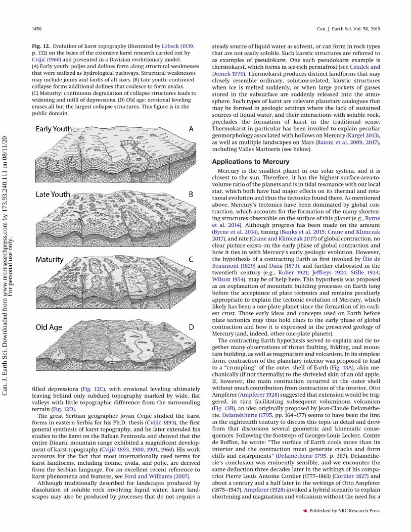
filled depressions (Fig. 12C), with erosional leveling ultimatelyleaving behind only subdued topography marked by wide, flatvalleys with little topographic difference from the surroundingterrain (Fig. 12D).
The great Serbian geographer Jovan Cvijic studied the karstforms in eastern Serbia for his Ph.D. thesis (Cvijic 1893), the firstgeneral synthesis of karst topography, and he later extended hisstudies to the karst on the Balkan Peninsula and showed that theentire Dinaric mountain range exhibited a magnificent develop-ment of karst topography (Cvijic 1893, 1900, 1901, 1960). His workaccounts for the fact that most internationally used terms forkarst landforms, including doline, uvala, and polje, are derivedfrom the Serbian language. For an excellent recent reference tokarst phenomena and features, see Ford and Williams (2007).
Although traditionally described for landscapes produced bydissolution of soluble rock involving liquid water, karst land-scapes may also be produced by processes that do not require a
steady source of liquid water as solvent, or can form in rock typesthat are not easily soluble. Such karstic structures are referred toas examples of pseudokarst. One such pseudokarst example isthermokarst, which forms in ice-rich permafrost (see Czudek andDemek 1970). Thermokarst produces distinct landforms that mayclosely resemble ordinary, solution-related, karstic structureswhen ice is melted suddenly, or when large pockets of gassesstored in the subsurface are suddenly released into the atmo-sphere. Such types of karst are relevant planetary analogues thatmay be formed in geologic settings where the lack of sustainedsources of liquid water, and their interactions with soluble rock,precludes the formation of karst in the traditional sense.Thermokarst in particular has been invoked to explain peculiargeomorphology associated with hollows on Mercury (Kargel 2013),as well as multiple landscapes on Mars (Baioni et al. 2009, 2017),including Valles Marineris (see below).
Applications to MercuryMercury is the smallest planet in our solar system, and it is
closest to the sun. Therefore, it has the highest surface-area-to-volume ratio of the planets and is in tidal resonance with our localstar, which both have had major effects on its thermal and rota-tional evolution and thus the tectonics found there. As mentionedabove, Mercury’s tectonics have been dominated by global con-traction, which accounts for the formation of the many shorten-ing structures observable on the surface of this planet (e.g., Byrneet al. 2014). Although progress has been made on the amount(Byrne et al. 2014), timing (Banks et al. 2015; Crane and Klimczak2017), and rate (Crane and Klimczak 2017) of global contraction, noclear picture exists on the early phase of global contraction andhow it ties in with Mercury’s early geologic evolution. However,the hypothesis of a contracting Earth as first invoked by Élie deBeaumont (1829) and Dana (1873), and further elaborated in thetwentieth century (e.g., Kober 1921; Jeffreys 1924; Stille 1924;Wilson 1954), may be of help here. This hypothesis was proposedas an explanation of mountain building processes on Earth longbefore the acceptance of plate tectonics and remains peculiarlyappropriate to explain the tectonic evolution of Mercury, whichlikely has been a one-plate planet since the formation of its earli-est crust. Those early ideas and concepts used on Earth beforeplate tectonics may thus hold clues to the early phase of globalcontraction and how it is expressed in the preserved geology ofMercury (and, indeed, other one-plate planets).
The contracting Earth hypothesis served to explain and tie to-gether many observations of thrust faulting, folding, and moun-tain building, as well as magmatism and volcanism. In its simplestform, contraction of the planetary interior was proposed to leadto a “crumpling” of the outer shell of Earth (Fig. 13A), akin me-chanically (if not thermally) to the shriveled skin of an old apple.If, however, the main contraction occurred in the outer shellwithout much contribution from contraction of the interior, OttoAmpferer (Ampferer 1928) suggested that extension would be trig-gered, in turn facilitating subsequent voluminous volcanism(Fig. 13B), an idea originally proposed by Jean-Claude Delaméthe-rie. Delamétherie (1795, pp. 164–177) seems to have been the firstin the eighteenth century to discuss this topic in detail and drewfrom that discussion several geometric and kinematic conse-quences. Following the footsteps of Georges-Louis Leclerc, Comtede Buffon, he wrote: “The surface of Earth cools more than itsinterior and the contraction must generate cracks and formcliffs and escarpments” (Delamétherie 1795, p. 367). Delaméthe-rie’s conclusion was eminently sensible, and we encounter thesame deduction three decades later in the writings of his compa-triot Pierre Louis Antoine Cordier (1777–1861) (Cordier 1827) andabout a century and a half later in the writings of Otto Ampferer(1875–1947). Ampferer (1928) invoked a hybrid scenario to explainshortening and magmatism and volcanism without the need for a
Fig. 12. Evolution of karst topography illustrated by Lobeck (1939,p. 132) on the basis of the extensive karst research carried out byCvijic (1960) and presented in a Davisian evolutionary model.(A) Early youth: poljes and dolines form along structural weaknessesthat were utilized as hydrological pathways. Structural weaknessesmay include joints and faults of all sizes. (B) Late youth: continuedcollapse forms additional dolines that coalesce to form uvalas.(C) Maturity: continuous degradation of collapse structures leads towidening and infill of depressions. (D) Old age: erosional levelingerases all but the largest collapse structures. This figure is in thepublic domain.
1450 Can. J. Earth Sci. Vol. 56, 2019
Published by NRC Research Press
Can
. J. E
arth
Sci
. Dow
nloa
ded
from
ww
w.n
rcre
sear
chpr
ess.
com
by
173.
93.2
40.1
11 o
n 08
/11/
20Fo
r pe
rson
al u
se o
nly.

pervasive crumpling of the outer shell, whereby conditionschange as the contraction progresses from surface to depth(Fig. 13C). These end-member cases highlight how shortening andmagmatism and volcanism may have taken place on a contractingplanet. But as the diversity of deformation observed on Earth wasnot compatible with either of these two scenarios of contraction(Figs. 13A, 13B), the contraction hypothesis was criticized longbefore the advent of the concept of plate tectonics (Dutton 1874;Ampferer 1928).
Hypothetical early and advanced stages of Mercury’s tectonicevolution after the onset of global contraction are depicted inFig. 14 in two schematic cross sections. In the early stage (Fig. 14A),it is assumed that the main thermally induced contraction oc-curred within the early lithosphere, analogous to the scenario ofthe hot interior of Earth with a rapidly contracting outer shell inFig. 13B. Such contraction thus could have triggered widespreadextension, which led to normal faulting, rifting, and associatedlithospheric thinning, which in turn could trigger magmatismand major volcanism through pressure-release melting or by of-fering readily accessible conduits through which existing magmacould ascend. This phase, which we name the “Delamétherianphase” in Mercury’s evolution, could have temporally overlapped
with other major processes at that time, such as a heavy meteor-oid bombardment and perhaps even planetary despinning. Muchof the crust may have been emplaced during this stage by a seriesof effusive volcanic eruptions and a succession of plains deposits(Denevi et al. 2009). Plains volcanism on Mercury ceased near thetime when global-contraction-induced thrust faulting was initi-ated (Byrne et al. 2016a), i.e., during what we call the “Beaumon-tian phase”, after Léonce Élie de Beaumont, who first recognizedin 1829 (Élie de Beaumont 1829–1830) the importance of globalcontraction for the origin of structures of shortening.
The stage of advanced cooling and contraction involves theonset of crustal shortening dominated by the overthrusting oflow-lying areas (first described as “Uberschiebung der Tiefen”, bySuess 1909; Sengör et al. 1993). Deformation in this stage couldinclude major, deep-seated thrust faults, some of which demar-cate the transition from high-standing to low-lying terrains, long-wavelength thrust-fault-related basement folds, and thin-skinnedfolding and thrusting in low-lying volcanic plains (Fig. 14B). Manyhigh-terrain-bounding thrust faults and smooth plains structuresoccur in spatial association with one another, and they frequentlyshare the same structural trends (Byrne et al. 2014). Those exam-ples may be structural systems where the smaller, smooth-plainsstructures root into the larger high-terrain-bounding thrust faults(Byrne et al. 2014, 2018; Fig. 14B), a common structural arrange-ment in terrestrial orogenic settings (see references given byByrne et al. 2018).
In such tectonic settings, the deeply rooted thrust faults corre-spond to what Stille (1920) called germanotype structures, whichtypically consist of a single major fault accommodating strain byblock faulting, where the majority of deformation is localized in anarrow zone along the major fault. In contrast, the smooth plainsstructures are, per Stille (1920), alpinotype faults that involve de-tachment folding, with the height of accumulated topographyindicating the depth of the detachment horizon. The distinctionbetween structures made with Stille’s terminology, as opposed tothe terms “lobate scarp” and “wrinkle ridge”, specifically intro-duces a structural meaning and a testable interpretation for thesestructures.
Applications to VenusWith respect to planetary size, interior constitution, and overall
composition, Venus is the most similar to Earth among the innerplanets. The distribution of impact craters on Venus, which isindistinguishable from a random distribution (Schaber et al.1992), makes terrestrial-style plate tectonics unlikely to have oc-curred after crater emplacement, but the low spatial density ofcraters indicates that the planet has likely been geologically activein the recent past. Indeed, Venus is a heavily deformed world,arguably to a greater extent than any other inner solar systembody aside from Earth. Early radar observations of the secondplanet revealed an abundance of landforms interpreted to be nor-mal faults and thrust-fault-related folds (e.g., Masursky et al. 1980;Campbell et al. 1983, 1984). Although there is no evidence ofterrestrial-style plate tectonics (i.e., with spreading and subduc-tion of oceanic-like plates) on Venus (e.g., Solomon et al. 1991), it isclear that considerable lithospheric extension and shortening hasoccurred. In places, tectonic deformation has been broadly dis-tributed spatially; in other areas, strain has been concentratedinto narrow curvilinear zones (Solomon et al. 1991).
As for Mercury, however, the terminology used for Venus tec-tonics frequently differs from that applied to terrestrial struc-tures, limiting the accessibility of findings for Venus for thosewho study other worlds. For example, portions of the Venus sur-face that show the greatest amount of tectonic deformation aretermed “tesserae” (e.g., Bindschadler and Head 1988), having for-merly been called “parquet terrain” (Barsukov et al. 1986). Thesenames arose because of the profound structural complexity of
Fig. 13. Possible end-member scenarios of planetary contraction(after Ampferer, 1928). (A) Contraction of the planetary interior witha rigid outer shell. The contraction leads to a crumpling of the outershell. (B) A hot planetary interior with rapidly contracting outershell produces extension at the surface. The extension triggersmagmatism and volcanism. (C) Progression of contraction from thesurface toward the interior leads to shortening in the outer shell.This figure is in the public domain.
Klimczak et al. 1451
Published by NRC Research Press
Can
. J. E
arth
Sci
. Dow
nloa
ded
from
ww
w.n
rcre
sear
chpr
ess.
com
by
173.
93.2
40.1
11 o
n 08
/11/
20Fo
r pe
rson
al u
se o
nly.
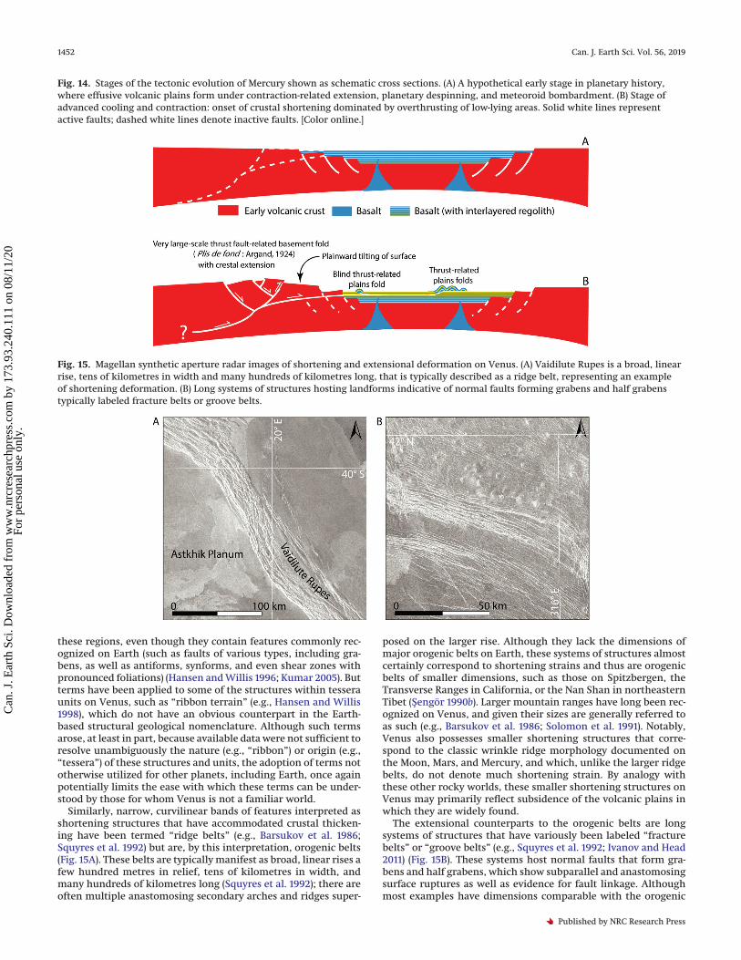
these regions, even though they contain features commonly rec-ognized on Earth (such as faults of various types, including gra-bens, as well as antiforms, synforms, and even shear zones withpronounced foliations) (Hansen and Willis 1996; Kumar 2005). Butterms have been applied to some of the structures within tesseraunits on Venus, such as “ribbon terrain” (e.g., Hansen and Willis1998), which do not have an obvious counterpart in the Earth-based structural geological nomenclature. Although such termsarose, at least in part, because available data were not sufficient toresolve unambiguously the nature (e.g., “ribbon”) or origin (e.g.,“tessera”) of these structures and units, the adoption of terms nototherwise utilized for other planets, including Earth, once againpotentially limits the ease with which these terms can be under-stood by those for whom Venus is not a familiar world.
Similarly, narrow, curvilinear bands of features interpreted asshortening structures that have accommodated crustal thicken-ing have been termed “ridge belts” (e.g., Barsukov et al. 1986;Squyres et al. 1992) but are, by this interpretation, orogenic belts(Fig. 15A). These belts are typically manifest as broad, linear rises afew hundred metres in relief, tens of kilometres in width, andmany hundreds of kilometres long (Squyres et al. 1992); there areoften multiple anastomosing secondary arches and ridges super-
posed on the larger rise. Although they lack the dimensions ofmajor orogenic belts on Earth, these systems of structures almostcertainly correspond to shortening strains and thus are orogenicbelts of smaller dimensions, such as those on Spitzbergen, theTransverse Ranges in California, or the Nan Shan in northeasternTibet (Sengör 1990b). Larger mountain ranges have long been rec-ognized on Venus, and given their sizes are generally referred toas such (e.g., Barsukov et al. 1986; Solomon et al. 1991). Notably,Venus also possesses smaller shortening structures that corre-spond to the classic wrinkle ridge morphology documented onthe Moon, Mars, and Mercury, and which, unlike the larger ridgebelts, do not denote much shortening strain. By analogy withthese other rocky worlds, these smaller shortening structures onVenus may primarily reflect subsidence of the volcanic plains inwhich they are widely found.
The extensional counterparts to the orogenic belts are longsystems of structures that have variously been labeled “fracturebelts” or “groove belts” (e.g., Squyres et al. 1992; Ivanov and Head2011) (Fig. 15B). These systems host normal faults that form gra-bens and half grabens, which show subparallel and anastomosingsurface ruptures as well as evidence for fault linkage. Althoughmost examples have dimensions comparable with the orogenic
Fig. 14. Stages of the tectonic evolution of Mercury shown as schematic cross sections. (A) A hypothetical early stage in planetary history,where effusive volcanic plains form under contraction-related extension, planetary despinning, and meteoroid bombardment. (B) Stage ofadvanced cooling and contraction: onset of crustal shortening dominated by overthrusting of low-lying areas. Solid white lines representactive faults; dashed white lines denote inactive faults. [Color online.]
Fig. 15. Magellan synthetic aperture radar images of shortening and extensional deformation on Venus. (A) Vaidilute Rupes is a broad, linearrise, tens of kilometres in width and many hundreds of kilometres long, that is typically described as a ridge belt, representing an exampleof shortening deformation. (B) Long systems of structures hosting landforms indicative of normal faults forming grabens and half grabenstypically labeled fracture belts or groove belts.
1452 Can. J. Earth Sci. Vol. 56, 2019
Published by NRC Research Press
Can
. J. E
arth
Sci
. Dow
nloa
ded
from
ww
w.n
rcre
sear
chpr
ess.
com
by
173.
93.2
40.1
11 o
n 08
/11/
20Fo
r pe
rson
al u
se o
nly.

belts, some of these extensional systems combine to form arraysthousands of kilometres long that may be underlain by dikeswarms (e.g., Ivanov and Head 2013). In any case, the structuresthat make up the extensional belts indicate stretching of the crustand so, by any measure related to Earth, comprise rift zones. Ofnote, much larger regions characterized by major extensionalstrains, vast volumes of proximal volcanic deposits, and stronggravity and geoid anomalies that suggest deep-seated compensa-tion consistent with mantle upwelling (e.g., Solomon et al. 1991;James et al. 2013) are also referred to as “rifts” and “rift zones”(e.g., Ivanov and Head 2011), and may be loosely analogous tomid-ocean ridges on Earth, albeit not within a coupled spreading–subduction system (Ghail 2015). The term “rift zone” therefore is,at least conventionally, applied only to extensional systems abovesome (nonspecific) spatial scale for Venus.
Applications to MarsMars is a geologically diverse planet, displaying many large- and
small-scale physiographic features that have been shaped byvolcanic, glacial, fluvial, eolian, and tectonic processes. With theinsight that plate tectonics has long operated on Earth, manyresearchers hypothesized and tested whether similar tectonicsalso operate or operated on other rocky bodies (e.g., Anderson1981; Sleep 1994; Yin 2012). Processes with phenomena similar tothose accompanying plate tectonics on Earth have also been in-voked to explain many peculiar large-scale physiographic Martianfeatures, such as the dichotomy boundary separating the compar-atively lightly cratered northern lowlands from the heavilycratered and thus older southern highlands, the Tharsis largeigneous province with its many volcanic shields, or Valles Mari-neris as the largest canyon system known in our solar system. Forexample, Sengör and Jones (1975) suggested a plate tectonicsmodel to account for a structural interpretation of images re-turned by Mariner 9. In that model, an elongated depression inthe Phoenicis Lacus area was interpreted as a trench into which apostulated Tharsis plate was obliquely subducted. Although themodel accounted for the dichotomy between the smooth lowlandplains in the north and cratered highlands in the south, as well asthe structural and volcanic lineations in the region, higher-resolution data acquired later did not support this interpretation.To date, no plate tectonic model for Mars has been widely ac-cepted, and the majority of landforms can be explained by pro-cesses not requiring multiple tectonic plates with substantialhorizontal mobility.
Mars had, and likely still has, a hydrologic cycle, and thus theprovenance and the effects of water must be considered in thetectonic assessment of the Red Planet. The presence of liquidwater plays an important role in the rheology of rock participating intectonic processes, for the strength of faults, for the formation of awide variety of minerals that may participate in deformation pro-cesses, and for the dissolution of minerals that gives rise to karstfeatures. The last of these processes, in particular, is of interest be-cause the substantial volumes of frozen water stored in the Martiansubsurface may allow for the development of thermokarst if suddenmelting occurs from an impact or magmatic event.
Recent thermokarst on Earth can be triggered by the rapid melt-ing of permafrost in response to global atmospheric warming.The sudden release of methane to the atmosphere producesthermokarstic landforms that are not unlike those of a typicalkarst landscape and include obruks (karst pits), dolinas, and evenuvalas. Prominent examples include the large Batagaika crater inSiberia, or the many smaller round craters that pockmark theSiberian permafrost landscape. On Mars, patterned ground andpingos (Carr and Schaber 1977; Burr et al. 2009) indicate that per-mafrost is widespread, and indeed large quantities of frozen waterare inferred to be present in the subsurface (Clifford et al. 2010;Stuurman et al. 2016; Weiss and Head 2017). Any heat source pres-
ent on Mars would therefore have the potential to trigger meltingof subsurface ices, also giving rise to thermokarst. Of note, scenar-ios of dikes intruding into ice-rich rock units have been invoked toexplain many of the large-scale outflow channels, chaos terrain,and flood deposits (McKenzie and Nimmo 1999) across the planet.Valles Marineris (Fig. 16), where dikes have been detected (Flahautet al. 2011; Brustel et al. 2017), is a candidate site where dike-induced melting could have produced not only large amounts ofwater to form outflow channels, but also the large canyon systemof Valles Marineris itself.
By this hypothesis, the melting of ice, the associated collapse ofrock volume that hosted the ice, and the discharge of water to-gether served to produce Valles Marineris (Sengör et al. 2016). If so,Valles Marineris would be the largest polje (Sengör et al. 2016)known in our solar system. This view is supported by the karsticgeomorphology of the canyon walls that resemble typical collapseand mass-wasting scarps (Sengör et al. 2016) that are unlike thoseassociated with typical rift structures, the prevailing explanationfor the feature’s origin (Sengör and Jones 1975; Masson 1977; Frey1979; Mège and Masson 1996; Mège et al. 2003). In addition, nu-merical (McKenzie and Nimmo 1999) and analogue (Jackson et al.2011; Sengör et al. 2016) modeling reveals that the transfer ofmagmatic heat to permafrost, as well as subsequent collapsecaused by melting and discharge of subsurface ice, can reproduceall landforms present in Valles Marineris without the need toinvoke a sequence of unrelated processes.
Fig. 16. Simulated westward view of Valles Marineris from spaceconstructed with Mars Orbiter Laser Altimeter (MOLA) topographyand High Resolution Stereo Camera (HRSC) images. The portion ofValles Marineris shown here is over 2000 km long. [Color online.]
Klimczak et al. 1453
Published by NRC Research Press
Can
. J. E
arth
Sci
. Dow
nloa
ded
from
ww
w.n
rcre
sear
chpr
ess.
com
by
173.
93.2
40.1
11 o
n 08
/11/
20Fo
r pe
rson
al u
se o
nly.
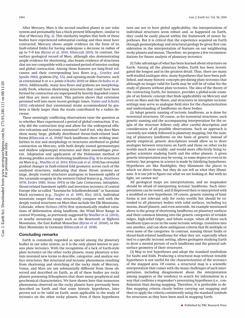
After Mercury, Mars is the second smallest planet in our solarsystem and presumably has a thick present lithosphere, similar tothat of Mercury (Fig. 2). This similarity implies that both of thesebodies have experienced substantial cooling and thus must havecontracted. Mercury shows ample evidence (in the form of itsfault-related folds) for having undergone a decrease in radius ofup to 7–9 km (Byrne et al. 2014; Klimczak 2015). In contrast, thesurface geological record of Mars, although also demonstratingample evidence for shortening, also boasts evidence of structuresthat are not compatible with a sustained period of interior coolingand global contraction. Among those features are long-lived vol-canoes and their corresponding lava flows (e.g., Greeley andSpudis 1981), grabens (Fig. 5A), and opening-mode fractures, suchas extensional b or a–c joints (Okubo 2010) or dikes (Schultz et al.2004). Additionally, many lava flows and grabens are morpholog-ically fresh, whereas shortening structures that could have beenformed by contraction are superposed by heavily degraded cratersand thus are more ancient. This pattern shows that extensionpersisted well into more recent geologic times. Nahm and Schultz(2011) calculated that extensional strain accommodated by gra-bens is likely larger than the strain contributed by a radius de-crease.
These seemingly conflicting observations raise the question asto whether Mars experienced a period of global contraction. If so,why did the contraction stop and allow for the widespread effu-sive volcanism and tectonic extension? And if not, why does Marsshow many large, globally distributed thrust-fault-related land-forms (Klimczak et al. 2018)? Such landforms show striking simi-larities in size and morphology to structures attributed to globalcontraction on Mercury, with both deeply rooted (germanotype)and shallow (alpinotype) structures and their assemblages pres-ent. Adaptation and application of the Holmesian method ofdrawing profiles across shortening landforms (Fig. 8) to structureson Mars (e.g., Mueller et al. 2014; Klimczak et al. 2018) has revealedgradual changes in fault-related fold geometry across each of theanalyzed structures, indicating that these thrust systems arelarge, deeply rooted structures analogous to basement uplifts ofthe Laramide orogeny in the western United States (e.g., Matthews1978; Erslev 1986; Stone 1993) or the Late Cretaceous, intraplate,thrust-related basement uplifts and inversion tectonics of centralEurope (the so-called “Saxonische Schollentektonik” or Saxonianblock tectonics) (e.g., Ziegler et al. 1995; Kley 2013). Individualmountain ranges that may structurally compare well with thedeeply rooted structures on Mars thus include the Elk Mountains,Colorado, where Holmes (1876) first systematically studied varia-tions of deformation along landform, the Wind River Range incentral Wyoming, as previously suggested by Mueller et al. (2014),or nearby mountain ranges such as the Beartooth or BighornMountains, the East Kaibab Monocline (Byrne et al. 2016b), or theHarz Mountains in Germany (Klimczak et al. 2018).
Concluding remarksEarth is commonly regarded as special among the planetary
bodies in our solar system, as it is the only planet known to pos-sess plate tectonics. With the recognition of a lack of Earth-styleplate tectonics on the other rocky planets, many planetary scien-tists invented new terms to describe, categorize, and analyze sur-face structures. But structural and tectonic phenomena resultingfrom shortening and stretching of the rocky rinds of Mercury,Venus, and Mars are not substantially different from those ob-served and described on Earth, as all of these bodies are rockyplanets possessing lithospheres that share many geophysical andgeochemical characteristics. We have shown here that numerousphenomena observed on the rocky planets have previously beendescribed on Earth and that some historic hypotheses, laterproven not to be valid on Earth, seem applicable to the study oftectonics on the other rocky planets. Even if these hypotheses
turn out not to have global applicability, the interpretations ofindividual structures seem robust and, as happened on Earth,they could be easily placed within the framework of newer hy-potheses. But it is critical that the experience acquired on Earththrough geomorphology and structural geology be given first con-sideration in the interpretation of features on our neighboringrocky planets and moons. Therefore, we propose a few recommen-dations for future analysis of planetary tectonics:
(1) Take advantage of what has been learned about structures onEarth. Among all the planetary bodies, Earth has been investi-gated the longest and in the greatest detail. Thus, there are manywell-studied analogue sites, many hypotheses that have been pub-lished, and many historic concepts pre-dating plate tectonics thatalthough no longer valid for Earth may be still be of value for thestudy of planets without plate tectonics. The idea of the theory ofthe contracting Earth, for instance, provides a global-scale exam-ple of an historic concept that finds applicability on Mercury andeven on Mars and the Moon, and structures in intraplate tectonicsettings may serve as analogue field sites for the characterizationand understanding of landforms on these bodies.
(2) Adopt genetic naming of tectonic landforms, as is done forterrestrial structures. Of course, as for terrestrial structures, suchgenetic naming and the accompanying interpretation for the or-igin of the structure follows only after careful description andconsideration of all possible observations. Such an approach iscurrently not widely followed in planetary mapping, but the nam-ing of planetary landforms on the basis of genetic instead ofpurely empirical, generic descriptions would allow us to drawanalogies between structures on Earth and those on other rockyworlds much more readily, and would more effectively bring to-gether scientists studying Earth and the other planets. A givengenetic interpretation may be wrong, to some degree or even in itsentirety, but progress in science is made by falsifying hypotheses.Hypotheses are like flashlights; they illuminate the places towhich we direct them, but they do not tell us what they illumi-nate. It is our job to figure out what we are looking at. But with nolight, we cannot see!
All geological maps are interpretations, and no mapmakershould be afraid of interpreting tectonic landforms. Such inter-pretations can be tested, and if disproved then re-interpreted witha modified or new hypothesis. Of course, genetic naming of land-forms is not relevant only for rocky worlds but should be ex-tended to all planetary bodies with solid surfaces, including icymoons, dwarf planets, and even asteroids. An example mentionedabove is the group of shortening landforms on planetary surfacesand their common binning into the generic categories of wrinkleridges, high-relief ridges, and lobate scarps, when all three suchlandform types occur in the same tectonic settings, transition intoone another, and can show ambiguous criteria that fit multiple oreven none of the categories. In contrast, naming thrust faults orthrust-fault-related landforms for what they are, especially whentied to a specific tectonic setting, allows geologists studying Earthto draw a mental picture of such landforms and the general sub-surface geometry of their structures.
(3) Map to test hypotheses and adopt the standard symbolismfor faults and folds. Producing a structural map without testablehypotheses is not useful for the characterization of the tectonicsof the mapped area. Of course, a structural map is a scientificinterpretation that comes with the many challenges of such inter-pretation, including disagreement about the interpretationamong mappers or the tendency to search for information in away that confirms a mapmaker’s preexisting hypotheses (i.e., con-firmation bias) during mapping. Therefore, it is preferable to de-fine mapping criteria clearly before carrying out mapping andthen to apply the criteria consistently using the standard symbolsfor structures as they have been used in mapping Earth.
1454 Can. J. Earth Sci. Vol. 56, 2019
Published by NRC Research Press
Can
. J. E
arth
Sci
. Dow
nloa
ded
from
ww
w.n
rcre
sear
chpr
ess.
com
by
173.
93.2
40.1
11 o
n 08
/11/
20Fo
r pe
rson
al u
se o
nly.

AcknowledgementsWe thank Editor-in-Chief Ali Polat and Guest Editor John Dewey
for handling our manuscript. We also thank Richard Ghail and ananonymous reviewer for constructive reviews, which helped toimprove the content and clarity of the paper.
ReferencesAmpferer, O. 1928. Beiträge zur Auflösung der Mechanik der Alpen, 3. Fortset-
zung. Jahrbuch der Geologischen Bundesanstalt, Wien, 78: 327–355.Anderson, D.L. 1981. Plate tectonics on Venus. Geophysical Research Letters, 8:
309–311. doi:10.1029/GL008i004p00309.Angelier, J. 1994. Fault slip analysis and palaeostress reconstruction. In Conti-
nental Deformation. Edited by P.L. Hancock. Pergamon Press, Oxford, UK,pp. 53–100.
Argand, É. 1911. Les nappes de recouvrement des Alpes Pennines et leurs pro-longements structuraux. Matériaux pour la Carte Géologique de la Suisse,nouvelle série, 31e livraison, 26 pp.
Argand, É. 1912. Coupes géologiques dans les Alpes Occidentales interprétée parÉmile Argand, 1902–1911. Pl 1: Les nappes de recouvrement dans les Alpsoccidentales et les territoires environnents. Essai de carte structurale,1:500,000; Pl. II: Neuf coupes à travers les Alpes occidentales, 1:400,000; Pl. IIIthe same; Pl. IV Les grands plis couchés dans les Alpes Pennines, 1:500,000:Matériaux pour la Carte Géologique de la Suisse, nouvelle série, 27e livraison.
Argand, É. 1924. La tectonique de l’Asie. In International Geological Congress,13th Session, Liège, Vaillant-Carmanne, 1: 171–372.
Argand, É. 1926. Sur l’arc des alpes occidentales. Eclogae Geologicae Helvetiae,14: 145–191.
Argand, É. 1934. La zone pennique. In Guide Géologique de la Suisse, fascicule IIIIntroductions générales. Wepf & Cie, Basel, pp. 149–189.
Baioni, D., Zupan Hajna, N., and Wezel, F.C. 2009. Karst landforms in a Martianevaporitic dome. Acta Carsologica, 38: 9–18.
Baioni, D., Tramontana, M., and Zupan Hajna, N. 2017. Karst landforms withinNoctis Labyrinthus, Mars. Acta Carsologica, 46: 73–82.
Banks, M.E., Xiao, Z., Watters, T.R., Strom, R.G., Braden, S.E., Chapman, C.R.,et al. 2015. Duration of activity on lobate scarp thrust faults on Mercury.Journal of Geophysical Research: Planets, 120: 1751–1762. doi:10.1002/(ISSN)2169-9100.
Barsukov, V.L., Basilevsky, A.T., Burba, G.A., Bobinna, N.N., Kryuchkov, V.P.,Kuzmin, R.O., et al. 1986. The geology and geomorphology of the Venussurface as revealed by the radar images obtained by Veneras 15 and 16.Journal of Geophysical Research, 91: D378–D398.
Bilotti, F., and Suppe, J. 1999. The global distribution of wrinkle ridges on Venus.Icarus, 139: 137–157. doi:10.1006/icar.1999.6092.
Bindschadler, D.L., and Head, J.W. 1988. Models for the origin of tessera terrainon Venus. Lunar and Planetary Science, 19: 78–79.
Blair, D.M., Freed, A.M., Byrne, P.K., Klimczak, C., Prockter, L.M., Ernst, C.M.,et al. 2013. The origin of graben and ridges in Rachmaninoff, Raditladi, andMozart basins, Mercury. Journal of Geophysical Research: Planets, 118: 47–58.doi:10.1029/2012JE004198.
Brace, W.F., and Kohlstedt, D.L. 1980. Limits on lithospheric stress imposed bylaboratory experiments. Journal of Geophysical Research, 85: 6248–6252.doi:10.1029/JB085iB11p06248.
Brustel, C., Flahaut, J., Hauber, E., Fueten, F., Quantin, C., Stesky, R., andDavies, G.R. 2017. Valles Marineris tectonic and volcanic history inferredfrom dikes in eastern Coprates Chasma. Journal of Geophysical Research:Planets, 122: 1353–1371. doi:10.1002/2016JE005231.
Bryan, W.B. 1973. Wrinkle-ridges as deformed surface crust on ponded marelava. In Proceedings of the Fourth Lunar Science Conference, pp. 93–106.
Bucher, W.H. 1933. The Deformation of the Earth’s Crust. Princeton UniversityPress, Princeton, N.J.
Buck, R. 1988. Flexural rotation of normal faults. Tectonics, 7: 959–973. doi:10.1029/TC007i005p00959.
Burr, D.M., Tanaka, K.L., and Yoshikawa, K. 2009. Pingos on Earth and Mars.Planetary and Space Science, 57: 541–555. doi:10.1016/j.pss.2008.11.003.
Byerlee, J. 1978. Friction of rocks. Pure and Applied Geophysics, 116: 615–626.doi:10.1007/BF00876528.
Byrne, P.K., Klimczak, C., Sengör, A.M.C, Solomon, S.C., Watters, T.R., andHauck, S.A., II. 2014. Mercury’s global contraction much greater than earlierestimates. Nature Geoscience, 7: 301–307. doi:10.1038/ngeo2097.
Byrne, P.K., Klimczak, C., McGovern, P.J., Mazarico, E., James, P.B., Neumann, G.A.,et al. 2015. Deep-seated thrust faults bound the Mare Crisium lunar mascon.Earth and Planetary Science Letters, 427: 183–190. doi:10.1016/j.epsl.2015.06.022.
Byrne, P.K., Ostrach, L.R., Fassett, C.I., Chapman, C.R., Denevi, B.W., Evans, A.J.,et al. 2016a. Widespread effusive volcanism on Mercury likely ended by about3.5 Ga. Geophysical Research Letters, 43: 7408–7416. doi:10.1002/2016GL069412.
Byrne, P.K., Klimczak, C., and LaFond, J.K. 2016b. The East Kaibab monocline: ATerran lobate scarp? Lunar and Planetary Science, 47: Abstract 1022.
Byrne, P.K., Klimczak, C., and Sengör, A.M.C. 2018. The tectonic character ofMercury. In Mercury – The View after MESSENGER. Edited by S.C. Solomon,
L.R. Nittler, and B.J. Anderson. Cambridge University Press, Cambridge, UK,pp. 249–286.
Campbell, D.B., Head, J.W., Harmon, J.K., and Hine, A.A. 1983. Venus: Identifica-tion of banded terrain in the mountains of Ishtar Terra. Science, 221: 644–647. doi:10.1126/science.221.4611.644.
Campbell, D.B., Head, J.W., Harmon, J.K., and Hine, A.A. 1984. Venus: Volcanismand rift formation in Beta Regio. Science, 226: 167–170. doi:10.1126/science.226.4671.167.
Carr, M.H., and Schaber, G.G. 1977. Martian permafrost features. Journal ofGeophysical Research, 82: 4039–4054. doi:10.1029/JS082i028p04039.
Chapman, D.S. 1986. Thermal gradients in the continental crust. In The Nature ofthe Lower Continental Crust. Edited by J.B. Dawson, D.A. Carswell, J. Hall, andK.H. Wedepohl. The Geological Society Special Publications, 24: 63–70.
Clifford, S.M., Lasue, J., Heggy, E., Boisson, J., McGovern, P., and Max, M.D. 2010.Depth of the Martian cryosphere: Revised estimates and implications for theexistence and detection of subpermafrost groundwater. Journal of GeophysicalResearch, 115: E07001. doi:10.1029/2009JE003462.
Cloos, H. 1936. Einfuhrung in die Geologie – Ein Lehrbuch der Inneren Dynamik.Gebrüder Borntraeger, Berlin, Germany. www.borntraeger-cramer.de.
Cordier, P.L.A. 1827. Essai sur la température de l’intérieur de la terre. Mémoiresde l’Academie des Sciences pour l’année 1827, 7: 473–556.
Cowie, P.A., Scholz, C.H., Roberts, G.P., Faure, Walker, J.P., and Steer, P. 2013.Viscous roots of active seismogenic faults revealed by geologic slip rate vari-ations. Nature Geoscience, 6: 1036–1040. doi:10.1038/ngeo1991.
Crane, K.T., and Klimczak, C. 2017. Timing and rate of global contractionon Mercury. Geophysical Research Letters, 44: 3082–3089. doi:10.1002/2017GL072711.
Crane, K.T., and Klimczak, C. 2019. Tectonic patterns of shortening landforms inMercury’s northern smooth plains. Icarus, 317: 66–80. doi:10.1016/j.icarus.2018.05.034.
Cvijic, J. 1893. Das Karstphänomen — Versuch einer Morphologischen Monog-raphie. Geographische Abhandlungen, 5: 217–329.
Cvijic, J. 1900. Morphologische und Glaciale Studien aus Bosnien der Hercegovinaand Montenegro. I. Theil: Das Hochgebirge und die Cañonthäler. Abhandlungender K. K. Geographischen Gesellschaft in Wien, 2: 3–93 (+9 plates).
Cvijic, J. 1901. Morphologische und Glaciale Studien aus Bosnien der Hercegov-ina and Montenegro. II. Theil: Die Karstpoljen. Abhandlungen der K. K. Geog-raphischen Gesellschaft in Wien, 3: 5–85.
Cvijic, J. 1960. La Géographie des Terrains Calcaires. Académie des Sciences etdes Arts, Monographies, Vol. 341. Classe des Sciences Mathématiques et Na-turelles, 26: 212.
Czudek, T., and Demek, J. 1970. Thermokarst in Siberia and its influence on thedevelopment of lowland relief. Quaternary Research, 1: 103–120. doi:10.1016/0033-5894(70)90013-X.
Dana, J.D. 1873. On some results of the Earth’s contraction from cooling, includ-ing a discussion of the origin of mountains and the nature of the Earth’sinterior. American Journal of Science, 5: 423–443. doi:10.2475/ajs.s3-5.30.423.
Delamétherie, J.-C. 1795. Théorie de la Terre. Maradan libraire, Paris.Denevi, B.W., Robinson, M.S., Solomon, S.C., Murchie, S.L., Blewett, D.T.,
Domingue, D.L., et al. 2009. The evolution of Mercury’s crust: A global per-spective from MESSENGER. Science, 324: 613–618. PMID:19407196.
Dutton, C.E. 1874. A criticism of the contractional hypothesis. American Journalof Science, 8: 113–123. doi:10.2475/ajs.s3-8.44.113.
Dzurisin, D. 1978. The tectonic and volcanic history of Mercury as inferred fromstudies of scarps, ridges, troughs, and other lineaments. Journal of Geophys-ical Research, 83: 4883–4906. doi:10.1029/JB083iB10p04883.
Élie de Beaumont, L. 1829. Faits pour Servir a l’Histoire des Montagnes del’Oisans. Mémoires de la Société d’Histoire Naturelle de Paris, pp. 1–32.
Élie de Beaumont, L. 1829–1830. Recherches sur quelques-unes des Révolutionsde la surface du globe, présentant différens exemples de coïncidence entre leredressement des couches de certains systèmes de montagnes, et les change-mens soudains qui ont produit les lignes de demarcation demarcation qu’onobserve entre certains étages consécutifs des terrains de sédiment. Annalesdes Sciences Naturelles, 18: 284–417; 19: 177–240.
Élie de Beaumont, L. 1852. Notice sur les Systèmes de Montagnes, tome III:P. Bertrand, Paris, pp. 1069–1543.
Erslev, E. 1986. Basement balancing of Rocky-Mountain foreland uplifts. Geol-ogy, 14: 259–262. doi:10.1130/0091-7613(1986)14<259:BBORMF>2.0.CO;2.
Flahaut, J., Mustard, J.F., Quantin, C., Clenet, H., Allemand, P., and Thomas, P.2011. Dikes of distinct composition intruded into Noachian-aged crust ex-posed in the walls of Valles Marineris. Geophysical Research Letters, 38:L15202. doi:10.1029/2011GL048109.
Ford, D., and Williams, P. 2007. Karst Hydrogeology and Geomorphology. Wiley,Hoboken, N. J.
Freed, A.M., Blair, D.M., Watters, T.R., Klimczak, C., Byrne, P.K., Solomon, S.C.,et al. 2012. On the origin of graben and ridges within and near volcanicallyburied craters and basins in Mercury’s northern plains. Journal of Geophys-ical Research, 117: E00L06. doi:10.1029/2012JE004119.
Frey, H. 1979. Martian canyons and African rifts: Structural comparisons andimplications. Icarus, 37: 142–155. doi:10.1016/0019-1035(79)90122-2.
Ghail, R. 2015. Rheological and petrological implications for a stagnant lid re-gime on Venus. Planetary and Space Science, 113–114: 2–9. doi:10.1016/j.pss.2015.02.005.
Klimczak et al. 1455
Published by NRC Research Press
Can
. J. E
arth
Sci
. Dow
nloa
ded
from
ww
w.n
rcre
sear
chpr
ess.
com
by
173.
93.2
40.1
11 o
n 08
/11/
20Fo
r pe
rson
al u
se o
nly.
Golombek, M.P., Plescia, J.B., and Franklin, B.J. 1991. Faulting and folding in theformation of planetary wrinkle ridges. Proceedings of Lunar and PlanetaryScience, 21: 679–693.
Golombek, M.P., Anderson, F.S., and Zuber, M.T. 2001. Martian wrinkle ridgetopography: Evidence for subsurface faults from MOLA. Journal of Geophys-ical Research, 106: 23811–23821. doi:10.1029/2000JE001308.
Greeley, R., and Spudis, P.D. 1981. Volcanism on Mars. Reviews of Geophysics, 19:13–41. doi:10.1029/RG019i001p00013.
Grott, M., and Breuer, D. 2008. The evolution of the Martian elastic lithosphereand implications for crustal and mantle rheology. Icarus, 193: 503–515. doi:10.1016/j.icarus.2007.08.015.
Handin, J. 1969. On the Coulomb-Mohr failure criterion. Journal of GeophysicalResearch, 74: 5343–5348. doi:10.1029/JB074i022p05343.
Hansen, V.L., and Willis, J.A. 1996. Structural analysis of a sampling of tesserae:Implications for Venus geodynamics. Icarus, 123: 296–312. doi:10.1006/icar.1996.0159.
Hansen, V.L., and Willis, J.J. 1998. Ribbon terrain formation, southwestern For-tuna Tessera, Venus: Implications for lithosphere evolution. Icarus, 132: 321–343. doi:10.1006/icar.1998.5897.
Holmes, W.H. 1876. Report on the geology of the northwestern portion of the ElkRange. U.S. Geological and Geographical Survey of the Territories, 8th AnnualReport, pp. 59–71.
Huntington, K.W., and Klepeis, K.A. 2018. Challenges and opportunities for re-search in tectonics: Understanding deformation and the processes that linkEarth systems, from geologic time to human time. A community vision doc-ument submitted to the U.S. National Science Foundation. Available fromhttp://hdl.handle.net/1773/40754.
Ivanov, M.A., and Head, J.W. 2011. Global geological map of Venus. Planetary andSpace Science, 59: 1559–1600. doi:10.1016/j.pss.2011.07.008.
Ivanov, M.A., and Head, J.W. 2013. The history of volcanism on Venus. Planetaryand Space Science, 84: 66–92. doi:10.1016/j.pss.2013.04.018.
Jackson, M.P.A., Adams, J.B., Dooley, T.P., Gillespie, A.R., and Montgomery, D.R.2011. Modeling the collapse of Hebes Chasma, Valles Marineris, Mars. Geo-logical Society of America Bulletin, 123: 1596–1627. doi:10.1130/B30307.1.
Jaeger, J.C., Cook, N.G., and Zimmerman, R.W. 2007. Fundamentals of RockMechanics (4th edition). Blackwell Publishing, Malden, Massachusetts.
James, P.B., Zuber, M.T., and Phillips, R.J. 2013. Crustal thickness and support oftopography on Venus. Journal of Geophysical Research: Planets, 118: 859–875. doi:10.1029/2012JE004237.
Jeffreys, H. (Sir). 1924. The Earth—Its Origin, History and Physical Constitution.Cambridge University Press, Cambridge.
Kargel, J.S. 2013. Mercury’s hollows: Chalcogenide pyro-thermokarst analog ofthermokarst on Earth, Mars, and Titan. Lunar and Planetary Science, 44:Abstract 2840.
Kley, J. 2013, Saxonische Tektonik im 21. Jahrhundert: Zeitschrift der DeutschenGeologischen Gesellschaft, 164: 295–311.
Klimczak, C. 2015. Limits on the brittle strength of planetary lithospheres un-dergoing global contraction. Journal of Geophysical Research: Planets, 120:2135–2151. doi:10.1002/(ISSN)2169-9100.
Klimczak, C., Watters, T.R., Ernst, C.M., Freed, A.M., Byrne, P.K., Solomon, S.C.,et al. 2012. Deformation associated with ghost craters and basins in volcanicsmooth plains on Mercury: Strain analysis and implications for plains evolu-tion. Journal of Geophysical Research, 117: E00L03. doi:10.1029/2012JE004100.
Klimczak, C., Byrne, P.K., and Solomon, S.C. 2015. A rock-mechanical assessmentof Mercury’s global tectonic fabric. Earth and Planetary Science Letters, 416:82–90. doi:10.1016/j.epsl.2015.02.003.
Klimczak, C., Kling, C.L., and Byrne, P.K. 2018. Topographic expressions of largethrust faults on Mars. Journal of Geophysical Research: Planets, 123: 1973–1995. doi:10.1029/2017JE005448.
Kober, L. 1921. Der Bau der Erde. Gebrüder Borntraeger, Berlin.Kober, L. 1931. Das Alpine Europa. Gebrüder Borntraeger, Berlin.Kober, L. 1942. Tektonische Geologie. Gebrüder Borntraeger, Berlin.Kohlstedt, D.L., and Mackwell, S.J. 2010. Strength and deformation of planetary
lithospheres. In Planetary Tectonics. Edited by T.R. Watters and R.A. Schultz.Cambridge University Press, Cambridge, UK pp. 397–456.
Kohlstedt, D.L., Evans, B., and Mackwell, S.J. 1995. Strength of the lithosphere:constraints imposed by laboratory experiments. Journal of Geophysical Re-search: Solid Earth, 100: 17587–17602. doi:10.1029/95JB01460.
Kreslavsky, M.A., and Basilevsky, A.T. 1998. Morphometry of wrinkle ridges onVenus: Comparison with other planets. Journal of Geophysical Research:Planets, 103: 11103–11111. doi:10.1029/98JE00360.
Kumar, P.S. 2005. An alternative kinematic interpretation of Thetis BoundaryShear Zone, Venus: Evidence for strike-slip ductile duplexes. Journal of Geo-physical Research, 110: E07001. doi:10.1029/2004JE002387.
Lobeck, A.K. 1939. Geomorphology—An Introduction to the Study of Landforms.McGraw-Hill, New York and London.
Mackwell, S.J., Zimmerman, M.E., and Kohlstedt, D.L. 1998. High-temperaturedeformation of dry diabase with application to tectonics on Venus. Journal ofGeophysical Research, 103: 975–984. doi:10.1029/97JB02671.
Masson, P. 1977. Structure pattern analysis of the Noctis Labyrinthus-Valles Mari-neris regions of Mars. Icarus, 30: 49–62. doi:10.1016/0019-1035(77)90120-8.
Masursky, H., Colton, G.W., and El-Baz, F. 1978. Apollo over the Moon: A Viewfrom Orbit. NASA Special Publication SP-362. Washington, DC.
Masursky, H., Eliason, E., Ford, P.G., McGill, G.E., Pettengill, G.H., Schaber, G.G.,and Schubert, G. 1980. Pioneer Venus radar results: Geology from images andaltimetry. Journal of Geophysical Research, 85: 8232–8260. doi:10.1029/JA085iA13p08232.
Matthews, V. 1978. Laramide folding associated with basement block faulting inthe western United States. Geological Society of America Memoir, 151. Boul-der, Colo.
McKenzie, D., and Nimmo, F. 1999. The generation of Martian floods by themelting of ground ice above dykes. Nature, 397: 231–233. doi:10.1038/16649.PMID:9930697.
Mège, D., and Masson, P. 1996. Amounts of crustal stretching in Valles Marineris,Mars. Planetary and Space Science, 44: 749–781. doi:10.1016/0032-0633(96)00013-X.
Mège, D., Cook, A.C., Garel, E., Lagabrielle, Y., and Cormier, M.-H. 2003. Volcanicrifting at Martian grabens. Journal of Geophysical Research, 108: 5044. doi:10.1029/2002JE001852.
Mueller, K., and Golombek, M. 2004. Compressional structures on Mars. AnnualReview of Earth and Planetary Sciences, 32: 435–464. doi:10.1146/annurev.earth.32.101802.120553.
Mueller, K., Vidal, A., Robbins, S., Golombek, M., and West, C. 2014. Fault andfold growth of the Amenthes uplift: Implications for Late Noachian crustalrheology and heat flow on Mars. Earth and Planetary Science Letters, 408:100–109. doi:10.1016/j.epsl.2014.09.047.
Nahm, A.L., and Schultz, R.A. 2011. Magnitude of global contraction on Marsfrom analysis of surface faults: Implications for martian thermal history.Icarus, 211: 389–400. doi:10.1016/j.icarus.2010.11.003.
Okubo, C.H. 2010. Structural geology of Amazonian-aged layered sedimentarydeposits in southwest Candor Chasma, Mars. Icarus, 207: 210–225. doi:10.1016/j.icarus.2009.11.012.
Okubo, C.H., and Schultz, R.A. 2006. Variability in Early Amazonian Tharsisstress state based on wrinkle ridges and strike-slip faulting. Journal of Struc-tural Geology, 28: 2169–2181. doi:10.1016/j.jsg.2005.11.008.
Padovan, S., Wieczorek, M.A., Margot, J.-L., Tosi, N., and Solomon, S.C. 2015,Thickness of the crust of Mercury from geoid-to-topography ratios. Geophys-ical Research Letters, 42: 1029–1038. doi:10.1002/2014GL062487.
Passchier, C.W., and Trouw, R.A.J. 2005. Microtectonics. Springer, Berlin, Germany.Pasyanos, M.E. 2010. Lithospheric thickness modeled from long-period surface
wave dispersion. Tectonophysics, 481: 38–50. doi:10.1016/j.tecto.2009.02.023.Pechmann, J.B., and Melosh, H.J. 1979. Global fracture patterns of a despun
planet: Application to Mercury. Icarus, 38: 243–250. doi:10.1016/0019-1035(79)90181-7.
Plescia, J.B. 1991. Wrinkle ridges in Lunae Planum Mars: Implications for short-ening and strain. Geophysical Research Letters, 18: 913–916. doi:10.1029/91GL01070.
Plescia, J.B. 1993. Wrinkle ridges of Arcadia Planitia, Mars. Journal of Geophysi-cal Research, 98: 15049–15059. doi:10.1029/93JE01324.
Plescia, J.B., and Golombek, M.P. 1986. Origin of planetary wrinkle ridges basedon the study of terrestrial analogs. Geological Society of America Bulletin, 97:1289–1299. doi:10.1130/0016-7606(1986)97<1289:OOPWRB>2.0.CO;2.
Pollard, D.D., and Aydin, A. 1988. Progress in understanding jointing over thepast century. Geological Society of America Bulletin, 100: 1181–1204. doi:10.1130/0016-7606(1988)100<1181:PIUJOT>2.3.CO;2.
Richter, H. 1983. Carl Ritter Werk und Wirkungen—Beiträge eines Symposiumsim 200. Geburtsjahr des Gelehrten, Quedlinburg, DDR. VEB Hermann HaackGeographisch-Kartographische Anstalt, Gotha, 254 pp.
Rothery, D.A., and Massironi, M. 2010. Beagle Rupes — Evidence for a basaldecollement of regional extent in Mercury’s lithosphere. Icarus, 209: 256–261. doi:10.1016/j.icarus.2009.12.009.
Schaber, G.G., Strom, R.G., Moore, H.J., Soderblom, L.A., Kirk, R.L., Chadwick, D.J.,et al. 1992. Geology and distribution of impact craters on Venus: What arethey telling us? Journal of Geophysical Research, 97: 13257–13301. doi:10.1029/92JE01246.
Schultz, R.A. 1993. Brittle strength of basaltic rock masses with applicationsto Venus. Journal of Geophysical Research, 98: 10883–10895. doi:10.1029/93JE00691.
Schultz, R.A. 2000. Localization of bedding plane slip and backthrust faultsabove blind thrust faults: Keys to wrinkle ridge structure. Journal of Geo-physical Research, 105: 12035–12052. doi:10.1029/1999JE001212.
Schultz, R.A., and Fossen, H. 2008. Terminology for structural discontinuities.American Association of Petroleum Geologists Bulletin, 92: 853–867. doi:10.1306/02200807065.
Schultz, R.A., and Tanaka, K.L. 1994. Lithospheric-scale buckling and thruststructures on Mars: The Coprates rise and south Tharsis ridge belt. Journal ofGeophysical Research, 99: 8371–8385. doi:10.1029/94JE00277.
Schultz, R.A., Okubo, C.H., Goudy, C.L., and Wilkins, S.J. 2004. Igneous dikes onMars revealed by Mars Orbiter Laser Altimeter topography. Geology, 32:889–892. doi:10.1130/G20548.1.
Schultz, R.A., Soliva, R., Okubo, C.H., and Mège, D. 2010. Fault populations. InPlanetary Tectonics. Edited by T.R. Watters and R.A. Schultz. Cambridge Uni-versity Press, Cambridge, UK pp. 457–510. doi:10.1017/CBO9780511691645.
Sengör, A.M.C. 1990a. Lithotectonic terranes and the plate tectonic theory oforogeny: A critique of the principles of terrane analysis. Circum-Pacific Coun-
1456 Can. J. Earth Sci. Vol. 56, 2019
Published by NRC Research Press
Can
. J. E
arth
Sci
. Dow
nloa
ded
from
ww
w.n
rcre
sear
chpr
ess.
com
by
173.
93.2
40.1
11 o
n 08
/11/
20Fo
r pe
rson
al u
se o
nly.

cil for Energy and Mineral Resources 2009 – Terrane Analysis of China andthe Pacific Rim, 13: 9–46.
Sengör, A.M.C. 1990b. Plate tectonics and orogenic research after 25 years:A Tethyan perspective. Earth-Science Reviews, 27: 1–201. doi:10.1016/0012-8252(90)90002-D.
Sengör, A.M.C., and Jones, I.C. 1975. A new interpretation of Martian tectonicswith special reference to the Tharsis region. In Geological Society of AmericaAbstracts with Programs, 7: 1264.
Sengör, A.M.C., Natal’in, B.A., and Burtman, V.S. 1993. Evolution of the Altaidtectonic collage and Palaeozoic crustal growth in Eurasia. Nature, 364: 299–307. doi:10.1038/364299a0.
Sengör, A.M.C., Acar, D., Özeren, M.S., Ulgen, S.C., Önsel, I.E., Öne, A.T., et al.2016. Valles Marineris and the Martian chasmata as thermokarstic poljes.Lunar and Planetary Science, 47: Abstract 2257.
Sengör, A.M.C., Natal’in, B.A., Sunal, G., and van der Voo, R. 2018. The tectonicsof the Altaids: Crustal growth during the construction of the continentallithosphere of central Asia between �750 and �130 Ma ago. Annual Reviewof Earth and Planetary Sciences, 46: 439–494. doi:10.1146/annurev-earth-060313-054826.
Sibson, R.H. 1990. Rupture nucleation on unfavorably oriented faults. Bulletin ofthe Seismological Society of America, 80: 1580–1604.
Sleep, N.H. 1994. Martian plate tectonics. Journal of Geophysical Research, 99:5693–5655. doi:10.1029/94JE00216.
Solomon, S.C. 1977. The relationship between crustal tectonics and internalevolution in the Moon and Mercury. Physics of the Earth and PlanetaryInteriors, 15: 135–145. doi:10.1016/0031-9201(77)90026-7.
Solomon, S.C., Head, J.W., Kaula, W.M., McKenzie, D., Parsons, B., Phillips, R.J.,et al. 1991. Venus tectonics: Initial analysis from Magellan. Science, 252:297–312. doi:10.1126/science.252.5003.297. PMID:17769277.
Solomon, S.C., Smrekar, S.E., Bindschadler, D.L., Grimm, R.E., Kaula, W.M.,McGill, G.E., et al. 1992. Venus tectonics: An overview of Magellan observa-tions. Journal of Geophysical Research, 97: 13199–13255. doi:10.1029/92JE01418.
Sonder, R.A. 1947. Discussion of “Shear patterns of the earth’s crust” by F. A. VeningMeinesz. Transactions of the American Geophysical Union, 28: 939–946. doi:10.1029/TR028i006p00939.
Sonder, R.A. 1956. Mechanik der Erde. Schweizerbart’sche Verlagsbuchhand-lung, Stuttgart.
Squyres, S.W., Jankowski, D.G., Simons, M., Solomon, S.C., Hager, B.H., andMcGill, G.E. 1992. Plains tectonism on Venus: The deformation belts ofLavinia Planitia. Journal of Geophysical Research, 97: 13579–13599. doi:10.1029/92JE00481.
Staub, R. 1924. Der Bau der Alpen. Beiträge Zur Geologischen Karte der Schweiz,52: 272 pp.
Staub, R. 1928. Der Bewegungsmechanismus der Erde – dargelegt am Bau derirdischen Gebirgssysteme. Gebruder Borntraeger, Berlin.
Stille, H. 1920. Uber Alter und Art der Phasen variszischer Gebirgsbildung.Nachrichten von der Gesellschaft der Wissenschaften zu Göttingen.Mathematisch-Physikalische Klasse, Heft 2: 218–224.
Stille, H. 1924. Grundfragen der Vergleichenden Tektonik: Gebrüder Borntra-eger, Berlin.
Stille, H. 1930. Uber Einseitigkeiten in der Germanotypen Tektonik Nordspani-ens und Deutschlands. Nachrichten von der Gesellschaft der Wissenschaftenzu Göttingen. Mathematisch-Physikalische Klasse, Fachgruppe IV (Geologieund Mineralogie), 5: 379–397.
Stille, H. 1940. Einfuhrung in den Bau Amerikas. Gebruder Borntraeger, Berlin.Stone, D.S. 1993. Basement-involved thrust-generated folds as seismically im-
aged in the subsurface of the central Rocky Mountain foreland. GeologicalSociety of America Special Papers, 280: 271–318. doi:10.1130/SPE280-p271.
Strom, R.G., Trask, N.J., and Guest, J.E. 1975. Tectonism and volcanism on Mercury.Journal of Geophysical Research, 80: 2478–2507. doi:10.1029/JB080i017p02478.
Stuurman, C.M., Osinski, G.R., Holt, J.W., Levy, J.S., Brothers, T.C., Kerrigan, M.,and Campbell, B.A. 2016. SHARAD detection and characterization of subsur-face water ice deposits in Utopia Planitia, Mars. Geophysical Research Letters,43: 9484–9491. doi:10.1002/2016GL070138.
Suess, E. 1868. Bemerkungen über die Lagerung des Salzgebirges bei Wieliczka:Sitzungsberiche der Kaiserlichen Akademie der Wissenschaften mathematisch-naturwissenschaftliche Klasse, 58: 541–547.
Suess, E. 1875. Die Entstehung der Alpen. W. Braumüller, Wien.Suess, E. 1883. Das Antlitz der Erde, Bd. Ia (Erste Abtheilung). F. Tempsky, Prag
and G. Freytag, Leipzig.Suess, E. 1885. Das Antlitz der Erde, Bd. Ib. F. Tempsky, Prag and G. Freytag,
Leipzig.Suess, E. 1888. Das Antlitz der Erde, Bd. II. F. Tempsky, Prag and Wien, and
G. Freytag, Leipzig.Suess, E. 1901. Das Antlitz der Erde, Bd. III1 (Dritter Band. Erste Hälfte). F. Tempsky,
Prag and Wien, and G. Freytag, Leipzig.Suess, E. 1909a. Das Antlitz der Erde, Bd. III2 (Dritter Band. Zweite Hälfte. Schluss
des Gesamtwerkes). F. Tempsky, Wien and G. Freytag, Leipzig.Suess, E. 1909b. The Face of the Earth (Das Antlitz der Erde), v. IV. Clarendon
Press, Oxford.
Suess, E. 1918. La Face de la Terre (Das Antlitz der Erde), traduit de l’Allemand,avec l’autorisation de l’auteur et annoté sous la direction de Emm. De Mar-gerie, tome III (4e partie {Fin}): Armand Colin, Paris.
Turcotte, D., and Schubert, G. 2002. Geodynamics. Cambridge University Press,Cambridge UK.
Vasavada, A.R., Paige, D.A., and Wood, S.E. 1999. Near-surface temperatures onMercury and the Moon and the stability of polar ice deposits. Icarus, 141:179–193. doi:10.1006/icar.1999.6175.
Vening Meinesz, F.A. 1947. Shear patterns of the earth’s crust. Transactions,American Geophysical Union, 28: 1–61. doi:10.1029/TR028i001p00001.
von Buch, L. (Baron). 1810. Reise nach Norwegen und Lappland, zweiter Theil. InLeopold von Buch’s Gesammelte Schriften (vol. 2). Edited by J. Ewald, J. Roth,and W. Dames (1870). G. Reimer, Berlin, pp. 357–563.
von Buch, L. (Baron). 1824. Ueber die geognostischen Systeme von Deutschland –Ein Schreiben an den Geheimrath v. Leonhard. V. Leonhards MineralogischesTaschenbuch fur das Jahr 1824, pp. 501–506.
von Humboldt, A. (Baron). 1823a. Essai Géognostique sur le Gisement des Rochesdans les Deux Hémisphères. F. G. Levrault, Paris, viij + 379 p.
von Humboldt, A. (Baron). 1823b. Ueber den Bau und die Wirkungsart der Vul-kane in verschiedenen Erdstrichen. Akademie der Wissenschaften zu Berlin,1822/23. Berlin, 1825: 138–155.
von Humboldt, A. (Baron). 1831. Fragmens de Géologie et de Climatologie Asia-tiques, tome premier. Gide, A. Pihan Delaforest, Delaunay, Paris, 309 p.
von Humboldt, A. (Baron). 1843. Asie Centrale — Recherches sur les Chaînes desMontagnes et la Climatologie Comparée, tome premier. Gide, Paris, LVIII + 571 p.
von Richthofen, F. (Baron). 1903. Geomorphologische Studien aus Ostasien. IV.Uber Gebirgskettungen in Ostasien, mit Anschluss von Japan. V. Gebirgsket-tungen im japanischen Bogen. Sitzungsberichte der königlich preussischenAkademie der Wissenschaften, Sitzung der physikalisch-mathematischenClasse vom 30. Juli, 40: 867–918.
Watters, T.R. 1988. Wrinkle ridge assemblages on the terrestrial planets. Journalof Geophysical Research, 93: 10236–10254. doi:10.1029/JB093iB09p10236.
Watters, T.R. 1989. Periodically spaced anticlines of the Columbia Plateau, Geo-logical Society of America Special Papers, 238: 283–292. doi:10.1130/spe239-p283.
Watters, T.R. 1991. Origin of periodically spaced wrinkle ridges on the TharsisPlateau of Mars. Journal of Geophysical Research, 96: 15599–15616. doi:10.1029/91JE01402.
Watters, T.R. 1993. Compressional tectonism on Mars. Journal of GeophysicalResearch, 98: 17049–17060. doi:10.1029/93JE01138.
Watters, T.R., and Nimmo, F. 2010. The tectonics of Mercury. Edited by T.R. Wattersand R.A. Schultz. Cambridge University Press, Cambridge, UK pp. 15–80.doi:10.1017/CBO9780511691645.
Watters, T.R., Cook, A.C., and Robinson, M.S. 2001. Large-scale lobate scarps inthe southern hemisphere of Mercury. Planetary and Space Science, 49: 1523–1530. doi:10.1016/S0032-0633(01)00090-3.
Watters, T.R., Solomon, S.C., Robinson, M.S., Head, J.W., André, S.L.,Hauck, S.A., II, and Murchie, S.L. 2009. The tectonics of Mercury: The viewafter MESSENGER’s first flyby. Earth and Planetary Science Letters, 285: 283–296. doi:10.1016/j.epsl.2009.01.025.
Weiss, D.K., and Head, J.W. 2017. Evidence for stabilization of the ice-cementedcryosphere in earlier Martian history: Implications for the current abun-dance of groundwater at depth on Mars. Icarus, 288: 120–147. doi:10.1016/j.icarus.2017.01.018.
Wernicke, B. 1995. Low-angle normal faults and seismicity: A review. Journal ofGeophysical Research, 100: 20159–20174. doi:10.1029/95JB01911. doi:, 10.1029/95JB01911.
Wickham, J. 1995. Fault displacement-gradient folds and the structure at LostHills, California (USA). Journal of Structural Geology, 17: 1293–1302. doi:10.1016/0191-8141(95)00029-D.
Williams, J.-P., Ruiz, J., Rosenburg, M.A., Aharonson, O., and Phillips, R.J. 2011.Insolation driven variations of Mercury’s lithospheric strength. Journal ofGeophysical Research, 116: E01008. doi:10.1029/2010JE003655.
Wilson, J.T. 1954. The development and structure of the crust. In The Earth as aPlanet: The Solar System II. Edited by G.P. Kuiper. The University of ChicagoPress, Chicago, pp. 138–214.
Wilson, J.T. 1965. A new class of faults and their bearing on continental drift.Nature, 207: 343–347. doi:10.1038/207343a0.
Yin, A. 2012. An episodic slab-rollback model for the origin of the Tharsis rise onMars: Implications for initiation of local plate subduction and final unifica-tion of a kinematically linked global plate-tectonic network on Earth. Litho-sphere, 4: 553–593. doi:10.1130/L195.1.
Ziegler, P.A., Cloetingh, S., and van Wees, J.-D. 1995. Dynamics of intra-platecompressional deformation: The Alpine foreland and other examples. Tec-tonophysics, 252: 7–59. doi:10.1016/0040-1951(95)00102-6.
Zoback, M.D. 2007. Reservoir Geomechanics. Cambridge University Press, Cam-bridge, UK.
Zuber, M.T. 1995. Wrinkle ridges, reverse faulting, and the depth penetration oflithospheric strain in Lunae Planum, Mars. Icarus, 114: 80–92. doi:10.1006/icar.1995.1045.
Klimczak et al. 1457
Published by NRC Research Press
Can
. J. E
arth
Sci
. Dow
nloa
ded
from
ww
w.n
rcre
sear
chpr
ess.
com
by
173.
93.2
40.1
11 o
n 08
/11/
20Fo
r pe
rson
al u
se o
nly.