private native forestry code of practice for river red gum
TRANSCRIPT
Private Native Forestry Code of Practice
Private Native Forestry Code of Practice for the River Red Gum Forests

Published by: Department of Environment and Climate Change NSW 59–61 Goulburn Street PO Box A290 Sydney South 1232 Ph: (02) 9995 5000 (switchboard) Ph: 131 555 (environment information and publications requests) Ph: 1300 361 967 (national parks information and publications requests) Fax: (02) 9995 5999 TTY: (02) 9211 4723 Email: [email protected] Website: www.environment.nsw.gov.au DECC 2007/342 ISBN 978 1 74122 505 1 July 2007 Printed on recycled paper

Contents Introduction ............................................................................................................................1 Assessment of broadscale clearing for private native forestry .................................................1 Minor variation of Code ............................................................................................................1 The Code.................................................................................................................................2 1 Property Vegetation Plans.....................................................................................................2 2 Forest operation planning and management.........................................................................2
2.1 Forest Operation Plan ............................................................................................2 2.2 Reporting ................................................................................................................3
3 Silvicultural operations ..........................................................................................................3 3.1 Single tree selection and thinning...........................................................................3 3.2 Australian Group Selection.....................................................................................4 3.3 Regeneration and stocking.....................................................................................4
4 Protection of the environment ...............................................................................................5 4.1 Protection of landscape features of environmental and cultural significance .........5 4.2 Protection of habitat and biodiversity......................................................................5 4.3 Minimising damage to retained trees and vegetation .............................................7 4.4 Drainage feature protection ....................................................................................7
5 Construction and maintenance of forest infrastructure..........................................................9 5.1 Construction and maintenance of roads.................................................................9
5.1.1 Road drainage .......................................................................................10 5.1.2 Roads crossing drainage features .........................................................10
5.2 Log landings, portable mill sites and snig tracks ..................................................11 5.2.1 Snig tracks and extraction tracks...........................................................11 5.2.2 Snig track and extraction track crossings on drainage ..........................12 5.2.3 Wet weather limitations for snigging, log landing and portable mill operations .......................................................................................................13
Appendix: Listed species ecological prescriptions..........................................................14 Introduction.............................................................................................................................14 General conditions .................................................................................................................14 Mammals................................................................................................................................15
Squirrel glider .............................................................................................................15 Koala ..........................................................................................................................16 Large-footed myotis....................................................................................................18
Birds .......................................................................................................................................18 Masked owl and barking owl ......................................................................................18 Swift parrot .................................................................................................................19 Regent parrot..............................................................................................................20 Bush stone-curlew ......................................................................................................20 Red-tailed black-cockatoo ..........................................................................................21 Osprey ........................................................................................................................21 Square-tailed kite........................................................................................................21 Turquoise parrot .........................................................................................................22
Threatened flora – specific prescriptions................................................................................22 Glossary ................................................................................................................................23 List of tables and figures Table A: Minimum stand basal areas for single tree selection and thinning operations...........5 Table B: Minimum standards for tree retention ........................................................................6 Table C: Riparian exclusion and buffer zones..........................................................................7

Table D: Maximum distance that water may travel along road surfaces, table drains and snig tracks........................................................................................................................................9 Figure 1: Catchment Management Authority (CMA) areas where prescriptions for some threatened species may vary .................................................................................................15 Figure 2: Koala Management Areas in NSW (from Draft State Koala Recovery Plan) ..........17 Table E: List of primary and secondary koala food trees .......................................................17 Figure 3: Area for application of regent parrot prescription ....................................................20 Table F: Conditions applying to flora species.........................................................................22
1
Introduction The object of this Private Native Forestry Code of Practice (Code) is to ensure the supply of timber products from privately owned forests at a regular rate that can be maintained indefinitely for present and future generations, while at the same time maintaining non-wood values at or above target levels considered necessary by society for the prevention of environmental harm and the provision of environmental services for the common good. River Red Gum Forests means forests dominated by Eucalyptus camaldulensis, being forests that are consistent with the description of Forest Type 199 (River Red Gum) set out in the document called State Forests of NSW, Research Note 17.
Assessment of broadscale clearing for private native forestry Under the Code, broadscale clearing for the purpose of private native forestry improves or maintains environmental outcomes if:
it complies with the requirements of this Code
any area cleared in accordance with the Code is allowed to regenerate and is not subsequently cleared except where otherwise permitted by this Code.
Note – A landowner may seek development consent to undertake PNF outside the provisions of the Code under the Native Vegetation Act 2003 (NV Act).
Minor variation of Code If, when preparing a Forest Operation Plan under the Code, the projected impact on the net harvestable area is greater than 10%, a landholder can request an accredited expert to examine the Forest Operation Plan and determine if it is appropriate to modify the environmental prescriptions of the Code in a specified manner. A private native forestry Property Vegetation Plan may modify in a specified manner the environmental prescriptions of the Code if an accredited officer is satisfied that: (1) the variation of the environmental prescriptions is minor
(2) the proposed clearing will improve or maintain environmental outcomes
(3) strict adherence to the Code is in the particular case unreasonable and unnecessary.

2
The Code
1 Property Vegetation Plans (1) Before any forestry operations commence on private land, a Property Vegetation Plan
(PVP) under the NV Act must be approved by the Minister for Climate Change, Environment and Water.
(2) Forest operations under an approved PVP must be conducted in accordance with any provision of this Code.
(3) For the purpose of preparing a PVP, the Department of Environment and Climate Change (DECC) will provide available digital information of landscape features (as identified in Table A) and any drainage features (as identified in Table C).
2 Forest operation planning and management
2.1 Forest Operation Plan (1) A Forest Operation Plan must be prepared before forest operations commence.
(2) A Forest Operation Plan must be in an approved form and be consistent with the provisions of this Code and the requirements of the Listed Species Ecological Prescriptions for River Red Gum Forests, which are set out in the Appendix to this Code.
(3) The landowner and any other persons carrying out forest operations must read, sign and date the Forest Operation Plan.
(4) A copy of the Forest Operation Plan must be available on-site when forest operations are occurring.
(5) A Forest Operation Plan must contain the following:
(a) A map (or maps) showing:
(i) the location and boundaries of the area in which harvesting or other forest operations will occur
(ii) recorded locations of any species, populations or endangered ecological communities listed under the schedules of the Threatened Species Conservation Act 1995
(iii) the location of landscape features as listed in Table A, and drainage features as listed in Table C
(iv) the indicative location of existing and proposed roads and drainage feature crossings
(v) the indicative location of log landings and portable mill sites.
(b) A written component that provides:
(i) details of ownership of the land
(ii) a description of the forest (including its disturbance history and current condition)
(iii) the estimated stand height and basal area for each stand in the area
(iv) details of forest access, including any necessary construction, upgrading or maintenance of forest roads and perennial stream crossings
(v) details of harvesting and other proposed forest operations

3
(vi) details of flora and fauna management actions
(vii) details of tree marking activities (where applicable)
(viii) details of activities to promote regeneration
(ix) details of relevant silvicultural treatments that may be carried out as part of the Forest Operation Plan.
(6) The landowner may amend the Forest Operation Plan at any time, except for matters referred to in 2.1 (5) (b) (iii). Any amendments to either the map or the written component must be noted on the Forest Operation Plan.
(7) The landowner must retain each Forest Operation Plan, including any amendments, for the life of the PVP or for three years after completion of the harvesting operations for which it was prepared, whichever is the later date.
(8) The landowner must provide the Forest Operation Plan, including any amendments, to an authorised officer from the Department of Environment and Climate Change if requested to do so.
2.2 Reporting (1) The landowner must lodge a report to the Department of Environment and Climate
Change by 31 March each year if:
(a) forest operations have been carried out on the land to which the PVP applies in the previous calendar year, or
(b) if in the current calendar year:
(i) it is intended to carry out forest operations in the next 12 months, or
(ii) forest operations have been carried out. (2) If forest operations have been carried out on the land to which the PVP applies in the
previous calendar year, the report must specify:
(a) the approximate volumes of the timber products harvested
(b) the approximate number of hectares on which forest operations occurred
(c) the silvicultural treatments that were applied during that period.
3 Silvicultural operations
3.1 Single tree selection and thinning
(1) Single tree selection and thinning operations must not reduce the stand basal area below 12 m2/ha. Ideally, single tree selection and thinning should aim to space trees according to the formula ¼ diameter at breast height over bark (cm)*100.
(2) The minimum stand basal areas are to be calculated in accordance with the guidelines prepared by Department of Environment and Climate Change.
Note: This provision: (1) uses stand basal area as a simple tool to determine disturbance thresholds
(2) establishes harvesting limits to both maintain forest biodiversity values and manage forests while considering appropriate silvicultural practices.

4
3.2 Australian Group Selection (1) Harvest operations that result in canopy openings must conform with the following
requirements:
(a) the sum of canopy openings must at no time exceed 20% of the net harvestable area; and
(b) the maximum width of a canopy opening must not exceed twice the stand height; and
(c) the minimum distance between canopy openings must not be less than twice the stand height.
(2) A canopy opening is an area greater than 0.1 hectares in size, measured between canopy perimeters, where any vegetation remaining within the opening is less than one-half of the stand height.
Note: For the purposes of selecting an appropriate silvicultural management regime, reference should be made to the Silvicultural guidelines for the Codes of Practice for Private Native Forestry prepared by Department of Environment and Climate Change.
3.3 Regeneration and stocking
(1) A minimum stand stocking, as determined by the percentage of stocked plots, of 60% within canopy openings and 70% elsewhere in the forest, must be achieved within 36 months of a regeneration event.
(2) In this clause, regeneration event is the second period of inundation following a harvesting or thinning operation.
(3) A harvesting operation must not occur in a previously harvested area until stocking levels meet the minimum stocked plot requirements in clause 3.3 (1).
(4) The percentage of stocked plots is to be measured in accordance with the guidelines prepared by Department of Environment and Climate Change.
(5) A landowner must comply with any requirements of the Director General for the purpose of regenerating or re-establishing the forest, if the minimum percentage of stocked plots has not been reached within 36 months following a regeneration event.
Note: Stocking is a measure of the occurrence and distribution of trees of any age throughout the forest. The simplest way to assess whether a forest is adequately stocked is to sample the level of stocking by measuring a number of plots. Plots will be found to be either stocked or unstocked. The percentage of stocked plots reflects the adequacy of stocking within the forest. Where stocking is found to be inadequate, regeneration will be required to meet the stocking requirements. The method for measuring plots for sampling and measuring stocking is found in the Department of Environment and Climate Change’s Private Native Forestry Codes of Practice Guideline No. 1:: Guidelines for assessing regeneration and stocking.

5
4 Protection of the environment
4.1 Protection of landscape features of environmental and cultural significance (1) Forest operations in and adjacent to specified landscape features must comply with
the requirements in Table A.
(2) Old growth will be identified according to the protocol approved by the Minister for Climate Change, Environment and Water.
Table A: Requirements for protecting landscape features Landscape feature Operational conditions Endangered ecological communities listed in the Threatened Species Conservation Act 1995
Forest operations may only occur in endangered ecological communities as part of an approved Ecological Harvesting Plan approved by the Director General of the Department of Environment and Climate Change, except that: existing roads may be maintained.
Endangered populations listed in the Threatened Species Conservation Act 1995
Forest operations must not result in any harm to an animal that is of, or is part of an endangered population, or result in the picking of any plant that is of, or is part of an endangered population, except that: existing roads may be maintained.
Vulnerable ecological communities listed in the Threatened Species Conservation Act 1995
Forest operations must not occur in vulnerable ecological communities, except that: existing roads may be maintained.
Old growth forest Forest operations must not occur within old growth forest, except that: existing roads may be maintained.
Wetlands
Forest operations must not occur in any wetland other than wetlands comprise a River Red Gum broad forest type or within 20 metres of any wetland, except that: existing roads may be maintained.
Disused mineshafts (excluding open pits less than 3 metres deep)
Forest operations must not occur within 10 metres of disused mineshafts, except that: existing roads may be maintained.
Aboriginal object or place as defined in the National Parks and Wildlife Act 1974
Forest operations must not occur within 50 metres of a known burial site.
Forest operations must not occur within 20 metres of an Aboriginal scarred or carved tree.
Forest operations must not occur within 10 metres of a known Aboriginal object or place.
This requirement does not apply to Aboriginal objects or places that may lawfully be destroyed.
Heritage site as listed under the Heritage Act 1977
Forest operations must not occur within 10 metres of a listed heritage site.
4.2 Protection of habitat and biodiversity (1) Habitat trees must be retained in accordance with Table B.
(2) A hollow bearing tree, recruitment tree, food resource tree, roost tree and nest tree are defined as habitat trees retained for the purposes of this Code.
(3) An individual tree may satisfy more than one condition in the tree retention standards (see Table B), if it has the appropriate characteristics.
(4) Retained habitat trees should, where possible, represent the range of species in mature and late mature growth stages.

6
(5) Habitat trees should, where possible, be evenly distributed throughout the area of harvesting operations and within the net logging area. Preference shall be given to trees with well developed spreading crowns and minimal butt damage.
(6) For the purpose of this clause:
(a) A hollow bearing tree is a dominant or co-dominant living tree, where the trunk or limbs contain hollows, holes or cavities. Such hollows may not always be visible from the ground but may be apparent from the presence of deformities such as protuberances or broken limbs, or places where the head of the tree has broken off. If there are more than the minimum required number of habitat trees, preference shall be given to the largest. Trees that pose a health or safety risk should be removed and, where possible, substituted with other hollow bearing trees, and if not possible, by recruitment trees.
(b) Dead standing trees cannot be counted as hollow bearing trees.
(c) A recruitment tree is a large vigorous tree capable of developing hollows to provide habitat for wildlife. Preference must be given to trees from the next cohort to that of retained hollow bearing trees.
(d) Roost, nest and food resource trees are defined as:
(i) trees with nests or roosts of any species of raptor including barking owls
(ii) trees which support maternity bat roosts
(iii) trees with recent V-notch incisions or other incisions made by a squirrel glider. Recent incisions are incisions less than two-years-old as evidenced by the fact the incision has not closed.
(iv) River Red Gum broad forest type trees with a diameter at breast height over bark of 125 centimetres or larger
(v) trees containing nests of colonial-nesting water birds (groups of stick-nests).
Table B: Minimum standards for tree retention
Trees that must be retained 5 hollow-bearing trees per hectare, within 20–50 metres of any permanent
watercourse, water bodies or major wetlands, must be retained. 2 hollow-bearing trees per hectare in all other areas, must be retained. One recruitment tree from the next cohort must be retained for every hollow-bearing
tree retained. Where the total number of hollow-bearing trees is less than 10 trees per hectare within
20–50 metres of any permanent water course, water bodies or major wetlands or 4 per hectare elsewhere, additional recruitment trees must be retained to bring the total number of trees retained up to 10 and 4 per hectare respectively.
Additional recruitment trees above the number kept for the hollow-bearing trees can be kept within the riparian buffer zone.
All roost or nest or food resource trees must be retained. Clumps of habitat trees must be retained in River Red Gum broad forests where they
constitute rookeries for water bird species such as herons, cormorants, spoonbills and egrets.

7
4.3 Minimising damage to retained trees and native vegetation
(1) As far as practicable, forestry operations must not damage protected trees.
(2) Without detracting from subclause (1):
(a) debris must not be heaped around protected trees; and
(b) machinery operations must not harm protected trees; and
(c) directional felling techniques must be employed to avoid (as far as is practicable) damage to protected trees.
(3) In this clause protected trees are defined as:
(a) trees required to be retained under section 4.2
(b) plants of the genus Xanthorrhoea (grass trees), genus Allocasuarina (forest oak) (except bull oak (Allocasuarina luehmannii)), and genus Banksia
(c) Acacia salicina (Cooba), Exocarpos strictus (dwarf cherry) and Eucalyptus microcarpa (grey box)
(d) other trees that are required to be retained by this Code.
4.4 Drainage feature protection
(1) Forest operations must not occur in riparian exclusion zones, other than in accordance with this clause, and except where otherwise allowed by this Code. For the purpose of this clause, riparian exclusion zones are defined as those areas within, and within the distance specified of, drainage features as listed in Table C.
Table C: Riparian exclusion and riparian buffer zones
Drainage feature Riparian Exclusion Zone distance from drainage
feature
Riparian Buffer Zone, distance beyond exclusion zone
Any drainage feature with an incised channel
5 metres Nil
Prescribed Streams 20 metres 25 metres
(2) Riparian buffer zones extend from the boundary of the riparian exclusion zone outwards away from the drainage feature for the distance specified in Table C. Limited forest operations may occur within riparian buffer zones subject to the following limitations:
(a) machinery using walkover techniques may extract logs from any area within a riparian buffer zone
(b) all hollow-bearing trees are retained
(c) only 30% of the pre-harvest basal area can be removed in any ten-year period and the minimum basal area limit of 12 m2/ha is maintained within the riparian buffer zone
(d) felling is directed away from the drainage line/riparian exclusion zone
(e) any furrows resulting from log removal are treated to prevent concentration of water flow
(f) clearing and disturbance within the riparian buffer zone is minimised.

8
Note: Basal area measurement will be in accordance with the guidelines prepared by the Department of Environment and Climate Change.
(3) The distance specified in Table C must be measured from the mean water level of the Prescribed Stream and away from the stream. For other drainage features with an incised channel, the distance must be measured away from the edge of the incised channel.
(4) Where harvesting is occurring adjacent to riparian buffer zones, all tree felling should employ directional felling to minimise as far as practicable disturbance to vegetation within the riparian buffer zone.
(5) Where a tree cannot be felled into the area outside the riparian buffer zone using directional felling, it may be felled into the riparian buffer zone provided that not more than 6 trees within any distance of 200 metres along the boundary of the riparian buffer zone enter the riparian buffer zone.
(6) Where a tree is felled into the riparian buffer zone, the crown must not be removed from the riparian buffer zone.
(7) If a tree is accidentally felled into a riparian exclusion zone, it may be removed from that zone if it contains a saleable log, provided that the crown is cut off the log at the boundary of the exclusion zone and left where it has fallen, and that the log may be recovered without any machinery operating on the ground within the riparian exclusion zone. Such removal must result in minimal disturbance to the bed and banks of the drainage feature.
(8) Trees may be felled within unmapped drainage depressions, and machinery may enter unmapped drainage depressions. However disturbance must be minimised by:
(a) using walkover techniques wherever possible
(b) preventing skewing of machinery tracks as much as possible
(c) operating with the blade up at all times (except during crossing construction)
(d) not snigging along drainage depressions.
(9) New roads may be constructed and old roads re-opened within riparian buffer and exclusion zones provided that:
(a) the road is identified on the Forest Operation Plan
(b) the road prism crosses the riparian zones at right angles or as close to right angles as is practicable
(c) clearing and disturbance within the exclusion zone is minimised
(d) any other necessary permits have been obtained.
(10) Machinery must not operate in drainage depressions or flood runners when the soil is saturated.
(11) Australian Group Selection logging system must not be used within:
(a) any riparian exclusion zone
(b) any riparian buffer zone
(c) any machinery exclusion zone.
9
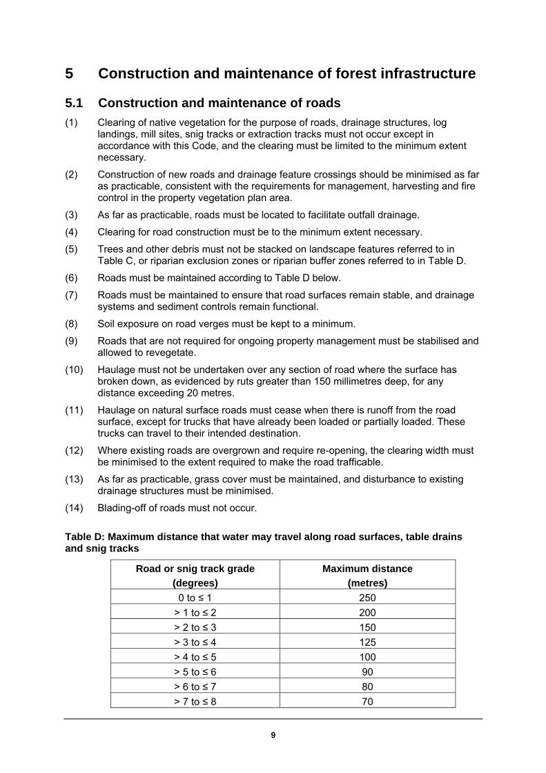
5 Construction and maintenance of forest infrastructure
5.1 Construction and maintenance of roads
(1) Clearing of native vegetation for the purpose of roads, drainage structures, log landings, mill sites, snig tracks or extraction tracks must not occur except in accordance with this Code, and the clearing must be limited to the minimum extent necessary.
(2) Construction of new roads and drainage feature crossings should be minimised as far as practicable, consistent with the requirements for management, harvesting and fire control in the property vegetation plan area.
(3) As far as practicable, roads must be located to facilitate outfall drainage.
(4) Clearing for road construction must be to the minimum extent necessary.
(5) Trees and other debris must not be stacked on landscape features referred to in Table C, or riparian exclusion zones or riparian buffer zones referred to in Table D.
(6) Roads must be maintained according to Table D below.
(7) Roads must be maintained to ensure that road surfaces remain stable, and drainage systems and sediment controls remain functional.
(8) Soil exposure on road verges must be kept to a minimum.
(9) Roads that are not required for ongoing property management must be stabilised and allowed to revegetate.
(10) Haulage must not be undertaken over any section of road where the surface has broken down, as evidenced by ruts greater than 150 millimetres deep, for any distance exceeding 20 metres.
(11) Haulage on natural surface roads must cease when there is runoff from the road surface, except for trucks that have already been loaded or partially loaded. These trucks can travel to their intended destination.
(12) Where existing roads are overgrown and require re-opening, the clearing width must be minimised to the extent required to make the road trafficable.
(13) As far as practicable, grass cover must be maintained, and disturbance to existing drainage structures must be minimised.
(14) Blading-off of roads must not occur.
Table D: Maximum distance that water may travel along road surfaces, table drains and snig tracks
Road or snig track grade
(degrees)
Maximum distance
(metres)
0 to ≤ 1 250
> 1 to ≤ 2 200
> 2 to ≤ 3 150
> 3 to ≤ 4 125
> 4 to ≤ 5 100
> 5 to ≤ 6 90
> 6 to ≤ 7 80
> 7 to ≤ 8 70

10
Road or snig track grade
(degrees)
Maximum distance
(metres)
> 8 to ≤ 9 65
> 9 to ≤ 10 60 5.1.1 Road drainage
(1) All reasonable steps must be taken to minimise soil erosion from roads. Accordingly, at least one of the following measures must be adopted, as appropriate in the circumstances:
(a) maintain vegetative cover (that is, plant material, living or dead) that protects the soil surface from erosion
(b) establish a grass cover using a sterile seed or native grass seed, where available
(c) crossfall drain the road or track with outfall or infall drainage, or by shaping the road to a crown so water drains to both of its sides
(d) construct drainage structures to convey water away from the road formation (for example, cross drains, mitre drains or relief culverts).
(2) Drainage structures must be established on a road if concentrated water flow on the road surface or table drains is likely to occur for distances exceeding the relevant spacing, as shown in Table D.
(3) Earth windrows resulting from road construction and upgrading operations must be removed from the shoulders of all roads unless they are specifically constructed to prevent erosion of fill batters or where infall drainage is used.
(4) Earth windrows from road maintenance must be cut through at regular intervals to ensure that water flow on road surfaces does not exceed the distances specified in Table D.
(5) Rollover banks must have a minimum effective bank height of 15 centimetres (consolidated). Spoon drains must have a minimum effective depth of 15 centimetres.
(6) Drainage structures must divert water onto a stable surface, and must be kept free of debris that may impede flow of water.
5.1.2 Roads crossing drainage features
(1) Drainage feature crossings must be stable causeways, culverts or bridges. Existing gully stuffers may be used if they are stable, but new crossings of these types must not be constructed.
(2) Crossings must be designed, constructed and maintained to minimise disturbance to the passage of fish and other aquatic fauna. They must be located and constructed to cause minimum disturbance to stream banks, stream beds and natural flows. The base of the crossing must be made of erosion-resistant material such as rock, concrete or heavy timber and must conform to the natural level of the stream bed.
(3) Crossings must be constructed as close as practicable to right angles to the water flow unless an angled approach reduces soil and ground disturbance.
(4) Disturbance to the bed and banks of the drainage feature during crossing construction or maintenance must be minimised. Disturbed areas must be reshaped and stabilised as soon as possible following crossing construction or maintenance.
(5) Any approaches to a crossing over a drainage line must be drained, using a drainage structure, within 5 to 30 metres of the crossing. (Where this is impracticable, a drainage structure must be constructed as near as practicable to the crossing).

11
(6) Permanent drainage crossing structures must be designed to convey a 1 in 5 year storm event and withstand a 1 in 10 year storm event. Bridges must be designed and constructed so the natural stream flow is not restricted and erosion is minimised.
(7) The surface of any crossing, and the approaches on both sides of it, must be made of stable material that is unlikely to be displaced during normal use of the crossing or approach.
(8) Causeways must be constructed of stable, non-soil material such as crushed gravel, rock, bitumen, concrete, logs, or other stable material that is unlikely to produce water turbidity.
(9) Construction equipment must minimise disturbance or damage to the watercourse bed and banks. Fill and construction material must not be placed into watercourses, and surplus fill must be located outside the drainage feature exclusion zone. Stream banks, and bridge embankments, must be protected to minimise erosion.
(10) Soil stabilisation must be undertaken in all areas disturbed by crossing construction, upgrading, or maintenance.
5.2 Log landings, portable mill sites and snig tracks
(1) Wherever practicable, log landings and portable mill sites must be located in flood runners or drainage depressions.
(2) Log landings and portable mill sites must be no larger than the minimum size necessary for efficient operations.
(3) Log landings and portable mill sites must be located and constructed as far as practicable to allow effective drainage during harvesting operations.
(4) Log landings and portable mill sites must not be located closer than 10 metres to an exclusion zone or riparian buffer zone.
(5) Runoff from log landings and portable mill sites must not be directly discharged into a drainage feature.
(6) Vegetation and debris from log landings and portable mill sites must not be deposited in an exclusion zone, buffer zone or flood runner.
(7) Woody waste and debris on log landings and portable mill sites must not be stacked against retained trees.
(8) Bark accumulated on log landings, and sawdust on mill sites, must be progressively dispersed away from the site during harvesting operations to prevent significant accumulations.
(9) On completion of operations, log landings and portable mill sites must be drained and reshaped to safely disperse runoff onto surrounding vegetation.
5.2.1 Snig tracks and extraction tracks
(1) Snig track or extraction track construction must be minimised, and as far as practicable, walkover extraction must be used, and slash retained on snig and extraction tracks.
(2) Soil disturbance and exposure on snig and extraction tracks must be minimised.
(3) Old snig tracks or extraction tracks must not be used if they are incised and cannot be drained.
(4) In re-opening old snig tracks and extraction tracks, the use of blades should be restricted to the removal of obstructions such as understorey vegetation, logs/tree heads and surface rock, and to ensuring that the track is adequately drained.

12
(5) Snig tracks and extraction tracks must not encroach on exclusion zones or riparian buffer zones except designated crossings and where permitted by other code conditions.
(6) Blading off of snig tracks and extraction tracks must not occur.
(7) Snig tracks and extraction tracks must be located and constructed to ensure that water flow along the track surface does not exceed the distances specified in Table D. This could be achieved by one or a combination of the following techniques:
(a) retain existing groundcover using walkover techniques
(b) retain or cover the track surface with slash and harvesting debris
(c) construct or maintain the track with outfall drainage
(d) construct track drainage structures.
(8) On completion of operations, the following measures must be implemented where practicable: snig tracks and extraction tracks must be reshaped; all earth windrows, wheel ruts, and log furrows must be removed; and recoverable topsoil must be spread back over the track.
(9) Crossbanks must be constructed to have a minimum effective height of 35 centimetres unconsolidated, or 25 centimetres consolidated, and as a guide should not be greater than 50 centimetres in height.
(10) Crossbanks must not be constructed of bark or woody debris.
5.2.2 Snig track and extraction track crossings on drainage
(1) The location of log landings and snig/extraction tracks must be planned to minimise the number of crossings required.
(2) Snig track and extraction track crossings must be stable causeways (including natural surface causeways), culverts or bridges. Existing gully stuffers may only be used if they are stable. New crossings of this type must not be constructed.
(3) Machinery must not cross a drainage feature which is running water, or when the soil is saturated, unless by means of a stable crossing.
(4) Approaches to crossings must be as close as possible to right angles to the flow of water.
(5) A crossbank must be installed on each approach, between 5 and 20 metres from the drainage feature crossing. The distance must be measured from the top of the bank of the incised channel. The drainage structure must divert water onto a stable surface. If such a surface is not available, sediment control measures must be used to prevent sediment entering the drainage feature.
(6) Disturbance to the bed and banks of the drainage feature must be minimised, and any spoil must be removed from the drainage feature.
(7) All areas disturbed during crossing construction and use, including approaches, must be rehabilitated following completion of use. Rehabilitation includes the reshaping of the crossing to conform as closely as possible to the original ground surface. If groundcover is not likely to recover naturally, sowing with a suitable sterile seed or endemic native seed/fertiliser mix must be undertaken to establish effective groundcover.

13
5.2.3 Wet weather limitations for snigging, log landing and portable mill operations
(1) Harvesting operations must not occur when:
(a) there is runoff from the snig track surface, or
(b) soils are saturated, or
(c) soil is rutted to a depth of more than 200 millimetres below the track surface over a 20-metre section or longer.
(2) Forwarders, excavators and truck-mounted loaders may be used as stationary loaders when there is runoff from the log landing.
(3) All other machinery on the log landing must remain stationary when there is runoff from the log landing surface, unless the log landing is constructed of gravel or other stable material.

14
Appendix: Listed species ecological prescriptions
Introduction These prescriptions must be applied within the forest operations area where there is a known record or site evidence of a threatened species. A known record is a sighting or record of the species in the NSW Wildlife Atlas. Site evidence is a sign a species has visited or regularly uses a site, and includes observations of, for example, faecal pellets or scats, chewed seed cones or a nest, or evidence that the site has been used as a latrine. A list of threatened species under the Threatened Species Conservation Act 1995 and species profiles for each species can be viewed on the Department of Environment and Climate Change (DECC) website at www.threatenedspecies.environment.nsw.gov.au. The prescriptions set out below assist in the protection of threatened species, and include: (1) additional widths to stream exclusion zones
(2) exclusion zones around locations of threatened species records
(3) additional tree retention requirements around locations of threatened species records. Exclusion zones and buffer zones requiring additional tree retention requirements must be applied within the Property Vegetation Plan (PVP) area subject to the Forest Operation Plan. Wildlife Atlas records that trigger these prescriptions are those less than 20 years old which have a reliability level of 1 to 5. Records in an adjoining protected area of public land (for example, in State Forests or National Parks) can be ignored if it can be demonstrated that the species has been protected and the conditions of the relevant Threatened Species Licence or Integrated Forestry Operation Agreement has been met. Some species prescriptions vary according to the region in which they occur. Unless otherwise stated, the regions referred to in the prescriptions are based on catchments administered by Catchment Management Authorities (CMAs) shown in Figure 1 on t he next page.
General conditions For all threatened species prescriptions, the following applies: (1) where a retained eucalypt tree (as required by these prescriptions) also meets the
requirements of a habitat tree, the eucalypt tree may be counted as a habitat tree
(2) where other exclusion zones form part of the habitat area required for threatened species prescriptions, the exclusion zones may count towards the area of habitat required to be retained
(3) buffer and exclusion zones are to be marked in the field where they adjoin the area, subject to forest operations. This marking has to be visible while forestry operations are occurring.

Figure 1 – Catchment Management Authority (CMA) areas where prescriptions for some threatened species may vary Further information about individual threatened species may be sourced from DECC. The DECC website provides species profiles and additional information. Visit www.environment.nsw.gov.au and www.threatenedspecies.environment.nsw.gov.au.
Mammals
Squirrel glider (Petaurus norfolcensis) CMAs for application of prescription Border Rivers–Gwydir, Central West, Lachlan, Murray, Murrumbidgee and Namoi. Prescription Where there is a squirrel glider record in an area of forest operations, or within 125 metres of the boundary of the area of forest operations (unless specified otherwise in this condition), the following must apply: (a) A buffer zone with a 250-metre radius (about 20 hectare) must be identified, centred
on the location of the record or records.
(b) Within this buffer zone, the following additional prescriptions must be implemented:
(i) a minimum of 15 trees per 2 hectares with visible hollows must be retained where available
(ii) a recruitment tree must be retained for each hollow bearing tree retained. Where the total number of hollow bearing trees and recruitment trees is less than 30 trees per 2 hectares, additional recruitment trees must be retained to bring the number up to 30 trees per 2 hectares
(iii) disturbance to understorey trees and shrubs (particularly banksias and acacias), ground logs, rocks and litter must be minimised.
(c) Where there are records of dens or roosts, these must be contained within buffer zones encompassing suitable habitat.
15

16
(d) Where there are more than two squirrel glider records closer than 250 metres apart within the forest operation area, advice on the location of the buffer area must be sought from DECC before commencing forest operations.
Additional information Squirrel glider habitat is generally dry eucalypt forest and woodland. In coastal areas, potential habitat is blackbutt, bloodwood and ironbark forest with a heathy understorey. In the absence of these forest types, areas of mature or old growth forest must be retained.
Koala (Phascolarctos cinereus) CMAs for application of prescription Border Rivers–Gwydir, Central West, Lachlan, Murray, Murrumbidgee and Namoi. Note: Koala populations are generally sparse or of low density in the South Coast, Central and Southern Tablelands and Western Koala Management Areas (Koala Management Areas 3, 5, 6 and 7; see Figure 2) and, as a result, scats are rarely encountered. Therefore, recording of any scat or a sighting of a koala in these areas should be considered significant. Prescription (a) Forest operations are not permitted within any area identified as ’core koala habitat‘
within the meaning of State Environmental Planning Policy No. 44 – Koala Habitat Protection.
(b) Any tree containing a koala, or where one or more koala faecal pellets in Koala Management Area 5) this tree must be retained and an exclusion zone of metres must be implemented around each retained tree;
(c) Where there is a record of a koala within an area of forest operations or within 500 metres of an area of forest operations, or a koala faecal pellet (scat) is found beneath the canopy of any primary or secondary koala food tree (see Table 1 below), the following must apply: (i) a minimum of 10 primary koala food trees and 5 secondary koala food trees
must be retained per hectare of net harvesting area (not including other exclusion or buffer zones), where available
(ii) these trees should preferably be spread evenly across the net harvesting area, have leafy, broad crowns and be in a range of size classes with a minimum of 30 centimetres diameter at breast height over bark
(iii) damage to retained trees must be minimised by directional falling techniques (iv) post-harvest burns must minimise damage to the trunks and foliage of
retained trees.
Additional information Generally, koala habitat comprises eucalypt forest and woodland containing primary and secondary food trees (see Table E). Koala droppings (faecal pellets or scats) are relatively distinctive, being cylindrical and pit-shaped. Colour varies between green–yellow to yellow–brown. Scats can remain under trees on or within the leaf litter for periods of several weeks to months. For further information on the identification of koala pellets or scats, contact DECC or refer to the DECC website – www.environment.nsw.gov.au.

Figure 2 – Koala Management Areas in NSW (from Draft State Koala Recovery Plan)
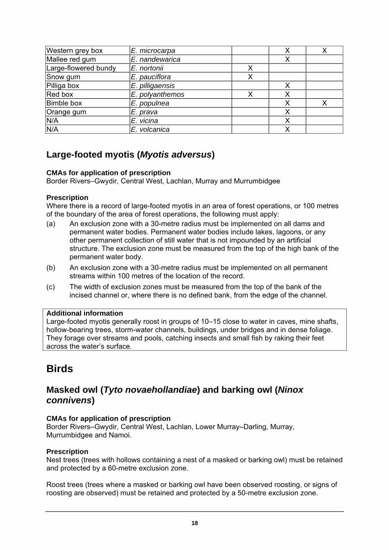
Table E: List of primary and secondary koala food trees A list of koala food trees for each Koala Management Area in the River Red Gum forests. Koala food free species Koala management area Common name Scientific name 5 6 7 PRIMARY TREE SPECIES River red gum E. camaldulensis X X Coolabah E. coolabah X X Ribbon gum E. viminalis X SECONDARY TREE SPECIES White box E. albens X X Eurabbie E. bicostata X Blakely’s red gum E. blakelyi X X X Apple-topped Box E. bridgesiana X X Broad-leaved sally E. camphora X Dirty gum E. chloroclada X Argyle apple E. cinerea X Fuzzy box E. Conica X Mountain gum E. dalrympleana X Tumbledown gum E. dealbata X X Dwyer’s red gum E. dwyeri X Bundy E. goniocalyx X Black box E. largiflorens X X Maiden’s gum E. maidenii X Brittle gum E. mannifera X Yellow box E. melliodora X X X
17
18
Western grey box E. microcarpa X X Mallee red gum E. nandewarica X Large-flowered bundy E. nortonii X Snow gum E. pauciflora X Pilliga box E. pilligaensis X Red box E. polyanthemos X X Bimble box E. populnea X X Orange gum E. prava X N/A E. vicina X N/A E. volcanica X
Large-footed myotis (Myotis adversus) CMAs for application of prescription Border Rivers–Gwydir, Central West, Lachlan, Murray and Murrumbidgee Prescription Where there is a record of large-footed myotis in an area of forest operations, or 100 metres of the boundary of the area of forest operations, the following must apply: (a) An exclusion zone with a 30-metre radius must be implemented on all dams and
permanent water bodies. Permanent water bodies include lakes, lagoons, or any other permanent collection of still water that is not impounded by an artificial structure. The exclusion zone must be measured from the top of the high bank of the permanent water body.
(b) An exclusion zone with a 30-metre radius must be implemented on all permanent streams within 100 metres of the location of the record.
(c) The width of exclusion zones must be measured from the top of the bank of the incised channel or, where there is no defined bank, from the edge of the channel.
Additional information Large-footed myotis generally roost in groups of 10–15 close to water in caves, mine shafts, hollow-bearing trees, storm-water channels, buildings, under bridges and in dense foliage. They forage over streams and pools, catching insects and small fish by raking their feet across the water’s surface.
Birds
Masked owl (Tyto novaehollandiae) and barking owl (Ninox connivens) CMAs for application of prescription Border Rivers–Gwydir, Central West, Lachlan, Lower Murray–Darling, Murray, Murrumbidgee and Namoi. Prescription Nest trees (trees with hollows containing a nest of a masked or barking owl) must be retained and protected by a 60-metre exclusion zone. Roost trees (trees where a masked or barking owl have been observed roosting, or signs of roosting are observed) must be retained and protected by a 50-metre exclusion zone.

19
Where there is a record within the area of forest operations, or within 500 metres of the area of forest operations for the masked owl or 250 metres for barking owl, of the area of forest operations, the following prescriptions apply: (a) Buffer zones with a1000-metre radius (about 300 hectare) for the masked owl and
500-metre radius (about 78 hectare) for the barking owl must be identified centred on the location of the record, or records. The radius of the buffer zone must be measured from the location of the record. Where there is more than one record, the radius of the buffer zone must be measured from a point equidistant from most records, where possible.
(b) Within this buffer zone, the following additional prescriptions must be implemented:
(i) a minimum of 15 trees per 2 hectares with visible hollows must be retained where available
(ii) a recruitment tree must be retained for each hollow bearing tree retained. Where the total number of hollow bearing trees and recruitment trees is less than 30 trees per 2 hectares, additional recruitment trees must be retained to bring the number up to 30 trees per 2 hectares
(iii) disturbance to understorey trees and shrubs, ground logs, rocks and litter, must be minimised.
(c) Where there are records of nests or roosts, these must be contained within buffer zones encompassing suitable habitat.
(d) Where there are more than two owl records consecutively less than 1000 metres apart but collectively spreading over an area greater than 1000 metres in any direction, advice on the location of the buffer area must be sought from DECC.
Swift parrot (Lathamus discolor) CMAs for application of prescription Border Rivers–Gwydir, Central West, Lachlan, Lower Murray–Darling, Murray, Murrumbidgee and Namoi. Prescription Where there is a record of a swift parrot in an area of forest operations, the following must apply: (a) At least ten eucalypt feed trees must be retained within every two hectares of the net
harvest area. These must be marked for retention. Where retained eucalypt feed trees also meet the requirements of habitat or recruitment trees, the retained eucalypt feed trees can be counted as habitat or recruitment trees.
(b) Where a swift parrot is observed feeding, the tree in which it is feeding must be retained.
Additional information Swift parrots migrate to the Australian south-east mainland between March and October. On the mainland, they occur where eucalypts are flowering profusely or where there are abundant lerps (from sap-sucking bugs). Favoured feed trees include winter-flowering species such as swamp mahogany (Eucalyptus robusta), spotted gum (Corymbia maculata), red bloodwood (C. gummifera), mugga ironbark (E. sideroxylon) and white box (E. albens). Commonly used lerp-infested trees include grey box (E. microcarpa), grey box (E. moluccana) and blackbutt (E. pilularis)

Regent parrot (Polytelis anthopeplus monarchoides) CMAs for application of prescription Lower Murray-Darling and Murray. Prescription There should be no harvesting of mallee within the areas shown on the following map (see Figure 3):
(a) within 20 kilometres of the Lower Wakool River defined as downstream of the junction of the Edward and Wakool Rivers, with the eastern boundary line being drawn perpendicular to the river at that point
(b) within 20 kilometres of the Murray River.
Figure 3: Area for application of regent parrot prescription Mallee within this zone can only be harvested by obtaining development consent under the Native Vegetation Act 2003 for non-Crown Timbered Lands.
Bush stone-curlew (Burhinus grallarius) CMAs for application of prescription All Prescription No forest operations are permitted within a 50-metre radius of all bush stone-curlew ground nests.
20

21
Additional information Bush stone-curlew nests are found in areas of dry, grassy open forest or woodland and are a small scrape on bare ground, often near a bush or tree or beside a fallen limb. Eggs are stone coloured, blotched dark brown, grey. Nesting season is August through to January.
Red-tailed black-cockatoo (Calyptorhynchus banksii) CMAs for application of prescription Border Rivers-/Gwydir, Central West, Lower Murray/-Darling, Namoi and, Western Prescription No forest operations are permitted within a 50-metre radius of all red-tailed black-cockatoo nests. Additional information Red-tailed black-cockatoos nest in tree hollows usually in larger, mature trees. Nest locations are indicative of where a bird is seen entering a hollow. Nesting season is from March to August. Red-tailed black-cockatoos are found in a wide variety of habitats. In coastal north-east NSW they have been recorded in dry open forest and areas of mixed rainforest/eucalypt forest.
Osprey (Pandion haliaetus) CMAs for application of prescription All except for Lower Murray–Darling and Western. Prescription No forest operations are permitted within a 100-metre radius of all osprey nests. Additional information Ospreys have a large stick nest (up to 2 metres wide) usually in tall, dead or occasionally live trees, often in an exposed position close to lakes, rivers or the ocean. Nesting season is from June to October.
Square-tailed kite (Lophoictinia isura) CMAs for application of prescription All Prescription No forest operations are permitted within a 100-metre radius of all square-tailed kite nests. Additional information Square-tailed kites have a large stick nest usually between 60 and 100 centimetres in diameter, and some 12–26 metres above the ground, generally in a eucalypt. Nesting season is from July to November.
22
Turquoise parrot (Neophema pulchella) CMAs for application of prescription All except for Lower Murray–Darling and Western. Prescription No forest operations are permitted within a 30-metre radius of all turquoise parrot nests. Additional information Turquoise parrots occur mainly west of the escarpment on the tablelands and western slopes, but are occasionally found more widely through most of eastern NSW, in open woodlands, dry sclerophyll forest and adjacent grasslands. Nests range from 1 – 20 metres above the ground. They are in hollows in small trees, often dead eucalypts, or in holes or stumps, fence posts, or even logs lying on the ground. Nesting season is from August to December and from April to May.
Threatened flora – specific prescriptions Table F: Conditions applying to flora species
(Note: Numbers in first column relate to conditions listed below this table)
Condition Scientific name Common name Catchment Management Authority H Amphibromus
fluitans Floating swamp wallaby-grass
Murray, Murrumbidgee
H. Damage to individuals avoided Damage to individuals of the species to which this condition applies should be avoided to the greatest extent practicable.
23
Glossary Expressions that are defined in the Native Vegetation Act 2003 and Native Vegetation Regulation 2005 have the same meanings in this Code as the meanings given to them in that Act and Regulation unless they are otherwise defined in this Code. All other expressions are defined as in this glossary. Accidentally felled
A tree is accidentally felled into any area of land only if it is apparent that techniques of directional felling were used in an attempt to fell the tree away from the area. Despite the above, a tree is not accidentally felled into an area if the person responsible knew or could reasonably have been expected to know that the tree would fall into the area.
Australian group selection
A silvicultural technique that creates canopy openings for the purpose of stimulating regeneration in certain forest types.
Batter An earth slope formed from fill material (fill batter) or cut into the natural hillside (cut batter), during road construction.
Clumps of habitat trees forming rookeries for waterbirds
A group of adjoining trees, together with a 20-metre surrounding buffer, in which there are multiple stick nests comprising the breeding rookeries of colonial waterbirds such as herons, cormorants, spoonbills or egrets. Nests usually comprise platforms of sticks, often near each other. They are usually found in trees in or near water bodies such as swamps. Such breeding rookeries can contain hundreds of nests and birds, and are often revisited annually.
Diameter at breast height over bark (dbhob)
The diameter of a tree measured at 1.3 metres above the ground. Measurements are made over the bark and horizontal to the trunk.
Directional felling
The felling of a tree so it falls in a pre-determined direction
Drainage depression
A shallow depression with smoothly concave cross-section that conveys runoff only during or immediately after periods of heavy rainfall.
Drainage feature A drainage depression, drainage line, river or watercourse.
Drainage line A channel down which surface water naturally concentrates and flows. Drainage lines exhibit one or more of the following features which distinguish them from drainage depressions:
evidence of active erosion or deposition – e.g. gravel, pebble, rock, sand bed, scour hole or nick point
an incised channel of more than 30 centimetres deep with clearly defined bed and banks
a permanent flow.
Drainage structure
A structure designed to convey water away from a road, track or area of soil disturbance.
Earth windrow A mound of soil material or gravel on the edge of a road or snig track formed by the spillage from the edge of a blade or similar machine during earthmoving operations.
Ecological logging regime
The use of logging (commercial and non-commercial) to rehabilitate or regenerate an ecological community. The primary goal is ecological improvements and commercial logging provides an economic incentive for the forest owner to undertake the works. Also known as ecological

24
silvicultural logging.
Exclusion zone Means an area of land (within a specified distance of landscape features identified in Tables A or C where forest operations are prohibited, unless otherwise allowed under this Code.
Extraction track A track constructed for use by forwarding machinery.
Flood runner A natural depression that carries the initial flood flows before complete inundation occurs.
Food resource trees
Trees with recent V-notch incisions or other incisions made by a yellow-bellied glider or squirrel glider. Recent incisions are incisions less than two-years-old as evidenced by the fact the incision has not closed.
Forest operations
All clearing resulting from activities associated with forest management including harvesting operations, construction and maintenance of roads and tracks, and prescribed burning for regeneration.
Girders High quality logs used in a round or flat faced form to support a deck such as a bridge or wharf or as large end section, heart-free, sawn timber suitable for heavy construction.
Gross forest area
The total area of forest defined in a Property Vegetation Plan.
Gully stuffer A drainage feature crossing formed by filling the drainage feature with trees, debris, spoil, soil, rock or other material to the level of the road or track.
Habitat tree A tree retained for habitat purposes under this Code.
Harvesting operations
Harvesting operations include:
timber felling, snigging and extraction
construction and maintenance of log landings, snig tracks and extraction tracks.
Incised channel A channel more than 30 centimetres deep with clearly defined bed and banks
Inundation Flooding of the forested area by water overflowing the banks of a river.
Log landing An area (usually cleared) where timber products are assembled for processing and sorting before being loaded onto a truck.
Machinery exclusion zone
Land within, and within 10 metres of the top edge of, the bank of any unmapped drainage line.
Nest trees Trees with nests or roosts of any species of raptor including powerful owls, barking owls, sooty owls and masked owls.
Trees with nests of colonial-nesting water birds (groups of stick-nests).
Old growth Ecologically mature forest where the effects of disturbance are now negligible.
This includes an area of forest greater than 5 hectares where:
the overstorey is in late to over-mature growth stage with the presence of relatively large old trees (many containing hollows and often with the presence of dieback or dead branches in the crown)
the age (growth) structure of the stand measured as relative crown cover consists of less than 10% of regeneration and advance growth, and more than 10% of late to over-mature (senescent) growth
the effects of unnatural disturbance are now negligible.
Old growth woodlands west of the Great Dividing Range, while comprising a characteristic canopy of late to over-mature trees (many with hollows), may comprise a woodland structure with less diverse or often shrubby understorey and a groundcover of grasses and herbs.

25
Portable mill site A site where a portable mill (easily movable milling equipment) operates.
Posts Term generally used to describe posts in round or split form used for fencing.
Prescribed Stream
Stream listed in the Major Rivers database of the Assessment Methodology database - Department of Environment and Climate Change webpage.
Protected trees Trees required to be retained under clause 8:
plants of the Xanthorrhoea (grass trees), Allocasuarina (forest oak (except bull oak (Allocasuarina luehmannii)) and Banksia genuses
For the River Red Gum Forests, Acacia salicina (cooba), Exocarpos strictus (dwarf cherry) and Eucalyptus microcarpa (grey box)
Other trees that are required to be retained by this Code.
Pulp logs Logs cut and prepared primarily to produce wood pulp for the manufacture of reconstituted products including paper and panel board.
Rainfall erosivity A measure of the ability of rainfall to cause erosion at any location. It is directly related to the likelihood of high intensity storms and can be used to predict times of the year when erosion risk is greatest.
Recovery plan As defined in the Threatened Species Conservation Act 1995.
Recruitment tree A tree capable of developing hollows to provide habitat for wildlife and which comes from the next smaller cohort than habitat trees
River Red Gum Forests
A forest dominated by Eucalyptus camaldulensis consistent with description of Forest Type 199 (River Red Gum) in State Forests of NSW, Research Note 17.
Riparian exclusion zones
Those areas within, and within the distance specified of, drainage features as listed in Table C where forest operations are not permitted, unless otherwise allowed by this Code.
Road Any route used for vehicular access to, and the transport of logs from the point of loading (log landing) within the forest area.
Road prism That part of the road from the inflexion point at the toe of the fill batter to the inflexion point at the top edge of the cut batter. Where there is no cut or fill batter as part of the road, the road prism is to be taken from the outside edge of the table drain on either side of the road.
Rollover bank A crossbank constructed with a smooth cross section and gentle batters, which is well-compacted to provide permanent vehicular trafficability.
Roost trees Trees with nests or roosts of any species of raptor including powerful owls, barking owls, sooty owls and masked owls, and trees which support maternity bat roosts.
Sawlog Log of a species suitable for processing through a sawmill into solid timber products.
Silvicultural operations
The activities associated with the management of trees within a forest for the purpose of meeting sustainable long-term productivity objectives, including thinning, single tree selection, and creation of canopy openings.
Single tree selection
A harvesting operation where the trees harvested are either single trees or small groups of trees. For the purposes of this Code, single tree selection operations will not create canopy openings.
Snig track A track used by snigging or skidding equipment.
Spoon drain A drain with a semi-circular cross-section, which has no associated ridge of soil. Its capacity is solely defined by the excavated channel dimensions.
Stand height Mean height of the dominant trees in the stand. Measurement of stand height must conform to methods described in approved guidelines.

26
Stocking level A measure of the frequency of occurrence of tree stems assessed as being capable of growing to canopy level. Measurement of stocking levels must conform with methods described in approved guidelines.
Thinning A silvicultural practice where some trees are removed in order to increase the growth rates of retained trees.
Timber products Commercial timber products removed from or felled within the forest, including sawlogs, veneer logs, poles, girders, piles and pulp logs.
Veneer log High quality logs that are rotary peeled or sliced to produce sheets of veneer.
Walkover techniques
Timber extraction or snigging without removing or unduly disturbing the existing natural groundcover; i.e. where no snig track construction involving soil disturbance is required.
Wetlands As defined in the Native Vegetation Act 2003.