program management plan march 24, 2008
TRANSCRIPT

Geospatial LoB Program Management Plan
GEOSPATIAL LINE OF BUSINESS
PROGRAM MANAGEMENT PLAN
MARCH 24, 2008

Geospatial LoB Program Management Plan
Last Updated 6/19/2008 i
Table of Contents GEOSPATIAL LINE OF BUSINESS ............................................................................................. I 1 INTRODUCTION ................................................................................................................. 3
1.1 Background ......................................................................................................................... 3 1.2 Document Structure ............................................................................................................ 4
2 WORK GROUP TASKS AND DELIVERABLES ................................................................ 5 3 ROLES AND RESPONSIBILITIES ..................................................................................... 7 4 PROGRAM MANAGEMENT APPROACH ......................................................................... 9
4.1 Cost, Schedule, and Outcomes Management .................................................................... 9 4.2 Action Items and Issues Management................................................................................ 9 4.3 Internal Communications and Status Reporting ................................................................. 9 4.4 Knowledge Management .................................................................................................... 9 4.5 Deliverable Quality Review and Submission ...................................................................... 9 4.6 Scope Management............................................................................................................ 9
5 MANAGING TEAM PROGRAM MANAGEMENT SUPPORT ............................................ 9 5.1 Schedule Management ....................................................................................................... 9 5.2 Briefing Development Support ............................................................................................ 9 5.3 OMB Reporting / Budgeting Support .................................................................................. 9 5.4 Financial and Investment Analysis...................................................................................... 9 5.5 Technical Analysis .............................................................................................................. 9 5.6 Advisory Guidance / Document Development Support ...................................................... 9 5.7 Meeting Support.................................................................................................................. 9 5.8 Membership Tracking Assistance ....................................................................................... 9
6 WORK GROUP PROGRAM MANAGEMENT SUPPORT.................................................. 9 6.1 Analysis Support ................................................................................................................. 9 6.2 Advisory Support (e.g. OMB Exhibit 300 expertise) ........................................................... 9 6.3 External Communication and Outreach Support ................................................................ 9 6.4 Meeting Coordination.......................................................................................................... 9 6.5 Schedule Management ....................................................................................................... 9 6.6 Document Coordination ...................................................................................................... 9 6.7 Work Plan Development and Maintenance ........................................................................ 9
APPENDIX A: PROGRAM MANAGEMENT TOOL SUMMARY MATRIX ........................... A-9 APPENDIX B: TASKS AND DELIVERABLES..................................................................... B-9 B.1 PERFORMANCE MANAGEMENT WORK GROUP.................................................... B.1-9 B.2 LIFECYCLE MANAGEMENT WORK GROUP............................................................ B.2-9 B.3 COMMON SERVICE WORK GROUP ......................................................................... B.3-9 B.4 GEO-ENABLED BUSINESS WORK GROUP ............................................................. B.4-9 B.5 GRANTS AND CONTRACTS WORK GROUP ........................................................... B.5-9 B.6 TECHNICAL ARCHITECTURE WORK GROUP......................................................... B.6-9 B.7 JOINT BUSINESS CASE (JBC) WORK GROUP ....................................................... B.7-9

Geospatial LoB Program Management Plan
Last Updated 6/19/2008 ii
APPENDIX C: MASTER PROJECT SCHEDULE FY 2008-2009......................................... C-9 APPENDIX D: WORK PLAN TEMPLATE............................................................................ D-9 APPENDIX E: STATUS REPORT TEMPLATE.................................................................... E-9 APPENDIX F: MEETING MINUTES TEMPLATE..................................................................F-9 APPENDIX G: ACTION ITEM TRACKING TEMPLATE.......................................................G-9 APPENDIX H: ISSUE TRACKING TEMPLATE ................................................................... H-9 APPENDIX I: BRIEFING TEMPLATE...................................................................................I-9 APPENDIX J: QUICKPLACE SCREEN SHOTS ..................................................................J-9 APPENDIX K: COMMENT LOG TOOL ................................................................................ K-9 APPENDIX L: COMMENT ADJUDICATION TOOL..............................................................L-9 APPENDIX M: EARNED VALUE MANAGEMENT REPORTING TOOL..............................M-9 APPENDIX N: MEMBER TRACKING TOOL........................................................................ N-9

Geospatial LoB Program Management Plan
Last Updated 6/19/2008 3
1 INTRODUCTION The Program Management Plan herein referred to as “the Plan,” lays out the Program Management
Office’s (PMO) approach for achieving the Fiscal Year (FY) 2008-2009 milestones of the Geospatial
Line of Business (Geospatial LoB) with contracting support from Grant Thornton. Herein, the term
“PMO” represents the combined parties of Grant Thornton and the Managing Partner Team. The Plan
builds upon the Performance Management Strategy (PM Strategy), which was completed in June 2007,
and the Performance Management Plan (PM Plan), which was completed in February 2008.
The Plan provides processes and tools to measure performance dimensions as introduced in the PM Plan
as well as practical approaches and tools for initiating, executing, and monitoring tasks, and producing the
deliverables presented in the PM Plan. Appendix A: Program Management Tool Summary Matrix
provides a comprehensive summary of key program management tools discussed throughout this Plan.
1.1 Background In September 2007, the U.S. Geological Survey (USGS) of the Department of the Interior selected Grant
Thornton to provide program management office support to the Geospatial LoB. As part of this two-year
contract, Grant Thornton provides program support to the Geospatial LoB PMO in the setup and
implementation of various work groups producing multiple deliverables to enhance the efficiency and
effectiveness of the acquisition and distribution of geospatial data among Federal agencies.
The Federal Geographic Data Committee (FGDC) Coordination Group oversees the Geospatial LoB and
serves as the coordination board for operational-level interagency management for the effective and
efficient prioritization, execution, and administration of the Geospatial LoB and its tasks, milestones, and
deliverables.
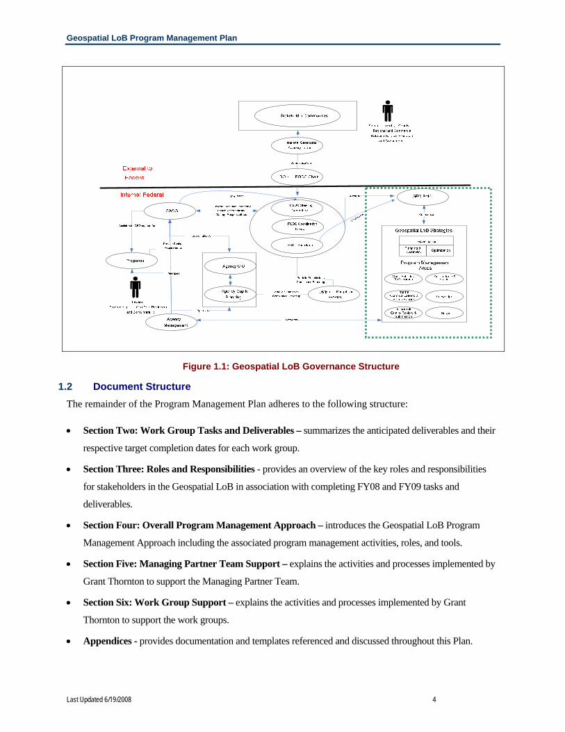
Figure 1.1: Geospatial LoB Governance Structure provides a graphical depiction of the specific relationships
and reporting structures associated with implementing this initiative. The green dotted box outlines the
Geospatial LoB, whose participants come from participating agencies, with additional oversight from the
FGDC Chair, and Office of Management and Budget (OMB). While this graphic is notionally accurate, the
governance model may change over time as a result of the work products and deliverables produced by the
Performance Management Work Group in association with Task 1: Review/Update FGDC Guidance
Documents.
Geospatial LoB Program Management Plan
Last Updated 6/19/2008 4
1.2 Document Structure The remainder of the Program Management Plan adheres to the following structure:
• Section Two: Work Group Tasks and Deliverables – summarizes the anticipated deliverables and their
respective target completion dates for each work group.
• Section Three: Roles and Responsibilities - provides an overview of the key roles and responsibilities
for stakeholders in the Geospatial LoB in association with completing FY08 and FY09 tasks and
deliverables.
• Section Four: Overall Program Management Approach – introduces the Geospatial LoB Program
Management Approach including the associated program management activities, roles, and tools.
• Section Five: Managing Partner Team Support – explains the activities and processes implemented by
Grant Thornton to support the Managing Partner Team.
• Section Six: Work Group Support – explains the activities and processes implemented by Grant
Thornton to support the work groups.
• Appendices - provides documentation and templates referenced and discussed throughout this Plan.
Figure 1.1: Geospatial LoB Governance Structure

Geospatial LoB Program Management Plan
Last Updated 6/19/2008 5
2 WORK GROUP TASKS AND DELIVERABLES Work groups represent ad hoc groups of interagency participants within the Geospatial LoB assembled to
execute one or more related tasks and subtasks including the development of deliverables. Each work
group has at least one identified team lead and works with the PMO to produce at least one deliverable
per task. Table 2.1 depicts currently identified work groups, their assigned tasks, and proposed
deliverables. A more detailed schedule of tasks, subtasks, and deliverables is in Appendix B: Tasks and
Deliverables.
Geospatial Line of Business
Work Group Tasks & Deliverables
Work Group Tasks Major Deliverables Target
Deliverable Completion
Date Joint Business Case
Revisions/Updates to Exhibit 300
• Resubmission of OMB 300 Exhibit for FY09 Following Passback (Q4)
• Earned Value Management Reports • Submission of OMB 300 Exhibit for FY10
Following (Q2-Q4)
• 03-15-2008 • Quarterly • 01-15-2009
Performance Management
Enhance FGDC Governance (Task 1)
• Memorandum from Deputy Secretary Scarlett designating Coordination Group as assuming the responsibilities of the Geospatial LoB Task Force
• Geospatial LoB Performance Management Plan
• OMB Strategic Plan • OMB concurrence with proposed
changes to A-16 Appendix on data themes
• 02-01-2008 • 02-15-2008 • 03-03-2008 • 09-29-2008
Evaluate and define the nine stages of the geospatial data lifecycle and identify common capabilities to allow cost-benefit ROI for shared services (Task 2)
• FDGC approved lexicon of data lifecycle stages
• FGDC approved criteria for establishing priority data sets
• Proposal for governmentwide management of data lifecycle for significant data sets
• 03-31-2008 • 03-31-2008 • 09-30-2009
Lifecycle Management
Define and establish A-16 data steward lifecycle responsibilities and performance measures (Task 3)
• Development of a repeatable process for modifying A-16 appendices and recommendations for specific A-16 changes
• Plan for use by the FGDC Coordinating Committee for recommending priorities and funding needs to FGDC Steering Committee
• 09-30-2009 • 06-30-2010

Geospatial LoB Program Management Plan
Last Updated 6/19/2008 6
Work Group Tasks Major Deliverables
Target Deliverable Completion Date
Develop outreach programs to demonstrate the value of “place based” approaches and geospatial technology (Task 5)
• Final Communications Strategy and Implementation Plan
• CAP Grants evaluation and compilation of best practices
• Geospatial Best Practices Articles
• 03-31-2009 • 06-30-2008 • Varies
Geo-Enabled Business
Provide a broker service for data searching among agencies which will build on and improve existing systems (Task 10)
• Broker Service Outreach Proposal • Selection of Geospatial Broker Service
• 06-30-2008 •
Expand SmartBUY (and alternatives) efforts for geospatial data and technologies (Task 4)
• ELA scope requirements and Acquisition Plan
• Selection of ELAs to pursue • ELA Negotiation Strategy • Deployed / Hosted Registry of Reusable
Tools and Components
• 01-31-2008 • 04-30-2008 • 06-30-2008 • 02-27-2009
Common Services
Implement MOUs/SLAs/ELAs for common geospatial services (Task 8)
• Template for data sharing and policy sharing
• Recommended ‘best practice’ for establishing MOU/SLA/ELA for data sharing across stakeholder communities
• 02-29-2008 • 03-31-2011
Develop and implement common grants language for geospatial information and services (Task 6)
• Adoption of proposed grants guidance language in 2 CFR
• Information packages for grantors and grantees
• 09-31-2008 • 09-31-2008
Grants and Contracts
Develop and implement geospatial requirements language for Federal contracts (FAR, DFAR) (Task 7)
• Development of voluntary agency-specific contract language models
• Approved timeline for changes to FAR/DFAR or addition to contracts
• 09-31-2008 • 12-31-2009
Technical Architecture
Develop requirements and recommendations for technology and telecommunications infrastructure required to deliver geospatial services (Task 9)
• Presentations to CIO Council on benefits of geospatial applications
• Geospatial Profile v2.x
• 12-30-2008 • 08-1-2008
Figure 2: Geospatial LoB Work Group Tasks & Deliverables

Geospatial LoB Program Management Plan
Last Updated 6/19/2008 7
3 ROLES AND RESPONSIBILITIES A number of parties are involved in the successful execution of the Geospatial LoB. The Managing
Partner Team, FGDC Coordination Group, Work Group Leads, work group team members, and
Contractor Support each support program management, managing partner, and work group activities.
Figure 3.1 depicts the major roles & responsibilities by party for each type of participant in the Geospatial
LoB. A legend following the table explains these role types identified: participant (P), accountable (A),
review (R), input (I), and keep informed (K).
Activity Sample Output PMO Contract Support
Work Group Lead
Geospatial LoB Agency Participants
FGDC Coordination
Group Program Management Tasks Cost Management
Budget for FY 09 P, R, I, S
P, A, R, I P P P, K
Schedule, Outcomes
Deliverable Prioritization List
P, A, R, I
P, A, R, I P, A, R, I
P, R, I K
Action Item Tracking
Action Item List as of 11.30.2007
P, A, R, I, S
P, A, R, I P, A, I P, A, I K
Issue Tracking Corrective Action Plan for issue resolution
P, A, R, I, S
P, A, I P, I, R A, R, I P, K
Meeting/Call Coordination
Schedule of activities for FY08
P, A, R, I, S
P, A, R, I P, I P, I P, K
Status Reporting
Status Report to Managing Partner Team
R, I, S A, I P, A, I K K
Knowledge Management
Posting of Fall meeting minutes on QuickPlace
P, R, I P, A, I P P P
Deliverable Quality Review & Submission
Draft of Program Management Plan
P, A, R, I, S
A, R, I, P, A, R, I
P, I P, S, K
Scope Management
Evaluation of proposed subtasks
P, A R, I, S
P, A, R, I P K K
Managing Partner Team Tasks Project Schedule Management
Draft of proposed project schedule for January & February 2008
P, A, R, I, S
P, A, R, I P K K
Briefings Briefing to FGDC Coordination Group
P, A, R, I, S
P, A, R, I P P P
OMB Reporting / Budgeting
Draft of OMB Exhibit 300 revisions
P, A, R, I, S
A, R, I K K K
Financial & Investment
Response to budget call
P, A, R, I, S
A, R, I P K K
Technical Analysis
Data Call Results Assessment
R, I, S, K
P, A, R, I P P K

Geospatial LoB Program Management Plan
Last Updated 6/19/2008 8
Activity Sample Output PMO Contract Support
Work Group Lead
Geospatial LoB
Agency Participants
FGDC Coordination
Group
Managing Partner Team Tasks (continued) Advisory/Guidance Recommendations
on OMB Exhibit 300 revisions
P, R, S, K
P, A, R, I P P K
Meeting Coordination
Agenda and schedule for next FGDC Coordination Group meeting
P, I, R, S
P, A, I P P P
Outreach to External Geospatial LoB stakeholders
Article for publication in GeoWorld
P, A, R, I, S
P, A, R, I P, I P, I P, K
Membership Tracking
Updated member contact information
R, S A, R, I P, A, I P, I K
Work Group Tasks Analysis Geospatial
technology trade-off assessment
R, I, S
P, A P, A, R, I
P, R, I K
Work Group Advising
Grants language standardization recommendations
R, I, S
P, A P, R, I R, I K
Work Group Meeting Coordination
Schedule of upcoming PM Plan Work Group meetings
P, I P, A P, A P, A K
Task/Subtask Schedule Management
Set deadline for subtasks
R, A, S
R, I P, A, R, I
P, I K
Subtask Identification
Listing of A-16 revision subtasks
R, S R, I P, A, R, I
P, I K
Document Review First draft of Communications Plan
R, S P, A, R, I, P, A, R, I
P, R, I K
Deliverable Production
First of two licensing agreements
P, R, I, S
P, A, R, I, P, A, R, I
P, R, I K
Work Plan Development & Maintenance
Common Services Group Work Plan
R, I, S
P, A, R, I P, A, R, I
P, R, I K
Legend P = Participant actively provides or receives information.
A = Accountable accountable based on contract, general understanding, or leadership position.
R = Review reviews draft documents (e.g. briefings, deliverables, etc.) upon completion.
I = Input provides input at meetings or produces items for inclusion in documents.
S = Sign-off provides final approval of LoB documents, subtasks, deliverables, etc.; without approval the item cannot move forward.
K = Keep Informed inform this stakeholder of LoB progress, issues, opportunities, or changes.
Table 3.1: Geospatial LoB Roles and Responsibilities Matrix

Geospatial LoB Program Management Plan
Last Updated 6/19/2008 9
4 PROGRAM MANAGEMENT APPROACH Because the Geospatial LoB is work group-based and involves a number of different parties, the Plan
entails a flexible and collaborative program management approach that engages the Managing Partner
Team, the FGDC Coordination Group, and work groups in the activities and processes relating to the
attainment of milestones and the creation of deliverables. The program management approach is divided
into six major areas, which guide work groups in the completion of tasks as depicted in Figure 4.1.
The PMO uses customized program management tools to manage the six areas of program management
and guide the work groups in the completion of their assigned tasks and subtasks to produce quality
deliverables. Each of the program management areas and tools shown in Figure 4.1 is explained in more
detail throughout the remaining sections of this Plan.
4.1 Cost, Schedule, and Outcomes Management Continuous tracking of Geospatial LoB costs, schedule, and outcomes is necessary to coordinate the
activities of individual work groups as well as to monitor level of effort (LOE) and resources for both
Government and contractor participants. When managing these project areas, the PMO acts in
accordance with existing OMB requirements and the master Geospatial LoB project schedule that all
Figure 4.1: Geospatial LoB Program Management Approach

Geospatial LoB Program Management Plan
Last Updated 6/19/2008 10
participants agreed upon prior to the start of the Geospatial LoB Project. Appendix C: Master Project
Schedule FY 2008-2009 shows the master schedule for Fiscal Year 2008-2009. Project schedules and
outcomes remain outwardly visible to all stakeholders with an eye towards results achieved by the
Geospatial LoB.
Collectively, Cost, Schedule, and Outcomes Management help ensure the Geospatial LoB accomplishes
the tasks and produces the deliverables described in the PM Plan and documented in Appendix B: Tasks
and Deliverables. Individually, each of these disciplines supports the overall Geospatial LoB as further
described:
• Cost Management - Cost Management entails tracking LOE for both Government and contractor on
a weekly basis as well as tracking OMB Joint Business Case - Exhibit 300 allocations and OMB
budgetary requirements against the larger project to promote accountability and fiscal responsibility.
• Schedule Management – Schedule Management entails tracking individual task, subtask, and
deliverable estimated start and end dates to the overarching project schedule and regularly updating
actual start and end dates upon the completion of tasks, subtasks, and deliverables. The PMO
incorporates performance and quality review measures when assessing the status of deliverables and
the overall project.
• Outcomes Management – Outcomes Management entails determining if deliverables produced meet
the needs of Geospatial LoB strategies of Governance, Planning and Investment, or Optimization as
presented in the PM Plan. Additionally, Outcomes Management supports the alignment of individual
deliverables to the overall project and helps ensure deliverables provide measurable results
appreciated by stakeholders.
4.1.1 Cost, Schedule, and Outcomes Management Roles The PMO collects and monitors information regarding cost, schedule, and outcomes submitted by work
groups. The PMO then compares this information to anticipated project costs, schedules, and outcomes
and reports Geospatial LoB progress to the FGDC Coordination Group. When cost and schedule
variances occur, the PMO works with Work Group Leads to identify appropriate corrective actions. Once
corrective action takes place, the PMO updates any project area impacted by the corrective action. If
variances between estimated and actual costs, schedule, or outcomes do not appear, the project continues
forward as planned with regular monitoring and status reporting.

Geospatial LoB Program Management Plan
Last Updated 6/19/2008 11
4.1.2 Cost, Schedule, and Outcomes Management Tools The PMO uses four key tools to track cost, schedule, and outcomes: Geospatial Work Group Work Plans,
Microsoft Project Schedule, Microsoft Excel spreadsheets, and Status Reports, each of which is described
below.
• Work Plans – Geospatial LoB work groups use work plans to guide the proposal, progress, and
completion of subtasks and deliverables associated with their respective assigned tasks. Each work
group will create work plans detailing their task and deliverable completion schedule, contractor and
government LOE in FTEs and hours, critical success factors, and task or deliverable dependencies.
Work Group Leads are responsible for updating their respective work plans and submitting them to
the PMO. To support the PMO—and inform the FGDC Coordination Group—Grant Thornton will
use work plan content in populating other management tools described in this plan. Appendix D:
Work Plan Template depicts the work plan template.
• Microsoft Project Schedule - Microsoft Project provides primary means of tracking project
schedules. Upon the completion of tasks, subtasks, and deliverables or the receipt of information
from work groups and the Managing Partner Team, the PMO updates the impacted areas of the
master schedule and incorporates updated Microsoft Project content into Status Reports. This tool
also provides visual representation of the time interdependencies of tasks, subtasks, and deliverables
and shows where scheduling issues, conflicts, or delays occur. As previously indicated, Appendix C:
Master Project Schedule depicts the baseline Geospatial LoB 2008-2009 project plan and schedule.
• Microsoft Excel spreadsheets –The PMO suse Microsoft Excel to monitor and share information
about project costs, schedule, LOE, and outcomes. Financial and mathematical functions found in
Excel allow for quick and accurate cost tracking and can provide automated summation of key
variables (e.g. percentage of government LOE needed, contractor cost as a percentage of budget, etc.)
while the row and column spreadsheet set-up allow for data sorting. Excel content also helps
populate tables for inclusion in various Geospatial LoB documents.
• Status Reports – On a bi-weekly basis, Grant Thornton compiles information from key project areas
to update the Managing Partner Team on current costs, schedules, and outcomes relative to the larger
Geospatial LoB project. Status Reports summarize work accomplished and deliverable progress for a
period of project performance, work planned for the next period of performance, and LOE. In
addition, Grant Thornton identifies any issues that might impact project completion and, when
appropriate, suggests corrective actions. Status Reports connect Program Management to
Performance Management and offer a method to track successes and shortcomings by period of

Geospatial LoB Program Management Plan
Last Updated 6/19/2008 12
performance for the PMO and individual work groups. Appendix E: Status Report Template depicts
the status reporting template.
4.2 Action Items and Issues Management Effectively tracking the assignment and completion of action items as well as tracking the identification
and resolution of issues are important steps towards achieving outcomes, tasks, and deliverables. An
“action item” refers to an agreed upon, documented task or activity that must occur to fulfill a goal or
requirement while an “issue” relates to a vocalized or documented concern or potential problem that may
be linked to a task, activity, person, group, or document.
4.2.1 Action Item and Issue Management Roles On an ongoing basis, Grant Thornton keeps formal meeting minutes at key meetings to capture action
items and issues related to Geospatial LoB program management areas. Appendix F: Meeting Minute
Template depicts the meeting minute template. Once meeting minutes are validated, Grant Thornton
transfers action items and issues into comprehensive databases where they are monitored from their date
of entry to their date of closure or resolution. Grant Thornton informs the Managing Partner Team of
open and closed action items and issues each week and, when appropriate, recommends or takes
corrective action.
4.2.2 Action Item and Issue Management Tools Both the Action Item and Issue Database provide accountability and transparency as well as encourage
open communication and attention to overall project cost and schedule. These tools are described below
and depicted in Appendix G: Action Item Tracking Template and Appendix H: Issue Tracking Template.
• Action Item Database – This database tracks action item factors including: submission date and source
(e.g. meeting minutes), a brief description, name of who proposed and who owns the action item, target
completion date, status (i.e. open or closed), and actual completion date.
• Issue Database – This database tracks current and potential issues associated with documents, tasks,
subtasks, and deliverables or associated with human or financial resources by logging: submission date,
submitter’s name, brief description, issue source, level of criticality (i.e. high, medium, low), proposed
resolution(s), target resolution date, resolution status (i.e. open or closed), and final resolution date.
4.3 Internal Communications and Status Reporting Stakeholders involved with the Geospatial LoB come from varied backgrounds and exhibit a diverse
range of interests and needs. Inclusive internal communication and regular status reporting creates
cohesion and focuses stakeholder time, effort, and resources on tasks at hand to promote timely
production of deliverables. Status Reporting links specific project periods to overall project progress by

Geospatial LoB Program Management Plan
Last Updated 6/19/2008 13
filtering critical information from project documents (e.g. meeting minutes, work plans) and stakeholders
into a comprehensive snapshot of document content, conversation, and correspondence.
4.3.1 Internal Communication and Status Reporting Roles The PMO uses a variety of tools, activities, and coordinated processes as it facilitates communication
among internal stakeholders. The Managing Partner Team, work groups, and the FGDC Coordination
Group support the communication process by submitting meeting minutes, work plans, document review
comments, action items, and issues in a timely manner so Grant Thornton can update project plans and
produce accurate Status Reports.
4.3.2 Internal Communication and Status Reporting Tools While a formal Communications Strategy and Implementation Plan addresses the needs of the larger
stakeholder community, the tools mentioned below helps Grant Thornton facilitate open, inclusive
dialogue and information sharing among the Geospatial LoB Managing Partner Team, Geospatial LoB
work groups, and the FGDC Coordination Group.
• Meetings, Calls, and Online Collaboration - Pre-arranged in-person meetings, conference calls, and
online collaborations represent primary modes of internal communication. These meetings and calls
involve active participation and feedback from stakeholders and provide a semi-structured forum for
project-related discussions. In some cases “Ready Access” or another similar online collaboration tool are
used to facilitate discussion among a geographically dispersed participant base. Any dialogue, discussion
topics, decisions, action items, and issues get captured using a meeting minute template as referenced in
Section 4.2.1 and as shown in Appendix F: Meeting Minute Template. Upon content validation, the
PMO disseminates the meeting minutes, adjust action item or issue databases, then posts meeting
documents on QuickPlace, an interactive online portal for sharing, storing and, managing project
information and documents. Additionally, the PMO keeps a master schedule of all FGDC Coordination
Group, Managing Partner Team, and work group meetings to assist in providing program management
support to these key stakeholders.
• Briefings - Briefings provide overviews of critical information, currents issues, next steps, or
recommendations, and often call for audience response, comment, or future action. Briefings provide
additional structure to meetings and conference calls by offering a point of focus for internal
communication. The PMO archives briefings on QuickPlace for later use. Appendix I: Briefing Template
provides and example of a briefing template.
• Status Reports - On a bi-weekly basis, the PMO compiles information from key project areas and
produces Status Reports. Status Reports provide current information regarding where project components

Geospatial LoB Program Management Plan
Last Updated 6/19/2008 14
stand relative to the bigger picture and connect Program Management to Performance Management.
Status Reports also offer a method to track successes and shortcomings. The PMO archives Status
Reports on QuickPlace. As indicated in Section 4.1.2., Appendix E: Status Report Template shows an
example of a Status Report.
4.4 Knowledge Management Knowledge Management facilitates the exchange of information, ideas, and documents by building an
accessible archive of documents, resources, schedules, and Geospatial LoB member contact information.
To support Knowledge Management, Grant Thornton selected Quick Place, an interactive online portal,
as the primary system to facilitate effective and efficient transfer of Geospatial LoB programmatic and
contractual documents and information.
As draft and final documents are produced and information shared, the PMO archives these items on
QuickPlace for quick and convenient retrieval by Geospatial LoB participants. In addition, the PMO
posts updated documents and templates as often as needed to support the activities of the Geospatial LoB
Managing Partner Team and work groups. The Managing Partner Team and each work group has its own
room in which it can directly manage the creation and posting of deliverables, group meeting schedules,
assigned activities, and independent collaborative work spaces. Appendix J: QuickPlace Screenshots
shows some main pages on the QuickPlace portal
4.5 Deliverable Quality Review and Submission The PMO works with the Managing Partner Team, FGDC Coordination Group, and the work groups through
a structured quality review process to produce high-quality documents and deliverables. The quality review
process tracks deliverables from initial development to final submission and includes one-time deliverables
such as public reports, proposals to OMB, or memoranda of agreements among agencies. The development,
approval, and delivery of high quality geospatial products is the joint responsibility of the entire LOB
governance structure. Although the specific steps of the quality assurance process may vary depending on the
nature of the document under review, the high-level quality assurance process consists of five major stages, as
identified below in Figure 4.5.

Geospatial LoB Program Management Plan
Last Updated 6/19/2008 15
This process could occur at any level within the Geospatial LoB. Each of these stages are described below:
• Initial QA Review - This stage focuses on review the quality of Geospatial LoB deliverables in terms of
accuracy, consistency, and conformance with the intent of the document.
• Identify & assign quality issues - This stage focuses on identifying key problems with quality in the
documents reviewed and assigning issues to the appropriate party for resolution.
• Resolve quality issues – In this stage, issues are resolved by the appropriate party, consolidated and then
submitted for sign-off. The PMO establishes standard quality control procedures to ensure that comments
from reviewers are reconciled when there are differences of opinion, and accurately reflected in final
products.
• Request sign-off - This step entails submission of geospatial deliverables for approval from the
appropriate party.
• Sign-off granted – In this stage, documents submitted for approval could either be approved or directed
back to the appropriate party with comments for resolution.
• Implementation – Upon receipt of approval, the deliverable is implemented (e.g. a newsletter article
would be distributed).
Quality assurance responsibilities lie with committees, work groups, and individuals during different
stages of product development. A key feature of the quality review process is tailoring the type of
reviews conducted and the particular reviewers involved to the categories of LoB products generated. To
illustrate, technical products are reviewed by Geospatial specialists represented on the work groups and
by data theme stewards; products that outline governmentwide acquisition and grant policies get reviewed
by the FGDC Coordination Group and Steering Committee, but receive final approval by OMB.
Figure 4.5: Geospatial LoB Quality Assurance Process

Geospatial LoB Program Management Plan
Last Updated 6/19/2008 16
4.5.1 Deliverable Quality Review and Submission Tools The PMO uses several different types of tools to support the quality assurance (QA) process from
development through approval. Some tools at the disposal of the PMO and work groups alike are
described below.
• Comment Log Tool – The PMO has developed the Geospatial LoB Comment log tool to allow for the
collection of comments, and their proposed resolutions, on internal documents, deliverables, etc. The tool
can be customized for many different types of work products. Appendix K: Comment Log Tool depicts
the tool used to collect comments.
• Comment Adjudication Tool – For work products that impact multiple agencies, the PMO developed the
Geospatial LoB Comment Adjudication tool. The tool allows for the collection of comments on any part,
section, figure, table, etc. of any work product along with Geospatial LoB. Appendix L: Comment
Adjudication Tool depicts the tool used to adjudicate comments.
4.6 Scope Management The PMO regularly evaluates and validates LOE required for deliverables and tasks including the
identification and management of variances from the LOE proposed that might occur in the course of the
contract. An integral part of project management entails keeping attuned to the variances between
planned and actual timelines, and whether timelines are met at, below, or above planned resource levels.
If performance deliverables within given time frames become high priority, the PMO identifies those
instances that necessitate contract amendments:
4.6.1 Scope Management Roles and Responsibilities The appropriate level of authority to approve changes in project scope varies depending on the type of
change required. The Geospatial LoB Managing Partner Team has responsibility for approval of changes
to administrative processes and adjustments to the mix of project resources allocated for each task. Each
individual work group has responsibility for approval of changes to deadlines in project deliverables and
adjustments in the mix of project resources allocated to specific subtasks. Any change in scope that
impacts the contractual LOE requires a contract modification facilitated by the Managing Partner Team to
which Grant Thornton responds.
4.6.2 Scope Management Tools To better control project scope, the PMO uses a variety of standard project management tools. These
tools help to ensure that the project is properly defined and allow for timely monitoring and reporting of
variations from the original project plan.

Geospatial LoB Program Management Plan
Last Updated 6/19/2008 17
• Project Management Plan – As mentioned in section 4.1 (also, Appendix B: Master Project Schedule),
the PMO developed a project management plan in order to better define project scope. The PMO began
this process by defining the scope of the project through the use of a Work Breakdown Structure (WBS).
The WBS served as the framework for grouping tasks, subtasks, activities, and work products to
define the overall project scope. This tool also serves as the basis for the project schedule and
reporting. The scope of this plan entails the proper delineation and approval by Geospatial stakeholders.
The plan serves as the basis for performance measurement under an Earned Value Management (EVM)
framework.
• Earned Value Management Reports – The PMO submits EVM Reports on a quarterly basis using
format shown in Appendix M: Earned Value Management Reporting Tool. Regular EVM reporting
aids in the identification of changed project scope. The PMO pays specific attention to establishing
processes that will identify when imbalances in resource allocations occur, and propose approaches
that redress these imbalances.

Geospatial LoB Program Management Plan
Last Updated 6/19/2008 18
5 MANAGING TEAM PROGRAM MANAGEMENT SUPPORT Over the course of the Geospatial LoB project, Grant Thornton provides various types of program support
to the Managing Partner Team. Section 5 describes a number of agreed upon support areas that may
fluctuate in importance or demand or that may expand as Geospatial LoB activities and deliverables
progress.
5.1 Schedule Management Grant Thornton provides Schedule Management support for all deliverables by developing and facilitating
updates to estimated task, subtask, and deliverable schedules and, when appropriate, by makes
recommendations or takes corrective actions to address variances in current schedule from the estimated
schedule. Managing Partner Team approval occurs before any proposed schedule modifications take
place.
5.2 Briefing Development Support When requested, the Grant Thornton team creates presentations for the Managing Partner Team’s use in
presenting critical information and key issues for action or discussion at FGDC Coordination Group or
Geospatial LoB meetings. Upon content validation, meeting invitees receive a copy of the briefing prior
to the meeting to provide time for review and meeting preparation. In addition, Grant Thornton archives
all briefings on QuickPlace for later recall, reference, or distribution. As referenced in Section 4.3.2.,
Appendix I: Briefing Template provides an example of the template used when creating briefings.
5.3 OMB Reporting / Budgeting Support Grant Thornton supports Geospatial LoB reporting and budgeting requirements by assisting the PMO in
performing budget analysis and preparing various reports as needed. Some of these reports include, but
are not limited to, the following:
• Quarterly EVM Reports for Department of the Interior – Using previous EVM reporting formats,
Grant Thornton reports on project EVM metrics on a quarterly basis.
• OMB Exhibit 300 Planning Documents – On an annual basis, the Grant Thornton team prepares an
initial draft of the OMB Exhibit 300 and incorporates JBC Work Group and Managing Partner Team
revisions. Additionally, Grant Thornton assists with Exhibit 300 revisions through the OMB Passback
process.
• OMB quarterly reports and other ad hoc reports – On an as-needed basis, Grant Thornton supports ad-
hoc reporting to OMB including 12-18 data calls annually.

Geospatial LoB Program Management Plan
Last Updated 6/19/2008 19
5.4 Financial and Investment Analysis Grant Thornton assists the PMO in performing financial and investment analysis including determination
of appropriate methods for calculating present value as well as downstream costs of capital investments in
geospatial infrastructure. Proposed approaches are consistent with guidelines specified in the
governmentwide Capital Planning Investment Control (CPIC) framework, and the Federal Enterprise
Architecture guidelines for IT investments.
5.5 Technical Analysis Grant Thornton can provide a range of technical analyses tailored to meet specific needs of the project as
the need arises. Specific areas of technical expertise include:
• Organization and governance design and assessment – The Grant Thornton team can provide
consultation to the Managing Partner Team regarding appropriate assignment of roles and
responsibilities in carrying out the responsibilities of the Geospatial LoB.
• Performance management and measurement – Grant Thornton can provide ongoing support in
enhancing the performance management architecture for the Geospatial LoB. As performance
measures are identified for each level of the performance management framework, Grant Thornton
provides expertise in precisely defining each performance measure; establishing a calculation
methodology for each measure; specify reporting protocols; and assuring vertical as well as horizontal
alignment among all measures.
• Cost and performance analysis – Grant Thornton can assist the FGDC Coordination Group in
linking budgeted resources to performance measures in order to estimate incremental performance
returns for changes in geospatial funding.
• Benchmarking – Grant Thornton can conduct research and support benchmarking efforts, as
appropriate to determine ‘best practices’ for functions that are analogous to geospatial mission and
strategies. Many of these best practices are found in public and private sector organizations that
perform parallel functions but fall outside of the geospatial community.
5.6 Advisory Guidance / Document Development Support Grant Thornton supports the Managing Partner Team by providing expert guidance, support, and process
management pertaining to the accomplishment of tasks and development of deliverables. The Grant
Thornton team analyzes the geospatial business requirements and advise the Managing Partner Team on
the best strategic, organizational, and technical solutions to execute specific Geospatial LoB program
tasks.

Geospatial LoB Program Management Plan
Last Updated 6/19/2008 20
5.7 Meeting Support Grant Thornton supports the Managing Partner Team in coordinating schedules, locations, and
presentations for meetings concerning both internal and external stakeholders. In addition, Grant
Thornton, when requested, hosts in-person meetings, conference calls, and online collaborative sessions
via Ready Access, or captures meeting minutes.
5.8 Membership Tracking Assistance Grant Thornton assists the Managing Partner Team in membership tracking by including a “Member
Section” in the work plans to monitor work group participants and capture the names and contact
information for meeting attendees. Additionally, the use of a In the event of updates made to the
contractor team, work group, or FDGC Coordination Group membership, Grant Thornton informs the
Managing Partner Team in a timely manner as well as document, disseminate, and archive the changes in
a master membership spreadsheet to keep all stakeholders informed. Appendix N: Membership Tracking
Template shows the template for tracking membership
Geospatial LoB Program Management Plan
Last Updated 6/19/2008 21
6 WORK GROUP PROGRAM MANAGEMENT SUPPORT Over the course of the Geospatial LoB project, Grant Thornton provides a wide variety of support to
Geospatial LoB work groups. Specific tasks vary by work group however there are several major
categories of support further described below.
6.1 Analysis Support The Grant Thornton Team provides the work groups analysis assistance in completing work group tasks
including: data collection tool design, data capture, data compilation, data analysis, and results
summation. Specific analysis techniques include: trade off analysis, market analysis, cost-benefit
analysis, and stakeholder analysis.
6.2 Advisory Support (e.g. OMB Exhibit 300 expertise) Grant Thornton supports the Geospatial LoB work groups by providing expert guidance, support, and
process management pertaining to the accomplishment of tasks and development of deliverables.
6.3 External Communication and Outreach Support In accordance with the Geospatial LoB Communications Implementation Plan, Grant Thornton works
with the Managing Partner Team to support development and distribution of communications content and
materials, such as briefings, fact sheets, articles, and website updates. Grant Thornton also supports
communications and outreach needs through the execution of various communications events and the
creation of the Geospatial LoB Communications Strategy and Implementation Plan.
6.4 Meeting Coordination Grant Thornton supports work group leads in coordinating schedules, locations, and presentations for
meetings concerning both internal and external stakeholders. In addition, Grant Thornton, when
requested, host in-person meetings, conference calls, and online collaborative sessions via Ready Access,
or capture meeting minutes. Work Group Meetings will be posted on a QuickPlace calendar so all work
group members can view upcoming meetings
6.5 Schedule Management The Grant Thornton team maintains the overall LoB schedule documents, and performs the same function
for each of the work groups. The Grant Thornton Team monitors schedule variances, and informs the
Managing Partner Team and Work Group Leads of any concerns about the ability of the work groups and
Managing Partner Team to adhere to the approved schedules. The Grant Thornton team, when
appropriate, suggests schedule modifications.

Geospatial LoB Program Management Plan
Last Updated 6/19/2008 22
6.6 Document Coordination The Grant Thornton team keeps all documents produced by work groups and takes responsibility for
version control, archiving documents, and converting draft documents from work groups into approved
LoB formats. At the request of the Work Group Leads or Managing Partner Team, the Grant Thornton
team distributes draft documents for comment and produces analyses of comments received to help
appropriate parties easily understand what decisions need to be made with respect to comments. The
Grant Thornton team will post draft and final versions of documents onto QuickPlace for easy reference
and retrieval by work group members.
6.7 Work Plan Development and Maintenance The Grant Thornton Team assists the work groups in refining and pursuing their Work plans, tracks
progress on all work group deliverables, and maintains current versions of those plans. Grant Thornton,
in conjunction with the Work Group Leads use the QuickPlace portal to help facilitate the development
and maintenance of the work plans.
Last Updated 6/19/2008 A-1
Appendix A: Program Management Tool Summary Matrix The Program Management Tool Summary Matrix summarizes the program management tools used by the Geospatial LoB Program Management Office, their description, and for which tasks the tools are used.
Cos
t, S
ched
ule,
Out
com
es
Man
agem
ent
Act
ion
Item
and
Issu
es
Man
agem
ent
Inte
rnal
Com
mun
icat
ion
Man
agem
ent
Kno
wle
dge
Man
agem
ent
Del
iver
able
Qua
lity
Rev
iew
Sco
pe M
anag
emen
t
Brie
fing
Dev
elop
men
t
OM
B R
epor
ting
/ Bud
getin
g
Fina
ncia
l, In
vest
men
t, or
Tec
hnic
al
Anal
ysis
Advi
sory
Gui
danc
e
Mee
tings
/Mee
ting
Coo
rdin
atio
n
Exte
rnal
Com
mun
icat
ions
Mem
bers
hip
Trac
king
Sch
edul
e M
anag
emen
t
Doc
umen
t Coo
rdin
atio
n
Microsoft Project Plan
Microsoft Office Application that allows project tracking to appear in phases showing task, cost, and schedule interdependencies and relationships
x x x x x x x x x x x x
Tasks & Deliverables Matrix
Visual representation of work groups and the tasks or subtasks for which they are responsible
x x x x x x x x x
Work Plan Template Flexible template to capture the activities, LOE, schedule, and membership of each work group
x x x x x x x x x x x x
Status Report Template
Template used to create status reports that provide a snapshot of current project progress to the overall project progress
x x x x x x
Meeting Minute Template
Template used to capture key discussion points, decisions, recommendations, issues and action items that arise during meetings
x x x x x x x x x
Comment Tracking Template
Template used to log comments on documents during the document quality review process
x x x x x
Comment Adjudication Template
Template used to adjudicate comments captured from documents during the document quality review process
x x x x x
Action Item Tracking Template
Template used to capture action items collected from meeting minutes or during email correspondence or stakeholder conversations with the PMO
x x x x x x x x x x x
Issue Tracking Template
Template used to capture issues or concerns raised in meeting minutes or during email correspondence or stakeholder conversations with the PMO
x x x x x x x x
Briefing Template Template used to brief stakeholder on the schedule and activities of the Geo LoB
x x x x x x x
QuickPlace Online collaborative tool used to share programmatic and contractual information and documents relating to the Geo LoB and its stakeholders
x x x x x x
Member Tracking Template
Template used to track contact information for participants in the Geo LoB
x x x x x x
Geospatial Line of BusinessProgram Management Tool Summary
Tool Description
Program Management Task
Program Management Support

Geospatial LoB Program Management Plan
Last Updated 6/19/2008 B.1-1
Appendix B: Tasks and Deliverables The Tasks and Deliverables matrix shows each work group’s tasks, the associated deliverables, deliverable schedule, and LOE.
B.1 Performance Management Work Group
Subtask Start Date
Completion Date
Resulting Deliverable
TASK 1 1.1 Transition LoB Task Force
roles & responsibilities to FGDC Coordination Group as defined in LoB Common Solutions/Target Architecture document
07Q4 08Q1 Memorandum from Deputy Secretary Scarlet designating Coordination Group as assuming the responsibilities of the Geospatial LoB Task Force, Align Coordination Group Charter to PMI standards and Geospatial LoB objectives.
1.2 Review and revise FGDC operational organizations (theme-based and LOB sub-groups) to align with JBC and Program Management Plan objectives (ncluding procedures and criteria for changing data themes and theme leads)
08Q2 08Q4 FGDC organization is aligned with LoB organizational goals and strategies.
1.3 Complete initial Performance Management Plan. The Performance Management Plan (PMP) provides a detailed work breakdown structure for each of the tasks and subtasks. The PMP will define each task linkage and dependencies among and across tasks as well as provide milestones, deliverables and the Return On Investment for each task and subtask. The PMP will become the operational 'road-map' for the execution of the tasks under the direction of the FGDC Coordination Group
07Q4 08Q1 Final Performance Management Plan.
Subtask Start Date
Completion Date
Resulting Deliverable

Geospatial LoB Program Management Plan
Last Updated 6/19/2008 B.1-2
1.4 Review OMB Circular A-16 to identify desired changes, particularly with respect to data themes and theme leads, and secure FGDC Steering Committee and OMB approval
08Q2 09Q4 OMB reissuance of A-16 with changes.
1.5 Develop and submit Geospatial LoB Tactical Plan to OMB per Passback guidance)
08Q1 08Q2 OMB concurrance with Tactical Plan
1.6 Align FY 09 FGDC CAP grant solicitation with JBC and Program Management Plan objectives.
08Q4 09Q1 FY09 CAP grant guidance issued in alignment with Geospatial LoB goals and strategies
1.7 Review A-130 and FGDC Charter and revise to include Data Life Cycle Management (9 stages) requirements for Data Stewards. Develop/define common terminology, processes, and procedures
08Q4 (pending
coordination with
Lifecycle Work
Group)
09Q2 (pending
coordination with Lifecycle Work Group)
1) Proposal for revisions to A-16 guidance 2) OMB approval of proposed updates or revisions to A-16

Geospatial LoB Program Management Plan
Last Updated 6/19/2008 B.2-1
B.2 Lifecycle Management Work Group
Subtask Start Date
Completion Date
Resulting Deliverable
2.1 Define the nine (9) lifecycle stages and create a detailed lexicon including the following: inventory, collect/produce, process, analyze/use, store, publish, distribute, archive and dispose
08/Q1 08/Q2 Lexicon of data lifecycle stages
2.2 For each A-16 data theme a) identify known data sets;b) based on available information, for each data set, list current leads, production schedules, milestones, performance measures and budget; and c) based on agreed upon criteria, identify the most significant data sets for each theme
08/Q1 08/Q3 Approved set of criteria to identify most significant data sets and list of high scoring data sets
2.3 Define geospatial data lifecycle stages to include: common terminology, practices, and procedures and propose how to reconcile terms under key Federal documents such as the OB CSTA, A-130, and FEA
08/Q2 08/Q3 Matrix comparing lifecycle terms for A-16, A-130, CSTA, Service Oriented Architecture (SOA), etc.
2.4 Based on identification of the most significant data sets for each theme, quantitatively assess opportunities to capture efficiencies in development and maintenance (cost, schedule, and quality) of lifecycle stages on a government-wide basis and identify “best practices for each lifecycle phase
09/Q1 09/Q4 Proposal for government-wide management of data lifecycle for most significant data sets
2.5 Structure annual A-16 theme data steward report consistent with the lifecycle lexicon
08/Q4 09/Q2 Annual A-16 Theme/Data Steward Report based on the geospatial data lifecycle lexicon to allow analysis of performance and potential efficiencies across all themes
Subtask Start Date
Completion Date
Resulting Deliverable

Geospatial LoB Program Management Plan
Last Updated 6/19/2008 B.2-2
Subtask Start Date
Completion Date
Resulting Deliverable
3.1 Compare the results of the FY 2006/2007 OMB Geospatial Data Calls and FY 2007 A-16 data theme/layers report to identify commonalities, inconsistencies and discrepancies as a basis for defining data requirements or priorities (see 2.2.2)
08/Q2 08/Q2 User Requirements Baseline to be used as tool for setting development and funding priority process
3.2 Identify additional key /nationally significant data themes, data layers and any associated data content standards that are not on the current A-16 list, but should be considered for inclusion based on user requirements (This subtask includes reconciliation of existing agency A-16 responsibilities with Homeland Security Information Program (HSIP) recommendations
08/Q2 08/Q4 Tool for FGDC Coordinating Committee with which to make decisions on recommendations on development priorities, additions, deletions, and/or outsourcing of data to the A-16 list and selection of new data standards for future development
3.3 Analyze the difference between work currently being done or scheduled under A-16 compared to user requirements for both A-16 and other nationally significant data sets (consult with NGAC)
09/Q1 09/Q4 User requirements and gap analysis for A-16 framework data and nationally significant data layers
3.4 Complete plan to address identified gaps between current A-16 data work and user needs identified under task 3.4 (will be a phased e.g. look at two themes at a time) to include harmonization of data definitions and feature classes, and standards, developing COI and adding /deleting data sets from A-16
09/Q4 TBD Plan for use by FGDC Coordinating Committee for recommending priorities and funding needs to FGDC Steering Committee
3.5 Make recommendation for establishing Minimum Data Standard, definitions and feature classes for non A-16/Nationally Significant Data Themes in support of NSDI. Based on assessments in tasks 3.1-3.3 (consult with NGAC)
09/Q2 10/Q2 1. Establishment of interagency communities of interest under data theme steward leads 2. Identification and comparison of data models and attributes 3. Identification of common definitions and feature classes (e.g. HSPD, DHS Data Model, SDSFIE, NIST),

Geospatial LoB Program Management Plan
Last Updated 6/19/2008 B.3-3
B.3 Common Service Work Group
Subtask Start Date
Completion Date
Resulting Deliverable
4.1 Define scope of Common Services Work Group
08/Q1 08/Q2 Work Group Statement of Scope
4.2 Evaluate Technology Options and Define Functional Requirements for licenses
08/Q2 08/Q3 Technology Trade-off Report, License Profiles for Small/Medium/Large Agencies
4.3 Develop and implement cross-licensing agreements and contracts
08/Q2 09/Q2 Draft Set of Two Federal Cross Licensing Agreements
4.4 Develop and launch reusable tool component registry concept
08/Q1 08/Q2 Concept of Registry of Reusable Tools and Components
4.5 Seek two to three tools and services for CY08 deployment
08/Q2 10/Q1 Identified Tools and Services
4.6 Develop approach to continue to expand enterprise licenses and share data
TBD TBD Selection Process for License Expansion
4.7 Assess "50 States Initiative" state plans to determine cost share opportunities
08/Q3 09/Q1 Process to Integrate 50 State Geospatial Business and Strategic Plans at National Level
8.1 Identify existing MOU/SLA/ELA across Fed for secure data sharing (HSIP)
09/Q3 10/Q2 Template for Data and Policy Sharing
8.2 Recommend best practices for establishing MOU/SLA/ELA for additional data sharing across stakeholder communities
10/Q2 10/Q2 Recommended Best Practices

Geospatial LoB Program Management Plan
Last Updated 6/19/2008 B.4-1
B.4 Geo-Enabled Business Work Group
Subtask Start Date
Completion Date
Resulting Deliverable
5.1 Develop Geospatial LoB Communications Strategy and Communications Implementation Plan
08/Q1 08/Q4 Final Communications Strategy and Implementation Plan
5.2 Execute Communications Implementation Plan
08/Q2 Ongoing 1) Survey and summary of survey results from Federal stakeholders 2) Communications products ready for distribution to target communities or ready for publication to target media outlets
5.3 Execute communication-focused FY07 Category 4 CAP Grants and evaluate their effectiveness
07/Q3 08/Q4 1) Geospatial Market Soultion Proposal 2) Completion of first round of CAP grants evaluation
10.1 Identify geospatial best practices 08/Q1 Ongoing 1) Broker Service Outreach Proposal 2) Selection of Broker Service

Geospatial LoB Program Management Plan
Last Updated 6/19/2008 B.6-1
B.5 Grants and Contracts Work Group
Subtask Start Date
Completion Date Deliverable
6.1 Determine process for both grants and acquisition updates to 2CFR
08/Q2 08/Q2 Update work group plan
6.2 Work with OMB to finalize grants policy guidance and terms & conditions language.
08/Q2 08/Q4 1. Adopted grants guidance language in 2 CFR 2. Information package for grantors and grantees
6.3 Conduct meetings to resolve policy issues 08/Q2 08/Q3 Revise guidance, as appropriate, and set proposed contract language
7.1 Work with acquisition community to assess the feasibility of developing voluntary agency-specific contract language
08/Q2 08/Q4 1. Model contract language 2. Explanatory information package for acquisition officers
7.2 Engage OMB and GSA to develop a strategy for FAR and DFAR geospatial contract language provisions.
08/Q2 09/Q3 FAR/DFAR geospatial language
7.3 Conduct meetings to share guidance or contract language
08/Q2 08/Q3 Meetings conducted with NSGIC, NACo, MAPPS, OGC
7.4 Set timeline for changes to FAR/DFAR or addition to contracts
08/Q2 09/Q1 Schedule for amending FAR/DFAR
B.6 Technical Architecture Work Group Subtask Start
Date Completion
Date Resulting
Deliverable

Geospatial LoB Program Management Plan
Last Updated 6/19/2008 B.6-2
9.1 Solicit and process comments on the Geospatial Profile, V2, conclude agency review and approval, gain approval from the CIO Council and FGDC Coordination Group
08Q3 08Q4 Geospatial profile V2
9.2 Promote the Profile through all possible channels to expand awareness and adoption; assess and develop supplementary documents and documentation to support additional audiences and improve uptake
08Q4 10Q3 Presentations to CIO Council on benefits of geospatial applications
9.3 Process and advance periodic updates to the FEA Geospatial Profile as a result of LoB requirements and feedback and changes and evolution of FEA and external standards and practices
08Q3 10Q3 Updated FEA Geospatial Profile
9.4 Investigate and document operational demands and requirements of geospatial Web services as “Best Practices” for federal operators or contractors
08Q4 10Q1 Web services testing and requirements reporting
9.5 Engage other Geospatial LoB activities in the definition, operation, or acquisition of common geospatial services to assure adherence to the FEA Geospatial Profile and referenced reference model guidance
08Q4 10Q4

Geospatial LoB Program Management Plan
Last Updated 6/19/2008 B.7-1
B.7 Joint Business Case (JBC) Work Group
Subtask Start Date
Completion Date
Resulting Deliverable
A.1 Revise FY09 OMB Exhibit 300 Passback 08Q1 08Q2 Revised FY09 OMB Exhibit 300
A.2 Develop FY10 OMB Exhibit 300 08Q3 08Q4 Initial FY10 OMB Exhibit 300 Submission
A.3 Revise FY10 OMB Exhibit 300 Passback 09Q1 09Q2 Final FY10 OMB Exhibit 300 Submission
B.1 FY08 Q1 Quarterly EVM Report 08Q2 08Q2
B.2 FY08 Q2 Quarterly EVM Report 08Q3 08Q3
B.3 FY08 Q3 Quarterly EVM Report 08Q4 08Q4
Geospatial LoB Program Management Plan
Last Updated 6/19/2008 C.1-2
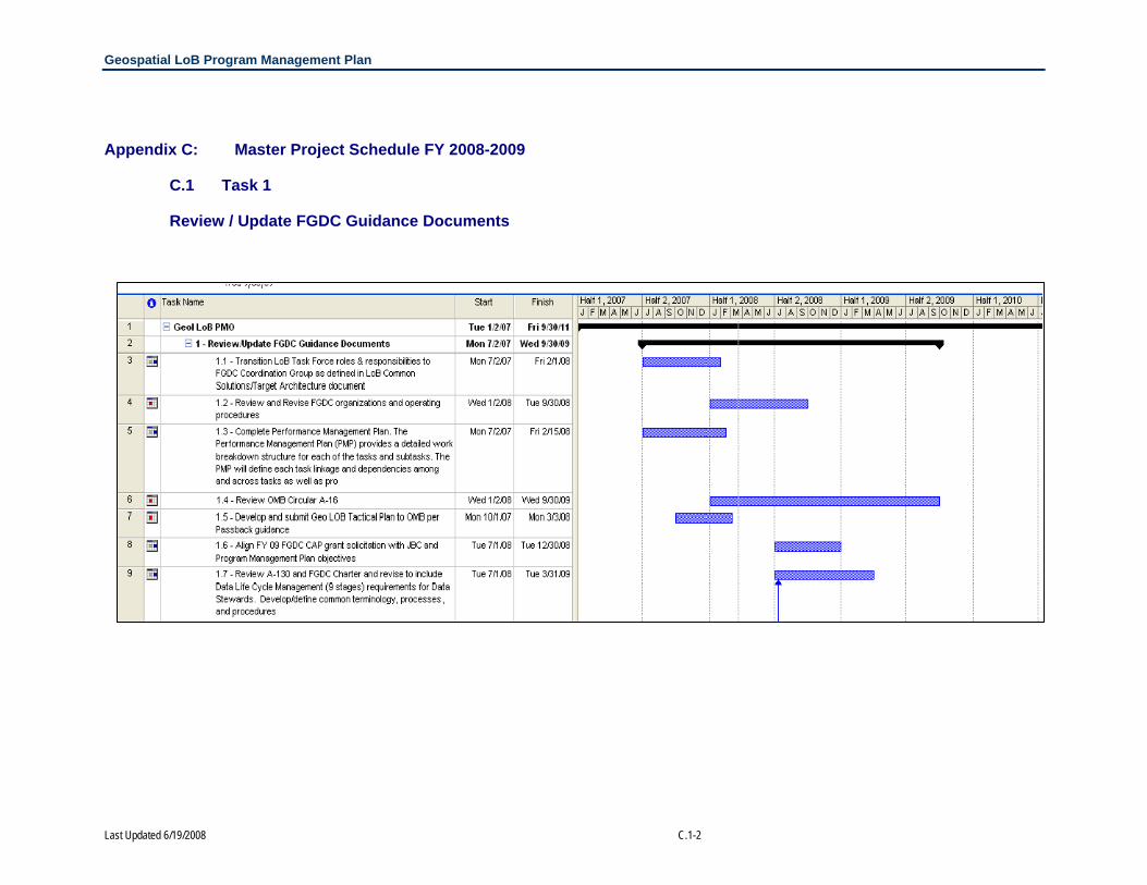
Appendix C: Master Project Schedule FY 2008-2009
C.1 Task 1
Review / Update FGDC Guidance Documents

Geospatial LoB Program Management Plan
Last Updated 6/19/2008 C.2-1
C.2 Task 2
Evaluate existing geospatial lifecycle frameworks (e.g. A-130, CSTA), develop common/standard terminology and processes for the stages of the geospatial data lifecycle and establish data steward responsibilities and performance measures associated with the phases

Geospatial LoB Program Management Plan
Last Updated 6/19/2008 C.3-1
C.3 Task 3
Review component themes of A-16 and reconcile with user needs

Geospatial LoB Program Management Plan
Last Updated 6/19/2008 C.4-1
C.4 Task 4
Expand smart-buy (and alternative) efforts for geospatial data and technologies

Geospatial LoB Program Management Plan
Last Updated 6/19/2008 C.5-2
C.5 Task 5
Develop outreach programs to demonstrate the value of “location based” approaches and geospatial technology

Geospatial LoB Program Management Plan
Last Updated 6/19/2008 C.6-1
C.6 Task 6
Develop and implement common grants language for geospatial information and services

Geospatial LoB Program Management Plan
Last Updated 6/19/2008 C.7-1
C.7 Task 7
Develop and implement geospatial requirements language for Federal contracts (e.g. FAR, DFAR)

Geospatial LoB Program Management Plan
Last Updated 6/19/2008 C.8-1
C.8 Task 8
Implement MOUs/SLAs/ELAs for common geospatial services

Geospatial LoB Program Management Plan
Last Updated 6/19/2008 C.9-1
C.9 Task 9
Develop Requirements and Recommendations for Technology and Telecommunications Infrastructure Required to Deliver Geospatial Services

Geospatial LoB Program Management Plan
Last Updated 6/19/2008 C.10-1
C.10 Task 10
Provide a broker service for data searching among agencies that will build on and improve existing systems

Geospatial LoB Program Management Plan
Last Updated 6/19/2008 C.11-1
C.11 JBC Tasks
Revisions/Updates to Exhibit 300 and Earned Value Management (EVM) Reporting

Geospatial LoB Program Management Plan
Last Updated 6/19/2008 D-1
Appendix D: Work Plan Template The Work Plan Template is a planning tool to used to manage work groups and their associated activities.
This work plan template is a planning tool to assist your Work Group and relate its work to the overall Geospatial Line of Business (LoB) program management strategy and schedule. The work plan consists of four sections that support the identification of the following planning components: purpose, current members, tasks, subtasks, deliverables, task schedule, and resource plans. Examples are provided in blue font throughout the document. SECTION 1: WORK GROUP STATEMENT OF PURPOSE
Instructions: In this section, list the purpose of your Work Group and how the activities of your Work Group impact the overall project.
Purpose:
Vision:
Goals:
Measures:
GEOSPATIAL LOB WORK PLAN TEMPLATE
Work Group Name:
Work Group Lead/Co- Lead:
Contractor Support:
Date Last Revised
Plan Type Draft
Final

Geospatial LoB Program Management Plan
Last Updated 6/19/2008 D-2
SECTION 2: WORK GROUP MEMBERSHIP
Instructions: In this section, list the name of group member(s) and their current contact information. List the name and contact information for the Work Group Team Lead on the first line and bold his or her name.
Name
Agency /
Organization Email
Primary
Phone #
Alternate
Phone #

Geospatial LoB Program Management Plan
Last Updated 6/19/2008 D-3
SECTION 3: TASKS, SUBTASKS, AND DELIVERABLES
Instructions: Individually list each task assigned to your work group. Under each task, provide a brief description of the task. Then use the table provided to note each subtask and its associated target completion date, duration, primary owner, and any resulting work products or deliverables. Deliverables will be further described in Section 4.
Task X:
Description:
Subtask Start Date Completion Date
Owner Resulting
Deliverable(s)
X.1
X.2
X.3
X.4
X.5
Task Y:
Description:
Subtask Start Date Completion Date
Owner Resulting
Deliverable(s)
Y.1
Y.2
Y.3
Y.4
Y.5

Geospatial LoB Program Management Plan
Last Updated 6/19/2008 D-4
SECTION 4: DETERMINATION OF LEVEL OF EFFORT
Level of Effort Validation by Subtask for 2008
Instructions: In the chart below allocate the total FY08 resources shown immediately above for each task across the subtasks you have defined for that task. Bear in mind that some of the subtasks and the resulting deliverables may be more resource intensive than others. At this time, you only need estimate this level of detail for FY08
# Subtask FY08 Q1
FY08
Q2
FY08
Q3
FY08
Q4
Total
Hrs.
Government
X.1
Contractor
Government X.2
Contractor
Government X.3
Contractor
Government Y.1
Contractor
Government Y.2
Contractor
Government Y.3
Contractor
GOVERNMENT HOURS
CONTRACTOR HOURS
TOTAL HOURS

Geospatial LoB Program Management Plan
Last Updated 6/19/2008 D-5
SECTION 5: CRITICAL SUCCESS FACTORS AND DEPENDENCIES
Instructions: List what your Work Group considers to be most important to meet the schedule proposed and produce the deliverables. Then list any dependencies of which you are currently aware involving your tasks and tasks of other Work Groups.
Success Factors:
Dependencies:

Last Updated 6/19/2008 E-1
Appendix E: Status Report Template The Status Report Template is used to provide a bi-weekly status update from the contractor to Managing
Partner Team.
SECTION 1: ACTIVITIES PLANNED • Includes a summary of work accomplished for the most recent period of performance in this section.
SECTION 2: ACTIVITIES ACCOMPLISHED • Includes a summary of major work planned for the next period of performance in this section.
SECTION 3: TASK MILESTONE SUMMARY This section highlights the project’s planned activities, progress, and accomplishment versus the established respective time estimate.
Deliverables Target Date of
Completion Project
Schedule Resource
Usage Comments
Program Management Office
Communication Plan October 11, 2007 • • Common Services Work Group
Enterprise Architecture Work Group
Geo-Enabled Business Work Group
Grants and Contracts Work Group
GEOSPATIAL LOB BI-WEEKLY STATUS REPORT
FOR WEEKS OF OCTOBER XX, 2007 AND OCTOBER XX, 2007

Last Updated 6/19/2008 E-2
Joint Business Case Work Group
Lifecycle Management Work Group
Performance Management Work Group
The “project schedule” column depicts whether the deliverable is ‘ahead or on target for scheduled completion’ (•), ‘close to scheduled completion date’ (•), or ‘behind scheduled completion date’ (•). The resource usage column depicts the level of effort expended by Grant Thornton to complete the scheduled deliverable is ‘less than or equal to estimate’ (•), ‘1-10% over estimate’ (•), or ‘> 10% over estimate (•).
SECTION 4: PROJECT ISSUES AND CORRECTIVE ACTIONS This section lists any project problems and issues that might impact the project progress, such as the ability to obtain data in a timely fashion, workload demands related to task, complex communication interface issues, any external events or circumstances, or personnel issues and their recommended plan or action to resolve the respective problem. Level of criticality is a reflection of the degree to which the project issue impacts the ability of the Geospatial LoB program to accomplish its goals.
Project Issue Level of Criticality (Low, Medium, High) Recommended Corrective Action

Last Updated 6/19/2008 F-1
Appendix F: Meeting Minutes Template Template that provides a standard for recording key topics, discussion points, recommendations, and decisions as well as records action items, who owns each action items, and the target completion date for action items.
1. KEY TOPICS
2. KEY DISCUSSION POINTS
3. RECOMMENDATIONS
4. DECISIONS
5. ACTION ITEMS
# Action Item Owner Target Due Date
1
2
3
4
5
GEOSPATIAL LOB MEETING MINUTES
FEBRUARY XX, 20XX Meeting Type:
LoB Task Force
FGDC
Managing Partner/ Team Meeting
Work Group:_____________
Meeting Location and Time:
Meeting Attendees: (optional)
. Notes Type: Draft
Final

Last Updated 6/19/2008 G-1
Appendix G: Action Item Tracking Template The Action Items Tracking Template provides a means of cataloging and tracking action items derived from meeting minutes, work plans, emails,
and phone calls.
ID #Date
IdentifiedRecommended/
Proposed By Action Item
Source (document review, meeting minutes,
call) Owner
Associated Team (FGDC Coordination
Group, PMO, Work Group - Indicate Name)
Target Completion
DateStatus
(open, closed)Date
Completed Notes123456789101112131415161718192021222324252627
Geospatial Line of Business Action Item Tracking Worksheet

Last Updated 6/19/2008 H-1
Appendix H: Issue Tracking Template The Issue Tracking Template that provides a means of cataloging and tracking issues that arise from meeting minutes, work plans, document
reviews, emails, and phone calls.
ID # Date Input
Recommended By Issue
Source (document review, meeting minutes,
call)
Level of Criticality
(high, medium,
low)
Associated Team (FGDC Coordination
Group, PMO, Work Group - Indicate Name)
Proposed Resolution(s) Associated Action Item(s)
Proposed Resolution
Target Date
Status (open or closed)
Date Closed Notes
12345678910111213141516171819202122232425
Geospatial Line of BusinessIssue Tracking Worksheet

Last Updated 6/19/2008 I-1
Appendix I: Briefing Template The Briefing Template that shows the basic format and style used for Geospatial LoB Briefings.
Title Slide
Body Slide

Last Updated 6/19/2008 J-1
Appendix J: QuickPlace Screen Shots Screen shots of QuickPlace log-in page, main room, calendar, and action item page.
QuickPlace Log-in
QuickPlace Main Room

Last Updated 6/19/2008 J-2
QuickPlace Calendar
QuickPlace Action Items

Last Updated 6/19/2008 K-1
Appendix K: Comment Log Tool The Comment Log Tool allows users to log comments regarding Geospatial LoB documents.
Commenter Name: Commenter Agency:
Date Submitted:
Comment Number Comment Section Page Comment Proposed Resolution
123456789
10
Geospatial Line of BusinessPerformance Management PlanComment Log Sheet
Please use this form to track feedback and comments on the draft final deliverable submitted November 2, 2007. For each comment, please select relevant "Comment Section" and enter the page of the draft final deliverable that contains the section on which

Last Updated 6/19/2008 L-1
Appendix L: Comment Adjudication Tool The Comment Adjudication Tool allows for adjudication of comments on Geospatial LoB document
Geospatial Line of Business Comment Adjudication Tool
Please use this form to track feedback and comments on the draft final deliverable submitted [M DD, YYYY]. For each comment, please select relevant "Comment Section" and enter the page of the draft final deliverable that contains the section on which you wish to comment. Please enter your comment in the "Comment" column, and a suggested resolution step in the "Suggested Resolution" column.
Agency Comment # Part Section Figure Table Page # Comment Buckets Recommended Response Action Assigned To
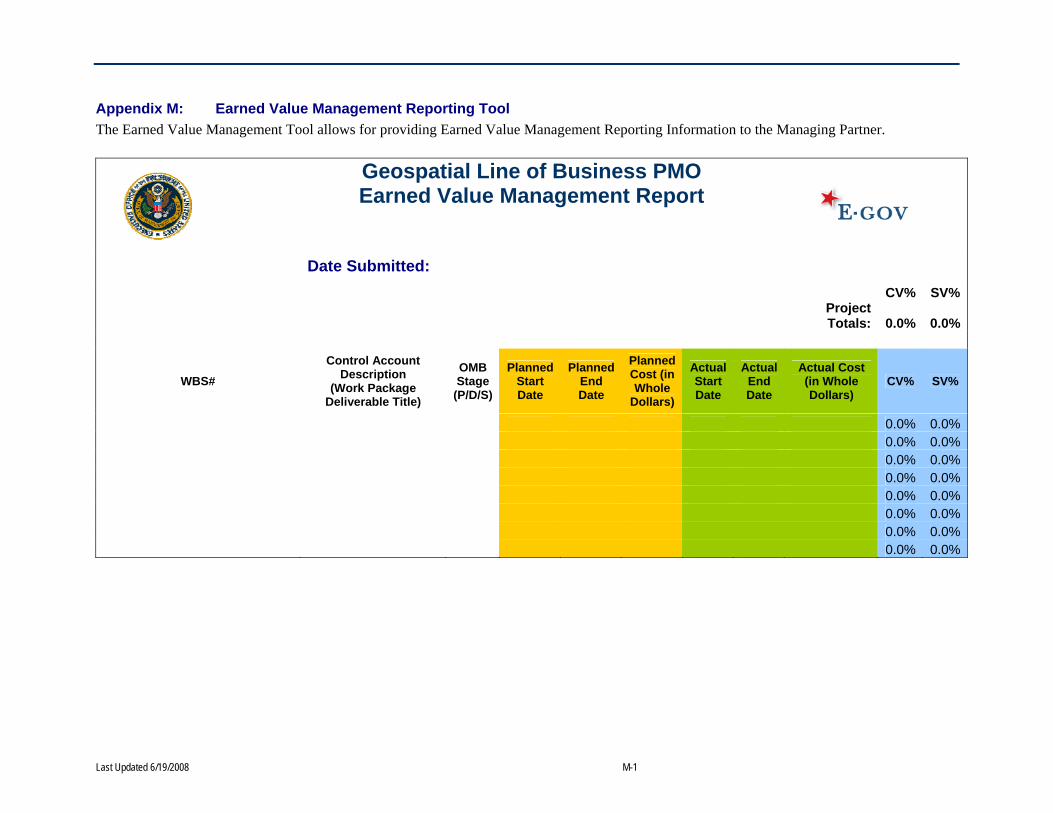
Last Updated 6/19/2008 M-1
Appendix M: Earned Value Management Reporting Tool The Earned Value Management Tool allows for providing Earned Value Management Reporting Information to the Managing Partner.
Geospatial Line of Business PMO Earned Value Management Report
Date Submitted:
CV% SV%
Project Totals: 0.0% 0.0%
WBS# Control Account
Description (Work Package
Deliverable Title)
OMB Stage
(P/D/S)
Planned Start Date
Planned End Date
Planned Cost (in Whole
Dollars)
Actual Start Date
Actual End Date
Actual Cost (in Whole Dollars)
CV% SV%
0.0% 0.0% 0.0% 0.0% 0.0% 0.0% 0.0% 0.0% 0.0% 0.0% 0.0% 0.0% 0.0% 0.0% 0.0% 0.0%

Last Updated 6/19/2008 N-1
Appendix N: Member Tracking Tool The Member Tracking Tool allows the PMO to track active and inactive members of work groups, and contains contact, and agency information
for all stakeholders.
L a s t N a m e
F ir s t N a m e
A g en cy / O rg an iz a t io n E m a il P h o n e P h o n e 2 Jo
int B
usin
ess
Cas
e
Perf
orm
ance
Man
agem
ent
Geo
-Ena
bled
Bus
ines
s
Com
mon
Ser
vice
s
Gra
nts
& C
ontr
acts
Life
cycl
e M
anag
emen
t
Ente
rpris
e Ar
chite
ctur
e
TF D
istr
ibut
ion
Mem
ber
BDR
Bud
get C
odin
g Te
am
x = M em b e r Y = Y e sX = L e a d M e m b e r N = N o
G e o s p a t ia l L in e o f B u s in e s sM e m b e r s h ip T r a c k in g W o r k s h e e t