program updates and current status - unoosa · program updates and current status fifth...
TRANSCRIPT
QZSSQZSSThe Japanese QuasiThe Japanese Quasi‐‐Zenith Satellite SystemZenith Satellite System
Program Updates and Current statusProgram Updates and Current status
Fifth International Committee on GNSSFifth International Committee on GNSS
Torino, ItalyTorino, Italy
October 18, 2010October 18, 2010
2010/10/18 5th International Committee on GNSS:Turin, Italy 1
ContentsContentsQZSS ServiceQZSS Service
QZSS System DescriptionQZSS System Description
Develop, Launch and the Next StepDevelop, Launch and the Next Step
OrganizationOrganization
Service Provided and Provision Policies Service Provided and Provision Policies
InterInter‐‐GNSSGNSS
MultiMulti‐‐GNSSGNSS
SummarySummary
2010/10/18 5th International Committee on GNSS:Turin, Italy 2
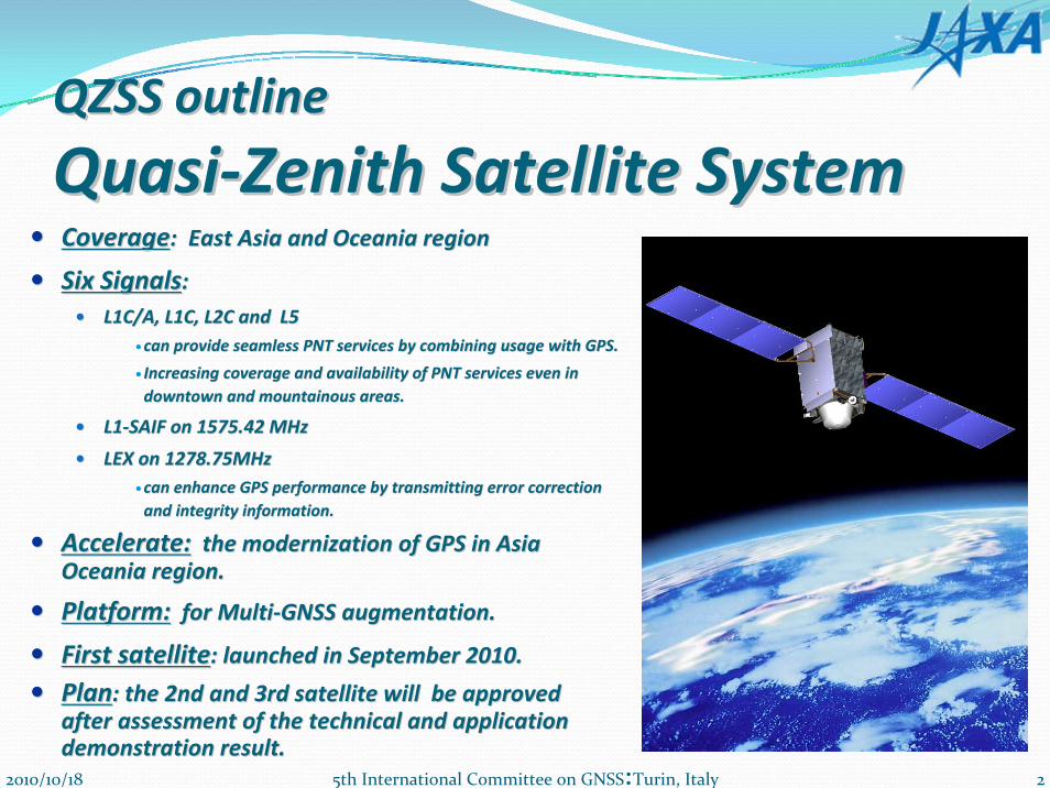
QZSS outlineQZSS outline
QuasiQuasi‐‐Zenith Satellite SystemZenith Satellite SystemCoverageCoverage: East Asia and Oceania region: East Asia and Oceania region
Six SignalsSix Signals::L1C/A, L1C, L2C and L5L1C/A, L1C, L2C and L5
can provide seamless PNT services by combining usage with GPS.can provide seamless PNT services by combining usage with GPS.
Increasing coverage and availability of PNT services even in Increasing coverage and availability of PNT services even in downtown and mountainous areas.downtown and mountainous areas.
L1L1‐‐SAIF on 1575.42 MHz SAIF on 1575.42 MHz
LEX on 1278.75MHz LEX on 1278.75MHz can enhance GPS performance by transmitting error correction can enhance GPS performance by transmitting error correction and integrity information.and integrity information.
Accelerate:Accelerate: the modernization of GPS in Asia the modernization of GPS in Asia Oceania region.Oceania region.
Platform:Platform: for Multifor Multi‐‐GNSS augmentation.GNSS augmentation.
First satelliteFirst satellite: launched in September 2010. : launched in September 2010.
PlanPlan: the 2nd and 3rd satellite will be approved : the 2nd and 3rd satellite will be approved after assessment of the technical and application after assessment of the technical and application demonstration result.demonstration result.
QZSS ServiceQZSS Service
2010/10/18 5th International Committee on GNSS:Turin, Italy 4
0 30 60 90 120 150 180 210 240 270 300 330 360-90
-60
-30
0
30
60
90
Lat
itude
(de
g)
g
10
10
10
10
10
102020
20
2020
20
30
30
30
30
30
40
4040
40
50
50
50
50
50
60
60
60
60
70
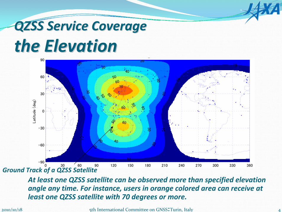
Ground Track of a QZSS SatelliteAt least one QZSS satellite can be observed more than specified elevation angle any time. For instance, users in orange colored area can receive at least one QZSS satellite with 70 degrees or more.
QZSS Service CoverageQZSS Service Coverage
the Elevationthe Elevation
2010/10/18 5th International Committee on GNSS:Turin, Italy 5
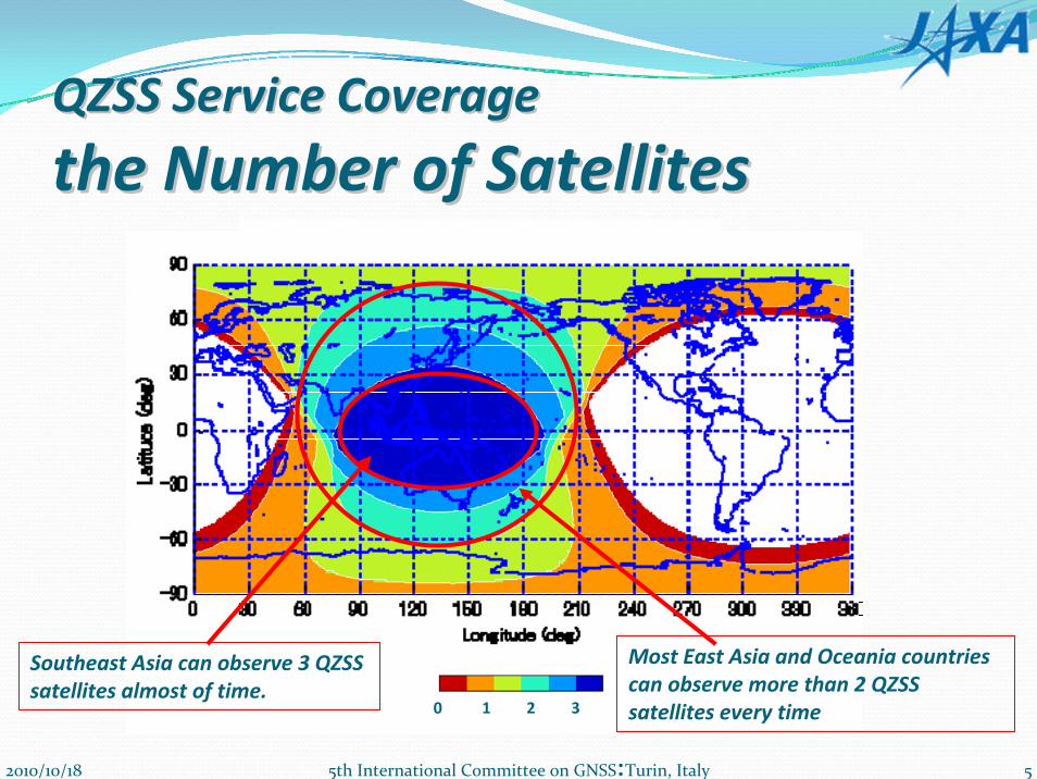
QZSS Service CoverageQZSS Service Coverage
the Number of Satellitesthe Number of Satellites
0 1 2 3
Southeast Asia can observe 3 QZSS satellites almost of time.
Most East Asia and Oceania countries can observe more than 2 QZSS satellites every time
2010/10/18 5th International Committee on GNSS:Turin, Italy 6
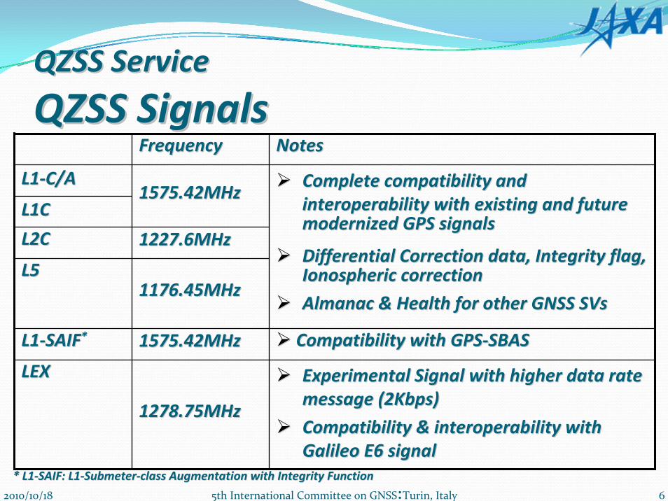
FrequencyFrequency NotesNotes
L1L1‐‐C/AC/A1575.42MHz1575.42MHz Complete compatibility and Complete compatibility and
interoperability with existing and future interoperability with existing and future modernized GPS signalsmodernized GPS signals
Differential Correction data, Integrity flag, Differential Correction data, Integrity flag, IonosphericIonospheric correctioncorrection
Almanac & Health for other GNSS Almanac & Health for other GNSS SVsSVs
L1CL1C
L2CL2C 1227.6MHz1227.6MHz
L5L51176.45MHz1176.45MHz
L1L1‐‐SAIFSAIF** 1575.42MHz1575.42MHz Compatibility with GPSCompatibility with GPS‐‐SBASSBAS
LEXLEX
1278.75MHz1278.75MHz
Experimental Signal with higher data rate Experimental Signal with higher data rate message (2Kbps)message (2Kbps)
Compatibility & interoperability with Compatibility & interoperability with Galileo E6 signalGalileo E6 signal
* * L1L1‐‐SAIF: L1SAIF: L1‐‐SubmeterSubmeter‐‐class Augmentation with Integrity Functionclass Augmentation with Integrity Function
QZSS ServiceQZSS Service
QZSS SignalsQZSS Signals
2010/10/18 5th International Committee on GNSS:Turin, Italy 7
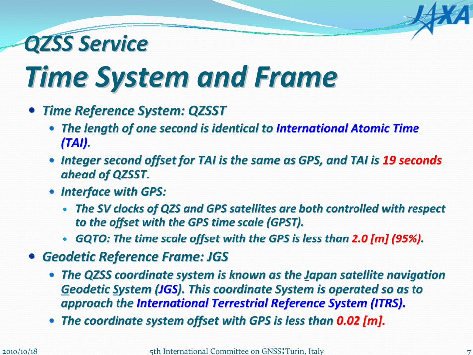
QZSS ServiceQZSS Service
Time System and FrameTime System and FrameTime Reference System: QZSSTTime Reference System: QZSST
The length of one second is identical to The length of one second is identical to International Atomic Time International Atomic Time (TAI)(TAI)..Integer second offset for TAI is the same as GPS, and TAI is Integer second offset for TAI is the same as GPS, and TAI is 1199 secondssecondsahead of QZSST.ahead of QZSST.Interface with GPS: Interface with GPS:
The SV clocks of QZS and GPS satellites are both controlled withThe SV clocks of QZS and GPS satellites are both controlled with respect respect to the offset with the GPS time scale (GPST). to the offset with the GPS time scale (GPST). GQTO: The time scale offset with the GPS is less than GQTO: The time scale offset with the GPS is less than 2.0 [m] (95%)2.0 [m] (95%)..
Geodetic Reference Frame: JGSGeodetic Reference Frame: JGSThe QZSS coordinate system is known as the The QZSS coordinate system is known as the JJapan satellite navigation apan satellite navigation GGeodetic eodetic SSystem (ystem (JGSJGS). This coordinate System is operated so as to ). This coordinate System is operated so as to approach the approach the International Terrestrial Reference System (ITRS).International Terrestrial Reference System (ITRS).The coordinate system offset with GPS is less than The coordinate system offset with GPS is less than 0.02 [m].0.02 [m].
2010/10/18 5th International Committee on GNSS:Turin, Italy 8
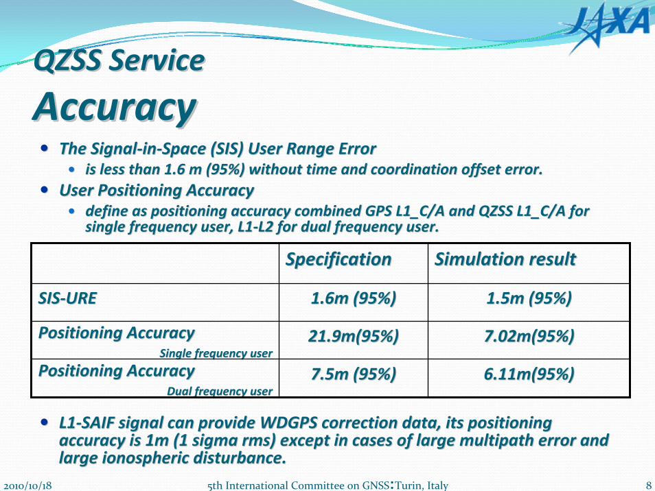
QZSS ServiceQZSS Service
AccuracyAccuracyThe SignalThe Signal‐‐inin‐‐Space (SIS) User Range ErrorSpace (SIS) User Range Error
is less than 1.6 m (95%) without time and coordination offset eris less than 1.6 m (95%) without time and coordination offset error.ror.User Positioning AccuracyUser Positioning Accuracy
define as positioning accuracy combined GPS L1_C/A and QZSS L1_Cdefine as positioning accuracy combined GPS L1_C/A and QZSS L1_C/A for /A for single frequency user, L1single frequency user, L1‐‐L2 for dual frequency user.L2 for dual frequency user.
L1L1‐‐SAIF signal can provide WDGPS correction data, its positioning SAIF signal can provide WDGPS correction data, its positioning accuracy is 1m (1 sigma accuracy is 1m (1 sigma rmsrms) except in cases of large multipath error and ) except in cases of large multipath error and large large ionosphericionospheric disturbance. disturbance.
SpecificationSpecification Simulation resultSimulation result
SISSIS‐‐URE URE 1.6m (95%)1.6m (95%) 1.5m (95%)1.5m (95%)
Positioning AccuracyPositioning AccuracySingle frequency user Single frequency user
21.9m(95%)21.9m(95%) 7.02m(95%)7.02m(95%)
Positioning AccuracyPositioning AccuracyDual frequency userDual frequency user
7.5m (95%)7.5m (95%) 6.11m(95%)6.11m(95%)
QZSS System DescriptionQZSS System Description
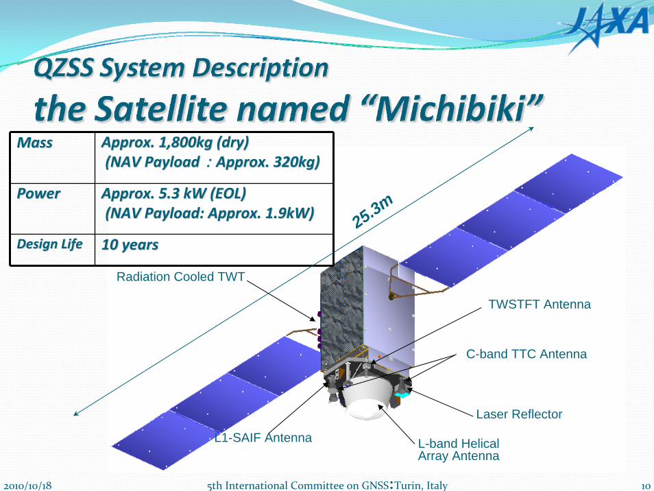
2010/10/18 5th International Committee on GNSS:Turin, Italy 10
MassMass Approx. 1,800kg (dry)Approx. 1,800kg (dry)(NAV Payload(NAV Payload::Approx. 320kg)Approx. 320kg)
PowerPower Approx. 5.3 kW (EOL) Approx. 5.3 kW (EOL) (NAV Payload: Approx. 1.9kW)(NAV Payload: Approx. 1.9kW)
Design LifeDesign Life 10 years10 years
L-band Helical Array Antenna
L1-SAIF Antenna
Laser Reflector
C-band TTC Antenna
Radiation Cooled TWT
TWSTFT Antenna
25.3m
2010/10/18 5th International Committee on GNSS:Turin, Italy 11
TimeComparison
Unit
Time TransferSystem
RF portion
RbAtomic Clock
TimeKeeping
UnitSynthesi
zer
NavigationOperationComputer
Modulator Amplifier
JAXA
LaserLaserReflectorReflector
RbAtomic Clock
Sine Wave
Signal of Two Way Satellite Time and Frequency Transfer
Navigation Signal
TimeKeeping
UnitSynthe-
sizer
NavigationOnboardComputer
Modulator Amplifier MUX
TimeComparison
Unit
Time TransferSystem
RF portion
NICT
L-Ant
Uploaded Data(including Remote Synchronization
Signal (by AIST))
Baseband Signal (Navigation Message + PRN Code)
Control/ Phase Error
(previously: CRL)
TT&CTT&C
Subsystem
TLM
Navigation Message, CMD
Ku-Ant
L1L1‐‐SAIF ANTSAIF ANT
12
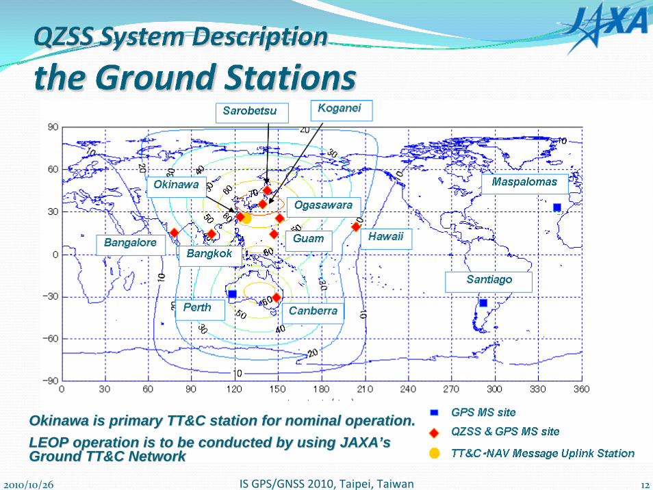
Okinawa is primary TT&C station for nominal operation. Okinawa is primary TT&C station for nominal operation. LEOP operation is to be conducted by using LEOP operation is to be conducted by using JAXAJAXA’’ssGround TT&C Network Ground TT&C Network
2010/10/26 IS GPS/GNSS 2010, Taipei, Taiwan
Development, LaunchDevelopment, Launch& Next Step& Next Step
2010/10/18 5th International Committee on GNSS:Turin, Italy 14
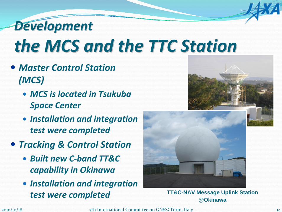
DevelopmentDevelopment
the MCS and the TTC Stationthe MCS and the TTC StationMaster Control Station (MCS)
MCS is located in Tsukuba Space Center
Installation and integration test were completed
Tracking & Control StationBuilt new C‐band TT&C capability in Okinawa
Installation and integration test were completed TT&C-NAV Message Uplink Station
@Okinawa
2010/10/18 5th International Committee on GNSS:Turin, Italy 15
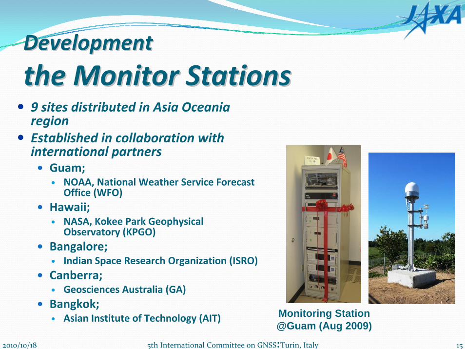
DevelopmentDevelopment
the Monitor Stationsthe Monitor Stations9 sites distributed in Asia Oceania regionEstablished in collaboration with international partners
Guam;NOAA, National Weather Service Forecast Office (WFO)
Hawaii;NASA, Kokee Park Geophysical Observatory (KPGO)
Bangalore;Indian Space Research Organization (ISRO)
Canberra;Geosciences Australia (GA)
Bangkok;Asian Institute of Technology (AIT) Monitoring Station
@Guam (Aug 2009)
2010/10/18 5th International Committee on GNSS:Turin, Italy 16
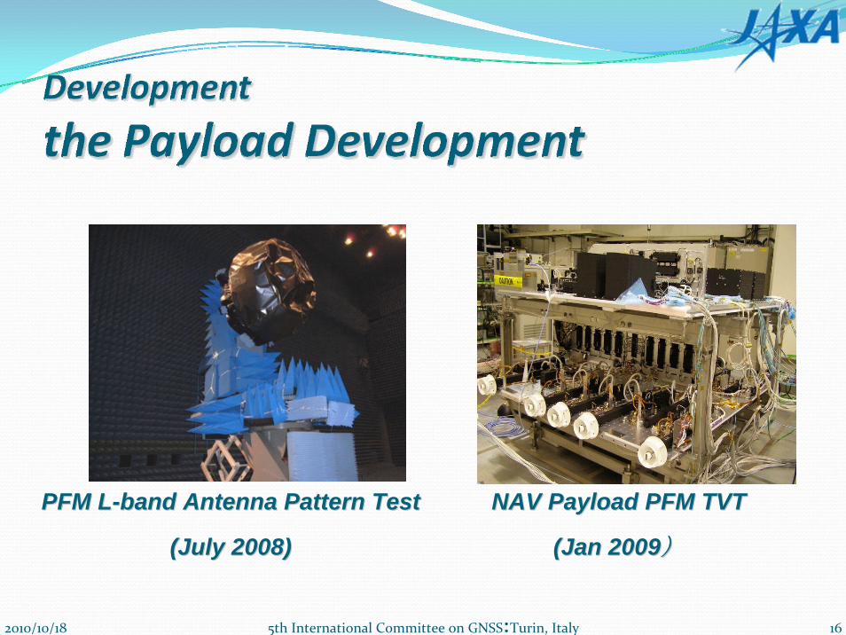
NAV Payload PFM TVT NAV Payload PFM TVT
(Jan 2009(Jan 2009))
PFM LPFM L--band Antenna Pattern Testband Antenna Pattern Test
(July 2008)(July 2008)
2010/10/18 5th International Committee on GNSS:Turin, Italy 17
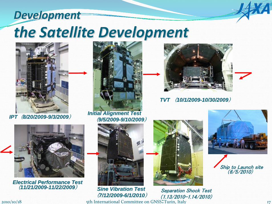
TVT TVT ((10/1/200910/1/2009--10/30/200910/30/2009))
IPTIPT((8/20/20098/20/2009--9/3/20099/3/2009))Initial Alignment TestInitial Alignment Test
((9/5/20099/5/2009--9/10/20099/10/2009))
Electrical Performance Test Electrical Performance Test ((11/21/200911/21/2009--11/22/200911/22/2009)) Sine Vibration TestSine Vibration Test
((7/12/20097/12/2009--6/1/20106/1/2010))Separation Shock TestSeparation Shock Test((1.13/20101.13/2010--1.14/20101.14/2010))
Ship to Launch siteShip to Launch site((6/5/20106/5/2010))
2010/10/18 5th International Committee on GNSS:Turin, Italy 18
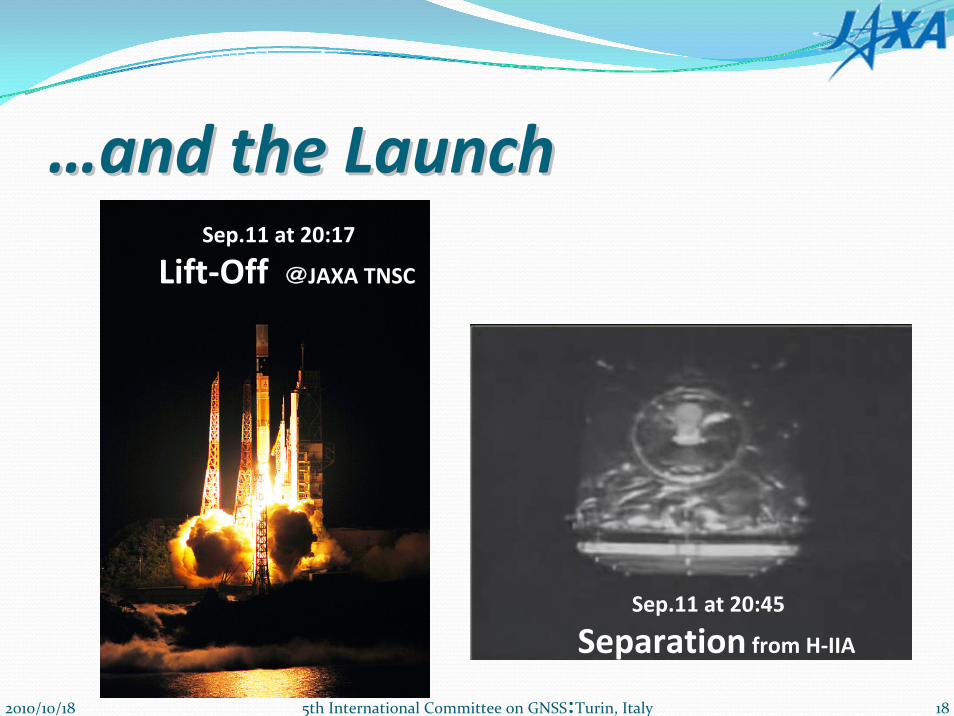
……and the Launchand the LaunchSep.11 at 20:17
Lift‐Off @JAXA TNSC
Sep.11 at 20:45
Separation from H‐IIA
2010/10/18 5th International Committee on GNSS:Turin, Italy 19
QZS-1
Launch and Next StepLaunch and Next Step
Launch and OOCLaunch and OOCLaunch:Launch:The 1The 1stst satellite (QZSsatellite (QZS‐‐1; MICHIBIKI) was launched on 1; MICHIBIKI) was launched on September 11th, 2010, JST.September 11th, 2010, JST.
OnOn‐‐OrbitOrbit‐‐Checkout: OOC:Checkout: OOC:3 months On3 months On‐‐OrbitOrbit‐‐Checkout (OOC) period after the launch;Checkout (OOC) period after the launch;
Orbit raising in the Orbit Transfer PeriodOrbit raising in the Orbit Transfer Period
Orbit settlement in the Orbit Drift PeriodOrbit settlement in the Orbit Drift Period
and the Initial Check Operations. and the Initial Check Operations.
2010/10/18 5th International Committee on GNSS:Turin, Italy 20
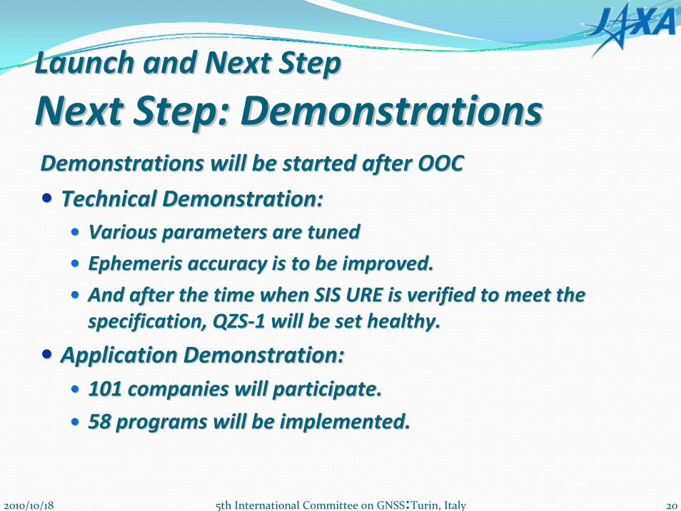
Launch and Next StepLaunch and Next Step
Next Step: DemonstrationsNext Step: DemonstrationsDemonstrations will be started after OOCDemonstrations will be started after OOC
Technical Demonstration:Technical Demonstration:Various parameters are tunedVarious parameters are tuned
Ephemeris accuracy is to be improved.Ephemeris accuracy is to be improved.
And after the time when SIS URE isAnd after the time when SIS URE is verified to meet the verified to meet the specification, QZSspecification, QZS‐‐1 will be set healthy.1 will be set healthy.
Application Demonstration:Application Demonstration:101 companies will participate.101 companies will participate.
58 programs will be implemented. 58 programs will be implemented.
OrganizationOrganization
2010/10/18 5th International Committee on GNSS:Turin, Italy 22
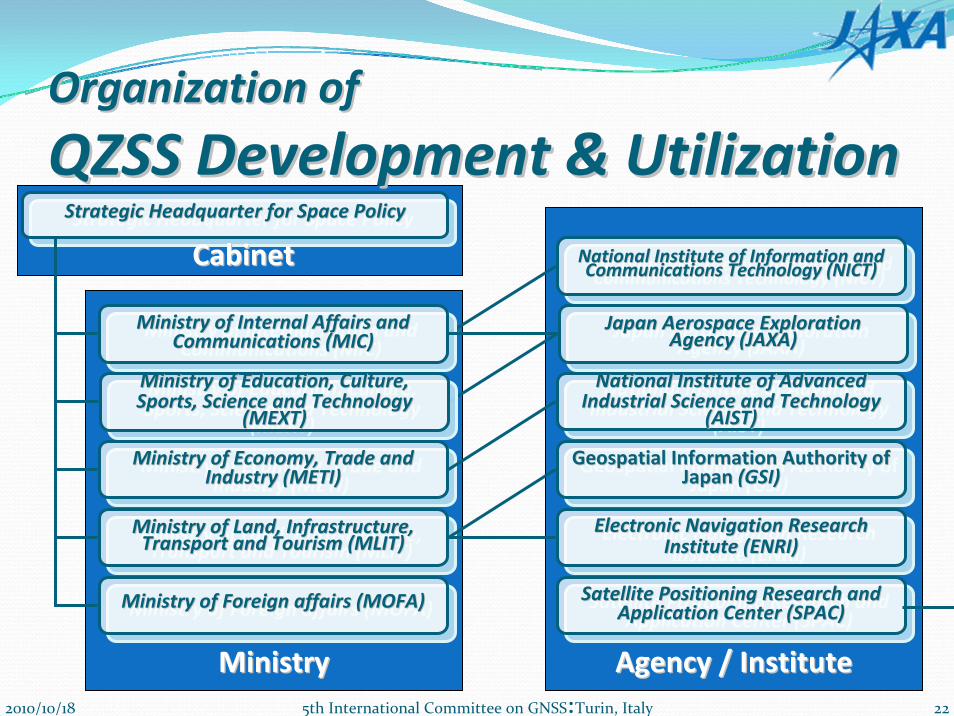
Strategic Headquarter for Space PolicyStrategic Headquarter for Space PolicyStrategic Headquarter for Space Policy
Ministry of Internal Affairs and Communications (MIC)
Ministry of Internal Affairs and Ministry of Internal Affairs and Communications (MIC)Communications (MIC)
Ministry of Education, Culture, Sports, Science and Technology
(MEXT)
Ministry of Education, Culture, Ministry of Education, Culture, Sports, Science andSports, Science and Technology Technology
(MEXT)(MEXT)
Ministry of Land, Infrastructure,Transport and Tourism (MLIT)
Ministry of Land, InfrastructureMinistry of Land, Infrastructure,,Transport and Tourism (MLIT)Transport and Tourism (MLIT)
Ministry of Economy, Trade and Industry (METI)
Ministry of Economy, Trade and Ministry of Economy, Trade and Industry (METI)Industry (METI)
Ministry of Foreign affairs (MOFA)Ministry of Foreign affairs (MOFA)Ministry of Foreign affairs (MOFA) Satellite Positioning Research and Application Center (SPAC)
Satellite Positioning Research and Satellite Positioning Research and Application Center (Application Center (SPACSPAC))
National Institute of Information and Communications Technology (NICT)
National Institute of Information and National Institute of Information and CommunicationsCommunications Technology (NICT)Technology (NICT)
Japan Aerospace Exploration Agency (JAXA)
Japan Aerospace Exploration Japan Aerospace Exploration Agency (JAXA)Agency (JAXA)
Geospatial Information Authority of Japan (GSI)
Geospatial Information Authority of Geospatial Information Authority of JapanJapan (GSI)(GSI)
National Institute of Advanced Industrial Science and Technology
(AIST)
National Institute of Advanced National Institute of Advanced Industrial Science and Technology Industrial Science and Technology
(AIST)(AIST)
Electronic Navigation Research Institute (ENRI)
Electronic Navigation Research Electronic Navigation Research Institute (ENRI)Institute (ENRI)
Organization ofOrganization of
QZSS Development & UtilizationQZSS Development & Utilization
MinistryMinistry Agency / InstituteAgency / Institute
CabinetCabinet
Service Provided and Service Provided and Provision PoliciesProvision Policies
2010/10/18 5th International Committee on GNSS:Turin, Italy 24
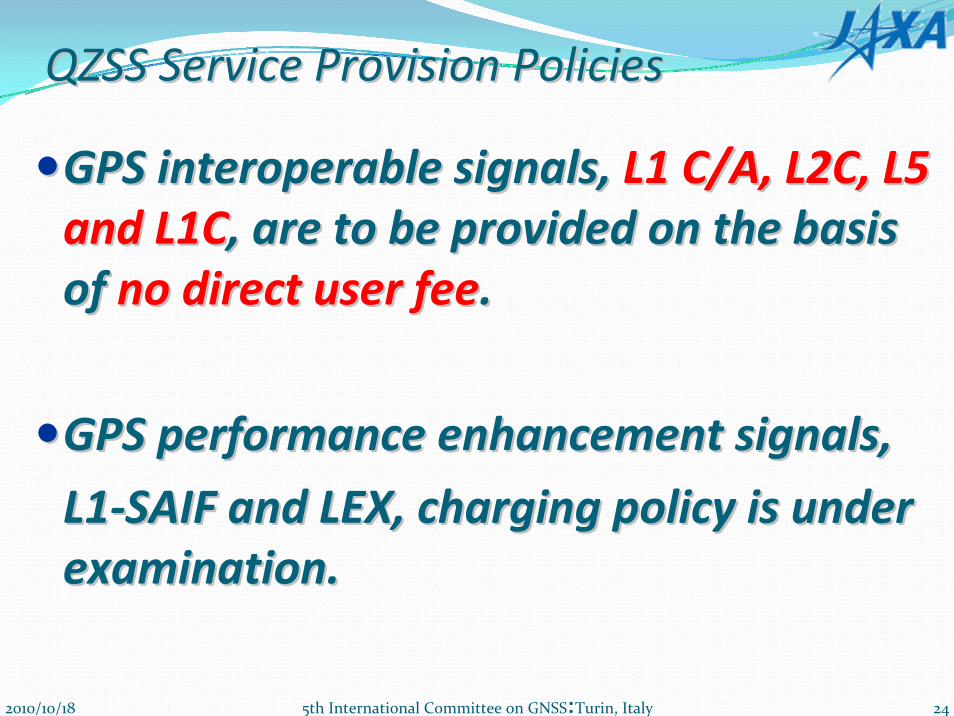
GPS interoperable signals, GPS interoperable signals, L1 C/A, L2C, L5 L1 C/A, L2C, L5 and L1Cand L1C, are to be provided on the basis , are to be provided on the basis of of no direct user feeno direct user fee..
GPS performance enhancement signals, GPS performance enhancement signals,
L1L1‐‐SAIF and LEX, charging policy is under SAIF and LEX, charging policy is under examination. examination.
QZSS Service Provision PoliciesQZSS Service Provision Policies
InterInter‐‐GNSSGNSS
2010/10/18 5th International Committee on GNSS:Turin, Italy 26
InterInter‐‐GNSSGNSS
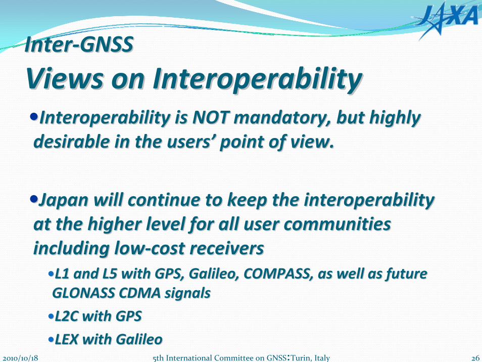
Views on InteroperabilityViews on InteroperabilityInteroperability is NOT mandatory, but highly Interoperability is NOT mandatory, but highly desirable in the usersdesirable in the users’’ point of view. point of view.
Japan will continue to keep the interoperability Japan will continue to keep the interoperability at the higher level for all user communities at the higher level for all user communities including lowincluding low‐‐cost receiverscost receivers
L1 and L5 with GPS, Galileo, COMPASS, as well as future L1 and L5 with GPS, Galileo, COMPASS, as well as future GLONASS CDMA signalsGLONASS CDMA signals
L2C with GPS L2C with GPS
LEX with GalileoLEX with Galileo
2010/10/18 5th International Committee on GNSS:Turin, Italy 27
InterInter‐‐GNSSGNSS
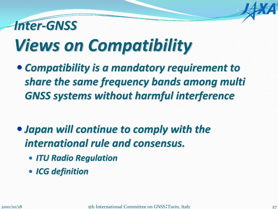
Views on CompatibilityViews on CompatibilityCompatibility is a mandatory requirement to Compatibility is a mandatory requirement to share the same frequency bands among multi share the same frequency bands among multi GNSS systems without harmful interference GNSS systems without harmful interference
Japan will continue to comply with the Japan will continue to comply with the international rule and consensus.international rule and consensus.
ITU Radio RegulationITU Radio Regulation
ICG definition ICG definition
MultiMulti‐‐GNSSGNSS
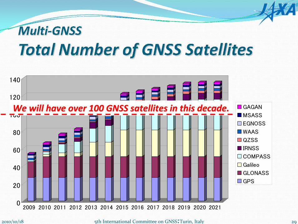
2010/10/18 5th International Committee on GNSS:Turin, Italy 29
0
20
40
60
80
100
120
140
2009 2010 2011 2012 2013 2014 2015 2016 2017 2018 2019 2020 2021
GAGAN
MSASS
EGNOSS
WAAS
QZSS
IRNSS
COMPASS
Galileo
GLONASS
GPS
We will have over 100 GNSS satellites in this decade.We will have over 100 GNSS satellites in this decade.
2010/10/18 5th International Committee on GNSS:Turin, Italy 30
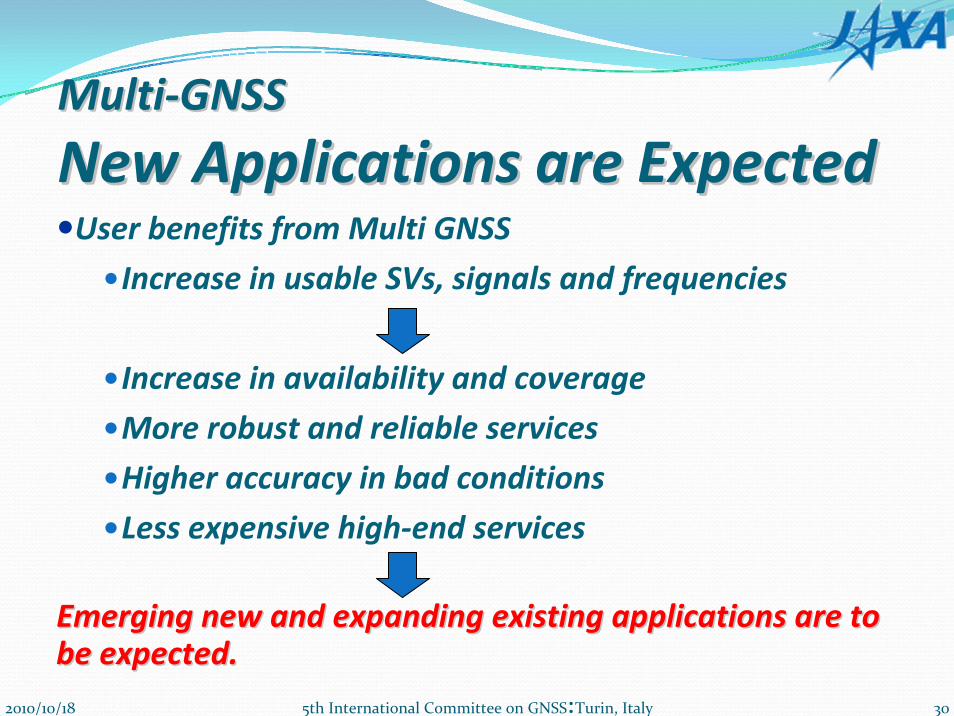
MultiMulti‐‐GNSSGNSS
New Applications are ExpectedNew Applications are ExpectedUser benefits from Multi GNSS
Increase in usable SVs, signals and frequencies
Increase in availability and coverage
More robust and reliable services
Higher accuracy in bad conditions
Less expensive high‐end services
Emerging new and expanding existing applications are to Emerging new and expanding existing applications are to be expected.be expected.
2010/10/18 5th International Committee on GNSS:Turin, Italy 31
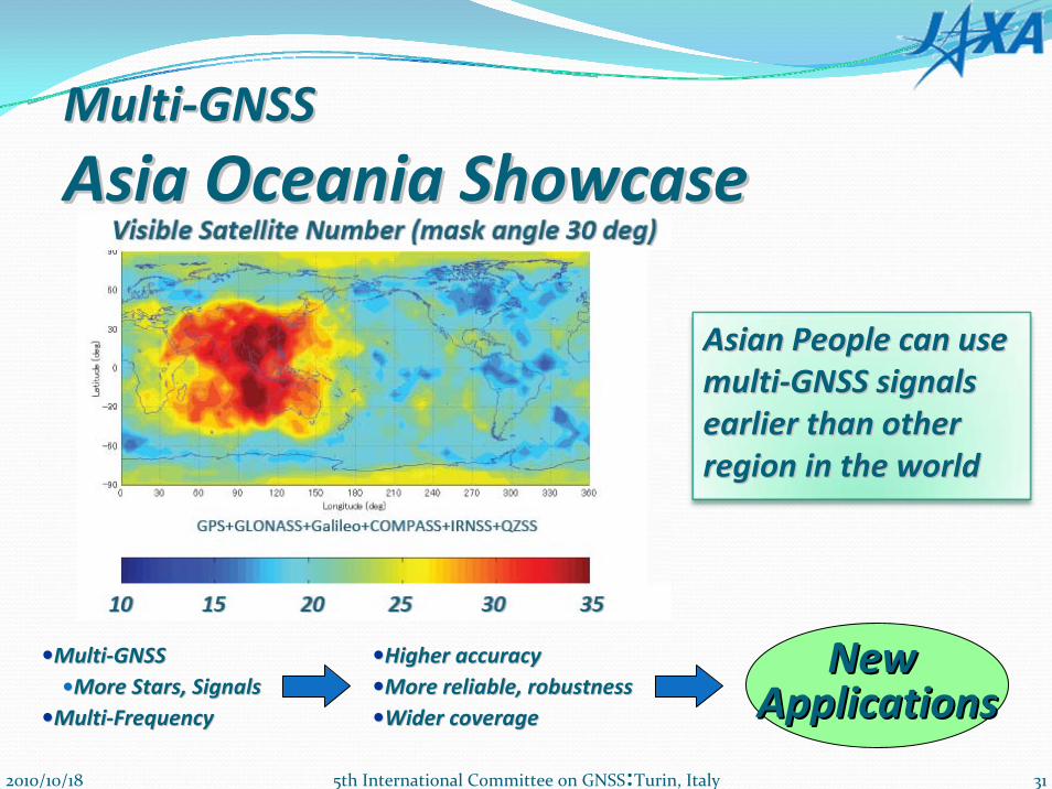
MultiMulti‐‐GNSSGNSS
Asia Oceania ShowcaseAsia Oceania Showcase
MultiMulti‐‐GNSSGNSSMore Stars, SignalsMore Stars, Signals
MultiMulti‐‐FrequencyFrequency
Asian People can use Asian People can use multimulti‐‐GNSS signals GNSS signals earlier than other earlier than other region in the worldregion in the world
Higher accuracyHigher accuracyMore reliable, robustnessMore reliable, robustnessWider coverageWider coverage
New New ApplicationsApplications
2010/10/18 5th International Committee on GNSS:Turin, Italy 32
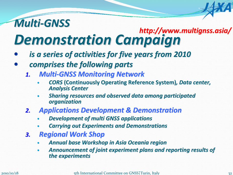
MultiMulti‐‐GNSSGNSS
Demonstration CampaignDemonstration Campaignhttp://http://www.multignss.asiawww.multignss.asia//
is a series of activities for five years from 2010is a series of activities for five years from 2010comprises the following partscomprises the following parts
1.1. MultiMulti‐‐GNSS Monitoring NetworkGNSS Monitoring NetworkCORSCORS (Continuously Operating Reference System)(Continuously Operating Reference System), Data center, , Data center, Analysis CenterAnalysis CenterSharing resources and observed data among participated Sharing resources and observed data among participated organizationorganization
2.2. Applications Development & DemonstrationApplications Development & DemonstrationDevelopment of multi GNSS applicationsDevelopment of multi GNSS applicationsCarrying out Experiments and Demonstrations Carrying out Experiments and Demonstrations
3.3. Regional Work ShopRegional Work ShopAnnual base Workshop in Asia Oceania regionAnnual base Workshop in Asia Oceania regionAnnouncement of joint experiment plans and reporting results of Announcement of joint experiment plans and reporting results of the experimentsthe experiments
2010/10/18 5th International Committee on GNSS:Turin, Italy 33
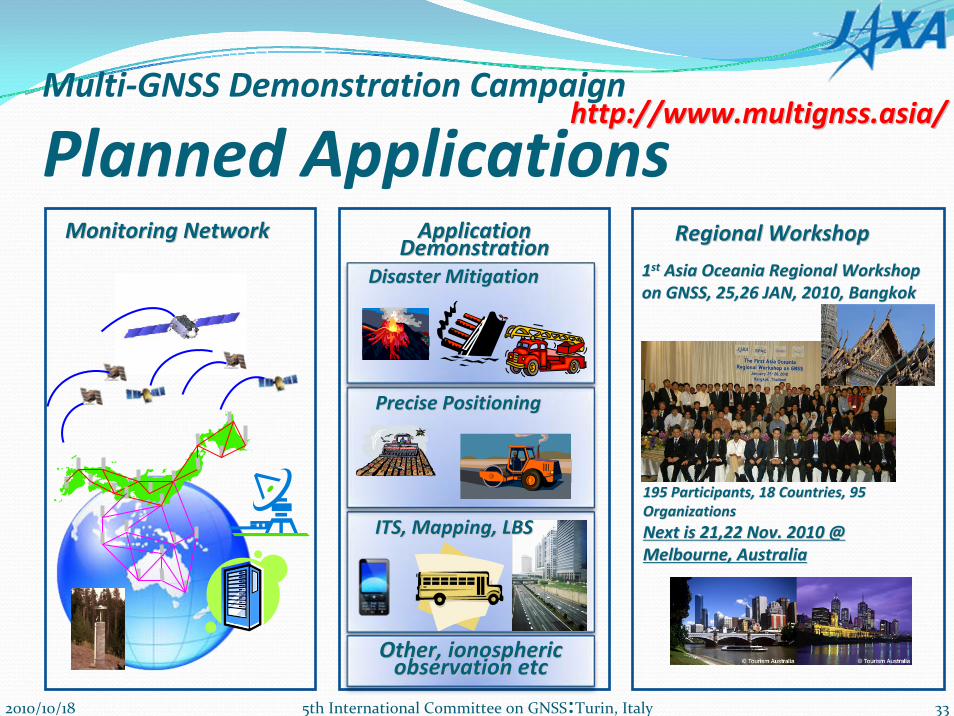
http://http://www.multignss.asiawww.multignss.asia//
Application Application DemonstrationDemonstration
Disaster MitigationDisaster Mitigation
Precise PositioningPrecise Positioning
ITS, Mapping, LBSITS, Mapping, LBS
Regional WorkshopRegional Workshop
11stst Asia Oceania Regional Workshop Asia Oceania Regional Workshop on GNSS, 25,26 JAN, 2010, Bangkokon GNSS, 25,26 JAN, 2010, Bangkok
Other, Other, ionosphericionosphericobservation etcobservation etc
195 Participants, 18 Countries, 95 195 Participants, 18 Countries, 95 OrganizationsOrganizationsNext is 21,22 Nov. 2010 @ Next is 21,22 Nov. 2010 @ Melbourne, AustraliaMelbourne, Australia
Monitoring NetworkMonitoring Network
Multi‐GNSS Demonstration Campaign
Planned Applications
2010/10/18 5th International Committee on GNSS:Turin, Italy 34
*SPAC: Satellite Positioning Applications Center *SPAC: Satellite Positioning Applications Center ** GISTDA: Geo** GISTDA: Geo‐‐Informatics and Space Technology AgencyInformatics and Space Technology Agency
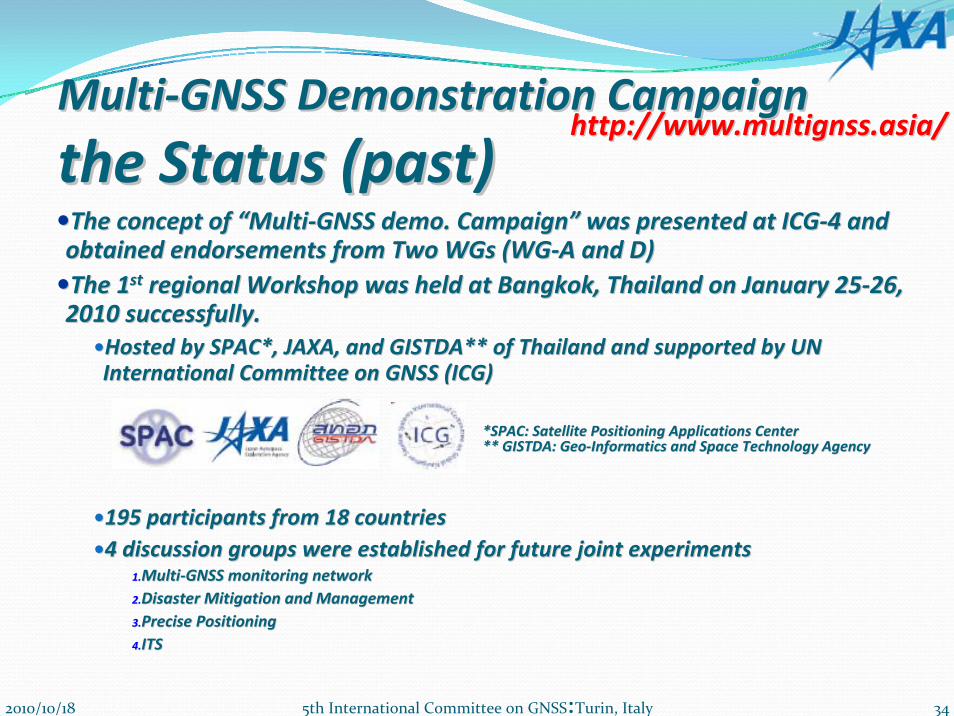
MultiMulti‐‐GNSS Demonstration CampaignGNSS Demonstration Campaign
the Status (past)the Status (past)The concept of The concept of ““MultiMulti‐‐GNSS demo. CampaignGNSS demo. Campaign”” was presented at ICGwas presented at ICG‐‐4 and 4 and obtained endorsements from Two obtained endorsements from Two WGsWGs (WG(WG‐‐A and D) A and D) The 1The 1stst regional Workshop was held at Bangkok, Thailand on January 25regional Workshop was held at Bangkok, Thailand on January 25‐‐26, 26, 2010 successfully.2010 successfully.
Hosted by SPAC*, JAXA, and GISTDA** of Thailand and supported byHosted by SPAC*, JAXA, and GISTDA** of Thailand and supported by UN UN International Committee on GNSS (ICG) International Committee on GNSS (ICG)
195 participants from 18 countries195 participants from 18 countries4 discussion groups were established for future joint experiment4 discussion groups were established for future joint experimentss
1.1.MultiMulti‐‐GNSS monitoring networkGNSS monitoring network2.2.Disaster Mitigation and ManagementDisaster Mitigation and Management3.3.Precise PositioningPrecise Positioning4.4.ITSITS
http://http://www.multignss.asiawww.multignss.asia//
2010/10/18 5th International Committee on GNSS:Turin, Italy 35
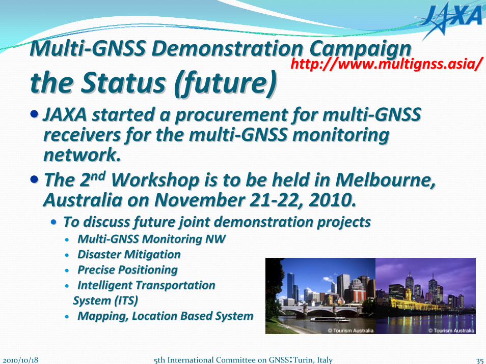
MultiMulti‐‐GNSS Demonstration CampaignGNSS Demonstration Campaign
the Status (future)the Status (future)JAXA started a procurement for multiJAXA started a procurement for multi‐‐GNSS GNSS receivers for the multireceivers for the multi‐‐GNSS monitoring GNSS monitoring network.network.The 2The 2ndnd Workshop is to be held in Melbourne, Workshop is to be held in Melbourne, Australia on November 21Australia on November 21‐‐22, 2010. 22, 2010.
To discuss future joint demonstration projectsTo discuss future joint demonstration projectsMultiMulti‐‐GNSS Monitoring NWGNSS Monitoring NWDisaster MitigationDisaster MitigationPrecise PositioningPrecise PositioningIntelligent Transportation Intelligent Transportation System (ITS)System (ITS)Mapping, Location Based SystemMapping, Location Based System
http://http://www.multignss.asiawww.multignss.asia//
2010/10/18 5th International Committee on GNSS:Turin, Italy 36
SummarySummaryQZSS is a regional spaceQZSS is a regional space‐‐based PNT system covers East Asia based PNT system covers East Asia and Oceania region and transmits six civil PNT signals.and Oceania region and transmits six civil PNT signals.
First satellite (QZSFirst satellite (QZS‐‐1; MICHIBIKI) was launched on September 1; MICHIBIKI) was launched on September 11th, 2010, JST.11th, 2010, JST.
We are performing 3We are performing 3‐‐monthmonth‐‐OnOn‐‐OrbitOrbit‐‐Checkout (OOC) after Checkout (OOC) after the launch. Technical and application demonstrations will be the launch. Technical and application demonstrations will be started after OOC. started after OOC.
Asia Oceania is the Showcase of New Multi GNSS EraAsia Oceania is the Showcase of New Multi GNSS EraNext workshop will be held in 21, 22 Nov 2010 in Melbourne, AustNext workshop will be held in 21, 22 Nov 2010 in Melbourne, Australiaralia
2010/10/18 5th International Committee on GNSS:Turin, Italy 37
Thank you for your attentionThank you for your attention
Our Planet from QZSOur Planet from QZS‐‐11
Backup SheetsBackup Sheets
Political Back groundPolitical Back ground
2010/10/18 5th International Committee on GNSS:Turin, Italy 40
Launch and Next StepLaunch and Next Step
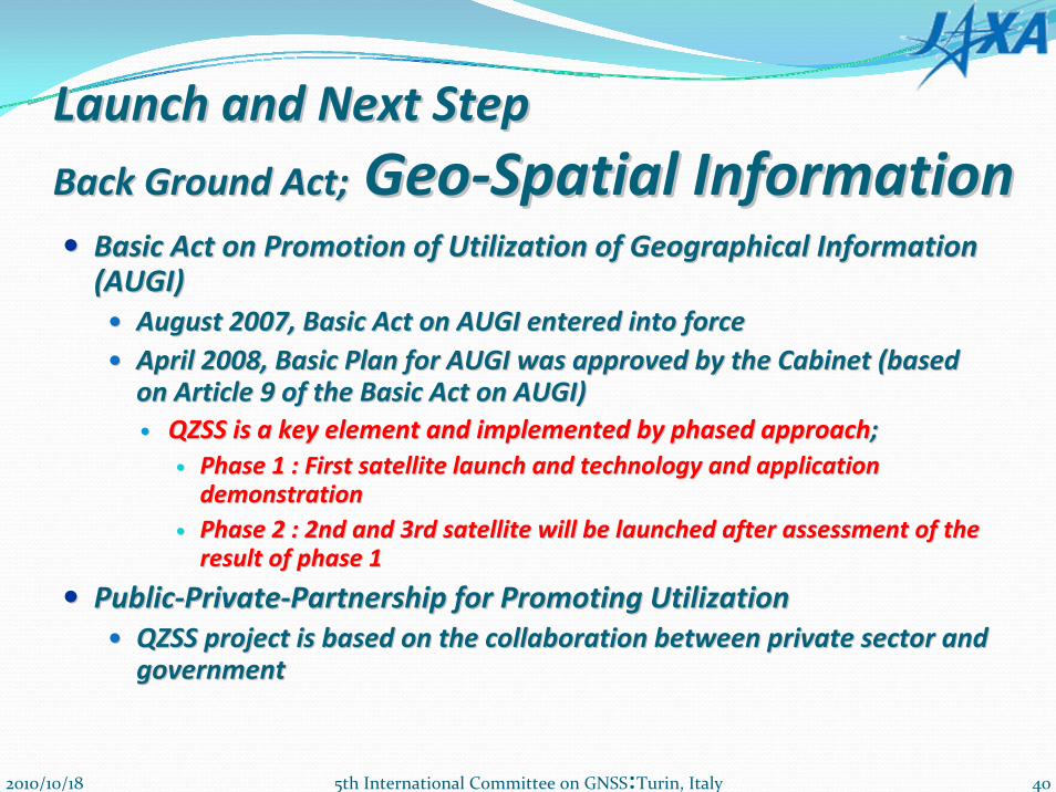
Back Ground Act;Back Ground Act; GeoGeo‐‐Spatial InformationSpatial InformationBasic Act on Promotion of Utilization of Geographical InformatioBasic Act on Promotion of Utilization of Geographical Informationn(AUGI)(AUGI)
August 2007, Basic Act on AUGI entered into forceAugust 2007, Basic Act on AUGI entered into forceApril 2008, Basic Plan for AUGI was approved by the Cabinet (basApril 2008, Basic Plan for AUGI was approved by the Cabinet (based ed on Article 9 of the Basic Act on AUGI) on Article 9 of the Basic Act on AUGI)
QZSS is a key element and implemented by phased approachQZSS is a key element and implemented by phased approach;;Phase 1 : First satellite launch and technology and application Phase 1 : First satellite launch and technology and application demonstrationdemonstrationPhase 2 : 2nd and 3rd satellite will be launched after assessmenPhase 2 : 2nd and 3rd satellite will be launched after assessment of the t of the result of phase 1result of phase 1
PublicPublic‐‐PrivatePrivate‐‐Partnership for Promoting UtilizationPartnership for Promoting UtilizationQZSS project is based on the collaboration between private sectoQZSS project is based on the collaboration between private sector and r and governmentgovernment
2010/10/18 5th International Committee on GNSS:Turin, Italy 41
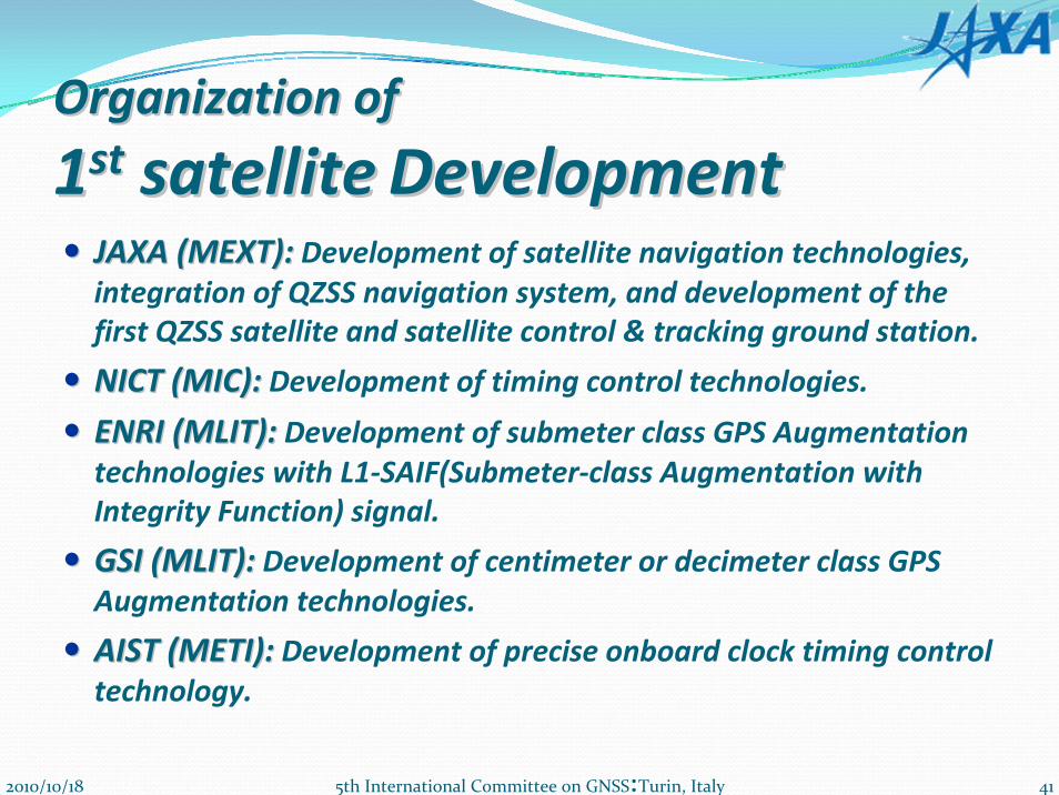
Organization ofOrganization of
11stst satellitesatellite DevelopmentDevelopmentJAXA (MEXT):JAXA (MEXT): Development of satellite navigation technologies, integration of QZSS navigation system, and development of the first QZSS satellite and satellite control & tracking ground station.
NICT (MIC):NICT (MIC): Development of timing control technologies.
ENRI (MLIT):ENRI (MLIT): Development of submeter class GPS Augmentation technologies with L1‐SAIF(Submeter‐class Augmentation with Integrity Function) signal.
GSI (MLIT):GSI (MLIT): Development of centimeter or decimeter class GPS Augmentation technologies.
AIST (METI):AIST (METI): Development of precise onboard clock timing control technology.
2010/10/18 5th International Committee on GNSS:Turin, Italy 42
Launch and Next StepLaunch and Next Step
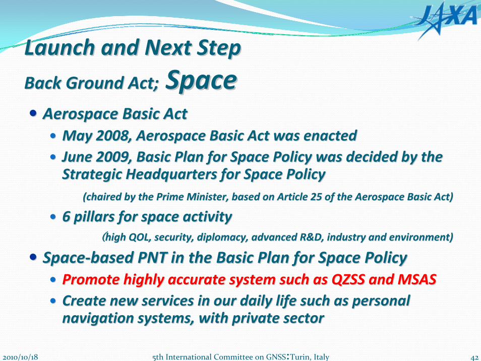
Back Ground Act;Back Ground Act; SpaceSpaceAerospace Basic ActAerospace Basic Act
May 2008, Aerospace Basic Act was enactedMay 2008, Aerospace Basic Act was enactedJune 2009, Basic Plan for Space Policy was decided by the June 2009, Basic Plan for Space Policy was decided by the Strategic Headquarters for Space Policy Strategic Headquarters for Space Policy
(chaired by the Prime Minister, based on Article 25 of the Aeros(chaired by the Prime Minister, based on Article 25 of the Aerospace Basic Act) pace Basic Act)
6 pillars for space activity6 pillars for space activity((high QOL, security, diplomacy, advanced R&D, industry and envirohigh QOL, security, diplomacy, advanced R&D, industry and environment)nment)
SpaceSpace‐‐based PNT in the Basic Plan for Space Policybased PNT in the Basic Plan for Space PolicyPromote highly accurate system such as QZSS and MSASPromote highly accurate system such as QZSS and MSASCreate new services in our daily life such as personal Create new services in our daily life such as personal navigation systems, with private sectornavigation systems, with private sector
2010/10/18 5th International Committee on GNSS:Turin, Italy 43
Launch and Next StepLaunch and Next Step
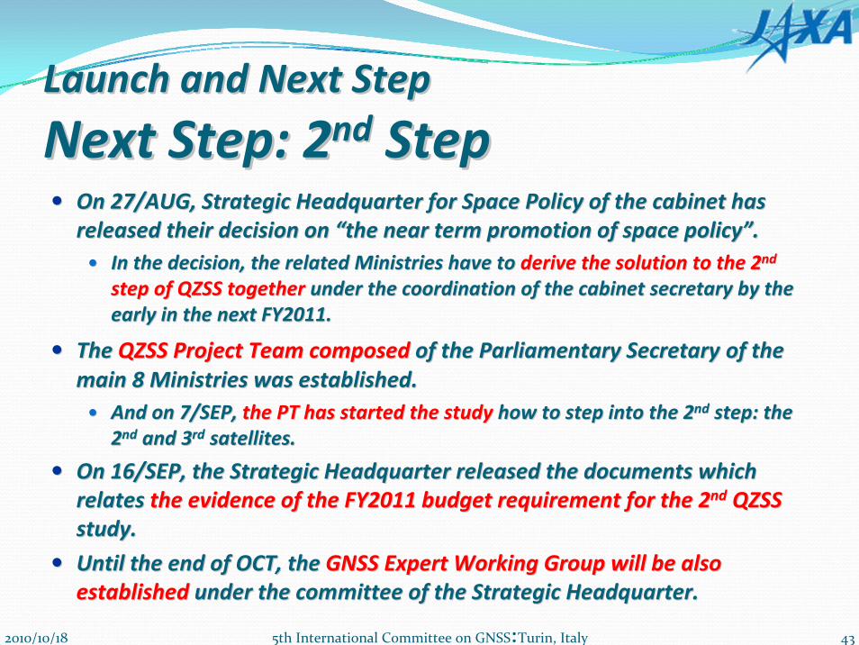
Next Step: 2Next Step: 2ndnd StepStepOn 27/AUG,On 27/AUG, Strategic Headquarter for Space PolicyStrategic Headquarter for Space Policy of the cabinet has of the cabinet has released their decision on released their decision on ““the near term promotion of space policythe near term promotion of space policy””..
In the decision, the related Ministries have to In the decision, the related Ministries have to derive the solution to the 2derive the solution to the 2ndnd
step of QZSS togetherstep of QZSS together under the coordination of the cabinet secretary by the under the coordination of the cabinet secretary by the early in the next FY2011.early in the next FY2011.
The The QZSS Project Team composedQZSS Project Team composed of the Parliamentary Secretaryof the Parliamentary Secretary of the of the main 8 Ministries was established.main 8 Ministries was established.
And on 7/SEP, And on 7/SEP, the PT has started the studythe PT has started the study how to step into the 2how to step into the 2ndnd step: the step: the 22ndnd and 3and 3rdrd satellites.satellites.
On 16/SEP, the Strategic Headquarter released the documents whicOn 16/SEP, the Strategic Headquarter released the documents which h relates relates the evidence of the FY2011 budget requirement for the 2the evidence of the FY2011 budget requirement for the 2ndnd QZSSQZSSstudy.study.
Until the end of OCT, the Until the end of OCT, the GNSS Expert Working Group will be also GNSS Expert Working Group will be also establishedestablished under the committee of the Strategic Headquarter.under the committee of the Strategic Headquarter.
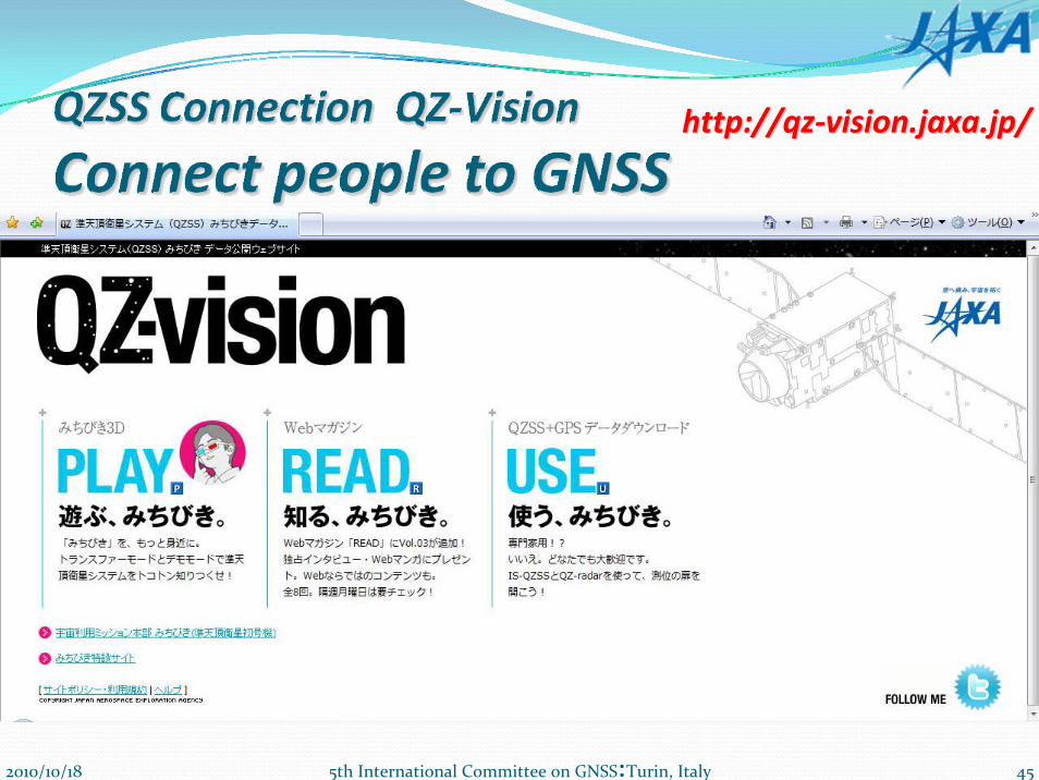
QZSS ConnectionQZSS Connection‐‐ Dissemination of the achievement Dissemination of the achievement
2010/10/18 5th International Committee on GNSS:Turin, Italy 45
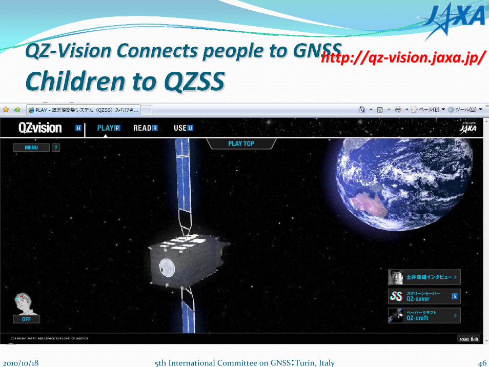
PP RR UU
http://qzhttp://qz‐‐vision.jaxa.jpvision.jaxa.jp//
2010/10/18 5th International Committee on GNSS:Turin, Italy 46
SS
HH RRPP UU
http://qzhttp://qz‐‐vision.jaxa.jpvision.jaxa.jp//
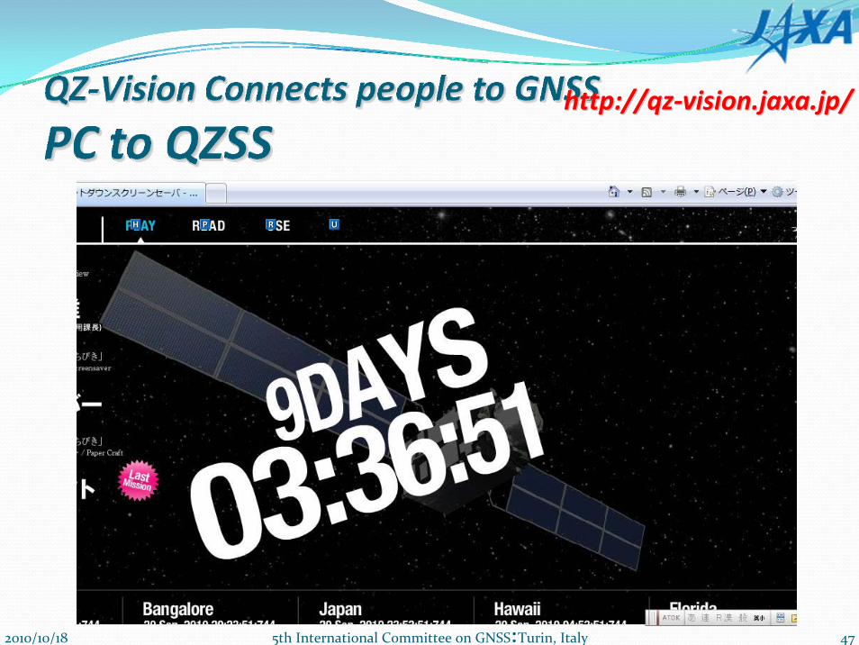
2010/10/18 5th International Committee on GNSS:Turin, Italy 47
RRPPHH UU
http://qzhttp://qz‐‐vision.jaxa.jpvision.jaxa.jp//
2010/10/18 5th International Committee on GNSS:Turin, Italy 48
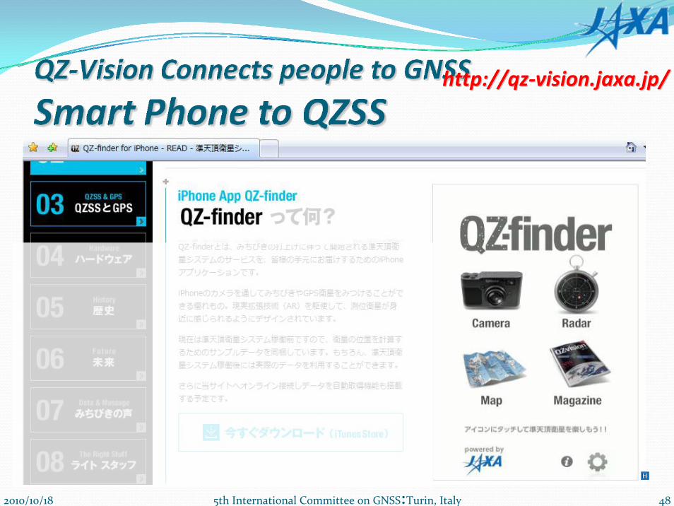
HH
http://qzhttp://qz‐‐vision.jaxa.jpvision.jaxa.jp//
2010/10/18 5th International Committee on GNSS:Turin, Italy 49
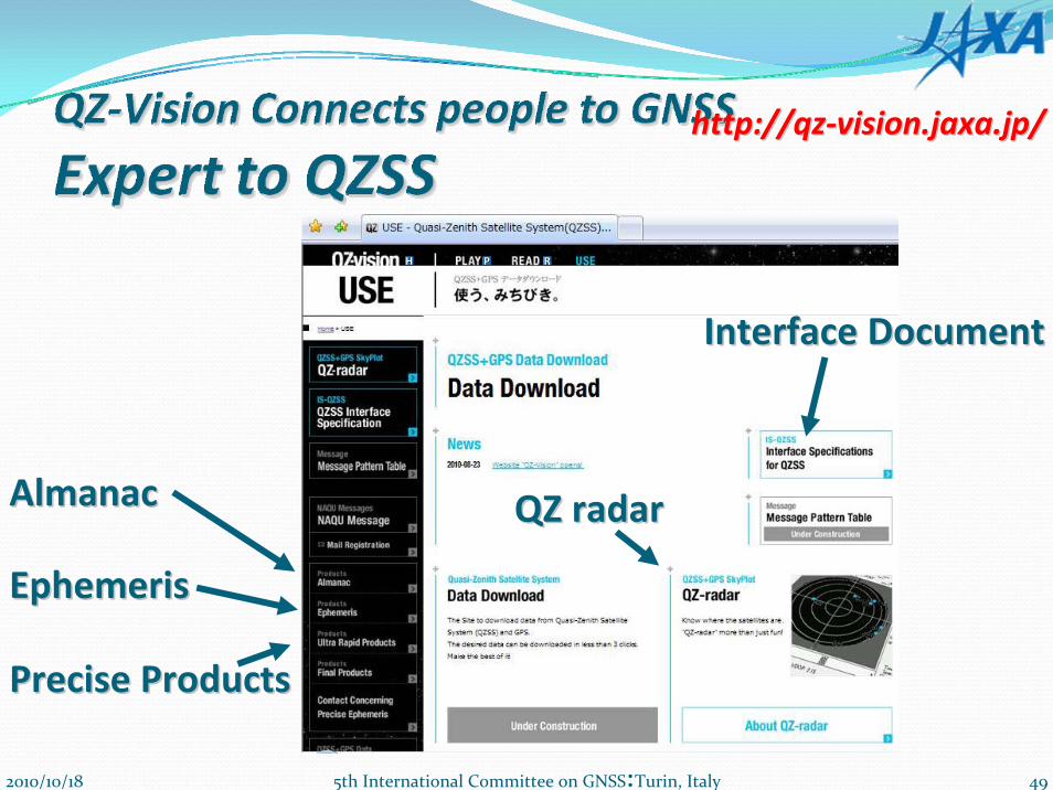
PP RRHH
Interface DocumentInterface Document
AlmanacAlmanac
EphemerisEphemeris
Precise ProductsPrecise Products
QZ radarQZ radar
http://qzhttp://qz‐‐vision.jaxa.jpvision.jaxa.jp//
Orbit deOrbit de‐‐confliction with GSO confliction with GSO and reand re‐‐orbit procedureorbit procedure
2010/10/18 5th International Committee on GNSS:Turin, Italy 51
Each satellite orbit has slight eccentricity so Each satellite orbit has slight eccentricity so that can keep appropriate separation away that can keep appropriate separation away from GSO. The vector of eccentricity will be from GSO. The vector of eccentricity will be maintained this appropriate separation more maintained this appropriate separation more than 50 km during operation.than 50 km during operation.After whole mission life, the satellite will be After whole mission life, the satellite will be injected into injected into ““Disposal OrbitDisposal Orbit””, which defined , which defined as the orbit with 1000 km higher perigee as the orbit with 1000 km higher perigee altitude from altitude from GSOGSO’’ss..
Avoidance of physical interference to GSO & reAvoidance of physical interference to GSO & re‐‐
orbit after operationorbit after operation