project change report - department of transport and main …/media/projects/m/moreton bay rail...
TRANSCRIPT

Moreton Bay Rail Link Project Change Report
50007372 V9 June 2011

MBRL Project Change Report (50007372 V8), Transport and Main Roads, June 2011 1
AECOM Quality Information
Document
Ref 60102334
Date 23-Jun-2011 Prepared by Michael Kahler
Reviewed by Mark Fairweather
Revision History
Revision Revision Date Details
Authorised
Name/Position Signature A 03-Nov-2010 Draft for comment Mark Fairweather
Technical Director Original Signed
0 23-Jun-2011 Final Issue Mark Fairweather Technical Director
Original Signed

MBRL Project Change Report (50007372 V8), Transport and Main Roads, June 2011 2
Contents Section Page
Executive Summary ........................................................................................................... 3
E1 Purpose ................................................................................................................ 3 E2 Background .......................................................................................................... 3 E3 Land Use Planning & Patronage ....................................................................... 4 E4 Changes to Design & Implementation ............................................................... 4 E5 Conclusions ........................................................................................................ 6
1.0 Introduction .............................................................................................................. 7 1.1 Purpose of Change Report ................................................................................. 7 1.2 Project Drivers ..................................................................................................... 7 1.3 Project Scope ...................................................................................................... 8
2.0 Overview of FIASR (2003) ..................................................................................... 9 2.1 Outline .................................................................................................................. 9 2.2 Options Assessment ........................................................................................... 9 2.3 Description of Preferred Rail Corridor ............................................................... 9 2.4 Implementation .................................................................................................. 10 2.5 Existing & Future Environment ........................................................................ 10 2.6 Environmental Management Plan.................................................................... 10 2.7 Consultation ....................................................................................................... 10 2.8 Conclusions ....................................................................................................... 11
3.0 Current Project Status .......................................................................................... 11 3.1 Project Assurance Framework ......................................................................... 11 3.2 Strategic Assessment of Service Requirement (March 2010) ...................... 12 3.3 Preliminary Evaluation Report (May 2010) ..................................................... 12
4.0 Changes to Planning Assumptions ..................................................................... 15 4.1 Land Use Planning ............................................................................................ 15 4.2 Changes in Modelling ....................................................................................... 16
5.0 Changes to Design & Implementation................................................................. 19 5.1 Changes to Rail ................................................................................................. 19 5.2 Stations .............................................................................................................. 20 5.3 Changes to Local Road Network ..................................................................... 21 5.4 Bridge Structures............................................................................................... 22 5.5 Retaining Walls.................................................................................................. 24 5.6 Changes to Bus Service Requirements .......................................................... 24 5.7 Changes to Active Transport ............................................................................ 24 5.8 Changes to Implementation ............................................................................. 24
6.0 Changes to Environment and Land Requirement .............................................. 25 6.1 Previous Studies ............................................................................................... 25 6.2 Design Changes ................................................................................................ 30 6.3 Legislative Changes .......................................................................................... 31 6.4 Additional Field Studies .................................................................................... 31 6.5 Cultural Heritage ............................................................................................... 33 6.6 Land Acquisition ................................................................................................ 34
7.0 Conclusions ........................................................................................................... 35 7.1 Community & Operational Benefits ................................................................. 35 7.2 Environmental Management ............................................................................ 36
Appendix A Natural Environment Technical Report Appendix B Moreton Bay Rail Link Reference Design Drawings (Dr No’s 131000 – 131010 and 171000 - 171020)

MBRL Project Change Report (50007372 V8), Transport and Main Roads, June 2011 3
Executive Summary
E1 Purpose An Impact Assessment Study for the Petrie to Kippa-Ring Public Transport Corridor was conducted by GHD for Queensland Transport. The Final Impact Assessment Study Report (FIASR) was released in October 2003. Since then, planning for the corridor (now known as the Moreton Bay Rail Link) has progressed. The purpose of this Project Change Report is to document the key changes that have occurred from October 2003 to 23 June 2011. An earlier version of the Project Change Report was released in late 2010 and used as an input into the Business Case Development phase and associated community consultation. This version incorporates changes and new information identified since that time.
E2 Background In the late 1970’s the former Metropolitan Transit Authority conducted a series of planning investigations for a public transport link between Petrie and Kippa-Ring, culminating in land being acquired for the corridor. An Impact Assessment Study commenced in 1999, with significant community consultation activities including public displays and a manned public exhibition of the Draft IAS. The FIASR was completed in October 2003 with the following findings: The existing corridor should be developed for heavy rail and should ultimately include six
stations at the nominated locations The original preserved corridor should be preserved The corridor should be developed in stages to meet population increases and demand
In 2008, the Queensland Government and Moreton Bay Regional Council (MBRC) decided to jointly submit the Moreton Bay Rail Link (MBRL) project for consideration under the Infrastructure Australia (IA) program. To facilitate this submission a Memorandum of Understanding (MOU) was signed and joint funding of $4 million was allocated to prepare the submission and develop the project under the Queensland Government’s Project Assurance Framework (PAF.) The submission was lodged in November 2009 and the Strategic Assessment of Service Requirement and Preliminary Evaluation Report were completed by Transport & Main Roads (TMR) in the first half of 2010. The Preliminary Evaluation Report found that a heavy rail, dual track solution with six (6) stations located at Kallangur, Murrumba Downs, Mango Hill, Kinsellas Road, Rothwell and Kippa-Ring provided the best transport solution. The financial analysis undertaken determined the infrastructure costs for these options as follows: A “Real” March 2010 cost of $801m A “Total Outturn” Cost of $1098m (construction from 2013 to 2015)
In the lead up to the 2010 federal election the incumbent Labor government announced that a re-elected Australian Government would invest $742 million, the Queensland Government $300 million and the Moreton Bay Regional Council $105 million to build the new rail line such that it was operational in 2016. To achieve the operational target date of 2016 the project progressed into the Business Case Development phase and community consultation in late 2010.

MBRL Project Change Report (50007372 V8), Transport and Main Roads, June 2011 4
E3 Land Use Planning & Patronage The Moreton Bay Regional Council (MBRC) was created as a result of the amalgamation of the former Redcliffe City, Pine Rivers and Caboolture Shire Councils in 2008. MBRC is currently developing a new Moreton Bay Regional Planning Scheme, however, at this point in time the former schemes of the three amalgamated Councils remain in force. Land Use planning, projected population and employment growth remain relatively consistent with the inputs utilised in the FIASR. Additional patronage modelling was undertaken as part of the Preliminary Evaluation report in 2010 and found that the single track solution recommended in the FIASR as the initial stage of the corridor development would not adequately service peak hour passenger demands after 2016. Subsequently, the initial staged construction of a single track only with passing loops at five stations (construction of the second track and Kinsellas Station were proposed in 2025) as recommended in the FIASR is no longer a suitable solution.
E4 Changes to Design & Implementation E4.1 Rail In general the proposed rail alignment has been based on the alignment recommended in the FIASR and follows the original preserved corridor. However changes to the alignment have occurred over some sections of the corridor to meet the current Queensland Rail Design parameters. Rail design changes include incorporating longer transitions to curves, increasing radii of curves where possible and incorporating straights or minimum horizontal radii of 2000 metres at station positions. The rail alignment is generally designed for 100km/h. Further development of the rail horizontal and vertical alignment has identified areas where the required corridor is outside the limits of the currently preserved corridor and subsequently some additional property acquisition may be required at specific locations. The FIASR recommended that the rail consist initially of a single track with passing loops at each station. Earthworks and bridge structures were to be undertaken for the ultimate dual track configuration to be implemented in 2025. Increased patronage estimates and engagement with Queensland Rail’s representatives indicated the construction of two tracks over the full length of the corridor was appropriate and cost effective upfront without staging. The provision of dual track also allows maximum flexibility for tying in with the operating of the Caboolture to City services. Subsequently the design has been changed from the FIASR to incorporate dual track over the full length of the corridor upfront and no staging will occur. Stabling provision requirements at both Petrie and Kippa-Ring stations were investigated. Investigations found that provision for stabling at Kippa-Ring station, from an operational perspective, was preferable rather than at Petrie Station as recommended in the FIASR. Stabling requirements at Kippa-Ring will be further investigated and finalised during the detail design phase of the project. The FIASR recommended that Kinsellas Road Station not be constructed until 2025. This recommendation will not be adopted because of the recent planning approval given to Urbex for a significant development in the vicinity of the Kinsellas Road Station which will increase the demand at the Station. Subsequently all six stations will be constructed as part of the MBRL Project. The six stations will be located at: Kallangur Murrumba Downs Mango Hill Kinsellas Road East Rothwell Kippa-Ring
The FIASR makes provision for side platforms at all stations. Side platforms will not be adopted for Kippa-Ring Station where a central platform will be incorporated to improve operations and the overall design functionality of the station.

MBRL Project Change Report (50007372 V8), Transport and Main Roads, June 2011 5
E4.2 Local Road Network & Bus Services The proposed design alignments for the local road network immediately adjacent to and crossing the rail corridor do not differ significantly from the FIASR. Grade separation will occur at Dohles Rock Road (road bridge over rail); the Goodfellows Road deviation (road bridge over rail); Brays Road (rail bridge over road); the Bruce Highway (rail bridge over road); Freshwater Creek Road (road bridge over rail); and Kinsellas Road East (road bridge over rail). Moreton Bay Regional Council’s planning also includes the Mango Hill Ring Road that crosses the MBRL at two locations - a new road bridge over rail to be built by Urbex under their infrastructure agreement with the Council and the extension of Mango Hill Ring Road between Kinsellas Road East and Halpine Drive which is included in Council's trunk planning and developer contributions policy. TransLink will work with Queensland Rail, the local bus operators and the community to review bus and train frequency requirements prior to the opening of the new rail line. E4.3 Environmental & Land use The key changes which have occurred since the completion of the FIASR which influence the environmental considerations of the project are: The inclusion of new road design elements for areas that had not been previously
surveyed for flora and fauna. These elements are primarily in the section between Petrie and Mango Hill
Increased footprint associated with the project created by the realignment of some sections of the rail line and addition of road and cycleway elements
Changes to Regional Ecosystem (RE) & Essential Habitat designation under Vegetation Management Act 1999
Changes to the species conservation status of koala in South East Queensland under the Nature Conservation Act 1992 and Conservation Plan. All native vegetation is now protected and requires a permit to be cleared. There are also possible offset triggers
The implementation of the Sustainable Planning Act 2009 (SPA) The introduction of the South East Queensland Koala Conservation State Planning
Regulatory Provision (SPRP) and State Planning Policy 2/10: Koala Conservation in South East Queensland (SPP) under the Sustainable Planning Act 2009 (SPA)
Potential Matters of National Environmental Significance (MNES) under Environment Protection and Biodiversity Conservation (EPBC) Act
Changes have occurred to the Land Use planning provisions along the corridor with implementation of new planning schemes, structure plans and Local Growth Management Strategies by the former Redcliffe City Council and Pine Rivers Shire Council. A regional Local Growth Management Scheme was created by Moreton Bay Regional Council in 2008
Amendments have occurred to the South East Queensland Regional Plan (SEQRP) and South East Queensland Infrastructure Plan and Program (SEQIPP) since the completion of the FIASR. The 2009 and 2010 SEQIPP’s make specific reference to the Petrie to Kippa-Ring Rail corridor and MBRL respectively
Due to the potential for the project to impact upon Matters of National Environmental Significance (MNES) under the Environment Protection and Biodiversity Conservation Act 1999 (EPBC Act), the project was referred to the Department of Sustainability, Environment, Water, Populations and Communities (DSEWPC) in July 2010. The DSEWPC subsequently advised after provision of additional information that the project is not a ‘controlled action’ and an Environmental Impacts Statement (EIS) will not be required for the project. This decision does not remove the need to seek relevant state and local government approval for activities that will have an environmental impact. As the project includes development assessable under the Sustainable Planning Act 2009, for example an environmentally relevant activity, an approval will be required. An application for a development permit must be made under the Sustainable Planning Act 2009.

MBRL Project Change Report (50007372 V8), Transport and Main Roads, June 2011 6
E5 Conclusions The MBRL is a key initiative of all three levels of government with funding commitments of $742 million from the Australian Government, $300 million from the Queensland Government and $105 million from Moreton Bay Regional Council to complete the project such that the new rail line is operating in 2016. A number of further investigations and refinements to the proposed MBRL have occurred since the completion of the Final Impact Assessment Study Report in 2003. The project has now progressed to the Business Case Development phase of the Queensland Governments Project Assurance Framework which will include the following activities: Refinement of design and capital estimates, including risk analysis and assessment of
potential escalation and specific sensitivity analysis Further public consultation Refinement of land requirements, including off-set conditions Development of a full benefits analysis and realisation plan Further economic analysis incorporating detailed patronage/demand modelling Constructability analysis Environmental impact analysis Value capture analysis and staging Further investigation of potential revenue sources

MBRL Project Change Report (50007372 V8), Transport and Main Roads, June 2011 7
1.0 Introduction
1.1 Purpose of Change Report An Impact Assessment Study for the Petrie to Kippa-Ring Public Transport Corridor was conducted by GHD for Queensland Transport. The Final Impact Assessment Study Report (FIASR) was released in October 2003. Since then, planning for the corridor (now known as the Moreton Bay Rail Link) has progressed. The purpose of this Project Change Report is to document the key changes that have occurred from October 2003 to 23 June 2011. An earlier version of the Project Change Report was released in late 2010 and used as an input into the Business Case Development phase and associated community consultation. This version incorporates changes and new information identified since that time.
1.2 Project Drivers The Moreton Bay region is a key population growth area for South East Queensland. It has a sizable existing population, large amounts of affordable housing and is commutable distance from northern Brisbane and the CBD. It is presently the third most populous Local Government area in Australia with an estimated resident population in July 2008 of 356,709 (representing approximately 8 percent of the total population of Queensland). This position will be maintained as Moreton Bay continues to be one of the fastest growing local government areas in Australia with the population projected to be in the order of 523,000 by 2031 (under the Queensland Government‘s medium series population projections). Similar to most outer metropolitan communities across Australia, the Moreton Bay region has a less than acceptable level of employment self-containment (i.e. fewer jobs than workers). The combination of population growth and low employment self containment within the Moreton Bay region results in 54% of commuter trips leaving the region, including 9% destined for the Brisbane CBD. This level of inter-regional commuter travel is higher than that observed for other South East Queensland local government areas including Ipswich City and Gold Coast City. In comparison to other growth areas in South East Queensland, the region is currently not well serviced by public transport options making the area very dependent on private car vehicle usage. The implementation of an effective transport solution facilitates the travel of Moreton Bay residents into Brisbane, thus allowing Brisbane based businesses to attract staff from easily commutable areas (as opposed to people currently commuting to Brisbane from further afield areas such as Ipswich and the Gold Coast). Preliminary transport modelling indicates that by 2016 there will be significant congestion problems within the region as a result of capacity restrictions on major arterial roads into Brisbane and the CBD, including Gympie Road and the Bruce Highway. It also indicates that if a rail solution was provided to this area approximately 10,000 additional public transport trips would be made per day, thus contributing to congestion reduction on road corridors such as the Bruce Highway and Gympie Road. Public transport investments that contribute to congestion reduction provide significant community benefits, and can influence land development and travel behaviour in areas like the Moreton Bay region where there is still undeveloped land available. In the lead up to the 2010 federal election the incumbent Labor government announced that a re-elected Australian Government would invest $742 million, the Queensland Government $300 million and the Moreton Bay Regional Council $105 million to build the new rail line such that it was operational in 2016.
MBRL Project Change Report (50007372 V8), Transport and Main Roads, June 2011 8
1.3 Project Scope The MBRL project will comprise approximately 12.6 km of dual track railway connecting Petrie to Kippa-Ring. Six new stations will be constructed at: Kallangur Murrumba Downs Mango Hill Kinsellas Road East Rothwell Kippa-Ring
The railway will be fully grade separated from the local road network. This necessitates bridges at Dohles Rocks Road, the Goodfellows Road deviation, Brays Road, the Bruce Highway, Freshwater Creek Road and Kinsellas Road East. Major water way structures are required at Yebri Creek, Freshwater Creek and Saltwater Creek/Hays Inlet. Bridges will also be constructed at locations between stations which will be finalised during detail design to allow free fauna movement and to minimise environmental impacts. Train stabling facilities will be provided in the vicinity of Kippa-Ring Station. The project will ultimately provide safe and continuous shared paths and dedicated pedestrian paths along the length of the corridor as determined appropriate during detailed design. Where practical, within 800 metres (walking distance) of a station, separate footpaths and bike paths will be provided. Beyond 800 metres where pedestrian volumes are reduced, the path will generally be designed as a shared path.

MBRL Project Change Report (50007372 V8), Transport and Main Roads, June 2011 9
2.0 Overview of FIASR (2003)
2.1 Outline In 1999, Queensland Transport commissioned consultants GHD Pty Ltd to undertake a public transport study of the existing public transport corridor between Petrie & Kippa-Ring. The overall aim of the Study was to assess the viability, preferred alignment and social, environmental and economic implications of establishing the public transport corridor. The Study was carried out in two stages. Stage 1 involved: an initial assessment of the viability of public transport within the corridor the selection of a preferred mode of transport determination of the preferred corridor alignment in the Mango Hill/Griffin Area
Stage 2 involved the completion of the technical studies including economic modelling, the selection of the preferred alignment between Petrie Station and the proposed Kallangur Station and the preparation of the Final Impact Assessment Study Report.
2.2 Options Assessment The four alternative modes of transport examined in Stage 1 of the Study were: Heavy (Passenger) Rail Buses/Busway Light Rail Monorail
A transport model was used to forecast levels of patronage and economic benefits associated with each mode of transport adopting a common corridor option. Heavy rail was selected as the preferred mode for this corridor on the basis that it is the only mode that provides an acceptable level of economic efficiency. Heavy rail also provided the highest levels of public transport patronage, largely due to better integration with the existing network and absence of any penalties associated with the need to switch modes.
2.3 Description of Preferred Rail Corridor Selection of the preferred corridor option involved a comprehensive evaluation process employing key evaluation criteria based on the Study’s technical investigations. The criteria related to the natural environment, the social environment, integrated transport aspects and cost. The evaluation process identified the existing preserved corridor from Petrie to Kippa-Ring as the preferred corridor. In broad terms the study recommended the rail line initially consist of a single line from Petrie to Kippa-Ring, along the originally preserved corridor, with passing sections at the end stations (Petrie and Kippa-Ring) and at the central Mango Hill Station. This configuration allowed for a 15 minute service frequency on the rail corridor extension which would meet future requirements. Embankments were to be constructed to provide the option of building a dual track should future patronage levels warrant this. The proposal allowed for stations to ultimately be provided at Kallangur, Murrumba Downs, Mango Hill, Kinsellas Road, Rothwell and Kippa-Ring. Bus services were assumed to be redirected to provide feeder services to the rail stations, with the Kippa-Ring and Mango Hill stations being of major importance in this regard. Assumed operating scenarios provided for all services to be through running to Central and Roma Street Stations, with 50% express from Petrie. The alignment was fully grade separated from the local road network. This required bridges at Dohles Rock Road; the Goodfellows Road deviation; Brays Road; the Bruce Highway; Freshwater Creek Road; and Kinsellas Road (North South Arterial). Major waterway structures were required at Yebri

MBRL Project Change Report (50007372 V8), Transport and Main Roads, June 2011 10
Creek; Black Duck Creek; Freshwater Creek; and Saltwater Creek/Hays Inlet. Bridges were to be constructed at three locations between the proposed Rothwell and Petrie stations to allow free fauna movement and to minimise environmental impacts.
2.4 Implementation The study found that the introduction of rail to the Petrie to Kippa-Ring Public Transport Corridor was economically feasible in the short term and that the project met normally accepted thresholds for implementation of this type of public transport service. Urban development along the corridor was rapidly proceeding and projections of patronage showed that the line was viable. The study further stated that the project had demonstrated economic viability, strong public support and that ideally; implementation should proceed immediately to allow the introduction of rail services to match the final sequence of urban development, and encourage further transit supportive development within station surrounds. It was recommended that the initial stage make provision for stations at Kallangur, Murrumba Downs, Mango Hill, Rothwell and Kippa-Ring. Construction of the Kinsellas Road Station was not recommended in the initial project due to its significantly lower patronage and proximity to Mango Hill Station.
2.5 Existing & Future Environment The study concluded that the preferred public transport corridor followed the currently preserved alignment which was identified in the 1970s and purchased in the 1980s. It stated land use planning in the Study Area had recognised the existence of the proposed corridor and allowed for its integration. While introduction of the corridor was expected to have significantly overall benefits to the community, a number of adverse impacts on the existing environment were identified. The study concluded that in most cases, these impacts could be partly or completely mitigated by the implementation of appropriate management measures.
2.6 Environmental Management Plan An Environmental Management Plan (EMP) was prepared in response to the potential impacts that were identified through the environmental assessment. It was intended that the EMP (Planning) provide an indication of the types of mitigation measures to be undertaken to minimise the identified environmental impacts and to guide the production of more detailed EMPs for the detailed design, construction and operation phases of the project.
2.7 Consultation The key purpose of the consultation process was to provide the opportunity for community input. This enhanced the quality of the background information on which key decisions were made. Increasing public awareness of the Study was also a focus of the consultation process. During Stage 1 of the Study, Corridor Options Assessment, consultation activities focused on raising public awareness of the project, the scope of work to be carried out and the issues to be addressed. Subsequent phases also focused on receiving community input on the evaluation criteria, corridor options assessment and station locations. In Stage 2, preparation of the Impact Assessment Study, consultations involved exhibition of the draft IAS and review of submissions and comments received on the draft document. The community were informed about the study via Newsletters, a Community Information Session, the project website, Community Open Days and the Free Call information line. Community feedback was obtained via written submissions, the Free Call information line, meetings, and Community Open Days. A summary of the response to the consultation process is provided below: 577 entries on the mailing list 11 meetings and briefings with potentially directly affected land owners and local
stakeholders, during Stage 1, Corridor Option Assessment attendance by approximately 150 persons at the Community Information Sessions at the
commencement of Stage 1 116 attendees at two Open Days at Petrie and 85 attendees at two Open Days at
Redcliffe during Stage 1

MBRL Project Change Report (50007372 V8), Transport and Main Roads, June 2011 11
33 registered attendees at the Petrie Open Day and 54 at Redcliffe Open Day during Stage 2
103 calls made to the Free Call hotline 8 written submissions on the draft Terms of Reference 13 written submissions on the corridor options report 72 written submissions on the draft IAS report 1,927 hits on the Study website
2.8 Conclusions The Petrie to Kippa-Ring Public Transport Corridor was identified in the Integrated Regional Transport Plan as a Brisbane Metropolitan strategic opportunity to improve public transport services in this rapidly growing part of the northern metropolitan area. Detailed analysis indicated that a rail corridor following the original preserved alignment was economically viable if implemented immediately. The report stated that the viability of the corridor was expected to improve over time as further population growth in the area occurred. It was acknowledged that construction and operation of the proposed heavy rail line along the Petrie to Kippa-Ring Public Transport Corridor would have a number of potential environmental, social and economic impacts. These impacts were considered to be mitigated through addressing the issues and strategies identified in the study. The FIASR recommendations are reproduced below: On the basis of these investigations, the primary conclusions and recommendations of this study are that: 1) The existing, preserved corridor (Option A) should be developed for heavy rail and
should include six stations at the nominated locations; 2) Implementation of the corridor should occur in three stages as follows:Stage 1:
Immediate commencement of enhancements to the existing public transport line haul service, during the 3 to 4 year lead time required for the detailed design and construction of the corridor. Stage 2: Implementation of the corridor by Year 2007, through introduction of a single track (with passing loops) between Petrie and Kippa-Ring. All Station except Kinsellas Road to be provided as part of Stage 2, with the introduction of the Rothwell Station conditional upon planning and development initiatives for transit supportive development in the area. Stage 3: Upgrade of the Corridor by Year 2025 by duplication of the track, addition of the Kinsellas Road Station and additional service enhancements.
3) The detailed design stage of the project should proceed. 4) The development of the Petrie to Kippa-Ring Public Transport Corridor will have
manageable environmental, social and economic impacts. 5) Mitigation measures and additional studies identified in Section 8 and the preparation of
comprehensive EMPs for design, construction and operation based on the recommendations in the EMP (Planning) (Section 9) should be implemented in full.
3.0 Current Project Status
3.1 Project Assurance Framework In 2008 additional work was undertaken by the Queensland Government and Moreton Bay Regional Council to build on previous work undertaken since the completion of the FIASR and to support the Infrastructure Australia submission. The work was progressed under the Queensland Governments Project Assurance Framework. The Project Assurance Framework (PAF) sets the foundation to ensure project management and evaluation is undertaken effectively across the Queensland public sector. It aims to deliver value for money to the government given significant investment in project work.

MBRL Project Change Report (50007372 V8), Transport and Main Roads, June 2011 12
An overview of the PAF, including the VfM Framework is included in Figure 1.
Figure 1 The Project Assurance Framework flowchart.
3.2 Strategic Assessment of Service Requirement (March 2010) The Strategic Assessment of Service Requirement (SASR) was completed in March 2010 by Transport & Main Roads. The SASR considered a number of solutions to meet the identified service need, including road, heavy rail, light rail and bus-way options. Of the solutions assessed the heavy rail option was identified as most effectively meeting the service need. The light rail and busway options along the preserved transport corridor are also found to be capable of meeting the service need. All other options such as buses on existing roads and non public transport options failed to effectively achieve desired transport outcomes.
3.3 Preliminary Evaluation Report (May 2010) The Preliminary Evaluation Report was completed in May 2010 by Transport & Main Roads. The report Conclusions are reproduced below.

MBRL Project Change Report (50007372 V8), Transport and Main Roads, June 2011 13
3.3.1 Conclusion 1 - Priority
The potential project is to provide a public transport solution along the preserved corridor between Petrie and Kippa-Ring servicing areas that would that would otherwise use the only major highway linking Brisbane and the north. This contributes to the achievement of the following government priorities and outcomes: Agency level:
- Reduces dependency on private vehicles by residents for mobility - Reduces congestion on the Bruce Highway, Anzac Avenue, Houghton Highway and
major arterial roads into the Brisbane CBD, including Gympie Road - Realises greater benefits from existing investment in the transport networks
Whole of Government level:
- Realise the population densities and preferred pattern of development as described in the South East Queensland Regional Plan (2009-2026)
- Meet broader government policy objectives as outlined in: Towards Q2 The South East Queensland Regional Plan (2009) The South East Queensland Infrastructure Plan and Program (2009) Climate Smart 2050- Queensland Climate Change Strategy
Conclusion - The project is a priority for DTMR and the Queensland Government as a whole 3.3.2 Conclusion 2 – Mode Choice
The Preliminary Evaluation assessed a number of modes for the project. Comparative analysis has shown: Heavy Rail attracts the highest patronage and reduces private car trips the most Heavy Rail provides the highest BCR; (1.2 Dual Track, 1.5 Single Track - ATC) Heavy Rail specific risks are well understood as compared to Light Rail Heavy Rail provides benefits to the rest of the rail network
Conclusion - Heavy Rail is the most appropriate mode for the project
3.3.3 Conclusion 3 - Cost Estimates
The Financial analysis determined that the infrastructure construction costs for a Heavy Rail Dual Track option from Petrie to Kippa-Ring has a: Real March 2010 cost of $801m Total Outturn Cost of $1098m (construction between 2013-2015).
Conclusion – The Business Case will assess staging options for the Heavy Rail project to determine a delivery plan that is affordable

MBRL Project Change Report (50007372 V8), Transport and Main Roads, June 2011 14
3.3.4 Conclusion 4 - Delivery Models
The Delivery Model analysis evaluated: Past Heavy Rail projects Operational Flexibility Risk Management Time to Deliver Project Market Interest Value for Money drivers Budget Certainty Flexibility (Future Scope Changes) Stakeholder Management
The analysis determined the most appropriate delivery models for the project.
Conclusion – The Heavy Rail project is not appropriate for PPP delivery and the Business Case to be developed under the Project Assurance Framework including assessment of the following delivery models to determine best value for money: Early Contractor Involvement (ECI); and Project Alliancing.

MBRL Project Change Report (50007372 V8), Transport and Main Roads, June 2011 15
4.0 Changes to Planning Assumptions
4.1 Land Use Planning 4.1.1 Local Planning
The Moreton Bay Regional Council was created as a result of the amalgamation of the former Redcliffe City, Pine Rivers and Caboolture Shire Council’s in 2008. The Council is in the early stages of commencing a new Moreton Bay Regional Planning Scheme however at this point in time the former schemes of the three amalgamated Councils remain in force. Figure 2 below shows the current land use planning in place along the corridor.
Figure 2 Existing Land Use Planning w/o Moreton Bay Rail Link
Since completion of the FIASR there have been a number of changes in the planning environment, in particular the superseding of the Transitional Planning Schemes for Pine Rivers Shire and Redcliffe City Council. A subsequent review of the following documents was undertaken: The Transitional Planning Schemes The Pine Rivers Plan The Redcliffe Planning Scheme 2005 The Mango Hill and Griffin Local Area Plans Pine Rivers Shire Draft Local Growth Management Strategy The Petrie Town Centre DCP, and the Mango Hill Infrastructure DCP (North Lakes) The provisions made for the multimodal transport corridor under the SEQ Regional Plan State legislation and State Planning Policies relating to the multimodal transport corridor

MBRL Project Change Report (50007372 V8), Transport and Main Roads, June 2011 16
Investigation into the large number of development applications that have been lodged (including approvals) for areas in close proximity to, or adjacent to, the transport corridor
Analysis of land use changes that have occurred since the production of the FIASR relevant to the corridor
Three primary options were identified as available for assessment of the project. It was noted that the approval process would be affected by the timeframe for delivery of the project. The three processes were: Assessment under an appropriately amended local planning scheme Community Infrastructure Designation State Significant Development (if project declared a “Controlled Action” under EPBC Act)
The current Pine Rivers Plan, the Redcliffe Planning Scheme, and the Mango Hill Infrastructure DCP (North Lakes) now regulate development in the area and for the time being remain valid; however at some point in the future they will be superseded by a new Moreton Bay Regional Council planning scheme to be prepared in accordance with the Sustainable Planning Act (2009).
4.2 Changes in Modelling 4.2.1 Daily Patronage Estimates
The FIASR found that the project boardings/alightings on the Petrie to Kippa-Ring services would be 7290 and 7086 passengers per day in 2011 respectively if all stations were constructed. In the development of the Preliminary Evaluation, additional transport modelling was undertaken on each of the proposed options using the Brisbane Strategic Transport Model (BSTM MM v1.1). The outputs of this preliminary model were used as inputs into the economic analysis, revenue calculations and the development of the operating schedules. In order to improve the model’s ability to determine the walk-up catchment area, the zone structure in the immediate study area was disaggregated to Census Collector District (CCD) areas. In addition to the base model demographics the Moreton Bay Regional Council provided new population and employment data for the study area. The base year for the model is 2006, this has been calibrated and local validation undertaken. The 2006 modelled commuter travel demands have been compared with the observed ABS journey to work data (2006) and the highway and public transport assigned volumes have been compared with observed highway and public transport data. The distribution and mode share of commuting travel patterns between the MBRL corridor and the remainder of the metropolitan area are generally well-modelled. The BSTM–MM model represents the quantum and distribution of commuting trips well, although underestimates the public transport mode share to the CBD. Mode share to other destinations is well modelled.

MBRL Project Change Report (50007372 V8), Transport and Main Roads, June 2011 17
Table 1 and Table 2 below represent the 2016 and 2031 total daily boardings and alightings per station for heavy rail as defined in the Preliminary Evaluation report for the MBRL. The patronage for the heavy rail dual and single track options are the same as there is no difference in the modelled rail operating patterns.
Table 1 – 2016 Daily Boardings and Alightings per station
Station Heavy Rail (dual or single track)
Boardings Alightings Kallangur 1728 2167 Murrumba Downs 1591 1594 Mango Hill 1344 1257 Kinsellas Road 1630 2206 Rothwell 871 1096 Kippa-Ring 2442 2432 Total 9606 10752
Table 2 – 2031 Daily Boardings and Alightings per station
Station Heavy Rail (dual or single track)
Boardings Alightings Kallangur 2850 4050 Murrumba Downs 2613 2614 Mango Hill 3467 3047 Kinsellas Road 2258 2609 Rothwell 1837 3666 Kippa-Ring 3017 3144 Total 16042 19130 Source: MBRL project (based on BSTM MM model)
4.2.2 Peak Hour Effectiveness
The morning peak period (between 7:00am and 9:00am) is currently the highest demand for services and is causing the greatest level of congestion. Table 3 below describes the services required to move the peak hour passengers in 2016 and 2031, using line load as a measure of demand.
Table 3 – Peak 2 Hour Services and Line Load Kallangur to Petrie – 2016 (AM 2 hour period)
Option 1 Line load
2 Planned number of services
3 Maximum capacity per vehicle
4 Maximum Service Capacity
Heavy Rail – Dual Track 5,357 8 trains 700 5,600
Heavy Rail – Single Track 5,357 8 trains 700 5,600

MBRL Project Change Report (50007372 V8), Transport and Main Roads, June 2011 18
The data above indicates the physical constraints of each of the options, based on the planned number of services, namely: The single track solution, in its current design, has a maximum operating capacity of 4
trains per hour (8 in the 2 hour peak) The dual track heavy rail solution although modelled only on 8 trains in the 2 hour peak
has the capacity to operate at higher levels Neither of the options evaluated in the preliminary modelling provided sufficient seated
capacity for the estimated peak period line load, in the first year of operation (2016) Hence the construction of a single track only as a first stage as recommended in the FIASR was not considered a suitable solution and subsequently the design changed to provide dual track over the full length of the corridor upfront.

MBRL Project Change Report (50007372 V8), Transport and Main Roads, June 2011 19
5.0 Changes to Design & Implementation
5.1 Changes to Rail 5.1.1 Rail Alignment
In general the proposed rail alignment has been based on the alignment recommended in the FIASR and follows the original preserved corridor. However changes to the alignment have occurred over some sections of the corridor to meet the current Queensland Rail design parameters. Rail design changes include incorporating longer transitions to curves, increasing radii of curves where possible and incorporating straights or minimum horizontal radii of 2000 metres at station positions. The rail alignment is generally designed for 100km/h. Key design elements include: Maximum Crest VC = 6670m Maximum Sag VC = 13300m Desirable maximum grade 1% Absolute maximum grade 2% Minimum Horizontal curve R 848m (100km/h) east of Dohles Rocks Road Minimum Horizontal curve R 250m (50km/h) at end of Petrie Station and then R 687m
(90km/h) to Dohles Rocks Road Minimum curve transition = 100m Minimum length of straight = 100m
The resulting amended alignment is shown in appendix B - Drawing No’s 131000 – 131010. The most significant change in alignment has occurred at the short curve immediately to the north of Petrie Station which is constrained to a similar radius as the adjacent existing tracks. Beyond this curve the alignment allows for a 100km/h speed. The radius of the curve was increased to 754m from the 600m radius specified in the FIASR. The larger curve radius cuts through the north-west corner of the Amcor’s approved disposal waste site. A maximum 2% compensated vertical grade was incorporated in the design to allow a future Kallangur Bypass/East Petrie Bypass to cross over the rail just north of Yebri Creek. In this location the rail will be crossed via road bridges. The larger rail curve radius and the skirting of the Amcor approved waste disposal area, locates the rail crossing of Dohles Rocks Road closer to School Road than the previous FIASR rail alignment. Further development of the rail horizontal and vertical alignment has identified areas where the required corridor is outside the limits of the currently preserved corridor and subsequently some additional property acquisition will be required at specific locations.
5.1.2 Dual Track
The FIASR recommended that the rail consist initially of a single track with passing loops at each station. Earthworks and bridge structures were to be undertaken for the ultimate dual track configuration to be implemented in 2025. Increased preliminary patronage estimates and engagement with Queensland Rail’s representatives indicated the construction of two tracks over the full length of the corridor was appropriate and cost effective upfront without staging. The provision of dual track also allows maximum flexibility for tying in with the operating of the Caboolture to City services. Subsequently the design has been changed from the FIASR to incorporate dual track over the full length of the corridor and no staging will occur.

MBRL Project Change Report (50007372 V8), Transport and Main Roads, June 2011 20
5.1.3 Stabling
Stabling provision requirements at both Petrie and Kippa-Ring stations were investigated. Investigations found that provision for stabling at Kippa-Ring station was preferable for operational requirements to Petrie station as had been previously recommended in the FIASR. The extent of stabling at Kippa-Ring will be further investigated and finalised during the detail design phase of the project.
5.2 Stations The FIASR recommended that Kinsellas Road Station not be constructed until 2025. This recommendation will not be adopted because of the recent planning approval given to Urbex for a significant development in the vicinity of the Kinsellas Road Station which will increase the demand at the Station. Subsequently all six stations will be constructed as part of the MBRL Project. The six stations will be located at: Kallangur Murrumba Downs Mango Hill Kinsellas Road East Rothwell Kippa-Ring
The FIASR makes provision for side platforms at all stations. Side platforms will not be adopted for Kippa-Ring Station where a central platform will be incorporated to enhance operations. An initial assessment by TransLink suggests that Kallangur, Murrumba Downs, Mango Hill, Kinsellas Road East and Rothwell will be classified as “Local Standard Stations” and Kippa-Ring a “District Multi-modal Station” in accordance with TransLink’s public transport stop and station hierarchy principles. “Local Standard Stations” primarily cater for the transport needs of the immediate community, with a limited interchanging role. “District Multi-modal Stations” are considered to be significant patronage attractors serving larger catchment areas, and provide a high level interchanging role (e.g. bus to rail). All stations will be designed in accordance with the principles of Universal Design: that is, for all types of people, including the elderly, children, people with luggage, people with visual or mobility impairments, and carers of children and people with disabilities. The location of the Rothwell Station has been changed from the site identified in the FIASR. The new location on Lot 9 on RP 227338 will result in reduced environmental impact, reduced traffic impacts by avoiding access to the Station from Mewes Road and provide greater opportunity for Transport Orientated Development under certain conditions. The stations may consist of 175m long high-level platforms, an overhead walkway with lifts, a ticket office, passenger waiting facilities and other public amenities. While parts of stations feature standardised components to ensure consistency across the public transport network, station design is site-specific with no two stations ever being exactly the same. Planning and detailed design of stations will be undertaken in accordance with the requirements of TransLink and Queensland Rail. Bus interchange, taxi, kiss and ride, park and ride and bicycle facilities will be provided depending on these individual station requirements. The station car parking layouts shown in the reference design have been primarily based on available land and will be refined in consultation with TransLink during the detailed design phase, taking account of likely future demand.

MBRL Project Change Report (50007372 V8), Transport and Main Roads, June 2011 21
5.3 Changes to Local Road Network 5.3.1 Dohles Rocks Road
The rail alignment crosses Dohles Rocks Road at meterage 2.100km (approximately 200m east of the intersection with School Road.) A drainage path flowing from south to north is also located in this vicinity. To keep the track formation level above the 100 year flood level, the vertical alignment of the MBRL has been designed to be 0.5m above the existing road surface. Moreton Bay Regional Council plans to continue duplication of Dohles Rocks Road with two eastbound and two westbound traffic lanes separated by a central median. Traffic on Dohles Rocks Road will pass over the rail corridor on two new overbridge structures - one for each carriageway (refer to Drawing No. 131002.)
5.3.2 Goodfellows Road
The rail corridor crosses Goodfellows Road at meterage 3.000km. The vertical alignment of the Reference Design has been lowered in this area to allow Goodfellows Road to be realigned, pass over the rail corridor on structure and connect directly to Dohles Rocks Road (refer to Drawing No. 131003.) Duffield Road will be realigned to access Goodfellows Road at a new signalised T-intersection to the north of the rail corridor and a cul-de-sac is proposed for Goodfellows Road south.
5.3.3 Brays Road
The rail alignment passes over Brays Road on a new structure at meterage 4.300km (refer to Drawing No. 131004.) The vertical alignment of the MBRL does not differ significantly from the FIASR and provides minimum vertical clearances to structure that comply with TMR standards. The cross section of Brays Road consists of two traffic lanes in each direction separated by a raised central median. A proposed roundabout to the north of the new bridge provides access to Murrumba Downs Station.
5.3.4 Bruce Highway
No permanent alignment or cross sectional changes are proposed to the Bruce Highway as a result of this project. Vertical clearances under the soffit of the rail bridge structure allow for future pavement overlays. The Reference Design rail alignment does not differ significantly from the FIASR (refer to Drawing No. 131004.) The only impacts on the Bruce Highway will be temporary, such as night closures of a single carriageway during installation of the Super-T girders.
5.3.5 Freshwater Creek Road
The MBRL passes under Freshwater Creek Road just south of an existing roundabout with Halpine Drive (refer to Drawing No. 131005.) The kerb alignments for the road above the rail will splay on the approaches to the roundabout. This results in road bridge that is wider than would otherwise be necessary. Also, in the southbound direction, a right turn lane is developed over the bridge thus adding to the width. A 4.0m wide footpath is located on both sides.
5.3.6 Kinsellas Road East
The final design for this bridge will depend on the detailed design of the road to align with nearby land development plans. For the purposes of the Reference Design, a horizontal and vertical alignment for the road has been assumed to meet TMR road design standards (refer to Drawing No. 131006.)

MBRL Project Change Report (50007372 V8), Transport and Main Roads, June 2011 22
5.3.7 Future Planned Local Roads
Moreton Bay Regional Council’s planning also includes the Mango Hill Ring Road that crosses the MBRL at two locations - a new road bridge over rail to be built by Urbex under their infrastructure agreement with the Council and the extension of Mango Hill Ring Road between Kinsellas Road East and Halpine Drive which is included in Council's trunk infrastructure planning and developer contributions policy.
5.4 Bridge Structures 5.4.1 Yebri Creek Rail Bridge (Meterage 0.800km)
The reference design for the rail bridge over Yebri Creek is a straight forward, single 25m span structure consisting of 1750mm deep pre-stressed concrete (PSC) girders.
5.4.2 Dohles Rocks Road Bridge (Meterage 2.100km)
The MBRL alignment crosses Dohles Rocks Road at a large skew which increases the length of the spans, the total deck area and thus the cost of the structure compared to a grade separation occurring with a zero degree skew. The Reference Design has the two 3.5m wide traffic lanes of the westbound carriageway on Dohles Rocks Road on a deck supported by five (5) 1800mm deep Super-T girders. The eastbound carriageway is on a separate deck supported by seven (7) Super-T girders. The extra width of the eastbound carriageway is required to accommodate a 4.0m wide footpath. Special performance barriers (1.5m high) will be provided for vehicle containment on both deck sections with high protection screens (total of 3.0m high) being installed above them on the eastbound structure only. The twin structures have four spans of varying length. The eastern span caters for the MBRL with the remaining three spans for a future road and shared path. In the detailed design, some rationalisation of these conservative span requirements may take place resulting in a more economic structure. A vertical clearance of 6.4m from rail level to soffit of structure has been adopted.
5.4.3 Goodfellows Road Bridge (Meterage 2.850km)
Goodfellows Road will pass over the rail corridor at a small skew The Reference Design has one 3.5m wide traffic lane in each direction with a northbound right turn lane to access Duffield Road at the intersection north of the bridge. The deck is supported by 1000mm deep deck units. A 2.5m footpath is provided in the eastern verge with a 4.0m shared path located in the western verge. Special performance barriers (1.5m high) will be provided for vehicle containment with anti throw screens installed. The bridge has three spans. The southern span caters for the MBRL with the remaining two spans to accommodate a future road. In the detailed design, some rationalisation of these conservative span requirements may take place resulting in a more economic structure. A minimum vertical clearance of 6.4m from rail level to soffit of structure has been adopted.
5.4.4 Bunbury Rail Bridge (Meterage 3.400km)
This rail bridge spans over land that is inundated by Freshwater Creek during storm events. The vertical alignment in the Reference Design has been lowered for this bridge (to allow Goodfellows Road to pass over it further to the west.) The planned extension of Bunbury Street under this bridge will not likely achieve the minimum required vertical clearances. The bridge has fourteen 25m spans using 1750mm deep PSC girders.

MBRL Project Change Report (50007372 V8), Transport and Main Roads, June 2011 23
5.4.5 Brays Road Rail Bridge (Meterage 4.200km)
This rail bridge spans over land that is inundated during storm events (Spans 1 to 4) and Brays Road (Span 5.). The vertical alignment is similar to the FIASR design. The major spans are 25m in length using 1750mm deep PSC girders.
5.4.6 Bruce Highway Rail Bridge (Meterage 4.800km)
This rail bridge spans over the Bruce Highway. The vertical alignment is similar to the FIASR design. The two major spans are 30m in length using 1800mm deep Super-T girders. The two side spans are 14.2m.
5.4.7 Freshwater Creek Rail Bridge (Meterage 5.100km)
This rail bridge spans over land that is inundated by Freshwater Creek during storm events. The vertical alignment is similar to the FIASR design. The four major spans are 25m in length using 1750mm deep PSC girders. The eastern side span is 14.7m.
5.4.8 Freshwater Creek Road Bridge (Meterage 5.550km)
The MBRL passes under Freshwater Creek Road just south of an existing roundabout with Halpine Drive. Due to the large skew, 1200mm high Super T girders are required for the single 25.3m span. This bridge is located where the MBRL formation is in a Reinforced Earth wall cutting. Regular performance barriers (1.1m high) will be provided for vehicle containment. A minimum vertical clearance of 6.4m from rail level to soffit of structure has been adopted.
5.4.9 Halpine Lake Rail Bridge (Meterage 6.050km)
The bridge carrying the MBRL over lowlying land near Halpine Lake is a straight forward, single 25m span structure consisting of 1750mm deep PSC girders.
5.4.10 Kinsellas Road East Bridge (Meterage 6.900km)
A 3.5m wide traffic lane has been accommodated in each direction with a 2.5m wide footpath on the southern side. Special performance barriers (1.5m high) will be provided for vehicle containment. The 25.1m single span is supported by 1050mm DP Deck Units. The approaches to the bridge are earth embankments with Reinforced Earth walls facing the rail formation at each abutment.
5.4.11 Saltwater Creek Rail Bridge (Meterage 7.550km)
This rail bridge spans over land that is inundated by Saltwater Creek during storm events. The bridge has seven 15m spans using 915mm deep PSC girders.
5.4.12 Hays Inlet Rail Bridge (Meterage 8.700km)
This rail bridge spans over land that is inundated during storm events. The bridge has five 25m spans using 1750mm deep PSC girders.
5.4.13 Hays Inlet Overflow Rail Bridge (Meterage 9.200km)
This rail bridge spans over land that is inundated during storm events. The bridge has ten 15m spans using 915mm deep PSC girders.

MBRL Project Change Report (50007372 V8), Transport and Main Roads, June 2011 24
5.5 Retaining Walls Retaining walls will be required along the rail corridor at the following meterages:
Up to 4.0m high on RHS from 2.900km to 3.000km
Up to 10.0m high on LHS from 5.250km to 5.950km
Up to 9.0m high on RHS from 5.450km to 5.650km
The retaining wall designs will be further developed in the detailed design stage.
5.6 Changes to Bus Service Requirements Since the release of the FIASR report in 2003, the State Government through TransLink has continued to invest in route and frequency improvements for bus services in the Moreton Bay region. This investment has been used to better connect key activity and transport centres and implement broader network coverage to provide greater access to public transport services. Further investment in future service improvements will be needed to serve the expanding population catchments in the region. As such, TransLink will work with Queensland Rail, the local bus operators and the community to review bus and train service frequency requirements prior to the opening of the new rail line.
5.7 Changes to Active Transport The FIASR provided only minimal detail of proposed cycleway and pedestrian linkages. Further investigations and development of cycle and pedestrian provisions have been undertaken by Queensland Transport and Department of Main Roads. The MBRL will ultimately cater for a safe and continuous shared path for pedestrians and cyclists along most of the majority of the corridor length. This facility will aim to encourage active transport as a viable alternative to the car for shorter trips as well as promoting recreational walking, cycling and jogging. It will also encourage people to walk and cycle to stations along the corridor. Each station will be served by suitable connecting paths and streets to encourage as many passengers as possible to walk or cycle to the train. Footpaths and bike routes will conform to recognised current standards that promote safety and convenience, especially where pedestrians and cyclists share the same path. Where practical, within 800 metres (walking distance) of a station, footpaths and bike paths will be separate. Beyond 800 metres, the path will generally be designed as a shared path. End-of-trip facilities, such as bicycle parking facilities, will be determined during the detailed design phase of the project.
5.8 Changes to Implementation The FIASR recommended that implementation of the rail corridor should occur in three stages as follows: Stage 1: Immediate commencement of enhancements to the existing public transport
line haul service, during the 3 to 4 year lead time required for the detailed design and construction of the corridor
Stage 2: Implementation of the corridor by Year 2007, through introduction of a single track (with passing loops) between Petrie and Kippa-Ring. All Stations except Kinsellas Road to be provided as part of Stage 2, with the introduction of the Rothwell Station conditional upon planning and development initiatives for transit supportive development in the area
Stage 3: Upgrade of the Corridor by Year 2025 by duplication of the track, addition of the Kinsellas Road Station and additional service enhancements

MBRL Project Change Report (50007372 V8), Transport and Main Roads, June 2011 25
Preliminary modelling undertaken as part of the Preliminary Evaluation in 2010 found that the single track solution proposed in the FIASR would exceed capacity soon after services commence in 2016. A dual track railway was found to be the only solution which met the peak hour operating capacity requirements from 2016 and beyond. Therefore, the ultimate MBRL comprising dual track and six stations will be built as one stage with a 2016 operational target date.
6.0 Changes to Environment and Land Requirement
6.1 Previous Studies The FIASR (2003) assessed the environmental and social characteristics of the landscape that may be impacted by the development for the Petrie to Kippa-Ring Transport Corridor, including: Description of the preferred rail corridor Recommended implementation strategy Description of the existing environment in the study corridor Examination of the likely impacts of the proposed alignment on the environment Community consultation survey and analysis Environmental Management Plan (EMP)
As a result of the analysis, the FIASR recommended the public transport corridor follow the currently preserved alignment. Where potential adverse impacts on the existing environment were identified, it was considered that in most cases, these impacts could be partly or completely mitigated by the implementation of management measures. The findings of the FIASR were updated in 2008 when TransLink and DMR commissioned a further study to highlight the potential environmental opportunities and constraints of the project with reference to amended legislation and new regulations and policies (Natural Environment Technical Report Appendix A). The assessment was based upon further field investigations undertaken in January and May 2007, a literature review of the FIASR and a previous report The Petrie to Kippa-Ring Public Transport Corridor Study Report: Mango Hill / Griffin Corridor Options Assessment Report (MHGCOAR) 2000. The Natural Environment Technical Report identified areas where the proposed works could have a detrimental impact on any Commonwealth and/or State listed threatened plant/s or animal/s, their populations, ecological communities or habitats. For the purpose of the investigations undertaken in 2003 and 2007/8, all lands that occurred within the preserved rail corridor between Petrie and Kippa-Ring, plus a buffer of 250 metres either side of this preserved corridor, were referred to as the study corridor. The 250 metre buffer was adopted to allow for possible variations in rail alignments during the concept design phase of the project. The Natural Environment Technical Report has since been updated again (due to further legislative changes) and the most recent version is appended to this document. This report publishes results of previous ecological studies (2003 and 2007/8) undertaken within the study corridor, however, as the rail design has been refined the document is able to report on impacts and mitigation within the development footprint of the rail corridor (rather than the study corridor of 500m in width). The Natural Environment Technical Report found the corridor would impact upon the important Hays Inlet Fish Habitat Area, this being an area protected by marine legislation and federal legislation (as a Ramsar wetland). With respect to vegetation, the reports indicated that the proposed corridor occurs on Crown Land and as such, while the Vegetation Management Act 1999 does not apply, there would be changes to areas of Regional Ecosystem (RE) and essential habitat designation under the Act. There would also be potential impacts to threatened species as a result of habitat removal, particularly the Koala and possibly the Grey-headed Flying Fox (vulnerable under EPBC Act).

MBRL Project Change Report (50007372 V8), Transport and Main Roads, June 2011 26
Findings of the ecological assessments and further refinement of the impact zones associated with the MBRL have lead to a referral being submitted with the Commonwealth Department of Sustainability, Environment, Water, Population and Communities (DSEWPC) in July 2010. The DSEWPC issued a request for further information in September 2010 and as a result more detailed work has been conducted with regards to the areas of impact on Ramsar wetlands and potential habitat of threatened and migratory species. Similarly, further work has been undertaken with regards to integrating mitigation measures into the design and developing strategies that will be included in an Environmental Management Plan (Construction). A summary of the potential environmental impacts is provided in Table 4 below.
Table 4 Findings of the environmental reports
Degree of Potential Impact
Description of Impact Legislation Project
Response Comment Proposal
Wetlands & Waterways Minor to Moderate
Disturbance to Ramsar wetland
EPBC Act 1999
Self assessment had determined that a referral to DSEWPC is required due to the disturbance to Moreton Bay.
DSEWPC has determined that the proposed works within the ramsar wetland will not be a “controlled action”.
A Construction Environmental Management Plan should be prepared to detail the mitigation measures to limit impacts upon Ramsar wetlands. Implementation of a bridge structure in this location will prevent impacts to the hydrology of the wetland.

MBRL Project Change Report (50007372 V8), Transport and Main Roads, June 2011 27
Fauna Major Severe loss of
core habitat of koala.
SEQ Koala Conservation SPRP
Significant areas of primary habitat will be cleared because of the proposed development. Potential offset opportunities exist to improve and rehabilitate alternative habitats and corridors.
Wherever possible, avoiding the habitat will be the best way to ensure the long-term survival of koala in the locality. It must be noted that the rail corridor is exempt from the compensatory habitat provisions under the SE QLD Regional Plan for Koala Habitat. However, in recognition of the importance of the habitats proposed for removal, compensatory areas should be investigated for rehabilitation or revegetation.
Previous studies have demonstrated that koala use of the project area is high and therefore we propose that further field surveys are required to demonstrate this impact has been thoroughly assessed. Develop a detailed koala management plan based on results of the above studies.
Major Disturbance to listed threatened fauna species (beach stone curlew, black necked stork, chestnut teal, freckled duck, green-thighed frog, grey goshawk, little tern, painted snipe, sooty oystercatcher and wallum froglet)
NC Act 1992 Disturbance to these species habitat is expected to result in harm to these species.
A permit will be required from DERM.
Liaise with DERM to identify requirements of Permits.

MBRL Project Change Report (50007372 V8), Transport and Main Roads, June 2011 28
Minor Disturbance to migratory species (Latham’s snipe, eastern curlew, white-bellied sea eagle, bar-tailed godwit, rainbow bee-eater and whimbrel).
EPBC Act 1999
Based on proximity to wetlands utilised by migratory species, there is potential for the project to impact these species indirectly.
A referral to DSEWPC has been prepared and submitted.
Appropriate management controls to limit disturbance during and following construction.
Minor Disturbance to listed threatened species (grey-headed flying fox).
EPBC Act 1999
The grey headed flying fox utilises parts of the rail corridor as foraging area.
A referral to DSEWPC has been prepared and submitted.
Compensatory planting to offset the loss of foraging resource and appropriate controls to limit disturbance during construction.
Minor Disturbance to Fish Habitat Area
Fisheries Act 1994
The project is adjacent to a fish breeding area and has the potential to create water quality issues.
Sedimentation and erosion control measures must be implemented prior to, during and following construction to ensure minimal impacts upon fish habitat areas.
Appropriate management controls for sedimentation and erosion to be implemented to ensure limited impacts during and following construction.
Minor Fragmenting wildlife corridor
Detailed design must consider appropriate structures to ensure existing corridors are not affected.
The presence of a bridging structure over Freshwater Creek suggests that this area of riparian vegetation will act as a significant fauna corridor. The koala habitat assessment undertaken in the Natural Environment Report has identified that Saltwater Creek acts an additional fauna crossing point.
A Construction Environmental Management Plan should be prepared to detail the mitigation measures either to avoid or to eliminate impacts upon these significant corridors.

MBRL Project Change Report (50007372 V8), Transport and Main Roads, June 2011 29
Flora Moderate Loss or
disturbance to remnant vegetation (12.5 ha)
VM Act 1999 Identify suitable compensatory planting opportunities.
Suitable rehabilitation areas have been identified within the Natural Environment Report.
No action required.
Moderate Loss or disturbance to regrowth vegetation (27.5 ha)
VM Act 1999 Identify suitable compensatory planting opportunities.
Vegetation clearing should be an immediate priority for the project
Given changes in vegetation clearing laws, a field survey of the newly mapped regrowth vegetation occurring in the project footprint should be undertaken.
Moderate Removal of threatened plant species
NC Act 1992 Determine the occurrence of threatened plant species whipstick wattle (Acacia attenuata), frogbit (Hydrocharis dubia) and Swamp Orchid (Phaius australis)
Determining the occurrence of these species should be considered a high priority as occurrence will trigger approval applications.
Targeted field surveys to be undertaken during species flowering periods to aid identification.
Minor Removal of marine plants
Fisheries Act 1994
Approximately 2.8 hectares of marine plants will be removed for construction of the proposed multimodal corridor.
A permit will be required from the DPIF. This is also likely to involve compensatory planting of species disturbed.
Undertake field work to identify refined footprint of clearing and liaise with DPIF to complete permit application
MBRL Project Change Report (50007372 V8), Transport and Main Roads, June 2011 30
Minor Spread of national environmentally significant weed (Lantana camara)
Land Protection: Pest and Stock Route Management Act 2002
A number of significant weed species have been recorded within the study area.
Appropriate management controls for weed management must be implemented prior to, during and following construction. These control techniques should be detailed within a Weed Management Plan for the study area for species such as Baccharis halmifolia (groundsel bush) and Pinus ellitoii (slash pine).
No action required
Cultural Heritage Moderate Aboriginal
Cultural Heritage
Aboriginal Cultural Heritage Act 2003
Disturbance to cultural heritage artefacts could occur
A cultural heritage management plan should be developed and agreed with the Gubbi Gubbi People
Develop a Cultural Heritage Management Plan or Cultural Heritage Management Agreement for the Project.
6.2 Design Changes The key design changes relating to environmental aspects between the FIASR and the current Reference Design are noted below: The inclusion of new rail elements for areas that had not been previously surveyed for
flora and fauna. These elements, as described in Section 5.1 are primarily in the section between Petrie and Mango Hill
Increased footprint associated with the project created by the addition of road and cycleway elements. This larger footprint will require additional clearing of vegetation
Minor changes to rail alignment require potential impacts to be reviewed to confirm that these changes do not represent an increase in adverse impacts

MBRL Project Change Report (50007372 V8), Transport and Main Roads, June 2011 31
6.3 Legislative Changes The key legislative changes relating to environmental aspects between the FIASR and the current Reference Design are noted below: Changes to Regional Ecosystem (RE) & Essential Habitat designation under Vegetation
Management Act 1999 with a new Version 6.0 released Introduction of Regulated Regrowth under the Vegetation Management Act 1999. The implementation of the Sustainable Planning Act 2009 (SPA) Changes to the species conservation status of koala in South East Queensland under
the Nature Conservation Act 1992 (NC Act) and Conservation Plan. The SEQ Koala Conservation State Planning Regulatory Provision (SPRP) and State Planning Policy 2/10: Koala Conservation in South East Queensland (SPP) have been made under the Sustainable Planning Act 2009 (SPA). These instruments are used for assessing development, whilst the Conservation Plan under the NC Act is used as a tool for management by government departments
New local government planning schemes replaced the transitional schemes that were used to assess the project in the FIASR
The project received federal funding, which attracted the interest of the federal assessment body Department of Sustainability, Environment, Water, Population and Communities (DSEWPC)
Several of these legislative changes triggered the requirement for additional field surveys to be undertaken. These are discussed in Section 6.4.
6.4 Additional Field Studies 6.4.1 Completed additional field studies
In 2007 field studies were conducted to supplement the information previously provided in the FIASR. The field studies verified the RE mapping, assessed koala habitat and utilisation, surveyed frogs (under optimal conditions), assessed the seasonal distribution of a number of migratory species known to occur within the Hays Inlet area and investigated areas not previously surveyed by the IAS in respect of new project elements. Vegetation in the proposed corridor was remapped and a comparison made with previous mapping and the conservation status of the vegetation. It was determined that the total vegetation required to be cleared would be approximately 40 ha, with 12.5 ha being remnant RE and 27.5 ha being regrowth RE. The results are summarised in Table 5 below.
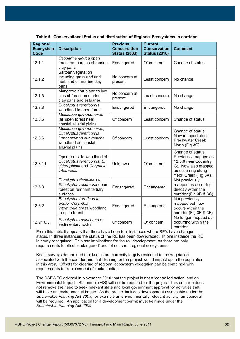
MBRL Project Change Report (50007372 V8), Transport and Main Roads, June 2011 32
Table 5 Conservational Status and distribution of Regional Ecosystems in corridor.
Regional Ecosystem Code
Description Previous Conservation Status (2003)
Current Conservation Status (2010)
Comment
12.1.1 Casuarina glauca open forest on margins of marine clay pans
Endangered Of concern Change of status
12.1.2
Saltpan vegetation including grassland and herbland on marine clay pans
No concern at present Least concern No change
12.1.3 Mangrove shrubland to low closed forest on marine clay pans and estuaries
No concern at present Least concern No change
12.3.3 Eucalyptus tereticornis woodland to open forest Endangered Endangered No change
12.3.5 Melaleuca quinquenervia tall open forest near coastal alluvial plains
Of concern Least concern Change of status
12.3.6
Melaleuca quinquenervia, Eucalyptus tereticornis, Lophostemon suaveolens woodland on coastal alluvial plains
Of concern Least concern
Change of status. Now mapped along Freshwater Creek North (Fig 3C).
12.3.11
Open-forest to woodland of Eucalyptus tereticornis, E. siderophloia and Corymbia intermedia.
Unknown Of concern
Change of status. Previously mapped as 12.3.6 near Coventry Ct. Now also mapped as occurring along Yebri Creek (Fig 3A).
12.5.3
Eucalyptus tindaliae +/- Eucalyptus racemosa open forest on remnant tertiary surfaces.
Endangered Endangered
Not previously mapped as occurring directly within the corridor (Fig 3B & 3C).
12.5.2
Eucalyptus tereticornis and/or Corymbia intermedia grass woodland to open forest
Endangered Endangered
Not previously mapped but now occurs within the corridor (Fig 3E & 3F).
12.9/10.3 Eucalyptus moluccana on sedimentary rocks Of concern Of concern
No longer mapped as occurring within the corridor.
From this table it appears that there have been four instances where RE’s have changed status. In three instances the status of the RE has been downgraded. In one instance the RE is newly recognised. This has implications for the rail development, as there are only requirements to offset ‘endangered’ and ‘of concern’ regional ecosystems. Koala surveys determined that koalas are currently largely restricted to the vegetation associated with the corridor and that clearing for the project would impact upon the population in this area. Offsets for clearing of regional ecosystem vegetation can be combined with requirements for replacement of koala habitat. The DSEWPC advised in November 2010 that the project is not a ‘controlled action’ and an Environmental Impacts Statement (EIS) will not be required for the project. This decision does not remove the need to seek relevant state and local government approval for activities that will have an environmental impact. As the project includes development assessable under the Sustainable Planning Act 2009, for example an environmentally relevant activity, an approval will be required. An application for a development permit must be made under the Sustainable Planning Act 2009.

MBRL Project Change Report (50007372 V8), Transport and Main Roads, June 2011 33
The EPBC Act provides a legal framework to protect and manage nationally and internationally important flora, fauna, ecological communities and heritage places—defined in the EPBC Act as matters of national environmental significance. The EPBC Act focuses Australian Government interests on the protection of matters of national environmental significance, with the States and Territories having responsibility for matters of State and local significance. The eight matters of national environmental significance to which the EPBC Act applies are: world heritage sites national heritage places wetlands of international importance (often called 'Ramsar' wetlands after the
international treaty under which such wetlands are listed) nationally threatened species migratory species Commonwealth marine areas the Great Barrier Reef Marine Park nuclear actions
When a project is likely to have a significant impact on any of the above matters (or if the activity affects or is undertaken on Commonwealth land, or if it is being carried out by a Commonwealth agency) then the proponent must make a referral to DSEWPC. It is up to proponents to determine whether a project is likely to have a significant impact on any of the matters of national significance and hence whether a referral is required. Note that the Federal Minister cannot intervene in a proposal if it has no significant impact on one of the eight matters of national environmental significance, even if there are other undesirable environmental impacts. The MBRL project has the potential to trigger the EPBC Act based on three of the above matters: the Moreton Bay Ramsar wetland; nationally threatened species that could potentially occur in the project area; and migratory species, which might visit Ramsar wetland adjacent to the project area. Environmental surveys and assessments to date have not determined that there will be a significant impact on matters of national significance, none the less, in adopting a precautionary approach, a referral has been made to DSEWPC. If DSEWPC determines that a significant impact on matters of national significance are likely as a result of the MBRL, then an EIS compliant with the EPBC Act will be required. Queensland has a bilateral agreement with the Commonwealth and therefore the State process for EIS’s satisfies the requirements of the EPBC Act, hence it is likely that the approval role would be passed from the Commonwealth back to the State.
6.4.2 Field studies yet to be completed
Water quality will require additional assessment once the final design has been prepared so as to mitigate the potential for impacts on local watercourses. A geotechnical investigation will also need to detail the properties of the geology and soils of the study area.
6.5 Cultural Heritage The Cultural Heritage Study completed in 2001 for the FIASR was reviewed and it was determined that the following areas had not previously been assessed: some creeks, which were in flood at the time of the study, the new rail alignment through the Amcor site, areas now proposed for roads, interchanges and park-and-ride stations. In addition to the areas not surveyed by the IAS, no representatives of the registered Aboriginal Party took part in the surveys.

MBRL Project Change Report (50007372 V8), Transport and Main Roads, June 2011 34
Additional cultural heritage work was subsequently undertaken in 2003 (Archaeo Cultural Heritage Services) and in September 2005 (Davies Heritage Consultants). These studies involved the Gubbi Gubbi, the traditional owners of the area. This resulted in several findings within and adjacent to the wider corridor area. The surveys highlighted, in particular, Freshwater Creek, Yebri Creek and the area between School Road and Dohles Rock Road. The reports suggest that the location of these cultural heritage sites in relation to the footprint of the rail corridor needs to be mapped and recommendations revisited. In general, the management process is to: Develop a monitoring program undertaken by an archaeologist and cultural heritage
indigenous field workers in significant sites during earthworks; and Should archaeological material be uncovered during excavation, then work should cease
until a proper archaeological examination of the material has been undertaken.
6.6 Land Acquisition The FIASR found that the proposed rail link from Petrie to Kippa-Ring could be accommodated within the existing preserved corridor. Subsequent further development of the concept design and changes to the rail alignment and active transport corridor to meet current Queensland Rail Design parameters has identified the need for acquisition of additional land outside the existing preserved corridor. In total of 10 land parcels are proposed to be fully acquired and 41 land parcels affected by partial resumptions along the length of the corridor. Final acquisition requirements will be finalised following further development of the design and detailed survey. The current overall land requirement plans are detailed in drawing no’s 171000 – 171020 of this report.

MBRL Project Change Report (50007372 V8), Transport and Main Roads, June 2011 35
7.0 Conclusions In the lead up to the 2010 federal election the incumbent Labor government announced that a re-elected Australian Government would invest $742 million, the Queensland Government $300 million and the Moreton Bay Regional Council $105 million to build a new rail line between Petrie and Kippa-Ring such that it was operational in 2016. A number of further investigations and refinements to the proposed MBRL have occurred since the completion of the Final Impact Assessment Report in 2003. The project has now progressed to the Business Case Development phase of the Queensland Government’s Project Assurance Framework which will include: Refinement of design and capital estimates, including risk analysis and assessment of
potential escalation and specific sensitivity analysis Further public consultation Refinement of land requirements, including off-set conditions Development of a full benefits analysis and realisation plan Further economic analysis incorporating detailed patronage/demand modelling Constructability analysis Environmental impact analysis Value capture analysis and staging Further investigation of potential revenue sources
7.1 Community & Operational Benefits The MBRL will have the following community benefits: A railway that connects new and existing resident populations to the broader public
transport network by fast, frequent and reliable trains will give better access for all to employment, education, social services, goods and recreation
Encouraging higher density transit supportive development around stations will enable more rail passengers to walk to the train
Construction of active transport opportunities along the corridor will enable more people to walk and cycle to their destination or to a station to continue the journey by train
High quality urban design and landscaping along the rail corridor will mitigate potential visual impacts and e impact on the local environment
Landscaping and planting themes will reinforce the character of the areas through which the rail corridor passes, ensuring connections with the surrounding areas and assisting in establishing a sense of place around the proposed stations
High quality urban design will be a catalyst for transit supportive development around the stations at Petrie, Kallangur, Murrumba Downs, Mango Hill, Kinsellas Road, Rothwell and Kippa-Ring
The changes to the design alignment meet Queensland Rail design parameters. Rail design changes include incorporating longer transitions to curves, increasing radii of curves where possible and incorporating straights or minimum horizontal radii of 2000 metres at station positions. The rail alignment is generally designed for 100km/h. The proposed MBRL will provide the following operational benefits: Providing appropriate bus connections to the new railway stations and Petrie Station will
encourage rail passengers to use public transport for the whole of their journey The railway may attract travellers away from private transport, relieve traffic congestion,
reduce the negative impacts of unsustainable private transport use on the local community and its health, the Australian economy, the local and global environment, and support State Government objectives

MBRL Project Change Report (50007372 V8), Transport and Main Roads, June 2011 36
7.2 Environmental Management The key changes which have occurred since the completion of the FIASR which influence the environmental considerations of the project are: The inclusion of new road and rail design elements for areas that had not been
previously surveyed for flora and fauna Increased footprint associated with the project created by the realignment of some
sections of the rail line and addition of road and cycleway elements Changes to Regional Ecosystem (RE) & Essential Habitat designation under Vegetation
Management Act 1999 Changes to the species conservation status of koala in South East Queensland under
the Nature Conservation Act 1992 and Conservation Plan. All native vegetation is now protected and requires a permit to be cleared. There are also possible offset triggers
The implementation of the Sustainable Planning Act 2009 (SPA) The introduction of the South East Queensland Koala Conservation State Planning
Regulatory Provision (SPRP) and State Planning Policy 2/10: Koala Conservation in South East Queensland (SPP) under the Sustainable Planning Act 2009 (SPA)
Potential Matters of National Environmental Significance (MNES) under Environment Protection and Biodiversity Conservation (EPBC) Act
The former Councils of Redcliffe City, Pine Rivers Shire and Caboolture Shire amalgamated to form Moreton Bay Regional Council in 2008. The current Pine Rivers Plan, the Redcliffe Planning Scheme, and the Mango Hill Infrastructure DCP (North Lakes) now regulate development in the area and for the time being remain valid; however at some point in the future they will be superseded by a new Moreton Bay Regional Council planning scheme to be prepared in accordance with the Sustainable Planning Act (2009)

MBRL Project Change Report (50007372 V8), Transport and Main Roads, June 2011 37
Appendix A Natural Environment Technical Report

MBRL Project Change Report (50007372 V8), Transport and Main Roads, June 2011 38
Appendix B Moreton Bay Rail Link Reference Design General Arrangement Drawings (Dr No’s 131000 – 131010 and 171000 - 171020)