project concept note€¦ · web viewquarterly progress reporting, midterm review, implementation...
TRANSCRIPT
Report No:
GEF PROJECT BRIEF
ON A
PROPOSED GRANT FROM THEGLOBAL ENVIRONMENT FACILITY TRUST FUND
IN THE AMOUNT OF USD $5 MILLION
TO THE
REPUBLIC OF EL SALVADOR
FOR A
PROTECTED Areas administration and Consolidation PROJECT
June 16, 2005
Environmentally and Socially Sustainable DevelopmentLatin America and the Caribbean RegionCentral America Country Management Unit
CURRENCY EQUIVALENTS(Exchange Rate Effective May 31, 2005)
Currency Unit = US$US$1 = US$1
FISCAL YEARJanuary 1 – December 31
ABBREVIATIONS AND ACRONYMSADESCO Community Development Association (Asociación del Desarrollo
Comunitario)AECI Spanish Agency for International Cooperation (Agencia Española de
Cooperación Internacional)CAS Country Assistance Strategy CBD Convention on Biological Diversity CEL Comisión Ejecutiva Hidroeléctrica del Río LempaCESSA El Salvador Cement Company (Cemento de El Salvador)CNR National Registry Center (Centro Nacional de Registros)COAL Local Advisory Council (Consejo Asesor Local)CONCULTURA National Council for Culture and Art (Consejo Nacional para la Cultura y el
Arte)CSJ Supreme Court of Justice (Corte Suprema de Justicia)EDD Disbursement Statements (Estados de Desembolsos)EMP Environmental Management PlanEU European UnionFMRs Financial Monitoring ReportsFONASA National Environmental Services Fund (Fondo Nacional de Servicios Ambientales)FONAVIPO National Popular Housing Fund (Fondo Nacional para la Vivienda Popular)FUSADES Salvadoran Foundation for Economic Development (Fundación Salvadoreña para el
Desarrollo Económico) DGPN General Directorate for Natural Patrimony (Dirección General de Patrimonio
Natural) GEF Global Environmental FacilityGOES Government of El Salvador (Gobierno de El Salvador)IBRD International Bank for Reconstruction and DevelopmentIDB Interamerican Development BankIGCN National Geographic and Cadastre Institute (Instituto Geográfico y Catastro
Nacional)EA Environmental AnalysisIFAC International Federation of Accountants ILO International Labor OrganizationILP Liberty and Progress Institute (Instituto Libertad y Progreso)IPDP Indigenous Peoples Development PlanISTA Salvadoran Institute for Agrarian Transformation (Instituto Salvadoreño de
Transformación Agraria)LAC Latin America and the Caribbean RegionIUCN International Union for Conservation of Nature and Natural Resources

LAP I Land Administration Project I (Phase I)LAP II Land Administration Project II (Phase II)M&E Monitoring and EvaluationMAG Ministry of Agriculture and Livestock (Ministerio de Agricultura y
Ganadería)MARN Ministry of Environment and Natural Resources (Ministerio de Medio
Ambiente y Recursos Naturales)MBC Mesoamerican Biological CorridorNBS National Biodiversity StrategyNGO Non-Governmental OrganizationNPAS Natural Protected Areas System (Sistema de Areas Naturales Protegidas)OP Operational ProgramOPAMSS San Salvador Metropolitan Area Planning Office (Oficina de Planificación
del Área Metropolitana de San Salvador)NPA Natural Protected AreaPACAP Protected Areas Consolidation and Administration ProjectPCU Project Coordination UnitPES Payment for Environmental ServicesPIU Project Implementation UnitPIP Project Implementation PlanPMIS Project Management Information SystemSIRyC Property Registry and Cadastre Information System (Sistema de Información
Registro y Catastro)SNET National Land Studies Service (Servicio Nacional de Estudios Territoriales)SOE Statement of ExpendituresSP Strategic PrioritySTP Technical Secretariat of the Presidency (Secretaría Técnica de la Presidencia)TOR Terms of ReferenceUACI Institutional Procurement and Contracting Unit (Unidad de Adquisiciones y
Contrataciones Institucional, CNR)UAP Unidad Administradora de Proyecto (Project Administration Unit, LAP I)UEP Unidad Ejecutora del Proyecto (Project Executing Unit, PACAP)UCP Unidad de Coordinación del Proyecto (Project Coordination Unit, LAP II)UFI Financial Institucional Unit of Ministry of Environment and Natural
Resources (Unidad Financiera Institucional)UNDP United Nations Development ProgramUNEP United Nations Environmental ProgramUPP LAP II Project Preparation Unit (Unidad de Preparación del Proyecto)USAID U.S. Agency for International Development
Vice President: Pamela CoxCountry Manager/Director: Jane Armitage
Sector Director: John RedwoodSector Manager: Abel Mejia
Task Team Leader: Frederic de Dinechin/Ann J. Glauber

EL SALVADORProtected Areas Consolidation and Administration Project
CONTENTS
Page
A. STRATEGIC CONTEXT AND RATIONALE......................................................................1
1. Country and sector issues....................................................................................................1
2. Rationale for Bank Involvement..........................................................................................3
3. Higher level objectives to which the project contributes.....................................................4
B. PROJECT DESCRIPTION..................................................................................................6
1. Lending instrument..............................................................................................................6
2. Project development objective.............................................................................................6
3. Project global environmental objective and key indicators.................................................6
4. Project components..............................................................................................................6
Table 1. Project Costs by Component and Subcomponent and Financing (million US$)......7
5. Lessons learned and reflected in the project design............................................................2
6. Alternatives considered and reasons for rejection...............................................................3
C. IMPLEMENTATION...........................................................................................................3
1. Partnership arrangements.....................................................................................................3
2. Institutional and implementation arrangements ..................................................................4
3. Monitoring and evaluation of outcomes/results..................................................................5
4. Sustainability and Replicability...........................................................................................6
5. Critical risks and possible controversial aspects.................................................................6
6. Loan/credit conditions and covenants.................................................................................7
D. APPRAISAL SUMMARY....................................................................................................7
1. Economic and financial analyses.........................................................................................7
2. Technical..............................................................................................................................8
3. Fiduciary..............................................................................................................................9
4. Social.................................................................................................................................10
5. Environment......................................................................................................................11
6. Safeguard policies..............................................................................................................11
7. Policy Exceptions and Readiness......................................................................................12

Annex 1: Country and Sector or Program Background..........................................................13
Country and sector issues..........................................................................................................13
Annex 2: Major Related Projects Financed by the Bank and/or other Agencies..................21
Annex 3: Results Framework and Monitoring.........................................................................23
Annex 4: Detailed Project Description0....................................................................................28
Annex 5: Project Costs................................................................................................................34
Annex 6: Components Project Cost Summary.........................................................................34
Annex 7: Financial Management and Disbursement Arrangements......................................39
Annex 7: Financial Management and Disbursement Arrangements......................................40
Annex 8: Procurement Arrangements.......................................................................................46
Annex 9: Economic and Financial Analysis..............................................................................51
Annex 11: Project Preparation and Supervision......................................................................83
Annex 12: Documents in the Project File..................................................................................85
Annex 13: Statement of Loans and Credits...............................................................................86
Annex 14: Country at a Glance..................................................................................................87
Annex 15: Incremental Cost Analysis........................................................................................89
Annex 16: STAP Roster Review.................................................................................................97
Annex 17: Pilot Site Selection...................................................................................................105
Annex 18: Protected Areas Tracking Tool..............................................................................110
Annex 19: Maps.........................................................................................................................130
Annex 20: Coordination between the El Salvador Protected Areas and Administration and El Salvador Environmental Services Projects..................................................................................131
A. STRATEGIC CONTEXT AND RATIONALE1. Country and sector issues
1. Biodiversity Significance. El Salvador supports a large diversity of species, comprising 1,477 vertebrate species (27% of which are threatened with extinction) of which 510 are birds (including 17 of the 23 species endemic to northern Central America), 140 reptiles and amphibians, as well as about 7,000 native plants (including more than 700 species of trees), and 800 species of butterflies–all in an area the size of Massachusetts. This high biodiversity1 – stemming from the country’s unique setting, highly volcanic and isolated from Central America’s Atlantic moist forests – persists even though El Salvador retains just 2% of its primary forest vegetation.
2. Threats to Biodiversity. The globally and regionally significant biodiversity sheltered within the natural protected areas system (Sistema de Areas Naturales Protegidas or NPAS) is severely threatened. El Salvador – the most densely populated country in Latin America –struggles with land-related issues, as population pressures have resulted in numerous encroachments into protected areas. These encroachments result in significant habitat destruction and deterioration, through the conversion of forests, pollution, and over-exploitation of natural resources, all of which stem in part from a lack of environmental awareness. Due to unchecked habitat destruction, it is likely that some of the smaller protected areas comprising NPAS no longer contain sufficient natural or near-natural habitats to warrant special protected status.
3. Conservation Efforts to Date. Notwithstanding the global, regional, and national significance of
its biodiversity resources, El Salvador has the least amount of land and water area formally protected of all the countries in the Mesoamerican Biodiversity Hotspot (around 75,500 ha or 4.6% of the national area).2,3 The NPAS aims to protect these remaining areas, but struggles due to a variety of challenges, explained more thoroughly in Annex 1. The NPAS includes 118 protected areas totaling approximately 40,000 ha, as well as an additional 35,500 ha of mangrove4 – all under the jurisdiction of the Ministry of Environment and Natural Resources (MARN). Despite the large number of protected areas (PAs), their average size is just 850 ha,5 and virtually no PAs have any managed buffer zone, comprising only the core area.6 Of these lands, only about 7,000 ha, or 0.3% are legally declared and demarcated, and no areas are fully consolidated (demarcated, titled and under a functioning management plan). Thus, the majority of the NPAS constitutes “parks on paper”, with inadequate legal framework and physical protection.
4. The lack of clear protected area boundaries is further complicated by the confusing institutional framework governing these lands. As described in Annex 1, the original PA system was created by
1 El Salvador is part of the Mesoamerican Biodiversity Hotspot, as identified by the Critical Ecosystem Partnership Fund2 According to the Ecosystem Profile: Southern Region, Mesoamerica (Critical Ecosystem Partnership Fund) this is significantly behind Costa Rica (with 24% of the land protected), Guatemala (23%), Nicaragua (17%), Panama (17%), Belize (10%), and Honduras (8%).3 More than 1.6% of El Salvador’s land was officially designated as protected area in the newly approved protected areas law (Ley de Areas Protegidas, February 2005). These lands include all mangroves in the country, which were considered national forests outside of the protected areas system prior to the passage of the law.4 According to the Wetlands Inventory (Inventario de Humedales), MARN 2004.5 Protected areas range in size from 1.9 (Colomita) to 31,699 ha (Bahia de Jiquilisco).6 Only one park, El Imposible, includes a legally defined buffer zone (area de veda).
1

the Ministry of Agriculture and Animal Husbandry (MAG), who had declared 47 PAs by 1976. The 1973 forest law (Ley Forestal) declared mangroves – which were not considered part of the NPAS – as natural resources of the state. The agrarian reform process, begun in 1980 to enable transfer from large landowners to the poor, expropriated 411,151 ha – about 20% of the country –including 22,000 ha of potential PAs to the jurisdiction of the Salvadoran Agrarian Reform Institute (ISTA). When the NPAS was first proposed in 1990, it included 118 areas under MAG’s jurisdiction – despite the fact that most of those lands officially pertained to ISTA, municipalities and private landholders, and had been selected based on unclear criteria. The first national environmental law (Ley de Medio Ambiente; 1998) created MARN and transferred to them responsibility for the NPAS. In the 2002 Forestry Law, mangrove forests passed to MARN’s jurisdiction. Today, MARN remains responsible for the oversight of the entire NPAS,7 but has legal title over only 7,072 ha. Consequently, the vast majority of the lands that theoretically could be part of the NPAS have unresolved legal status.
5. Conservation Needs and Opportunities. In addition to the lack of clarity regarding the physical boundaries of the NPAS, the quality and type of environmental goods and services and biodiversity resources protected are not well known, making management and prioritization difficult. Given the limited financial resources available, a refinement of NPAS National Strategy,8 including a prioritization of efforts, is much needed. Also needed is greater stakeholder consensus around this strategy and the broader importance of conservation more broadly.
6. MARN developed the NPAS Strategy to prioritize 15 Conservation Areas (CA) comprising most of the country’s PAs, building upon the biological corridor concept. The specific approach to consolidate these CAs must target the primary threats to biodiversity, including natural habitat loss and degradation (NBSAP, 2000). Moreover, the consolidation of these areas should be done with the understanding and support of a wide range of local of stakeholders, the majority of whom were not initially involved in the development of the protected areas strategy.
7. Presently, MARN lacks the legal tools to adequately manage the NPAS. While MARN is legally responsible to defend the biodiversity within protected areas, the majority of which have human inhabitants, tested instruments for adequately consolidating those areas do not currently exist. In fact, El Salvador has no experience in definitively addressing human settlements in protected areas. A new Protected Areas law, approved in February 2005, represents an important step toward the consolidation and sustainable management of the country’s protected areas system (see Annex 1), the regulations for which need to be developed in the near future.
8. An important legal distinction exists between mangroves9 and natural protected areas (NPAs) with regards to land rights. Both mangroves and NPAs
7 Today, the NPAS consists of 118 natural protected areas plus 35,500 ha of mangroves, managed under eight management categories. These include natural reserve, national park, natural monument, habitat/species management area, protected landscape or seashore, protected area with managed resources, and protection/restoration area and ecological park.8 Estrategia Nacional para las Areas Naturales Protegidas y Corredores Biologicos (2005).9 As governed under the 2002 forest law and the 2005 protected areas law.
2
are considered “protected areas”,10 wherein private or public entities are allowed to carry out activities that are compatible with the area’s conservation, upon authorization of MARN. Mangroves, unlike NPAs, are managed as sustainable use areas,11 wherein residents are eligible to receive land rights in the form of concessions, subject to uses defined in management plans. In NPAs, the new Law does not allow new human settlements once the areas have been established as protected,12 with the exception of the natural reserve category where no human settlements whatsoever are permitted. Thus, a methodology is needed to identify illegal and legal settlements within PAs, and regularize the latter.
9. While MARN has the mandate and political will to take the necessary actions to consolidate the NPAS, it is severely resource constrained, both in financial and human capital terms. For example, the headquarters-based Director of the Natural Patrimony mangrove section is the only full-time employee working on mangrove conservation in the country.
10. An additional challenge for the NPAS relates to clarifying land tenure. In all but three PAs, lands are not titled in the name of MARN,13 but remain in legal limbo among other state agencies, municipalities and even private individuals. This lack of tenure clarity in unoccupied areas has in part led to invasions of state-owned lands (most of which are protected areas). Most of these invasions are by the rural poor, who have limited production and livelihood alternatives.
11. The Government of El Salvador’s (GOES) Land Administration Program (LAP), currently entering its second phase with IBRD support, is systematically assessing land tenure nationwide. These efforts have important implications for the NPAS, as LAP’s activities include extensive geographic data collection (satellite images, overflights, etc.) and determination of land rights.
12. Despite the significant threats to the NPAS, the culmination of several events has provided a unique opportunity to address these issues. First, the protected areas law, on hold for 25 years, was passed in February 2005. This law provides MARN with the legal framework necessary to oversee these lands, as well as significant political capital. Secondly, the LAP is mid-way through completing the cadastre and registry of all lands in the country – which has been deemed a priority effort for the new Government. During the preparation of the second phase of the IBRD-funded project, the GOES identified the importance of resolving tenure conflicts in protected area lands, without which the LAP’s efforts to address all of El Salvador’s lands will fall short. The LAP’s implementing agency, CNR, has taken significant efforts to involve MARN in that project, including a component for demarcation of three (as yet unidentified) protected areas. While the participation of MARN in the LAP has historically been limited by MARN’s capacity, by developing a partially blended
10 Equivalent to IUCN Category II.11 Equivalent to IUCN Category VI.12The legal establishment of a protected area requires that it be demarcated, have secure title, and be decreed (via executive decree). 13 There are 18 legal steps required to transfer land titles from ISTA to MARN. This complicated process has led to significant delays in consolidating many protected areas.
3
operation, GEF funds will catalyze the consolidation of the national protected areas system by exploiting the significant opportunity presented by the LAP.
2. Rationale for Bank Involvement
13. The proposed Protected Areas Consolidation and Administration Project (PACAP) evolved from the recognition that the LAP provided an important and time-limited window of opportunity for advancing MARN’s biodiversity agenda. The wealth of detailed, land-related data collected for land administration activities across the country could serve as a base for advancing large-scale conservation, including consolidating protected areas and developing a strategy for addressing illegal settlements within those areas. Furthermore, the massive data collection and maintenance activities of the LAP could, through the PACAP, be linked to and formatted for MARN’s information catalog and management capacity, thereby addressing key information needs for the protected areas system. Moreover, the LAP could promote MARN’s agenda of legally consolidating key conservation areas and other protected areas under the protected areas system. The GOES expressed strong interest in working with MARN, CNR (the LAP implementing agency) and the Bank to take advantage of the conservation opportunity presented by the LAP.
14. The GOES formally asked for World Bank assistance for preparation of the proposed project and sought GEF assistance in a letter sent by the Technical Secretary of the Presidency on February 16, 2005. This further corroborated the endorsement of the GEF Focal Point on September 29, 2004.
15. In addition to the unique enabling environment presented by the LAP, the GOES would greatly benefit from the World Bank’s competitive advantage in the region’s land issues, with over 20 years of experience in land policies and operations and US$900 million (M) invested and committed in land programs in Central and South America. Given the growing body of knowledge regarding the conservation significance of land administration projects, the most recent of these operations include specific environmentally focused components and/or activities. The GOES would also benefit from the World Bank’s substantial experience in GEF activities, including GEF operations in most Central American countries and the Mesoamerican Biological Corridor program.
16. Finally, the World Bank has discussed the project with other donors interested in coordinating their efforts, including the IDB, the Spanish Agency for International Cooperation (AECI), and UNEP. The proposed project will build upon ongoing related activities, as described in Section C.1
17. GEF support is warranted because the project would: i) conserve globally and regionally significant biodiversity, including some critically endangered endemic species and ecosystems; ii) enhance the Salvadoran sections of the MBC, and the overall NPAS; iii) support the piloting of consolidation of two protected areas to develop a strategy for addressing key issues affecting the majority of Salvadoran protected areas; iv) capture lessons learned from the piloting exercise for application in future scaling up and replication to other parts of the country, as well as a potential model for other countries in the
4

region; and (v) complement the GEF-supported Payment for Environmental Services Project (PES; see Annex 20). Without the GEF increment, local benefits alone have, to date, been unable to secure conservation of the protected areas system.
3. Higher level objectives to which the project contributes
18. The project directly contributes to the GOES agenda described in the “País Seguro” Program, which identifies as key, actions directed at enhancing the environment for future generations, and ensuring that national development is environmentally and socially sustainable. Specifically, this national strategy includes actions to strengthen programs aimed at restoring mangroves and sustainably manage protected areas; strengthen the institutional and legal framework for the environment sector; and increase awareness on environmental protection and natural resource use.
19. The project also directly responds to El Salvador’s biodiversity priorities as per the 1999 National Strategy on Biological Diversity (NBS; GEF/UNDP/MARN). The NBS establishes as priority actions the implementation of a biodiversity information system and the consolidation of the NPAS; the redefinition of institutional responsibilities for conservation activities; and the strengthening of national, institutional and human resource capacities in biodiversity conservation. The project also strongly supports the draft Protected Areas Strategy (2005), and the proposed National Land Use Development Plan (Plan Nacional de Ordenamiento y Desarrollo Territorial; PNODT 2003), which propose to create 15 CAs designed to embed the severely fragmented NPAS within a larger landscape context. Moreover the project strongly sustains the new PA Law, which provides the basic legal framework necessary to consolidate the NPAS.
20. The new FY05-08Country Assistance Strategy (CAS) for El Salvador, supports the three main pillars of the Government’s agenda: (i) accelerating broad-based equitable growth and increasing employment; (ii) improving equity by building human capital and expanding access to basic infrastructure, assets, and markets; and (iii) enhancing security and reducing vulnerability. The CAS recognizes the need to consolidate the environmental sector’s regulatory and legal framework and to support measures aimed at watershed recovery, reforestation, ecosystem management, and biodiversity conservation. The CAS further notes that vulnerability to natural disasters is closely linked to rural poverty and that low productivity and high population pressures have depleted natural resources, caused soil erosion and land degradation, led to loss of habitat, biodiversity, and natural forests, and exacerbated problems in water management and conservation. The project will contribute to the third objective of the CAS; by supporting the consolidation of the NPAS, along with the strengthening of its institutional and legal framework, the project will directly contribute to addressing biodiversity conservation and the sustainable use of resources, and to reducing environmental degradation and therefore vulnerability to natural disaster.
GEF Operational Program Goal
5
21. In the broadest sense, the project will contribute to all four GEF Operational Programs (OPs) by strengthening the Salvadoran protected area system, which includes arid and semi-arid, coastal and marine, forest and mountain ecosystems. Through the targeted interventions that will consolidate two protected areas, the project specifically supports OP 2 (Coastal and Marine Ecosystems) and OP 3 (Forest Ecosystems). Activities in the Bahia de Jiquilisco Conservation Area will contribute to the conservation and sustainable use of El Salvador’s largest extension of mangrove forests, while in the Lake Guija San Diego-La Barra Protected Area Complex the project will support the conservation and sustainable use of the freshwater biodiversity of Lake Guija, and the largest dry tropical forest area in El Salvador, an eco-region identified as bio-regionally outstanding and a high priority at a regional scale14 (see Annex 17).
22. The project supports the objective of Strategic Priority (SP) 1 “Catalyzing Sustainability of Protected Areas” through a comprehensive intervention that will: a) strengthen the NPAS, through updating the national PA strategy and improving the relevant legal and institutional framework, as well as building MARN’s capacity to oversee the system; b) improve the sustainability of the NPAS through capitalizing upon the partially blended LAP II to collect and systematize environmental data, and establish a PA monitoring and evaluation system; and c) pilot the consolidation of two representative PAs for subsequent replication throughout the NPAS.
23. By piloting the consolidation of two PAs and heavily emphasizing learning and adaptive management, the project would support SP 4 (Generation and Dissemination of Best Practices), by integrating project results into the redefinition of the National Protected Areas Policy and disseminating them at the national, regional, and global level.
Link with IBRD Loan
24. The proposed project is partially blended with the Second Land Administration Project (P086953), approved by the Board in March 2005. This $40.2M project to the National Registry Center (CNR) is completing the cadastre and registry of all lands within El Salvador. Toward this aim, the LAP II is collecting high resolution spatial and tenure data, with direct applications to conservation and protected areas management. While the LAP II will resolve tenure for all private lands, it cannot do the same for all public lands, including PAs and mangroves, as CNR does not have the mandate to do so. Thus, the LAP II will define only the gross boundaries of PAs and mangroves given the absence of defined procedures and limited capacity of MARN. Were it not for the proposed project, the significant conservation opportunity presented by the LAP would be lost.
25. The proposed project would capitalize upon the opportunity provided by the LAP II, using GEF funds to enable MARN’s development of a strategy to consolidate PAs and “freeze” the current human population distribution in
14 A Conservation Assessment of the Terrestrial Ecoregions of Latin America and the Caribbean, E. Dinnerstein, et al., 1995.
6

those areas, limit allowable activities on critical biodiversity areas, develop a model to promote sustainable development, and participate with CNR in the delineation of all 118 PAs and mangroves in El Salvador. Moreover, the proposed project would influence IBRD funds (LAP II) to contribute to conservation of globally, regionally and nationally significant biodiversity, through: (i) financing the collection of detailed tenure information for PAs and mangroves in the linked registry-cadastre system (SIRyC) maintained and regularly updated by CNR, (ii) targeting the LAP II to demarcate three priority PAs (determined by MARN), and (iii) taking advantage of a key political moment to mainstream conservation into the broader land agenda. Moreover, the project helps secure additional CNR co-financing through ensuring their participation in delineating all PAs and mangroves (currently outside of the scope of the LAP).
B. PROJECT DESCRIPTION1. Lending instrument
26. The proposed project is a SIL, funded by a full-sized US$5 million (M) GEF grant. It is partially blended with the LAP II IBRD loan (P086953).
2. Project development objective
27. The Project Development Objective of the partially blended LAP II is to improve land tenure security and land transactions by providing efficient, equitable, and accessible land administration services, thereby facilitating better land-related investments and more productive and environmentally sustainable land use.
3. Project global environmental objective and key indicators
28. The Project Global Environmental Objective is: to conserve El Salvador’s globally significant biodiversity by strengthening the national protected areas and consolidation two priority protected areas.
GEO outcome indicators: National protected areas system strategy improved and pilot-tested. Two pilot protected areas consolidated and effectively managed (Tracking tool score of at least
40 for the 35,600 ha in Bahia de Jiquilisco and 1,917 ha in Lago Guija Complex San Diego-La Barra).
Biodiversity benefits established in at least 37,517 ha:o For Bahia de Jiquilisco PA at least 35,600 ha of mangrove or associated humid forest coverage
that will have zero deforestation compared to baseline o For the Lago Guija Complex San Diego-La Barra at least 1,917 ha of dry tropical forest or
associated riparian forest that will have zero deforestation compared to baseline Replicable model to protect biodiversity for use at national and regional level.
4. Project components
29. The project will have three components: (i) Strengthening of the National Protected Areas System (NPAS); (ii) Consolidation and management of two
7
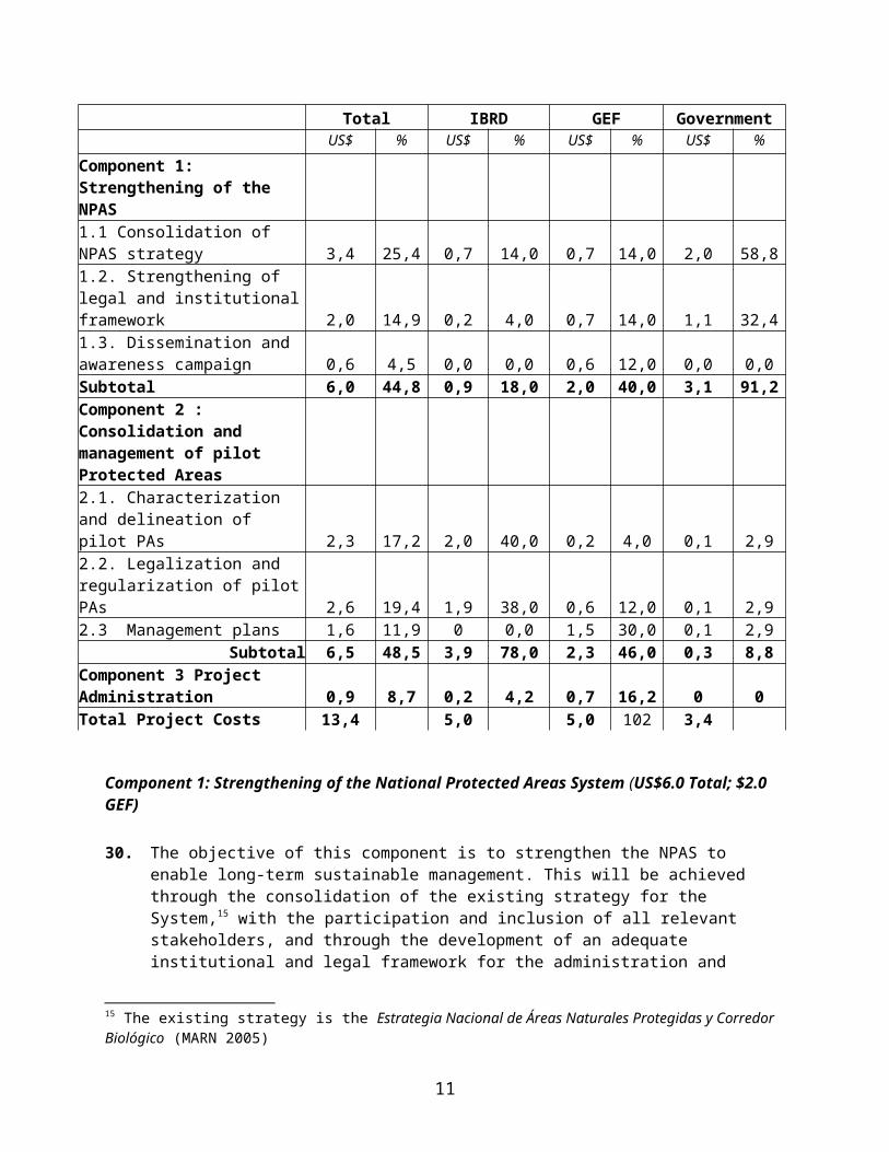
pilot protected areas; and (iii) Project Administration. The costs of each component and subcomponent are summarized in Table 1.
Table 1. Project Costs by Component and Subcomponent and Financing (million US$) Total IBRD GEF Government
US$ % US$ % US$ % US$ %
Component 1: Strengthening of the NPAS 1.1 Consolidation of NPAS strategy 3,4 25,4 0,7 14,0 0,7 14,0 2,0 58,81.2. Strengthening of legal and institutional framework
2,0 14,9 0,2 4,0 0,7 14,0 1,1 32,41.3. Dissemination and awareness campaign 0,6 4,5 0,0 0,0 0,6 12,0 0,0 0,0Subtotal 6,0 44,8 0,9 18,0 2,0 40,0 3,1 91,2Component 2 : Consolidation and management of pilot Protected Areas 2.1. Characterization and delineation of pilot PAs 2,3 17,2 2,0 40,0 0,2 4,0 0,1 2,92.2. Legalization and regularization of pilot PAs 2,6 19,4 1,9 38,0 0,6 12,0 0,1 2,92.3 Management plans 1,6 11,9 0 0,0 1,5 30,0 0,1 2,9
Subtotal 6,5 48,5 3,9 78,0 2,3 46,0 0,3 8,8Component 3 Project Administration 0,9 8,7 0,2 4,2 0,7 16,2 0 0Total Project Costs 13,4 5,0 5,0 102 3,4
Component 1: Strengthening of the National Protected Areas System (US$6.0 Total; $2.0 GEF) 30. The objective of this component is to strengthen the NPAS to enable long-term sustainable
management. This will be achieved through the consolidation of the existing strategy for the System,15 with the participation and inclusion of all relevant stakeholders, and through the development of an adequate institutional and legal framework for the administration and management of the NPAS. This component is divided into the following subcomponents:
1-1: Consolidation of NPAS strategy1.2: Strengthening of the legal and institutional frameworks1-3: Public dissemination and awareness campaign
Key outputs of this component include: i) completion of a rationalization study of the NPAS; ii) delineation of at least 40 protected areas and mangroves; iii) approved “Reglamento” for the
15 The existing strategy is the Estrategia Nacional de Áreas Naturales Protegidas y Corredor Biológico (MARN 2005)
8
implementation of the new Protected Areas Law iv) draft inter-institutional agreements for operating the NPAS; and v) at least 10% of national population aware of new protected areas law and reglamento.
Component 2: Consolidation and Management of Pilot Protected Areas (US$6.5 Total; $2.3 GEF)
31. The component aims to develop, test, and finalize a methodology for the consolidation of two pilot Protected Areas, including their delineation, demarcation, regularization, and to develop and implement management plans for their sustainable use. The results of this component will feed into the consolidation of NPAS Strategy (component 1). The component is divided into the following sub-components:
2-1: Characterization and delineation of pilot PAs.2-2: Legalization and regularization of pilot PAs;2-3: Management plans for pilot PAs.
32. Key outputs of this component include: i) Socio-economic study, environmental information, cadastre and registry for each pilot protected area linked with CNR database; ii) demarcation of the pilot PAs; iii) executive decrees to establish pilot PAs; and iv) number of beneficiaries associated with implementation of updated management plans for two pilot areas.
Component 3: Project Administration (US$0.9 Total; $0.7 GEF)33. This component will focus on project management mechanisms including
project coordination, planning, and monitoring and evaluation (M&E). The M&E system will be based on the existing system developed under the LAP II to coordinate and supervise the project. The existing system will be strengthened to include key indicators to measure GEF project performance. The project will finance administrative, supervision, and M&E costs, including M&E surveys.
5. Lessons learned and reflected in the project design
34. The key lessons learned from other GEF and non-GEF projects (listed in Annex 2), were taken into consideration in the design of the proposed project. These lessons include:
35. Lack of enabling legal and regulatory frameworks together with significant constraints in human resource skills and institutional capacity have resulted in limited sustainability of operations targeting conservation and sustainable use of biodiversity in El Salvador. Long-term effects have been further impinged upon by lack of inter-institutional coordination, poor planning, and overall ad hoc approaches with narrow sectoral and institutional focuses. Overlapping issues, jurisdictions, and impacts of sustainable ecosystem management require an adequate institutional and legal framework to guarantee the necessary interagency coordination and interaction.
9

36. Large-scale land administration activities present an important conservation opportunity. Extensive regional experience has shown that land administration projects present an important conservation opportunity. Land projects directly contribute to conservation through the clarification of land rights, legally and physically, in and around protected areas, as well as the collection of environmental and geographic information. Indirectly, land projects can be powerful instruments to further the conservation agenda, through providing both reduced incentives for encroachment and occupation and a tool to help strengthen protected areas systems. Specifically, PA systems can benefit by: capitalizing upon the information collected to clarify tenure, demarcate and consolidate PAs; developing strategies based on this information to “freeze” settlements in and near PAs, and to clarify use norms for those settlements; strengthening PA agencies through land administration activities; involving other stakeholders in decisions about those lands; and supporting conservation-friendly productive investments. Moreover, by exploiting the opportunity provided by land administration efforts, where governments must address difficult land-related issues, conservation can be included at the core of the development agenda, building upon the strong political commitment to leverage scarce funds for protected areas, update land-related laws and institutions, and bring stakeholders together.
37. Highly fragmented protected areas systems are difficult to efficiently manage . El Salvador’s PA strategy has struggled with a highly fragmented system. Relatively small, highly threatened protected areas are less able to adequately preserve natural resources, as many threatened species require relatively large habitat expanses, linked by corridors. Additionally, fragmented areas require extensive monitoring and management, with significant budget implications. By promoting the establishment of CAs, in which PA nuclei are linked by biodiversity friendly corridors, the project aims to resolve one of the key root causes of biodiversity degradation in El Salvador.
38. Private lands can support biodiversity friendly habitat . As the GEF-supported “Promotion of Biodiversity Conservation within Coffee Landscapes” found, biodiversity friendly agricultural production systems can be economically, environmentally and socially sustainable. By creating incentives for encouraging production systems that are compatible with conservation objectives, private lands in protected area buffer zones can contribute to biodiversity.
39. Broad stakeholder inclusion is key to conservation success. Buy-in of key stakeholders is critical to protected area viability. One factor that has hindered El Salvador’s PA system is the inadequate involvement of all necessary stakeholders (private and public sector, local residents, NGOs.).
6. Alternatives considered and reasons for rejection
40. The main alternatives considered and rejected were:
1. No project, as the existing threats to biodiversity would continue to expand, resulting in a significant decrease in extent and quality of globally and regionally significant biodiversity.
10
2. A protected areas project focused only on MARN, without any link to CNR and the LAP II, as it would represent a significant missed opportunity to capitalize upon the information collected, and enabling political environment created, by the LAP II.
3. A project focused on the management of individual protected areas, without efforts to consolidate the overall NPAS, as it would not allow replicability of the lessons learned, nor promote long-term sustainability of the system.
C. IMPLEMENTATION1. Partnership arrangements
41. Project preparation, implementation and sustainability depends upon the establishment of a number of partnerships, the most important one of which links MARN, the PA agency, and CNR, the cadastre and registry agency, beginning with the close collaboration between the PACAP preparation team and the LAP II implementation team(UAP). This partnership was formalized by a letter of understanding for preparation activities, and will be further strengthened through a legal agreement prior to effectiveness. This cooperation benefits the PACAP through co-financing provided by LAP II, collaboration with on-the-ground activities involving information collection, delimitation and demarcation of PAs and information dissemination. Additionally, this partnership benefits the LAP II, as MARN has come to a deeper understanding of the objectives and implementation mechanisms of the loan’s activities, and as a result has begun to participate in areas critical to the loan’s success but outside of CNR’s mandate.
42. Other key partnerships established during project preparation, which should continue to flourish during implementation are: (i) coordination with the ESP16
and Fund (FONASA), managed by MARN with GEF and World Bank support, which aims to support the development of a PES system in pilot watersheds (including one of PACAP’s pilot areas), and its future replication in other areas (see Annex 20); (ii) coordination with the Mesoamerican Biological Corridor (MBC) project, implemented by UNDP and managed under MARN with World Bank, GTZ, WWF and GEF support, working to consolidate El Salvador’s portion of the MBC; (iii) partnership with AECI, working on the Integrated Management of Mangroves and Coastal Wetlands project, which includes one of the PACAP’s priority pilot areas; (iv) partnerships with NGOs and Community Assocations (ADESCOs) actively working in the pilot PAs, whose participation will be critical to project success and information dissemination; and (v) partnerships with universities and research institutions, for definition of quantitative environmental baseline and related studies.
43. In addition to the LAP II, three other projects deserve special reference: Integrated Management of Trinational Montecristo Park (GEF FSP under preparation/IDB), Sustainable Land Management in Watersheds Draining to
16 The Environmental Services Project (ESP) provides incentives to landowners living in protected area buffer zones and other environmentally sensitive lands to sustainably manage their lands. The ESP and PACAP projects represent two complementary strategies to be undertaken by MARN, both of which pilot test mechanisms to support MARN’s Protected Areas Strategy (2005). Specifically, these projects support MARN in the creation of 15 Conservation Areas, by addressing the nuclei (natural protected areas), through the proposed project, and the buffer zones (adjacent private lands), jointly through the ESP and the proposed project (see Annex 20).
11

the Gulf of Fonseca (GEF MSP under preparation/UNEP) and AECI’s Sustainable Management of the Bahía de Jiquilisco, El Jocotal, and Los Volcanoes Protected Areas; all three projects support complementary actions in areas not selected as priority under the proposed project. The project preparation unit has coordinated with these three projects, only one of which (AECI) shares intervention areas.17 Other GEF-supported projects have also been identified as relevant to the proposed projects, which are summarized in Annex 2.
2. Institutional and implementation arrangements (see Annex 6)
44. MARN will execute the project and have responsibility for all fiduciary aspects, monitoring and evaluation (M&E), and most technical aspects.
45. CNR will be responsible for limited technical activities (related to LAP II – delineation, demarcation, registration), as well as training and capacity building for project fiduciary aspects and M&E. CNR and MARN will sign an agreement clarifying respective roles and responsibilities with regards to jointly implemented activities.
46. Direct implementation will be provided by a small Project Implementation Unit (Unidad Ejecutora del Proyecto; UEP or PIU) within MARN’s Department of Natural Resources (DGNP). The UEP will ensure overall project coordination with participating agencies and the World Bank. Specifically, the UEP will execute most activities in Components 1, 2, and 3 with support from CNR through the LAP II-UCP. In particular, CNR will provide technical assistance to MARN regarding financial management and procurement, through training and advisory services.18 At the central level, the UEP will include a project coordinator, an administrative assistant, an accountant, a procurement specialist, and an M&E expert. In each of the two pilot protected areas, the UEP will comprise a technical coordinator, an administrative assistant, up to three technical specialists (who will be responsible for management plan development and implementation), and several park guards (the number of which will be defined prior to effectiveness). The UEP will be temporary, with all its functions and activities to be assumed by MARN starting year 5 of the project.
17 The AECI-financed project aims to improve the management of wetlands along El Salvador’s eastern Pacific coast, including the Bahia de Jiquilisco, through the development and implementation of management plans. That project strengthens national policies for wetland protection and sustainable use, toward which it has achieved the identification, registry, mapping and measurement of 90% of the nation’s wetlands. Specifically, in the Bahia de Jiquilisco area the AECI project has developed a management plan for the bay’s wetlands (which form part, but not all, of the pilot area included in the proposed project), and applied for official RAMSAR designation. The proposed project would work with AECI to update this management plan, including remnant humid forest patches along with the bay’s wetlands, as well as addressing tenure of eligible residents. Moreover, the proposed project and the AECI Project would work together to consolidate this area through joint financing of this updated management plan: AECI would construct two park administrative offices, and finance existing park guards, while the PACAP would finance the park administrator and new park guards, and both projects would work together to support ecotourism, promote sustainable use of natural resources by local residents, and implement M&E.
18 The arrangements for ensure adequate fiduciary capacity is established within MARN during year one of project execution are expected to benefit the Environmental Services project, which starts in 2007 (year two of the proposed project). By January 2007, MARN’s UFI unit, which will be jointly handling fiduciary aspects of both GEF-financed projects, would have at least one year of experience successfully handling World Bank administrative requirements.
12
47. As the project supports a co-management approach for PAs, other actors, such as municipalities, community associations, including the local Protected Areas Committees (COAL), NGOs, universities, and direct beneficiaries will be involved in its implementation, especially at the local level. The project will strengthen the capacity of these entities, as well as MARN, to support and participate in the development and management of the NPAS. MARN will coordinate the various participating agencies by means of agreements that will become effective, to the World Bank’s satisfaction, before the corresponding activities begin.
48. Given the pilot nature of the project and the importance of building multi-sector alliances, an advisory committee will also be formed, which will function under the coordination of MARN-DGNP. This group will include representatives from the UEP, MAG, ISTA, CNR, CONAMA, municipalities, the private sector, and a local representative from each of the pilot areas. The group, which would be convened by MARN at least once a month, would provide a strategic decision-making mechanism related to improvements to the NPAS Strategy, PA consolidation, and the results assessment for each of the pilot areas.
3. Monitoring and evaluation of outcomes/results
49. M&E is a central to the project objectives, as the project – a pilot – emphasizes adaptive management, by which M&E results will be used to improve project design during implementation. The project M&E system will take advantage of the newly designed automated LAP II system, which tracks expenditures and progress for both administrative (procurement, flow of funds) and technical (project performance linked to outcome indicators) aspects. The LAP II M&E system will serve as the basis for the PACAP’s M&E system, which will be strengthened to include output indicators for the three project components.
50. As in the LAP II’s system, the project M&E system will assure the project’s efficient execution, and will be closely linked to the Results Framework. It will include a subsystem to allow project administrative and financial monitoring and to generate reports required by the World Bank’s administrative, financial, and procurement sections. It will have another subsystem that will allow the generation of three types of indicators: (a) indicators for physical execution (outputs) and financial execution (inputs); (b) results indicators for each component; and (c) outcome indicators of project global environment objectives (GEO).
51. A baseline will be utilized for GEO outcome indicators. This will be updated in years 2.5 and 5 of the project. The primary sources of data for the other indicators will be: (i) information from CNR and MARN; (ii) field reports by contractors and UEP supervision reports, as well as those by other entities associated with the project; (iii) CNR’s Registry and Cadastre Information System (SIRyC); and (iv) results from participatory field monitoring, undertaken by local beneficiaries under the supervision of the UEP.
13
52. The overall responsibility for the M&E system will be with the UEP, who will oversee ongoing consolidation of data obtained from activities carried out during PACAP execution and the maintenance of the web-based system. The M&E System will comply with the financial, procurement, administrative, monitoring and evaluation characteristics required by the World Bank as well as those of the Technical Secretariat of the Republic of El Salvador.
4. Sustainability and Replicability
53. The project is highly country-driven. It evolved during preparation of the LAP II, a participatory process involving extensive consultation with multi-sectoral stakeholders, during which it was recognized that the LAP provided a time-limited window of opportunity for advancing the country’s PA system. Following these consultations, MARN requested GEF support to work with CNR and the Bank to take advantage of the strong conservation opportunity presented by the LAP.
54. The project addresses long-term sustainability of the overall PA system as well as that of the individual pilot PAs. Current NPAS budgeting is not adequate, and reflects neither actual expenditures nor those necessary to address long-term challenges. The PACAP specifically addresses this issue in Component 1 through strengthening MARN’s institutional capacity to plan for long-term expenditures necessary to sustain the system, evaluating alternative financing sources, and building their capacity to manage the system. Additional project activities further support MARN’s institutional sustainability, such as the development of a PA M&E system linked to CNRs databases, a unified PA registry, development of partnerships with CNR and other institutions key to NPAS management, and the provision of PES incentives to private land owners. Regarding the sustainability of individual pilot PAs, the project will test mechanisms to capture alternate funding sources (such as establishing concessions for persons with legal but irregular titles in or adjacent to mangroves and protected areas, charging user fees, etc.), the specific goal of which will be to contribute to financing the recurrent costs of those areas. As in most PA systems world-wide, it is expected that the budget shortfall for individual PAs would be covered by annual appropriations, the costs of which will be evaluated during project implementation.
55. The project results will be replicable at two levels. First, at the individual PA level, the project is developing and testing a strategy to consolidate two pilot protected areas (one PA complex, including several individual PA, and the other a mangrove complex, including mangroves and individual PAs). These pilot areas were specifically chosen to represent conditions faced by most other PAs in the NPAS (see Annex 17). Thus, the lessons learned from this effort can be applied to other PAs in the future. Secondly, at the system level, the project is taking the lessons learned from the two pilot areas to translate them into a national protected areas strategy, along with the required legal and institutional frameworks to enable its implementation and long-term sustainability. One of the activities supported through the project is the analysis of the resources (both human and financial) needed to implement this
14
strategy and associated action plan, including the role of stakeholders at the local and national levels.
5. Critical risks and possible controversial aspects
Risks Mitigation Measures Risk RangeLack of participation by key stakeholders at local level.
Design and implement intensive communication campaign, based on results from socio-economic census.
Capacity building of key stakeholder groups financed through project.
Modest
Poor coordination and lack of participation by national and local agencies and weakness of various agencies, especially municipalities, with regard to human resources and equipment.
Establish advisory committee, including representatives from MAG, ISTA, CNR, CONAMA, municipalities, the private sector, and local communities.
Capacity building of COALs and ADESCOs at local level financed through project.
Training of key agencies and institutions financed through project.
Modest
The “land” issue has been the subject of major conflict throughout the country’s history (e.g., titling), and the project may lead to conflicts over land, be politicized, or seen as an instrument that favors one or more groups to the detriment of others.
Establish an open dialogue with state sectoral institutions and with municipal offices and civil society to avoid social conflicts as much as possible and give more transparency to the process.
Establish alternative conflict resolution mechanism to address local claims through project.
Implement and disseminate Process Framework.
Modest
6. Loan/credit conditions and covenants
Effectiveness: Project’s Operational Manual UEP established and staffed Inter-institutional agreement between CNR and MARN defining responsibilities of each institution in
the projectLegal covenants: Agreements between MARN and other participating agencies (MAG, ISTA)
D. APPRAISAL SUMMARY1. Economic and financial analyses
56. The project economic and financial analysis, currently being finalized, is evaluating the cost-effectiveness of alternative strategies to achieve the project’s GEO objectives. At the individual PA level, based solely on estimates from avoided deforestation and soil erosion over a 20 year period, activities to conserve the two pilot areas are estimated to result in benefits worth US$40.2m. In a second scenario, the GOES opts for “strict conservation” of the proposed PAs,
15

rather than the proposed mixed use. In that case, the cost of relocating PA residents would be approximately US$18.8m for the purchase of replacement land alone. As the project would invest US$6.5m ($2.3m of which are GEF) in the consolidation and management of these pilot areas in Component 2, the proposed project is significantly more cost effective in achieving project objectives.
57. Incremental Cost Analysis. The baseline scenario provides limited support for conservation of globally significant biodiversity with US$21.9m being spent on activities related to the proposed project’s objectives. The baseline scenario, however, provides this project with an enabling environment by collecting essential geo-spatial data and strengthening the related legal and institutional frameworks. The GEF alternative scenario would capitalize upon this situation, consolidating and sustainably managing two pilot areas, and strengthening the overall NPAS, thus contributing to the conservation of globally significant ecosystems and biodiversity. The total incremental project cost would be US$10m; of these funds, US$5m would come from the GEF grant to fund global benefits, and US$5m would come from the partially blended LAPII IBRD loan. Together, these projects would produce significant local and global benefits (see Annex 15).
2. Technical
58. The PACAP will consolidate and strengthen El Salvador’s incipient NPAS. In so doing, it will make full use of close linkages with the recently approved LAP II to resolve land tenure issues and ensure technically sound boundary delineation and physical demarcation of protected areas.
59. The project will improve the overall NPAS through enhancing MARN’s PA Strategy. Specifically, under Component 1 the project will support: 1) broad stakeholder consultation to identify and build consensus on the importance of the NPAS; 2) a study to rationalize the system through evaluating the conservation value of all PAs in the system, recommending how MARN should prioritize efforts to consolidate the most important areas; 3) development of legal tools necessary to consolidate the system (including regulations for the newly passed PA law); and 4) a national public awareness campaign regarding the importance of biodiversity and PAs. Based on the results of these activities (and those of Component 2), the PA Strategy will be revised.
60. At the protected area level, the project will target two pilot areas for action: one mangrove (35,600 ha of mangroves and associated humid tropical forest) and one NPA (1,917 ha of tropical dry forest and associated riparian forest). Lessons learned from these two pilot areas will enable MARN to more effectively consolidate the remaining priority areas for conservation within El Salvador. Each pilot area would be consolidated through: 1) defining the external and nucleus boundaries to minimize threats (excluding towns and intensive agriculture, to the extent possible); 2) developing and implementing a participatory management plan, including conservation-based zoning; 3) pilot testing incentives to promote conservation (see below); and 4) legally establishing the area, including physical demarcation and legal decree. Activities of local NGOs would continue under renewed co-management
16

agreements with MARN as well as project-sponsored investments to improve the quality of protection and management.
61. Two pilot areas were chosen through a prioritization process that considered global, regional and national biodiversity importance, probability of project success (based on existing land use, land tenure, size, participation, and other factors). The two pilot areas chosen were the Bahia de Jiquilisco Conservation Area and the Lago de Guija-San Diego-La Barra Complex (see Annex 17).
62. Bahia de Jiquilisco : This proposed Conservation Area (CA), a 63,000 hectare complex of mangroves, intertidal mudflats, estuaries, barrier islands, sandy beaches, and remnant humid forest patches (totaling 35,600 ha), as well as buffer zones extends along the Pacific coast from the mouth of the Rio Lempa to Playa El Espino. The area’s biodiversity significance includes four species of nesting sea turtles (all globally threatened), the threatened Black-handed Spider Monkey (Ateles geoffroyi), and a large diversity of migratory birds, including abundant shorebirds and land birds. Due to its importance for migratory birds, the area has been nominated as a Ramsar Wetland Site. The mangroves and adjacent humid forest patches are bordered by intensive agriculture and several towns. The mangrove currently receives limited on-the-ground protection (from AECI), and the small remnant forest patches are supported by individual NGOs. Key threats include conversion of mangroves for housing, expansion of shrimp and salt ponds, agriculture and tourism.
63. Possible Project-supported Incentives: In this area, the project would pilot test the use of incentives such as redefining concession types to promote sustainable activities (e.g. regulated fishing and shellfish harvest, controlled tourism, limited mangrove harvesting) – thereby regularizing existing residents of the mangroves and directly adjacent buffer zones under the condition that they comply with the management plan – as well as charging user fees, etc. Additionally incentives include support for alternative income generating activities, and a small grants program. Residents of the broader buffer zone would receive training and capacity building.
17
64. Lago de Guija-San Diego-La Barra : This complex of proposed natural protected areas is located in northwestern El Salvador along the Guatemalan border. It includes the proposed San Diego-La Barra National Park, comprising 1,831 ha of relatively contiguous tropical dry forest (the largest expanse in El Salvador) and 11 ha of floodplain forest with an impressive egret breeding colony, as well as five lakes and lagoons. The proposed project would directly address 1,917 ha of dry forest and associated floodplain forest and wetlands. The lakes and lagoons could be incorporated into the managed pilot area during project implementation
65. San Diego-La Barra National Park : The proposed park includes one of the largest expanses in Central America of Central American Tropical Dry Forest Ecoregion – an area with “Critical” conservation status (the highest ranking.)19 This forest area is surrounded by intensive agriculture, yet still reasonably well protected by the local NGO.20
66. Lago de Guija and Laguna de Metapan : The larger, multiple-use proposed NPA covers several freshwater bodies, including the 3,170 ha Lago Guija and smaller Laguna de Metapan. These lakes are of considerable biodiversity interest, harboring at least two globally threatened fish species, Mojarra Negra (Cichlasoma guija) and Istatagua (C. trimaculatum), plus numerous water birds.21
67. Key threats to the area include encroachments by farmers, agriculture-related forest fires, heavy fishing, invasive species (e.g. fish), pollution from agrochemicals and sewage. Possible Project-supported Incentives in this area include piloting the use of conditional titles linked to the management plan, support for alternative income-generating activities, and small grants to support conservation-friendly activities.
3. Fiduciary
68. MARN will be responsible for managing the fiduciary aspects of the project through the UCP located within MARN. Its main financial and accounting responsibilities will include: (i) maintaining accounting records, (ii) processing disbursements, (iii) preparing project financial statements in accordance with World Bank guidelines, (iv) managing bank accounts, (v) managing financial information systems, (vi) preparing and submitting quarterly Financial Monitoring Reports (FMRs), and (vii) preparing and submitting withdrawal applications.
Financial:69. The financial management (FM) assessment carried out during the preparation of the ESP
reviewed MARN’s FM structure, experience in managing donor funded projects and its internal 19 World Bank-WWF Conservation Assessment of Terrestrial Ecoregions of Latin America and the Caribbean (Dinerstein et al., 1995). 20 CEPRODE, the local NGO, has a co-management agreement with MARN but presently receives no funds from them.21 The effective conservation of these lakes is likely to prove very challenging (more so than the dry forest), because the environmental threats (including tilapia and other invasive fish species stocked by MAG, heavy fishing pressure from some 1,400 local people, intensive agriculture along much of the shoreline, pollution associated with agrochemical runoff and sewage pollution from numerous lakeshore homes and the town of Metapan) will not be easily controlled by MARN. One of the first key decisions in delineating the future boundaries of the Protected Natural Area will be to decide whether to include (any or all) the privately owned shoreline lands, along with the publicly owned lake surface area.
18
operating performance and procedures. On the basis of this assessment, the FM team concluded that overall, MARN has limited FM capacity (limited staffing and FM system) and does not have extensive experience in managing World Bank-funded projects. Therefore, an experienced accountant must be hired to manage project accounting and financial reporting information. However, as MARN has demonstrated its willingness to increase its capacity and, assuming MARN carries out the proposed action plan (especially regarding staffing), it would have FM arrangements adequate to meet the Bank’s minimum fiduciary requirements to manage PACAP’s specific financial activities. The project is rated modest for overall risk. The action plan (in Annex 7), supervision plan, and external audit scope have been designed to manage identified risks.
70. It is proposed that: (i) a Special Account in U.S. dollars will be opened in the Banco Central de Reserva to specifically manage grant funds; (ii) at least at the beginning, the project will use transaction-based disbursements; (iii) each quarter MARN will prepare the FMRs to be submitted to the World Bank; and (iv) annual project and MARN financial statements will be audited by independent auditors in accordance with International Standards on Auditing issued by the International Federation of Accountants (IFAC) and of El Salvador’s Corte de Cuentas, in accordance with terms of reference (TORs), both acceptable to the World Bank.
Procurement: 71. An assessment of MARN’s capacity to implement procurement actions for the
ESP recently approved by the Board of Directors concluded that as MARN has no previous experience implementing World Bank projects, the associated risk is considered high. Consequently, it is recommended that a Procurement Officer be hired as part of the PCU.
4. Social
Stakeholder Involvement 72. A participatory social assessment is being finalized in each pilot protected
area to: (a) identify all key stakeholders who should participate in decision-making on project design and implementation; (b) consider the project’s key stakeholders in a significant and adequate manner for the design, promotion, and execution of the project; and (c) identify the possible risks that could hinder the achievement of project objectives and make recommendations to compensate for such risks.
73. As described in Annex 10B, the assessment, based on quantitative and qualitative methods, has preliminarily identified project beneficiaries/stakeholders as: (i) specific focus groups such as the very poor (mostly un-regularized persons such as those without titles or concessions, former persons displaced by the civil war, and peasants) and wealthy (mostly holding legal but irregular titles in areas subject to MARN’s jurisdiction); (ii) MARN; (iii) CNR; (iv) municipal offices; (v) NGOs; and (vi) ADESCOs – all of which will be able to know what are the boundaries, who are the land’s legal title-holders, and what are their rights with regards to land, and what are the use restrictions on those lands – and, (iv) civil society— the local and national population, who will benefit from an improved PA system – as well as the
19
regional and global populations who will gain from the conservation of regionally and globally significant biodiversity.
74. Preliminarily, the project expects to mitigate and prevent adverse social impacts through: (i) emphasizing early and frequent consultation with key stakeholders at the local and national level, carrying out social promotion and education to achieve capacity building and participation; (ii) strategically disseminating the project, clearly showing its objectives and scope and avoiding the creation of false expectations; (iii) establishing dialogue with state sectoral institutions, municipal offices, NGOs and ADESCOs to avoid social conflicts as much as possible; (iv) developing management plans for the pilot areas with the participatory involvement of local stakeholders; (v) creating alternative conflict resolution mechanisms at the local level to address project-related disputes; and (vi) creating incentives, through the implementation of management plans.
75. In addition to the social assessment, six participatory workshops have been held. These include four national workshops,22 bringing together over 300 key stakeholders, including national agencies, municipalities, private sector representatives, ADESCOs, NGOs, and citizens to discuss how national conservation objectives could be integrated into the systematic land regularization process, and the specific project objectives. Two additional local workshops were held (one in each pilot area), in which local stakeholders contributed to the project design (see Annex 10).23
5. Environment76. The project is designed to achieve a strengthened PA system, based on results
gleaned from the consolidation of two priority protected areas. Through this outcome, the project aims to contribute to the conservation and sustainable use of regionally and globally significant biodiversity in El Salvador resulting from the rationalization and consolidation of the protected areas system.
77. The project was borne in part from the results of the Environmental Assessment (EA) done for the LAP II project, which found that that project had significant positive potential impacts related to the improved management of PAs, as land administration presents a limited window of opportunity to limit population distribution in PAs, limit allowable activities on ecologically sensitive lands, and develop a model for promoting sustainable development on those lands. This project attempts to realize those positive environmental impacts through consolidating two pilot protected areas and improving the overall management of the national protected areas system.
78. The proposed project aims at addressing the root causes of biodiversity loss in El Salvador by piloting a methodology to consolidate two priority protected areas. The project will develop and pilot-test mechanisms for the
22 Three of these national workshops were associated with the preparation of the partially blended LAP II and are described in the PAD for that project. The fourth national workshop was focused solely on the objectives of the proposed project, as described in Annex 10.23 The local workshop in Lago Guija was held on May 17, 2005, and the local workshop for Bahia de Jiquilisco, which was planned for May 20, had to be rescheduled for June 20, 2005, due to the arrival of Hurricane Adrian.
20
regularization of communities in and near two priority conservation areas, one mangrove (Bahia de Jiquilisco) and one inland protected areas complex (Lago Guija—San Diego – La Barra, or “Lago Guija Complex”) – as long as those residents abide by use limitations established in broadly consulted management plans – as part of a long-term comprehensive and sustainable development plan for those pilot areas. This methodology will come out of a participatory process, led by MARN and involving other government agencies addressing land and natural resource issues, as well as civil society and the private sector. Pilot consolidation activities will address the potential conditional regularization of residents in and near PAs containing globally significant biodiversity, and will develop and implement management plans, including identifying and supporting conservation-friendly income-generation activities for those residents. By developing and testing a methodology for consolidating PAs and supporting the creation of a strategy to rationalize the PA system, successful project completion would greatly advance biodiversity conservation in El Salvador. Additionally, by providing secure tenure, support for environmentally sustainable livelihood activities, and a strategy for quelling encroachment into the few remaining critical biodiversity nodes in the country, as well as strengthening the legal and institutional framework for natural resource management, the project contributes to the long-term protection and conservation of globally significant biodiversity.
6. Safeguard policies
Safeguard Policies Triggered by the Project Yes NoEnvironmental Assessment (OP/BP/GP 4.01) [X] [ ]Natural Habitats (OP/BP 4.04) [X] [ ]Pest Management (OP 4.09) [ ] [X]Cultural Property (OPN 11.03, being revised as OP 4.11) [X] [ ]Involuntary Resettlement (OP/BP 4.12) [X] [ ]Indigenous Peoples (OD 4.20, being revised as OP 4.10) [ ] [X]Forests (OP/BP 4.36) [ X] [ ]Safety of Dams (OP/BP 4.37) [ ] [X]Projects in Disputed Areas (OP/BP/GP 7.60)* [ ] [X]Projects on International Waterways (OP/BP/GP 7.50) [ ] [X]
79. The project is classified as a Category B, requiring some type of EA but not a full-scale Environmental Impact Assessment. Recommendations of the project’s EA, currently being finalized, will be embedded into the project design. In accordance with OP 4.01, the project EA builds upon that done for the linked LAP II, which was conducted by national and international experts during 2004. Specifically, the PACAP EA consists of three studies: (i) an overall PA study developing recommendations for improving the NPAS; (ii) ecological assessments of the two pilot areas; and (iii) an EA of eligible project activities within the two pilot areas. The project design is fully consistent with the Bank’s Natural Habitats, Forests, and Cultural Property policies (see Annex 10 for details).
* By supporting the proposed project, the Bank does not intend to prejudice the final determination of the parties' claims on the disputed areas
21
80. Although no involuntary resettlement would take place under the project, there might be increased restrictions in access to natural resources for some of the people living in, or adjacent to, the project pilot areas. Consequently, a Process Framework (see Annex 10C) has been produced is being developed to ensure that project beneficiaries receive appropriate consideration and assistance in their efforts to maintain or improve their livelihoods. Such assistance would be provided during the formulation and implementation of management plans for each pilot area.
81. In accordance with IBRD’s policy on Disclosure of Information (BP 17.50), copies of the EA and Process Framework will be available for viewing at MARN’s office (Edificio ISTA, km 2.5 Calle a Santa Tecla, San Salvador) and on MARN’s website (www.marn.gob.sv) before appraisal.
7. Policy Exceptions and Readiness
82. The project does not require any exception from IBRD or GEF policies. The fiduciary arrangements are in place. All key project staff and consultants are expected to be mobilized prior to project effectiveness. Adequate monitoring and evaluation capacity is already in place. This project complies with all applicable Bank policies.
22

Annex 1: Country and Sector or Program Background
EL SALVADOR: Protected Areas Consolidation and Administration Project
Country and sector issues
1. Biodiversity Significance: El Salvador, located in the geographical center of the Mesoamerican Biodiversity Hotspot24, supports an impressive diversity of species, comprising 1,477 species of vertebrates (27% of which are threatened with extinction) with 510 bird species (including 17 of the 23 birds endemic to northern Central America) and 140 species of reptiles and amphibians, around 7,000 native plant species (including more than 700 species of trees), and 800 species of butterflies–-all in an area the size of Massachusetts. This high biodiversity – stemming from the country’s unique setting, peppered with volcanoes and isolated from Central America’s Atlantic moist forests – persists despite the fact that El Salvador retains just 2% of its primary forest and perhaps 25% natural vegetation (including secondary forests). El Salvador also contains one of the largest expanses of mangroves in Central America (centered around the Bahía de Jiquilisco).
2. Threats to Biodiversity: The globally and regionally significant biodiversity sheltered within El Salvador’s protected areas system (NPAS) is severely threatened. El Salvador – the most densely populated country in Latin America – continues to struggle with land-related issues, as population pressures have resulted in numerous encroachments into protected areas. These encroachments result in significant habitat destruction and deterioration, through the conversion of forests, pollution, and over-exploitation of natural resources, all of which stem in part from a lack of environmental awareness. As a result of unchecked habitat destruction, it is likely that some of the smaller protected areas comprising NPAS no longer contain sufficient natural or near-natural habitats to warrant special protected status.
3. Protected Areas System Design and Consolidation: El Salvador’s protected area system oficially includes 118 natural protected areas, totaling 39,975 ha25, as well as approximately 35,500 hectares of mangrove – all under the jurisdiction of the Ministry of Environment and Natural Resources (MARN). Despite the large number of protected areas, their area size is just 850 ha, ranging from 1.9 ha (Colomita) to 31,699 ha (Bahia de Jiquilisco26), and virtually no areas have any legally defined buffer zones.27 Of all the countries in the Mesoamerican Biodiversity Hotspot, El Salvador has the smallest amount of area under formal protection (just 75,500 ha, representing 4.6% of the total country).28,29 Of this 4.6% of the country subject to MARN management, only about 7,000 ha (0.3% of national area) are legally declared and demarcated. To date, no Salvadoran protected areas are fully consolidated (demarcated, titled and under a functioning management plan). Thus, the vast majority of the protected area 24 As identified by the Critical Ecosystem Partnership Fund25 As per GEO26 According to MARN data, and considering only the area covered by mangroves (not the associated estuaries, beaches, bay, mudflats, etc.).27 Only one park, El Imposible, includes a legally defined buffer zone (area de veda).28 According to the Ecosystem Profile: Southern Region, Mesoamerica (Critical Ecosystem Partnership Fund) this is significantly behind Costa Rica (with 24% of the land protected), Guatemala (23%), Nicaragua (17%), Panama (17%), Belize (10%), and Honduras (8%).29 More than 1.6% of El Salvador’s land was officially designated as protected area in the newly approved protected areas law (Ley de Areas Protegidas, February 2005). These lands include all mangroves in the country, which were considered national forests outside of the protected areas system prior to the passage of the law.
23
system constitutes “paper parks”, with an inadequate legal framework and virtually no physical protection.
4. The system’s protected areas are largely undefined, both in terms of their physical boundaries and ecological resources, making management and priorization difficult. In addition, protected areas have been traditionally managed as individual units, where conservation efforts have considered mostly a “boundary inward” approach, thus limiting the possibilities of linking these protected areas with others within the landscape.
5. Given the limited resources available for protected area management, and the need to sustainably manage biodiversity, El Salvador developed a National Plan for the management of its landscape (Plan Nacional de Ordenamiento y Desarrollo Territorial, or PNODT, 2002). Through this Plan, 15 Conservation Units (now called Conservation Areas) were proposed to provide an ecologically sound and administratively feasible way to link protected areas, through the establishment and management of biological corridors and buffer zones. The idea of establishing 15 Conservation Areas is consistent with the need to prioritize biodiversity conservation efforts in the country. To date, management efforts considering this approach are being initiated in two Conservation Areas (Apaneca-Ilamatepec y Bahía de Jiquilisco).
6. Building upon the PNODT, the “Natural Protected Areas and Biological Corridor National Strategy” was recently elaborated by MARN (2005). This strategy considers an “Ecosystem Approach” to biodiversity conservation, and sets forth clear strategic activities to strengthen the NPAS. These include (i) institutional capacity building, (ii) land use and Conservation Area planning, (iii) political advocacy, (iv) public communication, (v) economic sustainability, (vi) information management, and (vii) research. This strategy seeks to address the main threats to the NPAS: habitat loss and degradation, resulting in the loss of renewable natural resources, which in turn, diminish the quality of life of local human populations. MARN has incorporated this strategy into its work program, strengthening liaisons with NGOs and ADESCOs working in protected area management. However, there is still the need to incorporate a larger number of key stakeholders, who (directly and indirectly) have an impact on specific protected areas as well as the overall NPAS.
7. Institutional and Legal Framework: The original protected areas system was created by the Ministry of Agriculture and Livestock (MAG), who had declared 47 NPAs by 1976. Before 1973, the mangrove forests were controlled by the local municipal authorities. With the approval that year of the Forestry Law (Ley Forestal), the mangrove forests were declared Natural Patrimony under the jurisdiction of MAG, and thus were protected lands. However, these forests were not managed as PAs (with park guards, management plans, etc), but were considered multiple use areas. In these areas, MAG, both through its Forestry (Servicio Forestal) and Fisheries (CENDEPESCA) services, was legally responsible for controlling the use of natural resources within mangrove ecosystems.
8. The agrarian reform process began in 1980 to facilitate transfer from large landowners to the poor, and expropriated 411,151 ha – about 20% of the country –including 22,000 ha of potential natural protected areas for the jurisdiction of the Salvadoran Agrarian Reform Institute (ISTA).
24
9. When the Salvadoran NPAS was first proposed in 1990, it included 118 areas under MAG’s jurisdiction – despite the fact that most of those lands officially pertained to ISTA, municipalities and private landholders, and had been selected based on unclear criteria. The first national environmental law (Ley de Medio Ambiente; 1998), created MARN and transferred to this institution the responsibility for the management of the NPAS. Today, MARN remains responsible for the oversight of more than 118 protected areas under eight management categories, plus approximately 35,000 ha of coastal mangroves, but has legal title over only 7,072 ha. Consequently, the vast majority of the lands that theoretically are part of the SANP have unresolved legal status.
10.An important legal distinction exists between mangroves (governed under the 2002 forest law and the 2005 protected areas law) and natural protected areas (NPAs) with regards to land rights. Both mangroves and NPAs are considered “protected areas”,30 wherein private or public entities are allowed to carry out activities that are compatible with the area’s conservation, upon authorization of MARN. Mangroves, on the other hand, are managed as sustainable use areas,31 wherein residents are eligible to receive usufruct rights in the form of concessions, granted by MARN, subject to uses defined in management plans. In NPAs, the new Law does not allow new human settlements once the areas have been established as protected, with the exception of the natural reserve category where no human settlements whatsoever are permitted. This implies the need to develop a methodology to identify illegal and legal settlements within PAs, and how to regularize the latter.
11. Institutional Capacity for Protected Areas Management: MARN, created in 1998, is severely resource constrained, both in financial and human capital terms. Its diverse responsibilities and small annual budget (around US$5 million) severely limit its capacity for on-site staffing of the main protected areas, as well as for the coordination of the broader Conservation Areas. Presently, six technical staff mostly located in the national capital (in the Protected Areas Section of the General Directorate of Natural Patrimony; DGPN), are responsible for the oversight of the entire NPAS.32 There is also only one full-time employee (also based in San Salvador) for all of the country’s mangrove ecosystems.
Land Tenure: An additional challenge for the NPAS relates to clarifying land tenure. In all but three protected areas comprising 7,072 ha, the system’s lands are not officially titled in the name of MARN, but remain in a legal limbo among other state agencies, municipalities and even private individuals. This lack of tenure clarity in unoccupied areas has in part led to a significant number of invasions of state-owned lands (most of which are protected areas). Most of these protected area invasions are by the rural poor, who have limited production and livelihood alternatives.
Table 1.1 Legally Protected Areas in El SalvadorProtected area
MONTECRISTO EL IMPOSIBLE LAGUNA EL JOCOTAL
Legal statusExecutive Decree, 1987 Executive Decree, 1989 Legislative Decree, 1996
Hectares 1,973 2,985 1,571
30 Equivalent to IUCN Category II.31 Equivalent to IUCN Category VI.32 Each technician is responsible for 10 – 15 protected areas, most of which do not count with on site protection. Only one National Park (Montecristo) counts with an on site Director; and five areas count with limited number of park guards.
25
Location Metapán, Santa Ana. Part of a Biosphere Reserve
San Francisco Menendez and Tacaba, Ahuachapan
El Transito, San Miguel
Biodoversity characteristics
Largest cloud forest in country, with 40% of its amphibians and 36% of reptiles in danger of extinction
One of the richest areas of biodiversity in the country. One of the region’s few protected areas of Pacific forests, containing almost 400 different tree species, more than 500 butterfly species, and 45 mammal species, most of which are threatened or endangered
RAMSAR site since 1998. Contains some of the largest flocks of water birds in country and serves as a refuge to migratory water birds. Offers one of the last remaining habitats for Jabiru mycteria in the country
Management plan Designed and in operation, jointly created with the governments of Honduras and Guatemala under the Trifinio Plan
Designed and implemented jointly with MARN and the NGO SalvaNatura
Designed and implemented jointly with NGOs
Current sources of financial support
European Union, UNESCO, Japanese International Cooperation Agency, IDB, PAES, AECI
IUCN, SalvaNatura, CARE, AECI
MARN, AECI, IUCN
12. The Government’s Land Administration Program (LAP), currently entering its second phase with IBRD support, is systematically assessing land tenure nationwide. These efforts have important implications for the SANP, as LAP’s activities include extensive geographic data collection (through satellite images, overflights, etc.) and determination of land rights.
13. Enabling Environment: Despite the significant threats to the protected area system, the culmination of several events has provided a unique opportunity to address these issues. First, MARN has recently completed several documents to strengthen the NPAS, including the (i) National Biodiversity Strategy, (ii) National Land Use and Development Plan, (iii) Natural Protected Areas and Biological Corridor National Strategy, (iv) National Strategy for Biodiversity Monitoring and Evaluation, together with procedures, and (v) National Strategy for Co-management, with its corresponding procedures. Perhaps most important , the Natural Protected Areas Law was finally approved in 2005, thus establishing the legal framework for management of the SANP under MARN´s jurisdiction (see below).
14. Furthermore, the LAP is mid-way through completing the cadastre and registry of all lands in the country, which has been deemed a high priority by the new Government. During the preparation of the second phase of the IBRD-funded project, the Government identified the importance of resolving tenure conflicts in protected area lands, without which the LAP’s efforts to address all of El Salvador’s lands will fall short. The LAP’s implementing agency, CNR, has taken significant efforts to involve MARN in that project, including a component for demarcation of three (as yet unidentified) protected areas. By developing a partially blended operation, GEF funds will catalyze the consolidation of the national protected areas system by exploiting the significant opportunity presented by the LAP.
Summary of new Protected Areas Law
26
15. The new Protected Areas Law, which was approved by the Assembly on February 13, 2005 and came into force on February 24, 2005, defines the structure and configuration of the NPAS, identifying the rules for selecting, establishing and managing the areas, both public and private, that can or should be part of it. Specifically, the objective of the Law is to regulate the legalization process, administration, management and increase of protected areas, with a view to promoting biodiversity conservation through their sustainable management for the benefit of the country’s population.
16. According to the Law, the protected areas will be legally established through executive decree, on the basis of their biological, technical and legal characterization and priority, as determined through technical studies. The regulation (Reglamento) for the implementation of the Law (which is still a work in progress) will define the required steps for establishing an area as protected area, including its delineation, technical categorization, and demarcation. Private properties will be eligible to be part of the Protected Areas System, as long as they are significant from a biological or historical standpoint and are managed, by the owner, in accordance with the Law. The declaration of protected area will have to be recorded in the Property Registry. All protected areas will be registered in the Protected Areas Registry maintained by the Ministry of Environment.
17. The Law further defines management categories, according to the objectives established for a given area and its available natural resources. These categories broadly corresponds to the IUCN protected area management categories.
18. Responsibility for implementation. Overall responsibility for the implementation of the Law and its regulations lies with the Ministry of Environment and Natural Resources. With regard to the management of protected areas, the Law identifies three levels of responsibilities: 1) a national, strategic level, under the leadership of a Protected Areas National Committee (to be created); 2) a national, operational level, under the leadership of the Directorate General of Natural Patrimony; and 3) a local level, at which Local Advisory Committees will be the main instrument for inclusion and broad participation of the local entities and communities.
19. Co-management approach. To ensure its efficient and effective implementation, the Law allows the Ministry of Environment to delegate, through executive agreement, some of the activities related to protected areas management to autonomous entities, municipalities or NGOs legally established. Co-management and the formal participation of civil society in the management of protected areas is an important concept in El Salvador, sanctioned in the Environment Law of 1998. It takes on even greater importance considering the limited institutional capacity within the Ministry of Environment and the ongoing decentralization efforts. Indeed, since the 1990s, NGOs have been actively involved in this area, and today several of them (about 30) have been delegated the management of a protected area.
20. Management plans. The delegation of the protected area management will require the formulation and approval of a management plan for the specific area. While no new human settlements are allowed within a protected area once it has been established, the management plan will have to include, if the case occurs, specific regulations to ensure that the preexisting settlements operate in accordance with the conservation objectives set for the area. No human settlements whatsoever are permitted in the Nature Reserve category. Currently, however, a methodology to identify illegal and legal residents within PAs and the regularization of the latter does not exist.
27
21. No management plan has yet been implemented for mangrove forests in El Salvador, despite the fact that the country supports one of the largest expanses of mangroves in Central America (e.g., Bahía de Jiquilisco).33 The development of ecosystem-based management plans for mangroves are of paramount importance given the high population density in El Salvador’s forests – at 269.6 persons/km2. El Salvador’s mangroves are subject to population pressures three times higher than any other Central American country
22. Activities within PAs. The management plan will also define buffer zones and regulate the productive activities therein so that they are compatible with the conservation of the area. More generally, the Law allows private or public entities to carry out activities within protected areas that are compatible with the area’s conservation, upon authorization of the Ministry of Environment and Natural Resources. In mangrove areas, in addition to authorizations, residents are eligible to receive usufruct rights in the form of concessions, granted by MARN, subject to uses defined in management plans.
23. Biological Corridor approach. The Law further allows combining the administration as a Conservation Area of those protected areas that are geographically interconnected and ecologically interdependent, thereby contributing to the establishment of the Mesoamerican Biological Corridor.
Protected Area Management Case Studies
24. Montecristo National Park: The management of Montecristo National Park, the largest cloud forest in country (1973 ha), was initiated in 1976 so as to prevent landslides and flooding into the City of Metapan. During the 1970s and 80s, Montecristo was considered to be the best managed park in the country, due to its permanent staff. A local fund was established (Fondo de Actividades Especiales) – replenished with entry fees, timber sales, flowers and coffee grown in certain park areas – by which the administration can generate and reinvest money for management.
25. Since its establishment, Montecristo has been managed by the GOES, with active participation by both MARN and the Vice-Presidency, as the area borders other two nations: Honduras and Guatemala. The park headquarters, a colonial building built in late 1880’s and refurbished with the help of CONCULTURA, serves as a tourist attraction. While several other governmental institutions participate in the management of the park, neither co-management agreements nor concessions have been granted to fund activities considered within the Park´s Management Plan.
Montecristo National Park is located within the Guija – Montecristo Conservation Area (PNODT 2002). This 44,531 ha Conservation Area is divided into three zones: a) high, containing Montecrito National Park, where mountain waters (2400 masl) feed Laguna de Metapan and Lago de Guija; b) intermediate, a densely populated area; and c) low, representing the only dry forest in the country, containing La Barra and San Diego Protected Areas.
The Pilot Trifinio Project (Proyecto Piloto Trifinio: PPT), supported through the European Economic Cooperation, was initiated in 1995. One of its main goals is to establish a Trinational Biosphere Reserve, covering large extensions of land at the nexus of three countries (El Salvador, Guatemala and Honduras), with the Park as its nucleus. PPT has promoted sustainable agriculture, integrated forestry management, water provision, health and education and small businesses formation in the buffer zones, as well as to increase the awareness of the importance of the Park.
Table 1.1: Main successes and shortcomings of Montecristo National Park management
33 AECI has recently completed a management plan for a portion of the Bahia de Jiquilisco, and plans to implement it in the short-term.
28
Motecristo National ParkManagement
Main Successes Main Shortcomings
Continuous conservation efforts since 1976
Reforestation and soil conservation programs
Management Plan in operation
Relatively well trained guides
Establishment of a governmental fund for the management of the Park
Established fire control system
Centralized and bureaucratic process to obtain entry permits
Buffer zones not effectively managed
Unresolved legal situation of human settlements within the Park
Lack of social development projects
Insufficient funding as not all money from the governmental fund are reinvested in the Park
Limited participation of key stakeholders in the MP
Linkages with other Protected Areas
Successes Shortcomings
Proyecto Piloto Trifinio Non-continuous buffer zone management efforts
Human activities and attitudes not congruent with sustainable management of land and resources
Non-existing interinstitutional arrangements between governmental entities to jointly administer land and resources between PAs
Lack of incentives for private land owners to develop alternative and sustainable productive activities
29
El Imposible National Park
El Imposible National Park is one of the largest (2,985 ha) and biodiverse PA within the NPAS, ranging from 300-1425 masl. One of the few areas of protected Pacific forests, El Imposible contains almost 400 different tree species, more than 500 butterfly species, and 30 mammal species, most of which are threatened or endangered. The National Parks and Wildlife Service (PANAVIS) initiated its administration in 1976, establishing a group of park guards. Through the 1980s, its management by PANAVIS considering a “boundary inward” approach, lacking the participation of other key stakeholders as well as the communities situated around the park.
In 1991 as part of a strategy to decentralize and socialize the management of PAs, PANAVIS signed a co-management agreement with SalvaNATURA, a Salvadoran NGO. From this date onwards, this NGO has been responsible for all management activities in the park, except for activities regarding law enforcement. A Management Plan (MP) was elaborated in 1996, and is being updated. Currently, six national (MARN-financed) and fifteen private (SalvaNATURA-financed) park guards work in the park (ca 240 ha per park guard). SalvaNATURA considers that at least 25 are needed to adequately protect the area.
El Imposible is part of the El Imposible and Barra de Santiago Conservation Area (PNODT 2002). This 36,000 ha Conservation Area is divided into three zones: a) high, containing El Imposible, at the headwaters for five large rivers; b) intermediate, the largest and most densely populated zone; and c) low, coastal area including alluvial plains and mangrove ecosystem. In addition to El Imposible, the Conservation Area contains four other PAs located on the low zone (Barra de Santiago, Santa Rita, Zanjón El Chino, Cara Sucia).
Several initiatives aiming to integrate the management of all the PAs within the Conservation Area have been developed since the mid 1990s, including BASIM (Barra de Santiago-El Imposible), financed by IUCN, and the Green Project (PROMESA), financed by USAID. PROMESA´s approach was to strengthen biodiversity conservation within the Conservation Area, through sustainable management of the entire watershed, providing opportunities by linking natural habitats (the PAs) through implementing sustainable agriculture and forestry in the intemediate zone between El Imposible and Barra de Santiago.
30

Table 1.2: Main successes and shortcomings of El Imposible National Park managementEl Imposible National ParkManagement
Main Successes Main ShortcomingsContinuous conservation efforts since 1976
Co-management agreement signed since 1991
Management Plan in operation
Novel elements of the Management Plan
Excellent promotion of El Imposible in mass media
Increased eco-tourism
Social Development Projects in several communities executed with small grants.
Sustainable Development Program of Management Plan has not been implemented
Buffer zones have not been delimitated and effectively managed
Unresolved legal situation of human settlements within the Park (30 families)
Territorial conflicts with neighboring farms
Lack of continuity of Social Development Projects
Insufficient funding
Limited participation of local communities and other key stakeholders in the MP
Linkages with other Pas
Successes Shortcomings
PROMESA project developed over four years
BASIM project under development
Non continuous buffer zone management efforts
Human activities and attitudes not congruent with the sustainable management of land and resources
Non-existent interinstitutional arrangements between governmental entities to jointly administer land and resources between PAs
Lack of incentives for private land owners to develop alternative and sustainable productive activities
31
Annex 2: Major Related Projects Financed by the Bank and/or other Agencies
EL SALVADOR: PROTECTED AREAS CONSOLIDATION AND ADMINISTRATIONPROJECT
Funding agency/Sector issue
Project Amount Latest Supervision (Form
590) Ratings
(Bank-financed projects only)
Implementation
Progress (IP)
Development
Objective (DO)
FINANCED BY THE WORLD BANK/GEF
Agricultural sector reform
Agricultural Sector Reform and Investment Project (PRISA)(Project ID 7167)
S S
Land Administration
Land Administration Project(Project ID 7174)
$50M S S
Land Administration
Second Land Administration Project(Project ID 86953)
$50M
Biodiversity Promotion of Biodiversity Conservation within Coffee Landscapes (GEF Mid-size Grant) (Project ID 56914)
$0.7M S S
Environmental Services
Environmental Services Project (GEF Full-size grant; IBRD loan; Project ID 64910)
$10M (GEF+IBRD)$600,000 (PHRD)
FINANCED BY OTHER DEVELOPMENT AGENCIES
AMOUNT SECTOR ISSUES
IDBEnvironmental management and
watershed management
$30,000,000 Program to Support theNational EnvironmentalManagement in El Salvador (PAES)
IDBMunicipal environmental
management
$348,000 Institutional and technical strengthening for municipal environmental management
IDBSustainable development of the
Lempa River
$300,000 Design of a Program for Sustainable Development of Bajo Rio Lempa
IDBEnvironmental clean-up of
critical areas
$37,529,000 Institutional and technical strengthening for solid waste and air/water quality management
32
GEF/ UNDPBiological corridor
$694,000 Mesoamerican Biological Corridor
GEF/UNDPBiodiversity management
$423,000 Strengthening National Capacities for Biodiversity Management; National Biodiversity Strategy
GEF/UNDPElectrification based on
renewable resources
$257,000 Small-scale sustainable energy sources for sustainable development
UICNWatershed management
$1,000,000 Integrated Watershed Management for a Sustainable Water Supply in Benefit of the Local Population and Ecosystems in the El Imposible-Barra de Santiago Geographic Unity.
Government of HollandEnvironmental Management
$244,000 Strengthening of regional environmental management systems
AECIProtection of Natural Areas
$223,000 Support to the Management of the Complejo Andes-Volcanes Protected Areas
AECIProtection of Natural Areas
$1,280,000 Management of Protected Areas and Watersheds
Ramsar AgreementConservation of Natural Areas.
$26,000 Restoration of the Natural Habitats of Cerrón Grande for its Conservation and Rational Use in El Salvador
USAIDParticipation in environmental
management
$100,000 Improve civil society participation in environmental management
Government of FranceAtlas of Agriculture and Forest
in El Salvador
$3,000 Land use information
Government of FinlandRenewable Energy
$600,000 Promotion of sustainable energy for rural poor
EULand Transfer Program
$4,500,000 Land regularization and formalization
EUEnvironmental Management Strengthening (FORGAES)
$9,600,000 Strengthening of local and central environmental and natural resources management
FIAESSmall-scale sustainable
development for conservation
$12,225,000 Support to protected areas, management of small watersheds and coastal-marine ecosystems
FONAESEl Salvador Environmental Fund
$3,136,000 Conservation and protection of biodiversity, institutional strengthening and reforestation
33

Annex 3: Results Framework and Monitoring
EL SALVADOR: Protected Areas Consolidation and Administration Project
Global Environment Objective
Outcome Indicators Use of Outcome Information
To conserve El Salvador’s globally significant biodiversity by strengthening the national protected areas system and consolidating two priority protected areas
Updated strategy and action plan for consolidating sustainable national protected areas system developed.
Two pilot protected areas consolidated and effectively managed (Tracking tool34 score of at least 40 for the 35,600 ha in Bahia de Jiquilisco and 1,917 ha in Lago Guija Complex San Diego-La Barra).
Biodiversity benefits established in at least 37,517 ha:
o For Bahia de Jiquilisco PA at least 35,600 ha of mangrove or associated humid forest coverage that will have zero deforestation compared to baseline
o For the Lago Guija Complex San Diego-La Barra at least 1,917 ha of dry tropical forest or associated riparian forest that will have zero deforestation compared to baseline
National protected areas system strategy approved and necessary supporting policy framework developed
Replication of PA consolidation and adaptations to existing individual PA management plans underway in other PA in the system.
Dissemination of results at national, regional and global levels
Intermediate ResultsOne per Component
Results Indicators for Each Component
Use of Results Monitoring
Component One:NPAS strengthened to enable long-term sustainable management through consolidation of existing strategy
Component One:Completion of a rationalization study of the NPAS
Delineation of at least 40 protected areas and mangroves
Component One:YR 2: Rationalization study presented at policy workshops
YR 5: Incorporate information into protected areas registry linked with SIRyC
YR 1-4: Incorporate lessons
34* Tracking Tool for GEF Biodiversity Strategic Priority 1
34
Approved “Reglamento” for the implementation of the new Protected Areas Law
Draft inter-institutional agreements for operating the NPAS
At least 10% of national population aware of new protected areas law and reglamento
learned from pilot sites into draft reglamento
YR 3-5: Incorporate concerns of key stakeholders into agreements
YR 1-5: Update information campaign based on results
Component Two:
Two pilot areas consolidated and effectively managed
Component Two:
Socio-economic census, environmental information, cadastre and registry for each pilot protected area linked with CNR databases
Demarcation of pilot PAs (including external boundaries of pilot areas, and nuclei)
Executive decrees to establish pilot PAs
Number of beneficiaries with improved environmental and biodiversity management through implementation of updated management plans** increased by 10% in both pilot areas
Component Two:
YR1: Inventory of all existing pilot site information made, with data gaps identified and prioritized.YR1-2: Develop plan for linking existing data to CNR databaseYR 3-5: Link protected area database with SIRyC
YR 1-2: Resolve identified conflicts through Alternative Conflict Resolution (ACR) meansYR 2-4: Determine and disseminate best method for demarcation
YR 4: Publish and register executive decrees
YR 2-5: Improve management plans based on monitoring resultsYR 2-5: Use results to refine NPAS Strategy and Action Plan
** Management plans will include zonification (including buffer zones, core zones, etc.), types and limits of allowable uses of natural resources by zone, basic infrastructure and user fees, granting of land rights (through usufruct, concessions, authorizations, conditional titles, etc.) to eligible residents within the pilot areas, monitoring and evaluation, and co-management, when appropriate.
35

Component Three:
Project effectively managed, supervised and monitored.
Component Three:
Publication of periodic Project reports (FMRs, semestral reports and annual work plan available).
Regular performance and impact monitoring reports produced and disseminated in accordance with annual work plan schedule.
MTR available and transmitted to the Bank.
Component Three:
YR 1-5: Improve project design based on monitoring results
YR. 2 – 5: Assess performance of PMU staff and modify staffing if needed.
YR 2-5 Annual budget review to adjust work plan.
36

Arrangements for results monitoringTarget Values Data Collection and Reporting
Outcome Indicators Baseline YR1 YR2 YR3 YR4 YR5 Frequency and Reports
Data Collection
Instruments
Responsibility for Data
Collection
Updated strategy and action plan for consolidating national protected areas system developed.
Two pilot protected areas consolidated and effectively managed (Tracking tool score of at least 40 for the 35,600 ha in Bahia de Jiquilisco and 1,917 ha in Lago Guija Complex San Diego-La Barra).
Biodiversity benefits established in at least 37,517 ha:
o For Bahia de Jiquilisco PA at least 35,600 ha of mangrove or associated humid forest coverage that will have zero deforestation compared to baseline
o For the Lago Guija Complex San Diego-La Barra at least 1,917 ha of dry tropical forest or associated riparian forest that will have zero deforestation compared to baseline
Preliminary strategy developed in non-consultative manner
See Annex 18
To be established in YR1
To be established in YR 1.
1 Public workshop held
X
X
X
X
X
X
X
Rationalization Study consulted
X
X
X
Preliminary action plan consuted
X
X
X
Strategy updated based on project results
Tracking tools results of at least 40
No loss of target habitats
No loss of target habitats
Yearly monitoring report
Tracking tool updated YR 2.5 and YR5
Yearly monitoring report
Yearly monitoring report
M&E reports
M&E reports, tracking tool
M&E report
M&E reports
MARN-UEP
MARN-UEP, Co-management entities
MARN-UEP
MARN-UEP
Results Indicators for Each Component
Baseline YR1 YR2 YR3 YR4 YR5 Frequency and Reports
Data Collection
Instruments
Responsibility for Data
CollectionComponent One:Completion of a rationalization study
NPAS consists of 118 protected
TORs finalized, consultant
Draft rationalization
Rationalization study
NPAS strategy recommendatio
Updated NPAS Strategy and
Quarterly/Semi/Annual progress
Supervision reports
MARN-UEP

of the NPAS
Delineation of at least 40 protected areas and mangroves
Approved “Reglamento” for the implementation of the new Protected Areas Law
Draft inter-institutional agreements for operating the NPAS
At least 10% of national population aware of new protected areas law and reglamento
areas and mangroves
Determined in YR 1
Preliminary draft regulations
No clear roles and responsibilities identified
Determined during YR 1
contracted
MARN-CNR develop work plan for delineation
X
Consultation with key institutions
Consultation strategy developed, information campaign underway
study completed and presented
At least 5 protected areas delineated
X
Proposed institutional framework
Consultations underway, campaign revised based on results
consultedX
At least 10 protected areas delineated
Revised draft regulations based on pilot results
X
Results from consultations used to improve NPAS strategy and action plan
ns include rationalization study findings
At least 20 protected areas delineated
Revised draft regulations consulted
Roles and responsibilities clarified
Best practices disseminated nationally and internationally
Action Plan for 2010-2020
At least 40 protected areas delineated and incorporated into protected areas registry linked with SIRyC
Draft regulations approved and in effect
Draft agreements consulted and agreed
NPAS Strategy and Action Plan approved by key participants
reporting; data reviewed by WB supervision
Quarterly/Semi/Annual progress reporting, mid-term review, data reviewed by WB supervision and implementation completion report
Quarterly/Semi/Annual progress reporting
Quarterly/Semi/Annual progress reporting
Quarterly/Semi/Annual progress reporting, mid-term review, data reviewed by WB supervision and implementation completion report
Supervision reports
Supervision reports
Supervision reports
Supervision reports
MARN-UEP; WB
MARN-UEP; CNR
MARN-UEP
MARN-UEP
Component Two:
Socio-economic census, environmental information, cadastre and registry for each pilot protected area linked with CNR databases
Cadastre and registry information for individual PAs in Lago Guija linked with SIRyC; partial demarcation of nuclei at Lago Guija
Inventory of all existing pilot site information made, with data gaps identified and prioritized;cadastre information updated for Lago Guija
Existing data linked to CNR database; cadastre information updated for Bahia de Jiquilisco
Protected areas database linked with SIRyC
X X Quarterly progress reporting; mid-term review, data reviewed by WB supervision and implementation completion report
Supervision reports
MARN-CNR-UEP; WB

Demarcation of pilot PAs (including external boundaries of pilot areas, and nuclei)
Executive decrees to establish pilot PAs
Number of beneficiaries with improved environmental and biodiversity management associated with implementation of updated management plans increased by at least 10% in both pilot areas
PAs not legally established
Management plans exist for part of both areas (approved for Jiquilisco)
To be established in YR1
Lago Guija delimited, identified conflicts being resolved
X
X
Jiquilisco delimited; identified conflicts being resolved
X
Improve communication strategy based on monitoring results
Conflicts resolved, demarcation of external boundaries underway
Legalization of pilot areas underway
X
External boundaries demarcated, nuclei underway
Legalization of pilot areas completed
Management Plan under implementation
Nuclei and internal zones delimited
Pilot areas legalizad and registered
Management plans revised based on monitoring results
Quarterly progress reporting; mid-term review, data reviewed by WB supervision and implementation completion report
Quarterly progress reporting, midterm review, implementation completion report
Quarterly progress reporting; mid-term review, data reviewed by WB supervision and implementation completion report
Supervision reports
Supervision reports
Supervision reports, MTR
MARN-UEP, CNR
MARN-UEP; CNR, WB
MARN-UEP, ADESCOs, NGOs; co-management entities
Component Three:
Publication of periodic Project reports (FMRs, semestral reports and annual work plan available).
Regular performance and impact monitoring reports produced and disseminated in accordance with annual work plan schedule.
0
0
X
X
X
X
X
X
X
X
X
X
Quarterly/Semi/Annual progress reporting
Semi-Annual monitoring reports
Supervision reports
Supervision reports
MARN-UEP, WB
MARN-UEP
MTR available and transmitted to the Bank.
0 X X X X XMTR report
MTR MARN-UEP, WB
Annex 4: Detailed Project Description0
EL SALVADOR: Protected Areas Consolidation and Administration Project
1. The Project Development Objective of the partially blended LAP II is to improve land tenure security and land transactions by providing efficient, equitable, and accessible land administration services, thereby facilitating better land-related investments and more productive and environmentally sustainable land use.
2. The Project Global Environmental Objective for the proposed project is: To conserve El Salvador’s globally significant biodiversity by strengthening the national protected areas system and consolidating two priority protected areas.
3. The envisaged project global environment outcome indicators are:
Updated strategy and action plan for consolidating sustainable national protected areas system developed.
Two pilot protected areas consolidated and effectively managed (Tracking tool score of at least 40 for the 35,600 ha in Bahia de Jiquilisco and 1,917 ha in Lago Guija Complex San Diego-La Barra).
Biodiversity benefits established in at least 37,517 ha:o For Bahia de Jiquilisco PA at least 35,600 ha of mangrove or associated humid forest
coverage that will have zero deforestation compared to baseline o For the Lago Guija Complex San Diego-La Barra at least 1,917 ha of dry tropical forest
or associated riparian forest that will have zero deforestation compared to baseline
Project Overview and Components
4. The proposed project – a pilot –would develop and pilot-test mechanisms for the regularization of communities in and near two priority pilot protected areas – as long as those residents abide by use limitations established in broadly consulted management plans – as part of long-term comprehensive and sustainable development plans for those pilot areas. The results of the pilot activities would be used to update and strengthen the national protected areas system (NPAS). The project is a priority of the Government of El Salvador and the El Salvador Ministry of Environment and Natural Resources (MARN).
Component 1: Strengthening of the National Protected Areas System (NPAS) (US$6.0 Total; $2.0 GEF)
5. The objective of this component is to strengthen the NPAS to enable long-term sustainable management. This will be achieved through the consolidation of the existing strategy for the System,35 with the
35 The existing strategy is the Estrategia Nacional de Áreas Naturales Protegidas y Corredor Biológico (MARN 2005)
41

participation and inclusion of all relevant stakeholders, including the private sector. The strengthening of the system will be further achieved through improvements to the institutional and legal framework for its administration and management.
1-1: Consolidation of NPAS strategy
6. The aim of this sub-component is to consolidate the existing NPAS strategy through data collection (targeting existing data gaps), prioritization of efforts, and broad stakeholder consultation and consensus-building.
7. This sub-component will build upon the National Protected Areas Strategy (Estrategia Nacional de Áreas Naturales Protegidas y Corredor Biológico; MARN 2005), which aims to contextualize the existing fragmented NPAS into a landscape-based management framework, using the concept of Conservation Areas. This Strategy has to-date not been broadly accepted by key stakeholders, including public and private sector institutions, and the general population.
8. Toward this aim, MARN will undertake a rationalization and prioritization study of all 118 areas currently included in the NPAS, as well as other areas considered for inclusion. This study will include a rapid ecological assessment of all such areas as well as their surroundings, an evaluation of the institutions currently involved in the management of those areas, and recommend where the NPAS should focus its efforts to consolidate a system including the areas supporting the most important biodiversity.
9. Results of the prioritization study, along with results obtained from project preparatory studies (including recommendations for improving the institutional oversight and economic viability of the NPAS) and results from project implementation in the pilot areas, as well as the existing Strategy, will be discussed as part of a broad “policy dialogue” with key stakeholders regarding the NPAS. The consultations, which will comprise workshops, meetings, and roundtable discussions, will be held in San Salvador as well as all department capitals and the two pilot areas. Key stakeholders include representatives of MARN, CNR, MAG, ISTU, ISTA, CONCULTURA, CENDEPESCA, NGOs and ADESCOs participating in the co-management of protected areas (PAs), municipalities, the academic sector (universities and museums), the private sector, and the general public. Based on the results of the workshop, MARN will update a ten-year Action Plan for implementation of the NPAS, including responsible parties, time frame and costs.
10. Additionally, as part of this component, MARN will participate in the delineation of all protected areas and mangroves in the country, currently being undertaken by CNR in LAP II areas.
42
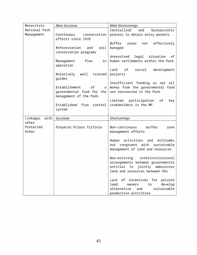
11. Key outputs of this sub-component include: i) completion of a rationalization study of the NPAS; and, ii) delineation of at least 40 protected areas and mangroves.
1.2: Strengthening of the legal and institutional framework
12. The aim of this sub-component is to identify gaps in, and propose solutions to, the legal and institutional framework for consolidating the NPAS, as well as to strengthen MARN so that it has the capacity to manage the consolidated system.
13. Building upon results of the legal, institutional, economic and NPAS analyses conducted during project preparation, and results of project implementation, this sub-component will develop specific tools and recommendations necessary to adapt the laws and institutions governing the protected areas system. Specifically, with regards to the institutional framework, recommendations for streamlining institutional oversight of the NPAS will be developed and implemented when possible, so as to avoid the existing duplication of efforts (e.g. ISTU and MARN with parallel responsibilities in distinct areas) and bottlenecks (e.g. reducing the 18 necessary steps for transferring title for protected areas from ISTA to MARN). Likewise, key responsibilities will be proposed for all institutions working in and near protected areas to facilitate their management, and MARN will establish convenios with key institutions to formalize these roles.
14. Similarly, the legal framework for protected areas will be improved through several activities. First, based on results of subcomponents 1.1 and 2.2, MARN will develop a proposal for improving identified legislative gaps regarding the consolidation of the NPAS, including all forests, mangroves, conservation areas, protected areas, and other ecosystems of interest. Secondly, MARN will work to draft the laws, regulations and norms necessary to enable the granting of land rights (such as usufruct, conditional “marginalized” titles, concessions and authorizations) for eligible residents in protected areas. Third, building upon project results, MARN will develop updated regulations for the new Protected Areas Law. Fourth, MARN with the support of CNR will develop the legal tools necessary to facilitate the creation of a single unified protected areas registry. And lastly, MARN will lead a proposal for developing an alternative conflict resolution mechanism for issues related to the management of protected areas.
15. Key outputs of this sub-component include: i) approved “Reglamento” for the implementation of the new Protected Areas Law, and ii) draft inter-institutional agreements for operating the NPAS.
1-3: Public dissemination and awareness campaign
43
16. The objective of this sub component is to design and carry out a public dissemination and awareness campaign to: (a) promote an understanding of the importance of biodiversity conservation, the NPAS and its sustainable use; (b) make people aware of the new protected areas law and other regulations regarding the use of protected areas; and, (c) publicize the results of the proposed project, at the local and international level, thereby facilitating the application of identified best practices.
17. This campaign, which will be developed prior to project effectiveness, builds upon lessons learned from the implementation of the LAP (the “Chambita Medidor” Program, as the LAP is locally known, is widely recognized throughout the country). The campaign’s specific message and methods will be adjusted to the various target audiences, at the local (Pilot Areas and other PAs where the project could be replicated), national and international levels. At the local level, the campaign will be implemented by two environmental educators (one for each pilot area), who will be part of the project implementation unit and based in the field. At the national and international levels, the campaign will be undertaken by a firm, working with representatives of MARN and ISTU.
18. Key outputs of this sub-component include: i) at least 10% of national population aware of new protected areas law and reglamento.
2: Consolidation and management of pilot Protected Areas (US$ 6.5 Total; $2.3 GEF)
19. The objective of this component is to consolidate two pilot areas through the development, testing and finalization of a methodology. For the purposes of the project, protected area consolidation includes the delimitation and physical demarcation of the pilot areas, regularization of eligible residents through establishment of legally binding land rights (e.g., usufruct, concession), the development and implementation of participatory management plans, and co-management. The results of this component will be used for the consolidation of the overall protected areas system included in Component One.
2-1: Characterization and Delineation of Pilot Protected Areas
20. The aim of this sub-component is to characterize and delineate the proposed pilot areas, through the collection, systematization and analysis of physical, ecological, socio-economic, cadastral, spatial and legal data.
44

21. CNR will undertake activities related to collection and analysis of cartographic and cadastral data. Specific activities include: (i) the preparation of basic cartography and digital mapping for cadastre surveys in Bahia de Jiquilisco (this was already done for the Lago Guija Complex under the LAP I); (ii) verification of rights and delimitation of properties in both pilot areas; and (iii) transfer of registry data to SIRyC, linking them with cadastre data.
22. MARN will be responsible for compiling, updating and organizing existing data regarding ecological and biological resources, socio-economic activities, land use, and existing infrastructure. Specific activities include: (i) preparation of a detailed socio-economic study; (ii) analysis of existing environmental and land use data (including concessions) and identification of information gaps; (iii) studies to fill identified environmental data gaps; (iv) preparation of procedures to link the existing, MARN-managed Environmental Information System (Sistema de Informacion Ambiental) and Protected Areas Registry (Registro de Areas Protegidas) with CNR’s geographic information systems and SIRyC, where relevant.
23. Key outputs of this sub-component include i) Socio-economic census, environmental information, cadastre and registry for each pilot protected area collected and linked with CNR databases.
2-2: Legalization and Demarcation of Pilot Protected Areas
24. The aim of this sub-component is to complete the steps necessary to legally declare (through Executive Decree) both pilot areas as protected areas.
25. MARN will be responsible for overseeing all activities related to the legal declaration of the pilot areas. Specifically, MARN will: i) resolve conflicts related to boundary properties; ii) secure title to the pilot area lands, through coordination with ISTA and possibly local municipalities; iii) demarcate the pilot area boundaries (including both buffer and nucleus zones), with the support and participation of local municipalities and communities; (iv) oversee alternative conflict resolution mechanisms; and (v) draft and approve executive decrees legalizing the pilot areas;
26. CNR will provide the following services: 1) technical assistance for the demarcation of the pilot area boundaries; 2) registry of the pilot areas in the name of MARN in the SIRyC.
27. Key outputs of this sub-component include: i) demarcation of pilot PAs (including external boundaries of pilot areas, and nuclei); ii) executive decrees to establish pilot PAs.
2-3: Management Plans for Pilot Protected Areas
45

28. The aim of this sub-component is to develop and implement comprehensive management plans for the buffer and nucleus zones of two pilot protected areas.
29. For each pilot area, MARN will be responsible for overseeing the updating of existing management plans to reflect new information and all lands included within pilot area boundaries. Specifically, working with local stakeholders (ADESCOs, COALs, NGOS, private sector, cooperatives, municipalities and final beneficiaries), management plans will be developed to guide the conservation and sustainable development and use of pilot protected areas. These plans will include zonification (including buffer zones, differential use zones, etc.), types and limits of allowable uses of natural resources by zone, basic infrastructure and user fees, granting of land rights (through usufruct, concessions, authorizations, conditional titles, etc.) to eligible residents within the pilot areas, monitoring and evaluation, and co-management, when appropriate. During the preparation of the management plan, MARN would be responsible for providing a local presence through hiring park guards and other key staff.
30. MARN and ADESCOs would jointly be responsible for implementing an alternative conflict resolution mechanism to address project-related grievances, according to an agreed framework that will be finalized prior to effectiveness. The specific join responsibilities would be set forth in a convenio between MARN and the ADESCOs.
31. While the project would not result in the involuntary resettlement of any people, there might be increased restrictions in access to natural resources for some of the people living in, or adjacent to, the project pilot areas. Consequently, MARN would be responsible for implementing the project’s Process Framework (see Annex 10C below) to ensure that project beneficiaries receive appropriate consideration and assistance in their efforts to maintain or improve their livelihoods. Such assistance would be provided during the formulation and implementation of management plans for each pilot area.
32. Once finalized, MARN would be responsible for implementing the management plans through agreements with local actors (municipalities, NGOs, ADESCOs and/or other organizations interested in participating in co-management). Financing of co-managed activities would be developed jointly through MARN and the interested entity. In addition to funding the activities included the management plan, MARN would finance a small grants program to support the local communities in conservation-compatible activities.
33. The key output of this sub-component is: i) Number of beneficiaries associated with implementation of updated management plans for both pilot areas.
46

Component 3: Project Administration (US$0.9 Total; $0.7 GEF)
34. The objective of this sub-component is overall management of the proposed project including monitoring and evaluation (M&E).
35. MARN will be responsible for project administration mechanisms including planning and M&E. The M&E system will be based on the existing M&E system –developed by CNR under LAP II- to conduct overall project coordination and supervision. This system will be modified and strengthened to include key indicators to measure GEF project performance. The activities will also include necessary audit services.
47

Annex 5: Project Costs
EL SALVADOR: Protected Areas Consolidation and Administration Project
Components Project Cost Summary(US$’000)
Component/Subcomponent Local Foreign Total
1. Strengthening of the National Protected Areas System (NPAS) 1.1. Consolidation of NPAS Strategy 540.0 52.0 592.01.2. Strengthening of legal and institutional framework 409.6 213.8 623.41.3. Public dissemination and awareness campaign 523.4 57.6 581.0
Subtotal 1,473.0 323.4 1,796.42. Consolidation and Management of Pilot Protected Areas
2.1. Characterization and delineation of pilot PAs 132.1 14.7 146.82.2. Legalization and regularization of pilot PAs 474.4 57.6 532.02.3. Management Plans for Pilots PAs 1,315.0 34.0 1,349.0
Subtotal 1,921.5 106.3 2,027.83. Project Administration 636.0 54.0 690.0
Total BASELINE COSTS 4,030.5 483.7 4,514.2Physical Contingencies 145.9 23.7 169.6Price Contingencies 300.5 25.1 325.6
Total PROJECT COSTS 4,476.9 532.5 5,009.3
48

Annex 6: Implementation Arrangements
EL SALVADOR: Protected Areas Consolidation and Administration Project
The Ministry of Environment and Natural Resources (MARN), the agency responsible for the national Natural Protected Areas System (NPAS), will be the Project executing agency, with responsibility for overall management, supervision, coordination, technical and fiduciary control, and monitoring and evaluation of the grant. Direct implementation will be provided by a small Project Implementation Unit within MARN’s Department of Natural Resources (DGPN). The project is partially blended with the second phase of the IBRD-funded Land Administration Project (LAP II), fully implemented by the National Registry Center (CNR), a financially sustainable, administratively autonomous agency responsible for the successful implementation of the LAP’s first phase (LAP I). For the proposed project, CNR will participate in technical activities in Components 1 and 2 related with delimitation and demarcation of overall pilot areas and parcels included therein, as well as cadastre and registry, rights verification and conflict resolution. Additionally, the project will capitalize upon CNR’s experience, as CNR will provide technical assistance to MARN regarding financial management and procurement, through targeted training and advisory services, related to Component 3. An agreement between MARN and CNR will define the specific roles and responsibilities of both institutions for Project execution.
Institutional Analysis
Ministry of Environment and Natural Resources. MARN was created by Presidential Decree No. 27 (May 1997) and ratified by Environmental Law No. 233. Its responsibilities and functions are to formulate, plan, and execute environmental and natural resources policies and legislation; promote active participation by all sectors in the sustainable use of natural resources and the environment; and collaborate with the Ministry of Foreign Relations in handling issues of international cooperation related to the environment and natural resources. MARN has the authority to enter into legal contracts, including the creation of sinking and trust funds. The ministry is headed by a Minister, Vice Minister, Executive Director, and three General Directors. MARN is divided into three departments: Natural Resources, Citizen Participation, and Environmental Management. As of December 2004, MARN had 220 staff.
Activities of the three departments are:a) Natural Resources. Enhancement, management, and protection of El Salvador’s natural
resources. The department is divided into four divisions: Physical Resources, Biological Resources, Mangrove Systems, and Protected Areas.
b) Citizen Participation. Facilitating links between civil society, municipalities, autonomous institutions and NGOs, and governmental organizations to conserve the environment and promote sustainable development. The department is divided into three divisions: Environmental Education, Gender, and Environmental Complaints.
c) Environmental Management. Environmental evaluations and monitoring of the Agree-ments and Protocol Units and the environmental information system. This department has one division, Environmental Evaluation.
Ministry of Agriculture and Livestock (MAG). The Ministry for Agriculture and Livestock was created by Executive Decree No.24 of April 18, 1989, published in Official Gazette No. 70, Volume 303. It directs, coordinates, and controls execution of government activities related to
49
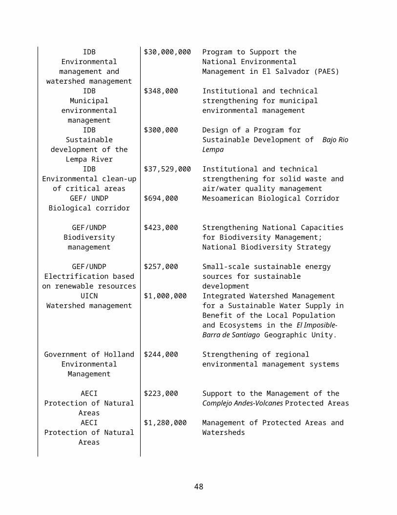
agriculture, forestry, fishing, and livestock. MAG has 1,877 staff and is headed by a Minister, Vice Minister, and Presidential Commissioner for Agriculture. It includes four advisory offices (Policy and Strategy; Agricultural Planning; Legal Counsel; and Internal Audits) and five centralized operational directorates (Plant and Animal Health; Forest, Watershed, and Irrigation Management; Fishing and Aquaculture; Agricultural Economics; and Agribusiness).
Activities of the four advisory offices are:a) The Policy and Strategy Office develops and implements sector policies and strategies
based on national and international macro- and microeconomic trends in agriculture, forestry, and fishing.
b) The Agricultural Planning Office carries out institutional planning, advises the various offices of MAG on the planning, formulation, and implementation of projects and institutional development, and conducts monitoring and oversight of the proposed objectives and goals.
c) The Legal Counsel’s Office advises the Minister, Vice Minister, and other ministry officers as needed.
d) The Internal Audit Office exercises internal control of the Ministry’s administrative, fi-nancial, and management systems.
Ministry of Tourism (MINTUR/ISTU/CORSATUR): The objective of MINTUR is to promote El Salvador as a tourist destination through establishing the regulatory framework and juridical security for tourist-related industries operating in the territory. The Tourism Corporation of El Salvador (CORSATUR), the institution responsible for the tourism sector, is responsible for coordinating all sectors contributing to promoting tourism. Working with MARN, CORSATUR has developed a Strategic Plan for the Sustainable Development of Ecotourism in El Salvador, which aims to promote tourism activities through environmental education activities directed to improve the quality of life of the communities living in tourist areas while protecting biodiversity within the NPAS.
National Council for Art and Culture (CONCULTURA): This council is responsible for the conservation of El Salvador's archeological areas, the administration of which is important for the development of the NPAS.
Center for the Development of Fishing (CENDEPESCA). The Center, part of MAG, is responsible for developing and implementing policies for the promotion of fishing and aquiculture, including catch regulations.
Agrarian Reform Institute (ISTA). ISTA is responsible for overseeing El Salvador’s agrarian reform process and for regularizing and transferring lands titled in their name to the state (such as NPAs). This process, started in 1999, is based on Legislative Decree 719 (article 30) and Executive Decree 103 (article 50), both issued in 1996, which describe the procedure for transferring such lands to MARN, the agency identified as responsible for the protected areas management in the Environment Law.
National Registry Center (CNR). CNR is the agency responsible for maintaining and providing official information on intellectual, commercial, and land property. It maintains cadastral and legal information of all land parcels in the country.
Municipalities. Local municipalities are responsible for the overall political and administrative management of their territory, including the sustainable management of natural resources and related services.
50

Nongovernmental Organizations. The goals and structure of NGOs varies according to their founding charters. They are associations or foundations that do not seek to directly profit their members, founders, or managers. They are authorized by the Interior Ministry, facilitated by the “Law on Nonprofit Associations and Foundations” contained in Legislative Decree N° 894 and its respective regulations. They may act at the national, regional, municipal, or local levels. There have been 5,464 NGOs registered in El Salvador since 1934. MARN has identified 70 NGOs that work in the environmental field and 26 that have specific activities in the potential project area.
Universities. El Salvador’s universities are regulated by the Law on Higher Education contained in Legislative Decree N° 522 and by the Ministry of Education through the National Directorate on Higher Education. This is a special system that contains the general principles for organization and operation of the National University as well as for private universities and official and private technical institutes. This framework encompasses three functions: teaching, scientific research, and social outreach. El Salvador currently has a national university, 26 private universities, 6 specialized institutes, and 9 technical institutes. In 2001 there were 1,589 students registered in six recognized major courses of study in the fields of agriculture and environment.
Agricultural Associations and Cooperatives. These are special organizations governed by regulations contained in the Special Law on Agricultural Associations in Legislative Decree No. 221, which grants the Ministry of Agriculture and Livestock authority to provide legal, administrative, and financial advice for creating agricultural associations and cooperatives to develop and conduct activities related to land ownership for the benefit of their members. They are legal entities administered by a Board of Directors that is elected by a general assembly of the members. Their activities are determined and regulated by their charters.
Community Associations. Community Associations (ADESCOs) are based on a declaration of interest by a group of at least 25 citizens establishing a purpose for the association. Legal standing or recognition is granted by the municipality though the mayor or an authorized representative, which allows the association to raise funds and execute agricultural, infrastructure, tourism, environmental, and other types of projects. These activities are governed by the statutes creating the association, which include stipulations defining the type of organization, its area of operation, formation of its board of directors, and their rights, responsibilities, and obligations.
Implementation Arrangements
The Project would finance the creation of a central Project Implementation Unit (PIU or UEP) within MARN’s Department of Natural Resources (DGPN) that would be responsible for overall Project coordination. The Central UEP would comprise a project coordinator, administrative assistant, accountant, procurement specialist, and monitoring and evaluation expert (see Figure 6-1). The accountant and procurement specialist will report to the project coordinator, but will be physically located for the first six months of project implementation in CNR’s administrative unit (UACI), after which they will move to MARN’s Institutional Financial Unit (UFI). CNR will then continue to provide technical assistance to MARN regarding financial management, procurement and monitoring and evaluation. The central UEP is meant to be temporary and all its relevant functions and activities to be assumed by MARN starting year 5 of the project.
In each of the two pilot protected areas, the UEP will comprise a technical coordinator, an administrative assistant, up to three technical specialists, who will be responsible for the development and implementation monitoring of management plans as well as environmental
51
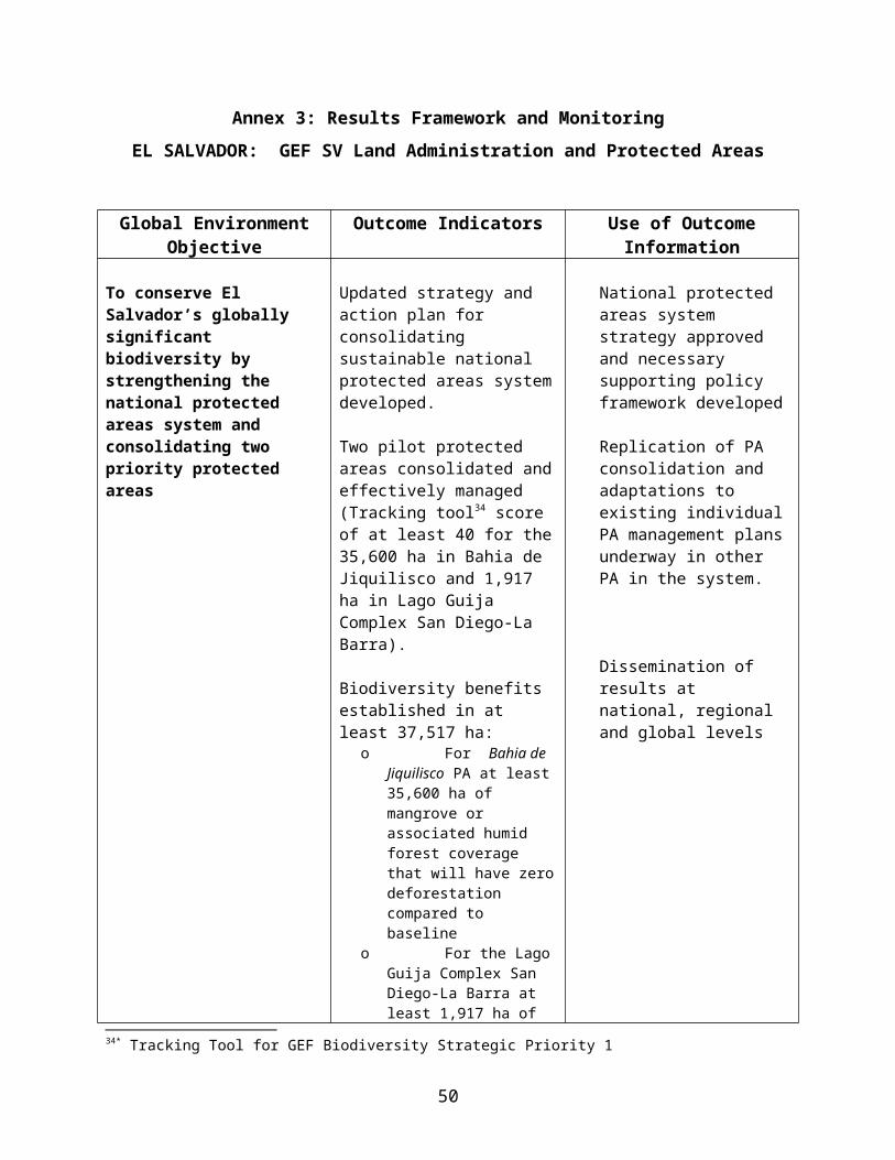
education, and several park guards (the number of which will be defined prior to effectiveness). Following project implementation, key members of the local UEPs (including park guards and key technical staff, such as the park manager) would remain, funded through proceeds of the management plan (e.g. user fees, concessions, etc.). Other staff would be available to work in other protected areas, as their duties in the pilot areas would be complete.
Given the pilot nature of the project and the importance of building multi-sector alliances, an advisory committee will also be formed, which will function under the coordination MARN’s DGNP. This group will include representatives from the UEP, CNR, MAG, ISTA, CONAMA, municipalities, the private sector, and a local representative from each of the pilot areas. The consultative group, which would be convened by MARN at least once a month, would support the project through providing a strategic decision-making mechanism with regard to the development of a strategy for PAs consolidation, a methodology for its implementation, and the results assessment for each of the pilot areas.
Internal Coordination:
So as to ensure MARN has sufficient capacity to manage the Project, during the first six months of execution, the UEP will be structured jointly with the LAP II project unit (LAP II UCP, housed within CNR) as follows:
1) Procurement: physically located within CNR – UACI. After six months of project implementation, this function will move to MARN’s UFI department.
2) Financial management: physically located within CNR - Departamento de Desarrollo Humano, Administración y Finanzas (DDHAF). After six months of project implementation, this function will move to MARN’s UFI department.
Coordination with Participating Agencies:For the implementation of technical activities, cooperation agreements will be signed between MARN/UEP and the other participating agencies. Specifically, for those activities, in Component 1 and 2, relating to the implementation of LAP II - delineation/demarcation/registration, as well as training and capacity building for project fiduciary aspects, monitoring and evaluation, an agreement will be signed by CNR and MARN, clarifying respective roles and responsibilities. Similarly, an agreement will be signed between MARN/UEP and the Local Advisory Committees (COAL), NGOs, ADESCOs and municipalities that will participate in the implementation of the activities of Component 2 at the local level, in particular the implementation of management plans (as per the co-management approach supported by the new Protected Areas Law). Finally, MARN/UEP and ISTA will sign an agreement with a view to rationalizing the process for the transfer to MARN of those land identified as potential protected areas but still under ISTA.
52
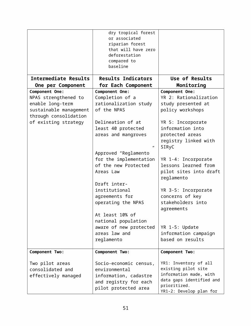
53
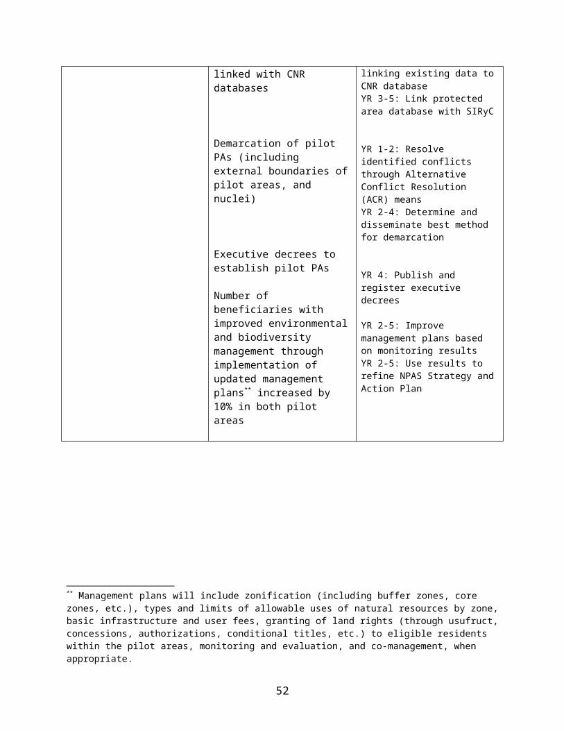
Annex 7: Financial Management and Disbursement Arrangements
EL SALVADOR: Protected Areas Consolidation and Administration Project
Summary Conclusion of Financial Management Assessment1. On the basis of the assessments performed, the financial management team presents the following conclusions:
(i) The executing agency, MARN, will be responsible for managing the fiduciary aspects of the proposed project, through a Project Coordination Unit (PCU), located within MARN.
(ii) Overall, MARN has limited capacity with respect to financial management (limited staffing and financial management system) and does not have extensive experience in managing projects financed by the World Bank. Thus the need to hire an Accountant for the management of accounting and financial reporting information of the proposed project, with appropriate experience.
(iii) Assuming that MARN carries out the proposed action plan presented in this assessment, especially with regards to staffing, it would have in place adequate financial management arrangements that meet the Bank’s minimum fiduciary requirements to manage the specific financial activities of the proposed project.
2. Standard requirements/agreements. It was agreed (1) that, at least at the beginning, the project will use transaction-based disbursements; 2) that each quarter MARN-PCU will prepare the Financial Monitoring Reports (FMRs) to be submitted to the World Bank; and (3) that annual project financial statements will be audited in accordance with International Standards on Auditing issued by the International Federation of Accountants (IFAC), by independent auditors and in accordance with terms of reference (TORs), both acceptable to the World Bank and the El Salvador’s Corte de Cuentas.
3. Implementing Arrangements. The executing agency for the proposed project will be MARN (“Ministerio de Medio Ambiente y Recursos Naturales”). Project implementation will be carried out by MARN through a Project Coordination Unit (PCU), located within MARN’s Department of Natural Resources (Dirección General de Patrimonio Natural—DGPN). MARN will have overall financial and accounting responsibility for the proposed project, including (i) maintenance of accounting records, (ii) processing disbursements, (iii) preparation of project financial statements in accordance with World Bank guidelines, (iv) management of bank accounts, (v) management of financial information systems, (vi) preparation and submission of quarterly Financial Monitoring Reports (FMRs), and (vii) preparation and submission of withdrawal applications.
4. Staffing. As indicated above, MARN will create a Project Coordination Unit (PCU) to manage the proposed project. At a minimum, the staff of the PCU should include a project coordinator, administrative assistant, a monitoring and evaluation specialist, as well as a procurement specialist and an accountant with sufficient experience working with projects financed by international agencies or donors. The procurement specialist and the accountant would report to the project coordinator but be located within the UFI (MARN’s central financial unit). Additionally, for each of the two pilot areas, the project
54

will contract a technical coordinator, an administrative assistant, three technical staff to oversee the implementation of the management plan, and a team of park guards based on the needs of each area.
Flow of Funds5. Project funds will be managed by the executing agency (MARN), with fund transfers from Treasury (DGT) utilizing the same mechanism used by local funds.
6. Under this mechanism, a Special Account in U.S. dollars will be established by the Treasury (Ministerio de Hacienda) at the borrower’s request in Banco Central de Reserva. The borrower (MARN) will operate the Special Accounts and be responsible for the management of this account. After the declaration of effectiveness, the World Bank will, upon MARN’s request, make an authorized allocation to the Special Account. Replenishments of the Special Accounts will be made, at least at the beginning, using a traditional disbursement method (transaction-based procedures, monthly submission of Statements of Expenditures – SOEs; see flow of funds diagram below). Once the preparation of required reports has been established and reviewed by the Bank’s team, the disbursement method could be changed to report-based procedures (based on the quarterly submission of Financial Monitoring Reports – FMRs).
7. MARN will also open a separate operating account in a commercial bank to facilitate local payments. Transfers to the operating accounts would be made from the Special Account, on the basis of requests prepared by MARN, supported by commitments.
55
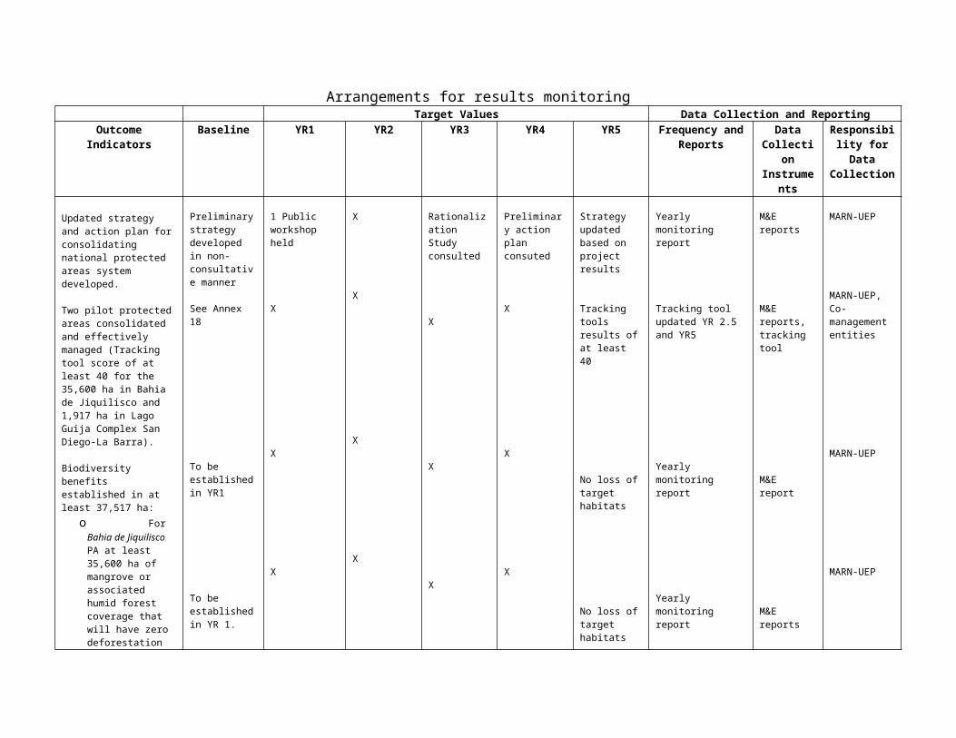
Disbursement requests (SOEs)
World BankGEF
SA in BancoCentral de Reserva
MARN
Disbursement to Special Account
Transfers to operationalAccounts based on commitments
Transfer Requests
Ministerio de Hacienda
Procesos para elFlujo de Fondos
Disbursement requests (SOEs)
World BankGEF
SA in BancoCentral de Reserva
MARN
Disbursement to Special Account
Transfers to operationalAccounts based on commitments
Transfer Requests
Ministerio de Hacienda
Procesos para elFlujo de Fondos
Accounting and Reporting8. Segregation of Duties. MARN’s organizational structure and established procedures support an adequate segregation of procurement, payment, and recording activities. The authorization to execute a transaction will be the main responsibility of the Project Coordinator and/or Technical Officers. Procurement activities will be the main responsibility of the procurement specialist. And, the recording of the transaction will be the main responsibility of the Accountant.
9. Budgeting. A budget will be prepared at the beginning of each year. The borrower will be responsible for compiling a comprehensive budget for the project. Typically, the annual budget would include:
An annual work plan classified by major goal/objectives, including physical and financial programs.
A budget (broken down at least quarterly) specifying detailed expenditures by major component, category, and source of funds.
10. Payment and Operation of Bank Accounts. MARN will be responsible for project disbursement to vendors. The process is expected to be as follows:
The Project Coordinator and Procurement Officer review the invoice (generally against a PO or contract) and review necessary approvals from the Technical Officers.
The approved invoice and payment request is received by the Accountant for processing.
56

The Accountant reviews the information and prepares a check request. The check request is submitted to Treasury for processing (including authorized
signatures). Once the authorized signatures have been obtained, the check is delivered to the vendor. Documentation is filed appropriately and transaction recorded into the computerized
accounting system.
11. Bank account reconciliations will be prepared at MARN, through the project financial unit, on a monthly basis.
12. Information Technology (IT) Systems. Project funds will be captured in the integrated financial management system (SAFI) used by MARN. However, given the need for the implementation of a basic financial system for the purposes of aggregating information from SAFI on a component basis (for financial monitoring to the Bank) and preparing withdrawal applications on the basis of disbursement categories, the PCU will utilize the system under preparation for the LAP II that will be ready by the effectiveness date. The system will include a module for procurement and physical monitoring.
13. Safeguard over assets. Assets acquired using project funds will be in the custody of the respective organizations. The borrower will keep a detailed subsidiary ledger (asset register) of equipment acquired. The accounting system does not allow for tracking of assets purchased. Therefore, the asset register will have to be kept separately from the accounting system. The amounts in the register will be reconciled monthly against the respective account balances. And, at least one annual physical inspection of the assets will be undertaken by PCU staff, preferable with the participation of external auditors.
14. Internal Audit. MARN has an internal audit department, which generally does not audit internationally funded projects, as they are audited instead by external independent auditors. For this project, the use of external independent auditors will contribute to ensuring that the resources are used for the purpose intended.
15. The audit policy of the World Bank, as documented in “Guidelines: Annual financial reporting and auditing for World bank-financed projects” will be applicable to the project. This means that a single audit opinion covering: (i) project financial statements, (ii) special account statements, and (iii) adequacy of supporting documentation maintained by MARN in respect of expenditures claimed for reimbursement via SOE procedures and eligibility of such expenditures for financing under the respective Grant Agreement, will be required.
16. In addition to the audit opinion, the auditors will have to present the management letter, covering: (i) weaknesses noted by the auditors in the internal control systems of the project, (ii) cases of application of inappropriate accounting policies and practices, (iii) issues regarding general compliance with broad covenants, and (iv) any other matters that the auditors considers should be brought to the attention of the borrower.
17. The project coordinator will be responsible for ensuring the external audits are undertaken, ensuring the recommendations of the auditors are complied with, and
57
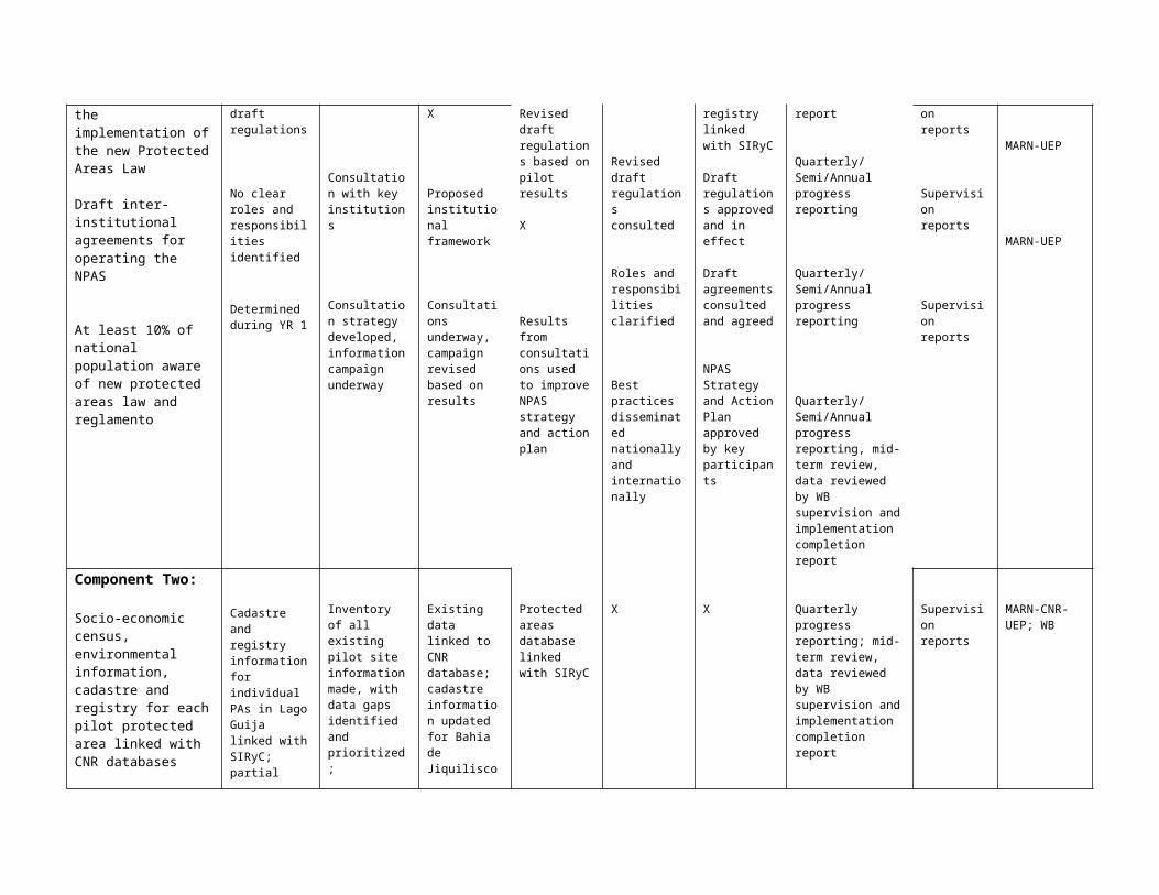
sending the results of annual and final financial audits to the Bank within at least six months of the end of the fiscal year and project close. The cost of these audits will be financed with project resources.
18. Reporting. The MARN-UEP will be responsible for producing the Financial Monitoring Reports (FMRs) on a quarterly basis to be submitted to the Bank, only for monitoring purposes at the beginning and possibly for disbursement purposes, once the system has been tested. FMRs will include a narrative outlining the major project achievements for the quarter, the project’s sources and uses of funds, a report presenting expenditures by sub-component, a physical progress report, a procurement report and a procurement table. FMRs should be submitted to the Bank no later than 45 days after the end of the reporting period.
19. The annual financial statements will include the project’s sources and uses of funds, a report presenting expenditure by sub-component, the schedule of SOEs presented during the year and a reconciliation of the Special Account. These reports will be prepared by the borrower and made available to the auditors after the end of the fiscal year.
20. Disbursement Arrangements. Withdrawal from the grant will made, at least at the beginning, using transaction-based disbursement procedures. Once the preparation of required reports has been established and reviewed by the Bank’s team, the disbursement method could be changed to report-based procedures (based on the submission of FMRs). Under the transaction-based disbursement method, the SOE thresholds would be consistent with the procurement prior review thresholds. All supporting documentation for payments using SOE procedures and other payments in general for Project activities will be retained by MARN for audit purposes and made available for the Bank’s supervision.
Financial Management Action Plan
No. Action Product/Indicador Responsable Deadline
1 Financial Monitoring Reports Finalize the FMR format MARN Negotiations2 External auditors contract process Finalize audit TORs MARN Effectiveness
3 Fiduciary Staffing Finalize TORs for key financial staff involved in the Project
MARN Negotiations
4 Operations Manual Preparation Operational Manual approved and ready for implementation
MARN Effectiveness
5 IT system available Implementation of simple financial management system to allow reporting of Project activities to World Bank
MARN Effectiveness
6 Staffing of PCU Contracts signed for key staff involved in project
MARN Effectiveness
7 External auditors contract process Contract signed MARN 3 months alter effectiveness
58
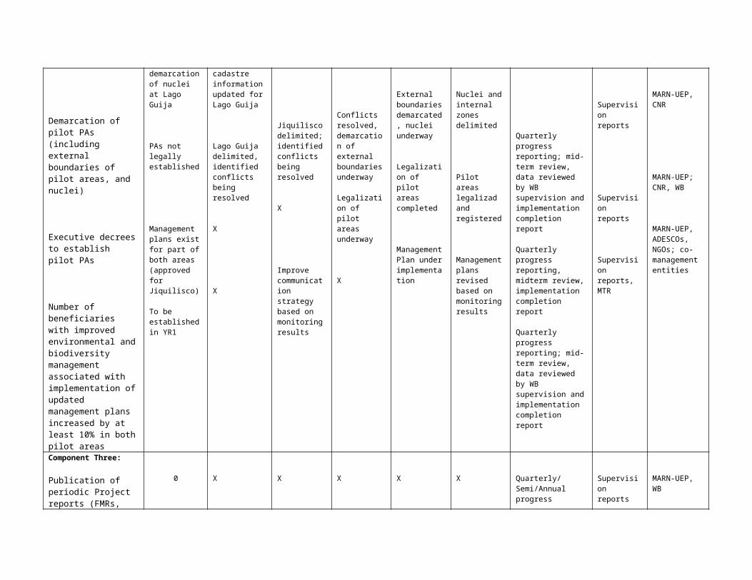
21. Supervision Plan. During project implementation, the Bank will review the project’s financial management arrangements in two principal ways: (i) reviewing the project’s quarterly financial management reports, MARN-UEP’s periodic financial information, annual audited financial statements, and the auditor’s management setter; and (ii) during the Bank’s missions, review the project’s financial management arrangements to ensure compliance with Bank requirements. Accredited financial management specialists will assist in the supervision process.
Allocation of Loan Proceeds (US$ million)
Expenditure Category Amount Financing Percentage
1. Goods, works Consultant Services, Training,1/ Non-Consultant Services,2/ and operating costs
3.7 100%
2. Implementation of Management Plan Jiquilisco
0.6 100%
3. Implementation of Management Plan Guija
0.5 100%
4. Unallocated 0.2 -
Total Financing 5.0
1/ Training includes training-related expenses different from consultants for workshops, seminars, and study tours. The loan would finance travel, subsistence, and per diems to trainers and trainees, registration fees, logistical expenses for organization of training events, and training materials.
2/ Non-consultant services include demarcation activities.
3/ Operating costs include operation and maintenance of vehicles and equipment, travel and subsistence of MARN and CNR officials for supervision of demarcation.
59
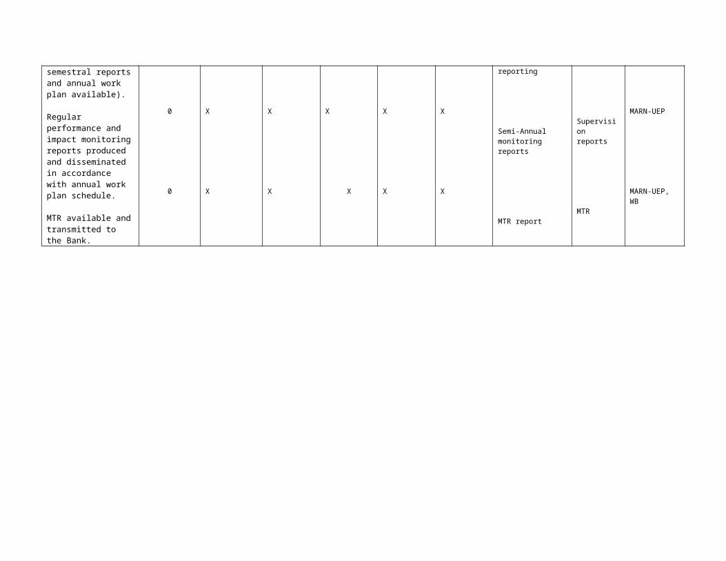
Annex 8: Procurement Arrangements
EL SALVADOR: Protected Areas Consolidation and Administration Project
A. General
1. Procurement for the proposed project would be carried out in accordance with the World Bank’s “Guidelines: Procurement Under IBRD Loans and IDA Credits” dated May 2004, “Guidelines: Selection and Employment of Consultants by World Bank Borrowers” dated May 2004, and the provisions stipulated in the Legal Agreement. The various items under different expenditure categories are described in general below. For each contract to be financed by the Loan/Credit, the different procurement methods or consultant selection methods, the need for pre-qualification, estimated costs, prior review requirements, and time frame are agreed between the Borrower and the Bank in the Procurement Plan. The Procurement Plan will be updated at least annually or as required to reflect the actual project implementation needs and improvements in institutional capacity.
2. Procurement of Works: Works under this project will be procured using the Bank’s Standard Bidding Documents (SBD) for all ICB and SBD agreed with the Bank for NCB and shopping. All SBDs will be included in the Operations Manual.
3. Procurement of Goods: Goods procured under this project will include vehicles, computers, printers, office equipment, communication equipment, GPS, furniture, hardware and software for photogrammetric, boat w/outboard motor, telephones, radios, etc. To the extent possible contracts will be grouped in bidding packages of more than US$250,000 and procured following International Competitive Bidding (ICB) procedures using Bank–issued Standard Bidding Documents. Contracts with values below this threshold per contract may be procured using National Competitive Bidding (NCB) procedures with standard bidding documents agreed by the Bank. Contracts for goods that cannot be grouped in larger bidding packages and estimated to cost below US$50,000 per contract may be procured using Shopping (National and International) procedures based on a model Request for Quotations (RfQ) satisfactory to the Bank.
4. Procurement of Non-Consulting Services: Technical services under the project amount to approximately US $ 460,000. These include demarcation of national protected areas. A decision has been made to prepare customized documents for this area by adapting the Procurement of Works, smaller contracts, standard documents, and the draft services (non consulting) document to the peculiarities of land projects. Work is underway and it is expected that before effectiveness, the project will have an approved document in this area. Contracts for Technical Services estimated to cost US$1 million or more will be procured following ICB procedures. Contracts estimated to cost between US$100,000 and US$1 million may be procured following NCB procedures. Contracts estimated to cost below US$100,000 may be procured under lump-sum fixed contracts awarded on the basis of quotations obtained from three qualified domestic contractors in response to a written Request for Quotations agreed with the Bank.
Non-Consulting Services other than Technical Services also include training activities such as workshops, etc.
5. Selection of Consultants: Consulting services from firms and individuals required for the project include impact evaluation studies, diagnostics, financial and procurement audits, advisory services from individual consultants, supervision, PCU staff, etc.
60

6. Operational Costs: Operational costs have been identified in the procurement plan. These costs have been reviewed and found acceptable to the Bank.
7. The procurement procedures and SBDs to be used for each procurement method, as well as model contracts for works and goods procured, are presented in the Project’s Operations Manual.
Prior Review Thresholds
Expenditure category
Contract value threshold a
(US$ thousands)Procurement
method Contracts subject to prior review
Goods
>150 ICB All (tender documents and evaluation reports)150≥ <50 NCB All(tender documents and evaluation reports)
≤ 50 Shopping First two each calendar year(request for quotations and evaluation reports)All contracts above US$25,000
Non-consulting services (incl. training)
>150 ICBAll contracts above US$25,000150≥ <25 NCB
≤ 25 ShoppingNon-consulting
services ( Technical Services)
>1,000 ICB All contracts above US$100,000First two contracts under shopping procedures 100≥ <1,000 NCB
≤ 100 Shopping
Consulting (firms) a
>100 QCBSWhole process for each contract above $50,000 and all single source contracts100≥ <50 QCBS/LCS/CQ
≤ 50 LCS/CQConsulting
(individual) aSection V in the
GuidelinesAll cases above US$25,000 and all single-source contracts
Direct contracting All cases regardless of the amounts involved
Agreements
All cases regardless of the amounts involvedAll cases identified for prior review in the
procurement planAll cases not included in the procurement
plan, regardless of the amounts involvedAll terms of reference for which Bank no
objection is requiredAll processes that, due to their complexity or
nature, the task manager decides must have the Bank’s no objection
Notes: The project will include no expenditures for worksa. Thresholds for consulting include the sum of the original contract and all extensions.
2. The thresholds will be reviewed when the PIU gains experience in Bank’s rules and regulations. All single-source selection of goods and works, regardless of the amount of the contract, will be subject to prior review by the Bank.
B. Assessment of the agency’s capacity to implement procurement
61
3. Procurement activities will be carried out by the Ministry of Environment and Natural Resources (MARN) through a Project Coordination Unit (PCU), located within MARN. Although the PCU will be responsible for coordinating the activities of the project, it has been decided that to promote institutional strengthening the procurement function will be integrated within the organizational structure of MARN. The project’s procurement officer will be integrated within the procurement unit of MARN ( UACI), with a direct link to the PCU. The Project Operations Manual will include, in addition to the procurement procedures, the SBDs to be used for each procurement method, as well as model contracts for works and goods procured.
4. A full assessment of the capacity of MARN to implement procurement actions for the project was carried out by Luis Prada, procurement specialist, on September 2004 for the National Environmental project for which MARN is the implementing agency. For the proposed project, a desk review of the capacity of MARN to implement procurement actions for the project has been carried out. The review included the organizational structure for implementing the project, the volume and complexity of procurement actions for the new project as well as the new arrangements by which the procurement function is being integrated into MARN’s relevant central procurement unit (UFI). Although MARN has no previous experience implementing World Bank projects, considering that procurement under this project is not complex or complicated, except for the technical services, it has been decided that the PCU will carry out all procurement actions. In the case of Technical Services and during the initial stages of project implementation, CNR which is implementing the Land Administration project (LAP II) and has extensive experience with World Bank procurement rules, regulations and procedures, will assist the PCU in MARN during the critical stages of the procurement process.
5. The overall project risk for procurement is high.
C. Procurement Plan
6. The Borrower, by appraisal, will finalize a procurement plan for project implementation that provides the basis for the procurement methods. A draft plan was agreed between the Borrower and the Project Team on June 8, 2005 and is available in the project files. It will also be available in the project’s database and in the Bank’s external website. The Procurement Plan will be updated in agreement with the Project Team annually or as required to reflect the actual project implementation needs and improvements in institutional capacity.
D. Frequency of Procurement Supervision
7. In addition to the prior review supervision to be carried out from Bank offices, since the overall risk assessment has been rated as HIGH, it is recommended that procurement supervision should take place every six months during the first year of the project and once a year thereafter and to reassess the capacity of the PCU to carry out procurement after one year in order to review the prior review thresholds.
E. Action Plan
8. The following actions are recommended to address major weaknesses identified by the Bank and to increase the capacity of MARN and the PCU in particular for implementing procurement:
Procurement Cycle Management: The Procurement Plan will be finalized and approved prior to negotiations. Completion of the Operations Manual is a condition of effectiveness. Standard
62
bidding documents for all procurement methods must be prepared for use by the project and should be based on the Bank’s SBDs in the case of NCB. SBDs for Requests for Quotations for Goods and Works have to be prepared and approved by the Bank and included in the Operations Manual. During project launch, the PCU staff concerned should be trained in the use and application of the SBDs. A system for monitoring procurement must be implemented prior to effectiveness. Increased supervision by the Bank is recommended during the initial stages of project implementation. Since Contract Administration is considered a weak area in the project, close supervision and monitoring is recommended.
9. Organization and Functions : It has been agreed that a procurement officer with relevant Bank procurement experience will be hired prior to effectiveness. Although this person will be physically in the UACI, he will respond to the project coordinator. Since internal manuals and instructions do not exist, priority should be given to preparing the Operations Manual. This is a condition for effectiveness.
10. Support and Control Systems : Since no auditing procedures are in place, the audit requirements must be established in coordination with financial management. Technical and administrative controls must be established, implemented and included in the Operations Manual. MARN must immediately enforce the fraud and corruption provisions in the Bank guidelines and SBDs. Anticorruption clauses must be included in all bidding documents.
11. Record Keeping : Proper record keeping will have to be ensured and a check list included in each file to permit verification that all relevant information is included. As the volume of procurement increases, it will be necessary to define a physical area to keep all records and files of the procurement processes under the project.
12. Staffing : The PCU will be strengthened with the hiring of a dedicated procurement officer with relevant experience in Bank procurement. It is recommended that to the extent possible, training courses in Spanish be identified for the procurement officer to attend. Although this person will be physically in the UACI during year one, and in the UFI during years two through five, he will respond to the project coordinator.
Attachment 1
1. Details of the Procurement Arrangement Involving International Competition
1. Goods, Works, and Non-consulting Services
(a) List of contract Packages that will be procured following ICB and direct contracting:
1 2 3 4 5 6 7 8 9
Ref. No.
Contract (Description)
Estimated Cost
Procure-ment
Method P-Q
Domestic Preference
(yes/no)
Review by Bank
(Prior / Post)Expected Bid-OpeningDate Comments
None
63
(b) ICB Contracts estimated to cost above US$150,000 per contract and all direct contracting will be subject to prior review by the Bank.
2. Consulting Services
(a) List of Consulting Assignments with short-list of international firms.
1 2 3 4 5 6 7Ref. No.
Description of Assignment
EstimatedCost
Selection Method
Review by Bank (Prior / Post)
Expected Proposals SubmissionDate Comments
None
(b) Consultancy services estimated to cost above US$50,000 per contract for firms, US$25,000 for individuals, and single-source selection of consultants (firms and individuals) regardless of the contract amounts will be subject to prior review by the Bank.
(c) Short lists composed entirely of national consultants: Short lists of consultants for services estimated to cost less than US$200,000 equivalent per contract may be composed entirely of national consultants in accordance with the provisions of paragraph 2.7 of the Consultant Guidelines.
64
Annex 9: Economic and Financial AnalysisEL SALVADOR:
LAND ADMINISTRATION AND PROTECTED AREAS CONSOLIDATION
9.1 The project will develop and pilot-test a methodology to consolidate two priority protected areas under different conservation categories, including: (i) dry tropical forest of the the Lago Guija Complex San Diego-La Barra; and (ii) the Bahia de Jiquilisco mangrove forest. Based on a highly participatory process, the project would produce a methodology for protected area demarcation, management plan development and regularization of parcels, where appropriate, through mechanisms such as concessions, usufruct rights, or conditional titles, subject to the requirements of, and the commitment of residents to comply with sustainable management plans. Working with MARN, local governments and NGOs, the project will implement the management plans for the two pilot protected areas, including identification of and support to sustainable development opportunities for protected area residents.
9.2 The expected Project Development Indicators are: (i) the National protected areas system strategy is improved and pilot-tested; (ii) the two pilot protected areas are consolidated and effectively managed; and (iii) biodiversity benefits are established. For the Bahia de Jiquilisco area, the project indicator is, as a minimum, no further loss of mangrove or associated humid forest coverage. Similarly, for the Lago Guija Complex San Diego-La Barra the indicator is no further loss of coverage of dry tropical forest, at minimum.
9.3 Through the introduction of sustainable management plans in the areas surrounding the core nuclei of the pilot areas, a change in land use patterns will be encourage, resulting in a reduction in environmental degradation, and an increased level of environmental services that bring both national benefits in the form of reduced level soil and water contamination from agricultural, livestock and fishing, better soil conservation practices, sustainable management of fishing stocks; and global benefits through increased biodiversity conservation and carbon sequestration.
9.4 To analyze the financial and economic impacts of the project, a cost/benefit analysis was undertaken based on the following scenarios:
Scenario 1: no action is taken to protect the area. This is the base case or “without project” scenario.
Scenario 2: The area is demarcated and concessions are given to all illegal residents for sustainable activities within the buffer zone surrounding the protected core nucleus, including new activities defined within the management plans that will be developed. Within the area of influence surrounding the core nucleus and the buffer zone, sustainable management techniques will be promoted. As part of the sustainable management plan, the harvest of marine resources will limited to sustainable levels.
65
Scenario 3: The area is demarcated and concessions are given to only those with irregular but legal titles. All other illegal residents are provided with land outside of the protected area to allow them to undertake productive activities in similar conditions. Those who are provided concessions are permitted to undertake sustainable activities within the buffer zone surrounding the protected core nucleus, including new activities defined within the management plans that will be developed. Within the area of influence surrounding the core nucleus and the buffer zone, sustainable management techniques will be promoted. Limiting rights to those with irregular, but legal, titles through “marginalization” in registry;
Scenario 4: A system of user fees is developed for those persons who visit the area;
Scenario 5: All individuals within the core nucleus and the buffer zone area that fall within the limits defined by the 1973 demarcation area are relocated.
a) Bahia de Jiquilisco
Scenario 1: Without Project Scenario
9.5 A recent study36 on the potential for carbon sequestration in El Salvador estimates that the rate of deforestation of mangroves in El Salvador was 0.8% up until 1996 and has increased to 5.8% from 1996 onward. The study makes the following assumptions: in areas where mangrove has been eliminated, 50% is initially used for establishing permanent crops and 50% is used to develop technified agriculture, aquiculture or salt fields. These areas are subsequently converted to urban areas at a rate of 25% per year.
9.6 Based on these parameters, a 20 year projection of land use was developed (Table 9.1). From this projection the annual loss in mangrove and forest in the Bahia de Jiquilisco conservation area was calculated (Table 9.2). The resultant carbon loss was then calculated based on estimated carbon storage capacity of the various biomasses (Table 9.3) and then converted into an economic value assuming a price of $4.50 per ton37 .
9.7 The economic net present value of the carbon loss is US$11.9 million.
36 Ing. Edwin Alpízar Vaglio et al, “Evaluación del Potencial de Mitigación del Sector Forestal en la República de El Salvador, Ante el Cambio Climático, Mediante Prácticas de Reforestación y Forestación”, Febrero de 2003, p. 2137 During a presentation to the Annual Meeting of Host Country Committee on Carbon Finance, the weighted average price for buyers purchasing high-quality potential compliance instruments was reported to be between $4.00 to $5.00. From the presentation notes of Richard Rosenzweig, Natsource Asset Management, February 2005.
66
Table 9.1Bahia de Jiquilisco Projected Land Use(hectares)
2005 2006 2007 2008 2009 2010 2011 2012 2013 2014 2015Uso del suelo
1 Bosques de mangle 19,449 18,321 17,258 16,257 15,314 14,426 13,589 12,801 12,059 11,359 10,701 2 Bosques latifoliados siempreverdes 3,621 3,535 3,450 3,367 3,286 3,207 3,130 3,055 2,982 2,910 2,840 3 Bosques latifoliados semicaducifolios 11,454 11,179 10,911 10,649 10,393 10,144 9,901 9,663 9,431 9,205 8,984 4 Lagunas costeras 19,969 19,969 19,969 19,969 19,969 19,969 19,969 19,969 19,969 19,969 19,969 5 Zonas ecotonales 2,138 2,138 2,138 2,138 2,138 2,138 2,138 2,138 2,138 2,138 2,138 6 Playas, dunas y arenales 1,220 1,220 1,220 1,220 1,220 1,220 1,220 1,220 1,220 1,220 1,220 7 Mares y océanos 53 53 53 53 53 53 53 53 53 53 53 8 Estuarios 25 25 25 25 25 25 25 25 25 25 25 9 Lagos, lagunas y lagunetas 4 4 4 4 4 4 4 4 4 4 4
10 Mosaico de cultivos y pastos 8,732 8,881 9,023 9,157 9,285 9,407 9,522 9,633 9,737 9,837 9,932 11 Cultivos permanentes de plantas de tallo 7,336 7,485 7,626 7,761 7,889 8,010 8,126 8,236 8,341 8,441 8,536 12 Granos básicos 5,641 5,790 5,931 6,066 6,194 6,316 6,431 6,541 6,646 6,746 6,841 13 Pastos naturales 4,312 4,461 4,603 4,737 4,865 4,987 5,103 5,213 5,317 5,417 5,512 14 Cultivos permanentes arbóreos 3,497 3,646 3,788 3,922 4,050 4,172 4,287 4,398 4,502 4,602 4,697 15 Terrenos principalmente agrícolas, con importantes espacios de vegetación natural 2,542 2,691 2,832 2,967 3,095 3,216 3,332 3,442 3,547 3,647 3,742 16 Pastos cultivados 1,590 1,739 1,881 2,015 2,143 2,265 2,380 2,491 2,595 2,695 2,790 17 Cultivos anuales asociados con cultivos 261 410 551 686 814 936 1,051 1,161 1,266 1,366 1,461 18 Perímetro acuícola 220 369 510 645 773 895 1,010 1,120 1,225 1,325 1,420 19 Vegetación esclerofila chaparral o espinoso 1,832 1,832 1,832 1,832 1,832 1,832 1,832 1,832 1,832 1,832 1,832 20 Ríos 1,266 1,266 1,266 1,266 1,266 1,266 1,266 1,266 1,266 1,266 1,266 21 Salinas 1,167 1,167 1,167 1,167 1,167 1,167 1,167 1,167 1,167 1,167 1,167 22 Tejido urbano discontinuo 1,127 1,127 1,127 1,127 1,127 1,127 1,127 1,127 1,127 1,127 1,127 23 Zonas quemadas 915 915 915 915 915 915 915 915 915 915 915 24 Praderas pantanosas 911 911 911 911 911 911 911 911 911 911 911 25 Terrenos regados por gravedad 849 849 849 849 849 849 849 849 849 849 849 26 Bosques de galería 359 359 359 359 359 359 359 359 359 359 359 27 Vegetación arbustiva baja (matorral) 319 319 319 319 319 319 319 319 319 319 319 28 Plantaciones de bosques monoespecificos 316 316 316 316 316 316 316 316 316 316 316 29 Bosques latifoliados caducifolios 171 171 171 171 171 171 171 171 171 171 171 30 Bosques en transición 160 160 160 160 160 160 160 160 160 160 160 31 Áreas turísticas, arqueológicas 76 76 76 76 76 76 76 76 76 76 76 32 Espacios con vegetación escasa 38 38 38 38 38 38 38 38 38 38 38 33 Marismas interiores 36 36 36 36 36 36 36 36 36 36 36 34 Roqueda, lavas 22 22 22 22 22 22 22 22 22 22 22 35 Aeropuertos 21 21 21 21 21 21 21 21 21 21 21 36 Zonas portuarias 17 17 17 17 17 17 17 17 17 17 17 37 Tejido urbano continuo 262 411 553 687 815 937 1,053 1,163 1,267 1,367 1,462 38 Redes viarias, ferroviarias 17 17 17 17 17 17 17 17 17 17 17
Total 101,943 101,943 101,943 101,943 101,943 101,943 101,943 101,943 101,943 101,943 101,943
67
2016 2017 2018 2019 2020 2021 2022 2023 2024 2025Uso del suelo
1 Bosques de mangle 10,080 9,495 8,945 8,426 7,937 7,477 7,043 6,635 6,250 5,887 2 Bosques latifoliados siempreverdes 2,772 2,706 2,641 2,577 2,516 2,455 2,396 2,339 2,283 2,228 3 Bosques latifoliados semicaducifolios 8,768 8,558 8,352 8,152 7,956 7,765 7,579 7,397 7,220 7,046 4 Lagunas costeras 19,969 19,969 19,969 19,969 19,969 19,969 19,969 19,969 19,969 19,969 5 Zonas ecotonales 2,138 2,138 2,138 2,138 2,138 2,138 2,138 2,138 2,138 2,138 6 Playas, dunas y arenales 1,220 1,220 1,220 1,220 1,220 1,220 1,220 1,220 1,220 1,220 7 Mares y océanos 53 53 53 53 53 53 53 53 53 53 8 Estuarios 25 25 25 25 25 25 25 25 25 25 9 Lagos, lagunas y lagunetas 4 4 4 4 4 4 4 4 4 4
10 Mosaico de cultivos y pastos 10,022 10,109 10,191 10,269 10,344 10,415 10,483 10,547 10,609 10,668 11 Cultivos permanentes de plantas de tallo 8,626 8,712 8,794 8,873 8,947 9,018 9,086 9,151 9,213 9,272 12 Granos básicos 6,931 7,017 7,100 7,178 7,252 7,324 7,391 7,456 7,518 7,577 13 Pastos naturales 5,603 5,689 5,771 5,849 5,924 5,995 6,063 6,128 6,189 6,249 14 Cultivos permanentes arbóreos 4,787 4,874 4,956 5,034 5,109 5,180 5,248 5,312 5,374 5,433 15 Terrenos principalmente agrícolas, con importantes espacios de vegetación natural 3,832 3,918 4,000 4,079 4,153 4,224 4,292 4,357 4,419 4,478 16 Pastos cultivados 2,880 2,967 3,049 3,127 3,202 3,273 3,341 3,405 3,467 3,526 17 Cultivos anuales asociados con cultivos 1,551 1,637 1,719 1,798 1,872 1,944 2,011 2,076 2,138 2,197 18 Perímetro acuícola 1,510 1,597 1,679 1,757 1,832 1,903 1,971 2,035 2,097 2,156 19 Vegetación esclerofila chaparral o espinoso 1,832 1,832 1,832 1,832 1,832 1,832 1,832 1,832 1,832 1,832 20 Ríos 1,266 1,266 1,266 1,266 1,266 1,266 1,266 1,266 1,266 1,266 21 Salinas 1,167 1,167 1,167 1,167 1,167 1,167 1,167 1,167 1,167 1,167 22 Tejido urbano discontinuo 1,127 1,127 1,127 1,127 1,127 1,127 1,127 1,127 1,127 1,127 23 Zonas quemadas 915 915 915 915 915 915 915 915 915 915 24 Praderas pantanosas 911 911 911 911 911 911 911 911 911 911 25 Terrenos regados por gravedad 849 849 849 849 849 849 849 849 849 849 26 Bosques de galería 359 359 359 359 359 359 359 359 359 359 27 Vegetación arbustiva baja (matorral) 319 319 319 319 319 319 319 319 319 319 28 Plantaciones de bosques monoespecificos 316 316 316 316 316 316 316 316 316 316 29 Bosques latifoliados caducifolios 171 171 171 171 171 171 171 171 171 171 30 Bosques en transición 160 160 160 160 160 160 160 160 160 160 31 Áreas turísticas, arqueológicas 76 76 76 76 76 76 76 76 76 76 32 Espacios con vegetación escasa 38 38 38 38 38 38 38 38 38 38 33 Marismas interiores 36 36 36 36 36 36 36 36 36 36 34 Roqueda, lavas 22 22 22 22 22 22 22 22 22 22 35 Aeropuertos 21 21 21 21 21 21 21 21 21 21 36 Zonas portuarias 17 17 17 17 17 17 17 17 17 17 37 Tejido urbano continuo 1,553 1,639 1,721 1,799 1,874 1,945 2,013 2,078 2,139 2,198 38 Redes viarias, ferroviarias 17 17 17 17 17 17 17 17 17 17
Total 101,943 101,943 101,943 101,943 101,943 101,943 101,943 101,943 101,943 101,943
Table 9.1Bahia de Jiquilisco Projected Land Use(hectares)
68

2016 2017 2018 2019 2020 2021 2022 2023 2024 2025Areas of mangrove loss (hectares) 621 585 551 519 489 460 434 408 385 362 Areas of forest loss (hectares) 284 277 270 264 258 251 245 239 234 228
Volumen of carbon loss mangrove (tons) 124,126 116,927 110,145 103,757 97,739 92,070 86,730 81,700 76,961 72,497 Volume of carbon loss forest (tons) 60,445 58,995 57,579 56,197 54,848 53,532 52,247 50,993 49,769 48,575 Total carbon loss (tons) 184,572 175,922 167,724 159,954 152,587 145,602 138,977 132,693 126,730 121,072 Value of carbon loss (US$) 830,572 791,647 754,758 719,791 686,642 655,208 625,396 597,117 570,286 544,824
2006 2007 2008 2009 2010 2011 2012 2013 2014 2015Areas of mangrove loss (hectares) 1,128 1,063 1,001 943 888 837 788 742 699 659 Areas of forest loss (hectares) 362 353 345 336 328 320 313 305 298 291
Volumen of carbon loss mangrove (tons) 225,608 212,523 200,197 188,585 177,647 167,344 157,638 148,495 139,882 131,769 Volume of carbon loss forest (tons) 77,066 75,217 73,411 71,650 69,930 68,252 66,614 65,015 63,455 61,932 Total carbon loss (tons) 302,674 287,740 273,608 260,235 247,577 235,595 224,251 213,510 203,337 193,701 Value of carbon loss (US$) 1,362,035 1,294,828 1,231,236 1,171,057 1,114,098 1,060,179 1,009,131 960,794 915,015 871,653
Table 9.2Volume and Economic Value of Carbon Loss
Table 9.3 Carbon Storgage Capacity38
Source MT/ha Mangrove 200 Permanent crops 174.3 Technified agricultural crops 10 Pasture and grain crops 10
Scenario 2: All producers operating with the protected areas are relocated
9.8 Available information from MARN on the concessions that have been granted or requested within the protected area was analyzed (Table 9.4). These concessions used for shrimp and salt harvest. In recent years it has been reported that salt harvesters are shifting to shrimp production. Of the 68 registrations in Table 9.4, only 29 are certified and 22 have been published in the official gazette. Certification is usually a precursor to publication in the official gazette, thus the number of certifications is a measure of the number of producers with quasi-legal status. On this basis, 43% of the registrations have irregular legal status.
9.9 The average size of concessions – including both granted and requested – is 28.2 hectares. In addition to the 68 registries presented in Table 9.4, an additional 50 applications are currently being processed, resulting in a total of 118 registries. Assuming that the new applications have similar characteristics
38 Ing. Edwin Alpízar Vaglio et al
69
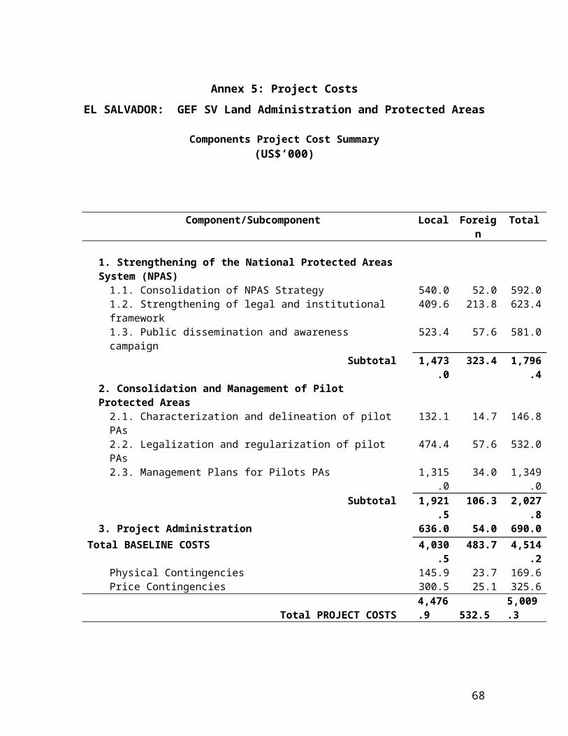
to those already processed, the combined registries would imply a total of 3,331 hectares of productive area. The MARN records are incomplete and it is not known how many of these certified or gazetted concessions are currently active. Nor is it known how many of the requested concessions are currently active, illegally. Assuming that much of this area is already under production and that a significant number of operations have not formally applied for concessions, it is possible that some 3,000 hectares are currently under operation.
9.10 MARN concessions are granted for productive operations that fall within the original boundaries of the protected area, established in 1973. The price area of land within those original boundaries is not known, however based on the assumption of 0.8% annual loss up until 1996 and 5.8% loss thereafter, the original area of protected land is estimated at 37,000 hectares, compared to 19,449 hectares of mangrove remaining in 2005.
9.11 Land prices in the Jiquilisco area are reported to be $5,700/ha.for cleared land, $2,100/ha. for uncleared land. Assuming that 3,000 hectares are currently under operation within the protected areas, the cost of obtaining similar land in order to relocate all producers within the protected area would be $17.1 million.
70
Table 9.4Concessions Granted or Requested in Bahia de Jiquilisco
Registry Number
Area Requested
(Has)Certified Official
GazetteCurrently
Valid
End of Validity Period
Active
1 287 2.7 No No No No
2 289 No No No No
3 285 No No No Sí
4 157 56.6 No No No No
5 155 2.8 No No No No
6 154 19.6 No No No No
7 153 2.1 No No No No
8 152 1.4 No No No No
9 150 3.5 No No No No
10 147 0.4 No No No No
11 145 28.0 No No No No
12 142 4.9 No No No No
13 151 14.0 No No No No
14 233 4.9 No No No No
15 263 2.7 No No No No
16 295 4.5 No No No No
17 290 2.8 No No No No
18 254 0.7 No No No No
19 252 12.6 No No No No
20 136 24.8 No No No No
21 167 4.9 No No No No
22 163 4.2 No No No No
23 162 83.0 No No No No
24 114 9.7 No No No No
25 113 99.3 No No No No
26 112 14.0 No No No No
27 111 14.7 No No No No
28 118 3.5 No No No No
29 103 16.1 No No No Sí
30 101 23.8 No No No No
31 98 21.0 No No No No
32 106 7.0 No No No No
33 134 0.6 No No No No
34 117 2.8 No No No No
71
Table 9.4 (con’t)
Concessions Granted or Requested in Bahia de JiquiliscoRegistry Number
Area Requested
(Has)Certified Official
GazetteCurrently
Valid
End of Validity Period
Active
35 126 97.4 No No No No
36 138 2.8 No No No No
37 286 27.3 No Sí Sí 11/5/2009 Sí
38 148 265.5 No Sí No No
39 146 13.5 Sí No No No
40 158 8.6 Sí No No No
41 232 50.0 Sí No No No
42 140 12.0 Sí No No No
43 97 4.2 Sí No No No
44 128 94.3 Sí No No No
45 132 6.3 Sí No No No
46 115 10.5 Sí No No No
47 125 17.7 Sí No No No
48 130 17.5 Sí No No No
49 122 64.4 Sí Sí Sí 10/12/2005 No
50 160 124.4 Sí Sí Sí 11/22/2009 No
51 235 4.0 Sí Sí Sí 1/29/2007 No
52 230 5.0 Sí Sí No 1/27/2002 No
53 165 16.7 Sí Sí Sí 7/26/2012 Sí
54 238 5.6 Sí Sí Sí 3/2/2011 No
55 104 44.6 Sí Sí Sí 3/6/2006 No
56 109 13.1 Sí Sí Sí 12/6/2010 No
57 108 79.0 Sí Sí No 4/13/2003 No
58 102 41.3 Sí Sí Sí 7/13/2011 No
59 100 5.1 Sí Sí Sí 9/9/2012 No
60 96 23.8 Sí Sí No 1/7/2003 No
61 135 70.3 Sí Sí Sí 12/20/2005 No
62 133 8.3 Sí Sí No 2/1/2004 No
63 131 124.6 Sí Sí Sí 7/6/2010 No
64 129 26.4 Sí Sí Sí 5/18/2009 No
65 123 27.0 Sí Sí Sí 11/5/2009 No
66 121 16.1 Sí Sí No 12/11/2002 No
67 120 13.4 Sí Sí No 12/11/2002 Sí
68 119 29.2 Sí Sí Sí 5/12/2010 No
72
Table 9.5Fish Production in Bahia de Jiquilisco by species(kg)
CANTON - COMUNIDAD BAGRE SARDINA CORVINA MACARELARUCOS / RONCONES ROBALO LISAS
JURELES / TAMALITOS MOJARRAS PARGO TIBURÓN
OTROS PECES
CAMARON DE MAR
CAMARON DE RIO
CANGREJOS / PUNHES JAIVAS
OTROS CRUSTÁCEOS CURILES CURILILLAS
MEJILLONES / ALMEJAS
EL ESPINO 1,211 28,320 2,169 18,647 7,991 10,655 848 550 5,541 1,459 15,983 35,600 8,121 26,818 35,000 9,423 48,728 9,420 65,450 ARCOS DEL ESPINO 35 423 45 248 106 142 24 350 88 59 212 3,323 2,030 - 350 - 12,182 1,413 5,000 PTO.PARADA 13,626 9,417 5,065 8,710 3,733 4,977 9,538 4,088 6,469 2,623 7,466 2,178 302 446 2,234 157 2,140 520 3,352 PTO.RAMIREZ 855 1,671 1,506 645 861 598 256 1,879 - 1,291 534 223 330 1,651 116 848 302 2,477 EL ICACO 1,167 2,270 2,048 878 1,170 817 350 2,555 - 1,755 726 74 110 551 39 283 105 826 PTO.GRANDE 1,094 2,138 1,927 826 1,101 766 328 2,403 - 1,652 685 167 247 1,239 87 638 227 1,858 LA PANIAGUA 179 1,167 816 350 466 125 354 1,008 - 699 - - - - - EVANGELICA 650 1,268 1,144 490 654 455 195 1,424 - 981 406 279 412 2,064 145 1,065 380 3,095 EL MILAGRO 171 335 301 129 172 120 250 376 - 258 108 112 165 826 58 423 151 1,239 COL.BRISAS DEL MAR 1,369 899 559 2,977 1,276 1,701 958 411 2,664 1,013 2,552 131 2 EL BOTONCILLO 1,196 2,336 2,109 904 1,205 837 359 2,628 O 1,808 748 1,690 2,501 12,517 879 6,444 2,300 3,000 PTO.EL FLOR 677 4,415 - 3,089 1,324 1,765 474 203 3,820 - 2,648 869 1,287 6,440 452 8,264 3,064 9,659 I. LA PIRRAYA 4,458 1,500 21,825 7,463 16,668 7,143 9,525 3,120 1,337 10,579 4,289 14,287 4,094 1,556 2,304 11,530 809 11,048 2,688 8,000 RANCHO VIEJO - 1,200 6,473 38,797 16,627 22,170 2,500 950 14,623 2,591 33,254 4,183 243 359 1,799 126 2,576 1,106 2,699 PUNTARENAS 3,804 2,506 1,554 8,273 3,546 4,728 2,663 1,141 7,398 2,806 7,091 360 1 1 5 0 8 LA CEIBITA 410 802 723 310 413 287 123 901 - 620 256 - - - - - EL AMATILLO 684 1,337 1,204 516 688 479 205 1,503 - 1,032 428 - - - - - EL COGOLLON 616 1,202 1,084 465 620 431 185 1,352 - 929 384 - - - - - EL CHILE 717 1,404 1,264 542 722 502 215 1,574 - 1,084 452 - - - - - CORRAL DE MULAS 1,170 7,578 5,304 2,273 3,031 819 351 6,561 - 4,546 261 386 1,931 136 2,480 921 2,897 EL ICACO - - - - - 150 - - - - - 283 105 - I .MADRE SAL 8,065 850 5,312 3,302 17,539 7,517 10,022 5,645 2,419 15,689 5,955 15,033 766 487 720 3,604 253 2,758 494 5,406 I.EL JOVAL 358 2,332 1,632 699 933 250 107 2,018 - 1,399 - - - - 827 99 - EL TRIUNFO 12,926 7,568 10,296 5,234 39,536 16,944 14,200 22,200 9,870 25,003 10,486 33,888 10,226 5,680 8,406 35,630 2,953 366,354 65,679 35,600 COL.PALMERAS 1,827 600 1,203 747 3,971 1,702 2,269 1,279 548 3,581 1,352 3,404 173 0 1 3 0 54,953 6,530 4 COL.IVU 878 400 570 332 528 226 302 614 263 392 160 452 136 151 223 1,116 78 1,068 259 1,673 EL VATICANO 992 350 1,938 1,746 748 998 694 298 2,175 - 1,497 618 371 550 2,751 193 1,417 506 4,127 B.LA PLAYA 1,504 800 2,940 2,651 1,136 1,515 1,052 451 3,305 - 2,272 939 631 934 4,677 328 2,407 862 7,015 EL TERCIO 241 470 422 181 241 168 325 527 - 362 150 - - - - - URBANIZACION 77 308 605 542 232 310 216 92 676 - 465 193 - - - - - B.LA ADUANA 445 800 871 784 336 448 312 134 978 - 672 276 - - - - - COL.SANTA ELENA 712 1,404 1,264 542 722 498 213 1,574 - 1,084 452 - - - - - COL.SANTA ROSA 650 1,268 1,144 490 654 455 195 1,424 981 406 - - - - - LOS MANCORNADOS 241 470 168 72 527 - 150 - - - - - COL CENTRO 241 470 422 181 241 168 160 527 - 362 150 390 577 2,889 203 1,486 531 4,333 SAN JUAN DEL GOZO 1,143 7,332 5,129 2,198 2,931 800 343 6,346 - 4,396 300 372 551 2,759 194 3,540 1,314 4,139 CEIBA DOBLADA 204 402 361 155 206 143 250 451 - 309 129 - - - - - PTO.AVALOS 4,068 7,948 7,168 3,072 4,096 2,847 1,220 8,940 - 6,144 2,542 4,550 6,734 18,960 2,366 17,385 6,157 12,000 EL RETIRO 610 400 251 1,323 567 756 427 183 1,185 447 1,134 56 0 0 1 0 2 CASER.LOS LIRIOS 204 402 361 155 206 143 350 451 - 309 129 - - - - 951 231 - I.MENDEZ 1,203 7,828 5,477 2,347 3,130 842 361 6,774 - 4,694 286 423 2,115 148 2,729 1,014 3,173 TOTAL BAHIA JIQUILISCO 70,897 14,068 152,247 26,721 208,838 89,502 110,944 65,280 30,205 157,889 33,240 179,004 72,387 28,845 54,486 152,642 19,144 553,278 106,378 187,034
73

b) Lago de Guija
9.12 As of 2002, the natural protected area of San Diego-La Barra was 1842 has. Under the proposed management plan for this area, the total size would be expanded to 5,795.57 hectares. The four portions identified in Figure 9.1 comprise a total of 2,345 hectares, of which 75%, or 1,795 hectares, is forested.
Scenario 1: No action
9.13 Current forest area within the protected area is estimated to be 1,700 hectares. Under the without project scenario, it is assumed that the current rate of deforestation will continue. In El Salvador there do not exist studies which show the tendency of deforestation. Recent maps are not compatible between time periods due to the fact that there were developed for different purposes and using different methodologies. The present study bases the rate of deforestation on the value that the Forest Service applies, estimated to be 4,500 hectares per year on a national level. As of 2005, it is estimated that there exist nationally a total of 126,685 hectares of forest. The forested area of San Diego-La Barra represents 0.93% of the national total. The annual deforestation is estimated as 4,500 hectares x 0.93% = 41.7 hectares per year, which translates into a carbon loss of 41.7 hectares x 73.9 metric tons/ha = 3,081 metric tons, with an economic value of approximately $14,000 per year.
9.14 Soil erosion. According a soil erosion study carried out by MARN on sloped areas during the period 1974-1979, it is estimated that the volume of erosion on slopes areas under agricultural production without conservation techniques is 100 tons per year per manzana, or around 71 tons per hectare. The study found that rainfall of 1,700 mm/year the rate of erosion is 63 tons/mz/year while will 1,900 mm/year, the erosion is 137 tons/mz/year. The average erosion was 100 ton/mz/year on 35% slopes in areas dedicated to basic grains.
9.15 The estimated area of basic grain in the San Diego-La Barra area is 2000 hectares. Supposing a conservative cost of $10 per ton, the economic cost from erosion is around $1,000 per manzana or $714 per hectare, translating into a loss of $1.4 million per year.
9.16 The Lago de Guija area produces an annual level of sedimentation into the Lago de Guija of 4.94 million tons per year39.
Scenario 2: Relocation of all producers
9.17 Within the San Diego Natural Protection Area, an area with a size of 196 hectares has been identified for possible relocation of existing agricultural producers (see the fuscia colored area in Figure 9.1). This area is characterized by annual flooding. Once the flood waters subside, the area is farmed with fruits and
39 Harza Engineering Company International, LP, “Estudio Global de la Sedimientación en la Cuenca del Río Lempa: Informe Principal”, San Salvador, Noviembre 1999, p. 40.
74

vegetables. An estimated 700 farmers produce in this area, with small plots averaging 0.18 hectares. In addition to these plots of land, the same farmers also produce basic grains (corn, beans and sorgo) on unirrigated land adjacent to this flood area (Porción 2 in Figure 9.1). Each farmer was provided with 2 hectares of land for basic grains by the Ministry of Agriculture. Thus, an estimated total of 1,400 hectares of basic grains are produced in Porción 2 as well as 135 hectares of fruits and vegetables in the tentative relocation zone. The basic grains are produced for subsistence which the fruits and vegetables are market oriented.
9.18 The Texistipeque CENTA office currently provides technical assistance in conservationist agricultural to 120 of the 700 producers. Excellent records are kept on the farmer’s current practices, and pilot farm methodology is used to promote more productive and conservationist techniques. The average net benefit per hectare obtained from vegetable production in the tentative relocation zone is $290.
9.19 Despite seasonal flooding, the in the tentative relocation zone is considered to be amongst the best land in the area. Land with similar characteristics would cost around $4,900 per hectare. The total cost of land for relocation of the farmers in this zone would be $1.4 million, with additional investments required in irrigation systems estimated at $300,000. Total cost of relocation would be $1.7 million.
Figure 9.1Boundary of the San Diego Natural Area
75

Table 9.5Sample of production in relocation zone of the San Diego Natural Area
Productor Cultivo Ha.
Net Benefit ($/ha
1 Frijol 0.21 (6.13)2 Frijol 0.7 61.723 Frijol 0.7 40.204 sorgo 2.1 20.695 sorgo 1.75 35.426 sorgo 2.45 22.407 maiz 2.1 1.348 maiz 1.05 10.599 maiz 2.45 22.57
10 maiz 0.525 15.4911 pepino 0.08 74.9012 sandia 0.14 120.1113 sandia 0.13 257.4114 pipian 0.25 41.4515 pipian 0.35 48.0816 pipian 0.18 23.1317 pepino 0.18 288.1918 chile dulce 0.18 20.9219 tomate 0.13 1,443.1720 tomate 0.18 57.3921 loroco 0.04 2.6322 loroco 0.70 1,463.7523 maracuya 0.04 42.6324 maracuya 0.08 33.6425 rabano 0.08 440.04
III. Financial Analysis of MARNS Protected Area System.
Based on the results of the two pilot area analyses, the financial analysis of the MARNs Protected Area System (PAS) as a whole was undertaken. Current costs were identified as well as the incremental costs associated with consolidating the current system. The sources for incremental revenue generation is identified from concessions, conditional titles, user fees, fines and sale of land no longer supporting biodiversity benefits. A cashflow analysis of the projected costs and benefits of the PAS is being finalized. This will demonstrated project costs showing the investment costs required to consolidate the system as well as the recurrent costs of the overall system, annual budget/allocation needs for system, counterpart funds from annual budget. Potential revenue sources include income form concessions, conditional titles, user fees, etc.
76

Table 9.5Operating Costs in 15 Conservation Area Offices
Enero Febrero Marzo Abril Mayo JunioArrendamiento de locales para oficinas $5,250.00 $5,250.00 $5,250.00 $5,250.00 $5,250.00 $5,250.00Total de Arrendamiento $5,250.00 $5,250.00 $5,250.00 $5,250.00 $5,250.00 $5,250.00
Mantenimiento de fotocopiadoras $0.00 $300.00 $300.00 $300.00 $300.00 $300.00Mantenimiento de impresores y fax $0.00 $450.00 $450.00 $450.00 $450.00 $450.00Mantenimiento y Reparación cpu y computadoras $0.00 $50.00 $50.00 $50.00 $50.00 $50.00Mantenimiento líneas telefónicas, teléfonos $0.00 $275.00 $275.00 $275.00 $275.00 $275.00Mantenimiento y apoyo informático $0.00 $1,755.00 $1,755.00 $1,755.00 $1,755.00 $1,755.00Mantenimiento mobiliario ( sillas, escritorios, archivos, etc ) $0.00 $225.00 $225.00 $225.00 $225.00 $225.00Mantenimiento de 15 vehículos y 30 motos $0.00 $0.00 $2,000.00 $2,000.00 $2,000.00 $2,000.00Total de Mantenimiento equipos varios $0.00 $3,055.00 $5,055.00 $5,055.00 $5,055.00 $5,055.00
$297.50Seguridad ( 15 agentes de turnos de 24 horas) $8,925.00 $8,925.00 $8,925.00 $8,925.00 $8,925.00 $8,925.00Servicio de limpieza ( 15 personas ) $2,625.00 $2,625.00 $2,625.00 $2,625.00 $2,625.00 $2,625.00Servicio de energía eléctrica/Oficinas $825.00 $825.00 $825.00 $825.00 $825.00 $825.00Servicio de Agua potable $300.00 $300.00 $300.00 $300.00 $300.00 $300.00Servicio telefonía celular $90.00 $375.00 $375.00 $375.00 $375.00 $375.00Teléfono + internet $0.00 $4,875.00 $4,875.00 $4,875.00 $4,875.00 $4,875.00Servicios de Radio comunicación ( 180 radios + 3 bases ) $0.00 $9,000.00 $9,000.00 $9,000.00 $9,000.00 $9,000.00Total de Servicios Básicos $1,215.00 $15,375.00 $15,375.00 $15,375.00 $15,375.00 $15,375.00
Combustible, lubricante ( para 15 vehículos y 30 motos) $0.00 $10,000.00 $10,000.00 $10,000.00 $10,000.00 $10,000.00Baterías para vehículos y motos $0.00 $0.00 $700.00 $700.00 $700.00 $700.00Llantas y reparaciones $0.00 $0.00 $1,500.00 $1,500.00 $1,500.00 $1,500.00Combustible, Lub. Y llantas $0.00 $10,000.00 $12,200.00 $12,200.00 $12,200.00 $12,200.00
Agua embotellada $675.00 $675.00 $675.00 $675.00 $675.00 $675.00Materiales de papel y cartón $300.00 $300.00 $300.00 $300.00 $300.00 $300.00Materiales y utiles de oficina $1,500.00 $1,500.00 $1,500.00 $1,500.00 $1,500.00 $1,500.00Materiales informáticos $1,000.00 $1,000.00 $1,000.00 $1,000.00 $1,000.00 $1,000.00Fumigación $300.00 $300.00 $300.00 $300.00 $300.00 $300.00Uniformes $0.00 $45,000.00 $0.00 $0.00 $0.00 $0.00Total de Gastos Operativos $3,775.00 $48,775.00 $3,775.00 $3,775.00 $3,775.00 $3,775.00
Remodelación de Oficinas $15,000.00 $0.00 $0.00 $0.00 $0.00 $0.00Sistema eléctrico y puntos de red $0.00 $5,000.00 $0.00 $0.00 $0.00 $0.00Rotulación é identificación de oficinas $0.00 $3,000.00 $0.00 $0.00 $0.00 $0.00Total de Gastos de Readecuación de Oficinas $15,000.00 $8,000.00 $0.00 $0.00 $0.00 $0.00
Equipo de protección dérmica (60) $0.00 $36,000.00 $0.00 $0.00 $0.00 $0.00Total de Materiales de Protección Personal $0.00 $36,000.00 $0.00 $0.00 $0.00 $0.00
TOTAL $34,165.00 $135,380.00 $50,580.00 $50,580.00 $50,580.00 $50,580.00
NECESIDADES COMPLEMENTARIASServicio de Publicidad $0.00 $0.00 $11,250.00 $0.00 $0.00 $11,250.00Servicio de Capacitación $0.00 $1,500.00 $0.00 $0.00 $0.00 $0.00Servicio de Publicación y Reproducción $2,000.00 $2,000.00 $1,600.00 $1,600.00 $2,000.00 $2,000.00
$2,000.00 $3,500.00 $12,850.00 $1,600.00 $2,000.00 $13,250.00
TOTAL GENERAL $36,165.00 $138,880.00 $63,430.00 $52,180.00 $52,580.00 $63,830.00
77

Table 9.5(con’t)
Operating Costs in 15 Conservation AreaJulio Agosto Sept. Octubre Noviembre Diciembre TOTAL
Arrendamiento de locales para oficinas $5,250.00 $5,250.00 $5,250.00 $5,250.00 $5,250.00 $5,250.00 $63,000.00Total de Arrendamiento $5,250.00 $5,250.00 $5,250.00 $5,250.00 $5,250.00 $5,250.00 $63,000.00
Mantenimiento de fotocopiadoras $300.00 $300.00 $300.00 $300.00 $300.00 $300.00 $3,300.00Mantenimiento de impresores y fax $450.00 $450.00 $450.00 $450.00 $450.00 $450.00 $4,950.00Mantenimiento y Reparación cpu y computadoras $50.00 $50.00 $50.00 $50.00 $50.00 $50.00 $550.00Mantenimiento líneas telefónicas, teléfonos $275.00 $275.00 $275.00 $275.00 $275.00 $275.00 $3,025.00Mantenimiento y apoyo informático $1,755.00 $1,755.00 $1,755.00 $1,755.00 $1,755.00 $1,755.00 $19,305.00Mantenimiento mobiliario ( sillas, escritorios, archivos, etc ) $225.00 $225.00 $225.00 $225.00 $225.00 $225.00 $2,475.00Mantenimiento de 15 vehículos y 30 motos $2,000.00 $2,000.00 $2,000.00 $2,000.00 $2,000.00 $2,000.00 $20,000.00Total de Mantenimiento equipos varios $5,055.00 $5,055.00 $5,055.00 $5,055.00 $5,055.00 $5,055.00 $53,605.00
Seguridad ( 15 agentes de turnos de 24 horas) $8,925.00 $8,925.00 $8,925.00 $8,925.00 $8,925.00 $8,925.00 $107,100.00Servicio de limpieza ( 15 personas ) $2,625.00 $2,625.00 $2,625.00 $2,625.00 $2,625.00 $2,625.00 $31,500.00Servicio de energía eléctrica/Oficinas $825.00 $825.00 $825.00 $825.00 $825.00 $825.00 $9,900.00Servicio de Agua potable $300.00 $300.00 $300.00 $300.00 $300.00 $300.00 $3,600.00Servicio telefonía celular $375.00 $375.00 $375.00 $375.00 $375.00 $375.00 $4,215.00Teléfono + internet $4,875.00 $4,875.00 $4,875.00 $4,875.00 $4,875.00 $4,875.00 $53,625.00Servicios de Radio comunicación ( 180 radios + 3 bases ) $9,000.00 $9,000.00 $9,000.00 $9,000.00 $9,000.00 $9,000.00 $99,000.00Total de Servicios Básicos $15,375.00 $15,375.00 $15,375.00 $15,375.00 $15,375.00 $15,375.00 $170,340.00
Combustible, lubricante ( para 15 vehículos y 30 motos) $10,000.00 $10,000.00 $10,000.00 $10,000.00 $10,000.00 $10,000.00 $110,000.00Baterías para vehículos y motos $700.00 $700.00 $700.00 $700.00 $700.00 $700.00 $7,000.00Llantas y reparaciones $1,500.00 $1,500.00 $1,500.00 $1,500.00 $1,500.00 $1,500.00 $15,000.00Combustible, Lub. Y llantas $12,200.00 $12,200.00 $12,200.00 $12,200.00 $12,200.00 $12,200.00 $132,000.00
Agua embotellada $675.00 $675.00 $675.00 $675.00 $675.00 $675.00 $8,100.00Materiales de papel y cartón $300.00 $300.00 $300.00 $300.00 $300.00 $300.00 $3,600.00Materiales y utiles de oficina $1,500.00 $1,500.00 $1,500.00 $1,500.00 $1,500.00 $1,500.00 $18,000.00Materiales informáticos $1,000.00 $1,000.00 $1,000.00 $1,000.00 $1,000.00 $1,000.00 $12,000.00Fumigación $300.00 $300.00 $300.00 $300.00 $300.00 $300.00 $3,600.00Uniformes $0.00 $0.00 $0.00 $0.00 $0.00 $0.00 $45,000.00Total de Gastos Operativos $3,775.00 $3,775.00 $3,775.00 $3,775.00 $3,775.00 $3,775.00 $90,300.00
Remodelación de Oficinas $0.00 $0.00 $0.00 $0.00 $0.00 $0.00 $15,000.00Sistema eléctrico y puntos de red $0.00 $0.00 $0.00 $0.00 $0.00 $0.00 $5,000.00Rotulación é identificación de oficinas $0.00 $0.00 $0.00 $0.00 $0.00 $0.00 $3,000.00Total de Gastos de Readecuación de Oficinas $0.00 $0.00 $0.00 $0.00 $0.00 $0.00 $23,000.00
Equipo de protección dérmica (60) $0.00 $0.00 $0.00 $0.00 $0.00 $0.00 $36,000.00Total de Materiales de Protección Personal $0.00 $0.00 $0.00 $0.00 $0.00 $0.00 $36,000.00
TOTAL $50,580.00 $50,580.00 $50,580.00 $50,580.00 $50,580.00 $50,580.00 $706,845.00
NECESIDADES COMPLEMENTARIASServicio de Publicidad $0.00 $0.00 $11,250.00 $0.00 $0.00 $11,250.00 $45,000.00Servicio de Capacitación $0.00 $1,500.00 $0.00 $0.00 $0.00 $0.00 $3,000.00Servicio de Publicación y Reproducción $1,600.00 $2,000.00 $1,600.00 $1,600.00 $1,000.00 $1,000.00 $20,000.00
$1,600.00 $3,500.00 $12,850.00 $1,600.00 $1,000.00 $12,250.00 $68,000.00
TOTAL GENERAL $52,180.00 $54,080.00 $63,430.00 $52,180.00 $51,580.00 $62,830.00 $774,845.00
78
Annex 10: Safeguard Policy Issues
EL SALVADOR: Protected Areas Consolidation and Administration Project
1. This project is expected to have a highly positive environmental impact. If implemented as planned, the project would have no significant adverse environmental effects. It would also comply with all applicable World Bank safeguard policies, as explained below.
2. Environmental Assessment (OP 4.01). The project is classified as Category B, requiring some type of Environmental Analysis (EA) but not a full-scale Environmental Impact Assessment. In accordance with OP 4.01, this project EA builds upon the one done for the partially blended LAP II, which was conducted by national and international experts during the summer of 2004. Specifically, the PACAP EA consists of three studies: (i) An overall protected areas study to develop recommendations for improving the NPAS; (ii) ecological assessments of the two pilot areas; and (iii) an environmental assessment of eligible project activities within the two pilot areas. This latter document provides the environmental criteria and procedures that are to be reflected within the protected area management plans that will be produced for each pilot area during project implementation (as part of Component 2). It indicates, among other information, (i) the types of eligible civil works (park guard houses, observation platforms, physical demarcation, etc.) and other project investments (excluding any which are likely to be environmentally harmful); (ii) the simple procedures and responsibilities (within MARN) for environmental screening and supervision of these investments; (iii) typical mitigation and monitoring measures to help ensure the environmental sustainability of any natural resource harvesting or alternative livelihood investments within or adjacent to the pilot areas; and (iv) standard environmental rules for civil works contractors and workers (regarding waste disposal, raw materials sourcing, no hunting, etc.). In accordance with OP 4.01, extensive consultation with conservation NGOs, local community representatives, and other stakeholders on the project’s environmental and other aspects took place during the preparation of the three reports that comprise the EA.
3. Natural Habitats (OP 4.04) and Forests (OP 4.36). The project is fully consistent with the Bank’s Natural Habitats and Forests policies. It would not cause, nor facilitate, any significant loss or degradation of forests or other natural habitats. On the contrary, the project is intended to prevent, or at least reduce, such loss or degradation by improving the protection and management of natural habitats within the project areas. Through the management plans to be developed for each pilot conservation area (under Component 2), the project will regulate any extraction of natural products by local people. The project will also support the environmental monitoring of such harvesting (and making adjustments in harvesting limits, if needed) to ensure sustainability. In the Bahia de Jiquilisco Conservation Area, limited harvesting of mangrove trees (as an alternative to ongoing activities that are more destructive to the mangroves) might possibly be authorized under the management plan that will be developed during project implementation. In such a case, the management plan will specify the need to conduct any mangrove harvesting in accordance with the criteria of OP 4.36 (Paragraph 12) for forest harvesting by local communities under community forest management.
4. Cultural Property (OPN 11.03). Some of the conservation areas to be supported under the project (indirectly through Component 1 and directly through Component 2) contain significant archaeological, historical, or other cultural patrimony. The preservation of cultural sites or relics will be an important element of the management plans for relevant conservation areas.
5. Involuntary Resettlement (OP 4.12). Although no involuntary resettlement of any people will take place under the project, there might be increased restrictions in access to natural resources for some of the people living in, or adjacent to, the project pilot areas. Consequently, a Process Framework (see Annex 10C below) has been produced to ensure that project beneficiaries receive appropriate consideration and assistance in their efforts to maintain or improve their livelihoods.
79
Such assistance would be provided during the formulation and implementation of management plans for each pilot area.
6. In accordance with IBRD’s policy on Disclosure of Information (BP 17.50), copies of the Environmental Assessment Report and Process Framework will be available for public viewing at CNR’s UCP office (1ª Calle Poniente and 45 Av. Nte. # 2310, San Salvador) and on CNR’s website (www.cnr.gob.sv) before appraisal.
80
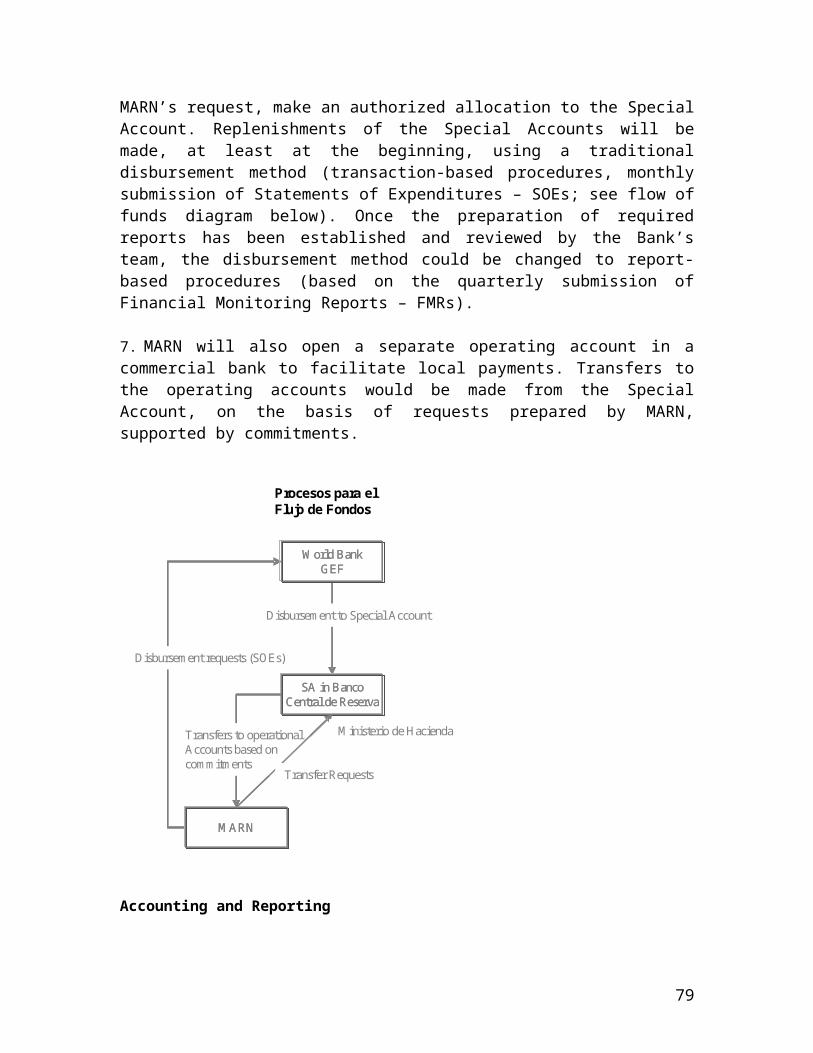
Annex 10B: SOCIAL ASSESSMENTExecutive Summary
1. Background
The National Registry Center (CNR) and the Ministry of Environment (MARN), as agreed between the World Bank and the Government of El Salvador in the Country Assistance Strategy (CAS) for El Salvador, have the objective of promoting land tenure security. The design of the Project takes as its basic framework objective the conservation of biodiversity and reduction of poverty in rural and semi-urban areas in and near priority protected areas. The Project will cover two pilot protected areas: Bahia de Jiquilisco (Jiquilisco Bay) and Lago Guija (Guija Lake). 2. Design of the Social Assessment.To investigate the social universe to be covered by the Project, the Social Assessment (SA) identified and analyzed several different "socio-geographic" scenarios. These consist of various geographical areas and the social groups that characteristically utilize or occupy the areas (project beneficiaries as well as other social actors), including small and medium-sized rural producers, and the semi-urban population. The SA incorporated a gender perspective where relevant.
3. Methodology. The SA (1) identified the social actors involved, especially beneficiaries, and the mechanisms for their participation in project design and execution; (2) analyzed the factors influencing access to land, including gender; (3) documented the existing modalities of land tenure; (4) studied the nature of land tenure conflicts and the instruments for their resolution; (5) examined the potential social impacts of the Project and recommended actions to avoid, mitigate or enhance impacts depending on their contribution to project objectives; and (6) presented recommendations for the design and implementation of the Project to maximize beneficiary participation so as to achieve social development and poverty reduction. The SA was based on a combination of quantitative and qualitative methodologies. These included the collection of relevant secondary information, collection of primary data in the field relevant to the purposes of Social Assessment, consultations directly with the social actors involved to interpret the information collected, empirical verification of interpretations and conclusions in the field, and design of recommendations for management of the project.
Primary Data Collection: Views of the Beneficiaries. Two instruments were used to obtain the views of project beneficiaries and other social actors that will be involved as well as primary data concerning their land tenure situation. First, a socioeconomic survey was conducted of about 400 rural and semi-urban producers that occupy land in buffer zones with and without benefit of title. Second, semi-structured interviews and focus group discussions were held among direct beneficiaries of the Project (producers, ADESCO members and local leaders), non-governmental organizations (NGOs) and official institutions responsible for the current land administration system and associated programs. The latter served to compliment, corroborate and triangulate information and opinions received from the sample survey.
Gender Focus. To identify the significant issues surround land tenure for each gender, to
81
provide data needed to address existing disparities and discriminatory factors, and to facilitate actions that favor women's access to land and ownership of means of production, the SA collected and analyzed specific issues flagged by women heads of households. This focus was maintained in the sample survey as well as in interviews and focus group discussions.
Characteristics of Land Tenure. The majority of the rural population of El Salvador occupies land owned by the national government (whether land occupied for generations or land acquired by the State for agrarian reform purposes) and enjoy possession rights but do not have legal titles. The Project is designed to establish the necessary conditions to legalize such possession. Some 60% of rural producers do no have titles to their farms. Salvador legislation with ISTA provides the opportunity for these farmers to convert their possession into legal title. While the majority of lands have the legal status of "possession" by an individual, there are several form of property rights which are recognized, depending upon how the possession was acquired (for example, by inheritance, by concession of the State, purchase or usufruct). The sample survey for the SA found that the majority of the lands were acquired by occupancy, reformed groups, inheritance or concession. The main obstacles to acquiring a title are economic (the cost of land and its titling cannot be covered by more than half of rural people who live in poverty; the situation is more severe for those living below the extreme poverty line). In addition, there are some institutional, legal and operational weakness of the current land administration system, which might constitute major obstacles.
Institutional factors. El Salvador still needs to improve the institutional response and efficiency of the system of land administration, and clarify some related norms and procedures. This process is being carried out by a separate World Bank Land Administration Project with CNR (LAP II). Still, most beneficiaries have difficulty understanding how the various parts function, who has responsibility and how to get their case addressed.
Economic factors. Under the existing conditions, the cost of land as well as the cost of land titling which must be borne by the individual seeking legal title are beyond the reach of the great majority of rural people and semi-urban people. In addition to the heavy costs of land and title, the time consuming process of the land measurement, mapping system, sanitation, titling and land registry impose high transactions costs that are a disincentive to the regularization of property rights.
Cultural factors. Despite the prolonged existence of the informal property market in El Salvador, some farmers perceive disadvantage in keeping their lands without title. However, at the same time, there is wide spread perception that regularization and titling will involve high fees and costs of the process and risk loosing their lands if they are unable to pay the debts acquired with the State.
Gender Barriers to Land Tenure Regularization. Legally there are limitations on women's access to tenure regularization, it is clear that in practice ideological and social stereotypes have historically blocked such access. However, in general, rural women do not possess land no family patrimony which would permit them to capitalize production and generate a minimum of security for their offspring. To overcome these social limitations, the Project should place special emphasis on education and information dissemination to both genders, more than on further
82
refinement of the legal framework, and the policies, programs and actions designed under the Project should provide special instruments for incorporating women into the project.
Land Tenure Conflicts and Conflict Resolution. The findings of the SA indicate that despite the overarching national legal framework and country-wide commonalities in the socioeconomic, institutional and cultural factors that constrain access to land tenure security, there is marked variation in the nature and significance of land tenure conflicts among the socio-geographic scenarios investigated. For instance, in some of the peri-urban areas in the area of the Guija Lake have been already measured by El Cambita Medidor (local name provided by CNR to LAP II staff in charge of measuring land) and some have tittles or are in process to obtain the titles or concession permits. While in the Jiquilisco Bay area, the Chambita Medidor has not yet arrived and most land is titled in the name of ISTA as a result of the Agrarian Reform process and of the after war Peace Agreements.
Protected Areas. Land tenure conflicts in protected areas stem from failure to regularize the holdings of individuals with possession or usufruct rights dating from before the creation of the protected area. Conflicts occur where protected areas have not been demarcated, and local property holders do not know the boundaries of protected areas. Still other conflicts are rooted in the exploitation of wood and other natural resources, without authorization by environmental authorities. The Project will demarcate two pilot protected areas and regularize the holdings of existing population. This is the first time El Salvador will undertake massive land titling in such areas. The Project will reach an agreement with present occupants on a cut-off date, before which all farmers and households resident in the area will have the right to title to their holding under certain conditions, for instance: (a) restriction of using the land, (b) resource exploitation and (c) participate actively in management plans. Social assessment results indicate that about the 90% of the people, at least in Guija Lake, are willing to participate in conservation and management plans if these are well designed in terms of scheduling (meeting agricultural calendar), activities, monitoring, and if there is some economic compensation. Most beneficiaries indicate that previous reforestation activities have failed because there is no following up nor monitoring activities. It seems that reforestation programs have been designed as a planting trees activity and do not provide maintenance to ensure forest formation. It seems also that indicators to measure reforestation needs to be revised. The common indicator is number of trees or acres planted, but the real indicator is number of acres turned into forest after three years.
All marine and coastal lands have various degrees of protection in relation to Integrated Coastal Management Plans, which are subject to legal enforcement in terms of inland zones subject to tidal flooding. Families using these lands must obtain title to the land by square meter rather than by hectare. In these cases, the Project will need to develop special provisions to ensure access to titles.
Identification of Beneficiaries and Other Social Actors. The Project will benefit all those rural and semi-urban property holders who do not have register legal title to the property upon which they depend for their livelihood. Specifically, the Project will benefit, at least, 40,000 small and medium producers in rural areas of which 80% are poor households. Most of these households have developed agricultural, livestock, fishing, extractive and manufacturing productive activities in areas traditionally dedicated to agriculture, including the agricultural
83

frontier. Within this group, special attention is required to recognition of the productive activities of women heads of households. About the 70% of the consulted people have separate parcels. That is to say that have one parcel used for residential purposes while at the same time have another one for agricultural purposes. This pattern was found in both rural and semi-urban areas.
Relationship Between Poverty and Tenancy Regularization. It should be noted that the Project beneficiary population coincides in grand measure to the priority intervention areas identified in the Poverty Map of El Salvador. From a social standpoint, a key condition for the Project to achieve its objective of poverty reduction is to establish alliances and linkages among its activities and those of other Government institutions with responsibility for registry (CNR, ISTA), credit, technical assistance, education, etc. to compliment the impact of land regularization. Without these associated investments, the effects of regularizing land tenure may be nullified. Moreover, the results of the focus groups and interviews with peasants indicate that there is a general fear that, far from improving the situation, land titling may have the opposite effect: many may be tempted to sell their land because of the of higher prices (due to the title) combined with the absence of complimentary programs to assist the poor to increase their productivity. This unwanted outcome would draw subsistence farmers off the land into the urban slums where impoverishment could deepen, given the lack of suitable skills and education of the rural poor. The full SA provides detailed data regarding the socioeconomic characteristics of the rural and semi-urban population, as well as details of the actual legal status of the lands upon which they depend.
Social Organization of the Actors. ADESCOS are the key local organization which activities varies across the country and depends of the degree of social capital developed in each of the communities. Some of the ADESCOS execute activities with local Municipalities and/or ONGs to provide potable water and garbage collection such is the case of San Diego. Other execute reforestation activities such is the case of El Desague. There are also some cooperatives formed as a result of the Agrarian Reform. It is likely that these peasants feel more need to organize to protect their land claims. There are first level, second and third level organizations: (a) First Level Organizations. These include ADESCOS, producer organizations, cooperatives, community councils or committees (most water related) with strictly local-level presence. (b) Second and Third Level Organizations. These include Association of Small and Medium Producers, the Federation of Agricultural Cooperatives. Other Social Actors. In addition to the beneficiary organizations and the regional and national organizations working with them, there are two other types of social actors: (a) Private Companies. These include companies such as CEL, CESSA and other tourist companies developing entertainment centers such as restaurants, Spa and Hotels in the buffer zones. There are also NGOs working in the areas such as FONAES and FIAES. The degree of effectiveness and people’s perception regarding the NGO’s performance varies across communities. Government Institutions. These include: (a) CNR, (b) Ministry of Tourism, (c) CONCULTURA, (d) Ministry of Agriculture, among others.
Poverty and Land Tenure. Rural poverty is determined by structural conditions under which agricultural production is realized, specifically, the economic and technical constraints of the traditional agriculture to face a global market. However it is recognized that lack of property titles is a factor that contributes to poverty and keep peasants away from new economic opportunities. Thus, the project challenge will be to secure complementary processes and
84
conditions that complement the delivery of property titles, such as: (i) mechanisms to guarantee access to land; (ii) changes in the social relationship between producers, the State, financial institutions and consumers; (iii) changes in the institutional and legal framework and in the mechanisms for technological transference to support associative efforts and consolidate the productive capacity of small and medium size producers.
Consultation and Participation. It is highly recommended that the project set aside enough resources to strengthen the capacity of the rural, peri-urban and urban organizations that constitute natural allies, in order to secure their active involvement in Project’s activities, particularly with ADESCOS.
Social Impact Indicators. The following are some of the most important indicators:* Number of families with holdings and property title regularized by the Project (withemphasis on the 50% living in poverty) vs number of families without title in areas that are adjudicable.* Number of land rights conflicts resolved and accords signed among peasants and the System of Protected Areas.* Number of land property disputes solved through alternative conflict resolution mechanisms vs number of dispute solved through judiciary means.* Percentage of women heads of households receiving title.* Number of poor land owners in the process of obtaining grants based by the Project.
85
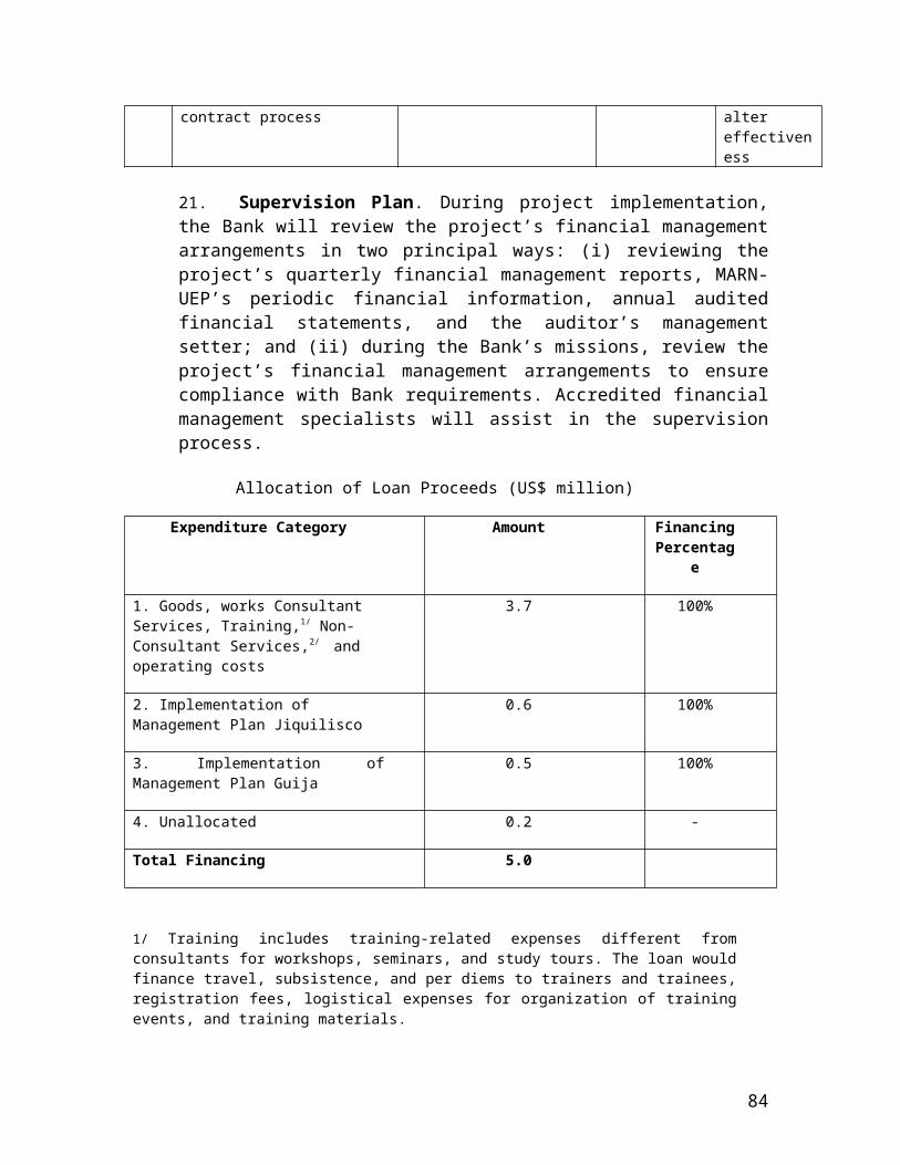
Annex 10 C:Process Framework for Mitigating Potential Livelihood Impacts
1. Project Summary. The Project seeks to strengthen the national protected areas system through a strategy developed based on results from the consolidation of two priority protected areas. The principal activities of the project will include protected area policy reforms, as well as cadastre and registry, demarcation and legalization of two pilot protected areas, land conflict resolution, and development and implementation of management plans including granting of land rights to eligible residents in two pilot protected areas: Jiquilisco Bay and Guija Lake.
2. No Physical Displacement. To effectively implement the project, no involuntary physical displacement or relocation of people would be required, and none will take place as a part of this project. This is consistent with previous Government practice in resolving land tenure issues in El Salvador.
3. Potential Impacts on Livelihoods. Nonetheless, the possibility remains that some Project activities to establish and consolidate protected areas might materially affect the current livelihoods of certain Salvadorans living within or adjacent to these pilot areas. This Process Framework outlines the criteria and procedures which the Project will follow in such cases, to ensure that eligible, affected persons are assisted in their efforts to restore or improve their livelihoods in a manner which maintains the environmental sustainability and territorial integrity of the relevant protected areas. In all such cases, MARN as the executing agency would seek to address the livelihood issues of these persons in a manner which is fair, just, and in accordance with Salavdoran law, as well as consistent with the World Bank's Safeguard Policies on Involuntary Resettlement (OP 4.12), Indigenous Peoples (OD 4.20), Natural Habitats (OP 4.04) and Cultural Property (OPN 11.03).
4. Impact Scenarios Considered. Based on the social and legal assessments conducted during project preparation, implementation of the Project could materially affect the existing livelihoods of some Salvadorans who live within the boundaries of protected areas, or live outside the protected areas but frequently enter to utilize natural resources. This Process Framework focuses primarily on explaining how the project would address the livelihood issues of persons living within or close to protected areas. A variety of other livelihood-related scenarios were carefully analyzed during project preparation, and found not to be relevant to this project Process Framework. These "ruled out" scenarios include the following:
a. Small and medium agricultural producers. This include farms (under possessors' rights) are located in State owned lands and rural towns, that will be demarcated. The main potential social issue in the demarcation of these lands is to ensure that these farmers are not adversely impacted by the change in land classification if and when their holdings come under municipal jurisdiction. However, these landholders would receive improved tenure status (as prior to the project, their lands were not eligible for titling, and once
86

declared as non-protected lands, can be titled), and moreover land which is reclassified from rural to urban invariably rises in value, substantially benefiting the farmer in financial terms. Nonetheless, the project design includes a series of steps which would mitigate adverse livelihood-related impacts even if they existed; these steps include socioeconomic studies and a census prior to demarcation, technical assistance for land titling before the land is transferred to the municipality, and special legal resolutions in each case, and alternative conflict resolution mechanisms.
b. People within Protected Areas. The procedures outlined below will apply to Salvadorans who have occupied the land, or frequently utilized the natural resources, within a protected area prior to the official cut-off date. The project through MARN will specify the cut-off-date on a case-by-case basis for each protected area, after close consultation with local residents and other stakeholders. To assist in this process, project has incorporated within its design the functioning of local, community-based Roundtables. As a general principle, the cut-off-date should be the date by which time essentially every head of household could reasonably be expected to know of the official existence and on-the-ground location of the protected area or could be a different date for each protected area based on its particular circumstances. In some cases, cut-off-date might be the starting date of the demographic census that will normally be part of the land tenure-socioeconomic study for establishing or consolidating a new protected area. In other cases, the cut-off-date might be before the census, if the existing protected area's location was previously demarcated or otherwise adequately publicized to local residents and neighbors (such as through routine patrol or enforcement actions). Persons who illegally occupy or begin exploiting the natural resources of a protected area after the cut-off-date would not be eligible for any type of livelihood-related or other assistance (consistent with the spirit of the Bank's OP 4.12). Besides the cut-off-date, other decisions concerning the eligibility of occupants or neighbors of protected areas for special consideration regarding livelihood issues would be consulted with stakeholders and recorded in the protected area Management Plan.
5. Procedures for Protected Areas. In the demarcation and consolidation of protected areas, the following actions (relevant to the livelihood concerns of residents or neighbors) will be carried out during project implementation. For the two pilot protected areas, those steps below that have already been adequately completed in the past would not be repeated, but checked and updated as needed. For example, given that both areas have existing management plans, the project would review and modify those plans to reflect the entire pilot area (in both cases the existing management plans only address part of the proposed pilot areas), and ensure that they give adequate consideration to the livelihood-related issues of protected area residents and neighbors. (a) Participatory meetings with local residents and other stakeholders regarding the protected area demarcation and consolidation process, along with the full range of viable alternatives for protected area management; (b) Land tenure-socioeconomic study of the residents and neighbors of the protected area, including a demographic
87

census, an assessment of the legal rights of each type of affected person, and (c) mapping of the lands claimed by each occupant as well as actual land use; (d) update a rapid ecological evaluation of the protected area and its vicinity, with special emphasis on (i) the relative conservation value of the sites under human pressure and (ii) the extent to which the natural ecosystems and species of conservation concern can survive under existing levels of human use and disturbance; (e) Decision on the precise boundaries of the area to be demarcated, made with the active participation of the local residents as well as other stakeholders. To the maximum extent feasible (consistent with the law or decree establishing the protected area), MARN (in coordination with CNR) will select boundaries which minimize the inclusion of occupied lands within each protected area, to minimize livelihood issues and other management complexities; (f) physical demarcation of the protected area boundaries; (g) formulation or updating of the protected area's Management Plan in a participatory manner that takes into account the views of different stakeholders. Each Management Plan will include (i) the conservation and management objectives of the protected area; (ii) co-management agreements (if any) negotiated with protected area occupants, neighbors, local authorities (ADESCOS), farmers Cooperatives, NGOs, private sector and/or other interested parties; (iii) procedures for negotiating any future land tenure agreements; (iv) rules concerning prohibited or restricted activities and different use zones; (v) the official cut-off-date; and (vi) a variety of other information relevant to protected area management; and (h) approval by MARN of the Management Plan and any associated co-management agreements.
6. Co-management agreements with eligible protected area occupants or neighbors would specify the time-bound manner by which these persons would be assisted in their efforts to restore or improve their livelihoods in ways which maintain the environmental sustainability and territorial integrity of the protected area. The types of land tenure and livelihood solutions which the Management Plans and co-management agreements could specify might include, depending on local circumstances, (i) provision of conditional titles or concessions to persons who could continue to inhabit or harvest resources from within specified zones of the protected area, subject to compliance with the Management Plan and any other agreed rules; (ii) adjustments in existing protected area boundaries to exclude the lands occupied or used by eligible individuals (provided that there is no significant net loss in the area under protection of each type of natural ecosystem); (iii) internal zoning with different restrictions to land, water, and natural resource use; (iv) technical or other assistance to eligible persons for pursuing alternative livelihoods which do not significantly damage the protected area; (v) any other alternatives mutually agreed to by the eligible affected persons and MARN; or (vi) sources of financing.
7. Enforcement of Rules in Protected Areas. New restrictions developed under the Project concerning natural resource use within protected areas will only be enforced against eligible persons after the World Bank (in its normal supervision role for the project funds) is provided an opportunity to review the relevant protected area Management Plan and any associated co-management agreements.
88
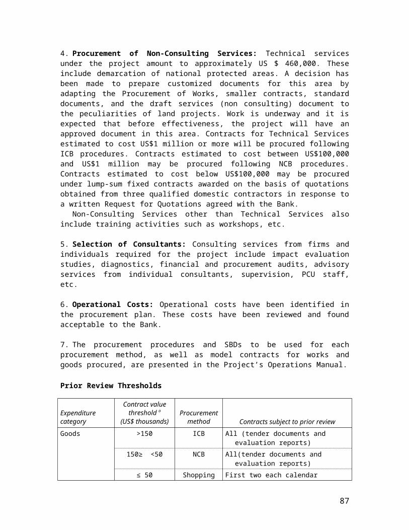
8. Conflict Resolution Mechanisms. The findings of the Social Assessment indicate that despite the overarching national legal framework and country-wide land administration activities, there exist socioeconomic, institutional, and cultural factors that constrain secure access to land. There is a marked variation in the nature and significance of land tenure conflicts among the socio-geographic scenarios investigated. The project will support the establishment of formal and alternative conflict resolution mechanisms.
9. Given the limitations of the means currently available for resolving land conflicts, the project has decided to pilot an alternative set of strategies to address these pressing issues. In particular, the project will support the targeted use of alternative dispute resolution strategies and methods to facilitate the resolution of disputes over land titling; demarcation, and definition of possible mixed-use regimes for protected areas. A pilot program in dispute resolution will be launched in the opening months of the project and closely monitored to permit objective assessment of its utility. Key activities proposed for the dispute resolution component of the project include the following:
a. A training program, oriented most directly to the members of the field teams that will identify and seek to resolve conflicting titling and demarcation claims in the project's focal zones. The training will provide a general introduction to the principles underlying alternative dispute resolution (ADR), but will emphasize the development of mediation skills relevant to the field teams' operating responsibilities. General introductory training in dispute resolution frameworks and strategies also will be provided to key staff of the eight government agencies that will be implementing the project.
b. Development of a manual for the field teams. The manual will provide hands-on, practical guidance for how field team members can apply dispute resolution principles to the settlement of competing claims over land titling and protected area demarcation.
c. Design of a conflict resolution monitoring and evaluation program that can be used to assess the value of individual training events, field team success in using ADR techniques to resolve land conflicts, and the utility of the manual.
d. Collaborative planning seminars for selected staff of the government agencies executing the project. Three government agencies with highly diverse mandates, philosophy, work cultures, and operating systems (e.g., the technical orientation of MARN compared with the legal orientation of the CNR) need to develop shared objectives and operating procedures in order for the project to succeed over the long run. The project will underwrite a series of collaborative planning seminars in which representatives of the government agencies can develop a collaboration framework.
10. Implementation Responsibilities. Depending on the specific task, the Governmental responsibilities outlined above will be carried out either by the project staff or consultants. Some tasks (such as land tenure-socioeconomic studies, and physical demarcation) would mostly be contracted out to qualified organizations, under close
89

supervision by the project and by MARN. For technical or other assistance to eligible persons for alternative livelihoods, the project and MARN would, in many cases, coordinate with other Government agencies or qualified NGOs for the provision of these specialized services.
11. Monitoring and Evaluation. The project would monitor the progress of the specific steps noted above for protected area demarcation, Management Plans, and co-management agreements. The project and the World Bank would carefully review the progress achieved in each of these steps during the Mid-term Evaluation and make any appropriate adjustments. The World Bank has also indicated its intention to monitor closely the livelihood-related and other social aspects. It is anticipated that both an environmental specialist and a social scientist from the World Bank would make at least two supervision visits per year.
12. Archeological and Historical Sites -Cultural Property. In general terms, project activities are sited and designed so as to prevent any possible damage to cultural property and/or historical sites. The project together with CONCULTURA and the Ministry of Tourism would classify the existing archeological and/or historical sites within project areas that were identified during project preparation through the EA and/or SA. The project would only support the delimitation of these sites once the voluntary agreement is signed with the owner of the plot. Nonetheless, in order to avoid further possible unanticipated adverse impact with respect to the vulnerable population living close by or in the areas of historical/archeological and cultural patrimony, the project will support key activities in order to maintain the cultural patrimony and its historical integrity as well as the livelihood of those Salvadoran living within or adjacent to such areas. Project actions as needed in this regard will include the following:
a. Specialized assessments/studies carried out by CONCULTURA to identify the level, the scope and the type of reconnaissance and of the preservation needed;
b. Participatory meetings with local residents and other stakeholder regarding the historical/archeological sites;
c. Land tenure socio-economic study of the residents, to minimize overlaps or potential conflicts;
d. Land zoning in the areas needed to be preserved, incorporating as much as possible, the neighboring population in the maintenance and conservation of the areas to maximize local involvement and potential benefits to the local population.
13. The activities mentioned above are included in the scope and costs of the project.
90
ANNEX 10D: Summary of Consultation Workshops
Development of National and Local workshops
National Workshop
CONSOLIDATION AND ADMINISTRATION OF PILOT PROTECTED AREAS AND MANGROVES
27-28 de Abril de 2005, San Salvador
I. SUMMARY AND OBJECTIVES
1. On April 27 and 28, 2005, a workshop was held in San Salvador, the goal of which was to disseminate the objectives and activities of the proposed project (PACAP) and promote dialogue among the organizations and institutions involved in the administration and management of El Salvador’s protected areas.
II. METHODOLOGY
2. Ninety three (93) persons representing a variety of private and public organizations and experts in protected areas management participated in the two-day workshop, which was structured as both an information dissemination event and a roundtable-based discussion (see agenda included as Table 1). Two phases of roundtable discussions were held, during the first of which the discussion centered around the following questions related to the PACAP: What do you think of the existing NPAS? Do you believe that the current protected area management efforts are contributing to the
consolidation of the NPAS? Do you believe that the objectives and components of the proposed Project are
adequate/necessary? From your perspective, are the objectives and components those necessary to achieve the
proposed project goals? From your perspective, are the priorities, activities and general orientation of the proposed
project adequate? What role should the communities and local governments living in and near protected areas
play in achieving a functioning NPAS? What observations about and recommendations to the Project would you make? Does the proposed Project design take into account the interests of your institution or
organization?
Table 1: Workshop AgendaTime Activity Presenter
DIA 1
9:00 -9:30 Opening CNR, MARN,9:30 -9:40 Greeting Rafael Antonio Parada
91
9:40 -9:50 Workshop Objectives and Methodology Rafael Antonio Parada9:50 -10:20 Summary of Proposed Project (PACAP) – Objectives and
CompomentsCarlos Roberto Hasbún
10:20 -10:35
Coffee Break
10:35 -10:55
GEF: Regional and Global Support for Biodiversity Projects Claudia Sobrevila
10:55 -11:15
Brief History of NPAS Ernesto López Z.
11:15 -12:00
Global Models for Protected Areas Management Jim Barborak
12:00 -12:30
Organization of Roundtable Discussions Rafael Antonio Parada
12:30 -1:30 Lunch2:10 -3:15 Roundtable Discussions3:15 -3:30 Coffee Break3:30 -5:00 Roundtable Discussions
DAY 2
8:00 -8:20 Case Study in Protected Areas Management: SalvaNatura Ian Varley8:20 -8:40 Case Study in Management of Lower Lempa River Miguel Ramírez9:15 -10:15 Roundtable Discussions10:15 -10:30
Coffee Break
10:30 -11:30
Roundtable Discussions
11:30 -12:30
Presentation of Roundtable Discussions
12:30 -1:30 Lunch1:30 -2:30 Presentation of Roundtable Discussions and Conclusions2:30 -2:45 Closing
III. GENERAL OBSERVATIONS
The participants contributed the following Project-related observations:A. The NPAS is currently operating to some degree.B. A new management model is needed for individual protected areas as well as for the overall system.C. Project initiatives must focus on areas where the biggest impact can be had, and not dilute
efforts through supporting a large number of processes and activities. D. Strategies should be created that enable sustainability of the protected areas.E. Efforts must focus on the sustained involvement of all key stakeholders.F. MARN should strive to make alliances with other organizations and institutions.G. Emphasis should be placed on an information dissemination campaign in the pilot areas.H. The establishment of institutional arrangements for effective management of NPAS is critical.I. Incentives should be established for the participation of the private sector, NGOs, and ADESCOs in
protected areas management.
92

Local Workshops
Summary of Local Consultation and Dissemination Workshop“Protected Areas Consolidation and Land Administration Project”
Lago Guija Complex San Diego-La Barra
I. SUMMARY AND OBJECTIVES
7. On May 17, 2005, a workshop was held in Metapan, in the El Salvadoran Department of Santa Ana, the goal of which was to disseminate the objectives and activities of the proposed project (PACAP), and to consult the local population on the proposed project and the management of the Lago Guija Complex.
II. METHODOLOGY
8. Twenty (20) persons representing a variety of private and public organizations participated (see Table 3) in the workshop, which was structured as both an information dissemination event and a roundtable-based discussion (see agenda included as Table 4). The discussion was centered around the following questions related to the PACAP.
Given that the PACAP aims to improve the conservation of the Lago Guja Complex and improve the quality of life for its residents, what activities would you propose be included in the project?
Which project activities would you like to be involved in?
9. During the discussion part of the workshop, participants took part in an exercise, based on the existing management plan, maps and satellite images, discussing the proposed zonification of the area, and recommending how proposed nucleus areas, buffer zones, and areas of influence should be adjusted.
III. RESULTS
10. The workshop participants proposed that the following activities be included in the project:
Activities aimed to strengthen the participation of women Disaster prevention works Small grants Community capacity building Information exchange with producers from other communities Dissemination of the results of project activities Environmental education Include cattle grazing areas in lagoon areas Forestry for fuel Promotion of organized ecotourism Improvement of institutional coordination Regulations for use and conservation of natural resources Activities to strengthen community organizations
93

Joint CEL-community activities Construction of a flood dike in La Barra Employment generation Management and treatment of wastes (organic and inorganic) Participatory planning Productive projects Create mechanisms for land use planning and relocation of agricultural activities Improve on-ground management through hiring of park guards Implement zonification included in the management plan Resolve land tenure problems Approve and disseminate management plan Decentralize management of protected areas Use international funds to contract locally based consultants
IV. SUGGESTIONS FOR IMPROVING COMMUNITY INVOLVEMENT IN PROJECT
Disseminate project in community assemblies (asambleas) Undertake annual participatory consultations with the agricultural producers Share experience of ADESCOs Co-implement Project activities Involve the municipality and CESSA Community enviromental education Ecotourism Involve community associations in policing of area Encourage CEL to work jointly with communities Participation in all Project activities Promote joint MARN-community activities in area Train park guards
V. GENERAL RECOMMENDATIONS FOR PROJECT
Undertake partipatory planning with local stakeholders Promote information exchange with other sites Promote use of local labor Pay special attention to CELs “floating lands” (regularly inundated areas) Increase involvement of park guards Achieve integration among all relevant actors Seek strategies to promote participation of other key stakeholders in Project dissemination
workshops
Table 3: ParticipantsName Organization Name OrganizationRosa María Morales ADESCOSAD Carlos Salvador Galicia Casa de la culturaCarlos Duarte ADESCONSAD Edgardo Armando
MoralesATRIDEST
Boris Romero ADESCONSAD Ricardo Valencia ADECELGUAUlises Najarro MAG-PRODERT Walter Chacón CATIEMaría José Menéndez
Consultora independiente
Carlos Duarte ADESCONSAD
José V. Mazariego ADESCOLAB Patricia Quintana DGPN-GANP-MARN
94
Gloria Serrano ADESCOLAB Zulma R. de Mendoza DGPN-GANP-MARNBeatriz Hernández ADESCOLAB Nestor Herrera ConsultorBenjamín Valenzuela CEPRODE Rebeca Magaña PACAPJimmy Escobar CEPRODE Rodrigo Samayoa
ValientePACAP
Table 4: Workshop AgendaTime Activity
0900 Workshop objectives (Zulma de Mendoza, MARN)0915 Summary of existing management plan for Parque Nacional San Diego-La
Barra (Patricia Quintana, MARN)1000 Introduction of PACAP (Carlos Roberto Hasbún, PACAP)1015 Coffee Break1045 Description of Work Methodology (Rodrigo Samayoa Valiente, MARN y
PACAP)1100 Roundtable discussion (products to strenghten PACAP design) (Rodrigo
Samayoa Valiente)1130 Presentation of roundtable results1200 Presentation of Environmental Assessment of Guija (Rodrigo Samayoa
Valiente y Néstor Herrera, Consultor)1220 Lunch1330 Roundtable discussion (zonification exercise)1500 Plenary1545 Closing1600 Refreshments
IV. CONCLUSIONS
1. Despite the broad list of invitees, there was poor attendance on the part of local communities. 2. With respect to Project design, participants demonstrated significant interest in including
activities related to promoting women’s participation, small grants for community projects, developing ecotourism, community strengthening, and improving community participation in policing.
3. Regarding the participation of local stakeholders in Project activities, participants demonstrated special interest in policing activities, productive projects, and participating in the implementation of the management plan.
95
Summary of Local Consultation and Dissemination Workshop“Protected Areas Consolidation and Land Administration Project”
Bahia de Jiquilisco
I. SUMMARY AND OBJECTIVES
1. On May 20, 2005, a workshop was to be held in Usulutan, the goal of which was to disseminate the objectives and activities of the proposed project (PACAP), and to consult the local population on the proposed project and the management of the Bahia de Jiquilisco Conservation Area.
II. OUTCOME
2. The planned workshop was postponed until June 10, 2005, due to the arrival of Hurricane Adrian.
96
Annex 11: Project Preparation and Supervision
EL SALVADOR: Protected Areas Consolidation and Administration Project
Planned ActualPCN review Sept. 7, 2004Initial PID to PIC Nov. 18, 2004Initial ISDS to PIC Nov. 18, 2004Appraisal July 11, 2005Negotiations Aug. 29, 2005Board/RVP approval Oct. 24, 2005Planned date of effectiveness Jan. 2, 2006Planned date of mid-term review June 30, 2008Planned closing date Dec. 30, 2010
Key institutions responsible for preparation of the project:
CNR, MARN
Bank staff and consultants who worked on the project included:Name Title UnitAnn Jeannette Glauber Co-TTL/Environmental
SpecialistLCSEN
Frederic de Dinechin Co-TTL/Senior Land Specialist
LCSER
George Ledec Lead Ecologist LCSENAnna Corsi Operations Analyst ESDVPElena Correa Senior Social Specialist LCSEOJorge Villegas Consultant LCSENLuis Prada Senior Procurement Specialist LCOPRFabienne Mroczka Financial Management
SpecialistLCOAA
Joseph Formosa Loan Officer LOAG1Teresa Roncal Operations Specialist LÁSERFabiola Altimari Country Lawyer LEGLASelpha Nyairo Legal Associate LEGLAKetty Morales Project Assistant LCSERMary Lisbeth Gonzalez Social ConsultantRoger Pipe Economist ConsultantSimon Milward Junior Professional Associate LCSEN
Bank funds expended to date on project preparation:1. Bank resources:
97

2. Trust funds:3. Total:
Estimated Approval and Supervision costs:1. Remaining costs to approval:2. Estimated annual supervision cost:
98
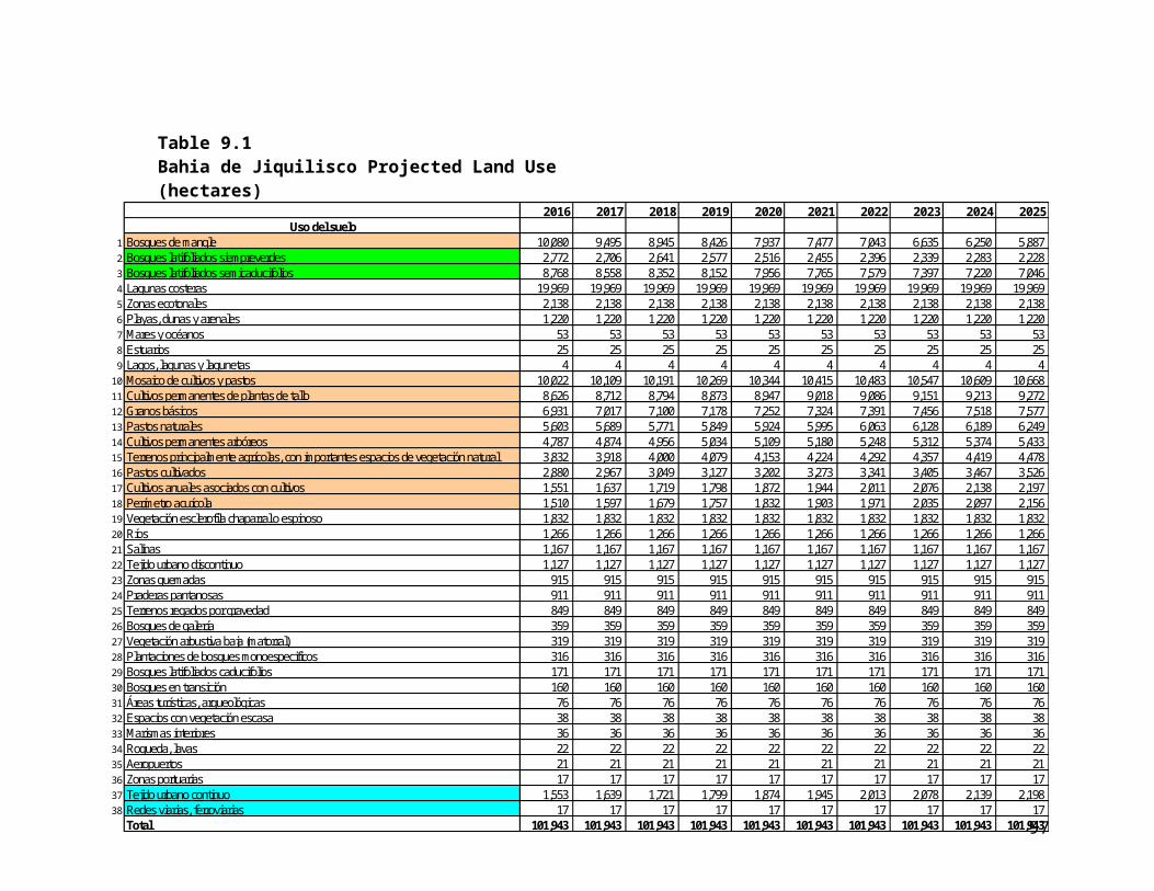
Annex 12: Documents in the Project File
EL SALVADOR: Protected Areas Consolidation and Administration Project
1. Government’s project document2. Detailed Project cost tables3. Procurement Plan4. Participatory Social Analysis5. Process Framework6. Economic-Financial Analysis7. Analysis of Protected Areas System (NPAS)8. Environmental Assessment of Bahia de Jiquilisco9. Environmental Assessment of Lago Guija Complex10. Environmental procedures for management plans in pilot areas11. Institutional Analysis12. Legal Analysis13. Monitoring and evaluation plan
99

Annex 13: Statement of Loans and Credits
EL SALVADOR: National Environmental Management Project
Original Amount in US$ Millions
Difference between expected and actual
disbursements
Project ID FY Purpose IBRD IDA SF GEF Cancel. Undisb. Orig. Frm. Rev’d
P064919 2003 SV JUDICIAL MODERNIZATION PROJECT
18.20 0.00 0.00 0.00 0.00 18.02 6.58 0.00
P067986 2002 SV-EARTQUAKE EMERGENCY REC. & HEALTH SER
142.60 0.00 0.00 0.00 0.00 139.86 -2.74 0.00
P050612 1998 SV EDUCATION REFORM 88.00 0.00 0.00 0.00 0.00 14.04 14.04 14.04
P041680 1998 SV SECONDARY EDUCATION 58.00 0.00 0.00 0.00 0.00 12.47 12.47 0.00
P007164 1997 SV PUBLIC SECTOR MODERN 24.00 0.00 0.00 0.00 0.00 7.62 7.62 0.00
P007174 1996 SV LAND ADMINISTRATION 40.20 0.00 0.00 0.00 0.00 3.88 3.88 -0.96
Total: 360.80 0.00 0.00 0.00 0.00 195.89 41.85 13.08
EL SALVADORSTATEMENT OF IFC’s
Held and Disbursed PortfolioIn Millions of US Dollars
Committed Disbursed
IFC IFC
FY Approval Company Loan Equity Quasi Partic. Loan Equito Quasi Partic.
AFP Crecer 0.00 1.20 0.00 0.00 0.00 0.78 0.00 0.00
2001 CAESS/EEO 43.44 0.00 0.00 70.90 30.02 0.00 0.00 48.54
2002 CALPIA 0.00 2.00 0.00 0.00 0.00 1.99 0.00 0.00
1997/00 CESSA 0.00 0.37 0.00 0.00 0.00 0.37 0.00 0.00
1998/03 CUSCATLAN-ES 0.00 0.00 15.00 0.00 0.00 0.00 15.00 0.00
2004 Metrocentro 25.00 0.00 0.00 0.00 10.00 0.00 0.00 0.00
1998 SEF Baterias 1.29 0.00 0.00 0.00 1.29 0.00 0.00 0.00
1999 SEF IMACASA 0.00 0.20 0.00 0.00 0.00 0.20 0.00 0.00
Total portfilio: 69.73 3.77 15.00 70.90 41.31 3.34 15.00 48.54
Approvals Pending Commitment
FY Approval Company Loan Equity Quasi Partic.
Total pending committment: 0.00 0.00 0.00 0.00
100

Annex 14: Country at a Glance
EL SALVADOR: National Environmental Management Project
101

102
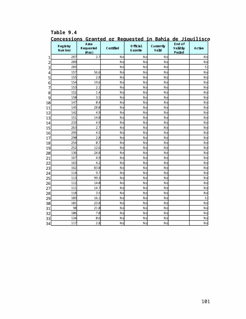
Annex 15: Incremental Cost Analysis
EL SALVADOR: Protected Areas Consolidation and Administration
OVERVIEW
The development objective of the partially blended Second Land Administration Project is to improve land tenure security and land transactions by providing efficient, equitable, and accessible land administration services, thereby facilitating better land-related investments and more productive and environmentally sustainable land use.
The global objective of the proposed project is to conserve El Salvador’s globally significant biodiversity by strengthening the national protected areas system and consolidating two priority protected areas. to have a strengthened national protected areas system in place, through a strategy based on results from the consolidation of two priority protected areas.
The global objective will be accomplished by the following components:
(i) Strengthening the National Protected Areas Strategy (NPAS) – improving the existing strategy, institutional framework and necessary legal instruments for the national protected areas system based on broad stakeholder participation, and disseminating lessons learned through the process;
(ii) Consolidation and management of pilot protected areas – developing and implementing strategies for consolidating two pilot protected areas – Bahia de Jiquilisco Conservation Area and Lago Guija-San Diego-La Barra Protected Area Complex – including management plans; and
(iii) Project Administration – improving capacity to manage and supervise, and monitor the protected area system.
The principal project outcomes will be:
(i) updated strategy and action plan for consolidating national protected areas system developed;
(ii) two pilot protected areas consolidated and effectively managed (Tracking Tool score of at least 40 for the 35,600 ha in Bahia de Jiquilisco and 1,917 ha in Lago Guija Complex San Diego-La Barra); and
(iii) biodiversity benefits established in at least 37,517 ha (in Bahia de Jiquilisco PA at least 35,600 ha of mangrove or associated humid forest coverage that will have zero deforestation compared to baseline; in Lago Guija Complex San Diego-La Barra at least 1,917 ha of dry tropical forest or associated riparian forest that will have zero deforestation compared to baseline).
The GEF Alternative will achieve these objectives at a total incremental cost of US $10 million (M), 5.0 M of which is being requested from the GEF to directly fund global benefits and 5.0 M of which would come from the IBRD-loan for the LAP II project which would fund necessary data-collection activities
103
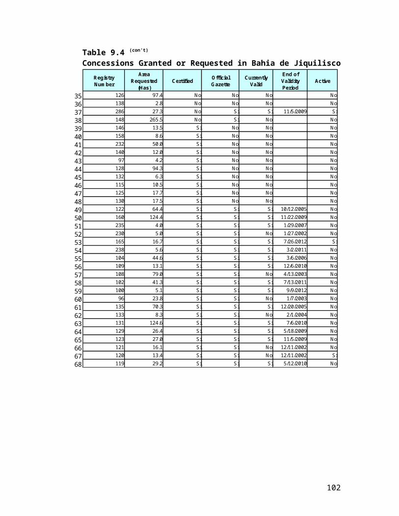
and investments in methodologies, as well as producing associated domestic benefits that would be essential in order to make the global benefits sustainable.
Context & Broad Development Goals
El Salvador supports an impressive diversity of species, comprising 1,477 species of vertebrates (27% of which are threatened, or severely threatened, with extinction), including 510 bird species (of which 17 of the 23 birds endemic to northern Central America are a part), an estimated 7,000 native plant species, including more than 700 species of trees, 140 species of reptiles and amphibians, and 800 species of butterflies– all in an area the size of Massachusetts. This high biodiversity stems from the country’s unique setting, being highly volcanic and isolated from Central America’s Atlantic moist forests. Yet, despite the importance of these resources, El Salvador’s protected area system only covers 755 km2, representing only 4.6% of the total country.40,41
The El Salvadoran authorities are becoming increasingly aware of both the importance of indigenous biodiversity and the significant threats to its sustainable management, which include a variety of unsustainable land and natural resource practices that are increasingly impacting all ecosystems and have been exacerbated by the intense population growth that has made the country the most densely populated area in Latin America. These include: conversion of wetlands and other critical natural habitats to agriculture or other land development; interference with the hydrological regime of wetlands for agriculture, municipal and industrial use of water; pollution; overgrazing and other unsustainable agricultural practices; hunting and unsustainable management of marine resources; and encroachment into protected areas.
El Salvador’s National Protected Areas System (NPAS) aims to protect these remaining resources, but has struggled due to a variety of constraints, most importantly the complicated legal and institutional frameworks coupled with severely constrained institutional capacity for protected area management, lack of a tested model to consolidate the NPAS or individual protected areas, and unclear inadequate land tenure. Additionally, the biodiversity harbored within the NPAS is threatened by habitat transformation, fragmentation and degradation; encroachments into protected areas are a serious problem for which the government does not have a viable strategy. These encroachments result in significant habitat destruction and deterioration, through the conversion of forests, pollution, and over-exploitation of resources, all of which stem in part from a lack of environmental awareness.
However, a series of events have culminated to provide an important enabling environment for addressing the threats to the globally significant biodiversity protected within the NPAS. First, the protected areas law, on hold for 25 years, was passed in February 2005. This law provides MARN with the legal framework necessary to oversee these lands, as well as significant political capital. Secondly, the IBRD-loan financed Land Administration Project (LAP) is mid-way through the completion of the cadastre and registry of all lands in the country – which has been
40 According to the Ecosystem Profile: Southern Region, Mesoamerica (Critical Ecosystem Partnership Fund) this is significantly behind Costa Rica (with 24% of the land protected), Guatemala (23%), Nicaragua (17%), Panama (17%), Belize (10%), and Honduras (8%).41 More than 1.6% of El Salvador’s land was officially designated as protected area in the newly approved protected areas law (Ley de Areas Protegidas, February 2005). These lands include all mangroves in the country, which were considered national forests outside of the protected areas system prior to the passage of the law.
104

deemed a priority effort for the new government. During the preparation of the second phase of the IBRD-funded project (which will begin disbursements in January 2006), the GOES identified the importance of resolving tenure conflicts in protected area lands, without which the LAP’s efforts to address all of El Salvador’s lands will fall short. The LAP’s implementing agency, CNR, has taken significant efforts to involve MARN in that project, including a component for demarcation of three protected areas. While the participation of MARN in the LAP has historically been limited by MARN’s capacity, by developing a partially blended operation, GEF funds will catalyze the consolidation of the national protected areas system by exploiting the significant opportunity presented by the LAP.
The immediate development goals of the new Government of El Salvador administration include accelerating broad-based equitable growth and increasing employment, improving equity by building human capital and expanding access to basic infrastructure, assets, and markets, and enhancing security and reducing vulnerability. In response, the World Bank’s new business compact with the Government of El Salvador focuses on priority areas consistent with the Government’s reform agenda, including: (i) consolidating the regulatory and legal framework for the environment sector, supporting implementation of measures aimed at watershed recovery, reforestation, management of ecosystems, and biodiversity conservation; and (ii) supporting activities to promote sustainable development, as vulnerability to natural disasters is closely related to rural poverty and that low productivity and high population pressures have depleted natural resources in many rural areas, caused soil erosion and land degradation, led to loss of habitat, biodiversity, and natural forests, and exacerbated problems in water management and conservation.
The GOES has also set forth priorities for biodiversity in the 2002 National Strategy on Biological Diversity (NBS; GEF/UNDP/MARN). The NBS establishes as priority actions the implementation of a biodiversity information system and the consolidation of the national protected areas system; the redefinition of institutional responsibilities for conservation activities; and the strengthening of national, institutional and human resource capacities in biodiversity conservation.
Baseline Scenario
Baseline scenarios for the three objectives of the project are set out below. The table in Attachment 1 below gives further details.
1: National Protected Areas Strategy: The following ongoing projects provide baseline support for the NPAS:
the Mesoamerican Biological Corridor project (UNDP/GEF), which is improving management capacity for key protected areas;
further UNDP/GEF ventures that have supported the development of the National Biodiversity Strategy and improved capacity for national biodiversity management;
the National Land Use Plan (Funded by the Salvadoran Fund for Preinvestment Studies; FOSEP), which established 15 Conservation Areas for consolidating protected areas management;
105
the FORGAES project (EU), which has strengthened natural resource management;
the FIAES project (funded through the US Debt Swap), which has supported small-scale sustainable development for conservation;
Participation in Environmental Management project (USAID), which has improved civil society participation in natural resource management;
several projects supported by the Spanish Government (AECI), including supporting the management of Los Volcanes National Park, and the Integrated Management of Mangroves and Coastal Wetlands (including a national wetlands inventory); and
preparatory studies funded by the GEF/IBRD-financed Environmental Services Project, which provide detailed descriptions of land uses and incentives in and around protected areas.
The current costs of the baseline activities that provide support for this component are US$ 19.3 million. On their own, these activities will result in a certain reduction of pressure on the protected areas but further activities are essential if adequate protection is to be given that is appropriate for El Salvador to play its role within the Meso-American Biological Corridor. Fortunately, however, there is significant potential for conserving global biodiversity as the baseline establishes an enabling environment for further activities to provide these global benefits. In particular, the geo-spatial data provided by the baseline and the strengthening of the institutional framework and management efforts in effect lays the groundwork for the current project to achieve global benefits through resulting in long-term conservation and sustainable use of globally and regionally significant biodiversity.
2: Consolidation and Management of Two Pilot Areas (Bahia de Jiquilisco and Lago Guija San Diego-La Barra): The following ongoing activities in the pilot protected areas contribute to the baseline:
Management Plans, which exist for part of both pilot protected areas (Funded by AECI in Bahia de Jiqulisco and CATIE in San Diego-La Barra);
Ramsar proposals for Bahia de Jiquilisco (AECI) and Guija San Diego-La Barra (IUCN), grants to local NGOs at both sites (CODEPA, UNES, CRD, MSM, Asociación Mangle and the local ADESCOs in Bahia de Jiquilisco -- and CEPRODE in San Diego-La Barra) provided by FIAES and IUCN;
Sustainable Development Program for the lower Lempa River, which includes the Bahia de Jiquilisco (funded by IDB); and
lessons learned from the GEF-financed Promotion of Biodiversity within Coffee Landscapes, which will likely be used to provide alternative income generation sources in the pilot areas.
The current costs of these baseline activities are US$ 2.0 million. On their own, these activities will result in protection of the biodiversity within these areas. However, this will fall far short of the potential protection that could be provided through comprehensive conservation activities in these areas combined with sympathetic management of the surrounding area and management of an entire national protected area system functioning as part of the Meso-American biological corridor.
106
3: Project Management and Monitoring: The proposed project relies heavily on monitoring and evaluation (M&E) to capture lessons learned, which will in turn be used to adapt project management and design. The proposed project’s M&E system builds directly upon the system built for the LAP II, which contributes to the baseline for these activities. Additionally, the substantial investments in technical and institutional strengthening for LAP project management, in part contribute to the baseline as the proposed project will capitalize upon this installed capacity to handle most project administration activities (e.g., procurement, financial management).
The estimated cost of the baseline is US$ 0.6 million. Future investment would build on the lessons learned and best-practice generated by the LAP II project and would be essential for producing a consolidated protected area system that would adequately conserve the globally significant biodiversity.
Overall Baseline Costs and Benefits
Baseline Costs: Implemention of the aforementioned programs/projects alone will contribute – in a limited way – to the project development objective. The total estimated costs of baseline activities amount to US$ 21.9 M and sources of assistance vary, consisting of Government revenues and funds from bi-and multi-lateral organizations. The Government/public contribution to the baseline is an estimated 29%.The remaining estimated 71% of the baseline costs is financed by external donors (AECI, IUCN, EU, CATIE, EU and IDB) and the other GEF-funded projects, mentioned above, that help to produce the limited baseline global benefits that are detailed below.
Baseline Benefits: Activities under the Baseline Scenario will result in limited protection of biodiversity, increased national environmental benefits related to small-scale conservation, forest and watershed management, increased participation in conservation, and slight improvements in protecting coastal areas. In addition, forest and soil conservation measures should marginally increase carbon storage in El Salvador’s forested areas. Moreover, land regularization activities should somewhat decrease pressure on protected areas, through the improved tenure security in nearby areas (although no parallel regularization or detailed information collection will take place in protected areas). Likewise, some progress will be made in achieving broader development goals related to strengthening environmental management and improved social and rural development. Training that has been provided by the GOES has been focusing on the importance of land rights/tenure security, but does not contribute to an improved understanding of the importance of conservation as a global or regional environmental issue. The baseline would include some introductory actions aimed at biodiversity conservation, such as: partial on-the-ground supervision and management of the two pilot protected areas, but this is very restricted in scope and highly dependent on outside funding sources; preliminary development of regulations for the new protected areas law, utilizing inadequate resources and based on highly limited experience;
107
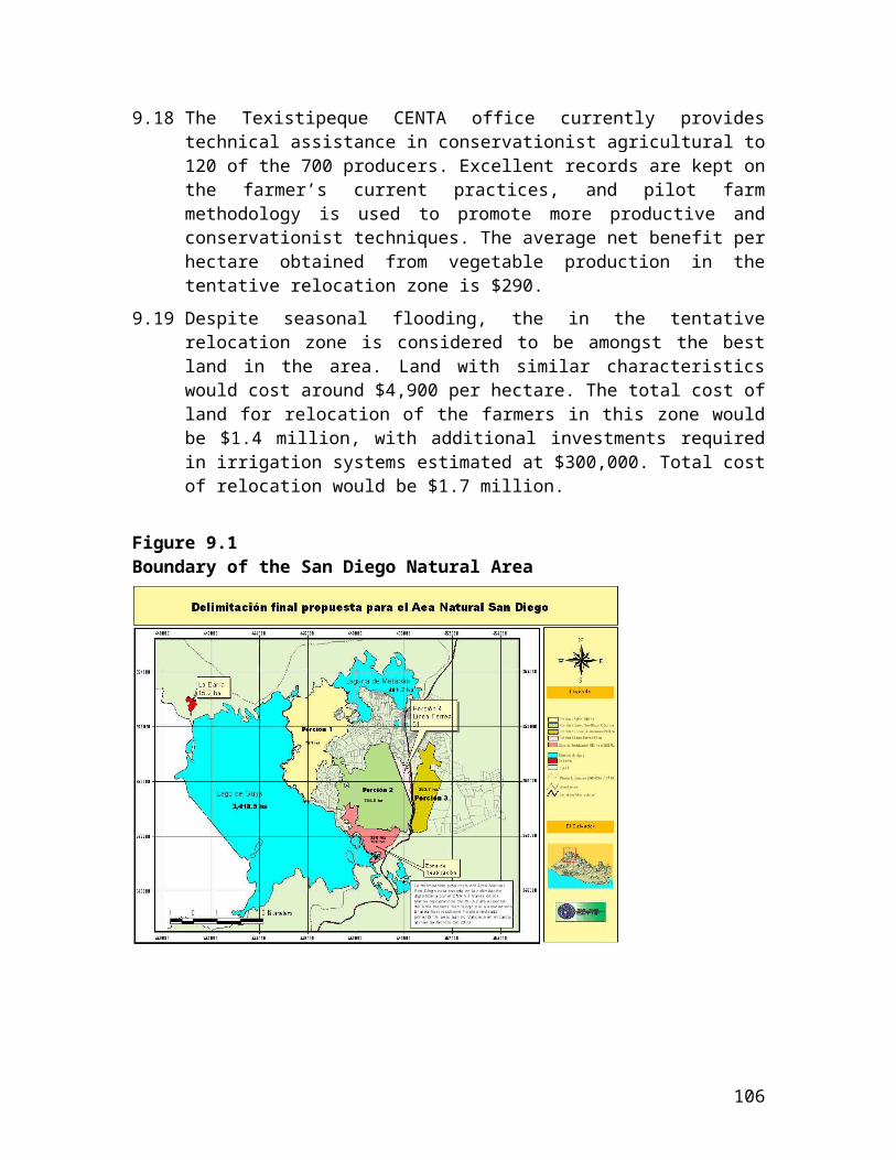
Under present circumstances, any action toward consolidating the protected areas system (or individual protected areas) would have less than optimal outcomes. Implementing a strategy for consolidating the system requires appropriate policies, techniques and methodologies applicable to: (a) strategies seeking support from rural landowners/residents as regards implementation of biodiversity-friendly land uses, including developing effective incentives; (b) identifying additional significant and sustainable sources for system financing; and (c) building capacity and clarifying roles and responsibilities for agencies charged with managing (or contributing to the management of) protected areas; and (d) gaining broad consensus as to the importance of and objectives for the NPAS.
GEF Alternative:
Scope: The GEF Alternative will support the conservation and sustainable use of regionally and globally significant biodiversity in El Salvador through the rationalization and consolidation of the protected areas system. The project would finance the incremental costs through a US$ 5.0M GEF grant and US$ 5.0M provided by the IBRD LAP II Project. Specifically this money would be used to:
(i) improve the strategy, institutional framework and necessary legal instruments for the national protected areas system based on broad stakeholder participation, and disseminating lessons learned;
(ii) develop and implement strategies for consolidating two pilot protected areas – Bahia de Jiquilisco Conservation Area and Lago Guija-San Diego-La Barra Protected Area Complex – including management plans; and
(iii) improve capacity to manage, supervise and monitoring the protected areas system.
Costs: The total cost of the GEF Alternative, combined with the Baseline is estimated to be US$ 31.9M which includes a GEF grant of US$ 5.0M and US$ 5.0M from the IBRD-loan financed LAP II project.
This LAP II project is the partially blended Second Land Administration Project (IBRD loan) for which the GOES is borrowing US$ 40.2M, to fund national environmental benefits including:
(i) improved prioritization of protected areas interventions;(ii) reduced local poverty through the adoption of sustainable development practices and
improved tenure security in small rural properties, leading to increased soil productivity and new possibilities to obtain financial resources derived from environmental services rendered by target priority pilot protected areas;
(iii) better quality and quantity of water for local consumption through improved natural resource management, and the resulting decrease in erosion rates and sediment flows into water bodies; and
(iv) increased capacity for protected area management, including improved outreach and involvement of civil society and the private sector in protected area management contributing to the improved quality of life for El Salvadorans.
This GEF project will influence these IBRD funds to demarcate three new protected areas within the updated and linked national land cadastre and registry and to obtain high-quality geospatial and land tenure data for the two pilot protected areas and
108

their surroundings, as well as investments in methodologies (including legal tools) for land regularization. This will both help the LAP II project to achieve local benefits as well as enabling the GEF project to pursue its objectives. In addition, the local benefits generated by the IBRD project will improve the sustainability of the global benefits produced by the GEF project.
This breaks down into the three project components as shown in the table in Attachment 1:
Benefits: Under the GEF Alternative, El Salvador would have in place a strengthened protected areas system, built on experience gained through consolidation of two priority protected areas. This would contribute to the conservation and sustainable use of regionally and globally significant biodiversity in El Salvador through the rationalization and consolidation of the protected area system. Additionally, it would assist the country in developing adequate tools and mechanisms to facilitate future large-scale consolidation of the overall protected area system, while providing additional opportunities for improved livelihoods and economic well-being of rural communities, which could in turn be used in other countries in the region undergoing or considering land regularization programs.42
Global benefits would include:
(i) long-term conservation and sustainable utilization of globally and regionally significant biodiversity, through strengthened on-site management;
(ii) development of viable approaches to sustainable natural resource use in protected areas;(iii) enhanced ecosystem integrity as a consequence of the adoption of improved natural resource
management practices, in both productive landscapes and priority ecosystems (mangroves, humid tropical forest, tropical freshwater lakes and wetlands, and tropical dry forest), which results in decreased soil erosion, increased carbon sequestration, and improved conservation and sustainable use of biodiversity;
(iv) enhanced ecosystem integrity through implementation of corridors between isolated protected areas of global biodiversity importance; (iv) restoration of globally important ecosystems, including through active reforestation programs and decreased pressure on those systems, with positive impacts on conservation of aquatic and terrestrial biodiversity; and
(v) an established protected area monitoring system, based on the updated protected area registry and cadastre, incorporating global concerns to the baseline M&E activities.
Sustainability would be ensured in part through the IBRD-financed components that would ensure local benefits arose from the conservation of globally significant biodiversity, as well as through the GEF-financed activities including a more rational, focused protected area system supported by a strong institutional and legal framework.
Incremental Costs
The incremental cost – the difference between the Baseline Scenario (US$ 21.9M) and the GEF Alternative (US$ 31.9M), is US$ 10M which would be financed partly by a US$ 5.0M grant from the GEF which would fund interventions to conserve the globally significant biodiversity and partly through US$ 5.0M from the LAP II IBRD loan which would fund activities such as demarcation and data collection and ensuring that local benefits arose from this conservation. These are essential to the project’s success as they provide the necessary background data and contribute to ensuring the
42 The IBRD is currently supporting ten similar projects in Latin America, with another ten under preparation. In addition to El Salvador, these include projects in other Central American countries such as Guatemala, Nicaragua, Honduras, and Panama.
109
sustainability of the project. The matrix below summarizes the baseline and incremental expenditures during the five-year project period.
Attachment 1: Incremental Cost MatrixCost
CategoryUS$
Million Domestic Benefit Global Benefit
Component 1: Strengthening of NPAS
Baseline US$ 19.3M
Slight decrease in pressure on protected areas through land regularization activities in neighboring lands
Preliminary development of regulations for the new protected areas law, utilizing inadequate resources and based on highly limited experience
Updated large-scale geo-spatial data used for non-conservation purposes and omitting protected areas from detailed cadastre and registry activities
Improved policy, institutional framework and tools to strengthen protected areas management
Improved prioritization of management efforts for protected areas system
Improved long-term financial planning ability for protected area system management;
Improved institutional capacity to enforce protected areas legislation
Improved public participation in natural resource management
Improved understanding of the importance of conservation to long-term economic growth.
Limited protection of globally significant local biodiversity
With GEF Alternative
US$ 22.2M(Additional 0.9M IBRD 2.0M GEF)
Some economic benefits to local communities (funded with IBRD money) that are essential for them to engage positively in conservation and to ensure the sustainability of the global benefits
Demarcation of three new protected areas (bringing the total number of demarcated protected areas within El Salvador to six out of 118)
Delineation of all protected areas and mangroves in country
Long-term conservation and sustainable utilization of globally and regionally significant biodiversity
Development of viable approaches to sustainable natural resource use in protected areas
Incremental US$ 2.9M
Comp 2: Consolidation and Management of Pilot Protected Areas
Baseline US$ 2.0M Limited natural resource management of two pilot areas
Limited protection of globally significant local biodiversity
110
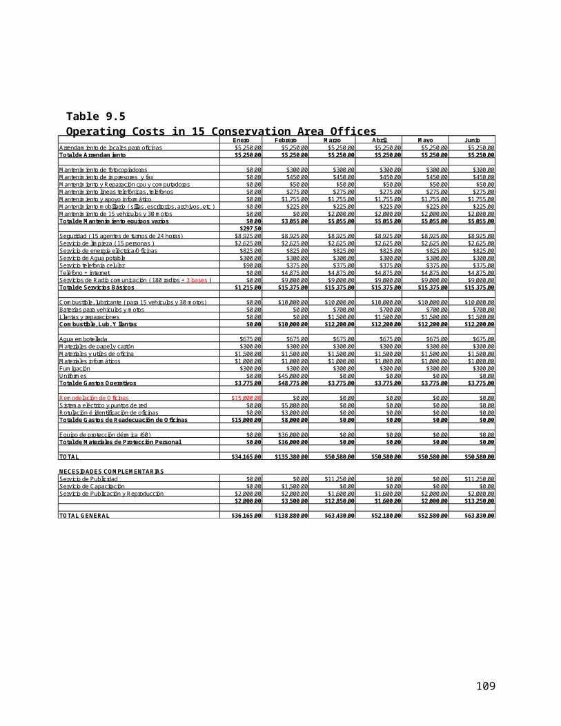
Improved tenure security for some people living on private lands adjacent to pilot areas
With GEF Alternative
US$ 8.2M(Additional 3.9M IBRD 2.3M GEF)
Improved natural resource management of two pilot areas, including alternative income generation activities, leading to decreased local poverty
Improved tenure security for eligible people living on state lands within protected areas and for some people living on private lands adjacent to pilot areas
Some benefits to local communities that are essential for them to engage positively in conservation and to ensure the sustainability of the global benefits.
Development of viable approaches to sustainable natural resource use in protected areas
Enhanced ecosystem integrity as a consequence of the adoption of improved natural resource management practices in priority ecosystems
Enhanced ecosystem integrity through corridor implementation between isolated protected areas of global biodiversity importance
Restoration of globally important ecosystem, with positive impacts on conservation of aquatic and terrestrial biodiversity
Incremental US$ 6.2M
Comp 3: Project Administration and Monitoring
Baseline US$ 0.6M Improved project and management skills at national and protected area levels
Limited protection of globally significant local biodiversity
With GEFUS$ 1.5M(Additional 0.2M IBRD 0.7M GEF)
Improved institutional capacity to monitor protected areas
Monitoring and evaluation system in place and operational
Increased capacity for consolidating protected area system
Monitoring and evaluation system incorporating global concerns to the baseline M&E activities
Improved outreach and involvement of civil society and the private sector in natural resources monitoring and management
Incremental US$ 0.9MTotal Baseline: US$ 21.9MTotal GEF Alternative: US$ 31.9M (5.0M GEF grant, 5.0M from IBRD-loan financed LAP II project)Total Incremental Costs: US$ 10M
111
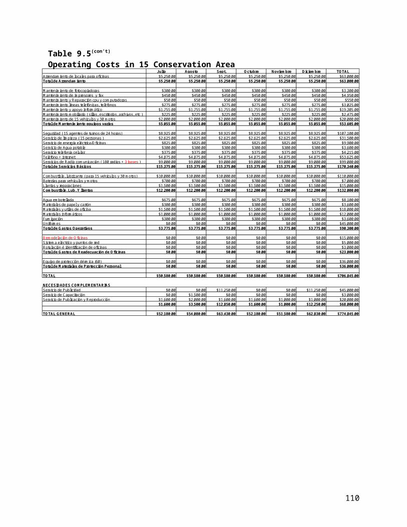
Annex 16: STAP Roster Review
EL SALVADOR:PROTECTED AREAS ADMINISTRATION AND CONSOLIDATION PROJECT
PROPOSAL(World Bank-GEF)
Overall appraisalThis is a well presented proposal with clear objectives and methodologies. El Salvador has biodiversity of global significance that needs to be protected, but the country does not have an effective national system of protected areas (PAs). The project’s goal of establishing a system of PAs is fully consistent with El Salvador’s commitment towards the Convention on Biological Diversity, the priorities of the GEF and with the recent law for PAs approved by the country. The initiative will provide needed systemic and institutional capacities and fully establish two demonstrative PAs. The final outcome would leave the country in a position to replicate approaches in other PAs, identified but not targeted by the project. The project is basically sound, but a few issues will need to be clarified.
Global Benefits and Regional ContextEl Salvador is a recognized Hot Spot: high biodiversity, severely endangered by non-sustainable socio-economical development. The country is also part of the Mesoamerican Biological Corridor (MBC), a regional effort to maintain the biological continuity of the region. This project will help protect the biodiversity of the country and by doing it, help provide continuity to the MBC. The proposal identifies some of the biodiversity in the two pilot sites and briefly describes the overall the biodiversity of the country, the ultimate target of the system of protected areas.
Scientific and Technical Soundness of the ProjectGenerally, the project reads as a sound proposal, but a few clarifications are needed:
The document mentions that PAs in El Salvador tend to be small and isolated, and it also mentions it will work to solve this problem, but does not mention any specifics. What would the project do to show how the overall matrix in the landscape can be made more biodiversity-friendly? Will the project support (guide) the establishment of one or more corridors of sustainable uses with native biodiversity? Where? How would these be funded?
The current proposal is not sufficiently clear regarding what will be accomplished in the buffer zones of the two PAs. It indicates the two areas will be sustainable at the end of the project, but this requires that people living in the whole areas agree to reduce or eliminate their use of resources in the PAs in exchange for some form of material compensation. The proposal indicates its complementarities with other projects and that financial resources from other initiatives would cover buffer zone objectives of this project, but is not specific enough. For example, it does not specify how many people and what fraction of them will benefit, how much money will be allocated to these goals, if these people agreed to a quid pro quo, etc. Conservation requires that stakeholders have their own lands legally recognized and also that all users of the resources agree to the management plan for the PA. Threats to the PAs from neighbors are multiple (paragraphs 64 and 69) and will require comprehensive compensation packages.
The WB-GEF project Payment for Environmental Services project could help provide some of these resources, but the teams preparing the two initiatives seem to have already chosen different demonstration sites. How much flexibility is there to change demonstration sites at this point in the development of these projects?
112
Co-financing in general could be better explained. The current text gives the impression the same money will be used to co-finance complementary projects. Specifics are needed.
It would be useful to expand on the explanation for the selection of the two pilot sites. Presumably, the overall strategy and actions of the project will be informed not only by these two pilots, but by previous experiences in other PAs in El Salvador. What is the range of issues already demonstrated with the establishment of previous PAs and what new issues will these two pilots illustrate for the overall approach?
Fit within the context of the goals of the GEFThe proposal fits clearly within OP2 and SP1. It will help protect globally significant biodiversity using and incremental costs approach.
Regional contextThe project will support the MBC and will therefore have extra global benefits from participating in the maintenance of the biological continuity of Mesoamerica.
ReplicabilityIt is a replicable project, both in the strictly PAs part and in its complementarities with rural development projects to secure biodiversity protection.
SustainabilityEcological and social sustainability should be clearer after proponents describe how the project will work with people in and out of the PAs as well as what it would do to link (corridors) the various PAs.
The project will work on the long-term financial sustainability of the system. The reviewer would like to suggest that if tourism is likely to become a source of income for PAs, during the project some efforts should be directed towards demonstrating how this could be achieved in practice.
The institutional sustainability is not well described in the document. MARN seems to have insufficient staff, it is unclear how many new people they would hire and how many they would maintain after project completion. The permanent number of people implementing and enforcing management plans in the field is critical.
The transfer of responsibilities from the Project Execution Unit to permanent MARN staff on the last year of implementation may be too abrupt. Perhaps an alternative modality, by which responsibilities are progressively transferred to MARN permanent staff starting earlier on, may be more sustainable. A clear plan for this transfer may be needed.
Stakeholder involvementThere were significant consultations with stakeholders, especially during the social assessment, but it is not clear if there were agreements made regarding possible land use restrictions in the PAs and buffer zones and eventual compensations.
Capacity Building. The project will increase the capacities of MARN to develop and manage the system of PAs, and
will help create the inter-institutional instruments that will make the PAs system possible. Would it be possible to add a few indicators of MARN´s increasing capacities to deal with other institutions when it comes to PAs? Indicators of MARN´s capacity to continue improving PAs management would also be helpful.
113
Miscellaneous comments Indicators for Development Objective and Project Global Objective could be strengthened by
making them more objectively verifiable. Demonstrating sustainable management of mangroves is one of the goals of the project and it would be desirable to have good indicators of this achievement. The current indicator of stopping new losses of plant cover seems insufficient.
Some of the indicators selected for components are actually activities and it may be better to replace them by accomplishments. For example, rather than having an indicators be the “formulation of the Reglamento for the PAs Law” (Annex 4), it may be better to have its official enactment or, even better, objective evidence showing it is being used.
Paragraph 2 could be a bit more explicit in describing the main barriers to the establishment of the PAs system before sending the reader to Annex 1.
Please spell out the full name of the organization or entity the first time an acronym is used.
The title of Annex 9 seems to be mistaken
Dr. Eduardo R. FuentesSantiago. ChilePhone: (56-2) 220.3125e-mail: [email protected]
114
Response to STAP REVIEW for:
EL SALVADOR:PROTECTED AREAS ADMINISTRATION AND CONSOLIDATION PROJECT PROPOSAL
(World Bank-GEF)
STAPOverall appraisalThis is a well presented proposal with clear objectives and methodologies. El Salvador has biodiversity of global significance that needs to be protected, but the country does not have an effective national system of protected areas (PAs). The project’s goal of establishing a system of PAs is fully consistent with El Salvador’s commitment towards the Convention on Biological Diversity, the priorities of the GEF and with the recent law for PAs approved by the country. The initiative will provide needed systemic and institutional capacities and fully establish two demonstrative PAs. The final outcome would leave the country in a position to replicate approaches in other PAs, identified but not targeted by the project. The project is basically sound, but a few issues will need to be clarified.
Global Benefits and Regional ContextEl Salvador is a recognized Hot Spot: high biodiversity, severely endangered by non-sustainable socio-economical development. The country is also part of the Mesoamerican Biological Corridor (MBC), a regional effort to maintain the biological continuity of the region. This project will help protect the biodiversity of the country and by doing it, help provide continuity to the MBC. The proposal identifies some of the biodiversity in the two pilot sites and briefly describes the overall the biodiversity of the country, the ultimate target of the system of protected areas.
Scientific and Technical Soundness of the ProjectGenerally, the project reads as a sound proposal, but a few clarifications are needed:
STAPi) The document mentions that PAs in El Salvador tend to be small and isolated, and it also mentions it will work to solve this problem, but does not mention any specifics. What would the project do to show how the overall matrix in the landscape can be made more biodiversity-friendly? Will the project support (guide) the establishment of one or more corridors of sustainable uses with native biodiversity? Where? How would these be funded?World Bank response:World Bank:The project is designed to help consolidate MARN-proposed Conservation Areas, which place the management of multiple small PAs into a landscape context. Toward that aim, the project pilot areas include one Conservation Area (Bahia de Jiquilisco), and one portion of another (Lago Guija Complex is part of the Trifinio Conservation Area, which also includes Montecristo National Park) – each of which includes multiple protected areas (nuclei) as well as surrounding private lands (buffer zones). Project funds will support the consolidation of these larger pilot areas, including their demarcation as well as the development and implementation of management plans, which provide guidance and training for conservation-friendly management of buffer zones. Additional incentives/funds for promoting the establishment of native biodiversity in buffer zones of Bahia de Jiquilisco will be provided by the complementary GEF/IBRD-financed Environmental Services Project. In addition to activities in the two pilot areas, the project funds: i) the establishment of an environmental information system linked to the country’s land and property information database, and ii) the updating of the national protected areas strategy, which will specifically address the actions and funds necessary to establish sustainable-use corridors between priority protected areas.
115
STAPii) The current proposal is not sufficiently clear regarding what will be accomplished in the buffer zones of the two PAs. It indicates the two areas will be sustainable at the end of the project, but this requires that people living in the whole areas agree to reduce or eliminate their use of resources in the PAs in exchange for some form of material compensation. The proposal indicates its complementarities with other projects and that financial resources from other initiatives would cover buffer zone objectives of this project, but is not specific enough. For example, it does not specify how many people and what fraction of them will benefit, how much money will be allocated to these goals, if these people agreed to a quid pro quo, etc. Conservation requires that stakeholders have their own lands legally recognized and also that all users of the resources agree to the management plan for the PA. Threats to the PAs from neighbors are multiple (paragraphs 64 and 69) and will require comprehensive compensation packages.World Bank:The proposal has been strengthened to clarify specific activities to be included in buffer zones of the pilot protected areas (see Annexes 1, 4 and 20). The project will participatorily demarcate pilot areas, including perimeters (including buffer zones) and nuclei (with internal use zones), and develop and implement management plans. The management plans will directly fund training and education in buffer zones. As part of these management plans, many residents of nuclei and some directly adjacent lands 43 without clear legal title will receive land rights subject to limitations set forth in the management plans. Therefore, the project is specifically addressing the issue of clear legal tenure, although only limited portions of the buffer zones will receive this benefit through the project. In addition to these benefits, through the implementation of management plans, material compensation will be provided to those persons who are directly losing access to resources as a result of this project. The specific approach that will be used to address this issue is set forth in the Process Framework included as Annex 10C. The project will also fund the development of a strategy for consolidating the national protected areas system.
STAPThe WB-GEF project Payment for Environmental Services project could help provide some of these resources, but the teams preparing the two initiatives seem to have already chosen different demonstration sites. How much flexibility is there to change demonstration sites at this point in the development of these projects? World Bank:The Environmental Services Project is initially working in one of the two project pilot protected areas (Bahia de Jiquilisco), and will expand to other sites in the future. The selection of future sites will take into account the significant biodiversity conservation benefits that could be achieved by combining efforts of the two projects.
STAPCo-financing in general could be better explained. The current text gives the impression the same money will be used to co-finance complementary projects. Specifics are needed. World Bank:The description of co-financing has been improved in Section A.3, Table 1, and Annex 15.
STAPIt would be useful to expand on the explanation for the selection of the two pilot sites. Presumably, the overall strategy and actions of the project will be informed not only by these two pilots, but by previous experiences in other PAs in El Salvador. What is the range of issues already demonstrated with the
43 Residents living within the delimited mangrove area, as defined based on their extent in 1973, may be eligible for receiving land rights. These lands, many of which have been converted to other uses and no longer support mangroves, remain as state property.
116
establishment of previous PAs and what new issues will these two pilots illustrate for the overall approach?World Bank:The improved explanation for the pilot site selection is included in Annex 17. Likewise, Annex 1 now includes a discussion of lessons learned from the establishment of other PAs in El Salvador (e.g. Montecristo and El Imposible).
STAPFit within the context of the goals of the GEFThe proposal fits clearly within OP2 and SP1. It will help protect globally significant biodiversity using and incremental costs approach.
Regional contextThe project will support the MBC and will therefore have extra global benefits from participating in the maintenance of the biological continuity of Mesoamerica.
ReplicabilityIt is a replicable project, both in the strictly PAs part and in its complementarities with rural development projects to secure biodiversity protection.
SustainabilityEcological and social sustainability should be clearer after proponents describe how the project will work with people in and out of the PAs as well as what it would do to link (corridors) the various PAs.
STAPThe project will work on the long-term financial sustainability of the system. The reviewer would like to suggest that if tourism is likely to become a source of income for PAs, during the project some efforts should be directed towards demonstrating how this could be achieved in practice.World Bank:Tourism is expected to be an important part of the management plans in both pilot areas. Specifically, in both pilot areas, training funded through the management plans will target tourism, small grants will be available to support sustainable tourism (and other activities compatible with the management plans), and in Bahia de Jiquilisco, concessions are likely to be granted for tourism.
STAPThe institutional sustainability is not well described in the document. MARN seems to have insufficient staff, it is unclear how many new people they would hire and how many they would maintain after project completion. The permanent number of people implementing and enforcing management plans in the field is critical. World Bank:The institutional and financial sustainability of MARN is currently being analyzed. Recommendations from these studies will be incorporated into the design of Components One (for MARN’s overall structure, staffing, and sustainability) and Two (for the staffing and sustainability of the two pilot protected areas. It should be noted that the hiring of local park guards in the two pilot areas will be priority activities for the first year of project implementation, and the permanent financing of those guards will be addressed through the management plan. As most persons in the UEP would be hired to implement the overall project (and not directly manage the pilot areas), they would not necessarily be absorbed by MARN. Other persons hired for the direct implementation and enforcement of the management plans (such as park guards) would be maintained permanently and funded by proceeds from park management.
117

STAPThe transfer of responsibilities from the Project Execution Unit to permanent MARN staff on the last year of implementation may be too abrupt. Perhaps an alternative modality, by which responsibilities are progressively transferred to MARN permanent staff starting earlier on, may be more sustainable. A clear plan for this transfer may be needed.World Bank:As noted above, key members of the Project Execution Unit (PIU) staff responsible for direct implementation and enforcement of the management plans at the pilot area would be absorbed at year five and funded through project-generated revenue.
STAPStakeholder involvementThere were significant consultations with stakeholders, especially during the social assessment, but it is not clear if there were agreements made regarding possible land use restrictions in the PAs and buffer zones and eventual compensations.World Bank:Negotiations regarding specific land use restrictions will be achieved during project implementation. The process that will be used to address compensations is set forth in Annex 10C.
STAPCapacity Building.The project will increase the capacities of MARN to develop and manage the system of PAs, and will help create the inter-institutional instruments that will make the PAs system possible. Would it be possible to add a few indicators of MARN´s increasing capacities to deal with other institutions when it comes to PAs? Indicators of MARN´s capacity to continue improving PAs management would also be helpful.World Bank:The project indicators have been revised to reflect the key outputs and impacts, which are aimed at making the NPAS management sustainable, and consolidating two pilot protected areas.
STAPMiscellaneous commentsIndicators for Development Objective and Project Global Objective could be strengthened by making them more objectively verifiable. Demonstrating sustainable management of mangroves is one of the goals of the project and it would be desirable to have good indicators of this achievement. The current indicator of stopping new losses of plant cover seems insufficient.World Bank:The indicators have been improved to be more quantifiable. We believe the project will be successful if it can conserve 35,600 ha of mangrove/associated humid forest and 1,917 ha of tropical dry forest/associated riparian forest.
STAPSome of the indicators selected for components are actually activities and it may be better to replace them by accomplishments. For example, rather than having an indicators be the “formulation of the Reglamento for the PAs Law” (Annex 4), it may be better to have its official enactment or, even better, objective evidence showing it is being used.World Bank:The indicators have been improved.
STAPParagraph 2 could be a bit more explicit in describing the main barriers to the establishment of the PAs system before sending the reader to Annex 1.
118

World Bank:This has been improved.
STAPPlease spell out the full name of the organization or entity the first time an acronym is used.World Bank:This has been improved.
STAPThe title of Annex 9 seems to be mistakenWorld Bank:This has been corrected.
119
Annex 17: Pilot Site Selection
EL SALVADOR: Protected Areas Consolidation and Administration Project
Background
The Protected Areas System of El Salvador (NPAS) comprises 118 Natural Protected Areas (Áreas Naturales Protegidas; NPAs) and all mangroves in the country. As most NPAs included in the System are small and isolated, the Ministry of Environment and Natural Resources (MARN) has proposed the creation of fifteen Conservation Areas (Áreas de Conservación), comprising most Natural Protected Areas (NPA) and all mangroves, along with buffer zones linking those areas. The goal of this proposed project is to strengthen the NPAS by developing a strategy to consolidate Conservation Areas. Toward this aim, the project will consolidate and manage two pilot areas (consisting of one full Conservation Area, and one portion of a Conservation Area. The lessons learned through this effort can be used throughout the NPAS to create a comprehensive and robust national protected area system.
Methodology for Choosing Pilot Sites:
The pilot areas were chosen through a two-step process.Step one was done during the prioritization of Conservation Areas, as part of the development of the National Protected Areas Strategy (Diagnóstico y priorización de Áreas Naturales Protegidas y Corredor Biológico Nacional; 2005). This effort, undertaken in 2004, was led by MARN, and convoked 14 experts in protected areas management, representing government institutions, NGOs, community associations, and academics. The goal of this prioritization was to be able to use the list and information about the parks to target and optimize future management. The specific criteria used are described below.
Step two was done in February 2005 during the preparation of the proposed project. Building upon the results of step one, MARN protected area experts developed additional criteria important to the project objective which required, in particular, that the areas be representative of other areas in their management requirements, cover a comprehensive set of management conditions in order that the suggestions produced would be transferable and contain significant threats to their future conservation. The specific criteria are described below.
Criteria for Choosing Pilot Sites
The specific criteria used during the two-stage pilot site selection included:
Step One:
State of conservation of the area; Legal and land tenure status; Representativeness of the ecosystems as typical of El Salvador;
120
Degree of community participation in the area’s management; Biodiversity and presence of endangered or threatened species; Ecosystem goods and services that the area provides; and Total size.
Step Two Representativeness: the existing threats are typical of those faced by PAs within the
NPAS, including:o pressure from economic development;o high invasion threats; ando unresolved land-tenure issues.
Comprehensiveness: the areas chosen represent examples of contrasting management requirements types and legal frameworks, which cover, as far as possible, situations that will be found throughout most of the NPAS. Specifically, the areas together will contain examples of:
o mangroves;o natural protected areas;o unconsolidated (non-legalized) areas with potential for integration into the NPAS;o preferably one example of an entire Conservation Area; ando a broad spectrum of physical and biological characteristics.
Threats to priority biodiversity due to lack of resources (financial or human) that prevent adequate protection and management of resources.
Enabling Enviroment: the existing enabling environment is representative of those in other areas including:
o the area has existing local stakeholder capacity including NGOs and social organizations;
o updated geo-spatial data exists or will exist due to the LAP and LAP II IBRD projects; and
o the surrounding landscape facilitates the creation of biological corridors, as there are relatively large, well-protected nuclei.
Results
Following Step One, five areas were identified as being of significant conservation value and of potential use as pilot sites. These were:
Bahía de Jiquilisco Conservation area; Montecristo National Park; El Imposible National Park; Lago Güija-San Diego-La Barra Complex; and Colima Natural Protected Area.
It should be noted that, during step two, the additional criteria of being representative of other areas in El Salvador and containing significant threats to conservation ruled out the two most renowned areas – the Montecristo National Park and the El Imposible National Park – because of the significant and successful conservation efforts realized to date, coupled with the high amount of resources dedicated to these areas.
121

Also, satisfying the criteria of having a comprehensive balance of different situations clearly favored choosing Bahía de Jiquilisco Conservation Area and the Lago Güija-San Diego-La Barra Complex as:
they have complementary and broad ranging geographical and biological conditions that cover most of the conditions that will be found in other protected areas throughout El Salvador; and
together, they contain a comprehensive blend of legal frameworks including an entire conservation area, and mangroves and Natural Protected Areas within conservation areas.
Therefore the GOES considered that: 1) Bahia de Jiquilisco Conservation Area; and 2) Lago Guija-San Diego-La Barra Complex (Lago Guija Complex), part of the Trifinio Conservation Area were the best choices for pilot areas. Detailed site descriptions demonstrating this are given below.
Pilot Protected Area #1: Lago Güija San Diego-La Barra Complex (Lago Guija Complex)
The 5,840 ha Lago Guija complex is located in the extreme northwest of El Salvador along the Guatemalan border. The area supports a wide variety of habitats, including: several lakes (Lago Guija, Metapán Lagoon, San Diego Lagoon, Clara Lagoon and Teconalá Lagoon); two separate Natural Protected Areas including the 1,831 ha tropical dry forest expanses of San Diego-La Barra Natural Protected Area (the best and most intact example of this regionally threatened ecosystem in El Salvador), as well as surrounding private lands. Thus, the project would provide useful, transferable examples for protection of a wide variety of scenarios.
From a biodiversity perspective, the complex is of high conservation value, supporting numerous animal species that are threatened and in danger of extinction, both locally and internationally, endemic plants, and other dry forest species comprising cactus and Bignoniaceae, with a high presence of migratory birds, such as Falco peregrinus, Buteo ptatypterus, Icterus galbula, Dendroica vires, Dendroica magnolia, piranga rubra, Catharus ustulatus. The area supports one of the last relict patches of tropical dry forest in El Salvador, which, according to Dinnerstein et al. (1995), is bioregionally outstanding, a high conservation priority at a regional scale and critically threatened. Within the area 180 species of plants have been recorded including: Terminalia oblonga, Ceiba petandra, Cochlospernum vitifolium, Sloanea terniflora y Omphalea oleifera; 250 species of birds, including: Agamia agami, Nomonyc deminicus, Parabuteo unicinctus, Pardirallus maculatus, Amazona auropilliata, Anas acuta and Pasarían ciris; 37 species of mammals, including: Canis latrans, Galictis vittata, Leopardus wiedii and Conepatus mesoleucus. Also present are fish species Cichlasoma guija (Mojarra negra o nativa), which is in danger of extinction, and Cichlasoma trimaculatum (Istatagua), which is threatened.
The area also is representative of mountainous regions being surrounded by dormant volcanoes and mountains including the volcanoes of San Diego, Isla El Tule, Masatepeque, La Vega de la Caña and Cerro Quemado.
The area also supports active local communities and local groups have developed a proposal to designate the area as a Ramsar site. In addition to its global and regional important for
122
biodiversity, the site contains strong local partners (e.g. CEPRODE, the local NGO, and the community ADESCO), which are actively involved in conservation, a solid baseline, and a protected area management plan that has been developed in collaboration with a local NGO with technical assistance from CATIE. On the Guatemalan side of Lago Guija, there is no official protection, but also currently no significant human populations.
The site also contains many typical key threats, including encroachment, agriculture-associated forest fires, illegal hunting, resource extraction, lack of education and options, and water pollution (from agrochemicals and household sewage).
Pilot Protected Area #2: Bahia de Jiquilisco Conservation Area
The proposed Bahia de Jiquilisco Conservation Area is a 63,000 hectare complex of coastal mangroves, intertidal mudflats, estuaries, barrier islands, sandy beaches, and remnant humid forest patches that is representative of other coastal areas. It comprises several Natural Protected Areas – Chaguantique (77.1 ha in two patches), Normandía (440.6 ha), and El Tercio (43.5 ha), which protect remnants of alluvial forests (3,551 ha.), along with the Bay’s mangrove forests (19,330 ha) – the largest expanse in the country. The area conserves populations of the threatened species the black-handed spider monkeys (Ateles geoffroyi), as well as breeding sites of coastal and marine bird species, and four species of nesting sea turtles.
The Bahia de Jiquilisco Conservation Area also contains most of the country’s marine and coastal birds, as well as being the unique nesting site for some of them. Species of fauna in danger of local extinction include four species of nesting sea turtles (all threatened), the American crocodile (Crocodrylus acutus), caiman (Caimàn crocodilus), spider monkey (A. geoffroyi), white-tailed deer (Odocoileus virginianus), and the bivalve casco de burro (Anadara grandis). The area also supports a large diversity of migratory birds, including abundant shorebirds as well as land birds, including the American oystercatcher (Haemantopus palliate), yellow-naped parrot (Amazona auropalliata), Pacific parakeet (Aratinga strenua), and muscovy duck (Cairina moschata). Owing to its importance for migratory birds, the area has been nominated as a Ramsar Wetland Site. Geomorphologically, the area plays an important role in terms of processing water-borne nutrients, controlling coastal erosion and mitigating earthquake damage.
The area also has prominent NGOs operating in the small remnant forest patches, which operate on a total annual budget of $100,000 (see Table 17-1). MARN provides no direct budget support to the management of the area and no on-the-ground government activities exist, despite the importance of the ecological resources present.
Key threats to the area include conversion of mangroves for housing, expansion of shrimp and salt ponds, agriculture and tourism.
123
Table 17-1: NGO Management of Humid Forest Patches in Bahia de Jiquilisco Bahia de Jiquilisco Conservation Area
Location Organization Source Amount DurationPuerto Parada CODEPA FIAES $20,000 2 añosAC general UNES UICN $50,000 1 añoEl Espino CRD FIAES $20,000 2 añosSan Juan del Gozo MSM FIAES $20,000 2 añosBajo Lempa Asociación Mangle FIAES $20,000 2 añosNancuchiname ADESCO BN FIAES $20,000 2 años
Bibliography:MARN 2005, Diagnóstico y Priorización de Áreas Naturales Protegidas y Corredor Biológico Nacional, MARN/CBMDinnerstein, Olsen, Graham, et al. World Bank. 1995. A conservation assessment of the Terrestrial Ecosystems of Latin America and the CaribbeanEl Salvador, in prep. Law of Natural Protected AreasIUCN, 2004. Red List. www.redlist.orgMARN y CNR, 2002. Land Use Maps CORINE Land Cover. El SalvadorMARN, 2003. Manual of procedures for the participation of society in the management of protected areas. MARN/UNDP/GEFMARN, in prep. Management Strategy for Protected Areas and National Biological Corridors. MARN/UNDP/GEFWWF, 2003. Global 200. www.panda.org
124
Annex 18: Protected Areas Tracking Tool
EL SALVADOR: Protected Areas Consolidation and Administration Project
Reporting Progress at Protected Area Sites: Data Sheet
Name of protected area Bahia de Jiquilisco Conservation Area Complex (Area de Conservacin Complejo Bahia de Jiquilisco)
Location of protected area (country and if possible map reference)
El Salvador, central coastal area between the Lempa River and the El Espino Beach, including all the mangroves of the Jiqulisco Bay (Bahia), barriers islands, semi-humid forest, inter-tidal mudflats and other coastal ecosystems (see Annex 17)
Date of establishment (distinguish between agreed and gazetted*) or formally established in the case of private protected areas
AgreedProposed for 2006
Gazetted
Ownership details (i.e. owner, tenure rights etc) Mangroves (public), concession, municipal and private lands
Management Authority MARN with co-management with several NGO’s and community associations
Size of protected area (ha) 63,000 ha
Number of staffPermanent1 MARN staff (but does not work on site)
TemporaryNGOs currently support 3 office staff
Budget $100,000 for management of humid forest patches (no direct budget support for mangrove)
Designations (IUCN category, World Heritage, Ramsar etc)
Bay: Tentatively IUCN Category VI (Managed Resource Area) and proposed Ramsar site.
Reasons for designation Multiple land uses exist
Brief details of World Bank funded project or projects in PA Not applicable when completing for GEF projects
Brief details of WWF funded project or projects in PA Not applicable when completing for GEF projects
Brief details of all relevant projects in PA
The area is supported through numerous programs funded by several bilateral agencies and local NGOs. Sustainable development activities include: an aquiculture program in the Puerto El Trifunio and La Pirrayita areas, supported by the Japanese International Cooperacion Agency (JICA); support for management plan development for the mangrove area and sustainable development of the artisenal fisheries sector, by AECI. Environmental education programs include: support for park rangers and ecotourism guides, as well as interpretative centers and trails supported by several NGOs (CODEPPA, CENCITA, SACDEL).
List the two primary protected area objectives
Objective 1 Biodiversity conservation
Objective 2 Sustainable management of fisheries, mangroves, and other natural resources
List the top two most important threats to the PA (and indicate reasons why these were chosen)

Threat 1Conversion of mangroves for shrimp and salt ponds
Threat 2 Encroachment for agriculture, housing and unregulated tourism development
List top two critical management activities
Activity 1 Protection of several humid forest patches by NGOs: Chaguantique, Normandia
Activity 2 All other protection and management activities are planned (not ongoing)
Date assessment carried out: ____________March 3, 2005_____________________________________________Name/s of assessor: ____________________George Ledec_____________________________________________
126
Issue Criteria Score Comments Next steps1. Legal status
Does the protected area have legal status?
Context
The protected area is not gazetted 0 Note: see fourth option for private reserves
1. Delimit on map.2. Demarcate on ground.3. Consult with stakeholders.4. Executive Decree to establish the
Conservation Area
The government has agreed that the protected area should be gazetted but the process has not yet begun
1
The protected area is in the process of being gazetted but the process is still incomplete 22The protected area has been legally gazetted (or in the case of private reserves is owned by a trust or similar)
3
2. Protected area regulations
Are inappropriate land uses and activities (e.g. poaching) controlled?
Context
There are no mechanisms for controlling inappropriate land use and activities in the protected area
0 1. Regulation for mangroves and procedures, based on recently passed Protected Areas Law.
2. Establish central posts (through project).
Mechanisms for controlling inappropriate land use and activities in the protected area exist but there are major problems in implementing them effectively
11Mechanisms for controlling inappropriate land use and activities in the protected area exist but there are some problems in effectively implementing them
2
Mechanisms for controlling inappropriate land use and activities in the protected area exist and are being effectively implemented
3
3. Law enforcement
Can staff enforce protected area rules well enough?
Context
The staff have no effective capacity/resources to enforce protected area legislation and regulations
0 Possible issue for comment: What happens if people are arrested?
No personnel yet (except forest patches)
1. Contract and train protected areas staff (through project)
There are major deficiencies in staff capacity/resources to enforce protected area legislation and regulations (e.g. lack of skills, no patrol budget) 11The staff have acceptable capacity/resources to enforce protected area legislation and regulations but some deficiencies remain
2
The staff have excellent capacity/resources to enforce protected area legislation and regulations
3
4. Protected area objectives
Have objectives been agreed?
Planning
No firm objectives have been agreed for the protected area 0 Supplement the Management Plan through the project
The protected area has agreed objectives, but is not managed according to these objectives
1
The protected area has agreed objectives, but these are only partially implemented 22The protected area has agreed objectives and is managed to meet these objectives
3

Issue Criteria Score Comments Next steps5. Protected area design
Does the protected area need enlarging, corridors etc to meet its objectives?
Planning
Inadequacies in design mean achieving the protected areas major management objectives of the protected area is impossible 00 The Conservation
Area is well-designed on paper
Management Plan needs to be implemented on the ground through the project.
Inadequacies in design mean that achievement of major objectives are constrained to some extent
1
Design is not significantly constraining achievement of major objectives, but could be improved
2
Reserve design features are particularly aiding achievement of major objectives of the protected area
3
6. Protected area boundary demarcation
Is the boundary known and demarcated?
Context
The boundary of the protected area is not known by the management authority or local residents/neighbouring land users
0 Many, including overlapping and conflicting claims (to be resolved where feasible through the project)
Delineate and demarcate through the project
The boundary of the protected area is known by the management authority but is not known by local residents/neighbouring land users 11The boundary of the protected area is known by both the management authority and local residents but is not appropriately demarcated
2
The boundary of the protected area is known by the management authority and local residents and is appropriately demarcated
3
7. Management plan
Is there a management plan and is it being implemented?
There is no management plan for the protected area 0 The Management Plan exists under the Environmental Law (Ley de Medio Ambiente), and is legally approved,
After the new Decree to establish the Conservation Area and Protected Area regulations (to be done through the project), consult further with local stakeholders to get consensus on the revised management plan.
A management plan is being prepared or has been prepared but is not being implemented 11An approved management plan exists but it is only being partially implemented because of funding constraints or other problems
2
128
Issue Criteria Score Comments Next stepsPlanning but has not been
adequately consulted. Some local stakeholders say the MP is not valid until it is based on the newly approved PA law.
SEE PROCEDURES HANDOUT.
I.1 During GEF preparationI.2 During GEF implementationII Mgt category in existing MP; boundaries during GEF implementationIII During GEF implementationIV 5 During GEF implementationIV.6 During GEF implementationIV.7 During GEF implementation, source of funding TBD.VI.8 MP (approved) exists. Update and implement during GEF implementation.
An approved management plan exists and is being implemented 3
Additional points
Planning
The planning process allows adequate opportunity for key stakeholders to influence the management plan
+1 Not now but planned.
During GEF project.
Not now. Planned under GEF project
where M&E results will be used
to improve management
There is an established schedule and process for periodic review and updating of the management plan
+1
The results of monitoring, research and evaluation are routinely incorporated into planning
+1
8. Regular work plan
Is there an annual work plan?
Planning/Outputs
No regular work plan exists 00 Create one, based on MP, during GEF project implementation
A regular work plan exists but activities are not monitored against the plan’s targets
1
A regular work plan exists and actions are monitored against the plan’s targets, but many activities are not completed
2
A regular work plan exists, actions are monitored against the plan’s targets and most or all prescribed activities are completed
3
9. Resource inventory There is little or no information available on the critical habitats, species and cultural values of the protected area
0 Evaluate ecological resources during project preparation.
129
Issue Criteria Score Comments Next stepsDo you have enough information to manage the area?
Context
Information on the critical habitats, species and cultural values of the protected area is not sufficient to support planning and decision making 11Information on the critical habitats, species and cultural values of the protected area is sufficient for key areas of planning/decision making but the necessary survey work is not being maintained
2
Information concerning on the critical habitats, species and cultural values of the protected area is sufficient to support planning and decision making and is being maintained
3
10. Research
Is there a programme of management-orientated survey and research work?
Inputs
There is no survey or research work taking place in the protected area 0 Research and monitoring to be promoted during GEF project implementation.
There is some ad hoc survey and research work 11There is considerable survey and research work but it is not directed towards the needs of protected area management
2
There is a comprehensive, integrated programme of survey and research work, which is relevant to management needs
3
11. Resource management
Is the protected area adequately managed (e.g. for fire, invasive species, poaching)?
Process
Requirements for active management of critical ecosystems, species and cultural values have not been assessed
0
Requirements for active management of critical ecosystems, species and cultural values are known but are not being addressed 11Requirements for active management of critical ecosystems, species and cultural values are only being partially addressed
2
Requirements for active management of critical ecosystems, species and cultural values are being substantially or fully addressed
3
12. Staff numbers
Are there enough people employed to manage the protected area?
Inputs
There are no staff 0 No full-time government staff in the area. Government staff visit; some NGO staff at their small PA sites.
Staff numbers are inadequate for critical management activities 11Staff numbers are below optimum level for critical management activities 2Staff numbers are adequate for the management needs of the site 3
13. Personnel management
Problems with personnel management constrain the achievement of major management objectives
0 N/A. There are essentially no
130
Issue Criteria Score Comments Next steps
Are the staff managed well enough?
Process
available resources.
Problems with personnel management partially constrain the achievement of major management objectives
1
Personnel management is adequate to the achievement of major management objectives but could be improved
2
Personnel management is excellent and aids the achievement major management objectives
3
14. Staff training
Is there enough training for staff?
Inputs/Process
Staff are untrained 0 N/A
Staff training and skills are low relative to the needs of the protected area 1Staff training and skills are adequate, but could be further improved to fully achieve the objectives of management
2
Staff training and skills are in tune with the management needs of the protected area, and with anticipated future needs
3
15. Current budget
Is the current budget sufficient?
Inputs
There is no budget for the protected area 00 No budget line in for the Conservation Area. Only monies come from bi/multilateral funding sources explained in Annex 17 and ICA. MARN’s funds are almost exclusively dedicated to salaries, not this or other PAs.
The available budget is inadequate for basic management needs and presents a serious constraint to the capacity to manage
1
The available budget is acceptable, but could be further improved to fully achieve effective management
2
The available budget is sufficient and meets the full management needs of the protected area
3
16. Security of budget
Is the budget secure?
Inputs
There is no secure budget for the protected area and management is wholly reliant on outside or year by year funding 00 N/A. No funds to
manage
There is very little secure budget and the protected area could not function adequately without outside funding
1
There is a reasonably secure core budget for the protected area but many innovations and initiatives are reliant on outside funding
2
There is a secure budget for the protected area and its management needs on a multi-year cycle
3
131
Issue Criteria Score Comments Next steps17. Management of budget
Is the budget managed to meet critical management needs?
Process
Budget management is poor and significantly undermines effectiveness 0 N/A. No funds to manageBudget management is poor and constrains effectiveness 1
Budget management is adequate but could be improved 2
Budget management is excellent and aids effectiveness 3
18. Equipment
Is equipment adequately maintained?
Process
There is little or no equipment and facilities 0 Only from NGOs, not from MARN.
There is some equipment and facilities but these are wholly inadequate 11There is equipment and facilities, but still some major gaps that constrain management
2
There is adequate equipment and facilities 3
19. Maintenance of equipment
Is equipment adequately maintained?
Process
There is little or no maintenance of equipment and facilities 00 There is almost no equipment.
There is some ad hoc maintenance of equipment and facilities 1
There is maintenance of equipment and facilities, but there are some important gaps in maintenance
2
Equipment and facilities are well maintained 3
20. Education and awareness programmeIs there a planned education programme?
Process
There is no education and awareness programme 00 None in the Bay.
Two small programs managed by the NGOs in the forest patches.
To be done during project implementation.
There is a limited and ad hoc education and awareness programme, but no overall planning for this 11There is a planned education and awareness programme but there are still serious gaps
2
There is a planned and effective education and awareness programme fully linked to the objectives and needs of the protected area
3
132
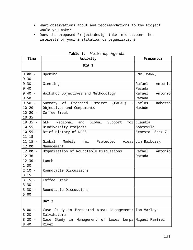
Issue Criteria Score Comments Next steps21. State and commercial neighbours Is there co-operation with adjacent land users?
Process
There is no contact between managers and neighbouring official or corporate land users
0 During project public awareness campaign, stakeholder consultation and monitoring.
There is limited contact between managers and neighbouring official or corporate land users 11There is regular contact between managers and neighbouring official or corporate land users, but only limited co-operation
2
There is regular contact between managers and neighbouring official or corporate land users, and substantial co-operation on management
3
22. Indigenous people
Do indigenous and traditional peoples resident or regularly using the PA have input to management decisions?Process
Indigenous and traditional peoples have no input into decisions relating to the management of the protected area
0 No indigenous people in area.
Indigenous and traditional peoples have some input into discussions relating to management but no direct involvement in the resulting decisions
1
Indigenous and traditional peoples directly contribute to some decisions relating to management
2
Indigenous and traditional peoples directly participate in making decisions relating to management
3
23. Local communities
Do local communities resident or near the protected area have input to management decisions?Process
Local communities have no input into decisions relating to the management of the protected area
0
For Bay
For the small PAs. They are part of the NGO association structure
Local communities have some input into discussions relating to management but no direct involvement in the resulting decisions 11Local communities directly contribute to some decisions relating to management
2
Local communities directly participate in making decisions relating to management 33
Additional pointsAdditional points
Outputs
There is open communication and trust between local stakeholders and protected area managers
+1
Programmes to enhance local community welfare, while conserving protected area resources, are being implemented
+1
24. Visitor facilities There are no visitor facilities and services 00 For Bay
Visitor facilities and services are inappropriate for current levels of visitation or are under construction
1
133

Issue Criteria Score Comments Next stepsAre visitor facilities (for tourists, pilgrims etc) good enough?
Outputs
For two of small PAs (Chaguantique and Nancuchiname).
Visitor facilities and services are adequate for current levels of visitation but could be improved 22Visitor facilities and services are excellent for current levels of visitation 3
25. Commercial tourism
Do commercial tour operators contribute to protected area management?
Process
There is little or no contact between managers and tourism operators using the protected area
0
There is contact between managers and tourism operators but this is largely confined to administrative or regulatory matters
1
There is limited co-operation between managers and tourism operators to enhance visitor experiences and maintain protected area values
2
There is excellent co-operation between managers and tourism operators to enhance visitor experiences, protect values and resolve conflicts
3
26. FeesIf fees (tourism, fines) are applied, do they help protected area management?
Outputs
Although fees are theoretically applied, they are not collected 0The fee is collected, but it goes straight to central government and is not returned to the protected area or its environs
1
The fee is collected, but is disbursed to the local authority rather than the protected area
2
There is a fee for visiting the protected area that helps to support this and/or other protected areas
3
27. Condition assessment
Is the protected area being managed consistent to its objectives?Outcomes
Important biodiversity, ecological and cultural values are being severely degraded 00 In mangroves,
continuing conversion.
In small Pas
Some biodiversity, ecological and cultural values are being severely degraded 1Some biodiversity, ecological and cultural values are being partially degraded but the most important values have not been significantly impacted 22Biodiversity, ecological and cultural values are predominantly intact
3
Additional points
Outputs
There are active programmes for restoration of degraded areas within the protected area and/or the protected area buffer zone +1
28. Access assessment Protection systems (patrols, permits etc) are ineffective in controlling access or use of the reserve in accordance with designated objectives 00 Rest of Bay
134
Issue Criteria Score Comments Next stepsAre the available management mechanisms working to control access or use?
Outcomes
Chaguantique and Nancuchimame Pas
Protection systems are only partially effective in controlling access or use of the reserve in accordance with designated objectives
1
Protection systems are moderately effective in controlling access or use of the reserve in accordance with designated objectives 22Protection systems are largely or wholly effective in controlling access or use of the reserve in accordance with designated objectives
3
29. Economic benefit assessment
Is the protected area providing economic benefits to local communities?
Outcomes
The existence of the protected area has reduced the options for economic development of the local communities 00 Rest
Chaguantique has guide services and (incipient) food for tourists. Nancuchiname has guide services, honey for sale
The existence of the protected area has neither damaged nor benefited the local economy
1
There is some flow of economic benefits to local communities from the existence of the protected area but this is of minor significance to the regional economy
22There is a significant or major flow of economic benefits to local communities from activities in and around the protected area (e.g. employment of locals, locally operated commercial tours etc)
3
30. Monitoring and evaluation
Planning/Process
There is no monitoring and evaluation in the protected area 00There is some ad hoc monitoring and evaluation, but no overall strategy and/or no regular collection of results
1
There is an agreed and implemented monitoring and evaluation system but results are not systematically used for management
2
A good monitoring and evaluation system exists, is well implemented and used in adaptive management
3
TOTAL SCORE 15 For Bay; 26 for small NGO-15 For Bay; 26 for small NGO-managed PAsmanaged PAs
135

Reporting Progress at Protected Area Sites: Data Sheet
Name of protected area
Protected Area Complex Lago de Güija San Diego-La Barra (Complejo de Areas Protegidas Lago de Güija San Diego-La Barra), includingSan Diego-La Barra Nacional Park (Parque Nacional San Diego-- La Barra)
Location of protected area (country and if possible map reference)
El Salvador, extreme northwestern corner of country, bordering Guatemala (see map in Annex 17).
Date of establishment (distinguish between agreed and gazetted*) or formally established in the case of private protected areas
AgreedEstimated for November 2005.
Gazetted
Ownership details (i.e. owner, tenure rights etc)
ISTA has title of some lands (which needs to be transferred to MARN); CEL has others, private lands.
Management Authority MARN through co-management by ADESCOs and NGOs.
Size of protected area (ha) 5,797 ha (land and open water); 1,842 forest
Number of staffPermanent Temporary
2 technical staff; 10 parks rangers (all from NGO)
Budget $130,000/year (from NGO)
Designations (IUCN category, World Heritage, Ramsar etc) Category II (National Park). Proposed Ramsar site.
Reasons for designation Unique tropical dry forest with freshwater lakes.
Brief details of World Bank funded project or projects in PA Not applicable when completing for GEF projects
Brief details of WWF funded project or projects in PA Not applicable when completing for GEF projects
Brief details of all relevant projects in PA
UNDP funds local NGO (CEPRODE) and ADESCOs, FIAES provides some funds for recurrent costs. CATIE financed the management plan.
List the two primary protected area objectives
Objective 1 Biodiversity conservation
Objective 2 Environmental services and products
List the top two most important threats to the PA (and indicate reasons why these were chosen)
Threat 1Deforestation for agriculture
Threat 2 Human-caused forest fires
List top two critical management activities
Activity 1 Supervision (to avoid invasions)
Activity 2 Prevention and control of fires
Date assessment carried out: ________________March 4, 2005 _________________________________________Name/s of assessor: _______________________George Ledec__________________________________________

Issue Criteria Score Comments Next steps1. Legal status
Does the protected area have legal status?
Context
The protected area is not gazetted 00 Lakes
Forest
1. Transfer of lands from ISTA to MARN
2. Inscription in the registry in the name of the State
3. Executive Decree4. Inscription of the
Decree in the protected areas registry
The government has agreed that the protected area should be gazetted but the process has not yet begun
1
The protected area is in the process of being gazetted but the process is still incomplete 22The protected area has been legally gazetted (or in the case of private reserves is owned by a trust or similar)
3
2. Protected area regulations
Are inappropriate land uses and activities (e.g. poaching) controlled?
Context
There are no mechanisms for controlling inappropriate land use and activities in the protected area 00 Lakes
Forest
Mechanisms for controlling inappropriate land use and activities in the protected area exist but there are major problems in implementing them effectively 11Mechanisms for controlling inappropriate land use and activities in the protected area exist but there are some problems in effectively implementing them
2
Mechanisms for controlling inappropriate land use and activities in the protected area exist and are being effectively implemented
3
3. Law enforcement
Can staff enforce protected area rules well enough?
Context
The staff have no effective capacity/resources to enforce protected area legislation and regulations 00 N/A for lakes (no staff)
Forests
Improvement awaits a regular project budget. Also a firmer legal status through the declaration.There are major deficiencies in staff capacity/resources to enforce protected
area legislation and regulations (e.g. lack of skills, no patrol budget) 11The staff have acceptable capacity/resources to enforce protected area legislation and regulations but some deficiencies remain
2
The staff have excellent capacity/resources to enforce protected area legislation and regulations
3
4. Protected area objectives
Have objectives been agreed?
Planning
No firm objectives have been agreed for the protected area 00 Lakes
Forests
The protected area has agreed objectives, but is not managed according to these objectives
1
The protected area has agreed objectives, but these are only partially implemented 22The protected area has agreed objectives and is managed to meet these objectives
3
137

Issue Criteria Score Comments Next steps5. Protected area design
Does the protected area need enlarging, corridors etc to meet its objectives?
Planning
Inadequacies in design mean achieving the protected areas major management objectives of the protected area is impossible 00 Including lakes, the PA would be
very difficult to effectively manage.
For forest patches alone
Inadequacies in design mean that achievement of major objectives are constrained to some extent
1
Design is not significantly constraining achievement of major objectives, but could be improved 22Reserve design features are particularly aiding achievement of major objectives of the protected area
3
6. Protected area boundary demarcation
Is the boundary known and demarcated?
Context
The boundary of the protected area is not known by the management authority or local residents/neighbouring land users
0
For lakes
For forests
Complete the demarcation.The boundary of the protected area is known by the management authority but is not known by local residents/neighbouring land users 11The boundary of the protected area is known by both the management authority and local residents but is not appropriately demarcated 22The boundary of the protected area is known by the management authority and local residents and is appropriately demarcated
3
7. Management plan
Is there a management plan and is it being implemented?
Planning
There is no management plan for the protected area 00 MP does not include lakes
MP for forest is still not approved, but the PA management follows the rules set forth in the draft MP.
A management plan is being prepared or has been prepared but is not being implemented 11An approved management plan exists but it is only being partially implemented because of funding constraints or other problems
2
An approved management plan exists and is being implemented 3
Additional points
Planning
The planning process allows adequate opportunity for key stakeholders to influence the management plan +1+1 For forests only
For forests only
Planned (for forests only)
There is an established schedule and process for periodic review and updating of the management plan +1+1The results of monitoring, research and evaluation are routinely incorporated into planning +1+1
8. Regular work plan No regular work plan exists 00 For lakes
138

Issue Criteria Score Comments Next stepsIs there an annual work plan?
Planning/Outputs
For forests
Needs full legal establishment to strengthen protection.
A regular work plan exists but activities are not monitored against the plan’s targets
1
A regular work plan exists and actions are monitored against the plan’s targets, but many activities are not completed 22A regular work plan exists, actions are monitored against the plan’s targets and most or all prescribed activities are completed
3
9. Resource inventory
Do you have enough information to manage the area?
Context
There is little or no information available on the critical habitats, species and cultural values of the protected area
0
For lakes
For forest
Information on the critical habitats, species and cultural values of the protected area is not sufficient to support planning and decision making 11Information on the critical habitats, species and cultural values of the protected area is sufficient for key areas of planning/decision making but the necessary survey work is not being maintained
22Information concerning on the critical habitats, species and cultural values of the protected area is sufficient to support planning and decision making and is being maintained
3
10. Research
Is there a programme of management-orientated survey and research work?
Inputs
There is no survey or research work taking place in the protected area 00 For lakes
For forestsThere is some ad hoc survey and research work 11There is considerable survey and research work but it is not directed towards the needs of protected area management
2
There is a comprehensive, integrated programme of survey and research work, which is relevant to management needs
3
11. Resource management
Is the protected area adequately managed (e.g. for fire, invasive species, poaching)?
Process
Requirements for active management of critical ecosystems, species and cultural values have not been assessed 00Requirements for active management of critical ecosystems, species and cultural values are known but are not being addressed
1
Requirements for active management of critical ecosystems, species and cultural values are only being partially addressed
2
Requirements for active management of critical ecosystems, species and cultural values are being substantially or fully addressed
3
12. Staff numberss
Are there enough people employed to
There are no staff 00 For lakes
For forestsStaff numbers are inadequate for critical management activities 11
139

Issue Criteria Score Comments Next stepsmanage the protected area?
Inputs
Staff numbers are below optimum level for critical management activities 2Staff numbers are adequate for the management needs of the site 3
13. Personnel management
Are the staff managed well enough?
Process
Problems with personnel management constrain the achievement of major management objectives
0N/A for lakes (no personnel)
For forests
Low salaries, high turnover of park rangersProblems with personnel management partially constrain the achievement of
major management objectives 11Personnel management is adequate to the achievement of major management objectives but could be improved
2
Personnel management is excellent and aids the achievement major management objectives
3
14. Staff training
Is there enough training for staff?
Inputs/Process
Staff are untrained 0N/A for lakes (no personnel)
For forestsStaff training and skills are low relative to the needs of the protected area 11Staff training and skills are adequate, but could be further improved to fully achieve the objectives of management
2
Staff training and skills are in tune with the management needs of the protected area, and with anticipated future needs
3
15. Current budget
Is the current budget sufficient?
Inputs
There is no budget for the protected area 00 For lakes
For forestsThe available budget is inadequate for basic management needs and presents a serious constraint to the capacity to manage 11The available budget is acceptable, but could be further improved to fully achieve effective management
2
The available budget is sufficient and meets the full management needs of the protected area
3
16. Security of budget
Is the budget secure?
There is no secure budget for the protected area and management is wholly reliant on outside or year by year funding 00 Serious problem, uncertain
future financing (without GEF).There is very little secure budget and the protected area could not function adequately without outside funding
1
There is a reasonably secure core budget for the protected area but many innovations and initiatives are reliant on outside funding
2
140

Issue Criteria Score Comments Next stepsInputs There is a secure budget for the protected area and its management needs on a
multi-year cycle3
17. Management of budget
Is the budget managed to meet critical management needs?
Process
Budget management is poor and significantly undermines effectiveness 0 N/A for lakes (no budget)
For forestInstability of funds complicates management.
Budget management is poor and constrains effectiveness 11Budget management is adequate but could be improved 2
Budget management is excellent and aids effectiveness 3
18. Equipment
Is equipment adequately maintained?
Process
There is little or no equipment and facilities 00There is some equipment and facilities but these are wholly inadequate 1
There is equipment and facilities, but still some major gaps that constrain management
2
There is adequate equipment and facilities 3
19. Maintenance of equipment
Is equipment adequately maintained?
Process
There is little or no maintenance of equipment and facilities 00 Only fences maintained for forest (with gaps).There is some ad hoc maintenance of equipment and facilities 1
There is maintenance of equipment and facilities, but there are some important gaps in maintenance
2
Equipment and facilities are well maintained 3
20. Education and awareness programmeIs there a planned education programme?
Process
There is no education and awareness programme 00 For lakes
For forest
There is a limited and ad hoc education and awareness programme, but no overall planning for this
1
There is a planned education and awareness programme but there are still serious gaps 22There is a planned and effective education and awareness programme fully linked to the objectives and needs of the protected area
3
141

Issue Criteria Score Comments Next steps21. State and commercial neighbours Is there co-operation with adjacent land users?
Process
There is no contact between managers and neighbouring official or corporate land users
0 N/A for lakes
For forestsThere is limited contact between managers and neighbouring official or corporate land users 11There is regular contact between managers and neighbouring official or corporate land users, but only limited co-operation
2
There is regular contact between managers and neighbouring official or corporate land users, and substantial co-operation on management
3
22. Indigenous people
Do indigenous and traditional peoples resident or regularly using the PA have input to management decisions?Process
Indigenous and traditional peoples have no input into decisions relating to the management of the protected area
0No IP in area.
Indigenous and traditional peoples have some input into discussions relating to management but no direct involvement in the resulting decisions
1
Indigenous and traditional peoples directly contribute to some decisions relating to management
2
Indigenous and traditional peoples directly participate in making decisions relating to management
3
23. Local communities
Do local communities resident or near the protected area have input to management decisions?Process
Local communities have no input into decisions relating to the management of the protected area 00 For lakes
For forests
Local communities have some input into discussions relating to management but no direct involvement in the resulting decisions
1
Local communities directly contribute to some decisions relating to management 22Local communities directly participate in making decisions relating to management
3
Additional pointsAdditional points
Outputs
There is open communication and trust between local stakeholders and protected area managers +1+1 Through the NGO (forest only)
Strengthening of community organizations (forest only)
Programmes to enhance local community welfare, while conserving protected area resources, are being implemented +1+1
24. Visitor facilities
Are visitor facilities (for tourists, pilgrims etc) good enough?
Outputs
There are no visitor facilities and services 00Visitor facilities and services are inappropriate for current levels of visitation or are under construction
1
Visitor facilities and services are adequate for current levels of visitation but could be improved
2
Visitor facilities and services are excellent for current levels of visitation 3
142

Issue Criteria Score Comments Next steps25. Commercial tourism
Do commercial tour operators contribute to protected area management?
Process
There is little or no contact between managers and tourism operators using the protected area 00There is contact between managers and tourism operators but this is largely confined to administrative or regulatory matters
1
There is limited co-operation between managers and tourism operators to enhance visitor experiences and maintain protected area values
2
There is excellent co-operation between managers and tourism operators to enhance visitor experiences, protect values and resolve conflicts
3
26. FeesIf fees (tourism, fines) are applied, do they help protected area management?
Outputs
Although fees are theoretically applied, they are not collected 0Still no feesThe fee is collected, but it goes straight to central government and is not
returned to the protected area or its environs1
The fee is collected, but is disbursed to the local authority rather than the protected area
2
There is a fee for visiting the protected area that helps to support this and/or other protected areas
3
27. Condition assessment
Is the protected area being managed consistent to its objectives?Outcomes
Important biodiversity, ecological and cultural values are being severely degraded 00 For lakes, aquatic biodiversity
suffering, water quality deteriorating, invasive species, unregulated fishing, cultural values (petroglyphs) degraded due lack of protection
In forests: Some resources subject to severe degradation stemming from agriculture-related fires.
Some biodiversity, ecological and cultural values are being severely degraded 1Some biodiversity, ecological and cultural values are being partially degraded but the most important values have not been significantly impacted 22Biodiversity, ecological and cultural values are predominantly intact 3
Additional points
Outputs
There are active programmes for restoration of degraded areas within the protected area and/or the protected area buffer zone +1 Not yet
28. Access assessment
Are the available management mechanisms working to control access or use?
Outcomes
Protection systems (patrols, permits etc) are ineffective in controlling access or use of the reserve in accordance with designated objectives 00 For lakes
For forestsProtection systems are only partially effective in controlling access or use of the reserve in accordance with designated objectives 11Protection systems are moderately effective in controlling access or use of the reserve in accordance with designated objectives
2
Protection systems are largely or wholly effective in controlling access or use of the reserve in accordance with designated objectives
3
143
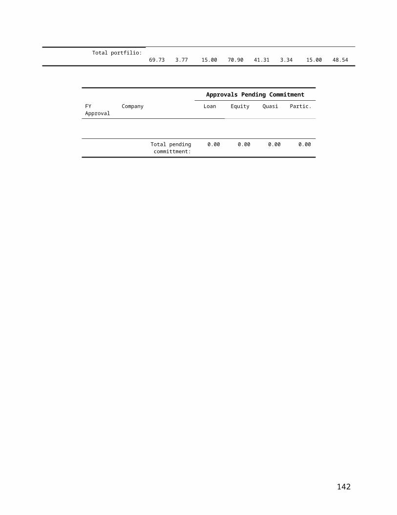
Issue Criteria Score Comments Next steps29. Economic benefit assessment
Is the protected area providing economic benefits to local communities?
Outcomes
The existence of the protected area has reduced the options for economic development of the local communities
0
The existence of the protected area has neither damaged nor benefited the local economy 11There is some flow of economic benefits to local communities from the existence of the protected area but this is of minor significance to the regional economy
2
There is a significant or major flow of economic benefits to local communities from activities in and around the protected area (e.g. employment of locals, locally operated commercial tours etc)
3
30. Monitoring and evaluation
Planning/Process
There is no monitoring and evaluation in the protected area 00 For lakes
For forests
There is some ad hoc monitoring and evaluation, but no overall strategy and/or no regular collection of results
1
There is an agreed and implemented monitoring and evaluation system but results are not systematically used for management
2
A good monitoring and evaluation system exists, is well implemented and used in adaptive management 33
TOTAL SCORE 37 for forest; 2 for lakes37 for forest; 2 for lakes
144
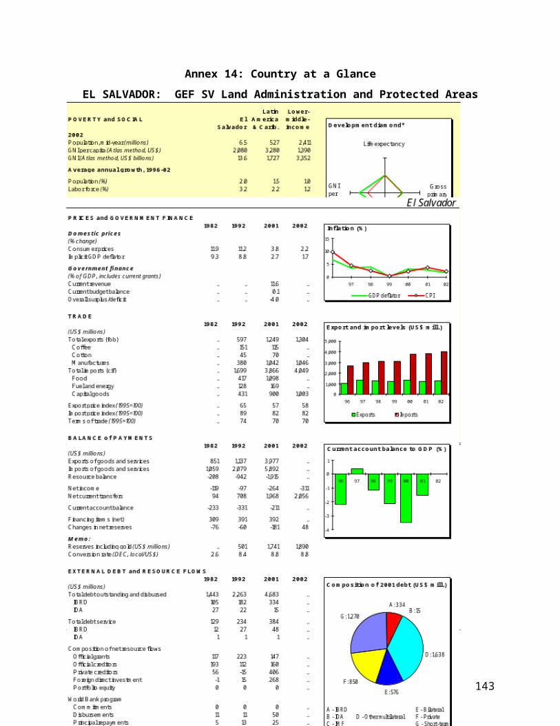
Annex 19: Maps
EL SALVADOR: Protected Areas Consolidation and Administration Project
145

Annex 20: Coordination between the El Salvador Protected Areas and Administration and El Salvador Environmental Services Projects
EL SALVADOR: Protected Areas Consolidation and Administration Project
1. The two IBRD/GEF-supported projects in El Salvador – the Protected Areas Consolidation and Administration project (P092202; PACAP) and the Environmental Services project (P064910; ESP) – contribute to the protection of globally significant biodiversity through different yet complementary approaches aimed at countering differing root causes of biodiversity loss. The Protected Areas Consolidation and Administration project: (i) strengthens the national protected areas system (NPAS), through updating the NPAS Strategy, improving the related legal and institutional frameworks, improving MARN’s capacity to oversee the NPAS, and improves its sustainability through the creation of a unified protected areas registry and monitoring and evaluation system; and (ii) consolidates two priority protected areas (one national park/Natural Protected Area and one protected mangrove forest) through a pilot program to develop and implement management plans that regularize communities in those areas, subject to use restrictions emphasizing the sustainable use of protected area resources. The Environmental Services project provides incentives to landowners living in protected area buffer zones and other environmentally sensitive lands to change their land use practices, thereby contributing the enhancement and protection of biodiversity.
2. Consequently, both projects, in conjunction, support the GOES’s strategy to further biodiversity conservation through the prioritization of 15 conservation units, comprising most of the country’s protected areas (e.g. El Salvador’s “Natural Protected Areas”, corresponding to IUCN Category II), building upon the biological corridor concept. The conservation units constitute “nuclei”, comprising the country’s 118 natural protected areas, and surrounding private lands that comprise the “buffer zones”. The specific approach to consolidate these areas target the primary threats to biodiversity, including habitat destruction, and the loss of natural resources stemming from deterioration in the quality of life for local populations (NBSAP, 2000).
3. In concert with the partially blended Land Administration projects, the proposed project aims at contributing to this strategy by developing and pilot testing mechanisms for biodiversity conservation. Specifically, the LAP (under Phase I that is nearing completion and Phase II that is partially blended with the proposed project) would delineate all protected areas in the LAP II area, resolve land tenure in adjacent private lands (buffer zones), and collect high quality geospatial data for many protected areas.44 Building upon the enabling environment presented by the LAP II, the proposed project would develop protected area policy reforms, delineate all protected areas (nuclei) in El Salvador, and in two pilot protected areas (Bahia de Jiquilisco and Lago Guija Complex, including both nuclei and buffer zones), demarcate and legalize those areas, resolve land conflicts, and develop and implement management plans including granting of usufruct rights to eligible residents. The proposed project would provide payment for environmental services (PES) as an incentive for biodiversity-friendly land use in private lands adjacent to the protected area nuclei (buffer zones) in the Bahia de Jiquilisco45.
4. Table 20-1 shows how both projects target different types of lands within priority Conservation Areas: the Environmental Services project does not work within strict protected areas but only in the buffer zones of those areas as well as in mangroves, which are subject to a different degree of legal protection (corresponding to IUCN Category VI); the Protected Areas Consolidation and Administration project, on the other hand, will work in one Natural Protected Area and one mangrove.
5. Likewise, the approaches and activities supported by the two projects are different yet complementary. The Environmental Services project provides payments to landowners, whose land use practices contribute to
44 These include all protected areas and mangroves in the LAP II area, plus the Lago Guija pilot area that is in the (already completed) LAP I area.45 The Payment for Environmental Services Project overlaps with the proposed project in one area: Bahia de Jiquilisco. The selection of future PES Project sites would strongly consider the proposed project’s second pilot area (Lago Guija Complex), so as to maximize biodiversity conservation impact.
146
the conservation and restoration of lands supporting globally significant biodiversity. This market-based mechanism is intended to promote biodiversity-friendly land use in areas critically important for conservation, yet outside the national protected areas system. In contrast, the Protected Areas Consolidation and Administration project supports the consolidation of the pilot areas (nuclei), including demarcation, resolution of legal status, development and implementation of management plans, capacity building and institutional strengthening for those areas – in short, the direct infrastructure and capacity investments to enable their sustainability. Only using mechanisms targeting both private and public lands can MARN realize their Conservation Area-based strategy.
6. Both projects are intentionally designed to complement each other’s activities to maximize impact and minimize duplication. With regards to technical activities, special attention will be paid to the institutional strengthening/capacity building and legal framework aspects of both projects to prevent redundancy and promote synergy. As noted, the partially blended LAP II/PACAP projects focus on defining tenure for all private and public lands in El Salvador, advancing the rationalization of the national protected areas system, consolidating two priority protected areas and developing a strategy to address existing communities in those areas. These activities are strongly complemented by the ESP, which provides incentives to landowners living in protected area buffer zones and other environmentally sensitive lands to sustainably manage their lands. The two complementary strategies are pilot testing mechansisms to support MARN in the establishment of it’s 15 Conservation Areas, by addressing the nuclei (natural protected areas), through the land administration GEF, and the buffer zones (adjacent private lands), through the ESP.
7. In addition to their technical complementarily, implementation arrangements have been developed to enhance impact. Both projects aim to maximize MARN’s technical and administrative capacity, while mainstreaming GEF activities within MARN’s portfolio and staffing. Specifically, a small project implementation unit (PIU) will be created for each project – and part of MARN’s existing administrative unit – comprising a project coordinator, administrative staff and a few select technical people. Likewise, both PIUs include fiduciary staff (an accountant and procurement specialist) that will be physically located within MARN’s existing accounting unit (UFI). More importantly, as the proposed project will be implemented in January 2006, one year earlier than the start date for the PES Project, the capacity created within MARN for complying with World Bank fiduciary and administrative standards will benefit the PES Project. Toward this aim, the proposed project takes advantage of the partially blended LAP II by housing PIU fiduciary staff within the LAP II administrative unit (UACI within CNR) for the first six months of project implementation so that they are trained in approved administrative procedures. After this period, the fiduciary staff would move to MARN’s UFI, where they would, in turn, build relevant capacity within MARN staff (and PES Project staff, as needed).
Table 20-1: Breakdown of Activities Financed by PACAP and ESPLocation of Investments
Project Activity Protected Area
(Nucleus)46
Mangrove (Nucleus and
Private Lands)47
Buffer Zone (Private Lands)
Protected Areas
Consolidation and
Administration (PACAP)
Demarcation X X X*Legal Consolidation X X X*Management Plan Development X X
Management Plan Implementation X X
Cadastre/Registry X X X*
46 IUCN Category II.47 IUCN Category VI.
147
Institutional Strengthening/Capacity Building
X X
MARN Legal Framework X X
Environmental Services (ESP)
Environmental Service Payment Contracts X X
Institutional Strengthening/Capacity Building
X X
Environmental Service Payments Legal Framework
X X
* through partially blended IBRD loan
148