project description 2.1 introduction and project overview
TRANSCRIPT

Berths 136-147 Terminal EIS/EIR 2-1
2 PROJECT DESCRIPTION 1
2.1 Introduction and Project Overview 2
This section describes the proposed Project and alternatives for the Berths 136-147 3 Container Terminal Project EIS/EIR. The Terminal is currently used and is proposed 4 to continue to be used for container terminal operations. The proposed Project 5 includes a 30-year lease renewal to the year 2038 and two phases of construction 6 (2008-2015 and 2015-2025) designed to optimize container terminal operations 7 within the Berths 136-147 area in the West Basin portion of the Port. 8
The proposed Project would include an expanded container terminal, deeper berths, 9 longer and improved wharves, replacement of existing cranes, new terminal buildings 10 and facilities, a new on-dock intermodal rail yard, a relocated Pier A rail yard, an 11 improved Harry Bridges Boulevard, and a 30-acre buffer area adjacent to Harry Bridges 12 Boulevard. Most of the improvements would occur on the 176 acres currently operated 13 by TraPac (Figure 2-1). The proposed terminal expansion area is bounded by Harry 14 Bridges Boulevard, the existing terminal, and the Pier A rail yard. Other proposed 15 Project components would occur in the area between “C” Street and Harry Bridges 16 Boulevard, and the area adjacent to Berths 200C – 200H. Additional detail on the 17 proposed Project is provided in Section 2.4.2. 18
Major construction elements of the proposed Project include dredging to deepen the 19 berthing areas; renovating 3,000 feet of wharf; constructing 705 feet of new wharf; 20 redeveloping 57 acres of additional land into container terminal backlands; constructing a 21 new on-dock rail yard and relocating the existing Pier A rail yard; and filling 10 acres of 22 the Northwest Slip to create additional backlands and wharf. Additional details of 23 proposed Project construction are provided in Section 2.4.4. 24
Six gantry (container) cranes that were on site during the baseline year would be replaced 25 with five new cranes for a net loss of one gantry crane; seven other existing cranes would 26 remain, resulting in a total of 12 gantry cranes at the new terminal instead of the 13 that 27 were there during the baseline year. (This number reflects the baseline conditions 28 existing in December of 2003. Two 50-gauge cranes along Berths 145 and 146 were 29 removed in the spring of 2007.) 30

Berths 136-147 Terminal EIS/EIR 2-2
1

Berths 136-147 Terminal EIS/EIR 2-3
2.1.1 Project Throughput Comparison 1
Table 2-1 compares activity at the Berths 136-147 Container Terminal during the 2 CEQA Baseline (year 2003) and No Federal Action/NEPA Baseline years 2015 and 3 2038 to the activities of the proposed Project. General information on the CEQA and 4 No Federal Action/NEPA Baselines is presented in section 1.5.5 and information 5 specific to this proposed Project in sections 2.6.1 and 2.6.2. Modeling of the activity 6 at the proposed Project site (see section 1.1.3 for a description of throughput and 7 capacity modeling) shows that cargo throughput would reach its maximum at year 8 2025 and would not increase from 2025 to 2038, the end of the 30-year lease period. 9 Note that in 2003, although approximately 20 percent of the terminal’s cargo entered 10 or left the Los Angeles region by rail, no rail trips from on-dock facilities are shown 11 in Table 2-1 because the cargo had to be conveyed by trucks to off-site rail yards in 12 Carson or East Los Angeles. Rail trips are shown for future conditions because the 13 proposed Project would have an on-dock rail yard, which would eliminate that 14 portion of local truck trips related to draying containers to rail yards. 15
Table 2-1. Project Throughput Comparison
CEQA
Baseline No Federal Action/
NEPA Baseline Proposed Project
2003 YEAR 2015 YEAR 2038* YEAR 2015 YEAR 2038* Terminal Acreage 176 233 233 233 243 TEUs per Acre 5,068 6,400 7,283 7500 9,831 Total annual TEUs 891,976 1,491,200 1,697,000 1,747,500 2,389,000 Annual Ship Calls 246 283 250 309 334 Daily Truck Trips 3,281 3,538 3,288 4,403 5,152 Annual Truck Trips** 1,197,589 1,291,247 1,200,205 1,607,093 1,880,401 Percent TEUs by Truck‡ 50% 62.1% 51.4% 62.1% 63.4% Annual Rail Trips† 731 925 1,351 1,085 1,434 Percent TEUs by On-dock Rail§ 0% 37.1% 41.3% 31.6% 29.3% Employee Estimates (including direct, indirect, and induced employees) 7,003 11,707 13,323 13,784 18,756
* Maximized at Year 2025 ** Round trips. This includes truck trips carrying no containers, and therefore 0 TEUs. ‡ Calculation derived by subtracting the percentage of total annual TEUs transported by on- and near-dock rail trips from 100%. Assumes that all TEUs not transported by rail are transported by truck. † Includes both on- and near-dock rail. CEQA Baseline figure is 100% near-dock as terminal has no on-dock facilities. Calculation extrapolated from annual TEU figures specified by Rail Master Plan. Assumes 330 containers per round trip and 1.85 TEUs per container. § Excludes near-dock rail. Annual TEU capacity of on-dock rail provided by Rail Master Plan.

2.0 Project Description
2-4 Berths 136-147 Terminal EIS/EIR
2.1.2 Need For Additional Capacity 1
Section 1.1.3 described the forecasted cargo volumes for the Port through the year 2030 2 and showed that the capacity of the Port’s terminals in that year, even with anticipated 3 improvements in operational efficiency, as well as expansions and modernization, 4 would be unable to accommodate the forecasted cargo demand. That analysis of 5 terminal capacity included the Berth 136-147 terminal as it would be improved by the 6 proposed Project as well as improvements at the Port of Long Beach and other 7 terminals in the Port of Los Angeles. The analysis showed that all terminals in both 8 ports are expected to be operating at maximum capacity, so that failure to expand the 9 Berth 136-147 could not be compensated for at those other terminals. 10
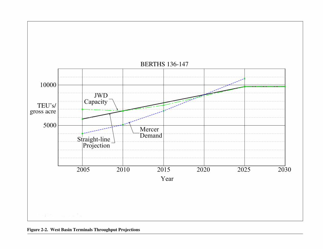
The demand for cargo throughput capacity at the Berths 136-147 terminal will 11 continue to rise (line labeled “Demand” in Figure 2-2). Capacity (the line labeled 12 “JWD capacity” in Figure 2-2) will also continue to rise, as a result of two factors: 13 increasing operational efficiency on the part of the terminal operator and physical 14 improvements to the terminal facilities accomplished under the proposed Project or 15 alternatives. The capacity line in Figure 2-2 is based upon the proposed Project; 16 other alternatives would produce different lines. As Figure 2-2 shows, even with the 17 improvements in the proposed Project the capacity of the Berths 136-147 Terminal is 18 expected to fall short of demand in approximately 2020, and will reach a maximum 19 in approximately 2025. 20
2.2 Existing Conditions 21
2.2.1 Regional Context 22
The Port is composed of 45 km (28 miles) of waterfront, approximately 300 23 commercial berths, and 3,035 hectares (7,500 acres) of land and water. The Port 24 includes automobile, container, omni, lumber, and cruise ship terminals; liquid and 25 dry bulk terminals; and extensive transportation infrastructure for cargo movement 26 by truck and rail. The Port accommodates commercial fishing, canneries, shipyards, 27 and boat repair yards; provides slips for 6,000 pleasure craft, sport fishing boats, and 28 charter vessels; and supports community and educational facilities such as a public 29 swimming beach, the Boy/Girl Scout Camp, the Cabrillo Marine Aquarium, and the 30 Maritime Museum. 31
2.2.2 Project Setting 32
The proposed Project area is located within the West Basin in the Wilmington and 33 San Pedro Districts of the Port, approximately 32 kilometers (km) (20 miles) south of 34 downtown Los Angeles and immediately south of the Wilmington Community 35 (Figures 1-1 and 2-1). The West Basin is used primarily for containerized cargo 36 operations at Berths 97-109 (China Shipping Terminal), Berths 121-131 (Yang Ming 37 Terminal), and Berths 136-147 (TraPac Terminal). Other uses in the West Basin 38
39
BERTHS 136-147
TEU’s/gross acre
Figure 2-2. West Basin Terminals Throughput Projections
Source: Bureau of Reclamation 2006

Berths 136-147 Terminal EIS/EIR 2-7
include liquid bulk operations at Berths 150-151 and an intermodal rail yard at Berths 1 121-131 that currently serves rail movements from the Yang Ming and China 2 Shipping Terminals. Additionally, the Pier A rail yard adjacent to Berths 156–160 is 3 used for switching purposes. 4
2.2.3 Project Site and Surrounding Uses 5
The Berths 136-147 Terminal is roughly bordered by Harry Bridges Boulevard on the 6 north; by Slip 1, Neptune Avenue, Water Street, and Fries Avenue on the east; by the 7 Turning Basin to the south, and by the terminal at Berths 118-131 to the west. Berths 8 136-147 currently operate as a single container terminal with a combined area of 176 9 acres and total berth length of 2,775 feet. Berths 136-139 occupy the northern-10 central West Basin, and Berths 142-147 occupy most of the eastern portion of the 11 West Basin. The Pier A rail yard, a classification (switching) yard, is located in the 12 southeast portion of the proposed Project area, adjacent to Berths 154-160. The 13 existing terminal has no direct rail access; containers are drayed to and from off-site 14 intermodal facilities or transported directly to destinations in the Los Angeles area. 15
Existing equipment and facilities on the container terminal portion of the proposed 16 Project site included thirteen shoreside cranes along the south- and west-facing 17 wharves in the 2003 baseline year, along with mobile equipment used to handle 18 containers, a 28,000-square-foot maintenance shop, several small buildings, and 19 surface parking. Two of the cranes were removed in the spring of 2007. Most of the 20 site consists of paved backlands used for storage of cargo containers. 21
Surrounding land uses include the community of Wilmington adjacent to and north of 22 the Port, and heavy port industries to the east and west. Wilmington is a predominantly 23 residential community, but also contains community and commercial uses. 24
2.2.4 Historic Use of Project Site 25
The proposed Project site was created in the 1920s by dredging and filling and has been 26 intensively used for various Port activities since then. In 1927, the Western Oil and 27 Refining Company constructed a marine oil terminal at Berth 128 on the western side 28 of the basin. The eastern shore was the site of the next development with completion 29 in 1932 of a passenger/cargo terminal and wharf at Berths 145-146. Over the next 30 six years development in the basin included Pan Pacific Piling and Construction 31 Company at Berth 140, the Coos Bay Lumber terminal at Berth 129, and the United 32 Fruit Banana Terminal at Berth 147. In 1935, the United Fruit Company designed a 33 new state-of-the-art fruit terminal at Berth 147. 34
The northern shore of the basin remained undeveloped until the coming of World 35 War II and development of a shipyard along the western and northern edge of the 36 basin, displacing the lumber and oil operations. After the war, most of the shipyard 37 was decommissioned, although some residual activity remained for a time in the 38 northwest portion of the basin (the Northwest Slip). New wharfs and break-bulk 39 cargo sheds were built along the northern (Berths 136-139) and eastern (Berths 143-40 144) edge of the basin in the 1960s. In 1973, a container terminal on the west portion 41

2.0 Project Description
2-8 Berths 136-147 Terminal EIS/EIR
of the basin (Berths 128-131) began operation. By 1987, the shed on the northern 1 shore of the basin had been removed and the TraPac Container Terminal began 2 operations at Berths 136-139. 3
The area of the proposed on-dock rail yard is presently the Pier A rail yard, which 4 serves as Pacific Harbor Railroad’s (PHL) switching yard and operations base. PHL 5 is a short-line rail operator currently serving both the Port of Los Angeles and the 6 Port of Long Beach. This base serves as a classification yard, crew on-duty point, 7 and locomotive service facility. PHL’s facility would be relocated approximately 8 one mile northeast to a site north of Berths 200A through H. That site has been used, 9 and will still be used, as a transfer yard. The Pier A rail yard receives rail cars of 10 non-containerized cargo from various points, including BNSF’s Watson Rail Yard in 11 Wilmington. The proposed Project would not result in an increase in rail movements 12 to the relocated Pier A rail yard. 13
The 30-acre parcel that is to be developed as a landscaped area between the 14 community and Port industrial activities was historically an area of commercial and 15 light industry uses. These included industrial and lumber yards, a junk yard, an 16 environmental recycler, a taxicab company, commercial buildings, trucking 17 companies, a filling station, warehouses, a bar and residences. Beginning in 2001, 18 the Port purchased these properties, through either negotiation or condemnation, and 19 conducted soil remediation; the assembled parcels are currently vacant except for the 20 State Fish Company, which will continue to operate at its existing location. 21
2.3 Project Purpose 22
LAHD operates the Port under legal mandates under the Port of Los Angeles 23 Tidelands Trust (Los Angeles City Charter, Article VI, Sec. 601) and the Coastal Act 24 (PRC Div 20 S30700 et seq.), which identify the Port and its facilities as a primary 25 economic/coastal resource of the State and an essential element of the national 26 maritime industry for promotion of commerce, navigation, fisheries and harbor 27 operations. According to the Tidelands Trust, Port-related activities should be water 28 dependent and should give highest priority to navigation, shipping and necessary 29 support and access facilities to accommodate the demands of foreign and domestic 30 waterborne commerce. 31
The overall purpose of the proposed Project is to increase and optimize the cargo-32 handling efficiency and capacity of the Port at Berths 136-147 in the West Basin to 33 address the need to optimize Port lands and terminals for current and future containerized 34 cargo handling. The proposed Project seeks to do this by improving facilities and 35 expanding an existing operating 176-acre marine terminal at Berths 136-147. 36
2.3.1 CEQA Project Objectives 37
The LAHD’s overall objective for the proposed Project is threefold: (1) provide a 38 portion of the facilities needed to accommodate the projected growth in the volume 39 of containerized cargo through the Port; (2) comply with the Mayor’s goal for the 40 Port to increase growth while mitigating the impacts of that growth on the local 41

2.0 Project Description
Berths 136-147 Terminal EIS/EIR 2-9
communities and the Los Angeles region by implementing pollution control 1 measures, including the elements of the CAAP specific to the proposed Project; and 2 3) comply with the Port’s Strategic Plan to maximize the efficiency and capacity of 3 terminals while raising environmental standards through application of all feasible 4 mitigation measures. These interrelated goals require increases in the cargo-handling 5 efficiency and capacity of existing terminal facilities in the Port. In order to 6 accomplish these basic objectives in a manner consistent with LAHD’s public trust 7 responsibilities, the following supporting objectives need to be accomplished: 8
1. Expand and modernize existing container terminal facilities at the Port to the 9 extent required to: 10
o Optimize the use of existing land and waterways and be consistent 11 with the Port’s overall use of available shoreline; 12
o Accommodate foreseeable containerized cargo volumes through the 13 Port; 14
o Increase container handling efficiency and create sufficient backland 15 area for container terminal operations, including storage, transport, and 16 on/offloading of container ships in a safe and efficient manner; 17
o Provide access to land-based rail and truck infrastructure capable of 18 minimizing surface transportation congestion or delays while 19 promoting conveyance to and from both local and distant cargo 20 destinations; and 21
o Improve or construct container ship berthing and infrastructure 22 capacity where necessary to accommodate projected containerized 23 cargo volumes through the Port. 24
2. Provide on dock-rail capabilities to promote direct transfer of cargo between ship 25 and rail. 26
3. Apply the foregoing principles to improvement of the existing terminal facilities 27 at Berths 136-147. 28
4. In connection with improvement and expansion of the Berths 136-147 terminal, 29 provide a landscaped area as a community amenity and to provide physical 30 separation between Port operations and residential areas. 31
2.3.2 NEPA Purpose and Need 32
As discussed in Section 1.1.3, the USACE, along with the Ports of Los Angeles and 33 Long Beach, prepared the 2020 Plan that determined the Ports would need to 34 construct new land for new container terminals and to optimize their existing terminals 35 in order to meet the forecasted cargo volumes arriving at West Coast ports. 36 Subsequent cargo forecasts and capacity analyses (see Section 1.1.3) have confirmed 37 the conclusions of the 2020 Plan. Therefore, a need exists to increase container 38 efficiency and container backlands, optimize and increase accommodations for 39 container ship berthing, and provide optimized truck-to-rail container movements. 40

2.0 Project Description
2-10 Berths 136-147 Terminal EIS/EIR
The overall purpose of the proposed Project is to increase and optimize the cargo-1 handling efficiency and capacity of the Port of Los Angeles at Berths 136-147 in the 2 West Basin to address the need to optimize Port lands and terminals for current and 3 future containerized cargo handling. Other proposed Project purposes include 4 establishing needed container-handling facilities that would maximize the use of 5 existing waterways and that would integrate into the overall use of the Port. The basic 6 purpose of the proposed Project is maritime trade, which is a water-dependent activity. 7
Specifically, the Port of Los Angeles needs to: 8
• Construct sufficient berthing and infrastructure capacity to accommodate 9 foreseeable increases in containerized cargo; and 10
• Provide the accessory buildings and structures at the terminal to support the 11 anticipated cargo-handling requirements. 12
2.4 Proposed Project 13
2.4.1 Project Summary 14
2.4.1.1 General Overview 15
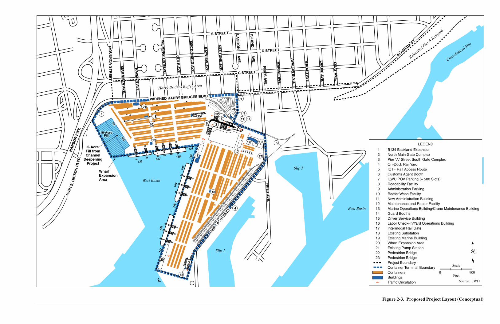
The proposed Project (Figures 2-3 and 2-4; Table 2-2) consists of expanding the Berths 16 136-147 Terminal by 57 acres, from 176 to 233 acres, by 2015 (Phase I of the proposed 17 Project), and by an additional 10 acres, to 243 acres, by 2025 (Phase II), and 18 constructing an intermodal rail facility in the terminal, and constructing a 30-acre 19 buffer area at the northern boundary of the terminal. The proposed Project also 20 includes replacing existing cranes, dredging deeper berthing areas, filling to create 10 21 acres of new land, reconstructing existing wharves, and constructing 1,105 feet of new 22 wharves. The increased terminal acreage and new wharves would increase the amount 23 of cargo that could be handled. 24
The terminal operator would be granted a 30-year lease, to 2038. The Project site and 25 associated facilities would continue to operate as a marine terminal for containerized 26 cargo for the life of the lease, as summarized in Table 2-2. The terminal operator 27 would be required to comply with all laws and regulations, including environmental 28 controls that are not part of the current lease. Those controls would be imposed 29 pursuant to the Clean Air Action Plan, Port Environmental Policy (see Section 1.6) 30 and the Port of Los Angeles Real Estate Leasing Policy (LAHD 2006; see Section 31 1.6.3), and would include emissions standards for terminal equipment, vessel speed 32 reduction and fuel requirements, AMP for a proportion of marine vessels, clean truck 33 requirements, and other environmental measures unrelated to air quality such as 34 storm water management. 35
As Table 2-2 shows, annual ship calls are not directly proportional to terminal acreage or 36 TEU throughput. For example, ship calls will actually decrease over time under the No 37 Federal Action yet throughput will increase because of changes in vessel size and 38 deployment patterns. This analysis assumes, consistent with the “Forecast of Container 39
40
10-AcreFill
10-AcreFill
5-AcreFill fromChannel
DeepeningProject
WharfExpansionArea West Basin
East Basin
Consolidated
Slip
Slip 5
Slip 1
134
135
134
135
ISL
AN
D A
VE
.
D STREET
HA
RB
OR
FW
Y.
MA
R V
ISTA
AV
E.
MA
RIN
E A
VE
.
AVA
LO
N B
LVD
.
LA
KM
E A
VE
.
BR
OA
D A
VE
.
QU
AY
AV
E.
C STREET
FR
IES
AV
E.
NE
PT
UN
E A
VE
.
GU
LF
AV
E.
WIL
MIN
GTO
N B
LVD
.
WIDENED HARRY BRIDGES BLVD.
HA
WA
IIN A
VE
.
MA
CD
ON
AL
D A
VE
.
BA
YV
IEW
AV
E.
JOH
N S
. GIB
SO
N B
LVD
.
JOH
N S
. GIB
SO
N B
LVD
.
FIG
UE
RO
A S
TR
EE
TF
IGU
ER
OA
ST
RE
ET
PIER
"A" S
TREE
T
PIER
"A" S
TREE
T
QU
AY
AV
E.
ALAMEDA ST.
MA
RIN
E A
VE
.
AVA
LO
N B
LVD
.
LA
KM
E A
VE
.
BR
OA
D A
VE
.
FR
IES
AV
E.
FR
IES
AV
E.
FR
IES
AV
E.
C STREET
D STREET
E STREETE STREET
NE
PT
UN
E A
VE
.
BA
YV
IEW
AV
E.
MA
R V
ISTA
AV
E.
GU
LF
AV
E.
WIL
MIN
GTO
N B
LVD
.
HA
WA
IIN A
VE
.
MA
CD
ON
AL
D A
VE
.
WIDENED HARRY BRIDGES BLVD.
4
17
6
10
151816
10
21
1
8
13
19
22
12 5
23
18
136137
138
139
142
143
144
145
146
147
148
149
7
ALAMEDA ST.
LA
GO
ON
AV
E.
2
11
9
14
15
320
Harry Bridges Buffer AreaHarry Bridges Buffer Area
Reloca
ted P
ier A R
ailyard
01 B134 Backland Expansion02 North Main Gate Complex03 Pier “A” Street South Gate Complex04 On-Dock Rail Yard05 ICTF Rail Access Route06 Customs Agent Booth07 ILWU POV Parking (+ 500 Slots)08 Roadability Facility09 Administration Parking10 Reefer Wash Facility11 New Administration Building12 Maintenance and Repair Facility13 Marine Operations Building/Crane Maintenance Building14 Guard Booths15 Driver Service Building16 Labor Check-In/Yard Operations Building17 Intermodal Rail Gate18 Existing Substation19 Existing Marine Building20 Wharf Expansion Area21 Existing Pump Station22 Pedestrian Bridge23 Pedestrian Bridge Project Boundary Container Terminal Boundary Containers Buildings Traffic Circulation
Figure 2-3. Proposed Project Layout (Conceptual)
Figure ES-3. Proposed Project Layout (Conceptual)
N
Source: JWD
Scale
0 900Feet
LEGEND

Wilmington Blvd.
Wilmington Blvd.
McDonald Ave.
McDonald Ave.
Bayview Ave.
Bayview Ave.
Neptune Ave.
Neptune Ave.
Lagoon Ave.Lagoon Ave.
FriesAve.FriesAve.
Gulf Ave.
Gulf Ave. C StreetHawaiin Ave.
Hawaiin Ave. Harry Bridges Blvd.
Interstat e110
Figueroa St.
Water Street
Figure 2-4. Location of Project Components
LEGENDNew Location of Pier A Rail Yard
Widening of Harry Bridges Blvd.
Harry Bridges Blvd. Landscape Area
Berths 136-149 Container Terminal

2.0 Project Description
Berths 136-147 Terminal EIS/EIR 2-15
1 Table 2-2. Project Summary Matrix
Berths 136-147 CEQA
Baseline No Federal Action NEPA Baseline Proposed Project
2003 YEAR 2015 YEAR 2038* YEAR 2015 YEAR 2038* OPERATIONS
Gross Acres 176 233 233 233 243 Annual Ship Calls 246 283 250 309 334 Annual TEUs 891,976 1,491,200 1,697,000 1,747,500 2,389,000 Number of Cranes 13# 11 11 12 12 Annual Truck Trips 1,197,589 1,291,247 1,200,205 1,607,093 1,880,401 Annual Rail Trips 731 925 1,351 1,085 1,434 Total Number of Access Gates 3 2 2 2 2
CONSTRUCTION Fill into Waters of U.S. (cubic yards) 0 0 0 0 800,000 Dredging (cubic yards) 0 0 0 295,000 3,000 Length of New Wharf** 0 0 0 705 400 Length of Seismic Retrofit Wharf** 0 0 0 3,000 0 Note: * Maximized at Year 2025 ** Linear feet # This number reflects the baseline conditions existing in December of 2003. Two 50-gauge cranes along Berths 145 and 146 were removed in the spring of 2007.
Vessel Specifications and Port Calls within San Pedro Bay” (Ports of Los Angeles and 2 Long Beach 2006), that the ships will increase in size from the current average of 5,000 3 TEU as more vessels of 10,000 TEUs and even larger enter service, thereby transporting 4 more containers via fewer ships. Additionally, shipping companies often deploy and sail 5 vessels even if not completely full in order to adhere to prearranged schedules. This topic 6 is covered further in Section 1.1.3 of this document. 7
2.4.1.2 Project History 8
TraPac, an existing tenant at the Port, currently operates the container terminal at 9 Berths 136-147. TraPac entered into a lease with the Port on January 7, 1985; the lease 10 expired in 2002 and the tenant has been on holdover since that time. This terminal was 11 included in the West Basin Container Terminal EIR (LAHD 1997a) and some 12 improvements to the wharf were constructed based on that assessment. The Port has 13 begun Term Sheet negotiations with TraPac in regards to this proposed Project/new 14 lease but has not entered into any agreements. Under the Port’s Leasing Policy, term 15 sheets contain tentative points of agreement that are non-binding on the Port and the 16 tenant, describing overall project parameters and compensation information 17 recommended for negotiation. If the proposed Project or an alternative is approved, a 18 new lease incorporating the terms of the approval would be negotiated with the tenant. 19
The Harry Bridges Buffer Area has a more complicated history. Prior to 2004, the 20 proposed Harry Bridges Buffer Area was proposed to become a 25-acre container 21

2.0 Project Description
2-16 Berths 136-147 Terminal EIS/EIR
storage/backlands expansion area for the Berths 136-147 Container Terminal 1 Redevelopment Plan. As part of this expansion, Harry Bridges Boulevard was to be 2 realigned north to C Street and a 20-foot-high sound wall was to be constructed along 3 the north edge of the realigned boulevard (LAHD 1994). In preparation for this use, 4 the Port acquired most of the properties in the area, either through negotiation or 5 condemnation, and conducted required remediation activities at a cost of 6 approximately $45 million. Based on community opposition and the growing 7 recognition of the land use conflict of having a heavy industry use immediately 8 adjacent to residential areas, the project was eventually modified to realign Harry 9 Bridges Boulevard in its existing location and develop 25 of the acquired acres as 10 open-space buffer (SMWM 2004). Recently, five additional acres were dedicated to 11 the open-space buffer for a total of 30 acres. These proposed Project changes were 12 reflected in the Supplemental Notice of Preparation for this EIR (LAHD 2006). 13
Throughout 2006, the Port and its consultants worked in a collaborative public planning 14 process with the Wilmington Waterfront Subcommittee of the Port Community Advisory 15 Committee (PCAC) on a conceptual design for the buffer area. During the public 16 planning process with the community, three alternative designs for the buffer area, each 17 including the elements in the current concept, were produced and evaluated. The concept 18 being carried forward as an element of the Berth 136-147 Container Terminal Project 19 was identified by the Port, with support from the Subcommittee, on December 5, 2006, 20 and ratified by the full PCAC on January 16, 2007. 21
Improvement of the Harry Bridges Buffer Area has been included in various past and 22 current area planning efforts, notably the Wilmington Waterfront Development Program 23 (LAHD and PCAC 2004). That Program is the result of efforts by the Port Community 24 Advisory Committee (PCAC), the PCAC Wilmington Waterfront Development 25 Subcommittee, and the City of Los Angeles Harbor Department. The Program identifies 26 a number of goals, objectives, and implementation strategies for the Wilmington 27 Waterfront area, and contemplates two separate and independent projects: 1) the Harry 28 Bridges Buffer Area, which is intended to provide a physical space between the 29 Wilmington community and the Port of Los Angeles; and 2) the Avalon Boulevard 30 Corridor development, which is intended provide waterfront access and commercial 31 development opportunities for Wilmington. The two projects are at different stages of 32 planning and development and do not rely on each other for implementation. 33
The Harry Bridges Buffer Area is being pursued as an element of the Berths 137-146 34 Container Terminal Project because of its planning and land acquisition history as an 35 element of that project. As redesigned in response to community input, it will provide 36 an open space buffer between that terminal and the community. Approval (or 37 disapproval) and implementation of the Harry Bridges Buffer Area component of this 38 proposed Project will occur separately from the Wilmington Waterfront Development 39 Program and is not contingent upon approval of any other project under that Program. 40
Development of the Avalon Boulevard Corridor immediately southeast of the Harry 41 Bridges Buffer Area is a plan for an adjacent area and the subject of its own 42 environmental assessment. The improvements proposed in that project would provide 43 additional public access and maritime-related development activities at the Wilmington 44 waterfront. Construction of the Harry Bridges Buffer Area, if approved, would proceed 45 independent of future decisions for development of the Avalon Boulevard Corridor. 46

2.0 Project Description
Berths 136-147 Terminal EIS/EIR 2-17
2.4.2 Project Elements 1
Key elements of the proposed Project include backlands development, improvements 2 to the terminal gates, new and reconstructed wharf facilities, dredging and landfill, 3 on-dock rail, relocation of an existing rail yard, and a buffer area between the 4 community and the terminal. 5
2.4.2.1 Expanded/Reconfigured Backlands and New Buildings 6
Phase I development would include adding 57 acres to the terminal for expanded 7 container storage and an on-dock rail yard through 1) the redevelopment of 52 acres 8 of existing land within the proposed Project area and 2) the development of 5 acres of 9 fill in the Northwest Slip. Part of the existing land is vacant, part is underutilized by 10 current uses, and part is occupied by the Pier A rail yard, which would be relocated. 11
The creation of the 5-acre fill is a separate project being analyzed as part of the 12 Channel Deepening Project SEIS/EIR (USACE and LAHD in preparation). The 5 13 acres of new land would allow realignment of the wharf roadway at Berths 136-139 in 14 the Northwest Slip, which in turn would facilitate safer and more efficient truck and 15 equipment movement on the wharf. The current configuration requires trucks and 16 other container handling equipment to make a 180-degree turn to exit the wharf area, 17 which raises safety concerns and causes traffic delays. The additional area would also 18 allow additional wheeled operations to occur for container storage and handling instead 19 of a stacked Rubber-Tired Gantry (RTG) operation (see Section 1.1.2). 20
The existing main guard station, administration building, reefer wash facility, 21 maintenance and repair and roadability facility, longshore restroom, yard operations 22 building, and Pacific Harbor Line office would all be demolished and replaced by new 23 buildings (Figure 2-3). The terminal would have two new truck gates, one at the 24 northeast corner of the terminal and the other at the south end of the terminal; the 25 existing gate would be removed. A new 500-space parking lot would be constructed in 26 the northeast corner of the site (Figure 2-3). The lot would be used by International 27 Longshore and Warehouse Union (ILWU) workers. A pedestrian under- or overpass 28 would connect the parking lot to the operating container terminal. Existing paving 29 throughout the terminal would be rehabilitated or replaced, as necessary. 30
Phase II of the proposed Project would add 10 acres of backland at Berth 134 for 31 container terminal use by filling in the remaining 10 acres of the Northwest Slip not 32 filled by the Channel Deepening Project (Figure 2-3). Note that if the 5-acre fill is not 33 permitted through the Channel Deepening Project then the 10-acre fill would not be 34 built in Phase II and the proposed Project would resemble the Reduced Fill 35 Alternative (see section 2.5.1.2). 36
The terminal would be served by existing utilities (water, sewer, electrical, storm drain, 37 lighting) except in the case of the 15 acres of created land, on which new utilities 38 would be installed. Existing utilities would have to be relocated to serve the new 39 buildings and terminal configuration, and additional electrical facilities constructed to 40 support AMP (see Section 2.4.2.3). 41

2.0 Project Description
2-18 Berths 136-147 Terminal EIS/EIR
The new storm drain system on the new land would be sized to accommodate the 10-1 year storm event and would include the installation of pollution control structures as 2 required by the Los Angeles County Standard Urban Stormwater Mitigation Plan 3 (LADWP 2002). Such structures may include catch basins and filter-type inserts to 4 trap particulate matter and oil and grease. 5
2.4.2.2 Deeper Vessel Berths 6
The waters adjacent to Berths 144-147 would be deepened by dredging to match the 7 planned –53-foot (MLLW) channel depth that is expected to be achieved by the 8 Channel Deepening Project. Approximately 265,000 cubic yards of sediments would 9 be dredged from Berths 144-147 and disposed of as described in section 2.4.4.1. 10
2.4.2.3 New and Reconstructed Wharf Facilities 11
The existing concrete wharves at Berths 136-139 and 145-146 (approximately 2,900 12 feet of wharf) would be upgraded to meet current seismic standards, and the existing 13 timber wharf at Berth 147 would be replaced by a new, 705-foot concrete wharf 14 (78,135 square feet). In Phase II, a new 400-foot (44,332 square feet) extension of the 15 Berth 136 – 138 wharf into Berth 134, along the south edge of the 10-acre landfill in 16 the Northwest Slip (see section 2.4.4.2) would be constructed. The wharf upgrades 17 would involve dredging approximately 30,000 cubic yards of sediments from the West 18 Basin (in addition to the 265,000 cy above). All berths would be equipped with shore 19 power capability to allow the use of Alternative Maritime Power for vessels calling the 20 terminal (see Section 1.6.2.3). 21
In addition to the new wharves, the proposed Project would include new wharfside 22 gantry cranes. There were 13 cranes at the terminal in 2003. Two of the 100-gauge 23 cranes along Berths 136-139 have been removed; these will be replaced by one new 24 100-gauge crane as part of the Project. In addition, two 100-gauge cranes and two 25 50-gauge cranes at Berths 144-147 would be replaced by four new 100-gauge cranes. 26 This would result in a total of 12 cranes at the container terminal (one less than 27 present in the baseline year of 2003), all of which would be electric powered. 28
As part of the China Shipping Settlement,1 the Port of Los Angeles has investigated 29 the use of low-profile cranes for container terminals to reduce the overall height of 30 container cranes, thereby reducing some potential aesthetic effects of the taller 31 standard A-frame cranes. Low-profile cranes utilize a boom that moves horizontally, 32 rather than up or down, to access different areas of the container ships. Because of 33 this, they have a lower profile (total height of approximately 175 feet) than A-frame 34 cranes at rest (approximately 280 feet). The Port’s investigation found low-profile 35 cranes to be infeasible under CEQA Guidelines Section 15126.4(a) due to economic 36 and productivity considerations. Low-profile cranes are somewhat shorter than the 37 standard A-frame cranes but are more bulky at the base. They were not found to 38
1 Amended Stipulated Judgment, Modification of Stay and Order Thereon, in the case, Natural Resources Defense Council, Inc., et al., v. City of Los Angeles, et al., in the Superior Court of the State of California, County of Los Angeles, Case No. BS 070017.

2.0 Project Description
Berths 136-147 Terminal EIS/EIR 2-19
reduce overall aesthetic impacts and they were found to cost significantly more than 1 standard A-frame cranes. Because of this expense combined with the relatively small 2 reductions in visual impacts, low-profile cranes are not considered to be feasible 3 mitigation measures. Additionally, low-profile cranes are associated with safety 4 issues because they are much heavier than standard A-frame cranes. 5
Mobile cranes, such as those manufactured by Leberer, are mounted on mobile, 6 rubber-tired units that can be moved along the wharf. The crane itself is a single arm 7 that is operated from the base of the unit and is kept vertical through 8 counterbalancing and hydraulic feet. From a visual perspective, the crane takes up a 9 very narrow aerial space and could be lowered when not in use. The cranes are 10 typically used in terminals that handle a diversified cargo or in situations where A-11 frame cranes are not available. The cranes are not considered feasible for use at Port 12 container terminals because they are much less efficient, in terms of number of 13 containers moved per hour, as A-frame cranes for this specialized use. To achieve 14 economically acceptable rates of container transfer, several mobile cranes would 15 need to operate in place of one A-frame crane in a coordinated fashion such that there 16 would be no physical contact between crane arms when transferring containers to and 17 from the ship. Even in these situations, it is unlikely that these cranes could achieve 18 the handling rates of A-frame cranes, which are specifically designed for container 19 operations. There are no major container terminals in the world that rely on mobile 20 cranes as the primary means for loading and unloading containers from newer-21 generation container ships. 22
2.4.2.4 New and Relocated Rail Facilities 23
On-Dock Rail Yard. The proposed Project includes an on-dock rail yard (Figure 2-3) to 24 be constructed where the Pier A rail yard is presently located (along the eastern edge of 25 the existing terminal; Figures 2-1 and 2-4). The rail yard would require approximately 10 26 acres of land and would consist of a container staging area and six working tracks totaling 27 approximately 16,200 feet. The rail yard would connect via lead tracks to the Alameda 28 Corridor. The facility could load and unload two trains per day. 29
Relocated Pier A Rail Yard. The Pacific Harbor Line’s (PHL) Pier A rail yard 30 would be relocated to a 70-acre area northeast of the existing terminal, between the 31 Consolidated Slip and Alameda Street (Figure 2-5), that is currently being used as a 32 rail transfer facility. PHL would continue its operations out of the relocated rail yard. 33 The new rail yard (Figure 2-5) would include 46 tracks totaling 125,630 feet of track, 34 a locomotive service facility; a small yard office (8,000 square feet) with change 35 areas, toilets, and showers; a track and material storage area; and 30 parking spaces 36 for employees. The locomotive service facility would include a 5,000-square-foot 37 diesel service shed and inspection pits, a sanding building with storage and 38 compressed air, and a 1,000-square-foot maintenance shed. 39
2.4.2.5 Harry Bridges Boulevard and Buffer Area 40
Harry Bridges Boulevard would be widened and a 30-acre buffer area would be 41 constructed between Harry Bridges Boulevard and “C” Street, from Figueroa Street to 42

2.0 Project Description
2-20 Berths 136-147 Terminal EIS/EIR
Lagoon Avenue, on vacant, Port-owned property (Figure 2-6). The north-south streets 1 within this area and their intersections with Harry Bridges Boulevard would be removed, 2 with the exception of King Avenue, which would remain open. The existing State Fish 3 Company and Harpur’s Marine buildings would remain, the former being within the 4 perimeter of the proposed buffer area and the latter at its east edge. The State Fish 5 driveway/loading area would be at least partially screened from public use areas with 6 plantings. The southern edge of the area, adjacent to the reconstructed boulevard, would 7 include enough space for a future extension of the Red Car Line, so that if that (separate) 8 development is ultimately approved a right of way would be available. Space would also 9 be available for a contemplated extension of the California Trail, although the trail itself 10 is not a component of the proposed Harry Bridges Buffer Area. 11
The topography would consist of a low berm (to a maximum of 16 feet) along the 12 southern edge of the proposed Project and gentle grades; landscaping would include 13 grass, trees (approximately 500 are proposed), and other plant material, as well as paths, 14 benches, hardscaping, water features, pedestrian bridges, restrooms, a playground, and 15 incidental architectural structures. The open space would serve public gatherings, 16 community events, informal play, sitting, and promenading. Along the north side of the 17 east end of the area there would be open fields for informal recreation, pick-up games, 18 and family events. There will be no areas in the buffer that will be dedicated to the 19 exclusive use of organized sports teams. All open areas in the Harry Bridges Buffer Area 20 will be available to any user, consistent with the trust grants and the public trust doctrine. 21 Two simulated perspectives of the Harry Bridges Buffer Area are shown in Figure 2-7. 22 Views of design features from other developments that may be incorporated into the 23 Harry Bridges Buffer Area design are shown in Figures 2-8 and 2-9. 24
2.4.2.6 Terminal Operations 25
The completed Berths 136-147 Terminal could handle a maximum of approximately 26 2,389,000 TEUs (1,277,540 containers) per year. That maximum capacity is 27 expected to be reached by 2025 (Table 2-2). 28
Marine Terminal Operations. The operation of container vessels, their loading and 29 unloading, and the handling of containers in the terminal are described in Section 30 1.1.2. A total of four vessels could be berthed at the terminal at any one time, but the 31 more usual case would be two vessels at berth. At maximum capacity, the terminal 32 would experience approximately 334 vessel calls per year by 2025. 33
A proportion of the vessels calling at the Berths 136-147 Terminal would use 34 Alternative Maritime Power (AMP) while at berth; that requirement would be phased 35 in over time as described in Section 3.2.4.4. AMP allows vessels to turn off their 36 diesel auxiliary generators and support hoteling needs with shoreside electrical 37 power. Vessels not capable of using AMP would be required to use low-sulfur fuel 38 (0.2 percent or less) in their generators and boilers while in the port area, and all 39 vessels would be required to use low-sulfur fuel in their main engines within 40 40 nautical miles of Point Fermin; those requirements would be phased in over time as 41 described in Section 3.2.4.4. 42

Figure 2-5. Relocation of Pier A Rail Yard
LEGENDProposed Rail YardBoundary
Henry F
ord Ave.
Henry F
ord Ave.
Alameda Stre
et
Alameda Stre
et
Harry Bridges Blvd.Harry Bridges Blvd.
“C” Street
Anaheim StreetAnaheim Street
Burbank A
ve.B
urbank Ave.
Avalon B
lvd.A
valon Blvd.
NScale
Mile0 0.3
Consolidated
Slip
Consolidated
Slip
Cer
rito
s
Cha
nnel
Cer
rito
s
Cha
nnel
47
“C” Street

POTENTIAL REDCAR CONNECTIONPOTENCIAL CONEXIONAL COCHE ROJO
POTENTIALCALIFORNIACOASTAL TRAILCONNECTIONPOTENCIAL CONEXIONAL CAMINO COSTALDE CALIFORNIA
LEGENDPIE
Figure 2-6. Harry Bridges Buffer Area and Conceptual Design Elements
N
WilmingtonWaterfrontMaster Plan

EVENT LAWN
GREAT MOUND ADVENTURE PLAYGROUND
SCULPTURE GARDEN PICNIC SLOPE
PROMENADEEL PASEO
SPLASH FOUNTAIN SEPTEMBER 14, 2006
Figure 2-7. Design Elements From Other Developments to be Used in the Buffer Area

Figure 2-8. North-South Cross-Section of the Buffer Area and Stepped Concrete Walls
WilmingtonWaterfrontMaster Plan
SEPTEMBER 14, 2006
Scale
0 12Feet

Figure 2-9. Simulated Perspectives of the Landscaped Buffer Area
2 1WilmingtonWaterfrontMaster Plan
KEY MAP
VIEW 1 VIEW 2SEPTEMBER 14, 2006

2.0 Project Description
Berths 136-147 Terminal EIS/EIR 2-31
Truck Operations. By 2025, when the throughput is expected to reach the terminal’s 1 maximum capacity, the Berths 136-147 Terminal would generate approximately 6,377 2 daily truck trips (Table 2-2). Those trips would include local cargo (principally Southern 3 California but including Northern California, Arizona, Nevada, and Utah), national cargo 4 hauled entirely by truck, and intermodal cargo bound for or coming from farther east. 5
The intermodal component would consist of containers that could not be accommodated 6 by the terminal’s on-dock rail yard. Trucks would haul those containers on public 7 highways to and from off-site rail yards, including the Union Pacific’s Carson ICTF, the 8 Burlington Northern Santa Fe’s Hobart Yard in Vernon, and the Union Pacific’s East Los 9 Angeles Yard. 10
Non-intermodal cargo, both local and national, would be hauled to and from the 11 terminal gates by trucks As rail use increases over time, the proportion of cargo 12 hauled by truck would decrease, but terminal planners estimate that in 2025 and 13 thereafter, approximately 70 percent of the terminal’s cargo (approximately 4,500 truck 14 trips per day) would move by truck at least as far as an off-site rail yard. 15
Rail Operations. The new on-dock rail yard at the Berths 136-147 Terminal would 16 handle cargo only from that terminal. According to the Port Rail Master Plan, the rail 17 yard could handle approximately 700,000 TEUs (374,331 containers) annually, or 18 approximately 30 percent of the terminal’s projected 2025 throughput of 2.4 million 19 TEUs per year. 20
Containers would be hauled by yard tractors between the vessel berths and the new rail 21 yard. At the rail yard they would be lifted onto and off of railcars by mobile cranes or 22 RTGs. The rail yard would be operated 24 hours per day, 350 days per year, and 23 could handle two double-stack unit trains each day. Although each train could carry 24 a maximum of 300 containers each way, they usually carry fewer than that due to 25 weight considerations. A more realistic estimate is that each inbound train trip (into 26 the Port) transports an average of 90 containers (167 TEUs) plus empty railcars, 27 while each outbound train trip (to inland locations) transports an average of 240 28 containers (444 TEUs), for an average of 330 containers (617 TEUs) per round trip 29 (Yang Ming/ MTC Terminal 2003). A loaded double-stack train is typically pulled 30 by three or four line-haul locomotives, although if PHL operates the train it would be 31 hauled by two or three smaller locomotives. 32
2.4.3 Federal Project 33
The limits of federal jurisdiction in this proposed Project mean that not all of the 34 elements described above are subject to federal permits, and the scope of the federal 35 review of the proposed Project is different from the scope of the CEQA review (see 36 section 1.4). The federal project is indicated by shading on Figure 2-10, and 37 basically consists of all dredging in the West Basin, the rehabilitation of the existing 38 wharves and the creation of a new 705-ft wharf at Berth 147, and the creation of the 39 10-acre fill and a 400-ft wharf in the Northwest Slip. Landside construction activities 40 within 100 feet of the shoreline also require a Corps of Engineers permit. The federal 41 project does not include the demolition and construction of buildings, gates, or rail 42 facilities; installation of utilities (except on and near the wharves); rehabilitation of 43

2.0 Project Description
2-32 Berths 136-147 Terminal EIS/EIR
paving; or the creation of the Harry Bridges Buffer Area. Any transport of dredged 1 material for the purpose of ocean disposal (LA-2, LA-3) would also be subject to 2 federal permitting requirements. 3
2.4.4 Construction Plan by Phase 4
Phase I of the proposed Project would be completed by 2015 and Phase II would be 5 completed after 2015. Figure 2-3 identifies the major improvements that would occur 6 during each construction phase. Table 2-3 shows the estimated construction schedule 7 for each component of the proposed Project, by phase. Within this overall schedule, 8 construction activities would be phased so as to minimize disruption both to the 9 terminal, which will continue to operate during the entire construction period, and to 10 surrounding operations. In practice this would mean that, for example, only one wharf 11 would be reconstructed at a time, construction of the on-dock rail yard would not begin 12 until the new Pier A rail yard had been completed and PHL’s operation transferred, 13 only a portion of the backlands construction would be occurring at any one time, and 14 dredging would affect only one berth at a time. 15
Table 2-3. Proposed Project Construction Schedule
Proposed Project Component Estimated Construction Schedule PHASE I CONSTRUCTION
Wharf Improvements 2008-2010 Backlands Improvements and Associated Facilities 2010-2011 Relocate Pier A Rail Yard 2009-2010 New On-Dock Rail Yard 2010-2011 Harry Bridges Buffer Area 2008-2010
PHASE II CONSTRUCTION Filling in the 10-acre Northwest Slip & Associated Wharf and Backlands Construction Post-2015
Prior to construction, the LAHD would prepare a Public Services Relocation Plan to 16 address the public utilities and services that would require relocation or otherwise be 17 affected during proposed Project construction. The Plan would be developed with 18 input from the service providers for the proposed Project site and would be submitted 19 to City regulatory departments for review and approval. Construction affecting 20 utilities could not begin until the Plan was approved. The Plan would be on file with 21 the LAHD during construction. 22
The Plan would include the following measures: 23
• Prior to disconnecting any existing services, new facilities (i.e., water, sewer, 24 communications, gas, and electricity) would be installed. Pipeline installation 25 would occur within existing utility corridors/easements. 26
27

HARRY BRIDGES BLVD.
Harry Bridges Blvd. Buffer Area
10-AcreFill
10-AcreFill
5-AcreFill fromChannel
DeepeningProject
Renovated Wharf
West Basin
East Basin
Consolidated
Slip
Reloca
ted P
ier A R
ailyard
Harry Bridges Blvd. Buffer Area
Slip 5
Slip 1
134
135
10-AcreFill
134
135
134
135
Renovated Wharf
New Wharf
New Wharf
NewAdministrationBuilding
NewAdministrationBuilding
On-DockRail Yard
ISL
AN
D A
VE
.
D STREET
HA
RB
OR
FW
Y.
MA
R V
ISTA
AV
E.
MA
RIN
E A
VE
.
AVA
LO
N B
LVD
.
LA
KM
E A
VE
.
BR
OA
D A
VE
.
QU
AY
AV
E.
C STREET
FR
IES
AV
E.
NE
PT
UN
E A
VE
.
GU
LF
AV
E.
WIL
MIN
GTO
N B
LVD
.
HA
WA
IIN A
VE
.
MA
CD
ON
AL
D A
VE
.
BA
YV
IEW
AV
E.
JOH
N S
. GIB
SO
N B
LVD
.
JOH
N S
. GIB
SO
N B
LVD
.
FIG
UE
RO
A S
TR
EE
TF
IGU
ER
OA
ST
RE
ET
PIER
"A" S
TREE
T
PIER
"A" S
TREE
T
QU
AY
AV
E.
ALAMEDA ST.
MA
RIN
E A
VE
.
AVA
LO
N B
LVD
.
LA
KM
E A
VE
.
BR
OA
D A
VE
.
FR
IES
AV
E.
FR
IES
AV
E.
FR
IES
AV
E.
C STREET
D STREET
E STREETE STREET
NE
PT
UN
E A
VE
.
BA
YV
IEW
AV
E.
MA
R V
ISTA
AV
E.
GU
LF
AV
E.
WIL
MIN
GTO
N B
LVD
.
HA
WA
IIN A
VE
.
MA
CD
ON
AL
D A
VE
.
HARRY BRIDGES BLVD.
136137
138
139
142
143
144
145
146
147
148
149
ALAMEDA ST.
LA
GO
ON
AV
E.
Project BoundaryContainer Terminal BoundaryContainersBuildingsDirect Impacts under Federal Jurisdiction In-water improvements covered by permit - Dredging - Wharf expansion - Wharf renovation Indirect Impacts under Federal Jurisdiction On-land within 100 feet of water’s edge Potential construction-related impacts necessary to complete in-water improvements
Cumulative Impact analysis extends beyond the delineatedDirect and Indirect Impacts areas under Federal Jurisdictionfor some issues, such as Air Quality and Traffic.
Figure 2-10. Scope of Analysis for FederalReview of Proposed Project Impacts
N
Source: JWD
Scale
0 900Feet
LEGEND

2.0 Project Description
Berths 136-147 Terminal EIS/EIR 2-35
• As demolition activities progress, unnecessary facilities and connections would 1 be eliminated and new facilities and connections activated. 2
• Minor service interruptions (defined as those lasting 1 day or less) may occur 3 during the transition between obsolete and newly installed facilities and services. 4 Affected properties would be properly notified prior to any service interruption. 5
• Full access to all utilities would be restored after the completion of proposed 6 Project construction. 7
2.4.4.1 Phase I (Projects Completed by 2015) 8
The first phase of construction is assumed to begin in mid-2008 and would include the 9 following activities: 10
• Backlands Development. Phase I would include demolishing most of the 11 existing structures and constructing new ones. Buildings or structures that would 12 be removed to provide additional backlands include the main guard station, 13 existing administration building, reefer wash facility, maintenance and repair and 14 roadability facility, longshore restrooms, yard operations building, Pacific 15 Harbor Line office, and the Pier A rail yard. In general, the buildings would not 16 be demolished until their replacements had been completed. Building 17 demolition would involve heavy diesel-powered construction equipment and 18 haul trucks to remove the debris, and would occur over a period of three months. 19
After the land is cleared, the areas would be graded, paved, and improved with 20 striping, lighting, fencing, utilities, buildings, and other typical backland 21 elements, and the new ILWU parking lot would be installed along with the 22 under- or overpass. Construction would require heavy, diesel-powered graders, 23 loaders, dirt-hauling trucks, excavators, trucks for delivering materials, cement 24 trucks, and paving equipment, and would last over 19 months. 25
A new 20,000 square-foot LEED-certified (gold certification) administration 26 building would be constructed in the northeast corner of the site as shown on 27 Figure 2-3. Employee and visitor parking would be provided adjacent to the 28 building. Other new buildings or structures include a customs agent booth, 29 roadability facility, reefer wash facility, LEED-certified maintenance and repair 30 facility, marine operations buildings/crane maintenance building, longshore 31 restrooms, guard booths, driver service building, and labor check-in/yard 32 operations building. Construction would require cement trucks, heavy-duty on-33 road trucks delivering structural materials, and cranes and other equipment used 34 in building fabrication, and would occur over a period of 19 months. 35
Two new truck access gates to the terminal would be built: the Pier “A” Street 36 South Gate Complex (inbound traffic) and the North Main Gate Complex 37 (inbound and outbound traffic). Construction would include the installation of 38 computer and fiber optic cables to support modern gate operations. Construction 39 equipment would be similar to that used in building construction. 40
The 5 acres of land created in the Northwest Slip by the Channel Deepening 41 Project would also be graded, paved, and improved with striping, lighting, and 42

2.0 Project Description
2-36 Berths 136-147 Terminal EIS/EIR
fencing. Construction equipment would be similar to that used in redevelopment 1 of the existing backlands (above). 2
• Dredging at Berth 144-147. Approximately 265,000 cy of sediments would be 3 dredged to support construction of the wharves at Berths 145-147 and to deepen 4 the waters adjacent to Berths 144-147 to match the planned -53-foot channel 5 depth. An additional 30,000 cy of sediments would be dredged for the wharf 6 seismic retrofit improvements (see below). On the basis of previous sampling 7 and analyses, the Army Corps of Engineers and USEPA have determined that 8 a portion of the material is unsuitable for unconfined ocean disposal. 9 Additional sampling may be performed to refine that determination, but for the 10 sake of this evaluation it is assumed that the material is unsuitable and thus 11 would be placed in an approved confined disposal site(s) (CDF) at either the 12 Port of Los Angeles or the Port of Long Beach, or at an appropriate upland site 13 such as the Anchorage Road Disposal Site or a site in the Port of Long Beach. 14 Clean material would be considered for disposal at the Pier 400 submerged 15 disposal site or at an EPA-approved ocean disposal site (LA-2 or LA-3). 16
Dredging would likely be accomplished by a barge-mounted clamshell dredge. 17 Dredged material would be placed in hopper barges that would be hauled to the 18 disposal site by tugboats. At the disposal site the material would be offloaded 19 either by bottom dump, if the material is being placed in the lower tiers of a 20 CDF, or clamshell derrick if it is being placed upland. Upland disposal would 21 also involve diesel-powered earthmovers, trucks, and loaders to de-water the 22 sediments at a waterfront site and convey the de-watered sediments to the 23 disposal site. Dredging and disposal would follow the requirements of the 24 permits issued by the Army Corps of Engineers, the Water Quality Control 25 Board, and the Port of Los Angeles, which would include measures to control 26 water pollution such as monitoring for excessive turbidity, prohibitions on 27 overfilling barges, regular inspections, and monitoring to ensure accurate 28 dredging and disposal. 29
Typically, construction would involve one clamshell dredge, two hopper 30 barges, one workboat, and one tugboat, and would take a total of 31 approximately 100 days, but those days would be spread over the entire Phase 32 I construction period. 33
• New and Reconstructed Wharves at Berth 145-147. Existing concrete 34 wharves at Berths 146-146 would be upgraded and the existing timber wharf at 35 the southern end of Berth 147 would be demolished and replaced by a new 705-36 foot wharf (78,135 square feet) concrete wharf. 37
Construction would require placement of approximately 179,500 cy of rock 38 barged from Catalina Island for the rock dike, placement of 25,000 cy of fill 39 behind the bulkhead, and placement of 380 piles to support the new wharf. The 40 rock would be brought to the site on barges pulled by tugboats and placed in 41 the dike by being pushed off the barges by bulldozers. The piles would be 42 installed by a barge-mounted pile driver that would be brought to the site and 43 maneuvered by a tugboat and supported by a workboat. Construction of the 44 wharf deck would require concrete trucks, heavy-duty on-road trucks delivering 45 structural materials, and cranes and other fabrication equipment. The rock 46 placement would require two tugboats and barges and last approximately 41 47

2.0 Project Description
Berths 136-147 Terminal EIS/EIR 2-37
days; pile driving and construction of the concrete wharf deck would take 1 approximately eight months. 2
Approximately 3,000 cy of sediment would be dredged from the area along the 3 wharf face as part of this phase of the proposed Project. The dredge material 4 would be disposed of in the same way as the dredging at Berths 144-147. 5 Dredging would require one diesel-powered clamshell dredge and barge and 6 their associated support boats, and would take one or two days. 7
Demolished concrete would be re-used for beneficial purposes to the extent 8 practical, and any that could not be re-used would be hauled to an approved 9 municipal landfill. Examples of beneficial uses include creation of approved 10 offshore reefs or grinding for use as aggregate. 11
• Wharf Seismic Improvements. For improved structural response to 12 earthquakes, approximately 2,900 feet of existing wharves at Berths 136-139 13 and 145-146 would be improved and upgraded. Additional piles would be 14 installed and 30,000 cy of sediments would be dredged and disposed of as 15 described above. 16
Construction would involve a barge-mounted crane and pile-driver 17 maneuvered by a tugboat, heavy-duty, diesel-powered demolition equipment, 18 heavy-duty on-road trucks to haul away demolition debris, cement trucks, 19 heavy-duty on-road trucks delivering structural materials, and cranes and other 20 fabrication equipment, and would occur over approximately 24 months. 21
• New Cranes. By the end of Phase I construction, two of the 100-gauge cranes 22 along Berths 136-139 would be removed and a new 100-gauge crane would be 23 installed in their place. In addition, two 100-gauge cranes along Berths 144-147 24 would be removed, and four new 100-gauge cranes would be installed in their 25 place. (Two 50-gauge cranes along Berths 145-147 were removed in the spring 26 of 2007, but for the purposes of the CEQA baseline and impact analyses they are 27 assumed to be at the site.) This would result in a total of 12 modern A-frame 28 container cranes at the completed terminal. A specialized cargo ship, assisted by 29 two tugboats, would deliver the cranes to the wharf. 30
• Relocate Pier A Rail Yard. Phase I development would relocate the Pier A rail 31 yard as shown in Figures 2-4 and 2-5. To minimize impacts on existing rail 32 operations, the new Pier A rail yard would be constructed before the existing 33 one is demolished and rebuilt as the on-dock facility. Construction would 34 include installing 125,630 feet of track, switches as necessary, a locomotive 35 maintenance facility, and office buildings. 36
Once construction of the new rail yard was complete the existing Pier A rail 37 yard would be demolished. Construction would require heavy-duty, diesel-38 powered demolition equipment, heavy-duty on-road trucks to haul away 39 demolition debris, specialized diesel-powered ballasting and track-laying 40 machines, excavators, loaders, dirt-hauling trucks, cement trucks, heavy-duty on-41 road trucks delivering structural materials, and cranes and other equipment, and 42 would occur over approximately twelve months. 43
• New On-Dock Rail Yard. Construction of the new on-dock rail yard would 44 install 16,200 feet of track, switches, paved loading areas, utilities, including an 45 underground compressed air system, and striping and lighting. 46

2.0 Project Description
2-38 Berths 136-147 Terminal EIS/EIR
Construction would require specialized diesel-powered ballasting and track-1 laying machines, excavators, loaders, dirt-hauling trucks and trucks to haul away 2 demolition debris, cement trucks, heavy-duty on-road trucks delivering structural 3 materials, and cranes and other fabrication equipment, and would occur over 4 approximately 12 months. 5
• Widening of Harry Bridges Boulevard. The roadway of Harry Bridges 6 Boulevard would be widened from 50 feet to 84 feet between Figueroa Street 7 and Alameda Street (see Figure 2-6). Intersections would be rebuilt in response 8 to the closure of several north-south streets, and signals and striping would be 9 altered as necessary following City of Los Angeles Department of 10 Transportation guidelines. The boundary of the new roadway alignment would 11 be moved 20 feet north of its present location. 12
Construction would require graders, excavators, dirt-haul trucks, concrete 13 trucks, heavy-duty on-road trucks delivering structural materials, and cranes 14 and other fabricating equipment, and would last approximately 13 months. 15 Traffic control measures conforming to the requirements and guidance of 16 Caltrans and the Los Angeles Department of Transportation would be 17 required by the construction permits. 18
• Harry Bridges Buffer Area. Existing streets within the site would be 19 demolished along with sidewalks, signage, and signals. Approximately 200,000 20 cubic yards of imported fill would be used to create varied terrain, and landscape 21 plants would be installed on the created terrain. Pedestrian walkways, benches, 22 shelters, lighting, signage, an irrigation system, sanitary facilities, a sanitary 23 sewer system, and a storm drain system would be installed. 24
Construction would require heavy-duty, diesel-powered demolition equipment, 25 heavy-duty on-road trucks to haul away demolition debris, graders, excavators, 26 dirt-haul trucks, concrete trucks and heavy-duty on-road trucks delivering 27 structural materials, and cranes and other fabricating equipment, and would last 28 approximately one year. 29
2.4.4.2 Phase II (Projects Completed between 2015 and 2025) 30
During Phase II construction, backlands would be expanded for container terminal use 31 and the wharf at Berth 136 would be extended westward. The backland expansion would 32 increase the terminal size from 233 to 243 acres. Construction staging would occur 33 onsite. Proposed Project construction would include: 34
• Additional Backlands. Filling in the 10-acre Northwest Slip would require 35 800,000 cy of fill, which may come from any combination of dredging for 36 channel deepening and wharf construction, outer harbor dredging, upland 37 sources, or sediment stored at underwater sites in the harbor for beneficial re-use, 38 depending upon what is available at the time of construction. Following 39 completion of the fill the site would be graded, utilities would be installed, and 40 the site would be paved, striped, and fenced. 41
Placement of fill is assumed to be accomplished by a hydraulic dredge pumping 42 a sediment/water slurry from an Outer Harbor borrow/dredge site such as the 43 Pier 400 underwater site or a channel deepening site into the 10-acre site. The 44

2.0 Project Description
Berths 136-147 Terminal EIS/EIR 2-39
dredge would be supported by one or two workboats. The slurry would be 1 conveyed by a pipeline laid along the Main Channel and across the West Basin 2 in such a way as to minimize navigational conflicts. The slurry would be 3 retained by a rock dike that would become the new shoreline, the sediments 4 would settle out in the diked area to become new land, and the clarified water 5 would be released to the West Basin. Monitoring at the release point would 6 ensure that turbidity would not exceed regulatory limits. The fill activity would 7 take several months to complete. 8
The rock dike would be composed of quarry rock from Catalina transported to 9 the site by tug-hauled barges. Two tug/barge combinations would work for 10 approximately 24 days to construct the dike. A surplus of material, either 11 dredged material or imported upland material, would be placed on the fill as 12 surcharge so that its weight would speed consolidation of the dredged material. 13 Once the new land was consolidated it would be graded, utilities (storm drains, 14 electrical conduits) would be installed, and the site would be paved, fenced, 15 and striped. 16
• Wharf Improvements. A 400-foot extension of the wharf at Berth 136 (44,332 17 square feet) would be constructed at the face of the new land created by filling 18 the Northwest Slip; the rock dike constructed to retain the fill would support the 19 new wharf. Approximately 12,000 cy of imported fill would be placed behind 20 the dike, and 397 concrete piles would be installed to support the wharf structure. 21 Approximately 3,000 cy would be dredged as part of this proposed Project and 22 disposed of either in the new fill or as in Phase I. The new wharf would be 23 equipped with utilities, including provisions for AMP. 24
Construction would require a barge-mounted clamshell dredge maneuvered by a 25 tugboat and supported by one or two workboats, a barge-mounted pile driver 26 maneuvered by a tugboat and supported by a workboat, cement trucks, heavy-27 duty on-road trucks delivering structural materials, and cranes and other 28 fabrication equipment, and would last for up to eight months. 29
2.5 Alternatives 30
2.5.1 Alternatives Evaluated In This EIS/EIR 31
This document presents a reasonable range of alternatives. The Port defines a 32 reasonable range of alternatives in light of the Port’s legal mandates under the Port of 33 Los Angeles Tidelands Trust (Los Angeles City Charter, Article VI, Sec. 601), the 34 Coastal Act (PRC Div 20 S30700 et seq.) and the Port’s Leasing Policy (LAHD 35 2006). The Port is one of only five locations in the State identified in the Coastal Act 36 (PRC sections 30700 and 30701) for the purposes of international maritime 37 commerce. These mandates identify the Port and its facilities as a primary 38 economic/coastal resource of the State and an essential element of the national 39 maritime industry for promotion of commerce, navigation, fisheries and operations of 40 a harbor. Activities should be water dependent and give highest priority to 41 navigation, shipping and necessary support and access facilities to accommodate the 42 demands of foreign and domestic waterborne commerce. Leaving the premises 43

2.0 Project Description
2-40 Berths 136-147 Terminal EIS/EIR
vacant for any extended time is not consistent with the Port’s legal mandates. Based 1 on existing demand and capacity limitations on industrial Port uses and Trust 2 purposes, all or most of the industrial facilities adjacent to deep water are needed to 3 accommodate maritime commerce, specifically containerized cargo. 4
Eighteen alternatives (including the proposed Project and the No Project and No 5 Federal Action Alternatives) were considered during preparation of this Draft 6 EIS/EIR, which included alternative terminal configurations and alternative terminal 7 locations. Of these, five met most of the proposed Project objectives and have been 8 carried forward for detailed analysis in Chapter 3. This section presents a description 9 of the alternatives analyzed in this environmental document (Figure 2-11, Table 2-4), 10 followed by the alternatives considered but eliminated from further discussion, 11 including the rationale for the decision to eliminate the alternatives from detailed 12 analysis. Chapter 6 includes a more detailed comparison of all alternatives. 13
2.5.1.1 Alternative 1 - No Project Alternative 14
This alternative considers what would reasonably be expected to occur on the site if no 15 LAHD or federal action would occur. The Port would not issue any permits or 16 discretionary approvals, and would take no further action to construct and develop 17 additional backlands or any aspect of the proposed Project. The USACE would not 18 issue any permits or discretionary approvals for dredge and fill actions or for 19 construction of wharves, and there would be no significance determinations under 20 NEPA. This alternative would not allow implementation of the proposed Project or 21 other physical improvements at Berths 136-147. The terminal would remain at its 22 current size of 176 acres and in its current configuration. Forecasted increases in cargo 23 throughput would still occur as greater operational efficiencies are made. Recently 24 approved projects would be in place, such as the original Channel Deepening Project 25 SEIS/SEIR (USACE and LAHD 2000) and the more recent Channel Deepening 26 Project for Additional Disposal Areas SEIS/SEIR (USACE and LAHD in preparation) 27 would most likely also be implemented, but this and other currently proposed projects 28 are subject to discretionary approval by the Port and various responsible agencies 29
Under this alternative, no construction impacts would occur. The terminal would 30 continue to be operated by TraPac under the current holdover lease. There would be 31 operational impacts: cargo ships that currently berth and load/unload at the terminal 32 would continue to do so, terminal equipment would continue to handle cargo 33 containers, and trucks would continue to pick up and deliver containers to local and 34 national destinations and regional intermodal facilities. No environmental controls 35 beyond those imposed by local, state, and federal regulatory agencies would be 36 implemented. There would be no on-dock rail yard or new cranes under this 37 alternative. This alternative would result in a maximum throughput of 1,697,000 TEUs 38 (907,487 containers), approximately 250 vessel calls, and 1,961,395 truck trips per year 39 by 2025. For a variant of this No Project alternative see Alternative 5 – Landside 40 Improvements/CEQA No Project Variant, that maintains the same throughput but 41 includes a new lease with an on-dock rail facility and environmental controls. 42
43

Alternative 4 – OMNI Terminal
176-AcreConvertedto OMNITerminal26 Acres ofAdditionalOMNITerminalArea
Alternative 1 – No Project
176-AcreExistingContainerTerminal
No IncreaseWidened Harry Bridges Blvd.Buffer Area
Widened Harry Bridges Blvd.Buffer Area
Widened Harry Bridges Blvd.Buffer Area
Widened Harry Bridges Blvd.Buffer Area
Widened Harry Bridges Blvd.Buffer Area
Alt. 2 – Project without 10-acre Fill
705’ New Wharf
176-AcreExistingContainerTerminal57-Acresof AdditionalTerminal AreaOn-DockRail Yard
176-AcreExistingContainerTerminal14-Acresof AdditionalTerminal AreaOn-DockRail Yard
176-AcreExistingContainerTerminal67-Acresof AdditionalTerminal AreaOn-DockRail Yard
3,000’Renovated
Wharves
705’ New Wharf
3,000’Renovated
Wharves
Alt. 5 – Landside Terminal Improvements
Proposed Project
176-AcreConvertedto OMNITerminal26 Acres ofAdditionalOMNITerminalArea
Alternative 3 – Reduced Wharf
176-AcreExistingContainerTerminal57-Acresof AdditionalTerminal AreaOn-DockRail Yard
3,000’Renovated
Wharves
Fill AreaWharf Expansion
Source: Bureau of Reclamation 2006
Figure ES-4. Container Terminal Changes Under the Proposed Project and Alternatives
Figure 2-11. Container Terminal Changes Under the Proposed Project and Alternatives

2-43 Berths 136-147 Terminal EIS/EIR
Table 2-4. Project Alternatives Summary Matrix
Berths 136-147 Proposed Project Alternative 1 -
No Project Alternative
Alternative 2 - Project Without 10-
Acre Fill
Alternative 3 - Reduced Wharf
Alternative 4 - Omni Terminal
Alternative 5 - Landside Terminal
Improvements
YEAR 2015
YEAR 2038*
YEAR 2015
YEAR 2038*
YEAR 2015
YEAR 2038*
YEAR 2015
YEAR 2038*
YEAR 2015
YEAR 2038*
YEAR 2015
YEAR 2038*
Operations Gross Acres 233 243 176 176 233 233 233 233 202 202 190 190 Annual Ship Calls 309 334 257 250 309 334 283 300 95 83 257 250 Annual TEUs 1,747,500 2,389,000 1,355,200 1,697,000 1,747,500 2,389,000 1,491,200 2,035,000 499,200 565,700 1,355,200 1,697,000 Annual Truck Trips 1,607,093 1,880,401 1,879,127 1,961,395 1,607,093 1,880,401 1,291,247 1,456,293 692,193 653,837 1,879,127 1.961,395
Annual Rail Trips 1085 1,434 1,110 1,390 1,085 1,434 925 1,391 409 463 1,110 1,390
Annual Autos Not applicable Not applicable Not applicable Not applicable 30,400 31,920 Not applicable
Annual Break-Bulk Commodities Not applicable Not applicable Not applicable Not applicable 300,320 315,366 Not applicable
Number of Cranes 12 12 11# 11# 12 12 12 12 11# 11# 11# 11# Total Number of Access Gates 2 2 3 3 2 2 2 2 2 2 3 3
Construction Fill into Waters of U.S. (cubic yards) 0 800,000 0 0 0 0 0 0 0 0 0 0
Dredging (cubic yards) 295,000 3,000 0 0 295,000 0 30,000 0 0 0 0 0
Length of New Wharf** 705 400 0 0 705 0 0 0 0 0 0 0
Length of Seismic Retro Wharf** 3,000 0 0 0 3,000 0 3,000 0 0 0 0 0
Note: * Maximum Throughput Achieved in Year 2025 ** Linear feet # There were 13 cranes in December of 2003 (baseline). Two 50-gauge cranes along Berths 145 and 146 were removed in the spring of 2007.

2.0 Project Description
2-44 Berths 136-147 Terminal EIS/EIR
2.5.1.2 Alternative 2 – Reduced Project: Project Without 10-1
Acre Fill 2
This alternative is the same as the proposed Project except that the 10-acre Northwest 3 Slip would not be filled for additional backland storage area, and the 400-foot wharf 4 extension adjacent to it would not be built, which would result in decreased container 5 movement efficiency when compared with the proposed Project. Because the Phase II 6 fill would not be built, terminal size would remain constant at 233 acres. Other Project 7 components, such as the relocation of the Pier A rail yard, construction of the new on-8 dock rail yard, widening of Harry Bridges Boulevard, and development of the Harry 9 Bridges Buffer Area would occur as described in Section 2.4.2. Construction of 10 Alternative 2 would also include constructing a new LEED-certified administration 11 building, and new, modern maintenance and ancillary buildings and demolishing existing 12 buildings; constructing two new gates to improve truck ingress/egress to the facility; and 13 installing utilities, paving, fencing, and lighting as necessary. 14
At full capacity, assumed to occur by 2025, this alternative would result in the same 15 amount of container throughput as the proposed Project (2,389,000 TEUs or 1,277,540 16 containers per year), the same number of vessel calls per year (approximately 334 per 17 year) the same number of rail trips (1,148 per year at the on-dock rail yard and 286 at off-18 site rail yards) and the same maximum number of truck trips (1,880,401 per year). The 19 throughput and vessel call projections are based on the number of available berths and the 20 rail and truck trips are driven by the throughput and size of rail yard, which is why 21 projections are the same between the proposed Project and Alternative 2. However, the 22 additional 10 acres would improve cargo handling efficiencies by providing more 23 backland space for handling cargo. 24
2.5.1.3 Alternative 3 – Reduced Wharf 25
This alternative is the same as the proposed Project except that the proposed new 26 705-foot wharf at Berth 147 would not be constructed, the 10-acre Northwest Slip 27 would not be filled for additional container storage area, and the 400-foot wharf 28 extension adjacent to it would not be built. This alternative would include expanding 29 the terminal by 57 acres; the backlands improvements and wharf seismic 30 improvements described in Section 2.4.2; relocation of the Pier A rail yard; 31 construction of the new on-dock rail yard; and widening Harry Bridges Boulevard 32 and development of the Harry Bridges Buffer Area. Construction of Alternative 3 33 would also include constructing a new LEED-certified administration building, and 34 new, modern maintenance and ancillary buildings and demolishing existing 35 buildings; constructing two new gates to improve truck ingress/egress to the facility; 36 and installing utilities, paving, fencing, and lighting as necessary. 37
This alternative would result in a container terminal of 233 acres with a maximum 38 throughput of 2,035,000 TEUs (1,088,235 containers) per year, and approximately 39 300 vessel calls per year by 2025. This alternative would result in the same number 40 of rail trips from the on-dock yard (1,148 per year) as the proposed Project and 41

2.0 Project Description
Berths 136-147 Terminal EIS/EIR 2-45
Alternative 2, and a maximum of 1,456,293 annual truck trips. Alternative 3 would be 1 subject to the same environmental control measures as the proposed Project. 2
In Alternative 3, the terminal would be operated under a new, 30-year lease between 3 the terminal operator and the Port. The new lease would include environmental 4 controls that are not part of TraPac’s current lease. Those controls would be imposed 5 pursuant to the Clean Air Action Plan, Port Environmental Policy (see Section 1.6) 6 and the Port of Los Angeles Real Estate Leasing Policy (LAHD 2006; see Section 7 1.6.3). The lease would include emissions standards for terminal equipment, 8 participation in the vessel speed reduction program, low sulfur fuel requirements, 9 AMP, clean truck requirements, and measures unrelated to air quality such as storm 10 water management. Those measures would be essentially the same as the measures 11 identified as mitigation measures for the proposed Project. 12
Construction of this alternative would be similar to Alternative 2 except that the 13 omission of the 705-foot wharf extension at Berth 147 would eliminate the need to 14 drive 380 piles, construct 78,135 square feet of concrete wharf, place 179,500 cy of 15 rock and 24,000 cy of fill, and dredge and dispose of 3,000 cy of sediment 16
2.5.1.4 Alternative 4 - Omni Terminal 17
This alternative would convert the Project area into an omni-cargo handling terminal, 18 similar to the Pasha Stevedoring & Terminals L.P. (Pasha) operation currently 19 operating at Berths 174-181. The omni terminal would differ from the proposed 20 Project in several ways: 21
• no seismic upgrades to the existing wharves; 22
• no new wharf construction; 23
• no change in existing cranes; and 24
• no 10-acre fill of the Northwest Slip. 25
Because no new fill, dredging, or wharf construction would be needed, the omni 26 terminal would require no federal permits for in-water construction and there would 27 be no significance determinations under NEPA. 28
Backland development would result in a 202-acre terminal. However, there would be 29 no on-dock rail yard and the Pier A rail yard would not be relocated. The backlands 30 redevelopment would include different buildings than those proposed for the proposed 31 Project and the configuration of the utilities, striping, and lighting would be different. 32
It is assumed that one-third of the omni terminal would be used for container cargo 33 (565,700 TEUs per year in 2025), one-third for automobile off-loading/transport (31,920 34 automobiles per year), and one-third for break-bulk use (315,336 metric tons per year in 35 2030). Approximately 83 vessel calls per year would be expected by 2025. There would 36 be no rail trips from an on-dock yard because the on-dock yard would not be built, but 37 intermodal cargo would generate a maximum of 483 trains per year to and from off-site 38 rail yards. This alternative would generate a maximum of 692,193 truck trips per year. 39

2.0 Project Description
2-46 Berths 136-147 Terminal EIS/EIR
Alternative 4 would be operated under a new, 30-year lease between the terminal 1 operator and the Port. The new lease would include environmental controls that are 2 not part of the current lease. Those controls would be imposed pursuant to the Clean 3 Air Action Plan, Port Environmental Policy (see Section 1.6) and the Port of Los 4 Angeles Real Estate Leasing Policy (LAHD 2006; see Section 1.6.3). The lease 5 would include emissions standards for terminal equipment, participation in the vessel 6 speed reduction program, low sulfur fuel requirements, clean truck requirements, and 7 measures unrelated to air quality such as storm water management. Those measures 8 would be essentially the same as the measures identified as mitigation measures for 9 the proposed Project. 10
Construction of Alternative 4 would include the addition of 26 acres of land to the 11 terminal, including the 5-acre fill placed under the Channel Deepening project. 12 Construction would require paving, fencing, and striping; the demolition of the 13 existing administration and maintenance buildings and the main gate; construction of 14 new buildings and gates; and construction of the Harry Bridges Buffer Area and the 15 associated roadway widening as described in Section 2.4.4. 16
2.5.1.5 Alternative 5 – Landside Terminal Improvements/CEQA 17
No Project Variant 18
Alternative 5 comprises only the upland infrastructure components of the proposed 19 Project, including new terminal buildings, new truck gates, an on-dock rail yard, a 20 new 500 space ILWU parking lot, and the paving, fencing, utilities, and lighting 21 necessary for the infrastructure changes. The Pier A rail yard would be relocated as 22 in the proposed Project, and PHL’s operations transferred to the new rail yard. The 23 new terminal’s area would be 190 acres including area for the new on-dock rail yard, 24 terminal buildings, and gate modifications. This alternative would not include new 25 land for container storage. This alternative includes widening Harry Bridges Blvd. 26 and constructing the Harry Bridges Buffer Area. The reconstructed terminal would 27 be operated under a new lease with the Port. 28
Under Alternative 5, the terminal would be operated under a new, 30-year lease 29 between the terminal operator and the Port. The new lease would include 30 environmental controls that are not part of the current lease. Those controls would be 31 imposed pursuant to the Clean Air Action Plan, Port Environmental Policy (see 32 Section 1.6) and the Port of Los Angeles Real Estate Leasing Policy (LAHD 2006; 33 see Section 1.6.3). The lease would include emissions standards for terminal 34 equipment, participation in the vessel speed reduction program, low sulfur fuel 35 requirements, AMP, clean truck requirements, and measures unrelated to air quality 36 such as storm water management. Those measures would be essentially the same as 37 the measures identified as mitigation measures for the proposed Project. 38
Under Alternative 5, the terminal would handle approximately 1,355,200 TEUs in 39 2015 and 1,697,000 in 2025 through 2038, the same as the No Project alternative. 40 Throughput limitations are imposed by the limited berth capacity and backlands 41 acreage. Thus, Alternative 5 is a variant of the CEQA No Project Alternative 42 (Alternative 1). Both the No Project Alternative and Alternative 5 would generate 43

2.0 Project Description
Berths 136-147 Terminal EIS/EIR 2-47
the same throughput, but Alternative 5 includes discretionary action and permits by 1 the LAHD that would include a new lease with environmental controls. 2
In order to incorporate environmental controls, construction of Alternative 5 would 3 include: constructing a new LEED -certified administration building, and new modern 4 maintenance, and ancillary buildings; constructing two new gates to improve truck 5 ingress/egress to the facility; relocating the existing Pier A rail yard and building an on-6 dock rail yard in its place to switch as much cargo as possible from truck to rail. In order 7 to implement these project elements, Alternative 5 would require 190 acres for the on-8 dock rail and gate improvements, and would require demolition of existing buildings and 9 installation of utilities, paving, fencing and lighting as necessary. These alternatives 10 have the same throughput because even with landside improvements/efficiencies, the 11 terminal becomes constrained at the berth (see Section 1.1.2 for a discussion of 12 terminal operation and constraints). 13
In this alternative, there would be no wharf upgrades, no new wharves or container 14 cranes, no dredging to deepen berths and no 10-acre fill in the Northwest Slip. 15 Alternative 5 is a No Federal Action alternative, which would not require a USACE 16 permit. Because there would be no federal action or permit, there would be no 17 significance determinations under NEPA for this alternative. This alternative differs 18 from the NEPA baseline, however, in that only the upland infrastructure components 19 are constructed but no new backland area for container storage is added. Therefore, 20 while throughput has the potential to grow due to operational changes, actual 21 throughput growth is constrained in 2015 by significantly less acreage and lack of 22 operational changes in this time frame 23
2.5.2 Alternatives Considered and Withdrawn 24
Several alternatives were considered during preparation of this EIS/EIR. This section 25 presents twelve alternatives considered but eliminated from further discussion and 26 includes the rationale for the decision to eliminate the alternatives from detailed 27 analysis. Alternatives considered but eliminated include the following: 28
1. Use of other ports outside Southern California; 29
2. Expansion of terminals within Southern California but outside the Los Angeles 30 Harbor District; 31
3. Lightering; 32
4. Off-site backland alternatives; 33
5. Development of new landfills and terminals outside the Berths 136-147 34 Terminal area and the adjoining the West Basin area; 35
6. Shallower dredge depth; 36
7. Alternative shipping use of the terminal; 37
8. Other sites within the Los Angeles Harbor District; 38
9. Non-shipping use of the terminal; 39
2.0 Project Description
2-48 Berths 136-147 Terminal EIS/EIR
10. Harry Bridges Boulevard relocated to provide additional container storage area; 1
11. Development and operation of a smaller terminal; and 2
12. Alternative designs for the Harry Bridges Buffer Area. 3
2.5.2.1 Use of Other West Coast Ports Outside Southern 4
California 5
In this alternative, the Port of Los Angeles would not expand and improve the Berths 6 136-147 Container Terminal, but would instead assume that the additional cargo would 7 be handled by other West Coast ports outside Southern California (i.e., Oakland, 8 Seattle, Tacoma, Portland, Vancouver, B.C.). It is important to note that the Port of 9 Los Angeles has no authority to direct cargo to ports outside its jurisdictional 10 boundaries; it could only refuse to provide the discretionary actions necessary to 11 increase Port capacity within its own boundaries, thus providing shippers with an 12 incentive to route cargo to other ports. Such a course is not consistent with the 13 Tidelands Trust or Coastal Act. 14
To evaluate this alternative it is important to recognize the current and expected role of 15 the Port of Los Angeles in U.S. foreign trade. Between 40% and 45% of the all 16 containers handled by U.S. ports come through the Port of Los Angeles (Journal of 17 Commerce 2007) and more than 75 percent of all containers shipped through West 18 Coast ports flow though the Ports of Los Angeles, Long Beach, and Oakland because 19 those ports have the specialized facilities and navigational channels of sufficient depth 20 to safely accommodate the new generation of deep-draft ships (USACE and LAHD 21 2000). The value of goods handled by the Ports of Los Angeles and Long Beach was a 22 combined $240.5 billion in 2004, whereas the value of goods handled by the Ports of 23 Oakland, Seattle, and Tacoma was a combined $63.9 billion in the same year 24 (MARAD 2005a). As described in Section 1.1.3, the large population base of the 25 Southwestern U.S. and the strong transportation connections to the rest of the country 26 make the two San Pedro Bay ports prime destinations for foreign trade. 27
Assuming that other ports could handle the large increases in cargo expected to come to 28 Los Angeles would ignore the physical situation and expansion potential of those ports. 29 An assumption of the cargo demand projections for the Ports of Los Angeles and Long 30 Beach, assumed a portion of the cargo would be going to the other West Coast ports. A 31 survey of West Coast ports prepared for the Deep Draft Navigation Improvements 32 Project showed that other West Coast ports are not capable of absorbing additional 33 cargo diverted from the Port of Los Angeles without constructing new facilities 34 (USACE and LAHD 1992). The 1992 survey is still valid: a number of new studies on 35 goods movement in California, such as the governor’s Goods Movement Action Plan 36 (CalEPA and the Business, Transportation, and Housing Agency 2005), have identified 37 capacity constraints at other West Coast ports. Other major West Coast ports are 38 already operating at or near current physical capacity, have recently expanded, or are 39 undergoing expansion to accommodate their projected future throughput demand. 40 Although small temporary diversions from the Port of Los Angeles can be 41 accommodated, large permanent diversions would require further physical 42 improvements at other major West Coast ports, improvements that are not being 43 contemplated by those ports. 44

2.0 Project Description
Berths 136-147 Terminal EIS/EIR 2-49
The improvements that would be necessary to allow the other West Coast ports to 1 accommodate additional cargo beyond their current forecasts would result in 2 environmental impacts similar to or more intensive than those of the proposed Project 3 (LAHD 1997a). The use of other ports would not meet the objectives of the proposed 4 Project to accommodate the projected growth in the volume of containerized cargo 5 through the Port in accordance with its legal mandates (see section 2.3.1). For that 6 reason, this alternative is considered infeasible. 7
2.5.2.2 Expansion of Terminals Within Southern California but 8
Outside of the Los Angeles Harbor District 9
In this alternative, new container terminal facilities would be constructed at other 10 Southern California ports (Long Beach, San Diego, Port Hueneme), or a new port 11 would be established, to accommodate future increases in cargo volumes that would 12 otherwise be handled by the proposed Project. As with the previous alternative, the 13 Port of Los Angeles has no authority to direct cargo to ports outside its jurisdictional 14 boundaries; it could only refuse to provide the discretionary actions necessary to 15 increase Port capacity within its own boundaries, which is not consistent with the 16 Tidelands Trust or Coastal Act. 17
The chief candidate among existing ports to accommodate Los Angeles’ share of 18 cargo is the Port of Long Beach because that port is similar in size to the Port of Los 19 Angeles and has modern container terminals and deep water access. However, the 20 Port of Long Beach faces future increases in cargo volumes similar to those forecast 21 for Los Angeles (see section 1.1.3). To meet that demand, Long Beach has embarked 22 on its own program of modernization and expansion of container terminals. 23 Furthermore, even if the proposed additional 67 acres of container terminal could be 24 located in the Port of Long Beach, it would have very similar impacts to those of the 25 proposed Project at the Port of Los Angeles, given the proximity of the two ports. 26 Other existing ports in Southern California do not have the water depths, wharf 27 facilities, backland capacity, or transportation connections to accommodate a large 28 amount of container cargo (USACE and LAHD 1992). 29
The option of building a new port to accommodate additional cargo is infeasible 30 because the California Coastal Act does not allow the development of new 31 commercial ports outside the existing port districts. The standards for master plans, 32 contained in Chapter 8 of the Coastal Act, require environmental protection while 33 expressing a preference for port-dependent projects. The logic behind this policy is 34 that it is environmentally and economically preferable to concentrate commercial 35 shipping activities and other maritime industrial facilities in existing ports rather than 36 siting them up and down the coastline. 37
Using other Southern California ports to accommodate future Port of Los Angeles 38 cargo volumes is infeasible because sufficient capacity does not exist and cannot be 39 constructed. Therefore, this alternative was eliminated from further consideration in 40 this EIS/EIR. 41

2.0 Project Description
2-50 Berths 136-147 Terminal EIS/EIR
2.5.2.3 Lightering 1
Lightering involves offloading a portion of a fully loaded vessel’s cargo onto smaller 2 vessels until the larger vessel’s draft has been reduced to the point where it can safely 3 transit to the terminals. It is a common practice for liquid bulk vessels, whose cargo 4 can be quickly and safely transferred between vessels through pipes, and is sometimes 5 used for breakbulk cargos at smaller ports in other countries. In this alternative, 6 containers would be offloaded from oceangoing container vessels to smaller vessels or 7 barges that would convey them to the existing terminal. This alternative would 8 eliminate the need to deepen berths and channels, since the large vessels would not 9 come to the terminal fully loaded. Instead, the oceangoing vessel would anchor 10 offshore, probably in the Outer Harbor, while the lightering process proceeded. 11
Lightering slows cargo movement, requires use of more vessels, and results in higher 12 operational costs. The extra cost of lightering, including use of smaller vessels and 13 delay times, would be considerable. Furthermore, lightering of containers on a large 14 scale has not been shown to be physically practicable or safe, and might not be 15 acceptable to labor and terminal operators for those reasons. Finally, although 16 lightering would avoid the temporary impacts associated with channel deepening 17 (dredging and dredge material disposal), its environmental impacts would be 18 considerable. The delays in port time would result in additional air emissions from the 19 oceangoing vessels, the use of smaller vessels in addition to the oceangoing vessel and 20 the requirement to double-handle containers would add air emissions, and the risk of 21 cargo loss during transfer would pose a risk to water quality and marine resources. 22
Compared to the proposed Project, this alternative would not meet the following 23 Project objectives: to expand and modernize existing container terminal facilities at 24 the Port, to optimize the use of Los Angeles Harbor waterways, and to accommodate 25 the projected growth in the volume of containerized cargo through the Port. 26 Therefore, this alternative was eliminated from further consideration in this EIS/EIR. 27
2.5.2.4 Off-Site Backland Alternatives 28
Off-site backland alternatives would mean using existing backland areas outside the 29 Berths 136-147 terminal but still within the Port to store and handle containers. Under 30 this alternative, the terminal would not be expanded as proposed. Instead, additional 31 container storage and handling facilities would be constructed elsewhere in the Port as 32 isolated yards with fencing, lighting, gates, and container handling equipment. Import 33 containers would be loaded from the ship onto chassis at the Berths 136-147 Terminal 34 by terminal equipment and drayed by on-road trucks from the terminal to the off-site 35 locations, where they would be lifted off the chassis into a grounded stack by terminal 36 equipment or stored on the chassis pending pickup. Export containers would be 37 handled in reverse. 38
This alternative would provide more backlands for container handling without 39 producing the impacts associated with additional fill (i.e., air quality, water quality, and 40 loss of marine resources). On the other hand, containers would have to be handled 41 more often with this alternative than in the proposed Project (once in the marine 42 terminal and once in the backlands facility), which would produce more air emissions 43

2.0 Project Description
Berths 136-147 Terminal EIS/EIR 2-51
from terminal equipment, and would have to be conveyed by on-road trucks between 1 the terminal and the backlands facility, which would contribute to congestion on local 2 streets and produce air emissions. 3
Local and regional planning programs encourage the upgrading and improvement of 4 transportation systems within the Port, and off-site alternatives would not result in such 5 improvements at Berths 136-147. Draying containers between the terminal and the off-6 site facility would add truck trips to the Port road system. The additional truck trips 7 and the additional handling cycle by terminal equipment would add air emissions. 8 Finally, container terminal operators are consolidating facilities wherever possible to 9 expand and optimize their cargo handling efficiencies and capacities. Consolidation 10 results in reduced traffic within the Port and reduced air emissions per TEU. Off-site 11 backland alternatives would not offer those benefits. Furthermore, land is in short 12 supply in the Port, so that it is not certain that suitable locations for off-site backlands 13 could be acquired and developed in a timely manner. 14
While off-site backlands may be needed in the future, they do not meet the current 15 objectives of the proposed Project to accommodate the projected growth in the 16 volume of containerized cargo through the Port in accordance with its legal mandates 17 (see section.2.3.1), and this alternative is judged to result in increased environmental 18 impacts compared to the proposed Project. Therefore, this alternative was eliminated 19 from further consideration in this EIS/EIR. 20
2.5.2.5 Development of New Landfills and Terminals Outside of 21
the Berths 136-147 Terminal Area and the Adjoining 22
West Basin Area 23
This alternative would consist of creating land elsewhere in the harbor and building a 24 new terminal on that land. This approach has been implemented in previous projects, 25 notably the Pier 400 Container Terminal. The new terminal would need to handle 26 approximately 700,000 TEU per year in 2025 in order to replace the proposed Project 27 (the difference in throughput between the proposed Project and No Project in 2038; 28 see Table 2-4), meaning that it would need to be approximately 70 acres (assuming 29 that in 2025 it would operate at 10,000 TEU per acre per year; see Section 1.1.3) and 30 have one or two berths. The new land would have to be in the Outer Harbor, as no 31 water body of that size that is not needed for vessel navigation exists elsewhere in the 32 harbor and it is not feasible at this point to operate a container terminal built outside 33 the breakwaters. Furthermore, the LAHD’s projections of future Port capacity 34 (Section 1.1.3) already incorporate the need for additional landfills in the Outer 35 Harbor, so that implementing this alternative would displace a need for new land that 36 has already been identified. 37
The costs and impacts of developing new facilities on new land, as well as the time it 38 would take, would be much greater than the proposed Project, which largely focuses 39 on optimizing existing facilities and expanding onto existing land. The creation of a 40 70-acre landfill would necessitate much more dredging than in the case of the 41 proposed Project, which would increase the impacts on biological and water 42 resources, and the loss of 70 acres of marine habitat, while it would be mitigated, 43 nevertheless represents an avoidable impact on biological resources. 44

2.0 Project Description
2-52 Berths 136-147 Terminal EIS/EIR
Constructing additional landfill in the Outer Harbor to expand container terminals 1 and backland capacities would not meet Port objectives to expand and modernize 2 existing container terminal facilities at the Port. This alternative was considered but 3 eliminated during previous environmental impact analyses (USACE and LAHD 4 1992), and was eliminated from further consideration in this EIS/EIR. 5
2.5.2.6 Shallower Dredge Depth 6
Under this alternative the berths would be dredged to a shallower depth than the -53 7 ft MLLW proposed for the Project. Some of the impacts associated with dredging 8 and disposal (e.g., air quality, water quality, impairment of marine resources) would 9 be lessened compared to the proposed Project. On the other hand, the larger, deep-10 draft container ships entering the West Basin would not be able to dock, thus confining 11 use of the terminal to smaller vessels and reducing the terminal’s ability to 12 accommodate modern oceangoing vessels. 13
Compared to the proposed Project, this alternative would not achieve the project 14 objectives of providing container ship berthing and infrastructure capacity to 15 accommodate projected containerized cargo volumes through the Port and to optimize 16 the use of existing waterways. Accordingly, this alternative is eliminated from further 17 consideration in this EIS/EIR. 18
2.5.2.7 Alternative Shipping Use of the Terminal 19
In this alternative, the existing terminal operations, along with TraPac’s lease, would 20 be terminated. The property would be converted to a different use consistent with 21 maritime commerce, such as a liquid bulk, cruise, automobile, or breakbulk terminal. 22 Many of the existing facilities, including cranes and buildings, would be removed or 23 demolished, but the wharves would remain in their present state and there would be 24 no dredging. New buildings and other structures would be built to suit the specific 25 use, and the Harry Bridges Buffer Area would also be built. Activity levels cannot be 26 predicted without knowing the specific use to which the property would be put. 27
The Port of Los Angeles Master Plan (LAHD 1980; POLA 2002) designates the West 28 Basin (of which the Berths 136-147 Terminal is a part) as Area 4 of the Los Angeles 29 Harbor District. Area 4 is dedicated to container, automobile storage, and liquid bulk 30 operations. Accordingly, converting the property to one of those uses would be 31 consistent with current land use plans and zoning. A cruise terminal, however, would 32 not be consistent with the approved uses in Area 4, and, in any case, cruise terminals 33 are present elsewhere in the ports of Los Angeles and Long Beach. Moreover, the 34 newest cruise ships cannot pass safely under the Vincent Thomas Bridge, making a 35 cruise terminal infeasible. 36
Although cargo terminals are appropriate uses for the property, the existing primary 37 demand for additional facilities at the ports of Los Angeles and Long Beach is for 38 container terminals, not for automobiles or breakbulk. Those uses are already being 39 accommodated at the ports of Los Angeles and Long Beach, and both ports are planning 40 or have already implemented expansions of those uses to meet current demand. 41
2.0 Project Description
Berths 136-147 Terminal EIS/EIR 2-53
Although the Port of Los Angeles Master Plan also allows liquid bulk in Area 4, the 1 Port’s priority is to site liquid bulk terminals in areas removed from local communities 2 and in areas with deep-water access, such as Pier 400. Since the berths 136-147 3 terminal site is near the Wilmington Community it would not be an appropriate site for 4 a liquid bulk terminal. 5
Given the lack of demand for alternative shipping uses, the infeasibility of locating 6 some of those uses at the Berths 136-147 terminal site, and the fact that such a use 7 would not meet the project objectives to expand and modernize existing container 8 terminal facilities at the Port, to optimize the use of Los Angeles Harbor waterways, 9 and to accommodate the projected growth in the volume of containerized cargo through 10 the Port, this alternative was eliminated from further consideration in this EIS/EIR. 11
2.5.2.8 Other Sites within the Los Angeles Harbor District 12
In this alternative, the Port would expand and reconfigure a different container 13 terminal enough to accommodate an additional 700,000 TEUs by 2025. The 14 expansion would include most of the landside elements in the proposed Project 15 except for the Harry Bridges Buffer Area and relocation of the Pier A rail yard. It is 16 likely that berth dredging and wharf upgrades and extensions would be needed to 17 accommodate the additional vessel traffic, but the need for additional landfill would 18 be site-dependent. 19
Although this alternative would meet the project objective to expand and modernize 20 existing container terminal facilities at the Port, it would not meet the other 21 objectives to optimize the use of Los Angeles Harbor waterways and to 22 accommodate the projected growth in the volume of containerized cargo through the 23 Port. All of the other adjacent West Basin container terminals (Berths 100-102 and 24 118-131) already have proposed expansion and modernization projects undergoing 25 NEPA/CEQA review. There are no other large tracts of land within the Port of Los 26 Angeles with water access and with a minimum of -53-foot channel depth available 27 at this time that have the potential to support container terminal operations. 28 Furthermore, as described in Section 1.1.3, there is a need to upgrade all of the 29 container terminals in the Port. Accordingly, this alternative was eliminated from 30 further consideration in this EIS/EIR. 31
2.5.2.9 Non-Shipping Use of the Terminal 32
In this alternative, the existing terminal operations, along with TraPac’s lease, would 33 be terminated. The property would be converted to a different use or uses that would 34 be unrelated to marine terminals, such as educational facilities, park and open space, 35 commercial development, warehousing, or a non-water-dependent industrial use. 36 The existing buildings and structures would be removed and replaced by others 37 appropriate to the use. The wharves would be abandoned but not demolished. No 38 dredging would take place. The Harry Bridges Buffer Area would not be constructed 39 because the site would likely be incorporated into the non-shipping use. Operational 40 activities would depend upon the use(s), but would likely involve passenger cars and 41

2.0 Project Description
2-54 Berths 136-147 Terminal EIS/EIR
light trucks, rather than the ships, heavy-duty diesel trucks, locomotives, and terminal 1 equipment that characterize current site activity. 2
The Port of Los Angeles Master Plan (LAHD 1980; POLA 2002) designates the West 3 Basin (of which the Berths 136-147 Terminal is a part) as Area 4 of the Los Angeles 4 Harbor District. Area 4 is dedicated to container, automobile storage, and liquid bulk 5 operations. In the Port of Los Angeles Plan (1982), Policy 6 states “The highest priority 6 for any water or land area use within the jurisdiction of the Port shall be for developments 7 which are completely dependent on harbor water areas and/or harbor land areas for their 8 operations.” Under the California Tidelands Act of 1911, the Port of Los Angeles’ 9 jurisdictional properties are held in trust by the City and administered by the City’s 10 Harbor Department to promote and develop maritime-related commerce, navigation, and 11 fisheries. Non-shipping alternatives are not consistent with these policies and would not 12 meet Project objectives. Therefore, this alternative was eliminated from further 13 consideration in this EIS/EIR. 14
2.5.2.10 Harry Bridges Boulevard Relocated to Provide 15
Additional Container Storage Area 16
In this alternative, Harry Bridges Boulevard would be realigned to approximately the 17 location of “C” Street and the existing vacant land plus the current footprint of Harry 18 Bridges Boulevard would be converted to approximately 30 acres of additional 19 container storage area for the Berths 136-147 Terminal. 20
This alternative would bring container operations closer to Wilmington residents 21 along “C” Street, thus exposing Wilmington residents to more noise and air impacts 22 than under the proposed Project. This alternative would require a noise wall or berm 23 to mitigate noise impacts on “C” Street residents, which would negatively affect 24 views from the area. While expanding the terminal by 30 acres would help 25 accommodate additional containerized cargo, this would not provide any space 26 between Port heavy industrial and Wilmington residential uses. Because of these 27 adverse effects, the Los Angeles Board of Harbor Commissioners decided (October 28 2004) to eliminate this alternative from further consideration. Therefore, this 29 alternative is not discussed further in this EIS/EIR. 30
2.5.2.11 Development and Operation of a Smaller Container 31
Terminal 32
In this alternative the LAHD would reconfigure the existing container terminal and 33 expand it to add more backlands, although by less than the 57 additional acres 34 contemplated under the proposed Project or Alternative 2, the Reduced Project. The 35 reconfiguration would include most of the project elements of Alternative 2, 36 including an on-dock rail yard, reconstructed wharves, relocated Pier A rail yard, and 37 new buildings. The new terminal would operate under a new lease that would 38 incorporate environmental control measures consistent with the Port’s environmental 39 policies (see section 1.6). The major differences between this alternative and 40 Alternative 2 would be that the lease would restrict throughput to a level below 41

2.0 Project Description
Berths 136-147 Terminal EIS/EIR 2-55
Alternative 2’s maximum of 2.4 million TEUs per year and the total terminal acreage 1 would be less than that of Alternative 2. 2
Development and operation of a smaller container terminal would result in reduced 3 environmental impacts relative to both the proposed Project and Alternative 2 4 because the reduced throughput would result in substantially reduced operations. 5 The limitation on throughput and the environmental controls in the lease would likely 6 result in less impacts than the No Project Alternative, as well. 7
This alternative, however, would not meet Project objectives to maximize the 8 efficiency and capacity of terminals to accommodate shipment of containerized cargo 9 (Section 2.3). That need is documented in Section 1.1.3, and the role of the Berths 10 136-147 terminal in meeting that need is described in Section 2.1.2. Accordingly, the 11 smaller container terminal alternative has been eliminated from further consideration. 12
2.5.2.12 Alternatives for the Harry Bridges Buffer Area 13
Alternative configurations for the Harry Bridges Buffer Area were considered during the 14 process of designing a buffer area that would constitute a community amenity and 15 provide physical separation between Port operations and residential areas. Throughout 16 2006, the Port and its consultants worked in a collaborative public planning process with 17 the Wilmington Waterfront Subcommittee of the Port Community Advisory Committee 18 (PCAC) on a conceptual design for the buffer area. During the process, three alternative 19 designs for the buffer area were produced and evaluated. The concept being carried 20 forward as an element of the Berth 136-147 Container Terminal Project was identified by 21 the Port, with support from the Subcommittee, on December 5, 2006, and ratified by the 22 full PCAC on January 16, 2007. The other two design alternatives considered during the 23 public planning process would have met the proposed project element purpose, but as 24 they were not preferred by the community and would offer no environmental benefits 25 over the preferred concept, they are not being carried forward in this document. 26
In addition to the alternative landscape designs, three other uses that constitute 27 alternatives were considered: 28
Flat Grass Area. Under this alternative, the area would be flat, planted largely in 29 grass with minimal landscaping. Such a large grass public area would, according to 30 community input received in the public planning meetings, likely result in the use of 31 the entire area for local organized youth and community sports activities, particularly 32 soccer. This alternative design does not provide the visual amenities that would be 33 provided by a landscaped alternative, was not a community preferred alternative, and 34 would by physical design and intentions expressed by the community, result in the 35 entire area being dedicated to organized sports activities, which is not consistent with 36 the trust grants and the public trust doctrine governing the use of Port land. This 37 alternative design would offer no environmental impact benefits over the preferred 38 concept, and was therefore dropped from further consideration. 39
Low Income Housing. Under this alternative, the area would be set aside for future 40 development of a residential area that would be coupled with a public transit amenity 41 along Harry Bridges Blvd., such as an MTA rail service. This alternative would not 42 provide any physical separation from Port activities and the Wilmington Community, 43
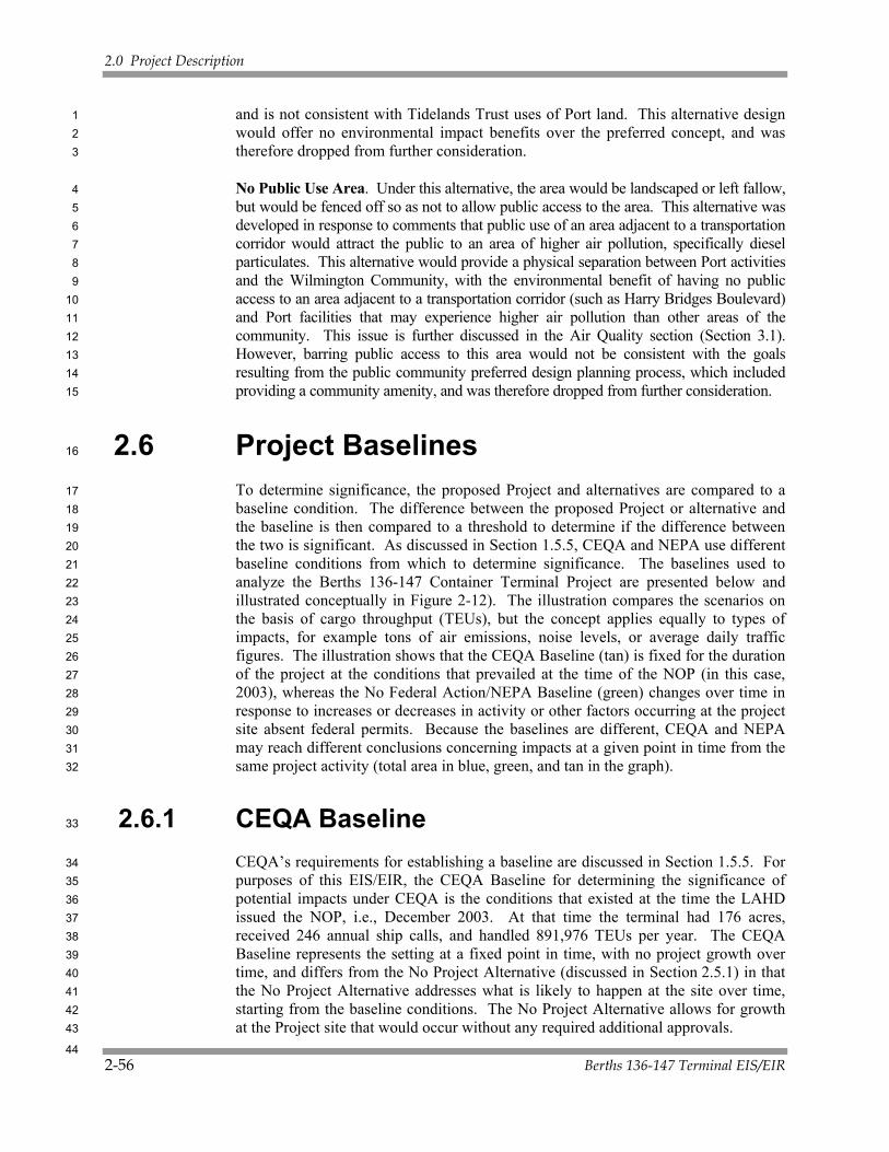
2.0 Project Description
2-56 Berths 136-147 Terminal EIS/EIR
and is not consistent with Tidelands Trust uses of Port land. This alternative design 1 would offer no environmental impact benefits over the preferred concept, and was 2 therefore dropped from further consideration. 3
No Public Use Area. Under this alternative, the area would be landscaped or left fallow, 4 but would be fenced off so as not to allow public access to the area. This alternative was 5 developed in response to comments that public use of an area adjacent to a transportation 6 corridor would attract the public to an area of higher air pollution, specifically diesel 7 particulates. This alternative would provide a physical separation between Port activities 8 and the Wilmington Community, with the environmental benefit of having no public 9 access to an area adjacent to a transportation corridor (such as Harry Bridges Boulevard) 10 and Port facilities that may experience higher air pollution than other areas of the 11 community. This issue is further discussed in the Air Quality section (Section 3.1). 12 However, barring public access to this area would not be consistent with the goals 13 resulting from the public community preferred design planning process, which included 14 providing a community amenity, and was therefore dropped from further consideration. 15
2.6 Project Baselines 16
To determine significance, the proposed Project and alternatives are compared to a 17 baseline condition. The difference between the proposed Project or alternative and 18 the baseline is then compared to a threshold to determine if the difference between 19 the two is significant. As discussed in Section 1.5.5, CEQA and NEPA use different 20 baseline conditions from which to determine significance. The baselines used to 21 analyze the Berths 136-147 Container Terminal Project are presented below and 22 illustrated conceptually in Figure 2-12). The illustration compares the scenarios on 23 the basis of cargo throughput (TEUs), but the concept applies equally to types of 24 impacts, for example tons of air emissions, noise levels, or average daily traffic 25 figures. The illustration shows that the CEQA Baseline (tan) is fixed for the duration 26 of the project at the conditions that prevailed at the time of the NOP (in this case, 27 2003), whereas the No Federal Action/NEPA Baseline (green) changes over time in 28 response to increases or decreases in activity or other factors occurring at the project 29 site absent federal permits. Because the baselines are different, CEQA and NEPA 30 may reach different conclusions concerning impacts at a given point in time from the 31 same project activity (total area in blue, green, and tan in the graph). 32
2.6.1 CEQA Baseline 33
CEQA’s requirements for establishing a baseline are discussed in Section 1.5.5. For 34 purposes of this EIS/EIR, the CEQA Baseline for determining the significance of 35 potential impacts under CEQA is the conditions that existed at the time the LAHD 36 issued the NOP, i.e., December 2003. At that time the terminal had 176 acres, 37 received 246 annual ship calls, and handled 891,976 TEUs per year. The CEQA 38 Baseline represents the setting at a fixed point in time, with no project growth over 39 time, and differs from the No Project Alternative (discussed in Section 2.5.1) in that 40 the No Project Alternative addresses what is likely to happen at the site over time, 41 starting from the baseline conditions. The No Project Alternative allows for growth 42 at the Project site that would occur without any required additional approvals. 43
44
Phase I Construction Phase II Construction Throughput maximized after 2025
Proposed Project*
No Federal Action/NEPA Baseline‡
CEQA Baseline§
*Proposed Project: Includes in-water elements and all upland elements for full container terminal buildout.‡No Federal Action/NEPA Baseline: Same as the No Federal Action scenario and is a floating baseline.‡Includes construction and operation of all upland elements to within 100 feet of the water.§CEQA Baseline: Fixed at December 2003, date of NOP. Any significant feature changes compared to 2007 conditions are noted in the impact analysis.
Figure 2-12. Comparison Between CEQA Baseline, No Further Action/NEPA Baseline and Proposed Project Parameters Based on Total Throughput

2.0 Project Description
Berths 136-147 Terminal EIS/EIR 2-59
2.6.2 No Federal Action/NEPA Baseline 1
The basis of the No Federal Action/NEPA Baseline is discussed in Section 1.5.5. For 2 purposes of this EIS/EIR, the evaluation of significance under NEPA is defined by 3 comparing the proposed Project or other alternative to the No Federal Action/NEPA 4 Baseline scenario. The No Federal Action/NEPA Baseline would include construction 5 and operation of all upland elements (existing lands) for backlands or other purposes. 6 The No Federal Action/NEPA Baseline would also not include any dredging, filling of 7 the Northwest Slip, or wharf construction or upgrades that would require permits from 8 the USACE under Section 10 of the River and Harbor Act, Section 404 of the Clean 9 Water Act, and for any transportation of dredged material for ocean dumping, Section 10 103 of the Marine Protection, Research, and Sanctuaries Act. The dredging and filling 11 associated with the previously approved Channel Deepening Supplemental 12 Environmental Impact Statement/Supplemental Environmental Impact Report 13 (SEIS/SEIR) and Channel Deepening Project for Additional Disposal Areas 14 SEIS/SEIR (USACE and LAHD 2000, in preparation) would, if approved, still occur, 15 creating the 5-acre fill. None of the existing wharves would be improved, and no 16 cranes would be replaced. 17
2.7 Relationship to Existing Plans 18
One of the primary objectives of the NEPA/CEQA process is to ensure that the 19 proposed Project is consistent with applicable statutes, plans, policies, and other 20 regulatory requirements. Table 2-5 lists the statutes, plans, policies, and other 21 regulatory requirements applicable to the proposed Project and alternatives. 22 Additional analysis of plan consistency is contained in individual resource sections 23 of Chapter 3 and, in particular, in Section 3.8 (Land Use). 24

2.0 Project Description
2-60 Berths 136-147 Terminal EIS/EIR
Table 2-5. Applicable Statutes, Plans, Policies, and Other Regulatory Requirements Applicable Statutes, Plans, Policies, and Other Regulatory Requirements Description
California Tidelands Trust Act, 1911 Submerged lands and tidelands within the Port of Los Angeles, which are under the Common Law Public Trust, were legislatively granted to the City of Los Angeles pursuant to Chapter 656, Statutes of 1911 as amended. Those properties are held in trust by the City and administered by the City’s Harbor Department to promote and develop commerce, navigation and fisheries, and other uses of statewide interest and benefit, including but not limited to, commercial, industrial, and transportation uses, public buildings and public recreational facilities, wildlife habitat, and open space. The LAHD would fund the proposed Project with trust revenues. All property and improvements included in the proposed Project would be dedicated to maritime-related uses and would, therefore, be consistent with the Trust. Although under the Tidelands Trust Act, the Port can have non-shipping uses, the Port has given container operations priority for the Berths 136-147 area.
California Coastal Act of 1976 The Coastal Act (PRC Div. 20 Section 30700 et seq.) identifies the Port of Los Angeles and its facilities as a “primary economic and coastal resources of the state, and an essential element of the national maritime industry (PRC Section 30701). The Port is responsible for modernizing and construction necessary facilities to accommodate deep-draft vessels and to accommodate the demands of foreign and domestic waterborne commerce and other traditional and water dependent and related facilities in order to preclude the necessity for developing new ports elsewhere in the state (Sections 30007.5 and 30701 (b)). The Act also establishes that the highest priority for any water or land area use within the jurisdiction of the Port of Los Angeles shall be for developments which are completely dependent on such harbor water areas and/or harbor land areas for their operations (Sections 30001.5 (d), 30255 and 31260). The Coastal Act further provides that the Port should “Give highest priority to the use of existing land space within harbors for port purposes, including, but not limited to, navigational facilities, shipping industries, and necessary support and access facilities.” (Section 30708 (c)).
Under the California Coastal Act, water areas may be diked, filled, or dredged when consistent with a certified port master plan only for specific purposes, including: (1) Construction, deepening, widening, lengthening, or maintenance of ship channel approaches, ship channels, turning basins, berthing areas, and facilities that are required for the safety and the accommodation of commerce and vessels to be served by port facilities; and (2) New or expanded facilities or waterfront land for port-related facilities.
In accordance with provisions of the Coastal Act, the Port has a certified Master Plan which provides the Port with Coastal Development Permit authority for actions/developments consistent with that Master Plan. Items inconsistent such as new fills in water would require a Master Plan Amendment through the Coastal Commission. The proposed Project is consistent with the Plan’s provisions, but implementation of the proposed Project will require an amendment of the Port of Los Angeles Master Plan (see below) because the 10-acre fill is not described in the current version of the Plan.
1

2.0 Project Description
Berths 136-147 Terminal EIS/EIR 2-61
Table 2-5. Applicable Statutes, Plans, Policies, and Other Regulatory Requirements (continued)
Applicable Statutes, Plans, Policies, and Other Regulatory Requirements Description
Coastal Zone Management Act Section 307 of the Coastal Zone Management Act (CZMA) requires that all federal agencies with activities directly affecting the coastal zone, or with development projects within that zone, comply with the state coastal acts (in this case, the California Coastal Act of 1976) to ensure that those activities or projects are consistent, to the maximum extent practicable. The California Coastal Commission will use this EIS/EIR when considering whether to find the proposed Project consistent with the Coastal Act, and the USACE will use that approval as a demonstration that the proposed Project is in compliance with the CZMA.
Port of Los Angeles Master Plan with Amendments (2002)
The Port of Los Angeles Master Plan (PMP: LAHD 1980) provides for the development, expansion, and alteration of the Port (both short-term and long-term) for commerce, navigation, fisheries, Port-dependent activities, and general public recreation. Those objectives are consistent with the provisions of the California Coastal Act (1976), the Charter of the City of Los Angeles, and applicable federal, state, and municipal laws and regulations. The proposed Project’s proposed uses are consistent with the Plan but the 10-acre fill would necessitate an amendment of the Port of Los Angeles Master Plan.
California Coastal Plan Under provisions of the California Coastal Act, the Port of Los Angeles Master Plan is incorporated into the Local Coastal Program of the City of Los Angeles. The LAHD has coastal development permit authority for activities in the Main Channel. Therefore, if the proposed Project would be consistent with the Port of Los Angeles Master Plan, the proposed Project would also be considered consistent with the Local Coastal Program. The LAHD does not currently have coastal development permit authority for the following proposed Project element: filling-in a 10-acre waterway for container terminal purposes. Authority would be granted if the Port of Los Angeles Master Plan were amended to include the Project element.
San Pedro Bay Clean Air Action Plan The Port, in conjunction with the Port of Long Beach and with guidance from AQMD, CARB and USEPA, has developed the San Pedro Bay Clean Air Action Plan (CAAP), which was approved by the Los Angeles and Long Beach Boards of Harbor Commissioners on November 20, 2006. The CAAP focuses on reducing diesel particulate matter (DPM), NOX, and SOX, with two main goals: (1) to reduce Port-related air emissions in the interest of public health, and (2) to disconnect cargo growth from emissions increases. The Plan includes near-term measures implemented largely through the CEQA/NEPA process and new leases at both ports. The proposed Project includes air quality control measures outlined in the CAAP, both as mitigation that will be imposed via permits and lease provisions and as standard measures that will be implemented through the lease, agreements with other agencies and business entities, and Port contracting policies.
Port of Los Angeles Real Estate Leasing Policy
The purpose of this Policy is to provide a framework governing leasing and rental decisions as they relate to tenant retention, selecting new tenants, development of new agreements and, as appropriate, modifications to existing agreements by amendments. The proposed Project would be consistent with the Leasing Policy in that it would incorporate CAAP provisions that would be implemented through the lease with the terminal operator.

2.0 Project Description
2-62 Berths 136-147 Terminal EIS/EIR
Table 2-5. Applicable Statutes, Plans, Policies, and Other Regulatory Requirements (continued)
Applicable Statutes, Plans, Policies, and Other Regulatory Requirements Description
Port of Los Angeles Strategic Plan The Port of Los Angeles Strategic Plan (LAHD 2007) identifies the Port’s mission and provides eleven strategic objectives for the next five years. The mission includes promotion of “grow green” philosophy combined with fiduciary responsibility and promotion of global trade. The eleven strategic objectives include, minimization of land use conflicts, maximizing the efficiency and the capacity of current and future facilities, addressing needed infrastructure requirements, maintaining financial self-sufficiency, raising environment standards and enhancing public health, promoting emerging and environmentally-friendly cargo movement technology and energy sources, provide for safe and efficient operations and homeland security, strengthen local community relations and developing more and higher quality jobs. The proposed Project is consistent with the Strategic Plan because it would help to maximize the efficiency and capacity of a Port terminal and would raise environmental standards through the incorporation of Port environmental policies into a new lease.
Risk Management Plan The Risk Management Plan, an amendment to the Port of Los Angeles Master Plan, was adopted in 1983, per requirements of the California Coastal Commission. The purpose of the Risk Management Plan is to provide siting criteria relative to vulnerable resources and the handling and storage of potentially hazardous cargo such as crude oil, petroleum products, and chemicals. The Risk Management Plan provides guidance for future development of the Port to minimize or eliminate the hazards to vulnerable resources from accidental releases (LAHD 1983). The proposed Project design is consistent with the Risk Management Plan.
City of Los Angeles General Plan — Port of Los Angeles Plan
The Port of Los Angeles Plan is part of the General Plan for the City of Los Angeles (City of Los Angeles 1982a). This plan provides a 20-year official guide to the continued development and operation of the Port. It is designed to be consistent with the Port of Los Angeles Master Plan discussed above. Because the proposed Project would be consistent with the Port of Los Angeles Master Plan it would also be consistent with the goals of the General Plan.
City of Los Angeles— Wilmington Harbor City District Plan
The Wilmington Harbor City District Plan is part of the General Plan of the City of Los Angeles (City of Los Angeles 1990). The proposed Project is located in an area south of, and adjacent to, the Wilmington Harbor City District. Although the District Plan does not include the proposed Project area, the plan recommends integrating future development of the Port with the Wilmington Community, including changes to transportation and circulation systems, and Port land acquisitions. The plan also recommends interagency coordination in the planning and implementation of Port projects to facilitate efficiency in Port operations, and to serve the interests of the adjacent communities. The proposed Project would be consistent with these recommendations as the Port has been involved in interagency coordination in the planning of this proposed Project and also has served the interests of adjacent communities through project scoping.

2.0 Project Description
Berths 136-147 Terminal EIS/EIR 2-63
Table 2-5. Applicable Statutes, Plans, Policies, and Other Regulatory Requirements (continued)
Applicable Statutes, Plans, Policies, and Other Regulatory Requirements Description
City of Los Angeles— San Pedro Community Plan
The San Pedro Community Plan (City of Los Angeles 1982b) serves as a basis for future development of the community. It is also the land use plan portion of the City’s Local Coastal Program for San Pedro. The Port of Los Angeles, although it is contiguous to San Pedro, is not part of the San Pedro Community Plan area. However, the San Pedro Community Plan does make recommendations regarding the Port, particularly for areas adjacent to commercial and residential areas of San Pedro. Although the proposed Project site is not contiguous with San Pedro the proposed Project would be consistent with these recommendations as the Port has taken into consideration the residential and commercial communities of San Pedro during project development through the scoping process.
City of Los Angeles General Plan— Air Quality Element
The City of Los Angeles General Plan has an Air Quality Element (City of Los Angeles 1992) that contains general goals, objectives, and policies related to improving air quality in the region. Policy 5.1.1 relates directly to the Port and requires improvements in harbor operations and facilities to reduce emissions. The LAHD is actively planning for and implementing such improvements. The proposed Project is consistent with the Air Quality Element in that it incorporates CAAP measures to reduce air quality impacts.
Water Quality Control Plan—Los Angeles River Basin
The Water Quality Control Plan for the Los Angeles River Basin (Region 4) was adopted by the Regional Water Quality Control Board, Los Angeles Region (RWQCB) in 1978 and updated in 1994 (RWQCB 1994a, 1994b). The Basin Plan designates beneficial uses of the basin’s water resources. The Basin Plan describes water quality objectives, implementation plans, and surveillance programs to protect or restore designated beneficial uses. The proposed Project would be operated in conformance with objectives of the Water Quality Control Plan because it would be required by the lease to comply with the General Industrial permit for storm water.
Water Quality Control Policy—Enclosed Bays and Estuaries of California
In 1974, the State Water Resources Control Board (SWRCB) adopted a water quality control policy that provides principles and guidelines to prevent degradation and to protect the beneficial uses of waters of enclosed bays and estuaries (SWRCB 1974). Los Angeles Harbor is considered to be an enclosed bay under this policy. Activities, such as the discharge of effluent, thermal wastes, radiological waste, dredge materials, and other materials that adversely affect beneficial uses of the bay and estuarine waters are addressed. Waste discharge requirements developed by the RWQCB, among other requirements, must be consistent with this policy. The proposed Project would be constructed and operated in conformance with objectives of the Water Quality Control Policy through controls on construction activities (dredging and fill, wharf construction) and on operations (storm water and other discharges).
2.0 Project Description
2-64 Berths 136-147 Terminal EIS/EIR
Table 2-5. Applicable Statutes, Plans, Policies, and Other Regulatory Requirements (continued)
Applicable Statutes, Plans, Policies, and Other Regulatory Requirements Description
Air Quality Management Plan The federal Clean Air Act (CAA) and its subsequent amendments establish the National Ambient Air Quality Standards (NAAQS) and delegate the enforcement of these standards to the states. In areas that exceed the NAAQS, the CAA requires states to prepare a State Implementation Plan (SIP) that details how the NAAQS will be met within mandated time frames. The CAA identifies emission reduction goals and compliance dates based on the severity of the ambient air quality standard violation within an area. The California Clean Air Act (CCAA) outlines a program to attain the more stringent California Ambient Air Quality Standards (CAAQS) for O3, NO2, SO2, and CO by the earliest practical date. The Lewis Air Quality Act of 1976 established the South Coast Air Quality Management District (SCAQMD), created SCAQMD’s jurisdiction over the four-county South Coast Air Basin (SCAB), and mandated a planning process requiring preparation of an Air Quality Management Plan (AQMP). The 2003 AQMP (SCAG 2003) proposes emission reduction strategies that will enable the SCAB to achieve the national and most state ambient air quality standards within the mandated time frames. The proposed Project would be consistent with this plan as discussions with the Southern California Association of Governments (SCAG) determined that construction and operation of the proposed Project are consistent with SCAG regional employment and population growth forecasts, which were used in the development of the 2003 AQMP.
California Air Resources Board – Emission Reduction Plan for Ports and Goods Movements in California
California Air Resources Board (CARB) approved the Emission Reduction Plan for Ports and Goods Movement (CARB 2006e) on April 20, 2006. All of the proposed mitigations in this EIR were developed as part of the Port’s Clean Air Action Plan (POLA and POLB 2006; see Section 1.6). Thus, the Port’s air quality plan complies with CARB’s goals and meets and/or exceeds all reduction strategies
AB 32 On September 27, 2006, Governor Schwarzenegger signed AB 32, the Global Warming Solutions Act. The Act caps California’s greenhouse gas emissions at 1990 levels by 2020. This legislation represents the first enforceable state-wide program in the U.S. to cap all GHG emissions from major industries that includes penalties for non-compliance. It requires the State Air Resources Board to establish a program for statewide greenhouse gas emissions reporting and to monitor and enforce compliance with this program. The proposed Project’s consistency with AB 32 cannot be accurately evaluated until the Air Resources Board establishes its program.
Southern California Association of Governments Regional Plans
Southern California Association of Governments (SCAG) is responsible for developing regional plans for transportation management, growth, and land use, as well as developing the growth factors used in forecasting air emissions within the South Coast Air Basin. SCAG has developed a Growth Management Plan (GMP), a Regional Housing Needs Assessment, a Regional Mobility Plan (RMP), and in cooperation with the SCAQMD, the AQMPs. The proposed Project would not generate population migration into the area or create a demand for new housing units, and thus would be consistent with these plans.

2.0 Project Description
Berths 136-147 Terminal EIS/EIR 2-65
Table 2-5. Applicable Statutes, Plans, Policies, and Other Regulatory Requirements (continued)
Applicable Statutes, Plans, Policies, and Other Regulatory Requirements Description
Congestion Management Plan The Congestion Management Program (CMP) is a state-mandated program intended as the analytical basis for transportation decisions made through the State Transportation Improvement Program process (LACMTA 1993). The CMP was developed to: (1) link land use, transportation, and air quality decisions; (2) develop a partnership among transportation decision makers on devising appropriate transportation solutions that include all modes of travel; and (3) propose transportation projects that are eligible to compete for state gas tax funds. The CMP includes a Land Use Analysis Program, which requires local jurisdictions to analyze the impacts of land use decisions on the regional transportation system. For development projects, an EIR is required based on local determination and must incorporate a Transportation Impact Analysis into the EIR. This EIR does include a transportation impact analysis and thus is consistent with the CMP.
1

2.0 Project Description
2-66 Berths 136-147 Terminal EIS/EIR
This page intentionally left blank. 1