project : eko atlantic city development, lagos, … · project : eko atlantic city development,...
TRANSCRIPT

Page 1 of 52
Language:English Original: English
PROJECT : EKO ATLANTIC CITY DEVELOPMENT, LAGOS, NIGERIA – SHORELINE PROTECTION, LAND RECLAMATION AND CITY MASTERPLANNING
COUNTRY : NIGERIA
ENVIRONMENTAL AND SOCIAL IMPACT ASSESSMENT (ESIA) SUMMARY
14 December 2018
Appraisal Team
Team Leader Ahmed El GAZZAR Senior Investment Officer PICU4 3655
Team Members
Bakia MBIANYOR Chief Environmental and Social
Safeguards Compliance Officer SNSC 4214
Osric Tening FORTON Principal Environmental and
Social Safeguards Officer SNSC 5078
Sanders MUTANDWA, Credit Risk Officer PGRF1 2425
Steven ONEN Chief Legal Counsel PGCL2 7750
Hassen BEN AYED Investment Officer PICU4 4335
Country Operations
Manager Late Dodji LAWSON RDNG 7751
Regional Director Ebrima FAAL RDNG0 7754

Page 2 of 52
ENVIRONMENTAL AND SOCIAL IMPACT ASSESSMENT (ESIA) SUMMARY
Project Name
Eko Atlantic City Development, Lagos, Nigeria – Shoreline Protection, Land Reclamation and City’s Master Planning
Code SAP P-NG-J00-003
Country Nigeria Category 1
Department PICU Division PICU4
1. INTRODUCTION
1.1 The Context of Coastal Erosion in Victoria Island
Towns and cities along the West African coastline have become prominent as important contributors
to national gross domestic products (GDPs). The latter is derived from coastal activities such as oil
and gas, shipping, fishing, tourism and commerce. The attractiveness of the coastline is resulting in
population concentrations along the coastline, with a rate of urbanization slightly higher than the
interiors. As a result, many capitals and major towns are coastal. At the same time, this geographical
space is undergoing annual coastal retreats of between 1-2 metres. This level of coastal erosion has
devastating effects and induces the loss of infrastructure such as buildings rail, bridges, roads etc. It
also threatens populations, who can no longer live close to the coastline. The projected rise in sea
levels due to climate change further exacerbates these risks.
Lagos, Nigeria, is one of such cities already experiencing the impacts of coastal erosion. With a
current population of 22 million inhabitants, it is the most populous city on the continent and one of
the fastest growing cities in the world. Victoria Island is its main business and financial centre. The
Lagos Central Business District (CBD) can be regarded as the original financial hub of the state as the
Nigerian Stock Exchange, Central Bank as well as the head offices of the biggest commercial banks.
The CBD of Lagos is at risk of being eroded, inundated and decimated by coastal erosion.
Over the past 100 years, the shoreline of Victoria Island retreated significantly (locally even 2
kilometers) with disastrous consequences (including loss of land, houses, livelihood sources, amenity
uses, etc.) on the communities adjacent to the sea and around Victoria Island. This natural
phenomenon has been compounded by the blocking of the coastal sediment transport (littoral
transport along the West African shoreline) by the construction of the Lagos Harbour Moles
(between 1908 and 1912) (Figure 1). Due to the effects of the coastal erosion, temporary coastal
protection measures, including several nourishment schemes, which had been put in place over time
to in order to reduce the erosion threat to Victoria Island continued to fail and there were regular
coastal flooding incidents in the area. In 2006, the protective beach disappeared with resultant flood
damage to the road infrastructure along Amadou Bello Way and Bar Beach.

Page 3 of 52
Figure 1. Erosion and accretion near to the moles of Commodore Channel
These events and the damaging consequences to Lagos has called for immediate intervention.
Without any action, highly valued areas of residential and commercial properties will continue to be
threatened by the intrusion of sea water with resultant destruction of properties, loss of income,
lives and livelihood. As such, following the 2005 incident, a sea revetment consisting of concrete X-
bloc armour units protected the coastline. However, a permanent and more extensive solution was
considered necessary to address the persistent erosion problem, which was predicted to be
exacerbated by climate change and increased likelihood of storm events. This necessitated this
project, consisting of the construction of the “Great Wall of Lagos” and the Eko Atlantic City which
will be constructed on reclaimed land.
1.2 Purpose of the Summary
This ESIA summary highlights the key assessment and management plans designed by the developer
– South Energyx Development F.Z.E (SEDFZE) (previously South Energyx Nigeria Ltd (SENL)) to ensure
the proposed project complies with national laws in Nigeria, the African Development Bank’s
Integrated Safeguards System and international development partners environmental and social (E
& S) policy requirements.
The ESIA summary is based on the review of the two ESIAs undertaken for the scheme i.e. the
shoreline protection and land reclamation EIA (dated February 2013) and the masterplan EIA (dated
November 2015) as well as ongoing activities associated with the construction works which began in
2008.
Accretion zone at Lighthouse
Beach, behind the West Mole
Erosion zone at Bar Beach
Predominant direction of sediment transport along the Atlantic coast (littoral drift)
East Mole
West Mole
Commodore
Channel
Eko Atlantic
Project site
Victoria Island
Land mass lost to coastal
erosion since the
construction of the East
and West Mole between
1918 and 1912

Page 4 of 52
1.3 African Development Bank Integrated Safeguards System
In accordance with the African Development Bank Integrated Safeguards Systems and Operational
Safeguards (OSs)1, the project has been classified as a Category 1 project with Operational
Safeguards 1, 3, 4 and 5 being triggered by the project. Operational Safeguards 2 on Involuntary
Resettlement: Land Acquisition, Population Displacement and Compensation is not triggered by this
project because the project did not result in any involuntary resettlement (physical or economic).
The shoreline protection and land reclamation project commenced in February 2008, due to
emergency action taken by the Lagos State Government to protect Victoria Island and Lagos from
the catastrophic effect of coastal erosion. Indeed, at the decision was taken to build the Great Wall
of Lagos in 2006, there were no PAPs or PACs in the project area or along the beach front because it
had been washed away. Due to the fact that OS2, has not been triggered, a specific Resettlement
Action Plan (RAP) which will typically be required for Category 1 projects, has not been prepared for
the project. The client will monitor the potential for livelihoods to be impacted during the
construction and operational phases of the project, and if applicable, a Livelihood Restoration Plan
(LRP) will be implemented.
2. PROJECT DESCRIPTION AND JUSTIFICATION
2.1 Project Location The Project is an extension of Victoria Island, Lagos State, Nigeria. As shown on Figure 2 and Figure 3, the Project site is located in the marine waters adjacent to Bar Beach, at Victoria Island, Lagos, within the Eti-Osa Local Government Area.
Figure 2. Situation of Lagos (in Nigeria) and Eko Atlantic (along the Lagos coastline)
1 Operational Safeguard 1: Environmental and social assessment / Operational Safeguard 2: Involuntary resettlement land acquisition,
population displacement and compensation /Operational Safeguard 3: Biodiversity and ecosystem services /Operational Safeguard 4:
Pollution prevention and control, hazardous materials and resource efficiency / Operational Safeguard 5: Labour conditions, health and
safety
Ikoyi

Page 5 of 52
Figure 3. Overview of the current status of the Eko Atlantic project, Lagos, Nigeria
2.2 Justification of the Project The shoreline of Victoria Island has retreated significantly in the past century. The main reason for this erosion is the blocking of the coastal sediment transport by the construction of the Lagos Harbour Moles (between 1908 and 1912) that have created Commodore Channel (Figure 1). Coastal protection schemes have been put in place over time, in order to reduce the erosion threat to Victoria Island, including several nourishment schemes. However, these have appeared to have only temporarily mitigated the erosion because regular coastal flooding incidents in this region have continued over time (Figures 1 and 3). The erosion culminated in 2005, when the protective beach disappeared with resultant flood damage to the road infrastructure at Bar Beach. With no action, highly valued areas of residential and commercial property would continue to be threatened by intrusion of sea water causing destruction of properties, loss of income and lives. Following the 2005 incident, the coastline was protected by a sea revetment consisting of concrete X-bloc armour units. However, a permanent and more extensive solution was considered necessary to address the persistent erosion problem, which is predicted to be exacerbated by climate change and increased likelihood of extreme storm events. With an increasing population and aspirations for greater economic development, there is a strong need to provide additional, strategically planned urban areas within Lagos. However, space for this within the central areas of Lagos is heavily restricted. In response to the need for land for future development and the necessity for a long-term solution to the erosion problems of Victoria Island, SEDFZE developed the proposal for the Eko Atlantic Development Project. The Project is anticipated to bring significant economic benefits to the region through direct investment in the local economy, knowledge sharing and publicity for the City of Lagos.
East Mole (1908)
Project boundary
with a vertical
groyne into the sea Additional groynes
constructed to slow
down the effects of
coastal erosion and
climate change
Lekki
West Mole with visible signs of
sediment build due to the
prevention of natural sediment
transport eastwards
City
Bar Beach on Amadou Bello Way had
been eroded during the catastrophic
2006 flood event
Additional land to be filled with dredged
material. This will only progress once the
sea defense wall is completed
Victoria Island
The Great Wall of Lagos
(under construction)

Page 6 of 52
2.3 Project Description The entire project is being completed in two distinct phases for which ESIAs have been undertaken
and a number of environmental and social risk management measures will be put in place for the
actual development of specific plots of land, within the reclaimed area. The phasing of the project
includes:
• Phase 1: Shoreline protection and reclamation activities of over 1000 ha of land . An ESIA
was prepared for the Phase 1 works. An ESIA completed for this phase of the project was
approved by the Federal Ministry of Environment (FMEnv.).
• Phase 2: Creating of a development platform and masterplan to enable the construction of
a new mixed-use development and city (Eko Atlantic City). An ESIA for the master planning
and infrastructure works was approved by the Federal Ministry of Environment (FMEnv.).
The Masterplan (2015 – 2040) distinguishes six phases of development of individual plots.
This Project will provide approximately 1000 hectares (ha) of high quality land and subsequently will
facilitate for the development of modern housing, business, retailing and tourism areas in Lagos. Eko
Atlantic has great aspirations to become the financial business hub of Africa.
2.3.1 Phase 1: Shoreline protection and reclamation activities
The reclamation works will form approximately 900 ha of land which will be for the future
development of a modern city. The new land will be realised using approximately 90 million m3 of
sand, dredged offshore from the coast of Lagos State from the sea bed of the Atlantic Ocean (Figures
1, 3 and 4). The main reclaimed area will be approximately 8 km long, with a width of 1.5 km on the
western end, tapering to 0.5 km on the eastern end. The outer edge of the reclaimed area will be
protected from the sea by an approximately 8 km long rock revetment to provide shoreline
protection to the new land and to Victoria Island.
The reclamation activities and associated works include the following tasks, which are further
described below:
a. Dredging of sand for reclamation from offshore borrow areas;
b. Pre-construction: strengthening of the East Mole by quarry materials to enable use of the
mole as an access road;
c. Construction: construction of the sea defence, using several grades of quarry materials,
geotextile fabrics and pre-cast concrete armour units; and
d. Construction – dredging of sand and sand placement for reclamation.
Dredging works
The dredging activities consist of:
• Dredging of approximately 90 million m3 medium to coarse sand from offshore borrow areas;
• Vessel navigation from borrow areas to the reclamation area; and
• Operation of tugs to assist the berthing of the dredging vessel on the East Mole.
All the activities where undertaken in compliance with the specifications detailed in a Dredging Management Plan being implemented by the Contractor. The location of the sand borrow pits off shore is presented in Figure 4.

Page 7 of 52
Figure 4. Location of Eko Atlantic and sand borrow areas Strengthening of the East Mole The East Mole is the existing breakwater located on the eastern side of the Commodore Channel,
the entrance to Lagos Port. This breakwater is able to provide a suitable area for an access road to
the Eko Atlantic site for the trucks delivering rock for the sea defense. The access road will be
temporary and will be in place for the duration of the reclamation. The side slopes of the East Mole
are excessively steep due to deterioration in time and lack of maintenance. In order to protect the
integrity and stability of the East Mole, the Project has stabilized the East Mole by the addition of
rock and re-profiling of the side slopes and there is an ongoing process of continuous monitoring.
Over the years, with the progress of the reclamation works, the temporary access road on the East
Mole has been abandoned with transport shifting to new roads on the reclamation area.
Construction of the sea defence The sea defence has been designed with a core of rock with a grading (size) of 1-1000 kg. Several layers of armour rock (500 – 2000 kg) and concrete armour blocks (5t AccropodesTM) to protect the structure from the ocean waves protect this core. The sea defence is designed for extreme wave conditions, such as a 1/100-year storm event and when completed, the crest of the sea defence will rise 6m above sea level (above Chart Datum) with a concrete wall on top of it up to approximately 9m. The sea defence has been physically tested on a scale of 1:30 on stability and overtopping at the Danish Hydraulic Institute (DHI) model testing basins in Denmark. DHI is world renowned for testing coastal structures and is considered a high-class facility for testing of this type. Four quarries located between approximately 100 km and 150 km from the Project area have supplied rock for the sea defence. The concrete armour blocks for the defence wall are produced on site on the Eko Atlantic site. The equipment used consists of bulldozers, trucks and plant to mix and cast the concrete

Page 8 of 52
armour blocks. The main materials used are rocks, cement, water, aggregates and sand. The manufacturing site was relocated into the reclamation site, adjacent to the new sea defence to reduce the amount of transportation and logistics required. Sand placement for reclamation Once the sea defense was constructed to shelter the waters behind from sea waves, it enabled the
safe and efficient filling of the area to be reclaimed. Several methods for reclamation were
considered and these were dependant on the location at which sand will be deposited. The main
methods will be pumping of dredged sand by i) Sand pumping into the reclamation area from the
Commodore Channel over the East Mole or ii) Sand pumping from behind the sea defence into the
reclamation area or iii) in some instances, rainbowing directly from the dredger onto the reclaimed
land may also be used. iv) Sand dumping by dredgers with bottom doors. Using a Dredging
Management Plan, all dredging methods and the placement of materials were selected to minimize
environmental impacts on water quality.
Program The construction activities are ongoing, and a considerable part of the revetment and land
reclamation have been completed. The massive and continuous dredging operation was commenced
in February 2008. By September 2012 about 50% of the total land area had been reclaimed from the
sea, while by the end of 2016 this area was about 60%. Dredging and reclamation works are being
carried out under the supervision of Royal HaskoningDHV. The dredging activities are planned to be
carried out until phase 6 of the reclamation is completed, on a 24/7 work basis (based on the use of
a single dredger).
2.3.2 Phase 2 ESIA (Eko Atlantic Masterplan)
The Master Plan
Eko Atlantic is a large-scale city development covering an implementation period of several decades
with a multi-billion-dollar cost. This means that both construction and operation activities will take
place simultaneously. Construction activities include, amongst others, the construction of buildings,
bridges, road infrastructure and utility infrastructure. Operation activities include, amongst others
life, work and recreation, traffic and transport, operation of utilities and maintenance.
As the city will be a permanent feature in Lagos, the operation time will be indefinite. The Master
Plan describes the Eko Atlantic vision for the year 2040. The Master Plan provides a vision and
overview for the future city development and describes the main characteristics of Eko Atlantic city.
The indicative implementation schedule for Eko Atlantic city is:
• 2010-2020 for the Shoreline Protection and Land Reclamation
• 2015-2040 and beyond for the City Development
Figure 5 presents an overview of the overall Master Plan design with the various anticipated
districts.

Page 9 of 52
Figure 5. Eko Atlantic City Development Master Plan
Eko Philosophy
The Eko philosophy implies that the development will be self-sufficient and sustainable with its
surrounding environment. Self-sufficiency includes amongst others power generation, water supply,
waste water treatment and appropriate solid waste management. Sustainability refers to sound
demographic distribution and pleasant living conditions with an attempt to limit emissions to its
surrounding environment.
Careful attention will be given to mixed-use development and around the clock dynamics in the city.
Residential plots are combined with offices, shops, restaurants, and bars so that all areas of the city
will be vibrant and lively during the day or night.
Eko Atlantic city will include public facilities such as schools, hospitals and houses of prayer and
recreational and leisure facilities such as theatre and cinema and shopping centres. Tree lined
boulevards, the ocean front promenade, canals and the marina provide places where people can
relax from their daily business and stress. For this purpose, a large nursery for tree development has
already been established since a number of years.
Parking in the streets will not be permitted in order to avoid congestion. All buildings will have
parking garages.
Target Group
The number of people living on Eko Atlantic is estimated on the basis of the percentages of
residential areas for each of the districts. The total number is roughly estimated at 250,000
inhabitants. Population in the high and middle-class income classes will have here their homes.
Many of these people will work in Eko Atlantic city. In addition, roughly about 150,000 commuters
will travel every day to Eko Atlantic city to work, shop or relax. This part of the work force also
includes drivers, cooks, household and office staff, security, construction workers, etc., etc. These
people are living in various parts of Lagos.
Business District
Harbour Lights
Ocean Front
Marina District
Downtown
Eko Island
Avenues
Eko Drive
Four Bridges
Avenues
East Side Marina
Eko Pier
Utility
district
Ocean Front
Eko Drive
Four Bridges
VICTORIA ISLAND
Kuramo Lagoon
Page 10 of 52
Land use and districts
Eko Atlantic city will include residential, commercial, financial and tourist developments. The
distribution of land use type shows that the urban development is predominantly residential (63%)
followed by offices (18%). The commercial and retail developments comprise 9% of the total area,
while 6% and 4% for recreational and leisure facilities and services respectively.
Eko Atlantic city is divided into the following 10 districts and 1 service area as indicated in Figure 5.
These are the Business District, Harbour Lights, Ocean Front, Marina District, Downtown, Eko Island,
Avenues, Four Bridges, Eko Drive, East Side Marina District and finally in the far-east the Utility plot
for utilities and services. All districts will have plots available for mixed use.
City infrastructure
Roads
The road network distinguishes three main road types which are the primary roads, the secondary
roads and local roads. The primary roads connect Eko Atlantic city with Victoria Island, initially, west
of Kuramo Lagoon 3 main access points will be constructed. For access point 1 in the west of Eko
Atlantic city a roundabout is established in the interim phase, while fly-overs are proposed for the
ultimate phase. For traffic control and safety traffic signals will be installed for vehicles as well
pedestrians. Also, pavement marking and safety barriers if needed will be planned for.
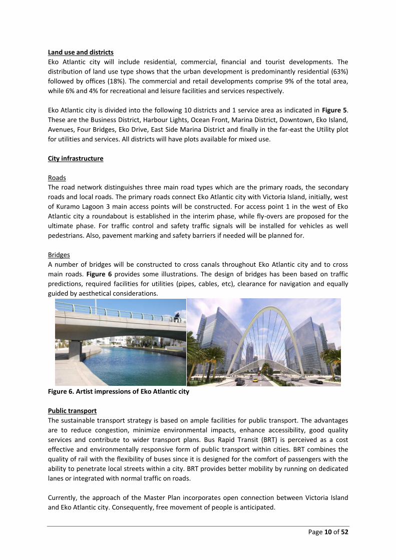
Bridges
A number of bridges will be constructed to cross canals throughout Eko Atlantic city and to cross
main roads. Figure 6 provides some illustrations. The design of bridges has been based on traffic
predictions, required facilities for utilities (pipes, cables, etc), clearance for navigation and equally
guided by aesthetical considerations.
Figure 6. Artist impressions of Eko Atlantic city
Public transport
The sustainable transport strategy is based on ample facilities for public transport. The advantages
are to reduce congestion, minimize environmental impacts, enhance accessibility, good quality
services and contribute to wider transport plans. Bus Rapid Transit (BRT) is perceived as a cost
effective and environmentally responsive form of public transport within cities. BRT combines the
quality of rail with the flexibility of buses since it is designed for the comfort of passengers with the
ability to penetrate local streets within a city. BRT provides better mobility by running on dedicated
lanes or integrated with normal traffic on roads.
Currently, the approach of the Master Plan incorporates open connection between Victoria Island
and Eko Atlantic city. Consequently, free movement of people is anticipated.

Page 11 of 52
The main options for public transport to and from Eko Atlantic city are:
• Buses via the main roads; the interaction with the BRT on Eko Atlantic city is under
study
• Taxis via the main roads
• Water taxis; Lagos State is going to develop a water transportation system
comprising of water taxis and ferries. The northern entrance of the canal at
Commodore Channel will serve as a hub where larger, inter-island water taxis and
ferry boats can arrive and depart.
Canals
A canal network runs through the city (Figure 7). The canal network links the Marina to other
districts and is in open connection to the Commodore Channel via the Northern and Southern
entrances. There will also be a canal entrance on the eastern side of the city.
Figure 7. Layout of the Canal System
The canals are sufficiently wide to allow for the water taxis and other watercraft to navigate the
canal system in both ways. The design of the canals and marina will ensure that there is sufficient
circulation. The canal walls are vertical sheet piles with anchors in the sand. The canals have an
approximate width of 18m. At three locations, an open connection to the sea is envisaged. All
entrances will be stabilized with rock protection to avoid erosion and scouring.
Utility reservation
Utility corridors are planned for to be provided within the Eko Atlantic development. The standards
adopted in the preparation of the utility corridors / disposition arrangements are International
Norms and Standards for utility installation. The utilities/systems envisaged for Eko Atlantic City
project site comprise:
• Potable water and Firefighting water system
• Wastewater collection system
• Storm water drainage
• Power/Electricity Distribution (HV), (MV) and (LV)
• Telecommunication system
• Street Lighting system

Page 12 of 52
Social aspects and social cohesion
The population development in Eko Atlantic city will develop in line with the development of the
various phases. This will last several decades and therefore the planning horizon in the ESIA report
has been presented up to 2044. It is anticipated that employment opportunities will increase along
with the development and operation of Eko Atlantic city. It will cover all sectors of business.
Examples are:
• Management and workers of companies during the construction / development phase; this
includes low skilled workers possibly from local communities (currently about 600 workers
for general land development and construction; 120 workers for the first building);
• Financial and business sector;
• Management and retail sector (including a shopping mall of 150,000 m2 in the north of Eko
Atlantic west of Avenue 3);
• Tourism, maintaining and operating attractions;
• Medical facilities, hospital;
• City administration; and
• Unskilled - cleaners, drivers, security, etc.
A community needs social cohesion and social infrastructure in order to reach a sustainable situation
in which people feel at home and living secure and with confidence towards the future. The Eko
Atlantic initiators and investors have adopted this principle aim. For this purpose, social
infrastructure is needed to be developed within the boundaries of the city of Eko Atlantic. These
include health facilities, education, religion, sports and other leisure. The project proponent is in
discussion with various groups to discuss and develop this.
The boulevards, ocean front promenade and the marina constitute places/areas where people can
relax from their daily business and stress. Despite its urban character and high building density,
special attention will be given to creating clean and green atmosphere. A company will be
contracted to keep Eko Atlantic green and clean.
Safety and security on Eko Atlantic city are key issues. Due attention, regulations and management
will be devoted to various subjects in this regard, which are traffic safety, environmental safety and
social security in terms of avoiding people / groups without any purpose to be on Eko Atlantic city.
A city with 250,000 inhabitants, commercial and financial centres, retail outlets, transport needs an
organisation to manage and regulate these activities. Management and administration will be the
full responsibility of the Eko Atlantic Management Company (recently registered). A number of core
services are being developed with various groups which needs functioning when the development
phases 1 and 2 are getting shape.

Page 13 of 52
2.3.3 Project Schedule
The Eko Atlantic project will be constructed over a period of a few decades as indicated Table 1
below.
Table 1: Schedule of the Eko Atlantic Development Project Project 5-years period
2008-
2012
2013-
2017
2018-
2022
2023-
2027
2028-
2032
2033-
2037
2038-
2042
2043-
2047
Shoreline Protection and Reclamation Works
Eko Atlantic City construction
Phase
1&2
Phase 3
Phase 4
Phase 5
Phase 6
Developed Eko Atlantic City in operation
The Eko Atlantic project is already underway in its implementation. The revetment and land reclamation (Phase 1) have progressed up to about 80% of the total completion. The city infrastructure (Phase 2) has largely been developed for the first two development phases of Eko Atlantic. Construction works is progressing on some of the development plots.
3 POLICIES, LEGAL AND INSTITUTIONAL FRAMEWORK
3.1 Overview
The ESIA studies have been carried out in line with the applicable legal and administrative
framework. Some of these include Nigerian EIA Act No 86 of 1992; EIA Sectoral Guidelines for
Dredging and Reclamation Sector, 2010; the international ESIA requirements of the AfDB, IFC/World
Bank Group Environmental, Health and Safety (EHS) Guidelines; IFC Performance Standards on
Environmental and Social Sustainability, 2012, and the World Bank Operational Policy (OP) 4.03 on
the use of Performance Standards for Private Sector Activities.
National regulations considered include the EIA Act 86 of 1992 (Revised in 1999), the NESREA Act 27
of 2007, the National Environmental Policy of 1998 (Revised 2009), etc.
3.2 Nigeria Environmental Administrative Framework
In Nigeria, there are several legislative and regulatory requirements controlling dredging for
developments related to industry (dredging for infrastructure, reclamation, and dredging associated
with aquaculture). These regulations include local laws as well as some international treaties, acts
and conventions. Local regulations for dredging for infrastructure and reclamation project fall under
the jurisdiction of two main government agencies: The Federal Ministry of Environment (FMEnv),
and State Environment laws. These following regulations are of relevance:

Page 14 of 52
• Federal Environmental Protection Agency (FEPA), (now Federal Ministry of Environment -
FMEnv) Environmental Guidelines and Standards, including the EIA Act No. 86 of 1992. This
is the core legislation that governs EIA in respect of proposed projects in Nigeria and flows
directly from the provisions of Principle 17 of the Rio Declaration. The Nigerian EIA Act No.
86 of 1992 -Section (1(a) makes it mandatory that before the final decision is taken or
approval given for any activity likely to significantly affect the environment, the effect of
such activity shall first be taken into account. This is very important because this stresses the
need to have an environmental assessment of a project in such a way that the action will be
environmental friendly and will not cause serious hazards to the people and the ecosystem;
• National Environmental Standards and Regulations Enforcement Agency (NESREA) Act. In
order to achieve effective enforcement of environmental laws, standards and regulations in
the country, the National Environmental Standards and Regulations Enforcement Agency
(NESREA) was established as a parastatal of the Federal Ministry of Environment. NESREA is
charged with the responsibility of enforcing all environmental laws, guidelines, policies,
standards and regulations in Nigeria, with the exception of oil and gas. It also has the
responsibility to enforce compliance with provisions of international agreements, protocols,
conventions and treaties on the environment (for more details on NESREA relevant to the
project, see http://www.nesrea.org/about.php);
• The Lagos State Environmental Pollution Control Law Cap 46 of 1989. Lagos State has also
enacted the Environmental Pollution Control Law, to provide for the control of pollution and
protection of the environment from abuse due to poor waste management hence the
creation of charges by the provisions of section 25(1) with the punishment of a fine;
• The Lagos State Waterfront Infrastructure Development Law 2009 (“the LAWID Law”). The
Lagos State House of Assembly passed a bill in 2008 for a law to provide for the regulation of
waterfront infrastructure development, sand dealing and dredging operations in the state.
The LAWID Law empowered Lagos State Ministry of Waterfront Infrastructure Development
(MWID) to regulate sand dredging in two (2) distinct areas. MWID is empowered to grant
permit for sand dredging or dealing within, around and on waterfronts and embankments
according to Sections 3(e), 4 and 1(2) of the LAWID Law. Waterfront is defined as land at the
edge of a stream, creek, lagoon, coastal area, shoreline, harbour, wharf, dock, bar beach and
other beaches within Lagos State – section 23 of the LAWID Law Embankment simply means
bank of wall of waterways. Sections 3, 4 and 1(2) of the LAWID law empower MWID to grant
permit for sand dealing or sand dredging around waterfronts. MWID is statutorily
empowered to regulate not only the transportation of granite, laterite etc. but also those
who buy and sell it. Sand stockpiles fall into the category of those who buy and sell sand.
3.3 National and State Regulatory Requirements and Legislations
A list of Nigerian national legislative frameworks and regulations relevant to the Eko Atlantic City
Development Project- Phase 1 and its EIA are listed below. This EIA study is based on them. The
frameworks and regulations are extensively discussed in the EIA report.
Page 15 of 52
1. Environmental Impact Assessment Act No. 86 of 1992 (EIA Act);
2. National Policy on Environment;
3. Harmful Wastes (Special Criminal Provisions etc.) Act of 1988 (Harmful Wastes Act);
4. Federal Ministry of Environment (FMEnv) Statutory Instrument (S.I.8) National
Environmental Protection (Effluent Limitations) Regulation of 1991;
5. National Environmental Protection (Pollution Abatement in Industries and Facilities
Generating Wastes) Regulations of 1991.
6. The Endangered Species Act 11, 1985.
7. Water Resources Act CAP W.2 Laws of the Federation of Nigeria (LFN) 2004.
8. Nigerian Ports Authority Act No 38 of 1999
9. National Inland Water Ways (NIWA) Act No. 13 of 1997
10. Sea Fisheries Act, CAP S4, LFN 2004.
11. Inland Fisheries Act, CAP I10, LFN 2004.
12. Nigerian Maritime Administration and Safety Agency (NIMASA) Act. 2007
13. Land Use Act No.6 of 1978
14. The Nigerian Minerals and Mining Act 2007 ("the Act")
15. Lagos State Environmental Pollution Control Law Cap 46 of 1989
16. The Lagos State Waterfront Infrastructure Development Law 2009 (“the LAWID Law”)
3.4 Regional and International Agreements and Conventions
Apart from the National Laws, Acts and Regulations, Nigeria is a signatory or party to many
International Environmental Conventions and Treaties and has participated in many related
conferences. A list of some of the relevant International Environmental Conventions and Treaties
ratified by the Government of the Federal Republic of Nigeria are presented in Table 2 below.
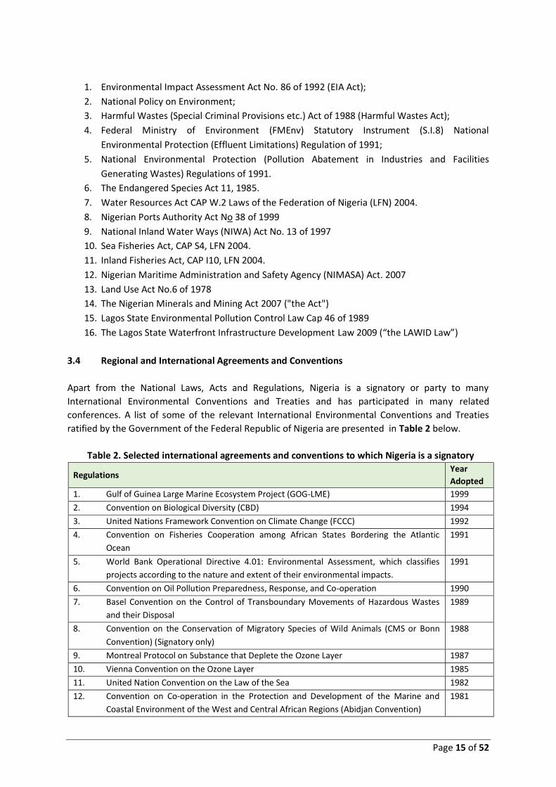
Table 2. Selected international agreements and conventions to which Nigeria is a signatory
Regulations Year
Adopted
1. Gulf of Guinea Large Marine Ecosystem Project (GOG-LME) 1999
2. Convention on Biological Diversity (CBD) 1994
3. United Nations Framework Convention on Climate Change (FCCC) 1992
4. Convention on Fisheries Cooperation among African States Bordering the Atlantic
Ocean
1991
5. World Bank Operational Directive 4.01: Environmental Assessment, which classifies
projects according to the nature and extent of their environmental impacts.
1991
6. Convention on Oil Pollution Preparedness, Response, and Co-operation 1990
7. Basel Convention on the Control of Transboundary Movements of Hazardous Wastes
and their Disposal
1989
8. Convention on the Conservation of Migratory Species of Wild Animals (CMS or Bonn
Convention) (Signatory only)
1988
9. Montreal Protocol on Substance that Deplete the Ozone Layer 1987
10. Vienna Convention on the Ozone Layer 1985
11. United Nation Convention on the Law of the Sea 1982
12. Convention on Co-operation in the Protection and Development of the Marine and
Coastal Environment of the West and Central African Regions (Abidjan Convention)
1981

Page 16 of 52
Table 2. Selected international agreements and conventions to which Nigeria is a signatory
Regulations Year
Adopted
13. Protocol Concerning Cooperation in Combating Pollution in Cases of Emergency in the
West and Central African Region
1981
14. Convention on Conservation of Migratory Species of Wild Animals 1979
15. International Convention on Standards of training Certification and Watch-Keeping for
Seafarer
1978
16. Convention on the Protection of the World Cultural and Natural Heritage (world
Heritage Convention), Paris
1975
17. International Convention for the Safety of Life at Sea 1974
18. Convention to Regulate international trade in Endangered species of Fauna and Flora
(CITES)
1973
19. International Convention for the Prevention of Pollution from Ships (MARPOL 73/78)
(this supersedes OILPOL, 1954)
1973
20. Convention on the Prevention of Marine Pollution by Dumping of Wastes and other
Matter (the convention was amended in 1992)
1972
21. Convention on the International Regulations for Preventing Collisions at Sea 1972
22. African Convention on the Conservation of Nature and Nature Resource 1968
23. Convention on the Territorial Sea and Contiguous Zone 1958
24. Convention on the Continental Shelf 1958
25. Convention on the High Seas, Geneva 1958
3.5 Nigeria Environmental Administrative Framework
In Nigeria, there are several environmental legislative and regulatory requirements controlling
infrastructural projects (i.e. urban development, utilities, energy, recreation etc.). These regulations
include local laws as well as some international treaties, acts and conventions.
Local regulations for infrastructural projects fall under the jurisdiction of two main government
agencies: The Federal Ministry of Environment (FMEnv), and State Environment laws (the State
where the proposed project is located). The role and responsibilities of the Federal Ministry of
Environment (FMEnv), the Lagos State Ministry of Environment and the Lagos State Environmental
Protection Agency are summarized below.
3.5.1 Federal Ministry of Environment
Primary authority for regulation and enforcement of environmental laws rests with the FMEnv,
previously the Federal Environmental Protection Agency (FEPA). FMEnv took over this function from
FEPA in 1999. The specific policies, acts and guidelines enforced by FMEnv that are relevant to the
Project include:
• National Policy on the Environment (1989, revised 1999);
• Environmental Impact Assessment Act No. 86 (1992);
• National Guidelines for Environmental Auditing in Nigeria (1999);
• Water Resources Act of 1993;
• National Environmental Protection (Management of Solid and Hazardous Wastes
Regulations) 1991;

Page 17 of 52
• National Environmental Protection (Effluent Limitation) Régulations 1991 ;
• Harmful Wastes (Special Criminal Provisions etc.) Act No. 42 (1988);
• Federal Environmental Protection Agency Act (1988);
• National Guidelines and Standards for Environmental Pollution; and Control in Nigeria
(1991);
• Environmental Impact Assessment Procedural/Sectoral Guidelines for Infrastructure
development projects (1995) of the Federal Ministry of Environment Guideline.
3.5.2 Lagos State Ministry of Environment and Lagos State Environmental Protection Agency
Lagos State as a federating unit of Nigeria set up its own Environmental Ministry and Agency- Lagos
Ministry of Environment (LSMOE) and Lagos State Environmental Protection Agency (LASEPA). The
functions and responsibilities of LSMOE includes evaluation of Environmental Impact Assessment
(EIA) and Environmental Audit Report (EAR), policy matters on air and other forms of pollution, co-
ordination of environmental sanitation exercise and protection services, initiation, formulation,
execution and monitoring of all issues relating to climate change towards mitigating the negative
impact of climate change, liaison with NAFDAC, NDLEA, FMEnv and Lagos State Environmental and
Special Offences and Enforcement Unit on any related matter, etc.
On the other hand, LASEPA is responsible for the protection and improvement of the environment
within the State. LASEPA’s functions include advising the State Government on all environmental
management policies, carrying out public enlightenment and educate the general public on sound
methods of environmental sanitation and management, monitoring, controlling and disposal of
waste generated by both government and private facilities within Lagos State, etc. LASEPA
administers the Environmental Protection Agency Law Cap L23, Laws of Lagos State of Nigeria
(2003).
3.5.3 National Environmental Standards and Regulations Enforcement Agency (NESREA)
In order to achieve effective enforcement of environmental laws, standards and regulations in the
country, the National Environmental Standards and Regulations Enforcement Agency (NESREA) was
established as a parastatal of the Federal Ministry of Environment. NESREA is charged with the
responsibility of enforcing all environmental laws, guidelines, policies, standards and regulations in
Nigeria, with the exception of oil and gas. It also has the responsibility to enforce compliance with
provisions of international agreements, protocols, conventions and treaties on the environment (for
more details on NESREA relevant to the project, see http://www.nesrea.org/about.php).
Primary authority for the Project lies with FMEnv. However, LSMOE will play a role as a key
stakeholder now and LASEPA and NESREA in the nearest future.
3.6 National and State Regulatory Requirements and Legislations
A list of Nigerian national/ local legislative frameworks and regulations relevant to the Eko Atlantic
City Development Project- Phase 2 and its EIA are listed below. This EIA study is based on them. The
frameworks and regulations are extensively discussed in the EIA report.
1. Environmental Impact Assessment (EIA) Act No. 86 of 1992. The EIA process in Nigeria is
governed by the provisions of the EIA Act No. 86 of 1992. The law confers the mandate to

Page 18 of 52
implement it on the Federal Ministry of Environment (FMEnv) in accordance with this law. It
makes it mandatory for proponents of all new major development activities to carry out EIAs
on their proposed projects.
2. Harmful Wastes (Special Criminal Provisions etc.) Act of 1988 (Harmful Wastes Act).
Activities relating to the purchase, sale, importation, transit, transportation, deposit and
storage of harmful wastes are prohibited and declared unlawful under the Act.
3. Federal Ministry of Environment (FMEnv) Statutory Instrument (S.I.8) National Environmental
Protection (Effluent Limitations) Regulation of 1991
4. Federal Ministry of Environment (FMEnv) Statutory Instrument (S.I.9) National Environmental
Protection (Pollution Abatement in Industries and Facilities Generating Wastes) Regulations
of 1991
5. National Environmental Protection (Pollution Abatement in Industries and Facilities
Generating Wastes) Regulations of 1991
6. The Endangered Species Act 11, 1985. The Act makes general provision for the protection of
flora and fauna.
7. Water Resources Act CAP W.2 Laws of the Federation of Nigeria (LFN) 2004 The Water
Resources Act is targeted at developing and improving the quantity and quality of water
resources.
8. Nigerian Ports Authority Act No 38 of 1999. The Nigerian Ports Authority (NPA) is a federal
government agency that governs and operates the ports of Nigeria.
9. National Inland Water Ways (NIWA) Act No. 13 of 1997
10. Sea Fisheries Act, CAP S4, LFN 2004. The Sea Fisheries Act makes it illegal to take or harm
fishes within Nigerian waters by use of explosives, poisonous or noxious substances.
11. Inland Fisheries Act, CAP I10, LFN 2004. The Inland Fisheries Act focused on the protection of
the water habitat and its species.
12. Nigerian Maritime Administration and Safety Agency (NIMASA) Act. 2007.
13. Coastal and Marine Area Protection Regulations, 2010. S. I. No 18. This Regulation provides
for the regulatory framework for the application of preventive, precautionary and
anticipatory approaches so as to avoid degradation of the coastal and marine environment.
14. Land Use Act No.6 of 1978. The Land Use Act of 1978 vested all Land situated in the territory
of each State (except land vested in the Federal Government or its agencies) solely in the
Governor of the State, who would hold such Land in trust for the people and would
henceforth be responsible for allocation of land in all urban areas to individuals resident in
the State and to organisations for residential, agriculture, commercial and other purposes.
Similar powers will with respect to non-urban areas are conferred on Local Governments.
The Law commenced from 27th March 1978.
15. Nigerian Urban and Regional Planning Act Cap N138, LFN 2004. The Urban and Regional
Planning Act is aimed at overseeing a realistic, purposeful planning of the country to avoid
overcrowding and poor environmental conditions.
16. Town and Country Planning (Building Plan) Regulations of 1986. Section 3(3) of the Town
and Country Planning (Building Plan) Regulations of 1986 states that “where the application
submitted is in respect of any development areas of 4 hectares and above and other
institutional/commercial/industrial complexes, such application shall be accompanied with
an environmental impact analysis report, giving an economic environment, traffic, ecology
and communication network duly prepared by Town Planner registered to practice in

Page 19 of 52
Nigeria”. Section 38(1) of the Lagos State Urban and Regional Planning Board No. 2 of 1988
also states that “A developer shall at the time of submitting his application for development,
submit a detailed Environmental Impact Analysis Report in respect of application for:
17. Factories Act, Cap F1, LFN 2004. The Factories Act promotes the safety of workers and
professionals exposed to occupational hazards.
18. The Labour Act (1990). The Labour Act (1990) is the primary law protecting the employment
rights of individual workers. The act covers protection of: wages; contracts; employment
terms and conditions; and recruitment. It also classifies workers and special worker types.
Union membership is governed by the Trade Union Amendment Act (1995). A 1999
constitution includes stipulation of “equal pay for equal work without discrimination on
account of sex, or any other ground whatsoever”.
19. The Nigerian Minerals and Mining Act 2007 ("the Act"). The Act was passed into law on
March 16, 2007 to repeal the Minerals and Mining Act, No. 34 of 1999 for the purposes of
regulating the exploration and exploitation of solid materials in Nigeria. The Act vests control
of all properties and minerals in Nigeria (in, under, or upon any land in Nigeria, its
contiguous continental shelf and all rivers, streams and water courses throughout Nigeria,
any area covered by its territorial waters or constituency and the exclusive economic zone)
in the State and prohibits unauthorized exploration or exploitation of minerals.
20. Lagos State Environmental Pollution Control Law Cap 46 of 1989. It provides for the control
of pollution and protection of the environment from abuse due to poor waste management.
21. Lagos Waste Management Authority Law 2007. The Law provides the Authority its functions
and powers for the effective waste management.
22. Environmental Sanitation Law 2000. A law of Lagos State focused on environmental
sanitation and protection.
23. Lagos Metropolitan Area Transport Authority (LAMATA) Acts 2002, 2007. LAMATA was
established as a semi-autonomous corporate body responsible for formulation, coordination
and implementation of urban transport policies and programmes in the Lagos metropolitan
area.
24. Lagos State Urban & Regional Planning and Development Law of 2005.
25. The Lagos State Waterfront Infrastructure Development Law 2009 (“the LAWID Law”). MWID
is empowered to grant permit for sand dredging or dealing within, around and on
waterfronts and embankments according to Sections 3(e), 4 and 1(2) of the LAWID Law.
4 DESCRIPTION OF THE PROJECT ENVIRONMENT
4.1 Introduction Extensive baseline studies have been carried since the beginning of the ESIA studies. Phase 1 baseline studies As part of the Phase 1 ESIA (for the construction of the sea defence wall and land reclamation), extensive baseline studies were undertaken to collect relevant information for the ESIA in line with Nigerian and international best practice and it included all areas within the within the potential impact footprint of the Project. The study area comprises the area of reclamation (directly adjacent to Bar Beach and the East Mole on Victoria Island, Lagos) and, the borrow pit areas located offshore of Victoria Island and the areas shown in the figure below.

Page 20 of 52
Baseline environmental and social studies within the project area of influence included meteorology, coastal and sediment processes, water and sediment quality, groundwater, air quality, noise environment, marine ecology, terrestrial ecology, socio-economic environment, navigation, fisheries, cultural heritage, religious worship, landscape character, urban development and public health. The baseline studies comprised desk-based literature research on the above parameters and where data gaps were identified, field studies were commissioned. This process helped to ensure that a comprehensive baseline environment could be established and used to inform the EIA process. The studies included:
• Marine and lagoon sediment quality;
• Marine and lagoon water quality;
• Marine and lagoon benthic ecology;
• Marine and lagoon plankton ecology;
• Terrestrial ecology;
• Social (local communities) studies;
• Social (economics) studies. Phase 2 baseline studies During the Phase 2 ESIA (masterplan ESIA) studies additional investigations and studies have been carried out spread over the two seasons in the field of:
• Water and sediment quality; • Hydro-biology • Air quality and noise; • Hydrology and hydrogeology; • Traffic and transport; and • Economy and socio-economy.
Several desk studies have been carried covering several other subjects. The study area has varied per subject from Eko Atlantic, to Victoria Island (local scale), to Lagos State (regional scale) and to Nigeria (national scale). A summary of the main features of the baseline environment at the Project site prior to the start of the construction of the sea defence wall (Great Wall of Lagos) and the land reclamation is presented below. 4.2 Physical Environment Land Environment. Victoria Island is a heavily urbanised and developed area, supporting both residential and commercial areas. This area is currently heavily affected by human activity and is not of ecological importance. The coastline from Lekki Beach to Bar Beach is highly impacted by urban development and disturbed, and unlikely to be of significant ecological importance. Coastal Environment. The coastline near Lagos is oriented in an east-west direction and is characterised by a complex system of interconnected lagoons, inland lakes, rivers, creeks, wetlands and channels. The bathymetry offshore from Lagos is characterised by a reasonably gentle and constant bottom slope. The 30m depth contour is located at about 8km from the shore, the 50m depth contours at 17km offshore. The continental shelf extends approximately 30km from the coast. The morphology of the lagoon complex of Lagos has largely been determined by local coastal dynamics and drainage. Bar Beach is exposed to persistent southerly to south-westerly swells resulting in a persistent long-shore sediment transport, directed from west to east. Bar Beach at

Page 21 of 52
Lagos was the fastest eroding beach in Nigeria with average erosion rates of 20-30 m annually, recorded over a period of 100 years. This high rate of erosion has been linked to the construction of the moles that were built to stop the silting up of the entrance to Lagos Port as shown in Figure 1 above. An example of coastal erosion and accretion along the Lagos coast (Bar Beach) is presented in Figure 8.
Figure 8. Coastal erosion and accretion at Bar Beach
Sediments (Lagoons and Marine). The marine sediment at the Project site generally consist of sandy sediments typical of the barrier beaches along this part of the Atlantic Coast of Africa. Fine and very fine sands predominate at the surface, rather than medium to coarse grained sands that are typical of the barrier-lagoon geomorphic complex, an indication that the surface sediments in the area may have been altered by anthropogenic activities. In general, the analysis of sediments showed the majority of marine sediment samples collected do not contain high concentrations of pollutants. However, some evidence of sediment pollution from heavy metals was recorded in patches, perhaps related to runoff from the industrial activities in Lagos, or pollution from ships, wrecks or discharges. Higher concentrations of pollutants were identified in the Lagoon sediments. This was likely to be related to the discharge of sewage and other wastes into this water body. Air Quality and Noise. The key existing sources of air pollution in the vicinity of the Project site include road transport, port activities (in particular marine vessels waiting to enter Lagos Port), the airport and its flight path. In addition, the use of generators (common in households) will also contribute to local air pollution. The main pollutants of concern from these emission sources are likely to be those relating to fuel combustion and other direct industrial releases, such as Nitrogen Dioxide, Sulphur Dioxide and particulate matter. The background noise environment on Victoria Island near the reclamation site is dominated by noise from road traffic, industrial activity and construction. Many of the urban express ways are close to residential buildings and schools, thus these are currently exposed to road traffic noise. The roads on Victoria Island are subject to very high levels of traffic. The Bar Beach road runs along the shore immediately adjacent to the reclamation area and therefore thus the properties closest to the site are likely to be used to relatively high levels of noise. 4.3 Biological Environment Water Environment (Lagoons and Marine). (i) Surveys of the offshore marine and lagoon environment in the Project area studied the physical, chemical and biological nature at offshore and lagoon sample sites. Evidence of pollution was identified in the survey, although it was found that Kuramo Waters and sampled sections of the Lagos lagoon have a clearly higher level of water and sediment pollution than recorded in the marine environment. (ii) The ecological survey found a total of 34 different types of organisms living in the seafloor within the marine study area. No ecological

Page 22 of 52
communities of conservation value were identified, and the species recorded are not usual for the Nigerian environment and Gulf of Guinea in general. (iii) A total of 15 different types of organisms were found living within the sediments of the Lagos Lagoon and Kuramo Waters. Annelids and insect larvae were the most abundant in these lagoons and the results of the analysis indicated that Kuramo waters are polluted. (iv) Thirty-three species of zooplankton were found in the sampled marine environment. The population and species richness are good when compared to similar areas in the Nigerian Gulf of Guinea. (v) A total of fifty-four species of phytoplankton and twenty-two species of zooplankton were recorded in Lagos Lagoon and Kuramo waters during the baseline surveys. Species diversity was generally higher in Lagos Lagoon, an indication that this section of the lagoon system is of better water quality. (vi) Overall, the results identified a marine environment that is typical of the Nigerian coastline. No species or habitats of specific conservation importance were identified that are likely to be regular users of the Project area. There is some evidence of pollution in the marine environment, mostly in the surface sediments, where fine particles are present in patches. The lagoon environment is typical of a disturbed system, with evidence of water and sediment pollution. The ecological communities identified in the lagoon also represent a disturbed environment.
4.4 Socio-Economic Environment
Urban and Social Environment. (i) Lagos is Nigeria's largest city with an official population of over 9
million (Nigeria 2006 population census) and unofficially between 22 million (Lagos State
Government) expanding rapidly. Spread over several large islands on a vast lagoon and mainland
near the Gulf of Guinea, Lagos is Nigeria's principal port and its commercial and cultural centre. The
city continues to grow and the conurbation, including Ikeja and Agege, extends 40 kilometres
northwest of Lagos Island. (ii) Victoria Island and Lekki are situated to the south of Lagos Island.
Along with Ikoyi, these are suburbs of Lagos, home to several large commercial and shopping
districts, and the city’s beaches. Victoria Island is Nigeria's busiest centres of banking and commerce,
with most major Nigerian and international corporations headquartered on the Island. (iii)The social
environment near the project is largely determined by businesses on Victoria Island, the people
working for these businesses as well as working in many related activities (retail, shops, on streets)
and people living in the estates more in eastern direction as well as other parts of Lagos. The
communities are more scattered throughout Eti-Osa Local Government Area.
Communities and businesses. The Project is situated near a large number of beachfront businesses
and scattered small long-standing communities (Figure 9). Throughout the whole ESIA projects
period various consultations have taken place west of Commodore Channel (with the communities
Lighthouse Creek, Middle Creek, Badagry Creek) and with more focus east of Commodore Channel
(with businesses situated in the proximity to the reclamation area, and the communities Apese,
Igbosere, Itirin, Inupa, Olukotun, Okokuku and Ilabare (within Eti-Osa LGA and Eti-Osa LCDA of Lagos
State)). In addition to the scattered communities a number of housing estates exist of which Goshen
and Oniru Estates are nearby the project.

Page 23 of 52
Figure 9. Location of villages and communities
Livelihoods
Fifty to sixty years ago, in Eti-Osa area small food crops were grown to support its small population,
while in the swamps and lagoon, fish and edible snails were caught. Sea fishing is confined to the dry
season when the sea is calm; this, however, was carried out by non-indigene Fanti fishermen.
Coconut trees planted along the sea shore were used to manufacture copra; and oil palms were not
harvested. The most lucrative trade was the sale of timber to Lagos for firewood and charcoal. But
all these activities have now virtually ceased, except in isolated communities on the lagoon shore.
The entire people of Eti-Osa, apart from hosting modern houses, estates, office buildings and
industries have embraced modern economic activities.
As would be expected, the vast majority of the population who once lived in the coastal villages
were naturally into fisheries. But over the years, especially since they migrated from the coastline to
other places, the economic life of the communities has evolved towards commerce. Arable lands
good for farming is not visible anymore in and around the project environment. Community
discussions and key informants interviews asserted however, that the indigenous population of the
seven local villages are still much involved in fishing but in places different from their original
habitats. The economy in the Eti-Osa and immediate Oniru Estate, Lekki Scheme 2 and surrounding
communities is based largely on trade and commerce and high-level professional services like
banking and the like.
Occupation. The community survey in 2013 reported fishing employing some 60 percent of the
respondents. Other occupations of the inhabitants of the communities include trading activities
(25%), artisans (8%), motorcyclists (5%) and civil service (2%) respectively. The main fishing areas in
the project area are the Lagos Lagoon, and the open sea. The fishermen consulted generally fish
only at daytime and sail up to about 40 kilometres out to sea.
Lighthouse Creek,
Middle Creek,
Badagry Creek:
fishing villages
LighthouseBeach
Lekki
Lekki
Beach
Victoria Island
Bar Beach
Businesses, hotels,
commerce, some
residential areas
Kuramo Lagoon / Beach
Kuramo community
Lekki and Lekki Beach
Residential area,
recreational area
Oniru Lagoon / Beach
Oniru community

Page 24 of 52
Cultural heritage. Due to the intensive land use in the area, it is very unlikely that there is cultural
heritage or an archaeological site of interest in the project area. No chance findings were discovered
at the project site.
Public health. The health sector in Nigeria is characterised by wide regional disparities in status,
service delivery and resource availability. More health services are provided in the southern states
than in the northern states. The current priorities in the health sector are in the area of childhood
immunisation and HIV/AIDS prevention.
Navigation. The project area is located adjacent to the Commodore Channel, the entrance to the
Port of Lagos. Vessel traffic into the Lagos Ports in 2009 was approximately 3,500 vessels. Eko
Atlantic has two entries / exits in Commodore channel. Apart from the opportunity of canal flushing,
it will facilitate recreational navigation as well as water transport.
5 PROJECT ALTERNATIVES
Alternatives with respect to Eko Atlantic project were considered in different ways and at different
scales. Alternatives are different means of completing the project while still meeting the purpose of
the
proposed activity. In addition, the alternatives analysis is intended to address other means of
completing the proposed project that could avoid or minimize adverse impacts that would be
associated
with the project.
The main alternatives considered are set out below.
5.1 Project site and no-project option
The site of Eko Atlantic in front of Victoria Island has been fixed due to the urgency of shoreline
protection. The revetment is under construction as shoreline protection in order to ensure long term
protection of Victoria Island from flooding. Therefore, the no-project option was ruled out.
Protection of Victoria Island has been highly urgent. That the investment in this protection through
establishing Eko Atlantic city could be organised in a relative short period of time, is very much in
line with this urgency.
5.2 Project approach and design alternatives
The project proponent has considered that Eko Atlantic city could be developed at different levels of
eco-friendliness and sustainability. The project proponent in consultation with the Lagos State
Government (LAGS) decided to develop a fully sustainable city. Some of the design alternatives
considered included:
5.2.1 Canal configuration
During the project design period, various positions of canals, marinas and outlets have been
considered and investigated. The Master Plan includes the multi-purpose canal option as it can be

Page 25 of 52
used for drainage as well as for transport and recreation. In addition, such a canal can
environmentally be better controlled and managed.
5.2.2 Utilities and services
This project description has given various alternatives for the various services which will be
integrated in Eko Atlantic, especially for power generation and water supply but also solid waste
management. All services are still under study for Eko Atlantic as a whole, both technically and
institutionally. Certain decisions are still to be taken. International standards and environmental -
sustainability arguments are playing an important role in the decision process.
5.3 Justification of the chosen alternative
The main alternative for this project was for no project to take place. In this case Victoria Island
would have continued to be exposed to see flooding and coastal erosion, with the associated risks of
land loss, damage to coastal infrastructure and flooding and potentially loss of life. Shoreline
protection is a critical and urgent need for Lagos. The project provides critical infrastructure for
Lagos and saves Victoria Island from the catastrophic effects of coastal erosion and climate change.
6 POTENTIAL ENVIRONMENTAL AND SOCIAL IMPACTS
6.1 Introduction
A comprehensive impact assessment on the Eko Atlantic Master Plan has been undertaken for both
the Phase 1 (sea defence wall and reclamation) and Phase 2 (master planning and creating of
development platforms) of the Eko Atlantic City project.
6.2 Phase 1, Shoreline Protection and Land Reclamation
A comprehensive impact assessment was undertaken by qualified international specialists using
standard methods and techniques. Significance levels were assigned to each impact in order to
provide a consistent framework for considering and evaluating impacts. Where potentially
significant adverse impacts (moderate / major) were identified and mitigation measures considered
and are described, either as part of the design or as a measure implemented during construction or
operation in the course of Eko Atlantic City Development. Mitigation measures are measures to
avoid or reduce potential significant impacts to acceptable levels. In addition, good practice
measures are discussed where relevant and will be undertaken throughout the project.
Impacts on the following environmental parameters were assessed, with mitigation and monitoring
requirements included where necessary: meteorology; coastal and sediment processes; water and
sediment quality; groundwater; air quality; noise environment; marine ecology; terrestrial ecology;
socio-economic environment; navigation; fisheries; cultural heritage; landscape character.
Overall, based on the outcome of the impact assessment process, it was predicted that the Project
will have minimal adverse environmental effects on the majority of receptors. Analyses of project-
level design and planning of engineering and procedural mitigation measures have resulted in the
minimisation and avoidance of potential negative impacts over the lifetime of the Project. The

Page 26 of 52
predicted residual impacts are of minor significance or greater. Following mitigation, there are no
impacts greater than minor adverse significance are predicted.
The majority of adverse impacts are expected to be small scale and of little concern, being
undesirable but acceptable. A number of beneficial impacts have also been identified, including
some major beneficial impacts which are defined as being large scale and providing a significant
positive gain to the environment.
6.2.1 Main positive impacts from Phase 1, Shoreline Protection and Land Reclamation
Coastal morphology and sediment processes. An assessment of the impact of the Project on
hydrodynamics and geomorphology looked at the changes that the reclamation could have on the
local waves, currents and sediment transport regime. The Project will provide a long-term solution
to the coastal erosion at Victoria Island. However, the analysis predicts that the pressure of coastal
erosion currently experienced at Victoria Island may continue to the land eastward of Eko Atlantic. In
order to minimise this potential effect, the shape of the sea defence has been designed to maximise
the long shore coastal transport of sediment. In addition, a monitoring and mitigation strategy has
been recommended to monitor the potential erosion zone and instruct coastal protection
management actions to be implemented if required. It should be noted that the coastal regions of
Nigeria are considered to be naturally eroding. The study identified that overall a highly significant
beneficial effect is predicted for Victoria Island.
Socio-economics. The Project has the potential to generate positive economic effects, which given
the total Project investment of several billion dollars is considered to be a beneficial impact to the
local and national economy. Positive effects would arise from employment and via the supply chain.
In addition, the sharing of international knowledge and expertise with local workers is considered a
positive effect of the Project. The luxury hotels and offices on Adetokumbo Ademola Street and the
businesses on Ahmadu Bello Way are predicted to benefit significantly from the reclamation activity
in the operation phase as the real estate value of their properties will increase.
6.2.2 Main potential adverse impacts from Phase 1, Shoreline Protection and Land Reclamation
Landscape and Visual Character. The landscape is defined in this Project as views from the land out
to sea. Given the scale and extent of the Project, it is inevitable that effects upon the surrounding
landscape would be incurred. The visual effects arising from the presence of the new land would be
greatest for the coastal properties of Victoria Island. Overall, the likely landscape and visual effects
arising from the Project varies from property to property. However, impacts of this nature should be
considered in reference to the coastal protection value afforded to these properties by the Project
and the relatively low value of landscape character in Lagos.
Other potential adverse impacts. Potential moderate impacts for which engineering and procedural
mitigation measures have been identified are:
• Impacts of Eko Atlantic reclamation on coastal erosion and accretion (see above)
• Impacts of increased suspended solids on water quality
• Impact on water quality from mobilisation of sediment contaminants.
• Impact on marine ecology from increased suspended sediments
• Impacts on occupational health and safety

Page 27 of 52
6.2.3 Cumulative Effects
In order to assess the cumulative effects of the Project on the environment, all other relevant
Projects within the Project area were identified. Those Projects which would potentially impact upon
the same receptors as the Eko Atlantic Project within the same time frame were selected for review.
The overall conclusion of the cumulative effects assessment was that the Project would not
significantly contribute to in-combination effects within the Study Area.
6.3 Phase 2, Eko Atlantic City Masterplan Development
In relation to the Eko Atlantic City Masterplan, qualified international specialists using standard
methods and techniques undertook a comprehensive impact assessment. Significance levels were
assigned to each impact in order to provide a consistent framework for considering and evaluating
impacts. Table 2 below provides an overview of the receptors and impacts that have been
considered. Subsequently, the most relevant positive and adverse impacts are highlighted.
Table 2. Summary of potential impacts including residual impacts as result of the proposed mitigation measures (Phase 2, City Development)
Description of Impact Significance of
Impact Residual Impact
Biotic Environment
a.1 Coastal Processes and Hydrodynamics
Impact of City Operation on currents/flow Minor adverse
impact
Minor adverse
impact
Impact of reduced water flushing with enclosed water areas Minor adverse
impact
Minor adverse impact
a.2 Coastal Ecological Resources
Impact of influence of the water quality from the canals Minor adverse
impact
Minor adverse impact
Impacts of influence of sediment quality from the canals Negligible Negligible
Impact of alternative substrate on available habitat Minor beneficial
impact
Minor beneficial
impact
Impact of reduced water quality Minor adverse
impact
Minor adverse impact
Impact of increase in suspended sediment due to the
construction of the canals and entrances
Minor adverse
impact
Minor adverse impact
Impact of increase in suspended sediment due to the
construction of the canals and entrances
Minor adverse
impact
Minor adverse impact
Increase in disturbance due to construction activities Minor adverse
impact
Minor adverse impact
Increase in disturbance and increased risk of collision due to
increased number of vessels
Negligible Negligible

Page 28 of 52
Description of Impact Significance of
Impact Residual Impact
a.3 Marine Water Quality
Impact of change to water quality due to increase of hard
surfaces and runoff from the city and structures
Moderate adverse
impact
Minor adverse impact
Impact of decrease in water quality due to sewage and waste
water discharge
Moderate adverse
impact
Minor adverse impact
Impact of decrease in water quality due to the release of vessel
waste
Moderate adverse
impact
Minor adverse impact
Impact of potential Changes to Water Quality through
accidental spillages
N/A N/A
Impact of potential changes to suspended sediment
concentration in water due to the construction of the canals
and entrances
Minor adverse
impact
Minor adverse impact
Impact of potential changes to levels of chemical
contamination in water due to the construction of the canals
and entrances
Negligible Negligible
Impact of discharge from the temporary sewage treatment
plant and the storm water drainage networks
Negligible Negligible
Impact of accidental spillages during the construction activities
into the canals and coastal areas
N/A N/A
a.4 Marine Sediment Quality
Impact of change in sediment quality as a result of increased
suspended sediment concentration
Minor adverse
impact
Minor adverse impact
Impact of potential changes to sediment quality through
accidental spillages and leaks
N/A N/A
Impact of change in sediment quality as a result of increased
suspended sediment concentration
Minor adverse
impact
Minor adverse impact
Impact of accidental spillages during the construction activities
into the canals and coastal areas
N/A N/A
Impact of Eko Atlantic on terrestrial environment Negligible Negligible
Abiotic Environment
b.1 Air Quality
Exhaust emissions from road vehicles and subsequent impact
on human health
Moderate adverse
impact
Minor adverse impact
Exhaust emission from power generation plants Moderate adverse
impact
Minor adverse impact
Nuisance dust generated by development and road network
upgrades, vehicle movement and materials handling
Moderate adverse
impact
Minor adverse impact
Exhaust emissions from power generation plants Moderate adverse
impact
Minor adverse impact
b.2 Noise and vibration
Future noise impact from Eko Atlantic City Moderate adverse
impact
Minor adverse impact
Impact of construction noise Moderate adverse
impact
Minor adverse impact

Page 29 of 52
Description of Impact Significance of
Impact Residual Impact
b.3 Hydrology and hydrogeology
Impacts of Eko Atlantic on the surface water drainage of
Victoria Island
Negligible Negligible
Impacts of Eko Atlantic on groundwater levels of Victoria Island Minor adverse
impact
Minor adverse impact
Impact of Eko Atlantic on water availability and water quality
of existing boreholes
Negligible Negligible
Impact of the phased development on the drainage of Victoria
Island
Negligible Negligible
Impact of City Construction on groundwater level Minor adverse
impact
Minor adverse impact
Impact of deep groundwater abstraction on hydraulic head,
water availability, aquifer salinization and soils subsidence.
Minor adverse
impact
Minor adverse impact
Human Environment
c.1 Socio-Economics
Influx of work seekers into the area Moderate adverse
impact
Minor adverse impact
The disruption of Social Networks and decrease in Social
Capital
Moderate adverse
impact
Minor adverse impact
The impact of the project on expectations and perceptions Moderate adverse
impact
Minor adverse impact
The impact of the project on local, regional and national GDP Major beneficial
impact
Major beneficial
impact
The reduction of capacity of local government due to increase
in population
Minor adverse
impact
Minor adverse impact
Employment, income and skills development Major beneficial
impact
Major beneficial
impact
Impact on surrounding businesses Negligible Negligible
Impact on land value Moderate
beneficial impact
Moderate beneficial
impact
Impact on Government revenues Major beneficial
impact
Major beneficial
impact
The impact of the completion of construction activities Moderate adverse
impact
Minor adverse impact
The impact of influx of workers on spreading of disease Moderate adverse
impact
Minor adverse impact
The impact of crime rate increase Moderate adverse
impact
Minor adverse impact
The impact on daily movement patters Minor adverse
impact
Minor adverse impact
Impacts from impact inequity Minor adverse
impact
Minor adverse impact
Impacts to vulnerable groups Minor adverse
impact
Minor adverse impact
c.2 Traffic and Transport

Page 30 of 52
Description of Impact Significance of
Impact Residual Impact
Impact of increase traffic on parking availability Minor adverse
impact
Minor adverse impact
Impact of increase traffic/demand on public transport Moderate adverse
impact
Minor adverse
Increase in abnormal loads Moderate adverse
impact
Minor adverse impact
Impact of additional transport movements associated
abnormal loads
Minor adverse
impact
Minor adverse impact
Impact of additional transport movements associated with
HGV traffic
Minor adverse
impact
Minor adverse impact
Impact of transporting construction personnel to and from site Minor adverse
impact
Minor adverse impact
c.3 Navigation
Impact of City Operation on navigation restrictions within the
marina approach Moderate adverse
impact
Minor adverse impact
Impact of City Operation on increased collision risk Moderate adverse
impact
Minor adverse impact
Impact of City construction on navigation Negligible Negligible
c.4 Landscape
Visual impacts from landscape changes Moderate
beneficial impact
Moderate beneficial
impact
Human receptors along the coastline Minor adverse
impact
Minor adverse impact
6.3.1 Main positive impacts from Phase 2, City development
Social Benefits. The Project has the large potential to generate positive economic effects at local,
regional as well as national level. It moreover, will relieve pressure on Lagos through providing prime
development land to give the space for business and commerce to expand and fulfil its potential.
Consequently, Eko Atlantic will substantially provide employment, income and skills development, it
will have considerable positive effects on surrounding businesses, on the value of land, and last but
not least on Government revenues. The new city will set an example of how creating a high standard
of living can be combined with concern for the environment. Its new infrastructure will reduce the
level of carbon emissions and improve sustainability. The specific sustainability can be characterized
as follows:
Technical: Based on the project proponent sustainability aims, the project will apply best available
technologies, especially for all its utilities and services. These includes power generation, water
supply and waste water handling, solid waste separation, re-use and destination, storm water
management, and of course applying the highest integrity standards for the revetment and land
reclamation. Contractors on Eko Atlantic should comply to the Manual for contractors including
environmental regulations.

Page 31 of 52
Economic: The project investor is supported by a consortium of banks for the full financing of the
Eko Atlantic project. The economic sustainability on the long run depends on the selling of land to
project developers. The current sales are considered as largely promising in view of economic
sustainability.
Environmental: The overall environmental sustainability is highly positive as erosion and further
deterioration of the coastline are stopped, through the application of best technologies and high
international standards. The environmental footprint can be considered limited as the reclaimed
land already existed in the past and the land is developed in a much more sustainable way compared
to many other areas in Lagos.
Social: Increased economic prosperity will result in more jobs and higher earnings at an average. The
sustainability of this improved situation is high as Eko Atlantic city is being developed to become a
permanent part of Lagos. Both people living in Eko Atlantic city and in Lagos and beyond are
expected to benefit in terms of social sustainability. The consequence is that mitigation measures
that are normally proposed for large projects are already in place in the project set-up Master Plan.
Part of the Master Plan has already been translated to detailed designs. Examples are the sewerage
network and facilities for storm water drainage.
Visual Impacts. Visual impacts are anticipated positive. The future landform of the site is virtually
flat as Victoria Island. The road elevation is with 6m above sea level a bit higher than along the
coastal road of Victoria Island. The majority of the site would change from reclaimed sand area to
residential-commercial land uses with properly paved roads. The urban area will have higher
buildings and is more homogeneous than on Victoria Island. However, the canals and marina areas
are differentiating features. The character of Eko Atlantic will be substantially different from Victoria
Island. The urban development will have a very modern outlook. The streets will be clean without
parked cars, nice canals, and greeneries/trees all over. The future boulevard is anticipated to be a
pleasure of walking and sea view.
6.3.2 Main potential adverse impacts from Phase 2, City development
Environment. The project will apply best available technologies especially for all its utilities and
services. If properly reviewed, implemented and monitored this will potential impacts to a minimum.
This concerns in principle all receptors including soil, water, air. During the construction phase
which will be ongoing also when part of Eko Atlantic will be in operation (see time schedule in
Figure), various potential impacts have been identified which require proper attention and
mitigation and monitoring. These include:
• Impact of change to water quality due to increase of hard surfaces and runoff from the city
and structures
• Impact of decrease in water quality due to sewage and waste water discharge
• Impact of decrease in water quality due to the release of vessel waste
• Exhaust emissions from road vehicles and subsequent impact on human health
• Exhaust emission from power generation plants
• Nuisance dust generated by development and road network upgrades, vehicle movement
and materials handling
• Exhaust emissions from power generation plant
• Future noise impact from Eko Atlantic City

Page 32 of 52
• Impact of construction noise
Social. The total number of people planned to live on Eko Atlantic is roughly estimated at 250,000
inhabitants. Population in the high and middle-class income classes will have here their homes.
Many of these people will work in Eko Atlantic city. In addition, roughly about 150,000 commuters
will travel every day to Eko Atlantic city to work, shop or relax. This part of the work force also
includes drivers, cooks, household and office staff, security, construction workers, etc., etc. These
people are living in various parts of Lagos. This influx with these number of people implies a
substantial challenge for the project proponent and the Lagos authorities to accommodate this and
to organise themselves accordingly in the best way possible during the coming decades. Potential
impacts that require due attention in the near future are:
• Influx of work seekers into the area
• The disruption of social networks and decrease in Social Capital
• The impact of the project on expectations and perceptions
• The impact of the completion of construction activities
• The impact of influx of workers on spreading of disease
• The impact of crime rate increase
• Impact of increase traffic/demand on public transport
• Increase in abnormal loads
• Impact of City Operation on navigation restrictions within the marina approach
• Impact of City Operation on increased collision risk
Especially for these impacts mitigating measures will be implemented and various management
plans will be prepared and implemented as well. If this all will be implemented it is anticipated that
residual impacts are controlled at an acceptable level.
7 ENHANCEMENT/MITIGATION MEASURES AND COMPLEMENTARY INITIATIVES
This section provides a summing up of the main mitigation measures as identified during the impact
assessments and which are further described in the ESIA reports.
The tables in the previous section (Table 2), summarizes the environmental and social impacts with
their assessment levels. The difference between impact and residual impact is the result of
mitigation measures as identified.
7.1 Summary of environmental and social mitigation measures (Phase 1 ESIA)
7.1.1 Erosion and dredging
• Selection of Layout with the addition of an S-shaped extension on the east side of the
Project area.
• Implementation of adaptive coastal erosion mitigation scheme
• Ensure that dredging is only undertaken in depths greater than the 15m depth contour.
• Select borrow Area A and B as primary dredge areas

Page 33 of 52
• Vessels should maintain a constant speed and direction as far as possible to minimize the
risk of disturbance and collision; apply navigation guidelines of the NPA
7.1.2 Land reclamation
• Minimize spillage and loss of material from the reclamation site e.g. creation of breakwater
early in project to create sheltered reclamation site.
• Ensure that overflow is released below the keel of the vessel to minimize the plume effect;
• Avoid rainbowing of sand fill into reclamation area where possible and favor direct pumping
• Minimize lighting at night
7.1.3 Good housekeeping
• Minimize discharges and spillages
• Apply appropriate waste management (see Figure 10 below), including hazardous and non-
hazardous materials, bilge water, ballast water, etc.
• Construct containment for storage and handling of oil products and chemical substances
• Arrange emergency response
• Control measures for traffic and vehicles and roads
• Dust control equipment should be readily available on site from the commencement of
works
• Maintain good communication with all users of the area, through regular communications
including NPA, Government, etc.
• Contractors to prepare and implement HSE plans
Figure 10. Illustration of solid waste management priorities
7.2 Summary of environmental and social mitigation measures (Phase 2 ESIA)
The Eko Atlantic Development Project Master Plan already has substantial provisions that are
normally covered by mitigation measures. Based on the Master Plan and the assessment both
detailed measures (based on receptor assessments) and general measures (based on conditions to
secure proper detailing of the Master Plan) have been identified. The main measures are (not
complete):

Page 34 of 52
7.2.1 Environment measures
• Water and sediment quality: some control measures and preparation of a Pollution Control
Plan
• Hydrology and hydrogeology: monitoring measures to verify predictions; large scale
groundwater abstraction not recommended
• Air quality: apply best available technology; prepare separate ESIA in case of on-site power
generation
• Dust nuisance: apply specific and concrete mitigation measures
• Noise nuisance: apply construction best practice and stimulate reducing traffic
7.2.2 Social and health measures
• Optimise the use of local labour as much as possible; provide equal opportunities
• Prepare an Influx Management Plan
• Prepare a code of conduct for contractors and Project Developers regarding potential social
and health issues
• Prepare a Stakeholder Engagement Plan; incorporate a grievance procedure in the EMS
• Regularly communicate progress, job requirements, code of conduct, etc.
• Develop and implement a programme to control STD and HIV/AIDS; implementation of
awareness raising
• Apply strict control over the project sites (whole area and the plots) and apply identification
cards
7.2.3 General measures
• Traffic: Regularly communicate and consult with Lamata in order to coordinate the Master
Plans regarding traffic and transport; Prepare the traffic impact study for all phases of Eko
Atlantic; The anticipated enlargement of the coastal road and improvement of the drainage
situation on Victoria Island are of considerable importance
• Pollution control: apply international standards; apply best available technologies; provide
technologies / methodologies for review by the competent authority; prepare ESIA for
construction of power plants
• Social: expectations and concerns: conduct regular (annual) consultations based on a
Stakeholder Engagement Plan
• Institutional: organise sufficient institutional capacity with the established Eko Atlantic
Management Company
• Legal: incorporate HSE, code of conduct and environmental management guidelines in all
contractor contracts through the Rules and Regulations Manual
• Transportation routes: proper selection and planning of transportation routes for materials
• Quarries: make contractors aware that natural materials should be taken from unrestricted
areas and if needed an environmental permit provided
• Phasing / simultaneous construction and operation: separate sites as much as possible and
apply EMP also for temporary installations

Page 35 of 52
7.3 Summary of enhancement measures
The ESIA report provides a number of interesting enhancement measures for those impacts that are
already neutral or positive / beneficial. Examples of areas are the solid waste management and
further stimulation of economic development.
7.4 Cumulative Effects and Measures
A number of other major projects have been described in the ESIA report. These projects concern
Badagry Port, Lekki Port, Lekki Epe International Airport and major road – rail infrastructure in Lagos.
Potential impacts include:
7.4.1 Eko Atlantic under construction
• Only minor to moderate direct effects are expected with the construction of major road and
rail infrastructure as long this infrastructure is outside of Victoria Island.
• Indirect effect from all major infrastructure works can be expected where it concerns
resourcing natural building materials;
• Indirect effects from all major infrastructure projects can be expected where it concerns the
limited availability of highly skilled labour; low skilled labour is assumed to be sufficiently
available;
• Direct severe effects with major impact can be expected if also the Coastal Road between
Victoria Island and Eko Atlantic is coming under construction at the same time;
7.4.2 Eko Atlantic in operation
• Only in case of construction of the Coastal road along Victoria Island, serious effects are
expected (see above); minor effects in case of infrastructure development outside Victoria
Island;
• Major beneficial direct effects are expected for Eko Atlantic city when additional major
infrastructure will be implemented; with the new airport or with the Fourth Inland Bridge
congestion will be substantial less;
• Major beneficial indirect effects are expected for Eko Atlantic city when other Ports and / or
the new Airport are in operation; business connections and economic opportunities are
expected to expand substantially.
7.4.3 Mitigation measures
As general measure, it is recommended that the project proponent and Ministry of Transport –
Lamata have regular contact to coordinate issues and anticipate for potential impacts related to
transport and traffic. Specific measures are required in case of a simultaneous construction of the
Coastal Road along Victoria Island.

Page 36 of 52
8 ESMP IMPLEMENTATION AND MONITORING ARRANGEMENTS AND PROGRAMME
8.1 Introduction
A comprehensive Environment Management and Monitoring Plan (ESMP) has been established for
both ESIA Phase 1 and 2. The core of the Environmental and Social Management Plans comprises:
• The table with the environmental and social mitigation actions
• The table with the environmental and social monitoring actions
The key environmental and social mitigating actions have already been highlighted in the previous
section. The ESMP in the two ESIA documents includes roles and responsibilities towards the
implementation and management of E & S risk management measures. South Energyx Development
F.Z.E (SEDFZE) is currently preparing a stand-alone ESMP that will summarise all progress to date in
relation to E & S risk management and also outline the E & S risk management, mitigation and
monitoring measures to be followed through all subsequent phases of the Eko Atlantic City
development.
8.2. Environmental and social monitoring plan
The environmental and social monitoring actions are based on the mitigation measures that have
resulted from the impact assessment. The environmental and social monitoring actions consist of:
• Monitoring and auditing whether mitigating actions are properly implemented
• Monitoring environmental and social quality parameters (including water quality, sediment
and sand quality, integrity of the revetment, groundwater levels, marine ecology, HSE
performance, consultations, etc)
The proposed environmental and social monitoring measures are presented in Table 3 in Annex 1.
8.3 ESMP & ESMS Implementation arrangements
In the ESMP the mitigation and monitoring actions are linked to organisations that will be
responsible for and/or involved in implementation during the further development of Eko Atlantic
city. The main actors are the project proponent SEDFZE, the Project Developers, the Contractors and
LASG. The institutional setting relevant to ESMP implementation, is described in the ESIA report and
visualised through the Figure 11 below.
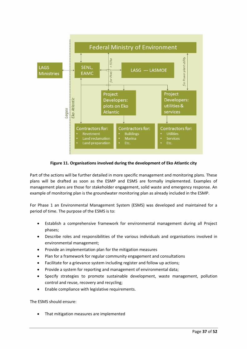
Page 37 of 52
Figure 11. Organisations involved during the development of Eko Atlantic city
Part of the actions will be further detailed in more specific management and monitoring plans. These
plans will be drafted as soon as the ESMP and ESMS are formally implemented. Examples of
management plans are those for stakeholder engagement, solid waste and emergency response. An
example of monitoring plan is the groundwater monitoring plan as already included in the ESMP.
For Phase 1 an Environmental Management System (ESMS) was developed and maintained for a
period of time. The purpose of the ESMS is to:
• Establish a comprehensive framework for environmental management during all Project
phases;
• Describe roles and responsibilities of the various individuals and organisations involved in
environmental management;
• Provide an implementation plan for the mitigation measures
• Plan for a framework for regular community engagement and consultations
• Facilitate for a grievance system including register and follow up actions;
• Provide a system for reporting and management of environmental data;
• Specify strategies to promote sustainable development, waste management, pollution
control and reuse, recovery and recycling;
• Enable compliance with legislative requirements.
The ESMS should ensure:
• That mitigation measures are implemented
Page 38 of 52
• That environmental and social as well as audits are carried out
• That the ESMP is updated upon substantial changes in the project descriptions
• That regular and good communication with all stakeholders is maintained
• Engage with the communities and relevant stakeholders on a regular basis and provide
follow up if needed
• Maintain a grievance register and provide follow up if needed
• Report on progress and issues
• Facilitate the Impact Mitigation Monitoring and Compliance Monitoring missions by the
FMEnv
The project proponent is preparing for the ESMS for Phase 2 and the remainder of Phase 1. Based on
the effort needed to implement the ESMP (management and monitoring) the team is formed.
The implementation of environmental and social conditions and mitigating measures depends on a
proper and clear institutional and legal setting.
8.4 Roles and responsibilities
Where Phase 1 had few main implementing organizations (proponent and contractors), Phase 2 has
multiple stakeholders to implement the project with the highest standards and the least
disturbances. Besides the FMEnv as governing competent authority, the main organisations directly
involved are:
• South Energyx Nigeria Limited, the project proponent but more and more as project
facilitator;
• The Eko Atlantic Management Company, who will be fully responsible for managing Eko
Atlantic for a period of 78 years;
• The project developers, who invest in Eko Atlantic land to develop assets and/or establish
business;
• The contractors who are contracted by the Project Developers;
• LASG, responsible for Lagos State and facilitated with the development of Eko Atlantic as a
special urban area (10km2);
The Eko Atlantic Development project will become a success (also environmentally and socially)
when the key organisations as well as other related stakeholders all take their responsibility for their
business and tasks as well as their obligation within the context of this ESMP.
8.4.1 SEDFZE
SEDFZE is the prime project proponent and has initiated the Eko Atlantic project. It took
responsibility for the design and the implementation of full Phase 1 and for the land and facilities
development of Phase 2. The land development includes the preparation of roads, canals, bridges,
sewerage, storm water drainage, water mains, electricity distribution cables, communication cables.
Moreover, they will develop the utility district with a power plant, waste supply treatment, waste
water treatment and solid waste management. At a certain stage all these components are
contracted out.

Page 39 of 52
Consequently, SEDFZE has also initiated and developed the Environmental and Social Impact
Assessment for both phases. The responsibility for the preparation up to approval of both EIA’s
(phase 1 and 2) is with SEDFZE.
SEDFZE sells the land to be further developed under a number of conditions. The technical service
facilities will be contracted out as management agreements while all kinds of social services and
facilities are taken over by interested groups through agreements as well.
Contract and agreements will be as much as possible in line with the vision and set-up of Eko Atlantic
Master Plan. This also includes the responsibilities concerning natural and human environment as
written in this EIA report.
8.4.2 Eko Atlantic Management Company (EAMC)
The Eko Atlantic Management Company will be fully responsible for managing Eko Atlantic in all its
components during its operation phase. The EAMC has recently been established. SENL and LASG
have agreed that EAMC will have the full and sole responsibility for managing Eko Atlantic.
The responsibility comprises amongst others:
• City administration
• Operation and maintenance
• Liaison with LASG Ministries and organisations
• Implementation of this EMP with its partners / stakeholders.
8.4.3 Project Developers
Plots on Eko Atlantic are sold to project developers. The project developers may be investment
companies, national banks, international bank, and multinational companies in various economic
sectors. Subsequently, the buildings will be used for offices, housing, shopping, social facilities like
schools, sports and other leisure, health facilities, etc. Project Developers and SENL negotiate and
sign contracts which are based on the vision of Eko Atlantic and related to that a number of
conditions linked to that vision.
Another area of project development concerns the various required utilities. The responsibility for
the preparation and implementation of the utilities will be contracted out to dedicated companies
with experience in these fields. SENL is currently in contact with various groups / companies to
prepare this.
The conditions for Project Developers have been discussed and negotiated between LASG and SENL.
A manual for this purpose is available and is applied in the contracts. Project Developers are liable
under the Law of Nigeria to the respective Governmental organisations.
8.4.4 Contractors
Numerous contractors will be on site during the coming decades of developing Eko Atlantic. These
contractors are either contracted by SENL, EAMC or by the various Project Developers. Contractors
should comply to provisions in the EMP (mitigating measures) and with general H&S conditions. This
should be thoroughly incorporated in the contracts between the Project Developer and the
Contractor.

Page 40 of 52
In order to manage and monitor the implementation of these guidelines, it is recommended that the
checklists and mitigations measures outlined within this EIA are used to develop an Environmental
Action Plan (EAP). The EAP should be completed by the appointed contractor and approved by SENL,
EAMC or Project Developers. Moreover, each contractor is required to have a proper HSE manual in
place which is in line with the general regulations.
8.4.5 LASG
The Lagos State Government is the main counterpart of SENL and EAMC for the development of Eko
Atlantic. With various Ministries regular communication and coordination has been maintained
during the preparation and implementation of Eko Atlantic. In this the Ministry of Waterfront and
Infrastructure Development was the key Ministry as this Ministry is responsible for erosion and
coastal infrastructure. One of the line ministries important for subsequent phases concerns the
Ministry of Transport (including Lamata) in order to further develop and implement traffic and
transport arrangements.
During the preparation of both EIA’s regular contact and consultation has been maintained with the
Lagos Ministry of Environment (LASMOE). LASMOE will also monitor the implementation of the EMP
of the Eko Atlantic project.
8.5 Contract and agreement
8.5.1 Manual for Project Developers
SENL in consultation with LASG has prepared the manual for “Construction, Rules, Procedures and
Regulations for the Execution and Completion of Works at Eko Atlantic City”. The main components
of the manual are:
• Site rules and procedures
• Regulations for the health and safety of personnel and protection the environment
• Regulations governing substances dangerous and hazardous to health and the environment
• Fines for violation
The complete first version of the manual has been attached as Appendix to ESIA Phase 2. The
manual is already applied for the initial contracts that have been negotiated with various Project
Developers. The manual will be updated periodically based on experiences and lessons learned. The
manual comprises a long list of many subjects that will be regulated on site in order to avoid or
reduce risk for people and environment. As such it is a solid and successful follow up of many issues
identified in this EIA and, even more important, further operationalization of project and mitigating
measures.
8.5.2 HSE regulations for Contractors
Contractors should have their health, safety and environment policy and manuals. Contractors
should take account of the HSE provisions in the manual for Project Developers. Examples of proper
HSE manuals have been discussed during the preparation of phase 1 ESIA and which have been
prepared and implemented by the phase 1 contractors for the revetment and reclamation works.
Project Developers are responsible to check HSE provisions and monitor implementation.

Page 41 of 52
8.6 Estimated cost to implement the ESMP
The total cost for the implementation of the ESMP over a period of various decades is in the order of
0,5% of the total investment for Eko Atlantic.
The implementation of the ESMP implies an effort for various parties. In this section, the cost to be
made by the project proponent for a proper implementation of the ESMP are listed.
The main cost items for the ESMP concern:
• Cost for organisation of the project proponent
• Cost of mitigating measures, Phase 1 and 2
• Cost of monitoring measures, Phase 1 and 2
• Cost of additional studies and management plans
A rough estimation of the one-off and annual cost is presented in the Table 5 below.
Table 5. Estimated Cost for the implementation of the ESMP
Cost type and cost items Remarks Annual
cost (USD)
One-time cost
(USD)
Organization
• HSE officer Full time 20,000
• Community liaison including grievance, etc Part time 10,000
• Office, workshop, visits FMEnv, visits AfDB,
etc
30,000
Sub-total: 60,000
Cost of mitigating measures
• Measures in design Phase 1 In design;
implemented
na na
• Measures in design Phase 2 In design; under
implementation
na na
• Measures with contractors Cost with contractors;
To be audited
na na
• Community consultations Once - twice per year 30,000
Sub-total 30,000
Cost of monitoring measures
• Coastal process through erosion
monitoring scheme; short report
2x per year initially 20,000
• Stability of sea defence Weekly, eventually
annually
Part of
supervision

Page 42 of 52
Table 5. Estimated Cost for the implementation of the ESMP
Cost type and cost items Remarks Annual
cost (USD)
One-time cost
(USD)
• Stability of reclamation Weekly, eventually
annually
Part of
supervision
• Water and sediment quality Reduced to annually 15,000
• Air and noise studies Once per year 15,000
• Marine ecology Reduced to annually 15,000
• Groundwater levels on EA and VI Monthly for 2 years 5,000 30,000
• Pollution incident If needed (???)
• Erosion mitigation scheme 15,000
• HSE compliance contractors; 4 audits per
year
1 extra staff for 2
weeks per audit of all
contractors
25,000
Sub-total 110,000 30,000
Cost of additional studies
• ESIA for power plant 150,000
• Preparation of solid waste management
plan
20,000
• Preparation of stakeholder engagement
and communication plan
10,000
• Preparation of influx management plan 20,000
• Preparation of community health action
management plan
20,000
• Preparation of traffic impact assessment
and management plan
60,000
Sub-total: 280,000
Total cost: 120,000 310,000
9 PUBLIC CONSULTATION AND DISCLOSURE
9.1 Stakeholders
Throughout the period in which ESIA activities have been carried out, the list of stakeholders with an
interest or an involvement in the project have developed. The ESIA reports presents a complete list
according to the following set-up.
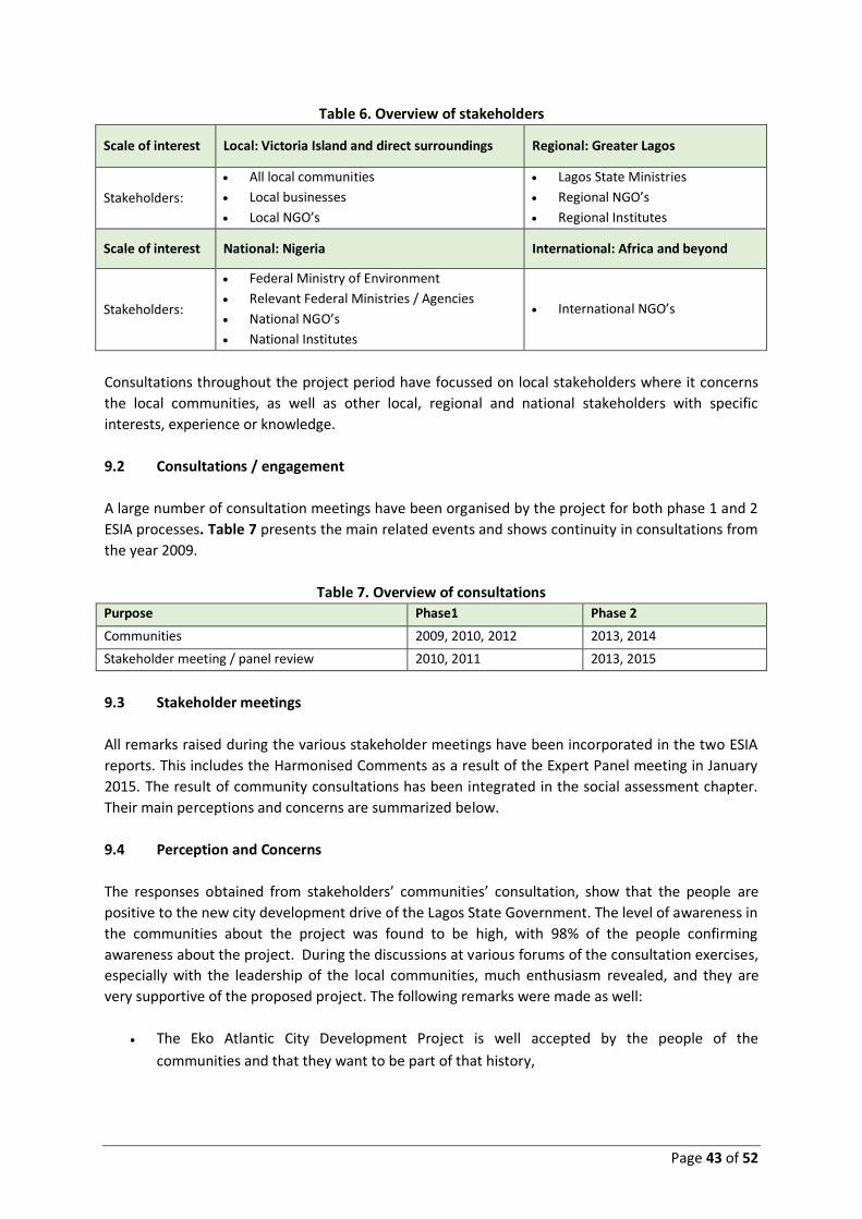
Page 43 of 52
Table 6. Overview of stakeholders
Scale of interest Local: Victoria Island and direct surroundings Regional: Greater Lagos
Stakeholders:
• All local communities
• Local businesses
• Local NGO’s
• Lagos State Ministries
• Regional NGO’s
• Regional Institutes
Scale of interest National: Nigeria International: Africa and beyond
Stakeholders:
• Federal Ministry of Environment
• Relevant Federal Ministries / Agencies
• National NGO’s
• National Institutes
• International NGO’s
Consultations throughout the project period have focussed on local stakeholders where it concerns
the local communities, as well as other local, regional and national stakeholders with specific
interests, experience or knowledge.
9.2 Consultations / engagement
A large number of consultation meetings have been organised by the project for both phase 1 and 2
ESIA processes. Table 7 presents the main related events and shows continuity in consultations from
the year 2009.
Table 7. Overview of consultations
Purpose Phase1 Phase 2
Communities 2009, 2010, 2012 2013, 2014
Stakeholder meeting / panel review 2010, 2011 2013, 2015
9.3 Stakeholder meetings
All remarks raised during the various stakeholder meetings have been incorporated in the two ESIA
reports. This includes the Harmonised Comments as a result of the Expert Panel meeting in January
2015. The result of community consultations has been integrated in the social assessment chapter.
Their main perceptions and concerns are summarized below.
9.4 Perception and Concerns
The responses obtained from stakeholders’ communities’ consultation, show that the people are
positive to the new city development drive of the Lagos State Government. The level of awareness in
the communities about the project was found to be high, with 98% of the people confirming
awareness about the project. During the discussions at various forums of the consultation exercises,
especially with the leadership of the local communities, much enthusiasm revealed, and they are
very supportive of the proposed project. The following remarks were made as well:
• The Eko Atlantic City Development Project is well accepted by the people of the
communities and that they want to be part of that history,

Page 44 of 52
• The Project is a development project; it is promoting the image of Lagos State and the
Federal Government of Nigeria to the outside World as one of the fastest growing business
hub in Africa; and,
• It will be beneficial in terms of job creation for the youth of the identified communities and
beyond.
The communities’ main concerns regarding Eko Atlantic city as expressed during consultations are:
• The execution of the project is expected to have direct economic impact on the immediate
communities. Ample work for both temporary and permanent jobs during the construction
and eventual operation of the new city is expected. This is expected to empower local
inhabitants, improve their skills, and boost local economy of the area. Communities’
leadership requests to be informed about opportunities and procedures.
• The traffic situation around the new city when fully developed is of great concern to the
people. The Eko Atlantic Master Plan indicates that the future situation involves a city with
about 250,000 inhabitants. Communities realize that the Master Plan development also has
provisions for the development of transport infrastructures in both the land and marine
(water) modes. When fully developed, these are expected to serve as relief for the
anticipated heavy traffic of the enlarged population movements.
The Communities and the resident associations are still much concerned about the rate of erosion
and flooding. Shore protection measures with Eko Atlantic and by LASG east of Eko Atlantic are
regarded to take care of these concerns when fully completed (dealt with in ESIA Phase 1).
9.5 Future and Continuous Stakeholder Engagements
The planned actions that are related to consultations as discussed are:
• Assignment of one employee based locally at the organization of the project proponent
• Preparation and implementation of the detailed Consultation Plan
• Preparation and implementation of a Grievance Management Mechanism by the project
proponent
• Regular reporting of the consultation activities and the grievance register
The person designated by the project proponent to receive complaints is: Mr David Frame,
Managing Director of SEDFZE; tel: +234-1-291-0180; email [email protected]
10 CONCLUSIONS AND RECOMMENDATIONS
The Master Plan for the Eko Atlantic City Development is an integral plan for the erection of new
part of Lagos with high aspirations in the field of residential, economic and business development on
one hand and in the field of sustainable development on the other hand.

Page 45 of 52
The ESIA concludes that in principle the Master Plan provides a balanced and sustainable basis for its
development. With the detailed and general mitigation measures that are proposed in this EIA
report based on extensive analyses, a balanced implementation is foreseen. Due attention has been
given to both environmental and social issues, but also legal requirements and the institutional
capacity have been dealt with in view of an excellent implementation.
Given the provisions as reported, notably the implementation of the ESMP and the ESMS, this
project could be successfully implemented without unacceptable impacts. Eko Atlantic has regional
and national importance with lots of possibilities for substantial positive cq. beneficial impacts.
11 REFERENCES AND CONTACTS
11.1 References
1. Royal HaskoningDHV (2015) Eko Atlantic Phase 2 EIA (Masterplan EIA). A report prepared for South EnergyX Nigeria Limited. November 2015
2. Royal HaskoningDHV (2015) Eko Atlantic Phase 1 EIA (Shoreline Protection and Reclamation project EIA). A report prepared for South EnergyX Nigeria Limited. February 2013
11.2 Contacts
For additional information in relation to the Eko Atlantic Lagos shoreline protection and masterplan project, contact the following individuals
For the African Development Bank
• Bakia Mbianyor, Chief E&S Compliance Officer, AfDB. Email: [email protected]
• Osric Tening Forton, Principal E & S Safeguards Officer, AfDB. Email: [email protected]
For the developer (SEDFZE)
• More information and impressions on Eko Atlantic city can be obtained through its web-site:
www.ekoatlantic.com . Films, related to the shoreline protection and land reclamation as
well as the city development, can be found on www.youtube.com .
• The Eko Atlantic sales office at Bar Beach in Lagos can be visited. The address is “Eko Atlantic
Sales Office, Ahmadu Bello Way, Bar Beach, Victoria Island, Lagos.
• The Eko Atlantic sales office can be contacted through the web-site, through email or by
telephone (Tel: +234-1-291-0180; email: [email protected])

Page 46 of 52
Table 3. Monitoring actions of the revetment / reclamation works (Phase 1)
Monitoring
Parameter
Objective Location Method Frequency Management Action
Construction
Phase
Coastal processes Determine any change
in rate of erosion as a
result of the
development.
10 km of beach
starting at the
western extent of the
development.
Bathymetric and topographic
surveys. Due to lack of
baseline data, it is proposed
that a geomorphological
assessment will be
undertaken.
Every six months to
annually. Frequency to be
optimised based on any
observed changes.
Surveys to be reviewed and erosion
rate to be determined. It is
proposed that this monitoring will
be combined with that undertaken
during the operational stage of the
scheme.
Stability of sea
defence
Determine settlement
of sea defence to
ensure structural
integrity.
Regular intervals
along the defence,
determined by the
Resident Engineer.
Level survey of primary
armour AccropodeTM units
and of rock berm.
Initially weekly reducing to
monthly after initial
settlement period.
Frequency to be optimised
based on any observed
changes
Surveys to be reviewed and
settlement rate to be determined.
Mitigation strategy to be consulted
and evaluated.
Determine stability of
sea defence to ensure
structural integrity.
Along full length of
structure.
Side scan sonar and
bathymetric survey; visual
inspection of sections above
water level.
Post construction and then
initially at six monthly
intervals reducing to
annually; and after large
storm events.
Surveys to be reviewed and
integrity of the revetment to be
determined. Mitigation strategy to
be consulted and evaluated.
Determine erosion at
toe of sea defence to
ensure structural
integrity.
Along full length of
structure.
Side scan sonar and
bathymetric survey.
Post construction and then
initially at six monthly
intervals reducing to
annually; and after large
storm events.
Surveys to be reviewed and
integrity of the revetment to be
determined. Mitigation strategy to
be consulted and evaluated.
Stability of
reclamation
Determine settlement
of reclamation area to
ensure integrity.
Reclamation area. Level survey of settlement
beacons, to be determined
by the Resident Engineer.
Initially weekly reducing to
monthly after initial
settlement period.
Frequency to be optimised
based on any observed
changes.
Surveys to be reviewed and
settlement rate to be determined.
Mitigation strategy to be consulted
and evaluated.

Page 47 of 52
Monitoring
Parameter
Objective Location Method Frequency Management Action
Determine settlement
of reclamation area to
ensure integrity and
bearing capacity.
Reclamation area. Boreholes and Cone
Penetration Tests (CPT), to
be determined by the
Resident Engineer.
Post construction. Surveys to be reviewed and ground
conditions to be determined.
Mitigation strategy to be consulted
and evaluated.
Marine water
quality
To detect any
breaches of quality
standards or turbidity
levels.
Baseline sites
S3, S7, S8, S10, S11,
A2, A10, A8, B2 and
B4.
Sites should be added
in Borrow Area C, if
used.
In-situ probe to measure
basic physical parameters
including: temperature,
salinity, pH, dissolved
oxygen, turbidity and
chlorophyll.
Monthly initially, with
subsequent lowering
frequency to be optimised
on any observed changes.
Mitigation measures to be
reviewed, thresholds for action
agreed and new measures
identified as appropriate and
implemented if pollution above
agreed threshold.
Laboratory analysis should
include the following
parameters:
nitrate; total phosphorus;
total petroleum
hydrocarbons (TPHs); total
suspended solids (TSS).
Every three months initially,
with subsequent lowering
frequency to be optimised
on any observed changes.
Lagoon water
quality
Confirm impact
assessment
predictions and
ensure no significant
changes to lagoon
environment
Baseline sites
C1, C2, W1, W3, E1
and E3.
In-situ probe to
measurements, as for marine
water quality.
Every six months initially,
with subsequent lowering
frequency to be optimised
on any observed changes.
Further investigation and
potentially mitigation /
enhancement measures to be
developed in the case that effects
are observed e.g. significant
changes in salinity.
Laboratory analysis of the
following parameters:
nitrate; total phosphorus;
total coliforms; heavy metals.
Every year.
Sediment quality To monitor quality of
sediment used in
reclamation
Hopper of dredger Laboratory analysis of the
following parameters:
PSA; heavy metals; TPHs;
polyaromatic hydrocarbons
(PAHs).
Monthly Dredge location selection to be
reviewed, with potential to
relocate elsewhere in borrow area
if pollution in sediments significant.
Dependent upon the findings of the above monitoring, the following monitoring may be undertaken

Page 48 of 52
Monitoring
Parameter
Objective Location Method Frequency Management Action
Sediment quality To detect any
breaches of quality
standards.
Dependant on
findings of water
quality monitoring.
Sites should be
selected at same
locations as water
quality sampling.
Laboratory analysis of the
following parameters:PSA;
heavy metals; TPHs; PAHs.
Only in the case of a
pollution incident, or
significant effects identified
by monitoring.
Mitigation measures to be
reviewed, new identified as
appropriate and implemented if
pollution above background
recorded.
Noise To detect
unacceptable noise
levels if complaints
received from local
residents.
6 sites: 4 along the
shoreline of Victoria
Island and 2 on the
reclamation area
Hand held noise meter. As required dependent on
noisy activity.
Mitigation measures to be
reviewed, new identified as
appropriate and implemented as
necessary.
Operation phase
Coastal processes Determine any change
in rate of erosion as a
result of the
development.
10 km of beach
starting at the eastern
extent of the
development.
Bathymetric and topographic
surveys. Due to lack of
baseline data, it is proposed
that a geomorphological
assessment (including review
of coastal processes review)
will be undertaken to
determine whether the
proposed scheme has
affected the current erosion
of the frontage.
Every six months to
annually. Frequency to be
optimised based on any
observed changes and
based on any additional
measures taken
Surveys to be reviewed and erosion
rate to be determined. Mitigation
strategy to be consulted and
evaluated (see Section 8.2).
Marine water
quality
To detect any
breaches of quality
standards.
Baseline sites S3, S7,
S8, S10 and S11.
In-situ probe to measure
basic physical parameters
including: temperature,
salinity, pH, dissolved
oxygen, turbidity and
Every six months for three
years.
Mitigation measures to be
reviewed, new identified as
appropriate and implemented if
pollution above background
recorded.
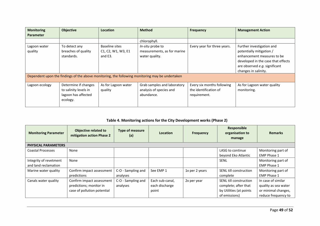
Page 49 of 52
Monitoring
Parameter
Objective Location Method Frequency Management Action
chlorophyll.
Lagoon water
quality
To detect any
breaches of quality
standards.
Baseline sites
C1, C2, W1, W3, E1
and E3.
In-situ probe to
measurements, as for marine
water quality.
Every year for three years. Further investigation and
potentially mitigation /
enhancement measures to be
developed in the case that effects
are observed e.g. significant
changes in salinity.
Dependent upon the findings of the above monitoring, the following monitoring may be undertaken
Lagoon ecology Determine if changes
to salinity levels in
lagoon has affected
ecology.
As for Lagoon water
quality
Grab samples and laboratory
analysis of species and
abundance.
Every six months following
the identification of
requirement.
As for Lagoon water quality
monitoring.
Table 4. Monitoring actions for the City Development works (Phase 2)
Monitoring Parameter Objective related to
mitigation action Phase 2
Type of measure
(a) Location Frequency
Responsible
organisation to
manage
Remarks
PHYSICAL PARAMETERS
Coastal Processes None LASG to continue
beyond Eko Atlantic
Monitoring part of
EMP Phase 1
Integrity of revetment
and land reclamation
None SENL Monitoring part of
EMP Phase 1
Marine water quality Confirm impact assessment
predictions
C-O - Sampling and
analyses
See EMP 1 1x per 2 years SENL till construction
complete
Monitoring part of
EMP Phase 1
Canals water quality Confirm impact assessment
predictions; monitor in
case of pollution potential
C-O - Sampling and
analyses
Each sub-canal,
each discharge
point
2x per year SENL till construction
complete; after that
by Utilities (at points
of emissions)
In case of similar
quality as sea water
or minimal changes,
reduce frequency to

Page 50 of 52
Monitoring Parameter Objective related to
mitigation action Phase 2
Type of measure
(a) Location Frequency
Responsible
organisation to
manage
Remarks
1x per 1 or 2 years
Canals water quality Monitor visual pollution
(especially related to solid
waste)
C-O - Observations Along the all canals Same as previous
parameter
SENL till construction
complete; after that
by Utilities (at points
of emissions)
Lagoon water quality None Limited monitoring
part of EMP Phase 1
Sediment quality None Monitoring part of
EMP Phase 1
Noise To monitor noise levels if
required due to complaints
from local communities.
C - Measuring with
hand held noise
meter;
To be selected if
needed
As required
dependent on
noisy activity.
SENL up to land
preparation is
completed
Contractors
Reference to manual
Air To monitor air quality
levels if required due to
complaints from local
communities.
C – Measuring with
air tubes as in EIA
To be determined
to extent needed
(on VI and EA)
As required
dependent on-air
emission or
complaint.
SENL up to land
preparation is
completed; after that
integration with
LASMOE system
Air quality near
power plant through
EIA by Utility
Company;
To be considered
when the various
methods in utility
sector known
(see also Air -
Institutional)
Air To reduce dust
development as much as
possible
C - Observation In the construction
areas
During audits SENL up to land
preparation is
completed
Surface water –
Hydrology
Follow the flooding
characteristics on VI
C-O - Observation VI In rainy season SENL Linked to
groundwater / used
for interpretation
flooding

Page 51 of 52
Monitoring Parameter Objective related to
mitigation action Phase 2
Type of measure
(a) Location Frequency
Responsible
organisation to
manage
Remarks
Groundwater –
Hydrogeology
Estimate contribution to
flooding on Victoria Island
based on groundwater
levels
C-O – Measuring On Victoria Island
and Eko Atlantic
6 – 12x per year
(for few years)
SENL See Monitoring Plan
in ESIA-2
SOCIAL PARAMETERS
Job expectations Obtain information to what
extent the expectations by
local communities are in
line with reality
C-O - Interviews Local communities
Eti-Osa
1x per year SENL up to land
preparation is
completed
This monitoring can
be part of the
Stakeholder
Engagement
Concerns Get an idea to what extent
concerns with local
communities are discussed
and being dealt with
C-O - Interviews Local communities
Eti-Osa
1x per year SENL up to land
preparation is
completed
This monitoring can
be part of the
Stakeholder
Engagement
H&S Get an idea and manage
well-being of people, local
communities, etc.
C-O - audits Local communities,
Local businesses
1x per year SENL up to land
preparation is
completed
Register for
grievances,
complaints, injuries,
key diseases,
casualties is part of
the EMS
LEGAL PARAMETERS
Environmental
statements
Monitor necessity for
environmental statements
C – Check Eko Atlantic Regularly SENL / EAMC
Project Developers
Mainly concerns
development of large
plots
EIA’s Monitor necessity for
submitting EIA’s
C – Check Eko Atlantic Regularly SENL / EAMC
Project Developers
Mainly concerns
power generation
INSTITUTIONAL
PARAMETERS
Air (LASG) Communicate with LASG
for follow up to air quality
monitoring plan (to
C-O – progress
meetings
At LASG and
selected locations
on VI and Eko
One-time action SENL with air quality
monitoring plan; SENL
carries out audit.

Page 52 of 52
Monitoring Parameter Objective related to
mitigation action Phase 2
Type of measure
(a) Location Frequency
Responsible
organisation to
manage
Remarks
upgrade general air quality
in Lagos)
Atlantic
Traffic (LAMATA) Communicate with Lamata
on the connection between
the 2 Master Plans
C-O – progress
meetings
MoT / Lamata,
Lagos
Regular SENL / EAMC Also progress of the
Coastal Road design
process at various
stages recommended
to be monitored
EMP (EAMC) To monitor the level and
quality of organisation to
implement the EMP
O - audit Main office 1x per year Through SENL by
independent team
Related to EMS to
achieve a sustainable
and EKO friendly city
HSE (Contractors) Monitor compliance to
standards, law and HSE
manual
C - audit Construction sites 2x per year Project Developers
HSE manual (Project
Developers)
Monitor compliance to
standards, law and HSE
manual
C - audit Offices 2x per year SENL / EAMC Regular contact and
reporting established
• (a): C = construction, O = operation