project name citywide congestion management plan eligible ... · in-house and capital project...
TRANSCRIPT

1
Cover Page
Project Name Citywide Congestion Management Plan
Eligible Entity Applying to Receive Federal
Funding
New York City Department of Transportation
Total Project Cost $12,320,000
ATCMTD Request $6,160,000
Are matching funds restricted to a specific
project component?
No
State in which project is located NY
Is the project currently programmed in the:
Transportation Improvement Program
(TIP)
Statewide Transportation
Improvement Program (STIP)
MPO Long Range Transportation Plan
State Long Range Transportation Plan
No
No
Yes
Yes
Technologies proposed to be deployed Sensors and cameras for High Occupancy
Vehicle lanes on bridges, Transit Signal
Priority technology for key bus routes, quiet
delivery truck technology citywide
Submitted by in response to:
Notice of Funding Opportunity Number 693JJ317NF0001
“Advanced Transportation and Congestion Management Technologies Deployment Initiative”
ATCMTD Request: $6,160,000; Local Match: $6,160,000
Submitted to: U.S. Department of Transportation
By:
Commissioner Polly Trottenberg
June 12, 2017

2
Table of Contents Project Description ........................................................................................................................................ 3
1. Project Introduction ....................................................................................................................... 3
2. Goals and Objectives of Proposed Deployment ............................................................................ 7
3. Proposed Deployment Components ............................................................................................ 10
4. Benefits of the Proposed Deployment .......................................................................................... 12
5. Proposed Deployment Plan .......................................................................................................... 13
New York City Department of Transportation ........................................................................................... 13
Staffing ........................................................................................................................................................ 14
Funding Description .................................................................................................................................... 15
Schedule ...................................................................................................................................................... 16

3
Project Description
1. Project Introduction
As part of the Citywide Congestion Management Plan (CCMP), New York City Department of
Transportation (NYCDOT) requests $6,160,000 in Advanced Transportation and Congestion
Management Technologies Deployment Initiative (ATCMTD) funds to develop and deploy
technologies to reduce congestion in the five boroughs of NYC. Specifically, the project includes
the following congestion mitigating technologies: launching Transit Signal Priority (TSP) on key
bus routes, encouraging off hour deliveries (OHD) for trucks by employing noise-mitigating
solutions on congested corridors citywide and installing High Occupancy Vehicle (HOV)
cameras on East River bridges. To evaluate project success, goals include expansion of
innovative data sets; analysis to evaluate the performance of our transportation network
including crosswalks, bus and bike lanes; and implementation of systems to efficiently plan and
operate streets and bridges to reduce costs, delay and crashes. Benefits include ability to monitor
speeds, bus travel times, and bottlenecks, as well as origin and destination information for more
efficient routing. Increasing reliability for bus service, shifting truck deliveries to improve traffic
flow and promoting more efficient travel options will help NYCDOT efficiently and safely plan
and operate its streets.
New York City is reaching record highs in the number of residents, jobs, and tourists, and these
growth trends have clear impacts on the City’s transportation network. In 2015, the City was
home to more than 8.5 million residents and hosted 58.3 million tourists. Providing
transportation options to efficiently and safely move millions of people every day presents
significant challenges, which are exacerbated by congestion and the continued growth of
commercial and home deliveries across the city. As the City attracts more visitors, workers, and
residents, sidewalks and crosswalks are busier than ever and with more construction there is an
increase in lane closures, impacting traffic flow. Speeds in the City, particularly Midtown
Manhattan are slower, yet fewer cars overall are entering the core (Figures 1-2).
Figure 1

4
Figure 2
The City’s growth is straining our transportation system as never before. Up until now, New
York City has largely been able to meet the travel demand generated by this growth with existing
subway capacity and increased walking and biking. Between 2010 and 2016, citywide subway
ridership increased 22 percent to 1.76 billion. Ridership is now 78 percent higher than during the
system’s nadir of 991 million riders in 1982. The number of frequent bike riders has risen 54
percent to 778,000 in the last five years, and pedestrian activity has increased dramatically. To
support these shifts, the city has significantly expanded bus, bike and pedestrian facilities, and
has done so in most cases without reducing overall vehicle throughput.
But overall, DOT believes that the City’s extraordinary growth is likely the dominant factor
leading to congestion and dropping traffic and bus speeds on the streets (Figure 3).
Figure 3
As a national leader in the use of data to monitor, manage, and evaluate multimodal
transportation networks, NYCDOT is uniquely prepared to leverage ATCMTD funds to build on
a long history of innovative data collection and analysis and use those tools to reduce congestion
for all modes throughout NYC. NYCDOT has been collecting annual key screenlines since 1948,
and has continuously sought to improve and expand both the data collected and the use of this
data to plan for mobility improvements citywide. Midtown In Motion (MIM), NYCDOT’s
NYCT Bus Speeds
Weekdays 4pm-6pm

5
monitoring system for the central business district, helps the City evaluate traffic flow on key
corridors in Midtown Manhattan, and NYCDOT’s partnership with the New York City Police
Department and New York State Department of Transportation on the Joint Traffic Management
Center use cameras and speed detection equipment to monitor traffic conditions in real time.
CCMP will build upon these efforts and purchase a new complete data set, to enable NYCDOT’s
Traffic Operations and Transportation Planning and Management divisions to support improved
operations management and monitoring, evaluation, and planning efforts as well as inform the
agency on how to best deploy congestion mitigation measures, including TSP, OHD and HOV.
The new real-time and historical data allows NYCDOT to analyze complete travel paths, traveler
attributes, origin-destination information, vehicle type, relative volume, travel times, trip length,
speeds, delay costs, roadway and traffic event information, and planning time and buffer time
metrics. This data will enable NYCDOT to utilize a rich dataset with the widest coverage
available, arming the agency to improve the performance of the entire transportation network.
This data will equip NYCDOT to plan safety projects and initiatives to monitor and improve the
City’s transportation network to alleviate congestion and reduce the number and severity of
crashes for all modes throughout the City.
CCMP will focus on the following technologies to monitor and address congestion:
Transit Signal Priority Technology
TSP allows for improved reliability and performance on key corridors throughout NYC and
encourages transit use, which reduces congestion. Smart traffic signals can detect when a bus is
approaching, and adjust timing so the bus is more likely to encounter a green light. As a bus gets
close to an intersection, it sends a wireless signal that is transmitted to the traffic signal
controller, either directly or through a centralized TSP server. The controller then has the ability
to maintain a green light longer for a bus to make it through the intersection, or to turn a red light
green sooner if a bus is stopped at the red. Controls are put in place to make sure that the light
never changes before pedestrians have enough time to safely cross, and that overall traffic flow is
maintained (Figure 4). TSP makes small changes at each individual intersection, but over the
course of a corridor bus speed and reliability can significantly improve. TSP has been
implemented at approximately 370 intersections (about 3 percent of total signalized
intersections) on seven routes in NYC and has reduced travel times by five to 20 percent.
Figure 4

6
Off Hour Delivery Technology
Another component of CCMP includes reducing peak hour deliveries in the most congested parts
of NYC, specifically Midtown Manhattan. NYCDOT will identify and deploy low noise
transportation technology and unassisted delivery technology to facilitate and encourage more
off hour deliveries in our dense, urban environment. This initiative is supported by the Mayor's
OneNYC Plan 2015 and NYCDOT's Strategic Plan 2016. Noise related to transportation and
delivery processes is a barrier to implementing more off hour deliveries due to resident concerns
associated with noise mitigation. Low noise engines, quiet refrigeration systems, quiet cargo
handling equipment and other truck accessories are some of the strategies that can be
implemented to reduce noise impacts. Staffing costs for receivers can also present challenges for
businesses interested in implementing OHD. The use of electronic doormen, virtual delivery
cages, and other security technologies can support unassisted deliveries. These technologies will
incentivize the adoption of OHD by shippers and receivers.
HOV Lane Occupancy Verification Technology
Beyond addressing bus and truck congestion, NYCDOT is preparing to integrate a quarter of a
million displaced daily transit riders into surface transportation. The Canarsie Tunnel, which
carries the L subway line under the East River between Brooklyn and Manhattan will be closed
to repair Superstorm Sandy-related damage starting in 2019, requiring 225,000 daily subway
commuters to find other travel options (Figure 5). Travel on this corridor, between Brooklyn and
Manhattan is limited to the ferry, three bridges and one tunnel. Some of these commuters will
shift to other subway options that have also experienced increases in ridership, but there is no
parallel transit route to the L train, leaving commuters with less efficient daily travel options.
Figure 5
As a result, NYCDOT is exploring HOV restrictions over the East River bridges to enable high-
volume replacement bus service that can serve as an acceptable alternative. While many of the
entry points of these bridges are from city streets, some connect to limited-access highways
where vehicles will be entering the bridge approaches at higher speed. The ATCMTD funds
would aid NYCDOT in testing technological solutions to address the significant changes in
travel demand through the use of vehicle occupancy sensor technology, which enables open-road
verification and enforcement of HOV restrictions. Other US Cities have implemented camera-
based technologies of this kind, and NYCDOT’s intention would be to conduct a test of camera
technology and its accuracy at key locations. A concept of operations diagram for this
technology is depicted in Figure 6. Note that NYCDOT would only seek to implement cameras,

7
test their accuracy and collect data under this grant funding, not develop a violations processing
infrastructure.
Figure 6
Integration with NYC and Other Initiatives The CCMP project will directly support the following initiatives and programs:
Vision Zero
MTA/NYCDOT L-Train Construction Mitigation
MTA/NYCDOT Select Bus Service Operations
NYC Freight Plan
New York Metropolitan Transportation Council’s Long Range Transportation Plan and
travel demand processes
Performance measurement and reporting for MAP-21 and FAST Act
Roadway State of Good Repair (SOGR) monitoring
In-house and capital project planning, design and construction
Overall traffic operations, system monitoring and management
USDOT Strategic Plan goals
New York State Department of Transportation planning objectives
2. Goals and Objectives of Proposed Deployment
The proposed deployment of CCMP will support NYCDOT’s core mission, which is to provide
for the safe, efficient, and environmentally responsible movement of people and goods in the
City of New York and to maintain and enhance the transportation infrastructure crucial to the
economic vitality and quality of life of its primary customers, NYC residents.
To meet the needs of the city and NYCDOT, CCMP will:
Provide complete, accurate and reliable real-time count, curbside utilization, travel time
and origin-destination data
Seamlessly interface with NYCDOT’s current ITS infrastructure and Traffic
Management Center systems

8
Provide coverage at critical intersections, corridors, and screenlines throughout NYC
Alleviate congestion and streamline traffic flow throughout the five boroughs
Monitor and improve the operational performance and efficiency for all modes of the
transportation network
Reduce the number and severity of traffic crashes and increase safety for all modes
Deliver economic benefits by reducing delays, improving system performance, and
providing for the efficient and reliable movement of goods and services

9
2.1. Goals and Objectives of the Proposed Deployment
Proposed Deployment(s) Objectives Goals
Transit Signal Priority
(TSP) Analyze the feasibility
and quantify potential
benefits of TSP for
selected bus routes
through use of micro
simulation modeling
Design and develop the
framework necessary for
field implementation of
TSP
Improve or maintain
Level of Service (LOS)
for all other road users
while simultaneously
minimizing bus delays
Improve the overall
mobility by reducing bus
transit travel time
Improve reliability of
bus service and on-time
performance
Improve the overall
intersection traffic
operation (delays, speed,
air quality, etc.),
specifically during peak
weekday commuter
hours
Encourage use of transit
Improve transit
operations and service
quality
Improve mobility
Reduce mobile-source
emissions and fuel
consumption rates
Off Hour Deliveries (OHD) Reduce noise impacts
for truck deliveries
Facilitate unassisted
truck deliveries
Reduce traffic
congestion and
transportation related
emissions by expanding
the off hour deliveries
program
Reduce delivery costs
and improve delivery
times for transporters,
shippers and receivers
(businesses) through
OHD
High Occupancy Vehicle
(HOV) Test the accuracy of
vehicle occupancy
camera technology in a
constrained, high-
volume roadway setting
Enable fast, high-
volume interborough bus
service through the use
of HOV lanes that
reduce overall traffic
volume
Encourage carpooling
and transit use
Reduce highway
congestion at bridge
interface points

10
3. Proposed Deployment Components
Transit Signal Priority
Objective: Improve performance of bus service through the application of Transit Signal Priority
on key corridors.
Challenges: NYCDOT and MTA are embarking on an ambitious program to provide TSP to
6,000 buses in New York City. A key component of the project is New York City’s dedicated
broadband wireless infrastructure (NYCWiN), which was created by the city’s Department of
Information Technology and Telecommunications to support public safety and operations.
Because NYCWiN supports the implementation of TSP without any additional hardware or
infrastructure changes, this approach is particularly cost-effective and attractive for widespread
implementation of TSP in New York.
Approach: TSP in New York City uses in-vehicle GPS tracking devices and other on-bus TSP
software to detect a bus’s location. The bus then sends a TSP request to the NYCDOT Traffic
Management Center (TMC), relayed through MTA’s Bus Command Center. The TMC uses the
New York City Wireless Network (NYCWiN) to communicate with the traffic signal controllers
(Figure 7). In order to create a safe and efficient intersection with TSP, significant traffic
analysis is required. Analysis will be conducted utilizing both macroscopic and microscopic
modeling software. The former will be used to identify existing capacity problems, evaluate
mitigation measures to alleviate these problems, and optimize signal timings and offsets. All
analyses of TSP operations will be evaluated at the microscopic level to measure traffic
performance and visualize operations. TSP operational benefits are dynamic in nature and
sensitive to changes in traffic characteristics such as volumes, signal timing and phasing, new
pedestrian phases, intersection geometry, bus schedules and frequencies. Thus, optimal results
can be maintained over time by fine tuning TSP parameters based on periodic reassessments.

11
Figure 7
Off Hour Deliveries Program Expansion
Objective: Implement low-noise and unassisted delivery technology to encourage and
incentivize the shift of truck related deliveries to the off peak hours, thereby reducing traffic
congestion and emissions, as well as reducing delivery costs and improving goods delivery
times.
Challenges: NYCDOT seeks to reduce the impact of the trucks on congestion. In NYC, trucks
carry approximately 91 percent of goods. Daily freight trips are estimated to have increased
steadily in the city, growing by 5.7 percent between 2010 and 2013. Moreover, trucking industry
partners have advised NYCDOT that they have experienced a 30 percent increase in parcel
deliveries to sections of Manhattan since 2010. This increased truck traffic puts additional
demands on already congested streets. The added congestion results in increased emissions,
delayed delivery of goods, and added costs for shippers and receivers. Two major concerns that
arise in implementing OHD are noise concerns for community residents and the need for
additional staff for businesses. Utilizing technology solutions to address both will facilitate
broader implementation of OHD.
Approach: OHD will scale up work that NYCDOT has previously developed through an OHD
Pilot (2009/2010), during which 400 business shifted deliveries to the off peak hours. Benefits of
the pilot program included financial benefits for shippers (lower delivery, reduced parking fines)
and receivers (reductions in inventory costs, improved reliability of deliveries, and lower
shipping costs). In addition, there were reductions in transportation emissions by trucks having
shorter and more direct routes, faster speeds, and less time stuck in traffic. NYCDOT would seek
additional OHD participation from shippers and receivers in the most congested areas of the city.
NYCDOT would use this grant to develop and distribute an incentives program, which would
include a customized scheme to provide financial incentives for receivers and transporters to
acquire technology that could facilitate unassisted deliveries, such as electronic doormen, quiet
pallet jacks and virtual delivery cages.
High Occupancy Vehicle Verification
Objective: Implement and test vehicle occupancy verification cameras at key locations.
Challenges: NYCDOT is working in partnership with Metropolitan Transportation Authority
(MTA) to mitigate the effects of the closure of the L subway line between Brooklyn and
Manhattan for resiliency repairs. The closure is expected to take 15 months starting in early
2019, and force 225,000 subway commuters to find a different commute option. Most likely
shuttle bus service will be primarily concentrated on the Williamsburg Bridge, the nearest bridge
to the L subway line, and if these buses were to operate in mixed traffic, they would experience
significant delay. Unreliable service would stimulate some shift to less efficient modes, further
exacerbating congestion.
To ensure fast, reliable operation of high-volume bus service between Manhattan and Brooklyn,
NYCDOT is exploring HOV restrictions on the Williamsburg Bridge, as well as other nearby

12
crossings. In order to enforce HOV restrictions, NYCDOT will work with the New York Police
Department (NYPD) to station officers at key locations to check vehicle occupancy and enforce
against violators. Where bridge connections are made from major highways, this approach is
logistically difficult. Other US cities have tested and adopted camera technologies to verify and
enforce against motorists carrying fewer than the minimum required passengers for HOV lane
access. NYCDOT seeks to test technologies of this type, but acknowledges the unique challenges
that arise from operating in the heavily-congested, under-engineered roadway environment of
New York City and its bridge crossings.
Approach: NYCDOT will follow agency procurement guidelines to ascertain viable
technological solutions from eligible vendors, and procure material for camera installations at
key locations. NYCDOT staff will consult with other jurisdictions who have implemented
similar technologies on how to structure tests of the accuracy at installation locations. NYCDOT
will then collect vehicle occupancy data using the cameras as well as through manual counts and
evaluate the accuracy of camera technology. After piloting the technology, NYCDOT will issue
a monitoring report summarizing the results of the test and including a recommendation on
future applicability.
4. Benefits of the Proposed Deployment
Following development and deployment of these technologies, the supplemental data is crucial
to evaluating performance. Under current conditions, many counts and travel data collection
surveys that are performed at key locations across the city are only deployed one-to-two weeks at
a time, once or twice a year, or on a project-by-project basis. As a result, there is no information
on the traffic flow characteristics at other times and NYCDOT must draw conclusions from such
data for planning, operations, and monitoring purposes. Having a sustainable, consistent source
of data is critical. Detection equipment deployed under the proposed system will have uniform
technology specifications and counting procedures. The resulting data will be consistent in
format and will be seamlessly integrated into NYCDOT’s current data flows. In addition,
variation due to count contractor personnel and count methods will be eliminated.
A reliable set of continuous, renewable, real-time and historical data will provide insights into
the spatial and temporal fluctuations of traffic activity, greatly benefit a number of citywide
initiatives, and provide a basis for performance monitoring. The new dataset for CCMP will also
allow NYCDOT to analyze an unprecedented amount of continuous, real-time information on
traffic flows to support innovative programing and applications that improve mobility and
system efficiency.
Transit Signal Priority Benefits:
Improving bus service reliability and on-time performance will encourage increased transit
usage, public safety and improve air quality. TSP enables buses to move out of traffic congestion
and minimize customer delay.
Off Hour Delivery Benefits:
OHD promotes less loading and double parking, which alleviates congestion in the daytime
hours. Carriers/shippers benefit from faster and more reliable travel times, reductions in delivery

13
costs, reductions in parking fines, and less stress on delivery crews. Receivers benefit from large
increases in the reliability of deliveries, reductions in inventory costs, and lower shipping costs.
Also, low-noise delivery practices and technologies will reduce disruption during night time
deliveries. OHD reduces vehicular emissions produced by trucks due to shorter routes with less
congestion, faster speeds, and no stop-and-go traffic.
HOV Vehicle Occupancy Verification Benefits: If camera technology proves viable in the
NYC environment, the near-term applicability would be to allow for verification of occupancy in
HOV lanes during the L subway line closure. This would result in the reduction of congestion on
East River bridges and the adjacent street network, as well as the prioritization of more efficient
travel modes such as bus service and carpooling. Over the longer term, HOV lane restrictions
could potentially be implemented after the end of the L line construction closure, and facilitated
through the development of a full electronic enforcement infrastructure built around camera-
based enforcement. Such an outcome would offer the benefit of long-term congestion reduction
as well as reduced police enforcement costs.
5. Proposed Deployment Plan
TSP Technology
In-vehicle GPS tracking devices will be installed in buses and activated in signals along major
outerborough routes with high ridership. Priority bus routes for TSP deployment could include
South Brooklyn Crosstown – B82, South Bronx Crosstown- BX6, and Woodhaven Blvd –
Q52/53.
OHD Technology
NYCDOT proposes to add 900 new participants to the OHD program during the course of 24
months. The deployment plan would include an updated marketing strategy, a recognition/
incentives program as well as noise monitoring and low noise technology program.
HOV Vehicle Occupancy Technology
NYCDOT will procure and install camera technology for vehicle occupancy verification at key
locations on East River bridges. Using these cameras, NYCDOT will collect vehicle occupancy
data and evaluate the accuracy of camera technology. At the conclusion of the pilot, NYCDOT
will issue a monitoring report summarizing the results of the test and including a
recommendation on future applicability.
New York City Department of Transportation
NYCDOT will enter into the agreement with FHWA. NYCDOT has extensive experience in
Federal grant administration and in the planning, design and engineering of capital and ITS-
related projects. The agency has professional licensed and certified planners, engineers, and
construction managers and staff that are able to manage projects and/or manager consultants
providing staff support and technical assistance through existing engineering service agreements.
Assistance with grant administration will be provided by the Division of Finance, Contracts and
Program Management, which has extensive experience administering grants and complying with
all requirements. NYCDOT has an annual operating budget of over $900 million and has

14
significant financial controls. NYCDOT’s staff of over 5,000 employees oversees and manages a
five year $10 billion capital program.
The project is consistent with the metropolitan planning process of the local Metropolitan
Planning Organization (MPO) – the New York Metropolitan Transportation Council (NYMTC.
All project elements are consistent with the NYMTC long range Regional Transportation Plan
(RTP). NYCDOT which is a voting member of the NYMTC is committed to adding all
ATCMTD-funded project elements into the Transportation Improvement Program (TIP)/State
Transportation Improvement Program (STIP) within one month upon confirmation that the
project has been awarded ATCMTD funds.
Staffing
15
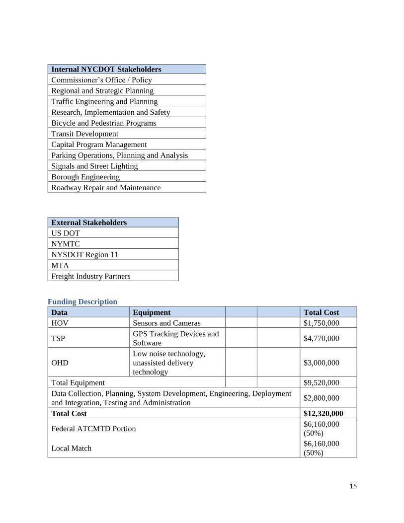
Internal NYCDOT Stakeholders
Commissioner’s Office / Policy
Regional and Strategic Planning
Traffic Engineering and Planning
Research, Implementation and Safety
Bicycle and Pedestrian Programs
Transit Development
Capital Program Management
Parking Operations, Planning and Analysis
Signals and Street Lighting
Borough Engineering
Roadway Repair and Maintenance
External Stakeholders
US DOT
NYMTC
NYSDOT Region 11
MTA
Freight Industry Partners
Funding Description
Data Equipment Total Cost
HOV Sensors and Cameras $1,750,000
TSP GPS Tracking Devices and
Software $4,770,000
OHD
Low noise technology,
unassisted delivery
technology
$3,000,000
Total Equipment $9,520,000
Data Collection, Planning, System Development, Engineering, Deployment
and Integration, Testing and Administration $2,800,000
Total Cost $12,320,000
Federal ATCMTD Portion $6,160,000
(50%)
Local Match $6,160,000
(50%)

16
Schedule
Months from Award Task
1-12 Grant authorizations, equipment procurement
12-24 Equipment installation, system checks and integration
24-36 Initial data gathering, data integrity checks and system refinements
Notes:
1. A kick-off meeting will be scheduled within one month following award announcement.
2. Progress reports will be submitted monthly following award announcement.
3. A comprehensive status update report will be produced annually (at months 12, 24 and 36)
following award announcement.
4. A series of coordination meetings with the US DOT team will be proposed for the project
duration.