project narrative final smith estates 01 23 17 - home - …€¦ · · 2017-02-07massadona silt...
TRANSCRIPT
CIVIL & CONSULTING ENGINEERS * ARCHITECTURE * CONSTRUCTION MANAGEMENT * PROJECT ENGINEERS * PLANNING & PERMIT EXPEDITING
2394 Patterson Road, Suite 201 Grand Junction, CO 81505 (970) 245-9051 (970) 245-7639 fax www.vortexeng.us
Final Plan Project Narrative
For Smith Estates Subdivision
Date: January 23, 2017
Prepared by: Robert W. Jones II, P.E. Vortex Engineering, Inc. 2394 Patterson Rd., Ste 201 Grand Junction, CO 81505 970-245-9051 VEI # F16-025
Submitted To: Mesa County 200 South Spruce Street
Grand Junction, CO 81501
Type of Design: Major Subdivision Final Plan
Owner/Petitioner: Jerry & Edna Smith
Property Address Tax Schedule Number
2248 J Road 2701-184-09-001
2292 J Road 2701-184-00-072
1054 22½ Road 2701-181-00-720
1035 23 Road 2701-184-00-722
1039 23 Road 2701-184-00-721
1061 23 Road 2701-181-00-577
1069 23 Road 2701-184-00-718
1073 23 Road 2701-181-00-327
1075 23 Road 2701-181-00-719
Project Narrative Page 2 of 9 Smith Estates
1.0 Introduction This application is a request for approval of a major subdivision final plan to subdivide eight (8) parcels of land, and an additional previously platted 15 acre lot, which when combined comprise approximately ± 204 acres.
2.0 Property Location The eight (8) parcels are located west of 23 Road and North of J Road to the west is the Grand Valley Canal. The site is bounded on all sides by rural residential/agricultural.
A location map and an aerial photograph are attached to this narrative that illustrates the parcels.
The site is bounded on all sides by rural residential/agricultural. Please reference Exhibit ‘A’ - Location Map within this report for further information.
3.0 Property Description The eight (8) parcels encompass approximately ± 188 acres currently consisting of active agricultural fields with three (3) existing homes. The property owners are proposing to subdivide the parcels into 36 new residential lots; 2 lots with existing homes, 1 reserve lot with an existing dwelling on it, and 1 vacant reserve lots. The new lots will be approximately ± 1 acre in size and will be constructed in 2 – 3 phases. The subject parcels are currently zoned AFT; these parcels are within the Rural 5 – 10 acres zone.
According to the USDA National Resource Conservation Service (NRCS), the soils across the site consist of Fruita clay loam (Fe), 0 to 2 percent slopes; Fruitvale clay loam (Fg), 0-2% slopes; Fruita clay loam (Ff), 2-5% slope; Blackston very gravelly loam (BkD), 5-25% slopes; Massadona silt clay loam (Ba), 0-2% slopes; Fruitvale fine sandy loam (Fs), 0-2% slopes and Persayo Silty Clay loam (Re), 12-40% slopes. The hydrologic class of these soil groups varies from Type B to C.
4.0 Utilities & Services
The parcels will be serviced by the following utilities and public services:
Potable Water = Ute Water Conservancy District (UWCD)
Sanitary Sewer = Onsite Wastewater Treatment Systems (OWTS)
Irrigation Water = Grand Valley Water Users Association
Fire Protection = Lower Valley Fire Department
Police Protection = Mesa County Sheriff
Telephone = Century Link
Electricity = Grand Valley Power
Natural Gas = Xcel
Cable Television = Charter Cable
Drainage = Grand Valley Drainage District
Project Narrative Page 3 of 9 Smith Estates
5.0 Mesa County Land Development Code Compliance
A Final Plan must meet criteria in Section 3.6.3.C of the Mesa County Land Development Code. Criteria in this section include the following:
The proposed project is consistent with the goals and policies of the Mesa County Master Plan. The property is not subject to any Area Plans.
Section 3.6.4.C - Final Plan Criteria Compliance
The following standards shall apply to Property Line Adjustments (approval criteria discussions / answers are in red):
C. Approval Criteria The Planning Director shall approve a Final Plan only if the Planning Director determines that the Final Plan is consistent with the approved Concept Plan and meets all conditions imposed by the Planning Director during the approval of the Concept Plan. A Final Plan is deemed to be consistent with the approved Concept Plan when 1) the locations of the connections to public roads and adjacent properties not owned by the applicant are not altered and internal street and pedestrian path alignments may be slightly modified; 2) drainage and detention facility locations are retained within the general areas identified in the approved Concept Plan; 3) all applicable requirement of the Land Development Code are met; and 4) other modifications are determined by the Planning Director to be consistent with the approved Concept Plan.
1. All review agency comments not in conflict with the conditions of approval shall be resolved
with the Final Plan.
Response: Comment acknowledged. All review agency comments not in conflict with the conditions of approval have been resolved with the Final Plan.
2. A Stormwater Construction Permit shall be obtained from the Colorado Department of Public Health and Environment before over-lot grading and road construction begins.
Response: Comment acknowledged. A Stormwater Construction Permit will be obtained from the Colorado Department of Health and Environment before over-lot grading and road construction begins.
3. The Right-to-Farm and Ranch policy and the Hunting notice shall be noted on the recorded site plan.
Response: Comment acknowledged. The Right-to-Farm and Ranch policy and the Hunting notice will be noted on the recorded site plan.
Project Narrative Page 4 of 9 Smith Estates
4. Due to expansive and collapsible soils, shallow groundwater, and corrosive soil conditions, the following note shall be placed on the recorded site plan:
Prior to building permit application, a site-specific geotechnical investigation and analysis is required to determine depth to groundwater and bedrock, soils conditions, and structural fill requirements. An engineered foundation design is required for all structures requiring a building permit.
Response: Comment acknowledged. The following note will be placed on the recorded site plan:
Prior to building permit application, a site-specific geotechnical investigation and analysis is required to determine depth to groundwater and bedrock, soils conditions, and structural fill requirements. An engineered foundation design is required for all structures requiring a building permit.
5. A second means of access shall be developed when a recorded filing brings the total number of new lots on the Craftsman Street access on J Road to 30 lots or more in compliance with the approved Preliminary Access Location permit.
Response: Comment acknowledged. A second means of access will be developed when a recorded filing brings the total number of new lots on the Craftsman Street access on J Road to 30 lots or more in compliance with the approved Preliminary Access Location permit.
6. The proposed Lot 3, currently Lot 1, Pritchard Mesa Estates II Subdivision, shall be excluded from the Final Subdivision Plat while allowing the density associated with this lot to be transferred to the balance of the Smith Estates Concept Plan property.
Response: Comment acknowledged. The proposed Lot 3, currently Lot 1, Pritchard Mesa Estates II Subdivision, will be excluded from the Final Subdivision Plat while allowing the density associated with this lot to be transferred to the balance of the Smith Estates Concept Plan property.
Approval is based on the following finding of fact that the petition demonstrates compliance with a majority of the criterion in Section 3.6.3G and Section 3.1.17 of the Mesa County Land Development Code (2000, as amended).
D. Time Frames The Final Plan shall be approved within one (1) year of the date of submittal. One (1) extension of one (1) year may be approved by the Planning Director upon review of a written request.
Project Narrative Page 5 of 9 Smith Estates
Section 3.1.17 - General Approval Criteria Compliance
A. Complies with all applicable standards, provisions, and the purposes (Sec 1.5), of this Land Development Code.
According to Section 1.5, the Mesa County Land Development Code is adopted for the purpose of preserving and improving the public health, safety, and general welfare of the citizens and businesses of Mesa County. More specifically, it is the purpose of the Mesa County Land Development Code to:
Implement, generally, the purposes, goals, and policies of the Mesa County Master Plan;
Promote predictability, consistency, and efficiency in the land development process for residents, neighborhoods, businesses, agricultural and development interests;
Provide appropriate opportunities for participation and involvement in the development process by all affected parties;
Be fair to all by giving due consideration to protecting private property rights, the rights of individuals, and the rights of the community as a whole; and,
Promote development that is consistent and compatible with that of the City of Fruita within the Joint Urban Planning Area.
The Site Plan/Plat generally complies with the above applicable standards, provisions, and the purposes of Section 1.5 of the Mesa County Land Development Code. As submitted, the Smith Estates Subdivision Final Plan MEETS this review criterion.
B. Is consistent with review agency comments; and
The petitioners will consider any review comments received to determine their applicability to the Final Plan. The Final Plan CAN MEET this review criterion upon receipt and review of review comments.
C. Is consistent with applicable intergovernmental agreements between the County and other
entities.
The subject site lies outside of the Joint Urban Planning Area of Fruita and Mesa County, and lies outside of the Persigo 201 boundary. Hence this application does not fall under the jurisdiction of the Persigo Agreement. The Final Plan MEETS this review criterion.
Project Narrative Page 6 of 9 Smith Estates
4.0 Conclusion
The applicant is proposing a Major Subdivision for eight (8) parcels of land totaling 188 +/- acres. The applicant proposes to subdivide into 36 separate residential lots, 2 existing houses 1 reserve lot with a dwelling, and 1 vacant reserve lots. Individual residential lots sizes vary with all being greater than 1.0 acres.
The proposed subdivision is within an area presently zoned AFT and is surrounded by current and proposed AFT residential and agricultural uses.
5.0 Limitations/Restrictions
This report is a site-specific report and is applicable only for the client for whom our work was performed. The review and use of this report by Mesa County, affiliates, and review agencies is fully permitted and requires no other form of authorization. Use of this report under other circumstances is not an appropriate application of this document. This report is a product of Vortex Engineering, Inc. and is to be taken in its entirety. Excerpts from this report that are taken out of context may not convey the true intent of the report. It is the owner’s and owner’s agent’s responsibility to read this report and become familiar with recommendations and findings contained herein. Should any discrepancies be found, they must be reported to the preparing engineer within 5 days.
The recommendations and findings outlined in this report are based on: 1) The site visit and discussion with the owner, 2) the site conditions disclosed at the specific time of the site investigation of reference, 3) various conversations with planners and utility companies, and 4) a general review of the zoning and transportation manuals. Vortex Engineering, Inc. assumes no liability for the accuracy or completeness of information furnished by the client or municipality/agency personnel. Site conditions are subject to external environmental effects and may change over time. Use of this report under different site conditions is inappropriate. If it becomes apparent that current site conditions vary from those reported, the design engineering should be contacted to develop any required report modifications. Vortex Engineering, Inc. is not responsible and accepts no liability for any variation of assumed information.
Vortex Engineering, Inc. represents this report has been prepared within the limits prescribed by the owner and in accordance with the current accepted practice of the civil engineering profession in the area. No warranty or representation either expressed or implied is included or intended in this report or in any of our contracts.

Project Narrative Page 7 of 9 Smith Estates
ATTACHMENT “A”
LOCATION MAP
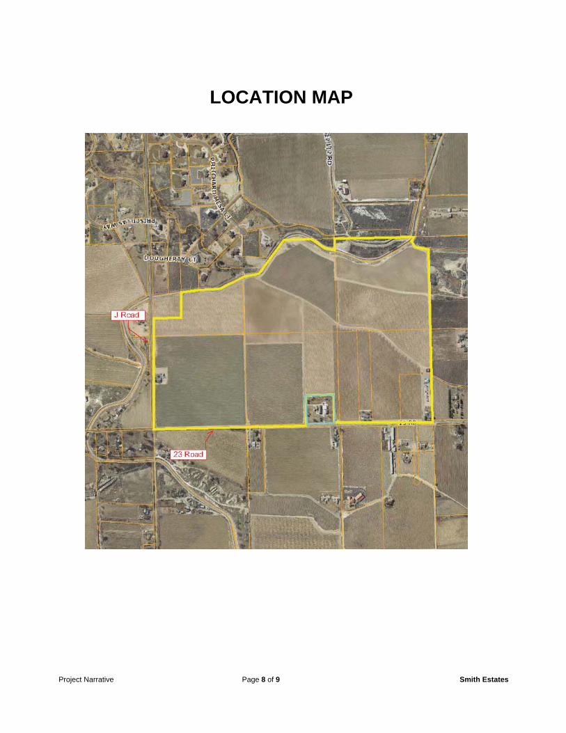
Project Narrative Page 8 of 9 Smith Estates
LOCATION MAP

Project Narrative Page 9 of 9 Smith Estates
ATTACHMENT “B”
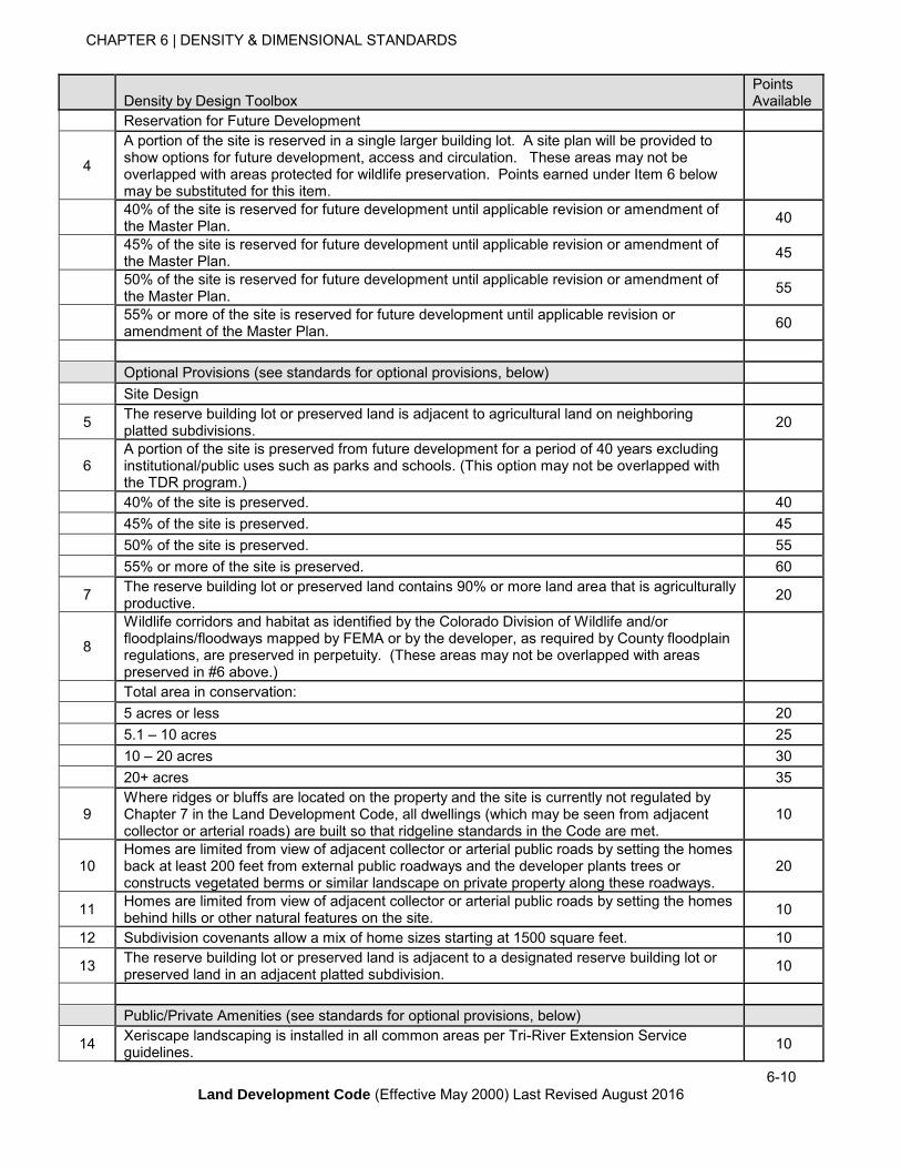
DENSITY BY DESIGN TOOLBOX
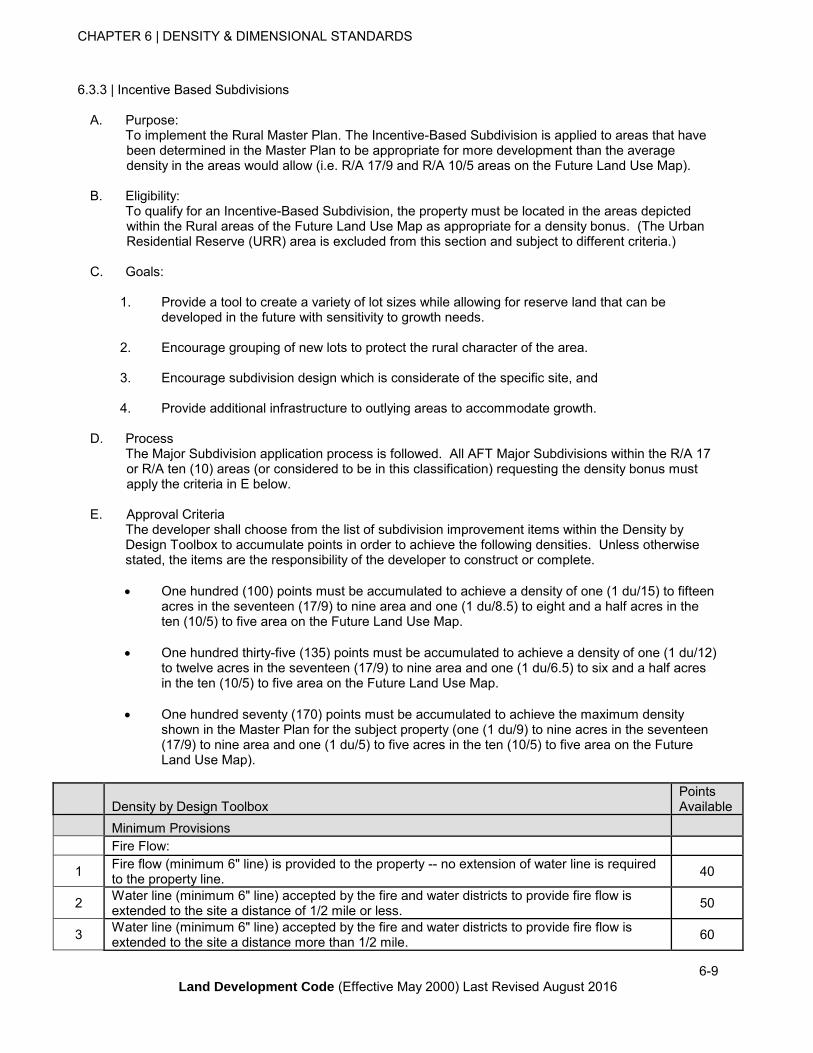
CHAPTER 6 | DENSITY & DIMENSIONAL STANDARDS
6-9
Land Development Code (Effective May 2000) Last Revised August 2016
6.3.3 | Incentive Based Subdivisions
A. Purpose: To implement the Rural Master Plan. The Incentive-Based Subdivision is applied to areas that have
been determined in the Master Plan to be appropriate for more development than the average density in the areas would allow (i.e. R/A 17/9 and R/A 10/5 areas on the Future Land Use Map).
B. Eligibility: To qualify for an Incentive-Based Subdivision, the property must be located in the areas depicted
within the Rural areas of the Future Land Use Map as appropriate for a density bonus. (The Urban Residential Reserve (URR) area is excluded from this section and subject to different criteria.)
C. Goals:
1. Provide a tool to create a variety of lot sizes while allowing for reserve land that can be developed in the future with sensitivity to growth needs.
2. Encourage grouping of new lots to protect the rural character of the area.
3. Encourage subdivision design which is considerate of the specific site, and
4. Provide additional infrastructure to outlying areas to accommodate growth.
D. Process The Major Subdivision application process is followed. All AFT Major Subdivisions within the R/A 17
or R/A ten (10) areas (or considered to be in this classification) requesting the density bonus must apply the criteria in E below.
E. Approval Criteria The developer shall choose from the list of subdivision improvement items within the Density by
Design Toolbox to accumulate points in order to achieve the following densities. Unless otherwise stated, the items are the responsibility of the developer to construct or complete.
One hundred (100) points must be accumulated to achieve a density of one (1 du/15) to fifteen acres in the seventeen (17/9) to nine area and one (1 du/8.5) to eight and a half acres in the ten (10/5) to five area on the Future Land Use Map.
One hundred thirty-five (135) points must be accumulated to achieve a density of one (1 du/12) to twelve acres in the seventeen (17/9) to nine area and one (1 du/6.5) to six and a half acres in the ten (10/5) to five area on the Future Land Use Map.
One hundred seventy (170) points must be accumulated to achieve the maximum density shown in the Master Plan for the subject property (one (1 du/9) to nine acres in the seventeen (17/9) to nine area and one (1 du/5) to five acres in the ten (10/5) to five area on the Future Land Use Map).
Density by Design Toolbox
Points Available
Minimum Provisions
Fire Flow:
1 Fire flow (minimum 6" line) is provided to the property -- no extension of water line is required to the property line.
40
2 Water line (minimum 6" line) accepted by the fire and water districts to provide fire flow is extended to the site a distance of 1/2 mile or less.
50
3 Water line (minimum 6" line) accepted by the fire and water districts to provide fire flow is extended to the site a distance more than 1/2 mile.
60
CHAPTER 6 | DENSITY & DIMENSIONAL STANDARDS
6-10
Land Development Code (Effective May 2000) Last Revised August 2016
Density by Design Toolbox
Points Available
Reservation for Future Development
4
A portion of the site is reserved in a single larger building lot. A site plan will be provided to show options for future development, access and circulation. These areas may not be overlapped with areas protected for wildlife preservation. Points earned under Item 6 below may be substituted for this item.
40% of the site is reserved for future development until applicable revision or amendment of the Master Plan.
40
45% of the site is reserved for future development until applicable revision or amendment of the Master Plan.
45
50% of the site is reserved for future development until applicable revision or amendment of the Master Plan.
55
55% or more of the site is reserved for future development until applicable revision or amendment of the Master Plan.
60
Optional Provisions (see standards for optional provisions, below)
Site Design
5 The reserve building lot or preserved land is adjacent to agricultural land on neighboring platted subdivisions.
20
6 A portion of the site is preserved from future development for a period of 40 years excluding institutional/public uses such as parks and schools. (This option may not be overlapped with the TDR program.)
40% of the site is preserved. 40
45% of the site is preserved. 45
50% of the site is preserved. 55
55% or more of the site is preserved. 60
7 The reserve building lot or preserved land contains 90% or more land area that is agriculturally productive.
20
8
Wildlife corridors and habitat as identified by the Colorado Division of Wildlife and/or floodplains/floodways mapped by FEMA or by the developer, as required by County floodplain regulations, are preserved in perpetuity. (These areas may not be overlapped with areas preserved in #6 above.)
Total area in conservation:
5 acres or less 20
5.1 – 10 acres 25
10 – 20 acres 30
20+ acres 35
9 Where ridges or bluffs are located on the property and the site is currently not regulated by Chapter 7 in the Land Development Code, all dwellings (which may be seen from adjacent collector or arterial roads) are built so that ridgeline standards in the Code are met.
10
10 Homes are limited from view of adjacent collector or arterial public roads by setting the homes back at least 200 feet from external public roadways and the developer plants trees or constructs vegetated berms or similar landscape on private property along these roadways.
20
11 Homes are limited from view of adjacent collector or arterial public roads by setting the homes behind hills or other natural features on the site.
10
12 Subdivision covenants allow a mix of home sizes starting at 1500 square feet. 10
13 The reserve building lot or preserved land is adjacent to a designated reserve building lot or preserved land in an adjacent platted subdivision.
10
Public/Private Amenities (see standards for optional provisions, below)
14 Xeriscape landscaping is installed in all common areas per Tri-River Extension Service guidelines.
10
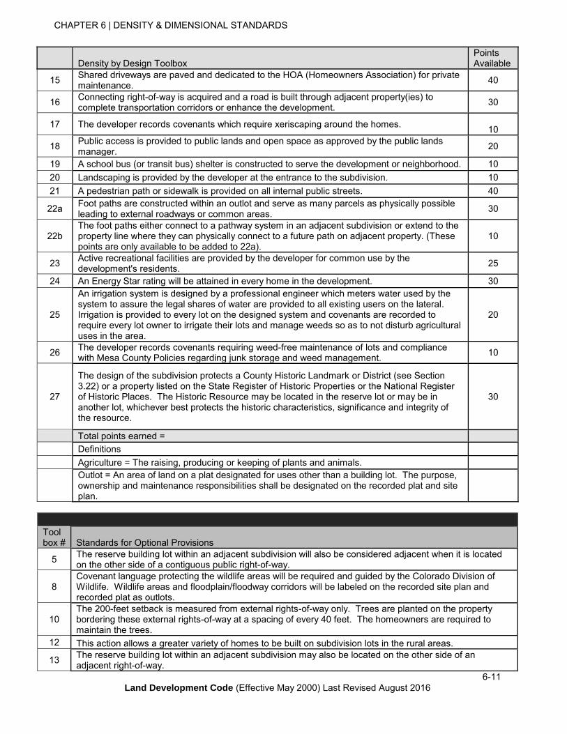
CHAPTER 6 | DENSITY & DIMENSIONAL STANDARDS
6-11
Land Development Code (Effective May 2000) Last Revised August 2016
Density by Design Toolbox
Points Available
15 Shared driveways are paved and dedicated to the HOA (Homeowners Association) for private maintenance.
40
16 Connecting right-of-way is acquired and a road is built through adjacent property(ies) to complete transportation corridors or enhance the development.
30
17 The developer records covenants which require xeriscaping around the homes.
10
18 Public access is provided to public lands and open space as approved by the public lands manager.
20
19 A school bus (or transit bus) shelter is constructed to serve the development or neighborhood. 10
20 Landscaping is provided by the developer at the entrance to the subdivision. 10
21 A pedestrian path or sidewalk is provided on all internal public streets. 40
22a Foot paths are constructed within an outlot and serve as many parcels as physically possible leading to external roadways or common areas.
30
22b The foot paths either connect to a pathway system in an adjacent subdivision or extend to the property line where they can physically connect to a future path on adjacent property. (These points are only available to be added to 22a).
10
23 Active recreational facilities are provided by the developer for common use by the development's residents.
25
24 An Energy Star rating will be attained in every home in the development. 30
25
An irrigation system is designed by a professional engineer which meters water used by the system to assure the legal shares of water are provided to all existing users on the lateral. Irrigation is provided to every lot on the designed system and covenants are recorded to require every lot owner to irrigate their lots and manage weeds so as to not disturb agricultural uses in the area.
20
26 The developer records covenants requiring weed-free maintenance of lots and compliance with Mesa County Policies regarding junk storage and weed management.
10
27
The design of the subdivision protects a County Historic Landmark or District (see Section 3.22) or a property listed on the State Register of Historic Properties or the National Register of Historic Places. The Historic Resource may be located in the reserve lot or may be in another lot, whichever best protects the historic characteristics, significance and integrity of the resource.
30
Total points earned =
Definitions
Agriculture = The raising, producing or keeping of plants and animals.
Outlot = An area of land on a plat designated for uses other than a building lot. The purpose, ownership and maintenance responsibilities shall be designated on the recorded plat and site plan.
Tool box #
Standards for Optional Provisions
5 The reserve building lot within an adjacent subdivision will also be considered adjacent when it is located on the other side of a contiguous public right-of-way.
8 Covenant language protecting the wildlife areas will be required and guided by the Colorado Division of Wildlife. Wildlife areas and floodplain/floodway corridors will be labeled on the recorded site plan and recorded plat as outlots.
10 The 200-feet setback is measured from external rights-of-way only. Trees are planted on the property bordering these external rights-of-way at a spacing of every 40 feet. The homeowners are required to maintain the trees.
12 This action allows a greater variety of homes to be built on subdivision lots in the rural areas.
13 The reserve building lot within an adjacent subdivision may also be located on the other side of an adjacent right-of-way.