project withdrawn before ccb - cloud object storage genesis project for reforestation is situated in...
TRANSCRIPT

1
Project Design Document (PDD)
For validation at
CLIMATE, COMMUNITY AND BIODIVERSITY STANDARD (CCBS)
VERSION 1.0
(10/12/2008)
Genesis Forest Project: Reforestation of Brazilian Savannah Native Species in the
State of Tocantins, Brazil
Projec
t with
drawn b
efore
CCB Stan
dards
valid
ation
, May
2, 20
11

2
Table of Contents
I. GENERAL INFORMATION .................................................................................. 3 II. EXECUTIVE SUMMARY ..................................................................................... 5 III. GENERAL SECTION .......................................................................................... 7
G1 Original Conditions at the Project Site ......................................................... 7 G2 Baseline Projections ................................................................................... 25 G3 Project Design and Goals ........................................................................... 43 G4 Management Capacity and Best Practices.................................................. 48 G5 Land tenure ................................................................................................. 51 G6 Legal Status ................................................................................................ 52 G7 Adaptive Management for Sustainability ................................................... 53 G8 Knowledge Disseminations ........................................................................ 55
IV. CLIMATE SECTION.......................................................................................... 56
CL1 Net Positive Climate Impacts ..................................................................... 56 CL2. Offsite Climate Impacts (“Leakage”)......................................................... 67 CL3 Climate Impact Monitoring ........................................................................ 69 CL4 Adapting to Climate Change and Climate Variability ............................... 77 CL5 Carbon Benefits Withheld from Regulatory Markets ................................ 83
V. COMMUNITY SECTION .................................................................................... 84
CM1 Net Positive Community Impacts ............................................................. 84 CM2 Offsite Stakeholder Impacts ...................................................................... 88 CM3 Community Impact Monitoring ................................................................ 89 CM4 Capacity Building...................................................................................... 90 CM5 Best Practices in Community Involvement ............................................... 92
VI. BIODIVERSITY SECTION ............................................................................... 95
B1 Net Positive Biodiversity Impacts ............................................................... 95 B2 Offsite Biodiversity Impacts ...................................................................... 101 B3 Biodiversity Impact Monitoring ................................................................ 102 B4 Native Species Use .................................................................................... 102 B5 Water and Soil Resource Enhancement..................................................... 103
VII. COMPLETE BIOGRAPHY.......................................................................... 105
Projec
t with
drawn b
efore
CCB Stan
dards
valid
ation
, May
2, 20
11

Gen Clim Comm Bio
3
I. GENERAL INFORMATION
Location of the project:
Country: Brazil
Nearest City: Palmas, State of Tocantins (TO)
District: Taquarussu
Geographic Location of the project activities: meridians 48°03’W and 48°21’W and latitude
parallels 9°43’ and 10°28’ S.
Implementing Organization:
Ecologica Institute – IE (Instituto Ecológica)
Name of the Contact Person: Luiz Eduardo Leal
Title:Technical Director
Address: Quadra 103 Sul, Rua SO-03, Lote 28 –
Palmas, TO - Brazil
Telephone Number: +55 63 3215 1279
E-mail:[email protected]
Website:www.ecologica.org.br
Primary Functions of Ecologica Institute: IE is responsible for the project coordination and
project activities
Institutional Partners:
A) Cantor CO2e Brazil
Name of the Contact Person: Diego Machado Carrion Serrano
Projec
t with
drawn b
efore
CCB Stan
dards
valid
ation
, May
2, 20
11

Gen Clim Comm Bio
4
Title:Technical Coordinator
Address: Rua Borges Lagoa 1065, conjunto 146
Vila Clementino – São Paulo – SP
Brazil
Telephone Number: +55 11 5083 3252
E-mail:[email protected]
Website:www.cantorco2e.com
Primary Functions of Cantor CO2e Brazil: Cantor CO2 Brazil is responsible for the Project
Document Development (PDD)
B) Carbonfund.org
Name of the Contact Person: Eric Carlson
Title:Executive Directory
Telephone Number: (240) 595-6890
E-mail:[email protected]
Website:www.carbonfund.org
Primary Functions of Carbonfund.org: Carbonfund.org is responsible for the Project
Articulation between the Hyundai (financial input) and with Ecologica Institute and Cantor
CO2e Brasil.
Projec
t with
drawn b
efore
CCB Stan
dards
valid
ation
, May
2, 20
11

Gen Clim Comm Bio
5
II. EXECUTIVE SUMMARY
The project area is located inside the APA Serrado Lajeado and to the South of the Serra do
Lajeado State Park, which are protected areas that play an important role for the conservation of
biodiversity, based on their respective conceptual and legal nuances. In this conservation
context, the project intends to reforest 130 hectares with Brazilian Savannah native species. In
the future, this area must be transformed in a Legal Reserve according to the Article 16 of the
Brazilian Forest Code 4.771/65, which will serve as a refuge for local fauna, increasing the
forestry physiognomy area inside the conservation unity of APA Serra do Lageado, and lending
to greater linkage between other forest fragments in the region.
The Genesis Forest Project was conceived to align different strategies in order to support
environment and social aspects by joining activities of reforestation, conservation, fire combat,
local community capacitating in sustainable management as well as environmental education.
The reforestation, workshops and training courses will be done in the private properties of the
Ecológica Institute in the vicinity of the Ecológica Ranch, in the Taquaruçu district of Palmas,
Tocantins, Brazil. This region contains areas favorable to conservation (see REDD project) as
well degraded land that are the focus of the reforestation strategies.
The combination of recuperation of degraded lands, conservation and social engagement in the
areas near the project brings to the region the possibility of the rising of a new paradigm in
terms of the necessity to combat and avoid the use of fire as a management tool and also to
create a culture of sustainable income generation by using and processing biodiversity products.
These approaches in terms of capacitating, environment education, as well as fire brigade
support, are expected to generate significant “positive leakage” beyond the reforestation
activities benefits. All these activities would be aligned and backed by initiatives of the Center
for Biodiversity Learning and Climate Change –Ecotropical Center, conceived by the
Ecológica Institute and inserted in the project area.
In the absence of the project, use and occupation of the project area suggests a tendency to
maintain the pasture and periodical fires, and no significant changes would be expected in
common practices in terms of land use and use of fire as management tool in the region as a
whole.
The absence of project activities, besides the previously mentioned direct environmental
impacts, would imply the reduction of the surrounding community’s chances to participate in
Projec
t with
drawn b
efore
CCB Stan
dards
valid
ation
, May
2, 20
11

Gen Clim Comm Bio
6
capacity building and dissemination of knowledge about Savannah conservation and proper use
of its natural resources. Furthermore they would be excluded from the benefits arising from the
planned parallel activities of the project such as support and training of the local fire brigade,
Artisans and other groups.
From the perspective of project area without the intervention of project activities, 130 hectares
would remain degraded and none social and environmental activity would be done together with
the community. Note that the tendency in the region is in the use of land for subsistence
agriculture and pasture whose output is destined for commercial sale. This form of activity
implies the degradation of vegetation cover from the use of fire as a pasture or crop
management tool, and promotes the removal of scarce organic matter in the soil. Furthermore,
the activity promotes the emission of available carbon (as well as other non-carbon gases)
associated with the complete (CO2) or incomplete (CO) combustion of biomass in both
vegetation and soil into the atmosphere.
With resources stemming from the reforestation carbon credits, communities in the region will
be able to participate on activities of appropriate use of native tree species (non-timber use), as
well as of activities to strengthen the regional fire brigade’s ability to fight fires. The goal of the
project in a broader sense goes beyond simple reforestation of Savannah forest fragments,
aiming to disseminate new practices that promote a new paradigm of production and
conservation for the region.
As a direct impact of the project in terms of climate, it is expected that the reforestation
activities will remove from the atmosphere in 40 years around 61,377 tCO2eq.
Projec
t with
drawn b
efore
CCB Stan
dards
valid
ation
, May
2, 20
11

Gen Clim Comm Bio
7
III. GENERAL SECTION
G1 Original Conditions at the Project Site
The Genesis Project for Reforestation is situated in the Cerrado (Brazilian savannah) Brazil’s second largest biome after the Amazon rainforest. Despite its importance as a centre of biodiversity, only about 1% of the Cerrado is included within the Brazilian protected areas system (compared to 6% for the Amazon and 2.7% for the Atlantic rainforest) and it has been subject to intensifying human pressures. An estimative by Conservation International; 2004 suggests that roughly 80% of the Cerrado has been completely altered or modified in a major way and it’s deforestation rate ranges around 1,5% per year. The Cerrado has been considered, for some three decades now, as Brazil’s under-exploited agricultural frontier. Initially, productive activities were limited to extensive cattle ranching but, more recently, large-scale agribusiness operations (rice, maize and soya) have been established with considerable environmental and social impacts. In addition, resettlement programs for people without technical or financial resources to develop agribusiness in a sustainable way have ensured the continuation of slash-and-burn subsistence farming and the unsustainable use of natural resources. Due to the common practice in the region of environmental degradation, through the removal of forest cover, an advanced stage of degradation is observed causing innumerable impacts on the climate, communities, and biodiversity. In this regard the initiative of reforestation in the location, besides going against common practices in the region, will recover degraded areas allowing improvements for the natural resources and ecosystems and bringing to the community in the vicinity of the project the an increased perception and environmental awareness about climate and biodiversity. G1.1.1 The location of the project
The project area is located in the central region of the Brazilian state of Tocantins, between the longitude meridians 48°03’ and 48°21’W and latitude parallels 9°43’ and 10°28’ S. The project area lies east-south-east of the state capital Palmas in the Taquaruçu district, and inside the Environmental Protection Area (APA), Serra do Lajeado. (see map in item G3.3)
G1.1 General Information
Projec
t with
drawn b
efore
CCB Stan
dards
valid
ation
, May
2, 20
11

Gen Clim Comm Bio
8
Figure 1: Location of the Genesis Forest Project, in detail, the reforestation area (green), the Ecologica Network Farm (boundary in white) and the Conservation area – REDD (in red).
The APA Serra do Lajeado was created May 20, 1997 under Brazilian Law (906) and encompasses the municipalities of Palmas, Aparecida do Rio Negro, Tocantínia and Lajeado. It is 121,415 ha in area and acts as buffer zone for Lajeado State Park (roughly 5km from the project’s border). The principle objective of the APA is to protect the river system that supplies the city of Palmas, as well to organize the urban expansion in this important socio-economic region.
Figure 2: Location of the Protected Areas in the region of the Genesis Reforestation Project.
The Project Area pertaining to the Ecológica Group includes a total of four private properties situated around Ecológica Ranch (Fazenda Ecológica) in Taquarussu: São Francisco Ranch (main) and parcels 06, 12B, 09A, and 07A. (Appendix V) The proponent of project Ecologica Institute intends to develop at the Ecológica Ranch a program for the Center for Biodiversity Learning and Climate Change, or Ecotropical, whose mission is to develop interdisciplinary research on Tropical Biodiversity with a focus on Climate Change, Renewable Energy, Social
Projec
t with
drawn b
efore
CCB Stan
dards
valid
ation
, May
2, 20
11

Gen Clim Comm Bio
9
Carbon, among others, promoting the exchange and interaction between communities, national and foreign researchers and society. The objectives of Ecotropical are:
• To implement a Learning Center for the development of research, training, and capacity-building:
• To establish a center for documentation and a library which assembles all of the information garnered from the region;
• To promote the exchange and interaction between communities, national and foreign researchers and society.
• To develop activities valuing the use and conservation of biodiversity:
• To maximize the effectiveness of conservation programs through the combination scientific findings with the policies of sustainable development, among others.
G1.1.2 Basic physical parameters
G1.1.2.1 Climate
The pluviometric precipitation during the rainy season and the elevated permeability and high storage capacity of the subsoil are largely responsible for the development and maintenance of perennial watercourses. Discharge is kept relatively high during dry spells, however release indices are significantly reduced in this period. The climatic conditions of the region are relatively homogenous: geographically lying near the 10°S parallel, or part of the tropical belt (EMBRAPA, 1992). Climatic data from the Meteorological Observatory at Porto Nacional shows average monthly temperatures in excess of 26°C, reaching a maximum at the end of the winter, before the advent of the rains. Highest absolute temperatures at that time exceed 41°C. There is virtually no rain at all during the winter months, rainfall being concentrated in the summer months. Annual average rainfall is 1667mm1. In the dry season, a few small showers may occur in the higher parts of the range, especially those facing south-east. Table 1: Regional climatic data (1961-1990). (T) temperature, (P) precipitation, (ETP) evapotranspiration, (ARM) available water in soil profile, (ETR) real evapotranspiration, (DEF) water deficit, (EXC) water surplus
1 Source: management plan of Lageado Environmental Preservation Area (APA), conservation unity situated few kilometers from the project area.
Projec
t with
drawn b
efore
CCB Stan
dards
valid
ation
, May
2, 20
11

Gen Clim Comm Bio
10
Source: INMET (Porto Nacional station)
Figure 3: Monthly Water Balance of the project area Source: INMET (Porto Nacional station)
Figure 4: Monthly Water Balance of the project area Source: INMET (Porto Nacional station)
Projec
t with
drawn b
efore
CCB Stan
dards
valid
ation
, May
2, 20
11

Gen Clim Comm Bio
11
G1.1.2.2 Geomorphology
The Top of the Serra do Lajeado, where the project is located, refers to the back of the coastal slope remainder represented by the Tocantins Residual Plateau (Planalto Residual do Tocantins), marked by traces of pediment with tabular surface structure and desiccated forms or smoothed by erosive processes which help conserve the planar structure. These characteristics refer to the large extension in the East section of the APA Serra do Lajeado, normally beginning in the higher sections of the erosive escarpments (Figures 5 and 6), at altitudes between 600 and 700 meters. The extension continues until the eastern limit of the APA: the boundary between the Lajeado-Taquaruçu Grande Rivers and the Preto River watersheds. The extension of the peak is highly fragmented by the orthoclinal drainage of the Lajeado River and the anaclinal or peneanteclinal tributaries, such as the vein of the Ágio River and the Cedro and Mutum streams. To the South of the APA new veins arise from the anaclinal desiccation in response to the Taquarussu River and its principal tributary, the Taquarussuzinho River. The pediment peaks are found, as a rule, coated with ferrolitic concretions overlaying the sand-silt sequences of the Pimentary Formation (Formação Pimenteiras).
Figure 5: “Chapadões” are typical topographic formations of the project area
Projec
t with
drawn b
efore
CCB Stan
dards
valid
ation
, May
2, 20
11

Gen Clim Comm Bio
12
Figure 6: Slope map of the Project area (in degrees)
G1.1.2.3 Soil
The predominant soil types in the project region belong to landscape units with thin and lightly disturbed soils, where principal soils are lithic, generally gravely and pebbley with a B-Horizon, red-yellow podsols with a latosolic B-horizon and dark-red and yellow-red latosols.
Over more than 80% of the region, soils with low natural fertility dominate, while in the remaining areas (in spite of an overall dominance of low natural fertility), soils with medium to medium-high to high also occur in subdominance.
Over more than 65% of the region, there are moderate to strong impediments to the use of mechanized agriculture by virtue of the thin soils, moderately rocky matrix, rocky agglomerations and steep slope angles; the remaining areas are amenable to the use of mechanization with little or no limitations.
Figure 7: Field technique demonstrating the presence of clay in the soil (>50%).
Projec
t with
drawn b
efore
CCB Stan
dards
valid
ation
, May
2, 20
11

Gen Clim Comm Bio
13
Figure 8: Soil Map of the Project Region (Source: SEPLAN – Management Secretary of the
Tocantins state)
G1.1.2.4 Hidrography
The APA Serra do Lajeado is found in the Rio Tocantins Basin, located in the immediate vecinity of the flood área of the Luis Eduardo Magalhães Hydroelectric Dam, or Lajeado Dam, with a reservoir area of 630 km2. The regional drainage is characterized by a dentritic type, and generally following the general form imposed by the linear structures (in NE-SW, N-S, or NW-SE directions), which responds with a series of angularities at the tectonic intersections. In the domain corresponding to the Parnaíba Sedimentary Basin, the drainage assumes a trelice type, associated with monocline structures. According to the classification adopted by the DZE (2003), the APA Serra do Lajeado corresponds with the Rio Tocantins Basin (T1), which integrates the hydrological system of the Tocantins River, equivalent to 21.5% of the total área (172,747.5 km2, or 62.3% of the State of Tocantins). The Tocantins River is oriented orthogonal relative to the sediments of the western border Parnaíba Sedimentary Basin, which favors the development of cuestiform morphostructures.
The Taquarussu Grande River Basin displays a subdentritic drainage model, characterized by anaclinal courses, such as the Taquarussu and Taquarussuzinho, comprising the existence of orthogonal confluences or the phenomenon of angularity, as in the vicinity of falls of the Bad Cave trail. The drainage is also distinguished by its perennial nature as a result of its recharge conditions.
Related to the potential of surface water resources in the basins comprising the study area, of note are:
• Taquarussu Grande River, where numerous falls and waterholes of interest for ecotourism exist, and where an important source for SANEATINS for the water supply of Palmas (near highway TO-050) is located.
Projec
t with
drawn b
efore
CCB Stan
dards
valid
ation
, May
2, 20
11

Gen Clim Comm Bio
14
• Lajeado River, generator at a PCH located on the slope of the mountain, near the falls, next to the UHE Dam and the city of Lajeado.
Meriting further attention are the watercourses of the Brejo Comprido Creek, which is found outside the APA and Agua Fria Stream, which make up the tributaries of city’s water supply and effluents discharge.
Figure 9: Digital Elevation Model (DEM) of the project area and hydrology
G1.2 The types and condition of vegetation at the project site.
The Genesis Forest Project for the Brazilian Savannah is located in the central region of the Brazilian Savannah.
According to the studies to determine the baseline of the land cover in the project region 4 different types of vegetation were recognized: Riparian Forest, Closed Savannah, Stricto Sensu Savannah, Open Savannah. The vegetation categories are briefly described below 2.
Gallery Forests (riparian forests)
These formations occur on the banks of watercourses, on the plateau, permeating the Cerrado areas and on the watersheds associated with Slope Forests. The structure of the gallery forest is characterized by three woody strata and one herbaceous stratum. The occurrence of moister, more fertile soils is responsible for the great diversity of flora and fauna present. The gallery forests also serve as a refuge for animals in time of fires in the cerrado areas.
According to the Botanical Garden of Brasília (JBB 1994), despite the difficulty of botanic identification to the species level, a phytological survey of these forests reported the occurrence of 42 species in the forest of Córrego Brejo da Lagoa, 40 in that of Água Branca, and 20 in that of Taquarussu Grande River.
In the forest of Taquarussu Grande River, the total density was 1085.7 individuals per ha (ind/ha), and total dominance 50.49 m²/ha. Species with the highest Index of Importance Values (IVIs) were Pourouma sp. (Mouraceae), Erisma cf. incinatum (Vochysiaceae), Copaifera langsdorffi (Caesalpiniaceae). The forest of the Brejo da Lagoa Creek had a density of 1360 ind/ha, and a total basal area of 30.8 m². Species with the greatest IVIs were: Maximiliana regia
2From analysis of multi-spectral satellite imagery of LANDSAT TM-5 (EMBRAPA 1992), and topographical maps provided by the Directorate of the Geographical Service.
Projec
t with
drawn b
efore
CCB Stan
dards
valid
ation
, May
2, 20
11
Gen Clim Comm Bio
15
(Arecaceae), Guarea sp.1 (Meliaceae), Myrciaria cf. floribunda (Myrtaceae), and Tapirira guianensis (Anacardiaceae).
Families with the highest IVIs were: Arecaceae (47.92%), Myrtaceae (41.42%), Meliaceae (18.46%), and Anacardiaceae (27.67%). The forest of Água Branca Creek had a total density of 1280 ind/ha, and total basal area of 30.82 m². The species with highest IVIs were: Scheelea phalerata (Arecaceae), Guarea guidonea (Melicaceae), Protium heptaphyllum (Burseraceae), Inga sp. (Mimosaceae), and Amaioua sp (Rubiaceae). Families with highest IVIs were: Arecaceae (45.50%), Meliaceae (28.24%), Burseraceae (24.33%), Myrtaceae (23.77%), and Rubiaceae (21.36%). The Myrtaceae, Rubiaceae and Sapindaceae families had the greatest relative densities, with Arecaceae, Meliaceae and Burseraceae having the greatest dominance values. Similarity analysis of the Gallery Forests studied produced low values.
Closed Savannah
This category is formed by xeromorphic and predominantly arboreal species with a profuse canopy furnished by large, coriaceous, evergreen leaves. The bushy stratum is understated, and the herbaceous stratum is composed of grassy tussocks, mingled with stunted woody plants and dwarf palms. The differentiation between Closed Savannah and the other types of Savannah is basically conditioned by the fertility of the soils, with those in the cerradão areas being the more fertile. Among the species observed are: Bowdichia virgiloides, Dalbergia miscolibium, Dimorphandra mollis, Callithene major, Qualea grandiflora, Vochysia thyrsoideae, Caryocar brasiliense, Himatanthus obovata, Strychnos pserdoquina, and Xilopia aromatica.
Stricto Sensu Savannah
This is a landcover formation with sparse trees. Its plant composition is similar to that of the cerradão, but more open and lower to the ground. It has 3 strata with predominantly herbaceous vegetation and woody species, growing up to 7 m high. In the Lajeado Range, two cerrado types can be observed, both with similar floral compositions with regard to tree density. Cerrado is a vegetative form, which occurs mainly on the plateau of the Lajeado Range, on flat or gently undulating terrain, extending uniformly over the region.
Among the species identified in the cerrado zone by EMBRAPA (1992) are: Hancomia speciosa, Curatella americana, Kleimeyea petiolaris, K. corymbosa, Ascomium dasycarpum, Anadenanthera macrocarpa, Qualea grandiflora and Q. parviflora.
The phytosociological survey done by the Botanical Garden of Brasília (JBB, 1994) noted that the cerrado’s of the south have more species than those in the north. The cerrado of the plateau between the Taquarussu Grande River and Taquarussuzinho River has the greatest densities (1,587.7 ind/ha) and total dominance (24.65 m²/ha). In contrast, the cerrado near Córrego Brejão, despite having the highest total density (1,842.5 ind/ha), has total dominance of 7.98 m²/ha. The Sorensen Similarity Indices (IS) are greater than those found for the forests, which shows that the Cerrado’s have many species in common. The lowest IS was 28.57, recorded for the cerrado between the Córregos of Ubim and Cedro in the extreme north of the study area.
Open Savannah
This covers approximately 30% of the area of the baseline studies, and is characterized by what are essentially pasture formations, both natural and anthropogenic (extensive pastures). The height of the vegetation varies between 0.20 – 1.50 m, with grasses predominating and with a few low growing woody plants (bushes). Species diversity is relatively low (EMBRAPA, 1992) and the landscape is dominated principally by flatsedge (Panicum sp.). This is because of the low fertility of the soils and also the action of fires set by cattle ranchers. The herbaceous stratum of campo cerrado consists of many of the species that are common in the cerrado formation, namely: Vellozia glochidea, Campomanesia pubescens, Anarcardium humile, Veronia herbacea, Bulbostylis hirtella, Cochlospermum regium, Euphorbia caecorum, Diandrostachya chryostrix, Echinolaena inflexa, Gymnospegum fliosus, Leptocoriphium lanatum, Arachis glabatra, Cassi tetraphylla, Galactia decumbens, Pavonia speciosa and Sida macrodon.
Projec
t with
drawn b
efore
CCB Stan
dards
valid
ation
, May
2, 20
11
Gen Clim Comm Bio
16
The plant collections of JBB (1994) recorded the occurrence of 208 species, in 106 genera and 74 families in the areas of the Baseline Study area that it studied. The gallery forest flora contained some species of the Amazon Forest (Pourouma sp, Erisma cf uncinatum) and species common to other gallery forest of the Cerrado domain, such as Hymenaea courabil var. stilbocarpara, and Copaifera langsdorffii, among others. Some of these species have medicinal properties, while others are used for charcoal or produce edible fruit.
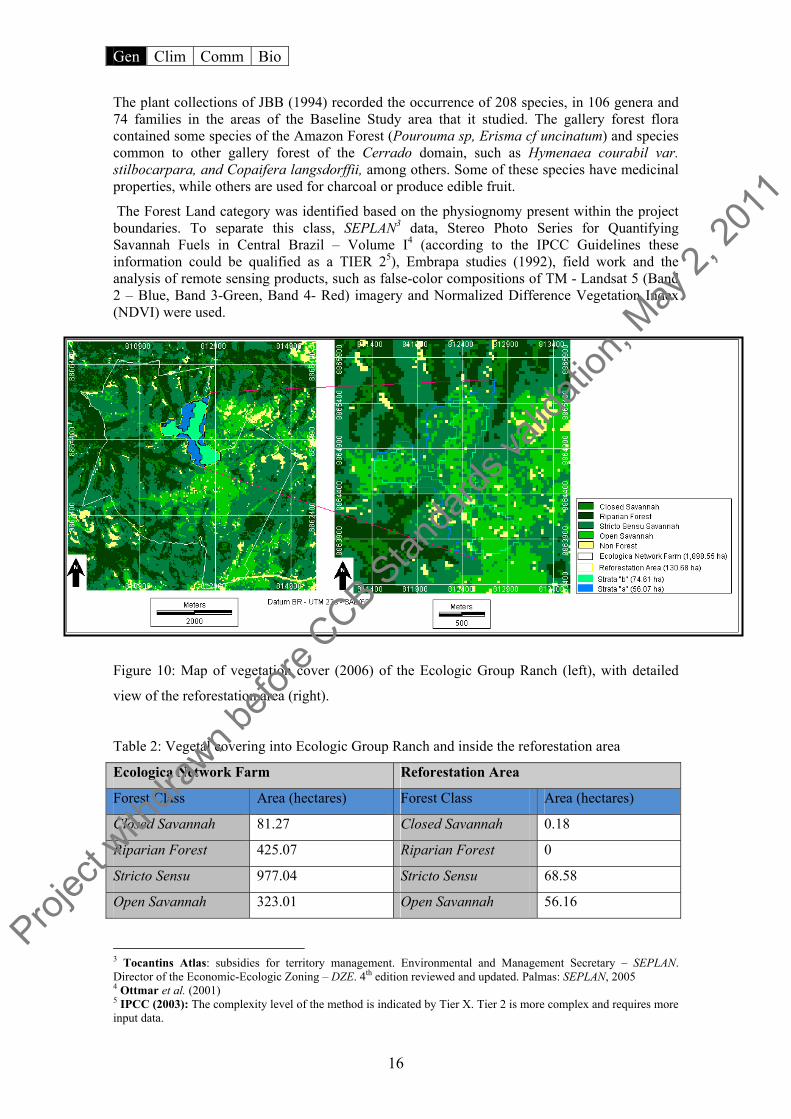
The Forest Land category was identified based on the physiognomy present within the project boundaries. To separate this class, SEPLAN3 data, Stereo Photo Series for Quantifying Savannah Fuels in Central Brazil – Volume I4 (according to the IPCC Guidelines these information could be qualified as a TIER 25), Embrapa studies (1992), field work and the analysis of remote sensing products, such as false-color compositions of TM - Landsat 5 (Band 2 – Blue, Band 3-Green, Band 4- Red) imagery and Normalized Difference Vegetation Index (NDVI) were used.
Figure 10: Map of vegetation cover (2006) of the Ecologic Group Ranch (left), with detailed
view of the reforestation area (right).
Table 2: Vegetal covering into Ecologic Group Ranch and inside the reforestation area
Ecologica Network Farm Reforestation Area
Forest Class Area (hectares) Forest Class Area (hectares)
Closed Savannah 81.27 Closed Savannah 0.18
Riparian Forest 425.07 Riparian Forest 0
Stricto Sensu 977.04 Stricto Sensu 68.58
Open Savannah 323.01 Open Savannah 56.16
3 Tocantins Atlas: subsidies for territory management. Environmental and Management Secretary – SEPLAN. Director of the Economic-Ecologic Zoning – DZE. 4th edition reviewed and updated. Palmas: SEPLAN, 2005 4 Ottmar et al. (2001) 5 IPCC (2003): The complexity level of the method is indicated by Tier Х. Tier 2 is more complex and requires more input data.
Projec
t with
drawn b
efore
CCB Stan
dards
valid
ation
, May
2, 20
11

Gen Clim Comm Bio
17
Non Forest 92.16 Non Forest 5.76
Total 1898.55 Total 130.68
Climate Information G1.3 Current carbon stocks within the project area(s), using land-use stratification and methods of carbon calculation (such as biomass plots, formulae, default values) from the Intergovernmental Panel on Climate Change’s 2006 Guidelines for National GHG Inventories for Agriculture, Forestry and Other Land Use (IPCC 2006 GL for AFOLU) or other CCBA approved methodologies As stated by the methodology regarding baseline approach, the most likely baseline scenario for this small-scale A/R project activity is considered to be the land-use prior to the implementation of the project activity, that in this case is grassland used as pasture for cattle grazing, with frequent burning during the dry season.
Natural regeneration is not expected to contribute significantly to the carbon stock available in woody perennials even if the constant burns and cattle grazing were to halt, especially in stratum (b) where the old natural vegetation is not characterized as a forest physiognomy6.
Additionally, it has been observed in similar and nearby areas, where cattle grazing has been excluded for several years, have not resulted in a greater presence of trees, but rather invasive weeds, grassland and some shrubs. This is probably due to the soil physical and chemical characteristics (rocky and acid, respectively) that encourage natural cover of open savannah regardless of human intervention affecting the resilience capacity of the ecosystem, unless under land preparation practices such as liming (pH correction), ploughing and direct seedling introduction.
On the other hand, the regeneration process of the (a) stratum after a long time under human influence is not supposed to reach 10% of the biomass mean annual increment obtained under the project activities. This aspect can be observed in some areas of these strata that were deforested at least 10 years ago but have not been grazed for the past few years. Meanwhile, due to lack of financial resources of the land owner, fire could not be suppressed during this period which contribute to an overall diminished resilience of the area.
The land is degraded and there are barriers that prevent investors and local communities from implementing different types of land uses such as forests not destined for timber production. “Business as usual” predicts that without the proposed A/R CDM project activity, the project area will continue as pasture, as will the management practice of burning the biomass in the project region.
Thus the baseline projection of biomass project a reduction or at least smaller increases in the absence of the project activities.
On the other hand, the project activities will prepare the land to create the necessary conditions for seedling success, of the contribution of carbon removal from atmosphere through photosynthesis, and live biomass storage in trees.
The live biomass carbon stock changes, as mentioned before, were conservatively assumed as zero; notwithstanding, the current carbon stocked calculated in live biomass in both strata. This value will be subtracted from the total GHG removed from the project activities, in order to achieve the net anthropogenic GHG removal.
Table 3: Baseline Assumptions
6 According to the definition of forest by the Ministry of Science and Technology (MCT).
Projec
t with
drawn b
efore
CCB Stan
dards
valid
ation
, May
2, 20
11

Gen Clim Comm Bio
18
Area Size (Ha)
Current and historic land use
Number of trees/Ha
Current Carbon stock/ha (Tier 2)
Baseline projection Data source (Tier 2) Observation
Stratum
(a)
56.1 Deforestation of closed Savannah and introduction of exotic grasses for cattle-grazing
667 40.9 tCO2eq/ha Fire, cattle and exotic grasses will continue to degrade this stratum, preventing establishment and growth of natural tree species
Field survey based in the “Stereo Photo Series for Quantifying Cerrado Fuels/Biomass in Central Brazilian Savannah Volume I”
Burning occurs in the area every year. Cattle were sold7 in July, 2008, for the purpose of this project
Stratum
(b)
74.6 Open savannah managed as grassland for cattle-grazing
1110 13.9 tCO2eq/ha Natural characteristic of the area, as soil acidity and rocks and the cattle and the fire will prevent establishment and growth of natural tree species
Field survey based in the “Stereo Photo Series for Quantifying Cerrado Fuels/Biomass in Central Brazilian Savannah Volume I”
Burning occurs in the area every year. Cattle were sold8 in July, 2008, for the purpose of this project
Community Information G1.4 A description of communities located in and around the project area, including basic socioeconomic information (using appropriate methodologies such as the livelihoods framework).
The communities in the vicinity of the project area are the urban areas Palmas, the capital of the state of Tocantins and the district of Taquarussu located 32 km from the capital in the interior of the Lajeado APA.
According to City Government, the municipality of Palmas is part of the North Region (based on the Brazilian national macro-regional classification system), with an expanse of 2218 km2 and located on the right bank of the Tocantins River. City center is located at the coordinates –10°12’46’’ S, -48°21’37’’ W and has average altitude of 330m above sea level. The Brazilian Institute for Geography and Statistics (IBGE) locates the city in the Oriental Mesoregion of the state.
Palmas, founded over 20 years ago, is Brazil’s newest capital city, exhibiting the most impressive demographic growth rates in the last decade and receiving people from nearly every Brazilian state. According to estimates by IBGE, the municipality experienced a population growth of 156.50% in 2006 campared to the resident population in 1996. Specifically, the populations rose from 86,116 to 220,888 with an average annual growth rate of 9.75%, according to IBGE studies.
In terms of education, the municipality registered 34,081 enrollments in primary schools and 11,792 high school enrollments in 2007. In 2005, the city had a total 100 health establishments, of which 72 were registered with the National Health System (SUS).
In recent years, the economic development that the municipality of Palmas has experienced in a way has contributed to the draw of a population contingent coming from various parts of the country. This migratory flux is attributed to the expectation created by the rise in business and job opportunities as a result of the creation of the state and its capital.
7 See more details on the section CL2. 8 See more details on the section CL2.
Projec
t with
drawn b
efore
CCB Stan
dards
valid
ation
, May
2, 20
11

Gen Clim Comm Bio
19
Upon the creation of the state of Tocantins in decade of the 80s and its capital Palmas, various factors have contributed to the environmental deterioration in the region primarily as a result of a process of disorganized use and occupation of the landscape, combined with a common cultural change in the opening of new frontiers.
The primary source of revenue of the district of the Taquarassu according to the Socio-economic and Environmental Diagnostic of the sub basin of the Taquarassu Grande River is salaried work representing 33%, followed by the sale of part-time laborers at 25%. These data point to a possible leaking-out of labor utilized in its own subsistence production, thus reducing the quantity of goods produced.
From the data above, 65% of the interviewed received up to twice the monthly minimum wage. However, of those, 45% received only 1.5 times the minimum. Again according to the Socio-economic and Environmental Diagnostic produced by the Thousand Women Project of the Federal Technical School of Palmas, Taquarassu family access to the government programs to combat poverty is high. Nearly 67% of families receive some type of assistance and approximately 80% of these families receive up to R$150.00/month in benefits.
With respect to education, the illiteracy rate stands at around 10% of those interviewed, and the scholasticism reached 90%, and of this 5% have completed higher education. The district of Taquarassu further benefits from a local cultural center offering classes and capacity-building courses in the artes and trades, as well as a Reference Center for Social Assistence for the same purpose.
In relation to the health of citizens, the existence of the The Community Health Agency Program is recognized and admits bimonthly family visits. In the district there is also a Health Post, however, according to the Socio-economic and Environmental Diagnostic of the Taquarassu Grande River sub basin, Taquarassu citizens attest to the problems in the Health Posts including (25%) a shortage of doctors, (22%) shortage of medication, and (15%) delays in seeing the patient/distances to the post, among other problems.
According to the same diagnostic, in relation to basic sanitation it was observed that a majority of properties included a dwelling built of concrete (81%) and equipped with sanitation installations (86%). The most use is the Fossa Negre system (52%). Meanwhile, 87% of water consumed comes from a cistern or well, where 74% used some kind of water treatment before consumption, a great majority (90%) using water filtration as the treatment method.
Among the illnesses identified in the study, diarrhea and giardia were identified as being directly related to the type of water treatment, since this did not guarantee disinfection. 53% of interviewees burned household solid waste, followed by 28% who say they take their trash to the city, where it is deposited in collectors installed by the city government.
With respect to local culture, many of the activities occurring in the region in part orginate in the estate whence the migrants came. Handicraft is one of the principal cultural components in the region.
In the district of Taquarassu near the project area there are two rural settlements that were established by Agrarian Reform. According to the National Instute for Colonization and Agrarian Reform (INCRA), “Agrarian reform is a suite of measures whose aim is to promote better distribution of land, by means of modifications in the ownership and use regimes, and with the purpose of upholding the principles of social justice, of rural sustainable development, and of increasing production.”
The Settlement projects of Entre Rios and Taquarassu Mountains, located roughly 10km from the district of Taquarassu, current report a total of 131 families currently settled and organized into two associations. Both of the settlements are involved in rice, beans, corn, and manioc cultivation for subsistence. Also present is subsistence cattle ranching and milk production. Some families have initiated artisanal production of cheese and other milk products for sale, but
Projec
t with
drawn b
efore
CCB Stan
dards
valid
ation
, May
2, 20
11
Gen Clim Comm Bio
20
have been prohibited by the National Health Monitoring Agency (ANVISA) from producing for commercial sale.
The settlements have infrastructural features such as neighborhood roads between parcels, electricity, and cistern water supplies. Children of school age go attend a school near the district of Buritirama, and use a school bus provided by the City of Palmas.
G1.5 A description of current land use and land tenure at the project site (see also G5).
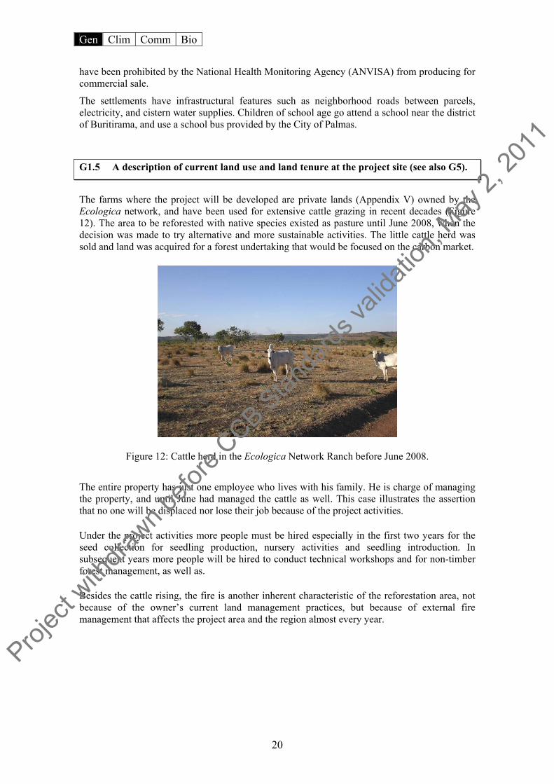
The farms where the project will be developed are private lands (Appendix V) owned by the Ecologica network, and have been used for extensive cattle grazing in recent decades (Figure 12). The area to be reforested with native species existed as pasture until June 2008, when the decision was made to try alternative and more sustainable activities. The little cattle herd was sold and land was acquired for a forest undertaking that would be focused on the carbon market.
Figure 12: Cattle herd in the Ecologica Network Ranch before June 2008.
The entire property has just one employee who lives with his family. He is charge of managing the property, and until June had managed the cattle as well. This case illustrates the assertion that no one will be displaced nor lose their job because of the project activities.
Under the project activities more people must be hired especially in the first two years for the seed collection for seedling production, nursery activities and seedling introduction. In subsequent years more people will be hired to conduct technical workshops and for non-timber forest management, as well as.
Besides the cattle rising, the fire is another inherent characteristic of the reforestation area, not because of the owner’s current land management practices, but because of external fire management that affects the project area and the region almost every year.
Projec
t with
drawn b
efore
CCB Stan
dards
valid
ation
, May
2, 20
11
Gen Clim Comm Bio
21
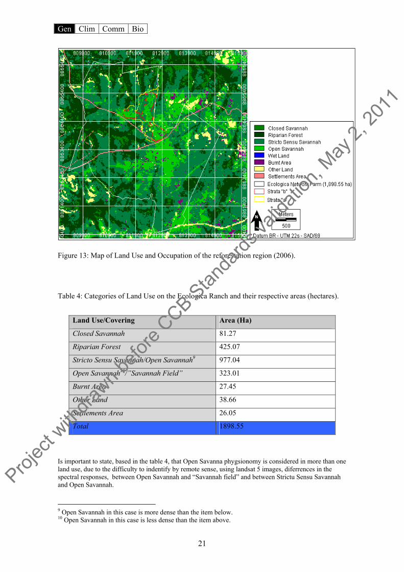
Figure 13: Map of Land Use and Occupation of the reforestation region (2006).
Table 4: Categories of Land Use on the Ecologica Ranch and their respective areas (hectares).
Is important to state, based in the table 4, that Open Savanna phygsionomy is considered in more than one land use, due to the difficulty to indentify by remote sense, using landsat 5 images, diferrences in the spectral responses, between Open Savannah and “Savannah field” and between Strictu Sensu Savannah and Open Savannah.
9 Open Savannah in this case is more dense than the item below. 10 Open Savannah in this case is less dense than the item above.
Land Use/Covering Area (Ha)
Closed Savannah 81.27
Riparian Forest 425.07
Stricto Sensu Savannah/Open Savannah9 977.04
Open Savannah10/”Savannah Field” 323.01
Burnt Area 27.45
Other Land 38.66
Settlements Area 26.05
Total 1898.55
Projec
t with
drawn b
efore
CCB Stan
dards
valid
ation
, May
2, 20
11
Gen Clim Comm Bio
22
Biodiversity Information
G1.6 Description of current biodiversity in the project area and threats to that biodiversity, using appropriate methodologies (e.g., key species habitat analysis, connectivity analysis), substantiated where possible with appropriate reference material.
The entire Savannah region has a marked dry season, which can last between 4-6 months with precipitation ceasing towards the end of April, and no further rainfall occurring until the beginning of October. This prolonged drought has a marked influence on the vertebrate fauna in the Lajeado Range, particularly for migratory birds that make temporary use of the area and whose migratory route is oriented in a North-South direction, following the course of the River Tocantins.
Conservation International (CI) considers the Cerrado Biome a “biodiversity hotspot”. CI maintains that a hotspot occurs when two factors combine: “the high number of endemic species (or species which exist nowhere else in the world) and a high degree of threat. The plants are generally used as the measure of endemism. Hotspots have at least 1500 endemic plant species and have lost at least 75% of its vegetation cover, isolating many species in small forest islands. In some hotspots the destruction reaches 90% of the landscape. Only 22% of the Cerrado is left.”
The biodiversity in the project site is very complex and extensive. In the following section the approach for the vegetation is analogous to the characterization presented in the section G.1.2 the preliminary characteristics of the fauna will be introduced, as is complemented by section B.
• Palm groves: Dominant species in this vegetation type are buriti (Mauritia vinifera) and babaçu (Orbignya oleifera) palms, as well as Copernicia and Acrocomia and associated palm species. These species tend to favor topographical features such as open or enclosed depressions in the hydrographic network, where soil moisture is high. Such features are found at the base of plateaus, river headwaters, springs and creeks. Wading birds such as egrets, rails and herons are common.
• Stricto Sensu Savannah: The vertical structure of the vegetation is irregular, and harbors fauna specialized in exploiting each vegetative stratum.
• Closed Savannah: This is a forest type has significant densities of high and low woody species. Species of cerrado zones and others of broad-leaved deciduous forest are present. There are numerous fruit eating species in these habitats.
• Riparian Foress: Because of the ready availability of water in these habitats, they are important refuges for a number of species in the dry period.
• Open Savannah: This type is occupied by fauna of open environments with rodents and insectivorous or seed-eating birds being very common.
In surveys11 in the project region species were identified in the study area through direct observation and indirect observation, noting the presence of droppings, feathers, tracks, nests, holes, etc. The researchers occasionally resorted to trapping to help identify some specimens, particularly animals with crepuscular or nocturnal habits.
Costa et al (1981) cite roughly 1500 species of reptiles, birds and mammals occurring in the Brazilian Savannah. In surveys conducted in the Lajeado Environment Preservation Area (APA), almost 138 species of vertebrates were identified, of which 87 were birds, 33 were mammals, and 18 were reptiles. All told, there were 60 families present, of which 36 were birds, 17 mammals and 7 reptiles. The bird group, with approximately 63% of the total species richness of the area, is the best represented. Mammals are next with 23%, and the reptile group
11 EMBRAPA (1992).
Projec
t with
drawn b
efore
CCB Stan
dards
valid
ation
, May
2, 20
11
Gen Clim Comm Bio
23
has 14% and thus has the least number of species of the three. Of course, this inventory is by no means complete, but nevertheless gives a fairly accurate picture of the Lajeado fauna.
The bird group is the richest in species, not only in the area studied, but also in the Savannah as a whole. In all 935 bird species are found in Brazilian Savannahs. Thus the Lajeado Range, which represents only 0.07% of the total Savannah area, contains representatives of almost 10% of all Savannah species.
The total number of mammals identified on the Brazilian Savannah is 298 species. In the Reference Area, 39 species were recorded12, which is more than 10% of the Savannah´s mammal species. It should be noted that in this group there are large species such as anteaters, paca, jaguar, deer and wild dog, which have a high biological value since they are endangered species in other regions of the country. These species tend to survive best in inaccessible areas, which have been altered little by humans.
Such areas could include the riparian forests along the Lajeado Creek, and probably those along the Água Suja, São Jõao and Mangues Creeks. The THEMAG researchers also note that large predators such as the jaguar (Panthera onca) and the cougar (Puma concolor) are only recorded in the Lajeado Range, and not in the plains of the Tocantins River Valley13. Nonetheless, these animals need large areas, and could therefore make use of the riparian forests for their movements, making occasional incursions into the Lajeado area.
The reptiles, with 7 families, are present in modest numbers with most of the species recorded belonging to the serpent group. Of the 268 reptile species known to occur in the Savannah, 18 were found and identified in the reference area, thus representing more than 6% of Savannah reptile species. The Colubridae family is the richest, with 6 species present, all of which are non-poisonous. Among the lizards, iguanas (chameleon) tegu and calangos are most common, and have varied dietary habits (herbivores, omnivores and carnivores).
Of the 5 classificatory units mentioned above, the Summit Zone is the richest in terms of fauna, with 106 vertebrate species being found. Among the species which are only found in this zone are the rhea, the wild dog, and the black snake. The second richest unit is the Valley Bottom Zone, where 72 species were recorded, but only 2 of them (the nun bird and the black lizard) are found only in this type of environment.
The Foothills have 65 vertebrate species, typical of the Savannah (e.g. field woodpecker, partridge).
Only 3 species are unique to this type of microhabitat, two kingfishers and one teal species. The Summit Veredas revealed 60 vertebrate species, with only 2 being exclusively found in such habitats - the tapir and the otter – both of which are classified as endangered species.
The Scarp Slope fauna was represented by 56 species, 3 of which are unique to this type of microhabitat.
Skunks and field foxes were the most commonly observed mammals during field excursions. Green parakeets and doves were the commonest birds, and the calango, tegu lizards, and vine snakes were the commonest reptiles. These species occupy a wide range of habitats and are relatively tolerant of human activities.
The number of invertebrate species probably exceeds several thousands. The species found and recorded are the most dominant, and consequently perform an important role in the composition/structure of fauna populations, and in the equilibrium of the ecological systems of the Lajeado APA.
Table 5: Biodiversity counts in the Cerrado.
12 EMBRAPA (1992). 13 THEMAG (1996): The company responsible by the Management Plan of the Lajeado state Park
Projec
t with
drawn b
efore
CCB Stan
dards
valid
ation
, May
2, 20
11

Gen Clim Comm Bio
24
Savannah Endemic Threatened %
Plants 11.000 40 10
Mammals 199 19 10
Birds 837 29 3
Reptiles 177 20 < 1
Amphibians 150 32 ?
Fishes 1.200 ? ?
Invertebrate 67.000 ? ?
Source: Embrapa Cerrados, 2008
G1.7 A list of all IUCN Red List threatened species (which encompasses endangered and vulnerable species) and species on nationally recognized list (where applicable) found within the project boundary (See also B1).
Table 6: Rare and Endangered Species on the project area14.
Scientific Name Popular Name Risk Level
Harpyhaliaetus coronatus Águia-cinzenta Endangered
Penelope ochrogaster Jacu-de-barriga-vermelha Vulnerable
Procnias averano averano Araponga-de-barbela Least Concern
Cercomacra ferdinandi Chororó-tocantinense Vulnerable
Culicivora caudacuta Maria-do-campo Vulnerable
Anodorhynchus hyacinthinus Arara-azul-grande Endangered
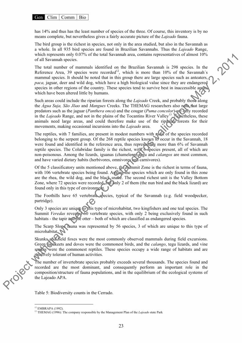
Cyanopsitta spixii Ararinha-azul Critically Endangered
Pyrrhura pfrimeri Tiriba-de-orelha-branca Endangered
Taoniscus nanus Inhambú-carapé Vulnerable
Blastocerus dichotomus Cervo-do-pantanal Vulnerable
Chrysocyon brachyurus Lobo-guará Near Threatened
Speothos venaticus Cachorro-vinagre Vulnerable
Leopardus pardalis mitis Jaguatirica Least Concern
Leopardus tigrinus Gato-do-mato Near Threatened
14 Based on the list of the Brazilians Environmental Ministry and in the IUCN Red List.
Projec
t with
drawn b
efore
CCB Stan
dards
valid
ation
, May
2, 20
11
Gen Clim Comm Bio
25
Leopardus wiedii Gato-maracajá Least Concern
Oncifelis colocolo Gato-palheiro Near Threatened
Panthera onca Onça-pintada Near Threatened
Pteronura brasiliensis Ariranha Endangered
Priodontes maximus Tatu-canastra Vulnerable
Myrmecophaga tridactyla Tamanduá-bandeira Near Threatened
Figure 14: Species present in the Project Area: Lobo Guará (left), Ararinha Azul (center) e
Jaguatirica (right).
G2 Baseline Projections
G2.1Description of the most likely land-use scenario in the absence of the project: would existing laws and regulations have required project activities anyway?
Under a reference scenario of “no project”, the reforestation area and Grupo Ecologica Ranch are described according to the perspectives of the surrounding areas where the common practice of the region exerts strong pressures on the ecosystems and natural resources.
A local and regional propensity exists to manage land without caution or adequate techniques. Common practices include clearing of pastures where native vegetative cover is removed and crude management techniques like the periodic use of fire. The use of fire is considered “business-as-usual” in the region and occurs most frequently during the dry months of July to October which mirrors the dry season in the North of Brazil.
In general the land is degraded and there are barriers that prevent investors from implementing different types of land uses such as forestry for non-timber production. Without the proposed A/R project activity, the project area will continue to be a pasture and the management practice of burning the biomass will also continue to be the “business as usual”, regardless the environment “conscience” of the property owners. Thus the biomass baseline projection is supposed to reduce or have smaller increases without the project activities.
Projec
t with
drawn b
efore
CCB Stan
dards
valid
ation
, May
2, 20
11

Gen Clim Comm Bio
26
Although fires and logging in the cerrado15 are permitted with authorization from a responsible government agency16, the great majority of fires and burning are illegal, or without the proper authorization. In this regard the Forest Code of Brazil has been systemmatically ignored in the State of Tocantins and in the North of the Brazil in general. The environmental agencies on the other hand, do not have adequate infrastructure: neither a complete functioning body nor enough resources to fine non-comforming properties. The land of the Grupo Ecologica Ranch that composes the region where the forestation area is located, is covered with more than 35% native vegetation required by law dealing with Legal Reserve17. Thus the planned reforestation, in the scope of Forest Code, is not legal requirement. After Ecologica Group acquired the properties, the area became managed less intensively than in the past or compared to surrounding properties. Although less intensive can be equated with less “predatory” or more sustainable with respect to land use, the area has not escaped the effects of either the spread of fires from neighboring properties or arson.
That is, though the current land-owners may show an environmental awareness and perception, cattle ranching continues within the project boundaries and the fires have not ceased. The lack of resources for conservation and the necessity of earning money to cover property expenses are among the principal factors in ensuring the continuity of business-as-usual practices is in the project areas.
One common practice in the region is the reconditioning and clearing of pastures through the use of fire. According to the Brazilian Agricultural Research Agency (EMBRAPA), fire is employed in the preparation of pastures for planting and harvest. However, the use of fire implies the gradual loss of biodiversity and a drastic alteration in the vegetation structure, which occurs especially when fires are frequent. “In terms of the interferences to chemical and biological exchange processes, the harm to the most superficial soil layers caused by fire are known and have been observed. Harm also in terms of the adaptability of fauna, in groves with occurrence of Indaia Palm (Attalea exigua) and bromeliads, where invertebrate fauna are protected from fire by the humid spaces of the leaf base.”
The occurrence of palms in genus Mauritia also increase biomass, giving fire a greater permanence and consequently, increasing the heat over the soil. In larger landscapes such as the cerradão and riparian forests, the accumulation of organic matter originating in humid soil horizons are sufficient to generate catastrophic effects as in any forest formation.
While there are species in the Cerrado capable of resisting fire, a gradual loss of biomass in woody individuals is becoming apparent in the reforestation area with every fire that passes through. Susceptibility to forest fires is increased with the annual burning of conserved forest fragments, and thus the process of degradation contributes in the medium and long term to deforestation of the area. The practice of reforestation on the other hand, associated with relevant components of fire fighting and preventions, becomes an additional remedy. Together with fire, other processes of degradation in the cerrado are equally representative, such as: anthropogenic interference in ecosystems through deforestation, use of chemical pest control, opening of roads, new and existing urban construction and expansion, among others.
Due to the common practices in the region, the cerrado biome and the existing communities in the region lose out when the products of biodiversity are used unsustainably. Although great agricultural productivity is possible, it is restricted to large landholders, while the biodiversity resources such as essential oils, sweets, seed fibers, honey, and others, are rarely among the economically viable options to more needy communities, since they are systematically crippled and replaced by activities of large agribusiness.
15 According to the National Forest Code (Law No. 4771, of 15 September 1965. art 16th ), just 65% of natural vegetal cover in the project region is allowed to be removed for alternative land use. 16 Nature Institute of Tocantins (NATURATINS) 17 See land use map item G1.5
Projec
t with
drawn b
efore
CCB Stan
dards
valid
ation
, May
2, 20
11

Gen Clim Comm Bio
27
G2.1.1 Land Eligibility
The approach used to assess the maintenance of biomass/carbon stock within the project boundary (stable baseline) in the last years was a Normalized Difference Vegetation Index (NDVI)18 analysis between Landsat 5 satellite images of May 1987 and June 2006 (dry season). The difference between two images over the 19-year interval showed no significant difference in the vegetation cover. This assessment supports the argument for baseline future projections assumed for both reforestation strata.
Figure 15: NDVI values for Landsat 5 TM image acquired May 1987 showing reforestation area in detail (right).
Figure 16: NDVI values for Landsat 5 TM image acquired June, 2006, showing reforestation area in detail (right).
18 MARQUES Jr. & SOUSA, 2007 have used the NDVI approach for detection of changes in vegetation cover in natural Brazilian biomes.
Projec
t with
drawn b
efore
CCB Stan
dards
valid
ation
, May
2, 20
11

Gen Clim Comm Bio
28
Figure 17: NDVI difference values (NDVI-06 – NDVI-87) showing reforestation area in detail (right).
The difference between NDVI-06 and NDVI-87 did not exceed 0.33 (Figure 17) in the majority of the project area, which translates to a mean annual vegetation cover change of less than 1.7%. Dark green areas represent the stratum (b) where the carbon stock changes are less significant (in some cases even negative) and where the current carbon stock is small. The light green- yellow represents the stratum (a) where the current carbon stock is slightly higher and where the carbon stock changes in the last two decades presented higher values compared to stratum (a), but still much less than the 10% of the GHG emissions equivalent removed by project activities. The discount follows the methodology: AR-AMS0001.
The baseline approach 22(a): “Existing or historical, as applicable, changes in carbon stock in the carbon pools within the project boundary”, is the most appropriate approach for determination of the baseline scenario. On the other hand, approach 22(b): “Changes in carbon stocks within the project boundary from a land use that represents an economically attractive course of action” is not applicable for several reasons (see additionality analysis) such as, difficulty of reaching an attractive internal rate of return (IRR). Another example is the difficulty in obtaining a decent income form non-timber forest product ventures. Yet another example is a lack of resources or even credit access to start a native forest plantation. There is much uncertainty about “alternative” forest products and this aspect is a priority of the project. Natural regeneration (of above and below ground biomass) is not expected to exceed 10% of the ex-ante actual net GHG removals by the project’s A/R activities, even if the area is isolated from fire, and cattle grazing. There has been a long period of human activities, which led to a stage of severe degradation that will be difficult to overcome, and which is planned for reforestation. Moreover, some regions within the project border never existed as forest and
G2.1.2 Justification of the applicability of the proposed small-scale A/R CDM project activity to baseline methodology
Projec
t with
drawn b
efore
CCB Stan
dards
valid
ation
, May
2, 20
11

Gen Clim Comm Bio
29
would never be able to stock significantly more biomass than is currently present. The plan is for these areas to undergo afforestation. Some of these areas are known as Open Savannahs and the only way for them to support a forest is by human intervention. The third approach 22(c) “Changes in carbon stocks within the project boundary from the most likely land use at the time the start of the project.” is also a valid option because in this case it resembles Approach 22(a). Finally, the status of the land is economically unattractive, and there is no economically attractive alternative beyond cattle grazing, unless the up-front or ex-ante carbon credits income become available. The proposed small-scale A/R CDM project activity complies with the applicability conditions under which the chosen baseline methodology is applied and this technical study was developed in the same way that is specified in the methodology: The project baseline approach is presented in section 5 of part II. “Baseline net greenhouse gas removals by sinks” contained in AR-AMS0001 states that “The most likely baseline scenario of the small-scale A/R CDM project activity is considered to be the land-use prior to the implementation of the project activity, either grasslands or croplands”. The actual land use of the area, for either strata (see strata description below) is a mix of native and exotic grasses to support cattle grazing (Figure 18). This land is subject to frequent fires (Figures 19 and 20) originating in neighboring pastures. Thus the most frequently applied baseline is approach (b) “carbon stock in the living biomass of trees is expected to decrease in the absence of the project activity” from paragraph 6. In this case, according to approach (b) “the baseline net GHG removals by sinks shall be conservatively assumed to be zero” where “the baseline carbon stocks in the carbon pools are constant and equal to the existing carbon stocks measured at the start of the project activity”.
Figure 18: Unproductive and extensive grassland. Project area land use before June, 2008
Figure 19: Cerrado tree death by the constant fires (photo Left) and burnt dead wood in the project area (photo Right).
Projec
t with
drawn b
efore
CCB Stan
dards
valid
ation
, May
2, 20
11
Gen Clim Comm Bio
30
G2.1.3 Stratification of the Project Area
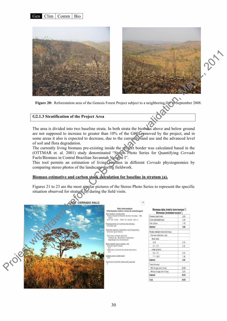
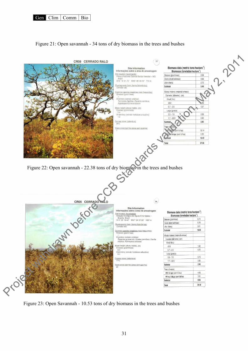
The area is divided into two baseline strata. In both strata the biomass above and below ground are not supposed to increase to greater than 10% of the GHG removed by the project, and in some areas it also is expected to decrease, due to the currently land use and the advanced level of soil and flora degradation. The currently living biomass pre-existing inside the project border was calculated based in the (OTTMAR et. al. 2001) study denominated “Stereo Photo Series for Quantifying Cerrado Fuels/Biomass in Central Brazilian Savannah Volume I”. This tool permits an estimation of living biomass in different Cerrado physiognomies by comparing stereo photos of the landscape during fieldwork. Biomass estimative and carbon stock calculation for baseline in stratum (a). Figures 21 to 23 are the most similar pictures of the Stereo Photo Series to represent the specific situation observed for stratum (a) during the field visits.
Figure 20: Reforestation area of the Genesis Forest Project subject to a neighboring fire in September 2008.
Projec
t with
drawn b
efore
CCB Stan
dards
valid
ation
, May
2, 20
11
Gen Clim Comm Bio
31
Figure 21: Open savannah - 34 tons of dry biomass in the trees and bushes
Figure 22: Open savannah - 22.38 tons of dry biomass in the trees and bushes
Figure 23: Open Savannah - 10.53 tons of dry biomass in the trees and bushes Proj
ect w
ithdra
wn befo
re CCB S
tanda
rds va
lidati
on, M
ay 2,
2011

Gen Clim Comm Bio
32
According to the tables beside the pictures above, the mean value of biomass per hectare for the tree and woody perennial individuals19 in stratum (a) is about 22.3 tons of dry matter per hectare, or the CO2eq around 40.9 tons/hectare20 The subsequent images are pictures taken from stratum (a) in order to enable comparisons between the reference study and reality:
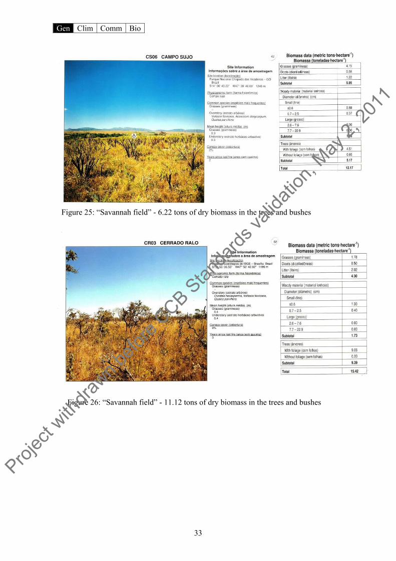
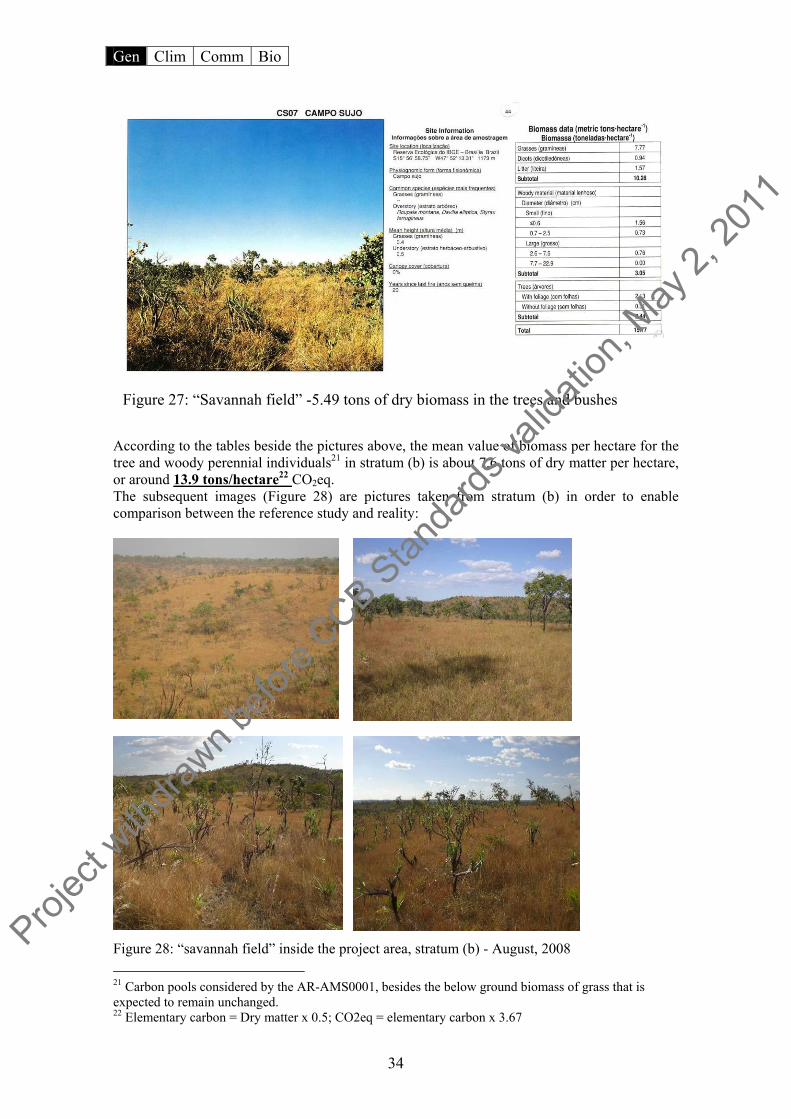
Figure 24: Open savannah inside the project area, stratum (a) - August, 2008 Biomass estimate and carbon stock calculation for baseline in stratum (b) Figures 25 to 27 are the most similar pictures of the (OTTMAR, et. al. 2001) study to represent the specific situation observed for stratum (b) during the field visits.
19 Carbon pools are considered by the AR-AMS0001, besides the below ground biomass of grass that is expected to remain unchanged. 20 Elementary carbon = Dry matter x 0.5; CO2eq = elementary carbon x 3.67
Projec
t with
drawn b
efore
CCB Stan
dards
valid
ation
, May
2, 20
11
Gen Clim Comm Bio
33
Figure 25: “Savannah field” - 6.22 tons of dry biomass in the trees and bushes
Figure 26: “Savannah field” - 11.12 tons of dry biomass in the trees and bushes
Projec
t with
drawn b
efore
CCB Stan
dards
valid
ation
, May
2, 20
11
Gen Clim Comm Bio
34
According to the tables beside the pictures above, the mean value of biomass per hectare for the tree and woody perennial individuals21 in stratum (b) is about 7.6 tons of dry matter per hectare, or around 13.9 tons/hectare22 CO2eq. The subsequent images (Figure 28) are pictures taken from stratum (b) in order to enable comparison between the reference study and reality:
Figure 28: “savannah field” inside the project area, stratum (b) - August, 2008 21 Carbon pools considered by the AR-AMS0001, besides the below ground biomass of grass that is expected to remain unchanged. 22 Elementary carbon = Dry matter x 0.5; CO2eq = elementary carbon x 3.67
Figure 27: “Savannah field” -5.49 tons of dry biomass in the trees and bushes
Projec
t with
drawn b
efore
CCB Stan
dards
valid
ation
, May
2, 20
11

Gen Clim Comm Bio
35
The project area, for purpose of the baseline carbon stock calculation, was classified into two strata according to the characteristics stated in paragraph 7 of the methodology baseline:
Figura 29: Reforestation Area classified according to the current biomass stock
• Reforestation Area
(a) This stratum of approximately 56.1 hectares is divided into 4 separated areas. These areas, according to local people and neigbours, used to be Closed Savannah, where the natural vegetation was suppressed or displaced by exotic grassland species (Andropogon sp.), for the previous owner, interested in cattle feeding rising. Presently, in terms of vegetation physiognomy, the area can be considered an Open Savannah or “Cerrado ralo”. The woody perennials and the grassland carbon stock that currently exist in this stratum are not expected to change or increase by more than 10% of GHG removed by the project activities based on business-as-usual practices that the area has experienced (see section G 2.1.1). in this case the approach used was the approach “a”, paragraph 6 of the methodology. Thus, the assumed carbon stock changes for the ex-ante actual net GHG is zero. The current carbon stock in the living biomass was calculated and subtracted from the ex-ante project activity GHG removals.
• Afforestation Area
(b) Area of grassland with changes in the carbon stocks in the living biomass pool of woody perennials and in below-ground biomass of grasslands is not expected to exceed 10% of ex-ante actual net GHG removals by sinks multiplied by its share of the area in the entire project area (see section G 2.1.1). This stratum represents the other 74.6 hectares of the project area. A single uninterrupted area composes this stratum. Stratum (b) shares the same characteristics and land use conditions of the stratum (a), where the woody biomass suffered sistematicaly depleciation due to the fires and cattle. The difference in this case is that the area is naturally an Open Savannah/Cerrado strictu sensu and “Savannah field” or campo sujo”(Figure 30). Since this area is naturally an Open Savannah, the biomass is not expected to increase, but rather may decrease due to fire. Biomass recovery after fires is not expected to exceed “historic” and natural levels of an Open Savannah. Thus the most applicable baseline assumption in these
Projec
t with
drawn b
efore
CCB Stan
dards
valid
ation
, May
2, 20
11

Gen Clim Comm Bio
36
areas is item “b”, from paragraph 6 of the methodology. In this stratum as well stratum (a) the current carbon stock in living woody biomass was calculated and subtracted from the ex-ante project activities GHG removals.
Figure 30: Overview of the two strata in the reforestation area 10°15’18’’S/48°09’29’’N (Google Earth Image)
G2.2 A projection of future carbon stock changes in the absence of the project, based on the land-use scenario described above. The timeframe for this analysis can be either the project lifetime (see G3) or the project accounting period, whichever is more appropriate2. If there is evidence that non-CO2 greenhouse gas (GHG) emissions such as CH4 or N2O are more than 15% of the baseline GHG fluxes at the project site (in terms of CO2 equivalents), then they must be estimated. The Project area has been under significant human influence for several decades (see section G 2.1.1). Almost all of the Cerrado biome (Brazilian Savannah) area is currently being used for extensive cattle grazing with native or planted pasture, while another large part of Brazilian savannahs are being used for agribusiness as soybean, cotton, and corn. With respect to land use the state of Tocantins is no exception. Tocantins currently has around 7 million head of cattle (seven times the human population) and has been showing an increasing trend, and is mirrored in the project district (Figure 32). The same trend is seen in large monocultures such as soybean, rise, cotton and corn. The main cropland in the project microregion (Porto Nacional) is soybean and in less proportion corn (Figure 31).
B A
Projec
t with
drawn b
efore
CCB Stan
dards
valid
ation
, May
2, 20
11

Gen Clim Comm Bio
37
Cropland area of corn and soy bean in the project microregion (hectares)
-10,00020,00030,00040,00050,00060,00070,00080,00090,000
100,000
1990
1992
1994
1996
1998
2000
2002
2004
2006
Year
Hec
tare
s
milhosoja
Figure 31: Increasing cropland area in the project microregion (Porto Nacional).
Herd of cattle in Palmas district
-5,000
10,00015,00020,00025,00030,00035,00040,000
1990
1991
1992
1993
1994
1995
1996
1997
1998
1999
2000
2001
2002
2003
2004
2005
year
herd
Palmas - TO
Figure 32: Increase in herd count in the project district (Palmas).
On the other hand no significant forest ventures (even traditional commercial forest, like eucalyptus monoculture) are currently being pursued in the state. Based on the common practices for land used and land use conversion, that is based in cattle grazing, constant use of fire as management tool and agribusiness, it is not expected that the owner will be able to avoid this kind of activity. In time, carbon credits will grant the landowner an opportunity to pursue an alternative activity and at the same time enable more generally capacity-building in the local communities in earning income sustainably. In a conservative approach, even after considering that the current carbon stock contained in the living biomass in the reforestation area is likely to diminish or show smaller increases without
Projec
t with
drawn b
efore
CCB Stan
dards
valid
ation
, May
2, 20
11
Gen Clim Comm Bio
38
the project activities23. The baseline carbon stock changes were thus conservatively assumed to be zero, and the actual biomass stock (baseline) was measured (Table 7) in order to subtract from the GHG removed by the project’s activities. For the baseline approach as well as other aspects regarding climate change mitigation and carbon, the approved baseline methodology was used: “Revised Simplified baseline and monitoring methodologies for selected small-scale afforestation and reforestation project activities under the clean development” Version 4.1, (AR-AMS0001). One of the main factors in support of the carbon stock baseline reduction approach to the project, is the constant fires affecting the project area as a result of ill-managed pastures and of the fire lines that came from paved and unpaved roads around the project farm. These fires also contribute to the destruction of a large part of the seed pool of several tree species, and contribute the reduced resilience of the savannah ecosystem. G2.2.1 Current carbon stock calculation in the project area
1. Baseline carbon stocks was determined by the equation:
Where: B(t) = carbon stocks in the living biomass within the project boundary at time t in the absence of the project activity (t C) BA(t)i = carbon stocks in above-ground biomass at time t of stratum i in the absence of the project activity (t C/ha) BB(t)i = carbon stocks in below-ground biomass at time t of stratum i in the absence of the project activity (t C/ha) Ai = project area of stratum i (ha) i = stratum i (I = total number of strata) Above-ground biomass 2. For above-ground biomass BA(t) is calculated per stratum i as follows:
Where: BA(t) = carbon stocks in above-ground biomass at time t in the absence of the project activity (t C/ha) M(t) = above-ground biomass at time t that would have occurred in the absence of the project activity (t d.m./ha)3 0.5 = carbon fraction of dry matter (t C/t d.m.) Below-ground biomass
3. For below-ground biomass BB(t) is calculated per stratum i as follows:
23 See baseline description in the absence of the project in item G2.1 and item C
(1)
(2)
Projec
t with
drawn b
efore
CCB Stan
dards
valid
ation
, May
2, 20
11
Gen Clim Comm Bio
39
Where: BB(t) = carbon stocks in below-ground biomass at time t that would have occurred in the absence of the project activity (t C/ha) Mgrass = above-ground biomass in grass on grassland at time t that would have occurred in the absence of the project activity (t d.m./ha) 24 Mwoody(t=0) = above-ground biomass of woody perennials at t=0 that would have occurred in the absence of the project activity (t d.m./ha) Rwoody = root to shoot ratio of woody perennials (t d.m./t d.m.) Rgrass = root to shoot ratio for grassland (t d.m./t d.m.)6 As the carbon stock baseline following the business as usual (BAU) is not expected to increase and may even decrease for stratum (b), and not expected to increase to more than 10% of the GHG project carbon removal for stratum (a), therefore, the baseline changes does not need to be monitored according to AR-AMS0001.
24 Grassland will be considered for neither the baseline nor the GHG removal, in order to maintain a conservative estimate and because of the constant variation in biomass due to fires.
(3)
Projec
t with
drawn b
efore
CCB Stan
dards
valid
ation
, May
2, 20
11

Gen Clim Comm Bio
40
Table 7: Constant biomass stock25, below and above ground and it respective biomass stock
already existent within the reforestation area in the next 40years without the project activities
25 More informatios about baseline approach available in section CL.1.1 – item “Baseline”
Projec
t with
drawn b
efore
CCB Stan
dards
valid
ation
, May
2, 20
11

Gen Clim Comm Bio
41
G2.3 Description of how the “without-project” scenario would affect local communities in the project area.
The communities settled in project area environs have been identified as leading subsistence lifestyles and consequently direct users of the available natural resources. They therefore (like urban communities) can be affected negatively by the adverse impacts on the local environment, especially those that damage soil and water resources.
With regard to latter aspect, the dependence of the city of Palmas’s water supply on the hydrological maintenance of the Taquarussu Grande River sub-basin should be reiterated, as well as the Taquarussu district, and surrounding between the Taquarussu Rivers and Mountains rural settlements.
The absence of project activities, besides the previously mentioned direct environmental impacts, would imply the diminution of the surrounding community’s chances to participate in capacity building and dissemination of knowledge about cerrado conservation and sensible use of its natural resources. Furthermore they would be excluded from the benefits arising from the planned parallel activities of the project such as support and training of the local fire brigade, as well other groups as the Artisans House of Taquarussu (figure 55).
Figure 33: Examples of communities who benefit from project activities and who live in the project’s environs (geographic location: 10°15.117’ S, 48°07.98’ W)
Activities related to a network of native trees seeds collecting, for the project nursery supplying is other activitie that would not occur in the absence of the project.
G2.4 Description of how the “without-project” land-use scenario would affect biodiversity in the project area. From the perspective of project area without the intervention of project activities, it is assumed that the possibility of conserving forests and deforestation reduction will be compromised. According to past studies, the tendency in the region is the use of land for pasture. This form of activity implies the degradation of vegetation cover as a result of the use of fire as a land management tool. Further degradation ensues as fires hinder the recovery of already deforested areas. Fires may invade neighboring properties that contain forest fragments, promoting the destruction of the little biomass (organic material) contained above and below the soil and causing the direct loss of individuals and species in the reforestation area. On the other hand the absence of project activities (reforestation) would mean that the local macro, meso, and micro fauna fail to receive the benefits of habitat and food that the more than 120,000 individual trees of native species would offer.
Projec
t with
drawn b
efore
CCB Stan
dards
valid
ation
, May
2, 20
11

Gen Clim Comm Bio
42
G2.5 Description of how the “without-project” land-use scenario would affect water and soil resources (See also B5). According to the Final Report of the Socioeconomic and Environmental Diagnostic of the Taquarussu Grande River sub-basin, 65% of rural producers in the district of Taquarussu are characterized as subsistence farmers, where 60% claim not to know of any conservation or soil management techniques.
This type of activity implies the removal of vegetative cover and the utilization of conventional techniques in the management of pasture or crops. Consequently, laminar erosion in the furrows and gullies becomes significant, principally stemming from the absence of measures related to soil conservation and management, such as terracing.
Figure 34: Photo left: plantation area recently prepared using grading (geographic location: 10°15.39’ S, 48°07.14’ W); Photo right: early stages of gullying, arising from the use of inappropriate soil management techniques (geographic location: 10°14.31’ S, 48°07.058’ W)
According to the same report there is little economic capacity to support mechanized land management, necessitating the use of more traditional practices, such as the use of fire, which 40% of interviewees affirmed to have employed regularly. These findings are supported by data gathered this year by the National Institute for Space Research (INPE).
Furthermore, 24% of Taquarussu residents indicated that uncontrolled fire was among the central environmental problems in the sub-basin. Ranked third (16% of interviewees) among cited problems was deforestation, which is normally associated with fires. A further 36% reportedly did not know of environmental problem in the region. These findings are indicative of the level of consciousness of this population and of their perceptions vis-à-vis the environment.
The hydrological basin, moreover, in which the project is inserted is an important contributor to the water supply of the population of Palmas and the perspective of the absence of a project may contribute to a loss in the quality of this resource, since the removal of a vegetative cover can influence the hydrological cycle of the region.
Projec
t with
drawn b
efore
CCB Stan
dards
valid
ation
, May
2, 20
11

Gen Clim Comm Bio
43
Figure 35: Permanent Protected Area (APP) of the Taquarussu Grande River. Recent deforestation shown in a small subsistence plot (geographic location: 10°14.28’ S, 48°08.95’W; date: August, 2008)
The reforestation of the 130 hectares is not likely to yield significant effects on the hydrological or edaphic system of the region in general. Therefore its absence, being of small scale, will not be of direct consequence hydrologically for the region. On the other hand, the local impacts will be evident, since soil conservation and the drainage system (spring and intermittent streams) will amply benefit from the reforestation.
Meanwhile, the dissemination of good management practices and capacity-building courses in agro-ecology are among the principal aspects that the regional ecosystem would lack, should the project not come to fruition. In other words, the positive leakages of the project, as well its indirect benefits in terms of conservation pratices and environment education are some of the good effects that will not occur in the absence of the project.
G3 Project Design and Goals
G3.1 Provide a summary of the project’s major climate, community and biodiversity objectives. The Genesis Forest Project was conceived to align reforestation activities with conservation actions in private properties and communities in the vicinity of the Ecológica Ranch, in the Taquarussu district of Palmas, Tocantins, Brazil. This region shows similar levels of deforestation and contains areas favorable to conservation. The combination of reforestation actions and social engagement in the areas near the project brings to the region the possibility of a paradigm shift with respect to management practices that are sustainable as well aligning parallel actions between the present project and the Center for Biodiversity Learning and Climate Change – Centro Ecotropical, conceived by the Ecologica Institute and inserted in the same area. The present project has the following overall objectives:
Reforestation of 130 hectares with native cerrado species; Remove approximately 61,000 tCO2eq in 40 years; Maintain the reforestation areas and protect them from fires; Include local labor for the implementation of project activities and in the native
tree seeds gathering network;
Projec
t with
drawn b
efore
CCB Stan
dards
valid
ation
, May
2, 20
11
Gen Clim Comm Bio
44
Togeter with the REDD project, support the local district fire brigade in fighting fires;
Togeter with the REDD project, to promote the capacity-building and dissemination of knowledge through training courses and free workshops in subjects relating to agroecology, conservation and sustainable use of cerrado species for local communities.
When the planted forest reaches maturity, the non-wood products it yields should be managed in partnership that must still be defined in such as way as to guarantee the sustainability of the local communities. G3.2 Describe each major project activity (if more than one) and its relevance to achieving the project’s goals. The Genesis Project is divided into two components:
i) Forest (Reforestation) ii) Social
Both components are tied to activities that remove and reduce emissions of greenhouse gases. Activities occur intrinsically between the two components and involve the same stakeholders. In the following paragraphs activities, which reflect the project, components are described.
Reforestation: this activity will be responsible for the generation of income in the short run for communities, since the processes related to the preparation of the soil and plantation will demand a considerable amount of manual labor, which the communities encompassed in the project can offer.
Establishment of a seeding nursery. This action will supply part of the reforestation activities of the project and as a byproduct, will meet a local demand for native plants for use in restoration of degraded areas. The physical implementation and seed collection for seedling products, as well as grounds maintenance will generate more work opportunities for local communities.
Forest management for non-wood forest products. Occurring in reforestation areas, this activity will provide surrounding communities with opportunities to learn skills in earning income sustainably. Native species will be selected for reforestation, that are adequate for the production of the following products: biojewelry, and handcrafts from seeds, essential oils, sweets, jellies, and liqueurs made from native fruits, honey and other derivates (figure 53).
Employ for every action, a training and outreach component of the knowledge. The reforestation will be executed with local temporary labor, which will be selected from the surrounding community and trained in the various subjects related to the theme, such as: techniques of reforestation, nursery techniques, Cerrado biome valuation and environmental education. The non-wood forest products will enable the promotion of events for capacity-building and dissemination of knowledge. Workshops about seed collection for biojewelry manufacture, production of comestibles, and extraction of essential oils, as well as the commercialization of these products26.
The trainings and outreach programs will be offered free of charge to the surrounding populations, and should take place in the form of workshops, free courses, presentations and 26 Most of the activities described in the paragraph, are already been developed by Ecologica Institute in different communities of the state of Tocantins. (Please see: www.ecologica.org.br)
Projec
t with
drawn b
efore
CCB Stan
dards
valid
ation
, May
2, 20
11
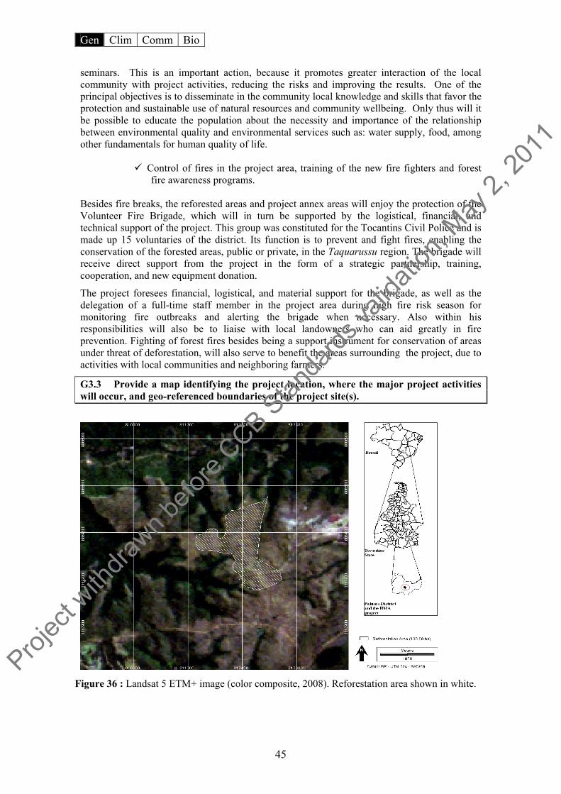
Gen Clim Comm Bio
45
seminars. This is an important action, because it promotes greater interaction of the local community with project activities, reducing the risks and improving the results. One of the principal objectives is to disseminate in the community local knowledge and skills that favor the protection and sustainable use of natural resources and community wellbeing. Only thus will it be possible to educate the population about the necessity and importance of the relationship between environmental quality and environmental services such as: water supply, food, among other fundamentals for human quality of life.
Control of fires in the project area, training of the new fire fighters and forest fire awareness programs.
Besides fire breaks, the reforested areas and project annex areas will enjoy the protection of the Volunteer Fire Brigade, which will in turn be supported by the logistical, financial, and technical support of the project. This group was constituted for the Tocantins Civil Police and is made up 15 voluntaries of the district. Its function is to prevent and fight fires, enabling the conservation of the forested areas, public or private, in the Taquarussu region. The brigade will receive direct support from the project in the form of a strategic partnership, training, cooperation, and new equipment donation.
The project foresees financial, logistical, and material support for the brigade, as well as the delegation of a full-time staff member in the project area during high fire risk season for monitoring fire outbreaks and alerting the brigade when necessary. Also within his responsibilities will also be to liaise with local landowners who can aid greatly in fire prevention. Fighting of forest fires besides being a support instrument for conservation of areas under threat of deforestation, will also serve to benefit the areas surrounding the project, due to activities with local communities and neighboring farmers.
G3.3 Provide a map identifying the project location, where the major project activities will occur, and geo-referenced boundaries of the project site(s).
Figure 36 : Landsat 5 ETM+ image (color composite, 2008). Reforestation area shown in white.
Projec
t with
drawn b
efore
CCB Stan
dards
valid
ation
, May
2, 20
11

Gen Clim Comm Bio
46
G3.4 Provide a timeframe for the duration of the project and its credits, as well as the rationale used for determining their duration. If the accounting period for carbon credits differs from the project lifetime, explain. G3.4.1 Duration of the proposed SSC A/R CDM project activity / Crediting period 40 years G3.4.2 Starting date of the proposed SSC A/R CDM project activity and of the (first) crediting period, including a justification Starting date: March 2009 First crediting period: 2009 up to and including 2049. G3.4.3 Expected operational lifetime of the proposed small-scale A/R CDM project activity 40 years (20 years, renewable once if this typical CDM approach be required) G3.4.4 Choice of crediting period and related information 40 years as agreed between project proponent and the credits buyer G3.4.5 Renewable crediting period, if selected 20 years, renewable once (if necessary) G3.4.6 Starting date of the first crediting period 2009 G3.4.7 Fixed crediting period, if selected 40 years or a period of 20 years that can be renewed once, if the “renewable crediting period” approach is required for a 40 years project validation. G3.4.8 Starting date 01/03/2009 G3.4.9 Length 40 years G3.5 Identify likely risks to climate, community and biodiversity benefits during the project lifetime. Outline measures that the project plans to undertake to mitigate these risks. The principal risks to the project are generally forest fires, which are common in the project region. Besides the risks to communities already mentioned, as in the case of a large forest fire that may affect the reforestation area, the communities would not be able to benefit from the non-timber forest products either in a direct way from the products and services themselves, but also indirectly in field training activities which would cease in case of a forest fire.
In focusing on a particular area that is small and easy to monitor, anthropogenic damage such as firewood collection and seedling destruction to the reforestation area is not expected. On the other hand the fires originating outside of project properties constitute the greatest risk to the reforestation. For this reason, the project activities feature significantly in the objectives already mentioned in item G3.2 that refer to actions to control forest fires. In order to assure the gains
Projec
t with
drawn b
efore
CCB Stan
dards
valid
ation
, May
2, 20
11
Gen Clim Comm Bio
47
for the climate in reforestation activities, the current project considers the effect of commercialization in assuming that only 80% of credits generated from the project. That is, 20% will be discounted as “buffer” in order to guarantee that the climate benefits will not be underestimated, in case that some of the reforestation is destroyed or does not developed according to plans and model predictions. If the buffer is not required to replace any accidentally carbon stock loss, or fail in the seedling growth, than the buffer might be progressively released for commercialization. With respect to extreme climatic events such as drought, the threats to the survival of the seedlings in the first few years of the project have been considered. Therefore periodic watering will occur according to soil water scarcity in the plantation area, through visual analysis of the superficial horizon, especially in the first two years when the seedlings are most susceptible to dry conditions. With respect to pest control, the methods used will follow the basic principles of Integrated Pest Management (MIP), where efforts will concentrate on the leaf-cutter ant nests (genus Atta), by bating pre- and post-planting. Damage to the reforestation area caused human activities will be monitored via Social Carbon Methodology – MCS (see Appendix VII) and it is hoped that they can be minimized through activities, which include the community (e.g. reforestation and forest management for non-timber forest products using native species). All of the activities described in the project, besides the monitoring foreseen in the SMP, will be tracked using the tools of the Social Carbon Methodology (see section G.7). By means of this it will be possible to construct a suite of indicators in accordance with the actions of the project. Having been identified according to techniques and time frames proposed in the methodology, they will reveal the relationships of sustainability in the project, and support the evaluation of positive and negative points. More importantly, the MCS by its conceptual and directed structure, will at any given time allow all of the actors involved to participate directly and indirectly in the project in dealing with information observed during its application. More importantly, the MCS by its conceptual and directed structure, will at any given time allow all of the actors involved, directly or indirectly in the project, to participate in dealing with information observed during its application. G3. 6 Document and defend how local stakeholders have been or will be defined. To guarantee the effective and long lasting participation of local communities, several contacts have been made since August 2008, (phone calls, conference calls and e-mails), also meetings were held in Palmas and Taquarussu, between Ecologica Institute and local stakeholders, as: Fire Brigade representatives, local NGO’s, Artisans House of Taquarussu, and Government agencies to inform, and collect suggestions from those that will be directly and indirectly involved in activities. These meetings and first contacts by no means preclude the occurance of further participatory meetings or workshops.
One workshop is also being planned to be held in Taquarussu district, few months before the beginning of the project activities, in order to:
Involve more stakeholders (especially the local community and those citizens that are not organized in groups and because of it were not contacted yet) to discuss conservation strategies;
Discuss future stakeholders’ rights and obligations regarding each project activity, as well the rights and obligations of the project proponent;
Projec
t with
drawn b
efore
CCB Stan
dards
valid
ation
, May
2, 20
11

Gen Clim Comm Bio
48
Definition of courses and training activities to teach those involved about making sustainable use of biodiversity and natural resources inside the project area and its surroundings.
G3.7 Demonstrate transparency by: making all project documentation publicly accessible at, or near, the project site; only withholding information when the need for confidentiality is clearly justified; informing local stakeholders how they can access the project documentation; and by making key project documents available in local or regional languages, where applicable. The conception Genesis Project concept was coordinated by the Ecologica Institute (IE) with support from the carbon credit perspective from CantorCO2e Brasil consulting company. The Ecologica Institute is a Civil Society of Public Interest Organization (OSCIP), located in the state of Tocantins and has a history of activity in the project region that enabled the aggregation of data and strategies of interest to the project. The partnerships of the IE were fundamental to the definition of priority actions in the region, not only climate-related, but also community, and biodiversity-related, referencing their own studies and diagnostics in the process, which were of extreme importance in the collection of secondary data.
As a result the Ecologica Institute will be the focal point of information related to the project, distributing all of the data and documents generated by the project in transparent manner. Specifically, this set of information will be made available at the Ecotropical Research Center, at the organization’s headquarters and at its website (www.ecologica.org.br).
The list of stakeholders that where informed and invited to participate during the project elaboration can bee seen in appendix I and the official letter can be seen in appendix II
G4.1 Document the management team’s experience implementing land management projects. If relevant experience is lacking, the proponents must demonstrate how other organizations will be partnered with to support the project.
Ecológica Institute (www.ecologica.org)
Founded in 2000, the IE is a Civil Society of Public Interest Organization (OSCIP) whose mission is to reduce the effects of climatic change through scientific research activities; conservation, environmental preservation, and sustainable development support to communities. With its head office in Palmas (TO), it has representation offices in São Paulo (SP), Rio de Janeiro (RJ) and Brasília (DF).
Currently, the IE priority actions are concentrated in the area around Bananal Island, in the southwest region of the Tocantins State known as Cantão. In this region three important ecosystems unite: The Amazon, Pantanal and Cerrado, and for this reason, it was strategically chosen by the IE to develop its climate change projects. The exuberant natural beauty and the wealth of the local biodiversity, constantly threatened by climate change effects, also provoke reflexes in the life of the local communities. Over the past seven years, this scenario has been the backcloth to countless scientific research and socio-environmental initiatives recognized worldwide.
G4 Management Capacity and Best Practices
Projec
t with
drawn b
efore
CCB Stan
dards
valid
ation
, May
2, 20
11

Gen Clim Comm Bio
49
In the field of Climate Change, IE performance is distinguished in its pioneering conception and execution of the first Brazilian carbon sequestration project. Set on Bananal Island the project was innovative in guaranteeing the communities' involvement in the initiative. This work resulted in the creation of the Social Carbon Methodology, the challenge of which was to transform the sustainable development goals into a reality, through actions encouraging community development and socio-commercial responsibility. Through its holistic and dynamic character, with reliability and efficiency, the methodology is being certified by independent entities and replicated in several Brazilian regions, Latin America and Europe.
In the area of scientific research, the IE became a reference for the implantation of the first research center specialized in climatic changes - the Canguçu Research Center, also located on Bananal Island. And in 2008 it is going to inaugurate its second scientific unit - the Tropical Biodiversity Knowledge Center, near Palmas (TO).
More experioences of the Ecologica Institute can be seen in the appendix III
CantorCO2e Brazil (www.cantorco2e.com)
CantorCO2e Brasil is part of the CantorCO2e global group, leading global provider of financial services to the world’s environmental and energy markets, offering finance, advice, technology and transaction services to clients engaged in using energy and managing emissions across the world. With a staff of 30 employees, CantorCO2e Brasil has a portfolio of more than 80 CDM / Voluntary Carbon projects in Brazil and other Latin America countries. Projects vary from Energy Efficiency and Renewable Energy to Carbon Sequestration and Conservation. Over the past several years, CantorCO2e Brasil has designed an approach that focuses on CERs/VERs generation through strategic partnerships (e.g. CARE International), the creation of the Social Carbonfund.org and tailor-made environmental consultancy. CantorCO2e Brasil, lead by Divaldo Rezende, has a technical team that is divided into three main areas: Biomass Fuel Switch, Renewable Energy & GHG Inventories and Forestry. It also has a Business Development Area, responsible for generating business, and the commercialization of credits. CantorCO2e Brazil is proud to be the only carbon consultancy in Brazil to have a Sustainability Department, which applies the Social Carbon Concept to its projects, so their contribution to sustainable development can be monitored and safeguarded. In the current project, the company will be responsible for the carbon dioxide removal estimates from reforestation throughout the crediting period.
Hyundai Motors America (HMA) Hyundai Motors America (HMA) will the sponsor of the project and are interested in up-front payment for the carbon credits generated by the forest project. HMA, once very committed to quality projects, has chosen the Genesis Forest Project after a Request for Proposal launched in April 2008 in California, USA. An HMA new public relations approach that focused on carbon offsetting through environmental and social projects, lead them to agree to pay for the credits in advance and was critical to the implementation of the project activities. In the absence of this sponsor the project would never have been possible. Carbonfund.org
Projec
t with
drawn b
efore
CCB Stan
dards
valid
ation
, May
2, 20
11
Gen Clim Comm Bio
50
Carbonfund.org is a nonprofit based in Silver Spring, Maryland with a mission to address global climate change by supporting renewable energy, energy efficiency and global reforestation projects. Such reforestation projects include the Tensas River Reforestation project in Louisiana, the Return to Forest project in Nicaragua and most recently, the Genesis Forest Project of Tocantins, Brazil. With this in mind, Carbonfund.org partners with over 1,00 companies – including Hyundai - along with over 400,000 individuals by encouraging people to continually strive to reduce their carbon footprint through sensible reductions combined with cost-effective, certified and third party audited carbon offsets. Furthermore, Carbonfund.org’s entire financial portfolio is audited by a certified public accountant and our project portfolio is also verified by an independent auditor. Carbonfund.org is acting as a project facilitator between Hyundai, CanotrCO2e and Ecologica Institute.
G4.2 Demonstrate that management capacity is appropriate to the scale of the project.
As mentioned previously, the Genesis Forest Project as a small-scale reforestation project is not expected to have any kind of field management barrier regarding the scale or the size of the project. CantorCO2e Brazil and the Ecologica Institute have significant experience in forest, social, and carbon projects.
CantorCO2e has merged with Ecológica Assessoria, a privately owned consultancy firm specializing in planning and environmental projects, creating the company CantorCO2e Brazil, and therefore has assembled the knowledge, experience, and expertise of the Ecológica Group.
Ecológica was formed in January 1997 with the aim of ensuring that development in The Amazon Region takes place in a socially responsible manner, with full consideration of the environment and the needs and aspirations of local communities. In the few short years since its formation, the company had built up an impressive clientele, becomming energetically engaged in the design and implementation of carbon sequestration projects associated with economic values and in consultancy work for government institutions and private companies.
Cantor CO2e Brasil had a permanent staff of 30 and draws on a multidisciplinary pool of some twenty-five consultants who specialize in a range of socio-economic and environmental fields. It thus has the expertise to deliver effective solutions at all stages of the project cycle, and has considerable experience in project management covering all activities from initial conceptualization and appraisal through to implementation and monitoring in the field.
Ecologica Institute itself already develops a series of activities with the surrounding communities, many of whom are stakeholders who will be considered and participate directly and indirectly in the project activities. They are already have a connection with one or more Institute activities in the Taquarussu region (see appendix III)
G4.3 Document key technical skills that will be required to successfully implement the project and identify members of the management team or project partners who possess the appropriate skills. General Coordination of the Genesis Project
Ecologica Institute
Stefano Merlin – Director President
Luiz Leal - Project Manager
Renato Glaber Araújo Reis – Project Technical Coordinator
Projec
t with
drawn b
efore
CCB Stan
dards
valid
ation
, May
2, 20
11

Gen Clim Comm Bio
51
Paula Montenegro – Project Environmental Education and Income Generation Coordinator
Dariusz Kurzatkowski – LBA researcher and External Consulter
Maria Amélia Maciel – Ecotropical Coordinator
Coordination of the A/R and LULUCF approach, Baseline Carbon Estimates and Project Design Document (PDD) Development
Cantor CO2e Brasil
Divaldo Rezende – Director President
Diego Machado Carrion Serrano – Forestry Coordinator
Bruno Melo da Matta – Forest and GIS Analyst
Celly dos Santos – Socio Environmental Specialist
Guilherme Lefreve – Business Developer
Cantor CO2e USA
Sean Carney – Forest Project Broker
G4.4 Document the financial health of the implementing organization(s). The Ecologica Institute develops projects with financial support from public and private companies, with the majority of support coming from private companies.
Since 2000 when it was founded, the Ecologica Institute has adopted an effective management and planning system, enabling effective cost control.
Over the years the organization has been audited by the Brazilian Justice Department, renewing its title as a Social and Public Interest Organization (OSCIP).
Other donors in 2007 and 2008 include Petrobras, Natura, HSBC Bank Brazil, FNMA, and Brazil Power (Energias do Brasil). To guarantee the effectiveness of project expenses, the Ecologica Institute allocates a separate bank account for each project, enabling control and allowing the sustainability of Ecologica Institute (See Appendix IV).
G5.1 Guarantee that the project will not encroach unwelcome on private property, community property, or government property.
The project area is owned by the Ecologica Institute and there are no land tenure disputes in the project area. Documentation proving tenure is available in Appendix V.
G5.2 Guarantee that the project does not require the relocation of people, or any relocation is 100% voluntary and fundamentally helps resolve land tenure problems in the area. Among the areas affected by the project, only the base São Francisco Ranch has a family that works in the area as. This family is likely to remain on the property playing the same role for the duration of the project. In the northern part of the project the presence of approximately 30 families settled along the banks of the Taquarussu Grande River, has been verified. These families practice subsistence agriculture and the raising of small livestock, but the at the
G5 Land Tenure
Projec
t with
drawn b
efore
CCB Stan
dards
valid
ation
, May
2, 20
11
Gen Clim Comm Bio
52
expense of the gallery forest, due to the good quality soils and ease of collecting water. In this respect the Genesis Forest Project will not require the relocation of people, as it involves an area that is 100% in private hands. The squatting that occurs in isolated cases of people looking to extract and use natural resources. However, it will not be necessary to relocate people.
G5.3 Describe potential “in-migration” of people from surrounding areas, if relevant, and explain how the project will respond. The project is of small scale and operating at the level of the private property, and so no influx of people into the restoration areas is expected. For being a project, which is strongly based in environmental and biodiversity aspects, the human presence in these areas will be restricted to implantation, management, and during training sessions once the project has been implemented. Nor is it expected that the project will cause any immigrations to other regions near the project area. Should new families move into surrounding region, however, they will be inserted into the social activities of the project: capacity-building and environmental education programs.
G6 Legal Status
G6.1 Guarantee that no laws will be broken by the project. The Genesis Forest Project is in perfect congruence with the principal laws pertaining to preservation and conservation of the environment and climate change. Specifically, it is in accordance with article 22527 of the Federal Constitution of Brazil of 1988, which concerns the collectivity, defense, and preservation of the environment. According to law 9433/97 that treats Water Resources National Policy, the project fits into the objectives to ensure that water is available to current and future generations, into the standards of quality adequate for respective uses, because it foments the conservation of streams and springs important for supplying the public. In a similar vein, the project is in perfect accordance with Law number 4.771/65 which deals with as Areas of Permanent Preservation (APPs) through article 2° and 4°. While not compulsory through forest law, the project will comply with these articles voluntarily as well with article 16 which refers to Legal Reserves (RL) since the reforestation area will be a registered piece of real estate (as a Legal Reserve) in the future. Its important to the good understanding of the reforestation initiative that the activities not soley comply with but also exceed the relevant legislation, since they will promote reforestation of native species through volunteerism. The Genesis Forest Project observes the principles of environmental protection, conservation and recuperation as specified in the RIO-92 Declaration. Additionally it observes the principles and rules establishes by the Convention of Biological Diversity and the United Nations Framework Convention on Climate Change (UNFCCC). G6.2 Document that the project has, or expects to secure, approval from the appropriate authorities. See letter of approval by authorities of the government of the State of Tocantins about the commercialization approval for the carbon credits generated by project activities (Appendix VI).
27 Art. 225. Everyone has a right to an ecologically balance environment, of common use of the public and essential to a healthly quality of life, and impressing on Public Law and the collective the requirement to defend and preserve it for present and future generations.
Projec
t with
drawn b
efore
CCB Stan
dards
valid
ation
, May
2, 20
11

Gen Clim Comm Bio
53
G7 Adaptive Management for Sustainability
G7.1 Demonstrate how management actions and monitoring programs are designed to generate reliable feedback that is used to improve project outcomes. The adoption of the Social Carbon Methodology – MCS (Appendix VII) by the Genesis Forest Project should consider among other aspects, the support of the project management. In general terms, the MCS will promote the equal participation of the surrounding community and other stakeholders in the management and execution of the project, thereby making it more adaptive to the necessary changes gained from collective decision-making.
As the process employed by the MCS is transparent and participatory, it guarantees the continued confidence of all participants in the project. The transparency and participation of all the actors directly involved in the project is a prerequisite of the methodology, since the structure and functioning is based on the selection and monitoring of indicators that only the public involved can foresee.
Based on this understanding, the primary challenges will be to guarantee that the removal of emissions can inserted sustainable development issues in its activities and also to guarantee a transparent method of measuring and sizing of social and environmental benefits to the communities involved in the project. Structuring the methodology to meet this challenge must take into account the perspectives, resources, strategies, threat and opportunity factors, political organizations and social relationships, and in doing produces the following basic guidelines for the MCS:
Communities take center stage; Value the human resource potential; Be participatory, holistic, dynamic, and flexible; Focus on local and global relationships; Focus on analyses of biodiversity and ecosystem potential; Focus on the solution of problems and the search for sustainability; Seek social inclusion and recognize issues of this nature and other forms of social
difference; Recognize relationships of power and the political context.
The MCS engenders a diagnostic structure based on indicators – human, social, natural, biodiversity, financial, and carbon – which according to the guidelines determine the sustainability relationships in themselves and in project actions. As a result, the application of the Social Carbon Methodology in different projects in recent years has demonstrated that monitoring is an effective means of guaranteeing that climate change mitigation initiatives can be delivered through environmental control and social development activities. Thus, greater certainty vis-á-vis the sustainability of the project, can be conveyed to organizations that lend financial support and tracking, management, and decision-making tools with respect to project activities. G7.2 Have a management plan for documenting decisions, actions and outcomes and sharing this information with others within the project team, so experience is passed on rather than being lost when individuals leave the project. The reports of the Social Carbon Methodology, along with the results obtained by the Strategic Conservation Plan, will document the results of the diagnostic, the way in which the information was produced, as well as the participation processes and the actors involved.
Projec
t with
drawn b
efore
CCB Stan
dards
valid
ation
, May
2, 20
11

Gen Clim Comm Bio
54
The Ecologica Institute (IE) will conduct the management of the activities of Social Carbon, which is a Civil Society of Public Interest Organization (OSCIP) and therefore is an institution with a public responsibility of transparency in its activities.
The IE, besides being the creator of the MCS, has within its technical experience, professionals knowledgeable in conducting group activities that require efficient communication. Through the use of appropriate techniques and tools relevant to the MCS, the IE will provide the best flow of communication between actors, which will be reported publicly each cycle through the publicity mechanisms of the IE and its partners. G7.3 Demonstrate how the project design is sufficiently flexible to accommodate potential changes and that the project has a defined process in place to adjust project activities as needed. The flexible nature of the MCS is important to qualify the project as amenable to accommodate the necessary changes. This flexibility is acquired by means of the stimulus of equal participation from the various actors, extending transparency to the project activities.
The project’s flexibility, however, can be characterized by its capacity-building component, whereby primarily conferences betweens the interested parties will take place to determine the initial job titles, dates, quantities, and the focus of events. In the forest component, the possibilities for accommodating changes are more restricted, as the areas were pre-determined based on the technical criteria and land availability. Moreover the carbon calculations have already been conducted, primarily in relation to the baseline. Meanwhile, actions concerning fighting forest fires with landowners, local communities, and the volunteer fire brigade can be remodeled if changes yield better results in terms of safeguards, efficiency, and operability.
G7.4 Demonstrate an early commitment to the long-term sustainability of project benefits once initial project funding expires. Potential activities may include: designing a new project that builds on initial project outcomes; securing payments for ecosystem services; promoting micro-enterprise; and establishing alliances with organizations or companies to continue sustainable land management. The process of capacity building in which the surrounding community will be involved encompasses some aspects important to the successful generation of income of the community which will guarantee its sustainability success after the project. The invitation to participate in the activities will be extended to the entire community, however people will low income will have priority. All of the raw materials and equipment necessary for capacity building will be supplied by the Genesis project. The raw material (seeds and fruits) will be managed in the reforestation areas of the project. The teachers will be artisans and confectioners of the community, that already participates in the projects of the Ecologica Institute.
The themes of thetraining will deal not only with the practice of conservation, but also the importance of conservation of natural area, the sustainable use of natural resource, design, and commercialization. In the first years of the project, all of the equipment, inputs, and raw materials will be donated to the participants who will be able to collect, add value, and sell the finished product. To this end, the Ecologica Institute will endeavor to promote the integration of these groups into associations and/or work cooperatives. Later, the level of economic growth from the reforestation area permitting, a study involving all parties to examine the possibility of sharing of profits will be conducted, in order to help the Institute offset management and conservation expenses in the project area.
These aspects have been outlined with the purpose of enabling community participation and of fomenting the generation of income necessary to impact social and environmental well-being. Of note is the participation of women in the trainings, among them “biojewelry” and foods (sweets, jellies, and liqueurs), augmenting the potential for social transformation in the
Projec
t with
drawn b
efore
CCB Stan
dards
valid
ation
, May
2, 20
11

Gen Clim Comm Bio
55
communities in the project vicinity. This becomes especially pertinent in light of results of the “Mulheres Mil” diagnostic (2008)28, which shows that 65% of women of Taquarussu are unemployed. The Social Carbon Methodology will be the best instrument of community, and other stakeholders’ participation in the project, guiding them as to where and how the project ought to be structurally adjusted.
G8 Knowledge Disseminations
G8.1 Describe how they will document the relevant or applicable lessons learned.
Besides the issues of Social Carbon that will be distributed on the institutional site (www.ecologica.org.br) and in diverse articles about the project in the Monthly Update of the IE, the project will also publish its results in the journal Social Carbon. According to project counterparts, studies will be conducted about biological conservation, climate change, and environmental education that will yield scientific publications. The journal Social Carbon is a tri-monthy indexed publication of the IE and is distributed throughout Brazil.
Besides the preexisting information dissemination mechanisms that will be offered by the IE, the project will enjoy the presence of the Ecotropical Research and Learning Center located in the same property as the project activities, which will support scientific study of reforestation. The results produced in the form of scientific articles, theses and dissertations will be distributed to the scientific community, as a way of contributing to the greater body of knowledge about the cerrado biome.
G8.2 Describe how they will disseminate this information in order to encourage replication of successful practices. Examples include: undertaking and disseminating research that has wide reaching applications; holding training workshops for community members from other locales; promoting “farmer to farmer” knowledge-transfer activities; linking to regional databases; and working with interested academic, corporate, governmental or non-governmental organizations to replicate successful project activities. The research that will be conducted by Ecotropical in the conservation areas will be distributed by different mean, not restricted to solely academic ones. Reaching the greater public therefore becomes a necessity. In this way, the mission of Ecotropical is explicit even in name, as the Learning Center implies not only scientific knowledge common to university programs but also the local community’s empirical knowledge, aiming to establish universal knowledge about the themes. Along these lines, the Center has an outreach character, which is evident from the serious approach that is given to capacity-building activities and workshops among its principal strategies. The reporting of the project will be realized through the institutional website and publications of the IE, but also in workshops for presents results and diverse meetings on related themes. It should be mentioned that the relative costs to conduct workshops and participatory events are included in the project budget. Project activities will be disseminated on the internet through High Interactive Project’s Website (Link on Hyundai’s website to this page) that includes a tCO2eq timer showing the ongoing CO2 conservation 24 hrs a day, a webcam on the area (waterfall or conserved areas), and pictures of animals seen in the area, with date/time and name of the photographer.
28 Study conducted by the Federal Technical School of Tocantins (EFTO, 2008)
Projec
t with
drawn b
efore
CCB Stan
dards
valid
ation
, May
2, 20
11
Gen Clim Comm Bio
56
IV. CLIMATE SECTION
CL1 Net Positive Climate Impacts
CL1.1 Use the methodologies of the Intergovernmental Panel on Climate Change’s Good Practice Guidance (IPCC GPG) to estimate the net change in carbon stocks due to the project activities. The net change is equal to carbon stock changes with the project minus carbon stock changes without the project (the latter having been estimated in G2). Alternatively, any methodology approved by the CDM Executive Board may be used. This estimate must be based on clearly defined and defendable assumptions about how project activities will alter carbon stocks and non- CO2 GHG emissions over the duration of the project or the project accounting period. All the calculations and assumptions regarding ex-ante net GHG removal, baseline, additionality, leakage, project emission as well ex-post actual net GHG removal monitoring was made according to the approved baseline methodology “Revised Simplified baseline and monitoring methodologies for selected small-scale afforestation and reforestation project activities under the clean development” Version 4.1. (AR-AMS0001) CL 1.1.1 Additionality: Project activity can only occur if the generation of carbon credits can be shown The project’s reforestation activities, as well as its climate benefits are additionally based on the fact that the reforestation or natural regeneration would likely not occur without human intervention. In this case a voluntary initiative of the HMA is serving as sponser to offset its emissions through forestry ventures in order to extract real environmental benefits. Without this income, forest would likely never develop in the project area according to the Brazilian Designated National Authority (DNA), nor increase its carbon stock in the living biomass as result of the baseline carbon stock changes.
i. Investment Barriers
Debt funding unavailable for this project activity;
The only incentive to plant Brazilian savannah native species is for the production of non-timber forest products that are available to and identified by the landowner. Furthermore, he is assisted only by the resources voluntarily offered by the HMA offset policy. The forestry farm is a financially independent accounting enterprise and does not currently enjoy of any kind of subsidy, public or private for this type of undertaking.
Lack of access to credit;
The property owner currently lacks the resources to embark in a forestry venture. This is especially true of non-timber forest products that typically generate much less income than enterprises based on timber products. As a project focused on climate, social and environmental benefits, no timber or logging activity will be condoned in this reforestation initiative. Only non-timber forest products are supposed to be produced in the project area, such as: native fruits, sweets, essential oils, honey and seeds for handcrafts.
ii. Barriers relating to local traditions, inter alia:
Projec
t with
drawn b
efore
CCB Stan
dards
valid
ation
, May
2, 20
11

Gen Clim Comm Bio
57
Traditional knowledge or lack thereof, laws and customs, market conditions, practices
Markets for non-timber forest products are insipid compared to those for traditional forest products such as timber, firewood and charcoal. There exists further lack of knowledge of how to add economic value to these products. The proposal to implement a non-timber reforestation project will entail a break in the paradigm and must still be developed together with the local communities in order to promote a new approach to generate income based on sustainable forest practices (see social benefits section).
iii. Barriers due to prevailing practice, inter alia:
The project activity is a “first of its kind”: No project activity of this type is currently operational in the macro region.
Forest ventures are unusual in the state of Tocantins. In neither field research, interviews, or GIS modeling were forest projects identified in the project zone or the reference zone. According to the local players and the results of the satellite images analysis (see section G1.5 and G5) traditional land use greatly contrasts project activities. The local rural activities are based on the deforestation of the cerrado biome for firewood and charcoal production followed by cattle grazing. In some cases greater resources or access to credit may permit the landowner to produce soybeans in a typically agro industrial operation. Cases of forest projects based on the reforestation of natives plants for non-timber uses is more difficult to find in the state simply because this kind of undertaking generally manifests the lowest internal rate of return compared to commercial forestry practices that focus on tree harvesting. This project is only feasible from a carbon credit approach.
iv. Barriers due to local ecological conditions, inter alia:
Degraded soil (e.g. water/wind erosion, salinization, etc.)
The Brazilian savannah biome has most of its area composed of dystrophic soils (low saturation base due to high acidity, aluminum and manganese saturation). This reduces the regenerative capability of many tree species without intervention such as pH correction. Soil compaction from years of cattle trampling, especially during the rainy season, also inhibits natural regeneration. Finally, the successive fires help to decrease the soil fertility by the wind erosion, which removes nutrient-rich ash from the burnt areas.
Catastrophic natural and / or human-induced events (e.g. land slides, fire, etc) As mentioned in the topics above, the periodic uncontrolled fires constitute one of the main barriers to investment in forestry ventures. They jeopardize the survival of young trees, as well as the natural increase in biomass carbon stock.
Unfavorable meteorological conditions (e.g. early/late frost, drought); The central region of Brazil is known to have two well-defined seasons: a “summer” which is hot and wet (November – April) when flooding may occur, and a dry “winter” (May-October) when most of the big fires and severe droughts generally occur. Droughts in the Cerrado during the dry season can be very severe and cause serious damage to the young vegetation especially the tree samplings. In this case, the plantation management or even the natural regeneration management can be crucial to the forest establishment process, especially in areas that have suffered human alteration for a long time.
Projec
t with
drawn b
efore
CCB Stan
dards
valid
ation
, May
2, 20
11

Gen Clim Comm Bio
58
Pervasive opportunistic species preventing regeneration of trees (e.g. grasses, weeds) Invasive species present serious problems for the establishment of native forest cover. Furthermore some invasive grass species, such as Braquiaria sp and Andropogon sp. have become widespread. These species are found not just in the project area but also all over the Brazilian savannah, and even other biomes where the cattle grazing is the norm.
Unfavorable course of ecological succession Natural ecological succession has been clearly disturbed by competition from exotic species, thereby reducing the natural regeneration process.
Biotic pressure from grazing, fodder collection, etc. No fodder collection is conducted in the project area by landowner or any neighbors, but the natural and planted pastures are used extensively for grazing. In this case, the invasive grass represents is not the only threat to the natural regeneration and tree growth. Cattle are also inclined to eat the leaves of young trees (Figure 35), which damages them and inhibits their growth. Fortunately, the property owner has sold the herd in exchange for forest carbon credits from the reforestation activities, which will add economic value to this new form of land-use.
Figure 37: Cattle eating young tree leaves.
v. Institutional barriers, inter alia:
(a) Lack of enforcement of legislation relating to forests or land-use.
The percentage of Legal Reserve (RL)29 for the Legal Amazon Region30 is currently being discussed by several Brazilian stakeholders, such as: politicians, state and federal government institutions, environmentalists, agribusiness sector, farmers, and popular movements for agrarian reform. The segments linked to the productive sector have been trying to reduce the percentages of RL stated in the Brazilian forest code. If accepted, the new policies have the potential to further diminish the strength of Brazilian environmental legislation promoting forest restoration on private property.
29 Brazilian Forest Code: Law No. 4771, of 15 September 1965. art 16 (RL) that states that each rural property in the country must maintain, or restore native forest cover to least 20% of the property’s area. In practice throughout the country, the law is widely ignored. 30 Legal Amazon Region or “Amazônia Legal” in Portuguese, is an administrative area twice as large as the Amazon rain forest biome and includes a large part of the Brazilian savannah biome.
Projec
t with
drawn b
efore
CCB Stan
dards
valid
ation
, May
2, 20
11
Gen Clim Comm Bio
59
On the other hand, though the obligation to restore the RL31 already exists, it has being widely ignored by most farm owners throughout Brazil and currently constitutes one of the primary reasons for citations from the country’s environmental sector. In this case even if the owner is reforesting the area determined in the register office as RL to meet the law’s requirements (which is not the case of this project32), it would already be additional based on the national and regional business as usual, simply because nobody actually complies with the law, nor has been penalized for this.
vi. Technological barriers, inter alia:
Lack of infrastructure for implementation of the technology.
The soil in the project area has a great quantity of rock, which complicates the preparation of the establishment for the use of machineries such as farm tractors or implements. In many areas within the reforestation project, the land will have to be prepared and planted manually, which is supposed to increase the average costs per hectare.
vii. Barriers due to social conditions, inter alia:
Widespread illegal practices (e.g. illegal grazing, non-timber product extraction and tree felling)
The most common illegal practice that directly affects the capacity of the project area to become a forest without the project activity’s intervention are the fires coming from other properties. The pasture burning management is not an illegal practice if it is conducted with the environmental agency authorization and if the fire exceeds the property limit hitting other properties; it can be considered a crime. Meanwhile, according to the most widespread business as usual, no farmer, especially in the North region, is aware of the need to build firebreaks, or take any kind of precaution to keep the fire controlled, this has caused severe damages in the pasture areas where the project reforestation activities will be conducted. In order to prevent fire damages to the project area, one of the project activities is to build and maintain firebreaks, besides training and supporting fire brigades.
Lack of skilled and/or properly trained labor force
Few people in the project region are aware of forestry techniques, or has any kind of knowledge of sustainable forest management focused in non-timber forest products, nor native forest reforestation practices.
The most likely baseline scenario of the proposed small-scale A/R CDM project activity is considered to be the land-use prior to the implementation of the project activity (Section G2 – Baseline Analysis) In all cases, the natural regeneration would be quite limited and would not result in the conversion to a forest in the absence of the proposed small-scale A/R CDM project activity. Especially in those areas with the natural vegetal covering, before the deforestation process and
31 Brazilian Forest Code: Law No. 4771, of 15 September 1965. art 44 which states the obligation to restore the natural forest cover within 30 years of the date the RL is registered. 32 The Legal Reserve of the project property will be composed by the conservation área (see REDD part of this document)
CL 1.1.2 Description of how the actual net GHG removals by sinks are increased above those that would have occurred in the absence of the registered small-scale A/R CDM project activity
Projec
t with
drawn b
efore
CCB Stan
dards
valid
ation
, May
2, 20
11

Gen Clim Comm Bio
60
the frequent fires were not classified as forest physiognomy such as Open Cerrado and some parts of Cerrado Strictu Sensu (stratum b). The project activities will promote the increase in the net GHG removals by sinks above those that would have occurred in the absence of the project activities. This will be done by reforesting 130 hectares with native Cerrado species in a density of 667 and 1110 trees per hectare33, for non-timber production in a zone where, according to the business as usual, would never have become a forest physiognomy, according to the DNA definition for forest. To guarantee the carbon stock removed by the trees, fire breaks and fire brigades will be created and trained in a way to protect the plantation against the common Brazilian Savannah fires, after the beginning of the project.
Formulae used for ex-ante calculation:
Where: N(t) = total carbon stocks in biomass at time t under the project scenario (t C) B(t) = carbon stocks in the living biomass pools within the project boundary at time t in the absence of the project activity (t C) NA(t) i = carbon stocks in above-ground biomass at time t of stratum i under the project scenario (t C/ha) NB(t) i = carbon stocks in below-ground biomass at time t of stratum i under the project scenario (t C/ha) Ai = project activity area of stratum i (ha) i = stratum i (I = total number of strata) T(t)i = above-ground biomass at time t under the project scenario (t d.m./ha) (Tier 2) 34 0.5 = carbon fraction of dry matter (t C/t d.m.) R = root to shoot ratio (t d.m./ t d.m. ) (Tier 2)35
33 Seedling density will depends of the stratum: (a) 667 or (b) 1110 34 The above ground biomass was estimated based on the only study available about Brazilian savannah biomass behavior from reforestation with native species (Melo & Durigan; 2006), thus the SV(t)i, BEF and WD values, where not used
(4)
(5)
(6)
(7)
(8)
(9)
CL 1.1.3 Description of formulae used for ex-ante estimation of the actual net GHG removals by sinks due to the project activity within the project boundary.
Projec
t with
drawn b
efore
CCB Stan
dards
valid
ation
, May
2, 20
11
Gen Clim Comm Bio
61
0.5 = carbon fraction of dry matter (t C/t d.m.) NB(t) = carbon stocks in below-ground biomass at time t achieved by the project activity during the monitoring interval (t C/ha) Δ CPROJ,t = removal component of actual net GHG removals by sinks per year (t CO2-e/yr) Δt = time increment = 1 (year) Δ CACTUAL,t = ex-ante actual net greenhouse gas removals by sinks in year t (t CO2-e /yr) GHGPROJ, t = project emissions (t CO2-e /yr)
The assumptions for the ex-ante calculation was based in a Brazilian study of MELO & DURIGAN (2006)36, about biomass stock changes in native species reforestation projects in the Brazilian savannah (Cerrado) of Sao Paulo state (see Table 8) and the study of DURIGAN & SILVEIRA (1999)37 about forest restoration in Cerrado. Meanwhile the growth rate for living biomass assumed for Genesis reforestation project was 25,4% greater than that found by Melo & Durigan. This difference between the studies results and project growth rate predictions, however is still quite conservative due to three main reasons: i) the project area is situated in an area with higher annual precipitation: 1667mm/year38 instead of 1485mm/year of the Durigan & Silveira studied zone; ii) the soil acidity in the Genesis project area is planed to be limed until the base saturation (V%) reaches 50%39 at least. In Melo & Durigan and Durigan & Silveira studied areas the V% was 26%, what can be considered very acid for a good seedling development (acid soils with a very high manganese and aluminum ion saturation (Al3+) are quite common in the tropical Brazilian Savannah soils); iii) the project seedlings will be fertilized with 5kg of manure per plant what is supposed to increase significantly the nitrogen, phosphor, potassium and micro nutrients available for the seedlings. In the Durigan & Silveira experiments, none kind of fertilization, neither liming was done during the plantation nor after. In the Beyond the better individual tree development, also the death rate is supposed to decrease significantly. In the Durigan & Silveira experiments with 2.222 plants per hectare the death rate exceed 50%. So all these precautions together are predict to affect direct the mean annual increment (MAI) of the Genesis reforestation project compared to the results obtained by Durigan, Melo and Silveira assay.
35 Mean root/shoot ratio for the Brazilian savannah - Cerrado “strictu sensu” equal to 1.0 (Abdala et al, 1998) 36 The above ground biomass was estimated based on the only study available about Brazilian savannah biomass behavior from reforestation with native species (Melo & Durigan, 2006) – Tier 2, thus the SV(t)i, BEF and WD values, were not necessary for the ex-ante calculations. 37 Riparian forest restoration in cerrado, Assis, SP, Brazil (Durigan & Silveira, 1999) – Tier 2 38 Source: Management Plan of Lajeado Environmental Preservation Area (APA), a conservation area a few kilometers from the project area. 39 CRUZ et al (2004) describes a 73% increase in the total biomass in young trees of Tabebuia impetiginosa, (a typical Brazilian savannah species that will be used in the project) when the base saturation (V%) ranges from 24% to 50%. Meanwhile FURTINI NETO et al (1999) report from laboratory experiments a significant increase in total dry matter from pioneer and secondary Brazilian savannah woody species after liming management, ranging from 11.3g/pot to 15.4g/pot for pioneer and 9.80g/pot to 16.3g/pot for secondary species. Finally, VIOTTO et al (2007) describe better development of Guazuma crinita (a typical Brazilian savannah species that also will be used in the project) in V% varying from 40% to 60%.
CL 1.1.3.1 Estimate of the actual net GHG removals by sinks
Projec
t with
drawn b
efore
CCB Stan
dards
valid
ation
, May
2, 20
11
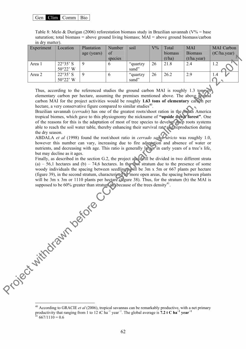
Gen Clim Comm Bio
62
Table 8: Melo & Durigan (2006) reforestation biomass study in Brazilian savannah (V% = base saturation; total biomass = above ground living biomass; MAI = above ground biomass/carbon in dry matter).
Experiment Location Plantation age (years)
Number of species
soil V% Total biomass (t/ha)
MAI Biomass (t/ha.year)
MAI Carbon (tC/ha.year)
Area 1 22°35’ S 50°22’ W
9 6 “quartzy sand”
26 21.8 2.4 1.2
Area 2 22°35’ S 50°22’ W
9 6 “quartzy sand”
26 26.2 2.9 1.4
Thus, according to the referenced studies the ground carbon MAI is roughly 1.3 tons of elementary carbon per hectare, assuming the premises mentioned above. The above ground carbon MAI for the project activities would be roughly 1.63 tons of elementary carbon per hectare, a very conservative figure compared to similar studies40. Brazilian savannah (cerrado) has one of the greatest roots/shoot ration in the South America tropical biomes, which gave to this physiognomy the nickname of “upside down forest”. One of the reasons for this is the adaptation of most of tree species to develop deep roots systems able to reach the soil water table, thereby enhancing their survival rate and reproduction during the dry season. ABDALA et al (1998) found the root/shoot ratio in cerrado sensu stricto was roughly 1.0, however this number can vary, increasing due to fire adaptation and absence of water or nutrients, and decreasing with age. This ratio is generally larger in early years of a tree’s life, but may decline as it ages. Finally, as described in the section G.2, the project area will be divided in two different strata (a) – 56,1 hectares and (b) – 74,6 hectares. In the first stratum due to the presence of some woody individuals the spacing between seedlings will be 3m x 5m or 667 plants per hectare (figure 39), in the second stratum, characterized by more open areas, the spacing between plants will be 3m x 3m or 1110 plants per hectare (figure 38). Thus, for the stratum (b) the MAI is supposed to be 60% greater than stratum (a) because of the trees density41.
40 According to GRACIE et al (2006), tropical savannas can be remarkably productive, with a net primary productivity that ranging from 1 to 12 tC ha−1 year−1. The global average is 7.2 t C ha−1 year−1 41 667/1110 = 0.6
Projec
t with
drawn b
efore
CCB Stan
dards
valid
ation
, May
2, 20
11

Gen Clim Comm Bio
63
Figure 38: plantation system in stratum (b) based on tropical ecological succession approach.
Figure 39: Plantation system in stratum (a) based on tropical ecological succession. In Table 9 below the actual net GHG removal by sinks is presented based on mean annual values for the 40 years of the project lifetime.
3m
3m
Non pioneer
pioneer
Legend
5m
3m
Non pioneering
pioneering
Legend
Projec
t with
drawn b
efore
CCB Stan
dards
valid
ation
, May
2, 20
11

Gen Clim Comm Bio
64
Table 9: The actual net GHG (CO2eq) removal “ex-ante” by sinks in the total project area in (tCO2e) 42
* Negative values between 1st and 4th year means the carbon stock content in the biomass already existent within the project area (baseline) 42 Weighted values based on the specifics of the two strata: number of seedlings and total area.
Projec
t with
drawn b
efore
CCB Stan
dards
valid
ation
, May
2, 20
11
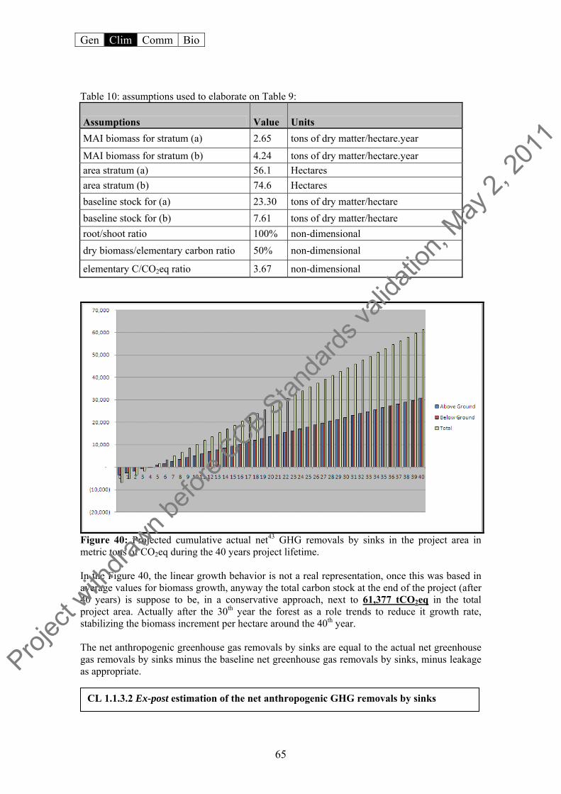
Gen Clim Comm Bio
65
Table 10: assumptions used to elaborate on Table 9:
Assumptions Value Units MAI biomass for stratum (a) 2.65 tons of dry matter/hectare.year
MAI biomass for stratum (b) 4.24 tons of dry matter/hectare.year area stratum (a) 56.1 Hectares area stratum (b) 74.6 Hectares baseline stock for (a) 23.30 tons of dry matter/hectare baseline stock for (b) 7.61 tons of dry matter/hectare root/shoot ratio 100% non-dimensional dry biomass/elementary carbon ratio 50% non-dimensional
elementary C/CO2eq ratio 3.67 non-dimensional
Figure 40: Projected cumulative actual net43 GHG removals by sinks in the project area in metric tons of CO2eq during the 40 years project lifetime. In the Figure 40, the linear growth behavior is not a real representation, once this was based in average values for biomass growth, anyway the total carbon stock at the end of the project (after 40 years) is suppose to be, in a conservative approach, next to 61,377 tCO2eq in the total project area. Actually after the 30th year the forest as a role trends to reduce it growth rate, stabilizing the biomass increment per hectare around the 40th year. The net anthropogenic greenhouse gas removals by sinks are equal to the actual net greenhouse gas removals by sinks minus the baseline net greenhouse gas removals by sinks, minus leakage as appropriate.
CL 1.1.3.2 Ex-post estimation of the net anthropogenic GHG removals by sinks
Projec
t with
drawn b
efore
CCB Stan
dards
valid
ation
, May
2, 20
11
Gen Clim Comm Bio
66
The resulting lCERs at the year of verification tv are calculated as follows: for the first crediting period:
for subsequent crediting periods:
Where: P(t) = carbon stocks within the project boundary achieved by the project activity at time t (t CO2e) GHGPROJ, (t) = project emissions from use of fertilizers (t CO2e/year) Δ CBSL,t = baseline net GHG removals by sinks (t CO2-e/year) Ltv = total GHG emission due to leakage at the time of verification (t CO2e) LCP1 = total GHG emission due to leakage at the end of the first crediting period (t CO2e) lCER(tv-k) = units of lCERs issued following the previous verification tv = year of verification (years) κ = time span between two verifications (years) CL1.2 Factor in the non-CO2 gases CH4 and N2O to the net change calculations (above) if they are likely to account for more than 15% (in terms of CO2 equivalents) of the project’s overall GHG impact. CL 1.2.1 Formulae used for project GHG emission (NOX)
Where: N2O direct- N t = Direct N2O emission as a result of nitrogen application within the project boundary, t-CO2e in year t FSN,t = Mass of synthetic fertilizer nitrogen applied adjusted for volatilization as NH3 and NOX, t-N in year t FON,t = Mass of organic fertilizer nitrogen applied adjusted for volatilization as NH3 and NOX, t-N in year t MSFi,t = Mass of synthetic fertilizer type i applied, tonne in year t MOFjt = Mass of organic fertilizer type j applied, tonne in year t EF1 = Emission Factor for emissions from N inputs, tonne-N2O-N (t-N input)-1 (Tier 1)44 FracGASF = Fraction that volatilises as NH3 and NOX for synthetic fertilizers, dimensionless
43 The CO2e stocked in the baseline biomass was already discounted in this graphic representation. 44 IPCC 2006 Guidelines (Table 11.1), the default emission factor (EF1) is 1% of applied N.
(12)
(13)
(14)
(10)
(11)
Projec
t with
drawn b
efore
CCB Stan
dards
valid
ation
, May
2, 20
11
Gen Clim Comm Bio
67
FracGASM = Fraction that volatilises as NH3 and NOX for organic fertilizers, dimensionless (Tier 1)45 MW N2O = Ratio of molecular weights of N2O and N (44/28), tonne-N2O (t-N)-1 GWPN2O = Global Warming Potential for N2O, kg-CO2-e (kg-N2O)-1 (IPCC default = 310, valid for the first commitment period) NC SFi = Nitrogen content of synthetic fertilizer type i applied, g-N (100 g fertilizer)-1 NC OFj =Nitrogen content of organic fertilizer type j applied, g-N (100 g fertilizer)-1 (Tier 2)46 I = Number of synthetic fertilizer types J = Number of organic fertilizer types
The emissions calculated from fertilizer was no greater than the 10% of the GHG removed by the project (see Section C.2) so according to AR-AMS0001 the GHG emitted by project activities must be assumed to be zero.
CL 1.2.2 Project emissions calculation According to AR-AMS0001 the only source of GHG that must be considered as a project emission is the NOX emitted from the organic fertilizer. However, if the GHG emitted by the project activities does not exceed 10% of the total ex-ante net GHG removed by the project activities, net project emissions can be assumed to be zero. For the case of HMA forest project the fertilization will be divided in two stages: 2.5 kg per seedling of manure in the first year and 2.5 kg of manure per seedling in the second year. The total manure used in both strata will be 577.2 tons, which translates to 5,551 tons of CO2eq in form of NOX. This value represents 9.04% of the total ex-ante net GHG removed within the project borders, and thus can be ignored. The fertilizer NOX emissions were calculated according to formulae 12, 13 and 14 in Section C1.2.1. CL1.3 Demonstrate that the net climate impact of the project (including changes in carbon stocks, and non-CO2 gases where appropriate) will give a positive result in terms of overall GHG benefits delivered. During the preparation of the project, all aspects of carbon removal or GHG emissions from project activities were investigated based on the AR-AMS0001 methodology (see sections CL1.2 and CL2.1) Both quantitative and qualitative analyses suggest that project emissions can be neglected as they will not reach the 10% of calculated ex-ante GHG removals by the project. Even considering baseline project emissions the contribution of the project toward climate change mitigation by GHG removal from the atmosphere is evident.
CL2. Offsite Climate Impacts (“Leakage”)
Neither emigration of people from the project area, nor a reallocation of activities are expected results of project. The most plausible leakage scenario of the project activities is a leakage near zero, due to the low impact on the surrounding areas of using a small area (130 hectares) for reforestation.
45 IPCC 2006 Guidelines (Table 11.3) Organic fertilizer nitrogen that are emitted as NOX and NH3 is 0.2 46 COSTA, 2005: Nitrogen content of manure = 2.47g/kg
Projec
t with
drawn b
efore
CCB Stan
dards
valid
ation
, May
2, 20
11

Gen Clim Comm Bio
68
CL2.1 Estimate potential offsite decreases in carbon stocks (increases in emissions or decreases in sequestration) due to project activities. According to decision 6/CMP.1, Appendix B, paragraph 9: “If project participants demonstrate that the small-scale afforestation or reforestation project activity under the CDM does not result in the displacement of activities or people, or does not trigger activities outside the project boundary, that would be attributable to the small-scale afforestation or reforestation project activity under the CDM, such that an increase in greenhouse gas emissions by sources occurs, a leakage estimation is not required. In all other cases leakage estimation is required.” The only activity previously conducted in the area of this small-scale afforestation and reforestation project was the cattle grazing. The AR-AMS0001 mentions three leakages indicators that must be monitored. None of them is applicable to the project area:
(a) Area under cropland within the project boundary displaced due to the project activity:
No cropping is currently taking place within the 130 hectares designated for afforestation/reforestion.
(b) Number of domesticated grazing animals within the project boundary displaced due to the project activity:
The number of animals that grazed inside the total area of the Ecologica network
properties (1898 ha) was around 60, so inside the reforestation area (130ha), was less than 10 animals. However, the entire herd was sold for slaughter or sold to more productive pasture of large commercial cattle-rearing farms in the surrounding region, and thus no leakage need be considered from this activity.
(c) For domesticated roaming animals, the time-average number of domesticated grazing
animals per hectare within the project boundary displaced due to the project activity:
As mentioned above the animals were not displaced removed willingly. Thus, no forest or natural savannah areas need to be converted into pasture to permit the reallocation of this herd.
Summarizing: Ltv = 0 (15) Where: Ltv = total GHG emission due to leakage at the time of verification (t CO2-e) CL2.2 Document how negative offsite impacts resulting from project activities will be mitigated, and estimate the extent to which such impacts will be reduced. Not applicable, since the impacts of project activities will be positive in relation to the climate, community, and biodiversity. CL2.3 Subtract any likely project-related unmitigated negative offsite climate impacts from the climate benefits claimed by the project. The total effect, equal to the net increase in onsite carbon stocks (calculated in the third indicator in CL1) minus negative offsite climate impacts, must be positive.
Projec
t with
drawn b
efore
CCB Stan
dards
valid
ation
, May
2, 20
11

Gen Clim Comm Bio
69
In reality the project-related climate impacts are expected to be positive in terms of avoided emissions in other areas and also for carbon removal from side reforestation activities. Firstly, as mentioned previously, the project has a role to support local fire brigades and to implement fire control strategies in the project borders that will positively impact other areas beyond the project borders. The project fire brigade, as well as the municipal fire brigade of Taquarussu, will be in charge and will be support to controlling not just fires that directly threaten the reforestation area, but also other regional fires outbreaks. In the case of the project brigade, the priority will be the reforestation area and nearby fire outbreaks, while the municipal fire brigade will of course have its own priorities, but must be committed with the conservation of the project area, once this is the only counterpart from them to the project47. Secondly, the project, once permitted to promote forestry and sustainable production workshops, is expected to create a new paradigm for income generation for the local communities and ranchers, in showing the potential of non-timber and non-energetic48 forest product management, and the viability of native species for commercial applications. By using this new commercial forestry approach, the project proponents seek to introduce an alternative land use to the project region, based on the reforestation with economical native species, influencing local communities, ranchers, settlers activities, as well as governmental development local policy. Table 11: Project Carbon Balance Stratum Project
Emissions (tCO2eq)49
Leakage (tCO2eq)50
Baseline (tCO2eq)51
Carbon removal due to the project in 40 years (tCO2eq)52
Net GHG removal by the project activities foreseen after 40 years
(a) 0 0 4,797 21,824 15,306 (b) 0 0 2,083 46,433 40,541 Total 0 0 6,880 68,257 55,847
CL3 Climate Impact Monitoring
In accordance with decision 6/CMP.1, Appendix B, paragraph 6, which states that, “no monitoring of the baseline is requested.” Thus, the baseline monitoring for this project will not be conducted.
The project area was pre-classified into two different areas as mentioned above (“a” and “b”) in order to improve the accuracy and exactness of biomass estimations (ex-post) and baseline calculations (Section G2). During the field data collection for the first monitoring period, if significant statistical variation is observed in the biomass results, sub-stratification must be instated in order to reduce the 47 The terms of the partnership is currently under negociation between the I.E. and the Voluntary Fire Brigade of Taquarussu parts, and wil be conclude before the beginning of the project activities. 48 Charcoal and firewood 49 According to section CL 1.2.2. 50 According to section CL 2.1 51 According to section G 2.1.4 52 According to section CL 1.1.3.2
CL 3.b Ex-post estimation of the actual net greenhouse gas removals by sinks
CL 3.a Ex-post estimation of the baseline net greenhouse gas removals by sinks
Projec
t with
drawn b
efore
CCB Stan
dards
valid
ation
, May
2, 20
11

Gen Clim Comm Bio
70
sampling effort and the cost of the forest inventory. This sub-stratification is based on approach (ii) “stratification approach that can be shown in the PDD to estimate biomass stocks according to good forest inventory practice in the host country in accordance with DNA indications” stated in Section 38, for ex-post estimation of project GHG removals by sinks, of the AR-AMS0001. The carbon stock variability will be monitored in permanent plots according to Section 4.3.3.4 of the IPCC Good Practice Guide. The number of permanent plots will be determined form the biomass standard deviation found for each stratum. Sampling stratification in homogeneous sites of the reforestation area allows for a significant reduction in the sampling effort and forest inventory costs, and contributes qualitatively to analysis results. The stratification for stock quantification will be defined prior and aspects considered will be: previous stratification (strata “a” and “b”), the terrain slope when applicable and the visual aspect of the tree development. The reforestation area with its current two strata regime were geo-referenced along with the land use within this and surrounding areas (reference areas). The product of this assessment is shown in Section G1.5 (Land Use Map) and G2.1.4 (Classified Map). GPS points will define the exact location of each plot. This land use map will be used to orient the plot locations in the few months before the first biomass monitoring. Carbon stocks (expressed in t CO2-e) shall be estimated through the following equations:
Where: P(t) = carbon stocks within the project boundary at time t achieved by the project activity (t CO2-e) PA(t) i = carbon stocks in above-ground biomass at time t of stratum i achieved by the project activity during the monitoring interval (t C/ha) PB(t) i = carbon stocks in below-ground biomass at time t of stratum i achieved by the project activity during the monitoring interval (t C/ha) Ai = project activity area of stratum i (ha) i = stratum i (I = total number of strata) The following calculations shall be performed for each stratum. • Above-ground biomass For above-ground biomass PA(t) i is calculated per stratum i as follows: PA(t)i = E(t)i*0.5 E(t)i =SV(t) i * BEF*WD Where: PA(t) i = carbon stocks in above-ground biomass at time t achieved by the project activity during the monitoring interval (t C/ha) E(t) i = estimate of above-ground biomass at time t achieved by the project activity (t d.m./ha) SV(t) i = stem volume (m3/ha) WD = basic wood density (t d.m./m3) BEF = biomass expansion factor (over bark) from stem to total aboveground biomass (dimensionless)
(17)
(18)
(16)
Projec
t with
drawn b
efore
CCB Stan
dards
valid
ation
, May
2, 20
11
Gen Clim Comm Bio
71
• Below-ground biomass Carbon stocks in below-ground biomass at time t achieved by the project activity during the monitoring interval PB(t) shall be estimated for each stratum i, as follows: PB(t)i = E(t)i * R * 0. 5 Where: PB(t)i = carbon stocks in below-ground biomass at time t achieved by the project activity during the monitoring interval (t C/ha) E(t)i = estimation of above-ground biomass of stratum i at time t achieved by the project activity (t d.m./ha) R = root/shoot ratio (dimensionless) 0.5 = carbon fraction of dry matter (t C/t d.m.)
The N2O emission from fertilizers will not reach 10% of the actual net greenhouse gas removals by sinks, thus the project emissions are not significant and assumed to be zero. The N2O emission was estimated in accordance with the IPCC Good Practice Guidance and Uncertainty Management in National Greenhouse Gas Inventories (hereafter referred to as IPCC Good Practice Guidance). For GHG emitted by the project activities, please see items CL1.2 and CL1.3.
CL3.1 Have an initial plan for how they will select carbon pools and non-CO2 GHGs to be monitored, and the frequency of monitoring. Potential pools include aboveground biomass, litter, dead wood, belowground biomass and soil carbon. Pools to monitor must include any pools expected to decrease as a result of project activities. Relevant non-CO2 gases must be monitored if they account for more than 15% of the project’s net climate impact expressed in terms of CO2 equivalents.
The area is currently divided into two strata stated according to the current biomass stock and land use and particularities of the vegetation cover (Section CL 1.1). Notwithstanding another stratification will be done a few months before the first forest inventory, based mainly on the aspects observed for the tree development. This approach is expected to homogenize the sample reducing the sample efforts, and forest inventory costs. A visual assessment of the planted forest is supposed to aggregate indirectly information regarding chemical and physical soil characteristics, water availability for the seedling, biotic influences in the tree development, among others. All the strata will then be geo-referenced and plotted over the project area map, composing the GIS database and the biomass growth monitoring for the subsequent monitoring periods.
Sample processing will be conducted on the dendrometric data collection (diameter at 30 cm high and tree oblique height) made in the permanent plots that will allow the biomass calculation for the plot, stratum and the entire project area.
CL 3.1.2 Sampling structure
(19)
CL 3.1.1 Project area stratification
Projec
t with
drawn b
efore
CCB Stan
dards
valid
ation
, May
2, 20
11

Gen Clim Comm Bio
72
The steps are as follows: • Divide the total area in homogeneous strata for inventory and data collection purposes • Stratum definition • 3 sampling units (plots), randomly located for each stratum • Calculate the average and standard deviation per stratum • Calculate the sampling density, sampling error and confidence interval • Determine the definitive number of plots per strata • Random allocation of permanent plots for all strata
Pilot sample Following the standard proceedings for forest inventory, a few months before permanent plots are determined, three preliminary plots will be placed in the field for each stratum53 to calculate the exact number of permanent plots for the total area. Calculation of stratum variability:
Sj = (Ymaxi - Ymini)/4.5
Where: Sj: standard deviation of stratum j Y maxj : maximum volume/plot in stratum j Y minj : minimum volume/plot in stratum j
Calculation of the population variability:
Where: Sstr.: standard deviation of the classified population M: number of strata Nj: number of strata in the sample N: total number of samples pre-determined for the population
Sampling intensity (n) or the total number of permanent plots per stratum:
Where: n: number of plots per stratum t: Student’s t (table value with a confidence interval of 95%) Sstr: standard deviation of the population that was divided in the plot E: error (mean volume x 0.1 to obtain 10% accuracy) N: total number of the samples pre-determined for the population (considering all strata)
53 The number of preliminary plots will depend on the heterogeneity observed in the field for each stratum and on size.
CL 3.1.4 Allocation of the permanent parcels of the forestry inventory (excellent distribution or the Neyman)
(20)
(21)
(22)
CL 3.1.3 Forest inventory formulation
Projec
t with
drawn b
efore
CCB Stan
dards
valid
ation
, May
2, 20
11

Gen Clim Comm Bio
73
The number of plots for each stratum will be defined by:
Where: nj = number of plots for each stratum Sj: standard deviation of stratum j M: number of strata Nj: number of strata in the sample n: number of plots per stratum N: total number of the samples pre-determined for the population (considering all strata)
Figure 41: Plots of 50 m X 20 m, sub-divided into 10 squares of 10 m X 10 m
During the forest biomass inventory phase, information will be collected in the field (permanent plots): Tree oblique height and diameter at 30cm high (D30). In case of species belonging to the Arecaceae order – botany family Palmaceae, the volume calculations will be made based in allometric equation supplied in Appendix 4.A.2 from the IPCC’s Good Practice Guidance for LULUCF. For D30 measurements precision calipers will be used: currently aluminum alloy calipers show millimeter graduations. Dimensions may vary in the forest population where the survey will be conducted, from 45 cm to 120 cm. The usual dimensions for planted forests area vary from 45 to 65 cm diameter.
(23)
CL 3.1.5 Field data sampling
Projec
t with
drawn b
efore
CCB Stan
dards
valid
ation
, May
2, 20
11

Gen Clim Comm Bio
74
Figure 42: Use of precision calipers For height measurements a telescopic rod will be used. The method is applicable to young individuals whose height does not exceed 10 meters.
Figure 43: Telescopic rod.
The carbon stocks in the soil organic matter, litter and dead wood is not considered in this methodology, so the verifiable variations and quantifiable for the present small scale reforestation project carbon stock are equal to the carbon stock in the live trees biomass above and below ground. The relationship between forest data and the carbon stock calculation will be made by the estimative of the cylindrical volume of the trees biomass, which can be expressed by plots, per stratum and the project area. The dry biomass will be calculated using the volume of each individual tree in the parcel using the alometric equation for the Cerrado biome (ABDALA et al, 1998)
CL 3.1.6 Carbon stocks change measurements and estimative in time
CL 3.1.7 Forest biomass monitoring Projec
t with
drawn b
efore
CCB Stan
dards
valid
ation
, May
2, 20
11

Gen Clim Comm Bio
75
Reforestation will be monitored every five years. The forest inventory data and monitoring reports will be kept available for two years after the last credit period of the project. After the fifth year the monitoring will be made in all permanent plots disposed in each stratum. Table 12: Data to be collected or used in order to monitor the verifiable changes in carbon stock in the carbon pools within the project boundary resulting from the proposed small-scale A/R CDM project activity, and how this data will be archived.
Data variable Source Data
unit
Measured, calculated or estimated
Frequency (years) Proportion Media Comment
Location of the areas where the project activity has been implemented
Field survey, cadastral information, and satellite imagery
latitude and longitude
Measured 5 100 per cent
Electronic, paper, photos
GPS was used for field survey (precision error less than 3 meters)
Ai - Size of the areas where the project activity has been implemented for each type of strata
satellite imagery and GPS
ha Measured 5 100 per cent
Electronic, paper, photos
GPS was used for field measurement (precision error less than 3 meters)
Location of the permanent sample plots
Project maps and project design
latitude and longitude
Defined 5 100 per cent
Electronic, paper
Plot location will be registered with a GPS and marked on the map
Diameter of tree at 30 cm height (D30)
Permanent plot measurement
cm Measured 5 Each tree in the sample plot
Electronic, paper
Measure diameter at 30 cm height (D30) for each tree that falls within the sample plot and applies to size limits
Oblique Height of the trees
Permanent plot
m Measured 5 Each tree in the sample plot
Electronic, paper
Measure oblique height (H) for each tree that falls within the sample plot and applies to size limits
Basic wood density
Technical Literature (Tier 2)
tonnes of dry matter per m3 fresh volume
Estimated Once
Electronic, paper
Projec
t with
drawn b
efore
CCB Stan
dards
valid
ation
, May
2, 20
11
Gen Clim Comm Bio
76
Total CO2 Project activity
Mg or metric tones
Calculated 5 All project data
Electronic, paper
Based on data collected from all plots and carbon pools
The quality control procedures are focused mainly on the field data collection. In order to guarantee the quality in the field data collection the steps below will be followed:
• Adequate equipment will be used to the field measurement of area, D30 and oblique height (see equipment described in item b.3.1)
• The dendrometric data collection (D30 and H) will permit to be done using only the field-filing card system according to the model in Appendix 2.
• The field data annotation will be done by the engineer in charge of the forest inventory activities. In his or her absence, an agronomer with forest experience can substitute.
• The fieldwork team must be composed of professionals with broad experience in forest inventories and dendrometric data collection.
Besides the methods planned for field data collection, special attention will be payed to guarantee best results during the field data processing, analysis and storage. This services will be done by the project proponent’s technical team composed of at least: 1 administrator, 1 forest engineer, 1 agronomer, 1 environmental engineer, 1 GIS and image processing analyst and 2 office assistants. The data and processed information will be available to all participants of the project. It will be saved on multiple computers as well in printed form for access up to two years after conclusion of the project and the crediting period. The field data as well as field information will be assessed and compared with other similar projects conducted in other zones of Brazilian savannah in order to confirm the accuracy of final results. Wide disparities between results of this and other similar studies will merit secondary field data collections and field information reprocessing. If during the site verification activities, any significant difference be noted in the final biomass results, a new biomass inventory can be done in the field to check the correct values, or the project proponent can adopt the lowest value in order to keep the conservative approach regarding the credit generation.
The Ecologica Institute will provide reforestation instruction, forest management, and fire breaks maintenance. The I.E. will contract local people and experts to conduct the reforestation activities, and will conduct the specific supervision of the implementation of the proposed A/R CDM project activity according to the PDD description, and monitor forest development and firebreaks on routine basis. CantorCO2e Brazil will lead all the stages regarding biomass measurement and carbon calculations in the proposed small-scale A/R project. CantorCO2e Brazil will also be in charge of the monitoring report, and will support I.E. anytime about the field activities when required.
CL 3.1.8 Qualitative explanation of how quality control (QC) and quality assurance (QA) procedures are undertaken
CL 3.1.9 Brief description of operational and management structure(s) that the project operator will implement in order to monitor actual GHG removals by sinks by the proposed small-scale A/R CDM project activity.
Projec
t with
drawn b
efore
CCB Stan
dards
valid
ation
, May
2, 20
11

Gen Clim Comm Bio
77
CL4 Adapting to Climate Change and Climate Variability
CL4.1 Identify likely regional climate change and climate variability impacts, using available studies.
According to Cândido et al (2007), global climate change is already in progress. It has caused a increase in the overall air temperature and changes in precipitation patterns. The temperature increase alone is enough to dramatically affect the biodiversity of the ecosystems in the Legal Brazilian Amazon. Extremes events are supposed to became more frequently, especially flooding and droughts.
In 2005, the North region of Brazil (The Legal Amazon) experienced the worst drought in 60 years and the Amazon River dropped to its lowest level 30 years. In 2006 between January and March, abnormal heat waves swept the region. In January 2007, extreme climatic events in the form of hard rains, floods, and a rare tropical cyclone also hit the region54 (Figure 44).
Figure 44: Rain anomalies between September 2000 and May 2001 in mm/month (Source: Cavalcanti and Kouksy, 2001)
It should be reiterated that the changes are associated with an overall increase of 0.7°C since 1900 (NOAA, 2000). An IPCC (2007) study used mathematical model to predict the temperature increase under different carbon emissions scenarios.
The Business as Usual (BAU) model A1B, which assumes that emissions will continue at today’s levels, predicts that the temperature will increase by approximately 2.8°C by the year 2100. Model B1 assumes that the emissions goals prescribed with Kyoto Protocol will be met, predicting a 1.8°C increase in global average temperature by the year 2100. In an optimistic but unlikely scenario, where emissions are drastically reduced to 2000 levels, the model predicts an increase by approximately 0.6°C by the year 210055 (see Figure 45).
54 NOAA (2008): http://www.ncdc.noaa.gov/oa/climate/research/hazards/index.php 55 IPCC (2007): Fourth Assessment Report Working Group I.
Projec
t with
drawn b
efore
CCB Stan
dards
valid
ation
, May
2, 20
11
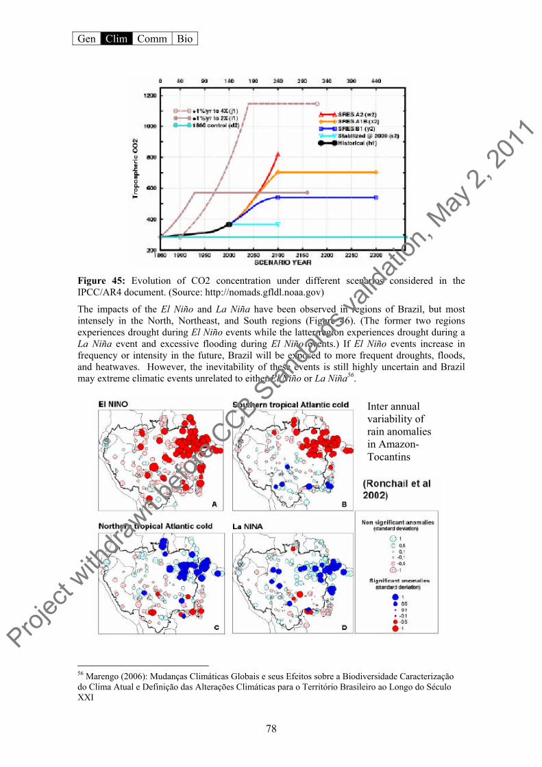
Gen Clim Comm Bio
78
Figure 45: Evolution of CO2 concentration under different scenarios considered in the IPCC/AR4 document. (Source: http://nomads.gfldl.noaa.gov)
The impacts of the El Niño and La Niña have been observed in regions of Brazil, but most intensely in the North, Northeast, and South regions (Figure 46). (The former two regions experiences drought during El Niño events while the latter region experiences drought during a La Niña event and excessive flooding during El Niño events.) If El Niño events increase in frequency or intensity in the future, Brazil will be exposed to more frequent droughts, floods, and heatwaves. However, the inevitability of these events is still highly uncertain and Brazil may extreme climatic events unrelated to either El Niño or La Niña56.
56 Marengo (2006): Mudanças Climáticas Globais e seus Efeitos sobre a Biodiversidade Caracterização do Clima Atual e Definição das Alterações Climáticas para o Território Brasileiro ao Longo do Século XXI
Inter annual variability of rain anomalies in Amazon-Tocantins
Projec
t with
drawn b
efore
CCB Stan
dards
valid
ation
, May
2, 20
11
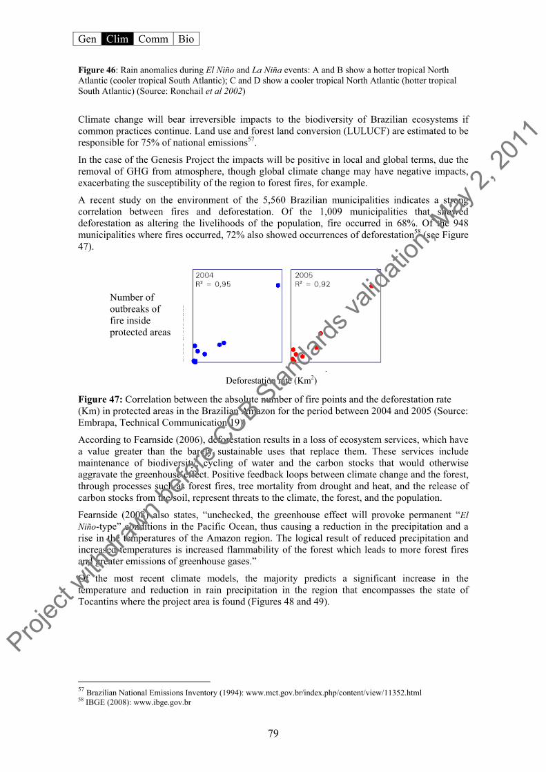
Gen Clim Comm Bio
79
Figure 46: Rain anomalies during El Niño and La Niña events: A and B show a hotter tropical North Atlantic (cooler tropical South Atlantic); C and D show a cooler tropical North Atlantic (hotter tropical South Atlantic) (Source: Ronchail et al 2002)
Climate change will bear irreversible impacts to the biodiversity of Brazilian ecosystems if common practices continue. Land use and forest land conversion (LULUCF) are estimated to be responsible for 75% of national emissions57.
In the case of the Genesis Project the impacts will be positive in local and global terms, due the removal of GHG from atmosphere, though global climate change may have negative impacts, exacerbating the susceptibility of the region to forest fires, for example.
A recent study on the environment of the 5,560 Brazilian municipalities indicates a strong correlation between fires and deforestation. Of the 1,009 municipalities that showed deforestation as altering the livelihoods of the population, fire occurred in 68%. Of the 948 municipalities where fires occurred, 72% also showed occurrences of deforestation58 (see Figure 47).
Figure 47: Correlation between the absolute number of fire points and the deforestation rate (Km) in protected areas in the Brazilian Amazon for the period between 2004 and 2005 (Source: Embrapa, Technical Communication 19).
According to Fearnside (2006), deforestation results in a loss of ecosystem services, which have a value greater than the barely sustainable uses that replace them. These services include maintenance of biodiversity, cycling of water and the carbon stocks that would otherwise aggravate the greenhouse effect. Positive feedback loops between climate change and the forest, through processes such as forest fires, tree mortality from drought and heat, and the release of carbon stocks from the soil, represent threats to the climate, the forest, and the population.
Fearnside (2008) also states, “unchecked, the greenhouse effect will provoke permanent “El Niño-type” conditions in the Pacific Ocean, thus causing a reduction in the precipitation and a rise in the temperatures of the Amazon region. The logical result of reduced precipitation and increased temperatures is increased flammability of the forest which leads to more forest fires and greater emissions of greenhouse gases.”
Of the most recent climate models, the majority predicts a significant increase in the temperature and reduction in rain precipitation in the region that encompasses the state of Tocantins where the project area is found (Figures 48 and 49).
57 Brazilian National Emissions Inventory (1994): www.mct.gov.br/index.php/content/view/11352.html 58 IBGE (2008): www.ibge.gov.br
Number of outbreaks of fire inside protected areas
Deforestation rate (Km2)
Projec
t with
drawn b
efore
CCB Stan
dards
valid
ation
, May
2, 20
11
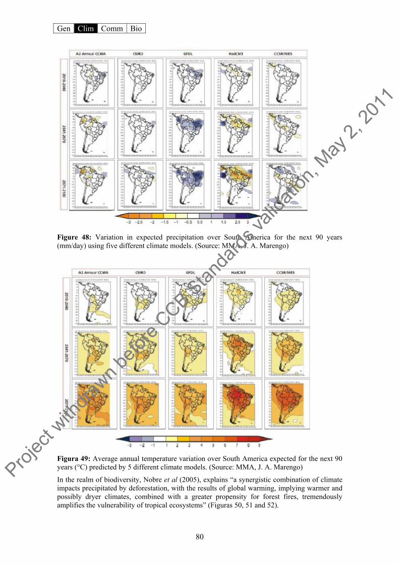
Gen Clim Comm Bio
80
Figure 48: Variation in expected precipitation over South America for the next 90 years (mm/day) using five different climate models. (Source: MMA, J. A. Marengo)
Figura 49: Average annual temperature variation over South America expected for the next 90 years (°C) predicted by 5 different climate models. (Source: MMA, J. A. Marengo)
In the realm of biodiversity, Nobre et al (2005), explains “a synergistic combination of climate impacts precipitated by deforestation, with the results of global warming, implying warmer and possibly dryer climates, combined with a greater propensity for forest fires, tremendously amplifies the vulnerability of tropical ecosystems” (Figuras 50, 51 and 52).
Projec
t with
drawn b
efore
CCB Stan
dards
valid
ation
, May
2, 20
11

Gen Clim Comm Bio
81
Figura 50 Relationship between fires (incêndios) and precipitation. (Source: Seção de Inteligência do 4˚BBM e LabCAA59)
Figure 51: Relationship between fires (incêndios) and relative air humidity (Source: Seção de Inteligência do 4˚BBM e LabCAA).
59 Climatology Laboratory and Environmental Analysis (LabCAA) of the Federal University Juiz de Fora (UFJF) 4th Battalion of Military Firefighters (4º BBM).
Projec
t with
drawn b
efore
CCB Stan
dards
valid
ation
, May
2, 20
11

Gen Clim Comm Bio
82
Figure 52: Map of fire risk at the end of the dry season (2008) for the state of Tocantins. (The white circle indicates the project area) (Source: INPE/CPTEC60).
This is because fire cycles occurring with high frequency disfavors biodiversity as Nobre et al (2005), tremendously amplifies the vulnerability of tropical ecosystems, favoring more adaptable species.” That is, species such as canela-de-ema (Vellozia squamata) and babaçu (Orbignya phalerata) which are more resistant to fire, tend to dominate the landscape after several fire cycles and accordingly lowering local diversity. With the passage of fire, the necessity for animals to flee the affected areas becomes apparent, to the extent that each is capable of doing so. Some smaller species find shelter in soil cavities where temperatures as fire sweep over is not extreme. However, the biota found in the arboreal substrate is negatively affected by the successive burning, harming the repopulation of these species.
For the social component of the project, the effects of climate would interfere profoundly to the surrounding community. Indirectly, surrounding populations the would be subjected to diminished environmental services provided by biodiversity and principally, hydrological resources whose direct response to climate change would be reduced supplies.
The expectation of climate change, in a scenario without any mitigation (occasioning temperature increase, precipitation decline, and resulting soil drying), combined with the known detriments of the use of fire in the region (a crude pasture and crop management methods) represents a significant threat to the project area.
CL4.2 Demonstrate that the project has anticipated such potential impacts and that appropriate measures will be taken to minimize these negative impacts.
60 http://sigma.cptec.inpe.br/produto/queimadas/maparisco/risco_est.html. Acesso em: Outubro de 2008.
Projec
t with
drawn b
efore
CCB Stan
dards
valid
ation
, May
2, 20
11
Gen Clim Comm Bio
83
Adaptive capacity is defined by the IPCC as, “… the ability of a system to adjust to climate change (including climate variability and extremes) to moderate potential damages, to take advantage of opportunities, or to cope with the consequences.”61
Fearnside (2008) adds that “adaptive capacity and vulnerability are intimately related to the ability of a social or ecological system to absorb impacts while at the same maintaining the same basic structure and the same functional means, the capacity to self-organize and the capacity to adapt to stress and change.”
Besides the potential risks to ecosystems due to global climate change, it is difficult to forsee the real impacts on the Genesis Project area in quantitative terms. With the identification of the forces impeding the project and the implementation of the Strategic Conservation Plan, a continuous and recurrant monitoring of the biodiversity, carbon, and the community will be conducted, and thereby conceivably mitigating the risks.
CL5 Carbon Benefits Withheld from Regulatory Markets
All of the carbon credits that will be generated by the Hyundai forest project (around 61,377 metric tons) will be withheld from the regulatory market. In other words, all credits less 20% buffer (contingency), will be sold as VER62’s to Hyundai for its voluntary offset commitment. CL5.1 Not sell at least 10% of the total carbon benefits generated by the project4 into regulated GHG markets (e.g., CDM, New South Wales GHG Abatement Scheme, Oregon Standard). Projects can sell these carbon benefits in a voluntary market or retire them.
When CCB (Climate, Community, and Biodiversity) assumptions are accounted for, the project is highly conservative, far exceeding the minimum required by CCB Standard. All told, 20% of the total verified emission reduction will be withheld as contingence until the verification process confirm that the buffer is not being used to replace any leakage or accidental carbon stock loss. Following this premise the buffer can be gradually released to the project carbon credits account.
61 Policymakers’ Summary. Climate Change 2007: Impacts, Adaptation, and Vulnerability. Contribution of Working Group II to the Fourth Evaluation Report of the Intergovernmental Panel on Climate Change. 62 Verified Emission Reduction (VERs), equal to one ton of CO2eq reduction or conservation, also know as carbon credit. This type of credit was designed as a mechanism for the voluntary market to mitigate climate change.
Projec
t with
drawn b
efore
CCB Stan
dards
valid
ation
, May
2, 20
11

Gen Clim Comm Bio
84
V. COMMUNITY SECTION
CM1 Net Positive Community Impacts
CM1.1 Use appropriate methodologies to estimate the impacts on communities, including all constituent socio-economic or cultural groups such as indigenous peoples (defined in G1) resulting from planned project activities. A credible estimate of impacts must include changes in community well-being due to project activities and an evaluation of the impacts by the affected groups. This estimate must be based on clearly defined and defendable assumptions about how project activities will alter social and economic well-being, including potential impacts of changes in water and soil resources, over the duration of the project. The “with project” scenario must then be compared with the ‘without project’ scenario of social and economic well-being in the absence of the project (completed in G2). The difference (i.e., the community benefit) must be positive for all community groups. The Genesis Project outlines two components of principle activities, which according to the project’s vision, are intrinsic and complement the mission of proponent institutions in attenuating the effects of climate change. The components were designed to aggregate the same targeted public and stakeholder groups, to enable information about the project to be equally shared among all. This approach guarantees the project that for example the same people responsible for labor in preparing the land for planting, will also be responsible for clearing firebreaks and therefore the protection of the reforestation area. Thus the financial sustainability in the short and also long run will be possible for the realization of non-timber forest product management (fibres, seeds, oils, fruits, and honey).
As a result of these actions, the project is expected to preserve natural areas through a community effort and based on raised environmental awareness and positive perception about the place where they live and make a living. Social gains for the surrounding community from project activities can be verified through the MCS (see Appendix VII), which takes into consideration the guidelines for participation already set forth in the General Section through analyses of Social, Human, and Financial Resources.
The activities planned for the non-timber product management and the protection of the reforestation areas from forest fires will promote simple advances in the local development of the surrounding communities: income earning and increasing environmental quality through protection of conservation areas for the production of water and promotion of connectivity of forest fragments that permits genetic flux through resulting forest corridors.
Considering the scenario without the project presenting in items G2.3 and G2.4, a tendancy is observed to use land for cattle rising, or agriculture, one of the most common practices in the region in which inadequate soil management techniques are utilized.
In this context, one of the most serious scenarios and one that the project aims to avoid, by supporting the Volunteer Fire Brigade, are the constant fires that roll over the region and every year cause serious harm to the population, such as respiratory disease (especially infants and elderly) from inhaled smoke that completely blankets the Taquarussu district. Still worse, fires can directly threaten the people and animals’ lives (as is consistently cited by inhabitants). Paralleling these threats are the material damages from the burning of houses and rural installations.
Add to this scene the disorganized tourism activities cited by the Socio-economic and Environmental Diagnostic of the sub basin of the Taquarassu Grande River as being the second
Projec
t with
drawn b
efore
CCB Stan
dards
valid
ation
, May
2, 20
11

Gen Clim Comm Bio
85
most important use of property (14%). The fact could present either a boon or problem for the project, since the activity is considered economic but not always considered environmentally sustainable.
According to the Management Plan of the APA Serra do Lajeado, “The potential tourist areas also present problems, which begin with conditions disorganized for the activity, bringing degradation to the natural resources or to cultural and historic patrimony. It’s believed that ignorance of the support capacity of an area constitutes one of the primary factors in adopting inadequate practices and visitations.”
The Management Plan states further that, “among the limiting factors to potential development of tourist activities in other areas of the Serra do Lajeado, foremost is the non-existence of adequate infrastructure both in quality and quantity, such as access roads and other tourist amenities such as hotels and restaurants. There is equal scarcity of local labor adequately trained in customer service, particularly in the orientation and monitoring during tourist outings, even though nobody knows the region better than its inhabitants.”
In this context, the project activities could benefit the surrounding communities in promoting tourism in the APA Serra do Lajeado region through capacity-building of the local agents in themes related to the installation of infrastructure appropriate for scientific tourism in the Ecotropical Research Center. Ecological and cultural tourism has potential for the region, whose great variety of settings and landscapes that form a construct of great scenic beauty and which offers a fan of alternatives for tourism and leisure activities, from simple contemplation of nature to hiking and extreme sports. The landscape is also reflected in an enormous number of rock paintings, some of which are stamped into the most remote chapadas of the project area. Furthermore the scientific activities planned by the Ecotropical Research Center in partnership with Genesis Forest Project and its workshops for the area, will foment the rise of a new type of tourism for the region, scientific tourism as well the enhancement of traditional ecotourism.
Project activities will therefore promote tourism as an economic, social and environmentally sustainable activities, and the measurement of social gains (monitored, measured and evaluated by the Social Carbon Methodology,63 taking into account both the rules of participation (see General Section), through an analysis of social, human, and financial resources.
Its worth also mentioning that the Social Carbon Methodology was inpired by the Sustainable Livelihoods Approach (SLA), whose logical structure is very to the MCS.
In this context among the direct and indirect gains foreseen for local communities are significant improvements in the following areas:
support for combating forest fires in the project area and region, both to the local fire
brigade but also via trainings and information sessions;
capacity-building for community member in earning income through alternative and sustainable means (see Figure 51);
environmental education, promoting a better relationship between man and environment to achieve a better quality of life;
direct and indirect job creation as well as income generation (reforestation, nursery, seed collecting, activities among others)
Increase the strength and scope of activities of the Ecotropical Research Center considering its strong synergy and complementarity with both initiatives.
Finally, the most important benefits of the project in terms of Community will happen outside the project borders, but strongly linked to the reforestation activities.
63 See more detailed information of the methodology at www.socialcarbon.com and appendix VII
Projec
t with
drawn b
efore
CCB Stan
dards
valid
ation
, May
2, 20
11

Gen Clim Comm Bio
86
Figure 53: Social Carbon product line produced by different needy communities using native plants from the cerrado.
In the absence of project activities suggests that many of the social gains described above will not materialize, seeing that the financial resources available for these type of initiatives are scarce and do not figure into a majority of political agendas, in addition the traditional land management style is inadequate and outdated and causes constant forest fires, principally in the dry months. Successive burns result in constant threatening to the community health (smoke), as well as physical integrity of the people, besides to lead to a gradual lost of soil quality, thus also compromising the communities’ subsistence agriculture in medium-long term.
CM1.2 Document local stakeholder participation in the project’s planning. If the project occurs in an area with significant local stakeholders, the project must engage a diversity of stakeholders, including appropriate sub-groups, underrepresented groups and women living in the project vicinity. Stakeholders in the project’s area of influence must have an opportunity before the project design is finalized, to raise concerns about potential negative impacts, express desired outcomes and provide input on the project design. Project developers must document stakeholder dialogues and indicate if and how the project proposal was revised based on such input. The formulation of the present proposal did not include formal meetings with the surrounding community. Until the present moment just punctual meetings where done between the I.E. and the main stakeholders (Fire Brigade, public institutions, Artisans House, local NGO’s, among others) However, besides these meeting with local stakeholders and conversation to present the project strategies to the neighbors landowners, other methods were fundamental to the composition of the project, such as diagnostics and research conducted by local institutions and diverse activities conducted by the IE with Taquarussu community.
Projec
t with
drawn b
efore
CCB Stan
dards
valid
ation
, May
2, 20
11
Gen Clim Comm Bio
87
Among the studies currently being conducted by IE in the region are a few of note: the Social Carbon Methodology diagnostic of local artisans and also special participation of inhabitants and social allies in the district with an MCS course on formation of multipliers. The actions that are now proposed in the present project were explicit in these activities, such as combating forest fires and fomenting sustainable tourism.
Developing project activities supported by the MCS will promote broad intervention conditions with the communities and other stakeholders of project.
Another point merits restating, which is that physical activities of project since they are occur on private properties, are the responsibility of the Ecologica group, the owners of the area. In that vein, much of the experience gained during the past eight year working with the communities of the Taquarussu region, were automatically and incorporated into the scope of the project in a profound way.
On the other hand with respect to the activities to be conducted outside the project areas, many have already been discussed between interested parties, and with the network of actors that will aid in the implementation of such activities. In this context, all of the partners are aligned on the proposal and the preliminary rules of the project, even though no formal mobilization has taken place to specifically discuss the project.
The benefits that could stem from the project will be presented and discussed with all of the stakeholders at an opportune time in a public consultation. At this time local leaders will be called to the table to help diagram the greater part of activities proposed by the project. such as: the content of classes and workshops that will be promoted by the project, the form that the interaction with the fire brigade will take, how could the community be benefited by the no-timber forest products once the trees start its production, among others.
One of the strategies of the project proponent (I.E.) will be to promote debate with stakeholders of the project in order to just present the project and define general rules, and only after approval can the project move forward. The contrary is common among communities and often creates frustrated expectations when a project is not approved, and in turn compromises the mobilization of the same communities in future initiatives.
CM1.3 Formalize a clear process for handling unresolved conflicts and grievances that arise during project planning and implementation. The project design must include a process for hearing, responding to and resolving community grievances within a reasonable time period. This grievance process must be publicized to local stakeholders. Project management must attempt to resolve all reasonable grievances raised, and provide a written response to grievances within 30 days. Grievances and project responses must be documented. In the gamut of program activities of the Genesis Project, it is hoped that possible conflicts can be managed through management processes effected by the MCS. Using several diagnostics the project agents will be capable of identifying possible problems and idealize solutions, among them decision making based on consensus of a majority of participants (Fire Brigade group, Artisans House group, I.E., network seed collecting group, public institutions and others). The decisions should be made in an assembly with minutes printed and signed by the parties, and later distributed to all stakeholders involved in the process.
Projec
t with
drawn b
efore
CCB Stan
dards
valid
ation
, May
2, 20
11
Gen Clim Comm Bio
88
CM2 Offsite Stakeholder Impacts
CM2.1 Identify potential negative offsite community impacts that the project is likely to cause. The project may create some discomfort among landowners, principally those who still use illegal methods or methods incompatible with the environment or public health, such as hunting, logging, and indiscriminant burning.
However, it is hoped that through the social actions called for in the project, the community will gain sensitivity to environmental and climate problems and their direct and indirect impacts on their lives, on biodiversity, and on the natural resources. Thus the project intends to promote a process of shifting consciousness reflected also in practice, bringing sustainability into the community activities that influence the environment.
CM2.2 Describe how the project plans to mitigate these negative offsite social and economic impacts. The project considers the necessary actions to minimize and restrain pressures on the natural resources of the area. To this end the social component of the project will contribute significantly to mitigating the problem, as well as promote an adequate approach to community-involved actions.
The insertion of surrounding communities into project activities and the possibility of fomenting local income through forest management capacitation and actions and job creation, and also capacity-building, and knowledge dissemination, will be strategic to sensitizing the community and demonstrating that the project will not trigger negative impacts in surrounding communities.
The insertion of local communities, as well as outside landowners, into the project activities, capacity-building, and dissemination of knowledge about conservation themes and the potential of ecotourism, will represent a primary strategy to meeting project goals. Their presence will also be important to sensitizing them and demonstrating that the project will not trigger negative impacts on surrounding communities, but instead represent new opportunities of business.
CM2.3 Evaluate likely unmitigated negative offsite social and economic impacts against the social and economic benefits of the project within the project boundaries. Justify and demonstrate that the net social and economic effect of the project is positive. With the Genesis Project it is hoped that using the MCS, points that may cause unforeseen negative impacts on the community can be recognized. Understanding these points, the MCS being a management tool, will propose effective mechanisms for solving possible impasses.
In any case, the project understands that the proposals presented must effectively broadly deal with the problems of the region, common to everyone in the community, such as conservation of natural resources and their services, combating forest fires, impediments to the socio-economic development and fomentation of socio-economic development through sustainable tourism.
Finally, even if some of the strategies do not work as predicted, the net economic and social benefits to the community will happened in anyway, once the project strategy as a whole is systemic and contemplates a wide range of variables and aspects.
Projec
t with
drawn b
efore
CCB Stan
dards
valid
ation
, May
2, 20
11

Gen Clim Comm Bio
89
CM3 Community Impact Monitoring
CM3.1 Have an initial plan for how they will select community variables to be monitored, and the frequency of monitoring. Potential variables include income, health, roads, schools, food security, education and inequality. Community variables at risk of being negatively impacted by project activities should be monitored.
According to item G2.3, recognized stakeholders are comprised of the community living around the project and the institutions (public, private, and NGO) acting either direct or indirectly on the project region. The envolvement of these agents in the implementation of the project will be guided by the MCS (Appendix VII), generating a diagnostic of sustainability relationships for the project. Besides monitoring using the MCS, periodic tracking of the effectiveness and applicability of activities with community using the indicators develop from the methodology.
To launch a diagnostic of sustainability relationships existing between project activities and the community, the MCS’s use should elect the six resources for study described in the following table:
Sustainability Resources – Social Carbon Methodology
Biodiversity Resources
The species, ecosystems and genes, which make up the biological diversity of a given region. Relevant aspects of this component are: the integrity of natural communities, the way humans use and interact with biodiversity, the degree of conservation, the pressures and threats imposed on native species and the existence of high-priority conservation areas or conservation “hotspots”.
Natural Resources
The natural resource stocks (soil, water, air, etc.) and environmental services (soil protection, maintenance of hydrological cycles, pollution sinks, pollination, etc.) from which resources for livelihoods are derived.
Financial Resources The basic capital (cash, credit/debt, savings and other economic assets) which is available to people and which provides them with different livelihood options.
Human Resources The skills, knowledge, ability to work and good health that people have. Taken together, these become fundamental for the successful pursuit of different livelihood strategies.
Social Resources
The social resources (networks, social duties, social relations, relationships of trust, affiliations, community associations, etc.) upon which people draw when pursuing different livelihood strategies.
Carbon Resources Refers to the type of carbon management being practiced, which may be categorized as sequestration, substitution, or conservation.
For each resource, the group of project executors, the surrounding community, and other stakeholders should define a set of indicators and variables, which will be analyzed according to the information investigated and supplied by the group.
This set will constitute a prospectus for the actual project, and should be identified according to the following graphic, commonly adopted by the MCS:
Projec
t with
drawn b
efore
CCB Stan
dards
valid
ation
, May
2, 20
11

Gen Clim Comm Bio
90
Figure 54: Hexagon – Graphic tool used by the Social Carbon Methodology (MCS) to monitor
the socio-environmental benefits of the project. Through the use of periodic analyses, denominated by the MCS as “benchmarks”, the group can verify which sustainability indicators are being best attained by the project and which are in need of incentives and adjustments, based on a comparison between current and previous benchmarks.
Each report will provide everyone directly or indirectly involved a means to track project activities. Important information, as well as information linked to project proponent Ecologica Institute’s monthly bulletin, will be available to the external public via their website (www.ecologica.org.br).
CM4 Capacity Building
CM4.1 Structured to accommodate the needs of communities, not only of the project The Genesis Project has a vested interest in promoting activities in the project area that guarantee the preservation and environmental conservation associated with the well-being of surrounding communities. The actions will be broad-sweeping, dynamic, and interdependent. The activities relating to reforestation were outlined and developed aiming to make compatible such activities with the communities that could potentially become influential by the project, and so the scope of the project from the beginning of its development calls for stakeholder participation, through periodic meetings of establish community groups (fire brigade, artisans, seed collecting group, among others), together with the use of diagnostics already conducted in the region. Thus the needs of the community are being contemplated from the structural developments of the project to the final definitions about the form of stakeholder participation. On the other hand these needs ought to be discussed further once the project is approved, otherwise if the project does not get the approval the stakeholders can get disappointed, compromising futures activities and social programs of the I.E. in Taquarussu.
Through monitoring of socio-environmental indicators via the MCS, the communities need will be adjusted and incorporated into the project dynamic. The aim is to establish a close relationship between communities and project decision-making.
Besides this preoccupation with the social results, the Genesis Project will utilize the tools of environmental education, multiplication of sustainable concepts, training courses (theory and practice), workshops, and capacity-building sessions to bring the benefits and positive social impacts to the community in the project region.
Projec
t with
drawn b
efore
CCB Stan
dards
valid
ation
, May
2, 20
11

Gen Clim Comm Bio
91
In this way, the activities chosen for the scope of the project must establish protections for the local biodiversity and cultural identity of the community, as the use of fruits and seeds from cerrado plants is common in local cuisine and in the manufacture of various items (souvenirs, culinary instruments, tools, etc.)
CM4.2 Targeted to a wide range of groups, not just elites In the district of Taquarussu 67%64 of families receive federal government aid in the form of the Bolsa Familia. The district is essentially residential and offers few employment opportunities for its population. The opportunities and income come from local commerce, public service (mail, tourist agencies, health clinics, cultural centers, and social reference centers) and from small-scale agriculture. Subsistence agriculture characterizes the majority of the land use, but is not considered work that directly involves income generation.
Many families have opted to supplement their income by producing handcrafts (edibles, decoratives, souvenirs, etc) engaging in informal business at a local scale in events and fairs. The Ecologica Institute promotes projects in Taquarussu, such as the Artisans House (figure 55), Sustainable Garden, and Ecotropical Center, with the objective of generating income and enhancing the manual arts in the region.
The Genesis Forest Project, while physically occurring on private property, tends to contribute, through direct and indirect action from suite of initiatives of the IE, that are already in progress in the Taquarussu region, and that aim to promote the sustainable development of the region, focusing on the inclusion of less fortunate communities into environmental education programs, and earning income sustainably.
Figure 55: Artisans House of Taquaruçu (L) and the artisans Gonsalo and Maria da Paz making biojewerlies (R)
CM4.3 Targeted to women to increase their participation Project activities should encompass a significant number of people in the community, most importantly in the capacity-building activities, tourist workshops, environmental education, and forest conservation.
Furthermore, these capacity-building exercises will focus on the sustainable use of biodiversity as an alternative form of income, such as: sweets, handicrafts in general, liqueurs and honey that
64 According to the “Mulheres Mil” diagnostic of the Federal Technical School of Palmas (ETF-TO).
Projec
t with
drawn b
efore
CCB Stan
dards
valid
ation
, May
2, 20
11
Gen Clim Comm Bio
92
naturally tends to target women, who have greater manual facilities for this type of work, and already do these kind of work.
On the other hand, field activities demand principally male labor, capable of contructing firebreaks, operating machinery and fighting fires. The Taquarussu Fire Brigade at the moment has only males working, though it does preclude the participation of females. In other communities such as Chapada Diamantina, females appear in the roster of the Chapada Diamantina Volunteer Brigade.
Meanwhile the female public can contribute positively to the articulation of education about fire fighting and fire prevention with landowners and children around the project area.
CM4.4 Aim to increase community participation in project implementation. The use of the MCS as a management tool will permit the open and equal participation of local agents. It is a method of continuous involvement of the community based on the diverse levels and types of knowledge that they possess as a whole.
The Ecologica Institute is responsible for project management via the MCS, and thus must make use of other tools to encourage new participation during the project. Individual and groups in the community will receive formal and informal invitation to attend meetings.
CM5 Best Practices in Community Involvement
CM5.1 Demonstrate that the project was developed with a strong knowledge of local customs and that, where relevant, project activities are compatible with local customs. The reforestation activities will happen inside the private property of Ecologica network, any way, since from the beginning of the project idealization (august 2008), the project proponent and developers keep a strong communication with the most relevant stakeholders and future partners. Furthermore, as was explained in item CM1.2, the actions of the project were developed according to the demands discovered in the recent diagnostics of the IE and other institutions working with the communities in the project region.
The list of stakeholders that where informed and invited to participate during the project elaboration can bee seen in appendix I and the official letter can be seen in appendix II
As also mentioned in section CM1.2, the other community members that will participate less often in the project and who will merely benefit from project activities, will be invited to present their contributions and ideas only when the project receives approval, so as not to create any false expectations for communities in the surrounding areas.
It’s important to emphasize that the IE already amply includes the district of Taquarussu in its activities, and thus possesses a profound knowledge of the local customs and keeps a good network with local stakeholders and institutions (see Appendix III).
CM5.2 Show that local stakeholders will fill all employment positions (including management) if the job requirements are met. Project proponents must explain how stakeholders will be selected for positions and where relevant, must indicate how traditionally underrepresented stakeholders and women, will be given a fair chance to fill positions for which they can be trained.
Projec
t with
drawn b
efore
CCB Stan
dards
valid
ation
, May
2, 20
11

Gen Clim Comm Bio
93
The Genesis project will absorb a considerable number of job positions compatible with many of the functions vital to project activities.
The management and planning positions will be occupied by Ecologica Institute personnel, which include among them local agents, being residents of the Taquarussu district, in constant contact with the region’s communities, and being themselves directly affected by initiatives developed in the region. Groups comprised primarily of less fortunate residents will be trained to be the future trainers, passing on project knowledge and other IE activities in the region. Thus, the Genesis Project will be an opportunity for these people to relay information to the rest of the community. Meanwhile the project aims to support preexisting initiatives, such as the Fire Brigade and the Artisans House of Taquarussu.
In another vein, individuals unaffiliated with previously established group and organizations, will be invited to participate in workshops and capacity-building exercises in the areas of: ecotourism, commercialization of fruits, seeds, oil and fibres from cerrado species, sustainability management, conservation techniques, among others. On the other hand those same individuals acting autonomously should integrate into many of the project activities, by either direct association with project or indirectly through an existing institution. Central among the activities are: the implantation and management of a tree nursery, with an estimated required staff of 5; the periodic collection of seeds by the community and remuneration for respective services; tree planting; area maintenance; fire patrol; fire fighting; fire-break construction; and community outreach and education programs.
Taken together these activities form part of the joint strategy of the Genesis Project and the Ecotropical Research Center to promote sustainable development in the region and knowledge generation, and some of which will target exclusively women, such as the use of cerrado species in the production of sweets and handcrafts.
CM5.3 Show that the project will inform workers about their rights, and that the project complies with international rules on worker rights. The management, coordinator, and technician positions will be drafted by the rules of the CLT (Consolidation of Labor Laws) according to the law-decree number 5452 of May 1, 1943, where all of the obligations and rights will be incorporated and obeyed.
The consultancy activities for training workshops and public awareness campaigns will be negotiated by contracted services between the IE, the Cooperatives, Associations and other institutions in which local agents are concentrated. Those that are not directly linked with the previously cited organizations will be contracted as registered self-employed with the city hall of Palmas.
CM5.4 Comprehensively assess situations and occupations that pose a substantial risk to worker safety. A plan must be in place to inform workers of risks and to explain how to minimize such risks. Where worker safety cannot be guaranteed, project proponents must show how the risks will be minimized using best work practices. The risks calculated for the execution of the project are minimal if only the reforestation and and capacity-building activities are considered. While minimal these risks (tractor, tools and implements management) must be observed and mitigated according to the current legislation to guarantee appropriate working conditions as the utilization of Individual Protection Equipent (EPI). Thus the activities that present greater risks to workers will have receive special attention.
Employment that involves dealing with forest fires presents the real risk of bodily harm to firefighters in Volunteer Brigade of Taquarussu. As such, safety equipment specific to the job
Projec
t with
drawn b
efore
CCB Stan
dards
valid
ation
, May
2, 20
11

Gen Clim Comm Bio
94
(currently fighters use safety equipment in precarious condition if it is used at all) will be distributed to all fire fighters. This includes (EPI) such as flame-resistant jumpsuits “gondola”, boots, masks, and gloves, among others. Additionally, other supports, like life insurance for fire fighter is currently being negotiated with the fire brigade representant, given that the relationship between fighters and the Brigade, and between fighters and the project will be not a formal employment condition “empregaticio”.
Projec
t with
drawn b
efore
CCB Stan
dards
valid
ation
, May
2, 20
11

Gen Clim Comm Bio
95
VI. BIODIVERSITY SECTION
B1 Net Positive Biodiversity Impacts
B1.1 Use appropriate methodologies (e.g., key species habitat analysis, connectivity analysis) to estimate changes in biodiversity as a result of the project. This estimate must be based on clearly defined and defendable assumptions. The “with project” scenario should then be compared with the baseline “without project” biodiversity scenario completed in G2. The difference (i.e., the net biodiversity benefit) must be positive Biodiversity as well as biodiversity resources and functions are intuitively valuable. Few would contest the fact that the decline of biodiversity would be costly to humankind, in particular with regard to those functions that cannot be replicated. But this general truth does not shed much light on how to identify, describe and measure the specific values that are held in respect of biodiversity and biological resources and functions65.
The Genesis Project will be conducted in the cerrado, a biome considered one of the 25 global “hotspots.”66 Besides this special status the project region exhibits addition peculiarities, which were explained in section G1.7, such as the high diversity of plants and animals, including endemics and species threatened with extinction. The area presents geophysical peculiarities as well, with terrain interrupted by savannahs and hills, which provide a great concentration of springs and streams.
Apart from representing the potable water supply for the city of Palmas, the region delivers other local and global environmental services. The value in these services can be denominated as either indirect or option. According to the Convention on Biological Diversity definition:
“Indirect use value relates to the indirect support and protection provided to economic activity and property by the ecosystem’s natural functions.” “Option value is a type of use value in that it relates to future use of the environment or biodiversity resources and functions.”
The project area is located inside the APA Serrado Lajeado and to the South of the Serra do Lajeado State Park, which are protected areas that play an important role for the conservation of biodiversity, based on their respective conceptual and legal nuances. In this conservation context, the project hopes to contribute the greater connectivity of forest fragments and to the recovery of a 130 hectare area. The biodiversity resources will be monitored and constantly evaluated using the Social Carbon Methodology, and the use of indicators specific to the subject as: footprint study, photo trap, visual register, data base updating, among others. In accordance with project activities, it will be possible to identify diagnostics and verify the three principal aspects that the project will uniquely offer the area:
Protection against Forest Fires
The project area region has been identified by the competent authorities as one of the primary centers of fires in the state of Tocantins. The soil management techniques that use fire to clear pastures and prepare the soil for planting, is common in the region (“business as usual”), occurring during the dry months, when the intense forest fires are difficult to control. 65 Secretariat of the Convention on Biological Diversity, (2007). 66 According to Conservation International Brasil’s definition, a hotspot is “a priority área for conservation. That is, having high biodiversity, high endemism, and the highest level of threat.”
Projec
t with
drawn b
efore
CCB Stan
dards
valid
ation
, May
2, 20
11

Gen Clim Comm Bio
96
In order to control fires, the project should build firebreaks along the entire perimeter of the area. Firebreaks will measure approximately five meters in width and will be constructed by agricultural machinery and manual labor.
The project will support the Taquarussu Fire Brigade in the form of donation of equipment for personal and collective use and in the form of financial support to its members through the wage payment mechanisms already established by the National Center for Forest Fire Prevention and Control (PREVFOGO), a program of the Brazilian Institute of the Environment and Renewable Natural Resources (IBAMA). Moreover, a special vehicle will be available to fire fighters to transport them to action. At the headquarters at São Francisco Ranch, a full-time employee will be responsible for collaborating with neighboring landowners, forming fire control strategies and communications/dispatch of the Taquarussu Fire Brigade.
The fire control activities will bring direct benefits to biodiversity, not only through a reduction of burn area and individual deaths, but also through the creation of a special protected zone that can shelter macrofauna during fires in neighboring areas.
The project will orient the staff to be awared and register, during the fires combat, any fauna locomotion, as well take pictures of death fauna for posterior analyses and register in a data base by the Ecotropical Research Center.
Protection of Flora, Fauna and Natural Resources
The conservation activities that the project proposes should establish direct protection mechanisms for the local flora and fauna. Areas set aside for conservation will enable a greater connectivity for the existing forest fragments of the project region, forming ecological corridors that permit genetic exchange between project areas and the conservation areas.
Biological conservation in the project should guarantee the maintenance of ecological services that nature affords the region, such as pollination, pest control, disease vector control, nutrient cycling (water, nitrogen, carbon), erosion control, local temperature and humidity regulation, and segure habitat for fauna seeking refuge from illegal hunting and extreme events like fire.
Furthermore, the reforestation activities must create an important site of fauna attraction, once thousand of native fruity species are going to be introduced in an area where in the absence of the project would remain with a low tree density and dominated by few fire opportunist species.
During the forest inventory for biomass quantification and carbon stock verification, also will be done the floristic inventory in order to follow the responses of native species, planted or not, to the reforestation activities.
Projec
t with
drawn b
efore
CCB Stan
dards
valid
ation
, May
2, 20
11
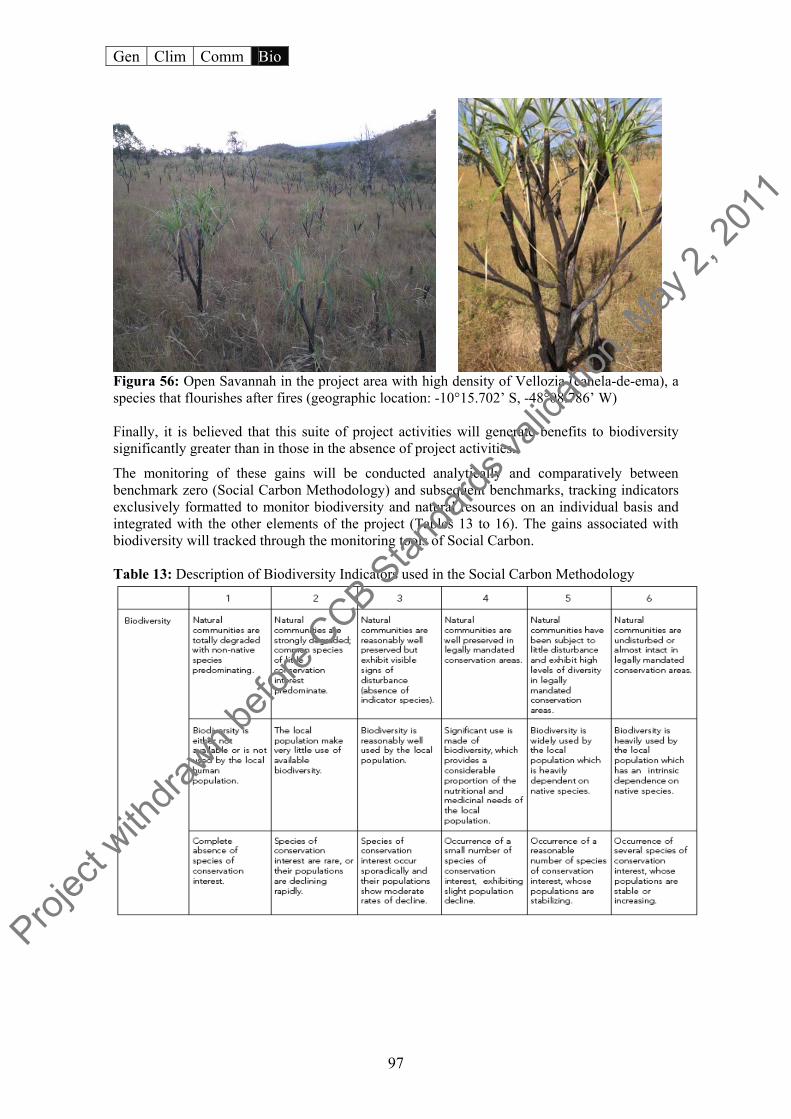
Gen Clim Comm Bio
97
Figura 56: Open Savannah in the project area with high density of Vellozia (canela-de-ema), a species that flourishes after fires (geographic location: -10°15.702’ S, -48°08.786’ W) Finally, it is believed that this suite of project activities will generate benefits to biodiversity significantly greater than in those in the absence of project activities.
The monitoring of these gains will be conducted analytically and comparatively between benchmark zero (Social Carbon Methodology) and subsequent benchmarks, tracking indicators exclusively formatted to monitor biodiversity and natural resources on an individual basis and integrated with the other elements of the project (Tables 13 to 16). The gains associated with biodiversity will tracked through the monitoring tools of Social Carbon. Table 13: Description of Biodiversity Indicators used in the Social Carbon Methodology
Projec
t with
drawn b
efore
CCB Stan
dards
valid
ation
, May
2, 20
11

Gen Clim Comm Bio
98
Table 14: Biodiversity indicators used in the Social Carbon Methodology
Table 15: Description of Natural Resource Indicators used in the Social Carbon Methodology
Table 16: Natural Resource Indicators used in the Social Carbon Methodology
B1.2 Describe possible adverse effects of non-native species on the area’s environment, including impacts on native species and disease introduction or facilitation. If these impacts have a substantial bearing on biodiversity or other environmental outcomes, the project proponents must justify the necessity of using non-native species over native species. This does not apply since no exotic species will be used for the reforestation in the project area (see Table 17).
The potential for exotic species to alter natural systems is enormous, given that exotic invasive plants are today considered the second largest threat to global biodiversity, surpassed in urgency only by habitat destruction from direct human exploitation. Invasive processes, in contrast with
Projec
t with
drawn b
efore
CCB Stan
dards
valid
ation
, May
2, 20
11
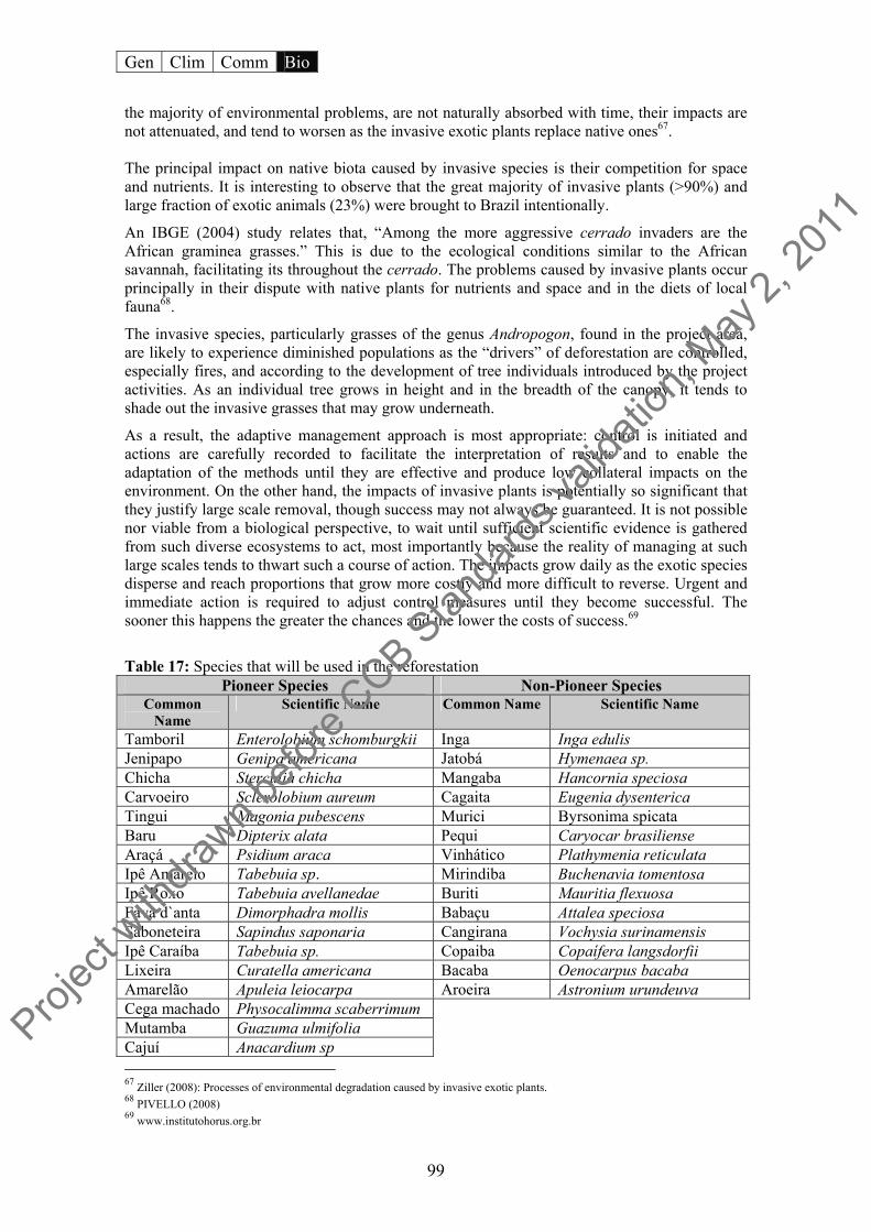
Gen Clim Comm Bio
99
the majority of environmental problems, are not naturally absorbed with time, their impacts are not attenuated, and tend to worsen as the invasive exotic plants replace native ones67. The principal impact on native biota caused by invasive species is their competition for space and nutrients. It is interesting to observe that the great majority of invasive plants (>90%) and large fraction of exotic animals (23%) were brought to Brazil intentionally.
An IBGE (2004) study relates that, “Among the more aggressive cerrado invaders are the African graminea grasses.” This is due to the ecological conditions similar to the African savannah, facilitating its throughout the cerrado. The problems caused by invasive plants occur principally in their dispute with native plants for nutrients and space and in the diets of local fauna68.
The invasive species, particularly grasses of the genus Andropogon, found in the project area, are likely to experience diminished populations as the “drivers” of deforestation are controlled, especially fires, and according to the development of tree individuals introduced by the project activities. As an individual tree grows in height and in the breadth of the canopy, it tends to shade out the invasive grasses that may grow underneath.
As a result, the adaptive management approach is most appropriate: control is initiated and actions are carefully recorded to facilitate the interpretation of results and to enable the adaptation of the methods until they are effective and produce low collateral impacts on the environment. On the other hand, the impacts of invasive plants is potentially so significant that they justify large scale removal, though success may not always be guaranteed. It is not possible nor viable from a biological perspective, to wait until sufficient scientific evidence is gathered from such diverse ecosystems to act, most importantly because the reality of managing at such large scales tends to thwart such a course of action. The impacts grow daily as the exotic species disperse and reach proportions that grow more costly and more difficult to reverse. Urgent and immediate action is required to adjust control measures until they become successful. The sooner this happens the greater the chances and the lower the costs of success.69
Table 17: Species that will be used in the reforestation
Pioneer Species Non-Pioneer Species Common
Name Scientific Name Common Name Scientific Name
Tamboril Enterolobium schomburgkii Inga Inga edulis Jenipapo Genipa americana Jatobá Hymenaea sp. Chicha Sterculia chicha Mangaba Hancornia speciosa Carvoeiro Sclerolobium aureum Cagaita Eugenia dysenterica Tingui Magonia pubescens Murici Byrsonima spicata Baru Dipterix alata Pequi Caryocar brasiliense Araçá Psidium araca Vinhático Plathymenia reticulata Ipê Amarelo Tabebuia sp. Mirindiba Buchenavia tomentosa Ipê Roxo Tabebuia avellanedae Buriti Mauritia flexuosa Fava d`anta Dimorphadra mollis Babaçu Attalea speciosa Saboneteira Sapindus saponaria Cangirana Vochysia surinamensis Ipê Caraíba Tabebuia sp. Copaiba Copaífera langsdorfii Lixeira Curatella americana Bacaba Oenocarpus bacaba Amarelão Apuleia leiocarpa Aroeira Astronium urundeuva Cega machado Physocalimma scaberrimum Mutamba Guazuma ulmifolia Cajuí Anacardium sp
67 Ziller (2008): Processes of environmental degradation caused by invasive exotic plants. 68 PIVELLO (2008) 69 www.institutohorus.org.br
Projec
t with
drawn b
efore
CCB Stan
dards
valid
ation
, May
2, 20
11
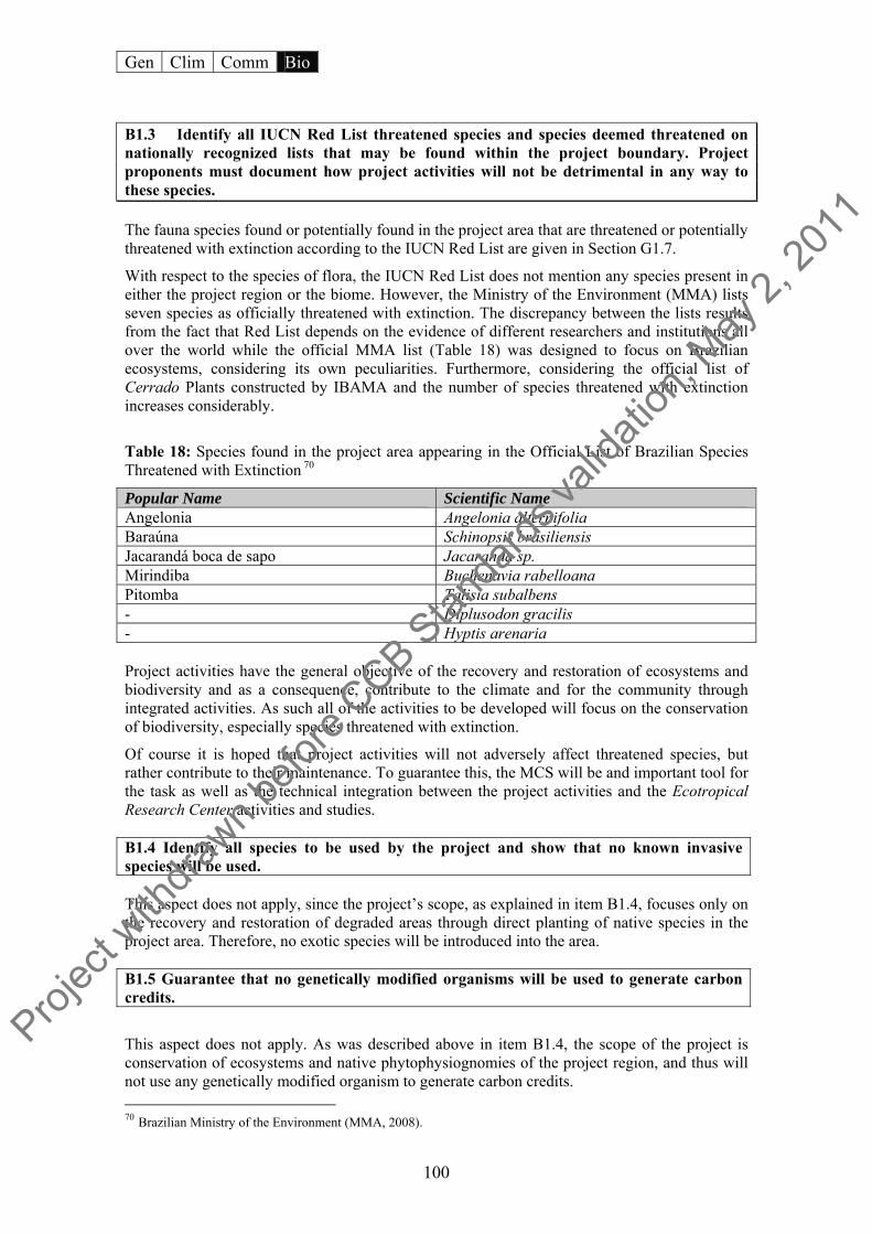
Gen Clim Comm Bio
100
B1.3 Identify all IUCN Red List threatened species and species deemed threatened on nationally recognized lists that may be found within the project boundary. Project proponents must document how project activities will not be detrimental in any way to these species. The fauna species found or potentially found in the project area that are threatened or potentially threatened with extinction according to the IUCN Red List are given in Section G1.7.
With respect to the species of flora, the IUCN Red List does not mention any species present in either the project region or the biome. However, the Ministry of the Environment (MMA) lists seven species as officially threatened with extinction. The discrepancy between the lists results from the fact that Red List depends on the evidence of different researchers and institutions all over the world while the official MMA list (Table 18) was designed to focus on Brazilian ecosystems, considering its own peculiarities. Furthermore, considering the official list of Cerrado Plants constructed by IBAMA and the number of species threatened with extinction increases considerably.
Table 18: Species found in the project area appearing in the Official List of Brazilian Species Threatened with Extinction 70
Popular Name Scientific Name Angelonia Angelonia alternifolia Baraúna Schinopsis brasiliensis Jacarandá boca de sapo Jacaranda sp. Mirindiba Buchenavia rabelloana Pitomba Talisia subalbens - Diplusodon gracilis - Hyptis arenaria Project activities have the general objective of the recovery and restoration of ecosystems and biodiversity and as a consequence, contribute to the climate and for the community through integrated activities. As such all of the activities to be developed will focus on the conservation of biodiversity, especially species threatened with extinction.
Of course it is hoped that project activities will not adversely affect threatened species, but rather contribute to their maintenance. To guarantee this, the MCS will be and important tool for the task as well as the technical integration between the project activities and the Ecotropical Research Center activities and studies. B1.4 Identify all species to be used by the project and show that no known invasive species will be used. This aspect does not apply, since the project’s scope, as explained in item B1.4, focuses only on the recovery and restoration of degraded areas through direct planting of native species in the project area. Therefore, no exotic species will be introduced into the area. B1.5 Guarantee that no genetically modified organisms will be used to generate carbon credits.
This aspect does not apply. As was described above in item B1.4, the scope of the project is conservation of ecosystems and native phytophysiognomies of the project region, and thus will not use any genetically modified organism to generate carbon credits. 70 Brazilian Ministry of the Environment (MMA, 2008).
Projec
t with
drawn b
efore
CCB Stan
dards
valid
ation
, May
2, 20
11
Gen Clim Comm Bio
101
B2 Offsite Biodiversity Impacts
B2.1 Identify potential negative offsite biodiversity impacts that the project is likely to cause. This aspect does not apply, because Project Genesis activities will be conducted both inside the project area and outside. No negative impacts are expected to affect the biodiversity as a result of project actions. On the contrary, the effects outside the project area should be benefits to biodiversity, however, at a larger scale than the areas contemplated directly by project activities.
In order to guarantee this, the MCS will be adaptive and malleable according to local particulars so that any type of negative leakage from project activities can be avoided (as explained in Section CL2.) Thus the biodiversity monitoring conducted through the MCS will be continuous and periodic, in order to monitor possible negative impacts outside the project area.
B2.2 Describe how the project plans to mitigate these negative offsite biodiversity impacts.
This aspect does not apply, because negative impacts are not likely to occur outside the project area as a result of project activities. On the other hand, as a way of augmenting the benefits for biodiversity in neighboring area, the project scope foresees an important social component, leading the communities in the project area through its activities, as well as the through the capacity-building in the sustainable use of resources. The project considers it important to bring to these communities new concepts and principles to approach biodiversity, on contrast to common practice in the region.
To create alternatives such as sustainable use of local biodiversity and disseminate positive practices about conservation of natural, it will be important to define a scenario without negative impacts or at least minimize them, in the areas around the project.
B2.3 Evaluate likely unmitigated negative offsite biodiversity impacts against the biodiversity benefits of the project within the project boundaries. Justify and demonstrate that the net effect of the project on biodiversity is positive.
This does not apply, since negative impacts of for biodiversity are not expected to occur outside the project area as a result of project activities, as mentioned in item B2.1.
As such the positive impacts in areas near the project area will be greater than the negative ones, since the recovery/restoration of remnant forest fragments will be responsible for granting innumerable environmental services to adjacent ecosystems (feed fauna, shelter for fauna during fires, and refuge from illegal hunting), as well as raising awareness in the population about earning income in harmony with conservation practices.
Projec
t with
drawn b
efore
CCB Stan
dards
valid
ation
, May
2, 20
11

Gen Clim Comm Bio
102
B3 Biodiversity Impact Monitoring
B3.1 Have an initial plan for how they will select biodiversity variables to be monitored, and the frequency of monitoring. Potential variables include species abundance and diversity, landscape connectivity, forest fragmentation, habitat area and diversity, etc. Biodiversity variables at risk of being negatively impacted by project activities should be monitored.
Just as the project impacts on communities will be monitored, their impacts on biodiversity will be monitored through the Social Carbon Methodology.
The sustainability resources developed by the MCS will allow project actions concerning biodiversity to be monitored, from species assemblages, ecosystems and genes that make up biological diversity to the natural resources (soils, water, air), to the environmental services such soil protection, water cycling, pollution absorption, and pest control (see indicators and descriptions in Section B1.1).
The biodiversity resources diagnostic will be given by the analysis of variables that will demonstrate the scenario of use of these resources and the relationship to sustainability of project activities. According to the norms of the MCS, this process will be participatory and will consider various forms of participation, lending transparency and trustworthiness to the process and the data gathered.
The results of these analyses will provide a perspective of biodiversity resources and variables necessary for greater project performance. The Genesis Project considers this analysis important, as it supports the flexibility of project’s execution, and highlights which resources and with what intensity the project should prioritize.
As was mentioned before, the MCS will produce a status report, detailing each variable and its relationship to biodiversity. In the same way, technical information about project activities relating to biodiversity will be evidenced in the Ecologica Institute’s website to the external public and interested parties.
The research on biological conservation that will be conducted at the Center for Biodiversity Learning and Climate Change (Ecotropical), will also contribute to the dissemination of knowledge and communication of results to society.
B4 Native Species Use
B4.1 Show that the project will only use species that are native to the region.
Since the scope of the Genesis Project focuses on the recovery/restoration of ecosystems and the physiognomy of the cerrado, only native species will be contemplated by project activities, these same species will be used in the future, under a participative management, for non-timber forest production.
Proj
ect w
ithdra
wn befo
re CCB S
tanda
rds va
lidati
on, M
ay 2,
2011

Gen Clim Comm Bio
103
B5 Water and Soil Resource Enhancement
B5.1 Identify project activities that are likely to enhance water and soil resources
As was mentioned before, the practice of land management common in the region is subsistence agriculture based on crude practices and extensive ranching. This leads to a graduation deterioration of the soil, and as a result of constant fires, affects the nutrient cycle and compromises the establishment of a protective vegetation cover for the soil. Of consequence to water resources is the continual use of soil in plantations, which also contributes to the reduced resilience of ecosystems. As Souza and Melo (2003) explain, “this process is accentuated by cultivation which removes organic matter and nutrients that in the long run, are not replaced at the same rate. In at a given moment, these materials can drop to levels so low as to render agricultural production unviable, characterizing a state of advanced degradation.”
Therefore the recovery/restoration of these fragments will directly impact the protection of water resources in the region. The project area is completely enclosed in the APA Serra do Lajeado, which according to its Management Plan, “is drained by three principal water courses: Taquaruçu Grande, Lajeado and Água Fria.” The Management Plan adds that, “of the 121,527 ha of APA Serra do Lajeado, almost 50% is occupied by the Lajeado River Watershed, followed by the Taquaruçu Grande with almost 30%. Therefore, the two together represent almost 80% of the total area of the protected area, including the Serra do Lajeado State Park.”
With respect to the potential for surface water resources in the basins that comprise that study area the Taquaruçu Grande River is prominent, as its topography its topography has created numerous waterfall and swimming holes of interest for ecotourism. SANEATINS (Tocantins Sanitation Company) also uses the river as important water source for supplying the city of Palmas while the Lajeado River generates electricity in a small hydropower central PCH located on the mountain slope near the falls, together with the dam.
The Secretary of Planning (SEPLAN) and the Nature Institute of Tocantins (NATURATINS) consider the watersheds, “water resource used in the supplying water to the public … of surface origin, with several points having subterranean water access.” Palmas’ water supply as well as the Taquarussu district is supplied by the Taquaruçu Grande and Água Fria Rivers, as well as the Brejo Comprido Stream.
The relationship between forest recovery/restoration and water resources is intimately combined, since the efficiency and productivity of watercourses in forests is directly related to the integrity of the forest ecosystem, comprised of the flora, fauna, and their numerous interrelationships of which they form part. Forest physiognomy promotes a better infiltration of the rain into the subterranean soil layers, supplying the streams.
The relevance of hydrological resources for the region is one of the motivations inciting a conservation initiative in the project region. In this way the direct and indirect activities, as objectives are achieved, will contribute to the maintenance of hydrogeological balance in the region, if but only in simple form.
B5.2 Credibly demonstrate that these activities are likely to improve water and soil resource compared to the baseline, using justifiable assumptions about cause and effect, and relevant studies.
From the point of view of indirect benefits, the Genesis Forest Project, while a pilot case that seeks conciliation between conservation activities and income generation through capacity-building of stakeholders, will play in important role in enabling a change in the common
Projec
t with
drawn b
efore
CCB Stan
dards
valid
ation
, May
2, 20
11

Gen Clim Comm Bio
104
practices of soil use in the region. In so doing the conserved areas may avoid the undergoing alterations with respect to soil, water, and biodiversity.
From the point of few of direct benefits, the restoration/recovery of 130 hectares, while seemingly a small compared to the total area, engenders real gains to conservation of the soil and water resources of the overall watershed.
In summary the restoration activities will be important to preserve the normal functioning of ecosystems, whether by maintenance of nutrient cycling, by minimizing the damaging effects of surface erosion, since kinetic energy in the water drops over the soil is reduced due to the interception of the tree canopy, contributing to recharge areas when loam formed in the forest soil has a greater potential for water absorption than exposed soil, among other benefits. With respect to the indirect benefits, the contribution to a paradigm shift in land use through capacity-building and raising awareness about alternatives methods for the using natural resources and cultivation by the communities involved in the project, is emphasized. Also the presence of a good forest cover is of enormous importantance to controlling the process of erosion, which can result in large accumulations of sediment in watercourses.
Projec
t with
drawn b
efore
CCB Stan
dards
valid
ation
, May
2, 20
11

Gen Clim Comm Bio
105
VII. COMPLETE BIOGRAPHY
ABDALLA, G. C.; CALDAS, L.S.; HARIDASAN M.; EITEN G.. Above and Below Ground Organic Matter and root: shoot ratio in a Cerrado in Central Brazil. Departamento de Ecologia and Departamento de Botânica. Universidade de Brasília, Brasília, DF, 1998.
AGÊNCIA MUNICIPAL DE MEIO AMBIENTE E TURISMO. Diagnóstico Turístico de Taquaruçu. Disponível em: http://www.revistaturismo.com.br/negocios/taquarucu.htm. Acesso em: Agosto de 2008 BRASIL. Artigo 225.Constituição da República Federativa do Brasil. Brasília, 1988. BRASIL. Cidades@. Informações Estatísticas de Palmas/TO. Disponível em: http://www.ibge.gov.br /cidadesat/topwindow.htm. Acesso em: Agosto de 2008. BRASIL. Diretoria de Projetos de Assentamento. Disponível em: http://www.incra.gov.br/. Acesso em: Agosto de 2008. BRASIL. Estimativas Anuais de Desmatamento. INPE. Disponível em: http://www.obt.inpe.br /prodes/prodes_1988_2007.htm. Acesso em: Setembro de 2008. BRASIL. Lista Oficial das Espécies da Flora Brasileira Ameaçadas de Extinção. Ministério do Meio Ambiente. Disponível em: http://www.mma.gov.br/. Acesso em: Outubro de 2008. BRASIL. Lei nº 9.433, de 8 de janeiro de 1997. Dispõe sobre a Política Nacional de Recursos Hídricos. Brasília, 08 de jun. 1997. BRASIL. Lei n° 4.771 de 15 de setembro de 1965. Institui o novo Código Florestal. Brasília, 15 de set. 1965. BRASIL. Reserva Particular do Patrimônio Natural. IBAMA. Disponível em: http://www.ibama.gov.br/rppn/home.php. Acesso em: Setembro de 2008. CÂNDIDO, L.A et al. O Clima atual e futuro da Amazônia nos Cenários do Painel Intergovernamental de Mudanças Climáticas: a questão da savanização. In: FEARNSIDE, P. M. As Mudanças Climáticas Globais e a Floresta Amazônica. Contribuição para: A Biologia e as Mudanças Climáticas Globais no Brasil. Marcos Buckeridge (ed.), Universidade de São Paulo, São Paulo, 2008. CASTRO-NEVES, B. M. Efeito de queimadas sobre o cerrado stricu sensu e na biomassa de raízes finas. Instituto de Ciências Biológicas, UNB, [S.n.], [S.l.] ,2007. COSTA, P.B. et al. Comparison between mineral composition of manure and vermicompost obtained from cattle and buffaloes. Universidade Federal Rural RJ, Seropédica- RJ, Brazil. CRUZ, C. A. F. et al. Effect of different rates of base saturation on the growth and quality of ipê-roxo seedlings (Tabebuia impetiginosa (Mart.) Standley). Scientia Forestalis – n.66, p. 100-107, dezembro 2004. CONSERVAÇÃO INTERNACIONAL. Hotspots.Disponível em: http://www.conservation.org.br /como/index.php?id=8. Acesso em: Agosto de 2008.
Projec
t with
drawn b
efore
CCB Stan
dards
valid
ation
, May
2, 20
11
Gen Clim Comm Bio
106
DURIGAN, G.; MELO, A.C.G.. Fixação de carbono em reflorestamentos de matas ciliares no Vale do Paranapanema, SP, Brasil. Scientia Forestalis - n. 71, p. 149-154, agosto 2006 DURIGAN, G., SILVEIRA, E. Riparian forest restoration in cerrado, Assis, SP, Brazil. Scientia Forestalis, n. 56, p. 135-144, dez. 1999. ESCOLA TÉCNICA FEDERAL DE PALMAS. Diagnóstico sócio econômico da comunidade feminina de Taquaruçu. Projeto Mulheres Mil. [S.l] : [S.n],[2008]. ESTADO DO TOCANTINS. Lei nº 906, de 20 de maio de 1997. Dispõe sobre a criação da APA Serra do Lajeado e dá outras providências. Diário Oficial n˚599. Tocantins, 1997. ESTADO DO TOCANTINS. Plano de Manejo da Área de Proteção Ambiental da Serra do Lajeado. Secretaria do Planejamento e Meio, Naturatins. Palmas : [S.n], [2005]. ESTADO DO TOCANTINS. Plano de Manejo do Parque Estadual do Lajeado. Secretaria do Planejamento e Meio Ambiente / DBO Engenharia, Naturatins. Goiânia : [S.n], 2005. FEARNSIDE, P.M. O valor de áreas protegidas em evitar mudança climática na Amazônia. In: A.K. Albernaz (ed.) Atualização das Áreas Prioritárias para a Conservação, Uso Sustentável e Repartição dos Benefícios da Biodiversidade – Bioma Amazônia, Ministério do Meio Ambiente, Brasília, DF. (in press). 2008
FURTINI NETO, A.E. et al. Liming effects on growth of native woody species from Brazilian Savannah. Pesquisa Agropecuaria Brasileira, Brasília, DF, v.34, n.5, p.829-837, 1999.
GRACE, J. et al. Productivity and carbon fluxes of tropical savannas. Institute of Atmospheric and Environmental Science, School of GeoSciences, The University of Edinburgh, UK.
HELOÍSA. S. M. Efeitos de regime do fogo sobre a estrutura de comunidade de cerrado. UnB. Disponível em: http://www.unb.br/ib/ecl/srei1.htm. Acesso em: Setembro de 2008 INVESTCO. Atualização do Zoneamento da Faixa de Proteção do Reservatório da UHE Luís Eduardo Magalhães (Lajeado). [S.l.]: [S.n.] ,2005.
JUNIOR, A.B.M.; SOUSA, C.J. da SILVA. Detecção de mudanças na cobertura vegetal, através da subtração de imagem NDVI, no Parque Estadual do Bacanga – São Luís – MA. Anais XIII Simpósio Brasileiro de Sensoriamento Remoto, Florianópolis, Brasil, 21-26 abril 2007, INPE, p. 4013-4020. KRUG, T. Nota Técnica: Vulnerabilidade, Impactos e Adaptação – o caso particular das florestas brasileiras. Prospecção Tecnológica Mudança do Clima. INPE / Instituto Interamericano para Pesquisas em Mudanças Globais. [S.l] : [S.n],[2008]. MARENGO, J. A. Mudanças climáticas globais e seus efeitos sobre a biodiversidade: caracterização do clima atual e definição das alterações climáticas – Brasília: MMA, 2007. 2a edição. MARGULLIS, S. Quem são os agentes de desmatamento na Amazônia e por que eles desmatam?. Draft. [2008]. MARTINS, S. R. Agricultura, ambiente e sustentabilidade: seus limites para a América Latina.EMATER, CD/ROOM, 2001
Projec
t with
drawn b
efore
CCB Stan
dards
valid
ation
, May
2, 20
11

Gen Clim Comm Bio
107
MERLIN, S. & REZENDE, D. SARMENTO, A. (org.). Carbono Social: agregando valores ao desenvolvimento sustentável. São Paulo: Peirópolis; Brasília, DF: Instituto Ecológica, 2003. MIRANDA, E. E. et al. Queimadas em áreas protegidas da Amazônia em 2005. Comunicado Técnico 19. Embrapa : Campinas, 2006. NOBRE. C. A. et al. Mudanças climáticas e possíveis alterações nos biomas da América do Sul.CEPTEC/INPE/IAE/CTA. São Paulo : [S.n], 2007. PIVELLO, V. R. Invasões Biológicas no Cerrado Brasileiro: Efeitos da Introdução de Espécies Exóticas sobre a Biodiversidade. Ecologia INFO 33. Disponível em: http://www.ecologia.info /cerrado.htm. Acesso em: Setembro de 2008. SANEATINS. Relatório Final do Diagnóstico Socioeconômico e Ambiental da Sub-bacia do Ribeirão Taquarussu Grande. Palmas: [S.n], 2007. SOUZA, W. J. O.; MELO, W. J. Matéria orgânica em um Latossolo submetido a diferentes sistemas de produção de milho. R. Bras. Ci. Solo, n. 27, p. 1113-1122, 2003. TORRES, F.T.P. Relações entre fatores climáticos e ocorrências de incêndios florestais na cidade de Juíz de Fora, MG. Disponível em: http://www.ig.ufu.br/revista/caminhos.html. Acesso em: Outubro de 2008.
VIOTTO, M., FERRAZ, A.V., COBRA, A.C.N., FERNANDES, D.M., GUERRINI, I.A.. Efeitos da saturação por bases no desenvolvimento e na nutrição mineral da mutamba (guazuma crinita). Departamento de Recursos Naturais/Ciência do Solo, Faculdade de Ciências Agronômicas, Campus de Botucatu, SP, outubro 2007.
Projec
t with
drawn b
efore
CCB Stan
dards
valid
ation
, May
2, 20
11