promoting volcano tourism in hazard zone area for...
TRANSCRIPT

1
Promoting Volcano Tourism in Hazard Zone Area for Rebuilding Local Economy: Case study of Tourism in Cangkringan Sub-District, Mt. Merapi, Yogyakarta
Saut Sagala*
1, Arief Rosyidie
1, Alpian Pratama
1, Ramanditya Wimbardana
1 and Anastasia Wijayanti
2
1Research Group of Regional and Rural Planning
School of Architecture, Planning and Policy Development,
Institute of Technology Bandung, Indonesia, Jl. Ganesha 10, Bandung 40132
2Study Programme of Regional and City Planning
School of Architecture, Planning and Policy Development,
Institute of Technology Bandung, Indonesia, Jl. Ganesha 10, Bandung 40132
*Corresponding author: [email protected]
For citation: Sagala, S., Rosyidie, A., Pratama, A., Wimbardana, R. and Wijayanti, A. (2012): Promoting
Volcano Tourism in Hazard Zone Area for Rebuilding Local Economy: Case study of Tourism in
Cangkringan Sub-District, Mt. Merapi, Yogyakarta
Abstract
As a country that is prone to natural disaster impacts, Indonesia has been highly affected
by many disaster events. While a disaster normally brings negative impacts, there are
positive impacts from disasters that can be used for economic development, such as
tourism. This paper explores the potentials provided by the location of hazard zones and
history of disaster records as a tourism attraction. More specifically, it identifies the role
of tourism in promoting the local economic development in hazard zone. Taking the case
study of Cangkringan Sub-District, Sleman District, Yogyakarta, this paper examines the
development of tourism sectors in the area that was heavily damaged by the pyroclastic
flows during the eruption. This research applies quantitative and qualitative analysis to
identify what factors and reasons that interest tourists to visit the area. Interviews were
carried out to the tourists and tourism service workers. Further question is whether the
current tourism attraction can sustain and bring sustainable impact to the local
communities. We explore the characteristics of tourists and tourism service workers. The
research found that the local economy has developed and the tourism sector has become a
potential for the local community to participate. This paper recommends that local
government can increase the quality of the tourism service in the area and sees the
potentials of up-scaling the benefit of the tourism in the hazard zone area.
Keywords: disaster, Merapi, tourism, Yogyakarta
1. Introduction
As a country that is prone to natural disaster impacts, Indonesia has been highly affected by
many disaster events. While a disaster normally brings negative impacts, there are positive
impacts from disasters that can be used for economic development, such as agriculture,
livestock, settlements, termal energy and tourism. Located at the pacific ring of fire,
Indonesia has more than 100 active volcanoes (SI-USGS, 2009). Most of the volcanoes are
inhabited since they offer many sources of economy to the inhabitants (fertile land, cold
climate, tourism). Despite the benefits, a volcano also poses risk to the inhabitants living
nearby. Therefore, it is important to integrate the benefits and costs of living near an active
volcano through the concept of “living with risk” (Kelman and Mather, 2008).
2
The last eruption of Mt. Merapi, Yogyakarta Indonesia in 2010 has been recorded as the
biggest eruption in the history for the last one decade (PVMBG, 2010). 196 people lossed
their lives due to the pyroclastic flows, 258 injured and 410,338 people had to evacuate. The
impact also causes as many as 3,245 destroyed houses. This big eruption has caused not only
physical damage, but also social and economic that causes a lot of impacts to the people and
their livelihood. People had to lose their previous jobs as cattle owners since many cattle are
dead and they had to live far from their previous place which was damaged by the volcanic
eruption. The number of cattles in Sleman Sub-District, the district which was mostly
affected by Merapi Eruption, was reduced significantly.
Benefits in hazard prone area are not only obtained from the potential of resources that a
disaster prone area can offer. It may also includes the impact that is caused after a disaster.
The heavily damaged areas by Mt. Merapi became a tourist attraction soon after the situation
was declared safe. Since December 2010, slowly some visitors enter the area which was later
famous as a Volcano Tour tourism area. Inskeep (1991) and Mill & Morrison (1985) suggest
that many tourism areas can open several sources of livelihood. directly or indirectly to the
people living nearby the areas.
Living in hazard prone area should be integrated with community resilience concept (Tobin,
1999). Sagala (2009) observed that the application of hazard zone in Mt. Merapi seems
difficult since there is a conflict between people safety and socio-economic interests. As
explained earlier, people living in Mt. Merapi are faced with socio-economic problems when
they are forced to relocate. Previous example was when some of the residents in Turgo
Hamlet, Pakem Sub-District that had to relocate down to another hamlet located down 10 km
away from the volcano top. The relocation didnot work well since most of them returned
back to Turgo.
Apart from economic reason, Dove (2009) also suggests that there is a strong attachment
between the community and the existence of Mt. Merapi. Therefore, the potential of
increasing the economic benefit of Mt. Merapi will be important for the people, at least for
two reasons. First, it provides an alternative source of livelihoods which subsequently
increase community resilience. Second, the use of the area as a volcano tourism will decrease
the density and the built up area of the hazard zone which ultimately will make people
exposure to the volcano decreases as well.
This paper explores the potentials provided by the location of hazard zones and history of
disaster records as a tourism attraction. More specifically, it identifies the role of tourism in
promoting the local economic development in hazard zone. Taking the case study of
Cangkringan Sub-District, Sleman District, Yogyakarta, this paper examines the development
of tourism sectors in the area that was heavily damaged by the pyroclastic flows during the
eruption. The paper aims to examine how the potential sources from volcano tourism may
bring economic benefit for rebuilding the local economy.
The rest of the papers will discuss the methods that are used in this research as well as the
respondents that are met in the fieldwork processes. It subsequently follows by the
explanation of the characteristics of study area location. Some findings and recommendation
are finally presented in the papers.
2. Volcano Tourism
3
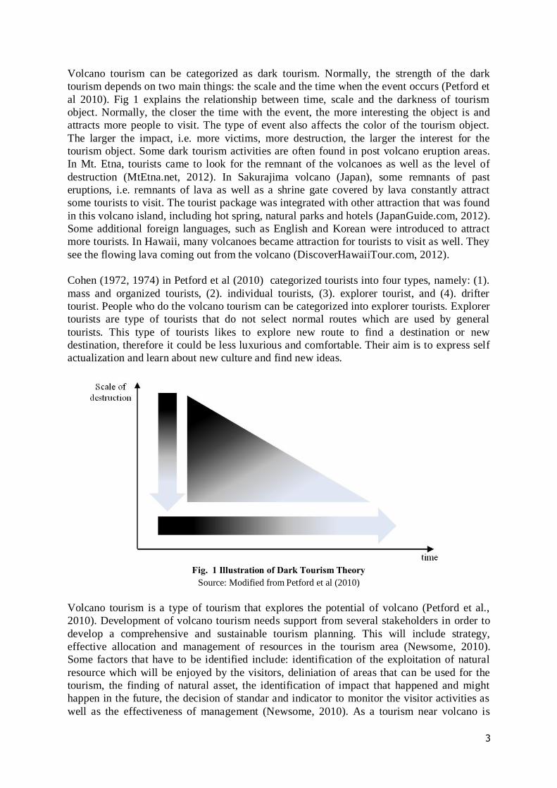
Volcano tourism can be categorized as dark tourism. Normally, the strength of the dark
tourism depends on two main things: the scale and the time when the event occurs (Petford et
al 2010). Fig 1 explains the relationship between time, scale and the darkness of tourism
object. Normally, the closer the time with the event, the more interesting the object is and
attracts more people to visit. The type of event also affects the color of the tourism object.
The larger the impact, i.e. more victims, more destruction, the larger the interest for the
tourism object. Some dark tourism activities are often found in post volcano eruption areas.
In Mt. Etna, tourists came to look for the remnant of the volcanoes as well as the level of
destruction (MtEtna.net, 2012). In Sakurajima volcano (Japan), some remnants of past
eruptions, i.e. remnants of lava as well as a shrine gate covered by lava constantly attract
some tourists to visit. The tourist package was integrated with other attraction that was found
in this volcano island, including hot spring, natural parks and hotels (JapanGuide.com, 2012).
Some additional foreign languages, such as English and Korean were introduced to attract
more tourists. In Hawaii, many volcanoes became attraction for tourists to visit as well. They
see the flowing lava coming out from the volcano (DiscoverHawaiiTour.com, 2012).
Cohen (1972, 1974) in Petford et al (2010) categorized tourists into four types, namely: (1).
mass and organized tourists, (2). individual tourists, (3). explorer tourist, and (4). drifter
tourist. People who do the volcano tourism can be categorized into explorer tourists. Explorer
tourists are type of tourists that do not select normal routes which are used by general
tourists. This type of tourists likes to explore new route to find a destination or new
destination, therefore it could be less luxurious and comfortable. Their aim is to express self
actualization and learn about new culture and find new ideas.
Fig. 1 Illustration of Dark Tourism Theory
Source: Modified from Petford et al (2010)
Volcano tourism is a type of tourism that explores the potential of volcano (Petford et al.,
2010). Development of volcano tourism needs support from several stakeholders in order to
develop a comprehensive and sustainable tourism planning. This will include strategy,
effective allocation and management of resources in the tourism area (Newsome, 2010).
Some factors that have to be identified include: identification of the exploitation of natural
resource which will be enjoyed by the visitors, deliniation of areas that can be used for the
tourism, the finding of natural asset, the identification of impact that happened and might
happen in the future, the decision of standar and indicator to monitor the visitor activities as
well as the effectiveness of management (Newsome, 2010). As a tourism near volcano is

4
potentially affected by risk, it is important that related agencies to provide information that is
needed to remind the tourists on potential impacts of volcano hazards (Erfurt-Cooper &
Cooper, 2010). This strategy is important for recommendation to increase community
awareness of volcano hazards.
3. Method and Research Location
3.1 Research Method
As an initial research that integrates tourism, economic development and disaster
management, this research started by identifying what factors on tourism and disaster
management that contribute to the local economic development. To do so, qualitative survey
and analysis were applied to find the basic reasons why and how things are going in the study
area, in relation to volcano tourism.
This research applies quantitative and qualitative analysis to identify what factors and reasons
that interest tourists to visit the area and the activities of the tourism service workers.
Qualitative survey was conducted through interviews to some selected key-informants.
Interviews were carried out to the tourists and tourism service workers. Early observation was
carried out in July 2011 and March 2012. Finally, this was followed by a week survey in
April 2012. Each interviews normally took around 1-2 hours. All the interviews were
recorded and subsequently transcripted and made into coding sheets. The coding sheets were
grouped and analyzed with qualitative content analysis in order to support the key findings.
To obtained objective information, triangulation was made through several key informants
that represent different job types. The information obtained was also confirmed through
interviews to government officers and through secondary data that was obtained through
surveys to district agency offices, namely: Planning and Development Agency and Tourism
Agency.
We conducted interviews to the workers in the volcano tourisms. They are selected as
respondents through purposive sampling and snow-balling techniques through previous
contact information that led us to another key-informants. The total number of key-
informants are 28 people (see Table 1). They consisted of restaurant owner, souvenir seller,
motor trail driver, jeep drivers, ojek driver, parking service and entrance ticket officer. Apart
from this informants, we managed to interview the volcano tourism management that was
managed by local village association.
In fact, Mt. Merapi has been a long-term research in various themes related to disaster risk
management and sustainable development by the first author between 2006-2011. Therefore,
a large number of data base and information provided from the previous field work activities
were used to support the current paper.
Table 1 Key-informants and information obtained for Qualitative Data
Informant Number Information
Workers in Volcano
Tour in Umbulharjo
Restaurant owner 5
Disaster impact, livelihood
before and after the disaster,
reasons of livelihood change.
Souvenir Seller 5
Motor trail driver 5
Jeep drivers 3
Ojek driver 3
Parking Service 3
Ticket Officer 4

5
We surveyed 95 tourists through structured questionnaire. The survey of tourists was carried
out in weekday and weekend time between 16-20 April 2012. Questionnaire survey includes
demographic data of the respondents, purpose of visit, how they understand about the
volcano and their impression about the facilities in the volcano tourism. The tourists were
selected from those who are convenient and willing to be interviewed. From each group of
tourists, the respondent was selected only one in order to have a deep variety of information.
In addition to that, the data on tourist visit was obtained through the ticketing office to
estimate the number of visitors each day.
3.2 Research Location and Mt. Merapi
The research is conducted in the tourism area of Volcano Tour, Mt. Merapi, Umbulharjo
Village, Cangkringan Sub-District, Sleman District, Yogyakarta Province. It is located in
north of Yogyakarta City, the capital of Yogyakarta Province. The areas were affected
heavily by the recent 2010 volcanic eruptions.
The common economic bases in Cangkringan Sub-District before the 2010 Merapi eruption
was dominated by agriculture, raising cattle, sand and rock mining activities and some small
tourism activity (Sagala, 2009a). Normally, the sand and rock mining activities are available
along the river valleys which channelled the lahars from Mt. Merapi eruptions in the past
time. The agriculture and farm activities get benefit from the mild climate on the slopes of the
mountain. The tourism activities include renting the rooms in the weekend, providing
sightseeing of the mountain. Thus, the economic bases of these sub-districts are mainly
influenced by the existence of Mt. Merapi (Sagala, 2009a).
Mt. Merapi or Mount of Fire is a conical volcano located on the border between Central Java
and Yogyakarta, Indonesia. It is the most active volcano in Indonesia and has erupted
regularly since 1548. The height of Mt. Merapi changes over time due to the active materials
produced and the current height is 2,968 metres (9,738 ft). It is very close to the city of
Yogyakarta, and thousands of people live on the flanks of the volcano, with villages as high
as 1700 m above sea level. Merapi has been very active within the last two decades. The
records noted that the volcano previously erupted in 1994, 1997, 2001, 2006 and 2010.
4. Tourist attraction in Cangkringan Volcano Tourism
There are at least three attractive objects for tourists found in the Cangkringan Volcano
Tourism. These objects are as follows: first, the grave of Marijan, the late gate keeper of Mt.
Merapi who died in the eruption of 2010, second, objects or built environment that destroyed
by the eruption and third, volcano tour drive to the large scale devastated area by the volcano
eruption. Apart from these tourist attractive objects, the mounstain scenery and the temporer
facilities provided by the local people added to the comfort of visiting the volcano tourism.
Grave of Marijan
Marijan was refused to evacuate when the eruption was getting more intensity which finally
costed his lives and some local residents living nearby his house. Marijan has been famous
nationally since the 2006 eruption that he insisted to stay in his house and showed that no
impact of volcanic eruption affected his house. Since then, became a star for an energy-drink
commercial advertisement and have been invited to several public occassion. In fact, in the
Yogyakarta Sultanate, Marijan has a duty as a gate keeper or servant of Yogyakarta Sultanate
that maintain annual offering to Mt. Merapi through labuhan ceremony and to communicate

6
spritually to Mt. Merapi (Schlehe, 1996 and Schlehe 2007). After the 2006 eruption subsided,
Marijan house’ has been visited by many visitors from many parts of Indonesia to meet him
and learn from his wisdom.
His death in the eruption 2010 has become an interesting story and therefore, his grave since
then has become a place where many people pay a visit (Fig 2). His daughter opened a
souvenir shop adjacent to his grave.
Fig. 2 Grave of Mr. Marijan
Source: Authors’ observation (2012)
Destroyed built environment
The area that is presently famous for the volcano tourism used to be two hamlets: Pelemsari
and Pangukrejo. The strong volcanic eruption demolished many built environment objects
(houses, motorcycles, cars). Some remaining objects have become interesting objects for
tourists (Fig 3) to take photographs and to learn from how large the destruction was. Some of
these objects were moved to a public area where tourists can easily access while some others
still remained in the place where they were hit. A wooden made tower was also provided by
the local people for some people who would like to see a wide range of the devastation with
some little contribution of money.
Fig. 3 A car that was destroyed by the volcano eruption in 2010
Source: Authors’ observation (2012)
Volcano tour

7
The volcano tour area covers the area that was demolished between Pelemsari Hamlet and
Kaliadem Hamlet. The volcano tour has short, medium and long routes and has different rates
for each route. The local people provided motor trails and jeeps for single and group
passengers subsequently (Fig 4).
Fig. 4 Motor trails and jeeps for volcano tour
Source: Authors’ observation (2012)
5. Findings
Further question is whether the current tourism attraction can bring sustainable and
significant impact to the local communities. To understand this, we explore the characteristics
of tourists and tourism service workers and the role of volcano tourism to the local people.
5.1 The establishment of volcano tourism
After the eruption in 2010, the communities from Pelemsari and Pangurekjo Hamlets have to
live in relocation place in Ploso Kerep Hamlet. Ploso Kerep is located down south from the
their previous hamlet. Some temporer woden structured houses were constructed with limited
space and no space for keeping their livestock. Temporarily, the communities were provided
food by the government to support their living. However, they have to lose their livelihood
since they have no place to raise their livestock and the grass for their livestock are located up
near the mountain slope.
The interest of people from outside of Cangkringan to visit the areas after eruption have
opened new opportunities for Pelemsari and Pangukrejo residents to start other types of
livelihoods. To make an agreement among the residents on how to manage the volcano
tourism they formed an association that consists of people living in these two hamlets (Fig 5).
The association subsequently managed the money obtained from the ticket and to decide how
the money is distributed among the people and public purpose. More and more services, such
as motor trails, jeeps, small restaurants, souvenirs, etc were established by local people which
normally formed through new associations related to the job types.

8
Fig. 5 Volcano Tour Establishment in Umbulharjo Village
5.2 Tourist Characteristics
From the survey we carried out to 95 tourists, most of the respondents came to the area for
holiday (68,4%) while some of them on study/research purpose (20%) (Fig 6). The large
number of tourist purpose as a holiday show that the volcano tour still serves as a tourist
attraction. Some respondents who said they came for study explains that the volcano tour
attracts people to learn from what happened in the last eruption.
Fig. 6 Purpose of Visit (n=95)
68,4
20,0
1,1
10,5
0,0
20,0
40,0
60,0
80,0
100,0
Holiday Study Sport Other
Per
cen
tag
e
Purpose of Visit

9
Fig. 7 Tourists' Origin
The origin of the tourists are mostly from Yogyakarta and Central Java Province (68%). This
is indicating that the volcano tourism still attracts people coming from nearby areas. A
quarter number of respondents coming from other parts of Indonesia explains that there is a
potential that the volcano tourism as an interesting object to see.
Fig. 8 Tourist Motivation
When they were asked on what was their motivation to visit Merapi, half of the respondents
said due to the eruption destruction. Indeed, this is in line with the theory of dark tourism
(Petford et al 2010). People motivation to visit Mt. Merapi is still affected by the previous
eruption.
5.3 Tourism Service Association
The tourism service in Volcano Tourism are categorized into ojek, food stall and souvenir
shops, motor trail tour and jeep tour. Each of this is managed by an association. Each
association has schedule and contribution from each member to the association. It has it’s
own rule. Apart from association, there are some groups, such as parking and ticketing staf
that receive monthly salary.
34,41%
34,41%
25,81%
5,38%
DI Yogyakarta
Central Java
Other part of
Indonesia
Abroad
36%
50%
12%
2%
Mountain Scenery
Eruption Destruction
History
Other

10
Ojek Association
Ojek driver normally takes passenger to the location of Marijan Grave. For one time service,
a passenger has to pay IDR 20,000. Some IDR 5,000 will be contributed to the association.
As the number of Ojek driver is larger than the daily demand, the ojek drivers are distributed
that each driver can only work one time in each three days. While driving, an ojek driver also
guides the passenger about the story of eruption and the areas they pass by. However, they
didnot receive proper training how to guide tourists.
Food Stall and Souvenir Shop Association
The food stall and souvenir shops open everyday in a fix place. Some retribution is provided
to the association and some land rent for people coming from outside of Pelemsari and
Pangukrejo Hamlets. There has been a good link between the shop owners and the goods
distributors and producers. This is accomodated by village government, NGO and some
private donations. In the relocation place, people were trained to produce some food and
goods to be sold in the volcano tourism place.
Trail and jeep tour association
The trail tour association was established in December 2011. The number of trail tour is small
and therefore there is no scheduling for who will be able to work weekly. The route for motor
trail costs 50.000 for short route, 100.000 for medium route and 150.000 for long route. Some
10,000 has to be contributed to the association for each route. Jeep tour association was
established also in December 2011. The route for jeep costs 250.000 for short route, 350.000
for medium route and 450.000 for long route. Since the jeep needs higher investment,
normally the driver rents the jeep from other people.
Parking and Ticketing Group
There are 300 residents of Pelemsari and Pangukrejo Hamlets work as parking and ticketing
staffs. They receive the salary was shared from the ticketing and parking charge. Since the
number of workers are many, they receive only small amount of money monthly.
5.4 Contribution of Volcano Tourism to Local Economy
In general, the volcano tourism has generated income to the local community and to the
village. The contribution from the entrance ticket can be seen from Fig 9. About 19% of the
revenue goes to village budget which is expected to increase the quality of the village service
to it’s community.
Fig. 9 Ticket Selling Revenue Share
Source: Tim Pengelola Volcano Tour Desa Umbulharjo (2012)
53%
23%
5%
19%
Salary of Officer
Operational Cost
Social Budget
Village Share

11
Unfortunately, the number of the visitors tends to decrease from the time it was opened. The
volcano tourism was opened in January 2011 and since then the number of tourists tend to
decrease. The high number of tourist in September 2011 is due to the month was on public
holidays where many people visit Mt. Merapi.
Fig. 10 Revenue from Volcano Tour January-November 2011
Fig. 11 Number of Visitors of Volcano Tourism
Source: Tim Pengelola Volcano Tour Desa Umbulharjo (2012)
6. Conclusion
This paper has examined the potential how a volcano hazard prone offers benefit through
volcano tourism to the communities living on the slope of the volcano. This potential is in
line with the concept of living with risk that is recently promoted by many stakeholders
natiaonally and internationally. This paper shows that the huge impact of the volcano
eruption has become a strong attraction for people and become a source of income for local
0
20000000
40000000
60000000
80000000
100000000
120000000
-
5.000
10.000
15.000
20.000
25.000
30.000

12
community that works in the tourist area. As a volcano tourism place, this area is limited with
the built environment characteristics and thus it is inline with the function of hazard zone 3 or
forbidden zone for permanent activity that is strongly urged by government. While there is a
decrease in the attractiveness of the area, local government can take role to support it’s
function as a volcano tourism and to integrate this with other potential of tourism activities in
order to increase it’s economic value and attract more people to visit. While the income
obtained from the tourism activities is still less than the income they receive from working as
Indeed, there is a question of the sustainability of the volcano tourism as also observed in the
decrease number of tourists in the area. However, this can be promoted more, if the district
tourism agency and community are hand in hand to promote and increase the quality of the
volcano tourism. This achievement will be important in increasing the community resilience
by contributing not only to hazard related factors but also to socio-economic factors that
contribute to decreasing the vulnerability of the society.
In the contect of tourism planning, this research offers other potential tourism activities that
can be explored in Indonesia. As many disasters have taken place in Indonesia in the past,
many interesting history and objects can be promoted and become interests of people to visit.
This potential will increase the economic development of the disaster prone area.
Acknowledgement
This paper is part of publication produced from a research project entitled “The role of
tourism for local economic development in hazard prone area” under research project number
118/I1.C10/PL/2012 funded by Research and Community Service Center (LPPM) - Institut
Teknologi Bandung. In addition, we thank other research team who also helped in data
collection as follows: Roby Dwiputra, Febriyanti, Adrian Mangunsong and Dodon.
References
Dove, M. R. (2008). Perception of Volcanic Eruption as Agent of Change. Geoforum 39 ,
736-746.
Kelman, I., & Mather, T. A. (2008). Living with volcanoes: The sustainable livelihoods
approach for Volcano Related Opportunities. Journal of Volcanology and Geothermal
Research 172 , 189–198.
Newsome, D. (2010). The Need for a Planning Framework to Preserve the Wilderness Values
of Sibayak Volcano, North Sumatra, Indonesia. Dalam E. Cooper, Volcano and
Geothermal Tourism: Sustainable Geo-resources for Leisure and Recreation (hal. 131-
141).
Sagala, S., Okada, N., & Paton, G. (2009). Modeling the Social Resilience of Mountain
Communities under Volcanic Risk. Proceeding of the 2009 IEEE International
Conference on System, Man, and Cybernetics , 1935-1940.
Sagala, S. (2009). Implementable Land Use Plan in Volcano Prone Area in Indonesia:
Challenges and Opportunities. nternational Conference on Urban and Regional
Planning: “Positioning Planning in Global Crises” .
Sagala, S. (2009). System Analysis of Social Resilience against Volcanic Risks. Case Studies
of Mt. Merapi, Indonesia and Mt. Sakurajima, Japan. Department of Urban
Management Graduate School of Engineering, Kyoto University. Disertation
Sagala, S., Okada, N., & Paton, D. (2009). Predictors of Intention to Prepare for Volcanic
Risks in Mt. Merapi. Indonesia. Journal of Pacific Rim Psychology , 47-57.
Schlehe, J., (1996). Reinterpretation of Mystical Traditions: Explanation of a Volcanic
Eruption in Java. Anthropos, 91: 391-409.

13
Schlehe, J., (2007). Cultural politics of natural disasters: Discourses on volcanic eruptions in
Indonesia. In: M. Casimir (Editor), Culture and The Changing Environment:
Uncertainty, cognition and risk management in cross-cultural perspective, Berghahn,
Oxford/ New York.
SI-USGS, 2009. Global Volcanism Program, accessed from:
http://www.volcano.si.edu/reports/usgs/ on July 4, 2009.
Tobin, G. A., & Whiteford, L. M. (2004). Chronic Hazards: Health Impact Associated with
On-Going Ash Falls around Mt. Turungahua, Ecuador. Papers of the Applied
Geography Conferences Vol. 27 , 84-93.
Tobin, G. A., & Whiteford, L. M. (2001). Economic Ramifications of Disaster: Experience of
Displaced Person. Papers of the Applied Geography Conferences, Volume 25 , 316-
324.
Tobin, G. (1999). Sustainability and Community Resilience The Holy Grail of Hazards
Planning. Environmental Hazards , 13-25.
Online Sources:
MtEtna.Net, 2012
JapanGuide.Com, 2012
DiscoverHawaiiTour.Com, 2012