property report - loopnet
TRANSCRIPT

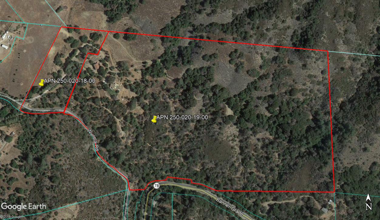
PROPERTY REPORT ADDRESS: 1760 Wynola Rd., Julian, CA 92036
DESCRIPTION: Come and explore all that awaits at this inviting and diverse property situated on 55
acres at the base of Volcan Mountain which was once identified as 'the place where water flows' by local Native American tribes. This property remains true to its heritage and is home to numerous water springs. This locale affords all the desirable features of rural living; serenity, privacy, and
a wealth of possibilities. Beyond the gated entry lies the welcoming 2400 esf., custom built
Mediterranean style villa, complete with 5 bedrooms, 5 ½ baths, chef’s kitchen, 1200 esf. unfinished basement and much more. A 2250 esf. 1940’s vintage farmhouse, located just beyond the main home,
enjoys privacy of its own. Complete with 3 bedrooms, 2 baths and large, open living spaces, this
home brings charm and additional opportunity for personalization. Well maintained roads and walking
paths traverse the property, passing by the sizeable pond and through the scenic, fragrant native flora.
Three springs and a pond bring bountiful flows of water to the property in addition to an existing solid producing water well. This stunning location embraces the beauty and natural surroundings of the area
while incorporating the comforts and amenities of modern living. This unique and tranquil setting
offers an ideal collective of custom features, a peaceful lifestyle, and incredible opportunity for
personalization. Bring your vision and realize your dreams within!
PRICE: $1,695,000
APN: 250-020-19-00, 250-020-18-00
CONTACT: Donn Bree; [email protected]; 800-371-6669
Meriah Druliner; [email protected]; 760-420-5131

Property Features
• Exclusive and
private location
• 3 Artesian springs
• Pond
• Knotty Alder solid
core doors
throughout
• Limestone fireplace
• Chef’s kitchen with
travertine farm
sink
• Peaceful view deck
1760 Wynola Rd., Julian, CA 92036
Come and explore all that awaits at this inviting and diverse
property situated on 55 acres at the base of Volcan Mountain.
This locale affords all the desirable features of rural living; serenity,
privacy, and a wealth of possibilities. Beyond the gated entry lies
the welcoming 2400 esf., custom built Mediterranean style villa,
complete with 5 bedrooms, 5 ½ baths, chef’s kitchen, 1200 esf. unfinished basement and much more. A 2250 esf. 1940’s vintage
farmhouse, located just beyond the main home, enjoys privacy of its
own. Complete with 3 bedrooms, 2 baths and large, open living
spaces, this home brings charm and additional opportunity for
personalization. Well maintained roads and walking paths traverse
the property, passing by the sizeable pond and through the scenic,
fragrant native flora. Three artesian springs bring bountiful flows of
water to the property in addition to an existing solid producing water well. This stunning location embraces the beauty and natural
surroundings of the area while incorporating the comforts and
amenities of modern living. This unique and tranquil setting offers
an ideal collective of custom features, a peaceful lifestyle, and
incredible opportunity for personalization. Bring your vision and
realize your dreams within!
Contact us to schedule your showing today!
$1,695,000
RED HAWK REALTY Junction Hwy 78 & Hwy 79, Santa Ysabel, CA 92070 CA DRE#01078868 CA DRE#01997162
[email protected] [email protected]
www.DONN.com
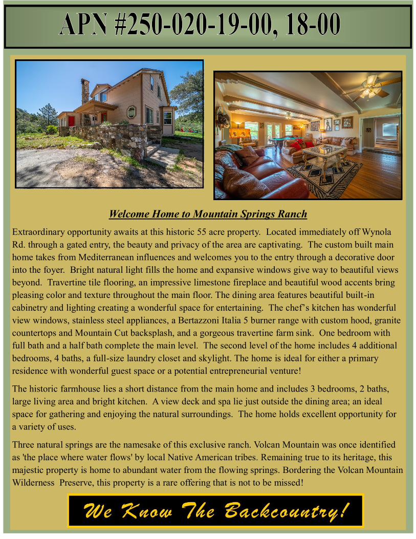
Welcome Home to Mountain Springs Ranch
Extraordinary opportunity awaits at this historic 55 acre property. Located immediately off Wynola
Rd. through a gated entry, the beauty and privacy of the area are captivating. The custom built main
home takes from Mediterranean influences and welcomes you to the entry through a decorative door
into the foyer. Bright natural light fills the home and expansive windows give way to beautiful views
beyond. Travertine tile flooring, an impressive limestone fireplace and beautiful wood accents bring
pleasing color and texture throughout the main floor. The dining area features beautiful built-in
cabinetry and lighting creating a wonderful space for entertaining. The chef’s kitchen has wonderful
view windows, stainless steel appliances, a Bertazzoni Italia 5 burner range with custom hood, granite
countertops and Mountain Cut backsplash, and a gorgeous travertine farm sink. One bedroom with
full bath and a half bath complete the main level. The second level of the home includes 4 additional
bedrooms, 4 baths, a full-size laundry closet and skylight. The home is ideal for either a primary
residence with wonderful guest space or a potential entrepreneurial venture!
The historic farmhouse lies a short distance from the main home and includes 3 bedrooms, 2 baths,
large living area and bright kitchen. A view deck and spa lie just outside the dining area; an ideal
space for gathering and enjoying the natural surroundings. The home holds excellent opportunity for
a variety of uses.
Three natural springs are the namesake of this exclusive ranch. Volcan Mountain was once identified
as 'the place where water flows' by local Native American tribes. Remaining true to its heritage, this
majestic property is home to abundant water from the flowing springs. Bordering the Volcan Mountain
Wilderness Preserve, this property is a rare offering that is not to be missed!

PROPERTY DESCRIPTION
Mountain Springs Ranch
1760 Wynola Rd.
Julian, CA 92036

INTRODUCTION & OVERVIEW
Volcan Mountain was once identified as 'the place where water flows' by local Native American
tribes. Remaining true to its heritage, this majestic property is home to numerous water-springs
and a lush naturescape. An exciting opportunity is waiting to be discovered at this peaceful 55
acre property. Additional features of the home(s) and property include;
Home
• Bright and inviting layout
• Crown molding
• Wood framed glass double doors leading from main entry to living area
• Double doors from living area to large deck beyond
• Outdoor patio seating
• Beautiful tile floors on main level
• Tile stairs leading to second level
• Carpeted bedrooms
• Wood sash windows
• Beautiful views
• Finished basement
• 120 gallon water heater
• Central forced heating and air, two zones
Farmhouse
• Private setting
• White oak floors
• Large fireplace in living area
• Spacious bedrooms
• Large, open kitchen
• View deck with spa
Property
• Three natural springs

• Water well
• 2 - 10k gallon plus 2 – 2500 gallon holding tanks
• Pond
• Maintained roads
• Gated entry
NATURAL SETTING
The property topography varies from flat to gentle slopes to steep slopes. Mature pines, cedar,
lilacs and oaks fill the property. This unique location borders the Volcan Mountain Wilderness
Preserve, creating an exceptional sense of privacy and natural beauty. Wildlife is abundant in the
area: deer and turkey roam freely, while raptors and other rare species of animals can be found
here because of the abundance of water and cover. A variety of birds make this area home
including hummingbirds, woodpeckers and Blue Jays.
AREA INFORMATION
Just a short drive away lies the historic mountain township of Julian; a well known get-a-way for
city residents from all over Southern California. The nearby community of Wynola is home to a
rich local music and food community. Tourism is now the primary draw, replacing the mining
interests when Julian’s population rivaled that of the City of San Diego. There are many fine
restaurants and lodging accommodations in the immediate area of this centrally, yet privately
located property. Major shopping and resources are no more than 35 minutes away.
RECREATION AND LIFESTYLE
Wineries, art galleries, music and shopping are nearby and offer many enjoyable venues from
which to discover the fine local artists. Enjoy golfing at Warner’s Ranch and Borrego Springs,
hunting and fishing, dining, and a variety of other opportunities for each family member. Hiking,
equestrian trails and world-renowned observatories are all within 30 minutes or less.
***All information contained herein has been obtained from independent sources,
including, but not limited to, the Seller and governing agencies. Buyer to investigate
Subject Property, including but not limited to, permits, code enforcement, build ability, and
utilities with governing authority and/or licensed and bonded professionals***


Disclaimer: This report is completed on a regional level with conservative data. The information provided is to be used as screening criteria only. All data is subject to review and may be verified through project site visits. This report may also include user generated static output from an internet mapping site. The information in this preliminary report may or may not be
accurate, current, or reliable and may need to be changed on the basis of a more specific review.
Report Run Date/Time: 6/7/2019 10:57:56 AMProject Manager:Land Development Manager:Project Record ID: Project Environmental Review (ER) ID:Assessor's Parcel Number(s): 2500201800,2500201900Project Name:
2500201800 2500201900General Information
USGS Quad Name/County Quad Number: Julian/38 Julian/38Section/Township/Range: 29/12S/04E 29/12S/04ETax Rate Area: 81003 81003Thomas Guide: / /Site Address: 0 Wynola Rd Julian 92036 1760 Wynola Rd Julian 92036
Parcel Size (acres): 5.24 50.17Board of Supervisors District: 2 2
Public Service and Utility Districts
Water/Irrigation District: None None
Sewer District: None NoneFire Agency: Julian-Cuyamaca Fire
Protection District (See Map)Julian-Cuyamaca Fire Protection District (See Map)
School District: Gen Elem Julian Union; High Julian Union
Gen Elem Julian Union; High Julian Union
1 of 5

2500201800 2500201900General Plan Information
General Plan Regional Category: Rural RuralGeneral Plan Land Use Designation: Rural Lands (Rl-40) 1 Du/40 Ac Rural Lands (Rl-40) 1 Du/40 Ac
Community Plan: Julian Julian
Rural Village Boundary: None NoneVillage Boundary: None NoneSpecial Study Area : None None
Zoning Information
Use Regulation: A70/S80 A70/S80Animal Regulation: L LDensity: -/.125 -/.125Minimum Lot Size: 4Ac/8Ac 20Ac/8AcMaximum Floor Area Ratio: - -Floor Area Ratio: - -Building Type: C CHeight: G GSetback: C CLot Coverage: - -Open Space: - -Special Area Regulations: - -/D1
Aesthetic
The site is located within one mile of a State Scenic Highway. No NoThe site contains steep slopes > 25%. Yes YesThe site is located within Dark Skies "Zone A". No No
Agricultural Resources
The site is a Farmland Mapping and Monitoring Program (FMMP) designated farmland. No NoThe site contains Prime Soils. Yes YesThere is evidence of active agriculture on the project site. Please Refer To Aerial Imagery Please Refer To Aerial Imagery
Sunset Zone: 18 18; 3The site is located within an Agricultural Preserve. No NoThe site is in a Williamson Act Contract. No No
2 of 5
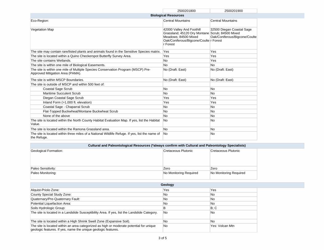
2500201800 2500201900Biological Resources
Eco-Region: Central Mountains Central Mountains
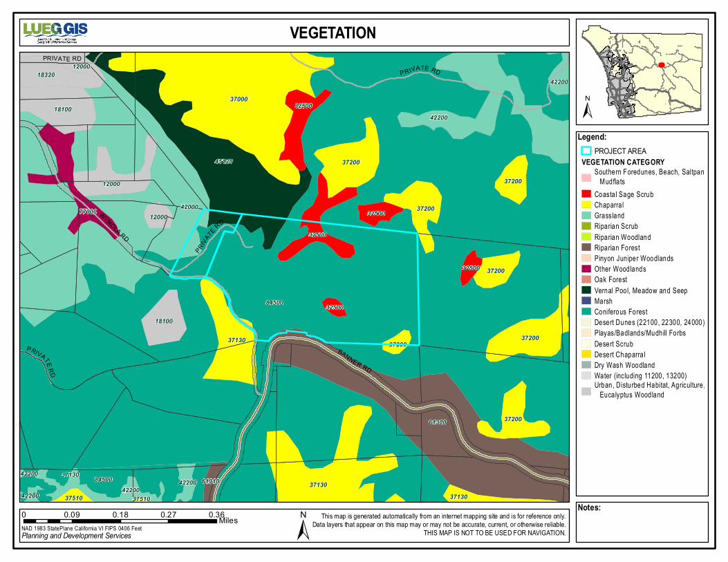
Vegetation Map 42000 Valley And Foothill Grassland; 45120 Dry Montane Meadows; 84500 Mixed Oak/Coniferous/Bigcone/Coulter Forest
32500 Diegan Coastal Sage Scrub; 84500 Mixed Oak/Coniferous/Bigcone/Coulter Forest
The site may contain rare/listed plants and animals found in the Sensitive Species matrix. Yes YesThe site is located within a Quino Checkerspot Butterfly Survey Area. Yes YesThe site contains Wetlands. No YesThe site is within one mile of Biological Easements. No NoThe site is within one mile of Multiple Species Conservation Program (MSCP) Pre-Approved Mitigation Area (PAMA).
No (Draft: East) No (Draft: East)
The site is within MSCP Boundaries. No (Draft: East) No (Draft: East)The site is outside of MSCP and within 500 feet of:
Coastal Sage Scrub No NoMaritime Succulent Scrub No NoDiegan Coastal Sage Scrub Yes YesInland Form (>1,000 ft. elevation) Yes YesCoastal Sage - Chaparral Scrub No NoFlat-Topped Buckwheat/Montane Buckwheat Scrub No NoNone of the above No No
The site is located within the North County Habitat Evaluation Map. If yes, list the Habitat Value.
No No
The site is located within the Ramona Grassland area. No NoThe site is located within three miles of a National Wildlife Refuge. If yes, list the name of the Refuge.
No No
Cultural and Paleontological Resources (*always confirm with Cultural and Paleontology Specialists)
Geological Formation: Cretaceous Plutonic Cretaceous Plutonic
Paleo Sensitivity: Zero ZeroPaleo Monitoring: No Monitoring Required No Monitoring Required
Geology
Alquist-Priolo Zone: Yes YesCounty Special Study Zone: No NoQuaternary/Pre-Quaternary Fault: No NoPotential Liquefaction Area: No NoSoils Hydrologic Group: B B; CThe site is located in a Landslide Susceptibility Area. If yes, list the Landslide Category. No No
The site is located within a High Shrink Swell Zone (Expansive Soil). No NoThe site is located within an area categorized as high or moderate potential for unique geologic features. If yes, name the unique geologic features.
No Yes: Volcan Mtn
3 of 5
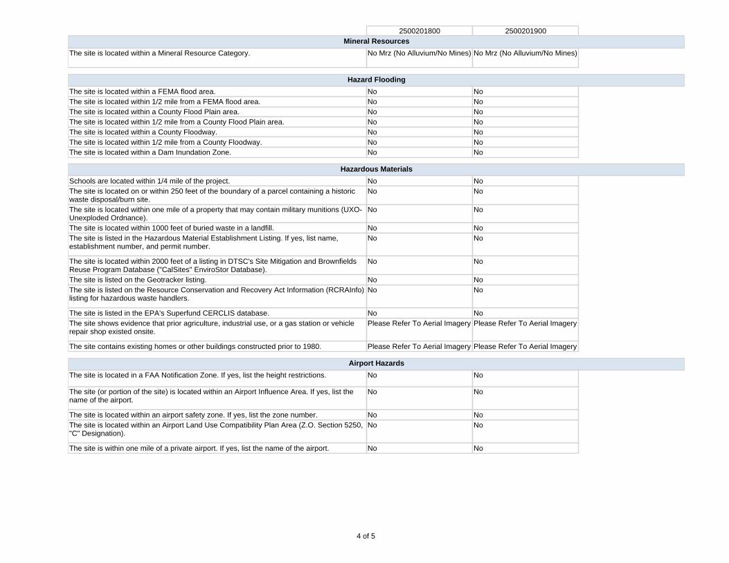
2500201800 2500201900Mineral Resources
The site is located within a Mineral Resource Category. No Mrz (No Alluvium/No Mines) No Mrz (No Alluvium/No Mines)
Hazard Flooding
The site is located within a FEMA flood area. No NoThe site is located within 1/2 mile from a FEMA flood area. No NoThe site is located within a County Flood Plain area. No NoThe site is located within 1/2 mile from a County Flood Plain area. No NoThe site is located within a County Floodway. No NoThe site is located within 1/2 mile from a County Floodway. No NoThe site is located within a Dam Inundation Zone. No No
Hazardous Materials
Schools are located within 1/4 mile of the project. No NoThe site is located on or within 250 feet of the boundary of a parcel containing a historic waste disposal/burn site.
No No
The site is located within one mile of a property that may contain military munitions (UXO-Unexploded Ordnance).
No No
The site is located within 1000 feet of buried waste in a landfill. No NoThe site is listed in the Hazardous Material Establishment Listing. If yes, list name, establishment number, and permit number.
No No
The site is located within 2000 feet of a listing in DTSC's Site Mitigation and Brownfields Reuse Program Database ("CalSites" EnviroStor Database).
No No
The site is listed on the Geotracker listing. No NoThe site is listed on the Resource Conservation and Recovery Act Information (RCRAInfo) listing for hazardous waste handlers.
No No
The site is listed in the EPA's Superfund CERCLIS database. No NoThe site shows evidence that prior agriculture, industrial use, or a gas station or vehicle repair shop existed onsite.
Please Refer To Aerial Imagery Please Refer To Aerial Imagery
The site contains existing homes or other buildings constructed prior to 1980. Please Refer To Aerial Imagery Please Refer To Aerial Imagery
Airport Hazards
The site is located in a FAA Notification Zone. If yes, list the height restrictions. No No
The site (or portion of the site) is located within an Airport Influence Area. If yes, list the name of the airport.
No No
The site is located within an airport safety zone. If yes, list the zone number. No NoThe site is located within an Airport Land Use Compatibility Plan Area (Z.O. Section 5250, "C" Designation).
No No
The site is within one mile of a private airport. If yes, list the name of the airport. No No
4 of 5
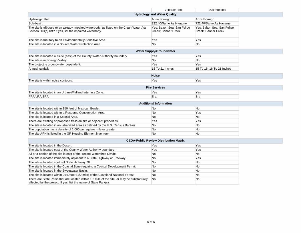
2500201800 2500201900Hydrology and Water Quality
Hydrologic Unit: Anza Borrego Anza BorregoSub-basin: 722.40/Same As Haname 722.40/Same As HanameThe site is tributary to an already impaired waterbody, as listed on the Clean Water Act Section 303(d) list? If yes, list the impaired waterbody.
Yes: Salton Sea; San Felipe Creek; Banner Creek
Yes: Salton Sea; San Felipe Creek; Banner Creek
The site is tributary to an Environmentally Sensitive Area. Yes YesThe site is located in a Source Water Protection Area. No No
Water Supply/Groundwater
The site is located outside (east) of the County Water Authority boundary. Yes YesThe site is in Borrego Valley. No NoThe project is groundwater dependent. Yes YesAnnual rainfall: 18 To 21 Inches 15 To 18; 18 To 21 Inches
Noise
The site is within noise contours. Yes Yes
Fire Services
The site is located in an Urban-Wildland Interface Zone. Yes YesFRA/LRA/SRA: Sra Sra
Additional Information
The site is located within 150 feet of Mexican Border. No NoThe site is located within a Resource Conservation Area. No YesThe site is located in a Special Area. No NoThere are existing or proposed trails on site or adjacent properties. Yes YesThe site is located in an urbanized area as defined by the U.S. Census Bureau. No NoThe population has a density of 1,000 per square mile or greater. No NoThe site APN is listed in the GP Housing Element inventory. No No
CEQA-Public Review Distribution Matrix
The site is located in the Desert. Yes YesThe site is located east of the County Water Authority boundary. Yes YesAll or a portion of the site is east of the Tecate Watershed Divide. No NoThe site is located immediately adjacent to a State Highway or Freeway. No YesThe site is located south of State Highway 78. No NoThe site is located in the Coastal Zone requiring a Coastal Development Permit. No NoThe site is located in the Sweetwater Basin. No NoThe site is located within 2640 feet (1/2 mile) of the Cleveland National Forest. No NoThere are State Parks that are located within 1/2 mile of the site, or may be substantially affected by the project. If yes, list the name of State Park(s).
No No
5 of 5
TOPO M AP
Leg en d:PROJECT AREA
Note s:0 0.1 0.2 0.3 0.4Miles
B ANNER R D
P RIV ATE R D
WYNOLA RD
FARMER RD
P R IVAT E R D
P RIVAT E R D
PR IVATE RD
FA RMER R D
FARM
ER R
D
Copyright:© 2013 Na tion al G eo graphic So ciety, i-cubed
NAD 1 98 3 S ta te P lan e C alifo rnia V I FIPS 04 0 6 Fe etPlanning and Development Services
This m ap is generated automatica lly from an in ternet m apping site and is for reference on ly.Data layers that appear on this map m ay or may not be accurate, current, or o therwise re liab le .
THIS MAP IS NO T TO BE USE D F OR NAVIG ATIO N.
±
±
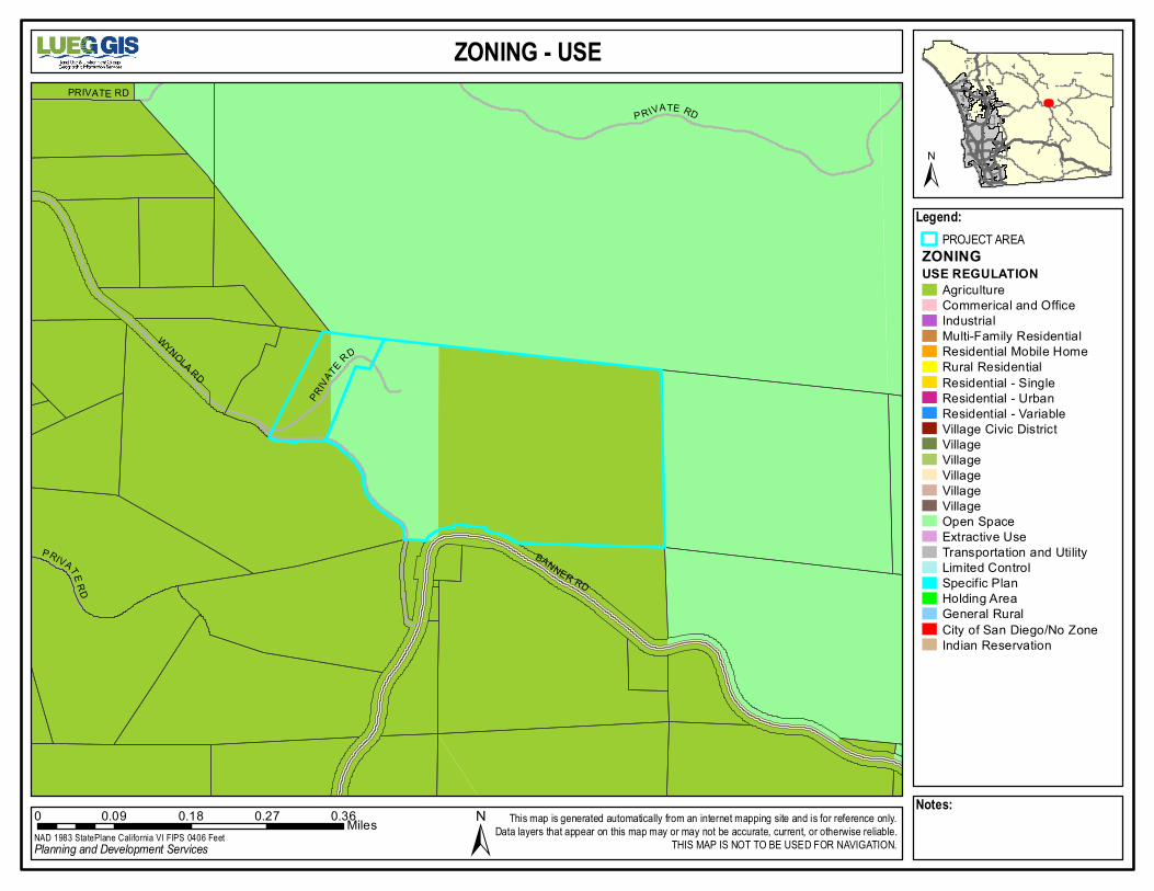
ZON ING - USE
Leg en d:PROJECT AREA
ZO N IN GUS E R EG U LAT IO N
Agr icu ltu reComm er ica l and O fficeIndustria lMu lti-F am ily R esiden tia lResident ial Mobile H om eRural Residen tialResident ial - S ing leResident ial - U rbanResident ial - Va riableVillage Civic Dis tric tVillageVillageVillageVillageVillageOpen SpaceExtrac tive U seTranspo rta tion and Uti lityLim ited C on tro lSpecif ic P lanHo lding A reaGeneral Ru ralCity o f San Diego /No Z oneInd ian Rese rva tion
Note s:0 0.09 0.18 0.27 0.36Miles
BAN NE R RD
WYNOLA RD
P R IVA TE R DPR IV A TE R D
PRIVA
TE R D
P RIVAT E RD
NAD 1 98 3 S ta te P lan e C alifo rnia V I FIPS 04 0 6 Fe etPlanning and Development Services
This m ap is generated automatica lly from an in ternet m apping site and is for reference on ly.Data layers that appear on this map m ay or may not be accurate, current, or o therwise re liab le .
THIS MAP IS NO T TO BE USE D F OR NAVIG ATIO N.
±
±

SOIL
Leg en d:PROJECT AREA
S O IL SALFISOLSENTISOLSINCEPTISOLSMOLLISOLSVERTISOLSOTHERURBANWATERUNKNOWN
Note s:0 0.09 0.18 0.27 0.36Miles
Cv G
SpG 2
CtE
CtFCa C
Ca D2
Hm E
Lu
Hn G
Cu E
Cu G
Hm E
BAN NE R RD
WYNOLA RD
P R IVA TE R DPR IV A TE R D
PRIVA
TE R D
P RIVAT E RD
NAD 1 98 3 S ta te P lan e C alifo rnia V I FIPS 04 0 6 Fe etPlanning and Development Services
This m ap is generated automatica lly from an in ternet m apping site and is for reference on ly.Data layers that appear on this map m ay or may not be accurate, current, or o therwise re liab le .
THIS MAP IS NO T TO BE USE D F OR NAVIG ATIO N.
±
±
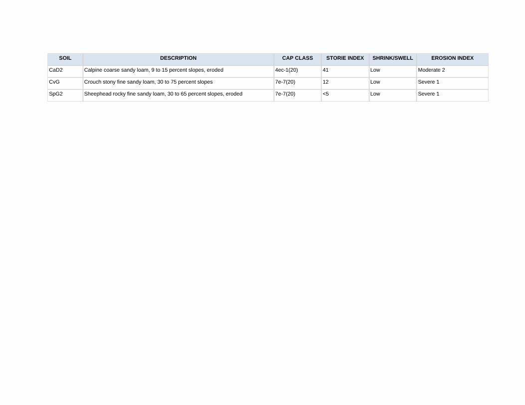
SOIL DESCRIPTION CAP CLASS STORIE INDEX SHRINK/SWELL EROSION INDEX
CaD2 Calpine coarse sandy loam, 9 to 15 percent slopes, eroded 4ec-1(20) 41 Low Moderate 2
CvG Crouch stony fine sandy loam, 30 to 75 percent slopes 7e-7(20) 12 Low Severe 1
SpG2 Sheephead rocky fine sandy loam, 30 to 65 percent slopes, eroded 7e-7(20) <5 Low Severe 1
VEGETATION
Leg en d:PROJECT AREA
V E G E TATIO N C ATE G O RYS out he rn F ored un es , B e ac h, S al tpa n, M ud fla tsCo as ta l S a ge S cru bCh ap arra lG ra ss la ndRipa ria n S c rubRipa ria n W o odlan dRipa ria n F o res tP iny on J un ipe r W oo dlan dsO t her W ood la nd sO a k F ore stVern al P oo l, M e ado w an d S eepM a rshCo ni fero us F o res tDe se rt D u ne s (2 21 00 , 22 30 0, 24 000 )P lay as /B a dland s/ M u dh ill F o rbsDe se rt S c ru bDe se rt C h ap arra lDry W as h W oo dla ndW a ter ( inc lu d ing 11 200 , 1 32 00)Urb an , D istu rbe d H a bi ta t, A g ric u l ture , E u ca ly ptu s W ood la nd
Note s:0 0.09 0.18 0.27 0.36Miles
BAN NE R RD
WYNOLA RD
P R IVA TE R DPR IV A TE R D
PRIVA
TE R D
P RIVAT E RD
84500
42000
61300
37000
45120
37130
42200
37130
84500
37200
18100
37200
77000
12000
37200
18320
37200
32500
18100
37200
37200
37130
32500
42200
12000
12000
32500
4220042200 61310
32500
37200
37510
32500
42200 37510
42200 37130
NAD 1 98 3 S ta te P lan e C alifo rnia V I FIPS 04 0 6 Fe etPlanning and Development Services
This m ap is generated automatica lly from an in ternet m apping site and is for reference on ly.Data layers that appear on this map m ay or may not be accurate, current, or o therwise re liab le .
THIS MAP IS NO T TO BE USE D F OR NAVIG ATIO N.
±
±

W ETLAND S
Leg en d:PROJECT AREAWETLANDS
Note s:0 0.09 0.18 0.27 0.36Miles
BAN NE R RD
WYNOLA RD
P R IVA TE R DPR IV A TE R D
PRIVA
TE R D
P RIVAT E RD
NAD 1 98 3 S ta te P lan e C alifo rnia V I FIPS 04 0 6 Fe etPlanning and Development Services
This m ap is generated automatica lly from an in ternet m apping site and is for reference on ly.Data layers that appear on this map m ay or may not be accurate, current, or o therwise re liab le .
THIS MAP IS NO T TO BE USE D F OR NAVIG ATIO N.
±
±

STEEP SLOPES
Leg en d:PROJECT AREASTEEP SLOPE (> 25%)
Note s:0 0.09 0.18 0.27 0.36Miles
BAN NE R RD
WYNOLA RD
P R IVA TE R DPR IV A TE R D
PRIVA
TE R D
P RIVAT E RD
NAD 1 98 3 S ta te P lan e C alifo rnia V I FIPS 04 0 6 Fe etPlanning and Development Services
This m ap is generated automatica lly from an in ternet m apping site and is for reference on ly.Data layers that appear on this map m ay or may not be accurate, current, or o therwise re liab le .
THIS MAP IS NO T TO BE USE D F OR NAVIG ATIO N.
±
±

9-10
2700
AGRICULTURAL USE REGULATIONS
A70 LIMITED AGRICULTURAL USE REGULATIONS
2700 INTENT. The provisions of Section 2700 through Section 2709 inclusive, shall be known as the A70 Limited Agricultural Use Regulations. The A70 Use Regulations are intended to create and preserve areas intended primarily for agricultural crop production. Additionally, a limited number of small farm animals may be kept and agricultural products raised on the premises may be processed. Typically, the A70 Use Regulations would be applied to areas throughout the County to protect moderate to high quality agricultural land.
2702 PERMITTED USES. The following use types are permitted by the A70 Use Regulations:
a. Residential Use Types.
Family Residential
b. Civic Use Types.
Essential Services Fire Protection Services (see Section 6905)
c. Agricultural Use Types.
Horticulture (all types) Tree Crops Row and Field Crops Packing and Processing: Limited
(Amended by Ord. No. 5508 (N.S.) adopted 5-16-79) (Amended by Ord. No. 6654 (N.S.) adopted 9-21-83) (Amended by Ord. No. 6782 (N.S.) adopted 5-16-84) (Amended by Ord. No. 7741 (N.S.) effective 3-28-90 (Urg. Ord.)) (Amended by Ord. No. 9422 (N.S.) adopted 1-9-02) (Amended by Ord. No. 10067 (N.S.) adopted 8-4-10)
2703 PERMITTED USES SUBJECT TO LIMITATIONS. The following use types are permitted by the A70 Use Regulations subject to the applicable provisions of Section 2980. The number in quotes following the use type refers to the subsection of Section 2980 which applies.
a. Residential Use Types
Mobilehome Residential "18"
9-10
2703
b. Commercial Use Types
Animal Sales and Services: Veterinary (Large Animals) "6" Animal Sales and Services: Veterinary (Small Animals) "6" Recycling Collection Facility, Small "2" Recycling Processing Facility, Wood and Green Materials "3"
c. Agricultural Use Types
Packing and Processing: Small Winery “22” (see Section 6910)Packing and Processing: Boutique Winery “22” (see Section 6910)Packing and Processing: Wholesale Limited Winery “22” (see Section 6910)
(Amended by Ord. No. 5508 (N.S.) adopted 5-16-79) (Amended by Ord. No. 5652 (N.S.) adopted 11-21-79) (Amended by Ord. No. 5935 (N.S.) adopted 11-19-80) (Amended by Ord. No. 6783 (N.S.) adopted 5-16-84) (Amended by Ord. No. 6924 (N.S.) adopted 2-20-85) (Amended by Ord. No. 8058 (N.S.) adopted 4-15-92) (Amended by Ord. No. 9940 (N.S.) adopted 6-18-08) (Amended by Ord. No. 10035 (N.S.) adopted 1-27-10) (Amended by Ord. No. 10067 (N.S.) adopted 8-4-10)
2704 USES SUBJECT TO A MINOR USE PERMIT. The following use types are allowed by the A70 Use Regulations upon issuance of a Minor Use Permit.
a. Civic Use Types.
Law Enforcement Services Minor Impact Utilities Small Schools
b. Agricultural Use Types.
Farm Labor Camps
c. Commercial Use Types.
Cottage Industries "17" (see Section 6920)
(Amended by Ord. No. 5508 (N.S.) adopted 5-16-79) (Amended by Ord. No. 5935 (N.S.) adopted 11-19-80) (Amended by Ord. No. 6654 (N.S.) adopted 9-21-83) (Amended by Ord. No. 7741 (N.S.) effective 3-28-90 (Urg. Ord.)) (Amended by Ord. No. 7768 (N.S.) adopted 6-13-90) (Amended by Ord. No. 7964 (N.S.) adopted 8-14-91) (Amended by Ord. No. 8175 (N.S.) adopted 11-18-92) (Amended by Ord. No. 8271 (N.S.) adopted 6-30-93) (Amended by Ord. No. 10003 (N.S.) adopted 8-5-09) (Amended by Ord. No. 10035 (N.S.) adopted 1-27-10)
10-09
2705
2705 USES SUBJECT TO A MAJOR USE PERMIT. The following use types are permitted by the A70 Use Regulations upon issuance of a Major Use Permit.
a. Residential Use Types.
Group Residential
b. Civic Use Types.
Administrative Services Ambulance Services Child Care Center Civic, Fraternal or Religious Assembly Clinic Services Community Recreation Cultural Exhibits and Library Services Group Care Major Impact Services and Utilities Parking Services Postal Services
c. Commercial Use Types.
Agricultural and Horticultural Sales (all types) Explosive Storage (see Section 6904) Participant Sports and Recreation: Outdoor Transient Habitation: Campground (see Section 6450) Transient Habitation: Resort (see Section 6400)
d. Agricultural Use Types.
Agricultural Equipment Storage Packing and Processing: Winery Packing and Processing: General Packing and Processing: Support
e. Extractive Use Types.
Mining and Processing (see Section 6550)
(Amended by Ord. No. 5508 (N.S.) adopted 5-16-79) (Amended by Ord. No. 6134 (N.S.) adopted 7-22-81) (Amended by Ord. No. 6543 (N.S.) adopted 3-2-83) (Amended by Ord. No. 6761 (N.S.) adopted 4-25-84) (Amended by Ord. No. 6782 (N.S.) adopted 5-16-84) (Amended by Ord. No. 6855 (N.S.) adopted 10-10-84) (Amended by Ord. No. 10006 (N.S.) adopted 9-16-09)
CCSF 85.21 (Rev 4/00)
C-1
COUNTY ZONING ORDINANCE
S-80 USE REGULATIONS
2802 PERMITTED USES. The following use types are permitted by the S-80 Use Regulations: a. Residential Use Types. Family Residential b. Civic Use Types. Essential Services Fire Protection Services (see Section 6905) c. Agricultural Use Types. Horticulture (All Types) Tree Crops Rowand Field Crops Packing and Processing: Limited (Amended by Ord. No. 5508 (N.S.) adopted 5-16-79) (Amended by Ord. No. 6654 (N.S.) adopted 9-21-83) (Amended by Ord. No. 6782 (N.S.) adopted 5-16-84) 2803 PERMITTED USES SUBJECT TO LIMITATIONS. The following use types are permitted by the S80 Use Regulations subject to the applicable provisions of Section 2980. The number in quotes following the use type refers to the subsection of Section 2980 which applies. a. Commercial Use Types. Recycling Collection Facility, Small or Large "2" Recycling Processing Facility, Wood and Green Materials "3" (Added by Ord. No. 6924 (N.S.) adopted 2-20-85) (Amended by Ord. No. 8058 (N.S.) adopted 4-15-92) 2804 USES SUBJECT TO A MINOR USE PERMIT. The following use types are allowed by the S80 Use Regulations upon issuance of a Minor Use Permit. a. Civic Use Types. Minor Impact Utilities Small Schools b. Agricultural Use Types Farm Labor Camps (Amended by Ord. No. 5508 (N.S.) adopted 5-16-79) (Amended by Ord. No. 6654 (N.S.) adopted 9-21-83) (Amended by Ord. No 10003 (N.S.) adopted 8-5-09) 2805 USES SUBJECT TO A MAJOR USE PERMIT. The following use types are permitted by the S80 Use Regulations upon issuance of a Major Use Permit. a. Civic Use Types.
CCSF 85.21 (Rev 4/00)
C-2
Administrative Services Ambulance Services Child Care Center Civic, Fraternal or Religious Assembly Clinic Services Community Recreation Cultural Exhibits and Library Services Major Impact Services and Utilities Parking Services Postal Services b. Commercial Use Types. Automobile and Equipment: Parking Explosive Storage (see Section 6904) Participant Sports and Recreation: Outdoor c. Extractive Use Types. Mining and Processing (see Section 6550) (Amended by Ord. No. 5508 (N.S.) adopted 5-16-79) (Amended by Ord. No. 6782 (N.S.) adopted 5-16-84) (Amended by Ord. No. 10006 (N.S.) adopted 9-16-09)

5510 OVERLAND AVE, SUITE 110, SAN DIEGO, CA 92123 ● (858) 565-5981 ● (888) 267-8770 www.sandiegocounty.gov/pds
PDS-444 (Rev. 4/2017) PAGE 5 of 12
Animal Schedule
ANIMAL USE TYPE (See Note 4)
Restrictions and Density Range
DESIGNATOR
A B C D E F G H I J K L M N O P Q R S T U V W X
ANIMAL SALES AND SERVICES: HORSE STABLE (see Section 3130)
Permitted X X X X X X Boarding of and riding lessons for up to 3 horses not owned by the property owner
X X X X X X X X X
10 Horses per acre of usable area up to 50 horses and 5 acres +Zoning Verification
X X X X X X X X X
10 Horses per acre of usable area up to 100 horses and 10 acres +Administrative Permit
X X X X X X X X X
More than 100 horses and more than 10 acresof usable area + by MUP
X X X X X X X X X
KENNELS (see Note 1)
Permitted X X X
Permitted provided fully enclosed
X X X
MUP required X X X X X
ZAP required X X X X X X
One acre + by MUP X X X
ANIMAL RAISING (see Note 6)
(a) Animal Raising Projects (see Section 3115)
Permitted X X X X
½ acre+ by AD X X X X X X X X X X X
1 acre+ by MUP X X X
(b) Small Animal Raising (includes Poultry) (See Note 8)
Chinchillas (See Note 5)
Permitted X X X X X
½ acre+ permitted X X X
100 maximum X
25 maximum X X X X X X X X X
½ acre+: 10 max X X X
Less than ½ acre: 100 Maximum
X X X
½ acre+ 25 max by ZAP
X X X
100 max by ZAP X X X X X
(c) Large Animal Raising (Other than horsekeeping)
1 acre + permitted X X
8 acres + permitted X X X X X X X X X
2 animals plus 1 per ½ acre over 1 acre
X X X X
4 animals plus 4 for each ½ acre over ½ acre
X X X
1 acre or less: 2 animals
X X X X X X
1 to 8 acres: 1 per ½ acre
X X X X
2 animals X X X X X
Part of Section 3100

5510 OVERLAND AVE, SUITE 110, SAN DIEGO, CA 92123 ● (858) 565-5981 ● (888) 267-8770 www.sandiegocounty.gov/pds
PDS-444 (Rev. 4/2017) PAGE 6 of 12
ANIMAL USE TYPE (See Note 4)
Restrictions and Density Range
DESIGNATOR
A B C D E F G H I J K L M N O P Q R S T U V W X (See Note 2)
½ acre plus 2 animals per ½ acre by ZAP
X X X
Grazing Only X X
(d) Horse keeping (other than Animal Sales and Services: Horse Stable)
(see Section 3130)
Permitted X X X X X X X X X X X X X X X X 2 horses + 1 horse per ½ acre over ½ acre + Administrative Permit
X X X X X X
(e) Specialty Animal Raising: Bees (See Title 6, Division 2, Chapter 9, County Code)
(See Note 7)
Permitted X X X X X X X X X X X X X X X X X X X X X X X X
(f) Specialty Animal Raising: Wild or Undomesticated (See Note 3)
ZAP Required X X X X X X X X X X X X X X X
(g) Specialty Animal Raising: Other (Excluding Birds or Aquaponics)
25 maximum X X X X X X X X X X X X X 25 maximum by ZAP X X X 25 plus by ZAP X X X X X X X X X X X X X Permitted X X X X X X
(h) Specialty Animal Raising: Birds
25 maximum X X X X X X X X X 100 maximum X X X X X X X Additional by ZAP X X X X X X X X X X X X Permitted X X X X X
(i) Racing Pigeons 100 Maximum X X X 100 Max 1/acre plus X Permitted X X X X X X X
ANIMAL ENCLOSURE SETBACKS (See Section 3112)
Most Restrictive X X X X X X X X X X X X X X X X X Moderate X X X Least Restrictive X X X X
MUP = Major Use Permit + = plus ZAP = Minor Use Permit Notes: 1. Dogs and cats not constituting a kennel and up to two pot-belly pigs are accessory uses subject to the Accessory Use
Regulations commencing at Section 6150 and are not subject to the animal enclosure setbacks. 2. On land subject to the “S” and “T” Animal Designators, grazing of horses, bovine animals and sheep permitted provided
no buildings, structure, pen or corral shall be designated or used for housing or concentrated feeding of animals, and the number of such animals shall not exceed 1 animal per ½ acre of land.
3. One wild or undomesticated animal, kept or maintained in conformance with State and local requirements, is an accessory use subject to the Accessory Use Regulations commencing at Section 6150, and is not subject to the Animal Schedule. (Amended by Ordinance Number 7432 (N.S.) adopted January 6, 1988.)
4. The Animal Schedule does not apply to small animals, specialty animals, dogs or cats which are kept for sale in zones where the Retail Sales, General Use type is permitted provided that all activities are conducted entirely within an enclosed building, the building is completely soundproof, there are no outside runs or cages, no boarding of animals, no outside trash containers and no offensive odors.
5. Chinchillas are considered small animals except that a ZAP may be approved for more than 25 chinchillas on property with the “L” Designator.
6. The number of animals allowed is per legal lot. This number shall not apply to the keeping of earthworms. 7. Additional regulations are applicable to beekeeping, see County Code Section 62.901 et seq. 8. Additional regulations are applicable to the keeping of roosters, see County Code Section 62.690 et seq.