proposal for biodiversity heritage...
TRANSCRIPT

Proposal for Curtorim BHS 2016
Page 1 of 66
PROPOSAL FOR BIODIVERSITY HERITAGE SITE
Fig: Indicative Google Image
CURTORIM BIODIVERSITY HERITAGE SITE (RAITOLLEM –ZUARI: INTEGRATED TRADITIONAL AGRO- PISCI-
ECOSYSTEM).
PREPARED
FOR
BMC CURTORIM By TSG – CHOWGULE COLLEGE
FEBRUARY - 2018
Extent of BHS proposed – Ralloi Tollem
– (Vaingnoddi Add ) – Angdi Tollem
(opp. Curtorim Church) – (Sirge Add –
Chowk – dyke) – Kottambo Poi ( water
channel upto river Zuari) Along with
Sonbem (Maina) Tollem , Mai Tollem,
Kum (Colomba) Tollem and Gud Tollem
( 6 lakes) Along with associated Khazan
Areas, Mangroves and Agroecosystems

Proposal for Curtorim BHS 2016
Page 2 of 66
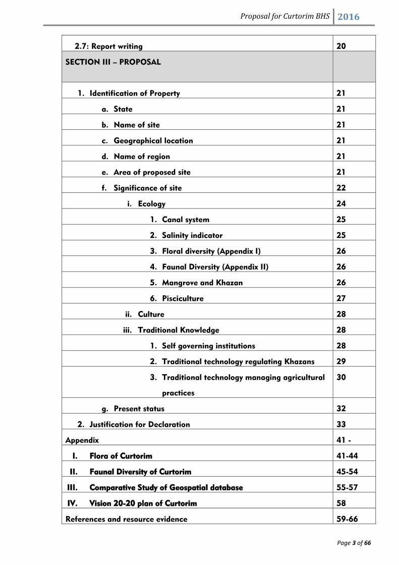
INDEX (INDICATIVE)
CONTENT
SECTION I: Intoduction 4-12
1.1: Curtorim- Over view 4
1.2 Location 4
1.3 Physical Aspects 4
1.4 Soil Types 5
1.5 Waterbodies 5
1. 6 Administration Divisions: 6
1.7 Cultural Aspects: 7
1.8 Demographic indicators 10
1.9 Economy of the Village 11
1.10 Irrigation system 12
1.11 Transportation and communication 12
1.12 Religion 12
SECTION II: JUSTIFICATION AND RESEARCH METHODOLOGY 14-20
2.1 Justification 14
2.2 Introduction to methodology: 14
2.3 Meetings with timelines. 16
2.4 Data Source and Methodology 17
2.5 Primary data 18
a) Lab Analysis 18
b) Transect walk 18
c) Interviews 18
d) GPS 18
e)Photography 18
2.6 Secondary data 19
Proposal for Curtorim BHS 2016
Page 3 of 66
2.7: Report writing 20
SECTION III – PROPOSAL
1. Identification of Property 21
a. State 21
b. Name of site 21
c. Geographical location 21
d. Name of region 21
e. Area of proposed site 21
f. Significance of site 22
i. Ecology 24
1. Canal system 25
2. Salinity indicator 25
3. Floral diversity (Appendix I) 26
4. Faunal Diversity (Appendix II) 26
5. Mangrove and Khazan 26
6. Pisciculture 27
ii. Culture 28
iii. Traditional Knowledge 28
1. Self governing institutions 28
2. Traditional technology regulating Khazans 29
3. Traditional technology managing agricultural
practices
30
g. Present status 32
2. Justification for Declaration 33
Appendix 41 -
I. Flora of Curtorim 41-44
II. Faunal Diversity of Curtorim 45-54
III. Comparative Study of Geospatial database 55-57
IV. Vision 20-20 plan of Curtorim 58
References and resource evidence 59-66

Proposal for Curtorim BHS 2016
Page 4 of 66
SECTION I INTRODUCTION
1.1 Introduction: Curtorim- Over view
The village of Curtorim – Codtary, Coddetary, or Kardeley as it seems the village was known in
olden times. The village was baptized by the Portuguese as Curtorim. It was also known Cuddtari
(Aldeia de Curtorim, pg.5, Diario de Goa, supplemento 1-2-1956 por Agusto Rodrigues, son of
Curtorim, Kuddutare Grama (in an inscription of 1546, Bharatha Kaumadi, pg.449 by prof. Dr.
George Moraes), Kuddasthali, (sthali- place), (Boletim do institute de Vasco de Gama, No.69-
1952, pg. 26 by prof.P. Pissurlencar), Kurhtori,(Dr. Jose Pereira- son of Curtorim in Marg). It is now
known as Curtorim, (English, Portuguese), Curtore (konkani), Kuddtore (Hindi, and Marathi), and
probably Kuddtorihalli, (halli- village) in Kannada.
A copper-plate inscription was issued by King Viramarmadeva of the Kadamba dynasty in 1049 CE
concerning a grant of a piece of land called 'Tudukapura' in 'Kudtarika agrahara' of 'Chhat sathi
desha'. This inscription suggests that 'Kudatari' or modern 'Curtorim' was known as 'Kudatarika'
then. 'Chhat sathi' refers to modern Salcete, known as 'Sashti' in the local Konkani language. It had
an 'Agrahara', which means an education centre or a university in the modern sense and was
started most probably by the said monarch Viramarmadeva or by 'Sasthadeva II' or 'Guhalladeva II'
of Goa Kadamba dynasty (https://en.wikipedia.org/wiki/Curtorim).
Curtorim is second –to-none in Salcete taluka in rice production and has earned the name
‘Granary of Salcete’( Saxtti Bhatacho Koddo, Celeiro de Salcete). Earlier the village was also the
centre for Maritime trade.
The area of Curtorim is appx. 1,735.5 Ha with approximate length of 4.5 kms and breadth of 4 kms.
Area under agriculture is nearly 65% with irrigated land occupying 386 Ha, unirrigated land being
699 Ha and waste land 25 Ha. About 53% of Agricultural land is held by owners, 45%
Communidade and 2% being Institutional (Fernandes, 2016)
1.2 Location: The village of Curtorim is located 8 kms away from Margao, the main town of Salcete and is
surrounded by the villages St. Jose De Areal/ South Central Railway to the South, Macasana,
Guirdolim to the East, Margao part/ Raia to the West and River Zuari to the North.
(www.curtorimpanchayat.com; Fig 1: indicating location of the village )

Proposal for Curtorim BHS 2016
Page 5 of 66
Fig 1: Location map of Curtorim village
1.3 Physical Aspects: Curtorim is a very picturesque village with hills and hillocks , green fields, coconut palms, springs and water
bodies giving it a complete and unique ambience.
The village of Curtorim can be broadly divided into two physiographic divisions that is the isolated
hillocks and riverine plains are found along the river Zuari which lies below the contour interval of
20 metres. There are scattered isolated hillocks lying in the village of Curtorim. It has ghats like
small terrain having to the north the Zuari river almost 5 kms in length. The riverine plains of the
river Zuari are the outstanding physiographic picture of Curtorim. The nature has been bountiful in
providing this village with rich and fertile soil of rice with the monopoly of producing seeds (Xitto
overtaken now by Jaya/ Jyoti) with abundant sub-soil waters.
Towards North of Curtorim is Firguembhat, Muxivaddo,Vetnem, Corjem, Sinaibhag and Ullando
where we find the Khazan lands. This Khazan lands are marshy in nature but very fertile, being
located near river Zuari creeps are formed out of alluvial soil. The Kher lands are also found,
normally this type of land is situated between the Khazan land and the morod lands. This type of
soil also yields other crops like onions, vegetables and sweet potatoes.
The land mass of the village can be classified into three regions

Proposal for Curtorim BHS 2016
Page 6 of 66
1. High lands consisting mainly of lateritic soil, which is mainly utilized in growing various types of
vegetables, the terraced gardens are mostly converted into Morod land which is used mainly to grow
paddy as a khariff crop ( with the help of the rain water).
2. Mid lands consisting mainly of land irrigated by the water stored in the various ponds as the Rabi Crop.
The said land also called as Kher land (Vaingonn). The mid lands are used to grow crops twice a year.
3. Low lands (the khazan lands) The khazan lands are low lying land wherein the river water gets infiltrated
into it thereby giving it a saline character. The said land is basically used for pisciculture as well as used to
be for the growth of Saline resistant paddy like xitto and asgo. But recent experiments have shown that
even high yielding variety paddy crops like Jaya can be grown in such fields with great success.
1.4 Soil Types:
Curtorim being essentially agricultural land is divided into 3 distinct zones.
1) The high zones comprising morods, lateritic morods which are cut on the hill sides.
2) The middle zones largely flat /plain being arenosilicon.
3) The low-lying area being argellio silicon (addis) and finally the khazans reclaimed from the river
with bunds of muddy soil. The khazannas are used only for one cultivation when rice or the type of
xitto which is used for seeding is planted. Addis are cultivated twice and are highly productive. The
morods cultivated in the monsoons are previously manured with the mud- soilof khazannas every
three years which contributes to the increase of production. The population of Curtorim lives on
agriculture.
1.5 Water Bodies:
Curtorim village is drained by River Zuari which is almost 5kms in length. Open surface drains
have been provided in all the wards of the Curtorim village. It is also drained by Six lakes such as
as Sonbem tollem (Maina) (approximate 10 hectare area),Ralloi tollem (approximate10 hectare area),
Angdi tollem (approximate 8 hectare area), Gud tollem(approximate 3 hectare area),
Maitollem(Carminagar) (approximate 10 hectare area) and Colombatollem (Kumtollem)(approximate5
hectare area) and at different sites which helps in a big way in maintaining the fertility of the soil and
cultivation of vegetables ( Sorce: Rodrigues Santan).
The success story for massive paddy fields and numerous vegetables grown in this village could
be attributed to the existence of Six large lakes at different places which helps in a big way in
irrigating and maintaining the fertility of the soil. Therefore the vast cultivated paddy fields in
Curtorim are proof of the fact that the village was once known as the ‘Granary of Salcete’.
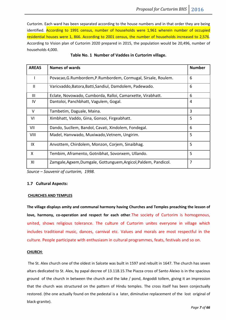
1.6 Administrative Setup: Curtorim is administered by Panchayat
PANCHAYAT: Curtorim Panchayat is one of the largest with 11 Members having Sarpanch, Deputy
Sarpanch and 9 members. The first edition to the Panchayat in free Goa was in 1962. Elections are
held every 4 years. The village of Curtorim has 58 Vadde’s which are looked after by Village Panchayat of
Proposal for Curtorim BHS 2016
Page 7 of 66
Curtorim. Each ward has been separated according to the house numbers and in that order they are being
identified. According to 1991 census, number of households were 1,961 wherein number of occupied
residential houses were 1, 866. According to 2001 census, the number of households increased to 2,576.
According to Vision plan of Curtorim 2020 prepared in 2015, the population would be 20,496, number of
households 4,000.
Table No. 1 Number of Vaddes in Curtorim village.
AREAS Names of wards Number
I Povacao,G.Rumbordem,P.Rumbordem, Cormugal, Sirsale, Roulem. 6
II Varicvaddo,Batora,Batti,Sandiul, Damdolem, Padewado. 6
III Eclate, Novowado, Cumborda, Ralloi, Camarxette, Virabhatt. 6
IV Dantoloi, Panchbhatt, Vagulem, Gogal. 4
V Tambetim, Daguale, Maina. 3
VI Ximbhatt, Vaddo, Gina, Gonsoi, Firgeabhatt. 5
VII Dando, Sucllem, Bandol, Cavati, Xindolem, Fondegal. 6
VIII Madel, Hanvwado, Muxiwado,Vetnem, Ungirim. 5
IX Anvottem, Chirdolem, Monzon, Corjem, Sinaibhag. 5
X Tembim, Aframento, Gotnibhat, Sovonxem, Ullando. 5
XI Zamgale,Agxem,Dumgale, Gottunguem,Argicol,Paldem, Pandicol. 7
Source – Souvenir of curtorim, 1998.
1.7 Cultural Aspects:
CHURCHES AND TEMPLES
The village displays amity and communal harmony having Churches and Temples preaching the lesson of
love, harmony, co-operation and respect for each other.The society of Curtorim is homogenous,
united, shows religious tolerance. The culture of Curtorim unites everyone in village which
includes traditional music, dances, carnival etc. Values and morals are most respectful in the
culture. People participate with enthusiasm in cultural programmes, feats, festivals and so on.
CHURCH:
The St. Alex church one of the oldest in Salcete was built in 1597 and rebuilt in 1647. The church has seven
altars dedicated to St. Alex, by papal decree of 13.118.15.The Piazza cross of Santo Aleixo is in the spacious
ground of the church in between the church and the lake / pond, Angoddi tollem, giving it an impression
that the church was structured on the pattern of Hindu temples. The cross itself has been conjectually
restored. (the one actually found on the pedestal is a later, diminutive replacement of the lost original of
black-granite).

Proposal for Curtorim BHS 2016
Page 8 of 66
Chapels
1. Capela De Nossa SenhoraDos Milagres (Chapel of Our Lady of Miracles), at St. Jacob (St. Jacob’s hill)
between Bandol and Cavati wards, from St. Alex church Curtorim, built by Communidade de Curtorim in
1647, rebuilt in 1745. A new provision of erection was dated 06-12-1847.
2. CAPELA DE NOSSA SENHORA DO CARMO:
(Chapel of Our Lady of Carmel), Carmi Copel, at Anvottem(Vonvottem) Karminagar- Curtorim built by the
residents of Dongorpelem and Fr. Inacio de Cunha, in 1780-82 was erected by the provision dated 22-11-
1782.
Temples: Before the Christianization of Curtorim, the people of the village venerated the Deities like
Santeri, Naraina, Chamundeshwari, Quetrapall, Santulio-Ravalnath, Chandranath, Durgadevi, Bhagavati,
Salvensvar, Maeswar, Ganesh and Quesnanto. The statues of Santeri and Chandexwari were shifted to
Guddo of Avedem of Quepem. The Church of Curtorim occupies the old place of the temple Ravalnath.
(Source required for more details???).
Now the village has Shripad Srivallabh, Ganapati Mahakali, Shantadurga Chamundeshwari, Ayappa temple
and Mahadev temple at Leprosy complex.
Feasts And Festivals: Curtorim, as the rest of Goa, is a land of festivities, feasts and festivals.
Feasts:
a) Khandi khuris fest:
Among numerous feasts and festivals celebrated in Curtorim the One which stands out is the
Khandi Khuris fest which is feast of “Cross near the sluice gate” celebrated annually on
August 20. The significance of this feast is that from August 20 the villagers commences
the preparation of building the Khandi (Sluice gate) that blocks the water from entering the
nearby fields and also stores the water for the post monsoon rabi crops that are cultivated by
Villagers.This feast has been celebrated in the village by Xetkars (Farmers) since centuries
(Azavedo, 2015).
b) Feast Of Nossa Senhora De Gaudalupe: This is the main feast of Curtorim, the village
feast. It is celebrated on 18th December, at St. Alex Church. The feast (festa/ fest) also
named Festa de O (Khelleam Fest) is celebrated in every home by Kudtorkars, attended by
their relatives and friends drawn from practically all parts of Goa. The fair at market place
(tinto) has stalls. On feast days, usually in the evenings, after a nap (fiesta followed by
siesta ) the kuddtorkars go for the football game (usually Soccer tournament Finals) at St.
Alex church ground or the new football ground near the cemetery prepared by the

Proposal for Curtorim BHS 2016
Page 9 of 66
Curtorim village Panchayat and at night usually the senior citizens(elders ) witness Tiatr at
St. Alex church ground while the junior citizens (youth ) go for a dance at Curtorim.
c) Feast Of St. Alex (Patron):
The feast was earlier celebrated on July 17th, now it is celebrated on the Sunday following
July 17th, and by the residential club of kudtorkars in Bombay at Jer Mahal, Dhobitalao,
Mumbai, with Solemn High Mass and distribution of pictures of St. Aleixo. It was on On
July 17 that St. Alex had passed away. The main door of St. Alex church has these words:
ALEIXUS NOBSSIMUS ROMANORUM.
d) Feast Of Nativity Of Our Lady:
Feast Of Nativity Of Our Lady is celebrated on September 8th of every year. The children of
Curtorim wear a copel of flowers on their heads and carry tiny basket of flowers to offer at
the feet of Our Lady, singing the hymns to Blessed Virgin Mary. This practice is followed
even today.
e) Feast Of St. Sebastiao:
Feast of St. Sebastiao is celebrated on January 20th, at different crosses in the village,
especially at the Chapel at Leprosy Home(Capela Central de Leprosaria- Dr. Froilano de
Melo) Aframento Curtorim.
ii. Festivals:
a) Harvest Festival: (Novem).
The Harvest Thanksgiving Day, August 15th is one of rejoicing for the catholic farmers
of Curtorim. The villagers go in the procession, after Mass, from St. Alex church to the nearest
paddy field of Communidade de Curtorim in the drained off Angoddi Tollem lake/ pond, carrying
the statue of the village Patron St. Alex. The parish priest cuts a few sheaves of the new paddy
crop, blesses the corn sheaves and distributes these to the congregation. The villagers carry a
sheaf home and place it in the Oratorio in gratitude for the bounty of Lord Jesus Christ. Many
household families prepare kheer, a sweet preparation of boiled rice, coconut and Goenche godd
(maddham godd from jaggery)- now a days sugarcane jaggery is used instead to mark the
prosperity , that the new corn has ushered in the village of Curtorim.
b) Festival Of St. Joao On the feast day of St. John the Baptist, on June 24th, after the morning mass, the daring
villagers wearing a wreath of Sanjuachival on their heads jump into the well at Curtorim, to
commemorate the leap of joy of John the Baptist, when he was in the womb of his mother
Elizabeth, as soon as her cousin Mary (Blessed Virgin) visited her. The brides who have become
mothers in that year, usually offer jackfruits and fenni to those villagers diving into the wells of

Proposal for Curtorim BHS 2016
Page 10 of 66
their homes. Besides we have the yuletide Festival (throughout the Christmas season ), New-Year
festival, Easter festival, etc.
DEMOGRAPHIC INDICATORS
According to 1991 census, the population of Curtorim was 9,840 thousands. The male population was 4,924
thousands and female population was 4,916 thousands. The total population in the age- group 0-6 was
1,123 thousands. The male population was 52.18 per cent and female population was 48.17 per cent the
decadal growth of population was16.64 per cent the density of population was 5.6 per cent the sex- ratio of
Curtorim village was 998/1000 males. The total literacy rate was 36.54 per cent where male literates were
41.95 per cent and female literates were 31.12 per cent.
According to 2001 census, the population of Curtorim was 11,187 thousand where the male population
was 5,515 thousands and the female population was 5,672 thousands.i.e. the sex-ratio was 1028/1000
males. The total population in the age-group 0-6 years was 997 thousands. The total literacy rate was 78.8
per cent, where the males were 84.7 per cent and the females were 73.2 per cent.
Addd 2011 and Panchayat records ) As per 2011 census/ latest Panchayat records the total
population of the Curtorim village is 12,886 people. Total population literates are 10,051 out of
which males are 5,033 and females are 5,018. Total population illiterates are 2,835 out of which
males are 1,183 and females are 1,652.
The Present Demographic status is given in the Table 1.3
Table 1.3: Population of males and females in different categories(2016)
Source: Vision Plan 2020 of Curtorim
1.10 Economy Of The Village: As per 2011 sensus the total workforce is 4537 persons of which 91 are Agriculture cultivators, 30 are Ag.
Laborers, 72 are household workers and majority of them are engaged in other services ie. 3145. There is
substantial workforce as marginal workers which accounts to 929persons. However Panchayat
records…………………..
Though Village largely depends on Agricultural practices many of them are part time Pisciculturist and
harvest not only rice but also fishes. The rights to harvest fish are auctioned wherein fresh water lake fishes
like chonok, pitol,khal, killapi and daddi are sold. Prawn farming is another upcoming practice of the
Proposal for Curtorim BHS 2016
Page 11 of 66
villagers fetching employment. Same has been expressed by Rubinoff J. (2001) in his article Pink Gold:
transformation of Backwater Aquaculture on Goa’s Khazan lands. However traditional sluice –gate
fishermans ……needs information.
Villagers face universal problem of unavailability of employers working in the farm but interestingly the rate
of people taking farming has increased due to awareness and technology ( Rodrigues Santan).
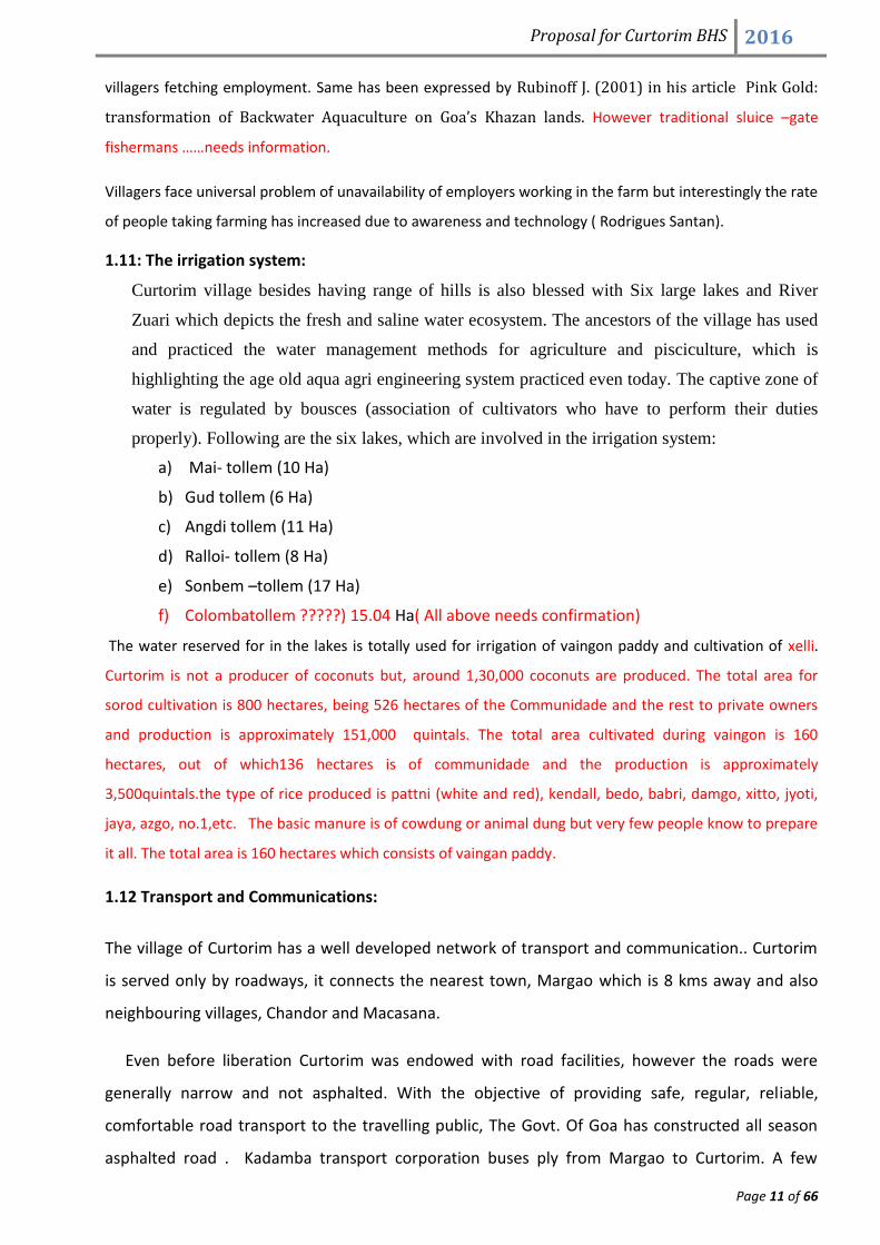
1.11: The irrigation system:
Curtorim village besides having range of hills is also blessed with Six large lakes and River
Zuari which depicts the fresh and saline water ecosystem. The ancestors of the village has used
and practiced the water management methods for agriculture and pisciculture, which is
highlighting the age old aqua agri engineering system practiced even today. The captive zone of
water is regulated by bousces (association of cultivators who have to perform their duties
properly). Following are the six lakes, which are involved in the irrigation system:
a) Mai- tollem (10 Ha)
b) Gud tollem (6 Ha)
c) Angdi tollem (11 Ha)
d) Ralloi- tollem (8 Ha)
e) Sonbem –tollem (17 Ha)
f) Colombatollem ?????) 15.04 Ha( All above needs confirmation)
The water reserved for in the lakes is totally used for irrigation of vaingon paddy and cultivation of xelli.
Curtorim is not a producer of coconuts but, around 1,30,000 coconuts are produced. The total area for
sorod cultivation is 800 hectares, being 526 hectares of the Communidade and the rest to private owners
and production is approximately 151,000 quintals. The total area cultivated during vaingon is 160
hectares, out of which136 hectares is of communidade and the production is approximately
3,500quintals.the type of rice produced is pattni (white and red), kendall, bedo, babri, damgo, xitto, jyoti,
jaya, azgo, no.1,etc. The basic manure is of cowdung or animal dung but very few people know to prepare
it all. The total area is 160 hectares which consists of vaingan paddy.
1.12 Transport and Communications:
The village of Curtorim has a well developed network of transport and communication.. Curtorim
is served only by roadways, it connects the nearest town, Margao which is 8 kms away and also
neighbouring villages, Chandor and Macasana.
Even before liberation Curtorim was endowed with road facilities, however the roads were
generally narrow and not asphalted. With the objective of providing safe, regular, reliable,
comfortable road transport to the travelling public, The Govt. Of Goa has constructed all season
asphalted road . Kadamba transport corporation buses ply from Margao to Curtorim. A few

Proposal for Curtorim BHS 2016
Page 12 of 66
private buses also ply locally. Due to improvement in the quality of life, the reliance on public
transport has decreased and people now use their own private vehicles- two wheelers and four
wheeler.
1.13 Religion:
Curtorim is a village dominated by Christians mainly the Catholics which are 82%, while
the Hindus are 12% Muslims and others are nearly 6 per cent. There is a ward wise variation in
the religious composition. The core village mainly consists of catholic population found in wards
like Dando, Sucllem, Bandol (Table No. 1.4). With the establishment of Mormugao Steel plant in ward no VI there has been influx of migrant
population mainly Hindus and Muslims. Maina has considerable Muslim population and Hindu
population may be attributed to the fact that this people have settled down because of
accessibility to Margao.
Table No. 1.4 Population of Curtorim based on religion
Ward Nos. Christians Hindus Muslims Others Total
WARD I 325 32 1 34 392
WARD II 379 34 1 9 423
WARD III 421 165 43 5 634
WARD IV 229 209 72 1 511
WARD V 257 12 - 8 277
WARD VI 403 12 - - 415
WARD VII 315 25 - 2 342
WARD VIII 292 13 1 3 309
WARD IX 339 11 - 4 354
WARD X 276 12 2 3 293
WARD XI 253 8 - 2 263
TOTAL 3489 533 119 72 4213

Proposal for Curtorim BHS 2016
Page 13 of 66
SECTION II
JUSTIFICATION AND RESEARCH METHODOLOGY
The village of curtorim, an ancient village of Sashti (salcette taluka) has a rich cultural and
ecological heritage. A cursory glance shows diverse components, integrated systems of Khazans,
irrigation systems, heritage monuments, heritage, culture and natural lakes. For centuries, the
people in this village have maintained this heritage, in short, which reflects a mosaic of natural,
semi- natural and man made habitats, supporting significant diversity of life forms. It becomes
more than an obligation to the villagers to protect this rich, unique, ecologically fragile ecosystem
under the laws of Biodiversity Heritage site (BHS) for the management and conservation under sub
section (2) of Section 37.
2.1 Justification: The proposed site of Curtorim village represents centuries old traditional
ecosystem of blending man environment relationship by practicing agro- pisci- culture in a
sustainable approach. The proposed BHS site is an unique composite of lakes, khazans, mangroves
and traditional occupations that show interlinkages of canal system engineered for fresh and
saline water management by using traditional knowledge and experience(Fig. 2.1). Thus, the
proposed site has the following points of consideration:
1. Supports age old irrigational system of fresh water and Khazans by canals, sluice gates and
bunds.
2. Supporting biodiversity in terms of Flora and fauna.
3. To understand and appreciate the Communidade and Gaunkaris system
FIG 2.1 : Man – Environment Interaction

Proposal for Curtorim BHS 2016
Page 14 of 66
2.2: Introduction to methodology:
The following proposed heritage site (Fig 2.2), shows integrated Agro-Pisciculture
ecological system of the fresh water and saline water that lie in the heartland of the curtorim
village, longitudinally extending from the Ralloitollem lake in the south to the river Zuari in the
North, covering an area of 4.3kms. approximately.
The following proposal has been prepared by engaging diverse stakeholders ranging from
researchers to village folks. The final proposal is a culmination of varied approaches, data
collections, methodologies and timelines. Therefore, this section of the proposal contains jist of
timelines of the meetings, approaches in the context of social, cultural and ecological heritage,
sources of data collection, primary as well as secondary and multidisciplinary approach.
2.3: Meetings with timelines:
The meetings were conducted to plan and execute field work, discuss characteristics, issues and
challenges of the proposed heritage site and review and execute of the data collection and
compilation of information to prepare the final draft.
Fig2. 2 : Toposheet of the Curtorim (black outline), showing biodiversity Heritage Site (red outline)

Proposal for Curtorim BHS 2016
Page 15 of 66
Month Agenda Task Remarks
April 2016 Formations of Curtorim biodiversity heritage site board
Nominations of members Principal Chowgule college nominates Dr. Uma Masur and Dr. Nandini Vaz Fernandes ( specialist in Flora and fauna research)
April 2016 Meeting at Curtorim Panchayat hall
Introduction of 12 BMC members and drawing the outline of the proposal
Chowgule college takes the responsibility of documentation & preparation of proposal as per BHS format
May 2016 Meeting in Chowgule College
Principal conducts meeting of all Science department to volunteer for the making of proposal.
Core member team is formulated 1. Dr. NN Sawant 2. Dr. Uma Masur 3. Dr. Nandini Vaz Fernandes 4. Dr. Sanjay Gaikwad
May 2016 Meeting with Mr. Santan & Mr. Gromiko
Submission of resource data, maps, photos etc.
All core members
May 2016 Pre-Field work
Selection of students and orientation
Five students volunteered to assist in documentation
May 2016 Field work Collection of flora/ fauna 5 days field work
May 2016 Post field work Collected information was compiled
Assisted by students
June 2016 Draft 1 submitted to Panchayat Chairman Mr. Santan
Review and give inputs Meeting attended by Dr.Uma and Dr. Nandini
July 2016 Feedback Discussion to finalize the BHS draft
Proposal was to include whole of Curtorim village- Mr. Santan
July 2016 Discussion BHS revision with more inputs
Core members
August 2016
Discussion Revision of draft Core members
September 2016
Discussion on 1. Area Mapping 2. Draft of proposal
Discussion Due to ambiguity in the thought process of Curtorim BMC members, Consulting members of Chowgule College requested to have a clarity prior to next meeting on the Map for Curtorim BHS Proposal so that the same can be included within.
October 2016
Draft 2 Discussion to finalize the BHS draft
Lack of clarity on area village visa via present proposed site
November 2016
Contents of Proposal and necessary changes
Discussion with GSBB team at chowgule college.
Evidences to be collected and field visit to be conducted.
November 2016
Field study To carry out field study, sample collection for lab
All core members with Santan.

Proposal for Curtorim BHS 2016
Page 16 of 66
analysis, photography, interviews.
Dec 2016 Maps, GPS, Lab analysis and data interpretation
Final draft of BHS
All core members
Dec 2016 Site visit and BMC meet in Curtorim
14 Feb 2018
Validation of BHS and PBR
Presentation infront of validation panel
Dr. Uma presented the PBR and BHS infront of Validation Panel. Some suugestions were given for improvement
Feb 2018 Finalizing report BMC and TSG members along with GSBB went through the draft for corrections
Maps and some facts were checked and inserted
Table 2.1: Meetings with timelines
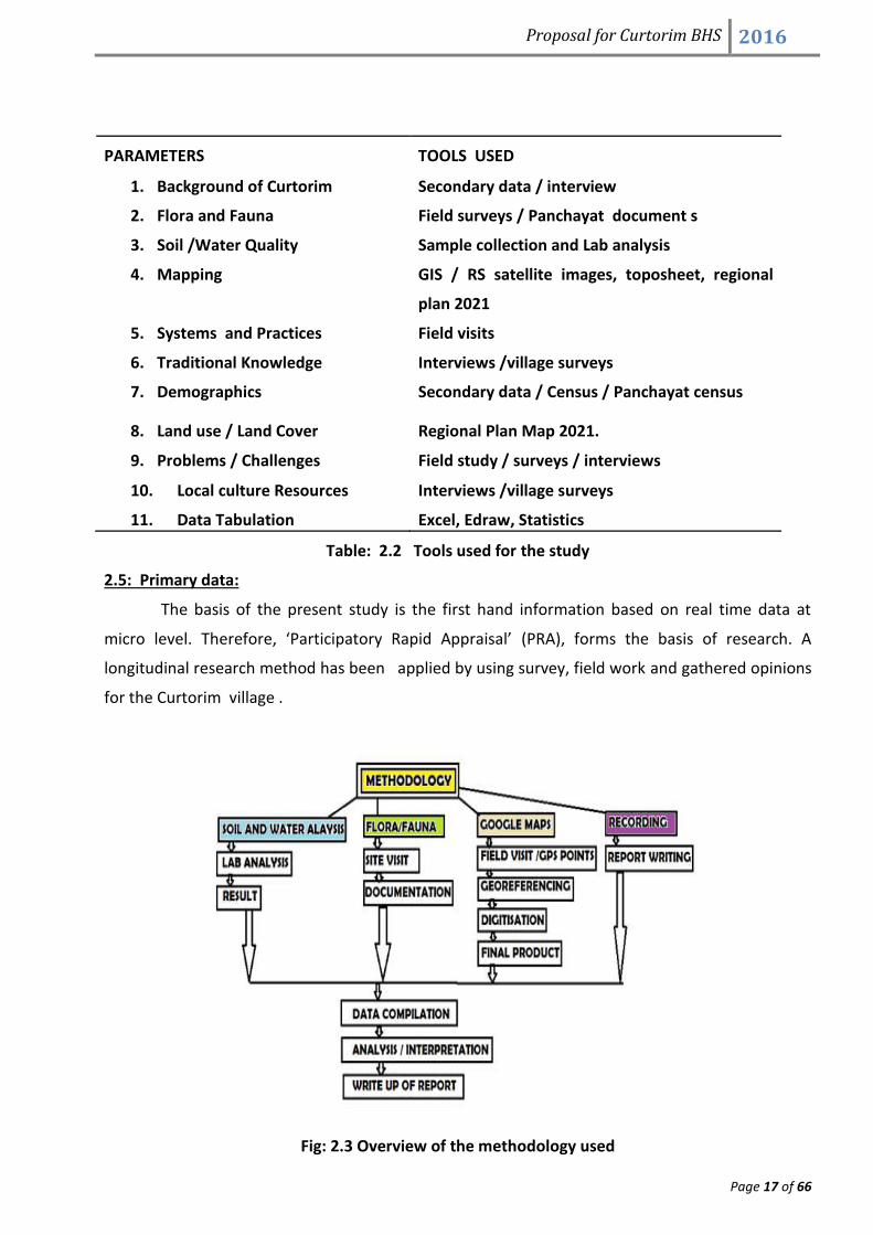
2.4: Data Source and Methodology:
Data for the present research, has been gathered from an array of sources, primary as well
as secondary (Fig: 2.2).
Fig: 2.2 Sources of Data collection
The primary data was collected through extensive field survey to find out the current
changes in the land use, land cover patterns, flora, fauna and morphological changes occurring at
the proposed heritage site. Field work also included the collection of samples of water and soil
from different points of the area under study.(Table 2.2).
Proposal for Curtorim BHS 2016
Page 17 of 66
PARAMETERS TOOLS USED
1. Background of Curtorim Secondary data / interview
2. Flora and Fauna Field surveys / Panchayat document s
3. Soil /Water Quality Sample collection and Lab analysis
4. Mapping GIS / RS satellite images, toposheet, regional
plan 2021
5. Systems and Practices Field visits
6. Traditional Knowledge Interviews /village surveys
7. Demographics Secondary data / Census / Panchayat census
8. Land use / Land Cover Regional Plan Map 2021.
9. Problems / Challenges Field study / surveys / interviews
10. Local culture Resources Interviews /village surveys
11. Data Tabulation Excel, Edraw, Statistics
Table: 2.2 Tools used for the study
2.5: Primary data:
The basis of the present study is the first hand information based on real time data at
micro level. Therefore, ‘Participatory Rapid Appraisal’ (PRA), forms the basis of research. A
longitudinal research method has been applied by using survey, field work and gathered opinions
for the Curtorim village .
Fig: 2.3 Overview of the methodology used

Proposal for Curtorim BHS 2016
Page 18 of 66
a) Lab Anaysis:
The water samples from the lakes and the soil near the lakes were tested for nitrate, sulphate and
phosphate concentrations. Samples were also analysed for microbial evaluation.
I. Nitrates: For the estimation of nitrates “Brucine method” - Spectrometric techniques were
used for the determination of nitrates in water and soil samples.
II. Sulphates: Sulphates in aqueous solution was determined by a gravimetric method in
which sulphate is precipitated as barium sulphate.
III. Phosphates: Estimation of phosphates was done by “Stannous chloride method”.
Phosphorus in water exists in either a particulate phase or a dissolved phase. Particulate
matter includes living and dead plankton, precipitates of phosphorus, phosphorus
adsorbed to particulates, and amorphous phosphorus. The dissolved phase includes
inorganic phosphorus, organic phosphorus excreted by organisms.
IV. Microbiological Parameter: The soil and water samples were analyzed for bacterial count
for presence of faecal coliform bacteria. Samples were subjected to bacterial count by
‘Spread plate method’ and evaluation by gram staining and IMViC test.
b) Transect Walk: A transect walk is a tool for describing and showing the location and
distribution of resources, features, landscape, main land uses along a given transect. It
helps in identifying and explaining the cause and effect relationships among topography,
soils, natural vegetation, cultivation, and other production activities and human settlement
patterns .It also helps in identifying major problems and possibilities perceived by different
groups of local analysts in relation to features or areas along the transect and learning
about local technology and practices.
Transect walk was undertake from Ralloitollem to Zuari river. During this exercise,
the group had interaction with local stakeholders (eg: President of Tenants Association and
TK holders) collected samples of water and soil, reviewed the topography, tracked the
canal system, understood the water management system, agricultural pattern and the
agricultural system.
c) Interview: Traditional knowledge and information about the biodiversity was obtained by
conducting interviews with ‘Gaunkaris’ and elderly people in the village. The interviews
were recorded using voice recorders and also cam coders.
d) GPS: Ground control points were taken, using GARMIN ETREX VISTA GPS to fix the location
of the various attributes like water channels and sources of water (Inlets and outlets).
These location points were transferred on the Google maps 2016 and then mapping was
done to show the current land use and Land cover (LULC) of the proposed site.

Proposal for Curtorim BHS 2016
Page 19 of 66
e) Photography: A village field visit was conducted to photograph the landscapes, historical
sites, canal systems, sluice gates, water management systems, fishing gears, mangroves,
khazans, lakes, flora, fauna and ecological niches serving as habitats for rich biodiversity.
2.6: Secondary Data:
a) Maps using GIS: In secondary data, satellite imageries and topographical maps no 48 I/3 to
the scale of 1:50000 were used. Arc GIS 10.2 was used for digitizing the geo-referenced
Toposheet used for the purpose of study. Toposheet & Regional Plan 2021 was rectified
using GCP data in GIS platform. Nearest neighbour Algorithm were used to rectify the
above map. The RMS error was maintained 0.001.
b) Resources / references: MS excel and Edraw software was used for the purpose of data
tabulation and generation of charts and figures. Data was obtained from books, journals,
magazines, newspapers and internet. Discussion and findings were summarized using Excel
tools.
2.7: Report writing: After data tabulation, the same was subjected to analysis and was
documented systematically into 3 sections. Section-1 dealing with introduction of Curtorim
village, Section –II highlighting the methodology used and Section –III compiling all the data to
justify the importance of this site to be declared as heritage site. During the report writing
several discussions were conducted (Timeline table 2.1). The final meeting with the GSBB
members on 16th November 2016, brought in clarity on two aspects: a) Area to be considered
under BHS, b)Format of proposal to be submitted to GSBB and BMC Curtorim.

Proposal for Curtorim BHS 2016
Page 20 of 66
SECTION III
PROPOSAL FOR DECLARATION OF BIODIVERSITY HERITAGE SITE-
CURTORIM
1. IDENTIFICATION OF PROPERTY:
a. State: Goa
b. Name of the proposed Biodiversity Heritage site: Curtorim Biodiversity Heritage Site
(Ralloitollem –Zuari: Integrated traditional Agro- pisci- ecosystem).
c. Geographical location: Geographical coordinates in decimal degrees (WGS84)
Latitude : 15.283N
Longitude : 74.033E
Geographical coordinates in degrees minutes seconds (WGS84)
Latitude : 15 17' 00'' N
Longitude : 74 02' 00'' E
d. Name of the region/ Place: Curtorim village, Salcette Goa (Fig 3.1a and Fig.3.1 b).
e. Area of site proposed (Sq. mtr.): 4.9 Sq.km. apprx(Fig 3.2).
Fig 3.1a : Curtorim google satellite
map

Proposal for Curtorim BHS 2016
Page 21 of 66
Fig 3.1b : Curtorim google image 2016
f. Significance of site: The site lies in the heartland of Curtorim, a village popularly known as
the “granary of Salcete” having rich socio-cultural history and biodiversity. It extends from
left bank of River Zuari (to the North) to the upland where Ralloitollem lake is located in
the South with a longitudinal distance of 3.8 kms. Approximately (Fig.3.2). Cross profile of
the site is given below (Fig.3.3). (Consider Ist Angadi tollem as Ralloitollem. Corrected map
will be provided)

Proposal for Curtorim BHS 2016
Page 22 of 66
Fig. 3.2 Highlighted site of BHS Curtorim
Fig 3.3 : Cross profile of Curtorim Biodiversity Heritage site

Proposal for Curtorim BHS 2016
Page 23 of 66
The proposed site (Fig. 3.4) signifies agro-pisciculture ecosystem that has been practiced
for centuries through engineered inland canal system connecting lakes from upland to lowland
that transit from Ralloitollem lake to the Zuari River, through the system of bunds, sluice gates,
and water regulation. The village of Curtorim has six lakes of which two major lakes Ralloitollem
and Angditollem are in this proposed site, representing biodiversity of significant flora and fauna
and aqua- agro age old practices. Many of the festive celebrations are associated with the seasons
andnature.
The site geographically extends 4.9 sq. Km. which can be broadly divided into two sections
a) Fresh water ecosystem and b) Saline water ecosystem.
a) Fresh water ecosystem: Ralloitollem lake and Angditollem lake represents fresh water
ecosystem showcasing age old water management system for agriculture and pisciculture
(Fig.3.5 & 3.6). It also serves as habitat for resident birds and breeding sites for migratory
birds. Culturally, the focal landmark is imposing white washed St. Alex Church built in the
year 1591 surrounded by Angditollem lake and lush green fields. Diagonally to the West is
Mt. Jacob hill dedicated to Our Lady of Milagres, built in 17th century. This hillock gives
picturesque view of the serene landscape.
Fig 3.4: Proposed BHS site

Proposal for Curtorim BHS 2016
Page 24 of 66
b) Saline water ecosystem is the low plains that support Mangroves and Khazan ecosystem
flanked by River Zuari (Fig. 3.4), which supports rich floral and faunal diversity. The village
has a unique saline water management system, which was traditionally practiced since 6th
century (Sonak et al, 2005). This mechanism of management relies on the regulation of the
sluice gates, channels and embankment, which helps in monitoring and control of water
salinity and enables to retain the pH of soil and its fertility, thereby serving as a unique
management mechanism of “agro-aqua-ecosystem”.
The Significance of site can be looked from the perspective of:
A) Ecology
B) Culture
C) Heritage monuments
D) Traditional knowledge
A) Ecology: Curtorim, located at the banks of River Zuari, at the foot of two isolated hillocks
namely St. Jacob hill situated on which is Our Lady of Milagres and Cormugale/ Rumbordem-
Roulem hillock, is a picturesque village having some significantly spectacular ecological sites
covering 10 Hectares of area (Fig 3.7 Consider Raitollem as ralloitollem Corrected map will be
provided)). The two lakes Ralloitollem and Angditollem help in maintaining agro-pisciculture
ecosystem and supports age old practice of paddy cultivation (Vaingan cultivation) (Plate -1). In
earlier days these lakes supplied water for agriculture through irrigational outlets. Significant
component of this area is construction of lakes as it is a well thought man made water resource
planned by villagers some 400 years/ since 6th century ago, as told by the villagers.
Fig 3.5 : View of Raitollem Lake Fig 3.6 : View of Angditollem lake

Proposal for Curtorim BHS 2016
Page 25 of 66
It displays a very good example of Villagers planning for their water resources to support crop
plant and other bio resources in the vicinity which also enable in ecological sustenance of
agriculture, pisciculture and biodiversity species. These Water bodies also support biodiversity in
the context of flora and fauna of which few endangered and rare ones are distributed in the area.
The remarkable features of this ecological site are its canal systems, salinity indicators, floral
diversity, faunal diversity, pisciculture, mangroves and khazans.
i) Canal systems: Ralloitollem lake located at an altitude of 10.10 mts. in the south, accumulates
water through the inflow of various streams. The stored water is then channelized by two outlets:
a) Inundation canal: a channel that works as inundation canal (Nalha) that directly connects
the ‘tonk’ , altitude 3 mts. above MSL (mixing pond in the Kahazan) to maintain the salinity (Plate-
2).
b) Irrigational canal: The other channel serves as the irrigational canal used for post
monsoon farming popularly known as ‘Vaingan’. This canal also distributes water to Angditollem
which is most suitable habitat for rich flora and fauna diversity including migratory birds.
ii) Salinity indicator: Lake water of Angdi Tollem is channelized to the ‘tonk’ which regulate the
fresh and saline water flow to maintain the required salinity for paddy fields using traditional
Fig 3.7 : 3D View of proposed BHS site

Proposal for Curtorim BHS 2016
Page 26 of 66
knowledge. As per this the salinity is indicated by a ‘marking stone’ harboured at a specific point,
submergence of which indicates increase in salinity. When the stone gets submerged the sluice
gates are opened to regulate the salinity.
iii) Floral diversity: The village is known for its seven Rice varieties and is popular around the
neighbourhood for its taste and vigour. The proposed site has about 16 crop plants, 41 medicinal
plants, 22 timber trees and 27 fruit trees. Site is supposed to be a niche for some endemic plants.
With water bodies predominantly found in this areas exibits swampy lands which are also a fertile
grounds for mangrove vegetation besides other terrestrial plants. Some of the groups of plants are
ecologically important as it supports faunal population and biodiversity in total. The site also has
rare and endangered plants (Plate-3) as listed in the IUCN redlist data. List of the plants is given
Appendix -1.
iv) Faunal diversity: Curtorim is very rich in faunal diversity. Besides Avifauna it also has rich
species diversity of amphibians, reptiles, and mammals. The wetlands, Paddyfields, scrubland and
forest covers harbour 250 species of birds (Plate-4). Besides being the home of 146 species of
resident avian species, it also serves as breeding site for 104 species of migratory birds. It is known
to be habitat for migratory birds and some threatened species as per IUCN. Wetland migratory
species include 49 species, and 55 species from paddyfields, scrubland and forest. Curtorim is also
a habitat for 06 vulnerable species of birds viz. Bar-headed goose (Anser indicus), White eyed
Pochard/Ferruginous Pochard (Aythya nyroca), Black Baza (Aviceda leuphotes), Montagu’s Harrier
(Circus pygargus), Rufous bellied Hawk eagle (Hieraaetus kienerii) and Lesser Pied kingfisher
(Ceryle rudis). Lesser Whistling-Duck (Dendrocygna javanica have high population concentrated in
the lake of curtorim as compared to other parts of Goa. Amongst the migrants, the raptor Eurasian
Marsh-Harrier (Circus aeruginosus) and amongst the wetland Green-winged Teal (Anas crecca)
seems to have a good population concentrated in Curtorim. The Indian Spotted Eagle (Clanga
hastate), River Tern (Sterna aurantia), Oriental Darter (Anhinga melanogaster) and Painted Stork
(Mycteria leucocephala) are some of the remarkable migratory birds observed in large numbers in
curtorim lake. Besides avifaunal diversity, curtorim is also rich in diversity of higher vertebrates,
which include 20 species of mammals, 15 species of reptiles and 06 species of amphibian
(Appendix -2).
The data given in the Appendix - 2, is a compilation of research done in curtorim by individual
researchers and Birders club of Chowgule college.
v) Mangroves and Khazans: A stretch of 4.5 km of Zuari River is flanked by mangroves which have
supported the marine ecosystem especially in the context of Pisciculture. Mangroves have also

Proposal for Curtorim BHS 2016
Page 27 of 66
been responsible to retain the ‘bunds’ which form an important component of the Khazan lands.
Mangroves are integral part of Goan ecosystem supporting rich biodiversity (Plate-2).
Khazan is inter tidal zone. These are lands, which have been reclaimed over centuries from
marshy mangrove swamps by construction of an obstruction(barrier). Developed by the local
people using their traditional knowledge of climate, tidal cycles, geomorphology, monsoon
precipitation, run-off, sediment dynamics, soil properties, and drainage characteristics of estuarine
lands (Agricultural Land Development Panel, 1972, these khazans represent integrated agro-aqua
ecosystems.
The dyke system consists of extrinsic (external) embankments made up of combination of
Laterite stones and mud lithified in order to strengthen and minimize the erosive effect by various
natural and anthropogencic factors . The mangrove vegetation near the external or internal bunds
provides the most important natural anti-erosive barrier Intrinsic (Inner) embankments are made
up of mud, straw and poles basically to divide the feilds and also protect from flooding
The tidal inflow and outflow (flushing) of waters in these unique agro pisci ecosystems is
maintained by sluice gates made up of wooden doors. These sluice gates are strategically located
along the contours and relief, elevated at the point of smooth inflow and outflow of saline water.
These sluice gates primarily protect the adjoining fields from inundation and control the water
flow in and out of the rivulets in most of the khazan lands. During the high tide the gates close and
during the low tide the gates open and the water flow from inland to the river. The sluice gates
also help to flush out during the monsoon that enables to harvest the Kharif crop during monsoon
in certain areas and also maintain the salinity.
vi) Pisciculture: Ralloitolem Lake is the main feeder for the “vaigan” paddy cultivation in the post
monsoon season. A research conducted by department of Geography, Parvatibai Chowgule
College, Margoa showed that 74% is paddy cultivation, 24 per cent is vegetable cultivation and 2
per cent is floriculture (Gaikwad, 2013) and in the pre monsoon season, as the lake dries, off late,
Pisciculture has been accorded high priority along with agricultural practices in Curtorim, in the 06
lakes. Traditionally, Pisciculture was confined to Maitollem Lake. However, looking into the aspect
of nutritional supplement as well as income generating aspect it is being widely experimented
with for all the lakes. The pisciculture practice in Ralloitollem involves rearing in confinement of
young fishes to an edible stage. The young fries or fingerlings are procured from ‘Keri’ and
introduced in the lakes. The fishes grown are mostly Cyprinus carpio (carps), Clarias batrachus
(catfish – Sangot/Tigur), Channa striatus (snakehead), Catla catla (catla), Labeo rohita (rohu),
Mullets (Mugil sps) and Palu (red mullet-goat fish). The lakes are auctioned at the rate of 2-
3lakhs/lake. Thus pisciculture presently becomes an important source of revenue for the tenants
association. Earlier, during communidade system, this income generated through pisciculture was
used for the maintenance of the bunds in the fields. After communidade system was being

Proposal for Curtorim BHS 2016
Page 28 of 66
replaced by the Tenants’ Act, pisciculture is taken over by Tenants Association. However the
Tenants Association does not look into the maintenance of the bunds and canals. The assumption
is also that the focus is more on the pisci culture than agriculture.
C) Culture: As per 2011 census/ latest Panchayat records the total population of the Curtorim
village is 12,886/ 20,000 people. Total population literates are 10,051 out of which males are
5,033 and females are 5,018. Total population illiterates are 2,835 out of which males are 1,183
and females are 1,652. Catholics 75%, Hindus 21%, 4% Muslims. The society of Curtorim is
homogenous, united, religious tolerance. The culture of Curtorim unites everyone in village which
includes traditional music, dances, carnival etc. Values and morals are most respectful in the
culture. People participate with enthusiasm in cultural programmes, feats, festivals and so on.
D) Traditional Knowledge: Curtorim village is rich in traditional knowledge governing management
of resources, technology regulating Khazans, formation of self governing institutions and
traditional technology managing agricultural practices.
i) Self governing institutions: (Gaunkari /Communinade)
Long before the Portuguese rule, traditional communities in Goa formed guilds for management of
resources. These self-governing institutions were called ‘gaunkaris’ (gaun: village and kari:
association). All male members of the village above the age of 14 years could be registered as
gaunkars under the gaunkari system. The land in the village was owned collectively and the profit
was shared among Gaunkars. Khazan lands then belonged to these self-governing village
institutions that is, Gaunkaris. The foundation of Gaunkari institution was based on the collective
management of property and resources. During the Portuguese rule in Goa (1510–1961) they
were renamed as comunidades.
Communidade is one of the richest and important institutions in the village.
Communidades are village communities or agricultural associations formed by Gaunkars (original
settlers of the area). The communidade or Ganvkari system has withstood the test of time and the
onslaught of invaders in Goa.
Communidade is a legal entity that owns all land in a village that is not privately owned.
Communidades maintained the khazan eco-system through ‘bhaus’ system (association of
farmers). The Gaunkar (supervisor) supervised the work of the bhaus; the ‘Kulkarni’ (accountant)
maintained the accounts, and the paini (guard) guarded the bunds. According to the code of
communidade, any breach in the bunds has to be repaired within twenty-four hours by the
‘bhaus’. The expenses incurred were recovered from its members. The communidade raised
money by auctioning rights of cultivation to farmers. The income from these was used for various
purposes such as, paying the land tax to the government and providing community services. A part
Proposal for Curtorim BHS 2016
Page 29 of 66
of this money was used to declare dividend (jun) to the shareholders (juneiro) or Gaunkars or
Zonnkar. Presently this system is replaced by the ‘Tenants Act’.
ii) The traditional technology regulating Khazans:
Traditionally, Khazan technology has been used till date to protect agricultural fields and villages
from tidal influx through a system of bunds (dykes) and salinity regulation of water. Estuaries,
mangrove areas, outer and inner embankments, backwaters, creeks, sluice gates, and drainage
canal form the important components of the khazan system.
The outer embankments (Bunds): Mangroves that grow along the outer bunds form an
important feature of these protective embankments because they act as wave breakers
against wave action of the tidal river. Followed by this are the longitidnal bunds that
basically protecting the wave action and salt water ingression. These bunds made of locally
available material like laterite stones, mud, and clay from the site. ‘Chanoy’ is the local
term used for clay that is filled in between the two outer layers of the outer bunds, so that
it is held tightly and is not vulnerable to wave actions (Plate). If any breaches appear in
bunds a trench was dug by skilled labours in order to repair the breaches.
The inner embankments (mero): are made up of mud, straw, and poles. These
embankments prevent soil erosion and protect fields from nutrient leaching (Plate-2)
A wooden sluice gate (manos): helps regulate the water level in fields. Sluice gates were
invented in order to contain the effects of high tide. The sluice gates regulate the flow of
water at every high tide and low tide and during monsoons, allowing the water to occupy
only a canal that goes all around the field, but not flood the fields, causing inundation or
water logging (Plate-2).The wooden shutters open and close with the pressure of the tidal
flow. During low tide, the gates open to let out the water from the fields. The gates are
closed during high tide, thus preventing saline water in fields. These shutters need repairs
when they are attacked by wood boring organisms. Adamo manos is an additional manos
erected near the sluice gate in the monsoon to maintain the level of water in the fields.
Unlike the sluice gate, which has vertically placed shutters, this manos has planks placed
horizontally.
‘Poiem’: On the landward side of the sluice gate is a depression, called ‘Poiem’. This
protects the agricultural fields from high tide. The sluice gate mechanism regulates water
in the poiem. The size and depth of poiem determines the fish yield.
Hut near the Poiem: In addition to the agricultural fields, dykes, canals, sluice gates, and
poiem, most khazan lands have a small hut-like structure with thatched roof, which
provides shelter during fish collection at nights.
Fishing: a small canoe (ponel) and fishing nets called manxeche jale (bagnet)(Plate -2).
While manxeche jale (sluice gate net derived from the words manos [sluice gate] and jale

Proposal for Curtorim BHS 2016
Page 30 of 66
[net]) is used to catch fish at the sluice gates, katalin (gill nets) and pagyer (cast nets) are
used for fishing in the fields and poiem, respectively. There is a special net for crabs. While
most nets used in fishing have specific names, sluice gate net does not have any specific
name. A canoe is used for collection of fish when the water level is very high (plate).
Canoes, which are used for fishing, are traditionally protected from fouling organisms using
sap (deek) or oil made of cashew seeds (Anacardium occidantale).
Sluice gates: shutters are made up of matti, which is most resistant to wood boring
agents, and are normally replaced in three years. Normally the sluice gates are made of
vertical planks(Plate). The tidal inflow and outflow (flushing) of waters in these unique agro
pisci ecosystems is maintained by sluice gates made up of wooden doors. These sluice
gates are strategically located along the contours and relief, elevated at the point of
smooth inflow and outflow of saline water. These sluice gates primarily protect the
adjoining fields from inundation and control the water flow in and out of the rivulets in
most of the khazan lands. During the high tide the gates close and during the low tide the
gates open and the water flow from inland to the river. The sluice gates also help to flush
out during the monsoon that enables to harvest the Kharif crop during monsoon in certain
areas and also maintain the salinity (Plate-2).
iii) The traditional technology managing agricultural practices:
Khazans are community managed, integrated agro–aqua ecosystems. These are mangrove
areas, reclaimed using a system of dykes, canals, and gates. The traditional aquaculture activity is
practiced through sluice gates in the khazan ecosystem (Fig. 3.8). This enables one to understand
a) Traditional knowledge involved in reclamation and maintenance of the khazan ecosystem.
b) Ecological functions and interactions associated with the khazan ecosystem
c) Processes underlying changes in the traditional aquaculture system
d) Assessing the support received by local people from the khazan ecosystem
Management strategies using scientific approaches and community participation have
helped to enhance production without compromising the resource base.The proposed heritage
site is a living example of the native people who very successfully interacted and understood the
natural systems. This enabled them to create and maintain water harvesting technique based on
deep engineering and topography, resulting in the unique systems of Khazan Management in the
form of bunds and sluice gates (Fig. 3.8 Corrected map will be provided).

Proposal for Curtorim BHS 2016
Page 31 of 66
The tidal riverine plains of Curtorim has been scientifically and environmentally reclaimed
and cultivated for centuries through a complex system of sluice gates, bunds and water
regulation(Plate-2). The tidal fluctuations of River Zuari, ingression of salt water have been
ecologically maintained by sluice gates, thus keeping the pH value of soil with level to support
paddy cultivation. The bunds (inner and outer) acted as antierosive barriers and also regulated the
Fig 3.8: Synoptic view of proposed BHS site showing the integrated agro-aqua ecosystems and its management

Proposal for Curtorim BHS 2016
Page 32 of 66
circulation of river water or monsoon water. Thus during the monsoons, heavy rains washes out
the salinity to support paddy cultivation while in the post monsoon sluice gates open and devoted
for pisciculture thus showing a perfect agro-pisciculture ecology is still practiced in this village.
Along the river Zuari the mangroves act as tidal wave breakers and thus also protected the
embarkments from erosion. Kurtorim is one of the few villages which still showcases a blend of
traditional knowledge ecology, cultural tradition and economic benefits.
The upland of this heritage site is a classic example of Agro-pisciculture ecology of fresh
water. The Raitollemlake being a depression collects voluminous water through monsoonal
precipitation and surface run off. The volume of water and sediment loaded run off in this lake
characterizes the multipurpose. This accumulated water is engineered for paddy cultivation
(Vaingan) through irrigational canal and also to also the sustainance of ecology of Angditollem.
The Raitollem lake also serves for Agro-pisciculture giving post and pre monsoonal season. The
famous ‘Xhitto’ rice variety is grown which is saline resistant. In the earlier past the village being a
granaryattracted people as far as Sawantwadi, Vengurla and other neighbouring regions.
Thus significance of this site is seen in its rich floral and faunal diversity integrated with
unique systems of management of resources and agricultural practices.
g. Present status:
Curtorim village has long standing legacy of rich natural and cultural heritage. Though it has
been able to preserve and sustain age old systems- khazan ecosystem, lake ecosystem, histo-
socio-cultural monuments and practices but slowly with development one can notice the
metamorphosis that would erase the rich culture, ethos and harmonious cultural biodiversity. The
importance of this site and its uniqueness is discussed in ‘Point F’ of this section. However there
are multiple threats to the site and therefore there is a strong need to declare this site as BHS for
conserving its rich floral and faunal diversity as sustaining the unique systems of management of
resources and agricultural practices.
The present status shows declining agriculture, increasing construction, rural
transformation and mismanagement of khazans. The threats to the ecosystem are discussed
below:
a) Transformation of natural Landscape: The longstanding practice of International migration
of catholic youths and evolution of remittance economy, has enhanced socio economic
status of the Curtorcars. In last few decades one can observe mushrooming of bungalows
thereby transformation of natural landscape to that of cultural landscape.

Proposal for Curtorim BHS 2016
Page 33 of 66
b) Urbanisation: Margao, the second largest town of Goa that lies 8 kms. from Curtorim has
witnessed rapid urbanization and increasing population. The urban sprawl due to spill over
population has occupied peripheral territory of Curtorim which would expand in coming
years and endanger the natural scenic ecologically sustaining system of Curtorim.
c) Garbage Menace: Modernization has also brought detrimental impact on sanctity of
Curtorim as there has been increasing garbage menance as it can be noticed at Sonsodo.
d) Preference of Pisciculture over Agriculture: With growing tourism and demand for prawns
there have been deliberate efforts to bridge the bunds resulting in increasing salinity of soil
and thereby declining as unsuitable for agriculture to convert as prawn farming ponds.
Bridging bunds and reaping fish harvest constitute a low capital investment and high yield
method of higher revenues.
e) Introduction of Tenant Act: Post 1960s, the management of khazans became the
responsibility of the Tenants’ Association. Land tenure was bestowed upon tenants by
Agricultural Tenancy Act, 1964. Joint responsibility of Tenants Rule, 1975, conferred more
responsibilities on Tenants’ Association. In the study area, there are five Tenants’
Associations regulating twelve sluice gates. The association submits its income and
expenditure accounts to the mamlatdar, who provides for 50% subsidy for maintenance and
repair of outer bunds and sluice gates. This subsidy has been increased up to 90% for the
construction of wide murrom bunds. During the field work and our interaction with
members of Farmers Association, it was given to understand that the bunds are maintained
by sharing the human resources within the members of association of farming community.
Fig 3.9: Factors causing Degradation of Khazan Land
Proposal for Curtorim BHS 2016
Page 34 of 66
Since there is no central regulating body to maintain and supervise the bunds and overall
field irrigation system, there has been breaching of bunds.
f) Deterioration of the Lake ecology: Some of the lakes are under the threat of getting
degraded due to siltation. Lab analysis also revealed the threats of undergoing
eutrophication in future. There is a need to desilt the lakes to conserve them as ecological
habits for faunal diversity.
Lab Anaysis:
The water samples from the lakes and the soil near the lakes were tested for nitrate,
sulphate and phosphate concentrations.
Nitrates: The lakes in curtorim receive nitrates from agricultural runoff. The nitrate
concentration in the lakes was found to be 1.85±0.35 mg/L. The soil nitrates were higher
than in water with concentration of 2.65±0.21mg/L showing 0.4mg/L increase in the soil.
Nitrates serve as main nutrients for plant material and are therefore essential constituent
in the lakes and soil. Angaddi tollem had lower nitrate concentration of nitrates than
Raitollem. The levels were within permissible limits of being hazardous to human health.
Bird droppings from the wetland birds and waders may help to add on to the nitrate
concentration in the soil. Increase in the bird population at the lakes may act as an
important factor for increasing the influx of nutrients from their droppings which may add
to the nitrate concentration.
Sulphates: Estimation of sulphates in the lake water showed suphate concentration of
930.5±143.2mg/L and soil concentration was 1395.45±269.98 mg/L. According to the
guidelines set upon quality of drinking water by the World Health Organization (WHO), the
permissible extent of sulphates in drinking water should be within 500mg/l. A
concentrations of 1000–1200 mg/litre can have laxative and dehydration. High levels of
sulphates in the lakes and the soil needs to be managed to reduce the concentration.
Phosphates: The evaluation of lake water samples revealed Phosphate concentration of
17.9±1.56 and that of soil was 11.3±9.1. The lake water showed higher concentration than
the soil in Raitollem. Phosphates can be added in water as a result of breakdown of organic
pesticides which contain phosphates. As per WHO standards, these levels are beyond the
permissible limits. Such high levels of phosphates in the water will result in rapid growth of
the algae. However, if an excess of phosphate enters the waterway, algae, and aquatic
plants will grow wildly, choke up the waterway and use up large amounts of oxygen. This
condition is known as eutrophication or over-fertilization of receiving waters. This rapid

Proposal for Curtorim BHS 2016
Page 35 of 66
growth of aquatic vegetation eventually dies and as it decays it uses up oxygen. This
process in turn causes the death of aquatic life because of the lowering of dissolved oxygen
levels. Raitollem lake is starting to undergo the process of Eutrophication and therefore
needs attention to curb the phosphate enrichment.
Microbial analysis: The soil and water samples were analysed for microbial count as well
as evaluation for Fecal coliform bacteria(Escherichia coli). Microbial studies of samples
from Anggadi tollem showed microbial faunal count of 15x103 microbes/ml while that of
Raitollem showed a high concentration of 20 x107 microbes/ml. The presence of fecal
coliform bacteria in aquatic environmental indicate that the water has been contaminated
with the fecal material of man or other animals. The presence of fecal contamination is an
indicator that a potential health risk exists for individuals exposed to this water.
a) Habitat fragmentation: The vast majority of the floral and faunal diversity as mentioned in the
list still exists in Curtorim village. However, a fast growing pace of development activities is
showing an impact on the biodiversity on account of fragmentation of the forest land/
habitats. This has further led to a spatial isolation of some amphibian and reptilian species
finally resulting in their decline of appearance over the years. Larger mammals viz. leopards,
wild boar, pangolin, sloth bears, porcupines that were once common in the village have also
declined significantly due to human-animal conflicts resulting from reclamation of lands and
deforestation.
b) Comparative study of Geospatial database: The study of Survey of India(SOI) topographical
charts (1968), satellite images of 2002 and 2016 when compared with the proposed vision plan
2020, clearly indicates the change in coverage and landuse (Table 3.).
a. The two water bodies indicated as Maitollem and Kum tollem in SOI and google earth
2002 and 2016 is shown as agricultural land in proposed vision plan 2020 of curtorim
(Plate 5a). Kumtollem measuring 5.58 hectres as per the SOI is not shown as lake on
the proposed vision plan 2020.
b. Angditollem is shown as measuring 0.45 hectares as compared to its original size of
10.19hecters indicating loss of more than 96% of its area.
c. Ralloitollem is not indicated as lake as per the vision plan 2020 of curtorim.
d. Sonbam Tollem is shown as measuring 1.54 hectares as compared to its original size of
19.72 hectares indicating loss of more than 93% of its area.

Proposal for Curtorim BHS 2016
Page 36 of 66
Table 3.1:Spatio-temporal change in the coverage of Lakes of Curtorim from 1963 to proposal of 2020
Sr. no
Lake Area in hectare Centroid
Topo, Surveyed 1963-1965
Integrated database google earth, 2003
Integrated database google earth, 2016
Updated curtorim vision plan, 2020
Latitude Longitude
1. Raitollem 15.04 17 17 10.70 15° 16' 14.13°N 74° 1' 4.39°E
2. Kum Tollem 5.58 6.5 6.5 0 15° 17' 44.35°N 74° 2' 32.89°E
3. Ralloi tollem 1.19 1.2 1.2 0 15° 17' 9.92°N 74° 2' 6.98°E
4. Angdi lake 10.19 12 12 0.45 15° 17' 15.04°N 74° 1' 9.96°E
5. Sonban tollem 19.72 21 21 1.54 15° 17' 47.47°N 74° 0' 14.12°E
6. Maitollem lake
12.46 13 13 12.20 15° 17' 38.82°N 74° 2' 14.61°E
Source: Compiled by TSG Chowgule college
2. JUSTIFICATION FOR DECLARATION:
a. Why do you think this site should be inscribed as Biodiversity heritage site?
I. The site provides the insight into ecosystem strategies towards production (Aqua-
agriculture) without compromising the resource base. A perfect blend of Agro-pisci
ecological system engineered traditionally for centuries, to manage the fresh water and
saline water systems, which is a unique phenomenal system practiced from 6th Century till
date.
II. The site needs protection as Heritage site because of its uniqueness of being a blend of rich
floral and faunal diversity, ecological habitat versatility with a sustainable management
technology of regulating the Khazans, agricultural practice, irrigation system of canals
regulating the freshwater and saline water and optimising the ecological resources. It also
has an age old self governing institutions for managing the village resources, and analyzing
local knowledge that strengthen social and environmental knowledge base which has been
practiced over the centuries. The reason for inscribing this site as BHS is discussed in point
‘f’ and ‘g’.
III. Curtorim is known as ‘Granary of Salcete’, due to vast area under rice cultivation of very
specific varieties known as land races. Scientifically known as Oryza sativa different
varieties like Kendall, Babri, Belo, Jamgo, Tambde bi, Shitto and Kochoro are primarily
grown in the Village. Besides seasonal crops like Raddish mulo, Red Amaranth Amaranthus
gangeticus, Cucumber, (Tavshi), Lady Finger- (Bhendi), Val Bhaji, Virvir, Pumpkin and guords
(Dudi, Kokandudi , Ghosali, Sweet Potato (Kongam, Katkonga), Chillies (Mirchi- Gavti),

Proposal for Curtorim BHS 2016
Page 37 of 66
Kashmiri (Shepdachyo), Onion (Kando), Brinjal (Vangi), green leafy vegetable (Dhavibhaji),
Finger millets, Eleusinecoracana (Nachne) having immense nutritional benefits and
Knolkohl Brassica caulorapa (Nab).
IV. Besides this Curtorim village has diverse flora, which are important medicinally, as Timber
trees as well as fruit bearing plants. Some of the medicinal plants are Bahuhinia racemosa,
Cassia fistula, Garciniab indica, Macaranga peltata, Datura stramonium, Vitex altissima,
Pongamia pinnata, Wrightia tinctoria, Hollarhena antidysentric, Cinamomum zylariccum,
Stereospernum personatum, Ficus religiosa, Azadirachta indica, Calotropis gigantean, Ficus
racemosa ,Cinnamomum zeylanicum, Hydrocotyle asiatica, Areca catechu, Adathoda
vesica, Curcuma domestica, Syzygium cuminii, Datura innoxia, Nux vomica,, Aegle
marmelos, Rauwolfia serpentine, Bryophyllum pinnatum, Catharanthus roseus, Abutilon
indicum, Achyranthes aspera, Gloriosa superba, Hemidesmus indicus, Leucas aspera,
Mimosa pudica, Ocimum sanctum, Embilica officinals, Tagetes erecta, Terminalia bellerica,
Strychonos nux-vomica, Careya arborea, Saraca indica.
V. Some of the timber trees are Pterocarpus marsupium, Caryota urens, Semicarpus
anacardium, Syzgium caryophyllatum, Thepecia populnea, Grewia riliaefilia, Machilus
marcamtha, Adina cordifolia, Terminal chebula, Albizzia odoratissima, Acacia catechu, Ficus
asperrma, Terminalia paniculata, Terminalia tomentosa / crenulata, Lagerstoemia
lanceolata, Nachilus macarantha, Bombax malabaricum, Gmelina arborea, Ficus
bengalensis, Messnea ferrea, Xylia xylocarpa and Cocos nucifera.
VI. Fruit plants like Ananas comosus, Zizyphus mauriliana, Anacardium occidentale,
Buchanania lanzan, Anthocephalus envamba, Musa paradisiaca, Calophyllum inophyllum,
Artocarpus hirsute, Carica papaya ,Macaranga tomentosa, Solanum giganteum, Carissa
spp. Celastrus paniculatus, Carissa carandas, Dioscorea bulbifera, Dillenia pentagyna,
Artocarpus altilis, Morus alba, Manilkara zapota, Anona reticulate, Anona anona,
Mangifera indica, Spondia mangifera, Moringa pterygosperma, M. Oleifera , Citrus grandis,
Artocarpus lakoocha.(Plate -3)(Resource PBR CurtorimPanchayat).
VII. Curtorim is very rich in faunal diversity. Besides Avifauna it also has rich species diversity of
amphibians, reptiles, and mammals. The wetlands. Paddyfields ,scrubland and forest
covers harbour 250 species of birds. Besides being the home of 146 species of resident
avian species, it also serves as breeding site for 104 species of migratory birds. Wetland
migratory species include 49 species, and 55 species from paddyfields, scrubland and
forest. Curtorim is also is habitat for 06 vulnerable species of birds viz. Bar-headed goose
(Anser indicus), White eyed Pochard/Ferruginous Pochard (Aythyanyroca), Black Baza
(Aviced aleuphotes), Montagu’s Harrier (Circus pygargus), Rufous bellied Hawk eagle
(Hieraaetuskienerii) and Lesser Pied kingfisher (Cerylerudis), Lesser Whistling-Duck
(Dendrocygna javanica have high population concentrated in the lake of curtorim as

Proposal for Curtorim BHS 2016
Page 38 of 66
compared to other parts of Goa. Amongst the migrants, the raptor Eurasian Marsh-Harrier
(Circus aeruginosus) and amonst the wetland Green-winged Teal (Anascrecca) seems to
have a good population concentrated in curtorim. The Indian Spotted Eagle (Clanga
hastate), River Tern (Sterna aurantia), Oriental Darter (Anhinga melanogaster) and Painted
Stork (Mycteria leucocephala) are some of the remarkable migratory birds observed in
large numbers in curtorim lake. Besides avifaunal diversity, curtorim is also rich in diversity
of higher vertebrates. 15 species of Mammals areobserved in the specified area. These
include Macaca radiate, Presbytisenletlus, Herpestesedwardii, Canisaureus, Hystrixindica,
Viverricula indica, Paradoxurus hermaphrodites, Lutralutra, Panthera pardus, Rousettusles
henaulti, Pteropus giganteus, Musboodugo, Funanbulus pennant, Bandicit indica and
Lepusnigricollis. Amphibians observed include 05 species of frogs and toads. 16 species of
reptiles are seen in the specified area (Plate 4).
b) Why the declaration is proposed? Give justification.
It provides understanding of interrelationship between environment, community and
culture. To site example Khazan lands has provided opportunities for practicing pisci-agricultural
system through Gaonkari and Communidade system thereby highlighting an unique interwoven
cultural niche.
The vast majority of the floral and faunal diversity as mentioned in the list still exists in
Curtorim village. However, a fast growing pace of development activities has seen a fair decline in
the site specific fauna over the years. This has primarily affected the amphibians, reptiles and
larger mammals.
This has further led to a spatial isolation of some amphibian and reptilian species finally
resulting in their disappearance over the years. Similarly, larger mammals viz. leopards, wild boar,
pangolin, sloth bears, porcupines that were once common in the village have now almost
disappeared. Some of this decline can also be attributed to human-animal conflicts resulting from
reclamation of lands and deforestation.
On the other hand, there has been a substantial change in the plant diversity of the
Curtorim village. This may be a result of increased cultivation of medicinal plants, agricultural
cultivars, timber varieties and traditional cultivars. A fair amount of khazan lands both freshwater
and semi saline, has also been brought under the cultivation of high yielding paddy and
horticulture varieties. Increased agricultural oriented self employment has also brought in hybrid
varieties of farm animals, birds and fish varieties. Several species of aquatic and terrestrial weeds
have also been encountered in the village in recent years.
Even today, like the biodiversity in all other regions in the country, in Curtorim too we are
faced with a continuous threat of unscrupulous farming of wetlands, growing human habitations
and the garbage menace.

Proposal for Curtorim BHS 2016
Page 39 of 66
Due to the multiple threats to the site as discussed under point ‘g’, there is a strong need
to declare this site as BHS for conserving its rich floral and faunal diversity as sustaining the
unique systems of management of resources and agricultural practices.
d) Distinguishing facts:
Curtorim was one of the earliest/ last settlements chosen for conversions by the
Portuguese. The imposing of St. Alex Church and Baroque style architecture Portuguese houses
are testimony to the rich cultural heritage which still rise for existence for generations to come.
The ecosystems that exist between the lakes agriculture (upland and lowland) interspersed and
supported by two lakes shows synergy of environment human community and their innovations.
This is a live example of how mans innovations can evolve balanced man- environment
relationship.
e) Benefits:
Education
The cultural sites are living museums wherein the students of sociology, history,
anthropology, planning, architecture and social geography can understand the human
perspective at length. The students of life sciences get an opportunity of understanding
ecosystems, biodiversity, evolution and interdependence with regard to complex food web
structures among the organisms.
Curtorim as a village represents some of the traditional knowledge and ethos of Goa
through agricultural practices, cultural monuments, feasts and other celebrations (Fig.32).
Tourism
Curtorim as village site is a mosaic of histo-socio- cultural and natural habitat. Each of these
components can be showcased or explored for tourism development. The cultural tourism
would emphasize on appreciating monuments, the architecture and historical records. The
village feast and carnival floats at Curtorim have already made this village as a cultural
tourist destination.
For tourists, the village would be promoted invarious forms of tourism like cultural tourism,
ecotourism and historical settlement. Walks could promote this or cycling that would
promote zero carbon footprints (Fig. 33).
o Eco tourism: Ralloitollem and Angditollemlake are perfect sites for birdwatching.
There are various local and migratory birds already being documented by the
Birder’s club Chowgule College and Curtorim biodiversity management cell. As
Proposal for Curtorim BHS 2016
Page 40 of 66
many as --- no.of birds have been documented. Further trail walk map route can be
developed that would start from Raitollem lake to Angdilake further up to the Mt.
Jacob, the highest point of the village to have the panoramic view of river Zuari and
its surrounding. Further these walks can be extended to Maitollemlake and to the
Mangroves. Along with this there would be designated places for fishing in the lake
and boating in River Zuari (Fig. 34 Fishing). Do it yourself..participate in the paddy
cultivation, coconut plucking , (Vinegar making, Jaggery making) (Fig. 35)
o Cultural Tourism: The major attractions would be the imposing white washed St.
Alex church built in the year 1597. Apart from these this heritage sites has all
around broque style old Portuguese houses and the local market. A three hour
heritage walk tour can be designed which would enable tourist to visit and
appreciate this historical village. Apart from these tourists would also get an
opportunity to witness age old brew “Fenny making and their traditional Pao(bread
making) bakery” (Fig.36 Bakery). The village St. Alex feast and floats during Carnival
would be additional attractions.
Regeneration: The age-old fresh water management system, connecting three lakes by
dykes and internal canal system needs to be rejuvenated. Siltation and lack of proper
maintenance has made these age old system non-functional and therefore need to be
regenerated( Fig. 37).
Conservation: The saline ecosystem (Khazans) was maintained by the regulation of tidal
water by sluice gates and dykes. Lack of government funding and co-ordination has
deteriorated the bunds and sluice gates. This has imbalanced the ecosystem and increase
in salinity at various locations (Fig. 38)
Protection: St. Alex church is a testimony of historical past and Portuguese legacy. The
church not only requires restoration but also protection from human and weather actions.
Declaration of the Church as “Heritage site” will enable protecting this monument. The
two lakes mentioned are lifelines of Curtorim, as these water bodies are the representation
of agro-pisci culture and ecosystem. Thus, enabling to derive economic and natural
benefits. Today, these water bodies are threatened by human interventions, (garbage,
encroachment etc.). Thus these lakes can be protected by construction of bunds and
fencing at certain spots.
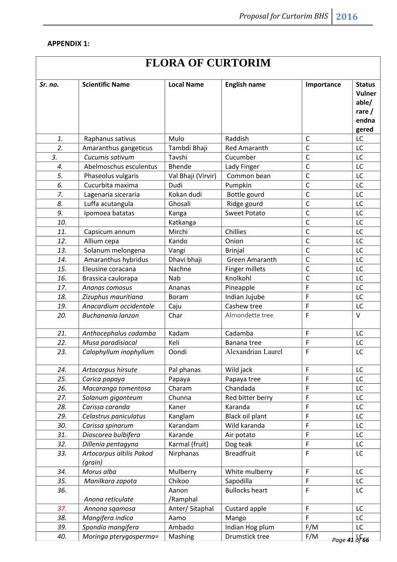
Proposal for Curtorim BHS 2016
Page 41 of 66
APPENDIX 1:
FLORA OF CURTORIM
Sr. no. Scientific Name Local Name English name Importance Status Vulnerable/ rare / endnagered
1. Raphanus sativus Mulo Raddish C LC
2. Amaranthus gangeticus Tambdi Bhaji Red Amaranth C LC
3. Cucumis sativum Tavshi Cucumber C LC
4. Abelmoschus esculentus Bhende Lady Finger C LC
5. Phaseolus vulgaris Val Bhaji (Virvir) Common bean C LC
6. Cucurbita maxima Dudi Pumpkin C LC
7. Lagenaria siceraria Kokan dudi Bottle gourd C LC
8. Luffa acutangula Ghosali Ridge gourd C LC
9. Ipomoea batatas Kanga Sweet Potato C LC
10. Katkanga C LC
11. Capsicum annum Mirchi Chillies C LC
12. Allium cepa Kando Onion C LC
13. Solanum melongena Vangi Brinjal C LC
14. Amaranthus hybridus Dhavi bhaji Green Amaranth C LC
15. Eleusine coracana Nachne Finger millets C LC
16. Brassica caulorapa Nab Knolkohl C LC
17. Ananas comosus Ananas Pineapple F LC
18. Zizuphus mauritiana Boram Indian Jujube F LC
19. Anacardium occidentale Caju Cashew tree F LC
20. Buchanania lanzan Char Almondette tree
F V
21. Anthocephalus cadamba Kadam Cadamba F LC
22. Musa paradisiacal Keli Banana tree F LC
23. Calophyllum inophyllum Oondi Alexandrian Laurel
F LC
24. Artocarpus hirsute Pal phanas Wild jack F LC
25. Carica papaya Papaya Papaya tree F LC
26. Macaranga tomentosa Charam Chandada F LC
27. Solanum giganteum Chunna Red bitter berry F LC
28. Carissa caranda Kaner Karanda F LC
29. Celastrus paniculatus Kanglam Black oil plant F LC
30. Carissa spinarum Karandam Wild karanda F LC
31. Dioscorea bulbifera Karande Air potato F LC
32. Dillenia pentagyna Karmal (fruit) Dog teak F LC
33. Artocarpus altilis Pakod (grain)
Nirphanas Breadfruit F LC
34. Morus alba Mulberry White mulberry F LC
35. Manilkara zapota Chikoo Sapodilla F LC
36. Anona reticulate
Aanon /Ramphal
Bullocks heart F LC
37. Annona sqamosa Anter/ Sitaphal Custard apple F LC
38. Mangifera indica Aamo Mango F LC
39. Spondia mangifera Ambado Indian Hog plum F/M LC
40. Moringa pterygosperma= Mashing Drumstick tree F/M LC

Proposal for Curtorim BHS 2016
Page 42 of 66
M. Oleifera
41. Citrus grandis Torand/ Toring Grape fruit F/M LC
42. Artocarpus lakoocha Otomb Monkey jack F/T LC
43. Artocarpus heterophyllus Phanas Jackfruit tree F/T LC
44. Bahuhinia racemosa Apto Bidi leaf tree M LC
45. Cassia fistula Bayo Indian Labearthern potum tree
M LC
46. Garcinia indica Bhirand Kokum M LC
47. Macaranga peltata syn. Tomentosa
Chandodo M rare
48. Datura stramonium Datura Jimson weed M LC
49. Vitex altissima Bavalgi Peacock chaste tree M rare
50. Pongamia pinnata Karanji Indian beech tree M LC
51. Wrightia tinctoria Kalakundo Pala indigo plant M rare
52. Hollarhena antidysentric Kudo Tellycherry M LC
53. Cinamomum zeylanicum Lavang True cinnamon tree M rare
54. Stereospermum personatum
Padval Trumpet tree M rare
55. Ficus religiosa Papal Peepal/ Religious Fig M LC
56. Thespecia lampa Ran Bhendi Common mallow M LC
57. Alstonia scholarias Saton Devil tree M V
58. Calycopteris floribunda Huski/Ekshi Paper flower climber M rare
59. Citrus medica Mavling Citron M EN
60. Azadirachta indica Kodolimb Neem M LC
61. Ixora coccinea Pitcoli Jungle geranium M LC
62. Calotropis gigantean Rui Milkweed M LC
63. Ficus racemosa (syn. Ficus glomerata)
Rumad/ Audumbar
Cluster fig tree M LC
64. Cassia tora Taykhillo Sickle senna M rare
65. Colocasia esculanta Terem/ aaloom Green Taro M LC
66. Leucus aspera Tumbo Common leucas M LC
67. Thuza occidentalis Tree of life Arborvitae M LC
68. Aloe vera katkuver Aloe M LC
69. Musa paradisiacal Keli Banana M LC
70. Azardirachta indica Neem Indian lilac M LC
71. Hydrocotyle asiatica Brahmi Indian pennywort M LC
72. Hibiscus rosasinensis China rose Shoeflower M LC
73. Areca catechu Supari Betal palm M LC
74. Adathoda vasica Adulsa Malabar nut M LC
75. Bauhinia variegate Apto Camels Foot tree M LC
76. Curcuma domestica Turmeric Indian saffron M LC
77. Eucalyptus globules Nilgiri Tasmanian blue gum M LC
78. Acalypha indica
Indian copper leaf
Indian nettle M LC
79. Allamanda cathartica
Glassfullan/ Golden trumpet
Allamanda M LC
80. Syzygium cuminii Jambul Java plum M LC
81. Datura innoxia Dhutro Thorn apple M LC
82. Nux vomica Kajara Poison nut M LC
83. Aegle marmelos Bael Holy fruit tree M V
84. Rauwolfia serpentine Sarpagandha Indian snakeroot M EN
85. Bryophyllum pinnatum Panfuti Sprout leaf plant M LC
86. Catharanthus roseus Sadapushpa Periwinkle M LC
87. Roson M Rare

Proposal for Curtorim BHS 2016
Page 43 of 66
88. Abutilon indicum Tupkadi Indian mallow M LC
89. Achyranthes aspera Kantmogra Prickly chaff flower M LC
90. Basella alba Valchi bhagi Indian spinach M LC
91. Curcuma domestica Halad Turmeric M LC
92. Gloriosa superb Vagam bochke Tiger claw M NT
93. Hemidesmus indicus Anantomul Indian sarsaparilla M EN
94. Mimosa pudica Lajri Touch me not M LC
95. Ocimum sanctum Tulsi Holy basil M LC
96. Phyllantheo emslica/ Embilica officinals Annalho / Awala
Indian gooseberry M LC
97. Dillenia pentagyna Karmal Dog teak M/F NT
98. Tagetes erecta
Garden marigold
Marigold M LC
99. Terminalia bellerica Goting Baheda M/T NE
100. Bridelia retusa Katekawach Spinous kino tree M/T NE
101. Careya arborea Kumbiyo Wild guava M/T NE
102. Saraca indica Asoka Mast tree/ False Ashoka O NE
103. Adenanthera pavonia Gunj Red sandalwood O NE
104. Delonix regia Gulmohar Flame tree O LC
105. Rhizophora mucoronata Kamdeli Asiatic mangrove O LC
106. Erythrina indica Pongaro Indian Coral Tree O
107. Sapindus emarginalis Rinte Soapnut tree O NE
108. Crossandra undulaefolia Aaboli Firecracker flower O NE
109. Leea sambucina Dino or Gino Bandicoot berry O NE
110. Sechium edule Gadeli Falgam Chow chow O NE
111. Cynodon dactylon Haryalli/ Durva Bermuda grass O NE
112. Jasminum sambac Mogrim Arabian jasmine O LC
113. Pterocarpus marsupium Assan Indian kino T V
114. Caryota urena Billemad Fishtail palm T LC
115. Semicarpus anacardium Bibba Marking nut T NE
116. Syzygium caryophyllatum Bhedas Wild black plum T EN
117. Thepecia populnea Bhendi Portia tree T NE
118. Grewia tiliaefilia Dhamen Dhaman T
119. Machilus marcamtha Elamb T NE
120. Adina cordifolia Hedu Kadam T NE
121. Terminal chebula Hirda Black myrobalan T
122. Albizzia odoratissima Kala siris Black siris T NE
123. Acacia catechu Khair Black catechu T NE
124. Ficus asperrma syn. Exasperate
Kharvat Sandpaper tree/ Brahmas Banyan
T NT
125. Terminalia paniculata Kindal Flowering Murdah T NE
126. Terminalia tomentosa / crenulata
Matti Black murdah, Indian Laurel
T NE
127. Lagerstroemia lanceolata Nano Ben teak T NE
128. Machilus/ Persea macarantha
Olamb Large flowered bay tree T NE
129. Bombax malabaricum Sawar Red Silk Cotton T NE
130. Gmelina arborea Shivan Beachwood T LC
131. Ficus bengalensis Vad Banyan T NE
132. Messnea ferrea Nagchampa Cobra saffron/ Indian rose chestnut
T
133. Xylia xylocarpa Zamba Burma ironwood T
134. Cocos nucifera Naal Coconut palm T/F LC

Proposal for Curtorim BHS 2016
Page 44 of 66
135. Lannea grandis Moi Indian ash tree T/M NE
136. Mimusops elengi Onwal Spanish cherry T/M NE
137. Tectona grandis Saguvan Teak T/M NE
138. Terminalia arjuna Savai matti Arjun T/M NE
139. Lagerstoemia speciosa Taman Pride of India T/M NE
140. Xanthoxylum rhetsa Triphal/ Chiphal Indian prickly ash T/M/F NE
141. Tamarindus indica Chinch Tamarind T/M/F LC
142. Azolla piñata Water fern Mosquito fern W LC
143. Hydrilla verticellata Indian star grass Florida elodea W LC
144. Blyxa echinosperma NA NA W NE
145. Rotala indica NA Indian toothcup W LC
146. Utricularia aurea Xello Golden bladderwort W NT
147. Utricularia exoleta NA Floating bladderwort W LC
148. Najas indica NA
Najas grass, guppy grass, water nymph
W LC
149. Nympheae nauchali NilKamal Blue Water lily W LC
150. Nymphaea rubra Lal kamal
Pink lotus/ Red water lily
W LC
151. Nymphaea indica NA Hairy water lily W LC
152. Fimbristylis junciformis/ miliacea Fringerush
W LC
153. Cyperus sp. Mandre behl Mat weed W LC
154. Scirpus sp. Mandre behl Mat weed W LC
155. Typha typha Mandre behl Mat weed W LC
156. Eriocaulon setaceum NA NA W LC
157. Marsilea sp. NA
Water clover/ pepperwort
W LC
158. Monochoria vaginalis NA Oval leaf pondweed W LC
159. Limnophila heterophila NA NA W NE
160. Limnophila repens NA NA W NE
161. Oryza sativa Tandul Rice W LC
162. Oryza rufipogon Red rice Brown beard rice W LC
163. Polygonum glabrum NA
Common marsh buckwheat
W LC

Proposal for Curtorim BHS 2016
Page 45 of 66
APPENDIX -2: Faunal Diversity Of Curtorim
The data given below is a compilation of research done in curtorim by individual
researchers and Birders club of Chowgule college.
LIST OF BIRDS FOUND IN CURTORIM, SALCETE.
Sr. No
Name Scientific name Ecosystem Status
1 Little Grebe Tachybaptus ruficollis W R
2 Little cormorant Phalacrocorax niger W R
3 Indian shag Phalacrocorax fuscicollis W R
4 Darter Anhinga malanogaster W R
5 Large cormorant Phalacrocorax carbo W M
6 Little egret Egretta garzetta W/P R
7 Grey Heron Ardea cinerea W R
8 Great crested grebe Podiceps cristatus W M
9 Large egret Casmerodius albus W/P R
10 Purple Heron Ardea purpurea W/P R
11 Little Green Heron Butorides striatus W/P R
12 Cattle egret Bubulcus ibis W/P R
13 Indian pond heron Ardeola grayii W/P R
14 Black crowned night heron Nycticorax nyticorax W/P R
15 Little bittern Ixobrynchus minutus W/P R
16 Tiger bittern/Malayan
night heron
Gorsachius melanolophus W/P R
17 Chestnut bittern Ixobrynchus cinnamomeus W/P M
18 Yellow bittern Ixobrynchus sinensis W/P M
19 Black bittern Dupetor flavicollis W/P M
20 Painted stork Mycteria leucocephala P M
21 Asian Openbill stork Anastomus oscitans P M
22 European White stork Ciconia ciconia P M
23 Woolly necked
stork/White necked stork
Ciconia episcopus P M
24 Lesser adjutant stork Leptoptilos javanicus P M
25 Oriental White ibis Threskiornis
melanocephalus
P M

Proposal for Curtorim BHS 2016
Page 46 of 66
26 Black ibis Pseudibis papillosa P M
27 Glossy ibis Plegadis falcinellus P M
28 Eurasian Spoonbill Platalea leucorodia P M
29 Ruddy shelduck/Brahminy
shelduck/Brahminy duck
Tadorna ferruginea W M
30 Nakta/Comb duck Sarkidiornis melanotos W M
31 Bar-headed goose Anser indicus W V
32 Lesser whistling teal/Tree
duck
Dendrocygna javanica W M
33 Cotton teal Nettapus
coromandelianus
W M
34 Northern Pintail Anas acuta W M
35 Common teal Anas crecca W M
36 Spotbill duck/Grey duck Anas poecilorhyncha W M
37 Mallard Anas platyrhynchos W V
38 Gadwall Anas strepera W M
39 Eurasian Wigeon Anas Penelope W M
40 Northern Shoveler Anas clypeata W M
41 Garganey/Grey winged
teal
Anas querquedula W M
42 Common Pochard Aythya ferina W M
43 White eyed
Pochard/Ferruginous
Pochard
Aythya nyroca W V
44 Black shouldered kite Elanus caeruleus W/F/S R
45 Black Baza Aviceda leuphotes F/S V
46 Blyths Baza Avecida jerdoni F/S M
47 Oriental Honey-buzzard Pernis ptilorhyncus F/S R
48 Black kite Milvus migrans W/P/S/F R
49 Brahminy kite Haliastur Indus W/P/S/F R
50 Shikra Accipiter badius W/P/S/F R
51 Crested Goshawk Accipiter trivirgatus S/F R
52 Besra Sparrowhawk Accipiter virgatus S/F R
53 Eurasian Sparrowhawk Accipiter nisus S/F M
54 Short-toed Snake Eagle Circaetus gallicus S/F R
55 Crested Serpent Eagle Spilornis cheela S/F R
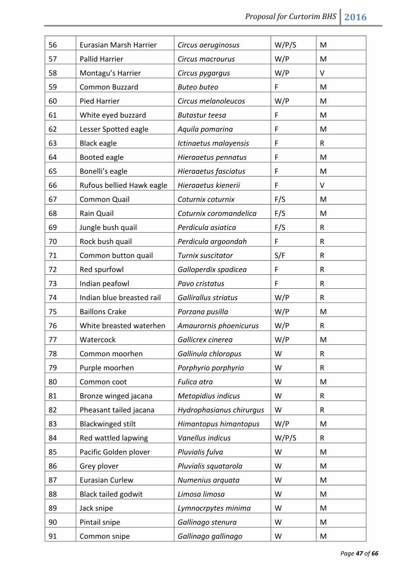
Proposal for Curtorim BHS 2016
Page 47 of 66
56 Eurasian Marsh Harrier Circus aeruginosus W/P/S M
57 Pallid Harrier Circus macrourus W/P M
58 Montagu’s Harrier Circus pygargus W/P V
59 Common Buzzard Buteo buteo F M
60 Pied Harrier Circus melanoleucos W/P M
61 White eyed buzzard Butastur teesa F M
62 Lesser Spotted eagle Aquila pomarina F M
63 Black eagle Ictinaetus malayensis F R
64 Booted eagle Hieraaetus pennatus F M
65 Bonelli’s eagle Hieraaetus fasciatus F M
66 Rufous bellied Hawk eagle Hieraaetus kienerii F V
67 Common Quail Coturnix coturnix F/S M
68 Rain Quail Coturnix coromandelica F/S M
69 Jungle bush quail Perdicula asiatica F/S R
70 Rock bush quail Perdicula argoondah F R
71 Common button quail Turnix suscitator S/F R
72 Red spurfowl Galloperdix spadicea F R
73 Indian peafowl Pavo cristatus F R
74 Indian blue breasted rail Gallirallus striatus W/P R
75 Baillons Crake Porzana pusilla W/P M
76 White breasted waterhen Amaurornis phoenicurus W/P R
77 Watercock Gallicrex cinerea W/P M
78 Common moorhen Gallinula chloropus W R
79 Purple moorhen Porphyrio porphyrio W R
80 Common coot Fulica atra W M
81 Bronze winged jacana Metopidius indicus W R
82 Pheasant tailed jacana Hydrophasianus chirurgus W R
83 Blackwinged stilt Himantopus himantopus W/P M
84 Red wattled lapwing Vanellus indicus W/P/S R
85 Pacific Golden plover Pluvialis fulva W M
86 Grey plover Pluvialis squatarola W M
87 Eurasian Curlew Numenius arquata W M
88 Black tailed godwit Limosa limosa W M
89 Jack snipe Lymnocrpytes minima W M
90 Pintail snipe Gallinago stenura W M
91 Common snipe Gallinago gallinago W M

Proposal for Curtorim BHS 2016
Page 48 of 66
92 Spotted redshank Tringa erythropus W M
93 Common redshank Tringa tetanus W M
94 Common greenshank Tringa nebularia W M
95 Marsh sandpiper Tringa stagnatilis W M
96 Spotted sandpiper Tringa glareola W/P M
97 Common sandpiper Tringa hypoleucos W M
98 Little stint Calidris minuta W M
99 Black-winged stilt Himantopus himantopus W M
100 Small Pratincole Glareola lacteal W M
101 Brown headed gull Larus brunnicephalus W M
102 Black headed gull Larus ridibundus W M
103 Slender billed gull Larus genei W M
104 Gull billed tern Gelochelidon nilotica W M
105 River tern Sterna aurantia W M
106 Little tern Sterna albifrons W M
107 Black bellied tern Sterna acuticauda W M
108 White cheeked tern Sterna repressa W M
109 Whiskered tern Chlidonias hybridus W M
110 Blue rock Pigeon Columba livia F/H R
111 Nilgiri Wood pigeon Columba elphinstonii F R
112 Pompadour green pigeon Treron pompadora F M
113 Oriental Turtle dove Streptopelia orientalis F R
114 Spotted dove Streptopelia chinensis F/H R
115 Eurasian collared dove Streptopulia decaocto F/H R
116 Emerald dove Chalcophaps indica F R
117 Red collared dove Streptopelia
tranquebarica
F/H R
118 Lorikeet Loriculus vernalis F/H M
119 Rose ringed parakeet Psittacula krameri F R
120 Plum headed parakeet Psittacula cyanocephala F R
121 Pied Crested cuckoo Clamator jacobinus F M
122 Brainfever bird Hierococcyx varius F M
123 Indian Plaintive cuckoo Cacomanti s passerines F M
124 Lesser cuckoo Cuculus poliocephalus F M
125 Asian Koel Eudynamys scolopacea F/H R
126 Small Green billed Phaenicophaeus F M

Proposal for Curtorim BHS 2016
Page 49 of 66
Malkoha viridirostris
127 Crow pheasant Centropus sinensis S/H R
128 Barn owl Tyto alba F/H R
129 Indian great horned owl Bubo bubo F R
130 Brown wood Owl Strix leptogrammica F M
131 Jungle owlet Glaucidium radiatum F R
132 Spotted owlet Athene brama F/H R
133 Brown hawk owlet Ninox scutulata F M
134 Franklins nightjar Caprimulgus affinis F/H R
135 Longtailed nightjar Caprimulgus macrurus F R
136 Common Indian nightjar Caprimulgus asiaticus F R
137 House swift Apus affinis H R
138 Asian Palm swift Cypsiurus balasiensis F/H R
139 Lesser Pied kingfisher Ceryle rudis W V
140 Small blue kingfisher Alcedo atthis W R
141 White breasted kingfisher Halcyon smyrnensis W/S R
142 Storkbilled kingfisher Halcyon capensis W R
143 Blue tailed bee eater Merops philippinus W/S R
144 Small bee eater Merops orientalis W/S R
145 Chestnut headed bee
eater
Merops leschenaultia W/S R
146 European roller Coracias garrulous F/S/H R
147 Indian roller Coracias benghalensis F/S/H R
148 Common Hoopoe Upupa epops S M
149 Malabar grey hornbill Ocyceros griseus F R
150 Malabar pied hornbill Buceros bicornis F M
151 Brown headed barbet Megalaima zeylanica F R
152 Coppersmith barbet Megalaima haemacephala F R
153 Rufous woodpecker Celeus brachyurus F R
154 Greater golden backed
woodpecker
Chrysocolaptes lucidus F R
155 Common golden-backed
woodpecker
Dinopium javanense F R
156 Lesser golden backed
woodpecker
Dinopium benghalense F R
157 Black shouldered Chrysocolaptes festivus F R

Proposal for Curtorim BHS 2016
Page 50 of 66
woodpecker
158 Indian pitta Pitta brachyuran F M
159 Singing bush lark Mirafra cantillans P/S M
160 Malabar crested lark Galerida malabarica P/S M
161 Dusky Craig martin Hirundo concolor S/F M
162 Common swallow Hirundo rustica H M
163 Wire tailed swallow Hirundo smithii H M
164 Red rumped swallow Hirundo daurica H M
165 Forest wagtail Dendronanthus indicus W/P/F/H/S M
166 Yellow wagtail Motacilla flava W/P/F/H/S M
167 White wagtail Motacilla alba W/P/S/F/H M
168 Large pied wagtail Motacilla
maderaspatensis
W/P/F/S/H M
169 Paddyfield pipit Anthus rufulus S/F M
170 Tawny pipit Anthus campestris S/F M
171 Large cuckoo shrike Coracina macei F M
172 Black headed cuckoo
shrike
Coracina melanoptera F M
173 Small minivet Pericrocotus
cinnamomeus
F R
174 Scarlet minivet Pericrocotus flammeus F R
175 Pied flycatcher shrike Hemipus picatus F M
176 Common wood shrike Tephrodornis
pondicerianus
F M
177 Greyheaded bulbul Pycnonotus priocephalus F M
178 Red whiskered bulbul Pycnonotus jacosus F/H/S R
179 Red vented bulbul Pycnonotus cafer F/H/S R
180 White browed bulbul Pycnonotus luteolus F R
181 Common iora Aegithina tiphia F R
182 Jerdons Chloropsis Chloropsis cochinchinensis F R
183 Golden fronted chloropsis Chloropsis chloropsis F R
184 Brown shrike Lanius cristatus F R
185 Bay backed shrike Lanius vittatus F R
186 Rufous backed Shrike Lanius schach F R
187 Eurasian Golden oriole Oriolus oriolus F R
188 Black headed oriole Oriolus xanthornus F R

Proposal for Curtorim BHS 2016
Page 51 of 66
189 Black napped oriole Oriolus chinensis F R
190 Black drongo Dicrurus macrocercus F/H R
191 Ashy drongo Dicrurus leucophaeus F/H R
192 White bellied drongo Dicrurus caerulescens F/H R
193 Bronzed drongo Dicrurus aeneus F R
194 Greater racket tailed
drongo
Dicrurus paradiseus F R
195 Indian tree pie Dendrocitta leucogaster F/H R
196 House crow Corvus splendens P/S/H R
197 Jungle crow Corvus macrorhynchos F R
198 Rosy starling Sturnus roseus F M
199 Ashy Swallow shrike Artamus fuscus F R
200 Baya weaver Ploceus philippinus P R
201 Common myna Acriditheres tristis P/S R
202 Jungle myna Acridotheres fuscus P/S/H R
203 House sparrow Passer domesticus P/H R
204 Black redstart Phoenicurcus ochruros P M
205 Malabar whistling thrush Myophonus horsfieldii P M
206 Orange headed thrush Zoothera citrine cyanotus P/F/S M
207 Spotted babbler Pellorneum ruficeps P/F R
208 Indian Scimitar babbler Pomatorhinus horsfieldii F M
209 Yellow-eyed babbler Chrysomma sinense F M
210 Rufous babbler Dumetia hyperythra F R
211 Jungle babbler Turdoides striatus F/P/S R
212 Common babbler Turdoides caudatus F R
213 Large grey babbler Turdoides malcolmi F M
214 Little spiderhunter Arachnothera longirostra F M
215 Pied bush chat Saxicola caprata F/P M
216 White headed babbler Turdoides affinis F M
217 Desert wheatear Oenanthe deserti F/P M
218 Indian robin Saxicoloides fulicata F/P/H/S R
219 Oriental magpie robin Copsychus saularis F/P/H R
220 White rumped shama Copsychus malabaricus F M
221 Ashy prinia Prinia socialis F R
222 Plain prinia Prinia inornata F R
223 Paddyfield warbler Acrocephalus Agricola F R

Proposal for Curtorim BHS 2016
Page 52 of 66
224 Purple sunbird Nectarinia asiatica R
225 Blyths reed warbler Acrocephalus dumetorum R
226 Black headed munia Lonchura malacca P R
227 Indian great reed warbler Acrocephalus stentoreus F/P R
228 Thick billed warbler Acrocephalus aedon F/P R
229 Booted warbler Hippolais caligata P R
230 Ashy prinia Prinia socialis F R
231 Common tailorbird Orthotomus sutorius F R
232 Olivaceous leaf warbler Phlloscopus griseolus F R
233 Large billed leaf warbler Phylloscopus magnirostris F R
234 Lesser white throat Sylvia curruca P R
235 Asian paradise flycatcher Terpsiphone paradisi F R
236 Tickells blue flycatcher Cyornis tickelliae F R
237 White throated fantail
flycatcher
Rhipidura albicollis F R
238 White browed fantail
flycatcher
Rhipidura aureola F R
239 Great tit Parus major F R
240 Oriental White eye Zosterops palpebrosus F R
241 Black lored yellow tit Parus xanthogenys F R
242 Tickells flowerpecker Dicaeum erythrorynchos F R
243 Lotens sunbird Nectarinia lotenia F R
244 Crimson sunbird Aethopyga siparaja F R
245 Small Sunbird Nectarinia minima F R
246 Purple rumped sunbird Nectarinia zeylonica F R
247 Plain flower pecker Dicaeum concolor F/H R
248 White rumped munia Lonchura striata P R
249 Franklins prinia Prinia hodgsonii P/S/F R
250 Plain prinia Prinia inornata P/S/F R
Habitat type: W= wetland, P= paddyfields, S= Scrubland, F=forest, H= habitation.
Status: M=Migrant, R=resident, V=vagrant

Proposal for Curtorim BHS 2016
Page 53 of 66
MAMMALS found in Curtorim
Common Name Scientific name Local name
1. Bonnet macaque Macaca radiate Makod
2. Langur Presbytis enletlus Vandor
3. Mongoose Herpestes edwardii Mongus
4. Jackal Canis aureus Colo
5. Common Indian porcupine Hystrix indica Sallu
6. Small Indian civet cat Viverricula indica Katanoor
7. Toddy cat Paradoxurus hermaphrodites Rann mazor/babko
8. Common Otter Lutra lutra Uddh
9. Leopard Panthera pardus Bibtto vag
10. Fulvous fruit bat Rousettus leshenaulti Vagul
11. Indian flying fox Pteropus giganteus Pako
12. Indian field mouse Mus boodugo Undir
13. 5 stripped squirrel Funanbulus pennant Channi
14. Bandicoot Bandicit indica Kol undir
15. Hare Lepus nigricollis Soso
16. Cow Bos indicus. Ghai
17. Goat Capra hircus Bokdi
18. Buffalo Bubalus arnee mhosh
19. Dog Canis lupis Sunno
20. Cat
REPTILES/HERPATS
COMMON NAME SCIENTIFIC NAME VERNACULAR/LOCAL NAME
1. Common sand boa Eryx sps Malund
2. Indian spectacled cobra Naja naja Nag Sorop
3. Checkered keelback Xenochrophis piscator Levane
4. Variegated kukri Oligidon taeniolata
5. Common ratsnake Ptyas mucosus Devodd
6. Indian rock python Python molurus Aaro
7. Trinket snake Elaphe Helena Rocmandolli
8. Green whip snake Ahaetulla nasuta Chutti
9. Russells viper Daboia russelli Mamdod
10. Saw scaled viper Echis carinata Furso
11. Painted bronzeback Dendrelaphis pictus Nanato

Proposal for Curtorim BHS 2016
Page 54 of 66
12. Common krait Bungarus caeruleus
13. Indian monitor lizard Varanus sp. Saap
14. Garden lizard Calotes diversicolor Topyo
15. Little skink Mabuya sp.
AMPHIBIANS:
1. Martins bush frog Pseudophilautus sps.
2. East asian tree frog Hyla sps
3. Fungoid frog Hydrophylax sps.
4. Tiger frog Hoplobatrachus tigerinus(Rana Tigrina)
5. Common Indian toad Duttaphrynus melanostictus
6. Indian pond terrapin Melanochelys trijuga
***

Proposal for Curtorim BHS 2016
Page 55 of 66
APPENDIX -3: Comparative study of Geospatial database.

Proposal for Curtorim BHS 2016
Page 56 of 66

Proposal for Curtorim BHS 2016
Page 57 of 66

Proposal for Curtorim BHS 2016
Page 58 of 66
APPENDIX -4: VISION 2020 PLAN OF CURTORIM

Proposal for Curtorim BHS 2016
Page 59 of 66
REFERENCES AND RESOURCES:
1. Alvares, Claude (1988) – Fish Curry and Rice, Goa Foundation for Economic Forum, Other
India Book Stores, Goa.
2. Azavedo, Gary (2015)- Curtorim celebrates its feast of fields and food. https://
timesofindia.indiatimes.com/ city/goa/Curtorim
3. Da Costa, Semeao, et.al.(1956), Supplemento Commemorativo Do Terceiro aniversario da
fundacao de “Diario de Goa”, dedicado a fregusia de Curtorim- A way Forward, Herald Goa
4. Fernandes Gromico (2016). Agrobiodiversity in Curtorim-A way forward. Herald Goa
5. Sonak S, Kazi & Abhram ( 2005) khazans in troubled waters , TERI , TERI Press, New Delhi.
6. ________________.( 1992) The report of the Agricultural Land Development Panel, ALDP
(Agricultural Land Development Panel), Government of Goa, Goa
7. ______________ ( 1979) Gazetter of union territory Goa, Daman and Diu , Government of Goa,
Government Printing Press, Goa
8. Rubinoff Janet (2001). Pink Gold: transformation of Backwater Aquaculture on Goa’s Khazan
lands. Economic and Political weekly.
9. Sawant N N (2010) “Mangroves in Troubled Water – Mitigation and strategies “ paper
presented at the two day seminar on Biodiversity Conservation With Special Reference to
Indian Desert jointly organised by Indian Human Ecology Council & Department of Geography,
University of Rajasthan, Jaipur , 5th& 6th June, 2010.
10. Sawant N., Suryawanshi R., Ferro A. and Ugavekar, N. (2014), “Rural Return Emigration:
Patterns and Characteristics - A Study of Curtorim and Macazana Villages, Salcette, Goa”
in “Human Migration in South Asia: Prospects and Constraints” , (ed.) G.B. Book Publications,
New Delhi, Pp 305 – 319
11. Rubinoff Janet (2001): Gold, Transformation of Backwater Aquaculture on Goa’s Kahazan
Lands ,Economic and Political Weekly, March 31, 2001
12. Cardoso da Silva, M., Pereira, H., Sonak S. (2005) Combining Local Knowledge And Research
For The Sustainable Management Of Small Scale Coastal Ecosystems: The Khazans (Goa, India)
Comunicação ao II Congresso sobre Planeamento e Gestão das Zonas Costeiras

Proposal for Curtorim BHS 2016
Page 60 of 66
RESOURCES / EVIDENCES:
Wednesday, November 24, 2016
HOME
GOA
EDIT
BUSINESS
CAFE
SPORTS
REVIEW
OBITUARIES
ARCHIVES
ADVERTISE
CONTACT Home > Review > Voice Of Opinion > Agro biodiversity in Curtorim – A way forward
Agro biodiversity in Curtorim – A way forward By Gromiko Fernandes | 07 Feb, 2016, 07:48AM IST It is said that Goa lives in villages and for that matter, there are over 200 revenue villages in the State of Goa and Curtorim is one of the villages of Goa which is predominantly agricultural in nature. The area of Curtorim is approximately 1,735 .5 hectares and the area under agriculture works out to be nearly 65% with irrigated land occupying 386 hectares, un-irrigated land being 699 hectares and the waste land being 25 hectares. The agricultural land under private holding is about 53%, with Comunidade being 45% and 2% being institutional land. Curtorim is a very picturesque and serene village with hills and hillocks with greenish blue hues with waving green fields, an array of coconut palm trees swaying along with the breeze, the various valleys, springs and the water bodies give it a unique ambience. Curtorim has 6 major lakes also called as ponds with equal number of kher lands (mid lying regions) and the same number of low lying Khazan lands, with River Zuari running along the border along the northern side which gives the village a tranquil sight. The hills, hillocks, valleys and the various water bodies are a home to a large variety of flora and fauna including wild animals like leopards and migratory birds. Our experts have documented about 250 species of birds in the village. Physiographic factors

Proposal for Curtorim BHS 2016
Page 61 of 66
The hills and hillocks which are on the southern side, form a source of water for the water bodies like the ponds and the lakes and it is this stored water that is used for irrigation at the Rabi crops (popularly known as Kher or Vaingon) For agricultural purposes, the land has been classified under four categories: Highlands The highlands consists mainly the slopes of the hills where water drains easily and the said land is used to grow vegetables such as lady fingers, brinjals, bottle gourds , snake gourds, bitter gours, pumpkins, cluster beans, onions etc. The soil is mostly lateritic. Hinterlands This land is partly lateritic with a certain percentage of alluvium.. This land is converted into terraced garden (locally called as Mord land) whch is mainly used to grow paddy by utilising the rain water.(Khariff Crop) Nowadays the terraced garden land is much sought after, for conversion to settlement area. Midland (Kher land) It is mainly used to grow 2 crops a year, alternating with each other. The Rabi crop and the Khariff crop. Nearly 75% of paddy grown in the village belongs to this Category. Low land or Khazan land There are six big khazans in Curtorim which are mainly used for pisciculture. Earlier the said land was used alternatively for pisciculture as well as agriculture, but nowadays owing to the high costs involved in the cultivation of the paddy hence becoming non viable economically, the land is mainly used for pisciculture, including prawn farming which has become a very lucrative business nowadays. The land is saline with a high pH, this land was utilised to grow paddy which is resistant to high salinity. Varieties of paddy such as Babri, Asgo etc were used. Since the height of the corn becomes more then a metre, it becomes highly inconvenient to harvest it by using harvesters. Recently an innovative method has been found by an agriculturist Shri Rui Menezes, from Curtorim wherein the Khazan land at Novar khazan, Corjem has been drained of all water from the said land and after levelling the said land, the whole area of about 2 lakh square metres has been manually transplanted with Jaya variety of Paddy, and lo and behold, even without weeding and applying fertilizers , he could get a bumper crop. The main idea is, he did not allow the salty water to enter on the land by controlling the water from the sluice gate without destroying the fishes in the trenches. He wishes to replicate this by using the transplanters for transplanting mechanically. If the same or similar methods could be used in other Khazan lands of Goa, the production of paddy could be much increased in our state. Of course, much effort need to be done by the Government not only by motivating the farmers but by supporting the farmers financially, by providing subsidies and other incentives at regular intervals. Curtorim, not only had been said, a granary of Salcete, but a leading producer of paddy in the yester years and I hope and pray that Curtorim continues to show the way to other villages so that one day Goa becomes sustainable in the production of food grains. (The author is Ex Headmaster & Member – Biodiversity Management Committee, Curtorim
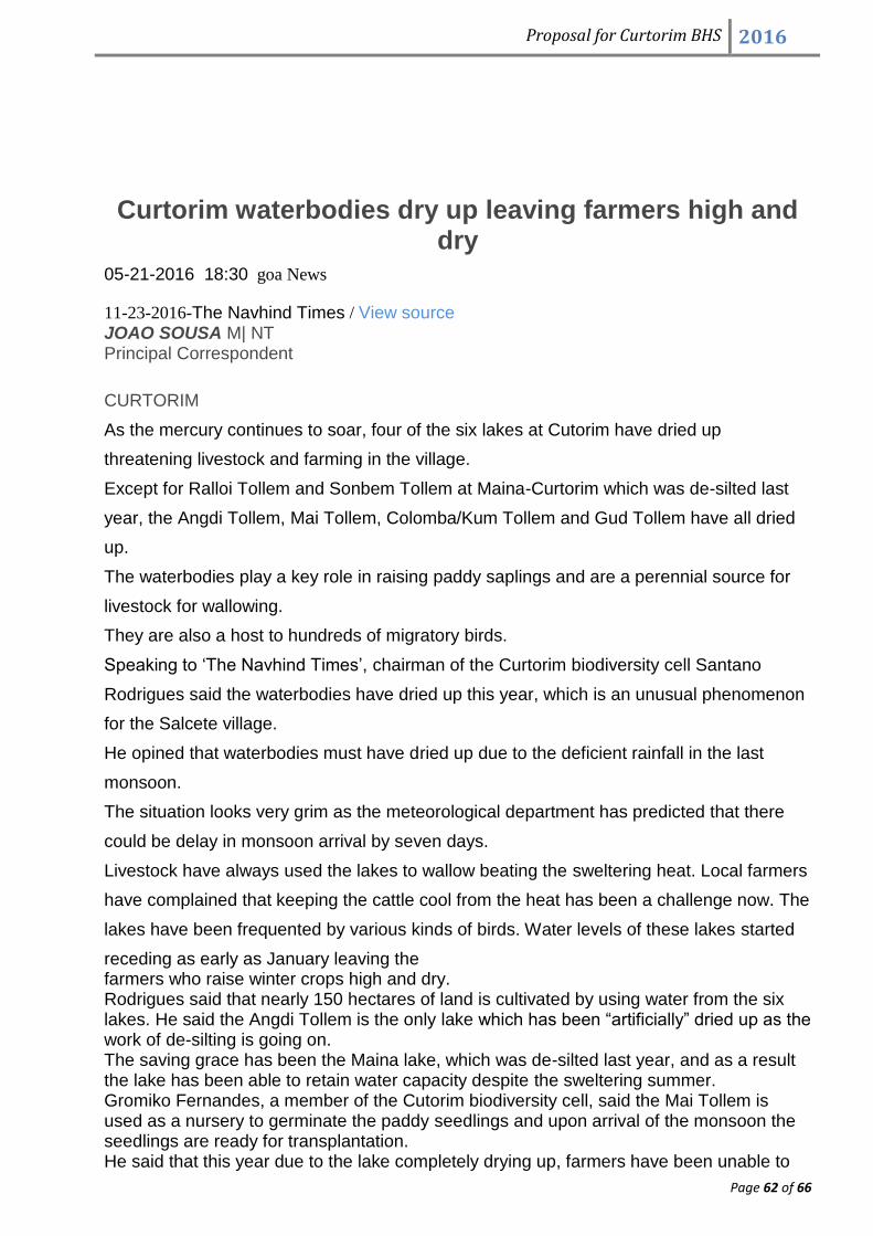
Proposal for Curtorim BHS 2016
Page 62 of 66
Curtorim waterbodies dry up leaving farmers high and dry
05-21-2016 18:30 goa News
11-23-2016-The Navhind Times / View source
JOAO SOUSA M| NT Principal Correspondent
CURTORIM
As the mercury continues to soar, four of the six lakes at Cutorim have dried up
threatening livestock and farming in the village.
Except for Ralloi Tollem and Sonbem Tollem at Maina-Curtorim which was de-silted last
year, the Angdi Tollem, Mai Tollem, Colomba/Kum Tollem and Gud Tollem have all dried
up.
The waterbodies play a key role in raising paddy saplings and are a perennial source for
livestock for wallowing.
They are also a host to hundreds of migratory birds.
Speaking to ‘The Navhind Times’, chairman of the Curtorim biodiversity cell Santano
Rodrigues said the waterbodies have dried up this year, which is an unusual phenomenon
for the Salcete village.
He opined that waterbodies must have dried up due to the deficient rainfall in the last
monsoon.
The situation looks very grim as the meteorological department has predicted that there
could be delay in monsoon arrival by seven days.
Livestock have always used the lakes to wallow beating the sweltering heat. Local farmers
have complained that keeping the cattle cool from the heat has been a challenge now. The
lakes have been frequented by various kinds of birds. Water levels of these lakes started
receding as early as January leaving the farmers who raise winter crops high and dry. Rodrigues said that nearly 150 hectares of land is cultivated by using water from the six lakes. He said the Angdi Tollem is the only lake which has been “artificially” dried up as the work of de-silting is going on. The saving grace has been the Maina lake, which was de-silted last year, and as a result the lake has been able to retain water capacity despite the sweltering summer. Gromiko Fernandes, a member of the Cutorim biodiversity cell, said the Mai Tollem is used as a nursery to germinate the paddy seedlings and upon arrival of the monsoon the seedlings are ready for transplantation. He said that this year due to the lake completely drying up, farmers have been unable to

Proposal for Curtorim BHS 2016
Page 63 of 66
make preparations for raising saplings, adding that there has been no sufficient water to irrigate winter crops.
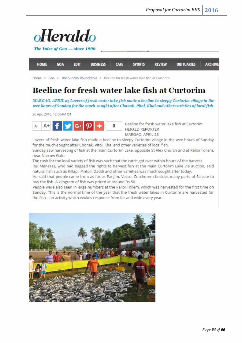
Proposal for Curtorim BHS 2016
Page 64 of 66

Proposal for Curtorim BHS 2016
Page 65 of 66

Proposal for Curtorim BHS 2016
Page 66 of 66