proposed balama graphite mine in the cabo … balama graphite mine eng...proposed balama graphite...
TRANSCRIPT

Proposed Balama Graphite Mine in the Cabo Delgado Province, Mozambique
Coastal & Environmental Services Draft Environmental Social & Health Impact Assessment 48
will accommodate approximately 250 people, mainly workers, and will not include families or children. The local production of food will be integrated to supply the local food requirement with the possibility of export. The village will be structured to include the following:
A residential area consisting of clusters of living pods;
A recreational building, gym and barbeque courtyard (serving as an outdoor cinema as well);
A mess hall, senior staff accommodation and visitor accommodation buildings;
An administration building (office space, storage space);
A medical clinic with a small pharmacy;
A housekeeping area (e.g. laundry, linen stores, cleaning stores and parking house);
A village hub (e.g. service area, barber shop, hairdresser, stationary store, small grocer, clothing store and guesthouse);
A soccer field and basketball court adjacent to the hub;
Bicycle paths running parallel to the main road; and The construction of the following infrastructure will be required:
Roads and paths for access (bitumen paved/spray sealed);
Substation and generating plant;
Electricity supply;
Sewerage system;
Water supply will be via a branch line from the main pipeline from the Chipembe reservoir to the raw water distribution system;
Small water treatment plant; Locally sourced materials and labour will be used where possible.

Proposed Balama Graphite Mine in the Cabo Delgado Province, Mozambique
Coastal & Environmental Services Draft Environmental Social & Health Impact Assessment 49
Figure 3.3: Proposed village Masterplan (Source: Equinox, 2013)

Proposed Balama Graphite Mine in the Cabo Delgado Province, Mozambique
Coastal & Environmental Services Draft Environmental Social & Health Impact Assessment 50
3.6.2 Sewage System
The construction and operational phases‘ workforce of approximately 250 individuals (at peak period) will generate sewage and wash water that will need to be managed. Table 3.1 shows the summary of the anticipated general sewage and domestic wash water effluent streams associated with the construction and operational phases of the Syrah Balama Graphite project. Table 3.1: Anticipated Wastewater Streams Associated with the Construction and Operational Phases of the Syrah Balama Graphite Project
Phase Waste Type Estimated Quantity Management & Disposal
Co
ns
tru
cti
on
/
Op
era
tio
nal
Sewage / domestic wash water
~5m3/day (conservative scenario) and ~40m3/day (worst case scenario)
A packaged sewage treatment plant will be utilised for the treatment of sewage and domestic wash water and the treated effluent discharged into the environment during the construction phase. During the operational phase, the treated effluent would be channelled to the process water dam for recycling.
Lined Ventilated Improved Pit (VIP) latrines would need to be considered for field operations, particularly near the mine pit.
Packaged sewage plant specification Based on the calculated estimate of generated sewage and domestic wash water during the construction and operational phases of the project, a packaged sewage treatment plant with the capacity of treating ~40m3 of domestic effluent per day is required for installation.
3.6.3 Landfill Site
The design and construction of the Syrah Balama Graphite general waste landfill site should be in accordance with international best practice as described in EPA (2000), details of which have been provided in the Minimum Requirements for Waste Disposal by Landfill, 3rd ed. (DWAF, 2005). Mozambique has no specific requirement for the siting, design and construction of a general waste landfill site. According to Article 7(I) of Decree No. 13/2006, of 15 June (Regulations on Waste Management) ―All public or private entities carrying out activities related to solid waste management should prepare their waste management plan, prior to entering into business, which should contain at least, information required in Annex I and/or Annex II, in case it is, respectively, a landfill or another waste management operation”. The size of the landfill site depends on the daily rate of waste deposition. To take time and growth into account, disposal sites are classified using the ‗Maximum Rate of Deposition‘ or ‗MRD‘. This is simply the projected maximum average annual rate of waste deposition, expressed in tonnes3 per day, during the expected life of the site. To calculate the MRD:
3 1 ton = 1.016tonne. NEMA WA refers to “Ton” while the DWAF 2005b refers to Tonnes. For the purpose of this report 1tonne has been
equated to 1ton.

Proposed Balama Graphite Mine in the Cabo Delgado Province, Mozambique
Coastal & Environmental Services Draft Environmental Social & Health Impact Assessment 51
Establish the ‗Initial Rate of Deposition‘ or ‗IRD‘. This is the measurement of the existing waste stream in tonnes per day.
Then, escalate the IRD at a rate that is usually based on the projected population growth for the estimated or design life of the disposal site.
The maximum average daily rate of deposition, which usually occurs in the final years of the operation, then represents the MRD.
The calculated IRD for the Syrah project is based on the following assumptions: Construction solid waste = 100kg (0.1 tonnes) / day Operational solid waste = 100kg (0.1 tonnes) / day Using the formula MRD = (IRD) (1 + d)t Where d = the expected (constant) annual increase in the rate of deposition and would usually be based on the anticipated population growth rate. In this case the anticipated population growth will be 1% since the number of employees will not increase throughout the life of the mine. t = the period or planned life of the site expressed in years. 51 years (including the 8 - 12 months construction phase). The MRD = (0.1) (1 + 1%)51 = (0.1) (1 + 0.01)51 = 0.1 x 1.66 = 0.166 tonne per day The disposal site size classification according to DWAF 2005, based on the above calculation, is a Communal Landfill Site C with a MRD of <25 tonnes/day. The estimated total waste disposal to landfill per year = 0.166 tonne/day x 260 d = 43.16 tonnes/yr, and the total waste disposal to landfill during the life of mine = 43.16 tonnes x 51 yrs = 2201.16 tonnes. As such, the total capacity of the proposed landfill should be in excess of 2201.16 tonnes but not exceeding 25000 tonnes. As ambient climate is the major uncontrollable cause of significant leachate generation at a landfill, a Climatic Water Balance is used as the first step in determining the potential for significant leachate generation. In essence, storm water generation would be expected to be high during the wet season (November to March) and highest in December each year and the site would be expected to generate leachate during this time of year. It is recommended that the proposed landfill site be rated as having potential for sporadic leachate generation and as such the engineering design should include a suitably designed leachate management system. This will include the installation of under-liners, drains and removal system to avert the potential contamination of water resource and in particular, ground water. A disposal site selection must be undertaken to ensure that:
The site to be developed is environmentally acceptable and that it provides for simple, cost-effective design, which in turn provides for good operation.
The site is also socially acceptable.
Proposed Balama Graphite Mine in the Cabo Delgado Province, Mozambique
Coastal & Environmental Services Draft Environmental Social & Health Impact Assessment 52
4. DESCRIPTION OF THE BIOPHYSICAL ENVIRONMENT
4.1 Introduction
This chapter provides a description of the natural environment that could potentially be impacted by the proposed development. The descriptions are based on the assessments presented by the various specialists who undertook baseline studies for this project. These specialist studies are presented as a separate volume, entitled Part IV: Specialist Volume.
4.2 Physical Environment
4.2.1 Climate
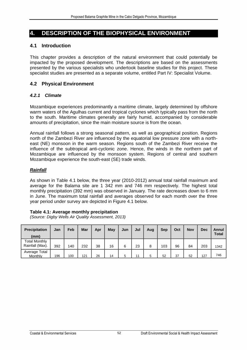
Mozambique experiences predominantly a maritime climate, largely determined by offshore warm waters of the Agulhas current and tropical cyclones which typically pass from the north to the south. Maritime climates generally are fairly humid, accompanied by considerable amounts of precipitation, since the main moisture source is from the ocean. Annual rainfall follows a strong seasonal pattern, as well as geographical position. Regions north of the Zambezi River are influenced by the equatorial low pressure zone with a north-east (NE) monsoon in the warm season. Regions south of the Zambezi River receive the influence of the subtropical anti-cyclonic zone. Hence, the winds in the northern part of Mozambique are influenced by the monsoon system. Regions of central and southern Mozambique experience the south-east (SE) trade winds. Rainfall As shown in Table 4.1 below, the three year (2010-2012) annual total rainfall maximum and average for the Balama site are 1 342 mm and 746 mm respectively. The highest total monthly precipitation (392 mm) was observed in January. The rate decreases down to 6 mm in June. The maximum total rainfall and averages observed for each month over the three year period under survey are depicted in Figure 4.1 below. Table 4.1: Average monthly precipitation (Source: Digby Wells Air Quality Assessment, 2013)
Precipitation
(mm)
Jan Feb Mar Apr May Jun Jul Aug Sep Oct Nov Dec Annul Total
Total Monthly Rainfall (Max). 392 140 232 38 16 6 23 8 103 96 84 203 1342
Average Total Monthly rainfall
196 100 121 26 14 5 11 5 52 37 52 127 746

Proposed Balama Graphite Mine in the Cabo Delgado Province, Mozambique
Coastal & Environmental Services Draft Environmental Social & Health Impact Assessment 53
Figure 4.1: Average monthly precipitation (Source: Digby Wells Air Quality Assessment, 2013)
Temperature Annual mean temperatures for Balama area are given as 20.1°C. The average daily maximum temperatures ranges from 17.5°C in July to 24.9°C in December, with daily minima ranging from 16.6°C in July to 23.1°C in January (refer to Table 4.2 and Figure 4.2). Table 4.2: Average monthly temperature (Source: Digby Wells Air Quality Assessment, 2013)
Temperature
(deg °C) Jan Feb Mar Apr May Jun Jul Aug Sep Oct Nov Dec Ann
Monthly Max. 24.2 24.6 21.5 20.6 18.6 18.1 17.5 18.9 20.4 21.5 22.9 24.9 21.1
Monthly Min. 23.1 21.5 21.1 20.2 17.4 17.4 16.6 17.8 18.4 20.4 21.1 20.6 19.6
Monthly Mean 23.6 22.8 18.0 20.4 18.2 17.7 17.0 18.3 19.5 21.0 21.8 23.0 20.1

Proposed Balama Graphite Mine in the Cabo Delgado Province, Mozambique
Coastal & Environmental Services Draft Environmental Social & Health Impact Assessment 54
Figure 4.2: Average monthly temperature (Source: Digby Wells Air Quality Assessment, 2013)
Wind The spatial and annual variability in the wind field for the Balama site is clearly evident in Figure 4.3. The predominant winds come from the northeast (12.13%), south southeast (12.27) with the strongest and most frequent from the south (13.37). Calm conditions (wind speeds < 0.5 m/s) occurred for 3.9 % of the period.
Figure 4.3: Wind Rose (Source: Digby Wells Air Quality Assessment, 2013)

Proposed Balama Graphite Mine in the Cabo Delgado Province, Mozambique
Coastal & Environmental Services Draft Environmental Social & Health Impact Assessment 55
Relative Humidity The annual maximum, minimum and mean relative humidity values are given as 79%, 77% and 79%, respectively. The daily maximum relative humidity remains above 70 % for most of the year (with the months from April to September above 80%, reaching 87% in June and July). The daily minimum on the other hand was 68% (January), with the highest value of 85% observed in the months of June and July. The monthly values observed in relative humidity for the three year period (2010-2012) are depicted in Figure 4.4 below.
Figure 4.4: Average monthly relative humidity (Source: Digby Wells Air Quality Assessment, 2013)
4.2.2 Topography
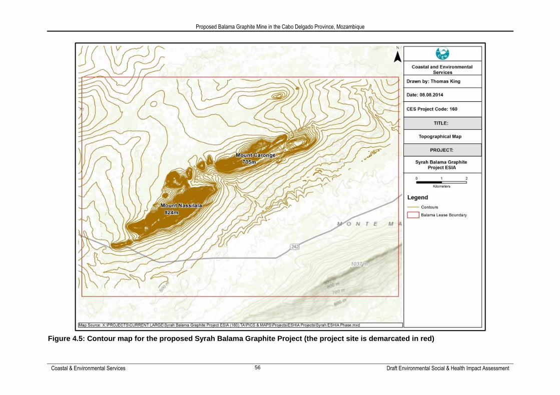
Mozambique's topography consists of coastal plains, mountains, and plateaus. About 44% of the country are coastal lowlands, and the terrain rises toward the west to a highland that ranges from 150 to 610 metres above mean sea level. In some sections elevations the highlands reach 550 to 910 m, with mountains reaching a height of nearly 2 440 m. Regional topography of the wider Balama project area shows elevations of 200 m above mean sea level, up to 1 440 m. The local topography of the Study Area is dominated by ground surface elevation which ranges from about 540 m to 678 m above mean sea level, with a NE-SW trending ridge. Elevation declines gradually to the northwest and southeast of the ridge (Figure 4.5).
Proposed Balama Graphite Mine in the Cabo Delgado Province, Mozambique
Coastal & Environmental Services Draft Environmental Social & Health Impact Assessment 56
Figure 4.5: Contour map for the proposed Syrah Balama Graphite Project (the project site is demarcated in red)

Proposed Balama Graphite Mine in the Cabo Delgado Province, Mozambique
Coastal & Environmental Services Draft Environmental Social & Health Impact Assessment 57
4.2.3 Geology and Soils
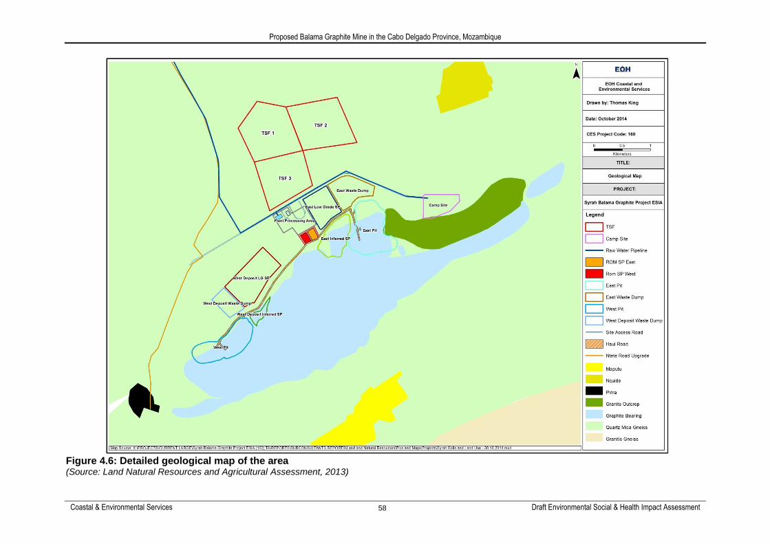
Regional Geology Metamorphic rocks of the Neoproterozoic Lurio Group that is included within the Xixano Complex (735 Ma), dominates the project area. These rocks are characterized by ultra metamorphites of granulite to upper amphibolite facies (paragneisses) intruded by high grade orthogneisses while the Xixano Complex is characterized by Neoproterozoic lithologies formed between 820 and 740 Ma. In a western shear zone the Marrupa Complex and the Xixano Complex connect, where the Marrupa Complex overlies the Xixano Complex. In the east the Montepuez Complex is strongly folded, where the Xixano Complex and the Nairoto Complex is separated by a major shear zone. Predominant rock types within the Xixano Complex include calcic, mafic gabbro and diorite and low-K tonalite. Local Geology Graphitic, pelitic and psammite schists with a large granitic intrusion in the northeast occur in the proposed Balama site. Other minerals such as vanadium and pegmatites have been found by local artisanal miners. The graphite layer is comprised of a sequence of metamorphosed carbonaceous pelitic and psammitic sediments within the Proterozoic Mozambique Belt (Brice, 2012). The sediments have been metamorphosed to graphitic schists (pelites) and graphitic sandstones (psammites) (Figure 4.6). Metamorphosed carbonaceous and, in parts, calcareous pelitic and psammitic sediments makes up the graphitic zone. Granite outcrops are evident in the north east of the western portion of the project area. Within these outcrops associated pegmatites occur which together with the granites appear to be intrusive into the schists. It is believed that the metasomatism between these rocks have resulted in the introduction of vanadium and chrome into the mineral assemblage. The foliation and bedding strike and dip appear to be one and the same (i.e. N 50° strike and dip 50° – 60°N).
Proposed Balama Graphite Mine in the Cabo Delgado Province, Mozambique
Coastal & Environmental Services Draft Environmental Social & Health Impact Assessment 58
Figure 4.6: Detailed geological map of the area (Source: Land Natural Resources and Agricultural Assessment, 2013)

Proposed Balama Graphite Mine in the Cabo Delgado Province, Mozambique
Coastal & Environmental Services Draft Environmental Social & Health Impact Assessment 59
Local Soils Loose graphitic brown soils (with no outcrop) cover flat areas, north and south of a range of hills, where the soil horizon can reach a maximum depth of 7 m. Most of the mining concession is underlain by red loam and sandy loam soils with high clay contents around the Mehucua River. The area where the mining activities will take place varies between medium textured soils in the west to sandy loam soils that are easily eroded located centrally and eastwards (Figure 4.7). Three exposed soil profiles were assessed as part of the Land, Natural Resource and Agricultural Assessment (CES, 2013). This assessment identified two soil types at the proposed Balama graphite mine site. The first is Red Arenosols, found on the plains and occurring in approximately 80% of the mining concession area. This soil group has a thin brown ochric surface horizon over deep subsoil and consists of sandy soils developed after in situ weathering of old, quartz-rich soil material or rock. These soils are highly erodible with low water containing capacity. The second soil type identified is Leptosols which occur on steep sloped inselbergs. These soil types accommodate very shallow soils over hard rocks. They are found in strongly eroded areas (like steep slopes). The A horizon is thin and has rich organic matter. For this reason, they have haplic characteristics. The pH is expected to be slightly acid. Soils found on the flat plain areas had an average pH of 6.1 compared to soils on the sloped area which were more acidic, with a pH of 5.1. This is to be expected as the outcrop is of a granitic origin and is considered a more acidic parent rock for soils on these slopes. Organic matter concentrations were found to differ when comparing soils on the sloped areas to soils on the plains. The low organic humus percentage found in the latter may be due to a high erosion potential combined with traditional agricultural methods (slash-and-burn clearing, incorrect cropping etc.) practiced on the plains.

Proposed Balama Graphite Mine in the Cabo Delgado Province, Mozambique
Coastal & Environmental Services Draft Environmental Social & Health Impact Assessment 60
Figure 4.7: General soil types found within the mining concession area (Source: Land Natural Resources and Agricultural assessment, 2013)

Draft Environmental Impact Assessment of the Proposed Balama Graphite Mine in the Cabo Delgado Province, Mozambique
Coastal & Environmental Services Draft Environmental Social & Health Impact Assessment 61
4.2.4 Air Quality
Adequate ambient air quality monitoring data is not available to evaluate the baseline air quality situation. However, dust fallout monitoring results from May 2013 were available for evaluation, and is shown in Table 4.3 below. Based on the various activities in the study area, the main sources identified as possibly impacting on air quality in the region included, but are not limited to:
Vehicle tailpipe (exhaust) emissions;
Domestic fuel combustion;
Biomass burning;
Informal refuse burning;
Charcoal production;
Slash and burn practices for agriculture
Fugitive dust emissions from vehicles on roads; and
Wind erosion of open areas. Table 4.3: Dust fallout results for the proposed Balama Project Site (2013) (Source: Digby Wells Air Quality Assessment, 2013)
DUST LEVELS MEASURED IN MG/M2/DAY
Site ID April (31 days)
May/June (57 days)
July to August (62 days)
September (34 days)
Camp 70 264 559 588
Phirira 96 31 349 850
Nquide 60 26 938 1061
Ntete 84 363 486 504
Maputo 65 156 765 685
Plant 50
*Exposure period in bracket
4.2.5 Noise
Based on the daytime results measured at the rural receivers, the general existing ambient noise levels are mostly below the IFC‘s guideline rating limits (55 dBA) for the maximum allowable outdoor daytime limit for ambient noise in residential districts. Overall the ambient noise levels at the rural receivers are at the level of what is expected of rural villages according to IFC guidelines, the only exception being the Ntete Village during the morning and afternoon, due to the operation of a maize milling machine, near the measurement location at Ntete which caused the average to increase to 69 dBA. The average noise levels, not taking the maize milling machine into account, is 52 dBA. The baseline level at Ntete is

Proposed Balama Graphite Mine in the Cabo Delgado Province, Mozambique
Coastal & Environmental Services Draft Environmental Social & Health Impact Assessment 62
set at the lower level of 52 dBA because of the fact that the maize milling machine is not always in operation and thus also falls within the IFC acceptable limits. The night time noise levels indicate that the ambient night time levels are mostly below the IFC‘s residential guideline limit (45 dBA). The only exception was at Piriri, however this was due to a Cicada that set itself on top of the windscreen covered microphone and the noise it produced caused the baseline level to measure at 77 dBA, which distorts the more representative baseline level. The more representative level, excluding the Cicada‘s noise contribution, is 43 dBA which falls within the IFC acceptable limits. The noise sources that were audible during the baseline measurements at the time of the noise survey and that were responsible for the day/night time levels are summarised in Table 4.4. Table 4.4: General noise sources during baseline measurements (Source: Digby Wells Noise Assessment, 2013)
Noise source description
Day Duration Night Duration
Maize milling machine at Ntete Intermittent Gryllidae (crickets) Continuous
Socializing activities Intermittent Cicadidae Cicada Continuous
Vehicular activities on gravel roads
passing through the villages as well
as main road passing through
Maputo
Intermittent Vehicular activities on main road
passing through Maputo Intermittent
4.2.6 Radiation
To manage naturally occurring radioactive material (NORM) it is recommended that Syrah adopt the NORM guidelines as published by the Government of Western Australia, Department of Mines and Petroleum. As stated in the guideline NORM 1 the purpose of this set of guidelines is to summarise the system of radiation protection as recommended by the International Commission on Radiological Protection (ICRP), International Atomic Energy Agency (IAEA) and the Australian Radiation Protection and Nuclear Safety Agency (ARPANSA). The guidelines illustrate how the system of radiation protection may be practically applied in the mining and mineral processing industry and in particular: implementing best practicable technology to reduce exposure and contamination levels.
For example, ensuring suitable engineering controls are used to the extent feasible;
classifying employees, work conditions and workplaces on the basis of measured or predicted radiation levels. For example the classification of designated employees, restricted areas, controlled areas and supervised areas; and
the establishment of contamination levels that trigger radiation protection responses. For example, defining special exposures and setting investigation and reporting levels.
Measurements taken (sampling points shown in Figure 4.8 and Figure 4.9), indicated the levels of radioactivity naturally occurring in radioactive materials. The readings were in the order of 3 to 10 times the background level and generally across the field locations where measurements were taken. One test at location number 35 exhibited a value about 30 times background. Measurements on core samples at the core shed also followed the same trend

Proposed Balama Graphite Mine in the Cabo Delgado Province, Mozambique
Coastal & Environmental Services Draft Environmental Social & Health Impact Assessment 63
although one specific piece of core from drill hole BMDD0123 at a depth of 18m exhibited a value about 30 times background. Calculations based on the field measurements indicate the dosage level encountered by personnel working in these areas will be less than 5mSv per year. The NORM guidelines provide classifications of work conditions and at dosage levels less than 5mSv the work area would be classified as a supervised area. The ARPANSA definition of a supervised area is ―an area in which working conditions are kept under review but in which special procedures to control exposure to radiation are not normally necessary‖. As the project progresses to production, ongoing monitoring will be conducted and any actions and mitigation measures required will be determined by the NORM guidelines.
Figure 4.8: Radiation sampling points east pit

Proposed Balama Graphite Mine in the Cabo Delgado Province, Mozambique
Coastal & Environmental Services Draft Environmental Social & Health Impact Assessment 64
Figure 4.9: Radiation sampling points west pit
4.2.7 Surface water
The project area lies south of the Ruvuma River in the upper reaches of the Montepuez/Megaruma River catchment area. This area is dominated by seasonal rivers such as the Messalo, Montepuez, Megaruma, Lurio, Mocuburi and Monapo Rivers. Most of these rivers are lined with swamps, with the lower courses of several expanding into long narrow lakes, such as Lake Biribizi on the Montepuez River. The Mehucua River flows through the southern section of the project site in a south-west to north-east direction. At this point it joins the Montepuez River 25 km downstream of the project site. The Mehucua River has three major tributaries; two of which - the Namiticu and the Naconha rivers - are upstream of the project area, both of which were sampled as part of the aquatic survey. The third tributary joins the Mehucua some distance downstream of the project area. The Namiticu and Naconha Rivers flow parallel to each other, and are both approximately 20 km long from their sources to their confluence, where they join to form the Mehucua River at a point on the southern boundary of the project site (Figure 4.10). A few small wetlands occur in the project area, the most notable being swampland located approximately 2 km south west of the proposed site and a wetland located approximately 7 km east south-east. The largest water body in the area, but outside of the project area, is the Chipembe Dam which is located 13 km northwest of the site. Completed in 1985 the dam covers approximately 7.1 km2 and has a capacity of close to 24 million m3. The primary water use is intended to be irrigation, but the planned irrigation scheme has largely failed (FAO, 2005a). The Mozambique Water Authority is responsible for the management of Chipembe Dam and has confirmed that there is suitable available capacity and allocation for Syrah to obtain over 2 000 000m3 annually for use in the processing of graphite (EBS, 2012).

Proposed Balama Graphite Mine in the Cabo Delgado Province, Mozambique
Coastal & Environmental Services Draft Environmental Social & Health Impact Assessment 65
In situ and ex situ water quality indicated that in general the water quality was good when compared to the various relevant water quality guidelines, specifically the MICOA standard for Category (a) human consumption (Ministerial Diploma of 18/2004). Aquatic macroinvertebrates were collected using the standard South African Scoring System (SASS5) protocol. The number of aquatic macroinvertebrate taxa ranged from 16 at the Chipembe Dam site to 10 at the Mehucua River site. The United States Environmental Protection Agency (USEPA) approach to the qualitative assessment of the biotic integrity of a stream was applied to the sample sites. The objective of the Ephemeroptera, Plecoptera and Trichoptera (EPT) Taxa Richness Metric is to provide a baseline for future rapid bioassessments. The percentage contribution of EPT taxa per site showed a range from 2 at the Namiticu River site and at Chipembe Dam, to 5 at the Namiticu River confluence site. and contributed a third of the overall invertebrate assemblage at the Namiticu River Confluence site. The high percentage contribution (> 30%) of EPT taxa to the overall invertebrate assemblage at the Namiticu River confluence site indicates that biotic integrity remains high at this site despite the impacts of riparian zone clearing and associated sedimentation of the river. Also, at the time of sampling, far more habitat structure was available for sampling, potentially accentuating the result unevenly. Further evidence of the good quality of the catchment in general, was the presence of a number of taxa with lower tolerance to pollution. In terms of the SASS methodology, three principal indices are calculated, namely the SASS Score, the Number of taxa, and the Average Score per Taxon (ASPT). By dividing the SASS Score by the Number of taxa identified, the ASPT index is calculated. This index provides a reliable measure of the health of a river. Table 4.5 shows the calculated ASPT for each of the sites sampled. The Mehucua River has the highest ASPT and SASS score, largely due to the category taxon (Oligoneuridae), while the Chipembe Dam site had a higher number of taxa and the lowest ASPT, as most taxa found at this site were in the lower, more pollution tolerant, ranges. Table 4.5: Number of taxa, SASS and ASPT scores at the five sample sites
Nam
itic
u
Riv
er
Nac
on
ha
Riv
er
Nam
itic
u
Riv
er
Co
nfl
uen
ce
Meh
ucu
a R
iver
Ch
ipem
be
Dam
SASS Score 70 63 89 75 76
No. of Taxa 13 11 15 10 16
ASPT 5.4 5.7 5.9 7.5 4.8
The following conclusions were reached based on the March 2013 survey of aquatic ecosystems:
In situ water quality indicated that in general the water quality was good. The dissolved oxygen content was slightly lower than expected, but this is in all likelihood due to the turbidity of the water due to the sediment loads present from the recent seasonal rains. The high air temperatures would also reduce the DO concentration in the upper water column, where the in situ measurement probe would rest.

Proposed Balama Graphite Mine in the Cabo Delgado Province, Mozambique
Coastal & Environmental Services Draft Environmental Social & Health Impact Assessment 66
The moderate/high percentage contribution (25 - 30%) of Ephemeroptera, Trichoptera and Plecoptera (EPT taxa) to the overall invertebrate assemblage in the general area indicates that biotic integrity remains high despite the impacts of riparian zone clearance and sediment load increases due to local farming practices;
The relatively low levels of taxon richness measured at all sites can be attributed to the relatively poor habitat availability. This was due to various reasons related to seasonality, including high flow levels and flood damage to marginal vegetation. It is anticipated that the dry season taxon richness may be higher.
Although guidelines for freshwater quality from other jurisdictions may provide some criteria appropriate to Mozambican, it is recommended that Syrah initiate a long-term water quality monitoring programme. This will allow for the development of a site-specific baseline water quality database. This database can then be used to provide a target water quality guideline specific to the Syrah site. Water quality monitoring subsequent to the initiation of mining operations can then be compared to the guideline developed from the baseline monitoring programme. As it is probable that there will always be natural fluctuation in ambient water quality, it is important to establish a mechanism to identify when a parameter is abnormally high rather than slightly elevated. It is recommended that the median values and associated percentiles of exceedance (as recommended in the Australian and New Zealand Guidelines for Fresh and Marine Water Quality – ANZEEC) be used.

Proposed Balama Graphite Mine in the Cabo Delgado Province, Mozambique
Coastal & Environmental Services Draft Environmental Social & Health Impact Assessment 67
Figure 4.10: River systems in and around the project area (Source: Aquatic Impact Assessment, 2014)
4.2.8 Groundwater
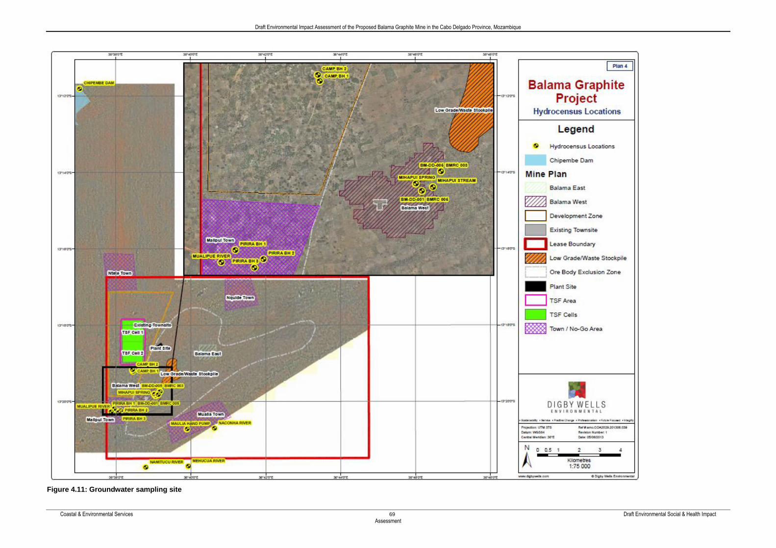
The groundwater system of the Mt Nassilala range of hills plays a major role in the regional surface water system as groundwater discharging from the hillside supports perennial flows in streams originating from the mountains. Groundwater levels in the project area range between 2 meters below ground level (mbgl) at Pirrira BH3 (Balama west) to 33 mbgl in BH8 (Balama east), (Sample sites are shown in Figure 4.11). A plot of all available groundwater level data against borehole surface elevation depicts that the inclusion of BBH2, BBH7 and BBH8 distorts a 99 % correlation to an 81 % correlation. This is indicative of two sets of aquifer systems in the project area: a weathered aquifer and a fractured aquifer system. Thus groundwater occurrence in the project area is associated with weathered and fractured graphitic schist, granites and pegmatites. The aquifer associated with the weathered bedrock varies in thickness throughout the area, but it can extend to depths of about 40 mbgl. The weathered aquifer is fairly permeable as only minor seepages were recorded in the
Montepuez River

Proposed Balama Graphite Mine in the Cabo Delgado Province, Mozambique
Coastal & Environmental Services Draft Environmental Social & Health Impact Assessment 68
weathered material during drilling. The pockets of deeper weathering may allow seepage migrating to the fractured zone aquifer. Graphitic schist, granites and pegmatites, when not weathered, are impermeable and have no storage capacity. The permeability and the storativity of these rocks are solely dependent on secondary structural features like fissures and fractures. In general fractures close when the lithostatic pressure increases with depth. However, important groundwater flow may occur in fractures accompanying fault zones. Exploration geology data indicates that 51 per cent of the fractures in the study area occur in the upper 60 m of the geological succession. Up to 27 % of the fractures occur between 140 and 180 mbgl. However a majority of the deeper fractures are unweathered. The fractures in the upper 60 m are mostly moderate to highly weathered. Therefore fracturing is relatively common in the upper 20 m of the fractured aquifer and groundwater flow is well interconnected. At greater depth groundwater flows may be associated with individual disconnected water bearing fractures. All major water strikes intercepted during drilling were between 40 and 60 mbgl. The major water strikes had yields between 0.78 and 9 L/s. Besides the fault gouge at Balama East, all major water strikes were associated with fractured intrusives at contact zones. Eleven boreholes were sampled for baseline assessment and compared against the WHO drinking water guidelines. The results indicated the following:
Groundwater from water supply boreholes Pirira BH2 and Pirira BH3 are not fresh due to elevated TDS values above 1000 mg/L;
Acid mine drainage (AMD) processes have taken place due to oxidation of exposed pyrrhotite in the dug trenches. As such BMRC 005, BBH2, BBH3 and BBH7 have AMD signatures due to their proximity to the trenches:
The only common heavy metals that have been significantly mobilised are iron, manganese, nickel and zinc;
Although all major and minor ions in BBH1 are within guideline values, its alkalinity has been depleted. The pH of BBH1 will further decrease due to seepage of AMD water from the nearby trenches;
BBH6, BBH8, Camp BH1, Pirira BH1 and Pirira BH3 are relatively unpolluted water with calcium-magnesium-bicarbonate signatures; and
The chloride enrichment in Pirira BH2 is associated to seepage from the sewage disposal at Pirira village.
Draft Environmental Impact Assessment of the Proposed Balama Graphite Mine in the Cabo Delgado Province, Mozambique
Coastal & Environmental Services Draft Environmental Social & Health Impact Assessment
69
Figure 4.11: Groundwater sampling site

Draft Environmental Impact Assessment of the Proposed Balama Graphite Mine in the Cabo Delgado Province, Mozambique
Coastal & Environmental Services Draft Environmental Social & Health Impact Assessment 70
4.2.9 Geochemistry
A geochemical baseline study was undertaken to investigate the potential formation of acid rock drainage and metal leaching from different types of bedrock found in the mineralized areas of the Balama Graphite ore body. Nine (9) rock samples (selected and provided by the client) were submitted for geochemical evaluations to determine the acid mine drainage (AMD) potential and risk of contaminants leaching into solution from both the graphite and the waste rock. These 9 samples were taken from 3 boreholes (3 samples per borehole) representing the pit areas that will be mined based on the pit layouts and mining plan at the time of sampling. The overburden and underburden from each borehole was tested to represent the mineralogy and constituents of the waste rock material. The third sample in each borehole was taken from the graphite zone. Samples were tested using the XRD method (measurement of the crystal structures to determine the mineralogical composition), the XRF method (determination of the elemental composition of a material), the ABA method (measuring the acid- and alkaline producing potential of undisturbed soil and rock overburden) in order to determine if, after disturbance, the waste material will produce acid and subsequently leach metals. NAG tests, which evaluate the Net Acid Generation and neutralising potential of the material, and Synthetic Precipitation Leachate Procedure (SPLP) tests were also done to simulate the heavy metal and anion leachate potential of soils and waste material left in-situ under normal conditions with only rain water allowing leaching to occur. The geology of the sampled material is extremely rich in metals and various other elements. The XRD and XRF tests revealed that the waste rock and graphite material are not homogenous in nature and that a combination of a wide range of oxides and metals form the rich mineralogy of the deposit. These tests identified the main oxides present as SiO2, Al2O3 and Fe2O3 with smaller amounts of MgO, CaO, K2O and MnO. Clay minerals, with high concentrations of K, Mg, Al, Fe and Mn, were found to dominate the waste rock mineralogy. Other major silicate minerals such as microcline and plagioclase were also present in the waste rock. The high pyrrhotite content in the waste rock can lead to oxidation reactions and the formation of AMD. The mineralogy of the Graphite ore body is dominated by a quartz based metamorphic sequence with traces of clay minerals. The high concentrations of Mn, Mg, Fe, SO4, K, Zn, Al and Ca elements in the samples could potentially leach from the material. The test analyses have revealed that almost all common metal concentrations found in the samples (Au, Ag, As, Ba, Fe, Cu, Cr, Zn, U, Co,Cs, Mo, Ni, V, W, Y and Pb) are above the global average crustal concentrations (Table 4.6). Even though these metals are much higher than normal most of them do not pose a significant health risk and are not mobile under normal aquatic and atmospheric conditions. The current pH of the groundwater system at Balama is close to neutral, with some boreholes close to pits and trenches having a more acidic pH due to oxidation processes. As pH affects the rate of metal dissolution and their mobility in groundwater it is important to note that once the graphite is mined and exposed to oxygen, AMD formation is a possibility because of the high Sulphur content observed in the ABA results. A drop in pH will result in the mobility of most metals which can lead to environmental risks. The main elements to highlight are Zn, Pb, Ni, U, As, Fe and Cu. The ABA and NAG results revealed that the Sulphur (S) content for all the tested samples were above the margin concentration of 0.3% S with the exception of BMD009HW and BMD012HW being below 0.01%. This means that the tendency for acid generation in the samples that were above 0.3% is higher than in the other samples, if the Net Neutralising Potential (NNP) is below 0. All the samples are classed as rock type 1 (potentially acid forming) with the exception of boreholes BMD009HW and BMD012HW, which has a low Sulphur content and a high neutralising potential. The paste pH values of the waste rock
Proposed Balama Graphite Mine in the Cabo Delgado Province, Mozambique
Coastal & Environmental Services Draft Environmental Social & Health Impact Assessment 71
material (overburden and underburden) are all above 8 with the exception of borehole BMD022HW, which has a slightly acidic paste pH of 5.3. The mineralised material were found to have a neutral paste pH, with only BMD009MZ showing an acidic formation. The SPLP test results were classed against the South African drinking water standards to quantify the quality of any leachate produced from the test samples (waste rock and Ore material). The SPLP tests are a leachate procedure in which the contaminants that can potentially seep into the groundwater and surface water reserves from waste facilities and stockpiles can be determined. The bio-availability of the elements is thus evaluated. The total elemental analysis indicated the total amount of metals present in the samples available for dissolution and seepage, the SPLP results will however show the amount that will leach from the solid state into fluids as water recharges through stockpiles and waste facilities. When the concentrated seepage does reach the receiving environment (groundwater or surface water) the concentrations will however be diluted to levels most probably below any levels potentially posing risks. The quality of the leachate was classed against the SANS 241:2005 drinking water guidelines, as well as WHO drinking water guidelines to evaluate its suitability for human consumption and the potential for contamination; should leachate reach and mix with local water resources. WHO guideline values were only used where the SANS guideline do not give criteria for that specific parameter. SANS 241:2005 identifies 3 classes namely Class 1 (recommended operational limit), Class 2 (maximum allowable concentration for limited duration) and Class 3 (Not recommended for human consumption). The metals found to be above the recommended drinking water guidelines, but within the maximum allowable limits were Ca, Co, Cr, Mn, Se and Zn. However Al, Cd, Fe, Cu, Ni, V and U were found to have concentrations well above the allowable drinking water limits and are cause for concern as these pose both a human health risk and environmental impact risk. All other metal concentrations that were identified were found to be within the limits and will thus have no environmental or health risk. Based on the results of the Geochemistry assessment discussed above, it is evident that material representing the waste rock as well as the ore body has samples that could potentially generate acid drainage. The waster rock dumps and tailings storage facility has a moderate potential for AMD due to the high Sulphur content and acid generation potential in the samples that were tested. The high concentrations of U, Sr, Se and Rb in the graphite zone were also found to be potentially radioactive posing a health risk. Potential trace element contamination is also possible from the waste rock dump due to the high concentrations of Mn, Fe, Ni and U identified in the waste rock samples. The ore material has a high potential for AMD formation due to the high Sulphur concentrations and low paste pH levels, which could result in leachate water with a low pH and high metal content. Trace element contamination risk from stock piles and exposed ore zones with a high potential of metal contamination with concentrations of Al, Cd, Co, Cr, Cu, Fe, Mn, Ni, V, Zn and U entering the receiving environment were identified and the high concentrations of U, Sr, Se and Rb in the graphite zone were also found to be potentially radioactive posing a health risk.

Draft Environmental Impact Assessment of the Proposed Balama Graphite Mine in the Cabo Delgado Province, Mozambique
Coastal & Environmental Services Draft Environmental Social & Health Impact Assessment 72
Table 4.6: Whole rock chemistry results summary (concentration in ppm) (Source: Digby Wells Geochemistry Assessment)
Element Upper Crustal Averages
Hanging wall Footwall Mineralised zone
BMD009HW BMD012HW BMD022HW BMD009FW BMD012FW BMD022FW BMD009MZ BMD012MZ BMD022MZ
Ag 0.05 0.03 0.08 0.12 0.12 0.08 0.05 0.04 0.04 0.08
Al 80400 31955.5 41428.9 52506.0 58586.9 44302.7 39746.0 25001.3 21428.9 31124.6
As 1.5 5.35 2.66 1.10 1.06 0.86 0.74 0.79 1.05 0.84
Au 0.0018 0.02 0.01 0.02 0.09 0.02 0.02 0.02 0.01 0.03
B 15 5.3 2.0 6.1 8.1 3.6 6.9 0.1 0.1 54.0
Ba 550 631.0 1980.0 1010.0 1648.0 2437.0 2021.0 1224.0 104.0 758.0
Be 3 1.7 1.5 1.8 2.1 1.6 1.7 1.0 0.6 2.8
Bi 0.127 0.2 0.1 0.3 0.4 0.3 0.2 0.3 0.1 0.5
Ca 30000 472.5 532.5 5411.0 5039.3 3783.4 8670.5 1732.0 39914.2 58098.6
Cd 0.098 0.4 0.7 5.4 4.7 3.0 2.5 16.8 15.2 12.9
Ce 64 30.9 35.6 1.6 7.8 2.3 15.7 3.6 50.3 59.9
Co 17 37.1 33.3 28.5 100.9 62.7 59.3 72.0 77.8 44.2
Cr 85 475.0 133.0 497.0 417.0 415.0 337.0 188.0 221.0 326.0
Cs 4.8 3.8 3.9 14.1 11.1 7.3 21.8 2.0 0.5 6.6
Cu 25 238.0 127.0 242.0 167.0 147.0 156.0 224.0 115.0 191.0
Fe 35000 95640.0 43670.0 42380.0 46100.0 23320.0 23430.0 21920.0 9749.0 27040.0
Ga 17 10.3 9.5 9.5 12.4 9.0 7.3 6.0 4.2 6.3
Ge 1.6 0.8 0.4 0.5 1.1 1.0 0.8 1.2 1.6 0.8
Hf 5.8 2.1 4.5 4.5 7.3 4.6 3.2 2.2 1.6 2.9
Hg 0.09 0.14 0.14 0.28 0.38 0.27 0.33 0.70 0.55 0.78
Ho 0.8 0.27 0.28 0.10 0.21 0.19 0.89 0.28 2.20 2.00
Ir 0.00002 0.09 0.09 0.07 0.08 0.08 0.06 0.07 0.07 0.04
K 28000 3426.9 8305.6 17367.1 18546.5 14510.0 18164.5 1711.8 58.1 8218.4
La 30 10.6 14.0 1.7 4.5 1.9 5.6 3.3 28.1 25.2
Li 20 8.0 9.9 32.1 31.9 21.0 33.5 10.0 2.2 15.4
Mg 13300 546.4 1131.3 7680.7 10915.7 4030.1 4241.6 755.4 279.5 7241.0
Mn 600 313.5 143.7 134.3 249.1 169.4 98.7 74.2 94.8 198.8
Mo 1.5 122.4 90.3 39.9 45.5 28.1 36.2 100.8 252.9 114.1
Na 28900 251.9 539.6 4124.1 5710.7 3221.7 2519.7 195.1 36.8 1535.0
Nb 12.5 2.9 2.3 1.1 33.5 4.9 2.9 4.6 3.3 5.7
Nd 26 22.5 27.3 4.3 9.7 4.9 14.4 6.9 52.0 50.6
Ni 50 170.0 105.0 469.0 456.0 266.0 397.0 916.0 558.0 746.0
Pb 16 23.1 8.9 9.3 19.1 8.0 10.2 16.9 19.1 23.7
Rb 112 48.6 56.0 120.8 139.5 62.5 87.3 9.8 6.5 92.3
Sb 0.2 0.6 0.4 2.3 0.2 0.1 0.5 0.2 0.1 0.6
Sc 13 23.2 14.2 10.4 14.2 10.3 11.6 13.0 9.9 5.7

Proposed Balama Graphite Mine in the Cabo Delgado Province, Mozambique
Coastal & Environmental Services Draft Environmental Social & Health Impact Assessment 73
Element Upper Crustal Averages
Hanging wall Footwall Mineralised zone
BMD009HW BMD012HW BMD022HW BMD009FW BMD012FW BMD022FW BMD009MZ BMD012MZ BMD022MZ
Se 50 0.2 0.9 1.7 1.9 1.1 1.0 0.8 1.2 1.3
Si 308000 272931.3 288592.8 268864.0 251192.1 309864.4 312529.2 253015.4 234174.8 210144.9
Sn 5.5 3.0 2.1 3.6 2.2 4.1 2.2 2.7 1.6 15.7
Sr 350 51.3 89.0 82.6 140.0 109.6 139.4 61.1 61.5 299.5
Ta 1.1 0.4 0.4 0.2 6.6 0.8 0.5 0.5 0.4 1.2
Th 10.7 13.2 4.9 0.5 6.2 0.6 2.3 0.6 3.1 5.2
Ti 3900 1733.5 2911.4 3846.7 4917.4 2669.5 2574.9 1666.5 1162.9 1571.9
Tl 0.75 1.5 2.8 7.4 5.2 2.5 9.1 1.5 2.2 3.5
U 2.8 21.6 14.1 14.4 28.2 9.6 13.6 36.2 85.4 46.9
V 110 2094.0 1072.0 942.0 1001.0 459.0 667.0 3050.0 2982.0 2634.0
W 2 199.4 226.2 184.9 527.1 452.7 424.0 200.0 388.8 278.2
Y 22 5.9 7.4 2.0 5.4 4.8 14.0 8.5 93.9 74.7
Zn 71 380.0 332.0 1247.0 773.0 690.0 505.0 4917.0 546.0 2962.0
Zr 190 113.4 172.5 160.2 248.8 172.2 140.7 119.1 81.1 121.0

Draft Environmental Impact Assessment of the Proposed Balama Graphite Mine in the Cabo Delgado Province, Mozambique
Coastal & Environmental Services Draft Environmental Social & Health Impact Assessment 74
4.3 Biological Environment
4.3.1 Vegetation
Vegetation Types in Mozambique The vegetation of Mozambique and the Cabo Delago Province specifically has very little detailed and published information available. Descriptions by Wild and Barbosa (1967) and a biogeographical survey by White (1983) are currently the most reliable sources of vegetation information. The above literature largely describes plant formations on a broad landscape level, but provides very little information on the communities found within the major vegetation types. Eight broad vegetation types have been described and mapped for Mozambique (MICOA, 2009). Miombo Woodland is the most widespread, dominating in the north and centre of the country followed by Mopane Woodland which occurs in the southern and northern parts of the country. The third most widespread vegetation type is Undifferentiated Woodland which covers extensive parts of the south, central and northern portions of the country. The remaining vegetation types include Afromontane Elements, Coastal Mosaics, Halophytic Vegetation, Mangroves and Swamp Vegetation. According to the Broad Vegetation map of Mozambique (After White, 1983 in MICOA, 2009), the vegetation of the proposed project site is classified as Miombo Woodland. Miombo Woodland covers almost three million square kilometres in southern, central and east Africa (Smith 2000). Despite this broad and extensive range, the World Wildlife Fund (WWF) has listed this vegetation type as Vulnerable. Miombo woodlands range from completely deciduous to almost evergreen vegetation but are mostly semi-deciduous in nature (White, 1983). Miombo tends to show resistance to fire, but cannot survive repeated fire events (White 1983). Natural stress and drought are important factors in the growth of Miombo (Chidumayo 1991) as well as its fruiting potential (Chidumayo, 1997). This vegetation type is characterized by nineteen (19) dominant species of Brachystegia and three (3) other species namely Julberbernadia globiflora, Julbernadia paniculata and Isoberlinia angloensis (White, 1983). The following species occur within this vegetation type and reach canopy height: Afzelia quanzensis, Anisophyllea pomifera, Erythrophleum africanum, Faurea saligna, Marquesia macroura, Parinari curatellifolia, Pericopsis angolensis and Pterocarpus angolensis. Included are a few species of Uapaca and Monotes, which tend to be about 10m tall (White, 1983). Miombo Woodland can further be divided into two classes; namely Wet Miombo and Dry Miombo, generally separated by the 1100 mm mean rainfall isohyet (Chidumayo 1987). The vegetation assessment suggests that the project area occurs within the drier Miombo type which can be defined by the following characteristics:
Rainfall is less than 1000mm.
Canopy height usually less than 15m.
Floristically poor.
Brachystegia floribunda absent or very localized.
Brachystegia spiciformis, Brachystegia boehmii and Julbernardia globiflora are often the only dominants present.
Associates in rocky places include many species which otherwise occur in deciduous forest and thicket or other dry types.
Associated vegetation includes dry deciduous forest and thicket, deciduous riparian forest, and dry dambos.
Proposed Balama Graphite Mine in the Cabo Delgado Province, Mozambique
Coastal & Environmental Services Draft Environmental Social & Health Impact Assessment 75
Site specific vegetation types A fine scale assessment of the site identified two main vegetation types namely Miombo Woodland and Riparian Woodland (Figure 4.12). The Miombo Woodland is further split into three types based on their species composition - Miombo Wodland Graphite, Miombo Woodland Granite and Miombo Woodland Plains (disturbed / intact). For the purpose of the site specific vegetation assessment the definition of woodlands, as described by Palgrave et al. (2007), has been adopted: ―Woodlands are open stands of trees at least 5 m tall with crowns that cover at least 20% of the surface and are not interlocking. Grass cover is usually present‖.

Draft Environmental Impact Assessment of the Proposed Balama Graphite Mine in the Cabo Delgado Province, Mozambique
Coastal & Environmental Services Draft Environmental Impact Assessment March 2014 76
Figure 4.12: Vegetation map of the project site

Draft Environmental Impact Assessment of the Proposed Balama Graphite Mine in the Cabo Delgado Province, Mozambique
Coastal & Environmental Services Draft Environmental Social & Health Impact Assessment 77
Riparian Woodland The Riparian Woodland is entirely restricted to a narrow band of a few metres, adjacent to the rivers and streams, throughout the Balama Graphite project area. In most cases, the riparian woodland is absent or highly degraded (Figure 4.12; Plate 4.1). The narrow strips of riparian trees were difficult to detect on the aerial imagery, limiting accurate mapping of this vegetation type. The dominant species in the intact areas are Brachystegia boehmii, Albizia adianthifolia, Grewia forbsii, Combretum sp., Tabernaemontana elegans and Xylotheca kraussiana (Plate 4.2) (see Vegetation Assessment for all species found in this habitat).
Plate 4.1: Riparian Woodland

Proposed Balama Graphite Mine in the Cabo Delgado Province, Mozambique
Coastal & Environmental Services Draft Environmental Social & Health Impact Assessment 78
Plate 4.2: Dominant species found in the Riparian Woodland A) Brachystegia boehmii. B) Grewia forbsii, C) Albizia adianthifolia D) Xylotheca kraussiana flower and D) Xylotheca kraussiana fruit. Miombo Woodland Miombo Woodland is found throughout the project site in varying states of degradation and transformation. Further analysis of the survey data indicates that this vegetation type can be further divided into three distinct vegetation types based on their species composition. These are described in detail below and their distribution is illustrated in Figure 4.12.
Proposed Balama Graphite Mine in the Cabo Delgado Province, Mozambique
Coastal & Environmental Services Draft Environmental Social & Health Impact Assessment 79
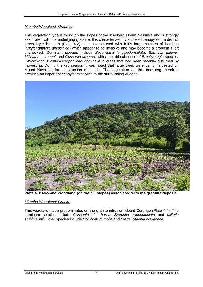
Miombo Woodland: Graphite This vegetation type is found on the slopes of the inselberg Mount Nassilala and is strongly associated with the underlying graphite. It is characterised by a closed canopy with a distinct grass layer beneath (Plate 4.3). It is interspersed with fairly large patches of bamboo (Oxytenanthera abyssinica) which appear to be invasive and may become a problem if left unchecked. Dominant species include Securidaca longipedunculata, Bauhinia galpinii, Milletia stuhlmannii and Cussonia arborea, with a notable absence of Brachystegia species. Diplorhynchus condylocarpon was dominant in areas that had been recently disturbed by harvesting. During the dry season it was noted that large trees were being harvested on Mount Nassilala for construction materials. The vegetation on this inselberg therefore provides an important ecosystem service to the surrounding villages.
Plate 4.3: Miombo Woodland (on the hill slopes) associated with the graphite deposit Miombo Woodland: Granite This vegetation type predominates on the granite intrusion Mount Coronge (Plate 4.4). The dominant species include Cussonia cf arborea, Sterculia appendiculata and Milletia stuhlmannii. Other species include Combretum molle and Steganotaenia araliaceae.

Proposed Balama Graphite Mine in the Cabo Delgado Province, Mozambique
Coastal & Environmental Services Draft Environmental Social & Health Impact Assessment 80
Plate 4.4: Miombo Woodland (on the hill slopes) associated with the granite intrusions Miombo Woodland: Plains This vegetation type predominates in the flat areas surrounding the inselbergs. It is largely secondary woodland, having been transformed by agricultural practices. Patches of degraded woodland occur along the road from Pirira village to Chipembe dam and within the project site. However, a significant patch of intact woodland was found to occur east of Nquide village (Plate 4.5). It is unclear why this woodland has not been transformed and planted by the local community but it is highly probable that this is a sacred site. Dominant species in the intact areas include Gardenia resiniflua, Ficus sp. Antidesma vernosum, Brachystegia boehmii, Brachystegia bussei and Strychnos madagascariensis. Dominant species in the degraded areas include Securidaca longipedunculata, Bauhinia galpinni, cf Dovyalis sp., Pseudolachnostylis maprouneifolia, MIlletia stuhlmannii and Antidesma vernosum.

Proposed Balama Graphite Mine in the Cabo Delgado Province, Mozambique
Coastal & Environmental Services Draft Environmental Social & Health Impact Assessment 81
Plate 4.5: Intact woodland found in the flat plains near the Nquide village Agricultural Land Large sections of the plains have been cleared for the cultivation of crops such as maize, cassava, beans and cotton. Despite the majority of tree species being cleared it was noted that there were numerous Baobab trees (Adansonia digitata) and Tall Star Chestnut trees (Sterculia appendiculata) that had not been removed (Plate 4.6). These trees are either too large to remove or they serve a functional purpose such as a source of shade or in the case of the baobab trees, as a source of food. They could also have spiritual significance to the local communities.

Proposed Balama Graphite Mine in the Cabo Delgado Province, Mozambique
Coastal & Environmental Services Draft Environmental Social & Health Impact Assessment 82
Plate 4.6: Example of typical agricultural fields with a single Baobab tree Vegetation Distribution Twenty percent of the project site is comprised of degraded Miombo Woodlands: Plains (Table 6-1 and Figure 6-3). Agricultural areas and Settlements make up a further 65.8% of the project area. The Miombo Woodlands associated with the granite intrusions and graphite deposits (i.e. the vegetation that occurs on Mount Coronge and Mount Nassilala) collectively make up 12.4 percent of the vegetation in the project area. Figure 6-3 illustrates the distribution of each vegetation type throughout the project area. The Miombo: Graphite vegetation is found on Mount Nassilala and the eastern portion of Mount Coronge. The Miombo: Granite vegetation can be found on the western portion of Mount Coronge. The degraded Miombo Woodlands: Plains is found in patches throughout the flat, low-lying areas and is surrounded by agricultural land. There was only one small patch of intact Miombo Woodlands: Plains. This occurs to the east of Nquide village. The vegetation type that will be most heavily impacted by the proposed mining infrastructure (excluding roads) is the Miombo Woodland: Graphite. 7.8% of the total area of this vegetation type will be lost during the mining process. The second most impacted vegetation type is the degraded Miombo Woodlands: Plains with a loss of 1.4% of this vegetation type. 1% of the Miombo Woodlands: Granite will be lost. The intact Miombo Woodlands: Plains will not be directly impacted by the mining operation. Although not included here, riparian vegetation will be impacted by infrastructure such as roads. Although not a ―vegetation type‖ it is worth noting that 13.0% of agricultural land will be directly impacted.

Proposed Balama Graphite Mine in the Cabo Delgado Province, Mozambique
Coastal & Environmental Services Draft Environmental Social & Health Impact Assessment 83
Table 4.7: Total Area of Each vegetation type and the area that will be directly impacted
Vegetation Type Total Area (Ha) % of Project Area
% of veg type Impacted
Riparian Woodland 56 0.7 0
Miombo Woodland: Graphite 824 10.5 7.8
Miombo Woodland: Granite 149 1.9 1.0
Miombo Woodland: Plains – degraded
1561 19.9 1.4
Miombo Woodland: Plains - intact 91 1.2 0
Agriculture 4840 61.6 13.0
Settlements 332 4.2 0
TOTAL
7 853 (Mapped Area)
100 9.1
Floristic Diversity Historically, vegetation surveys in Mozambique have been limited. However, there has been an increase in the last 20 years with specific areas of interest being targeted. These include protected areas (such as national parks and reserves), centres of endemism and suspected biological hotspots. From these surveys, it is estimated that over 5 500 plant species have been recorded in Mozambique although the actual number of species is likely to be much higher (MICOA, 1997 and 2009). Of these 5 500 species, 177 species are endemic and 300 occur on the Mozambique Red Data List (MICOA, 2002). Based on habitat distribution it is possible that nine vulnerable species listed on the Mozambique Red Data List could occur in the project site. These are listed in Table 4.8 below. Table 4.8: Vulnerable Plant Species that could occur in the project site
Species Status Endemism
Adenia mossambicensis Vulnerable Endemic
Cassipourea obovata Vulnerable Endemic
Combretum stocksii Vulnerable Endemic
Dichapetalum zambesianum Vulnerable Endemic
Grevea eggelingii Vulnerable Near-Endemic
Hexabolus mossambicensis Vulnerable Possible Endemic
Homalium mossambicensis Vulnerable Endemic
Maerua andradae Vulnerable Endemic
Viscum littoreum Vulnerable Endemic
Many of the identified endemic species and rare and threatened habitats are associated with isolated inselberg‘s such as the Chiperone and Namule hills, Mecula and Gorongosa Mountains and Chimanimani massive. While these areas are recognised as areas of floristic endemism, many more inselberg‘s are yet to be documented in the country (MICOA, 2007). Two inselbergs were identified on the project site, both being relatively intact compared to the surrounding vegetation. However neither of these can be described as critical habitats, as defined by the IFC Performance Standard 6, from a floral perspective since they do not contain critically endangered and/or endangered species, and neither of them are habitats of significant importance to endemic and/or restricted range species. Neither of these inselbergs can be classified as highly threatened or unique ecosystems and they are not

Proposed Balama Graphite Mine in the Cabo Delgado Province, Mozambique
Coastal & Environmental Services Draft Environmental Social & Health Impact Assessment 84
associated with key evolutionary processes. While these habitats are not classified as critical habitats they have been classified as natural habitats using the IFC definition “areas composed of viable assemblages of plant and/or animal species of largely native origin, and/or where human activity has not essentially modified an area‟s primary ecological functions and species composition.” (IFC, 2012). Based on the species identified on site (Total number of 111 species identified) the following was concluded:
No species of special concern appear on the IUCN (2012) list.
One exotic species is listed as data deficient and 25 species are likely to be classified as Least Concern since no species within their family occur on the list. There is no information available for the remaining 46 species.
According to the Mozambique Red Data List (2002), one species (Sterculia appendiculata) is considered ―vulnerable‖ as a result of over exploitation for firewood, timber and local construction
One CITES species, from the Orchidaceae family, appears in Appendix II. This species is not necessarily threatened, but is controlled in terms of international trade whereby CITES controls international trade of certain species i.e. all import, export and re-export of CITES species has to be authorised through a licensing system
No species appear on the Tanzanian, Zimbabwean, Zambian or Malawian Red Data Lists
No Alien species were identified on site. However, mango trees were prevalent in the flat plains near the villages, in amongst the cultivated lands. Bamboo (Oxytenanthera abyssinica) was also noted to occur in the woodlands, particularly the degraded woodlands at the foot and on the slopes of Mount Nassilala. Although this bamboo is indigenous to the region, it could become invasive, especially in disturbed areas where they regenerate and disperse rapidly from seeds and form impenetrable stands that prevent other species from establishing. It was noted that local communities avoided planting in areas previously covered by bamboo, possibly due to the extensive root system which is difficult to remove without machinery.
In terms of ecological sensitivity (Figure 4.13), a large portion of the project area had been cleared for agricultural crops such as cotton, maize and cassava, resulting in these areas having a low sensitivity as they have been transformed through anthropogenic activities and are highly degraded. Areas of natural vegetation, such as the degraded Miombo Woodland: Plains, were assigned a medium ecological sensitivity as they still have a relatively high species richness and form important ecological process areas for small mammals and birds in the area. These areas can withstand a limited loss of, or disturbance to, natural areas. Areas of high sensitivity were assigned to the Miombo Woodland: Granite and Miombo Woodland: Graphite, the intact Miombo Woodland: Plains and the Riparian Woodland. These vegetation types were assigned a high sensitivity score as these areas are all relatively intact and have high species diversity. They also contain species of special concern such as Sterculia appendiculata (listed as Vulnerable on the Mozambique red Data Lists). A number of these species were noted to occur on the slopes of the Granite Inselberg (Mount Coronge). Although highly degraded in most parts, the Riparian zone was assigned a high sensitivity score as it is an important process area for ecosystem functioning. It also scored a high biodiversity value.

Draft Environmental Impact Assessment of the Proposed Balama Graphite Mine in the Cabo Delgado Province, Mozambique
Coastal & Environmental Services Draft Environmental Social & Health Impact Assessment 85
Figure 4.13: Ecological Sensitivity map of the Project area (Source: Vegetation assessment, 2013). Note: SP – Stock pile; LG – Low Grade.

Draft Environmental Impact Assessment of the Proposed Balama Graphite Mine in the Cabo Delgado Province, Mozambique
Coastal & Environmental Services Draft Environmental Social & Health Impact Assessment 86
4.3.2 Fauna
Amphibians Although the faunal surveys did not occur at the beginning of the amphibian breeding season, many amphibians were still breeding and a good sample of the known and possible amphibians occurring the region was obtained. Only two problematic amphibians were obtained. One small reed frog was assigned to Hypeolius acuticeps of the Hyperolius nasutus complex (Channing et al. 2013), although this is based on geographical location and was not confirmed by vocalisation of genetic analysis. The other was a small puddle frog, provisionally assigned to the Prhynobtrachus cf. perpalmatus complex. Most of the observed amphibian fauna are characteristic species of wetlands in the lowlands of northern Mozambique, from which 25 species are recorded and a further 13 species are possible. Two amphibians collected in the region, Hyperolius acuticeps (previously H. nasutus) and Ameitia quecketti (previously A. angolensis) remain of problematic status as both belong to groups that have recently undergone taxonomic revision (Channing et al. 2013 and Channing & Baptista 2013, respectively), and assignment of material from northern Mozambique is only provisional. No amphibians in the Balama region are endemic or of conservation concern. No amphibians are endemic to northern Mozambique. There is no evidence of significant direct utilization of amphibians in the region, either for international trade or for food consumption. Amphibian threats are thus indirect, of which the most significant is habitat loss due to existing agricultural practises. This may be exacerbated by future industrial developments in the region, of which the proposed mine forms part. Increasing habitat fragmentation from land clearance or degradation resulting from agriculture or industry, can lead to secondary impacts, including road mortalities and exposure to predators as amphibians move to and from wetland breeding sites.
Plate 4.7: An array of amphibians which were recorded during the site visit (Top: Arthroleptis stenodactylus, Chiromantis xerampelina. Bottom: Amietophrynus gutturalis, Amietophrynus maculatus)

Proposed Balama Graphite Mine in the Cabo Delgado Province, Mozambique
Coastal & Environmental Services Draft Environmental Social & Health Impact Assessment 87
Reptiles Of the potential 87 reptiles that may occur in the Balama region, only 20 were recorded during the survey. A further eight large or conspicuous species, namely Southern Rock Python (Python natalensis), Spotted bush snake (Philothamnus semivariegatus), Mozambique spitting cobra (Naja mossambica), black mamba (Dendroaspis polylepis), green mamba (Dendroaspis angusticeps), tree agama (Acanthocercus branchi), and Eastern hinged tortoise (Kinixys zombensis), were reported by mine personnel and local villagers to be present. Most reptiles documented on site were conspicuous diurnal lizards, with relatively few snakes observed or captured. Although snakes form the dominant component of reptile diversity in the region (48, 52%), they are mainly small, cryptic and nocturnal and therefore easily overlooked. Although only six snakes were collected during the survey, numerous additional snakes (15-20) are likely to be present in the various habitats on site. Two of the snakes collected (Puff adder and southern burrowing asp) are venomous and are commonly responsible for snake bites in East and Southern Africa. One lizard of scientific interest was collected during the survey. A series of small, snake-eyed skinks (Panaspis cf wahlbergii) were collected beneath cashew trees near Nquide village. Molecular analysis of similar material collected near Lishinga indicates that a new species occurs in northern Mozambique. It is unlikely that this new species, which already appears to have a relatively wide distribution, will be of conservation concern although it may be endemic to Mozambique. Five Mozambican reptiles are listed as threatened in the IUCN Red List (2012); all are sea turtles found at the coast. These will not be impacted in any way due to the development. No other formally recognized threatened (IUCN 2012) reptiles were recorded in the region. Only one Mozambique reptile (the Zambezi soft-shelled terrapin, Cycloderma frenatum) is listed in the `Near Threatened' category of the Red List (2012), but no suitable habitat for the species occurs in region, although it is common in Lake Niassa and the Rovuma River. A number of non-threatened species in the region (e.g. the Flap-necked Chameleon, Chamaeleo dilepis), monitor lizards (Varanus niloticus and V. albigularis), a girdled lizard (Cordylus tropidosternum), tortoises (Kinixys spekii, K. zombensis and Stigomochelys pardalis) and Nile crocodile (Crocodylus niloticus), are involved in international trade and are listed on CITES Appendix 2 that controls and documents their numbers in international commerce. Endemicity in Mozambique reptiles is surprisingly low, with only approximately 14 taxa endemic to the country, most being associated with isolated populations on the various offshore islands of the Bazaruto Archipelago. Two new species have also recently been described from isolated montane habitats in northern Mozambique (Branch & Bayliss 2009, Branch & Tolley 2010), with additional new species being described (Branch et al. in press). Although these taxonomic novelties are associated with montane isolates, a new burrowing skink has also been discovered north of Pemba in the coastal region of northern Mozambique (Verburgt & Broadley in press). The unusual snake-eyed skink recorded during the faunal surveys indicates that additional new species may even occur in the Balama region. As with amphibians, there is no evidence of significant direct utilization of reptiles in the region, either for international trade or for food consumption. However, all snakes are treated as dangerous and are usually killed when discovered by local inhabitants; this despite the majority of snakes in the region being non-venomous and thus harmless. Interviews with local inhabitants and mine personnel confirmed that snakebites in the region were rare, and usually non-fatal (albeit with pain and occasional morbidity). No tortoises were observed in the wild during the survey, although an adult leopard tortoise (Stigmochelys pardalis) was offered for sale by local villagers. It was refused, but was not released as it was retained by

Proposed Balama Graphite Mine in the Cabo Delgado Province, Mozambique
Coastal & Environmental Services Draft Environmental Social & Health Impact Assessment 88
its captors for eating. Tortoises are known to be readily collected for food by local communities (Lindsey & Bento 2010), and their numbers may be very low or even locally extirpated due to local consumption. The most significant threats to reptiles are indirect, and result mainly from habitat loss due to existing agricultural practises. Proposed industrial developments in the region will compound this threat, especially from the resulting habitat fragmentation that leads to elevated mortality from road traffic and exposure to predators as reptiles (particularly tortoises, snakes and monitors) move over the landscape. Adult Nile crocodiles (C. niloticus) are the most important dangerous reptiles in the region. Crocodile encounters in the dam on the Chipembe River pose a serious threat, with three attacks (two fatal) reported in 2012 (pers. comm. Christian Nyaundi, Digby Wells). There are numerous venomous snakes in the region, including black mamba (Dendroaspis polylepis), green mamba (D. angusticeps), several cobras (Mozambique spitting cobra, Naja mossambica and the forest cobra, N. melanoleuca), the Puff adder (Bitis arietans), the snouted night adder (Causus rhombeatus), the boomslang (Dispholidus typus), the twig snake (Thelotornis mossambicanus), and the southern burrowing asp (Atractaspis bibroni). All, except the latter and the snouted night adder have venoms capable of causing death and therefore represent important clinical concerns. Despite this, only a few (about 3 a year) snakebites were reported locally, with no recent fatalities (pers. comm. Christian Nyaundi, Digby Wells).
Plate 4.8: An array of reptiles recorded during the site visit (Top: Trachylepis varia, Panaspis wahlbergii. Bottom: Trachylepis margaritifer, Hemidactylus platychephalus) Birds Of the possible 300+ bird species which may occur in the study area, 133 were observed during the wet season survey. The number of birds recorded is to be expected for a short-term survey, especially as it is likely that many intra-African and Palaearctic migrant birds had already departed at the time of the field trip.

Proposed Balama Graphite Mine in the Cabo Delgado Province, Mozambique
Coastal & Environmental Services Draft Environmental Social & Health Impact Assessment 89
The majority of the recorded species were typical residents of Miombo woodland and secondary woodlands in agricultural landscapes, which are the dominant habitats on site. Typical species included: black-headed oriole, black-backed puffback, black-crowned tchagra, spotted flycatcher, neddicky, tawny-flanked prinia, flappet lark, and broad-tailed paradise-whydah. Other species well represented in secondary clearings and grassy areas near rivers, included: black-winged bishop, yellow bishop, white-winged widowbird and Red-collared widowbird. A number of waterbirds, including white-faced whistling duck, pygmy goose, Hottentot teal, black crake, common moorhen, African jacana, grey, rufous-bellied and green-backed herons, white-breasted cormorant, pied and malachite kingfisher, etc., occurred in the open water and surrounding reedbeds of the Chipembe River and associated dam, and also along the small water impoundment on the Malipe Stream associated with the embankment on the road to Balama. Typical bird species found within the Riparian corridors (including riparian forest) included: pied kingfisher, little bee-eater, Klaas's cuckoo, Senegal coucal, Meyer's parrot, African green-pigeon, tropical boubou, orange-breasted bush-shrike and the ubiquitous dark-capped bulbul. The hydrophilic grasslands and reed beds associated with the streams and depressions were inhabited by hamerkop, rattling cisticola, African pied wagtail, golden weaver, village weaver, red-billed firefinch, blue waxbill, bronze mannikin as well as yellow-fronted canary. Numerous guilds of birds, common in uninhabited regions, were absent or very rare in the study area. These included: bustards and cranes, plovers and lapwings, francolin and spur fowl, ibis, and thrushes. These are large to medium-sized birds that are often eaten by rural people, and their absence is best explained by a long history of subsistence hunting targeting larger birds for food. In addition, increased fire regimes in floodplain habitats occur during cane rat hunts or when grazing is prepared for cattle. These fires can also lead to local extinctions of bird roosting and breeding sites. Many secretive birds of dense wetland vegetation, e.g. crakes, rails and fluff tails, were probably present but overlooked. Domesticated and introduced birds included: chickens (Gallus gallus domesticus), feral pigeon (Columba livia) and house sparrow (Passer domesticus), all of which occur in villages in the region. No bird species which are considered threatened by the IUCN were recorded on site. However, several (11) CITES listed species were recorded, while a further 61 bird SSC may occur in very low numbers or as vagrants on site. The recorded SSC include mainly the Falconiformes species (e.g. eagles, buzzards, goshawks, sparrowhawks etc), and Strigiformes species (owls), of which 10 species were recorded in the area. Of the Tauraco (louries) species that also fall under CITES legislation, only the purple-crested turaco was observed on site. Table 4.9 lists all possible and recorded bird SSC for the project area.

Proposed Balama Graphite Mine in the Cabo Delgado Province, Mozambique
Coastal & Environmental Services Draft Environmental Social & Health Impact Assessment 90
Table 4.9: All possible and recorded bird SSC for the project region
Species Common Name Category CITES Possible Recorded
Balearica regulorum Grey Crowned-crane EN Il 1
Necrosyrtes monachus Hooded Vulture EN Il 1
Gyps africanus White-backed Vulture EN Il 1
Bugeranus carunculatus Wattled Crane VU Il 1
Torgos tracheliotos Lappet-faced Vulture VU Il 1
Trigonoceps occipitalis White-headed Vulture VU Il 1
Sagittarius serpentarius Secretarybird VU Il 1
Bucorvus leadbeateri Southern Ground-hornbill VU 1
Terathopius ecaudatus Bateleur NT Il 1 1
Circus macrourus Pallid Harrier NT Il 1
Polemaetus bellicosus Martial Eagle NT Il 1
Stephanoaetus coronatus African Crowned Eagle NT Il 1
Falco vespertinus Red-footed Falcon NT Il 1
Falco concolor Sooty Falcon NT Il 1
Coracias garrulus European Roller NT 1
Gallinago media Great Snipe NT 1
Falco peregrinus Peregrine Falcon LC I 1
Tauraco porphyreolophus Purple-crested Turaco LC Il 1
Tyto alba Barn Owl LC Il 1
Tyto capensis African Grass-owl LC Il 1
Otus leucotis White-faced Scops-owl LC Il 1
Bubo africanus Spotted Eagle-owl LC Il 1
Otus senegalensis African Scops-owl LC Il 1
Bubo lacteus Giant Eagle-owl LC Il 1
Scotopelia peli Pel's Fishing-owl LC Il 1
Strix woodfordii African Wood-owl LC Il 1
Glaucidium perlatum Pearl-spotted Owlet LC Il 1
Glaucidium capense African Barred Owlet LC Il 1
Asio capensis Marsh Owl LC Il 1
Eupodotis melanogaster Black-bellied Bustard LC Il 1
Pandion haliaetus Osprey LC Il 1
Aviceda cuculoides African Cuckoo-hawk LC Il 1
Pernis apivorus European Honey-buzzard LC Il 1
Macheiramphus alcinus Bat Hawk LC Il 1
Buteo augur Augur Buzzard LC Il 1
Elanus caeruleus Black-shouldered Kite LC Il 1
Buteo buteo Common Buzzard LC Il
Haliaeetus vocifer African Fish-eagle LC Il 1

Proposed Balama Graphite Mine in the Cabo Delgado Province, Mozambique
Coastal & Environmental Services Draft Environmental Social & Health Impact Assessment 91
Species Common Name Category CITES Possible Recorded
Milvus migrans Black Kite LC Il 1
Milvus aegyptus Yellow-billed Kite LC Il 1
Circaetus cinereus Brown Snake-eagle LC Il 1
Circus aeruginosus Western Marsh-harrier LC Il 1
Circaetus pectoralis Black-chested Snake-eagle
LC Il 1 1
Circus ranivorus African Marsh-harrier LC Il 1
Circaetus cinerascens Banded Snake-eagle LC Il 1
Polyboroides typus African Harrier-hawk LC Il 1
Kaupifalco monogrammicus
Lizard Buzzard LC Il 1
Melierax metabates Dark Chanting-goshawk LC Il 1
Melierax gabar Gabar Goshawk LC Il 1
Accipiter tachiro African Goshawk LC Il 1
Accipiter badius Shikra LC Il 1
Accipiter minullus Little Sparrowhawk LC Il 1
Accipiter ovampensis Ovambo Sparrowhawk LC Il 1
Accipiter melanoleucus Black Sparrowhawk LC Il 1
Aquila pomarina Lesser Spotted Eagle LC Il 1
Aquila rapax Tawny Eagle LC Il 1
Aquila wahlbergi Wahlberg's Eagle LC Il 1
Aquila nipalensis Steppe Eagle LC Il 1
Hieraaetus spilogaster African Hawk-eagle LC Il 1
Hieraaetus pennatus Booted Eagle LC Il 1
Hieraaetus ayresii Ayres's Hawk-eagle LC Il 1
Lophaetus occipitalis Long-crested Eagle LC Il 1
Falco naumanni Lesser Kestrel LC Il 1
Falco rupicolus Rock Kestrel LC Il 1
Falco dickinsoni Dickinson's Kestrel LC Il 1
Falco amurensis Amur Falcon LC Il 1
Falco subbuteo Eurasian Hobby LC Il 1
Falco cuvierii African Hobby LC Il 1
Falco biarmicus Lanner Falcon LC Il 1
Falco eleonorae Eleonora's Falcon LC Il 1
Ciconia nigra Black Stork LC Il 1
TOTALS 61 11
The woodlands in the project area are under anthropogenic pressures from population expansion, the long history of subsistence farming, and recent developments such as logging, charcoal production and coal mining operations in the region. The proposed mining operation will cause direct habitat loss at the footprints of the mining and infrastructure, but may also lead to secondary habitat degradation by facilitating access to wooded areas by loggers and charcoaling groups along new road networks.

Proposed Balama Graphite Mine in the Cabo Delgado Province, Mozambique
Coastal & Environmental Services Draft Environmental Social & Health Impact Assessment 92
Mammals Due to the brief faunal survey no detailed investigation of the mammal fauna could be undertaken. Of the possible 145 mammal species which may occur in the study area (including 13 large mammals now locally extinct), only 14 were recorded during the wet season survey. A further 21 species were reported to still occur in the region, although some are now acknowledged to be very rare. The reported species derived from two interviews undertaken with local people at Nquide Village aimed to supplement field observations and to record dependence of the community on faunal resources. The interview group included the village headman and elders and local hunters. The group were shown pictures of mammals illustrated in Kingdon (1999) and further mammal images on a laptop. They were asked a series of general questions relating to mammals within the region and people‘s attitudes to them, i.e.: • Was the illustrated species still known in the region, and how common was it? • If considered very rare, when was it last seen? • Was it historically present before the onset of the civil war? • If present was it hunted or used for any other purpose? • If hunted, how commonly was it caught? • What hunting techniques were used? The results of the interviews are summarised in Table 4.10. Hunting was still common and it was reported that all large villages had 1-2 specialist hunters. Young boys would also hunt opportunistically. Despite this effort, few medium-sized animals were collected (1 per week or month, depending on species). As insufficient animals were caught, all meat was sold or consumed locally, with no bushmeat traded in adjacent urban areas. Scrub Hare (Lepus saxatilis) was said to be present, relatively common and snared or hunted with dogs to eat. Although Smithers & Tello (1976) do not show the species to occur in northern Mozambique, it is recorded in the region by Kingdon (2004). A number of medium-sized to large mammals recorded by Smithers & Tello (1976) were considered locally extinct by villagers, although were all known and some recorded seeing them still occasionally. They include: Greater Kudu (Tragelaphus strepsiceros), Impala (Aepyceros melampus), Reedbuck (Redunca arundinum), Waterbuck (Kobus ellipsiprymnus), Sable (Hippotragus niger), and Roan (Hippotragus equinus).

Proposed Balama Graphite Mine in the Cabo Delgado Province, Mozambique
Coastal & Environmental Services Draft Environmental Social & Health Impact Assessment 93
Table 4.10: Mammals present in the region and their use as a faunal resource SPECIES SCIENTIFIC NAME COMMENTS
Rock Hyrax Procavia sp. Present but restricted to mountains. Hunted, but difficult to snare
Pangolin Smutsia temmincki Very rarely found. Always killed as they had high commercial value for local good luck charms and, especially for sale to Chinese businessmen.
Fruit Bats Eidolon, etc. Seasonal, but not common and not eaten
Scrub Hare Lepus saxatilis Present and hunted with dogs
Porcupine Hystrix africaeaustralis
Present, relatively rare, and snared or dug out of burrows to eat
Cane Rat Thryonomys sp. Present in dambos and hunted with dogs in the dry season after fires
Vervet monkey Cercopithecus pygerythrus
Mainly found along rivers. Not eaten, but may be problem in crops; hunted with dogs
Baboon Papio cynocephalus Mainly in hills. Not eaten, but a big problem in crop fields near hills; hunted with dogs, chased into trees and killed with bow and arrows (and probably guns).
Side-striped Jackal Canis adustus Still present, but restricted to less disturbed areas; no problem to livestock and not hunted
Slender Mongoose Herpestres sanguinea Common, seen almost daily
Spotted-neck Otter Lutra maculicollis Reported in Chipembe River, where it damages fish nets and steal fish from traps. Not hunted.
Honey Badger Mellivora capensis Very rare, not a problem (probably as few people collect honey in the region)
African Civet Civettictis civetta Present, not considered a problem
Genet Genetta sp. Present, not considered a problem
Spotted Hyena Hyaena hyaena Uncommon. Attacks livestock, but few recent records.
Lion Panthera leo No recent records.
Leopard Panthera pardus Still present in mountains, but not a problem with livestock
Hippopotamus Hippopotamus amphibious
Recorded infrequently in Chipembe River
Elephant Loxodonta Africana Common before war, now rare. A small group comes to the dam on the Chipembe River each year. Three came to the village region 3 years ago and were chased off as they were damaging crops, and two were shot by agricultural services and all the villages remembered the feast.
Cape Buffalo Syncerus caffer Present before war, but no recent records
Bushbuck Tragelaphus scriptus Very rare now, but present in areas of thicker vegetation in riparian and hilly areas; hunted with dogs and snares
Suni & Common Duiker
Neotragus moschatus & Sylvicapra grimmia
Common in dambos; hunted with dogs and snares; one a month killed and sold in village (Sold at a cost of Me1800)
Bush Pig Potamochoerus larvatus
Still present and hunted for food with dogs, snares and guns.

Proposed Balama Graphite Mine in the Cabo Delgado Province, Mozambique
Coastal & Environmental Services Draft Environmental Social & Health Impact Assessment 94
Domestic mammals observed on site included: cats (Felis catus), dogs (Canis africanis), zebu cattle (Bos sp.), pigs (Sus scrofa), and goats (Capra aegagrus). A number of mammals not recorded during the survey are known by local people to still be present in the region. Hippo were reported to occur infrequently in the Chipembe River, and spotted hyaena were also reported to still occur in the region to the north of the study area. Yellow baboon, ground pangolin, civet, cane rats, porcupine, etc. (see Table 4.9) were also all reported to still occur in the region. Of the large number (96) of small mammal species which could possibly occur in the study area, the majority are either rodents (Rodentia), bats (Chiroptera), or shrews (Eulipotyphla). These are all small mammals which can prove to be difficult to capture and identify: bat surveys require long-term trapping, using diverse arrays and in diverse habitats to achieve meaningful coverage of the species likely to be present. For bats these difficulties are increased by seasonal movements, usually associated with food availability. The bat fauna of Mozambique has until recently been poorly documented. The most recent synopsis is 35 years old (Smithers & Tello 1976), in which only a single site (Ilha de Mozambique) had been surveyed north of the Zambezi River. Prior to 2000, a total of 56 bat species were known to occur in Mozambique, and 28 (50%) of these were known from two or fewer sites (Smithers &Tello, 1976), and at least three of these 56 species were based on misidentifications. To rectify this, Monadjem et al. (2010b) conducted a series of bat inventories across the country (2005 and 2009), including the first detailed surveys in northern Mozambique. They collected 50 species, including seven species new for the country, and increased the country total to 67 species. Subsequently, Taylor et al. (2012) described two new species, both endemic to Mozambique, bringing the country list (as of 2012) to 69 species. Monadjem et al. (2010b) modelled the distribution of bats across the country and recorded 38 bat species for northern Mozambique. Much of this diversity was restricted to montane isolates in the west, and the eastern coastal region of northern Mozambique had the lowest bat species diversity in the country. Two sites in the Balama region were surveyed and both had low diversity; i.e. Namapa and Balama Coutada where only four and two bat species were collected, respectively. However, Taylor et al. (2012) revised horseshoe bats of the Rhinolophus hildebrandtii complex, describing four new species of which two were endemic to Mozambique, including one species (R. mossambicus) from Namapa. The bat fauna for Mozambique thus includes 69 species, with 40 species recorded north of the Zambezi River. Due to the cryptic nature and migratory movements, the conservation status of bats is generally poorly known. Of the 69 bats recorded from Mozambique (Monadjem et al. 2010b, Taylor et al. 2012), most were considered of Least Concern (54, 78.3%), six were Data Deficient (8.7%), six were Near Threatened (8.7%) and only three (4.3%) were considered Vulnerable (Lissonycteris goliath and Myonycteris relicta, Pteropodidae; Cloeotis percivali, Hipposideridae). None of these were recorded from the study site, and one of these (Myonycteris relicta) has only been recorded once for the country. Many of the bat species which occur in the project area are wide-spread species of savannah and woodland. Many are associated with rivers and other water resources, and require either caves or buildings, or in some cases riparian forest, where they can roost during the day. While no large bat roosts in caves were observed or reported to occur in the study area, tall trees for fruit-eating bats do occur along the rivers systems in the region and can be expected to be used, at least seasonally. Although many large grazing mammals once occurred in the region, most have been extirpated from accessible regions. The large carnivores associated with the megafauna, such as lion, leopard, cheetah, and wild dog, have either been hunted to local extinction (e.g.

Proposed Balama Graphite Mine in the Cabo Delgado Province, Mozambique
Coastal & Environmental Services Draft Environmental Social & Health Impact Assessment 95
lion, cheetah, and wild dog), or have simply moved away from the area due to disturbance or food shortages. Eight mammal SSC were identified for the study area: three of these occurred in the area during historical times, but local people report no recent records and they are highly unlikely to still occur locally; two mammal SSC (African Elephant and Hippopotamus) were reported by locals to still occur in the area (see Table 4.11). Table 4.11: Mammals SSC which are likely to occur or have occurred within the project area
Scientific Name English Name Red List
status Historical Possible Reported Recorded
Lycaon pictus African Wild Dog EN 1
Acinonyx jubatus Cheetah VU 1
Panthera leo African Lion VU 1
Loxodonta africana African Elephant VU 1
Hippopotamus amphibius
Common Hippopotamus
VU 1
Hipposideros vittatus Striped Leaf-
nosed bat NT 1
Eidolon helvum Straw-coloured
Fruit Bat NT 1
Panthera pardus Leopard NT 1
Totals 3 3 2
Major threats to mammal biodiversity in the region is subsistence hunting and habitat destruction, as well as the impacts of uncontrolled burning, slash and burn agriculture, livestock overgrazing and uncontrolled settlements. With regards to larger mammals, many of the threatened species in Mozambique are either hunted for subsistence, are susceptible to habitat loss, or are key factors in human/wildlife conflict. Subsistence use and habitat degradation are key factors affecting the population dynamics of Red-Data small mammals in the region.
4.3.3 Aquatic environment
All rivers in the Study Area are considered to be seasonal and only flow in the wet summer months, considered to be from November to March or April. During the dry winter months when flow ceases, the rivers within the Study Area mostly consist of disconnected, shallow pools, barely able to support fish life. In addition, there are a few deeper pools with permanent surface water that provide refuge during the dry season. The co-ordinates and a brief description of these sampling sites are described Table 4.12.

Proposed Balama Graphite Mine in the Cabo Delgado Province, Mozambique
Coastal & Environmental Services Draft Environmental Social & Health Impact Assessment 96
Table 4.12: The 6 sites sampled for fish within the Study Area at the Syrah Balama Graphite mine (from north to south) during both the wet season (March) and/or dry season (August) 2013.
Site (River) Co-ordinates Description & Comments
South East
Chipembe Dam (Montepuez R)
130 12‘ 8.3‖ 38
0 3 7‘
19.6‖ In shallow marginal areas of the dam near spill way and below the dam in flowing river. Sampled 6/03/13.
Mehucua River (u/s)
130 19‘ 5.8‖ 38
0 42‘ 34.2‖ At track crossing river to the Chief Musa‘s
homestead. Sampled 4/03/13 & 17/08/13.
Malipe River 130 20‘ 15.6‖ 38
0 37‘ 51.3‖ First bridge after turnoff from camp on road to
Balama Village. Sampled 5/03/13/ &19/08/13.
Namiticu River (confluence)
130 20‘ 40.3‖ 38
0 40‘ 36.8‖ Below bridge over Namiticu R. at confluence with
Naconha R. Sampled 4/03/13 & 17/08/13.
Namiticu River 130 24‘ 28.8‖ 38
0 35‘ 12.8‖ Drift on first tributary from Balama Village.
Sampled on 5/03/13 &19/08/13.
Naconha River 130 25‘ 59.1‖ 38
0 36‘ 41.2‖ Bridge on second tributary after Balama Village.
Sampled on 5/03/13 & 19/08/13.
Fish were captured using the following equipment:
A 6m minnow seine (4 mm mesh).
A series of gill nets of various mesh sizes (15m sections of 4, 8, and 10 cm mesh size).
A fyke net (4 mm mesh, largest hoop of 60 cm).
A 12 volt DC back-pack electro-fisher (Samus 725G), in combination with a variety of dip nets.
Long line (15 hooks baited with fish). The fishing gear used was determined by the aquatic habitats present at the various sites and the river flow conditions at the time of sampling. A total of eleven fish species were observed and captured in the study area, with most of the species found at more than one site (Table 4.12). Most species appear to be common throughout the study area and have widespread distributions throughout Southern Africa. However, one species (the Mozambique tilapia, Oreochromis mossambicus) is near threatened and two species, the sand catlet (Zaireichtys cf. monotapa) and the orange finned killifish (Nothobanchius sp. “orange fins‖) appear to be previously un-described scientifically. Local villagers carry out fishing activities in these seasonal rivers mainly during the summer months (wet season and beginning of the dry season). Fish fences using wooden stakes and reeds are constructed across the river channel to trap fish upstream and to position funnel traps to capture fish migrating downstream when the water levels drop. Hook and line fishing for barbel and tilapia, is also undertaken, mainly by young boys. In the Chipembe dam fishes are captured all year round by means of gill nets set in open water and small reed funnel traps which are placed among vegetation in shallow water along the dam shoreline using dugout canoes. The majority of fishes captured (Oreochromis mossambicus, Clarias sp. and Barbus sp.) are less than 30 cm in length. All the streams sampled are located in the upper catchment of the Montepuez River system which under natural, undisturbed conditions drain well-vegetated catchments. Under pristine conditions, there should be dense riparian woodland along the seasonal rivers with a naturally high plant biodiversity. In most river reaches in the study area the riparian zone is
Proposed Balama Graphite Mine in the Cabo Delgado Province, Mozambique
Coastal & Environmental Services Draft Environmental Social & Health Impact Assessment 97
seriously degraded due to the clearing of the riparian vegetation to create lands for planting crops such as sugarcane and maize on deep, fertile soils near the rivers. Apart from animal manures from domestic stock and soap from washing activities at specific sites, no sources of pollution were apparent and the water quality appeared suitable for aquatic life. The main existing negative impacts on the aquatic habitats in the study area are associated with clearing of riparian vegetation to cultivate crops and the construction of roads and river crossings. These activities have resulted in localized river bank instability, soil erosion and elevated sediment input, the filling in of deeper refuge pools and also higher than normal turbidity in the rivers after rainfall events. Based on the baseline assessment of the aquatic environment it was found that the aquatic habitat integrity in the study area has been moderately modified based on the loss and modification of natural habitat and biota. These river reaches will thus fall into a Habitat Integrity of Category C after Kleynhans (1996) and Kemper (1999). In the upper tributaries of the Mehucua River, where human population densities are low, environmental impacts on aquatic habitat quality, diversity, size and variability are present at a relatively low number of sites and are also limited in severity. In terms of significance, the modifications to habitat integrity in these upper catchment streams are considered small to moderate and would fall into a Category B after Kleynhans (1996) and Kemper (1999). In this category the habitat integrity is described as largely natural with few modifications and a small change in natural habitat and biota may have taken place, but the ecosystem functions are essentially unchanged.
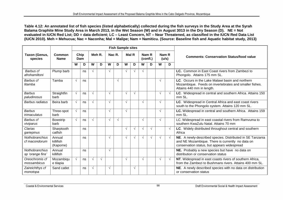
Draft Environmental Impact Assessment of the Proposed Balama Graphite Mine in the Cabo Delgado Province, Mozambique
Coastal & Environmental Services Draft Environmental Social & Health Impact Assessment 98
Table 4.12: An annotated list of fish species (listed alphabetically) collected during the fish surveys in the Study Area at the Syrah Balama Graphite Mine Study Area in March 2013, in the Wet Season (W) and in August 3013 in the Dry Season (D). NE = Not evaluated in IUCN Red List; DD = data deficient; LC – Least Concern, NT – Near Threatened, as classified in the IUCN Red Data List (IUCN 2010). Meh = Mehucua; Nac = Naconha; Mal = Malipe; Nam = Namiticu. (Source: Baseline fish and Aquatic habitat study, 2013)
Taxon (Genus, species
Common Name
Fish Sample sites
Comments: Conservation Status/food value Chip Dam
Meh R. Nac R. Mal R Nam R (confl.)
Nam R (u/s)
W D W D W D W D W D W D
Barbus cf afrohamiltoni
Plump barb ns √ √ √ √ √ LC. Common in East Coast rivers from Zambezi to Phongolo. Attains 175 mm SL.
Barbus cf litamba
Tamba √ ns √ √ LC. Occurs in the Lake Malawi basin and northern Mozambique. Feeds on invertebrates and smaller fishes. Attains 440 mm in length.
Barbus paludinosus
Straightfin barb
√ ns √ √ √ √ √ √ LC. Widespread in central and southern Africa. Attains 150 mm SL.
Barbus radiatus Beira barb √ ns √ √ √ √ √ LC. Widespread in Central Africa and east coast rivers south to the Phongolo system. Attains 120 mm SL.
Barbus trimaculatus
Three-spot barb
√ ns √ √ √ LC. Widespread in central and southern Africa. Attains 159 mm SL.
Barbus cf viviparus
Bowstrip barb
√ ns √ √ √ √ √ LC. Widespread in east coastal rivers from Ramvuma to southern KwaZulu Natal. Attains 70 mm
Clarias gariepinus
Sharptooth catfish
ns √ √ √ √ √ LC. Widely distributed throughout central and southern Africa
Nothobranchius cf macondorum
Annual killifish (Kapome)
ns √ √ √ √ √ √ √ NE. A newly-described species. Distributed in SE Tanzania and NE Mozambique. There is currently no data on conservation status, but appears widespread
Nothobranchius sp „orange fins‟
Annual killifish
ns √ NE. Probably a new species but have no data on distribution or conservation status
Oreochromis cf mossambicus
Mozambique tilapia
√ ns √ √ √ √ √ √ NT. Widespread in east coasts rivers of southern Africa, from the Zambezi to Bushmans rivers. Attains 400 mm SL.
Zaireichthys cf monotopa
Sand catlet ns √ √ √ NE. A newly described species with no data on distribution or conservation status

Draft Environmental Impact Assessment of the Proposed Balama Graphite Mine in the Cabo Delgado Province, Mozambique
Coastal & Environmental Services Draft Environmental Social & Health Impact Assessment 99
4.3.4 Spatial Planning Tools
Spatial planning tools are used to determine ecologically sensitive and ecologically important areas and thereby guide decision makers. Tools such as determining Critical Biodiversity Areas and biodiversity mapping are now available in many countries. However, since very few of these tools currently exist for Mozambique, the following international planning tools were consulted: WWF Eco regions The World Wildlife Fund (WWF) has defined global eco regions based on geographically distinct assemblages of species, natural communities and environmental conditions. Information on each eco region and its conservation status are provided to assist with the continued conservation of these areas. The project area falls into the Central and Eastern Miombo Woodlands Eco region as defined by WWF (Figure 4.14). This is a widespread eco region covering much of central and southern Africa. It is characterised by high species diversity and is dominated by a woody component whose dynamics can be attributed to three interacting disturbances: people, fire and wildlife. Anthropogenic activities such as clearing for agriculture, harvesting and burning have resulted in the modification or transformation of this ecosystem in many areas. Population growth therefore poses a threat to this Eco Region and it has consequently been listed as Vulnerable.

Proposed Balama Graphite Mine in the Cabo Delgado Province, Mozambique
Coastal & Environmental Services Draft Environmental Social & Health Impact Assessment 100
Figure 4.14: WWF Eco Regions surrounding the site (Source: Vegetation Assessment, 2013)
Proposed Balama Graphite Mine in the Cabo Delgado Province, Mozambique
Coastal & Environmental Services Draft Environmental Social & Health Impact Assessment 101
Protected Areas Current conservation legislation was drawn up by the colonial administration prior to 1977 and is in the process of being rewritten. The existing legislation makes provision for the creation of protected areas under six categories: National Park, Game Reserve, Partial Reserve, Faunal Reserve, Hunting and Photographic Safari Area and Forest Reserve. Management of protected areas petered out during the civil war. By 1992, all designated protected areas were unstaffed, without infrastructure and effectively unprotected. However, rehabilitation of the protected areas is gradually being implemented. This is reflected in the statistic that between 1995 and 2008 protected area coverage increased from 11% to 16% with new conservation areas being created (MICOA, 2009). Examination of these protected areas in relation to the project site revealed that no National Parks occur in close proximity to the project area (Figure 4.15). The closest protected area (Quirimbas), designated as a National Park, occurs 85 km north-east of the project site. The project site also occurs approximately 126 km north-west of a Hunting reserve, The Bloco C Luwiri, and between 92 km and 177 km from the three closest forest reserves, The Mecuburi Forest Reserve, The Mapalue Forest Reserve and the Ribaue Forest Reserve.

Draft Environmental Impact Assessment of the Proposed Balama Graphite Mine in the Cabo Delgado Province, Mozambique
Coastal & Environmental Services Draft Environmental Social & Health Impact Assessment 102
Figure 4.15: The protected areas surrounding the project site (Source: Vegetation Assessment, 2013)

Draft Environmental Impact Assessment of the Proposed Balama Graphite Mine in the Cabo Delgado Province, Mozambique
Coastal & Environmental Services Draft Environmental Social & Health Impact Assessment 103
4.3.5 Land use
Mozambique has a relatively rich natural resource base including untransformed indigenous forests, savannah woodlands and coastal habitats. About 25% of the land has commercial forestry potential, 12.5% constitutes state-protected areas and a further 22% comprises potential wildlife habitat (GPZ, 2003). Land use in the study area is primarily for subsistence agriculture (Plate 4.9). Crops such as maize, cotton and cassava are grown on the flat areas which are cleared using slash and burn techniques (Plate 4.10). Some small unit livestock is reared in the area, although these animals were only noted near the villages and are not abundant in the project site. Almost all households are heavily reliant on the natural resources for their livelihoods. Natural resources are used for construction, medicinal consumption and to supplement their food. Charcoal production was also evident in the project site (Plate 4.11).
Plate 4.9: A) Ground nuts planted around a homestead; B) Maize intercropped with ground nuts; C) A maize food garden; D) Large machambas planted with maize in the background and to the right; and E) A small grain storage structure (Source: Social Impact Assessment, 2013)

Proposed Balama Graphite Mine in the Cabo Delgado Province, Mozambique
Coastal & Environmental Services Draft Environmental Social & Health Impact Assessment 104
Plate 4.10: Recently burned field at the Project site (Source: Vegetation Assessment, 2013)
Plate 4.11: Trees and shrubs are used for charcoal production in the study area

Draft Environmental Impact Assessment of the Proposed Balama Graphite Mine in the Cabo Delgado Province, Mozambique
Coastal & Environmental Services Draft Environmental Social & Health Impact Assessment 105
5. DESCRIPTION OF THE SOCIAL ENVIRONMENT
5.1 A Demographic overview of the Project-Affected Communities
The proposed project is encircled by four villages which are considered to be the direct Project-Affected Communities (PACs). These are Ntete, Nquide, Pirira and Mualia (formerly known as Maputo). The land and households of these communities seem to be privately controlled by individual families under the jurisdiction of the traditional Macua Tribe. Land is primarily held by the Government of Mozambique (GoM), which also legally recognises the role of customary tenure systems. In the rural areas, although land ultimately belongs to the state, the area is controlled by the chiefs and elders who regulate the land under the custodianship of the Macua Tribe. The tribe does not seem to have legal title to, or a certificate for, the land. The villages are relatively large. The largest village is Ntete (with approximately 4 525 people), whilst the smallest one is Pirira (around 285 people). Considering the number of households, the village of Ntete has around 963 households, whereas few households have been recorded in Pirira (61). The average household size is approximately 4.4 members per household. The total population of all these villages combined is estimated at 11 048 people. The latest census of the Government of Mozambique (GoM, 2007) estimates the population of the Balama District at 124 100 people, which means that these four villages represent approximately 10% of the entire district‘s population. Females out-number males slightly in most villages, with the exception of Nquide where women represent just less than 50% of the village‘s gender make-up. Generally, with an average village male-to-female ratio of around 1:1, the data is similar to the male-to-female ratio for the district (ibid.). Based upon data gathered by CES as part of a Socio-Economic Baseline Survey (SEBS) of these communities, undertaken in March 2013, the estimated population of each village, the number of households in each, as well as each village‘s male-to-female ratio was determined (Table 5.1). Table 5.1: Direct Project-Affected Community Demographics
Village Estimated Population
Nr of Households Male-to-Female
Ratio
Ntete 4,525 963 1:1.73
Nquide 2,543 541 1:0.97
Pirira 285 61 1:1.01
Maputo (Mualia) 3,695 786 1:1.19
TOTAL 11,048 2351 1:1.0 (average)
The largest majority (56.5%) of the four villages‘ members seem to be 18 years or younger. About 29.3% of the population are of school-going age (between seven and eighteen years old). As expected, very few members are above 90 years, while the largest number of people falling into the working-age bracket of 19 to 65 years (40.5%). This means that employment opportunities are needed to sustain a large working-age group, as well as a significant youth population. Table 5.2 below provides an age profile of the PAC members.