proposed energy from waste facility and non hazardous landfill at
TRANSCRIPT

Proposed Energy from Waste Facility and Non Hazardous Landfill at New England Quarry, Ivybridge
Scoping Report
Viridor Waste Management
March 2009SLR Ref: 402.0036.00350

Viridor Waste Management i 402.0036.00350 Planning Scoping Report March 2009
SLR
CONTENTS 1.0 INTRODUCTION............................................................................................................ 1
1.1 South West Devon Waste Partnership ............................................................. 1 1.2 Viridor Waste Management ............................................................................... 1
2.0 ENERGY FROM WASTE .............................................................................................. 3 2.1 Advantages of Energy from Waste................................................................... 3 2.2 Background to Energy from Waste .................................................................. 3 2.3 Why use EfW to treat Residual Waste?............................................................ 3
3.0 ENVIRONMENTAL IMPACT ASSESSMENT ............................................................... 5 3.1 Scoping Exercise ............................................................................................... 5 3.2 Planning and Pollution Control......................................................................... 6
4.0 SITE DESCRIPTION AND SURROUNDING AREA ..................................................... 7 5.0 DESCRIPTION OF DEVELOPMENT ............................................................................ 9
5.1 Operation of Energy from Waste Facility ....................................................... 10 5.2 Waste Reception .............................................................................................. 10 5.3 Waste Combustion........................................................................................... 11 5.4 Energy Recovery .............................................................................................. 11 5.5 Air Pollution Control (APC) ............................................................................. 11 5.6 Incinerator Bottom Ash Recycling.................................................................. 11 5.7 Non Hazardous Landfill ................................................................................... 12 5.8 Proposed Access Road ................................................................................... 12 5.9 Hours of Operation........................................................................................... 12 5.10 Employment...................................................................................................... 12
6.0 POTENTIAL ENVIRONMENTAL IMPACTS AND SCOPE OF THE EIA.................... 13 6.1 Introduction ...................................................................................................... 13 6.2 Traffic ................................................................................................................ 14 6.3 Noise.................................................................................................................. 16 6.4 Air Quality ......................................................................................................... 16 6.5 Human Health ................................................................................................... 18 6.6 Water ................................................................................................................. 19 6.7 Ecology ............................................................................................................. 22 6.8 Landscape......................................................................................................... 25 6.9 Cultural Heritage .............................................................................................. 29 6.10 Climate Change ................................................................................................ 29 6.11 BREEAM Assessment...................................................................................... 30 6.12 Heat Plan ........................................................................................................... 30 6.13 Sustainability Assessment.............................................................................. 30 6.14 Alternative Technologies/Sites/Need ............................................................. 31 6.15 Need 34
7.0 KEY PLANNING POLICY............................................................................................ 35 7.1 International Policies ....................................................................................... 35 7.2 National Policies............................................................................................... 35 7.3 Regional Policies.............................................................................................. 36 7.4 Local Policies ................................................................................................... 36
8.0 SUMMARY................................................................................................................... 37
APPENDICES Appendix 1 Associated Drawings

Viridor Waste Management ii 402.0036.00350 Planning Scoping Report March 2009
SLR
DRAWINGS
• DWG.402.0036.00350.18.NE1 Site Location Plan • DWG.402.0036.00350.18.NE2 Site Boundary Plan • DWG.402.0036.00350.18.NE3 Potential Access Road

Viridor Waste Management 1 402.0036.00350 Planning Scoping Report March 2009
SLR
1.0 INTRODUCTION
Viridor Waste Management (Viridor) has commissioned SLR Consulting Ltd (SLR) to produce a scoping report for the proposed development of an Energy from Waste Facility (EfW) with bottom ash recycling and landfill at New England Quarry, near Ivybridge in Devon.
The proposed development will include a 275,000 tonnes per annum (tpa) EfW and non hazardous landfill facility within the quarry void together with associated office and visitor centre facilities. A new access road linking into the A38 at Lee Mill is also proposed.
This report provides an overview of the site, the development proposals, the intended scope of the environmental impact assessments and policy context which are relevant to the proposed development in this location.
It will be used to seek a formal scoping opinion from the Waste Planning Authority (Devon County Council) on the proposed Environmental Impact Assessment (EIA) which will accompany the planning application for the proposed development. The scoping opinion will confirm the scope of the Environmental Statement and will define what the planning application should cover.
1.1 South West Devon Waste Partnership
The proposed EfW is designed to meet the needs of the South West Devon Waste Partnership (the Partnership), which is made up of the following three Authorities: Plymouth City Council (PCC), Torbay Council (TC) and Devon County Council (DCC). The Partnership has now formally agreed to procure a shared solution to their future residual waste disposal needs, with the likely solution being a facility within or near to Plymouth.
The Outline Business Case (OBC) for the Partnership is based on the provision of a 225,000 tpa EfW, along with improved waste minimisation, recycling and composting such that the Partnership achieves a combined recycling rate which exceeds 50% by 2020. The OBC identifies that there are two potential sites within Plymouth allocated within their Waste Development Plan Document and that there is New England Quarry, just outside the city boundary, which is allocated within the Devon Waste Local Plan.
The proposed landfill will accept waste delivered to the EfW that cannot be processed by the EfW, for example bulky household waste and residual HWRC waste, and bottom ash from the EfW that cannot be recycled or sold in to the local aggregates market. This will remove the need to export non-processable material from the site and will not generate additional traffic movements as the landfill will only receive materials already being delivered to the site or being produced on site. Inputs are estimated at 40,000 tpa, which will ensure that the landfill is available for the proposed contract life of the EfW.
The proposed development at New England is therefore focussed on providing a local solution to the future residual waste management needs of the Partnership at a site which is allocated for these purposes in an adopted Waste Local Plan.
1.2 Viridor Waste Management
Viridor Waste Management Limited is owned by the Pennon Group, is part of a major PLC that is focused on the water and waste management industries. Viridor is one of the UK’s leading waste management companies that operate 25 regional landfill sites, numerous regional recycling facilities and over 189 waste processing sites throughout the United

Viridor Waste Management 2 402.0036.00350 Planning Scoping Report March 2009
SLR
Kingdom. The company is at the forefront of high quality environmental performance and over 100 of its operational centres are accredited to the ISO14001 Environmental Management System, the highest recognised industry standard.
Waste Management services offered by Viridor include:
• Material Recycling Facilities (MRF); • Bulking and Transfer Stations; • Material collection; • Glass reprocessing; • Composting (Window and In-Vessel); • Waste Treatment; • Transportation; • Household Waste Recycling Centres (HWRC); • Product destruction/recovery; • Residual waste disposal; • Landfill Gas Utilisation; and • Energy from Waste (EfW)

Viridor Waste Management 3 402.0036.00350 Planning Scoping Report March 2009
SLR
2.0 ENERGY FROM WASTE
2.1 Advantages of Energy from Waste
Energy from Waste (EfW) is the process of recovering energy from waste to generate heat and electricity in a combined heat and power station.
The proposal for Energy from Waste Facility at New England has the potential to make a fundamental contribution to waste management in the Partnership area. The introduction of an EfW is considered to have the following benefits associated with it:
• move away from the reliance of waste being sent to landfill as the means of disposing of waste and towards a solution by which residual waste (i.e. pre-sorted waste) is effectively and efficiently dealt with by means of a modern and proven industrial combustion process;
• the process will generate significant amounts of energy which will be exported to the National Grid and will be available for local uses;
• has a lower carbon footprint than many other disposal technologies; • safe and sustainable alternative to landfill for waste generated within the area; and • up to 35 permanent jobs plus further contract/temporary employment.
2.2 Background to Energy from Waste
The UK has traditionally relied on landfill for waste disposal, in contrast to many European countries. However, current national and European targets require increased recycling and recovery of materials, and diverting wastes from landfill. An escalating tax on landfill disposal also makes this practice increasingly expensive.
Devon County Council (independently) has to meet strict targets to reduce the amount of waste sent to landfill. To ensure that there is a safe and sustainable alternative for disposal of waste, the Council is currently deciding on alternative technologies and methods of treatment. As noted above DCC have decided to enter into a partnership with two other authorities to procure waste facilities within the south-western part of Devon, these facilities will assist Devon to meet these targets.
After a thorough review of available and robust technologies, Viridor has selected Energy from Waste as the best way of recovering value from residual waste and diverting it away from landfill. This will work alongside the Council’s current and upcoming initiatives to increase recycling and prevent waste.
2.3 Why use EfW to treat Residual Waste?
EfW facilities are used successfully to reduce the volume of waste and recover energy. There are already 20 facilities operational in the UK and many more across Europe.
EfW technology is proven, safe and robust. Viridor assessed all practical solutions before identifying EfW as the best technology for Devon and the Partnership over the next 25 to 30 years.
Waste will be treated by thermal processes (ie burnt) with the energy produced being recovered for the use in generating electricity, rather than burying it in a landfill site. This helps prevent the use of fossil fuels for electricity production and its associated carbon emissions.

Viridor Waste Management 4 402.0036.00350 Planning Scoping Report March 2009
SLR
It is estimated that the proposal would create around 20 Megawatts of installed electricity capacity and generate 150,000 MWh a year to power the facility and for the National Grid. There is also the possibility of supplying heat to local uses over the lifetime of the contract, which will improve resource efficiency and reduce the requirement for oil and natural gas.

Viridor Waste Management 5 402.0036.00350 Planning Scoping Report March 2009
SLR
3.0 ENVIRONMENTAL IMPACT ASSESSMENT
For any significant developments it is important to establish if an Environmental Impact Assessment is required at the outset. Te Town and Country Planning (Environmental Impact Assessment) (England and Wales) Regulations 1999, as amended by the Town and Country Planning (Environmental Impact Assessment) (England and Wales) (Amendment) Regulations 2000, (hereafter jointly referred to as the EIA Regulations) implement Council Directive No 85/337/EEC (as amended) on the assessment of the potential effects of specified development proposals on the environment. Prior to the granting of a planning permission in respect of any proposal to which the EIA Regulations apply an Environmental Impact Assessment (EIA) is required. Responsibility for compiling information regarding environmental effects lies with the developer, and the information is presented as an ‘Environmental Statement’.
The EIA Regulations specify the types of development for which an EIA is mandatory (Schedule 1 Projects) and categories of development where an EIA may be required (Schedule 2 Projects). In connection with the proposal at the New England Quarry site, it is considered to be a Schedule 1 development: “waste disposal installations for the incineration…of non-hazardous waste with a capacity exceeding 100 tonnes per day”. (Category 10).
In light of the above, Viridor has commissioned SLR Consulting Ltd to prepare an Environmental Statement to accompany the planning application currently being prepared.
SLR is a multi-disciplinary environmental consultant to, amongst others, the minerals and waste management industries and also provides advice to local authorities and the Environmental Agency on strategic issues. SLR is a registered Environmental Impact Assessor Member of the Institute of Environmental Management and Assessment (IEMA).
3.1 Scoping Exercise
Having established that an Environmental Statement is required to be prepared to accompany the proposed scheme, the Town and Country Planning (Environmental Impact Assessment) (England and Wales) Regulations 1999 (EIA Regulations) stipulate that the Applicant (Viridor Waste Management Ltd) may make a request for a formal Scoping Opinion (Part IV Regulation 10).
This report therefore forms Viridor’s written request to the Local Planning Authority, Devon County Council, under Regulation 10 of the EIA Regulations, for its opinion as to the information to be provided in the Environmental Statement.
Regulation 10 (1) of the EIA Regulations provides for a developer to obtain a formal ‘Scoping Opinion’ from the relevant Planning Authority on the topics that should be focused upon in the Environmental Statement (ES) prior to embarking on an EIA. Referring to Regulation 10 (2), requests for Scoping Opinions should be accompanied by: procurement
(a) a plan sufficient to identify the land;
(b) a brief description of the nature and purpose of the development and of its possible effects on the environment; and
(c) such other information or representations as the person making the request may wish to provide or make”

Viridor Waste Management 6 402.0036.00350 Planning Scoping Report March 2009
SLR
The three main purposes of the Scoping exercise are considered to be:
1. to focus the EIA on the environmental issues and potential impacts which need the most thought and attention;
2. to provide a means to discuss methods of impact assessment and reach agreement on the most appropriate way forward; and
3. to identify those which are unlikely to need detailed study.
The following sections are intended to provide Devon County Council and the relevant consultees with the information necessary to come to an opinion on the issues that should be addressed in the ES. The value of the statutory consultees in inputting to the Scoping Opinion is recognised by Viridor and SLR and both parties would be pleased to discuss any aspect of the proposed scheme with any organisation.
It is anticipated that the Scoping Opinion will focus on the key issues to be addressed in the EIA process. Whilst the EIA Regulations require all environmental considerations to be addressed, it is important to clearly identify the main environmental issues which allows for a more detailed and targeted assessment to be carried out in this respect.
The completed Environmental Statement will be submitted as part of the planning application.
3.2 Planning and Pollution Control
Once constructed the EfW and landfill at New England Quarry will need to operate under an Environmental Permit (EP). However, this can only be issued after planning permission has been granted. In addition to commissioning an EIA and submitting the requisite Environmental Statement, an application for an EP in respect of New England Quarry will be prepared in parallel with the planning application. This ensures that there is consistency between the data gathering and assessment stages of both planning and permitting regimes during the design exercise and the preparation of documents.

Viridor Waste Management 7 402.0036.00350 Planning Scoping Report March 2009
SLR
4.0 SITE DESCRIPTION AND SURROUNDING AREA
New England Quarry is located at National Grid reference 2595 0548 within the County of Devon (See Appendix 1 and 2). The site is located approximately 1km to the south of Lee Mill and approximately 3km to the south west of Ivybridge. The site is located within 1km of the A38 Trunk Road, the principal route between Plymouth and Exeter.
The Waste Planning Authority (WPA) for the Site is Devon County Council.
The site is a worked out stone quarry, of approximately 20 ha, with an existing access located to the south of the site on New England Hill, an unclassified rural lane.
The site is located within a landscape of predominately pastoral farmland and hedgerow networks with occasional small broadleaved woodlands. The River Yealm forms a wooded river corridor which runs north to south along the eastern side of the site, with further contiguous areas of broadleaved woodland lying to the north and south of the site, while land to the west is comprised of predominately pasture with a mature hedgerow network.
The site itself comprises an old quarry void with water-bodies present in its base surrounded by terraced areas which have become colonised by grasses and also support some rock outcrops. A number of sheds and small buildings are present in the plant area in the south eastern corner of the site. The quarry void is bounded by broadleaved woodland to the north, south and east, where the River Yealm flows. Land to the west of the quarry void is comprised of improved grassland fields bounded by mature hedgerows.
The north eastern corner of the site and much of the woodland to the north, south and east has been designated as Mackarell Parks, Southwood Woods and Strashleigh Ham County Wildlife Site (CWS) for the presence of ancient semi-natural woodland. The north western corner of the site has also been designated as New England Fields CWS for the presence of marshy grassland habitats. Much of the quarry void has also been designated as a Regionally Important Geological and Geomorphological Site (RIGS) due to the presence of gabbro intrusion into middle Devonian slate. Several other non-statutory wildlife sites are present within 2km of the site boundary; these are predominately ancient woodland and neutral grassland sites.
The site is within a mineral consultation area and partially within and adjacent to the floodplain of the River Yealm. Areas containing archaeological features have been identified to the north and east of the site but would not be directly affected by the proposals.
Planning permission was granted in 1993 for the importation of quarry and processed stone waste from Moorcroft Quarry in Plymstock but no material has been imported in recent years. Revised conditions were imposed in 1999 under the Review of Old Minerals Permissions legislation.
The site is identified in policy WPP1 of the Devon Waste Local Plan as a site for strategic waste management facilities with potential for the following developments:
• Inert waste recycling; • Materials recycling facility • Waste transfer station • Green waste composting; • Mixed waste composting; • Mechanical biological treatment/biological mechanical treatment; • Energy from Waste;

Viridor Waste Management 8 402.0036.00350 Planning Scoping Report March 2009
SLR
• Non hazardous landfill; and • Landfill gas collection.

Viridor Waste Management 9 402.0036.00350 Planning Scoping Report March 2009
SLR
5.0 DESCRIPTION OF DEVELOPMENT
The development will be a comprehensive scheme for the New England site to establish it as a strategic waste management facility for dealing with residual municipal waste from South West Devon, Plymouth and Torbay. The development will consist of the following:
• 275,000 tonnes per annum (tpa) Energy from Waste facility (including ancillary offices, welfare and parking facilities);
• visitor centre to the EfW; • non hazardous landfill; • new access road linking in to the A38 at Lee Mill; and • 62,500 tpa incinerator bottom ash (IBA) treatment and recycling facility.
Auxiliary and support infrastructure which, in addition to the process plant, make up the EfW facility include:-
• weighbridge: for monitoring and recording all wastes coming onto and leaving the site; • workshops; • bridge crossing over River Yealm; • transformer house: contains the metres, circuit breakers and step-up transformers
necessary to export electricity; and
• storage bays: for APCR’s and IBA skips and containers awaiting collection plus empty skips.
All waste will be transported by road and imports would comprise a range of vehicle types including direct delivery by refuse collection vehicles (RCV) and articulated bulk imports from waste transfer facilities.
It is anticipated that the EfW will receive approximately 275,000 tonnes of waste per annum. Assuming a roughly even split of RCV / bulk deliveries, it is estimated that the development will generate around 73 HGV trips a day (146 two-way movements); this figure is based on an average of 8 tonne loads for RCVs, 20 tonne loads for bulk imports and a 5 ½ day working week. Waste imports are likely to be evenly spread throughout the day and will not peak in line with traffic on the surrounding road network.
Assuming that all bottom ash could be recycled and sold in to the local aggregates market will generate an additional 12 HGV trips (24 two way movements) based on an average of 20 tonne loads and a 5 ½ day working week. However it is not anticipated that all this material could be re-used so actual movements are likely to be lower.
The proposed landfill will accept waste delivered to the EfW that cannot be processed by the EfW, for example bulky household waste and residual HWRC waste, and bottom ash from the EfW that cannot be recycled or sold in to the local aggregates market. This will remove the need to export non-processable material from the site and will not generate additional traffic movements as the landfill will only receive materials either already being delivered to the site or being produced on site.
The development will generate negligible light vehicle movements.
Preparatory works would include the establishment of the new access road/access improvements, office and plant area.
Viridor Waste Management 10 402.0036.00350 Planning Scoping Report March 2009
SLR
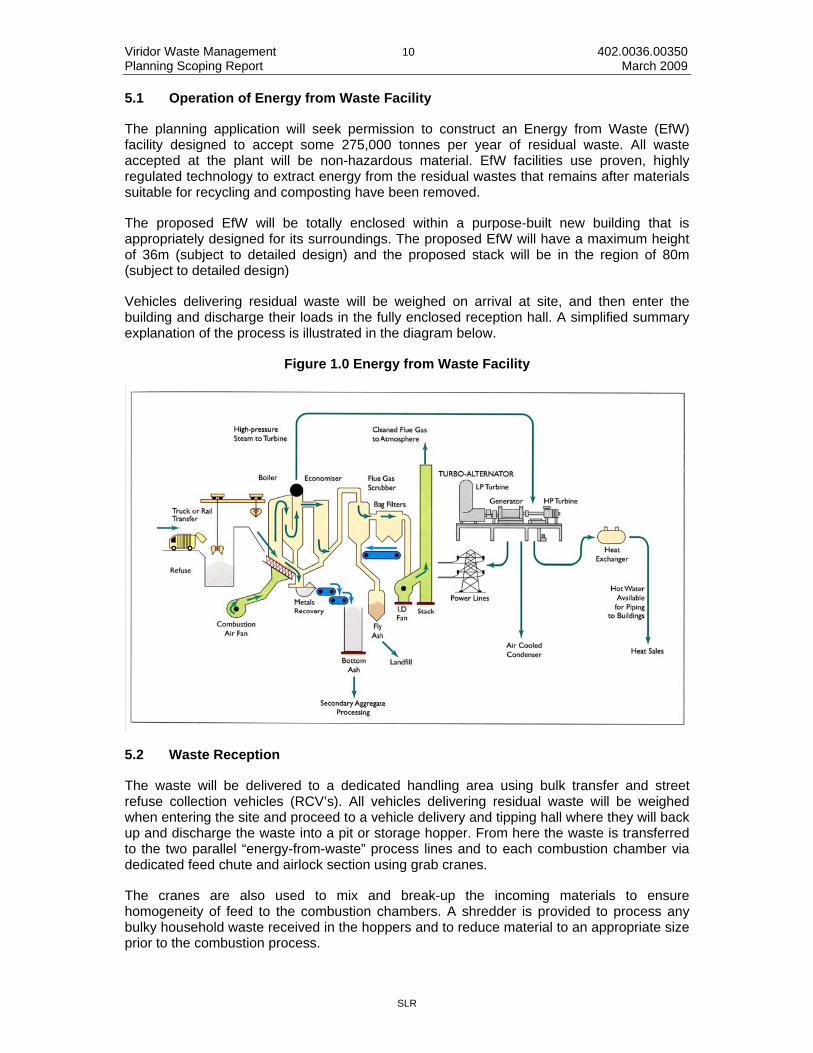
5.1 Operation of Energy from Waste Facility
The planning application will seek permission to construct an Energy from Waste (EfW) facility designed to accept some 275,000 tonnes per year of residual waste. All waste accepted at the plant will be non-hazardous material. EfW facilities use proven, highly regulated technology to extract energy from the residual wastes that remains after materials suitable for recycling and composting have been removed.
The proposed EfW will be totally enclosed within a purpose-built new building that is appropriately designed for its surroundings. The proposed EfW will have a maximum height of 36m (subject to detailed design) and the proposed stack will be in the region of 80m (subject to detailed design)
Vehicles delivering residual waste will be weighed on arrival at site, and then enter the building and discharge their loads in the fully enclosed reception hall. A simplified summary explanation of the process is illustrated in the diagram below.
Figure 1.0 Energy from Waste Facility
5.2 Waste Reception
The waste will be delivered to a dedicated handling area using bulk transfer and street refuse collection vehicles (RCV’s). All vehicles delivering residual waste will be weighed when entering the site and proceed to a vehicle delivery and tipping hall where they will back up and discharge the waste into a pit or storage hopper. From here the waste is transferred to the two parallel “energy-from-waste” process lines and to each combustion chamber via dedicated feed chute and airlock section using grab cranes.
The cranes are also used to mix and break-up the incoming materials to ensure homogeneity of feed to the combustion chambers. A shredder is provided to process any bulky household waste received in the hoppers and to reduce material to an appropriate size prior to the combustion process.

Viridor Waste Management 11 402.0036.00350 Planning Scoping Report March 2009
SLR
Air is extracted from the waste reception hall and used as waste combustion air which helps control odours arising in this area. The reception area is enclosed with access doors and air louvers to manage traffic and control air movements;
5.3 Waste Combustion
Combustion takes place in two stages, with primary combustion undertaken on a moving mechanical grate to promote the mixing of burning/unburnt wastes. There are four generic types of moving grate; reciprocating, counter reciprocating, roller and oscillating, each with particular advantages/disadvantages associated with the degree of pre-preparation of waste required prior to combustion and the scale of the waste throughput. The combustion gas from the primary stage will be heated in the secondary combustion chamber to reach its specified temperature (850 degrees for a minimum of two seconds). Afterwards the residue from primary combustion on the moving grate is removed as incinerator bottom ash (IBA).
5.4 Energy Recovery
The heat from combustion of the waste is recovered initially to form steam and ultimately as electrical energy at approximately 20 megawatts. The heat that is produced is recovered within a waste boiler to form high pressure steam, which is used to drive turbines to generate electricity. A proportion of this site generated energy would be used within the facility itself, but the majority would be exported to the National Grid.
The design of the heat recovery boiler is particularly suited to waste combustion and incorporates facilities to minimise dust carry-over and for online cleaning through rapping systems and soot blowers to minimise maintenance impacts. Dust collected from the boilers is discharged as fly ash and collected with the flue gas treatment residues.
The power generation and auxiliary equipment include turbine/generator sets, air condensers and a facility with the potential to extract further value from the partially cooled steam or hot water after it has been through the turbines. This could be used to provide heating or process heat for homes and businesses within a reasonable proximity to the site. Viridor will undertake a technical feasibility study for this element of the scheme in order to substantiate where economically efficient end use of this heat may currently exist as part of this application.
5.5 Air Pollution Control (APC)
Air pollution control is an essential element of any modern incinerator in order to meet the stringent requirements of EU Directive 2000/76/EC, (known as the Waste Incineration Directive or WID). APC Residues are classified as hazardous waste and will be collected within sealed silos and taken off site for disposal at a suitably licensed facility. Quantities will be in the region of 3 to 5% of annual throughput.
5.6 Incinerator Bottom Ash Recycling
It is proposed that Incinerator Bottom Ash will be treated and recycled to produce aggregate material at an on site plant adjoining the EfW. At full capacity it is estimated that the plant will produce approximately 62,500 tpa of recycled aggregate for the local market.
This will require the installation of mobile washing and screening plant and stockpile areas.

Viridor Waste Management 12 402.0036.00350 Planning Scoping Report March 2009
SLR
5.7 Non Hazardous Landfill
It is proposed to construct and operate a non hazardous landfill at the site. This will require the engineering of the existing quarry void to provide adequate containment in accordance with the requirements of the Environment Agency.
The development will comprise:
• the infilling, excavation and engineering of the existing quarry void to enable the disposal of non hazardous waste;
• the construction of an internal site access road; • on site leachate treatment and gas management plant; and • provision of site office, welfare, weighbridge and parking facilities
The proposed landfill will accept waste delivered to the EfW that cannot be processed by the EfW, for example bulky household waste and residual HWRC waste, and bottom ash from the EfW that cannot be recycled or sold in to the local aggregates market. This will remove the need to export non-processable material from the site and will not generate additional traffic movements as the landfill will only receive materials already being delivered to the site or being produced on site.
Landfill inputs are estimated at 40,000 tpa, which will ensure that the landfill is available for the proposed contract life of the EfW.
5.8 Proposed Access Road
It is proposed to install a dedicated new access road to serve the proposed development which will join the A38 at Lee Mill. Part of the road will make use of an existing private road to the Strashleigh tip, which was historically used for the disposal of inert waste and more recently for recycling soil and demolition waste. From there it is proposed that the access road follows the western edge of the tip and thereafter the route enters the woodland and turns west to cross the River Yealm before continuing on to connect into the former stocking area of the quarry where it is proposed that the EfW will be located, see Appendix 3.
5.9 Hours of Operation
The EfW process will be a continual one but it is proposed that waste will be delivered to the site during daytime hours only.
0700 to 1900 hours Monday to Friday; and
0700 to 1300 hours on Saturdays
5.10 Employment
The proposed EfW development will employ an estimated 35 full time equivalents and the proposed landfill an additional 5 full time equivalents.

Viridor Waste Management 13 402.0036.00350 Planning Scoping Report March 2009
SLR
6.0 POTENTIAL ENVIRONMENTAL IMPACTS AND SCOPE OF THE EIA
6.1 Introduction
This section outlines some of the potential environmental impacts and considerations of the proposed development and considers the scope of the EIA required to accompany the proposed planning application.
This section is intended to provided Devon County Council and relevant consultees with a breakdown of the various different environmental impacts which need to be addressed in the Environmental Impact Assessment, and the scope of their consideration.
The range of information proposed for each topic is based on the experience of Viridor in proposing and operating schemes of similar nature; the technical knowledge of SLR in relation to Energy from Waste and landfill facilities and a joint understanding of the regulatory system and the issues associated with the site and the surrounding area.
The extent of each particular issue is defined in respect of the recognition of each element of the development that subsequently could lead to different impacts, the manner in which the impact could manifest itself and the scope for allowing the EIA process.
Regulation 2 (1) specifies that an Environmental Statement is a statement “ which includes such information referred to in part 1 of Schedule 4 as is reasonably required to assess the environmental effects of the development…” The information described in Schedule 4 includes at paragraph 3 to Part 1 the following requirement:
“A description of the aspects of the environment likely to be significantly affected by the development, including, in particular, population, fauna, flora, soil, water, air, climate factors, material assets, including the architectural and archaeological heritage, landscape and inter-relationship between the above factors”
This scoping report identifies a range of potential environmental issues, which may be: temporary or permanent; direct or indirect; and positive or negative.
6.1.1 Temporary/Permanent Effects
The potential for effects to occur is dependent on the two key periods associated with the development: the potential disturbance as a result of the construction period; and the longer term influence of the proposed development.
6.1.2 Direct/Indirect Effects
The proposed development could have indirect effects upon nearby properties and settlements, together with the environment as a whole in relation to issues such as air quality, noise and the changing appearance of the site. Direct impacts would most likely be centred around landscape, ecology, traffic and hydrogeology and hydrology issues.
6.1.3 Positive/Negative
The proposed development has the potential to generate benefits as well as negative effects. These benefits might include the reduction of volumes of waste that would otherwise be disposed of to landfill, the potential to generate energy from waste as opposed to by means of burning fossil fuels; the effective use of otherwise vacant land, and the potential socio-economic benefits of the development.
Viridor Waste Management 14 402.0036.00350 Planning Scoping Report March 2009
SLR
Having considered the above issues, and taking into account the guidance contained in the DTLR publication “Environmental Impact Assessment: A Guide to Procedures” the potential environmental effects resulting from the proposed development have been identified below along with intended assessment methodologies.
SLR considers the following potential environmental impacts below to be of significance in relation to the New England Quarry site and the proposed development.
6.2 Traffic
The impacts of the proposed development with regard to Transportation and Highways will be considered within a Transport Assessment, which will form part of the Environmental Statement. This section proposes which of the potential impacts will be assessed in full within the Transport Assessment. The aim of this scoping report is to ensure that each of the issues is addressed in appropriate detail given the nature, location and scale of the development proposals.
The Transport Assessment will be prepared in accordance with the Guidance on Transport Assessment (Department for Transport, 2007). The assessment of environmental impact will be undertaken in accordance with the Guidelines for the Environmental Assessment of Road Traffic (Institute of Environmental Assessment, 1993). Due consideration would be given to relevant local planning guidance including the Devon Local Transport Plan, Devon Waste Local Plan and South Hams Local Plan.
The existing access routes from the site to the A38 predominantly comprise rural lanes which are not ideally suited for frequent heavy traffic. The Devon Waste Local Plan (2006) states that current access to the site is unsatisfactory and potential use as a waste management facility would be subject to appropriate improvements to the current access arrangements.
It is therefore proposed to provide a new haul road connecting New England Quarry to the A38 Lee Mill interchange. The haul road will join the public highway at a new junction located at the historic access to Strashleigh tip. The proposed access arrangements would allow full access from and to the westbound carriageway of the A38. Vehicles leaving or seeking to enter onto the eastbound carriageway of the A38 would be required to travel a short distance via the local road of the C194.
Part of the haul road will make use of an existing private road to the Strashleigh tip, which was historically used for the disposal of inert waste and more recently for recycling soil and demolition waste. Access to the tip was taken from a purpose built haul road which linked directly to the Lee Mill interchange. The proposed access location therefore has a historic use and no concerns regarding HGV turning movements at this location are known. No highways objections were raised in response to a planning application for extending Strashleigh tip, submitted in September 1998.
The proposed access scheme would be designed to the requirements of the highway authority / Highways Agency and an outline design would be submitted as part of the planning application.
6.2.1 Scope of Assessment
The study area for the Transport Assessment will be based upon the proposed access arrangements, discussed above. The large majority of vehicles generated by the proposed EfW would access the A38 at the Lee Mill interchange. The proposed landfill would be ancillary to the EfW such that only non hazardous residues from the process would be

Viridor Waste Management 15 402.0036.00350 Planning Scoping Report March 2009
SLR
deposited within it; no importation of waste would occur from external sources. A small number of local refuse collections and staff may use local routes for access to surrounding settlements such as Lee Mill, Cadleigh, and parts of Ivybridge. The study area will therefore comprise:
• the proposed haul road access; • the A38 Lee Mill interchange, entry and exit slips; • the proposed A38 eastbound exit slip / C194 priority junction; • the New Park Road / C194 junction; and • new Park Road through Lee Mill.
The Transport Assessment will additionally comprise:
• review of relevant national and local transport policy; • visual inspection of the existing highway network and access routes to / from the A38; • assessment of proposed trip generation and likely distribution on the surrounding
highway network;
• assessment of traffic redistribution due to new slip road; • quantitative assessment of material traffic increases on the A38 and access routes to
the A38;
• junction capacity assessments (as above); • assessment of most recent five years personal injury road accident data within the
defined study area;
• qualitative assessment of the environmental impacts caused by development traffic; and
• assessment of the development in the context of sustainable access for staff.
Appropriate traffic count data will be requested from the highway authority and Highways Agency; new traffic counts will be undertaken if appropriate data is not available.
The Guidance on Transport Assessment (DfT, 2007) recommends that the capacity of the local transport network be assessed for a period no less than five years after the date of registration of a planning application, which extends to ten years when considering the strategic road network. To provide a robust assessment of junction capacity, assessments will be undertaken for the proposed opening year 2013 and the +10 assessment year 2023. Baseline traffic levels will be calculated using National Traffic Model (NTM) growth rates attuned with TEMPRO local adjustment factors.
Recommendations will be made as to how the operation of the development proposals will be undertaken to minimise and mitigate the impact on the surrounding highway network. It is anticipated that the recommendations are likely include:
• HGV routing strategy; and • measures to prevent the deposition of waste on the public highway.

Viridor Waste Management 16 402.0036.00350 Planning Scoping Report March 2009
SLR
6.3 Noise
6.3.1 Scope of Assessment
An environmental noise survey will be carried out to establish the ambient noise levels at up to four of the noise-sensitive locations nearest the site during a representative mid-week period. The noise survey will cover daytime and night-time periods.
Measurements will be taken over four non-consecutive 15 minute periods during the daytime period and over two non-consecutive 15 minute periods during the night-time. The survey will be attended at all times by SLR staff to ensure that the measured noise levels are correctly attributed to the various sources in the area.
An assessment of the construction and operation of the proposed development will be carried out in accordance with national guidance and where appropriate, in accordance with any guidance stipulated by the local planning authority. The assessment will indicate whether the noise emission levels from the site are likely to generate complaints from the occupants of the closest noise-sensitive properties.
Vibration will be considered during the construction phase of the proposed development only as it is not anticipated that there would any significant vibration associated with the normal operation of the EfW or landfill.
Where necessary and feasible, mitigation measures will be outlined and any residual impacts identified.
6.4 Air Quality
6.4.1 Odours, bioaerosols and dust
The potential for the proposed EfW development to generate odours, bioaerosols and dust will be assessed qualitatively with reference to the location of sensitive receptors and the local climate. Each of these issues will be addressed in terms of the potential for release and the effectiveness of the designed in mitigation to demonstrate why impacts are not predicted to be significant at receptor locations (i.e. screened out).
The potential for the processing of incinerator bottom ash and landfilling of non hazardous waste to generate dust, odours and bioaerosols will also be assessed qualitatively in a similar manner.
6.4.2 Transportation emissions
The design proposal currently incorporates 146 HGV movements from the site onto local roads. Assessment of traffic emissions may not be required due to the fact that this is below threshold levels for air quality assessment; however assessment may be required on the basis of changes to traffic composition. This will be confirmed in consultation with the Local Authority.
The impact of the vehicular emissions on the receptors near the primary road links from the site will be screened using the most appropriate regulatory tools, such as:
• Design Manual for Roads and Bridges (DMRB); • Department for Transport’s website for guidance on the conduct of transport studies
(WebTAG).

Viridor Waste Management 17 402.0036.00350 Planning Scoping Report March 2009
SLR
This issue will be covered in terms of the potential for release and impact and the significance of impact determined on the basis of NSCA guidance (2006).
6.4.3 Potential Operational Impacts
The operation of the EfW plant will give rise to emissions to atmosphere. These emissions will include pollutants defined in the Waste Incineration Directive (WID) whose emissions will be regulated by the EA, as follows:
• oxides of nitrogen (NOx); • sulphur dioxide (SO2); • carbon monoxide (CO); • total suspended particles (TSP), including PM10 and PM2.5; • volatile organic compounds (VOCs); • hydrogen chloride (HCl); • trace metals (mercury, arsenic, cadmium, cobalt, chromium,, copper, lead,
manganese, nickel, antimony, tin, thallium and vanadium); and
• dioxins and furans (PCDD/Fs)
A detailed air quality assessment will be undertaken that would include the following:
• a review of air quality standards and guidelines of relevance to the EfW emissions; • a review of the existing air quality in the area of the EfW. This would include a
summary of the monitoring data obtained by the local authority, national networks and other air quality monitoring data of relevance to the development, including site specific monitoring (see below);
• a review of the status of the local authorities’ air quality review(s) for the area and the implications of the review findings for the project;
• dispersion modelling of the stack emissions from the EfW. The type of model used and level of detail with respect to the number of years of meteorological data to be used would be dependent on the requirements of consultees (EA and Planning Authority, for example). This would be finalised following initial consultations. An advanced dispersion model would be employed, such as US EPA AERMOD;
• assessment of the sensitivities of the process and dispersion model would be undertaken in accordance with Environment Agency guidance;
• comparison of predicted ground level concentrations with existing air quality and relevant air quality standards and guidelines; and
• recommendation of mitigation measures for minimising any residual air quality impacts i.e. optimum stack location/height determination.
This dispersion modelling assessment would be reported in a Technical Appendix for use in both planning and permitting.
6.4.4 Ecological Impacts
The assessment of impact of nitrogen and acid deposition on sensitive ecological receptors is considered likely to be a critical element of the air quality assessment with Dartmoor SAC located within approximately 7km of the site. This site is designated on the basis of a

Viridor Waste Management 18 402.0036.00350 Planning Scoping Report March 2009
SLR
number of criteria including European Dry Heaths, which are sensitive to both nitrogen and acid deposition. Therefore the assessment would include:
• comparison of predicted ground level concentrations with air quality standards for protection of vegetation (critical levels); and
• comparison of predicted ground level deposition with air quality standards for protection of vegetation (critical loads for acid and nitrogen)
The assessment would be undertaken in accordance with guidance for the Environment Agency and Natural England whereby predicted impacts of less than 1% (of the applied critical loads) are considered insignificant (irrespective of existing backgrounds) and require no further assessment. Consultation with NE will be undertaken to determine appropriate critical loads and agree background levels and significance criteria.
6.4.5 Background Monitoring
The baseline local air quality would be largely derived from data obtained from published sources and measurements as appropriate. Existing air quality data would be used and supplemented, as appropriate, by additional baseline monitoring carried out specifically for this planning application to obtain baseline local air quality data.
Subject to further monitoring being required in support of the assessment, baseline air quality will be monitored for a period of 6 months in relation to nitrogen dioxide (and oxide), sulphur dioxide, hydrogen chloride, hydrogen fluoride and VOCs (BTEX, trichloromethane and total VOC’s). Monitoring will be undertaken using passive absorption tube techniques with data ratification in line with the requirements of LAQM TG(09) where applicable.
These pollutants would be monitored because the background concentrations are highly variable over time and location, and the EfW (and associated traffic) could make a significant contribution to them. The results of the monitoring of these pollutants will typically be applied directly in the air quality assessment.
6.5 Human Health
An assessment of the potential effects of the EfW on human health will predominately focus on emissions from the combustion process. A staged approach will be adopted based on publications such as the Merseyside guidelines for HIA, including a full quantitative food-chain modelling.
A preliminary risk assessment will seek to examine the significance of each pathway in order to determine whether more detailed quantitative risk assessment (QRA) is required. These will include direct inhalation of gaseous emissions and particulate matter or deposition of particulates to soil followed by direct ingestion and dermal contact or incorporation into the food chain. However, indirect effects can occur following deposition of the emissions onto soil, water, etc and uptake into plants and animals. SLR would undertake food chain modelling of the dioxins and furans and trace metals based on standard methodologies.
A regional analysis of the local physical environment, meteorology and the local population, i.e. determine population size and demographic breakdown, would be undertaken. Existing, background levels of pollution, would also be assessed to inform any prognosis for additional pollution based on the activities/output of similar facilities.
The prognosis of the health impact assessment will therefore be based on a QRA, which will be informed by air quality and dispersion modelling, modelling of indirect exposure following

Viridor Waste Management 19 402.0036.00350 Planning Scoping Report March 2009
SLR
deposition and comparison of predicted pollutant intake rates to threshold limit values (e.g. published health criteria values) and agreed levels of acceptable risk for non-threshold toxicological effect pollutants.
The Environment Agency’s CLEA model for the risk assessment of contaminated land is used to model exposure pathways following deposition of particulate matter. Relevant exposure pathways include direct ingestion of soil and soil-derived dust, dermal contact and inhalation of soil-derived dust. The CLEA model and associated technical guidance have recently been revised and re-issued and contain the latest UK government guidance on human health risk assessment relevant to this type of scenario.
Food chain modelling is primarily of importance for dioxins and this assessment would be undertaken largely based on HMIP methodology presented in the ‘Risk Assessment of Dioxin Releases from Municipal Waste incineration Processes’ (HMIP, 1996). Human exposure via a number of pathways is estimated using HMIP guidance to calculate deposition rates, environmental fate and transport and intake by human receptors.
6.6 Water
The following section summarises the geological, hydrogeological and hydrological site setting of the New England Quarry and the potential constraints that will need to be addressed by the planning application for the proposed development.
The site setting can be summarised as follows:
• the quarry is a former stone quarry which extracted diabase (dolerite) from a dolerite dyke intrusion hosted within Devonian slates, that dip steeply to the south;
• bedrock faulting in the area generally trends NNE to SSW; • the River Yealm flows in a southerly direction along the eastern boundary of the site; • a tributary of the river flows in an easterly direction along the northern boundary of the
site and joins the River Yealm close to the north-eastern corner of the site boundary;
• the dolerite dyke has an oval shaped outcrop with its long axis trending WSW to ENE, thereby extending below the River Yealm;
• it is understood that parts of the site fall within a County Geological Site; • groundwater level monitoring data indicate that the base of the quarry lies below the
groundwater table within the dolerite intrusion, with the result that the lower part of the quarry void is currently flooded to an estimated depth of between 5 and 15m;
• the inferred groundwater level contours for the dolerite and Devonian bedrock indicate that groundwater flow direction across the site is east to north-east towards the River Yealm;
• in the immediate vicinity of the site groundwater elevations range between c.41maOD to c.71maOD, and available information indicates that they are similar to the elevation of the River Yealm, suggesting hydraulic continuity between the groundwater and the river along this boundary of the site;
• groundwater is controlled by fissure flow due to the weathering and fracturing of the dolerite and the mudstone/shale bedrock. Moderate to relatively low permeabilities of 1.17 x10⁻⁵ m/s to 2.52 x10⁻⁷ m/s and 1.17 x10⁻⁶ m/s to 1.91 x10⁻⁷ m/s for the dolerite and the Devonian Shales, respectively, have been estimated from site specific pumping tests;

Viridor Waste Management 20 402.0036.00350 Planning Scoping Report March 2009
SLR
• the dolerite groundwater system is classified as a ‘minor aquifer’ by the Environment Agency; and
• the site has previously accepted inert wastes (quarry wastes).
6.6.1 Key Issues
The key potential drivers that are likely to influence the proposed development of the site and the associated areas that will need to be addressed by the planning application are as follows:
• potential impact of leachate seepage on groundwater quality and on sensitive water receptors;
• consideration of potential flood risk to the development from local water courses and increased flood risk to others;
• potential implications on the regionally important geological site; • hydrogeological and hydrological implications of dewatering that may be required to
lower groundwater levels should engineering/development works be necessary sub-water table; and
• potential contamination of surface water runoff entering the aquifer and adjacent water course due to site activities.
Further details of each of these constraints are provided in the following sections.
6.6.2 Potential for Leachate Seepage
• review of the landfill design and the proposed leachate control measures; • assessment of the likely quality and quantity of leachate that will be produced during
the operation and post operational phases of the landfill; and
• assessment of the degree of leachate seepage and the potential impact on groundwater quality and on sensitive water feature.
6.6.3 Implications of Flood Risk
The following issues will need to be considered within the planning application:
• all potential sources of flooding to the proposed development including fluvial, overland flow and high groundwater levels;
• potential impact on flood risk off site due to change in land use and resultant change in surface water runoff rates; and
• mitigation measures including outline design of sustainable drainage techniques for the management of surface water runoff and site design measures to mitigate against potential sources of flooding (e.g. locating works outside of flood zones 2 and 3).
6.6.4 Infilling of Quarry Sump
The following issues would need to be considered in relation to infilling of the quarry sump to raise the base above bedrock groundwater levels:

Viridor Waste Management 21 402.0036.00350 Planning Scoping Report March 2009
SLR
• placement of infill materials with high silt and clay content should be avoided immediately adjacent to the quarry sidewalls as there is the potential for the fines (silt and clay) to travel through the fractures of the dolerite bedrock and entering the adjacent surface water channels, given the inferred hydraulic connectivity of the bedrock and surface water systems in the vicinity of the site;
• all infill materials will need to be inert; • the infill will need to be engineered prior to any overlying construction.
6.6.5 Scope of Assessment
The following tasks are envisaged in order to address these identified issues within the Environmental Statement that will support the planning application for the proposed development:
Site Visit and Desk Study/Data Review
A site visit and a thorough desk study/data review of the following sources of information would be undertaken;
• a site visit to assess the hydrogeological and hydrological site setting, identify suitable surface water gauging/monitoring points and complete surveys of adjacent water features;
• all site investigation data, geological and hydrogeological information, reports and monitoring data for the site;
• hydrogeological and hydrological information including licensed abstractions, surface water flows, flooding, rainfall data, water quality and groundwater hydrographs if available (Environment Agency), Catchment Abstraction Strategy Report and Strategic Flood Risk Assessment;
• information regarding private unlicensed abstractions (local council); and the design of the development, including proposed water management.
• The appraisal of existing monitoring infrastructure, groundwater and surface water monitoring will have the following objectives;
• establish a monitoring network that could be used to gather baseline data for the proposed development, including stream flow gauging stations up stream and down stream of the site. The opportunity would also be sought to obtain baseline groundwater and surface water quality and level/flow monitoring data.
Conceptual Hydrogeological Model Development
Review of information gathered will be used to further develop the conceptual hydrogeological model for the site and identify the baseline (predevelopment) conditions, with the following objects;
• identify the characteristics of the site’s hydrogeology and hydrology, and confirm the relevant interactions;
• present the appropriate source-pathway-target receptors that will need to be considered within the environmental impact assessment;
• provide a basis for the assessment of the potential site impacts; and

Viridor Waste Management 22 402.0036.00350 Planning Scoping Report March 2009
SLR
• identify water management options and licensing requirements (if appropriate).
The site’s conceptual hydrogeological model will be essential to assess impacts and appropriate mitigation measures for the proposed development.
Surface Water Management and Flood Risk Assessment
The baseline hydrological conditions and potential impacts of the development on the hydrology and flood risk will be determined as follows:
• description of the existing surface water regime; • description of the mitigation and monitoring measures to reduce the impacts on the
environment (engineered flow control, silt settlement, interceptors, monitoring regime etc); and
• assessment of the impact of any discharges on downstream receptors.
A surface water management plan will be provided to demonstrate how surface water runoff would be controlled and attenuated to pre-development greenfield rates through the use of sustainable drainage techniques. Attenuation / infiltration features would be sized and an outline drainage scheme provided.
A comprehensive Flood Risk Assessment, compliant with the requirements of PPS25 – Development and Flood Risk, will be included, given that the site is more than 1 hectare in size and available information would suggest that Flood Zones 2 and 3 encroach onto the site.
It is proposed that at the outset of the project information with regard to flood risk and flood levels would be obtained from the Environment Agency. This will be supplemented by Council records and anecdotal information from site owners and adjacent land owners. This information will be used with site survey information to confirm the flood risk at site.
Summary
The assessment will be made of the potential impacts of the proposed development on the baseline geology, groundwater and surface water environments. Key impacts are likely to be associated with surface water quality and surface water runoff / flood risk.
Appropriate mitigation measures will be identified and recommended where appropriate in order to negate the identified potential impacts. The assessment will also include an assessment of the residual impacts.
6.7 Ecology
6.7.1 Introduction
The site is situated within an ecologically sensitive landscape, with nationally important features including Dartmoor to the north and the south and Devon coast to the south. The site itself also has significant nature conservation value, comprising an old quarry void which has become colonised by a mosaic of habitat types and is bounded by ancient woodland habitats and the River Yealm to the east.

Viridor Waste Management 23 402.0036.00350 Planning Scoping Report March 2009
SLR
6.7.2 Designated Sites
International Designations
Two Special Areas of Conservation are present within 5km of the site; namely Dartmoor and Plymouth Sound and Estuaries. Dartmoor SAC has been designated for the presence of Annex I habitats including wet and dry heaths, blanket bog and sessile oak woodlands. Plymouth Sound and estuaries SAC has been designated for the presence of Annex I habitats including sandbanks, estuaries, shallow inlets and bays, reefs and Atlantic salt meadows.
These sites are legally protected under the Habitat Regulations 1994 (as amended)
National Designations
A total of 11 Special Sites Scientific Interest (SSSIs) and one National Nature Reserve (NNR) have been designated within 10km of the site; these include a wide range of heathland, woodland, unimproved grassland and estuarine habitats in the local area.
These sites are protected under the Wildlife and Countryside Act 1981 (as amended).
Local Designations
The north eastern corner of the site and much of the woodland to the north, south and east has been designated as Mackarell Parks, Southwood Woods and Strachleigh Ham County Wildlife Site (CWS) for the presence of ancient semi-natural woodland. The field immediately to the north west of the site have also been designated as New England Fields CWS for the presence of marshy grassland habitats. Much of the quarry void has also been designated as a Regionally Important Geological and Geomorphological Site (RIGS). Several other non-statutory wildlife sites are present within 2km of the site boundary; these are predominately ancient woodland and neutral grassland sites, however it is not anticipated that these would be directly affected by the proposals.
These are non-statutory designations and while they do not give the site any legal protection, such designations are normally recognised in the local plan and require protection as a material consideration through the planning process.
6.7.3 Protected Species
Bats
Bat surveys and archived records at the site have identified twelve species of bat at the site, of which four are confirmed as roosting within the small buildings in the plant area and the tunnels along New England Road.
Dormouse
Dormouse has been recorded in the scrub on the southern edge of the site and in the adjacent woods alongside the River Yealm; given the suitability of the habitats surrounding the site, it is assumed that this species is present within contiguous areas of suitable habitat to the north, south and east of the quarry void and the woodland through which the access road will pass.

Viridor Waste Management 24 402.0036.00350 Planning Scoping Report March 2009
SLR
Reptiles
Slow worm and common lizard have been confirmed on the tops of the quarry to the south and west, but not within the void itself. The mosaic of grassland and scrub, and varying topography of the site make it highly suitable for reptile species.
Badger
Several large badger setts have been noted within the area of woodland through which the access road will pass and it is likely that further setts are present throughout these areas, however ground within the void and former operational areas of the quarry are solid rock and unlikely to support significant setts.
Otter
Several holts have been recorded under the banks of the stretch of the River Yealm running adjacent to the site, including a suspected breeding holt near the north of the site. Several spraints and anal jelly was also noted and this species appears to be very active along this stretch of the river.
Great Crested Newt
Two water-bodies are present at the bottom of the quarry void, however these are completely devoid of vegetation for cover or egg laying. The distribution of this species is extremely patchy in most of Devon and a data search has confirmed that the closest known populations are approximately 10km away near Plymouth.
Invertebrates
The mosaic of bare earth, pools of water, grassland, scrub, rock outcrops and ancient woodland provide a wide range of habitat niches capable of supporting a diverse assemblage of invertebrates including protected and notable species. Initial surveys of the site have confirmed the presence of over 500 species including two scarce beetles, one scarce shore-bug, two scarce bees, 19 scarce flies and two flies with provisional Red Data Book status.
Breeding Birds
Breeding bird surveys have identified the presence of peregrine falcons nesting on the rock faces of the quarry void, and a diverse assemblage of woodland species in the surrounding habitats.
6.7.4 Potential Impacts
Habitats
The extent and layout of the proposed development will involve the loss of scrub, grassland, and standing-water habitats within the quarry void and the proposed access route will pass through areas designated as Ancient Woodland.
Designated Areas
EfW plants can potentially produce a number of aerial pollutants which research has shown can have adverse impacts on ecologically sensitive habitats if deposited above recognised critical loads. These pollutants can be deposited over a wide area and potentially sensitive receptors identified within a 10km radius includes heathland, blanket bog, unimproved

Viridor Waste Management 25 402.0036.00350 Planning Scoping Report March 2009
SLR
grassland, ancient woodland, freshwater, estuarine and coastal habitats. Impacts upon these habitats include acidification, phytochemical, oxidants, direct toxicity, eutrophication, accumulations of toxins and particulate matter. The impacts upon these receptors will be dependant upon the deposition patterns of aerial pollutants (predicted through modelling) and critical loads for each habitats type (based on levels published by the UK Air Pollution Information System).
CWSs include the north eastern corner of the site and woodland through which the access road will pass.
Protected Species
The development proposals could have impacts upon the protected species mentioned above during the construction and operational phases of development through direct mortality, habitat loss, and habitat fragmentation, and indirectly through disturbance of remaining populations of animals in the surrounding areas, particularly birds and mammals.
6.7.5 Potential Mitigation / Enhancement
Habitats
Retained habitats outside of the proposed working areas will be enhanced and maintained in the long term through an ecological management plan for the site, while there will also be potential for habitat creation within other areas of the site.
Designated Areas
The impacts upon nationally and internally designated sites will be assessed through the use of air modelling techniques as part of the air quality impact assessment. Recognised abatement techniques will be adopted and incorporated into the design of the proposed development as necessary to reduce any potential impacts of aerial pollutants on these sites to acceptable levels.
Mitigation for any impacts upon the adjacent CWSs will be secured through an ecological mitigation / management plan to manage / enhance the retained habitats; the scope and objectives of this management plan would be agreed in advance through close consultation with Natural England, the local Wildlife Trust and the County Ecologist.
Protected Species
European Protected Species (EPS) licences are likely to be required for bats and dormouse, and possibly for otter if impacts upon this species cannot be avoided. An exclusion licence would also be required from Natural England for any work involving the closure of a badger sett(s). In order to secure such licences, it will be necessary to implement detailed mitigation schemes involving exclusions, supervised removal of features, habitat creation / modification / enhancement, timing of works, and / or translocation of animals; the scope of these strategies will be dependant upon the proposed construction and operational activities, and will be subject to approval by Natural England. Other species e.g. reptiles, birds, invertebrates etc may not require licensing, but are still likely to require mitigation strategies to be approved by the local planning authority and Natural England.
6.8 Landscape

Viridor Waste Management 26 402.0036.00350 Planning Scoping Report March 2009
SLR
6.8.1 Introduction
This section examines the potential for landscape and visual impacts resulting from the EfW and landfill proposals at New England Quarry.
A search was carried out using the MAGIC web site, based on a 5km radius from the centre of the quarry. The following designations were identified:
• Dartmoor National Park • South Devon Area of Outstanding Natural Beauty • A listed building/structure is identified in the Waste Plan less than 500m south of the
quarry.
6.8.2 Potential Landscape and Visual Receptors
The above information, study of the 1:25,000 OS map data, and preliminary field assessment has identified the following receptors within the locality of the site.
Potential Landscape and Visual Receptors
Receptor Location Existing Landscape Within New England Quarry Surrounding Landscape Adjacent to New England Quarry
Dartmoor National Park Landscape Designations South Devon AONB Lee Mill
Local Settlements
Ivybridge
River Yealm Corridor Immediately east and north of New England Quarry
Property adjacent to Southwood Barn Oakhill Farm Swainstone Coyton Winsor Treby Farm & Old Treby Farm West Pitten & East Pitten Strashleigh
Isolated Dwellings
Lyneham Local Roads A38 Devon Expressway

Viridor Waste Management 27 402.0036.00350 Planning Scoping Report March 2009
SLR
Local lanes surrounding New England Quarry
Footpath connecting Ivybridge to Henlake Down on Dartmoor Footpath running along the bottom of Yealm Valley connecting Yeao Farm to Lotherton Bridge
Rights of Way
Footpath running eastwards from the River Yealm to Winsor
Visual Amenity Existing views from south Additional views caused by proposals
6.8.3 Potential for Landscape Impact
The proposed development is located within an old disused hard rock quarry, from aerial photographs it appears that the quarry basin is devoid of significant vegetation, but the quarry sides and surrounding land have well established tree and woodland belts. Keeping the development within the existing quarry area will minimise impacts on established tree belts.
The proposed development will have the potential to create landscape impacts within the surrounding landscape particularly in respect of the proposed stack. These landscape impacts could affect the local landscape character through changed perceptions and aesthetic considerations.
There is potential to impact on some views from the southern edge of Dartmoor National Park. There are open views of the quarry from the elevated land within this part of Dartmoor. It is unlikely that there will be any significant impacts (both landscape and visual) on the South Devon AONB because the surrounding landform and vegetation creates a buffer between the AONB and the site, but the stack may be visible and viewpoints will be established.
The ‘townscape’ of Lee Mill could potentially be impacted upon as it is within 1km of the quarry, however it is separated from it by the A38 Devon Expressway, and is visually screened by tree belts on the northern edge of the former quarry. There are views of the site from the elevated parts of Ivybridge. The setting of Ivybridge is unlikely to be significantly affected by the proposed development as a result of its distance from the site, however viewpoints will need to be identified and assessed.
There are a number of isolated dwellings and farmsteads within the locality of the quarry, some of these on the higher more elevated ground to the east and south-east have views which look into the quarry basin. The closest dwelling adjoins Southwood Barn, the quarry cannot be seen from this receptor as a result of surrounding vegetation and topography but it is likely that there will be potential impacts on the landscape character.
6.8.4 Potential for Visual Impact
The quarry is set within the western side of part of the River Yealm valley, the surrounding landforms and dense vegetation result in the quarry being visually contained within the immediate locality with few views into the site itself. There are views of the quarry basin from elevated land to the south-east, east and north east. The existing visual envelope of the site is fairly well contained, with few long distance views into the site.
Visual impact may occur to a small number of individual dwellings and farmsteads to the south-east and east.

Viridor Waste Management 28 402.0036.00350 Planning Scoping Report March 2009
SLR
6.8.5 Potential for Mitigation
The quarry already has extensive and well established tree belts surrounding it, and there is not much scope for any additional tree planting around the periphery of the site. The main potential for mitigation will be in the design of the EfW and landfill landform. Depending on the design it may be that only small scale mitigation works are required.
In addition an overall restoration masterplan for the quarry is proposed in order to establish the development in its setting and integrate it with the surrounding landscape. It is considered that there will be scope for extensive tree planting and other structural landscaping as part of the proposed development.
6.8.6 Scope of Proposed Assessment
The Landscape and Visual Impact Assessment will be undertaken in accordance with the Guidelines for Landscape and Visual Effect Assessment (Landscape Institute and Institute of Environmental Management and Assessment, Second Edition, 2002) and will address potential impacts associated with the proposed development.
Initially the LVIA will entail a desktop study of Ordnance Survey plans, site surveys and available aerial photography coverage of the site, along with relevant landscape policies and character studies.
A comparison of the theoretical visibility of both the current site and the proposed restoration landform would also be undertaken using digital terrain models, and the findings verified during subsequent field reconnaissance.
This submission will be accompanied by the following illustrative figures:
• Topographical Context; • Landscape Designations; • Landscape Character; • Zones of Theoretical Visibility for Permitted and Revised Restoration Schemes; and • Viewpoint Locations/illustrations.
The production of the Landscape and Visual Impact Assessment (LVIA) will include the following:
• compile the baseline of the site and immediate surroundings; • field reconnaissance including time to assess potential for landscape treatments and
mitigation, if required.
• verification of landscape character and assessment from a number of viewpoints; and • reporting and CAD input to produce chapter and designation/character maps.
The restoration section of the ES will explain the proposed masterplan with reference to current planning policy, Defra Guidance for Successful reclamation of Mineral and Waste Sites , and the landscape and visual impact assessment section of the ES.
Proposed after-uses and habitats will be described with reference to the availability of suitable restoration substrate and ground conditions at the site. Reference would be made to Minerals Planning Guidance (MPG) 7, the Good Practice Guide for Handling Soils and local BAP target priorities identified in the Ecology Section of the ES.

Viridor Waste Management 29 402.0036.00350 Planning Scoping Report March 2009
SLR
The restoration section will also outline the restoration and aftercare techniques, including ecological monitoring, to be adopted to ensure successful establishment of proposed habitats, and will give indicative timescales for the sites phased restoration.
6.9 Cultural Heritage
6.9.1 Introduction
New England quarry is located in rural surroundings, traditionally used for mixed farming. The proximity of Dartmoor with its known critical role in the original division of the landscape into territorial and economic zones during the Bronze Age, might be of significance for the cultural heritage of the area. The existing field pattern reflects the traditional dispersed settlement and irregular small enclosures and paddocks that characterise medieval and post-medieval Devon. Although no direct impact on sub-surface archaeological remains will occur as part of the EfW development, a small number of historic buildings are listed in the area, and the indirect effect on their settings will need to be assessed as part of the EIA.
6.9.2 Scope of Proposed Assessment
The LPA will require a baseline study to be produced including a site visit, map regression exercise, data gathering and compilation of various sources, culminating in a summary of the archaeological and historic development of the area. As part of this exercise special attention will be taken of the settings of designated sites, their value and cultural significance, and in conjunction with the landscape architects, an assessment of the potential significance of impact and magnitude of change on heritage assets and their settings will be undertaken.
Consultation will be undertaken with Devon CC Archaeology, with the local Historic Environment Record and Local Record Office.
6.10 Climate Change
Climate Change is becoming an ever increasing important topic within Planning. So much so that in December 2007, a supplement to Planning Policy Statement 1 (PPS1) ‘Delivering Sustainable Development’ was published. The supplement, ‘Planning and Climate Change’ sets out how planning should contribute to reducing emissions and stabilising climate change and also how new developments should be designed to reduce risk from climate change e.g. flooding.
6.10.1 Scope of Proposed Assessment
SLR Consulting will assess the potential impact of the proposed EfW facility on climate change and global warming. The potential impact of the EfW facility on climate change, and the reduction of risk for the EfW facility from climate change will be considered throughout the design of the proposal, with particular regard to the following;
• Building Research Establishment Environmental Assessment Method (BREEAM); • WRATE – Life cycle assessment of EfW facility; • Heat Plan – potential for the use of heat generated by the EfW facility; • Surface water management; • Design and materials used to minimise energy consumption and carbon dioxide
emissions; and
• Traffic – impact of emissions arising from traffic generation

Viridor Waste Management 30 402.0036.00350 Planning Scoping Report March 2009
SLR
6.11 BREEAM Assessment
A BREEAM pre assessment will be undertaken by SLR Consulting. The outcome of this consultation will advise the developer on the potential environmental impacts of the development, and the mitigation measures which can be employed to reduce them. The developers have expressed their intention to achieve a ‘good’ or ‘very good’ BREEAM rating
6.12 Heat Plan
It is expected that Devon County Council will ask whether the carbon footprint of the EfW can be further reduced by the utilisation of waste heat, and to quantify the additional carbon savings that may be achieved.
6.12.1 Scope of Proposed Assessment
The feasibility of a Combined Heat and Power (CHP) scheme relies on a consistent market for the heat supplied by the plant. In order to determine the existing potential market for heat in the Ivybridge area, a baseline assessment would be carried out which will involve looking at facilities in the local area such as industry, hospitals, schools, local authority housing and large commercial premises, all of which could provide an essential base load for the proposed CHP scheme.
A baseline study assessing the feasibility of a CHP scheme in Ivybridge with the following five key considerations taken into account:
• potential heat users; • retrofitting; • feasibility of obtaining planning for connection; • potential cost; and • disruption
6.13 Sustainability Assessment
Concern over the growing amount of waste by society has prompted a number of important policy initiatives by Government. Tackling the waste problem is seen as a crucial part of the strategy to deliver sustainable development. Sustainable development has become a cornerstone of Government policy in the UK, since its conception at the Rio Summit of 1992.
SLR will ensure that the proposed scheme accords with the general principals of sustainability during the design process, the facility’s construction and throughout its operational life.
6.13.1 Scope of Proposed Assessment
A sustainability report would be undertaken which would represent an assessment of generic sustainability indicator criteria set out in relevant national, regional and local policy.
The sustainability report would consider the following:
• the energy efficiency of the proposed development, covering both; • operational energy and CO2 issues and consideration of options for renewable energy; • the environmental implications of the use of the building materials (and use of recycled
materials) proposed in the development;
• use of sustainable drainage systems and water efficiency; and

Viridor Waste Management 31 402.0036.00350 Planning Scoping Report March 2009
SLR
• use of previously developed sites/existing waste management facility
6.14 Alternative Technologies/Sites/Need
Providing Strategic Waste Management Facilities is fundamental to the success of the South West Devon Partnership. Torbay, Plymouth and Devon County Council have all identified a shortfall in capacity and each Council has recognised that steps will have to be taken to ensure the future of sustainable waste management within the partnership area is to be successfully implemented. Three detailed assessments will be carried out by SLR of the different technologies available, the alternative sites available and the need for Energy from Waste.
6.14.1 Considering Alternative Technologies
The South West Devon Partnership used the Life Cycle Assessment approach to assess the impact of waste services provided by local authorities. With the help of Entec a range of options were developed in partnership with PCC, DCC and TC to reflect a range of potential solutions and technologies choices for the Partnership to choose from.
Six different options were considered:
• Option 1 – Baseline Scenario where all residual waste continues to landfill. Plymouth does not collect food waste, therefore remaining in the residual waste. Torbay and West Devon introduce food waste collections and utilise a merchant AD facility at Holdsworthy;
• Option 2 i and ii – Scenarios with multiple Energy from Waste (EfW) facilities for the residual waste stream – one for Plymouth, one for Torbay and one for West Devon, Teignbridge and South Hams. Options 2 I assumes an EfW power plant and Option 2 ii assumes an EfW with Combined Heat and Power (CHP) element. Plymouth does not collect food waste, therefore remaining in the residual waste. Torbay and West Devon introduce food waste collections and utilise a merchant AD facility located at Holdsworthy.
• Option 3 I and II – Scenarios with a single EfW facility for the residual waste stream. Option 3 I assumes an EfW with power only and Option 3 ii assumes an EfW with CHP. Plymouth does not collect food waste, therefore remaining in the residual waste. Torbay and West Devon introduce food waste collections and utilise a merchant AD facility located at Holdsworthy.
• Options 4 i and ii – Scenarios with a single EfW facility for the residual waste stream. Option 4 I assumes an EfW with power only and Option 4 ii assumes an EfW with CHP. These scenarios also include a purpose built Anaerobic Digestion facility for the treatment of food waste from Plymouth, Torbay and half of the food waste from West Devon. The remaining half of the food waste collected in West Devon is delivered to the Holdsworthy facility.
• Option 5 – Scenario with multiple MBT facilities for the residual waste stream – one for Plymouth, one for Torbay and one for West Devon, Teinbridge and South Hams. This MBT facility is assumed to be based on the EcoDeco technology. The refuse Derived Fuel (RDF) is assumed to be combusted in a local EfW facility with CHP. The organic waste stream is assumed to go to an Anaerobic Digestion facility.
• Option 6 – This option is the same as Option 5, with residual waste to multiple MBT facilities and the organic waste stream sent to AD facilities. This option differs from

Viridor Waste Management 32 402.0036.00350 Planning Scoping Report March 2009
SLR
Option 5 in that the RDF produced is assumed to be combusted in an EfW facility with CHP which is located within Runcorn, Cheshire.
SLR intend to build on the baseline studies carried out by Entec to devise a technical chapter within the Environmental Statement that examines the potential of other technologies in comparison with the use of an EfW in the partnership area to utilise sustainable waste management.
Entec made some initial overall conclusions which are set out below:
• savings can be made in terms of the Environmental Impact associated with the management of wastes within the Partnership area by moving away from the reliance on landfill for the disposal of wastes;
• the use of an EfW will provide environmental savings, particularly in terms of GWP, over the baseline scenario; however these are greatly enhanced where a facility can incorporate a CHP element;
• although the initial WRATE analysis showed that multiple sites are better as they reduce the transport impact with the impacts associated with the treatment facilities considered to be equal. This is unlikely to be replicated in reality, and of particular concern may be the replication of efficiencies of plants at a smaller scale, however, conversely to this it may be easier to utilise the CHP element at a local level;
• incorporation of AD facilities show additional savings in terms of GWP and Human Toxicity but this effect is rather limited compared to the total Environmental Impact. The abiotic Resource Depletion indicator differs depending on the efficiency of the EfW process which may be more effective in terms of this impact. The other indicators in terms of Eutrphication, Aquatic Ecotoxicity and Acidification are slightly elevated compared with the baseline; and
• the MBT options provide an improvement in terms of all impacts (although this is reduced for the option that requires the RDF to be sent further afield for processing). These improvements are due to savings associated with the recyclate that is recovered from this process and the high thermal efficiency of the process used to combust the RDF.
These initial baseline conclusions have shown that there are a variety of options readily available for the partnership to take into consideration. The EfW option is considered to be the most bankable and offers an improvement to landfill with regard to environmental protection.
6.14.2 Scope of Works
It is proposed that further investigation into alternative technologies will be undertaken to support the acceptability of Energy from Waste Technology.
6.14.3 Considering Alternative Sites
Torbay Council – has recognised that they cannot continue to send all of its residual waste to landfill. Four different methods were considered to provide a method of solution:
• A sub-regional energy from waste incineration facility (Sub-regional EfW) – procured in partnership with neighbouring local authorities. A regional facility would have the

Viridor Waste Management 33 402.0036.00350 Planning Scoping Report March 2009
SLR
advantages of economics of scale but would mean continuing to export residual waste out of the Bay;
• Energy from Waste within Torbay (EfW) – locally specific; • Advanced Thermal Treatment (ATT) within Torbay; and • Mechanical Biological Treatment within Torbay (MBT)
Torbay Councils preferred option of the above technologies was for a sub-regional Energy from Waste Facility where Torbay can benefit from potential economics of scale. Torbay Council did not recognise any site specific locations within Torbay to handle Energy from Waste Facility. SLR will carry out further investigations into sites potentially available to successfully incorporate Energy from Waste Facility within Torbay on a sub regional level. Plymouth Council – identified four potential sites to deliver a strategic waste management facility but only two were considered suitable for EfW development, which were:
• Coypool China Clay Works; and • Land West at Ernesettle Lane;
SLR proposes to carry out further investigations with regard to the suitability of each of these sites to handle Energy from Waste Facility. These sites will form part of a detailed planning matrix evaluation looking at the merits of each site and building on the work already carried out by Plymouth Council.
Devon County Council has recognised nine potential sites for a strategic waste management facility (see list below). From the nine sites identified SLR consider that only two sites are in a suitable location to serve the Partnership area and these are Wrangaton and New England Quarry.
• Heathpark Industrial Estate (new); • Exeter Transfer Station; • Seven Brethren, Barnstaple; • New England Quarry; • Wrangaton (new); • Heathfield Landfill Site; • Heathfield Industrial Estate; • Deep Moor, Great Torrington; and • Crowndale, Tavistock
6.14.4 Scope of Works
Based on Torbay, Plymouth and Devon County Council’s initial investigation into sites suitable for a strategic waste management facility SLR propose to consider the following sites as part of their consideration of alternative sites within the Environmental Statement:
• Coypool China Clay Works; • Land West at Ernesettle Lane; • New England Quarry; and • Wrangaton.
Furthermore SLR propose to carry out a brief desktop analysis of sites within the Torbay area to confirm the lack of suitable sites in this area.

Viridor Waste Management 34 402.0036.00350 Planning Scoping Report March 2009
SLR
6.15 Need
All three councils have identified a need to change the way their current waste planning initiatives are being run. In essence the South West Devon Waste Partnership is strongly in favour of diverting waste away from landfill in favour of more sustainable methods where waste is treated as a resource.
Future waste requirements across Torbay, Plymouth and Devon County Council have all revealed that there is a need for a strategic waste management facility.
SLR will provide a full need analysis building on the work already undertaken within each of the above Councils plans and waste management strategies.

Viridor Waste Management 35 402.0036.00350 Planning Scoping Report March 2009
SLR
7.0 KEY PLANNING POLICY
It is customary in undertaking an Environmental Impact Assessment (EIA), and in preparing an Environmental Statement (ES) in support of a planning application, to review planning policy at an international, national regional and local level, in order to consider whether the proposed development and the potential environmental implications are in conformity with such policy. This is particularly the case in the context of the requirements of Section 38(6) of the Planning and Compulsory Purchase Act 2004, which requires planning applications and appeals to be determined in accordance with the development plan, unless material considerations indicate otherwise. In effect, this established a presumption in favour of granting permission for developments which are in accordance with the development plan.
Schedule 4 to the Town and Country Planning (Environmental Impact Assessment) (England and Wales) Regulations 1999 does not make any specific reference to the inclusion of an assessment of planning policy. However, Chapter 6 of the DTLR Good Practice Guide on the preparation of an ES includes a section on “Policies and Plans”. Paragraph 6.1 states that “an ES should include a section on policies and plans which are relevant to the environmental assessment of the development in question”. The rationale for this is stated as “The objective is to demonstrate how these policy guidelines have been taken into account in developing the project and compiling the ES, and to provide a picture of the decision making context in which the environmental impacts will be evaluated”.
It can be seen that there is some ambiguity between the Regulations and the guidance provided by the Government. However, it is clear, from published guidance, that the Government is committed to a plan led system, with the Development Plan forming the basis of all planning decisions. Accordingly, policies and plans play an important role in determining any planning application. In the spirit of the guidance, therefore this Section provides an overview of the policies that have been considered in undertaking the EIA.
7.1 International Policies
The following International policies provide the overarching European framework for Waste applicable to the United Kingdom.
European Community (EC) Landfill Directive 1999/31/EC; and
EC Framework Directive for Waste 75/442/EEC as amended by 91/156/EEC.
7.2 National Policies
The following policy guidelines will be considered with regards to the proposed EfW at Ivybridge:
PPS1 – Delivering Sustainable Development (2005);
Planning and Policy Statement: Planning and Climate Change (supplement to Planning Policy Statement 1) (2007);
PPS9 – Biodiversity and Geological Conservation (2005);
PPS10 – Planning for Sustainable Waste Management (2005);
PPG 13 – Transport (2001)
PPS22 – Renewable Energy (2004);

Viridor Waste Management 36 402.0036.00350 Planning Scoping Report March 2009
SLR
PPS23 – Planning and Pollution Control (2004);
PPS25 – Flooding (2006) and
Waste Strategy (2007).
7.3 Regional Policies
Planning policy for the Region is set out in the following:
The Draft Regional Spatial Strategy (RSS) for the South West.
The South West’s approach to waste is to minimise the amount of waste produced in the region, and then to make a major shift away from current reliance on landfill or untreated waste, so that by 2020 less than 20% of waste produced in the region will be landfilled.
7.4 Local Policies
Devon Structure Plan 2001-2016 (Adopted 2004)
The policies which have been considered relevant with regard to the proposed EfW at New England Quarry are considered to be Policy W1 na Policy W2.The former flags up the importance of defining waste management sites within Devon and the latter highlights the importance of the waste hierarchy when providing future waste facilities.
Devon County Waste Local Plan (June 2006)
New England Quarry is identified within the Devon County Waste Local Plan as a site for strategic waste management facility (SH17)
The plan has identified that a maximum capacity for Energy from Waste facilities of 300,000 tonnes will be required to help handle Devon’s municipal waste.
Nine potential sites have been identified within the Devon County Waste Local Plan as Sites for Strategic Waste Management Facilities.
• Heathpark Industrial Estate (new) • Exeter Transfer Station • Severn Brethren, Barnstaple • New England Quarry • Wrangaton (new) • Heathfield Landfill Site • Heathfield Industrial Estate (new) • Deep Moor, Great Torrington and • Crowndale, Tavistock
The majority of waste policies within the Devon County Waste Local Plan will be considered within the Environmental Statement, these include:
• Policy WPC1 – Sustainable Waste Management • Policy WPC 2 – Development Control Considerations • Policy WPC 3 – Integrated Waste Management Facilities

Viridor Waste Management 37 402.0036.00350 Planning Scoping Report March 2009
SLR
8.0 SUMMARY
Viridor propose to develop New England Quarry as an Energy from Waste Facility with a capacity to handle 275,000 tonnes per annum together with an on site bottom ash recycling plant and a non hazardous landfill. A new site access/access improvements will be provided as part of the development (see Appendix 3)
The Devon Waste Local Plan, Plymouth Waste Development Framework and the Torbay Local Plan all identify the need for new waste management capacity in order to deliver the challenging national and regional landfill diversion targets and the New England is identified in an up to date development plan as a potential site for such a facility, subject to improvements to the access.
The likely significant effects have been identified as:
• Traffic; • Air Quality; • Hydrology; • Landscape and Visual; and • Ecology.
Other environmental effects which will also be considered include:
• Noise; • Cultural Heritage; • Land Use, Population and Socio Economic; and • Climate Change
The relevant planning policy documents have been identified and the proposed consideration of need and alternatives has been set out.
We therefore formally request a scoping opinion under regulation 10 of the Town and Country Planning (Environmental Impact Assessment) Regulations 1999 for the proposed development.

