proposed free range chicken broiler farm - planning report · ryacon® engineers pty ltd p2ml...
TRANSCRIPT

Ryacon® Engineers Pty Ltd Consulting Engineers & Project Managers P.O. BOX 554, BEAUDESERT Q 4285 Telephone: 07 5541 3500 Facsimile: 07 5541 2244 Email: [email protected]
Proposed Free Range Chicken Broiler Farm
427 Bromelton House Road, Beaudesert Lot 5 on RP218831
PLANNING REPORT
Revision B
Prepared For
P2ML Pastoral Pty Ltd
5 August 2013 Job: 120705

RYACON® ENGINEERS PTY LTD P2ML Pastoral Pty Ltd CONSULTING ENGINEERS & PROJECT MANAGERS Bromelton Free Range
Page 2 of 30 27/08/2013 8:31 AM R:\Jobs\120705 Bromelton Free Range\Reports\Planning Report Rev B.docx
Contents
Executive Summary ................................................................................................................................. 3
1. Introduction ..................................................................................................................................... 4
2. Site Details ....................................................................................................................................... 4
2.1 Location and Description ......................................................................................................... 4
2.2 Site Characteristics & Improvements ...................................................................................... 5
2.3 Surrounding Development ...................................................................................................... 5
3. Proposal ........................................................................................................................................... 6
3.1 General .................................................................................................................................... 6
3.2 Design Specifications ............................................................................................................... 7
3.3 Operational Procedures .......................................................................................................... 8
4. Environmental Considerations ........................................................................................................ 9
4.1 Waste Management ................................................................................................................ 9
4.2 Odour ..................................................................................................................................... 10
4.3 Noise ...................................................................................................................................... 10
4.4 Stormwater Management ..................................................................................................... 10
4.5 Flood Plain Management ...................................................................................................... 11
4.6 Water Supply ......................................................................................................................... 11
4.7 Dust Mitigation ...................................................................................................................... 11
4.8 Traffic ..................................................................................................................................... 12
4.9 Wastewater Management .................................................................................................... 12
5. Bromelton State Development Area ‐ Development Scheme ...................................................... 13
5.1 Land Use Definition ............................................................................................................... 13
5.2 Level of Assessment .............................................................................................................. 13
5.3 Overall Objectives for Land Uses within the BSDA ................................................................ 13
5.4 BSDA Land Use Precincts – Land Use Intent .......................................................................... 15
5.5 Review of Development Scheme – General Requirements .................................................. 16
5.6 Review of Development Scheme – General Requirements of Rural Enterprise, Transition
and Rural Uses Precincts. .................................................................................................................. 20
5.7 Review of Development Scheme – Specific Requirements of Rural Uses Precinct............... 27
6. Report Schedule ............................................................................................................................ 28
7. Conclusion ..................................................................................................................................... 28
8. Appendices .................................................................................................................................... 29
8.1 BSDA Designation Map .......................................................................................................... 29
8.2 Proposal Plans ....................................................................................................................... 30
RYACON® ENGINEERS PTY LTD P2ML Pastoral Pty Ltd CONSULTING ENGINEERS & PROJECT MANAGERS Bromelton Free Range
Page 3 of 30 27/08/2013 8:31 AM R:\Jobs\120705 Bromelton Free Range\Reports\Planning Report Rev B.docx
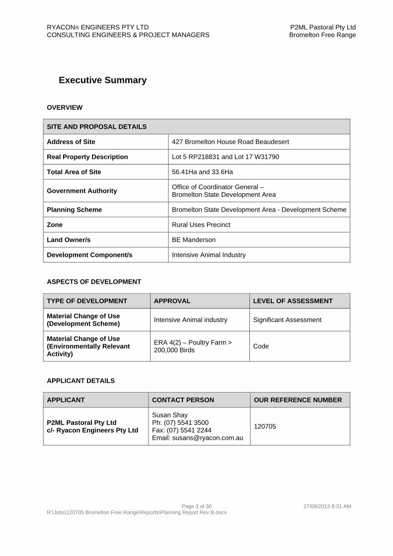
Executive Summary
OVERVIEW
SITE AND PROPOSAL DETAILS
Address of Site 427 Bromelton House Road Beaudesert
Real Property Description Lot 5 RP218831 and Lot 17 W31790
Total Area of Site 56.41Ha and 33.6Ha
Government Authority Office of Coordinator General – Bromelton State Development Area
Planning Scheme Bromelton State Development Area - Development Scheme
Zone Rural Uses Precinct
Land Owner/s BE Manderson
Development Component/s Intensive Animal Industry
ASPECTS OF DEVELOPMENT
TYPE OF DEVELOPMENT APPROVAL LEVEL OF ASSESSMENT
Material Change of Use (Development Scheme)
Intensive Animal industry Significant Assessment
Material Change of Use (Environmentally Relevant Activity)
ERA 4(2) – Poultry Farm > 200,000 Birds
Code
APPLICANT DETAILS
APPLICANT CONTACT PERSON OUR REFERENCE NUMBER
P2ML Pastoral Pty Ltd c/- Ryacon Engineers Pty Ltd
Susan Shay Ph: (07) 5541 3500 Fax: (07) 5541 2244 Email: [email protected]
120705

RYACON® ENGINEERS PTY LTD P2ML Pastoral Pty Ltd CONSULTING ENGINEERS & PROJECT MANAGERS Bromelton Free Range
Page 4 of 30 27/08/2013 8:31 AM R:\Jobs\120705 Bromelton Free Range\Reports\Planning Report Rev B.docx
1. Introduction
Ryacon Engineers Pty Ltd has been commissioned by P2ML Pastoral Pty Ltd to prepare this development application for a Material Change of Use of the subject premises for the purpose of an Intensive Animal Industry, namely a free range poultry farm. The application also seeks an Environmentally Relevant Activity (ERA) approval for a Poultry Farm in excess of 200,000 birds.
The proposed free range poultry farm comprises a total of six (6) sheds, each containing approximately 40,000 birds.
This report addresses the merits of the proposed development with regard to the provisions of the Bromelton State Development Area (BSDA) Development Scheme. For the purpose of this report the Bromelton State Development Area Development Scheme will be referred to as the BSDA Development Scheme. The Environmental Protection Act 1994 will be known as the EPA.
The poultry farm is considered an appropriate use of the subject land. The supporting site based management plan, odour, dust, stormwater management and traffic reports demonstrate that the potential impacts are within acceptable and manageable limits. The Office of the Coordinator General and the Qld Department of Agriculture, Fisheries and Forestry’s favourable consideration is warranted.
2. Site Details
2.1 Location and Description
The site is approximately 5km north north west of the township of Beaudesert. The subject land is comprised of one allotment described as:
Lot 5 RP218831 (56.41ha)
The land is a regular configuration with a general rectangular form. The Logan River is a dominant natural feature of the locality and forms the eastern boundary of the northern adjoining allotment (under the same ownership). The State owned Bromelton Offstream Storage is located on the adjoining allotment to the west of the subject site.
The allotment has access to Bromelton House Road, a Scenic Rim Regional Council controlled road of bitumen standard. A new access will be constructed to service the poultry and existing agricultural enterprises via an access easement over the adjoining allotment to the north under the same ownership (Lot 17 W31790). The current access to the allotment is to be retained for use as a domestic entrance to the residence only.
The land is not burdened by any easements.
Refer to the Appendix for a Cadastral Locality Map.

RYACON® ENGINEERS PTY LTD P2ML Pastoral Pty Ltd CONSULTING ENGINEERS & PROJECT MANAGERS Bromelton Free Range
Page 5 of 30 27/08/2013 8:31 AM R:\Jobs\120705 Bromelton Free Range\Reports\Planning Report Rev B.docx
2.2 Site Characteristics & Improvements
The general topography of the land is best described as flat flood plain, gently falling to the northwest. The highest point of the site is situated towards the south eastern corner of the allotment.
Improvements to the land include a house, farm sheds, cattle spray race and fenced yards, fenced paddocks and improved pastures. The property is currently operated as a farm raising beef cattle and crop farming. The property operated as a 250 head dairy farm from the mid 1940’s to 2003. Diversification of farming operations on the property is required to maintain a livelihood from the property for future generations of the owners.
As the allotment is within the BSDA it is excluded from the Strategic Cropping Land designation. Additionally poultry farming (intensive animal industry) is considered a consistent use on designated Strategic Cropping Land.
The allotment is not recorded on the Environmental Management Register.
The land is not included on the Contaminated Lands Register.
Both electricity and telephone services are available at the site.
Reticulated water and sewerage are not available.
2.3 Surrounding Development
The locality is exclusively rural in character. The predominant rural uses include farming and cultivation as well as animal husbandry based uses. Lot sizes vary but are typically large to medium rural holdings to the west and medium to smaller rural holdings to the north and south as demonstrated by the Cadastral Locality Map included in the Appendix. The subject site is designated Rural Uses under the BSDA.
The nearest poultry shed on a poultry farm, which is not a breeder farm, is approximately 1415m from the location of the nearest shed proposed for this development. There are no poultry breeder farms within the locality and none within 2000m of the location of the nearest shed proposed for this development.
The BSDA Scheme has designated the area surrounding the interstate railway line and Beaudesert Boonah Road junction for major industry development. This area is south west of the subject site and described in the BSDA Designation Map included in the Appendix.
All properties surrounding the subject site are located in either the Rural Uses or Transition Precinct of the BSDA. Properties on the eastern side of Bromelton House Road are outside the BSDA and under the Beaudesert Shire Planning Scheme are zoned Rural – Countryside.
Bromelton House Road is the primary transport route traversing this locality, connecting to Beaudesert Boonah Road to the south and Mount Lindesay Highway, via Allans Creek Road, to the north east.

RYACON® ENGINEERS PTY LTD P2ML Pastoral Pty Ltd CONSULTING ENGINEERS & PROJECT MANAGERS Bromelton Free Range
Page 6 of 30 27/08/2013 8:31 AM R:\Jobs\120705 Bromelton Free Range\Reports\Planning Report Rev B.docx
3. Proposal
3.1 General
The purpose of the application is to obtain a development permit for the following:
A Material Change of Use under the BSDA Development Scheme for an Intensive Animal Industry (Poultry).
A Material Change of Use for an Environmentally Relevant Activity – ERA 4(2) Poultry Farming in excess of 200,000 birds.
The development application seeks a permit for the staged construction of a free range poultry farm comprising a total of six (6) sheds. Each shed will have a capacity of 40,000 birds providing an ultimate capacity of 240,000 birds.
The development will be constructed over two (3) stages. Stage 1 will see the construction of Sheds 1 to 2. Stage 2 will see the construction of sheds 3 and 4, and Stage 3 the construction of sheds 5 and 6.
Stage Activities Proposed Completion Date
Stage 1 Earthworks associated with overall pad and individual pads for Sheds 1 and 2.
New access crossover and internal driveway construction.
Construction of Sheds 1 and 2 Retrofit of existing shed to accommodate amenities. Commencement of use (Sheds 1 and 2)
February 2014
Stage 2 Earthworks associated with individual pads for Sheds 3 and 4.
Construction of Sheds 3 and 4 Commencement of use (Sheds 3 and 4)
February 2015
Stage 3 Earthworks associated with individual pads for Sheds 5 and 6.
Construction of Sheds 5 and 6 Commencement of use (Sheds 5 and 6)
February 2016
Refer to Appendix for Proposal Plan.

RYACON® ENGINEERS PTY LTD P2ML Pastoral Pty Ltd CONSULTING ENGINEERS & PROJECT MANAGERS Bromelton Free Range
Page 7 of 30 27/08/2013 8:31 AM R:\Jobs\120705 Bromelton Free Range\Reports\Planning Report Rev B.docx
3.2 Design Specifications
As previously stated, the proposed free range poultry farm will have a maximum of six (6) sheds. All will be constructed to minimum tunnel ventilated standards and specifications and will include the following;
Sheds, Pad, Roads
The finished floor levels of the individual sheds will be consistent. The size of the overall pad is approximately 310 x 207m. The pad runs in a North-South direction. The sheds will be oriented in a general east west direction. A gravel ring road (minimum 3.5m wide) will be provided around the perimeter of the sheds. A wider loading area will be established on the eastern end as shown on the Proposal Plan. Each shed has dimensions of approximately 161m x 16m, and separated by 32m. The sheds are to be located within a security fenced compound. The proposed gross floor area of each shed is approximately 2576m2.
Floors The shed floors will be compacted earth/stabilized floors, covered with appropriate litter. At the end of each production cycle, all shed litter is removed from the sheds and taken for use as fertilizer. All litter is removed from the poultry shed and site in covered vehicles.
Walls and roof The sheds will be constructed to the applicable Australian Standards and Building Code of Australia. The sheds will consist of a steel frame with zincalume or similar metal sheeting roof and a combination of zincalume or similar metal sheeting and UV stabilised black curtain walls.
Insulation Appropriate insulation, if required, will be installed in the roofs and walls of the sheds which are to be fully enclosed.
Free range area Each shed will have individually fenced, grassed free areas each side the shed to allow for the chickens to free range. The free range area for each shed is equivalent to two times the floor area of the shed. Chickens will be allowed to free range from 21 days until pick up at 48 days during daylight hours.
Tunnel ventilation The farm will be operated as a free range facility allowing chickens to range on grassed areas outside of the sheds. Until 21 day bird age the sheds will be operated as tunnel ventilated. Tunnel ventilation will also be operated on extremely hot days during the subsequent growing period. Tunnel ventilation is designed to produce a constant environment for the birds inside the sheds. Temperature is varied depending on the age of the birds. Each shed will have four (4) gas heaters spaced along the length of the shed. On the opposite side of the sheds to the heaters, they are mirrored by 1 x 50” exhaust fan, plus an additional 2 x 50” exhaust fans on the east end which provide the minimum duty ventilation. In addition to the exhaust fans there are 16 x 50” tunnel fans. Eight (8) fans will be on the western end of the sheds, with an additional four (4) on the north western side and four (4) on the south western side of the sheds.

RYACON® ENGINEERS PTY LTD P2ML Pastoral Pty Ltd CONSULTING ENGINEERS & PROJECT MANAGERS Bromelton Free Range
Page 8 of 30 27/08/2013 8:31 AM R:\Jobs\120705 Bromelton Free Range\Reports\Planning Report Rev B.docx
Vermin Control The sheds will be fully enclosed and vermin proofed. Procedures for managing the vermin are documented within the Site Based Management Plan.
Staff It is expected that the proposed free range farm will generate 1.5 full time equivalent jobs
Access All farm access will be via the proposed new access. The access will be designed and constructed in accordance with the requirements of the Department of Transport and Main Roads Road Planning and Design Manual and Scenic Rim Regional Council Design and Construction Manual.
Biosecurity Biosecurity is a high priority for the operation of a poultry farm. All persons entering and leaving the farm will transit via the amenities block to wash and report to the farm manager.
Site Items The poultry farm will need ancillary buildings primarily for storage purposes. Additional structures and/or facilities anticipated include gas tanks, an amenities facility which will include toilets and showers, a dwelling, a generator shed, machinery and chemical storage shed and a cool room. Where possible existing buildings will be retrofitted suitable for these purposes. See proposal plans for further details.
Stormwater Control
Reference should be made to the accompanying Stormwater Management Plan and Site Based Management Plan.
Landscaping A landscaping buffer around the perimeter of the shed footprint is proposed to provide visual screening from Bromelton House Road and the neighbouring properties. This vegetation screening will provide some odour and dust control.
3.3 Operational Procedures
The owners of the farm will have a contractual agreement with a Processor. Processors are companies such as Ingham Enterprises and Steggles. The farm will be responsible for growing, then supplying chickens to the processing plant owned by the nominated company. In simple terms, it is the farm’s responsibility to provide the infrastructure and labour to grow the birds. The processor provides the day old chickens and the feed.
Day old chickens are delivered in batches to the farm from a hatchery and are subsequently collected at various stages of the growing cycle and transported to a processing plant. Fully stocked, each shed will have up to 40,000 birds. They are grown for approximately 48 days with progressive thin out which take birds away for processing. This provides a range of bird sizes for the market and keeps the total bird weight down in the sheds as the birds grow. A growing cycle is made up of the placement of new litter, the placement of day old birds, the growing of the birds and the progressive removal of birds and cleanout. Each cycle takes approximately 58 days resulting in 6.2 cycles per year. At the end of each production cycle all shed litter is removed from the site in covered vehicles and transported off site for use as fertilizer. Some litter may be spread on the cultivated pastures covering the other portions of the site that will continue to be operated. The sheds will be cleaned and disinfected. New litter will be layered on the shed floor prior to the delivery of every new batch of day old chicks.

RYACON® ENGINEERS PTY LTD P2ML Pastoral Pty Ltd CONSULTING ENGINEERS & PROJECT MANAGERS Bromelton Free Range
Page 9 of 30 27/08/2013 8:31 AM R:\Jobs\120705 Bromelton Free Range\Reports\Planning Report Rev B.docx
A typical rearing cycle consists of one to two day old chickens trucked to the site from a hatchery and released within the brooding sections until the chickens are old enough to maintain their own body temperature (typically at about two weeks of age). During the initial period, the internal shed temperature is maintained at about 32oC decreasing to about 20oC when the birds are 2 to 3 weeks of age. When the initial brooding period coincides with periods of cold weather, shed heating is provided.
From 21 days to harvesting the chickens will be able to free range outside the sheds in designated grassed and fenced areas during daylight hours. During periods of extreme hot weather the birds will be directed back into the sheds and the sheds operated as traditional tunnel ventilation.
Initial harvesting is generally conducted at approximately 38 days. Thinning of bird numbers at this stage supplies the market with smaller size birds and provides additional space for growing larger birds. Typically, about 50% of the birds are removed at about day 38, leaving the remaining 50% of the original number of birds to be reared up to 48 days, depending on the size of the birds required for market and other production requirements.
At the various stages of the cycle, the birds will be transported from the site by truck. The birds will be placed into transport cages from inside the shed and loaded onto trucks by a forklift. Bird collection will be undertaken both during the day and night times between midnight and midday. Collection takes approximately two days and will occur around the 38 day growing stage and at the final pickup at 48 days.
Over the growing cycle, a mortality rate of about 4% is expected. Dead birds are collected from the sheds on a daily basis and placed into an on-site cool room. This cool room may be of a mobile nature. The dead birds will be removed from the site weekly or in accordance with the procedures of the Site Based Management Plan.
4. Environmental Considerations
4.1 Waste Management
The farm will utilize highly absorbent litter consisting primarily of wood shavings or similar absorbent materials from biosecure sources.
Proposed waste management practices will include the following measures as a minimum:
All spent litter to be removed from site will be transported in covered trucks. The farm is expected to experience a 4% mortality rate. Deceased birds will be removed daily from
the sheds and stored in a cool room until removal from site on an as required basis.
All waste associated with the poultry farm will be appropriately managed to ensure no adverse impacts are caused to the local environment.
Refer to the Site Base Management Plan dated 19 May 2013.

RYACON® ENGINEERS PTY LTD P2ML Pastoral Pty Ltd CONSULTING ENGINEERS & PROJECT MANAGERS Bromelton Free Range
Page 10 of 30 27/08/2013 8:31 AM R:\Jobs\120705 Bromelton Free Range\Reports\Planning Report Rev B.docx
4.2 Odour
The potential odour impacts associated with the proposed development were investigated and modeled by Pacific Environment. The report concludes that dispersion modeling from the proposed farm (up to six sheds) indicates that odour levels associated with the farm at the nearest sensitive receptors will be within the Queensland EPA odour guideline criteria.
In light of the above finding, the potential odour impacts associated with the proposed poultry farm have been demonstrated to be within acceptable and manageable limits. It is not expected to have any significant adverse impacts on the locality by way of detrimental air quality where farm operations are conducted in accordance with the recommendation of the Odour Assessment Report and the Site Based Management Plan. Additionally it is not expected to impact the development potential of the neighbouring properties.
Refer to Odour and Dust Assessment Report prepared by Pacific Environment dated 28 March, 2013
4.3 Noise
Should the farm be operated in accordance with the Site Based Management Plan there is not expected to be any significant adverse impacts on the locality by way of detrimental noise emissions.
4.4 Stormwater Management
A stormwater management plan has been prepared in support of the Site Based Management Plan.
The farm will operate at all times in accordance with the Site Based Management Plan and the Stormwater Management Plan. These plans articulate the appropriate construction methods and farming procedures to be implemented to ensure there is no transfer of water into or out of the poultry sheds. This ensures the farm is managed in accordance with best practice environmental management for poultry farms and will reduce the potential impact on the local environment.
Refer to the Stormwater Management Plan Rev B dated 5 August 2013.

RYACON® ENGINEERS PTY LTD P2ML Pastoral Pty Ltd CONSULTING ENGINEERS & PROJECT MANAGERS Bromelton Free Range
Page 11 of 30 27/08/2013 8:31 AM R:\Jobs\120705 Bromelton Free Range\Reports\Planning Report Rev B.docx
4.5 Flood Plain Management
The allotment of the proposed free range poultry farm site is impacted by the flood extents of the Logan River for Q100 scale events. The Stormwater Management Plan addresses the impacts of the flooding on the proposed farm as well as the impacts of the farm on the flood plain storage.
Should the recommendations of the Stormwater Management Report, being the construction of a compacted earth pad, and elevating the shed floor levels to some 700mm above the highest observed flood height, be adopted then the proposed sheds will not be impacted by flooding. Additionally should the recommendation to undertake compensatory cut and fill in the flood zone to build the earth pad be adopted there should be no impact to the flood plain storage in the locality and accordingly no adverse impact to flood levels on surrounding properties.
Refer to the Stormwater Management Plan Rev B dated 5 August 2013.
4.6 Water Supply
The proposed development will use water from onsite bores and the Logan River, via an irrigation allocation and stock water licence. Infrastructure to be installed includes 3 x 250,000L water storage tanks constructed on ground along with associated water pumping equipment.
4.7 Dust Mitigation
Dust consisting mostly of organic materials such as feather particles, feed particles, dry manure particles and litter material may be emitted via the shed ventilation fans. Other potential dust sources at the proposed farm include wheel generated dust due to vehicle movements.
The amount of dust and airborne particulate matter typically present in a poultry shed is dependent on a number of factors including:
Bird activity Stocking density Cleaning practices Bird handling Residual dust levels Type and moisture content of litter and feed Ventilation system Nearby dust sources
The poultry farm is predicted to have no significant adverse impact on the locality by way of dust emission provided it is conducted and managed in accordance with the recommendations of the Dust Assessment Report and the Site Based Management Plan. These documents articulate the management strategies and corrective actions to be employed in the conduct of the farm.
Refer to Odour and Dust Assessment Report prepared by Pacific Environment dated 28 March, 2013

RYACON® ENGINEERS PTY LTD P2ML Pastoral Pty Ltd CONSULTING ENGINEERS & PROJECT MANAGERS Bromelton Free Range
Page 12 of 30 27/08/2013 8:31 AM R:\Jobs\120705 Bromelton Free Range\Reports\Planning Report Rev B.docx
4.8 Traffic
The farm will be accessed by a variety of vehicle types. Most vehicle movements will occur during daylight hours; however, bird pick-up will occur mostly at night. The night time collection of birds is undertaken to protect bird health so that they travel during cooler times. This will occur for two days at the first thin out and at final pick up between the hours of midnight and midday.
The majority of traffic will access the site via the Mount Lindesay Highway and Allans Creek Road before entering Bromelton House Road. This is expected to be the main transport route for vehicles entering the site as stockfeed, hatcheries and abattoirs are located north of the site.
The Traffic Impact Assessment Report prepared by Ryacon Engineers dated 19 May 2013, provides a preliminary estimate of the anticipated traffic movements associated with the poultry farm.
Bromelton House Road in the vicinity of the proposed access location is straight and level and there are no impediments to sight distance.
Refer to the traffic report titled Traffic Impact Assessment Rev B prepared by Ryacon Engineers Pty Ltd dated 5 August 2013.
4.9 Wastewater Management
The proposed development will generate wastewater from the proposed amenities facility and
washdown facility, both to be located within an existing (to be refurbished) shed, previously used as
a cattle cooling and feeding pad. A new onsite wastewater treatment plant will be provided to treat
wastewater generated from the toilet and shower provided as amenities. Treatment will be provided
in accordance with the Seqwater Development Guidelines for Water Quality Management in Drinking
Water Catchments 2012. Further details are provided in the report Effluent Disposal Site Evaluation
Report prepared by Edwards and Associates, dated 21 August 2013.
Wastewater from the washdown facility will be directed to the existing on site effluent ponds as
detailed on the proposal plans. The effluent ponds previously captured wastewater generated from
the cattle and the cooling sprinkler system at the cooling and feeding pad.
The poultry sheds are to be pressure cleaned using a low volume of water. No wastewater will leave
the sheds during the cleaning process. Accordingly the poultry sheds will not be connected to an on
site wastewater treatment facility.
Effluent will not be generated from the free range area of the facility. Management of runoff from
this area is discussed in the Stormwater Management Plan Rev B dated 5 August 2013.
Implementation of the proposed wastewater management strategies and satisfactory site management practices will ensure that the proposed development does not contribute to large scale, cumulative contamination of water supplies with pathogens and nutrients.

RYACON® ENGINEERS PTY LTD P2ML Pastoral Pty Ltd CONSULTING ENGINEERS & PROJECT MANAGERS Bromelton Free Range
Page 13 of 30 27/08/2013 8:31 AM R:\Jobs\120705 Bromelton Free Range\Reports\Planning Report Rev B.docx
5. Bromelton State Development Area - Development Scheme
5.1 Land Use Definition The proposed development is defined under the BSDA Development Scheme as Intensive Animal Industry. According to the BSDA Development Scheme the definition of intensive animal industry is; premises used for the intensive production of animals or animal products in an enclosure that requires the provision of food and water either mechanically or by hand. The poultry farm as proposed is considered and intensive animal industry.
5.2 Level of Assessment Pursuant to the conditions of the BSDA Development Scheme, a Material Change of Use to Intensive Animal Industry (Poultry Farm) in the Rural Uses Precinct is identified as a Specific Assessment.
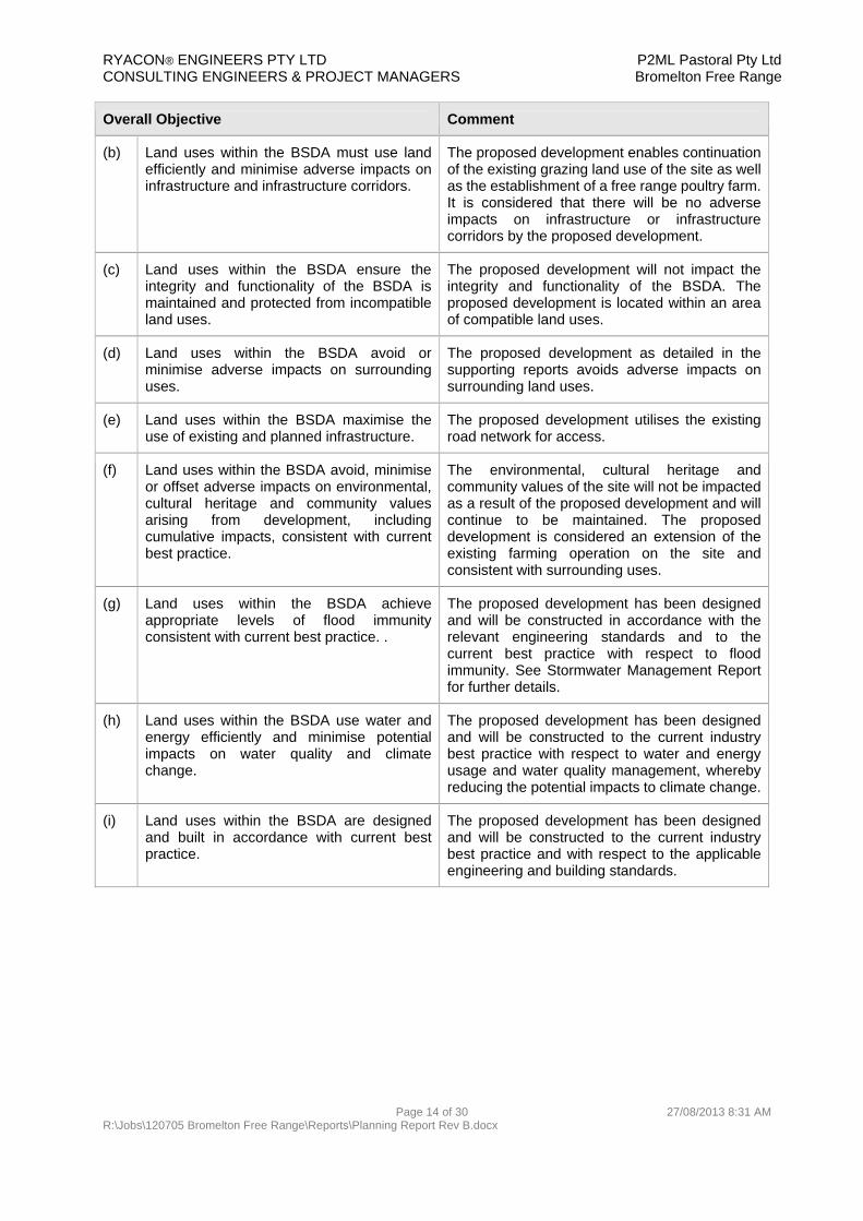
5.3 Overall Objectives for Land Uses within the BSDA The BSDA Development Scheme provides overall objectives for land uses within the BSDA. The following section provides an assessment of the proposal against these objectives.
Overall Objective Comment
(a) Land uses within the BSDA are consistent with the strategic vision for the BSDA, the land use precincts and the precinct’s preferred land use intent.
The proposed development is considered consistent with the strategic vision of the BSDA, the land use precincts and the preferred land use intent. The proposed development will not impact the
establishment of industrial activities of regional, state and national significance within the BSDA.
The proposed development will not impact the maximisation of the rail network nor the establishment of high impact and difficult to locate industries.
The proposed development provides for the continuation and establishment of rural uses in an appropriate location.
The proposed development will provide long term employment for two on site staff and support employment in off site operations in transport and meat processing.
The proposed development will be privately funded.
The proposed development will protect the values of the water supply catchments through appropriate stormwater management
RYACON® ENGINEERS PTY LTD P2ML Pastoral Pty Ltd CONSULTING ENGINEERS & PROJECT MANAGERS Bromelton Free Range
Page 14 of 30 27/08/2013 8:31 AM R:\Jobs\120705 Bromelton Free Range\Reports\Planning Report Rev B.docx
Overall Objective Comment
(b) Land uses within the BSDA must use land efficiently and minimise adverse impacts on infrastructure and infrastructure corridors.
The proposed development enables continuation of the existing grazing land use of the site as well as the establishment of a free range poultry farm. It is considered that there will be no adverse impacts on infrastructure or infrastructure corridors by the proposed development.
(c) Land uses within the BSDA ensure the integrity and functionality of the BSDA is maintained and protected from incompatible land uses.
The proposed development will not impact the integrity and functionality of the BSDA. The proposed development is located within an area of compatible land uses.
(d) Land uses within the BSDA avoid or minimise adverse impacts on surrounding uses.
The proposed development as detailed in the supporting reports avoids adverse impacts on surrounding land uses.
(e) Land uses within the BSDA maximise the use of existing and planned infrastructure.
The proposed development utilises the existing road network for access.
(f) Land uses within the BSDA avoid, minimise or offset adverse impacts on environmental, cultural heritage and community values arising from development, including cumulative impacts, consistent with current best practice.
The environmental, cultural heritage and community values of the site will not be impacted as a result of the proposed development and will continue to be maintained. The proposed development is considered an extension of the existing farming operation on the site and consistent with surrounding uses.
(g) Land uses within the BSDA achieve appropriate levels of flood immunity consistent with current best practice. .
The proposed development has been designed and will be constructed in accordance with the relevant engineering standards and to the current best practice with respect to flood immunity. See Stormwater Management Report for further details.
(h) Land uses within the BSDA use water and energy efficiently and minimise potential impacts on water quality and climate change.
The proposed development has been designed and will be constructed to the current industry best practice with respect to water and energy usage and water quality management, whereby reducing the potential impacts to climate change.
(i) Land uses within the BSDA are designed and built in accordance with current best practice.
The proposed development has been designed and will be constructed to the current industry best practice and with respect to the applicable engineering and building standards.

RYACON® ENGINEERS PTY LTD P2ML Pastoral Pty Ltd CONSULTING ENGINEERS & PROJECT MANAGERS Bromelton Free Range
Page 15 of 30 27/08/2013 8:31 AM R:\Jobs\120705 Bromelton Free Range\Reports\Planning Report Rev B.docx
5.4 BSDA Land Use Precincts – Land Use Intent The BSDA Development Scheme provides preferred land intents of the precincts within the BSDA. The following section provides an assessment of the proposal against land use intent of the Rural Uses Precinct.
Preferred Land use Intent Comment
(a) The Rural Uses Precinct is to provide for rural uses including agricultural production, rural living and compatible tourism related uses that do not compromise existing or future industrial uses in the BSDA
The proposed development is considered consistent with the land use intent of the Rural Uses Precinct. The proposed development, a free range chicken broiler farm, is an agricultural enterprise. It is considered that the proposed development will not compromise existing or future industrial uses in the BSDA. See supporting reports for further detail.
(b) Appropriate residential uses are provided for
No new residential dwellings are proposed as a part of this development. Additionally the proposed development does not impact the future establishment of residential dwellings on surrounding vacant land.
(c) Provide for infrastructure that may or may not be associated with activities within the BSDA.
The proposed development will not impact existing infrastructure or impact development of future infrastructure for activities within or outside of the BSDA.

RYACON® ENGINEERS PTY LTD P2ML Pastoral Pty Ltd CONSULTING ENGINEERS & PROJECT MANAGERS Bromelton Free Range
Page 16 of 30 27/08/2013 8:31 AM R:\Jobs\120705 Bromelton Free Range\Reports\Planning Report Rev B.docx
5.5 Review of Development Scheme – General Requirements The BSDA Development Scheme provides general requirements for development in the BSDA. The following section provides an assessment of the proposal against the prescribed general requirements.
General Requirement Comment
Infrastructure
1. Development maximises infrastructure use and minimises infrastructure costs for infrastructure associated with telecommunications, transport, water, wastewater, recycled water and energy.
The proposed development will utilise existing infrastructure. There is not expected to be an impact to infrastructure costs as a result of the proposed development.
Emissions
2. Levels of emissions from development including noise, air pollutants, water pollutants, heat, light and electromagnetic radiation, are compatible with surrounding land uses and local environmental constraints, with emissions and hazards to be managed in accordance with the: Environmental Protection (Air) Policy 2008; Environmental Protection (Noise) Policy 2008; Environmental Protection (Water) Policy 2009; Waste Reduction and Recycling Act 2011; Work Health and Safety Act 2011 and Work Health and Safety Regulation 2011.
Emissions from the development are compatible with the surrounding land uses and local environmental constraints. There is not expected to be any negative impacts to the surrounding properties, receptors and environment. Emissions will be managed in accordance with the relevant policies, acts and regulations.
Visual impacts
3. Visual impacts of buildings are minimised through building design and landscaping when viewed from a significant publicly accessible view point such as major roads or public parks.
The proposed development will be landscaped to minimise the visual impact on neighbouring properties and the adjacent Bromelton House Road.
Water sensitive urban design
4. Water sensitive urban design principles are integrated into the development.
Best practice water quality management systems and procedures for this type of development will be implemented – See Stormwater Management Plan. Water Sensitive Urban Design is not applicable to the proposed development.
Road works
5. Increased traffic arising from development is either able to be accommodated within existing road networks or works are undertaken to minimise adverse impacts on existing and future uses.
The increase in traffic arising from the development can be adequately accommodated in the existing road network. See Traffic Management Report.

RYACON® ENGINEERS PTY LTD P2ML Pastoral Pty Ltd CONSULTING ENGINEERS & PROJECT MANAGERS Bromelton Free Range
Page 17 of 30 27/08/2013 8:31 AM R:\Jobs\120705 Bromelton Free Range\Reports\Planning Report Rev B.docx
General Requirement Comment
Environment, cultural heritage and community
6. Environmental values, cultural heritage values and community values of the site and immediate surrounds are identified and protected, consistent with current best practice. Note: Duty of Care Guidelines under Section 28 of the Aboriginal Cultural Heritage Act 2003 should be considered a minimum requirement of all development.
The environmental, cultural heritage and community values of the site will not be impacted as a result of the proposed development and will continue to be maintained. The proposed development is considered an extension of the existing farming operation on the site and consistent with surrounding uses.
Engineering standards
7. Development is to be designed and constructed in accordance with the Table of Relevant Engineering Standards below, except as provided for otherwise by Tables 9–18 for development. Alternative, innovative solutions are encouraged.
The proposed development will be designed and constructed in accordance with the relevant engineering standards and to the current best practice.
Table of relevant engineering standards
Sewer and water
Standards of the relevant water and sewerage service provider (e.g. Queensland Urban Utilities).
Not applicable to the proposed development.
Stormwater quality
State Planning Policy 4/10: Healthy Waters and associated guideline
South East Queensland -Regional Plan 2009-2031 Implementation Guideline No. 7 Water sensitive urban design: Design objectives for urban stormwater management
Environmental Protection Policy (Water)
Water Sensitive Urban Design Technical Design Guidelines for South East Queensland
Construction and Establishment Guidelines, Swales, Bioretention Systems and Wetlands
Healthy Waterways -Water Sensitive Urban Design Technical Design Guidelines for South East Queensland Concept Design Guidelines for Water Sensitive Urban Design
Standard Drawings for Water Sensitive Urban Design
Development Guidelines for Water Quality Management in Drinking Water Catchments 2010
The proposed development has been designed and will be constructed in accordance with the applicable stormwater quality standards for this type of development. See the Stormwater Management Plan for further information.

RYACON® ENGINEERS PTY LTD P2ML Pastoral Pty Ltd CONSULTING ENGINEERS & PROJECT MANAGERS Bromelton Free Range
Page 18 of 30 27/08/2013 8:31 AM R:\Jobs\120705 Bromelton Free Range\Reports\Planning Report Rev B.docx
General Requirement Comment
Stormwater quantity
Queensland Urban Drainage Manual (QUDM) Australian Rainfall and Runoff (ARR) -where referenced by QUDM
The proposed development has been designed and will be constructed in accordance with QUDM. See the Stormwater Management Plan for further information.
Roads (major)
DTMR's Road Planning and Design Manual -A guide to Queensland Practice (when available). (Note: This document is currently in preparation and will reference Austroads Guide to Road Design.). Until the Road Planning and Design Manual -A guide to Queensland Practice is available; refer to; DTMR's Interim Guide to Road
Planning and Design Practice DTMR Pavement Design Manual DTMR Bridge Design Manual Queensland Urban Drainage
Manual (QUDM) -Chapter 7 DTMR Drainage Design Manual Manual of Uniform Traffic Control
Devices DTMR Guide to Pavement
Markings Australian Standard AS1158
(Street Lighting) Complete Streets Manual 2010
(Section 17: Industrial Streets)
Not applicable to the proposed development.
Roads (minor)
Relevant local government construction standards
Not applicable to the proposed development.
Site access Relevant local government design and construction standards
The proposed development’s site access has been designed and will be constructed in accordance with the SRRC Design and Construction Manual and the Department of Transport and Main Roads Road Planning and Design Manual
Footpaths and cycle paths
Local government standards for construction Austroads -Guide to Road Design Part 6A: Pedestrian and Cyclist Paths
Not applicable to the proposed development.
Soil erosion
International Erosion Control Association (IECA) -Best Practice Erosion and Sediment Control
The proposed development has been designed and will be constructed in accordance with IECA – Best Practice Erosion and Sediment Control. See the Stormwater Management Plan for further information.
Filling AS3798 -Guidelines on Earthworks for Commercial and Residential Developments
The proposed development has been designed and will be constructed in accordance with AS3798.

RYACON® ENGINEERS PTY LTD P2ML Pastoral Pty Ltd CONSULTING ENGINEERS & PROJECT MANAGERS Bromelton Free Range
Page 19 of 30 27/08/2013 8:31 AM R:\Jobs\120705 Bromelton Free Range\Reports\Planning Report Rev B.docx
General Requirement Comment
Non-resident workforce accommodation
8. Non-resident workforce accommodation is located to be easily accessible to: projects for which the accommodation is
required; facilities, infrastructure and services
capable of meeting the accommodation’s requirements; such that it avoids impacts on the intent of the precincts, specifically industrial and infrastructure uses.
Not applicable to the proposed development.
9. Non-resident workforce accommodation is designed and operated to a high standard and should be in accordance with Queensland Development Code for Temporary Accommodation Buildings and Structures (publication date: 2 June 2010).
Not applicable to the proposed development.
Built form
10. The scale, character and built form of development contributes to a high standard of amenity consistent with surrounding areas and the intent of the precinct.
The scale, character and built form of the proposed development is intended to be of a high standard maintaining the amenity of the Rural Uses precinct. There are five similar developments within a 5km radius of the site.
Landscaping
11. Development provides landscaping that: minimises the visual impacts of the development; incorporates at least 50% local species; and is low maintenance.
Landscaping is proposed for the development that will minimise the visual impact of the development. See landscaping details included in the design plans.
Legislation
12. New development is to demonstrate consistency with relevant legislation, regional plans, State Planning Policies to the extent practicable where the State interests articulated by these instruments may be affected by the proposed new use.
The proposed development is considered not in conflict with, or has no relevance, to the State Planning Policies, the South East Qld Regional Plan and the Sustainable Planning Act. It is considered that the proposed new use will not affect the State interests declared by these instruments.
Managing impacts
13. New uses are to avoid or minimise adverse impacts on existing or proposed State or local infrastructure.
The proposed development will avoid adverse impacts on existing or proposed State or local infrastructure.

RYACON® ENGINEERS PTY LTD P2ML Pastoral Pty Ltd CONSULTING ENGINEERS & PROJECT MANAGERS Bromelton Free Range
Page 20 of 30 27/08/2013 8:31 AM R:\Jobs\120705 Bromelton Free Range\Reports\Planning Report Rev B.docx
5.6 Review of Development Scheme – General Requirements of Rural Enterprise, Transition and Rural Uses Precincts.
Performance outcomes Acceptable solutions Proposed solutions
General requirements
PO69 Infrastructure is provided to service the needs of development and does not impact on the timing or sequencing of development in the Rail Dependant Industry Precinct and Major Industry Precinct.
AS69.1 Development is serviced by infrastructure (whether or not managed on-site) that is adequate to meet the needs and operational capacity of the use with regard to water, waste disposal, drainage, telecommunications, energy a suitable road network.
The proposed development is serviced by infrastructure that is adequate to meet the needs and operational capacity of the use with regard to water, waste disposal, drainage, telecommunications, energy and a suitable road network. It does not impact the timing or sequencing of development in the Rail Dependant Industry Precinct and Major Industry Precinct.
PO70 Effective separation is provided between uses where there are potential impacts or conflicts of use with regard to matters including (but not limited to) spray drift, odour, noise, dust, smoke or ash emissions.
AS70.1 The development provides sufficient setbacks to: a) avoid nuisance to neighbours and manage conflicts between residential and non-residential uses; b) protect the operation of existing non-residential uses; c) protect residential amenity; and d) maintain the rural landscape character and scenic amenity.
As detailed in the accompanying Odour and Dust Assessment, Traffic Assessment, Stormwater Management Plan Reports, and the Site Based Management Plan, the proposed development provides for sufficient setbacks to avoid potential impacts or conflicts of use.

RYACON® ENGINEERS PTY LTD P2ML Pastoral Pty Ltd CONSULTING ENGINEERS & PROJECT MANAGERS Bromelton Free Range
Page 21 of 30 27/08/2013 8:31 AM R:\Jobs\120705 Bromelton Free Range\Reports\Planning Report Rev B.docx
Performance outcomes Acceptable solutions Proposed solutions
PO71 Development for animal husbandry, animal keeping or intensive animal industry ensures animals are appropriately secured in enclosures and/or contained on the site so as not to cause a nuisance beyond site boundaries.
AS71.1 Development for animal husbandry, animal keeping or intensive animal industry provides fencing to secure animals kept on the premises.
As detailed in the development plans and Site Based Management Plan the birds will be securely enclosed in the growing sheds or fenced free range area and should not cause nuisance beyond the site boundaries.
Protection of infrastructure
PO72 Development provides for and protects the safe and efficient function of the Sydney-Brisbane Rail Corridor and identified existing and future transport infrastructure.
AS72.1 Development does not compromise the ability of the Sydney-Brisbane Rail Corridor and identified existing transport infrastructure and proposed Bromelton North-South Arterial identified on the Bromelton State Development Area Designation Map to provide for: a) high volumes of rail and road freight; b) a 24 hour public transport service for residents and workers; and c) the operational requirements of industry in the Bromelton State Development Area.
The proposed development will not affect the safe and efficient function of the Sydney-Brisbane Rail Corridor and identified existing and future transport infrastructure.

RYACON® ENGINEERS PTY LTD P2ML Pastoral Pty Ltd CONSULTING ENGINEERS & PROJECT MANAGERS Bromelton Free Range
Page 22 of 30 27/08/2013 8:31 AM R:\Jobs\120705 Bromelton Free Range\Reports\Planning Report Rev B.docx
Performance outcomes Acceptable solutions Proposed solutions
PO73 Development does not compromise the establishment and operation of existing and/or planned infrastructure.
AS73.1 Development does not compromise the establishment and operation of the future 100 metre wide corridor for the proposed Bromelton North South Arterial/Highway, future Bromelton Sewage Treatment Plant, future Bromelton Water/Recycled Water Reservoir and off stream storage; and the proposed Lions Way Pipeline.
The proposed development does not compromise the establishment and operation of existing and/or planned infrastructure
Stormwater management
PO74 The development maintains or enhances, and protects the water quality of the waterway corridors and wetlands.
AS74.1 Development occurs in accordance with a Site Based Stormwater Management Plan which outlines the measures to be taken to reduce potential adverse impacts on water quality, prevent direct or indirect discharge of contaminants to surface or groundwater bodies, manage stormwater runoff, provide adequate treatment and distribution infrastructure, provide on-site disposal and treatment, and manage dangerous and/or hazardous substances.
The development will occur in accordance with the Site Based Management Plan and the Stormwater Management Plan to maintain or enhance, and protect the water quality of the waterway corridors and wetlands. See Site Based Management Plan and Stormwater Management Plan.

RYACON® ENGINEERS PTY LTD P2ML Pastoral Pty Ltd CONSULTING ENGINEERS & PROJECT MANAGERS Bromelton Free Range
Page 23 of 30 27/08/2013 8:31 AM R:\Jobs\120705 Bromelton Free Range\Reports\Planning Report Rev B.docx
Performance outcomes Acceptable solutions Proposed solutions
Waterways, ecological corridors and nature conservation values
The ecological functioning and integrity of waterways, wetlands and their associated nature conservation values are protected and enhanced.
AS75.1 Development – a) does not involve the clearing, disturbance or modification to a waterway or wetland; and b) provides a dedicated buffer of suitable size and which is revegetated to (where possible) re-establish the pre-clearing regional ecosystem; and c) does not involve the clearing or disturbance of vegetation communities associated with a waterway or wetland; and d) rehabilitates a cleared or degraded waterway or wetland area using locally occurring native species complementary to the waterway or wetland community. Note: Proponents should refer to the Regional Vegetation Management Code for South East Queensland or the Queensland Wetland Buffer Planning Guideline to determine Appropriate setback distances between development and waterways/wetlands.
The proposed development does not involve the clearing, disturbance or modification to a waterway or wetland; nor does it involve the clearing or disturbance of vegetation communities associated with a waterway or wetland.

RYACON® ENGINEERS PTY LTD P2ML Pastoral Pty Ltd CONSULTING ENGINEERS & PROJECT MANAGERS Bromelton Free Range
Page 24 of 30 27/08/2013 8:31 AM R:\Jobs\120705 Bromelton Free Range\Reports\Planning Report Rev B.docx
Performance outcomes Acceptable solutions Proposed solutions
PO76 Ecological corridors along the Logan River, Allan Creek and Sandy Creek are identified and protected from development with appropriate buffers that: a) maximise connectivity between ecologically significant areas by consolidating native flora and providing for the movement of native fauna taking into account the habitat and nature conservation values of the land and waterway(s); and b) include rehabilitation of land with locally occurring native plants where the ecological corridor includes a cleared or partially cleared area or weed infested area.
AS76.1 Development is setback the following minimum distance from a waterway: 50m to a minor or
intermittent watercourse
100m to a major or permanent watercourse
800m to any major water storage facility (eg Bromelton Offstream Storage). Note: The setback distance is measured from the high bank of the watercourse.
The proposed development does not encroach on the minimum setbacks required for a waterway as deemed acceptable to protect the ecological corridors along the Logan River, Allan Creek and Sandy Creek.

RYACON® ENGINEERS PTY LTD P2ML Pastoral Pty Ltd CONSULTING ENGINEERS & PROJECT MANAGERS Bromelton Free Range
Page 25 of 30 27/08/2013 8:31 AM R:\Jobs\120705 Bromelton Free Range\Reports\Planning Report Rev B.docx
Performance outcomes Acceptable solutions Proposed solutions
PO77 Development protects areas of local and regional nature conservation and scenic amenity values including – a) significant flora and fauna (including endangered, vulnerable, rare and/or threatened species) and their habitats; b) areas of significant biodiversity value; c) significant trees that contribute to scenic amenity and character; and d) riparian vegetation.
AS77.1 Development does not involve the clearing or disturbance of any significant vegetation, areas of significant biodiversity value, or riparian vegetation.
The proposed development does not involve the clearing or disturbance of any significant vegetation, areas of significant biodiversity value, or riparian vegetation, whereby protecting areas of local and regional nature conservation and scenic amenity values.
Access, servicing and on-site manoeuvring
PO78 Site access does not unduly impact on the safe and efficient operation of the use or external road or rail transport infrastructure.
AS78.1 Site layout facilitates safe and efficient vehicular site ingress and egress in a forward motion for the largest vehicle likely to access the site.
As detailed in the development plans and Traffic Management Plan the proposed development facilitates safe and efficient vehicular site ingress and egress in a forward motion for the largest vehicle likely to access the site, in this case a B-Double. It is considered that the proposed site access will not unduly impact the safe and efficient operation of the free range poultry farm or external road or rail transport infrastructure.

RYACON® ENGINEERS PTY LTD P2ML Pastoral Pty Ltd CONSULTING ENGINEERS & PROJECT MANAGERS Bromelton Free Range
Page 26 of 30 27/08/2013 8:31 AM R:\Jobs\120705 Bromelton Free Range\Reports\Planning Report Rev B.docx
Performance outcomes Acceptable solutions Proposed solutions
PO79 Development satisfactorily addresses on-site access, servicing and manoeuvring requirements.
AS79.1 Off-street facilities for the loading/unloading, manoeuvring and parking of service vehicles are provided where necessary to meet the needs and operational capacity of the development that: a) Are adequate to meet the demands generated by the development; b) Are designed to accommodate the largest service vehicle likely to access the site; and c) Do not unduly impact on the safe and efficient operation of the use or external road or rail transport infrastructure.
As detailed in the development plans and Traffic Management Plan, the proposed development design provides for satisfactory on-site access, servicing and manoeuvring to meet the demands generated by the proposed use. It is designed to accommodate the largest vehicle likely to access the site, in this case a B-Double. It is considered that the proposed site access will not unduly impact the safe and efficient operation of the free range poultry farm or external road or rail transport infrastructure
Car parking
PO80 Development provides sufficient on-site car parking for staff and visitors (including for people with disabilities) to meet the needs of the development.
AS80.1 Parking is provided at a rate of 1 space per staff and 1 space for the average number of visitors which may be on-site at any one time.
As detailed in the development plans and Traffic Management Plan, the proposed development design provides for a minimum 2 parking spaces, as required to be provided for the 1 staff member and 1 visitor anticipated to meet the needs of the free range chicken farm use.

RYACON® ENGINEERS PTY LTD P2ML Pastoral Pty Ltd CONSULTING ENGINEERS & PROJECT MANAGERS Bromelton Free Range
Page 27 of 30 27/08/2013 8:31 AM R:\Jobs\120705 Bromelton Free Range\Reports\Planning Report Rev B.docx
5.7 Review of Development Scheme – Specific Requirements of Rural Uses Precinct
Performance outcomes Acceptable solutions Proposed solutions
General requirements
PO83 Residential and/or other sensitive receiving environments are located a sufficient distance from the Transition Precinct to ensure: The development
and operation of industrial activities in the Transition Precinct is not compromised and occurs in accordance with the purpose of the Transition Precinct; and
The amenity of residential and/or other sensitive uses is not compromised by existing or future industrial activities in the Transition Precinct.
AS83.1 No acceptable solution provided.
As demonstrated in the accompanying Odour and Dust Assessment, Traffic Assessment and Stormwater Management Plan Reports, and the Site Based Management Plan, the proposed development provides for sufficient setbacks to avoid potential impacts or conflicts of use for existing and future activities in neighbouring properties within the Rural Uses Precinct and the Transition Precinct.

RYACON® ENGINEERS PTY LTD P2ML Pastoral Pty Ltd CONSULTING ENGINEERS & PROJECT MANAGERS Bromelton Free Range
Page 28 of 30 27/08/2013 8:31 AM R:\Jobs\120705 Bromelton Free Range\Reports\Planning Report Rev B.docx
6. Report Schedule
Odour and Dust Assessment Report prepared by Pacific Environment dated 28 March, 2013
Stormwater Management Plan Rev B prepared by Ryacon Engineers Pty Ltd dated 5 August 2013.
Traffic Impact Assessment Rev B prepared by Ryacon Engineers Pty Ltd dated 5 August 2013.
Site Base Management Plan prepared by Ryacon Engineers Pty Ltd dated 19 May 2013.
Effluent Disposal Site Evaluation Report prepared by Edwards and Associates dated 21 August 2013
7. Conclusion
The preceding assessment has demonstrated the merits of the proposal in respect to the relevant requirements of the Bromelton State Development Area (BSDA) Development Scheme and the Environmental Protection Act 1994.
The nature and scale of the proposal is considered appropriate for the site given the rural characteristics of the land and context of the site.
The accompanying Odour and Dust Assessment Report, Stormwater Management Plan Report, Traffic Assessment Report and Site Based Management Plan have demonstrated that the potential impacts associated with the poultry farm are within acceptable and manageable limits.
The odour and dust reports demonstrate compliance with all relevant criteria pertaining to odour and dust emission. The report also identifies measures to be implemented to further safeguard the amenity of neighbouring properties. It is considered that the farm can be operated without causing environmental harm or nuisance.
The proposal concurs with the BSDA Development Scheme’s environmental outcomes and is consistent with the planning intent for the area.
The development achieves compliance with the relevant BSDA Development Scheme requirements. In particular it achieves the general outcomes of the Rural Enterprise, Rural Uses and Transition Precinct and the specific outcomes of the Rural Uses Precinct.
Having regard to the details and circumstances outlined in the report, the Coordinator General is requested to provide its support to this proposal and issue the necessary approval in accordance with the BSDA Development Scheme, subject to reasonable and relevant conditions.

RYACON® ENGINEERS PTY LTD P2ML Pastoral Pty Ltd CONSULTING ENGINEERS & PROJECT MANAGERS Bromelton Free Range
Page 29 of 30 27/08/2013 8:31 AM R:\Jobs\120705 Bromelton Free Range\Reports\Planning Report Rev B.docx
8. Appendices
8.1 BSDA Designation Map

RYACON® ENGINEERS PTY LTD P2ML Pastoral Pty Ltd CONSULTING ENGINEERS & PROJECT MANAGERS Bromelton Free Range
Page 30 of 30 27/08/2013 8:31 AM R:\Jobs\120705 Bromelton Free Range\Reports\Planning Report Rev B.docx
8.2 Proposal Plans
120705-01 Site Layout Shed Locality Plan
120705-02 General Arrangement proposed Shed Location
120705-03 Proposed Shed Location Earthworks Plan
120705-04 Cut/Fill Diagram Proposed Earthworks
120705-05 Cut/Fill Diagram Compensatory Cut
120705-06 Earthworks Sections Proposed Earthworks
120705-07 Earthworks and Intersection Setout Tables
120705-08 SWMP. Sediment and Erosion Control Plan
120705-09 Bromelton House Road Intersection Details
120705-10 Intersection Sight Distance SSD and SISD Plan and Long Sections
120705-11 Intersection Details and Truck Turning Movements
120705-12 Shed Elevations and Details
120705-13 Internal Driveway Longsection 1 of 2
120705-14 Internal Driveway Longsection 2 of 2
120705-15 Internal Driveway Cross Sections 1 of 2
120705-16 Internal Driveway Cross Sections 2 of 2
120705-17 Landscape Plan
120705-18 Flood Storage, Cut/Fill Sections, Volume Tables
120705-19 Site Drainage Longsections