proposed mooring areas - tasman
TRANSCRIPT

Proposed Mooring Areas
Assessment of Demand and the
Impact on Recreation and Navigation
-
- Tania Bray, 2015

Proposed Mooring Areas - Assessment of Demand and the Impact on Recreation and Navigation Page 1
1. Introduction
The coastline of the region offers recreational boating opportunities to both locals and visitors. Commercial use of boats and other craft are also a significant feature of the region’s tourism, marine farming and fishing industries. While many of the smaller recreational and commercial passenger craft are stored on dry land and have no need for water-based storage, there are many boats that do need some form of mooring, or berthage. Moorings generally provide a convenient and readily available form of boat storage. The limited number of suitable or accessible locations for moorings within the region mean that they tend to be grouped in particular areas such as Kaiteriteri and Mapua. Individual moorings have been established in other locations, providing a place for occasional recreational users and adjoining landowners to moor their boats. Many of the moorings (a mix of “all tide” and “dry”) have been in place for decades and the use of the area for mooring is a long established historical use. The locations suitable for moorings are limited to those that are reasonably sheltered from prevailing winds and can be readily accessed. These locations are often used for other recreational activities such as anchoring which has led to the development of a framework to manage competing demands. The policy and rules regarding moorings were initially developed in the mid-1990’s and since then changes to the type and demand for moorings has prompted Council to review the rules. After considering the options and feedback from consultation Council has decided to implement a new framework which makes the activity of mooring permitted in defined mooring areas, subject to the mooring owner holding a mooring licence issued by the Harbourmaster. This report forms part of the assessment of effects of the proposed new framework, and specifically assesses the need or demand for moorings within the proposed mooring areas and the potential impact on other recreational users, including the effects on navigation and safety.
2. Method Literature review:
Council and Department of Conservation Publications
Tourism websites
Organisation websites
Reserve Management Plans Discussions held with:
R. Squire (Coastal Planner)
D. Cairney (Harbourmaster)
A. Swanson (Deputy Harbourmaster) Feedback from the discussion document – Review of Mooring Management
No feedback was received from the MSA regarding the proposed mooring areas.
3. Executive Summary This report assesses the need or demand for moorings within the proposed mooring areas and the potential impact on other recreational users, including the effects on navigation and safety. National and regional recreation surveys suggest that boating and fishing are consistently popular recreational activities in New Zealand and it is likely the trend for increasing number of pleasure boats will continue. Regional results show high rates of participation in fishing activities in the district and strong population growth, both are suggestive of continued demand for pleasure boats within the District. While the storage of smaller boats may be achieved on land, the requirement for larger boats is likely to result in sustained and increasing demand for moorings and berths within the Tasman Region.

Proposed Mooring Areas - Assessment of Demand and the Impact on Recreation and Navigation Page 2
A qualitative assessment was undertaken for each of the proposed mooring areas and an estimate was made regarding the number of moorings that could be accommodated within the area. Each of the 12 areas proposed mooring areas were historical moorings areas which had a number of consented and unconsented moorings located within in them. The assessment identified demand (current and/or future) for mooring in all the proposed mooring areas, with current demand unlikely to be met in the areas proposed for Kaiteriteri and Otuwhero. A review was undertaken regarding the recreational use in and around the proposed mooring areas to establish if the proposed mooring areas would adversely impact on the recreational use of the area, including matters of navigation and safety. It was considered that the establishment of moorings within the mooring area would not affect existing recreational use and would generally have a positive effect through the provisions of safe locations for boat storage.
4. The Proposal
Tasman District Council intends to establish 12 mooring areas, which will permit the activity of mooring subject to conditions, including the mooring owner holding a mooring licence issued under the Navigational and Safety Bylaw (2015). An assessment of the potential number of moorings that could be established in each area has been made by the harbourmaster and deputy harbourmaster and this report is based on that assessment. The estimates were calculated using a mix of existing use patterns and/or an average 15m radius swing circle for additional moorings. In locations where the demand for moorings is likely to be high, e.g. Kaiteriteri, the estimates were based on the use of more efficient mooring systems like fore and aft moorings.
It is acknowledged that the estimates are more qualitative than quantitative and the total number of moorings located in any one area, at any one time, will largely be determined by the size and types of boat mooring in the area and the physical characteristics affecting that specific location. The maximum number of moorings for each area was estimated at:
Map1 - Mapua 42
Map 2 - Motueka 1 13
Map 3 - Motueka 2 20 (average 16)
Map 4 - Tapu Bay 4 (or 8)
Map 5 - Stephens Bay 13
Map 6 - Kaiteriteri 24
Map 7 - Outwhero - Marahau 4 (or 6-8)
Map 8 - Glasgows and Torrent Bays 11
Map 9 - Boundary Bay 8
Map 10 - Ligar Inlet 6
Map 11 - Milnthorpe 5
Map 12 - Mangarakau Wharf 8
Proposed Mooring Areas - Assessment of Demand and the Impact on Recreation and Navigation Page 3
5. Demand for Moorings
5.1 National/Regional Trends There are no specific recorded figures for recreational use of boats or demand for moorings in Tasman but the following information taken from the Maritime New Zealand (2007) Pleasure Boating Safety
Strategy1 and Sport and Recreation New Zealand publications is a useful indicator of demand.
The number of pleasure craft in New Zealand continues to grow and in 2012 was estimated at 900,000.
Increased spending on boats has seen a trend towards large, faster craft and many smaller craft such as kayaks entering the market.
The number of small craft is growing with tens of thousands of kayaks manufactured in 2007.
The number of larger craft has also grown, with different types of boats now available, enabling boaties to access a range of areas.
The number of people who go boating has remained constant; with 1.5 million New Zealanders (2007) making a voyage in pleasure craft each year, or one in three New Zealanders.
Changes in standards of living and the way New Zealanders live has also been reflected in boat types and usage with increasing pressure on facilities and more congestion in popular places especially over the summer months.
Sport and Recreation New Zealand2 estimated that in 2001, 5% of all New Zealand adults went yachting or sailing and by age group. Yachting or sailing was the fourth most important sport for 35 to 49 year olds and the second most important sport for 50 to 64 year olds. For the Tasman region (including
Nelson and Marlborough)3 a 2007/08 survey found that 39.5 % of men and 18.5% of women had participated in fishing (marine and freshwater) in the previous 12 months and nationally 6.4% of people
had participated in canoeing/kayaking within the previous year. 4 While the figures are variable it appears that boating and fishing are consistently popular recreational activities in New Zealand and it is likely that the trend for increasing numbers of pleasure boats in use
will continue. In addition, the population of Tasman is predicted to grow by 9% in the next 15 years5 and as a consequence it is anticipated the number of people in the District who own a pleasure craft will also increase. While the storage of smaller boats may be achieved on land, the demand for larger boats is likely to result in a sustained and increasing demand for moorings and berths in the Tasman region.
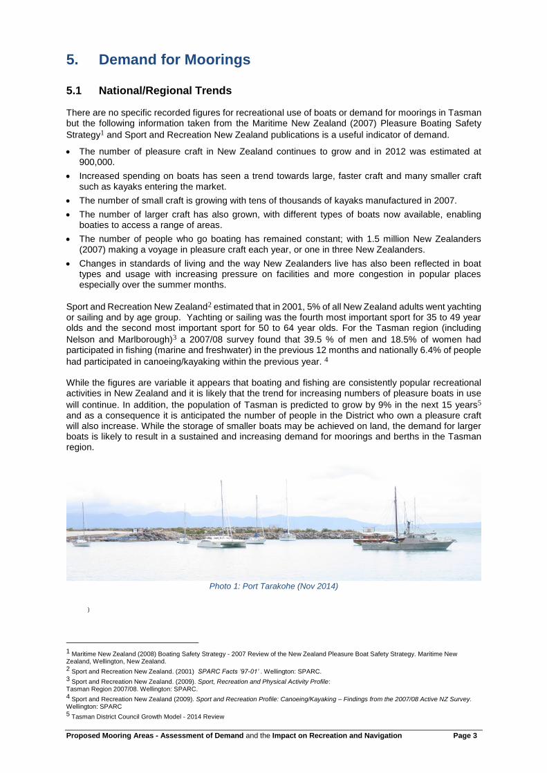
Photo 1: Port Tarakohe (Nov 2014)
)
1 Maritime New Zealand (2008) Boating Safety Strategy - 2007 Review of the New Zealand Pleasure Boat Safety Strategy. Maritime New Zealand, Wellington, New Zealand. 2 Sport and Recreation New Zealand. (2001) SPARC Facts ’97-01’ . Wellington: SPARC. 3 Sport and Recreation New Zealand. (2009). Sport, Recreation and Physical Activity Profile: Tasman Region 2007/08. Wellington: SPARC. 4 Sport and Recreation New Zealand (2009). Sport and Recreation Profile: Canoeing/Kayaking – Findings from the 2007/08 Active NZ Survey. Wellington: SPARC 5 Tasman District Council Growth Model - 2014 Review

Proposed Mooring Areas - Assessment of Demand and the Impact on Recreation and Navigation Page 4
6. Assessment of Demand for Each Mooring Area
6.1 Map 1 - Mapua The proposed mooring area adjoins Mapua township with access from the wharf and Grossi Point reserve. The mooring area experiences strong tidal currents which can place limitations on the type and size of boat that can moor there, however, the area is one of the few all tide mooring areas in the district. The mooring area is the closest to the township of Richmond and the combined population of Richmond, Mapua and the neighbouring Ruby Bay is over 15,000 (2011). The Mapua/Ruby Bay/ Richmond population is expected to increase by 9% in the next 15 years.5

Proposed Mooring Areas - Assessment of Demand and the Impact on Recreation and Navigation Page 5
Mapua currently has one of the highest concentrations of moorings in the district with 30 authorised moorings located in the area. The majority of the moorings were established decades ago under the Harbours Act 1950, at a time when no authorisation was required. Since 2000 five new moorings have been established and a similar number of pre 1991 moorings have been removed (withdrawn/surrendered/expired). Council has not received many enquiries regarding the establishment of new moorings in the main mooring area, this may be due to a belief that the area is full or it could be due to limitations and maintenance requirements arising from the tidal current. The five new moorings were established on the periphery of the existing areas.
Demand for new moorings in Mapua appears to be low, however, given the expected increase in population and the limited number of all tides moorings within the district, it is anticipated that demand for a permanent mooring area in Mapua is consistent and will increase over time.
6.2 Map 2 - Motueka 1
The Motueka 1 mooring area adjoins the Port of Motueka, which consists of well-established marinas for the Powerboat Club, Yacht Club and Peninsula Society. Access to the mooring area is tidally
restricted and dries for a significant part of the tidal cycle. There are two6 existing authorised moorings within the proposed area and approximately 23 unauthorised moorings.
Photo 2: Motueka 1 (Nov 2014)
The plan currently provides for moorings as a controlled activity in an area significantly larger than is proposed (see the area below). The controlled activity area is largely impractical for mooring and is
within an area with nationally significant natural ecosystem values7. Council has consequently made the decision to reduce the mooring area to the area currently occupied by moorings.
6 Council has received a third application for a mooring but the application is currently on hold at the request of the applicant. 7 Department of Conservation (1993). Internationally and nationally important coastal areas from Kahurangi Point to Waimea Inlet, Nelson, New Zealand: recommendations for protection. Occasional Publication 14.

Proposed Mooring Areas - Assessment of Demand and the Impact on Recreation and Navigation Page 6
The three marinas adjoining the proposed mooring area are currently full with demand for more berths, particularly during the off season when the commercial tourist operators berth their boats for the winter. The two consented moorings in the proposed mooring area were issued to a commercial operator. Access to the mooring area is currently limited by tide and occasionally weather, should access improve
through dredging or natural changes to the channel then demand for moorings is likely to increase.8
8 Pers Com. A Swanson Feb 2015

Proposed Mooring Areas - Assessment of Demand and the Impact on Recreation and Navigation Page 7
Photo 3: Motueka 1 (Nov 2014)
There were four boats moored/ anchored in the proposed mooring area on both site visits and between four to nine boats were noted in aerial photos (from 2001). The four boats appeared to be privately owned boats. It is estimated that up to 13 partial tide moorings could be located in the proposed area, which could leave a shortfall of 10 should all current mooring owners seek moorings licenses. It appears that the proposed mooring area would meet current use, but demand could be exceeded, particularly if access by water was improved.
6.3 Map 3 - Motueka 2
A new mooring area is proposed in front of the residential houses at Trewavas Street. The area is accessed through the adjoining residential properties and the foreshore reserve.

Proposed Mooring Areas - Assessment of Demand and the Impact on Recreation and Navigation Page 8
There are a number of dinghies and small boats stored on the adjoining foreshore reserve and 18 unauthorised moorings within the proposed area. No resource consent applications have been received by Council for moorings in this area, despite the area being extensively used to moor boats over a number of years. Two or more of the boats currently moored in the area are unused commercial boats, but otherwise it is uncertain who the moorings/boats belong to and as such demand is difficult to determine.
Photo 4: Motueka 2 (Nov 2014)
The area extensively dries out during low tide so use is restricted. Narrow access lanes and the distance from roads (up to 500m) may limit the type of boat that can be provisioned (e.g. refuelling) in that
location9. It is estimated that up to 20 moorings could be located in the proposed area with 16 moorings a realistic number. Eleven boats were moored along the foreshore at the time of the site visit and a number of additional small boats beached on the reserve were also noted. From the aerial photos (from 2001) between 8 to 10 boats are visible within the area. Demand for this area is unknown, but given that the area is accessible; in a residential area and adjoins the popular and growing township of Motueka it is likely that demand will be consistent and grow over time. The proposed area will meet the needs of the currently moored boat owners, however, should all mooring owners in the area seek a mooring licence then there will be a shortfall of 10 -15 moorings.
6.4 Map 4 - Tapu Bay The proposed mooring area adjoins the Stephens/Tapu Bay residential area and is 2 km south of the larger township of Kaiteriteri. The proposed area extensively dries during low tide which limits boat access. Vehicle access to the area is via a steep, unformed road which leads to the Tapu Bay Reserve. It is estimated that four moorings could be established in the proposed mooring area.
9 Pers Comm A Swanson Feb 2015

Proposed Mooring Areas - Assessment of Demand and the Impact on Recreation and Navigation Page 9
Photo 5: Tapu Bay (Jan 2015)

Proposed Mooring Areas - Assessment of Demand and the Impact on Recreation and Navigation Page 10
The area contains 15 unauthorised moorings which are thought to belong to Stephens/Tapu Bay residents and if that is correct then the demand for further moorings in the area may be relatively static as the residential area is largely developed. However, as the adjoining Stephens Bay mooring area is almost full, any further demand for moorings by the residents will need to be met in this area or elsewhere. There were no boats in Tapu Bay during the November site visit and two boats during the January site visit. Aerial photos (from 2001) show between 0 and 4 boats visible in the area. In the Assessment of Feedback on TRMP Mooring Review it was suggested by staff that the size of the area should be reduced as there appeared to be limited use and no specific demand for the area. The Council agreed and the area was reduced to the mapped area shown above. There are 15 unauthorised moorings in the Bay and it is assumed that demand could exceed the four mooring sites that could be established. The Harbourmaster sees value in retaining the larger, originally proposed area, which could contain up to eight mooring sites. The Harbourmaster believes the site could be useful in providing storage for some types of boats unable to be moored in the neighbouring
Stephens Bay and Kaiteriteri which are close or at capacity10. Overall, it is considered that there is currently limited demand for moorings in the proposed mooring area, however there is likely to be demand in the future and it is recommended that consideration be given to enlarging the proposed area to that originally proposed.
6.5 Map 5 - Stephens Bay
Stephens Bay has a well-established existing mooring area containing eight consented moorings. It is proposed that the area be extended seaward to incorporate two additional consented moorings and landward to incorporate another consented mooring. Stephens Bay is well used with access from the beach and the boat ramp. It is surrounded by residential dwellings with a large new area of residential development occurring on the hills between Kaiteriteri and Stephens Bay.
10 Pers Comm D Cairney Dec 2014

Proposed Mooring Areas - Assessment of Demand and the Impact on Recreation and Navigation Page 11
There are 12 authorised moorings in the proposed mooring area, three or four of the moorings are used by local commercial operators with the remaining held by a mix of residents, holiday home owners and people who reside outside of the district. Two moorings were established prior to 2000, seven between 2001 to 2009 and three moorings since 2010. Demand appears to have been relatively recent and steady. Feedback from consultation suggests that only three to five of the existing moorings are regularly used. The Harbourmaster has identified limited potential for further moorings to establish in the area, however, the site is quite exposed so demand may not be as high as it might otherwise be expected for an all tide site.
6.6 Map 6 - Kaiteriteri Kaiteriteri is the centre of the tourist industry for the Abel Tasman National Park with at least eight marine tourist operators based there. Kaiteriteri and the camping ground are also very popular with locals and visitors who use the beach to access the costal marine area. There are 22 authorised moorings located in the bay and three unauthorised moorings. Two commercial boats semi permanently anchor in the bay. Sixteen of the authorised moorings are managed by the Kaiteriteri Reserve Board (including one for the launch warden) and the remainder are held by commercial operators and two private individuals.

Proposed Mooring Areas - Assessment of Demand and the Impact on Recreation and Navigation Page 12
The Kaiteriteri Recreation Reserve Board (KRRB) holds resource consent until 2028 for the establishment of 13 seasonal moorings (November to April) and two permanent moorings in the mooring area closest to shore. The KRRB moorings have been placed in the same general area of the Bay for over 40 years and are rented out by KRRB to landowners and visitors. The purpose of the seasonal moorings is to relieve summer congestion and they are removed in winter when there is little demand. The two permanent moorings are available for use all year. Demand for recreational moorings is high over summer with demand exceeding supply.
Photo 6: Kaiteriteri (Jan 2015)
The second mooring area (seaward) contains four moorings in deeper water which are used by two commercial operators and two private individuals. There are two other moorings permitted by the current plan which are currently outside the proposed mooring area. The tourism industry has grown significantly over the last 20 years with a trend for more and bigger boats operating out of the Bay. While some boats relocate to other locations such as Port Motueka over the winter months this is not considered practicable during the summer months when the boats are operating for longer hours and access is dependent on weather and tide. There are currently insufficient moorings available for all commercial operators operating from the bay. Council has received enquiries and requests on a number of occasions by private individuals and commercial operators wanting to place additional moorings at Kaiteriteri. Policy in the Plan currently prevent the establishment of new moorings in the area and anecdotal evidence suggests that the number of illegal moorings and semi-permanent anchoring in the bay is increasing in response to unmet demand.
Photo 7: Kaiteriteri Bay (Nov 2014)

Proposed Mooring Areas - Assessment of Demand and the Impact on Recreation and Navigation Page 13
The moorings in the seaward proposed mooring area are currently defined as permitted activities in the Plan and the mooring layout is inefficient. The Harbourmaster considers that even with a more efficient swing mooring layout there will be insufficient space available for those boats that currently moor within the Bay. The use of different mooring systems such as fore and aft moorings would achieve more efficient use of this space. However, it is unlikely further demand for permanent moorings could be accommodated without reducing the area available to other recreational users, unless a very different approach is taken to boat storage in Kaiteriteri.
6.7 Map 7 - Otuwhero - Marahau The proposed mooring area is near the small settlement of Marahau and close to the boundary of the Abel Tasman National Park. The number of people travelling through and staying in Marahau swells during the summer months, with an estimate of more than 2000 people per day accessing the Park via
Marahau at the peak of the season (2012)11. Visitation is highly seasonal with 80% of use occurring
between November to April each year. The population of Marahau is likely to grow slowly12 over time with development opportunities existing within the township.
11
Department of Conservation & Tasman District Council (2012) Abel Tasman Foreshore Scenic Reserve Management Plan. Nelson, New Zealand 12
Tasman District Council Growth Model - 2014 Review.

Proposed Mooring Areas - Assessment of Demand and the Impact on Recreation and Navigation Page 14
No applications have been received by Council for moorings in this area, even though the area is already extensively used for mooring boats. There are 10 unauthorised moorings in the proposed area and a further nine located in the immediate area. The area extensively dries out during low tide which limits accessibility. There is rough vehicle access along the sand spit but recent erosion of the spit and further planned development work may reduce this to pedestrian access only. There is a car park at the base of the spit. North of the proposed mooring area is a boat launching ramp which is predominantly used by commercial operators to launch their boats. There is little information regarding the ownership of moorings. Anecdotal evidence suggests that one/two of the boats are used as live-aboard accommodation and some are owned by local residents. Feedback from consultation suggests that the area is heavily used during summer but not so well used during the rest of the year. During the two site visits in November the number of boats moored/anchored in the area was around 10 and the number of boats moored/anchored during the January site visit exceeded 20. Local anecdotal observation noted that the number of long term boats had decreased within the last year.
Photo 8: Otuwhero (Nov 2014)
Photo 9: Otuwhero (Jan 2015)

Proposed Mooring Areas - Assessment of Demand and the Impact on Recreation and Navigation Page 15
Photo 10: Otuwhero (March 2015)
Feedback suggests that there is an issue with boats being abandoned. The Harbourmaster confirmed that two derelict/abandoned boats were disposed of during the past year. The presence of 19 unauthorised moorings in the immediate area suggests there is demand for moorings. It is estimated that only four moorings can be established in the proposed area which means there is likely to be unmet demand for moorings in this area. Unmet demand could be met in part by semi-permanent anchoring in the area. It is recommended that Council reconsider the size and location of the mooring area to accommodate current use.
6.8 Map 8 - Torrent Bay The Torrent Bay settlement was surveyed as a village in the 1920s and remained in private ownership when the Abel Tasman National Park was established. There is no road access to the properties with residents and visitors relying on commercial boat transport or private craft to access the properties. There are 10 existing moorings which are currently authorised by resource consent. The consent for these moorings does not expire until 2029.

Proposed Mooring Areas - Assessment of Demand and the Impact on Recreation and Navigation Page 16

Proposed Mooring Areas - Assessment of Demand and the Impact on Recreation and Navigation Page 17
Photo 11: Torrent Bay 13
Photo 12: Torrent Bay (Jan 2015)
The New Zealand Cruising Guide14 identifies Torrent Bay as the most popular anchorage in Abel
Tasman National Park and the Charter Guide15 describes the area as the “only good big boat anchorage” in the Park. The Department of Conservation has recorded up to 21 boats per night using
Torrent Bay (1991-2).16
A previous Harbourmaster17 noted more than 100 boats rafted together at New Year. There is demand from commercial operators to moor in the adjoining Anchorage area.
13 http://www.baldwin.org.nz/images/adventurephotos/honeymoonbay/PC300251s.JPG 14 Murray, K. (2013) New Zealand Cruising Guide- Central Area. Stevens Publications. Wellington, New Zealand 15 http://www.charterguide.co.nz/Q_area.htm 16 Department of Conservation (1993). Internationally and nationally important coastal areas from Kahurangi Point to Waimea Inlet, Nelson, New Zealand: recommendations for protection. Occasional Publication 14. 17 Graham Caradus( comment from A Swanson)

Proposed Mooring Areas - Assessment of Demand and the Impact on Recreation and Navigation Page 18
Photo 13: Anchorage 18
The Plan currently limits the ownership of new moorings to those owning land in the bay with the establishment of new moorings subject to an assessment of effects. There are 46 built properties (plus three un-built) in Torrent Bay and 11 existing moorings (with one being located in Anchorage) associated with those properties. If all landowners in Torrent Bay required moorings then there would be demand for a further 38 moorings in the vicinity. Council granted two new applications for a mooring in 2012 with the majority of consents initially granted in 1994 and subsequently renewed at expiry of the term. Anecdotal evidence suggests that it may now be less convenient for landowners to use commercial transport and as a consequence there may be an increase in the use of personal craft to
access properties and demand for further moorings19. It is estimated that there may be room for one additional mooring within the constraints of the location.
6.9 Map 9 - Boundary Bay The Boundary Bay also adjoins the Abel Tasman National Park and contains eight privately owned properties. There is no road access to the properties with residents and visitors relying on commercial boat transport or private craft to access the properties. There are eight existing moorings which are currently authorised by resource consent. The majority of these consents do not expire until 2029. The
LINZ Nautical Chart 6144 and the New Zealand Cruising Guide10 identify Boundary Bay as a safe
anchoring area. The Plan currently limits the ownership of new moorings to those owning land in the bay with the establishment of new moorings subject to an assessment of effects. There are six built properties (plus two un-built) in Boundary Bay and eight existing moorings associated with those properties. The most recent consents were granted in 2013, 2009 and 2008. Five Boundary Bay properties have moorings associated with them, and one of those properties holds four of the eight mooring consents. Of the three properties without a mooring consent, two have not been developed and one has mooring access from the adjoining bay. It appears that there is sufficient room within the proposed mooring area to meet current demand. However, if the two undeveloped sections require mooring access then there will be a shortfall in mooring space. There may also be demand for moorings in Boundary Bay by Torrent Bay residents if mooring space is unavailable within that area. Potentially there is room to establish one additional mooring.
18 http://4time2fun.com/wp-content/uploads/2013/08/anchorage-Torrent-Bay-abel-tasman-national-park-new-zealand.jpg 19 Pers Comm. A Swanson Feb 2015

Proposed Mooring Areas - Assessment of Demand and the Impact on Recreation and Navigation Page 19
Photo 14: Boundary Bay (Jan 2015)

Proposed Mooring Areas - Assessment of Demand and the Impact on Recreation and Navigation Page 20
6.10 Map 10 - Ligar Inlet A new mooring area is proposed within the estuary and on the seaward side of the sand spit at Ligar Bay. The adjoining residential areas are Tata Beach and Ligar Bay. The larger township of Pohara is
4km south-west of the proposed mooring area. There are approximately 543 people (2014)20 living in the Pohara/Tata Beach/Ligar beach area, with the population swelling considerably over the summer months. The area has developed substantially over the past 20 years as a holiday and retirement area, and with the expected development of the immediate area and Port Tarakohe, the population could
increase further.21 Thirteen unauthorised moorings are located within the mooring area with a further six swing and a number of fixed moorings and jetties located in the immediate vicinity. The proposed mooring area is accessible via the road reserve and beach. The area dries out at low tide with restricted access to the proposed mooring area.
20 Tasman District Council Growth Model - 2014 Review. 21 Pers. Comm G. Cooper, 7/11/14

Proposed Mooring Areas - Assessment of Demand and the Impact on Recreation and Navigation Page 21
Port Tarakohe is located 2km south west of the proposed mooring area and contains 20 all tide moorings, currently there is a wait list for moorings. The Port also contains 41 marina berths and 20 pile berths that at the time of writing had some spare capacity. A recent review of the commercial operations within the Port lead to increased fees and the effect was for a number of existing boat owners to vacate their berths and either leave the port entirely or to relocate to the lower fee moorings within the Port.
This has led to a shortage of moorings within the Port and a surplus of marina berths22. The Port considers that there is no spare capacity to develop additional swing moorings within the Port and it is anticipated that within the next 5 years the number of moorings available within the Port will double when the Port moves to a more efficient mooring system e.g. fore and aft.
Photo 15: Ligar Inlet (Nov 2014)
It is estimated that six moorings could be established within the proposed mooring area at Ligar Bay. Should all existing mooring holders seek mooring space then there would be a shortfall of seven moorings. There were no boats moored/anchored at the time of the site visit. There were a number of dinghies beached on the sand spit. Future demand for moorings may be met by the provision of additional moorings within the Port. However, this opportunity will only be taken up by those boat owners with sufficient means and desire to pay the higher Port charges.
6.11 Map 11 - Milnthorpe A new mooring area is proposed near the wharf at Milnthorpe. Currently three unauthorised moorings are located in the proposed mooring area with a consented fixed mooring located at the edge of the proposed area. Access to the area is provided from the adjoining road and wharf. The feedback from consultation suggests that parts of the area are stony and sloping and that there may be limitations on the location, type of boat and mooring system used. Both moorings adjoining the proposed area use a four point mooring system to hold the boats. It is estimated that a maximum of five moorings could be provided in this area.
22
Pers Comm G. Cooper, 7/11/14

Proposed Mooring Areas - Assessment of Demand and the Impact on Recreation and Navigation Page 22
The consented moorings and boats in Milnthorpe appear to be owned by locals and residents. There have been few applications or enquires for moorings in the area with two of the three applications formalising historic moorings. At the time of the site visit there were three boats moored/anchored in the area. The Milnthorpe settlement is almost fully developed and it is anticipated that very little additional demand will occur in the immediate future.

Proposed Mooring Areas - Assessment of Demand and the Impact on Recreation and Navigation Page 23
Photo 16: Milnthorpe (Nov 2014)
6.12 Map 12 – Mangarakau Wharf The proposed mooring area adjoins the Mangarakau Wharf (with a 20 m setback), the location and size is defined by the Westhaven Marine Reserve and the 20 m setback form Mean High Water Springs. The land adjoining the wharf is part of the North-West Nelson Conservation Park. Access to the wider inlet is provided by the boat ramp at Mangarakau and near the Kaihoka Road turn-off. The population of the wider Westhaven area is low with a few scattered farms and holiday homes to the SW and NW of the proposed area. There are currently two moorings located within the proposed area which are owned and by local fisherman. These moorings have been at this location for over 30 years and are regularly used and maintained. The feedback from consultation identifies this area is the only “safe haven” between Golden Bay and Westport; deep water and most sheltered from all winds.
Photo 17: Mangarakau Wharf (Nov 2014)

Proposed Mooring Areas - Assessment of Demand and the Impact on Recreation and Navigation Page 24
It is estimated that a maximum of eight moorings could be established within the proposed area. It is thought likely that demand will remain low due to the remoteness of the area, however, demand may increase with time.

Proposed Mooring Areas - Assessment of Demand and the Impact on Recreation and Navigation Page 25
7. Recreational Use and Navigational Safety
Assessment for each Mooring Area
7.1 Map 1 - Mapua
Mapua is a small settlement about 19 km from the main township of Richmond. Mapua has a thriving wharf and commercial area and is a popular recreational destination, particularly during the summer months. Once a busy coastal freight wharf during the orchard heyday, Mapua Wharf now contains a restaurant, bar, café and arts and crafts precinct.
Photo 18: Mapua (Nov 2014)
The area is popular with recreational boaties and is often visited as a day trip from Nelson or Motueka. The area has historically been used for marine activities and consists of a large mooring area, wharf, boat ramp and floating pontoon. A ferry operates between Mapua and the neighboring Rabbit Island providing a link for cyclists on the Great Taste cycle way. The Mapua camping ground is popular and particularly busy during the summer months and campers are encouraged to use the boat ramp and wharf facilities during their stay.
Photos 19: Mapua (Nov 2014)

Proposed Mooring Areas - Assessment of Demand and the Impact on Recreation and Navigation Page 26
The wharf provides berthage with space for a number of visiting boats to moor alongside. The size of boats entering the Mapua estuary is limited because of the depth of water and navigational space within
the channel and estuary. The New Zealand Cruising Guide23 recommends that cruising boats will find adequate depths of water as far as the wharf. The Guide also advises that the sandbar at the entrance to the estuary shifts and can be dangerous to cross at certain times of the day and conditions.
Adjoining the proposed mooring areas are two recreation reserves. The Mapua Waterfront Reserve and the Grossi Point Reserve which are used for passive recreation e.g. walking, picnicking, swimming, fishing, bird-watching, dog walking and boat launching. Broader recreational use of the Waimea Inlet includes shellfish collection, duck shooting, whitebating, fishing, and walking24.
The proposed mooring area adjoining the wharf is located in an established and historic mooring area and the scale and intensity of moorings is not expected to change significantly from traditional use. The newer area at Grossi point has also been used for moorings for a number of years and moorings in this area are an established use. To accommodate other recreational users the proposed mooring areas have been set back 20 m from the foreshore and wharfage structures and three access ways are included.
The extension of the existing mooring areas is likely to have a positive effect on the recreational use of the area, providing additional safe locations for boat storage while leaving sufficient space or other recreational users moving through the area. Moorings are anticipated in the area and an extension of the mooring area is not expected to significantly affect other recreational users. The locations of the proposed mooring areas have been reviewed by the Harbourmaster and they are considered appropriate in terms of navigation safety. The Harbourmaster considered there is ample room within the channel for public use for the bulk of the tide cycle and navigation through the Glossi Point access area is possible at low tide.
7.2 Map 2 - Motueka 1 A small commercial port and marina adjoins the proposed mooring area. They form the largest hub of marine activity within the District. The main wharf is owned and operated by Talleys Group Ltd and is used for commercial purposes (restricted access) There are also three separate marinas, one formed boat ramp and two informal boat ramps, owned and operated by the Motueka Power Boat Club, Motueka Yacht and Cruising Club and Motueka Peninsula Marine Society. There are approximately 90 berths within the three marinas which are used by a mix of commercial and recreational boats.
Photos 20: Motueka
There is also an adjoining hardstand area which is used for boat storage and maintenance.
23 Murray, K. (2013) New Zealand Cruising Guide- Central Area. Stevens Publications. Wellington, New Zealand 24 Robertson, B. & Stevens, L. (2012) Tasman Coast Waimea Inlet to Kahurangi Point: Habitat Mapping, Ecological Risk Assessment, and Monitoring recommendations. Wriggle Limited, Nelson

Proposed Mooring Areas - Assessment of Demand and the Impact on Recreation and Navigation Page 27
Photos 21: Motueka (Nov 2014)
Berths and other services are provided for visiting boats. Casual users can access the boat ramps for the launching and retrieval of recreational boats. During the site visit three recreational boats where launched or retrieved from the main boat ramp, with the boat owners stating that they had been fishing. It appears that some of the boats in the marina are used as live aboard accommodation. There was little passive recreational use of the area noted, however it is anticipated that this would occur as wharf areas tend to attract people. Other recreational use of the broader Moutere Inlet includes shellfish collecting, swimming, whitebaiting, fishing, walking and scientific appeal.
The New Zealand Cruising Guide 25 does not specifically mention this area but shows the proposed area as “dries”. LINZ Nautical Chart 6144 does not show this area as an anchorage. Concerns have been expressed that the bar entrance is getting increasingly shallow and dangerous for unskilled and inexperienced boaties and there is increasing pressure to dredge the channel to enable greater use of
the Port26.There is also interest from the community and port users to further develop the marina
facilities enabling greater commercial and recreational use of the Port27. The Harbourmaster is aware of the concerns raised regarding the bar entrance but does not have any specific concerns regarding the location of the proposed mooring area.
Photo 22: Proposed Mooring Area
The area proposed for moorings is an area already identified within the Plan for moorings and there are a number of boats moored within this area. The area has been used for moorings for a number of decades and the presence of moorings in this area is anticipated. The area identified for moorings in the draft plan change is significantly smaller than currently identified in the Plan. It is considered that the proposed mooring area will not affect existing recreational use and overall will have a positive effect, providing a safe location for boat storage.
7.3 Map 3 - Motueka 2
25 Murray, K. (2013) New Zealand Cruising Guide- Central Area. Stevens Publications. Wellington, New Zealand 26 http://www.stuff.co.nz/nelson-mail/news/4979054/Port-users-channel-should-be-dredged 27 http://www.motuekaonline.org.nz/news/stories11/151011s1.html
Proposed Mooring Areas - Assessment of Demand and the Impact on Recreation and Navigation Page 28
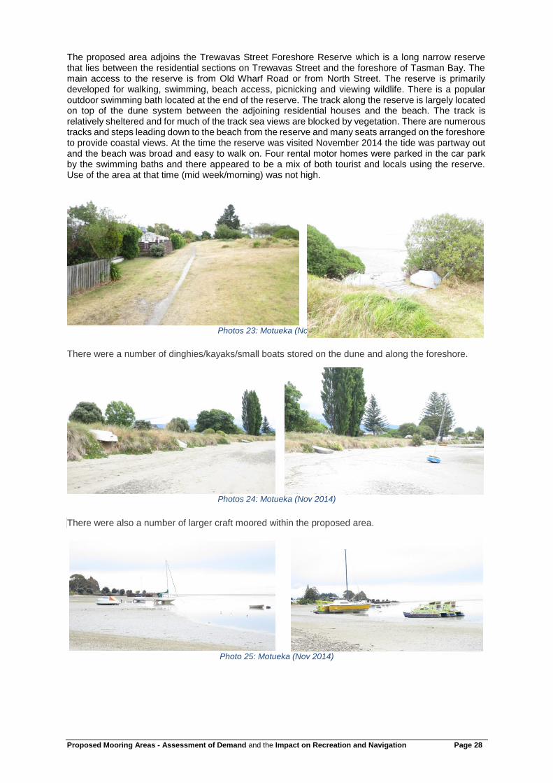
The proposed area adjoins the Trewavas Street Foreshore Reserve which is a long narrow reserve that lies between the residential sections on Trewavas Street and the foreshore of Tasman Bay. The main access to the reserve is from Old Wharf Road or from North Street. The reserve is primarily developed for walking, swimming, beach access, picnicking and viewing wildlife. There is a popular outdoor swimming bath located at the end of the reserve. The track along the reserve is largely located on top of the dune system between the adjoining residential houses and the beach. The track is relatively sheltered and for much of the track sea views are blocked by vegetation. There are numerous tracks and steps leading down to the beach from the reserve and many seats arranged on the foreshore to provide coastal views. At the time the reserve was visited November 2014 the tide was partway out and the beach was broad and easy to walk on. Four rental motor homes were parked in the car park by the swimming baths and there appeared to be a mix of both tourist and locals using the reserve. Use of the area at that time (mid week/morning) was not high.
Photos 23: Motueka (Nov 2014)
There were a number of dinghies/kayaks/small boats stored on the dune and along the foreshore.
Photos 24: Motueka (Nov 2014)
There were also a number of larger craft moored within the proposed area.
Photo 25: Motueka (Nov 2014)

Proposed Mooring Areas - Assessment of Demand and the Impact on Recreation and Navigation Page 29
Feedback from consultation generally supports the proposed mooring area with existing boats considered not to be causing a problem, with one respondent seeing it as practical to moor a boat near the house. The Motueka Yacht and Cruising Club supported the proposed mooring area (at a reduced size and low density) and believe the amendments reflected the use of the estuary by small boats over many decades However, other respondents raised concerns that the proposed mooring area could result in a large number of boats which could restrict the use of the area by swimmers, kayakers and dingy sailors. Concerns were also raised by respondents regarding the sensitive environment of the estuary and abandoned/ derelict boats. Following consideration of the feedback by Council the proposed mooring area was significantly reduced in size.
The New Zealand Cruising Guide28advises that almost all of the inlet dries at low water and shows the area on the map as “dries”. LINZ Nautical Chart 6144 does not show this area as a safe anchorage The Harbourmaster has no navigation safety concerns with the proposed mooring area.
Following the reduction from the original proposed area, it is considered that the proposed mooring area will not significantly affect recreational use in the area and will support recreational use by providing additional boat storage. Residual concerns regarding the number of boats within the area and the impact they might have can be controlled by limiting the number of mooring licenses issued or imposing a maximum density, if needed. The Harbourmaster also has powers to dispose of derelict boats.
7.4 Map 4 - Tapu Bay The proposed mooring area adjoins the Tapu Bay reserve in the settlement of Tapu Bay. The reserve comprises a grassed area beside the beach with picnic tables and rubbish containers. The main access to the reserve is down a steep access from Tapu Place. The reserve provides vehicle access to the foreshore and the main use of the reserve is for boat launching, and informal recreation.
Photo 26: Tapu Bay Reserve (Nov 2014)
28 Murray, K. (2013) New Zealand Cruising Guide- Central Area. Stevens Publications. Wellington, New Zealand

Proposed Mooring Areas - Assessment of Demand and the Impact on Recreation and Navigation Page 30
Photo 27: Tapu Bay (Nov 2014)
The Council is currently working with adjoining landowners to restore the reserve. Reserves staff have no concerns regarding the effects of the proposed mooring area on recreational use of the reserve. Tapu Bay adjoins Stephens Bay and Stephens Bay appears to be the favored location for recreation use.
The New Zealand Cruising Guide29does not discuss Tapu Bay other than to say that Anawera Point separating Tapu and Stephens Bay has an outlying reef and should be given a wide berth. LINZ Nautical Chart 6144 does not show this area as an anchorage. The Harbormaster has not raised any navigational or safety concerns with the proposed area.
Photo 28: Tapu Bay (Nov 2014)
It is considered that the proposed mooring area will not affect existing recreational use of the area and overall will have a positive effect, providing a safe location for boat storage.
7.5 Map 5 - Stephens Bay Stephens Bay and the adjoining foreshore reserve is a popular location for both passive and active marine based recreation (boating, swimming, walking, fishing and shellfish gathering) particularly during the summer months. A few commercial tourist operators operate out of the Bay with additional operators using the boat ramp when adverse weather and tidal conditions affect their normal sites.
29 Murray, K. (2013) New Zealand Cruising Guide- Central Area. Stevens Publications. Wellington, New Zealand

Proposed Mooring Areas - Assessment of Demand and the Impact on Recreation and Navigation Page 31
Photo 29: Stephens Bay - Proposed Mooring Area (Jan 2014)
There is a recreation reserve adjoining the esplanade reserve which contains a picnic/BBQ area and toilet facilities. The reserves are used year around, particularly by Stephens and Tapu Bay residents. The proposed mooring area is located approximately 100 m off shore from mean high water springs and incorporates 10 existing moorings. Up to 3 new moorings could be located seaward of the existing area.
The New Zealand Cruising Guide30 states that in addition to the outlying reef at Anawera Point there are a number of rocks and other underwater obstacles in Stephens Bay which should only be approached with great caution. LINZ Nautical Chart 6144 does not show this area as a safe anchorage. The Harbourmaster has not raised any navigational and safety concerns (see below). Historically, the use of the Bay at peak times of year has caused conflict between locals and other users, particularly with regard to parking. Aerial photos taken during the Christmas period show numerous cars, boat trailers, boats, kayaks and dinghies in and around the esplanade reserve.
Photo 30: Explore Tasman (taken from internet 12.1.15)
30 Murray, K. (2013) New Zealand Cruising Guide- Central Area. Stevens Publications. Wellington, New Zealand
Proposed Mooring Areas - Assessment of Demand and the Impact on Recreation and Navigation Page 32
Changes to the reserve, roading and parking layout have since improved the situation31. However, concern still exists and several respondents to the consultation document raised concerns about: the popularity of the bay; capacity to cope with additional use; pressure on/for new onshore facilities; and safety and conflicting uses and values. Some felt the bay was too busy and felt unsafe. The feeling among some was that there is no room for additional boats, particularly for more commercial activity. There appears to be two potential impacts from the proposed moorings area. The first is the increasing complexity and level of use in the bay and whether or not the proposed moorings area will adversely affect other users. The second issue is potential adverse effects arising from the use of the bay by commercial operations. All existing moorings in the proposed mooring area are consented and have the right to continue occupying the space until expiry of consent (between 2015 and 2025). The potential addition of 3 moorings (seaward) is thought to have a lesser impact on recreational use than the current moorings which are located within 100m of the foreshore. From the feedback there was a comment that only three to five of the moorings were regularly used, if the use of the existing moorings where to increase as well as additional moorings then the complexity and level of use of the bay may also increase, creating further conflicts among recreational users. However, from the site visits the majority of congestion appeared to occur between the beach and the mooring area, with very little occurring within the mooring area other than people passing through. There are no recorded complaints regarding the moorings in Stephens Bay. If activity increases in the bay to the extent that there is a significant conflict between recreational uses and the moorings then, the Harbourmaster has the capacity to relocate moorings (on expiry of consent or license) or reduce the number of moorings to mitigate navigation and safety concerns. The Harbourmaster also has powers to prohibit and reserve areas for particular uses e.g. swimming, water skiing, should conflicting recreational use become a navigational safety matter. Council has very little control over who uses the road, reserve or boat ramp to access the coastal area and subsequently it is difficult to limit commercial operators within Stephens Bay.
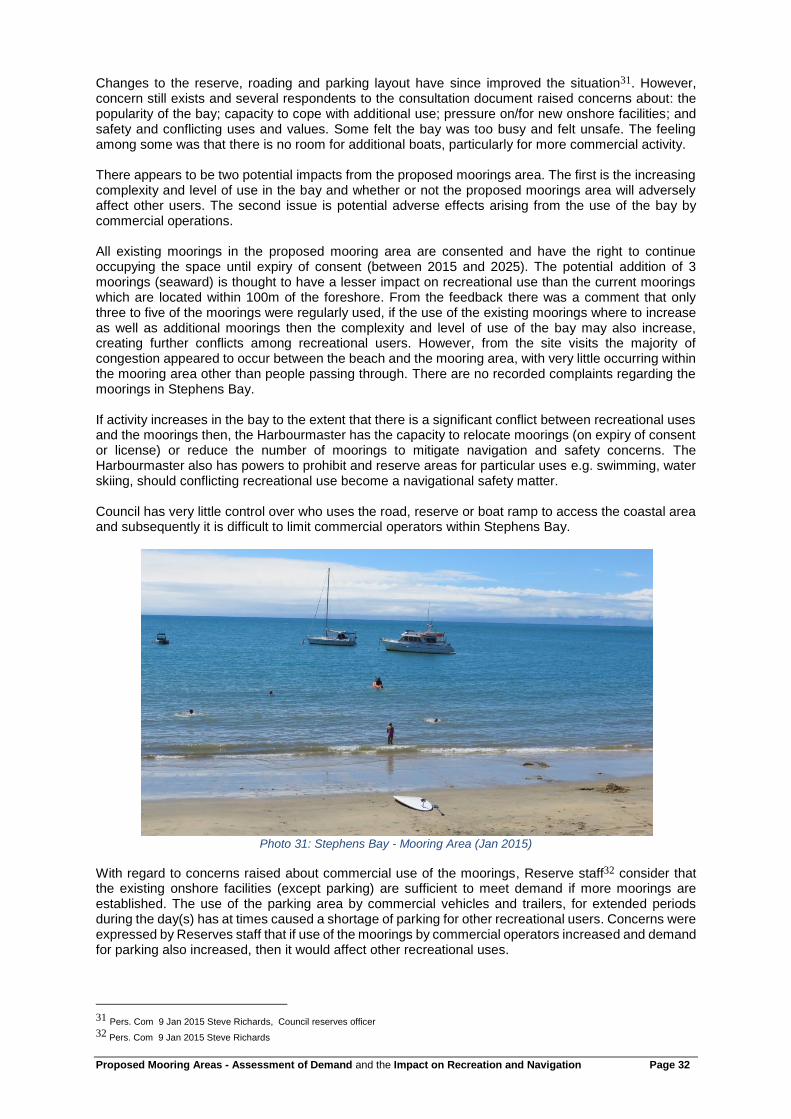
Photo 31: Stephens Bay - Mooring Area (Jan 2015)
With regard to concerns raised about commercial use of the moorings, Reserve staff32 consider that the existing onshore facilities (except parking) are sufficient to meet demand if more moorings are established. The use of the parking area by commercial vehicles and trailers, for extended periods during the day(s) has at times caused a shortage of parking for other recreational users. Concerns were expressed by Reserves staff that if use of the moorings by commercial operators increased and demand for parking also increased, then it would affect other recreational uses.
31 Pers. Com 9 Jan 2015 Steve Richards, Council reserves officer
32 Pers. Com 9 Jan 2015 Steve Richards

Proposed Mooring Areas - Assessment of Demand and the Impact on Recreation and Navigation Page 33
The launching of commercial boats and trailer parking on legal road cannot be addressed through the draft plan change as parking on the road is a permitted activity. The provisions in the draft plan change cannot also address the current commercial use of the moorings because they are authorised by resource consent, up until 2025. Long term the use of the moorings by commercial operators could be controlled through the Plan; however, it may encourage commercial operators to trailer in large boats instead which could worsen the identified parking problem. The Harbormaster has not raised any navigational or safety concerns with the proposed area.
Over all, it is considered that the proposed mooring area will not significantly affect existing recreational users.
7.6 Map 6 - Kaiteriteri The Kaiteriteri Recreation Reserve consists of 242 Ha of land and is a nationally important recreational and leisure destination. Residential development surrounds the reserve and there is a significant
permanent resident population (789 people -2013 census33) as well as a large number of holiday homes. Kaiteriteri Recreation Reserve is one of the most popular camping sites in the South Island and is an important gateway to the Abel Tasman National Park. In 2008 the water taxis and guided on-water tour concessionaries operating from Kaiteriteri carried over 38,000 visitors into Abel Tasman National Park and between 100,000 and 114,000 bed nights are recorded at the Kaiteriteri Recreation Reserve
annually. 34 35 Kaiteriteri is a high recreational use area with both commercial and private recreational activities taking place. Recreational use is a mix of passive (walking, sunbathing) and active – boating, kayaking, swimming, paddle boarding etc. In 2009 a 180 Ha mountain bike park was added to the Reserve and in 2014 the Great Taste Bike trail was extended to Kaiteriteri, increasing the number of land based recreational users.
Photo 32: Kaiteriteri (http://www.tasman.govt.nz/tasman/settlements/kaiteriteri/kaiteriteri-photos/)
The New Zealand Cruising Guide36 describes the amenities of the Bay and suggests that launches can temporally beach their bows on the sand and anchorage is shown on the maps within the area set aside for swimming. Anchoring is only recommended in certain winds. The Harbourmaster recommends
33 http://www.stats.govt.nz/Census/2013-census/profile-and-summary-reports/quickstats-about-a-place.aspx?request_value=14560&parent_id=14547&tabname= 34Department of Conservation (2006) Kaiteriteri Recreation Reserve Management Plan 2006, http://www.doc.govt.nz/about-doc/policies-and-plans/conservation-management-plans/kaiteriteri-recreation-reserve-management-plan/ 35 Kaiteriteri Recreation Reserve Board (2011) Draft Kaiteriteri Recreation Reserve Management Plan. 36 36 Murray, K. (2013) New Zealand Cruising Guide- Central Area. Stevens Publications. Wellington, New Zealand

Proposed Mooring Areas - Assessment of Demand and the Impact on Recreation and Navigation Page 34
anchoring beyond the 3m contour as beached boats can be swamped. A former Harbourmaster also states the bay is not safe for anchoring with rough seas building very quickly in certain winds and
areas37. LINZ Nautical Chart 6144 does not show this area as an anchorage. The Kaiteriteri Recreation Reserve Board manages the reserve, including the foreshore, for a range of recreational opportunities primarily through the allocation of space to different users. In the 2006
Kaiteriteri Recreation Reserve Management Plan38 the proposed mooring area partially falls within and adjoins an area identified in the Plan for mooring and anchorage use. Boat launching, swimming and waterskiing are provided for elsewhere in the Bay. Navigation and safety matters arising from use of the water is managed under the Draft Navigation and Safety Bylaw (2014). The Bylaw specifies areas and times of use for particular activities. The inshore proposed mooring area is partially identified as an anchoring prohibited area and boat access, waterskiing and swimming are specifically provided for in other areas. The Harbourmaster has no navigational and safety issues with the areas proposed for mooring, and the proposed mooring areas are consistent with the recreational uses of the area.
Photo 33: Kaiteriteri (Jan 2015)
From the feedback there appeared to be little tension between the recreational use and the demand from commercial operators for more moorings. One person commented that it appeared that pressure was being put on Council to accommodate the commercial sector with preference over the general public which was at odds with the purpose of Kaiteriteri Recreation Reserve. The issue was more with the impact of commercial operations than the moorings them self. There were a number of suggestions as to how the moorings could be arrange to enable greater casual anchoring in the Bay. It appears that the demand for moorings within the Bay by commercial operators has reached the point that the response to the unmet demand is in the form of illegal moorings and semi-permanent anchoring may now be impacting on casual anchoring opportunities. Through the proposed mooring areas there is the potential to meet the needs of the commercial operators as well as providing more space for causal mooring through more efficient use of the mooring area.
37 Tom Rowling- Feed back on the discussion document 38 Department of Conservation (2006) Kaiteriteri Recreation Reserve Management Plan 2006, http://www.doc.govt.nz/about-doc/policies-and-plans/conservation-management-plans/kaiteriteri-recreation-reserve-management-plan/

Proposed Mooring Areas - Assessment of Demand and the Impact on Recreation and Navigation Page 35
Photo 34: Kaiteriteri (Jan 2015)
7.7 Map 7 - Otuwhero - Marahau Marahau is a small settlement which is located near the entrance to the Abel Tasman National Park. The number of people travelling through and staying in Marahau swells during the summer months with 80% of the National Park use occurring between November to April each year. A large number of commercial operators access the Abel Tasman National Park from Marahau. Most commercial operators and private individuals use a centrally located concrete boat ramp with a defined corridor for launching. At the peak of the season over 100 vehicle movements per day (2008)
have been recorded at the boat ramp39.
Photos 35: Marahau (Nov 2014)
Marahau is the most popular launching site for kayakers using the Park and the majority of guided kayak tours leave from Marahau. A number of water taxis also operate from Marahau, providing a pick up and drop off service to trampers in the Park. Other recreational uses of Otuwhero estuary include shellfish collecting, swimming, whitebaiting, fishing, boating and walking.
39
Tasman District Council (2008). Resource Consent application file 080651

Proposed Mooring Areas - Assessment of Demand and the Impact on Recreation and Navigation Page 36
Photo 36: Marahau (Nov 2014)
The New Zealand Cruising Guide40does not recommend this area and shows the area as “dries”. LINZ Nautical Chart 6144 does not show this area as an anchorage. The proposed mooring area is located 500m SW of the main boat ramp and is accessed along a sandbar. A car park and toilet are located at the base of the sandbar. Vehicle access is possible, but limited.
At the time of the November site visit there were 11 boats moored/ anchored around the sand spit, which is a decrease on 15-16 boats normally seen on aerial photos. One derelict boat had been removed earlier in the year with a further derelict boat due for removal. Local feedback suggested that a number of long term boats had recently relocated elsewhere. Feedback from respondents suggested the area traditionally is used by local, small, non-commercial craft and provides “low cost, self serviced moorings for people of small means to own and enjoy boats”.
Photo 37: Marahau (Nov 2014)
A number of dinghies, kayaks, bikes and other recreational equipment were stored on the foreshore. At the end of the spit is a boat launching area.
40
Murray, K. (2013) New Zealand Cruising Guide- Central Area. Stevens Publications. Wellington, New Zealand

Proposed Mooring Areas - Assessment of Demand and the Impact on Recreation and Navigation Page 37
Photo 38: Marahau - boat launching area (Nov 2014)
One respondent identified that the two spits were increasingly used for walkers, bird watches, kayakers, paddle boarders, swimmers, windsurfers and fishers and opposed the proposed mooring area because it was a prime area for recreation. Another respondent similarly suggested that the inlet had become a major recreation area, particularly for swimming, and that the boats and mooring structures & ropes were a hazard to the public. Concern was raised regarding the congestion that occurred in the adjoining car park and loading zone from commercial and non-commercial recreational use. The feedback suggested that the proposed mooring area would lead to further congestion.
Photo 39: Marahau (Jan 2015)
The proposed mooring site was visited three times (during the week, mid and late afternoon and weekend) no other person was seen on the sand spit during those visits, although there was evidence of the area being used (boats, bikes and footprints). During the weekend there were a number of campervans, tourists and a commercial operator at the car park. It was considered that there were few if any impediments to recreation on the eastern side of the spit and sufficient room for walking along the western side of the spit. There were several anchor ropes on the foreshore, but in general walking access along the foreshore was not considered difficult.

Proposed Mooring Areas - Assessment of Demand and the Impact on Recreation and Navigation Page 38
Photo 40: Marahau (Jan 2015)
The introduction of a proposed mooring area is anticipated to reduce the number of boats moored in the area. It is anticipated that the proposed mooring area will not increase the congestion currently
experienced at the car park which appears from community feedback and observation41 to be largely associated with local, tourist and commercial use of the sand spit. The introduction of a mooring area may improve access along the foreshore with greater regulation of mooring systems and a reduction in the number of boats moored in the area. The reduction in the number of moorings may reduce the recreational opportunity for those previously moored in the area, however, this may be offset by the boats anchoring further offshore, which is a permitted activity. The Harbourmaster does not have any navigation or safety concerns with the proposed mooring area. Overall, it is considered that the proposed mooring area will not significantly affect the recreational use of the area and may positively enhance it by reducing the number of mooring and anchoring ropes along the foreshore.
7.8 Map 8 - Glasgow and Torrent Bays and Map 9 - Boundary Bay Glasgow and Torrent Bay are areas used for both mooring and casual anchoring by recreational vessels, particularly over the summer months. The New Zealand Cruising Guide42
identifies the Torrent Bay area as the most popular anchorage in the Abel Tasman National Park and states that Anchorage is the most protected with three anchoring areas shown. The Guide advises that Torrent Bay has good holding and shelter from W to N winds and there is not much room to anchor. Boundary Bay is identified as having dangerous reefs extending from either side of its entrance, but sheltered within.43
The LINZ Nautical Chart 6144 shows anchorages in Boundary Bay and in the Anchorage. The Department of Conservation has recorded up to 21 boats per night using Torrent Bay (1991-2)44 and over 100 boats
were noted by a former Harbormaster at one New Year45. The Abel Tasman National Park Great Walk Track passes through Torrent Bay and the beach at Torrent Bay and Anchorage are commercial access points for the track. The Department of Conservation limits commercial boat drop offs to Torrent Bay to the morning & noon. These restrictions do not effect residents (or their guests) or private pleasure craft. There is no direct access to the track from Boundary Bay and the bay is not an identified commercial tourist access point. Both areas contain private residences and holiday homes. The Abel Tasman National Park is used by a wide range of people for
41 Site visit Jan 2015 42 Murray, K. (2013) New Zealand Cruising Guide- Central Area. Stevens Publications. Wellington, New Zealand 43 Murray, K. (2013) New Zealand Cruising Guide- Central Area. Stevens Publications. Wellington, New Zealand 44 Department of Conservation (1993). Internationally and nationally important coastal areas from Kahurangi Point to Waimea Inlet, Nelson, New Zealand: recommendations for protection. Occasional Publication 14. Pg 90 45 Per Com from A. Swanson regarding a comment by Graham Caradus.

Proposed Mooring Areas - Assessment of Demand and the Impact on Recreation and Navigation Page 39
tramping, swimming, sunbathing, boating and pic-nicking. Many people access the Abel Tasman coast from the sea, with over 90% of the visitors to the national park using the coastal environment.46 There have been no complaints lodged with Council with respect to the placement and use of the existing moorings and the use is understood to be infrequent, usually of short duration and seasonal. The feedback also states that the mooring location causes few problems during the busy Christmas period. Recreational users of the area are accustomed to the placement and use of the moorings and anchor and navigate accordingly. Comment was made through the feedback that further moorings would over-intensify the use of the available water and restrict water taxi access. It is proposed that only one additional mooring in Torrent and Boundary Bay be established and at that density the Harbormaster is not concerned the mooring area will restrict water taxi access. The Harbourmaster has not identified any navigational or safety concerns with the proposed mooring area location. It is considered that the proposed mooring area will not affect existing recreational use of the area and overall will have a positive effect, providing a safe location for boat storage.
7.9 Map 10 - Ligar Inlet The proposed mooring area is on the western side of the Ligar Bay sand spit and is located at the end of Ligar Bay beach. There is off road parking and access to the area from the adjoining Ligar Bay foreshore reserve. Access along the spit is not well formed and at high tide access along the spit beach is restricted. At low tide the area dries. There are few houses in the vicinity of the mooring area with most residential dwellings located further south & north in Ligar and Tata Bay.
The New Zealand Cruising Guide47 describes the area as pleasant in calm weather, but the beach becomes most difficult in W to NW winds when a strong swell affects it. No anchorage areas are identified. LINZ Nautical Chart 6144 does not show this area as a safe anchorage. The Harbourmaster has not identified any navigational or safely issues. Tourist websites identify Ligar Bay as a good picnic spot with a safe, sandy, flat and beautiful beach with little motorised sporting activities, fishing and kayaking is popular. The neighbouring Tata Beach has a boat ramp which is popular with water skiers and jet skiers. Port Tarakohe, 2km south west of the proposed mooring area, contains a marina, moorings, the local boat club and other amenities and maintenance facilities. Port Tarakohe is the main location for marine activity. Robertson, B. & Stevens identify the wider area has having high use, and is valued for its aesthetic appeal, biodiversity, shell fish collection, swimming, whitebaiting, boating, walking, cycling and scientific
appeal48.
Photo 41: Ligar Bay (Nov 2014)
46 Tasman District Council& Department of Conservation ( 2012) Abel Tasman Foreshore Scenic Reserve Management Plan. Nelson, New Zealand 47 Murray, K. (2013) New Zealand Cruising Guide- Central Area. Stevens Publications. Wellington, New Zealand 48 Robertson, B. & Stevens, L. (2012) Tasman Coast Waimea Inlet to Kahurangi Point: Habitat Mapping, Ecological Risk Assessment, and Monitoring recommendations. Wriggle Limited, Nelson

Proposed Mooring Areas - Assessment of Demand and the Impact on Recreation and Navigation Page 40
At the time of the site visit no boats were moored/ anchored in the proposed mooring area. Four boats were located across the channel either on pile or lean on moorings and one boat was seen anchored further into the inlet.
Photo 42: Ligar Inlet (Nov 2014)
It is considered that the proposed mooring area will not affect existing recreational use of the area and overall will have a positive effect, providing a safe, low cost location for boat storage.
7.10 Map 11 - Milnthorpe Milnthorpe is a small residential area consisting of about 20 houses located in the Parapara Inlet. Two consented moorings are located north of the proposed mooring area and are owned by residents. A third consented fixed mooring is located adjoining the proposed mooring area. Access to the proposed mooring area is through the Milnthorpe Quay reserve. The reserve contains a boat ramp and adjoins an old wharf which is derelict.
Photos 43: Milnthorpe
The New Zealand Cruising Guide49 does not mention the proposed mooring area beyond stating that it is possible to enter the river at High Water and there is a wharf. LINZ Nautical Chart 6144 does not show this area as an anchorage. During the site visit three boats were moored in the area and a recreational fishing boat departed from the boat ramp. From the feedback it appears the area is also used by kayakers and small boats, particularly catamarans. Other comments were that the proposed mooring area was suitable because it was in an area not used by other boaties. Concern was raised in the feedback regarding the need to keep the mooring area set back from the channel and to keep the channel clear for navigation and particularly for recreational users such as learner sailors. Issues were raised regarding the effects of an existing 4 point mooring which was thought to hamper other craft turning in the area. Feedback also suggested that a 40m set back from
49
Murray, K. (2013) New Zealand Cruising Guide- Central Area. Stevens Publications. Wellington, New Zealand

Proposed Mooring Areas - Assessment of Demand and the Impact on Recreation and Navigation Page 41
shore should be used. The Harbourmaster has not identified any navigational safety issues with the proposed mooring area.
Photo 44: Milnthorpe (Nov 2014)
There are numerous tracks criss-crossing the hillside above the settlement in the Milnthorpe Park
Scenic Reserve, with some tracks leading to the beach50. There is also a coastal walkway developed
along the Milnthorpe Quay Reserve51. The Department of Conservation suggests that the estuary and
coast provide good swimming. Robertson & Stevens52 states the area is valued for shellfish collection, swimming, whitebaiting, fishing, boating, and walking. It is considered that the proposed mooring area will not significantly affect existing recreational use of the area and overall will have a positive effect, providing a safe location for boat storage.
7.11 Map12 – Mangarakau Wharf
Photo 45: Mangarakau Wharf
The proposed mooring area is located at the remote Mangarakau Wharf, in the Westhaven Inlet and adjoins one of the two boat ramps in the immediate area. The area is dominated by an old derelict wharf and reclamation which is predominantly used as a storage area for commercial fishing.
50 http://www.goldenbaynz.co.nz/walks/milnthorpe-park-scenic-reserve/ 51 Tasman District Council (2003) Golden Bay Ward Reserves Management Plan-Milnthorpe Quay Reserve. 52 Robertson, B. & Stevens, L. (2012) Tasman Coast Waimea Inlet to Kahurangi Point: Habitat Mapping, Ecological Risk Assessment, and Monitoring recommendations. Wriggle Limited, Nelson

Proposed Mooring Areas - Assessment of Demand and the Impact on Recreation and Navigation Page 42
Photo 46: Mangarakau (Nov 2014)
There were no boats in the mooring area at the time of the site visit, however, through the feedback it appears the area is regularly used by commercial fishermen for mooring. The area is surrounded by the Westhaven (Te Tai Tapu) Marine Reserve which also adjoins the Westhaven (Whanganui Inlet) Wildlife Management Reserve. Robertson & Stevens identify the area as having high recreational values (boating, walking) with rich biodiversity (fishing, whitebaiting & duck
shooting)53. The area is of particular cultural significance to Maori. There are several holiday homes and accommodation providers located around the inlet. Feedback from consultation suggests that the area is becoming increasingly popular for recreational use.
The New Zealand Cruising Guide54 and LINZ Nautical Chart 61 do not identify anchorages in this area. The area is identified by Council as a remote location for marine search and rescue. The Harbourmaster has not identified any navigational or safety issues. The proposed mooring area is the only area in the inlet not subject to a reservation and subsequently is the only area where moorings can be established. The impact of the mooring area on the recreational values is unknown, however given the remoteness of the area the impact is thought to be minimal and the mooring area may support recreational use by providing a safe location for boat storage and a secure location for the commercial fishing boats used in local search and rescue to moor.
8. Conclusion Tasman District Council is proposing to introduce 12 mooring areas within the district. Within these mooring areas members of the public, who hold a mooring license issued by the Harbourmaster, will be able to moor their boats as a permitted activity. The New Zealand public cherish the coastal marine area and before any space within the coastal marine area is allocated an assessment needs to be undertaken regarding the need for the space and the impacts the mooring area will have on other users. An assessment was undertaken regarding the need for moorings within the district and it was found that there was demand, and there would continue to be demand in the future. It was also identified that some of the proposed areas would be insufficient to meet existing demand and a reconsideration of the area proposed was suggested. An assessment was also undertaken regarding the impacts of the proposed mooring areas on recreational use of the area, including effects on navigation and safety. There were no issues identified and it was generally considered that the proposed mooring areas would positively affect use of the coastal marine area by providing a safe location for boat storage.
53 Robertson, B. & Stevens, L. (2012) Tasman Coast Waimea Inlet to Kahurangi Point: Habitat Mapping, Ecological Risk Assessment, and Monitoring recommendations. Wriggle Limited, Nelson 54 Murray, K. (2013) New Zealand Cruising Guide- Central Area. Stevens Publications. Wellington, New Zealand