proposed reinforcement to the electrical … · 132kv overhead line between legacy and oswestry...
TRANSCRIPT

132kV Overhead Line BetweenLegacy and Oswestry132kV Overhead Line BetweenLegacy and Oswestry
PROPOSED REINFORCEMENT TO THEELECTRICAL DISTRIBUTION SYSTEMPROPOSED REINFORCEMENT TO THEELECTRICAL DISTRIBUTION SYSTEM
Consultation Document
February 2007February 2007
PROPOSED REINFORCEMENT TO THE ELECTRICAL DISTRIBUTION SYSTEM
132kV Overhead Line Between Legacy and Oswestry
Consultation Document
Report Reference TEP 700.054 Rev. F
© Copyright Scottish Power UK plc Published by: Scottish Power UK plc 1 Atlantic Quay Glasgow G2 8SP February 2007 All rights reserved. No part of this publication may be reproduced, stored in a retrieval system, or transmitted in any form or by any means electronic, mechanical, photocopying or otherwise without prior written permission of the publisher. Produced for SP Manweb plc (a Scottish Power Company) by TEP, Environmental Consultants. SP Manweb plc, Registered Office, 3 Prenton Way, Prenton, Merseyside, CH43 3ET. Registered in England and Wales No 2366937.
1.0 INTRODUCTION ................................................................................................. 1 Purpose of the Project................................................................................................ 1 The Consultation Document........................................................................................ 1 Statutory Consents Procedure..................................................................................... 3
2.0 PROJECT DESCRIPTION...................................................................................... 4 Project Context......................................................................................................... 4 Overhead Line Design ................................................................................................ 6 Construction and Technical Issues............................................................................... 9
3.0 APPROACH AND METHOD.................................................................................13 The Approach to Route Selection ...............................................................................13
4.0 STUDY AREA INVENTORY .................................................................................21 Study Area..............................................................................................................21 Settlements and Infrastructure ...................................................................................21 Planning Context and Development Proposals ..............................................................22 Development Land Allocations ...................................................................................24 Safeguarded Areas ...................................................................................................25 Topography and Woodlands ......................................................................................25 Agriculture ..............................................................................................................26 Landscape Character ................................................................................................27 Landscape Designations ............................................................................................29 Nature Conservation .................................................................................................34 Archaeology and Cultural Heritage..............................................................................38 Recreation And Tourism............................................................................................41 Mineral Resources ....................................................................................................43 Landfill and Land Reclamation....................................................................................44
5.0 BROAD ROUTE OPTIONS ...................................................................................45 Strategic Environmental Considerations.......................................................................45 Route comparisons ...................................................................................................47 Summary of Broad Route Options...............................................................................53 Identification of Preferred Broad Route Option..............................................................53 Table 5.1: Summary Table of Broad Route Options.......................................................54
6.0 DETAILED ROUTE OPTIONS ...............................................................................55 Zoning of the Study Area ..........................................................................................55 Environmental and Technical Considerations ................................................................55 Identification of the Preferred Route............................................................................56
Route Descriptions and Comparison............................................................................56 Zone A (Legacy) Route Options..................................................................................56 Comparison of Zone A (Legacy) Options: A1, A2 and A3 ..............................................59 Zone B (Dee River Crossing) Route Options .................................................................60 Comparison of Zone B (Dee River Crossing) Options .....................................................65 Zone C (Oswestry) Route Options ..............................................................................68 Comparison of Zone C (Oswestry) Options ..................................................................70 Comparison of Western and Eastern Routeing Strategies ...............................................73 Conclusion ..............................................................................................................74
7.0 THE PREFERRED ROUTE ....................................................................................75 Route From Legacy (Zone A) .....................................................................................75 River Dee Crossing (Zone B) ......................................................................................75 Approach to Oswestry Substation (Zone C) .................................................................76
8.0 FUTURE WORKS ...............................................................................................77 9.0 THE NEXT STEPS..............................................................................................78
Consultation ............................................................................................................78 Confirmation of the Proposed Route ...........................................................................78 Environmental Impact Assessment .............................................................................78 Application for Consent.............................................................................................79 Construction of the New Connection ..........................................................................79
Appendices Appendix 1A: Consultees
Appendix 1B: Glossary
Appendix 1C: References and sources of information
Appendix 4A: Summary of Planning Policies
Appendix 4B: Landscape Character Areas
Appendix 4C: Scheduled Monuments List
Appendix 6A: Environmental and Technical Constraints to Detailed Routeing
Appendix 6B: Summary Table of Key Environmental Factors Relating to Detailed Route Options
Appendix 6C: Comparison of Route B1 Sub-options around Wynnstay Park
Appendix 6D: Comparison of Route B3 Sub-options for crossing the River Dee
Appendix 6E: Comparison of Route C1 Sub-options in the River Perry Valley
Figures Figure 2.1: Regional Context (D700.072 Rev C)
Figure 2.2: Existing Electrical System (D700.041 Rev C)
Figure 2.3: Comparison of Support Types (D700.008 Rev E)
Figure 2.4: Proposed Wood Pole Types (D700.053 Rev E)
Figure 3.1: The Route Selection Process (D700.052 Rev D)
Figure 4.1: Study Area (D700.040 Rev B)
Figure 4.2: Settlements and Infrastructure (D700.032 Rev B)
Figure 4.3: Development Allocations and Consultation Zones (D700.031Rev D)
Figure 4.4: Topography and Woodland (D700.036 Rev C)
Figure 4.5: Agricultural Land Classification (D700.0.46 Rev C)
Figure 4.6: Landscape Character Areas (D700.033 Rev C)
Figure 4.7: Landscape Character Photographs (D700.045 Rev C)
Figure 4.8: Landscape Designations (D700.039 Rev D)
Figure 4.9: Nature Conservation (D700.034 Rev D)
Figure 4.10: Cultural Heritage (D700.037 Rev D)
Figure 4.11: Recreation and Tourism (D700.038 Rev C)
Figure 4.12: Mineral Resources (D700.042 Rev D)
Figure 5.1: Broad Route Options (D700.035 Rev C)
Figure 6.1: Detailed Route Options (D700.050 Rev E)
Figure 6.2: Detailed Route Options with Environmental Constraints (D700.044 Rev G)
Figure 6.3: Zone A (Legacy) Options with constraints (D700.047 Rev E)
Figure 6.4 Zone B (River Dee) with constraints (D700.048 Rev E)
Figure 6.5: Zone C (Oswestry) Options with constraints (D700.049 Rev E)
Figure 7.1: Preferred Route (D700.051 Rev D)
Figure 8.1: Future Connection to Chirk (D700.063 bw Rev B)
Legacy – Oswestry Reinforcement Consultation Document
1 February 2007
1.0 INTRODUCTION Purpose of the Project
1.1 SP Manweb has a statutory duty and a licence obligation to develop and maintain an
efficient, co-ordinated and economical system of electricity supply to its customers. To meet these requirements, SP Manweb proposes to reinforce the 132kV distribution system between Legacy substation and Oswestry substation, ensuring compliance with its statutory duties and to secure supplies to 80,000 customers.
The Consultation Document
Purpose
1.2 This Consultation Document aims to: • Describe the design of the type of 132kV overhead line proposed and
explain how it would be constructed; • Explain the considerations relevant to assessing different route options; • Set out the process through which route options are developed into a
preferred route and then provide a description of this route. Having identified a preferred route, through this Consultation Document SP Manweb are inviting consultees and interested parties to comment on the preferred route.
1.3 All comments raised as part of this consultation process will then be considered in
the next stage of the decision making process, which is to select the proposed route. Following this selection, an application for consent to construct an overhead electrical line on the proposed route will be made under Section 37 of the Electricity Act 1989 and an Environmental Statement prepared under the Electricity Works (Environmental Impact Assessment) (England and Wales) Regulations 2000.
Consultation
1.4 The consultation process which has so far been undertaken for the preparation of
this document has included local authorities and other relevant bodies whose interests may be affected by the proposal. The organisations which have been contacted are listed in Appendix 1A. All responses have been considered, with site visits and meetings undertaken where required. The information obtained so far has formed an important input into the identification of alternative routes.
1.5 Copies of this document are being sent to the consultees listed in Appendix 1A.
Copies have also been deposited at council planning offices in Wrexham, Oswestry and Shropshire County Council and will be available for public consultation until 13th April 2007. The document is also available at www.sppowersystems.com.
1.6 Public consultation exhibitions are being staged at Ruabon on 26th February 2007
and St Martin’s on 28th February 2007. A copy of this document will be available to view at these exhibitions. The owners of land through which the preferred route passes are being individually consulted.
1.7 SP Manweb wishes to receive further comment, preferably in writing, from
consultees and other interested parties.
Legacy – Oswestry Reinforcement Consultation Document
2 February 2007
Structure of Document 1.8 The remainder of this document is divided into sections which cover the project
description, the approach and method used for routeing distribution lines, options for power line design including technical issues, the environmental and development context, the range of route options considered and compared, and the identification of a preferred route. These sections can be summarised as follows:
Section 1: Introduction
1.9 Section 1 explains the need for a distribution link between Legacy and Oswestry and reviews the purpose and scope of the Consultation Document and outlines the next steps and the statutory consents procedure.
Section 2: Project Description/Characteristics
1.10 Section 2 describes the design, construction and maintenance of an overhead distribution line.
Section 3: Approach and Method
1.11 Section 3 outlines the study method and provides a systematic and objective account of the process by which the preferred route is identified.
Section 4: Study Area Inventory
1.12 Section 4 reviews the environmental context of the study area including information such as topography, landscape character, nature conservation, cultural heritage and landscape designations and the policy and development framework.
Section 5: Broad Route Options
1.13 Section 5 identifies the general corridors the route could follow, then analyses and compares these to identify those to be examined in more detail. Visual and environmental parameters form the principal basis for the comparison and analysis of these route options.
Section 6: Detailed Route Options
1.14 Section 6 identifies the detailed route options, following close examination of the area selected in section 5. It then analyses and compares the options to identify the preferred route.
Section 7: Selection of a Preferred Route
1.15 Section 7 reviews the preferred route option.
Section 8: Future Works 1.16 Section 8 identifies future works that may be required to reinforce the distribution
system in this vicinity.
Section 9: The Next Steps 1.17 The next steps in the process are outlined in Section 9.
Appendices 1.18 Appendices relating to each section are collated at the back of the document,
referenced by the section number to which they relate, followed by A, B, C etc. A glossary is included as Appendix 1B, with references and sources of information as Appendix 1C.
Legacy – Oswestry Reinforcement Consultation Document
3 February 2007
Statutory Consents Procedure Statutory and Licence Obligations 1.19 Section 9 of the Electricity Act (1989) requires SP Manweb, as an electricity
distributor and licence holder, to develop and maintain an efficient, co-ordinated and economic electrical supply. Section 37 of the 1989 Act stipulates that consent is required from the Secretary of State for Trade & Industry to install any overhead line above 20kV.
Section 37 Application
1.20 Once a proposed route is identified after this consultation, an application will be made to the Secretary of State for Trade and Industry for consent under Section 37 of the Electricity Act 1989 to construct and keep installed the proposed overhead distribution line. Notices of the application for consent will be placed in newspapers to advertise the opportunity for representations to be made within a given period and the address to which these representations should be submitted. In addition, local planning authorities for the areas through which the proposed line is to be constructed will be served notice of the application.
Environmental Statement
1.21 SP Manweb will voluntarily submit an Environmental Statement, under the Electricity Works (Environmental Impact Assessment) (England and Wales) Regulations 2000 to accompany the application for consent to construct the overhead line. The Environmental Statement will assess the environmental impact of the proposed overhead line.
1.22 The Environmental Statement will incorporate relevant information from this
document and the consultation process. Following further detailed environmental and technical assessment, it may identify deviations from the proposed route in order to mitigate local impacts. It will identify and describe in appropriate detail the environmental effects of line construction and operation and will identify any appropriate mitigation measures.
1.23 Further detailed technical studies will be undertaken for the preparation of the
Environmental Statement. The Environmental Statement will provide a detailed visual and environmental assessment of the proposed route and will include any appropriate mitigation measures. Where appropriate, specialists in the fields of archaeology and ecology will undertake detailed studies in order to identify how to minimise adverse effects during construction and operation.
Legacy – Oswestry Reinforcement Consultation Document
4 February 2007
2.0 PROJECT DESCRIPTION
Project Context 2.1 SP Manweb plc has a statutory duty under Section 9 of the Electricity Act 1989 to
develop and maintain an efficient, co-ordinated and economical system of electricity distribution.
2.2 SP Manweb plc is the holder of an Electricity Distribution Licence for the Cheshire,
Merseyside and North Wales area. Condition 5 of the licence places a responsibility on the Company to plan and develop the distribution system in accordance with a standard not less than that set out in Engineering Recommendation P2/5, ‘Security of Supply’ (October 1978 revision) of the Electricity Council Chief Engineers Conference. Condition 9 of the licence requires compliance with the Distribution Code which is designed so as to permit the development, maintenance and operation of an efficient, co-ordinated and economical system for the distribution of electricity.
2.3 To meet these requirements, SP Manweb proposes to reinforce the 132kV distribution system between Legacy substation and Oswestry substation, ensuring continued compliance with its statutory duties and to secure supplies to approximately 80,000 customers. Existing Network
2.4 The SP Manweb 132kV network south of Wrexham supplies large parts of Mid
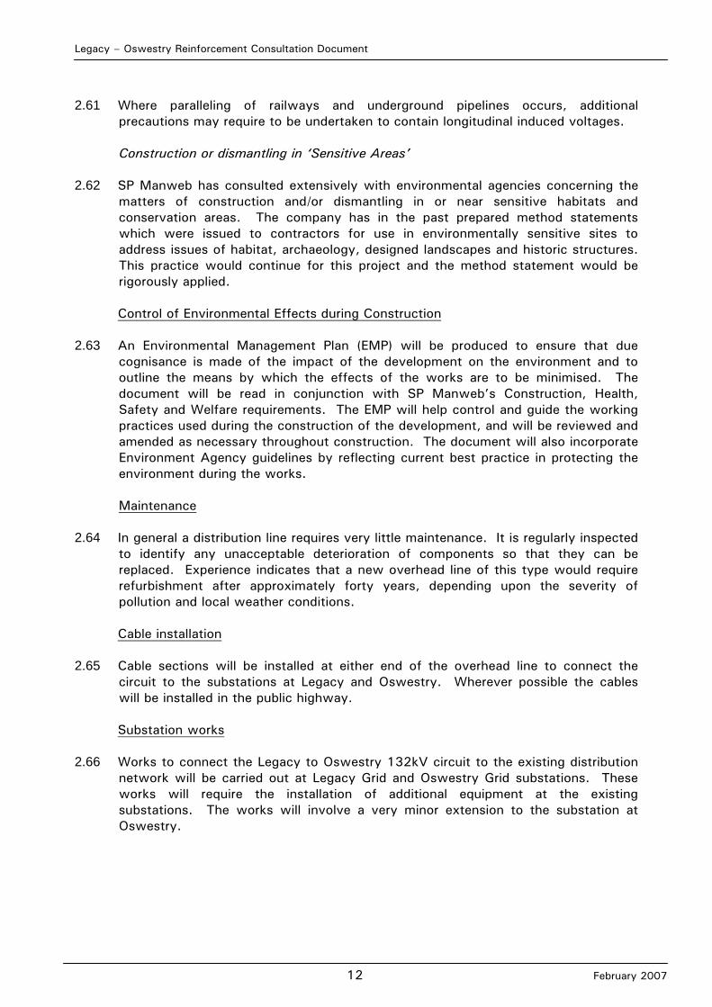
Wales and comprises two 132kV overhead line circuits carried on one steel lattice tower line between Legacy substation and Oswestry substation. Two further 132kV circuits from Oswestry substation supply Newtown and Welshpool substations respectively. An additional 132kV overhead line from Legacy substation supplies Whitchurch substation. A plan showing the regional context is shown in Figure 2.1.
2.5 The existing high voltage electrical system is shown in Figure 2.2. The substations
at Legacy, Oswestry, Whitchurch, Welshpool and Newtown have 132/33kV transformers which supply the 33kV network which in turn supplies customers via lower voltage networks. The 33kV network (not shown) electrically interconnects certain groups of 132/33kV transformers at different substation sites and allows load to be immediately transferred between 132/33kV transformers following failures of circuits or transformers. The SP Manweb 33kV network utilises both overhead lines and underground cable circuits.
Current and Future Issues
2.6 The SP Manweb network is designed to comply with the supply security
requirements of the Engineering Recommendation P2/5, which forms part of the electricity company’s licence agreement. The existing 132kV network south of Legacy currently meets this recommendation. However, if during a period when one circuit is out of use, the network is subjected to a fault, then approximately 80,000 customers would be disconnected. To maintain the security of supply requirements for this part of the network, one third of the customers disconnected during such an event must be restored with power within 3 hours. At present, the existing network arrangements are sufficient to meet this requirement. However, as load demand increases, the network arrangements will become insufficient.

Legacy – Oswestry Reinforcement Consultation Document
5 February 2007
2.7 If the system was kept in the current condition without the addition of a new 132kV
overhead line, SP Manweb could not continue to meet is statutory obligations as load grows.
2.8 Works have been carried out in the area to manage the current load growth issues.
Conductors capable of carrying increased capacity have been fitted to the existing overhead lines between Legacy and Oswestry. To ensure continued compliance with its statutory duty and licence obligation, SP Manweb needs to reinforce the 132kV overhead electrical network between Legacy and Oswestry.
Proposal
2.9 The reinforcement proposal will require an investment of over £6 million to construct
a third 132kV circuit between Legacy substation and Oswestry substation. This will consist of an overhead line, approximately 21 kilometres in length, with a cable section connecting each end to the substations at Legacy and Oswestry respectively. The cable sections will be terminated in the existing substations. Further works are required at both Legacy and Oswestry substations with additional investment for this associated work. Future works
2.10 Due to the increasing load in the Chirk area it is proposed to reinforce the 33kV
network between Legacy, Chirk and Oswestry by installing a new 132/33kV substation at Chirk. Whilst such a connection has not been considered in detail, the implications of connecting to the future Chirk substation have formed a component of the route selection process. Alternative Solutions
2.11 The decision to reinforce the 132kV electrical network between Legacy and
Oswestry has been taken after careful consideration of all the available options. 2.12 Alternative options, such as building a 400kV substation at Oswestry or 132kV
connections to Whitchurch, Connah’s Quay, Crewe and Trawsfynydd substations, have been considered and rejected on the basis of environmental concerns, technical reasons or cost. Of the available options, the Legacy to Oswestry 132kV option is the most economic and environmentally acceptable solution.
2.13 The alternative 132kV options are limited by the technical need to operate the new
circuit in parallel with the existing circuits and for the circuit to operate as part of the interconnected 132kV network.
2.14 If the new circuit could be used on standby as a back-up circuit, (usually referred to
as being on “open standby”) then a wider range of substations can be considered as the source substation as shown in the Table 2.1 overleaf. However, the “open standby” option does not provide a desirable technical solution.
Legacy – Oswestry Reinforcement Consultation Document
6 February 2007
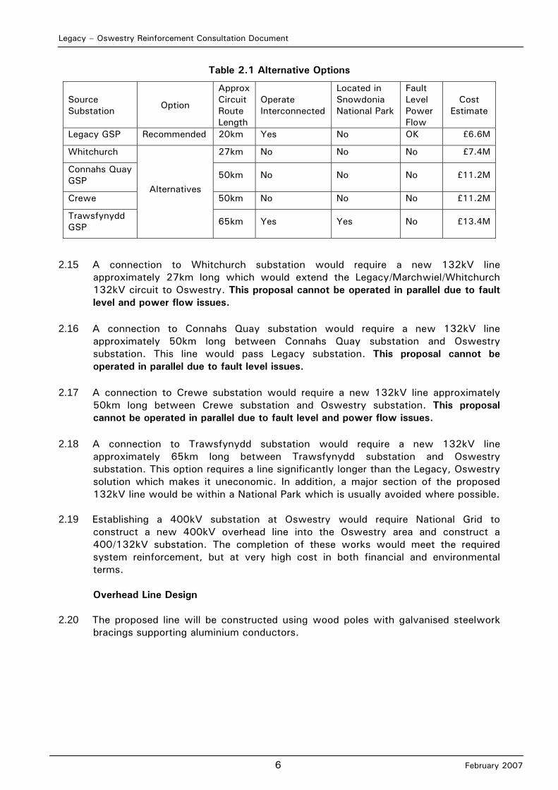
Table 2.1 Alternative Options
Source Substation Option
Approx Circuit Route Length
Operate Interconnected
Located in Snowdonia National Park
Fault Level Power Flow
Cost Estimate
Legacy GSP Recommended 20km Yes No OK £6.6M
Whitchurch 27km No No No £7.4M
Connahs Quay GSP 50km No No No £11.2M
Crewe 50km No No No £11.2M
Trawsfynydd GSP
Alternatives
65km Yes Yes No £13.4M
2.15 A connection to Whitchurch substation would require a new 132kV line approximately 27km long which would extend the Legacy/Marchwiel/Whitchurch 132kV circuit to Oswestry. This proposal cannot be operated in parallel due to fault level and power flow issues.
2.16 A connection to Connahs Quay substation would require a new 132kV line approximately 50km long between Connahs Quay substation and Oswestry substation. This line would pass Legacy substation. This proposal cannot be operated in parallel due to fault level issues.
2.17 A connection to Crewe substation would require a new 132kV line approximately 50km long between Crewe substation and Oswestry substation. This proposal cannot be operated in parallel due to fault level and power flow issues.
2.18 A connection to Trawsfynydd substation would require a new 132kV line approximately 65km long between Trawsfynydd substation and Oswestry substation. This option requires a line significantly longer than the Legacy, Oswestry solution which makes it uneconomic. In addition, a major section of the proposed 132kV line would be within a National Park which is usually avoided where possible.
2.19 Establishing a 400kV substation at Oswestry would require National Grid to
construct a new 400kV overhead line into the Oswestry area and construct a 400/132kV substation. The completion of these works would meet the required system reinforcement, but at very high cost in both financial and environmental terms.
Overhead Line Design
2.20 The proposed line will be constructed using wood poles with galvanised steelwork
bracings supporting aluminium conductors.
Legacy – Oswestry Reinforcement Consultation Document
7 February 2007
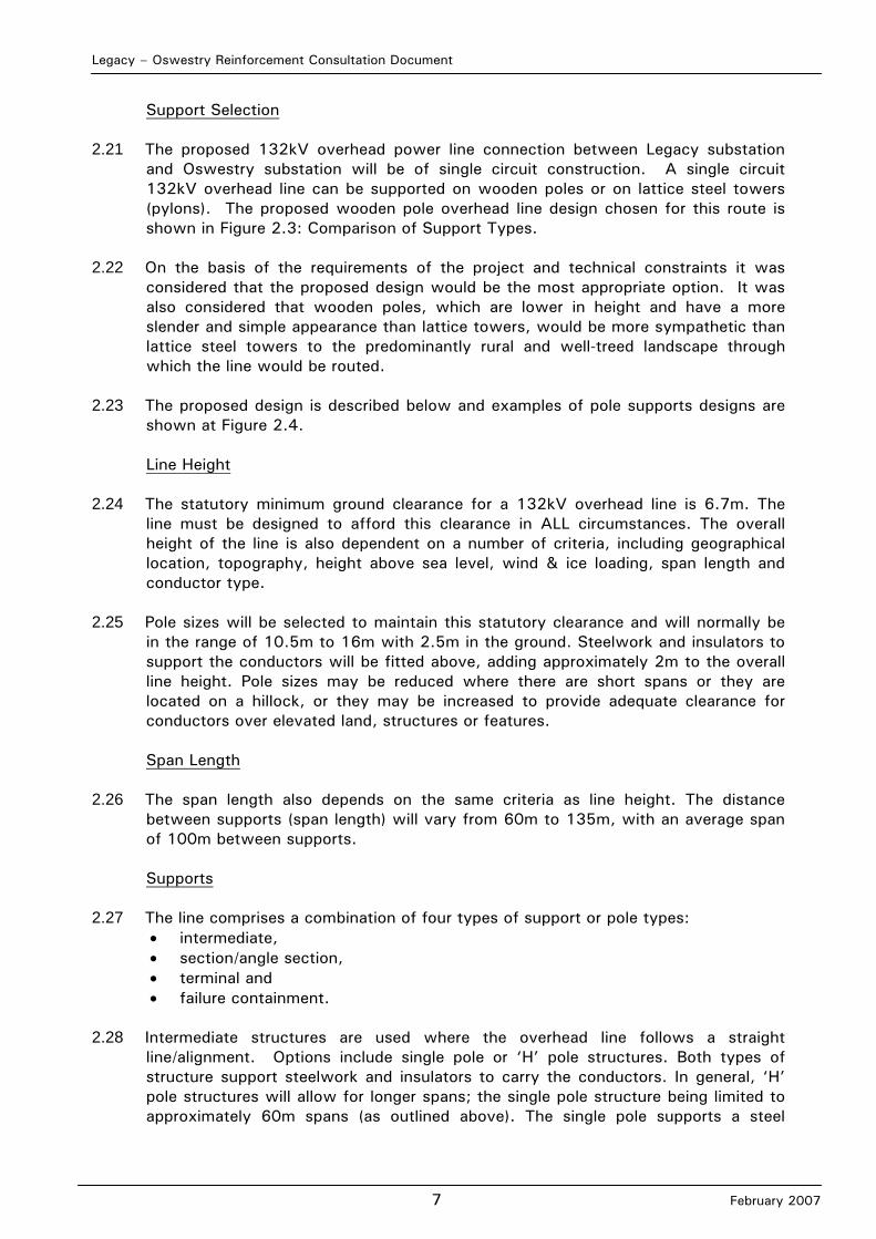
Support Selection 2.21 The proposed 132kV overhead power line connection between Legacy substation
and Oswestry substation will be of single circuit construction. A single circuit 132kV overhead line can be supported on wooden poles or on lattice steel towers (pylons). The proposed wooden pole overhead line design chosen for this route is shown in Figure 2.3: Comparison of Support Types.
2.22 On the basis of the requirements of the project and technical constraints it was
considered that the proposed design would be the most appropriate option. It was also considered that wooden poles, which are lower in height and have a more slender and simple appearance than lattice towers, would be more sympathetic than lattice steel towers to the predominantly rural and well-treed landscape through which the line would be routed.
2.23 The proposed design is described below and examples of pole supports designs are
shown at Figure 2.4.
Line Height 2.24 The statutory minimum ground clearance for a 132kV overhead line is 6.7m. The
line must be designed to afford this clearance in ALL circumstances. The overall height of the line is also dependent on a number of criteria, including geographical location, topography, height above sea level, wind & ice loading, span length and conductor type.
2.25 Pole sizes will be selected to maintain this statutory clearance and will normally be
in the range of 10.5m to 16m with 2.5m in the ground. Steelwork and insulators to support the conductors will be fitted above, adding approximately 2m to the overall line height. Pole sizes may be reduced where there are short spans or they are located on a hillock, or they may be increased to provide adequate clearance for conductors over elevated land, structures or features.
Span Length
2.26 The span length also depends on the same criteria as line height. The distance
between supports (span length) will vary from 60m to 135m, with an average span of 100m between supports.
Supports
2.27 The line comprises a combination of four types of support or pole types:
• intermediate, • section/angle section, • terminal and • failure containment.
2.28 Intermediate structures are used where the overhead line follows a straight line/alignment. Options include single pole or ‘H’ pole structures. Both types of structure support steelwork and insulators to carry the conductors. In general, ‘H’ pole structures will allow for longer spans; the single pole structure being limited to approximately 60m spans (as outlined above). The single pole supports a steel

Legacy – Oswestry Reinforcement Consultation Document
8 February 2007
crossarm of nearly 6m overall length. The ‘H’ pole comprises two poles set 3m apart, with a similar overall crossarm length.
2.29 In some situations the ‘H’ pole structure can be secured further with stays, allowing
span lengths to increase. The ‘footprint’ of the structure will, however, be increased as a result. In order to maintain the stresses induced in the overhead line, ‘H’ pole structures are required at regular intervals along a straight line. There is also a need for the failure containment arrangement at regular intervals (see below).
2.30 Angle section structures are used to enable changes of direction in the overhead
line. Whilst there are minor differences in options for these structures, relating to the angle to be negotiated, all comprise ‘H’ pole structures, supported by a minimum of four stays (2 per pole). The maximum angle of deviation is 35 degrees.
2.31 Terminal structures are used at either end of the overhead line. The terminal
structure allows the overhead line to be connected either to a cable or directly to a substation. The cable termination structure comprises a terminal pole with two smaller poles in front to support the cable termination.
2.32 Failure containment provision for conductor failure (‘broken wire’) situations is a
requirement of European/British standard document BS EN 50431 specifying the design of overhead lines above 33kV. The failure containment structure is an ‘H’ pole configuration, with poles set at 6m apart, and stayed.
2.33 All wood poles are fully seasoned and treated with an appropriate preservative. The
galvanised steelworks associated with this support (pole top steelwork) is assembled using galvanised high tensile steel bolts with nuts and locking devices. In special circumstances, for example where space is too restricted for stay wires, wood poles may be replaced by a steel ‘H’ pole arrangement. This would require substantial concrete foundations.
Access
2.34 Access for construction traffic will be required and maintained to all sites during the
construction phase. Future access arrangements for maintenance and fault repairs will be arranged with the relevant land owners.
Line Clearance
2.35 New lines will be positioned to maintain statutory clearances from buildings,
structures, trees, vegetation, etc. Line routes shall, in general, be chosen to minimise tree cutting/lopping.
Underground Cabling
2.36 SP Manweb policy seeks to find an overhead line route for all high voltage
distribution routes, and only where there are exceptional constraints will undergrounding be considered as a design alternative. Such constraints can be found in urban areas and rural areas of highest scenic and amenity value. There are many technical, environmental and economic disadvantages of undergrounding which relate to: physical extent of land required; fault repair time; general maintenance; increased cost (5 times at 132kV); greater ground disturbance by excavation of a trench; the restriction of development and planting within the
Legacy – Oswestry Reinforcement Consultation Document
9 February 2007
underground power line corridor; and land requirements and extra structures at each end of an underground section.
Overhead Line Components
2.37 The single-circuit comprises three separate phase conductors which are attached to
the pole top structure on insulators, made from porcelain, glass or modern composite materials. Insulators are fastened to the pole top steelwork. At intermediate supports the conductors sit on top of insulators. At other supports the conductors are cut and terminated on both sides of the pole with insulators placed on top of the steelwork. A fourth conductor is carried underneath the crossarm as an earth conductor. This earth conductor provides both a path for fault current and a means of transmitting SP Manweb protection and communication information via a fibre optic core. The line is earthed at every pole using a copper conductor and copper rods beneath the ground in a cross formation emanating from the foot of the pole(s). The amount of earth conductor laid in the ground at any particular pole position is dependent on the resistance of the surrounding soil/rock at that point.
2.38 The line design allows for several different types of conductor with varying cross-
sectional areas.
Construction and Technical Issues
Overhead Line Construction
2.39 Overhead power line construction follows a standard sequence of activities. For single-circuit wooden pole lines these activities include:
Preparation of accesses Excavation of foundations Delivery of poles Erection of poles Undergrounding/deviation of lower voltage lines where necessary for safety
clearances. Delivery of conductor drums and stringing equipment Insulator and conductor erection and sagging. Clearance and reinstatement.
2.40 Construction is anticipated to take approximately three to four weeks per kilometre.
Pre-Construction Activities 2.41 Prior to construction of the overhead line a precise ground survey is carried out to
determine the ground profile along the centre of the line route and for 10m on either side where the ground profile slopes across the line route. This is to ensure that the location selected for poles and stays and their relationship with each other comply with the technical limits laid down for maximum span lengths, maximum sums of adjacent spans and safe clearance to live conductors in the final siting of pole. Further consideration is given to detailed environmental effects and the wishes of the landowners.
2.42 Where the route of the line passes over or in close proximity to trees that could
infringe safe clearances to ‘live’ conductors, the trees must be felled or pruned prior to the construction of the line.

Legacy – Oswestry Reinforcement Consultation Document
10 February 2007
Land Use and Access during Construction
2.43 Vehicular access with a maximum width of 5m has to be secured to every pole site
on the route. Access routes and detailed arrangements are agreed with each landowner or occupier. Where there is no existing access available or where ground conditions prevent normal access, temporary access routes may have to be constructed. Every effort will be taken to minimise land damage by using four wheel drive or tracked vehicles. If temporary access roads need to be installed then either a trackway system or temporary stoned access roads are technically acceptable.
2.44 Access for single-circuit wood pole construction requires an area at least 225m2 at
pole sites and a 5m wide track under the conductors along the route, whilst conductor stringing is in progress.
2.45 At convenient places along the route, temporary storage areas may be required for
the dispersal of plant and equipment. These are agreed between the contractor and the landowners.
Wood Pole Erection
2.46 The erection of wood poles requires excavation to allow the pole brace blocks
and/or steel foundation braces to be positioned in place. Each support’s earth mat is installed, comprising two earth conductors being laid at the base of the pole in an ‘X’ arrangement horizontally, at about 600mm deep. Earth rods are inserted vertically along the route of these conductors.
2.47 The excavation is then backfilled and consolidated in layers, normally with the
original materials. Topsoil is reserved for the top layer and any surplus subsoil or rock is removed from the site.
Wood Pole Conductor Stringing
2.48 Once all poles within the section of line under construction have been erected, all poles are fitted with insulator supports. Running blocks are fitted to the top of the insulator support and the conductors are fitted using the following techniques.
2.49 Drums of conductor and a tensioner with a hydraulic brake are located at one end of
the line section, with the pulling winch at the other. The conductor is joined to a single, heavy-duty pilot wire and drawn through the section, one conductor at a time, under constant tension. During stringing radio communication is maintained between the operators of the pulling winch, the tensioner, hydraulic brake and intermediate observation points so the pulling can be stopped if problems arise. By using the ‘Continuous Tension Stringing’ method the conductors are held aloft at all times and do not touch the ground or any other structures.
2.50 Overhead line conductors are usually erected from one end of the line, in short
sections (dependent upon the terrain and complexity of the design). Temporary stays will be required along the line to balance the conductors as the build progresses to the other end. These stays will be installed and removed along the length of the line as the individual sections are completed.
Legacy – Oswestry Reinforcement Consultation Document
11 February 2007
2.51 Erection is completed with agreed reinstatement of the ground and access routes taking place.
Transport of Materials
2.52 During construction the wooden poles are transported on general purpose 4 wheel
drive cross-country vehicles which have incorporated lifting devices. 2.53 Drums of conductors are delivered as close as possible to the angle or tension pole
sites from which the conductors are pulled. If necessary tractors adapted to carry such loads are used to transport drums to the pole sites.
2.54 The anticipated rate of progress during the erection of the 132kV overhead line is
three to four weeks per kilometre. The required storage areas for materials both on and off site will be relatively small.
2.55 Special plant is available if there are any requirements for special precautions to be
taken during construction of the line due to local environmental conditions or hazards.
Noise
2.56 During construction contractors would be required to maintain low noise levels in
the vicinity of dwellings or other noise sensitive receptors by employing sufficiently silenced machinery and by distancing, or where practicable, screening noisy activities or items of plant, as outlined in BS5228: 1984. Noise levels generated during construction of the wood pole line are likely to be low.
Crossing Existing Lines
2.57 It may be necessary to cross existing overhead lines to achieve the most favourable
or environmentally acceptable route or, where practicable, to maximise the distance from dwellings. The crossing of lines may cause temporary interruptions to supply while the works are being carried out. Crossing of lines will therefore be programmed at times when existing lines can be temporarily taken out of service.
2.58 Statutory clearances must be maintained between live conductors of the existing
line and the conductors of the new line and pole stay wires used in new pole construction. These are generally maintained by keeping separation distances between lines, including where lines run in parallel. Crossing/paralleling Roads, Railways, Waterways and Other Services
2.59 Where the proposed line crosses roads, railways, and other electricity lines or telephone wires, certain precautionary works have to be completed prior to the commencement of conductor stringing. Scaffolding and nets would normally be erected over major roads and railways to enable the conductors to be pulled out unhindered.
2.60 Where the proposed distribution line crosses navigable rivers and underground
pipelines, all requirements of the appropriate authority would be adhered to, both at the design stage when locating individual poles and ensuring minimum clearances are provided, and at the construction stage by complying with relevant codes of practice, specifications and procedures.
Legacy – Oswestry Reinforcement Consultation Document
12 February 2007
2.61 Where paralleling of railways and underground pipelines occurs, additional
precautions may require to be undertaken to contain longitudinal induced voltages.
Construction or dismantling in ‘Sensitive Areas’ 2.62 SP Manweb has consulted extensively with environmental agencies concerning the
matters of construction and/or dismantling in or near sensitive habitats and conservation areas. The company has in the past prepared method statements which were issued to contractors for use in environmentally sensitive sites to address issues of habitat, archaeology, designed landscapes and historic structures. This practice would continue for this project and the method statement would be rigorously applied.
Control of Environmental Effects during Construction
2.63 An Environmental Management Plan (EMP) will be produced to ensure that due
cognisance is made of the impact of the development on the environment and to outline the means by which the effects of the works are to be minimised. The document will be read in conjunction with SP Manweb’s Construction, Health, Safety and Welfare requirements. The EMP will help control and guide the working practices used during the construction of the development, and will be reviewed and amended as necessary throughout construction. The document will also incorporate Environment Agency guidelines by reflecting current best practice in protecting the environment during the works.
Maintenance
2.64 In general a distribution line requires very little maintenance. It is regularly inspected
to identify any unacceptable deterioration of components so that they can be replaced. Experience indicates that a new overhead line of this type would require refurbishment after approximately forty years, depending upon the severity of pollution and local weather conditions.
Cable installation
2.65 Cable sections will be installed at either end of the overhead line to connect the circuit to the substations at Legacy and Oswestry. Wherever possible the cables will be installed in the public highway.
Substation works
2.66 Works to connect the Legacy to Oswestry 132kV circuit to the existing distribution network will be carried out at Legacy Grid and Oswestry Grid substations. These works will require the installation of additional equipment at the existing substations. The works will involve a very minor extension to the substation at Oswestry.
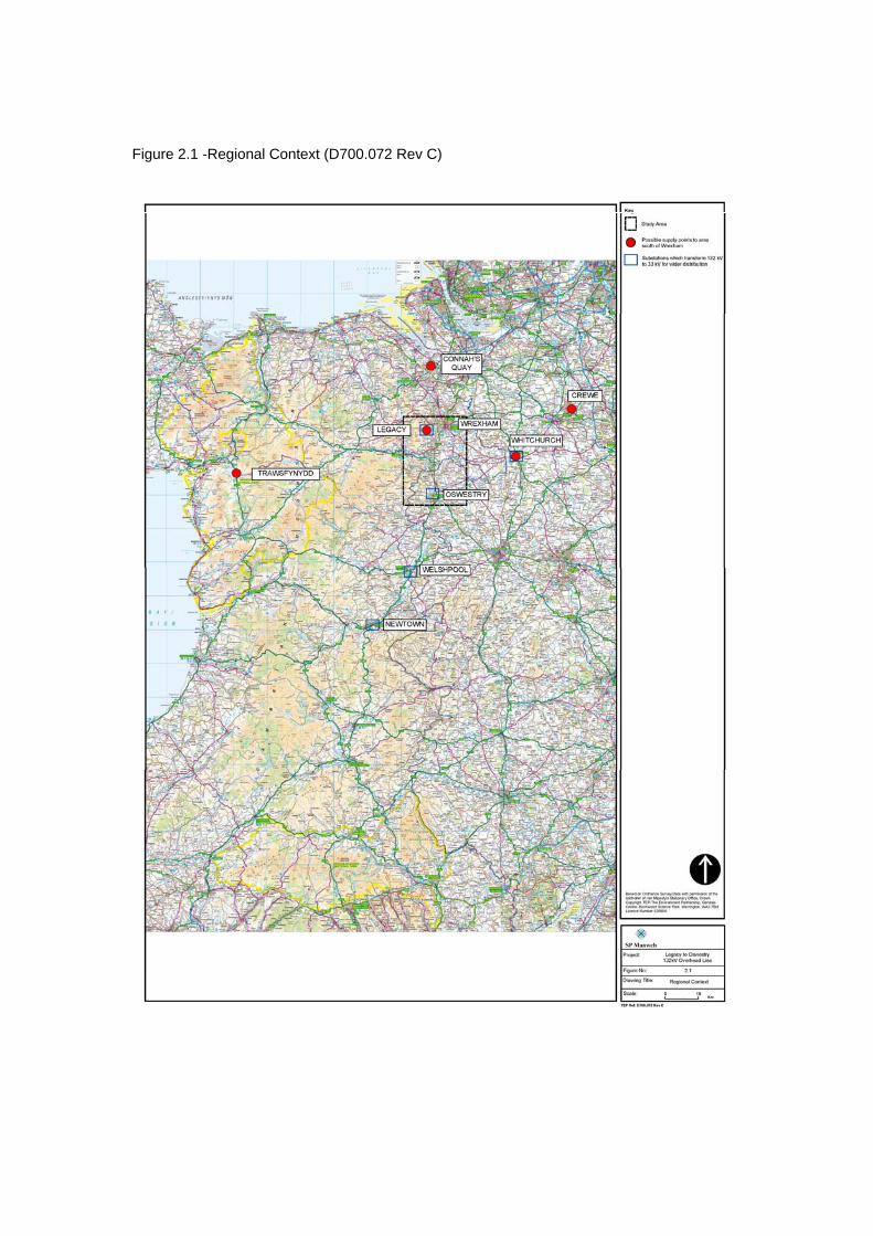
Figure 2.1 -Regional Context (D700.072 Rev C)
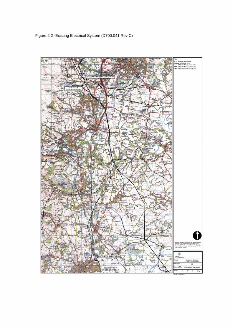
Figure 2.2 -Existing Electrical System (D700.041 Rev C)
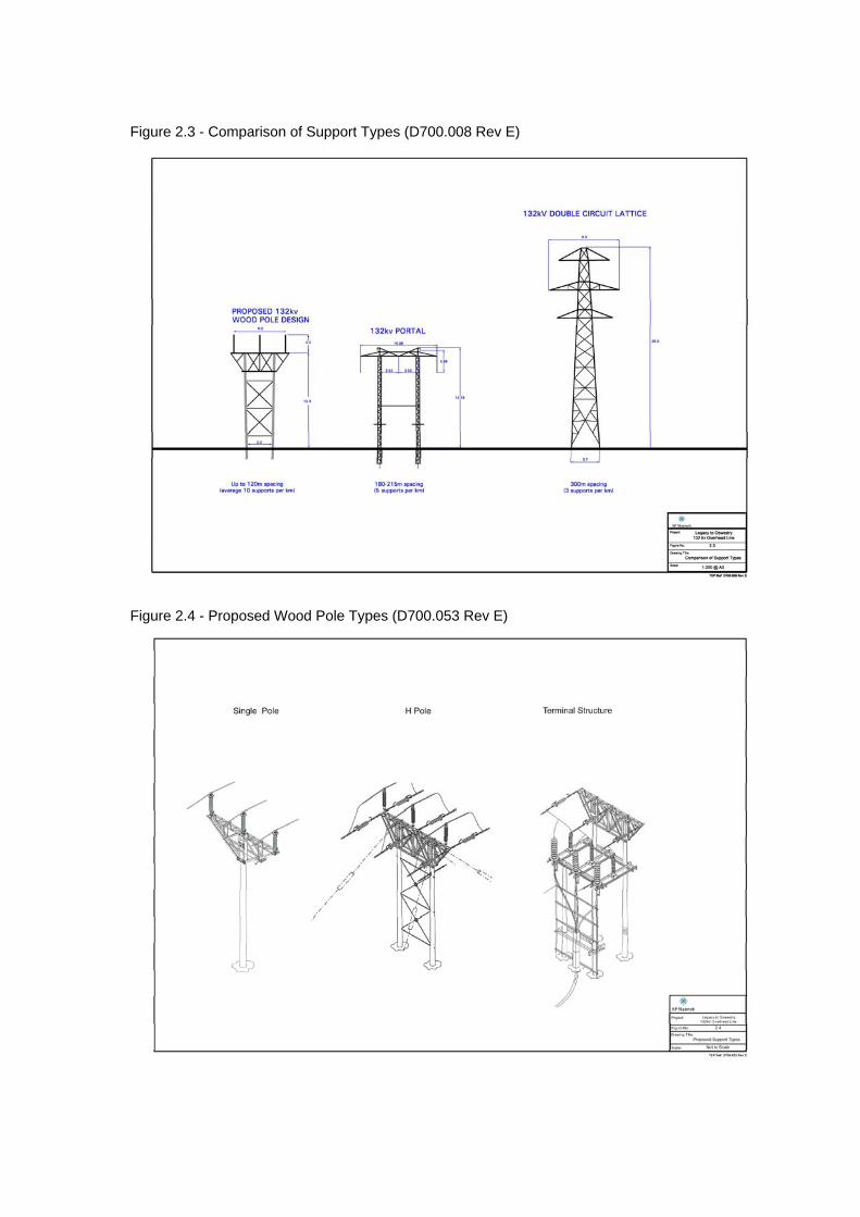
Figure 2.3 - Comparison of Support Types (D700.008 Rev E)
Figure 2.4 - Proposed Wood Pole Types (D700.053 Rev E)
Legacy – Oswestry Reinforcement Consultation Document
13 February 2007
3.0 APPROACH AND METHOD 3.1 This section describes the method and techniques used in the identification of
potential route options and in the identification of a preferred route.
The Approach to Route Selection 3.2 SP Manweb’s approach to routeing is based on the principle that the major effect of
an overhead distribution line is its visual intrusion and that the degree of visual intrusion can be reduced by careful routeing, for example by utilising topography and trees to provide screening and backgrounding and by seeking to retain appropriate distance from settlements and viewpoints. In addition, routeing also takes account of other environmental considerations by seeking to avoid the most sensitive and valued natural and man made features.
3.3 The SP Manweb approach is based on published and established practice for route
identification. The approach taken is iterative and the steps taken may be revisited several times before a balance is achieved between environmental, technical and economic considerations which require professional judgement to be utilised to balance the factors. Consultation is carried out throughout the process.
3.4 The approach to route selection is summarised in the flow diagram Figure 3.1: The
Route Selection Process (adapted from R. Marshall & R. Baxter, 2002) and has the following steps which are then described in turn below: • Objective of route selection • Established practice for overhead transmission line routeing • Determination of likely effects • Routeing considerations/collection of background information • Routeing strategy • Development of route options • Evaluation of route options • Selection of the preferred route • Modification of the preferred route • Selection of the proposed route
The Objective of Route Selection
3.5 The primary objective of route selection is to identify a technically feasible and
economically viable overhead distribution line route between two specific points (substations), which causes the least disturbance to people and the environment.
Established practice for overhead line routeing
3.6 Broad principles for overhead line routeing were formulated by the late Lord Holford,
Professor of Town Planning, University College, London in 1959 and published by the Royal Society of Arts. The Rules, originally intended for the guidance of those responsible for lattice steel tower line routeing, remain the starting point for routeing electricity transmission lines in the UK. The National Grid Company (NGC) reviewed the Holford Rules in 1992 and added supplementary notes of clarification. Guidelines have also been produced by the Forestry Commission in 1989 for routeing of overhead power lines. These relate primarily to forest areas. National Grid produced further guidance on route selection in 1997.

Legacy – Oswestry Reinforcement Consultation Document
14 February 2007
3.7 Current routeing practice followed by SP Manweb is derived from the Holford Rules and NGC supplementary notes. Scottish Hydro-Electric Transmission Limited (SHETL) reviewed and expanded on the Rules, particularly to address Scottish circumstances (SHETL (2004) Approach to the Routeing of High Voltage Steel Lattice Tower Transmission Lines in Scotland). For this study, these notes on the Rules have been amended where reference is made to designations, in order to relate to England and Wales. The principles relating to routeing of steel lattice tower transmission lines are considered applicable to routeing of smaller scale, wood pole mounted overhead lines. The various guidelines are outlined below.
The Holford Rules
1. ‘Avoid altogether, if possible, the major areas of highest amenity value, by so planning the general route of the line in the first place, even if the total mileage is somewhat increased in consequence.
2. Avoid smaller areas of high amenity value or scientific interest by deviation,
provided this can be done without using too many angle towers, ie the more massive structures used when lines change direction.
3. Other things being equal, use the most direct line, with no sharp changes of
direction and thus fewer angle towers. 4. Choose tree and hill backgrounds in preference to sky backgrounds wherever
possible; and where the line has to cross a ridge, secure this opaque background as long as possible and cross obliquely when a dip in the ridge provides an opportunity. Where it does not, cross directly, preferable between belts of trees.
5. Prefer moderately open valleys with woods where the apparent height of
towers will be reduced, and views of the line will be broken by trees. 6. In country which is flat and sparsely planted, keep the high-voltage lines as
far as possible independent of smaller lines, converging routes, distribution poles and other masts, wires and cables, so as to avoid a concatenation of ‘wirescape’.
7. Approach urban areas through industrial zones, where they exist; and where
pleasant residential and recreation land intervenes between the approach line and the substation, go carefully into the comparative costs of undergrounding, for lines other than those of the highest voltage’.
National Grid Company Supplementary Notes (1992) • ‘Residential areas: Avoid routeing close to residential areas as far as possible
on grounds of general amenity • Designations of County, District and Local Value: Where possible choose route
which minimise the effect on Special Landscape Areas, Areas of Great Landscape Value and other designations of County, District of Local value
• Alternative Tower Designs: In addition to adopting appropriate routeing, evaluate where appropriate the use of alternative tower designs now available where these would be advantageous visually and where the extra cost can be justified’.
Legacy – Oswestry Reinforcement Consultation Document
15 February 2007
SHETL Notes 2004 (adapted to identify English and Welsh designations) Note on Rule 1 • Investigate the possibility of alternative routes, avoiding if possible major areas
of highest amenity value. If there is an existing transmission line through an area of highest amenity value and the surrounding land use has to some extent adjusted to its presence, particularly in the case of commercial forestry, then the effect of remaining on this route must be considered in terms of the effect of a new route avoiding the area.
• Areas of highest amenity value require to be established on a project by project basis considering planning guidance and the spatial extent of areas identified.
• Examples of areas of highest amenity value which should be considered are: - Special Area of Conservation - Special Protection Area - Ramsar Site - National Parks - Areas of Outstanding Natural Beauty - National Nature Reserves - Protected Coastal Zone Designations - Sites of Special Scientific Interest (SSSI) - Scheduled Monuments - Listed Buildings - Conservation Areas - World Heritage Sites (a non-statutory designation) - Historic Gardens and Designed Landscapes (a non-statutory designation)
Note on Rule 2 • Small areas of highest amenity value not included in Rule 1 as a result of their
spatial extent should be identified along with other areas of regional or local high amenity value identified from development plans.
• Effects on the setting of historic buildings and other cultural heritage features should be minimised.
• If there is an existing transmission line through an area of high amenity value and the surrounding land uses have to some extent adjusted to its presence, particularly in the case of commercial forestry, then the effect of remaining on this line must be considered in terms of the effect of a new route deviating around the area.
Note on Rule 3 • Where possible choose inconspicuous locations for angle towers, terminal
towers and sealing end compounds. • Too few angles on flat landscape can also lead to visual intrusion through very
long straight lines of towers, particularly when seen nearly along the line.
Notes on Rules 4 and 5 • Utilise background and foreground features to reduce the apparent height and
domination of towers from main viewpoints. • Minimise the exposure of numbers of towers on prominent ridges and skylines. • Where possible follow open space and run alongside, not through woodland or
commercial forestry and consider opportunities for skirting edges of copses and woods. Where there is no reasonable alternative to cutting through woodland or commercial forestry the Forestry Commission Guidelines should be followed (Forest Landscape Design Guidelines, second edition, The Forestry Commission

Legacy – Oswestry Reinforcement Consultation Document
16 February 2007
1994 and Forest Design Planning – A Guide to Good Practice, Simon Bell/The Forest Authority 1998)
Note on Rule 6 • In all locations minimise confusing appearance. • Arrange wherever practicable that parallel or closely related routes are planned
with tower types, spans and conductors forming a coherent appearance; where routes need to diverge, allow where practicable sufficient separation to limit the effects on properties and features between lines.
Note on Rule 7 • When a line needs to pass through a development area, route it so as to
minimise as far as possible the effect on development. • Alignments should be chosen after consideration of effects on the amenity of
existing development and on proposals for new development. • When siting substations take account of the effects of the terminal towers and
line connections that will need to be made and take advantage of screening features such as ground form and vegetation.
Explanatory note on Rule 7 • The assumption made in Rule 7 is that the highest voltage line is overhead.
Forestry Commission Guidelines Route transmission lines to follow open space and to run along side not through
woodland Where there is no alternative route, a power line through a forest should avoid
areas of landscape sensitivity; avoid the line of sight of important views; be kept in valleys and depressions; not divide a hill into two similar parts where it crosses over a summit; cross skyline or ridges where they drop to a low point; follow alignments diagonal to the contour as far as possible; and be inflected upwards in hollows and downwards on ridges. The guidelines specify design parameters for routeing transmission line corridors through woodland areas.
Planning and Amenity Aspects of High Voltage Transmission Lines and Substations, National Grid, first published 1997, reprinted 1999 • This document refers to the selection of an overhead line route as being a
balance between various factors or constraints. In selecting a route the visual effect should be minimised in terms of the number of people affected and the degree to which they are affected. The nature and topography of the area should be considered along with any statutory protection. Routes should seek to avoid crossing the highest contours where the line would be most prominent, and the quality of the landscape and its ability to accommodate an overhead line should also be taken into account. Existing vegetation, buildings and topography should be utilised for their screening ability where possible and when viewed from principle viewpoints an overhead line should ideally be viewed against a background of existing landscape or development rather than sky.
• It is however noted in this publication that a number of potential conflicts of interest may exist in establishing a new overhead line route. For example the best route through a landscape may be to follow a river valley rather than the adjacent higher ground where the effect outside the valley will be minimised. The valley is however likely to be more intensively populated and likely to contain transport corridors and the most versatile agricultural land, which may lead to the route having a greater effect on a larger number of people. The
Legacy – Oswestry Reinforcement Consultation Document
17 February 2007
upland areas on the other hand may have relatively little development and fewer dwellings but are likely to be covered by protective designations. In practise a combination of many factors needs to be considered and the route selection will vary on a case by case basis and in response to individual circumstances.
Determination of Likely Effects
3.8 From experience across the electricity industry it is recognised that an overhead
distribution line is a large linear feature that is likely to affect, to varying degrees: - visual amenity - the landscape - nature conservation (flora and fauna) - agriculture - archaeology - cultural heritage - recreation - tourism.
3.9 The scale of a distribution line relative to objects in close proximity, e.g. houses and
trees, is such that the major effect is usually the effect on visual amenity and landscape character. A distribution line may also have an effect on the environment through which it passes as a result of disturbance during construction works and maintenance operations during the life of the line.
Routeing Considerations and Collection of Background Information
3.10 The main technical and environmental considerations which should be studied in
order to route a distribution line with least visual intrusion and least disturbance to people and the environment are determined from a study of likely effects and established routeing practice. These routeing considerations include topography, landscape character and areas of amenity value and scientific and historical interest. Identification of study area
3.11 The first step in identifying potential route options is to identify a ‘study area’ for which environmental information can be gathered, consultations undertaken, routeing principles applied, and site visits undertaken.
3.12 The study area is determined primarily by the location of the two existing
substations which the proposed overhead line will link. The study area is generally extended just beyond the existing substations to enable all approaches into the substations to be considered. All things being equal the shortest most direct route is considered to be the most appropriate route as the total linear length of the proposed line has the potential to cause an effect. In practise however environmental factors often form constraints to direct routeing and the study area is widened to allow for all reasonable route options to be considered. A balance needs to be struck between increasing the overall length of the line between the fixed end points (the substations) and the avoidance of the main constraints. Desk Based Assessment
3.13 A desk-based assessment is initially undertaken of the study area. This includes the study of 1:50,000 and 1:25000 scale mapping; a review of published documents and publicly available information; a review of local planning documentation; and the study of aerial photography.
Legacy – Oswestry Reinforcement Consultation Document
18 February 2007
Consultation 3.14 Consultation is undertaken at several stages during the routeing process. Initial
consultation is undertaken on the basis of the broad principles of the project requirements and based on an identified study area prior to the determination of any route option corridors. This initial consultation informs the consultees of the broad project proposals and gives them an opportunity to make comments at an early stage in the project including their views on the boundaries of the study area. It also forms an important part in gathering baseline environmental information used to inform the routeing process.
3.15 Letters were initially sent to over 50 consultees including local authorities within the
study area, statutory consultees, other environmental bodies and interested parties and utility companies with potential assets within the study area. Initial meetings to discuss the proposals were also offered to the Local Planning Authorities and the key statutory consultees. A list of consultees is included in Appendix 1A.
Collation of Baseline Information
3.16 The baseline information is collated onto a geographical information system and a review of all environmental information gathered is undertaken to identify the principal constraints and key issues in routeing a new overhead line through the study area.
3.17 Broadly, the information collated relates to development and planning allocations and
proposals; landscape character and features including designations; visual receptors; transport and infrastructure; topography; woodland; nature conservation; archaeology; recreation and tourism; and agricultural land quality. Information relating to former, active and future mineral sites and allocations; existing and potential landfill and reclamation sites is also collected. A review of all collated information is included in the Study Area Inventory in Chapter 4.
3.18 Considerations which are likely to constrain routeing are mapped together on a
‘Constraints Map’, which is a key part of the routeing process. The landscape character of the study area is mapped separately. In general, visibility of the route options (excluding vegetation) is also mapped and compared. In this instance, scheme design details and preliminary site visits established that this would not be a useful aid to route identification. This is partly because of the relatively small scale of the proposed support structures (wood pole), which means that they are not generally visible above mature trees or from great distances. It is also due to the nature of the landscape of this particular study area, which predominantly comprises rolling topography and scattered mature trees and woodland blocks combining to prevent long-distance views.
Routeing Strategy
3.19 Following collation of baseline environmental information, routeing considerations
and established practice for line routeing are used to develop a ‘routeing strategy’ which establishes considerations used to identify broad corridors (routeing issues) and those which are used to modify routes within corridors (deviation issues). Routeing issues are generally of a strategic nature and extensive in area; deviation issues tend to be of local importance and smaller in scale.
3.20 In this study a two-stage approach was adopted because of the scale of the study
area, and the complexity of landscape character and pattern within the area. A first, strategic stage identifies broad corridors within the study area and evaluates
Legacy – Oswestry Reinforcement Consultation Document
19 February 2007
key environmental constraints to determine the preferred broad corridor option. This is followed by a revisiting of the routeing strategy to determine routeing issues and deviation issues within the selected corridor. This refinement is tailored specifically to the nature of constraints within the preferred broad corridor. Identification of detailed route options within the preferred broad corridor is followed by their comparative evaluation to determine a preferred route option.
Relative Importance of Environmental Issues
3.21 The main effect of an overhead line is widely acknowledged to be visual. For this reason information relating to topography, landscape character, designated or valued landscapes, dwellings and public viewpoints are given high consideration in the review of environmental information. These factors are considered to be strategic constraints in the initial routeing process. Factors such as tree and woodland removal required for routeing a proposed overhead line also need to be considered as strategic constraints (routeing issues) as they have visual implications.
3.22 Environmental considerations such as ecological and archaeological features are
taken into consideration with known valued or designated sites avoided where possible in the routeing process. The scale or extent of the feature can be of relevance in this context. Designations covering a large geographical area are generally considered strategic constraints, whilst smaller areas can be addressed through deviation (and are therefore not key constraints to overall routeing).
3.23 Environmental effects are also associated with the ground which the overhead line
crosses including the support siting and foundation construction, line-oversailing and required clearances and the effects associated with the construction phase and the future maintenance of the line.
3.24 In accordance with current best practice in routeing, areas of highest amenity value
require to be established on a project by project basis (note on Rule 1). Chapter 5.0: Broad Route Options, and Chapter 6.0: Detailed Route Options, set out the hierarchy of environmental constraints employed at broad corridor and detailed route option stages respectively, prior to route comparisons. These are specifically tailored to both the characteristics of the study area and the nature of the proposed overhead line. Development of Route Options
3.25 The identification of route corridors is focused on planning and environmental issues
with only preliminary regard given to access, technical and engineering constraints and considerations. For example, the presence of existing overhead lines of lower voltage is not considered a routeing constraint. Similarly no consideration is given to land ownership at this early stage, with landowner liaison undertaken by SP Manweb following the determination of the preferred route option.
3.26 The route of the line must be continuous and as a consequence the environmental
advantages of routeing in one area may be offset by the disadvantages of routeing through an adjoining area.
Evaluation of Route Options
3.27 The broad route options require initial evaluation to identify options which have the
least likely adverse environmental effects, whilst still being technically feasible and economically viable. Route options were developed according to the routeing
Legacy – Oswestry Reinforcement Consultation Document
20 February 2007
strategy; a second application of the broad routeing principles establishes the relative importance of environmental issues by reference to the constraints map and assessment criteria. The options which perform poorly in this initial evaluation are rejected. The remaining route options are then further refined and re-evaluated.
3.28 The route selection process is an iterative process with each stage requiring a
greater level of detail of analysis, assessment and review. 3.29 Site visits and refinement/review of collated information enables each route option
to be continually refined and developed. During this stage route options may be rejected, modified or studied in further detail. The process is flexible in nature and is responsive to information built up during the feasibility and routeing study.
Selection of a Preferred Route
3.30 After the comparative evaluation of route options, a preferred route option is
selected. The consideration of the environmental effects in the preparation of this consultation document has been carried out to enable the identification of potential routes, an evaluation and comparison of these routes, and the justification for selection of a preferred route. Modification of Preferred Route and Selection of Proposed Route
3.31 The preferred route will be subject to further evaluation following responses received
during this consultation exercise and may be further modified to take direct account of comments received. Specific local issues will similarly be considered during the detailed design of the line which may result in minor local deviation. At this stage the preferred route becomes the ‘proposed route’.
3.32 The proposed route is then subject to a detailed environmental assessment to
determine and quantify its likely effects on the environment. During this ‘environmental assessment process’ further modifications may be made to the proposed route and preliminary measures identified to reduce or remedy adverse effects. An Environmental Statement will be prepared for the proposed route option.
3.33 The Environmental Statement will form part of the application for consent. During
determining the application, there are opportunities for interested parties to make representations to the Secretary of State for Trade and Industry.
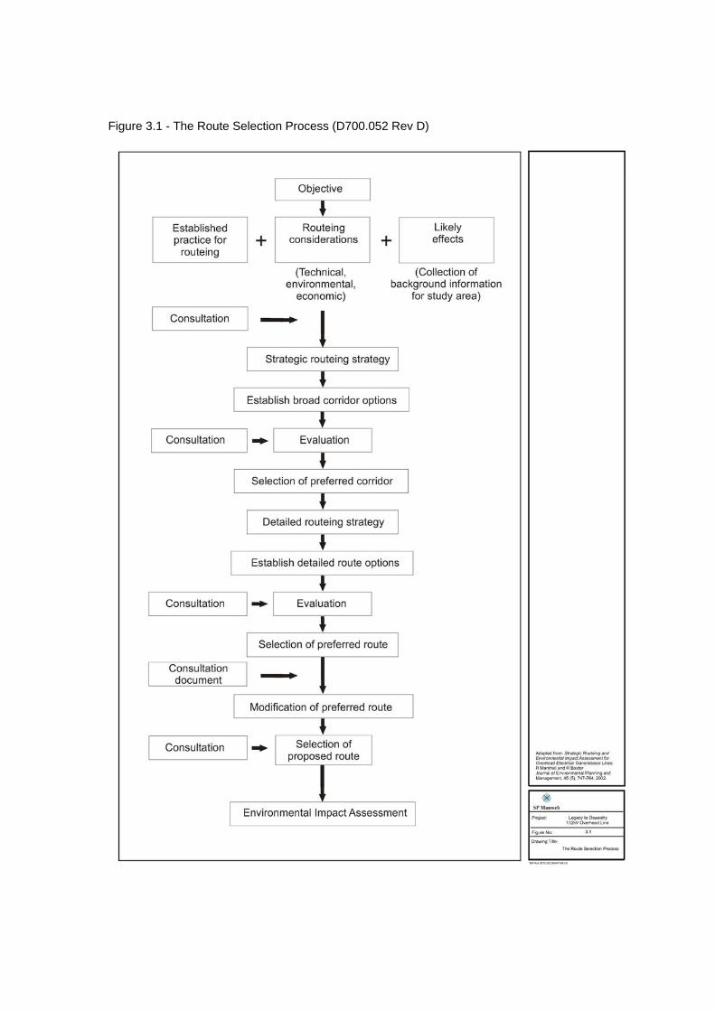
Figure 3.1 - The Route Selection Process (D700.052 Rev D)
Legacy – Oswestry Reinforcement Consultation Document
21 February 2007
4.0 STUDY AREA INVENTORY 4.1 In this section, information on landform, landscape character, land use, planning
designations, future proposals and other relevant information is considered with a view to identifying the principal considerations and key issues in the routeing of the proposed 132kV distribution line.
4.2 This information has been assembled under the following sub-headings:
• Settlements and Infrastructure • Planning Context and Development Proposals • Topography and Woodland Cover • Agriculture • Landscape Character • Landscape Designations • Nature Conservation • Archaeology and Cultural Heritage • Recreation and Tourism • Mineral Resources
Study Area
4.3 The area for which environmental information was assembled is illustrated on Figure
4.1: Study Area. 4.4 The study area covers an area of approximately 19km north-south by 11km east-
west. The southern edge of Wrexham forms the northernmost extent, with Oswestry, located 18km to south, forming the southernmost extent. The A483/A5(T) forms a direct link between these two border towns and runs approximately down the centre of the study area. The study area extends eastwards towards Erbistock and Overton and westwards beyond Trevor and Cefn Mawr.
4.5 The study area was largely determined by the location of the two existing
substations which the proposed 132kV line will link. Legacy substation is located 4km to south west of Wrexham to the north of Rhosllanerchrugog and Oswestry substation is located on northern edge of the built development of Oswestry. The study area extends approximately 1km beyond the existing substations to enable all approaches into the substations to be considered. The eastern and western limits of the study area were defined by higher ground and steep valley topography to the west and by distance to the east, whereby there were no overriding environmental factors which required the routeing of a line further east. Settlements and Infrastructure
4.6 Figure 4.2 illustrates the main settlements and pattern of infrastructure. The study
area is predominantly rural, bordered by the large settlement of Wrexham to the north and town of Oswestry to the south. A series of smaller settlements are located in the northwestern part of the study area. These settlements, Rhostyllen, Rhosllanerchrugog, Johnstown, Ruabon and Cefn-Mawr, form an almost continuous band of developed land along the boundary of the foothills of the Clwydian range and undulating lowlands to the east. South of the river Dee settlements tend to be more distinct and of a smaller size (Chirk, Weston Rhyn, St Martin’s and Gobowen).
Legacy – Oswestry Reinforcement Consultation Document
22 February 2007
4.7 Main areas of settlement have been defined through interpretation of boundaries of built development shown on 1:50,000 scale OS plans and extending over an area of 0.5km2. This is imperfect as it does not identify very dispersed settlements but gives a good indication of the pattern of settlement.
4.8 The main transport corridor through the area follows a broadly north-south
alignment and comprises the A483(T)/A5, together with the main line rail connection between Wrexham and Oswestry. This corridor is also occupied in its central part by the Shropshire Union canal (Llangollen branch). The canal crosses the southern part of the study area in a northwest to southeast alignment, crosses the Ceiriog and Dee alongside the rail line, and occupies the Vale of Llangollen in the west.
4.9 Main roads linking to the A483(T)/A5 corridor generally provide east-west
connections (A539, A495, A5). These routes are supplemented by a dense network of narrow minor lanes, which are particularly tortuous and winding in the Dee and Ceiriog valleys. Planning Context and Development Proposals
4.10 The following appraisal of planning context includes a summary of English and
Welsh planning guidance and policy hierarchy of planning guidance and development plan policies that are of relevance to the proposed development. The details of guidance and policies are presented in a table in Appendix 4A. National Guidance (England)
4.11 National policy advice is issued as central government guidance in the form of
Planning Policy Guidance Notes (PPGs) and their replacements Planning Policy Statements (PPSs). The PPGs and PPSs that are of most potential relevance to the proposed development options include PPS1: Delivering Sustainable Development; PPG2: Green Belt; PPS7: Sustainable Development in Rural Areas; PPS9: Biological and Geological Conservation, PPG13: Transport, PPG15: Planning and the Historic Environment; and PPG16: Archaeology and Planning, PPG25: Planning and Flood Risk.
National Guidance (Wales)
4.12 Current land use planning policies of the Welsh Assembly Government are contained
in Planning Policy Wales (PPW), published in March 2002. It is supplemented by a series of Technical Advice Notes (TANs) and circulars. Together the PPW, TANs and circulars comprise national planning policy. The TANs that are most potentially relevant to the proposed development options are: TAN 5: Nature Conservation and Planning, TAN 6: Agricultural and Rural Development, TAN15: Development and Flood Risk, and TAN 18: Transport.
Regional Guidance
4.13 At a regional level, policy advice is presented in Regional Planning Guidance Notes
(RPGs) and their replacements Regional Spatial Strategies (RSSs) issued by the Secretary of State. The West Midlands Spatial Strategy, RSS11, (formerly known as RPG 11) covers an area from Staffordshire in the north to Warwickshire and Worcestershire in the south and from Shropshire in the west to the east of Birmingham City. It was published by ODPM in June 2004. Guidance contained in

Legacy – Oswestry Reinforcement Consultation Document
23 February 2007
RPGs/RSSs is primarily used to inform the preparation of local authority development plans and local transport plans.
4.14 The vision for the West Midlands presented within the West Midlands Spatial
Strategy is ‘one of an economically successful, outward looking and adaptable Region, which is rich in culture and environment, where all people working together, are able to meet their aspirations and needs without prejudicing the quality of life for future generations’.
4.15 The spatial strategy is a series of strategic objectives and associated strategic
policies (Appendix 4A) supported by topic specific policies all of which have been developed to achieve the vision of the RPG. One of the spatial strategy’s objectives which is seen as a core element in the achievement of sustainable development and the implementation of the Spatial Strategy and Regional Vision is:
• ‘To ensure the quality of the environment is conserved and enhanced across all parts of the Region’.
Development Plans
4.16 The study area under consideration for the route of the proposed overhead line is
contained within the administrative areas of Shropshire County Council, Wrexham County Borough Council and Denbighshire County Borough Council. Within Shropshire the study area covers land contained within two districts, North Shropshire and Oswestry. The planning policy documents listed below are being reviewed under the Planning and Compulsory Purchase Act, 2004. In England, this Act established a new planning policy framework in the form of Local Development Frameworks. These are in the early stages of preparation, starting with Statements of Community Involvement and Options and Core Strategy documents. In Wales, the equivalent policy documents are emerging in the form of Delivery Agreements and Local Development Plans.
Shropshire and Telford and Wrekin Joint Structure Plan 1996 – 2011 (Adopted November 2002)
4.17 This is a replacement for the Shropshire Structure Plan 1989-2006. It sets out the broad planning strategy for Shropshire, Telford and Wrekin. The purpose of the structure plan is to provide an overall strategy for development and use of land within the context of sustainable development strategies. The plan includes policies for the protection and enhancement of the environment and provides a framework within which development should take place.
Wrexham Unitary Development Plan 1996-2011 (Adopted February 2005)
4.18 The Wrexham UDP covers the administration area of Wrexham County Borough Council. The plan was prepared to supersede the Wrexham Maelor Local Plan, the Glyndwr District Local Plan, and the Clwyd Structure Plan: First Alteration. In 2006 Wrexham Council is beginning preparation of Wrexham Local Development Plan, which will be a long-term land use and development strategy, focused on achieving sustainable development. Once adopted it will replace the Unitary Development Plan. It is envisaged it will cover the period 2006-2021.
Denbighshire Unitary Development Plan 1996- 2011 (Adopted July 2002)
4.19 This plan provides the strategic and detailed policy framework within which provision will be made for development and conservation needs. The plan states that development should seek to be sustainable, making the best use of resources by protecting landscape character, biodiversity and the best and (most) versatile
Legacy – Oswestry Reinforcement Consultation Document
24 February 2007
agricultural land. Following recent changes made by the Welsh Assembly Government to the planning system in Wales, the Council have commenced work on the Denbighshire Local Development Plan, which, once approved will provide the principal policy framework for all land use decisions requiring planning consent in the county.
North Shropshire Local Plan 2000 – 2011 (Adopted December 2005)
4.20 Sustainability is the underlying theme of the Local Plan and four of the plan’s objectives aim to achieve this. Objective 2 in particular, aims to maintain the special character and natural resources of the District, its settlements and countryside and to maintain and enhance the best landscape and features of nature conservation value amongst others. The first Local Development Scheme (which sets out the documents which currently form the district’s development plan and is the guide to the future programme of document production for North Shropshire Local Development Framework) of 2005 was revised in April 2006. The Core Strategy Issues and Options Report is due to be published in 2007.
Oswestry Borough Local Plan 1996-2006 (Adopted July 1999)
4.21 The Oswestry Borough Local Plan sets out the Council’s Planning Strategy for the future development of the Borough of Oswestry. It contains planning policies and proposals to guide and control new development between the period of 1996-2006. The Local Plan’s Strategy is to create a sustainable pattern of development which promotes community development and safeguards the environment for the present and future populations. In respect of the new planning framework, the Oswestry Borough Local Development Framework: Core Strategy Issues and Options Report was available for public consultation between February and March 2006. Comments have been submitted by SP Manweb seeking policy guidance for electricity infrastructure upgrades. Summary of Planning Policy Context
4.22 The table presented as Appendix 4A summarises national, regional, county and local
policies that are directly relevant to this proposed scheme.
Development Land Allocations 4.23 A number of current development proposals for the area are outlined below and
indicated on Figure 4.3 Development Allocations and Consultation Zones. For the purpose of this consultation document, housing and employment land allocations contained within development plans have been considered, together with any other allocations considered to be a constraint to routeing, such as major road proposals. As proposed routes avoid urban areas, proposals related to inner urban areas have not been included.
Housing Allocations
4.24 Housing allocations identified in Wrexham UDP under policy H1 include sites at
Chirk, Rhostyllen, Ruabon and Trevor. North Shropshire’s local plan does not identify any allocated housing sites in rural areas (Policy H5) within the study area. The Borough of Oswestry local plan identifies numerous sites with either outstanding planning permission or allocated for housing in rural areas (Policies H8 and H10 respectively). These are concentrated on the fringes of Oswestry, Whittington village, Gobowen, St Martin’s and Weston Rhyn.
Legacy – Oswestry Reinforcement Consultation Document
25 February 2007
Economic Development Allocations 4.25 There are no employment land allocations within the North Shropshire District part
of the study area. 4.26 Oswestry Borough Council allocates land at four sites within the study area for
economic development (Local plan policies LE4, LE6, LE8 and LE17). Two are adjacent to the A5/B5070 junction at Gledrid roundabout (one of these being a proposed truck stop). The others are near St Martin’s at Ifton Industrial Estate and Bank Top.
4.27 Wrexham UDP allocates employment land under policy E1. Approximately half of the
allocated land is within Wrexham Industrial Estate (65 ha), which is outside the study area. Only sites on the edge of settlements within the study area have been mapped. These comprise:
• Acrefair: Wynnstay Industrial Estate (site 22) • Johnstown: Vauxhall Industrial Estate (site 24) • Rhosllanerchrugog: Coppi Industrial Estate (site 32) • Rhostyllen: Croesfoel Industrial Estate (site 33) • Rhosmedre: Plas Kynaston (site 34) • Wrexham: Technology Park (site 38) • Wrexham: Ruthin Road Development Area (site 39)
Safeguarded Areas
4.28 On the northeastern outskirts of Oswestry, a strip of land is safeguarded under local
plan policy TR9 for a new road between eastern Oswestry/Harlech Road and the Whittington Road.
4.29 The Highways Agency has advised that consideration should be taken of the
possibility of widening the A5 to dual carriageway at some future date. 4.30 The Civil Aviation Authority has identified an aerodrome just east of the settlement
of Chirk (1 nautical mile east). 4.31 Transco has provided information regarding high pressure and intermediate pressure
gas pipelines in the area. The medium and low-pressure distribution network is concentrated in built-up areas. However, there are instances where mains are routed across open land linking up small villages.
Topography and Woodlands
Topography
4.32 The study area lies within a transitional zone between mountainous land of the
Clwydian Range and Berwyn Mountains to the west and lower land to the east associated with the River Dee floodplain (see Figure 4.4). The area includes the eastern slopes of Esclusham Mountain and Ruabon Mountain, foothills of the Clwydian Range, which rise to approximately 500m AOD. Foothills of the Berwyn Mountains located within the study area include Selattyn Hill and Baker’s Hill, which rise to 371m and 350m respectively. Land height varies from over 400m AOD in the extreme north-west to below 25m AOD in the east. The transition from foothill
Legacy – Oswestry Reinforcement Consultation Document
26 February 2007
slopes to rolling lowlands occurs at around 100 – 120 m AOD. (Within the study area, the A483(T)/A5 road corridor follows this change in topography.)
4.33 The key topographic features within the study area are the deep valleys of the rivers
Dee and Ceiriog (a tributary of the Dee). These rivers flow in a generally west to east direction through the centre of the study area.
4.34 The land in the eastern part of the study area is gently undulating lowland, situated
at around 100m AOD, and dotted with small ponds. It is bisected into northern and southern parts by the River Dee. Here the river occupies a narrow valley with steeply sloping valley sides. Numerous minor watercourses flow in either a southerly or northerly direction to join the Dee, creating a local landscape of several smaller side valleys and intervening low ridges.
4.35 In the western part of the study area, the Dee and Ceiriog have formed deeply
incised valleys in the east facing slopes of the Berwyn foothills. The Ceiriog occupies a narrow valley floor, whilst the Dee meanders through a wider (up to 1 km), flat-bottomed valley - the Vale of Llangollen.
4.36 North of Legacy and immediately south of Wrexham, the river Clywedog flows in an
easterly direction, ultimately joining the river Dee north of Bangor-on-Dee. In the southern part of the study area, the river Perry originates west of Selattyn Hill, and flows in a south-easterly direction towards the river Severn. These two rivers have not created incised valleys, and form much less prominent physiographic features within the landscape than the Dee and Ceiriog. Woodlands
4.37 Small woodlands are scattered throughout the study area (see Figure 4.4), as are
numerous mature hedgerow trees, giving an overall well-wooded appearance to the landscape. Larger areas of woodland are concentrated in the Dee and Ceiriog valleys (and associated side valleys), on the Berwyn foothills, and in parkland landscapes. The least wooded part of the study area is the south-eastern part, in the vicinity of St Martin’s and Dudleston Heath.
4.38 Ancient woodland is defined in England and Wales as land continuously wooded
since 1600. Identification of an area of woodland as being of ancient origin does not bring statutory protection; however, local authorities generally seek to protect them. This applies particularly to ancient semi-natural woodland, which are areas of woodland that have never been cleared or replanted, as these are considered a valuable and irreplaceable natural resource.
4.39 The Ancient Woodland Inventories for Shropshire and Clwyd (which cover Wrexham
CBC) indicate that the majority of ancient woodlands are located in the Dee valley, although there are also some large ancient woodland areas in the vicinity of Erddig Hall, south of Wrexham.
Agriculture
4.40 Figure 4.5 indicates the classification of agricultural land capability for the study
area. The classification is based on the potential productivity, cropping flexibility and ease of management of an area. Grade 1, 2 and 3a represent prime agricultural land. It is government policy, as set out in Planning Policy Statement 7 (PPS7) to have a general presumption against development in these areas. If any such land

Legacy – Oswestry Reinforcement Consultation Document
27 February 2007
were disturbed by scheme proposals it should be restored to full agricultural production without loss of quality.
4.41 Land north of Oswestry substation is identified as grade 3 in the Provisional
Agricultural Land Classification (surveyed pre 1976), although DEFRA has indicated (23/07/03) that more recent surveys of agricultural land capability indicate areas of Grade 2 and 3a close to Oswestry substation.
4.42 The Agricultural Land Classification for Wales indicates that the majority of land
within the Welsh part of the study area is of grade 3 or poorer quality.
Landscape Character 4.43 Landscape character is a result of interaction between physical factors (e.g.
geology, soils, vegetation, climate), natural processes (e.g. erosion, flooding) and human influence (e.g. agriculture, forestry, settlements, industry and developments).
4.44 The landscape character of England has been mapped on a broad scale as part of
the countryside character programme of England, prepared by the Countryside Commission (now Countryside Agency), English Nature and assisted by English Heritage. This map identifies the parts of the study area within England as being part of Character Area 61: Shropshire, Cheshire and Staffordshire Plain, to the east and Character Area 63: Oswestry Uplands, to the west. As the character areas are further defined and subdivided by a more detailed, county level landscape character assessment, they have not been mapped here. However, the key characteristics of these broad areas are described below. Wrexham’s LANDMAP Landscape Assessment is currently in the ‘final draft’ stage, and will update and replace the Clwyd Landscape Assessment of 1995. Whilst the timescale of the LANDMAP study has meant that there has been no LANDMAP input into Wrexham’s Unitary Development Plan, once adopted, LANDMAP will form a material consideration in determining planning applications.
4.45 The southern part of the study area lies entirely within the county of Shropshire. A
Landscape Character Assessment of Rural Shropshire commenced in 1999 and is nearing completion. Draft landscape character areas and descriptions have been provided by Shropshire County Council (2003) for the purpose of this study.
4.46 Figure 4.6 identifies the Landscape Character Areas of Wrexham and Shropshire
within the study area. Figure 4.7 illustrates various character areas with photographs. The key features of each character area are summarised in Appendix 4B.
Countryside Commission Character Area 61: Shropshire, Cheshire and Staffordshire Plain
4.47 The key characteristics of this area are:
• Extensive gently rolling plain interrupted by sandstone ridges, the most prominent being the Cheshire Sandstone Ridge
• A unified rural landscape, with strong field patterns, dominated by dairying which merges with more mixed and arable farming to the north and south-east
• Mosses, meres and small field ponds are scattered throughout. Subsidence flashes occur to the east of the Cheshire Plain
Legacy – Oswestry Reinforcement Consultation Document
28 February 2007
• Boundaries are predominantly hedgerows, generally well-managed, with abundant hedgerow trees which are mostly oak. Metal railing fences occur locally on estates
• Woodlands are few and are restricted to deciduous and mixed woods on the steeper slopes of sandstone ridges, and some of the wetter areas. There are also locally extensive tracts of coniferous woodland. The plentiful hedgerow trees, particularly in Cheshire, give the appearance of a well-wooded landscape
• Large farmsteads regularly spaced throughout with dispersed hamlets and few market towns
• Buildings are predominantly red brick with warm sandstone churches and, in the national park, occasional very distinctive black and white half timbered buildings
• Extractive industries generally small-scale but widespread – sand, gravel, salt, sandstone, peat.
Countryside Commission Character Area 63: Oswestry Uplands
4.48 This is a small area of flat-topped, steep-sided hills, and narrow, wooded valleys. It
forms the eastern edge of the Clwydian Hills, extending from mid-Wales and bringing a distinctively Welsh character into the western edge of Shropshire. The key characteristics are:
• Intricate pattern of flat topped hills and steep-sided valleys • Welsh place names, settlement character and farming pattern • Pasture fields, copses, hedgerow oaks, valley-side woodlands and
overgrown hedges forming a strong landscape pattern, with fine views • Farms and cottages in undressed local stone • Limestone quarries of many sizes, many now overgrown • Prominent hillforts • Parks on lower slopes around Oswestry.
Wrexham LANDMAP
4.49 The northern part of the study area (within Wrexham County Borough) has a variety
of landscape character types, ranging from Upland Moorland, Upland Valley and Border Hill Slopes to the west, Urban Villages – Upland/Lowland Edge and Wooded Valley – Rural in the central part, and Agricultural Lowlands with Floodplain to the east.
4.50 Upland moorland is defined by the edge of unenclosed moorland, and includes most
upland over 450m. Typically exposed and windswept plateau or rounded mountain ridges with outstanding long distance views.
4.51 Upland enclosed pasture comprises areas of exposed upland plateau, slopes or lower
spurs of the Berwyn Mountains between approximately 350m and 450m. 4.52 Upland valley type is defined by landform, and consists of sheltered valleys, often
with steep slopes, strongly enclosed by surrounding upland ridges and mountains. 4.53 Border hill slopes encompass east-facing slopes from between 180m and 350m and
forms the interface between upland and lowland. There are two main character areas within this type: the area containing the ‘gateways’ to the Ceiriog Valley and
Legacy – Oswestry Reinforcement Consultation Document
29 February 2007
the Vale of Llangollen which is dominated by Chirk Castle and parkland; and the east-facing slopes of Ruabon/Esclusham Mountain.
4.54 Urban villages – upland/lowland edge is a mixed landscape character type, which
also functions as a communications corridor, incorporates areas disturbed by past underground and open cast coal mining, clay extraction and industrial development. Linear features are important, following the grain of the landscape; road, rail and canal routes use this corridor, as do electricity pylons. The larger urban villages are part of an often fragmented settlement pattern originating in mining and quarrying. They are characterised by the widespread use of Cefn sandstone from local quarries in older buildings. Changes include new housing and industry, and restoration of derelict land. Pockets of undisturbed and attractive farmland still exist, often with small irregular fields bounded by mixed hedgerows. The area is historically important, with Offa’s Dyke, prehistoric hill forts and industrial archaeology.
4.55 Urban villages – lowland is defined largely by its correlation with the underlying
geology, the glacial sands and gravels of Wrexham Delta Terrace, and its proximity to urban areas. Historically the main settlements have been strongly influenced by coal mining and sand quarrying, although the area now includes commuter villages.
4.56 Wooded valley – rural/urban is defined by landform, vegetation cover and historical
land uses. There are several deeply incised river valleys located on the upland/lowland transition which are well wooded.
4.57 Urban residential/commercial relates to Wrexham, the cultural and communications
hub of the borough and the largest town in North Wales. The southern border of the town is the Clywedog Valley, and there is a sharp distinction between residential areas and the estate-influenced landscapes to the south.
4.58 Urban industrial relates to Wrexham Industrial Estate. It is clearly defined by all
aspects, but particularly by culture. The estate forms an ‘island’ of development in the countryside. Tall buildings and large scale of development give the impression of an urban area or city from distant viewpoints.
4.59 Wooded valley – rural These are wooded valleys within the eastern lowlands of the
borough of sufficient size to form distinct landscape character areas. The valleys are predominantly rural with little settlement, and are enclosed and strongly wooded in places with a woodland/pasture mosaic in others.
4.60 Agricultural lowlands includes much of lowland Wrexham and is similar in character
to the Cheshire and North Shropshire Plain. Parts exhibit a largely rural ‘English’ character which shows the influence of existing and former estates.
4.61 Floodplain areas form a distinctive landscape type, low-lying agriculturally improved
land, open flat and often treeless, with little settlement, and forming barriers to communication.
Landscape Designations
4.62 Designated landscapes in the study area are indicated at Figure 4.8. There are three
levels of designation designed to protect areas of recognised high quality landscape: national, regional (or county) and local. Sites are designated for a variety of different purposes, and development proposals require to be assessed for their effects on the natural heritage interests which the designation is intended to
Legacy – Oswestry Reinforcement Consultation Document
30 February 2007
protect. In England and Wales, designations of National Park and Area of Outstanding Natural Beauty (AONB) are protected by Government legislation. Areas of regional or local importance are designated by the relevant local authority.
4.63 No nationally designated areas lie within the study area. 4.64 The overhead distribution line routeing process aims to minimise visual intrusion,
particularly into areas acknowledged as of high landscape quality.
Potential Designation: Area of Outstanding Natural Beauty 4.65 Wrexham County Borough Council and Denbighshire County Council identify areas
which they recognise as being of national landscape importance, but which are not currently protected by national designation. It is possible that these areas will be designated within the plan period (up to 2011). They comprise:
• Llantysilio and Berwyn Area of Outstanding Beauty (Denbighshire); • the Berwyn Mountain Range, which includes much of the Ceiriog valley; and • the Clwydian Range AONB may be extended to include sections of Ruabon
Mountain (Wrexham). 4.66 These areas are currently protected through local designations (see below). Policies
state that development should not unacceptably harm the landscape or prejudice future designation as AONB. Local Landscape Designations
4.67 Other local landscape designations are identified by planning authorities to safeguard
local important areas of scenic quality from inappropriate development. They are non-statutory designations but have a valuable role in protecting local natural heritage.
Llantysilio and Berwyn Area of Outstanding Beauty (Denbighshire CC UDP Policy ENV2)
4.68 Y Berwyn is yet to be designated as an AONB although it is recognised as a landscape of national importance and is under consideration by CCW for full AONB status. In recognition of the national landscape importance of the area is has been designated as an ‘Area of Outstanding Beauty’. Development affecting the AOB ‘will be permitted where it would not unacceptably harm the character and appearance of the landscape, or prejudice future designation as an AONB’.
Area of Special Environmental Interest (North Shropshire Local Plan Policy L5)
4.69 The Dee Valley in the north-west corner of the district ‘has high landscape value, a steep sided wooded valley with the river as its major feature. The northern side of the valley is included in the Wrexham UDP within a Special Landscape Area’. Area of Special Landscape Character (Oswestry Borough Local Plan Policy NE1).
4.70 Areas of Special Landscape Character are established in the County Structure Plan (Policy 2/13). The Local Plan defines boundaries which are shown diagrammatically in the structure plan. The ASLC within the study area is termed Northwest Uplands. The area is described as follows:
‘Many of the most dramatic landscapes in the County are those marking the transition from lowland to upland with the hills rising to the west of
Legacy – Oswestry Reinforcement Consultation Document
31 February 2007
Oswestry being a prime example. The area defined….includes transitional areas as well as the more rugged landscape which retains many of its traditional field patterns and a wealth of archaeological, geological and wildlife interest’.
Special Landscape Areas (Wrexham UDP Policy EC5)
4.71 Not all of the areas indicated are individually named. The areas are defined as: • ‘upper slopes of Ruabon mountain • Ffrith valley • parts of the Dee valley • the Ceiriog valley
and pockets of high value landscape which contribute to the setting, amenity and character of local settlements, or views along main communication routes, and comprise attractive and sensitive environments in their own right. Examples include parkland and garden landscapes in the CADW Register of Parks and Gardens of Special Historic Interest (all of which lie within SLAs),Landscapes of Historic Interest, village greens, open areas within or adjacent to built-up areas, river valleys and farmland. Development is often inappropriate in such sensitive locations and the maintenance and enhancement of the landscape quality is particularly important’.
Historic Gardens And Designed Landscapes
4.72 Registers of historic parks and gardens are compiled and maintained by English
Heritage (Register of Historic Parks and Gardens) and Cadw/CCW/ICOMOS (Register of Landscaped Parks and Gardens of Special Historic Interest in Wales). These areas are not statutorily protected, although the effect of proposed development on an historic garden or designed landscape is a material consideration in the planning system.
4.73 There are eleven Registered Historic Parks and Gardens located within the study
area. These are: Erddig, Clwyd (grade I) Wynnstay, Clwyd (grade I) Chirk Castle, Clwyd (grade I) Whitehurst, Clwyd (grade II*) Brynkinalt, Clwyd and Shropshire (grade II*) Trevor Hall, Clwyd (grade II*) Brogyntyn Hall, Shropshire (grade II) Erbistock Hall, Wrexham (grade II) Rosehill, Wrexham (grade II) Pen-y-lan, Wrexham (grade II) Argoed Hall, Clwyd (grade II)
4.74 The Erddig estate and Chirk Castle are owned by the National Trust; the remaining
parks and gardens are in private ownership. 4.75 The main landscape features of interest relating to each historic park and garden are
set out in turn below.
Legacy – Oswestry Reinforcement Consultation Document
32 February 2007
Erddig 4.76 Erddig is situated just to the south of Wrexham, on the western edge of a bluff
between the Black Brook valley to the west, and the Clywedog valley to the north. It is an outstanding example of a grand formal garden in the Dutch style, of the late seventeenth-early eighteenth century. Its main features survive unaltered, and have been well restored. Erddig Hall is a Grade I listed building, and from its west front there are fine views out over the park in the Black Brook valley. There are also significant views eastwards from the house, over the formal gardens and towards New Sontley. The two main entrances to the park, both with lodges, lie to the south-east and south-west of the house.
Wynnstay
4.77 This park, situated immediately south-east of Ruabon, is described in the Register as:
‘an outstanding eighteenth century landscape park, one of the largest and most important in Wales. Although now cut in two by the A483 trunk road, the park still retains many of its historic features, some of which are attributed to Richard Woods and Capability Brown’.
4.78 The Wynnstay mansion stands on a plateau to the north of the Dee valley, and from
it there are fine views to the Ruabon mountains to the west and the Vale of Llangollen and Berwyn Mountains to the south. The hall is presently residential apartments.
Chirk Castle
4.79 The castle is a massive stone fortress situated on elevated ground to the north of the Ceiriog valley, west of Chirk village. The ground around it is rolling, rising to a ridge in the west, and dropping quite steeply to the Ceiriog valley on the south. The grounds are considered an outstanding example of a landscape park, partly designed by William Emes (who also designed Erddig). The park began as a small fourteenth-century deer park, and has been wooded, cleared and replanted at various stages in its history. Of note are terraced and informal gardens, with remains from the medieval period. There are significant views to the north and east from the castle and gardens, and important views towards the castle, particularly from the north.
Whitehurst
4.80 The gardens are situated approximately two kilometres north of Chirk Castle, adjacent to the A5. They comprise a seventeenth century walled garden of Chirk Castle, including tiered curving fruit walls, gates, banqueting house and mount.
Brynkinalt
4.81 Brynkinalt, near Chirk, lies on high ground above the valley of the river Ceiriog shortly before it joins the river Dee. The estate is a large picturesque landscape park, laid out in the early nineteenth century. It is bisected by the A5. Brynkinalt Hall, dating from 1612, is grade II listed, and there are several gothic features within the estate. The English border follows the river, thus the views from the house are partly into Shropshire. The essential setting to the park encompasses the wooded Ceiriog valley to the south and east, and open land to the north.
Trevor Hall
4.82 Situated at the extreme west of the study area, Trevor Hall is situated on the north side of the Dee valley on ground sloping to the south. Primary reasons for grading are the seventeenth and eighteenth-century garden, in a fine position overlooking the Dee valley.
Legacy – Oswestry Reinforcement Consultation Document
33 February 2007
Brogyntyn
4.83 The park lies immediately to the north-west of the town of Oswestry, the mansion house standing in the centre of its park, and enjoying extensive views particularly out to the east. Brogyntyn Hall is grade II* listed, and there are several other listed structures associated with the estate. Castell Brogyntyn, a possible Iron Age hill fort and scheduled monument, is located within the park.
Erbistock Hall
4.84 The hall is a Georgian brick mansion situated on elevated ground to the west of the river Dee, just south of Rose Hill. The primary reasons for grading relate to a partly terraced garden, probably dating to the early eighteenth century, with well preserved, very fine yew hedging and topiary of some antiquity. The garden incorporates a well preserved early eighteenth century dovecote.
Rosehill
4.85 This is a substantial late Georgian brick house situated on elevated ground to the west of the river Dee. The primary reason for grading is the landscape park, in a picturesque location overlooking the river Dee, surviving in its entirety.
Pen-y-lan
4.86 A stuccoed and castellated house situated on high ground overlooking the Dee valley to the south. The early nineteenth century landscape park in fine, unspoilt scenery of the Dee valley, survives in its entirety and is still managed as a park.
Argoed Hall
4.87 Argoed Hall is a substantial stone house situated on the northern edge of the village of Froncysyllte, between the canal and the River Dee. There are the remains of a Victorian garden and extensive woodland grounds laid out with numerous walks on the steep slope above the river Dee and with a lake on the flood plain.
Other parklands
4.88 Several other parklands have been identified from Ordnance Survey maps (where they are identified as ‘Park or ornamental grounds’). Public accessibility to these grounds has not been ascertained. The parklands are:
• Cefn Park, east of Wrexham • Overton Lodge, near Erbistock • Henlle Hall, north of Gobowen • Fernhill Hall, north-west of Whittington • Halston Hall, east of Whittington • Hardwick, north-east of Welsh Frankton.
Evaluation of Landscape Quality and Sensitivity
4.89 The Wrexham LANDMAP landscape assessment is currently at final draft stage.
Once adopted, it will form a material consideration in planning decisions (see section on Landscape Character for more details).
4.90 In addition to defining landscape character areas and types, the LANDMAP process
includes evaluation of the quality of each resource, or aspect, considered (the evaluation uses standardised criteria to ensure consistency and is intended to be applied on a national basis throughout Wales). Of particular relevance to this study is the evaluation of the ‘Visual and Sensory Aspect’ of Wrexham County Borough’s

Legacy – Oswestry Reinforcement Consultation Document
34 February 2007
landscape. The evaluation is recorded on a four point scale: Outstanding/High/Moderate/Low. Areas of the highest quality (Outstanding) are identified in Figure 4.8 and are described below.
4.91 The Erddig, Wynnstay and Chirk Estates are assessed as being of the highest
quality, classified as ‘outstanding’ – they are all on the Cadw Register of Landscapes, Parks and Gardens of Special Historic Interest, evaluated as Grade I. However, Wynnstay’s landscape quality is variable. The Dee Valley from Newbridge to Froncysyllte is evaluated as outstanding, because of the Pontcysyllte Aqueduct. It is also within the area designated by Cadw as the Vale of Llangollen and Eglwyseg Landscape of Special Historic Interest. The incised wooded lowland valleys are of very high value. The Dee-Ceiriog valley is described as verging on outstanding.
4.92 Shropshire County Council’s landscape assessment is currently in draft. Within the
analysis of each landscape description unit (or character area) there is an assessment of visual sensitivity, inherent sensitivity of the landscape and overall sensitivity. One character area within the study area, SP/38 Halston Hall, is identified as having high visual and overall sensitivity, the remaining areas being of either low or moderate sensitivity. Landscape character areas are shown on Figure 4.6.
Nature Conservation
4.93 The overhead distribution line routeing process aims to minimise the effect on
recognised areas of nature conservation or scientific value, where possible avoiding them altogether.
4.94 In England and Wales there are three levels of designation designed to protect areas
of high nature conservation and scientific interest; international, national and local, as follows:
• International designations – Wetlands of International Importance (Ramsar sites), Special Areas of Conservation (SAC) and Special Protection Areas (SPA);
• National designations – National Nature Reserves, Sites of Special Scientific Interest (SSSIs);
• Local designations – Local Nature Reserves, Local Wildlife Sites. 4.95 National and international designations are important material planning
considerations but they do not necessarily preclude development. Development proposals much be assessed to determine what effects they would have on the natural heritage interests that the designation is intended to protect. Nature conservation designations within the study area are outlined in this section and are shown in Figure 4.9.
4.96 There are no Ramsar sites or Special Protection Areas within the study area.
Special Areas of Conservation (SAC) 4.97 Special Areas of Conservation are designated under the EC Habitats Directive. The
process involves initial designation as a possible SAC (pSAC), and following submission to the European Commission these become candidate SACs (cSAC). Note that all cSACs are also designated as SSSIs.
Legacy – Oswestry Reinforcement Consultation Document
35 February 2007
4.98 Designation relates to habitat types and species considered to be most in need of
conservation at European level (excluding birds). SACs are intended to play a key role in ensuring that rare, endangered or vulnerable habitats and species of community interest are either maintained at or restored to a favourable conservation status.
4.99 There are three SACs within the study area:
• River Dee and Bala Lake; and • Johnstown Newt Sites (Wrexham) • Berwyn and South Clwyd Mountains
River Dee and Bala Lake
4.100 This designation covers an area of 1308.93 hectares, 90% of which is inland water body. Within the study area, the SAC comprises the watercourses of the rivers Dee and Ceiriog.
4.101 The primary reason for selection of the site is because the waters support a
protected habitat (Annex I habitat), namely watercourse(s) of plain to montane levels with floating vegetation often dominated by water-crowfoot, a plant which occurs in relatively unpolluted waters. Atlantic salmon and floating water plantain are Annex II species that are also cited as a primary reason for selection of the site. This area is considered to be one of the best in the UK for Atlantic salmon. Other species which are qualifying features for site selection include otter, sea lamprey, brook lamprey, river lamprey and bullhead.
Johnstown Newt Sites (Wrexham)
4.102 The SAC designation has been applied to the SSSI known as Stryt Las A’r Hafod (see below), but under a different name. The reason for site selection is for presence of the protected species great crested newt. The area boundaries of the SAC and SSSI are the same.
Berwyn and South Clwyd Mountains
4.103 The primary reasons for selection of this site are the protected habitats (Annex 1 habitats) of European dry heath and Blanket bog. Berwyn contains the largest stands of European dry heath in Wales, and supports the most extensive tract of near-natural blanket bog in Wales. The designation extends over some 27,200 hectares.
Sites of Special Scientific Interest (SSSIs)
4.104 SSSIs are defined in the Wildlife & Countryside Act as ‘areas of land or water which
are of special interest by reason of their flora, fauna or their geological or physiographical features’. They are at the core of national and international arrangements for the protection of species, habitats and geological or geomorphological features.
4.105 The study area contains 8 SSSIs:
• Afon Dyfrdwy (River Dee) • River Dee (England) • Ruabon & Llantysilio Mountain & Minera • Stryt Las A’r Hafod (Wrexham) • Sontley Marsh (Wrexham)
Legacy – Oswestry Reinforcement Consultation Document
36 February 2007
• Nant-y-Belan and Prynela Woods (Wrexham) • Shell Brook Pastures (Wrexham) • Fernhill Pastures (Shropshire)
Afon Dyfrdwy (River Dee, Wales) and River Dee (England)
4.106 These two adjoining sites are of special interest for fluvial geomorphology, Carboniferous geology, range of river habitat types, saltmarsh transition habitats, populations of floating water plantain, slender hare’s ear, sea barley, hard-grass, otter, salmon, bullhead, brook lamprey, river lamprey, sea lamprey, club-tailed dragonfly and other aquatic invertebrates.
4.107 The main channel of the River Dee lies within both Wales and England, and is
notified as two separate SSSIs – the Afon Dyfrdwy (River Dee) SSSI in Wales and the River Dee (England) SSSI in England. The features for which the SSSIs are notified, in particular migratory fish, depend upon the whole river ecosystem. Salmon, otter, club-tailed dragonfly and fluvial geomorphology are of special interest in both Wales and England.
4.108 The designation includes the channel of the River Ceiriog.
Ruabon & Llantysilio Mountain & Minera 4.109 This site extends north from the Dee Valley between Corwen and Ruabon for a
distance of up to 9kms. The site is notified firstly on biological grounds, for its heather moor, limestone and neutral grassland habitats and for its species interest comprising a range of upland breeding birds, rare and uncommon plants and the use of mines and caves by bats. The site is also notified on geological grounds as it contains three sites of special interest within its boundaries.
Stryt Las A’r Hafod
4.110 A composite site (total area 69.4 ha) located south west of Wrexham, of special interest for its amphibians. The waterbodies of the SSSI support one of the largest known breeding populations of great crested newt. Surrounding areas of land support a mosaic of scrub and planted trees, grassland, and tall ruderal vegetation. These form important foraging and over-wintering areas for adult and juvenile amphibians. Stryt Las is managed as a community nature park and land at Hafod is to be managed as community woodland.
Sontley Marsh
4.111 A 13 hectare site located south of Wrexham, designated for its botanical interest as one of the best wetland examples in Clwyd of the ‘southern mesotrophic mire’ type more characteristic of south-west Wales. The site occupies the western valley side of the Gefeiliau Brook and is characterised by extensive areas of alder carr (woodland), tall fen vegetation and herb-rich damp grassland. The major part of the site is owned by the National Trust and managed as a Nature Reserve by the North Wales Naturalists Trust.
Nant–y–Belan and Prynela Woods
4.112 The largest (35.5 ha) and one of the best examples of a woodland type largely restricted to Wales and south-west England. The part of the Dee valley in which these woods lie is generally well wooded, but most of the woodland has been affected by large scale replanting with conifers and non-native hardwoods. Nant-y-Belan and Prynela Woods thus represent a significant area of largely semi-natural woodland which occupies the northern slopes of the Dee valley and extends up
Legacy – Oswestry Reinforcement Consultation Document
37 February 2007
tributary valleys. The woods are very variable, the majority of the area being dominated by oak, ash, Wych elm and wild cherry. Lack of grazing has resulted in a well developed understorey with hazel the dominant shrub. The herb layer is equally variable, and there are extensive flush areas within the woods. The uncommon Wild Daffodil occurs in parts of Nant-y-Belan Wood.
Shell Brook Pastures
4.113 These comprise 11 hectares of unimproved calcareous clay pastures, largely established on the steep valley side of the Shell Brook. This represents a type of habitat that survives only as isolated fragments in the Maelor. The pastures are botanically rich, the variety of plants present being enhanced by the presence of springs in the valley side and areas of marsh adjacent to the Shell Brook, together with scrub and woodland edge communities.
Fernhill Pastures
4.114 A series of traditionally managed fen-meadows situated on gently sloping ground alongside the River Perry in north west Shropshire, comprising a total of 11.8 hectares. Parts of the site support a type of fen-meadow which is characterised by an abundance of the rushes Juncus effusus and J. acutiflorus, whereas other areas are dominated by meadowsweet or by lesser pond-sedge. There has been widespread loss of unimproved wet grassland and fen meadow habitats in lowland Shropshire as a result of drainage and associated agricultural improvements. Fernhill Pastures is of special interest as the largest remaining example of these types of habitats which are now scarce in Shropshire. Local designations
County Wildlife Sites
4.115 Spot/point locations have been provided by North Wales Wildlife Trust for 25 sites, site boundaries were provided by WCBC. Shropshire Wildlife Trust identified sixteen wildlife sites within their part of the study area. These sites are shown in Figure 4.9.
Local Nature Reserves
4.116 Local Nature Reserves are statutory designations made under section 21 of the National Parks and Access to the Countryside Act 1949 by local authorities. Natural England defines them as being ‘for both people and wildlife. They are places with wildlife or geological features that are of special interest locally, which give people special opportunities to study and learn about them or simply enjoy and have contact with nature.’ Oswestry Borough Council declared Ifton Meadows, an area of some 16 hectares north of St Martin’s village, as a Local Nature Reserve in early 2005. Additionally, the Old Racecourse at Oswestry (SJ 2573060) is effectively treated as a Local Nature Reserve for management purposes (English Nature 22/05/03). There are no LNR’s within the Welsh part of the study area.
Ancient Semi-Natural Woodlands
4.117 In England and Wales, ancient woodlands are defined as land continuously wooded
since AD 1600. Ancient Woodland is divided into ancient semi-natural woodland and plantations on ancient woodland sites. Ancient semi-natural woodland is considered by the Joint Nature Conservation Committee to be a valuable and irreplaceable natural resource. The identification of an area of woodland as being of ancient or semi-natural origin does not carry any statutory force.
Legacy – Oswestry Reinforcement Consultation Document
38 February 2007
4.118 A UK national inventory of ancient woodland has been prepared in recognition of the importance of these areas in terms of nature conservation. Information for the study area has been received from English Nature (for Shropshire), CCW (Clwyd Inventory of Ancient Woodlands) and from Forestry Commission Wales.
4.119 Ancient semi-natural woodland is identified at Figure 4.9. Most of this woodland
type, together with plantations on ancient woodland, is found in the vicinity of the River Dee valley, towards the central part of the study area.
Archaeology and Cultural Heritage
4.120 Today’s urban and rural landscape is the product of human activity over thousands
of years. There are settlements and remains of every period, from the camps of the early hunter-gatherers to remains of 20th Century industrial and military activities. They include places of worship, settlements, defences, burial grounds, farms, fields and sites of industry, in some cases forming broader archaeological landscapes.
4.121 The study area has a wide and varied archaeological and built heritage. These
archaeological and historic features contribute to the social and economic prosperity of the community, as they comprise important tourist attractions and education initiatives.
4.122 Sites of archaeological and cultural importance are a finite and non-renewable
resource and should therefore be protected and managed. PPG 16 sets out the government’s planning policy on how archaeological remains and discoveries should be handled in the context of the development plan and development control systems.
4.123 Statutory protection of the heritage resource is afforded through Scheduled
Monument, Conservation Area and Listed Building status. Further non-statutory designations of national importance include Parks and Gardens registered by English Heritage and Cadw. Further archaeological sites may also have the potential to fulfil the scheduling criteria of English Heritage/Cadw but have no formal protection.
4.124 Scheduled Monuments, Listed Buildings and Conservation Areas should not be seen
in isolation. They are part of an overall heritage resource which includes their inter-relationship to each other and to the wider heritage resource including ancient woodland, areas of landscape character and historic landscapes.
4.125 For this consultation document, Scheduled Monuments, Listed Buildings,
Conservation Areas and Parks and Gardens on the English Heritage/Cadw Registers have been mapped, together with areas identified on the Register of Landscapes of Special Historic Interest in Wales, produced by Cadw (see Figure 4.10).
Scheduled Monuments
4.126 Scheduled Monuments are designated under the Ancient Monuments and
Archaeological Areas Act, 1979. They are defined in PPG16 as archaeological sites of national importance. Scheduled Monument Consent is required from the Secretary of State for any development affecting such a monument.
4.127 There are numerous Scheduled Monuments within the study area. The majority of
these are fragmented and small in area and will therefore be considered as deviation
Legacy – Oswestry Reinforcement Consultation Document
39 February 2007
issues. At the strategic level, only the larger scheduled monuments, or groups of monuments, have been considered, namely: • Offa’s Dyke • Wat’s Dyke • Old Oswestry Hill Fort • Rhyn Park Roman Military site. • Whittington Castle
Offa’s Dyke
4.128 Offa’s Dyke is a linear earthwork, believed to date from the 8th century, which roughly follows the Welsh/English border. It consists of a ditch and rampart constructed with the ditch on the Welsh-facing side. Much of the dyke is still traceable along the 80 miles from the Wye valley to Wrexham. It follows an approximately north-south alignment in the western part of the study area. The route of Offa’s Dyke Path, a National Trail, does not follow the earthwork precisely within this area.
Wat’s Dyke
4.129 This is a similarly constructed earthwork, and is scheduled along much of its 49 mile length. Wat’s Dyke is likely to date from within the Anglo-Saxon period, perhaps built earlier than Offa’s Dyke. From Mold to Oswestry the two earthworks are almost parallel, with Offa’s Dyke to the west and on higher ground.
Old Oswestry Hill Fort
4.130 Old Oswestry Hill Fort is a large Iron Age fort with a series of five ramparts and an elaborate, heavily defended western entrance. It forms a prominent feature in the landscape.
Rhyn Park Roman Military site
4.131 The site is thought to have been a Roman fortress, possibly a campaign base of legionary size. There is evidence of a large fort, area estimated 19.57 hectares, dating from mid 1st century, overlain with a smaller, later fort (area 5.86 ha) on the east side. Within the later Roman Fort is the cropmark of a small native style farmstead lying close to the hamlet of Rhyn and probably post-dating the military phase. Evidence of the military site is primarily through aerial photography; it is not readily discernible from the surrounding area.
Whittington Castle
4.132 This castle is one of the few remaining Marcher Castles largely intact. Initially a medieval motte and bailey castle, it was altered in the thirteenth century with the construction of a stone keep, walls, towers and a gatehouse. The castle is surrounded by a ring of defensive earthworks. Following decay and the reuse of stone, the principal building is the gatehouse and an attached 17th Century cottage. The castle is both a Scheduled Monument and Grade I listed building, and lies within Whittington Village Conservation Area.
4.133 A full list of Scheduled Monuments within the study area is contained as in
Appendix 4C.
Listed Buildings 4.134 The term building is defined broadly and can include walls and bridges. Buildings of
special architectural or historic interest are protected under the Planning (Listed
Legacy – Oswestry Reinforcement Consultation Document
40 February 2007
Buildings and Conservation Areas) Act 1990 and are divided into three categories, Grade I, II* and II. In determining an application for development affecting a listed building or its setting, the planning authority is required to have special regard to the desirability of preserving the building or its setting, or any features of special architectural or historic interest which it possesses. Listed buildings are scattered throughout the study area. As they are small in area they are treated as deviation issues rather than routeing considerations.
Conservation Areas
4.135 Conservation Areas including their setting are protected by statute under the
Planning (Listed Buildings and Conservation Areas) Act 1990. There are no conservation areas affected by the proposed development as they are contained within settlement boundaries which have been generally avoided. In addition to five Conservation Areas within the urban fabric of Wrexham, the following Conservation Areas are located within the study area:
• Bersham • Marchwiel • Penycae • Cefn Mawr • Ruabon • Pontcysyllte • Overton • Erbistock • Chirk • Whittington • Oswestry.
Historic Parks and Gardens
4.136 Information on Historic Parks and Gardens has been included under ‘Landscape
Designations’ section. Landscapes of Historic Interest (Wales only)
4.137 The Register of Landscapes of Historic Interest in Wales is being compiled by Cadw,
Welsh Historic Monuments, the Countryside Council for Wales and the International Council on Monuments and Sites. There are currently two parts to the Register, Part 1 being the Register of Landscapes of Outstanding Historic Interest in Wales and Part 2 encompassing landscapes of Special Historic Interest. The first part of this, covering thirty-six ‘outstanding’ landscapes, was first published in 1998, the second part in 2001. Although non-statutory, it provides a national overview of the historic content of the Welsh landscape.
4.138 There are two identified Landscapes of Special Historic Interest on the western and
eastern fringes of the study area. These are: • Vale of Llangollen and Eglwyseg Mountain; • Maelor Saesneg.
4.139 The Vale of Llangollen is described in the citation as presenting ‘a remarkable visual
combination of stark natural landforms and ancient and modern man-made features’.
Legacy – Oswestry Reinforcement Consultation Document
41 February 2007
4.140 Maelor Saesneg is described as uncharacteristic of Wales, with a historic character more typical of the English border than of Wales. Historically, the majority of Maelor Saesneg would have been subject to similar land use patterns, with a predominantly pastoral economy. The integrity of the historic landscape is best preserved in the western part of the area. In Welsh terms, the scale and survival of this remarkable medieval field and cultivation pattern make this ‘a very rare and valuable landscape’ (extract from Wrexham Landmap June 2004).
4.141 There is no equivalent register of historic landscapes in England. The process of
‘historic landscape characterisation’, which will ultimately provide more detailed information about the character of the landscape and inform the way in which aspects of the historic landscape may be managed, is underway in both England and Wales.
Recreation And Tourism
4.142 Tourism and leisure activities are considered important within the study area, which
is predominantly rural. The area is generally marketed under ‘Borderlands’, referring to the English/Welsh border. The River Dee, with its tributary the Ceiriog, forms this boundary. The Ceiriog Valley is commonly described as ‘quiet, ‘unspoilt’ and ‘undiscovered’. This stretch of the River Dee is renowned for angling. Figure 4.11 identifies the main recreation and tourism resources of the area.
Main Tourist Attractions
4.143 Ancient defences are now tourist attractions, particularly fortresses such as Chirk
Castle, and Offa’s Dyke, along which there is a National Trail, some 177 miles long, extending from Prestatyn to Chepstow. This trail is located in the extreme west of the study area.
4.144 The Shropshire Union Canal (Llangollen branch) is identified as one of the important
features of the area. In addition to forming a popular holiday route, it provides opportunities for informal recreation such as walking, fishing and canal boat rides. Trevor Wharf and Chirk Marina provide access to water-based recreation within the study area.
4.145 The Pontcysyllte aqueduct, which carries the canal in a narrow cast iron trough
some 121 feet above the River Dee, is located in the west of the study area. This is a proposed World Heritage Site. The canal is transported over the River Ceiriog by the Chirk aqueduct.
4.146 Two National Trust estates are located within the study area. Erddig Hall is situated
immediately south of Wrexham and Chirk Castle is located several miles further south, above the northern bank of the Ceiriog valley. These estates comprise historic buildings, parks and gardens which are regularly open to the public. In addition to providing parking and picnicking facilities for visitors, both estates have extensive parkland. Erddig parkland is managed as a Country Park.
4.147 Other historic attractions include Whittington Castle and Old Oswestry Hill Fort.
Whittington Castle is located centrally within the small village of Whittington, some 5km north-east of Oswestry. The castle dates from the 13th century. Old Oswestry Hill Fort is a Scheduled Monument comprising a series of ditches and ramparts, overlying a natural hill. It was first occupied around 300 BC, and is chronicled as the birthplace of Arthur’s Guinevere. English Heritage manages the site.

Legacy – Oswestry Reinforcement Consultation Document
42 February 2007
4.148 The A483(T)/A5, which follows a north-south alignment through the study area, is
considered to be a main tourist route between England and Wales.
Recreational Routes 4.149 In addition to Offa’s Dyke Path, the study area is crossed by three other
Recreational Paths: • the Maelor Way • the Clywedog Trail • the Ceiriog Trail.
4.150 The Maelor Way, 39kms in length, follows the southern banks of the rivers Ceiriog
and Dee, from south of Chirk Castle (where it connects to Offa’s Dyke Path), to Grindley Brook (east of Erbistock). The Clwedog Trail (13kms) follows the river Clywedog, and links Wrexham, via Erddig Country Park to Minera Lead Mines and Country Park, on the shoulder of Esclusham Mountain. The Ceiriog Trail (23 miles) is found in the extreme west of the study area, joining Offa’s Dyke Path west of Chirk Castle.
4.151 There are two on-road cycle routes (identified through Sustrans website) within the
study area. The Ceiriog Cycle Network follows a route to the north and south of the river Ceiriog, west of Chirk. Regional Route 31 is a 28 mile signed route between Oswestry, Gobowen, Ellesmere and Whitchurch. Within the study area it utilises quiet lanes.
4.152 Wrexham local plan identifies several walking/cycling routes under development
(Policy T10). These often utilize former railway trackbeds and will link outer areas/settlements with Wrexham. Within the study area these are:
• Rhos – Legacy • Legacy – Rhostyllen • Plas Madoc – Trevor • Ruabon via Acrefair to Trevor.
Country Parks and Access Land
4.153 In addition to the country park at Erddig, there are three other country parks within
the study area, all within and managed by Wrexham County Borough Council. These are:
• Hafod Community Park, near Rhosllanerchrugog • Stryt Las Park, Johnstown • Ty Mawr Country Park, Cefn Mawr.
4.154 Hafod Community Park is being developed on the former Hafod spoil heap, and
comprises some 90 acres. In addition to being a designated SSSI, the park features a substantial hill formed by the spoil heap, which offers opportunities for long distance views (to the Peak District).
4.155 Stryt Las Park is a smaller country park, also of high nature conservation value,
enclosed within the urban fabric of Johnstown. 4.156 Ty Mawr Country Park, is situated on the banks of the River Dee, bounded by the
Cefn viaduct, and with views out over the Vale of Llangollen and the Pontcysyllte
Legacy – Oswestry Reinforcement Consultation Document
43 February 2007
Aqueduct. It provides access to the Offa’s Dyke Path, the Llangollen canal and the Dee valley countryside.
4.157 Whilst country parks generally have some form of visitor facilities, there are other
areas, identified on Ordnance Survey maps as ‘Access Land’, which are open to the public by permission of the owners, often the Forestry Commission, National Trust or Woodland Trust. Such areas are found in the Dee, Ceiriog and Clywedog valleys within the study area.
Angling
4.158 Angling is an important outdoor pursuit within the study area, particularly relating to
the River Dee and its tributary, the Ceiriog. The River Dee near Erbistock is described as ‘classic salmon water’ (Wirral Game Fishing Club website). A number of angling clubs control waters throughout the study area.
4.159 In addition to the rivers, which are fished for salmon, grayling, chub, gudgeon, pike,
perch and trout, there are several fishing lakes which support angling clubs. The majority of these are stocked with trout. These include:
• Big Ben Pool, near Middle Sontley • Clay Pit Pool, near Sontley • Wem Fishery, near Rhostyllen • Chirk Lakes at Glyn Ceiriog • Llyn Pen y Cae, near Rhostyllen • Pen y Cae Reservoir • Ty Mawr Reservoir, Bronwylfa.
4.160 Overhead power lines can constitute a potential danger to anglers, and so popular
fishing waters can constitute a constraint to routeing.
Other recreational facilities 4.161 Within the study area there are several golf courses, campsites or caravan sites,
gardens open to the public and farm parks or craft centres. These have been identified from OS maps and during field survey, and are shown on Figure 4.11. The Oswestry Showground is also identified. This is situated in close proximity to Oswestry substation, at the junction of the A5/A495.
Mineral Resources
4.162 As mineral resources are finite it is important that potential resources of economic
importance are not sterilised by development but are safeguarded for the future. Whilst presence of mineral resources would not preclude the siting of an electricity distribution line, their presence may form a consideration when selecting route alignments. Similarly, tips and landfill sites (often former mineral workings and quarries) would not form a constraint at the strategic level, but there would be a general presumption to avoid. A more detailed review of potential impacts upon landfill and contaminated sites will be undertaken at the next stage of route identification.
4.163 To assist in the safeguarding of mineral resources, the Town and Country Planning
Act 1990 makes provision for the designation of areas known to contain potential mineral resources other than coal. The Mineral Consultation Areas are defined
Legacy – Oswestry Reinforcement Consultation Document
44 February 2007
following discussions with the minerals industry and the District Planning Authorities. The Coal Authority defines Coal Consultation Areas.
4.164 Within the English part of the study area, these consultation areas are defined by
the Shropshire, Telford & Wrekin Minerals Local Plan 1996-2006 (adopted April 2000). Wrexham County Borough Council has provided details of mineral sites within the Welsh part of the study area. These are illustrated on Figure 4.12.
4.165 The main mineral resources within the study area relate to a belt of carboniferous
rock which occurs in a broadly north-south aligned central strip, and to sand and gravel deposits within glacial drift, which mantles the North Shropshire Plain. The carboniferous rocks have given rise to a series of small coalfields, including the Oswestry coalfield. Although there are no active coal workings, much of the area is affected by shallow, medium and deep former colliery workings. Brick clay and fire clay also occur within the carboniferous strata; there are active and former claypits within the study area.
4.166 In 2005, a late update to the Wrexham Local Plan identified areas where mineral
resources will be safeguarded from non-mineral development in order to prevent the sterilisation of unworked deposits (Policy MW9). It also identified minerals buffer zones around existing minerals sites (Policy MW11), where new development which would be sensitive to any adverse impact of mineral working will be resisted. Wrexham Council officers have indicated that they consider a 132kV distribution line to be development which would generally be resisted under these policies. These additional safeguarded areas have been mapped as an environmental constraint, and considered in route option evaluation. They did not, however, form part of the environmental information at the development of route options stage (and so routes were not developed to avoid these areas).
Landfill and Land Reclamation
4.167 Information on landfill sites within the study area has been provided by Wrexham
CBC and extracted from the Shropshire Waste Local Plan 2002-2014. The majority of landfill sites are closed, with the exception of Pen y Bont, situated in a large meander of the River Dee, and Preeshenlle landfill, just north of Gobowen. Sites are shown on Figure 4.12.
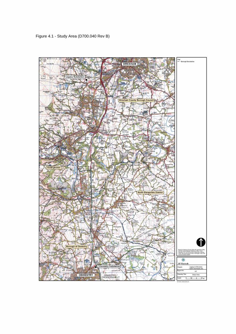
Figure 4.1 - Study Area (D700.040 Rev B)

Figure 4.2 - Settlements and Infrastructure (D700.032 Rev B)
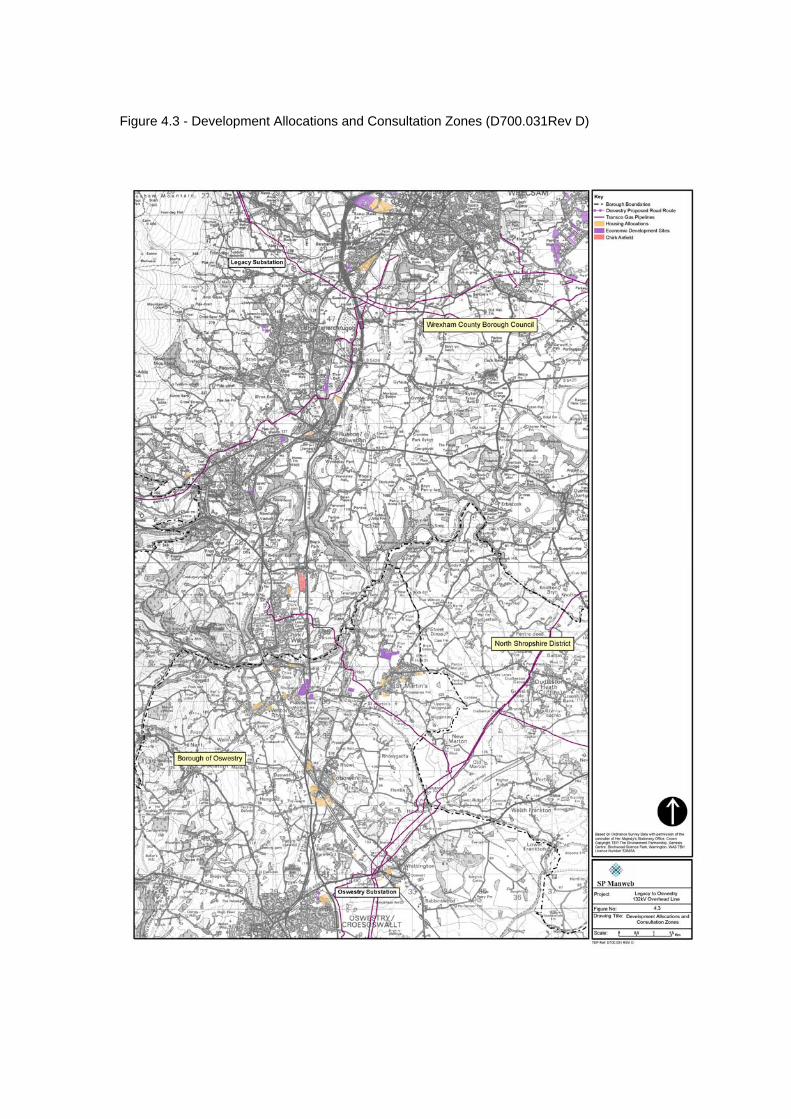
Figure 4.3 - Development Allocations and Consultation Zones (D700.031Rev D)
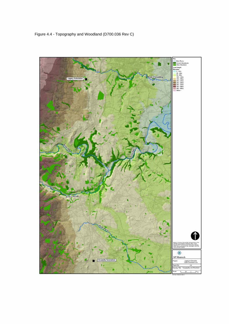
Figure 4.4 - Topography and Woodland (D700.036 Rev C)

Figure 4.5 - Agricultural Land Classification (D700.0.46 Rev C)
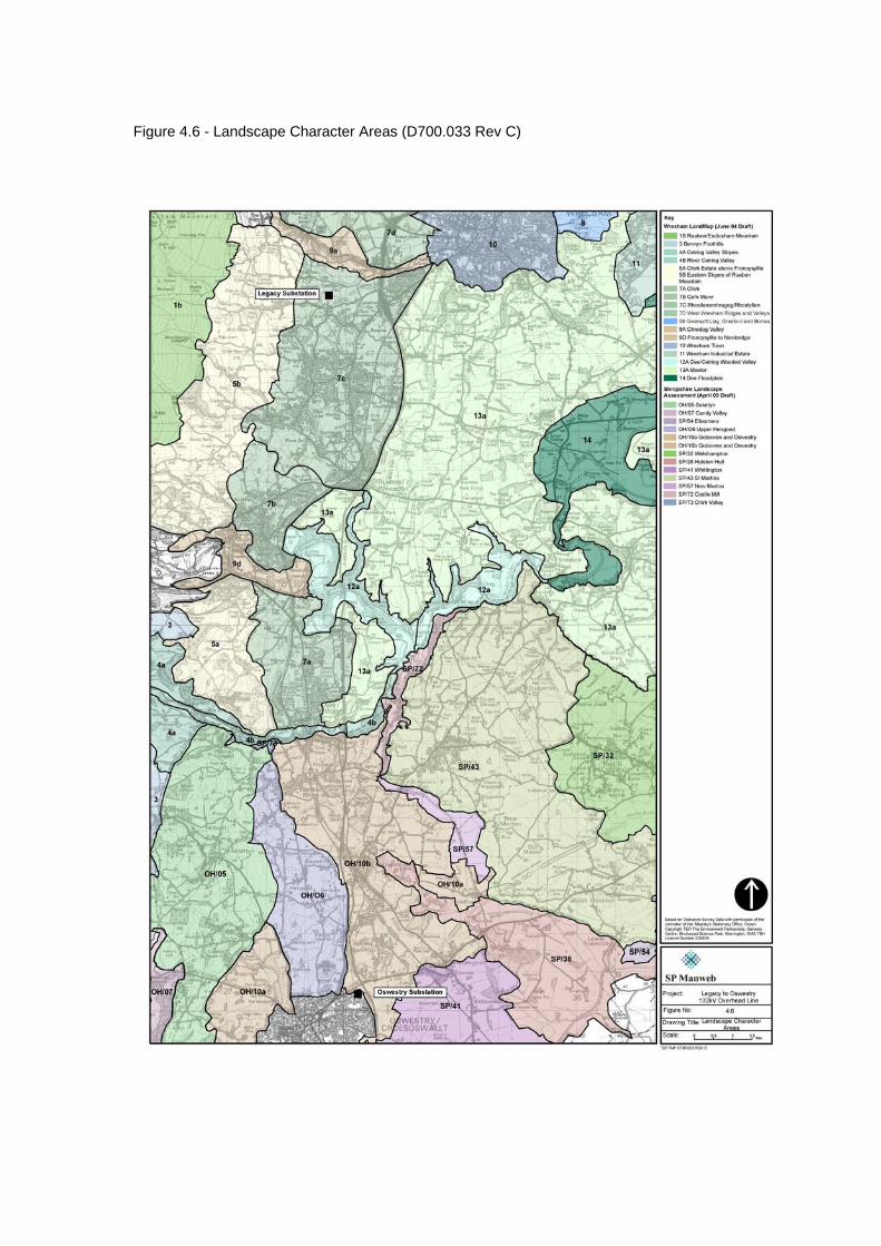
Figure 4.6 - Landscape Character Areas (D700.033 Rev C)
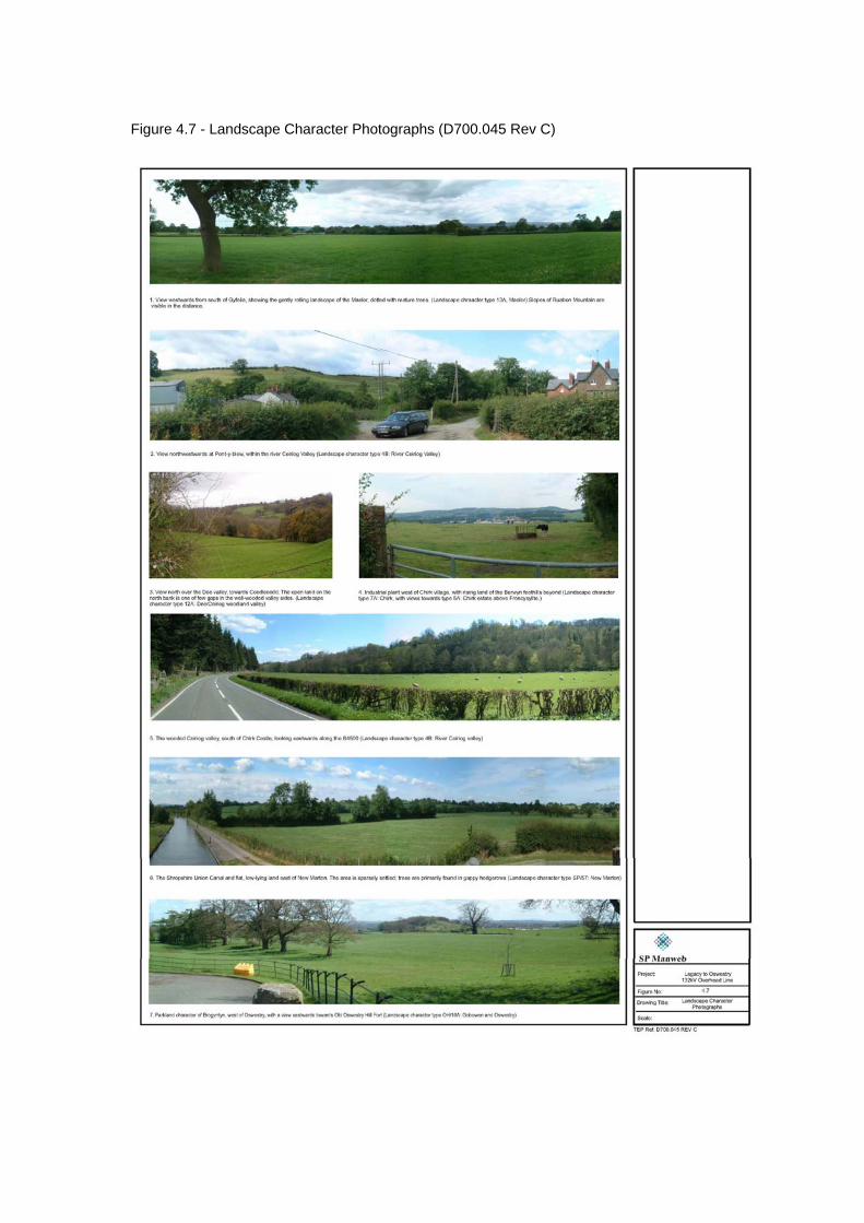
Figure 4.7 - Landscape Character Photographs (D700.045 Rev C)
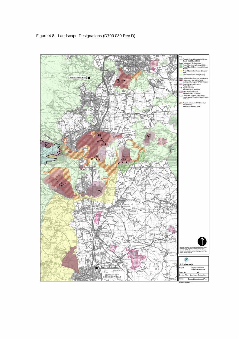
Figure 4.8 - Landscape Designations (D700.039 Rev D)
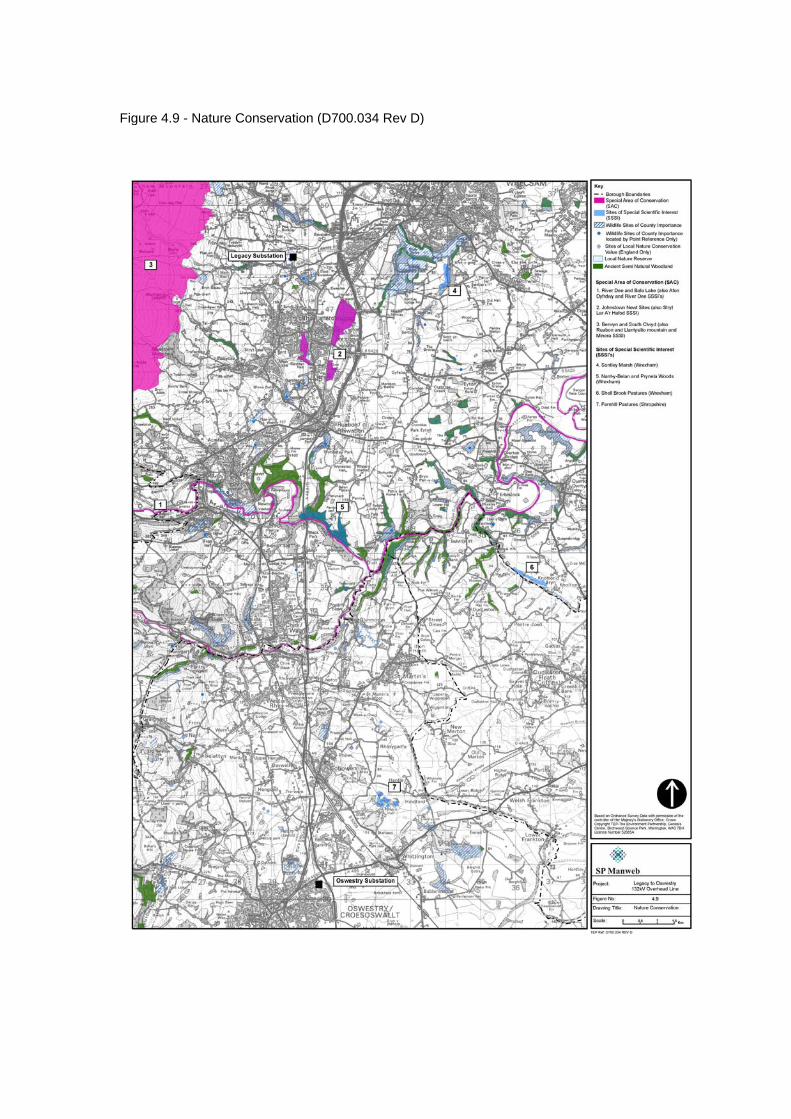
Figure 4.9 - Nature Conservation (D700.034 Rev D)
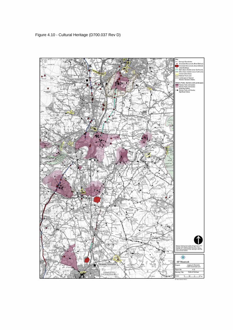
Figure 4.10 - Cultural Heritage (D700.037 Rev D)

Figure 4.11 - Recreation and Tourism (D700.038 Rev C)
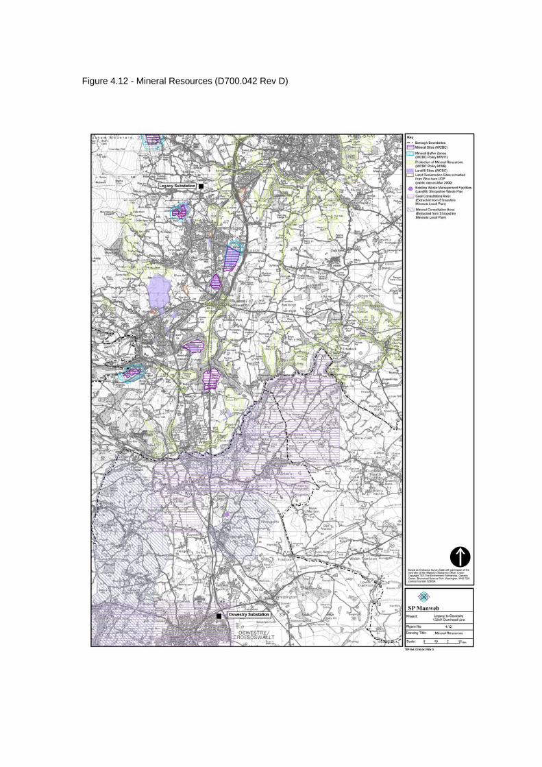
Figure 4.12 - Mineral Resources (D700.042 Rev D)
Legacy – Oswestry Reinforcement Consultation Document
45 February 2007
5.0 BROAD ROUTE OPTIONS 5.1 Following the process outlined in Chapter 3.0: Approach and Method, broad route
options have been identified which connect Legacy and Oswestry substations. These are: Option 1 to the east of the A483(T)/A5; Option 2 to the west of the A483(T)/A5; Option 3 following the main north south road corridor; and Option 4 paralleling the existing 132kV overhead line. These broad route options are shown on Figure 5.1.
5.2 Information gained during initial consultation, collation of the baseline information
and through initial site visits was used to carry out a preliminary assessment of these options. This information was used to identify potential routes or key constraints to routeing within these broad corridors.
5.3 Only strategic level environmental constraints and effects on people were considered
at this stage.
Strategic Environmental Considerations 5.4 Holford Rule 1 is of relevance here, which recommends avoidance altogether, if
possible, of the major areas of highest amenity value. This is interpreted as extensive areas that have been designated for their landscape, cultural, nature conservation or recreational value at the international or national level. Of these, the study area includes examples of the following: • Special Area of Conservation (European designation) • Sites of Special Scientific Interest (SSSI)(national designation) • Scheduled Monuments (national designation) • Listed Buildings • Conservation Areas • Historic Gardens and Designed Landscapes (national, non-statutory registers) • National Trails (recreational routes) • National Trust Estates open to the public • Ancient Semi-Natural Woodland
5.5 There are none of the following potential strategic constraints within the study area:
• Ramsar sites (international designation) • Special Protection Areas (European designation) • National Parks (national designation) • Areas of Outstanding Natural Beauty (national designation) • National Nature Reserves (national designation) • World Heritage Sites
5.6 There are no landscape designations of national importance or above within the
area. The areas of highest amenity value in terms of landscape, in the context of this study, are those designated at local planning authority level. Such designation was not considered a strategic constraint to routeing but was given a high priority below the strategic constraints identified. Approximately one third of the study area has a local landscape designation.
5.7 In order to minimise the effects upon landscape character routeing through blocks of
woodland should be avoided if at all possible. Thus woodlands were identified as a strategic constraint to routeing.
Legacy – Oswestry Reinforcement Consultation Document
46 February 2007
5.8 The following paragraphs summarise the main designation sites constraining strategic routeing.
Special Areas of Conservation
5.9 There are three SACs within the study area: • River Dee and Bala Lake • Johnstown Newt Sites • Berwyn and South Clwyd Mountains.
5.10 The River Dee SAC applies to the watercourses only of the Dee and Ceiriog rivers.
It is not possible to avoid crossing this SAC at least once in achieving a route between Legacy and Oswestry. Route options west of the confluence of the Dee and Ceiriog (east of Chirk) will cross both the Dee and Ceiriog.
5.11 Johnstown Newt Sites is a group of relatively small sites adjoining the eastern edge
of the settlement of Rhosllanerchrugog and Johnstown. Although existing high voltage distribution lines cross the designated site, this SAC is likely to constrain route selection eastwards from Legacy
5.12 Berwyn and South Clwyd Mountains SAC covers an extensive area in the north
west of the study area, approximately 2-3 km west of Legacy substation.
Sites of Special Scientific Interest 5.13 The study area contains eight SSSIs, only one of which, Ruabon & Llantysilio
Mountain & Minera, is considered of sufficient extent to form a constraint to corridor routeing. This site is located within the Berwyn and South Clywd Mountains SAC, at the extreme northwest of the study area. The geographical location of all SSSIs was mapped in order to see if clusters or concentrations occurred which would form a constraint to routeing.
Ancient Semi-Natural Woodland
5.14 The extent of Ancient Semi-Natural Woodland within the study area is limited, and comprises several very small woodlands or parts of woodland. All woodland has been regarded as a strategic constraint to routeing, although it was recognised that some woodlands are likely to be affected due to their widespread occurrence throughout the study area. Areas of Semi-Natural Woodland were mapped as these would be avoided where possible if it was inevitable that woodlands would be affected by a route.
Scheduled Monuments
5.15 The majority of Scheduled Monuments within the study area are of insufficient geographical extent to be considered at the strategic routeing stage. However Offa’s Dyke, which runs broadly north south in the western part of the study area, is marked by a series of scheduled monument designations, as is Wat’s Dyke, which follows a similar alignment east of Offa’s Dyke. Frequent crossing or paralleling of these routes could have an impact upon their overall setting, and these were thus considered strategic constraints to routeing.
Listed Buildings
5.16 Like most Scheduled Monuments, listed buildings can be worked around in finding the precise route, and are not addressed until the detailed routeing stage.
Legacy – Oswestry Reinforcement Consultation Document
47 February 2007
Historic Gardens and Designed Landscapes 5.17 There are eleven Registered Historic Parks and Gardens within the study area,
situated predominantly within a central band across the study area, in the vicinity of the Dee and Ceiriog valleys. Although some of the smaller estates could be avoided through deviation, overall such a designation was considered a strategic constraint to routeing.
National Trust Estates
5.18 Estates owned by the National Trust and open to the public, Erddig and Chirk Castle, were considered strategic constraints. Such estates are valued for both their cultural and recreational aspects, and are important tourist attractions.
Offa’s Dyke Path National Trail
5.19 This national recreational route is located in the extreme west of the study area, only in part following the alignment of the ancient defensive earthwork.
Local Landscape Designations
5.20 The entire western part of the study area, from the edge of the main settlements westwards, is designated, either as an Area of Outstanding Beauty (Denbighshire CC), Area of Special Landscape Character (Oswestry BC) or Special Landscape Area (Wrexham CBC). This designation encompasses the area around Legacy substation.
5.21 The Dee and Ceiriog valleys, together with adjacent slopes, side valleys and historic
parkland areas are largely protected by local landscape designations - Special Landscape Area (Wrexham CBC) and Area of Special Environmental Interest (North Shropshire BC). It is not possible to route between Legacy and Oswestry (within the study area) without crossing through this designation (or routeing through a main area of settlement), and so for this aspect, consideration was focussed upon minimising the distance through the designated area.
5.22 In the northern part of the study area further smaller Special Landscape Areas
(Wrexham CBC) are found around Erddig and other parkland estates.
Effects on People 5.23 Supplementary Note A to the Holford rules states ‘Avoid routeing close to residential
areas as far as possible on grounds of general amenity’. This is applied at the strategic level as it influences broad-scale routeing decisions.
5.24 The study area is bounded by the large settlements of Wrexham and Oswestry to
the north and south respectively. The primary constraint to routeing however is the almost continuous band of built development extending south from Wrexham to the Dee valley. This comprises the settlements of Rhostyllen, Rhosllanerchrugog, Johnstown, Ruabon and Cefn-Mawr. To the east of the study area there are few settlements larger than villages, with the exception of St Martin’s.
Route comparisons
5.25 The following sections describe the characteristics of areas identified as broad route
options, to identify potential constraints and opportunities, and summarises the conclusions about each one.
Legacy – Oswestry Reinforcement Consultation Document
48 February 2007
Option 1 - East of the A483(T)/A5 5.26 This option covers the eastern half of the study area to the east of the A483(T)/A5.
The area primarily comprises gently undulating pastoral agricultural land supporting scattered farms and dwellings with the larger village settlements of St Martin’s, Rhewl, Gobowen and Whittington to the south of the rivers Dee and Ceiriog. The Dee and Ceiriog valleys run in an east-west direction through the centre of this area and form distinctive landscape features, which are designated as a Special Landscape Area (SLA). The area immediately surrounding Legacy substation also falls within a SLA.
5.27 Being predominantly rural in land use, there are fewer settlement areas and main
communication corridors which otherwise present challenges for choosing a route option. This is evident by the presence of existing high voltage overhead lines to the west of the route option area.
5.28 The areas to the north and south of the Dee valley are characterised by hedgerows
and hedgerow trees, which, combined with gently rolling topography and small incised valleys containing linear woodlands, create a largely enclosed landscape character with few distant views (Character areas WCBC 13A Maelor and SP/43 St Martin’s). The area’s landscape character is also strongly influenced by the occurrence of several large parkland estates, including Erddig, Wynnstay, Brynkinalt, Pen-y-lan, Rosehill, Erbistock, Henlle, Great Fernhill and Halston Hall.
5.29 Woodland is largely confined to the Dee and Ceiriog valleys, although the presence
of mature trees and hedgerows throughout gives the whole area a fairly wooded appearance. The Dee and Ceiriog valleys are designated as a Special Area of Conservation (SAC), and there are several smaller pockets of land designated for their ecological value to the north in the vicinity of Legacy substation.
5.30 Wat’s Dyke runs through the eastern part of the study area and is an important
archaeological feature. Tourist attractions within the area include Erddig Park, a National Trust owned property to the north, and the Shropshire Union Canal which runs through the southern half of the study area. Key Environmental Factors
5.31 The main constraints within this predominantly rural area are considered to be the several registered historic parklands and extensive areas of woodland, mostly associated with the Dee and Ceiriog valleys. These constraints form an almost continuous band from east to west across the study area.
5.32 Generally the undulating nature of the topography combined with mature hedgerows
and trees affords the landscape a relatively high capacity to accommodate a wood pole overhead line. There are several potential route options which avoid the main areas of constraint.
Legacy – Oswestry Reinforcement Consultation Document
49 February 2007
Option 2 - West of the A483(T)/A5 5.33 This option covers the western half of the study area to the west of the
A483(T)/A5. The northern half of this area is densely populated with the settlements of Rhosllanerchrugog, Penycae, Ruabon, Plas Madoc, Acrefair, Cefn Mawr and Trevor forming an almost continuous band of built development between the River Dee and Legacy substation. The settlement of Chirk occupies the area of land between the Rivers Dee and Ceiriog and Western Rhyn lies to the south of the Ceiriog. To the east of these settlements there are also areas of Registered Parkland associated with the Wynnstay and Brynkinalt estates.
5.34 The remaining area to the west comprises smaller village settlements and isolated
farms and dwellings. West of Legacy, the topography rises steadily to Ruabon and Esclusham Mountains (circa 500m AOD). The landscape becomes notably more rural in nature with the higher ground comprising open heather moorland. The intervening border hill slopes are characterised by small irregular fields, hedgerows with mature hedgerow trees, and scattered farms and small settlements (Wrexham Landmap Character Area 5B Eastern Slopes of Ruabon Mountain). The higher ground to the west is designated as SLA, which extends over a significant area of upland landscape occupying much of the area within Option 2.
5.35 The Dee and Ceiriog rivers form distinct steep sided landscape features within the
area, with the valley sides supporting dense woodland vegetation. The aqueducts, viaducts and road bridges associated with these valleys form important cultural heritage features within the landscape. The Pontcysyllte aqueduct, carrying the Shropshire Union canal over the river Dee, is a proposed World Heritage Site.
5.36 Chirk Castle occupies an area of higher ground to the west of Chirk overlooking the
Ceiriog valley and is owned by the National Trust. 5.37 The land to the south of the study area in the vicinity of Oswestry is rural in
character and comprises gently undulating pastoral land bounded by mature hedgerows with mature hedgerow trees. The landscape becomes more parkland in character to the west of Oswestry in the vicinity of Brogyntyn, which is a Registered Historic Park and Garden. (Character area OH/05 Selattyn).
5.38 Oswestry Hill Fort Scheduled Monument lies to the south of the study area
approximately 0.5km to the north west of Oswestry substation and it forms a prominent embanked feature in the landscape. Wat’s Dyke runs in a north easterly direction from the Fort.
5.39 Offa’s Dyke runs through the northern half of the study area passing through Chirk
Castle grounds before running in a north easterly direction crossing the River Dee to the east of Cefn Mawr. It then runs through Wynnstay Park and through Ruabon and Rhosllanerchrugog before heading north to the east of Legacy substation.
5.40 The Dee and Ceiriog valleys are designated as a SAC, as are the Berwyn Mountains
to the west, and there are several smaller pockets of land designated for ecological importance to the north in the vicinity of Legacy substation, including the mosaic of sites which make up Johnstown Newt Sites SAC.
Legacy – Oswestry Reinforcement Consultation Document
50 February 2007
Key Environmental Factors 5.41 The key environmental issues affecting the routeing of an overhead line are primarily
located in the northern half of the study area, with fewer constraints to the south within the borough of Oswestry. To the north, the combination of large areas of settlement adjacent to areas designated for their landscape value limit potential route options, as both factors are likely to result in a route option having a greater overall visual impact (in comparison to a sparsely settled landscape with no landscape designation).
5.42 Dense built development stretches to the south of the substation at Legacy from
Rhosllanerchrugog to Cefn Mawr and there are very few gaps which could be utilised as potential overhead line routes. The few gaps that are present between parts of the built development are largely associated with sites of mineral activity, areas of ecological importance or are associated with historic parkland. Breaks in the development are also utilised as routes for existing overhead lines. The continuous development in this area is considered to pose a constraint on route options available.
5.43 The continuous built development would necessitate potential route options taking a
more westerly alignment, along the eastern slopes of Ruabon Mountain, an area of pastoral farmland between 180m and 350m AOD rising from edges of urban villages to the edge of Ruabon Moors. The higher ground is designated as an area of Special Landscape Value. Potential routes within this area are considered likely to give rise to increased visual impact.
5.44 The Dee and Ceiriog Rivers occupy steep valleys within this area and are heavily
wooded with no natural crossing points. This is considered to be a constraint to routeing.
5.45 To the south of the River Ceiriog there are fewer constraints to overhead line
routeing and the area offers several potential routes. Oswestry Hill Fort and Brogyntyn historic parkland are located in the vicinity of the substation and would have to be carefully considered in detailed routeing options.
5.46 The presence of a number of high-level constraints, notably to the north, limits
potential routes within this western option. That is not to say that there is no potential, however other broad route options offer more potential. This broad route option has not been studied in any further detail at this stage. Option 3 - Following the Main Road Corridor
5.47 This option follows the main road which runs between Wrexham and Oswestry and
forms the most accessible direct route between the substations. The main road comprises the A5 from Oswestry to Halton, where it then runs in a westerly direction towards Llangollen, and the A483(T) which continues from Halton towards Wrexham and beyond.
5.48 The road comprises stretches of single carriageway, dual carriageway and some sections of three lane carriageway with varying priority for the overtaking lane. It is a fast national speed limit road and there are six junctions onto it located between Wrexham and Oswestry. The road is predominantly level with surrounding land or on embankment allowing views out over the surrounding area.
Legacy – Oswestry Reinforcement Consultation Document
51 February 2007
5.49 This stretch of road includes two high road bridges (viaducts) over the River Dee and the River Ceiriog which run in deep valleys. From these crossing points there are impressive views out along the wooded valleys.
5.50 To the north of the study area there is a significant amount of development, notably to the west of the road. This includes the urban areas of Rhosllanerchrugog and Ruabon. Developed areas immediately abut the road in places, and in the case of Ruabon development abuts the road corridor on both sides.
5.51 The land surrounding Erddig Hall is under the ownership of the National Trust and lies to the immediate east of the A483(T) for approximately 1km to the north of the study area. Further south the A483(T) runs through two other Registered Historic Parklands, the Wynnstay Estate (for over 2km) and the Brynkinalt Estate (for approximately 1.5km).
5.52 There are several areas of new development or development allocations in the vicinity of the junction leading into Chirk. To the west of the settlements of Gobowen and Rhoswiel development lies in close proximity to the road. The remaining land along the road is predominantly in agricultural use, especially to the south of the study area where there is less built development.
5.53 Oswestry Hill Fort is located 0.5km to the west of the A5 in the vicinity of
Oswestry substation and is a prominent landmark when viewed from the road. Key Environmental Factors
5.54 The key issues affecting the routeing of an overhead line along the existing road are primarily located to the northern half of the study area where there are substantial areas of land supporting existing built development.
5.55 In the central part of the study area the key constraints are the areas of historic
parkland associated with the Wynnstay and Brynkinalt Estates and the steep river valleys.
5.56 There are fewer constraints to the south adjacent the A5, however the settlements
of Gobowen and Rhoswiel form a restriction on routeing. 5.57 The A483(T)/A5 is a main road through the border area between England and Wales
and as such is a well-used tourist route, notably for travelling to destinations such as Llangollen and other border market towns. The road is also well used by local people and there are several settlements and dwellings located in close proximity to the road. A route which follows the alignment of the existing road is likely to affect the visual amenity of a greater number of people than options routed through land of a more rural nature.
5.58 A technical issue related to routeing along the road corridor relates to the road
crossings of the river valleys. It is not possible to mount poles along the viaduct safely, both in terms of structural integrity of the viaduct and the overhead line support and in relation to maintaining electrical clearances. It would be necessary to use cables within the road carriageway or mounted in some way on the viaduct. Consultation with the local authority currently responsible for the viaducts (Conwy County Borough Council) has demonstrated that this is not feasible and a diversion away from the road corridor would be necessary for crossing the river valleys.
Legacy – Oswestry Reinforcement Consultation Document
52 February 2007
5.59 The constraints identified in relation to routeing a line along the existing road corridor are considered to be such that other options offer increased potential. This option has not therefore been considered further at this stage. Option 4 Paralleling the Existing 132kv Overhead Line
5.60 This option follows the line of the existing 132kV double circuit lattice tower line which runs between Legacy and Oswestry substations.
5.61 Although the Holford Rules and other guidance express caution regarding running lines closely together, the geographical area affected by the overhead lines is minimised in comparison to separate routes, where a larger geographical area would be affected. When routes run in parallel, sufficient distance should be maintained between the lines to ensure that, should one of the lines suffer disruption or failure, it would not also affect the adjacent line. The ‘falling distance’ of the taller of the support structure is generally the height of the tower/pole plus 3.4 metres (safety clearance requirement for 132kV line). In this situation, the taller structures will be the existing 132kV support towers (with a typical height of 26.5m). This translates to a need to maintain at least 30 metres between lines.
5.62 The Holford Rules observe that converging overhead line routes can lead to a concatenation ‘wirescape’, although this observation is made in relation to country which is ‘flat and sparsely planted’ whereas this landscape is typically gently rolling with good hedgerow cover with trees. However, the existing 132kV lattice line already runs in close parallel with the NGC owned Ironbridge No.2 400kV line between Legacy and the River Dee crossing point. A further addition to these parallel overhead lines may lead to an increased cumulative impact. This may be compounded by introduction of a third type of support, and different interval between supports (the typical spans between 132kV lattice steel towers are greater than between wood pole supports; and the intervals between the larger 400kV lattice steel towers are greater still).
5.63 Initial assessment of existing pole mounted lines in the local area indicated that they are able to be well assimilated into the undulating landscape which is characteristic of this area. The local undulations combined with mature hedgerows and hedgerow trees do not generally enable views of the wood pole supports beyond a field or two in distance. Routeing a new wood pole line in parallel with an existing lattice tower line is considered likely to increase the attention focused towards both existing and proposed overhead lines, whereas routed in isolation the new line would be less intrusive in the landscape.
Key Environmental Factors
5.64 Between Legacy and the A483(T) the existing 132kV lattice steel tower overhead line occupies a corridor in close proximity to the large settlements of Rhosllanerchrugog and Johnstown, in places entering within the urban fabric. Avoidance of proximity to residential areas (Supplementary Note A to the Holford Rules) is considered a strategic constraint to routeing.
5.65 The existing route crosses Johnstown Newt Sites SAC. It also crosses the drive of the registered parkland of Wynnstay, and extends for over one kilometre within the Essential Setting of this estate. In addition to crossing the locally designated landscape of the Dee valley, the existing line follows an alignment on the eastern bank of the Ceiriog valley, resulting in over 5km length within a SLA designation.
Legacy – Oswestry Reinforcement Consultation Document
53 February 2007
5.66 In addition, the cumulative effect which would result from paralleling is considered to be a constraint to routeing. On this basis, a paralleling option is not considered to be a favoured option and has not been considered in any further detail at this stage.
Summary of Broad Route Options
5.67 A summary of the options considered is shown on Table 5.1. The key
environmental issues relating to each option are identified. Each environmental factor is of varying weight and the determination of a preferred option is a judgement based on a combination of the factors and levels of constraint. However Table 5.1 provides a concise summary of the key issues which were considered.
5.68 In summary, Option 1 would utilize a gently rolling landscape with opportunities to
use the numerous woodlands to integrate and assimilate the wood pole line. Additionally, few settlements are likely to be affected. Option 2 comprises a large proportion of dense urban development, which borders rising land with an open aspect, making any potential route likely to be visible to numerous receptors. A significant proportion of the more open, higher land is designated as a Special Landscape Area. Option 3, utilising the road corridor, has not proved technically possible in certain key locations. Option 4, installing an additional route parallel to existing high voltage overhead lines, is constrained by the cumulative visual effects of paralleling, together with proximity of existing lines to settlement and sites designated for their nature conservation value or historic landscape value.
Identification of Preferred Broad Route Option
5.69 The preliminary assessment of broad route options, as described above and as summarised in Table 5.1, indicates a strong preference for the identification of potential routes within Option 1 – East of the A483(T)/A5. This is followed in terms of preference by Option 4, which, although it contains a number of overhead lines already, similarly occupies a rolling landscape where there are plenty of wooded areas to screen the new line. A more detailed route selection and evaluation process has been undertaken in the area to the east of the A483(T)/A5. This is described in the following Chapter.

Legacy – Oswestry Reinforcement Consultation Document
54 February 2007
Table 5.1: Summary Table of Broad Route Options KEY ISSUES ROUTE OPTIONS
LANDSCAPE CHARACTER
LANDSCAPE DESIGNATIONS
PROXIMITY TO SETTLEMENTS/VISUAL
IMPLICATIONS ECOLOGY
TREES AND WOODLAND
ARCHAEOLOGY LEISURE AND
TOURISM TECHNICAL
ROUTE 1 EAST OF A483(T)/A5
Gently undulating rural land in pastoral agricultural use supporting scattered farms and dwellings. Several large areas of parkland Woodland largely confined to Dee and Ceiriog Valleys although mature hedgerows and trees give landscape a more wooded appearance
Land around Dee Valley designated as a Special Landscape Area Erddig, Wynnstay, Pen y lan, Erbistock, Rosehill and Brynkinalt Registered Parks and Gardens & several unregistered parklands
Farms, isolated dwellings and small settlements scattered throughout area.
Dee and Ceiriog SAC Johnstown Newt Sites SAC situated between Legacy substation and A483(T)
Dense woodland along Dee and Ceiriog Valleys with occasional breaks in vegetation cover
Offa’s Dyke (between Legacy substation and A483(T) Wat’s Dyke Oswestry Hill Fort SM Rhyn Park SM
Erddig Park (National Trust) Shropshire Union Canal
Crossing existing 132kV and 400kV OHLs River Crossings
ROUTE 2 WEST OF A483(T)/A5
Topography rises to west beyond dense urban settlements along A483/A5 and becomes more rural. Dramatic steep wooded river valley landscapes of Dee and Ceiriog Rivers
All high ground designated as a Special Landscape Area Wynnstay, Brynkinalt, Brogyntyn and Chirk Castle Registered Parks and Gardens
Dense urban development of Rhosllanerchrugog, Pen y Cae, Ruabon, Acrefair, Cefn Mawr, Plas Madoc, Chirk Bank and Weston Rhyn. Few breaks in urban area - would require route to run through higher ground to west
Berwyn SAC Dee and Ceiriog SAC Johnstown Newt Sites SAC
Dense woodland along Dee and Ceiriog Valleys with very few breaks to utilise as crossing points
Offa’s Dyke runs to the west of the A483(T) / A5 Oswestry Hill Fort SM
Chirk Castle (National Trust) Offa’s Dyke National Trail Shropshire Union Canal Pontcysyllte aqueduct proposed World Heritage Site
River Crossings
ROUTE 3 FOLLOWING MAIN NORTH SOUTH ROAD CORRIDOR
Busy transport corridor runs north south from Wrexham to Oswestry. Variable landscape character includes urban area, rural pastoral land, parkland and dramatic valleys
Passes through Wynnstay and Brynkinalt Registered Parks and Gardens Runs alongside Erddig Hall Parkland
Passes in close proximity to Ruabon and Gobowen. Views from road Land adjacent A5 allocated for housing at Rhoswiel and Gobowen
Utilise existing road bridge crossings over Dee and Ceiriog SAC
Dense woodland along Dee and Ceiriog Valleys. Use of existing road bridge crossings will avoid the need for tree removal. Blocks of woodland run up to A483(T)/A5 necessitating some tree removal
Offa’s Dyke (between Legacy substation and A483(T)) Wat’s Dyke Oswestry Hill Fort SM
Follows line of the main north south route through the Wales England borders Shropshire Union Canal
Maintenance aspects of utilising road bridges
ROUTE 4 PARALLELING EXISTING 132kV LATTICE LINE
Gently undulating rural land in pastoral agricultural use supporting scattered farms and dwellings with several large areas of parkland. Woodland largely confined to Dee and Ceiriog Valleys although mature hedgerows and trees give a more wooded appearance
Land around Dee & Ceiriog valleys designated Special Landscape Area Passes through essential setting of Wynnstay Registered Park and Garden
Proximity to Rhosllanerchrugog and Johnstown (within urban fabric in places) Visual effect of proposed line considered greater if run in parallel to existing 132kV lattice tower line. Cumulative impact
Crosses Johnstown Newt Sites SAC Dee and Ceiriog SAC
Dense woodland along Dee and Ceiriog Valleys. Utilisation of existing OHL route will require tree removal in several places
Crosses Offa’s Dyke (near Legacy substation) Oswestry Hill Fort SM Rhyn Park SM Crosses Wat’s Dyke x3
Shropshire Union Canal and new marina development beneath existing 132kV OHL
Proximity of paralleling existing 132kV line River Crossings
High or major level constraint Moderate level constraint Absence or low or minor level constraint
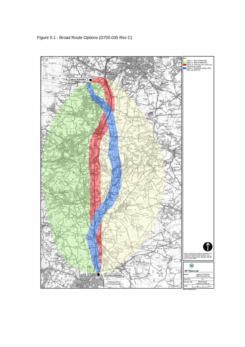
Figure 5.1 - Broad Route Options (D700.035 Rev C)

Legacy – Oswestry Reinforcement Consultation Document
55 February 2007
6.0 DETAILED ROUTE OPTIONS 6.1 Following the selection of a broad route option, Option 1, in the previous chapter,
this chapter outlines the development and evaluation of detailed route options to the east of the A483(T)/A5. Potential routes within this area were identified following the main principles of the Holford rules and other published guidance and had regard to all the environmental baseline information gathered. As outlined in Chapter 3.0: Approach and Method, routes were identified which avoided residential areas, including villages and other small settlements and occupied properties, areas of known nature conservation value, woodland, sites of heritage and amenity value. Routes were selected which maximised the potential for existing topography and vegetation to aid assimilation of the line into the landscape.
6.2 The potential routes identified within Option 1 are illustrated in Figure 6.1.
Zoning of the Study Area 6.3 The study area has been split into three geographical zones for the sole purpose of
describing the route options. Each zone is described followed by a description of identified routes and reasons for their identification.
6.4 The zoning of the study area has been used as a tool to enable a variety of routes
and combinations of part routes to be considered. The key areas in identifying routes were considered to be the substation entries and the river crossing points. The zoning has enabled different river crossing points to be considered with different substation entry options. The following zones have been identified:
• Zone A Legacy – this zone extends from the substation at Legacy to a point
approximately 4km to the south in the vicinity of Moreton/Gyfelia.
• Zone B River Crossings – this zone extends from a point in the vicinity of Moreton/Gyfelia to the B5070/B5068 which runs in an east west direction from the A5 through St Martin’s. This zone covers an area of approximately 8km which includes the Dee and Ceiriog river valleys.
• Zone C Oswestry – this zone extends from the B5070/B5068 to Oswestry
substation located approximately 5.5km to the south.
6.5 The boundary between Zones A and B is not clearly apparent on the ground, however it is where the routes from A and B converge to a central point. The boundary between Zones B and C is clearly defined on the ground as the B5070/B5068. The route options to the north of this road are clearly focused on the river crossing points, whereas to the south the routes are focused on the entry into the substation at Oswestry making this an appropriate boundary for descriptive purposes.
Environmental and Technical Considerations
6.6 The guidance presented in the Holford Rules is considered in comparing route
options. The analysis of the detailed route options is carried out at a smaller scale and finer grain than the analysis of the broad route options. In addition to the designations discussed under broad corridor routeing, all published local, regional and non-statutory designations are taken into account. In addition to effects upon
Legacy – Oswestry Reinforcement Consultation Document
56 February 2007
main settlements, questions of visual amenity in terms of villages and other small settlements, principal transport routes and tourist attractions that may be affected are all considered, as is the effect upon landscape character.
6.7 Appendix 6A identifies the environmental and technical constraints considered at the
detailed stage. 6.8 Note is taken of the comparative length of the different route options at this stage
because this is not only a technical and economic issue but also because the longer route that is built, the greater the length over which environmental disbenefits are caused.
Identification of the Preferred Route
6.9 It is not possible to identify the overall preferred route by selecting the preferred
options on a zone-by-zone basis, as not all route options join at zone boundaries. The preferred option for one zone may not connect to the preferred route of an adjoining zone to form an overall coherent route. The route options illustrated in Figure 6.1 result in numerous possible overall routes from Legacy to Oswestry.
6.10 The method employed for reducing the number of route options to ultimately arrive
at a preferred route was a process of direct comparison of sections of those routes which have common starting and end points. Through selecting the ‘best’ option for each section, the number of possible overall routes is reduced step-by-step, ultimately identifying the route which is, overall, likely to cause the least impact upon environment and people.
Route Descriptions and Comparison
6.11 Figure 6.2 shows the detailed route options and zone boundaries overlaid on the
identified environmental and technical constraints. The following sections describe and evaluate the potential routes identified within each zone. The resulting one or two ‘best’ routes within a zone are then combined to form overall coherent routes from Legacy to Oswestry, and these overall routes then evaluated/compared.
6.12 In the comparisons below, reference should be made to the relevant route
descriptions and key constraints and the summary table of alternative route options presented in Appendix 6B. Zone A (Legacy) Route Options
6.13 Zone A is shown in Figure 6.3 and covers the area from Legacy substation to
Moreton/Gyfelia approximately 4km to the south west. The substation itself is relatively unapparent in the wider landscape as it is surrounded by high mounding and tree planting, however the numerous line entries are more evident. The substation is located in a Special Landscape Area which extends out from the substation in all directions, but notably to the higher ground to the west. This designation extends in a south-westerly direction for just over 1km to the B5605, Wrexham Road. Further protective landscape designations within Zone A relate to the land around the registered historic parkland of the Erddig estate.
6.14 Former mining and extractive industries are evident in the landscape, most notably
Hafod Tip, which has recently been reclaimed and landscaped as a country park, and Bersham Tip which retains a distinctive angular appearance. The A483(T) runs
Legacy – Oswestry Reinforcement Consultation Document
57 February 2007
in a north-south direction approximately 1.5km to the east of the substation. To the west the land is primarily in agricultural use in the area immediately surrounding the substation, however there is residential development along the majority of roads, a crematorium to the south of the substation, and the dense urban development of Rhosllanerchrugog/Johnstown and Ruabon further to the south. The built development within this area combined with existing overhead line routes entering the substation limits potential route options available in this area.
6.15 To the east of the A483(T) the land becomes more open and agricultural with less
built development. It comprises gently undulating pastoral land bounded by mature hedgerows supporting mature hedgerow trees with scattered farms along a network of minor roads. The National Trust owned Erddig Hall lies to the north of this area, which includes Hafod-y-bwch Farm Park at its southern most extent. There are fewer constraints to routeing within this part of Zone A and routeing opportunities are more flexible.
6.16 The key constraints within Zone A are:
• There are already several existing overhead lines of a variety of design and voltages entering the substation at Legacy.
• The continuous built development of Rhosllanerchrugog, Johnstown and Ruabon prevent a route option being progressed to the south
• Built development along the B5605, Hafod and Bersham Tips, the A483(T) and the National Trust owned Erddig property restrict route options to a narrow band of land which already supports several existing overhead lines.
• A partially completed development (Rural Welcome Centre) including a residential property occupies a very narrow pinchpoint of land between A483(T) and Hafod Tip.
• Wat’s Dyke runs in a broadly north-south direction to the east of the A483(T)
• Hafod Tip, a steep sided, elevated area of woodland which is part of the Special Area of Conservation (SAC) site known as Johnstown Newt Sites, currently managed by WCBC as a community park.
• Offa’s Dyke runs in a broadly north-south direction between the substation and Pentre Bychan.
• Several other Scheduled Monuments in the area – moated sites and barrows.
• Large areas safeguarded for protection of mineral resources between Legacy and the A483(T)
Route A1 6.17 This option leaves the substation as an underground cable taking a south easterly
route along the existing road system to Pentre Bychan via the B5097 Bronwylfa Road and B5426, Smithy Lane, to its junction with the B5605, Wrexham Road. East of Wrexham Road it emerges onto a wood pole support and continues in a south-easterly direction across open farmland, to skirt around the northern boundary of Hafod Tip to Hafod Road. The route corridor here occupies a narrow strip of land between Hafod Tip and the A483(T). Crossing Hafod Road and the A483(T) in the vicinity of the bridge taking Hafod Road over the trunk road, the route continues in a south-easterly direction to a point west of the fishing lakes at Sontley.
6.18 From here it would follow a more southerly route for approximately 1km before
again heading in a south easterly direction through agricultural land, crossing Wat’s
Legacy – Oswestry Reinforcement Consultation Document
58 February 2007
Dyke, and then heading in a south-easterly direction between Moreton Below and Gyfelia. There are several farms and isolated properties within this area, and the route has been aligned to avoid close proximity to these properties.
Key Environmental Factors
6.19 The following key environmental factors have been identified related to route A1: • Potential effect on archaeology during cable laying. There are several known
archaeological sites in the vicinity of the substation • Proximity to SAC and community park at Hafod Tip, potential tree loss • Offa’s Dyke crossing (cable) • Wat’s Dyke crossing (wood pole) • Crosses area safeguarded for protection of mineral resources
Route A2
6.20 This route would utilise the route taken by the existing ‘portal’ frame overhead line.
The portal line carries a single 132kV circuit. This existing circuit could be combined with the proposed 132kV circuit together on a double circuit lattice tower (pylon) line. The existing portal line would be dismantled and replaced by a double circuit line to the point where the two circuits would diverge. This option allows for a reduction in the number of overhead lines routed through this area, however it would result in larger and taller supports being required to carry the two circuits. Figure 2.2 shows a comparison of the different support types to which reference is made.
6.21 This route would be cabled for approximately 0.5km from Legacy substation to a
point to the south of the B5097 Bronwylfa Road where the existing portal line commences. From here the portal line would be replaced by a lattice tower line to a point to the east of the A483(T) at the point of an existing deviation tower. From this point the portal line would continue in an easterly direction on the alignment it currently occupies and a new wood pole route would head in a southerly direction to a point west of the fishing lakes at Sontley. At this point the line could either join with route A1, or take a more south-easterly direction along A2 for approximately 1km to beyond Moreton View, then turning onto a southerly alignment to cross the B5426 west of Gyfelia.
Key Environmental Factors
6.22 The following key environmental factors have been identified related to route A2: • Visual effect of double circuit lattice tower line replacing portal line from
Legacy to east of A483(T) – more substantial and taller structures, but with greater spans between towers, so fewer supports required.
• Lattice towers would replace portal supports in landscape protected by local designation (Special Landscape Area)
• Proximity to 3 Scheduled Monuments (double circuit lattice tower section) • Close proximity to several properties, including 2 Grade II* listed buildings at
Hafod y Bwch Hall • Wat’s Dyke Crossing (wood pole overhead line) • Offa’s Dyke crossing (cable) • Route crosses a small section of National Trust land (not publicly accessible)
Legacy – Oswestry Reinforcement Consultation Document
59 February 2007
Route A3 6.23 Route A3 would similarly combine the existing circuit carried by portal frame
supports and the new circuit onto a double circuit lattice tower line. This route however considers the potential for realigning the line away from the existing portal route to increase the distance it is sited from its closest visual receptors. The existing portal line would be dismantled to a point where the two circuits would diverge in separate directions to the east of the A483(T). This route follows a line approximately 0.25km to the north of the existing portal crossing of the A483(T).
6.24 The new double circuit lattice line would run east to the north of Hafod-y-bwch
Farm Park through the National Trust owned land associated with Erddig Hall to a point west of Sontley, crossing Hafod Wood and Wat’s Dyke in the process. From here the route would run south to the present alignment of the existing portal line from where the portal line would continue east and a new wood pole line would run south through undulating agricultural land primarily in pastoral use. This route would follow the same alignment as route A2 from north of Moreton View to the Zone boundary. The proposed route is aligned to avoid close proximity to farms and isolated dwellings.
Key Environmental Factors
6.25 The following key environmental factors have been identified related to route A3: • Route crosses National Trust owned land using lattice towers – close
proximity to Erddig Registered Parkland and Hafod-y-Bwch Farm Park • Tree removal likely to be required at Hafod Wood Wildlife Site of County
Importance (WCBC) • Portal line removed from views from Middle Sontley Farm and nearby
properties • Wat’s Dyke crossing • Offa's Dyke crossing (cable) • Proximity to 3 Scheduled Monuments (lattice section) • Proximity to 2 Grade II* listed buildings
Comparison of Zone A (Legacy) Options: A1, A2 and A3
6.26 In this zone, Option A1 uses 1.5km of underground cable and 4.2km of wood pole
overhead line. Options A2 and A3 use a smaller amount of underground cabling, and both utilize steel lattice towers for a good proportion of their overall length. Although the use of lattice towers would enable removal of sections of an existing overhead portal line, thus bringing some benefits in terms of visual amenity, in general the use of lattice towers is considered likely to have wider effects on visual amenity than use of wood pole construction.
6.27 It is considered that the numbers of residential properties where views would be
affected would be approximately the same for all options but that the effect would be greater where lattice towers were employed. Additionally, Option A3 would bring a new lattice tower overhead line within 0.5km of the Registered Historic Parkland of Erddig, within land owned by the National Trust, and would be likely to require tree removal where it crosses Hafod Wood, a Wildlife Site of County Importance. Although it is acknowledged that benefits would arise from removal of the portal line from views from properties in the vicinity of Middle Sontley, this option was rejected because of the adverse effects described above.
Legacy – Oswestry Reinforcement Consultation Document
60 February 2007
6.28 The balance between option A1 and A2, favours A1 in terms of effects on views and effects upon designated landscapes. The visual effects of a wood pole line are generally likely to be less than those of a line supported on steel lattice towers. Also option A2 would pass through a Special Landscape Area on lattice tower overhead line, whereas option A1 is undergrounded through the designated area. There is no clear favourite between these options in terms of other environmental considerations (ecology, cultural heritage, tourism).
6.29 Option A1 was selected as the preferred option through Zone A.
Zone B (Dee River Crossing) Route Options
6.30 Zone B is illustrated at Figure 6.4. It extends from Moreton/Gyfelia southwards for
approximately 8km to the B5070/B5069 which runs in an east-west direction from the A5 through St Martin’s. The zone is primarily rural in nature and the Dee and Ceiriog river valleys form the key features.
6.31 The land to the north of the River Ceiriog falls within Landscape Character Area 13a
Maelor and comprises gently undulating pastoral lowland with an abundance of mature hedgerows and hedgerow trees. Within this agricultural landscape there are several large estates where the landscape is of a more parkland character. The estates include Wynnstay Hall, which occupies several square kilometres to the north west of the zone; Brynkinalt to the south west of the zone in between the Rivers Dee and Ceiriog; and Pen-y-lan, Rosehill and Erbistock to the centre of the zone to the immediate north of the River Dee.
6.32 The Dee and Ceiriog river valleys form prominent features in the landscape. The
valleys are steeply sloping to the west becoming gentler towards the east where the River Dee widens and meanders. Valley sides are predominantly wooded with relatively few breaks in the woodland vegetation. The river valleys are locally designated areas of high landscape value. Both the Dee and Ceiriog are important fishing areas, with access being confined primarily to private tracks and access points for permit holders.
6.33 A SAC designation applies to the entire length of the rivers within the study area.
This European nature conservation designation primarily covers the area of water and does not include the valley sides.
6.34 To the south of the Dee, the landscape is similarly rolling and in agricultural use,
with an increase in arable production. Fields are bounded by mature hedgerows and development primarily comprises small settlements and isolated farms and dwellings, with St Martin’s forming the main settlement focused along the B5070/B5069.
6.35 Sites of nature conservation value, archaeologically important sites and listed
buildings are scattered throughout the area. 6.36 Two high voltage overhead lines run through this zone: the existing SP Manweb
132kV Legacy to Oswestry line and the NGC 400kV Ironbridge No. 2 line from Legacy to Ironbridge. To the north of the River Dee these lines run in close parallel, whereas to the south of the river crossing they diverge. The 400kV line continues in a south westerly direction whilst the 132kV line takes a south easterly direction towards Oswestry, where it terminates at the substation.
Legacy – Oswestry Reinforcement Consultation Document
61 February 2007
6.37 The key constraints in Zone B are: • Several historic parkland landscapes covering a sizable area • River Dee SAC designation (includes Ceiriog) • Dee and Ceiriog river valleys and associated woodlands • Several ecological and archaeological sites • Scattered farms and small settlements • Larger settlement of St Martin’s to south of zone • Wat’s dyke runs to the west of the zone • Maelor Way Long Distance Footpath • Local landscape designations cover much of the central area
Route B1
6.38 Route B1 takes the western most route through this zone. From the boundary with
Zone A there are three sub-options available which then merge together 2km to the south of Wynnstay Hall Registered Park and Garden. Option B1(C) takes the most easterly and southerly route which skirts around the edge of the land considered to be within the essential setting of Wynnstay Park. Option B1(B) takes the central line of the three options and runs partially through land associated with Wynnstay Park parallel to the northern edge of The Drive Wood before running south past Argoed Farm. Option B1(A) takes the western most route following a similar line to an existing 33kV overhead line crossing the A539 to the west of Cinders Farm and passing through land associated with Wynnstay Park.
6.39 From the convergence point of these three sub-options, route B1 travels in a
southerly direction through agricultural land following a clough woodland associated with a River Dee tributary. To the south east of Park Farm, the route changes direction to follow a south-westerly route beneath the existing 132kV and 400kV overhead lines and then turns south to a river crossing point in the vicinity of Coedleoedd Wood. This river crossing point utilises an existing break in the valley woodland.
6.40 From the River Dee crossing point the route runs south through an attractive valley
area associated with the River Ceiriog. There are several options available for a route through this area, with the preferred one being to follow the natural contours along the valley floor to Tenement before running west along side an area of woodland (Bola’s Dingle) to the higher ground at Lower Halton. From here the route would run south again following the natural contours and back into the valley to cross the River Ceiriog at Pont-y-blew. This crossing point is currently utilized by an existing 33kV line. A more direct route along the valley floor between Tenement and Pont y Blew was discounted due to the presence of several dwellings along the valley floor and woodland vegetation along the river. As the route leaves the valley and re-enters, it exploits localised variations in topography and woodland cover, following side valleys linked to the Ceiriog valley.
6.41 On leaving the Ceiriog valley near Glynmorlas, the route runs in a southerly direction
alongside Coed Glanyrafon woodland through land in agricultural use. It passes through Rhyn Park (scheduled monument area) and crosses the B5070 to the west of Rhos y Llan Wood and the small hamlet of Nefod, to the west of St Martin’s.

Legacy – Oswestry Reinforcement Consultation Document
62 February 2007
Key Environmental Factors 6.42 The following key environmental factors have been identified related to route B1:
• Options B1(B) and B1(A) pass through a small corner of Wynnstay Registered Parkland, plus approximately 1km of the Essential Setting.
• Option B1(B) benefits from backgrounding by The Drive Wood. • Option B1(C) avoids the Registered Parkland and its Essential Setting;
however is in closer proximity to more properties and is in an area of more open landscape character.
• 7.5km through SLA associated with River Dee and Ceiriog • Dee and Ceiriog River SAC crossings • 1km through Essential Setting of Brynkinalt Registered Park and Garden • Crosses Scheduled Monument of Rhyn Park Roman military site • Maelor Way Long Distance Footpath • Crosses Wildlife Site of County Importance (Bola’s Dingle) near Lower Halton
with potential tree losses • Proximity to landfill site at Lower Halton • Maintains distance from properties • Crosses area safeguarded for protection of mineral resources in vicinity of
Ceiriog valley
Route B2 6.43 Route B2 takes the most easterly route through Zone B. It follows that of Option
B1(C) to Park Eyton and runs in a south-easterly direction through undulating farmland past Crymbal and Park Eyton. It continues from here in a south-easterly direction, crossing the A539 at Twining Hill and then following a route across agricultural land between two minor roads which lead towards Erbistock. The route avoids close proximity to dwellings and follows the general lie of the land. It avoids areas of woodland vegetation, utilising it as backgrounding or for screening purposes where possible.
6.44 Route B2 crosses the River Dee approximately 0.5km to the west of the Boat Inn
and just under 0.5km to the south of Manley Hall. From here it follows the lower lying ground along the woodland lining Shell Brook to maintain distance from Sodylt Hall and crosses the B5069 to the east of Bank Farm. The route then heads in a south westerly direction through agricultural land utilising topography and the vegetation associated with Llanyfelin Brook tributary and Castle Dingle to accommodate the line where possible. Close proximity to dwellings is avoided. This route crosses the existing 400kV overhead line to the south east of Vron Farm and then joins route B3 east of Street Dinas to head in a more southerly direction to cross the B5068 to the east of St Martin’s.
Key Environmental Factors
6.45 The following key environmental factors have been identified related to route B2: • There are tourism assets in the form of The Boat public house and Gardens
open to the public • 3km of route pass through SLA • 0.3km pass through essential setting of Erbistock Registered Parkland • Proximity to Erbistock Conservation Area • Dee River SAC crossing • PROW along northern river bank is well used walk from popular public house
The Boat • Maelor Way Long Distance Footpath near southern river bank
Legacy – Oswestry Reinforcement Consultation Document
63 February 2007
• Fishing rights and permanent fishing platform in vicinity of proposed river crossing point
• Crossing point utilises natural break in woodland vegetation along Dee and minimises tree removal required.
• Routed through relatively unpopulated areas and maintains distance from isolated farms and dwellings
• Crosses extensive area safeguarded for protection of mineral resources in vicinity of Erbistock (Dee valley)
Route B3
6.46 Route B3 follows the same course as Option B1(C) to a point 0.5km north of the
small village of Pen-y-lan. From here it follows a route south through farmland towards Pen-y-lan. The route runs to the east of Bryn Farm and Bryn Pen-y-lan and runs through the northern extent of the Pen-y-lan Registered Historic parkland.
6.47 From this point there are 2 options which run to the north and south of Lower Farm,
B3(A) and B3(B). Both options avoid existing woodlands and cross the River Dee approximately 1km distance from each other. After crossing the Dee, they converge to the south of Sodylt Wood. From this point the route runs south alongside a clough woodland and then in a south westerly direction approximately parallel and offset approximately 300m from the B5069. This route crosses beneath the existing 400kV overhead line to the west of Warren Hall and heads southeast to cross the B5069 to the north-east of Little Common/Street Dinas. The route runs south through farmland before crossing the BB5068 to the east of St Martin’s.
Key Environmental Factors
6.48 The following key environmental factors have been identified related to route B3: • 3km through SLA • Relatively close proximity to rear of properties in Bryn Farm and Bryn Pen-y-
lan • Passes through northern extent of Pen-y-lan Registered Historic Parkland • Dee River SAC crossing • Option B3(B) runs in close proximity to four dwellings, in comparison to
B3(A), which is not close to any dwellings • Option B3(B) requires crossing woodland on banks of River Dee (Sodylt
Wood), possibly requiring tree removal
Route B4 6.49 Route B4 follows the alignment as described in Route B1 for approximately 3.5km
south of the boundary with Zone A, to a point north of the River Dee where route B1 crosses beneath the existing overhead lines. From here, this route option would parallel the existing 132kV lattice line to utilise the existing corridor through areas of woodland and use the same crossing point over the River Dee. It is considered likely that additional tree removal will be required at several points to allow an appropriately wide easement to accommodate two overhead lines.
6.50 This route follows the existing 132kV line for 3.5km to a point to the south of
Glynmorlas where the existing line then heads in a south westerly direction, and the proposed route heads in a south easterly direction. It crosses the B5069 utilising a
Legacy – Oswestry Reinforcement Consultation Document
64 February 2007
break in the built development between St Martin’s and Moors Bank, to the east of Rhyn School.
Key Environmental Factors
6.51 The following key environmental factors have been identified related to route B4:
• Tree removal would be required in woodlands on the eastern slope of the Ceiriog valley
• 3.5km parallel section with existing lattice line (effect on visual amenity of properties in Glynmorlas)
• 4.5km through SLA • Dee River SAC crossing • Runs through attractive valley area of Dee-Ceiriog confluence which already
contains overhead lines • Runs in relatively close proximity to properties in River Ceiriog valley area
(Ddol) • Runs through 0.3km Ifton Meadows Local Nature Reserve • Utilises narrow area of undeveloped land in between St Martin’s and Moors
Bank potentially bringing the line in close proximity to a relatively high number of visual receptors
• Crosses Maelor Way Long Distance Footpath • The effects relating to route B1 where it is subdivided into options B1(A),
B1(B) and B1(C) in the vicinity of Wynnstay Registered Parkland.
Route B5 6.52 Route B5 follows the alignment as described in Route B1 for approximately 6km
south of the boundary with Zone A, to a point north of the hamlet of Tenement, in the Ceiriog valley. It crosses the River Ceiriog just west of the hamlet, following a south-easterly alignment across the valley and exploiting a small break in woodland on the eastern valley side. Some tree removal may be necessary to widen this gap. The route crosses beneath the existing 132kV power line south of Lower House Farm, and continues in a southerly direction for approximately a kilometre, crossing farmland and Ifton Meadows Local Nature Reserve. South of Ifton Meadows the route follows a southwesterly alignment through gently undulating farmland. It then follows a southerly route (along the line of a former railway) between Rhos-y-llan Wood and an industrial estate situated immediately north of the B5070. After crossing the B5070 the route continues in a southerly direction to cross the Shropshire Union Canal near Preeshenlle Bridge, north of Henlle Hall, where it joins with Route C1.
Key Environmental Factors
6.53 The following key environmental factors have been identified related to route B5:
• Some tree removal may be required in three locations • 6.9km through SLA • Dee and Ceiriog River SAC crossings • Runs through 0.3km Ifton Meadows Local Nature Reserve • Crosses Maelor Way long distance footpath • The effects relating to route B1 where it is subdivided into options
B1(A), B1(B) and B1(C) in the vicinity of Wynnstay Registered Parkland.
Legacy – Oswestry Reinforcement Consultation Document
65 February 2007
Comparison of Zone B (Dee River Crossing) Options 6.54 Five possible route options have been identified through Zone B. Routes B1, B4 and
B5 cross the River Dee in the vicinity of the existing 132kV overhead line crossing, near the confluence of the Dee with the Ceiriog. Routes B2 and B3 follow a more easterly alignment, crossing the River Dee in the vicinity of Erbistock. River crossing position influences the route alignments further south, with eastern river crossings taking a route to the east of the large village of St Martin’s (Routes C3 and C4), and western river crossings passing to the west of St Martin’s (Routes C1 and C2).
6.55 For Zone B, a comparison of the eastern river crossing route options was
undertaken, followed by a comparison of the western river crossing route options. The best option from each of these was then added to the best linking/corresponding western or eastern option in Zone C, from St Martin’s to Oswestry substation. Finally, the ‘best overall’ western option was compared with the ‘best overall’ eastern option. Sub-options
6.56 As illustrated in Figure 6.1, there were initially several short variations to routes, such as three sub-options for Route B1 to pass through or around Wynnstay, a registered parkland. Only the favoured sub-option is described and evaluated here. The comparison of sub-options is detailed within Appendices 6C and 6D. Comparison of Eastern River Crossings: B2 and B3(A)
6.57 The preferred sub-option for Route B3 crossing of the River Dee is B3(A): see
Appendix 6D. This is directly comparable with Route B2 between Park Eyton and Street Dinas. North and south of these points, the options follow a common route to the boundaries with Zones A and C.
6.58 Both of these options traverse a large portion of locally designated landscape.
Option B2 affects a slightly greater extent as it takes a more easterly route. Option B3(A) would pass through the corner of the Registered Parkland of Pen-y-lan; Option B2 crosses the essential setting of Erbistock, but maintains distance from the Registered part of this parkland.
6.59 Both options are aligned well with local topography in general, and cross the river
Dee directly at points which would minimise tree loss. However, immediately north of the Dee crossing Option B3(A) rises to cross an exposed local ridge line along an alignment less in keeping with landform and landscape pattern. South of the Dee, Option B2 has an overall better ‘fit’ with the landscape, in terms of utilizing topography and backgrounding by woodlands.
6.60 In terms of effects upon people, Option B2 is considered to have less effect upon
visual amenity of residential properties, primarily because B3(A) passes the small settlements of Pen-y-lan and Bryn Pen-y-lan (north of the river crossing) and Little Common/Street Dinas (south of the river crossing) whereas Option B2 is routed past individual dwellings.

Legacy – Oswestry Reinforcement Consultation Document
66 February 2007
6.61 Option B2 may be visible from three listed buildings at Sodylt Hall and from the listed Manley Hall and is approximately 0.5km distant from Erbistock Conservation Area. Option B3(A) would not affect these, but may potentially affect two listed buildings in Bryn Pen-y-lan and the listed Bryn House, north of Pen-y-lan.
6.62 Both options cross the Maelor Way on the southern side of the Dee valley. Option
B2 would additionally cross a well-used public footpath on the northern bank of the Dee, originating from near The Boat Inn at Erbistock. The garden open to the public, at Garden House, Erbistock, would be 0.5km from Option B2.
6.63 The choice between B3(A) and B2 is finely balanced. B2 has potential to affect
public viewpoints in the vicinity of the tourism assets at Erbistock, although it is unlikely that there would be direct effects on views from the Garden House and public house gardens. Route B3(A) has no effect upon Erbistock although it too crosses the Maelor Way. Route B2 avoids effects on views close to all but occasional isolated properties and this absence of potential effects on settlements has led to a preference for Option B2.
6.64 Option B2 is carried forward as the preferred eastern river crossing.
Comparison of Western River Crossings: B1, B4 and B5
6.65 The comparison of the three route options for the crossing of the rivers to the west is presented in summary form in Table 6.1 overleaf, for ease of identifying which option is preferred in relation to the different environmental aspects. The table highlights only the main differences between the options. Where effects of the three routes are anticipated to be similar, such as effects upon tourism/recreation related to the line crossing over the river, these have not been included in the comparison table.
6.66 Route B4 performs least well of the three options in nearly all comparisons and is
discounted. The selection of a preferred option from Route B1 and B5 requires a balancing of the effects upon landscape character with the effects upon cultural heritage and effects upon people, in terms of visual amenity. Whilst Route B5 has a less sympathetic alignment within the landscape than B1, this aspect is considered to be of lesser importance than avoidance of areas designated for their landscape, cultural heritage or scientific interest at a national level, namely the Essential Setting of Brynkinalt and the Rhyn Park Scheduled Monument Area.
6.67 Option B5 is carried forward as the preferred western river crossing.
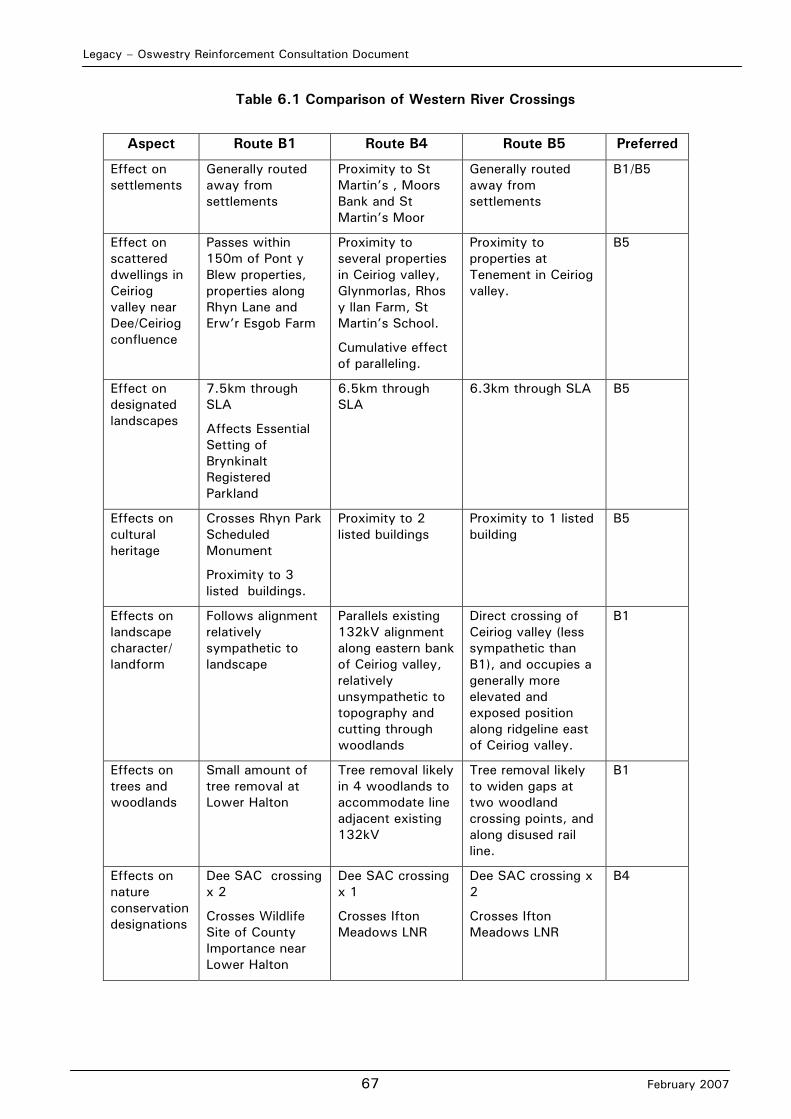
Legacy – Oswestry Reinforcement Consultation Document
67 February 2007
Table 6.1 Comparison of Western River Crossings
Aspect Route B1 Route B4 Route B5 Preferred
Effect on settlements
Generally routed away from settlements
Proximity to St Martin’s , Moors Bank and St Martin’s Moor
Generally routed away from settlements
B1/B5
Effect on scattered dwellings in Ceiriog valley near Dee/Ceiriog confluence
Passes within 150m of Pont y Blew properties, properties along Rhyn Lane and Erw’r Esgob Farm
Proximity to several properties in Ceiriog valley, Glynmorlas, Rhos y llan Farm, St Martin’s School.
Cumulative effect of paralleling.
Proximity to properties at Tenement in Ceiriog valley.
B5
Effect on designated landscapes
7.5km through SLA
Affects Essential Setting of Brynkinalt Registered Parkland
6.5km through SLA
6.3km through SLA B5
Effects on cultural heritage
Crosses Rhyn Park Scheduled Monument
Proximity to 3 listed buildings.
Proximity to 2 listed buildings
Proximity to 1 listed building
B5
Effects on landscape character/ landform
Follows alignment relatively sympathetic to landscape
Parallels existing 132kV alignment along eastern bank of Ceiriog valley, relatively unsympathetic to topography and cutting through woodlands
Direct crossing of Ceiriog valley (less sympathetic than B1), and occupies a generally more elevated and exposed position along ridgeline east of Ceiriog valley.
B1
Effects on trees and woodlands
Small amount of tree removal at Lower Halton
Tree removal likely in 4 woodlands to accommodate line adjacent existing 132kV
Tree removal likely to widen gaps at two woodland crossing points, and along disused rail line.
B1
Effects on nature conservation designations
Dee SAC crossing x 2
Crosses Wildlife Site of County Importance near Lower Halton
Dee SAC crossing x 1
Crosses Ifton Meadows LNR
Dee SAC crossing x 2
Crosses Ifton Meadows LNR
B4

Legacy – Oswestry Reinforcement Consultation Document
68 February 2007
Zone C (Oswestry) Route Options 6.68 Zone C is shown at Figure 6.5. It extends from the B5070/B5068, which runs in an
east-west direction from the A5 through St Martin’s, to the existing substation at Oswestry. It comprises gently undulating agricultural land to the north with fields defined by mature hedgerows and trees. To the centre of this zone the land becomes flatter, low lying and more open in the area around New Marton in the vicinity of the Shropshire Union Canal. To the south the landscape remains low lying and flat around Halston and Fernhill Halls, however the occurrence of plantation woodland increases which reduces its openness. The west of this zone comprises higher intensity mixed agriculture with the larger settlements of Weston Rhyn, Gobowen and Oswestry located along the A5. The Oswestry Orthopaedic Hospital and Oswestry Showground are located to the south of Gobowen with Henlle Hall Golf Course and a new marina development located to the north. To the east of this area, between Dudleston Heath Criftins and Welsh Frankton, the landscape pattern is similar to that around St Martin’s, comprising a small scale, undulating landscape with mature hedgerows and trees. There are large mineral consultation zones to the east.
6.69 The embanked Oswestry Hill Fort forms a landmark feature in the landscape. Wat’s
Dyke runs in a northerly direction from the hill fort through Gobowen and to the east of Henlle Hall. There are several sites of ecological importance scattered through this area, with Fernhill Pastures, in the vicinity of Fernhill Hall, designated as a SSSI for its traditionally managed fen meadows.
6.70 The key constraints within Zone C are considered to be:
• Several areas of historic parkland although none of these are Registered Parklands
• Areas of plantation woodland to south of the zone • Fernhill Meadows SSSI • Oswestry Hill Fort Scheduled Monument and its setting • Wat’s Dyke (discontinuous line of Scheduled Monuments) • Shropshire Union Canal and associated lower lying open landscape • Scattered farms and small settlements • Larger settlements of Weston Rhyn, Gobowen and Oswestry • Whittington village, Conservation Area and castle • The Robert Jones and Agnes Hunt Orthopaedic Hospital and Oswestry
Showground occupy significant area of land to the north east of the substation
Route C1 6.71 Route C1 runs in a southerly direction from the B5070 with two potential options to
avoid a listed building at Erw’r Esgob. These options cross the dismantled railway at separate points before converging prior to crossing the Shropshire Union Canal to the north of Henlle Hall. This route then runs alongside Wat’s Dyke for approximately 0.5km. Wat’s Dyke forms the eastern boundary to the grounds Henlle Hall, which are now a golf course.
6.72 Route C1 runs in a south-east direction to the east of the settlements of Rhewl and
Gobowen through agricultural land. Two sub-options, C1(A) and C1(B), take alternative routes either to the east or to the west of Hillyards Plantation before converging to the north of Fernhill Hall. Option C1(A) is the most direct route, and would follow an alignment currently taken by a low voltage (33kV) line, adjacent

Legacy – Oswestry Reinforcement Consultation Document
69 February 2007
Hillyards Plantation. Route C1(B) runs approximately 1km to the east beyond the plantation. From the convergence point of the sub-options, route C1 runs in a westerly direction, crossing the railway and running through an area of agricultural land between the Orthopaedic Hospital to the north and Park Hall Farm and Oswestry Showground to the south. On crossing the A5 this route runs parallel to the A5 in a southerly direction towards the substation. Due to the presence of numerous other distribution lines occupying the narrow corridor of land between Old Oswestry Fort and the A5, including the existing 132kV overhead line, the proposed route would be laid as underground cable from a point just east of the A5 crossing to its entry to Oswestry substation (approximately 1.4km).
Key Environmental Factors
6.73 The following key environmental factors have been identified related to route C1: • Tree removal along dismantled railway – less tree removal anticipated on
western most crossing point • Close proximity to Henlle Hall • Crosses and parallels Wat’s Dyke Scheduled Monument • Option C1(A) runs in close proximity to Hillyards Plantation – possible tree
removal required • Option C1(B) runs in close proximity to Great Fernhill listed building • Option C1(B) immediately adjacent Fernhill Pastures SSSI • Visual effect on setting of Oswestry Hill Fort minimised by undergrounding
route in this vicinity • Potential effects on archaeology during cable installation
Route C2
6.74 Route C2 utilises the break in development between Moors Bank and St Martin’s
and runs in a south-easterly direction from the B5069 to cross the Shropshire Union Canal to the east of St Martin’s Moor. From here the route runs in a southerly direction through agricultural land avoiding running in close proximity to several farms which are located in the area. This route merges with route C1(B) to the north east of Hillyards plantation from where it follows a south easterly line to the north of Fernhill Hall and follows route C1 described above.
Key Environmental Factors
6.75 The following key environmental factors have been identified related to route C2: • Effect on visual amenity of residential properties on fringes of St Martin’s and
Moors Bank • Runs in close proximity to Great Fernhill listed building • Visual effect on setting of Oswestry Hill Fort minimised by undergrounding
route in this vicinity • Immediately adjacent Fernhill Pastures SSSI • Potential effects on archaeology during cable laying
Route C3
6.76 Route C3 runs from the B5068 to the east of St Martin’s in a south-westerly
direction through the Upper Wiggington area and crosses the Shropshire Union Canal to the north of New Marton locks. From here the route runs south through lower lying land passing to the west of the settlement of Henlle and to the east of Fernhill Hall. This route then runs in a south westerly direction through undulating farmland to the north and west of Whittington. The route crosses the A495 west
Legacy – Oswestry Reinforcement Consultation Document
70 February 2007
of Whittington and skirts to the south of Drenewydd Farm, before taking a route 200m south of and approximately parallel with the A495, crossing the A5 and entering the substation at Oswestry from the east.
Key Environmental Factors
6.77 The following key environmental factors have been identified related to route C3: • Proximity to properties on eastern fringe of St Martin’s • Immediately adjacent Fernhill Pastures SSSI • Close proximity to properties on northern and western fringes of Whittington
village • Proximity to Whittington Conservation Area • Close proximity to Drenewydd (Listed Building)
Route C4
6.78 Route C4 commences at the same point on the B5068 as Route C3, described
above, to a point approximately 1km to the south-west of Upper Wiggington. From here the two routes diverge, with Route C4 taking a more easterly route through the lower lying land associated with the Shropshire Union Canal. Route C4 crosses the canal approximately 0.75km to the south of New Marton Locks and runs between the settlements of Henlle and Hindford. From here the route runs in a southerly direction through undulating agricultural land to the east of Whittington and to the west of Halston Hall. This route runs around the south of Whittington and heads in a westerly direction towards the substation at Oswestry, passing to the south of the sewage works located to the south of the A495. It then turns northwards to join Route C3, approaching Oswestry from the east.
Key Environmental Factors
6.79 The following key environmental factors have been identified related to route C4:
• Proximity to properties on eastern fringe of St Martin’s • Approximately 2km through flat open lower lying land with little vegetation • Close proximity to Halston Hall parkland estate • Close proximity to southern edge of Whittington – including edge of the
Conservation Area
Comparison of Zone C (Oswestry) Options 6.80 Four possible route options have been identified through Zone C, the approach to
Oswestry substation. Routes C1 and C2 are located to the west of St Martin’s, and would link to Routes B1, B4 or B5 (not all cross-links are shown). Routes C3 and C4 follow a common alignment just east of St Martin’s, and link to either Route B2 or B3.
6.81 For Zone C, a comparison between Routes C1 and C2 was undertaken to determine
the favoured option to join with the preferred western river crossing. A comparison between Routes C3 and C4 was similarly undertaken, with the favoured option linking with the preferred eastern river crossing option.
Legacy – Oswestry Reinforcement Consultation Document
71 February 2007
Sub-options 6.82 As with sub-options for routes in Zone B, sub-options for routes in Zone C have
been compared, with only the favoured sub-option reported here. Details of the comparison of sub-options for Zone C are included in Appendix 6.E.
Comparison of Western Options through Zone C: C1(A) and C2 6.83 There are relatively few environmental constraints affecting routeing in the
predominantly rural area between the western edge of St Martin’s and Oswestry sub-station. In order to avoid the settlement of Gobowen and large hospital and college grounds to the south of this, both routes C1(A) and C2 take a generally southerly alignment across the shallow valley of the River Perry. The routes join at Great Fernhill, following a common alignment westwards and then southwards to the substation.
6.84 Route C1(A), the most westerly route, generally avoids proximity to settlement,
whereas Route C2 exploits a gap in buildings between St Martin’s and Moors Bank/St Martin’s Moor, and is likely to have an effect upon visual amenity of a greater number of properties.
6.85 Route C1(A) crosses and parallels the Scheduled Monument of Wat’s Dyke in the
vicinity of the Shropshire Union Canal, whereas Route C2 has no effects upon cultural heritage (other than those common to both routes where they combine to approach Oswestry substation).
6.86 Other differences between the routes include a greater potential impact upon nature
conservation designations with Route C2, which is adjacent to the SSSI of Fernhill Pastures, and a greater likelihood of tree removal with Route C1(A) in the vicinity of Hillyards Plantation and in crossing a dismantled railway line.
6.87 On balance, Route C1(A) is preferred as the avoidance of proximity to settlements,
and avoidance of a nature conservation designation of national importance (SSSI) is considered a greater benefit than avoidance of crossing Wat’s Dyke Scheduled Monument. Direct effects on this linear feature can be avoided by careful siting of line supports.
6.88 Option C1(A) is carried forward as the preferred western approach to Oswestry
substation. Comparison of Eastern Options through Zone C: C3 and C4 Comparison of Northern Parts of Routes C3 and C4 between St Martin’s and Fernhill: C3 (north) and C4 (north)
6.89 Between St Martin’s and Fernhill, where the northern parts of routes C3 and C4
converge, there are relatively few environmental constraints affecting routeing. Both routes cross the Shropshire Union Canal, the main feature in this low-lying and relatively open landscape. Option C4 has a marginally greater effect on the canal, as it crosses at a more oblique angle than C3, and so is closer for a greater distance.
Legacy – Oswestry Reinforcement Consultation Document
72 February 2007
6.90 Option C3 maintains a greater distance from the small settlements of Hindford and Henlle, although it is closer to several isolated farmsteads to the west of the canal. The village of Hindford has numerous mature trees, providing enclosure and screening views out, whereas Henlle and the several farmsteads to the west of the canal generally have elevated positions and open aspects. Option C3 north is likely to have a greater overall impact upon visual amenity from residential properties.
6.91 South of Henlle, option C3 follows an alignment in close proximity to Fernhill
Pastures SSSI, and runs alongside woodland adjacent to the designated site. Option C4 does not affect the SSSI.
6.92 On balance, between St Martin’s and Fernhill, Option C4 (north) is preferred over
Option C3 (north), primarily for reasons of lower effects on visual amenity of residential properties.
Comparison of Southern Parts of Route C3 and C4 Between Fernhill and Oswestry: C3 (south) and C4 (south)
6.93 Between Fernhill and Oswestry substation the key consideration is the effect upon
Whittington village. Option C3 follows a route to the north and west of the settlement, whereas Option C4 skirts to the east and then south of the village.
6.94 Option C3 is separated from the northern edge of Whittington by a narrow strip of
woodland associated with a disused railway line, but is in close proximity to several properties on the western fringe of the village, including Drenewydd listed building. Option C4 generally maintains a greater distance from the edge of settlement.
6.95 To the south and east of Whittington the landscape is less rolling and comprises
larger fields with less tree cover in comparison with the landscape to the north of the village, making assimilation of an overhead line more difficult than in the more enclosed landscape typically characterising the study area.
6.96 Option C3 utilises the route of a 33kV overhead line from north of Whittington to
Oswestry substation, for a distance of approximately 2.5km. Much of this length is within the larger scale, more open landscape south of the A495 Whittington Road. In accordance with the routeing criteria, the lower voltage line is not taken into consideration at this stage. This is of relevance with regard to the visual amenity of several south-facing properties at Park Green, on the A495 and also of the listed building at Drenewydd.
6.97 Options C3 and C4 between Fernhill and Oswestry are finely balanced, with a slight
preference for C4. 6.98 In the comparison of routes C3 with C4, a hybrid route option between St Martin’s
and Oswestry substation is directly comparable with C4. This comprises Option C3 from the zone boundary south to Henlle, with a short cross link to Option C1(B) north of Fernhill Pastures SSSI, and Option C1(B) from this point to Oswestry substation. This hybrid route would avoid the village of Whittington, a key consideration in this zone, and generally avoid proximity to property. In addition, this route would be shorter than option C4, and the approach to Oswestry substation would be via underground cable, minimising visual intrusion. The benefits of avoiding proximity to Whittington are considered greater than the disbenefits of route option C3, which relate to effects upon visual amenity from scattered residential properties in the vicinity of New Marton and Henlle.

Legacy – Oswestry Reinforcement Consultation Document
73 February 2007
6.99 In the overall comparison of Options C3 and C4, the hybrid of C3 with C1(B) is
preferred. This forms the preferred eastern approach to Oswestry substation.
Comparison of Western and Eastern Routeing Strategies
6.100 Comparison on a zone by zone basis has resulted in two coherent routeing strategies (or overall routes from Legacy to Oswestry), a western route, A1-B5-C1(A), and an eastern route, A1-B2-C3+C1(B). A summary of the comparison of these strategies is presented in Table 6.2 below.
Table 6.2: Comparison of Western and Eastern Routeing Strategies
Aspect Route A1/ B5/C1(A)
Western Option Route A1/ B2/C3+C1(B)
Eastern Option Preferred Strategy
Effects on settlement
Generally routed away from settlements
Effects on eastern edge of St Martin’s
Western
Effects on designated landscapes
6.5km through SLA;
4.5km through SLA; 0.3km through essential setting of Erbistock Registered Parkland
Western
Effects on cultural heritage
Crosses Wat’s Dyke x1 and parallels Scheduled Monument Area for 0.5km Cable route crosses Offa’s Dyke Proximity to Bryn House and Great Fernhill listed buildings
Within 0.5km of Erbistock Conservation Area Crosses Wat’s Dyke x1 Cable route crosses Offa’s Dyke Proximity to 3 listed buildings at Sodylt Hall and Great Fernhill listed building
Western
Effects on landscape character/landform
Generally routed through undulating terrain with plentiful mature tree cover. Impact upon Ceiriog valley.
Relatively open, low-lying landscape west of New Marton - route less easily assimilated within these landscapes. Central section (river crossing) routed within estate-influenced Maelor landscape – unspoilt parkland of high scenic quality.
Western
Effects on trees and woodlands
May require tree removal crossing River Ceiriog, Bramble Wood (x 2), adjacent disused railway line and Hillyards Plantation
No tree removal identified Eastern
Effects on nature conservation designations
Crosses River Dee SAC x 2 (Dee and Ceiriog) Crosses LNR at Ifton Meadows
Crosses River Dee SAC x 1 (Dee) Immediately adjacent Fernhill Pastures SSSI
Eastern
Effects on recreation/tourism
No direct effects on interests Affects well –used footpath adjacent river Dee from Boat Inn PH; angling interests
Western
Route length 19.6km wood pole 3.0km cable
20.0km wood pole 3.0km cable
Western

Legacy – Oswestry Reinforcement Consultation Document
74 February 2007
6.101 The western strategy is the preferred option. It follows a route generally sympathetic to local topography and woodlands, through an undulating landscape in which a wood pole line will be easily assimilated. The eastern route would pass through more open, flatter landscapes such as the area between New Marton and Henlle, and the estate-influenced parkland landscape in the vicinity of Erbistock, Manley Hall and Sodylt Hall. Both of these landscape types are considered less able to effectively assimilate a power line of the type proposed.
6.102 Avoiding potential effects upon settlements is one of the most important aspects of
comparing the options. The western route avoids all settlements, whilst the eastern route may have effects upon the eastern edges of St Martin’s village (although there may be potential to confirm a route at a greater distance from this settlement than the indicative alignment). Although the comparison is finely balanced, the western option will have marginally less impact upon visual amenity.
6.103 Other disadvantages of the eastern option relate to cultural heritage and
tourism/recreational interests in the vicinity of Erbistock in particular. The essential setting of a registered parkland is considered a national designation (although non-statutory) and therefore is accorded greater weight than the local landscape designation (which is affected to a greater extent by the western option). However, it may be possible to deviate the route to avoid the essential setting of Erbistock Registered Parkland, and also to minimise any effects on angling interests in the vicinity of Erbistock. Future connections
6.104 The western option is considered the preferred alternative for reinforcement of the
Legacy to Oswestry 132kV power distribution line, when there is no requirement to provide a connection to Chirk. The case for proposing a western route is strengthened if a future connection to Chirk is required, as this is likely to involve a substantially shorter length of power line (and hence environmental disbenefits) than a connection to a more easterly route. Conclusion
6.105 The assessment of alternative options indicates a preference for a route comprising
a combination of A1 with the western river crossing B1(C) – B5 - C1(A) . This combination is based on a balanced decision considering all environmental aspects required to create an entire connection from Legacy to Oswestry. It is considered that this combination offers the ‘preferred route’ to be taken forward within the consultation process.
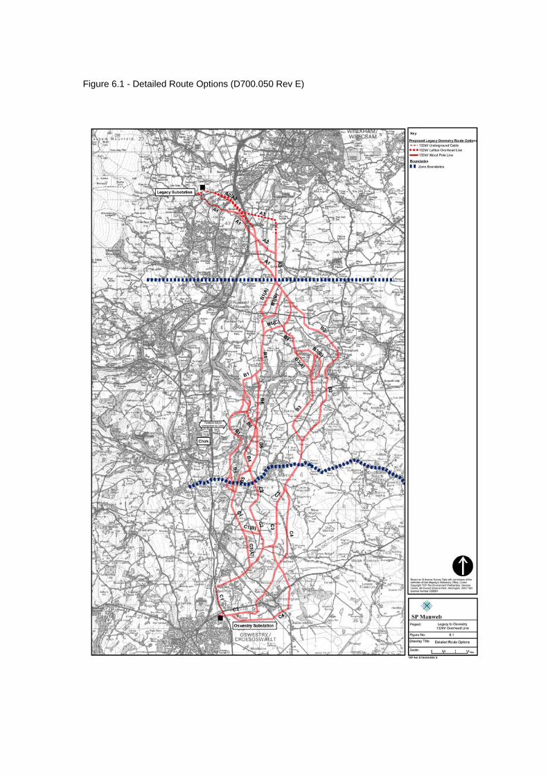
Figure 6.1 - Detailed Route Options (D700.050 Rev E)

Figure 6.2 - Detailed Route Options with Environmental Constraints (D700.044 Rev G)
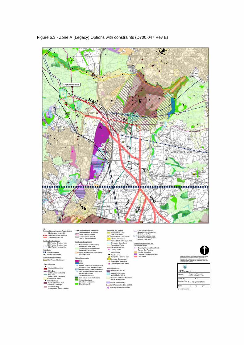
Figure 6.3 - Zone A (Legacy) Options with constraints (D700.047 Rev E)
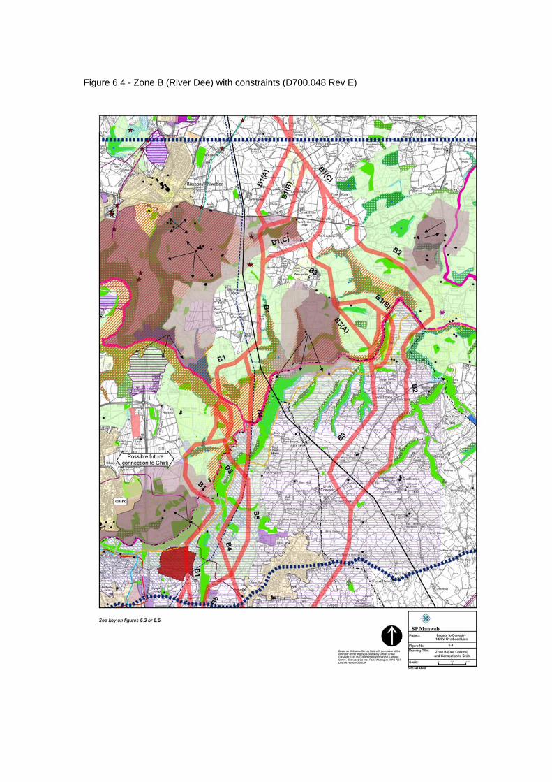
Figure 6.4 - Zone B (River Dee) with constraints (D700.048 Rev E)

Figure 6.5 - Zone C (Oswestry) Options with constraints (D700.049 Rev E)
Legacy – Oswestry Reinforcement Consultation Document
75 February 2007
7.0 THE PREFERRED ROUTE
7.1 A two stage approach was followed in the routeing study. The first stage took a strategic approach and identified the broad corridor which had the least high-level constraints to routeing. This was followed by consideration of detailed route options within the broad corridor, with potential routes identified, compared and analysed.
7.2 During the definition of the preferred route in Chapter 6: Detailed Route Options, areas were identified where further work may be required early in the Environmental Impact Assessment process to refine the route. Overall the preferred route avoids settlements, areas of high amenity, cultural or nature conservation value, whilst maximising the potential of the existing landform and vegetation for screening purposes.
7.3 The line of the preferred route, A1-B1(C)-B5-C1(A), is described below and shown on Figure 7.1. Route From Legacy (Zone A)
7.4 The preferred route leaves the substation as an underground cable, taking a south
easterly route along the existing road system to Pentre Bychan via the B5097 Bronwylfa Road and B5426, Smithy Lane, up to its junction with the B5605, Wrexham Road. East of Wrexham Road it emerges onto a wood pole support and continues in a south-easterly direction across open farmland, to skirt around the northern boundary of Hafod Tip to Hafod Road. The route corridor here occupies a narrow strip of land between Hafod Tip and the A483(T).
7.5 Crossing Hafod Road and the A483(T) in the vicinity of the bridge taking Hafod Road over the trunk road, the route continues in a south-easterly direction to a point west of the fishing lakes at Sontley. From here it would follow a more southerly route for approximately 1km before again heading in a south easterly direction through agricultural land, crossing Wat’s Dyke, and then heading in a south-easterly direction between Moreton Below and Gyfelia. There are several farms and isolated properties within this area, and the route has been aligned to avoid close proximity to these properties.
7.6 Particular issues identified to be considered in detailed routeing: • Potential effect on several known archaeological sites in the vicinity of the
substation during cable installation • Proximity to SAC and community park at Hafod Tip • Potential tree loss where route is constrained between Hafod Tip and
A483(T) River Dee Crossing (Zone B)
7.7 From the boundary with Zone A, the route takes a south-easterly and then south-
westerly direction in the vicinity of Park Eyton, in order to skirt around the edge of the land considered to be within the Essential Setting of Wynnstay Park. It then takes a southerly direction through agricultural land following a clough woodland associated with a River Dee tributary. To the south east of Park Farm, the route changes direction to follow a south-westerly route beneath the existing 132kV and 400kV overhead lines and then turns south to a river crossing point in the vicinity of
Legacy – Oswestry Reinforcement Consultation Document
76 February 2007
Coedleoedd Wood. This river crossing point utilises an existing break in the valley woodland and the proposed line is able to follow the natural topography.
7.8 From the River Dee crossing the route runs south through an attractive valley area
associated with the River Ceiriog. The route through this area follows the natural contours of the valley along the valley floor to Tenement. It crosses the River Ceiriog just east of the hamlet, following a south-easterly alignment across the valley and exploiting a small break in woodland on the eastern valley side. Some tree removal may be necessary to widen this gap.
7.9 The route crosses beneath the existing 132kV power line south of Lower House
Farm, and continues in a southerly direction for approximately a kilometre, crossing farmland and Ifton Meadows Local Nature Reserve. The route utilizes the corridor of an existing 33kV power line, both in crossing a narrow belt of woodland and crossing the local nature reserve. South of Ifton Meadows the route follows a southwesterly alignment through gently undulating farmland. It then follows a southerly route (along the line of a former railway) between Rhos-y-llan Wood and Bank Top Industrial Estate situated immediately north of the B5070.
7.10 Particular issues identified to be considered in detailed routeing:
• Crossing of Ifton Meadows Local Nature Reserve • Crossing of the River Ceiriog may require localised tree removal
Approach to Oswestry Substation (Zone C)
7.11 The preferred route runs in a southerly direction from the B5070 to cross the
Shropshire Union Canal near Preeshenlle Bridge, north of Henlle Hall, where it joins with Route C1. It follows an alignment alongside Wat’s Dyke for approximately 0.5km, where the dyke forms the eastern boundary to a golf course, developed in the grounds of Henlle Hall.
7.12 The route runs in a south-westerly direction to the east of the settlements of Rhewl and Gobowen through agricultural land. It then follows a route through the shallow valley of the River Perry to the west of Hillyards Plantation, and west of the listed building of Great Fernhill. From near Great Fernhill, the route runs in a westerly direction, crossing the main line railway and running through an area of agricultural land between Oswestry Orthopaedic Hospital to the north and Park Hall Farm and Oswestry showground to the south.
7.13 On crossing the A5 the route then runs parallel to this road in a southerly direction towards Oswestry substation. Due to the presence of numerous other distribution lines occupying the narrow corridor of land between Old Oswestry Fort and the A5, including an existing 132kv overhead line, the proposed route would be laid as underground cable from a point just east of the A5 crossing to its entry to Oswestry substation (approximately 1.4km).
7.14 Particular issues identified to be considered in detailed routeing: • Running parallel with Wat’s Dyke Scheduled Monument • Close proximity to Hillyards Plantation, possibly requiring tree removal.
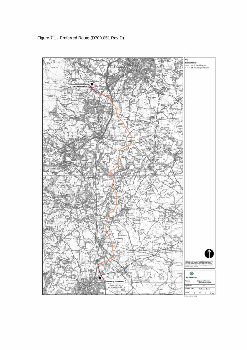
Figure 7.1 - Preferred Route (D700.051 Rev D)
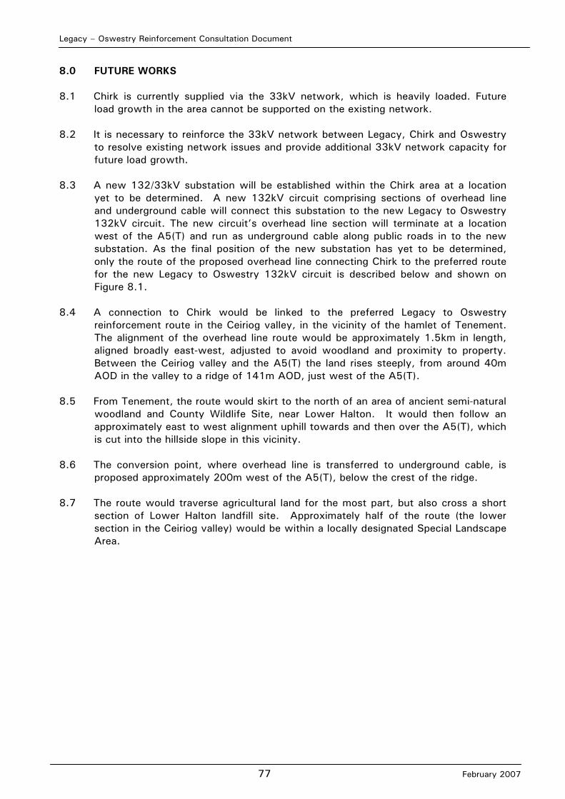
Legacy – Oswestry Reinforcement Consultation Document
77 February 2007
8.0 FUTURE WORKS 8.1 Chirk is currently supplied via the 33kV network, which is heavily loaded. Future
load growth in the area cannot be supported on the existing network. 8.2 It is necessary to reinforce the 33kV network between Legacy, Chirk and Oswestry
to resolve existing network issues and provide additional 33kV network capacity for future load growth.
8.3 A new 132/33kV substation will be established within the Chirk area at a location
yet to be determined. A new 132kV circuit comprising sections of overhead line and underground cable will connect this substation to the new Legacy to Oswestry 132kV circuit. The new circuit’s overhead line section will terminate at a location west of the A5(T) and run as underground cable along public roads in to the new substation. As the final position of the new substation has yet to be determined, only the route of the proposed overhead line connecting Chirk to the preferred route for the new Legacy to Oswestry 132kV circuit is described below and shown on Figure 8.1.
8.4 A connection to Chirk would be linked to the preferred Legacy to Oswestry
reinforcement route in the Ceiriog valley, in the vicinity of the hamlet of Tenement. The alignment of the overhead line route would be approximately 1.5km in length, aligned broadly east-west, adjusted to avoid woodland and proximity to property. Between the Ceiriog valley and the A5(T) the land rises steeply, from around 40m AOD in the valley to a ridge of 141m AOD, just west of the A5(T).
8.5 From Tenement, the route would skirt to the north of an area of ancient semi-natural
woodland and County Wildlife Site, near Lower Halton. It would then follow an approximately east to west alignment uphill towards and then over the A5(T), which is cut into the hillside slope in this vicinity.
8.6 The conversion point, where overhead line is transferred to underground cable, is
proposed approximately 200m west of the A5(T), below the crest of the ridge. 8.7 The route would traverse agricultural land for the most part, but also cross a short
section of Lower Halton landfill site. Approximately half of the route (the lower section in the Ceiriog valley) would be within a locally designated Special Landscape Area.
Figure 8.1 - Future Connection to Chirk (D700.063 bw Rev B)

Legacy – Oswestry Reinforcement Consultation Document
78 February 2007
9.0 THE NEXT STEPS Consultation
9.1 SP Manweb has considered the options for the required reinforcement between
Legacy and Oswestry carefully, including the detailed assessment of route options presented in this document. It has consulted with local authorities and statutory consultees on relevant information during the assessment of options.
9.2 The consultation process based on this document seeks to confirm a route which SP
Manweb will take forward to an application for consent under Section 37 of the Electricity Act 1989. SP Manweb wishes to receive views on the assessment and on the route it has identified as its preferred route for the connection.
9.3 SP Manweb welcomes comments, views or representations on this document which
should be sent to:
Legacy Oswestry Consultation SP Manweb 3 Prenton Way Prenton CH43 3ET e-mail address: [email protected]
Confirmation of the Proposed Route
9.4 At the conclusion of the consultation process a proposed route will be selected after
consideration of all the comments and responses made during the consultation process on the preferred route. As stated earlier, it is anticipated that this proposed route will be based on the preferred route described in Chapter 7, although SP Manweb will carefully consider all responses received from the consultation process before proceeding. It is likely that further specific consultation with local planning authorities and statutory agencies such as Environment Agency, Natural England, Countryside Council for Wales and others will take place before the proposed route is confirmed. Environmental Impact Assessment
9.5 SP Manweb will voluntarily submit an Environmental Statement, under the Electricity
Works (Environmental Impact Assessment) (England and Wales) Regulations 2000 to accompany the application for consent to construct the overhead line.
9.6 Once the proposed route is confirmed, SP Manweb will submit a Scoping Report to
the Secretary of State for the Department of Trade and Industry. The Scoping Report will contain the issues that SP Manweb considers should be included in the Environmental Impact Assessment and how these issues should be addressed. The Scoping Report will be based on the issues identified in this assessment and on responses received during consultations. SP Manweb will submit a written request under the Electricity Works (Environmental Impact Assessment)(England and Wales) Regulations 2000 for the Secretary of State’s opinion as to the information to be provided in the Environmental Statement.
Legacy – Oswestry Reinforcement Consultation Document
79 February 2007
9.7 The Environmental Statement will report on the anticipated environmental effects of the proposed connection, addressing the issues that the Secretary of State identifies as important and incorporating appropriate detailed assessments. The Environmental Statement will identify any appropriate mitigation measures to avoid, reduce or compensate for adverse effects.
Application for Consent
9.8 An application will be made to the Secretary of State for Trade and Industry for
consent under Section 37 of the Electricity Act 1989 to construct and keep installed the proposed overhead distribution line. The Environmental Statement will accompany the consent application.
9.9 Advertisements will be placed in newspapers to give notice of the application, the
opportunity for representations to be made within a given period and the address to which these representations should be submitted. SP Manweb will place copies of the application and Environmental Statement on deposit in public locations (usually local libraries) and will notify statutory consultees and others of the application and the process for making representations to the Secretary of State.
9.10 Local planning authorities for the areas where the connection is proposed will be
notified of the proposal as part of the statutory process. The Secretary of State must take their representations into account when determining the application.
Construction of the New Connection
9.11 The overhead line component of the proposed connection can only be constructed
and operated with the consent of the Secretary of State for Trade and Industry. If consent is granted, this is generally with conditions which seek to ensure that measures are taken to mitigate potential adverse effects. The conditions are usually based on those identified in the Environmental Statement, identified by local planning authorities and in representations made to the Secretary of State.
9.12 If consent is granted for the proposed connection, a programme of construction
would be prepared to build the overhead line in accordance with conditions attached to the consent.

Legacy – Oswestry Reinforcement Consultation Document
February 2007
APPENDIX 1A: LIST OF ORGANISATIONS CONSULTED
Legacy – Oswestry Reinforcement Consultation Document
February 2007
Local Authorities Denbighshire County Council North Shropshire District Council Oswestry Borough Council Shropshire County Council Wrexham County Borough Council Nature Conservation/Forestry/Heritage/Agriculture/Landscape/Tourism & Leisure British Waterways (Chester) British Waterways (Shropshire) Cadw Campaign for Protection of Rural Wales (Montgomery) Campaign for Protection of Rural Wales (Wrexham) Clwyd Powys Archaeological Trust Council for the Protection of Rural England Countryside Agency (West Midlands Branch) Countryside Council for Wales Country Land and Business DEFRA DEFRA North Mercia English Heritage Environment Agency (Northern Wales Region) Environment Agency (Upper Severn Region) Forestry Commission – North Wales Office Forestry Commission – West Midlands Heart of England Tourist Board National Farmers Union Cymru National Farmers Union West Midlands National Federation of Anglers National Monuments Record Wales (Royal Commission on the Ancient and Historical Monuments of Wales) National Trust (Regional Office West Midlands) National Trust (Office for Wales) Natural England (formerly English Nature) North Wales Tourism North Wales Wildlife Trust (Loggerheads CP) Ramblers’ Association London Ramblers’ Association Wales RSPB Central England Office RSPB North Wales Office RSPB UK Headquarters Shropshire Wildlife Trust SUSTRANS The Woodland Trust Wales Utilities British Telecom Dee Valley Water Hyder Operations Mercury Communications Ltd Midland Electricity Board National Grid Company Ltd National Grid Transco (Howick Cross Lane)
Legacy – Oswestry Reinforcement Consultation Document
February 2007
NTL PGS Atlantic Power Severn Trent Water Other Civil Aviation Authority Coal Authority Department of Trade & Industry The Chief Fire Officer – North Wales The Chief Fire Officer – Shropshire Health and Safety Executive (Wales and South West Division) Health and Safety Executive (Midlands Division) Highways Agency Ministry of Defence Network Rail
Legacy – Oswestry Reinforcement Consultation Document
February 2007
APPENDIX 1B: GLOSSARY
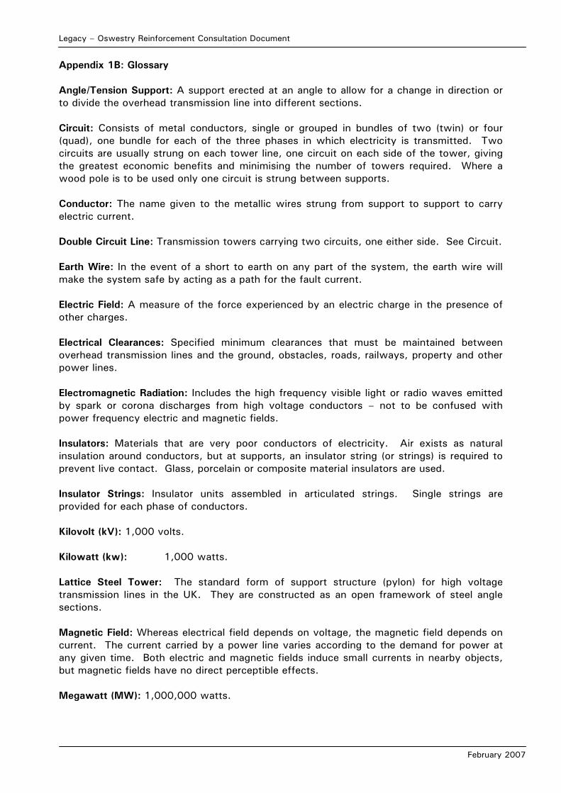
Legacy – Oswestry Reinforcement Consultation Document
February 2007
Appendix 1B: Glossary Angle/Tension Support: A support erected at an angle to allow for a change in direction or to divide the overhead transmission line into different sections. Circuit: Consists of metal conductors, single or grouped in bundles of two (twin) or four (quad), one bundle for each of the three phases in which electricity is transmitted. Two circuits are usually strung on each tower line, one circuit on each side of the tower, giving the greatest economic benefits and minimising the number of towers required. Where a wood pole is to be used only one circuit is strung between supports. Conductor: The name given to the metallic wires strung from support to support to carry electric current. Double Circuit Line: Transmission towers carrying two circuits, one either side. See Circuit. Earth Wire: In the event of a short to earth on any part of the system, the earth wire will make the system safe by acting as a path for the fault current. Electric Field: A measure of the force experienced by an electric charge in the presence of other charges. Electrical Clearances: Specified minimum clearances that must be maintained between overhead transmission lines and the ground, obstacles, roads, railways, property and other power lines. Electromagnetic Radiation: Includes the high frequency visible light or radio waves emitted by spark or corona discharges from high voltage conductors – not to be confused with power frequency electric and magnetic fields. Insulators: Materials that are very poor conductors of electricity. Air exists as natural insulation around conductors, but at supports, an insulator string (or strings) is required to prevent live contact. Glass, porcelain or composite material insulators are used. Insulator Strings: Insulator units assembled in articulated strings. Single strings are provided for each phase of conductors. Kilovolt (kV): 1,000 volts. Kilowatt (kw): 1,000 watts. Lattice Steel Tower: The standard form of support structure (pylon) for high voltage transmission lines in the UK. They are constructed as an open framework of steel angle sections. Magnetic Field: Whereas electrical field depends on voltage, the magnetic field depends on current. The current carried by a power line varies according to the demand for power at any given time. Both electric and magnetic fields induce small currents in nearby objects, but magnetic fields have no direct perceptible effects. Megawatt (MW): 1,000,000 watts.

Legacy – Oswestry Reinforcement Consultation Document
February 2007
Refurbishment: The replacement of old conductors, insulators, earth wires, etc, as used in overhead line construction. Substation: Controls the flow of power by means of transformers and switchgear, with facilities for control, fault protection and communications. Transformer: An apparatus which transforms currents from one voltage to another. Watt: The unit of electric power. Wood Pole: An alternative to the lattice steel tower support where only a single circuit is required.

Legacy – Oswestry Reinforcement Consultation Document
February 2007
APPENDIX 1C: REFERENCES AND SOURCES OF INFORMATION
Legacy – Oswestry Reinforcement Consultation Document
February 2007
Appendix 1C: References and Sources of Information References Countryside Commission (1998) Countryside Character Volume 2: North West Electricity Act (1989) Electricity Works (Environmental Impact Assessment)(England and Wales) Regulations 2000 Forestry Commission (1989) Forest Landscape Design Guidelines, Forestry Commission, Edinburgh Holford, Sir W (1959) Preserving Amenities (paper given to the Royal Society of the Arts, 25.11.59) Marshall, R and Baxter, R. (2002) Strategic Routeing and Environmental Impact Assessment for Overhead Electrical Transmission Lines, Journal of Environmental Planning and Management National Grid Company (1992) Guidelines for the routing of new high voltage overhead transmission lines National Grid Company (1997) Planning and Amenity Aspects of High Voltage Transmission Lines and Substations Ordnance Survey Landranger (1:50,000) and Explorer (1:25,000) Map Series SHETL (2004) Approach to the Routeing of High Voltage Steel Lattice Tower Transmission Lines in Scotland. Shropshire County Council, 2003, Draft landscape character areas and descriptions Wrexham County Borough Council, Wrexham LANDMAP (Final Draft June 2004) Planning Guidance - issued as PPGs or PPSs by the Office of the Deputy Prime Minister (for England) and as TANs by the National Assembly for Wales PPG2: Green Belts PPG13: Transport PPG15: Planning and the Historic Environment PPG16: Archaeology and Planning PPG25: Development and Flood Risk PPS7: Sustainable Development in Rural Areas PPS9: Biodiversity and Geological Conservation RPG11:West Midlands Spatial Strategy, 2004 TAN5: Nature Conservation and Planning, 1996 TAN6: Agricultural and Rural Development, June 2000 TAN15: Development and Flood Risk, 2004 TAN18: Transport, 1998
Legacy – Oswestry Reinforcement Consultation Document
February 2007
Development Plans Denbighshire County Council, Denbighshire Unitary Development Plan 1996-2011 (adopted 2002) North Shropshire District Council, North Shropshire Local Plan 2000-2011 (Revised deposit draft 2003) Oswestry Borough Council, Oswestry Borough Local Plan 1996-2006 (adopted 1999) Shropshire County Council and Telford & Wrekin Council, Shropshire and Telford & Wrekin Joint Structure Plan 1996-2011 (adopted 2002) Shropshire County Council and Telford & Wrekin Council, Shropshire, Telford & Wrekin Minerals Local Plan 1996-2006 Shropshire County Council, Shropshire Waste Local Plan 2002-2014 Wrexham County Borough Council, Wrexham Unitary Development Plan (adopted 2005) Other sources of information Cadw, (Landscapes of Special Historic Interest in Wales, Scheduled Monuments) Cadw/CCW/ICOMOS (Register of Landscape Parks and Gardens of Special Historic Interest in Wales) Clwyd & Powys Archaeological Trust (CPAT) (Sites of archaeological interest) Countryside Council for Wales, (Clwyd Inventory of Ancient Woodlands, SACs and SSSIs) DEFRA (Agricultural Land Classification for English part of study area) English Heritage (Register of Historic Parks and Gardens, Scheduled Monuments) English Nature, (Ancient Woodlands Inventory, SACs and SSSIs) Forestry Commission, Wales (Ancient Woodlands information) Joint Nature Conservation Committee, www.jncc.gov.uk (SACs and SSSIs) National Grid (existing 400kV overhead line information) National Trust Wales (National Trust Land) North Wales Borderlands website (tourist information) North Wales Wildlife Trust (local wildlife sites) Scottish Power (existing overhead line information and digital terrain model data)

Legacy – Oswestry Reinforcement Consultation Document
February 2007
Shropshire Wildlife Trust (local wildlife sites) Sustrans website (cycle routes) Transco (gas pipeline information) Welsh Assembly (ALC for Welsh part of study area)
Legacy – Oswestry Reinforcement Consultation Document
February 2007
APPENDIX 4A: TABULATED SUMMARY OF PLANNING POLICIES
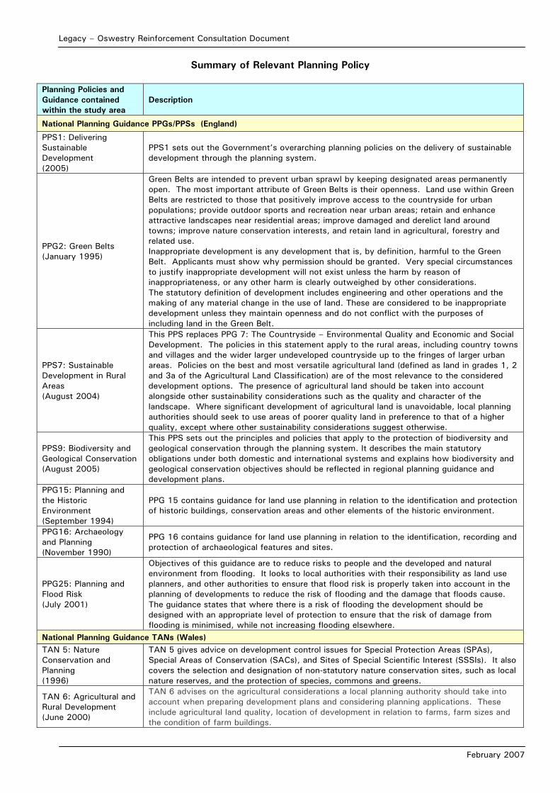
Legacy – Oswestry Reinforcement Consultation Document
February 2007
Summary of Relevant Planning Policy
Planning Policies and Guidance contained within the study area
Description
National Planning Guidance PPGs/PPSs (England)
PPS1: Delivering Sustainable Development (2005)
PPS1 sets out the Government’s overarching planning policies on the delivery of sustainable development through the planning system.
PPG2: Green Belts (January 1995)
Green Belts are intended to prevent urban sprawl by keeping designated areas permanently open. The most important attribute of Green Belts is their openness. Land use within Green Belts are restricted to those that positively improve access to the countryside for urban populations; provide outdoor sports and recreation near urban areas; retain and enhance attractive landscapes near residential areas; improve damaged and derelict land around towns; improve nature conservation interests, and retain land in agricultural, forestry and related use. Inappropriate development is any development that is, by definition, harmful to the Green Belt. Applicants must show why permission should be granted. Very special circumstances to justify inappropriate development will not exist unless the harm by reason of inappropriateness, or any other harm is clearly outweighed by other considerations. The statutory definition of development includes engineering and other operations and the making of any material change in the use of land. These are considered to be inappropriate development unless they maintain openness and do not conflict with the purposes of including land in the Green Belt.
PPS7: Sustainable Development in Rural Areas (August 2004)
This PPS replaces PPG 7: The Countryside – Environmental Quality and Economic and Social Development. The policies in this statement apply to the rural areas, including country towns and villages and the wider larger undeveloped countryside up to the fringes of larger urban areas. Policies on the best and most versatile agricultural land (defined as land in grades 1, 2 and 3a of the Agricultural Land Classification) are of the most relevance to the considered development options. The presence of agricultural land should be taken into account alongside other sustainability considerations such as the quality and character of the landscape. Where significant development of agricultural land is unavoidable, local planning authorities should seek to use areas of poorer quality land in preference to that of a higher quality, except where other sustainability considerations suggest otherwise.
PPS9: Biodiversity and Geological Conservation (August 2005)
This PPS sets out the principles and policies that apply to the protection of biodiversity and geological conservation through the planning system. It describes the main statutory obligations under both domestic and international systems and explains how biodiversity and geological conservation objectives should be reflected in regional planning guidance and development plans.
PPG15: Planning and the Historic Environment (September 1994)
PPG 15 contains guidance for land use planning in relation to the identification and protection of historic buildings, conservation areas and other elements of the historic environment.
PPG16: Archaeology and Planning (November 1990)
PPG 16 contains guidance for land use planning in relation to the identification, recording and protection of archaeological features and sites.
PPG25: Planning and Flood Risk (July 2001)
Objectives of this guidance are to reduce risks to people and the developed and natural environment from flooding. It looks to local authorities with their responsibility as land use planners, and other authorities to ensure that flood risk is properly taken into account in the planning of developments to reduce the risk of flooding and the damage that floods cause. The guidance states that where there is a risk of flooding the development should be designed with an appropriate level of protection to ensure that the risk of damage from flooding is minimised, while not increasing flooding elsewhere.
National Planning Guidance TANs (Wales) TAN 5: Nature Conservation and Planning (1996)
TAN 5 gives advice on development control issues for Special Protection Areas (SPAs), Special Areas of Conservation (SACs), and Sites of Special Scientific Interest (SSSIs). It also covers the selection and designation of non-statutory nature conservation sites, such as local nature reserves, and the protection of species, commons and greens.
TAN 6: Agricultural and Rural Development (June 2000)
TAN 6 advises on the agricultural considerations a local planning authority should take into account when preparing development plans and considering planning applications. These include agricultural land quality, location of development in relation to farms, farm sizes and the condition of farm buildings.
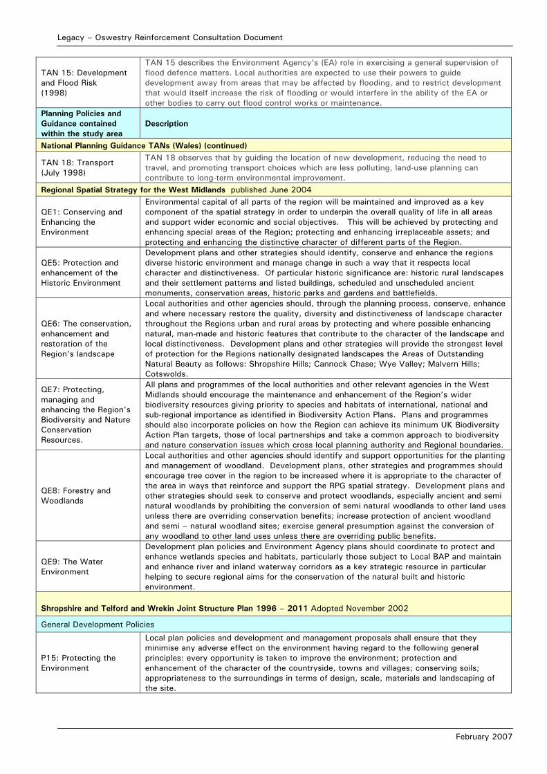
Legacy – Oswestry Reinforcement Consultation Document
February 2007
TAN 15: Development and Flood Risk (1998)
TAN 15 describes the Environment Agency’s (EA) role in exercising a general supervision of flood defence matters. Local authorities are expected to use their powers to guide development away from areas that may be affected by flooding, and to restrict development that would itself increase the risk of flooding or would interfere in the ability of the EA or other bodies to carry out flood control works or maintenance.
Planning Policies and Guidance contained within the study area
Description
National Planning Guidance TANs (Wales) (continued)
TAN 18: Transport (July 1998)
TAN 18 observes that by guiding the location of new development, reducing the need to travel, and promoting transport choices which are less polluting, land-use planning can contribute to long-term environmental improvement.
Regional Spatial Strategy for the West Midlands published June 2004
QE1: Conserving and Enhancing the Environment
Environmental capital of all parts of the region will be maintained and improved as a key component of the spatial strategy in order to underpin the overall quality of life in all areas and support wider economic and social objectives. This will be achieved by protecting and enhancing special areas of the Region; protecting and enhancing irreplaceable assets; and protecting and enhancing the distinctive character of different parts of the Region.
QE5: Protection and enhancement of the Historic Environment
Development plans and other strategies should identify, conserve and enhance the regions diverse historic environment and manage change in such a way that it respects local character and distinctiveness. Of particular historic significance are: historic rural landscapes and their settlement patterns and listed buildings, scheduled and unscheduled ancient monuments, conservation areas, historic parks and gardens and battlefields.
QE6: The conservation, enhancement and restoration of the Region’s landscape
Local authorities and other agencies should, through the planning process, conserve, enhance and where necessary restore the quality, diversity and distinctiveness of landscape character throughout the Regions urban and rural areas by protecting and where possible enhancing natural, man-made and historic features that contribute to the character of the landscape and local distinctiveness. Development plans and other strategies will provide the strongest level of protection for the Regions nationally designated landscapes the Areas of Outstanding Natural Beauty as follows: Shropshire Hills; Cannock Chase; Wye Valley; Malvern Hills; Cotswolds.
QE7: Protecting, managing and enhancing the Region’s Biodiversity and Nature Conservation Resources.
All plans and programmes of the local authorities and other relevant agencies in the West Midlands should encourage the maintenance and enhancement of the Region’s wider biodiversity resources giving priority to species and habitats of international, national and sub-regional importance as identified in Biodiversity Action Plans. Plans and programmes should also incorporate policies on how the Region can achieve its minimum UK Biodiversity Action Plan targets, those of local partnerships and take a common approach to biodiversity and nature conservation issues which cross local planning authority and Regional boundaries.
QE8: Forestry and Woodlands
Local authorities and other agencies should identify and support opportunities for the planting and management of woodland. Development plans, other strategies and programmes should encourage tree cover in the region to be increased where it is appropriate to the character of the area in ways that reinforce and support the RPG spatial strategy. Development plans and other strategies should seek to conserve and protect woodlands, especially ancient and semi natural woodlands by prohibiting the conversion of semi natural woodlands to other land uses unless there are overriding conservation benefits; increase protection of ancient woodland and semi – natural woodland sites; exercise general presumption against the conversion of any woodland to other land uses unless there are overriding public benefits.
QE9: The Water Environment
Development plan policies and Environment Agency plans should coordinate to protect and enhance wetlands species and habitats, particularly those subject to Local BAP and maintain and enhance river and inland waterway corridors as a key strategic resource in particular helping to secure regional aims for the conservation of the natural built and historic environment.
Shropshire and Telford and Wrekin Joint Structure Plan 1996 – 2011 Adopted November 2002
General Development Policies
P15: Protecting the Environment
Local plan policies and development and management proposals shall ensure that they minimise any adverse effect on the environment having regard to the following general principles: every opportunity is taken to improve the environment; protection and enhancement of the character of the countryside, towns and villages; conserving soils; appropriateness to the surroundings in terms of design, scale, materials and landscaping of the site.
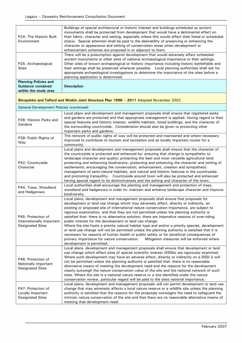
Legacy – Oswestry Reinforcement Consultation Document
February 2007
P24: The Historic Built Environment
Buildings of special architectural or historic interest and buildings scheduled as ancient monuments shall be protected from development that would have a detrimental effect on their fabric, character and setting, especially where this would affect their listed or scheduled status. Special attention shall be paid to the desirability of preserving or enhancing the character or appearance and setting of conservation areas when development or enhancement schemes are proposed in or adjacent to them.
P25: Archaeological Sites
There will be a presumption against development that would adversely affect scheduled ancient monuments or other sites of national archaeological importance or their settings. Other sites of known archaeological or historic importance including historic battlefields and their settings shall be preserved wherever possible. Local planning authorities shall ask for appropriate archaeological investigations to determine the importance of the sites before a planning application is determined.
Planning Policies and Guidance contained within the study area
Description
Shropshire and Telford and Wrekin Joint Structure Plan 1996 – 2011 Adopted November 2002
General Development Policies (continued)
P26: Historic Parks and Gardens
Local plans and development and management proposals shall ensure that registered parks and gardens are protected and that appropriate management is applied, having regard to their special features and historic interest, wildlife habitats, listed buildings, and the character of the surrounding countryside. Consideration should also be given to protecting other important parks and gardens.
P39: Public Rights of Way
The network of public rights of way will be protected and maintained and where necessary improved to contribute to tourism and recreation and as locally important routes for a community.
P42: Countryside Character
Local plans and development and management proposals shall ensure that the character of the countryside is protected and enhanced by: ensuring that change is sympathetic to landscape character and quality; protecting the best and most versatile agricultural land; protecting and enhancing biodiversity; protecting and enhancing the character and setting of settlements; encouraging the conservation, enhancement, creation and sympathetic management of semi-natural habitats, and natural and historic features in the countryside; and promoting tranquillity. Countryside around town will also be protected and enhanced having special regard to its distinctiveness and the setting and character of the town.
P44: Trees, Woodland and Hedgerows
Local authorities shall encourage the planting and management and protection of trees, woodland and hedgerows in order to: maintain and enhance landscape character and improve biodiversity.
P45: Protection of Internationally Important Designated Sites
Local plans, development and management proposals shall ensure that proposals for development or land use change which may adversely affect, directly or indirectly, an existing or proposed site of international nature conservation importance, are subject to rigorous examination, and that they are not permitted unless the planning authority is satisfied that: there is no alternative solution; there are imperative reasons of over-riding public interest for the development or land use change. Where the site hosts a priority natural habitat type and and/or a priority species, development or land use change will not be permitted unless the planning authority is satisfied that it is necessary for reasons of human health or public safety or for beneficial consequences of primary importance for nature conservation. Mitigation measures will be enforced where development is permitted.
P46: Protection of Nationally Important Designated Sites
Local plans, development and management proposals shall ensure that development or land use change which affect sites of special scientific interest (SSSIs) are rigorously examined. Where such development may have an adverse effect, directly or indirectly on a SSSI it will not be permitted unless the planning authority is satisfied that: there is no reasonable alternative means of meeting the development need and the reasons for the development clearly outweigh the nature conservation value of the site and the national network of such sites. Where the site is a national nature reserve or a site identified under the nature conservation review, particular regard will be paid to the sites national importance.
P47: Protection of Locally Important Designated Sites
Local plans, development and management proposals will not permit development or land use change that may adversely affects a local nature reserve or a wildlife site unless the planning authority is satisfied that the reasons for the proposals outweighs the need to safeguard the intrinsic nature conservation of the site and that there are no reasonable alternative means of meeting that development need.

Legacy – Oswestry Reinforcement Consultation Document
February 2007
P48: Biodiversity
Local plans, development and management proposals take into account the effects of development and land use change on wild flora and fauna. Plans will examine ways to protect, conserve and enhance the range, type and quality of habitats and ecosystems of wild flora and fauna. Habitats of high nature conservation importance should be protected and sympathetically managed to meet targets set in biodiversity action plans. Particular care will be taken to safeguard and consolidate the integrity of linear and other landscape features which are of importance for wild flora and fauna.
P49: Species Protection
Local Plans, development and management proposals shall ensure that planning permission will not be granted for development or land use change that would have an adverse effect on protected species of nature conservation concern. Where development that may have an adverse effect on those species is permitted the planning authorities will impose conditions on the planning permission or enter into planning obligations to: facilitate the survival of individual members of the species; reduce disturbance to a minimum; provide adequate alternative habitats to sustain at least the current levels of population of that species.
P51: Geological Sites
Local plans, development and management proposals shall ensure that SSSIs are designated because of their geological and geomorphological interest are protected and conserved. Development that will adverse affect such sites will not be permitted unless the planning authority is satisfied that the reason for the proposal outweighs the special interest of the site and that there are no reasonable alternative means of meeting the development need. Development will be mitigated against to ensure any adverse affects are minimised.
Planning Policies and Guidance contained within the study area
Description
Shropshire and Telford and Wrekin Joint Structure Plan 1996 – 2011 Adopted November 2002
General Development Policies (continued)
P52: Agricultural Land
Local plans, development and management proposals shall take into account the need to protect from development the best and most versatile agricultural land, Grades 1, 2 and 3A. They shall consider the availability and suitability of alternative sites on land of a lower grade taking into account any statutory designation. In considering the suitability of a site for development, the grading of agricultural land shall be judged alongside its landscape character, historic features, wildlife habitats and recreational amenity.
North Shropshire Local Plan 2000 – 2011 Adopted December 2005
D1: General Development Control
All applications for development must satisfy the following: size and intensity of the proposal must not have an unacceptable impact on the surrounding area and it’s immediate setting; the visual appearance of the development should not adversely affect the character of the area or of existing buildings, especially where these are of special architectural, environmental or historic value; natural features, habitats or species of significant historic, scientific or conservation value should not be adversely affected by development proposals; the development will not lead to unacceptable loss, or loss of quality, of the best and most versatile agricultural land (Grades 1, 2 and 3a) and existing public rights of way must be safeguarded and where necessary as a result of development, be replaced by new routes generally acceptable to the public.
C1: Conservation Areas
Development proposals within or adjacent to a conservation area will not be permitted unless they retain open spaces and the materials, features and details of buildings or structures that contribute to the character of the conservation area; are of height, size; design and materials that respect the character of the conservation area and that the proposed design and materials of the development are of high quality.
C7: Archaeological Sites
There will be a presumption in favour of the preservation of scheduled ancient monuments and other nationally important monuments, and development that would adversely affect their site or setting will not be permitted. The district council will seek to safeguard other sites of archaeological interest but exceptionally, when development is permitted and preservation in-situ is not merited, the District Council will require satisfactory provision to be made for excavation and recording.
L1: Development in the Countryside
Development proposals in the countryside should protect the visual quality of the landscape and should be sited and designed to minimise visual intrusion and adverse impact upon local features of historic, scientific or conservation value. Particular concern will be taken with respect to proposals within areas of special conservation value; areas of historic parkland; areas of special environmental interest; and adjacent to the Shropshire Union Canal Conservation Area.
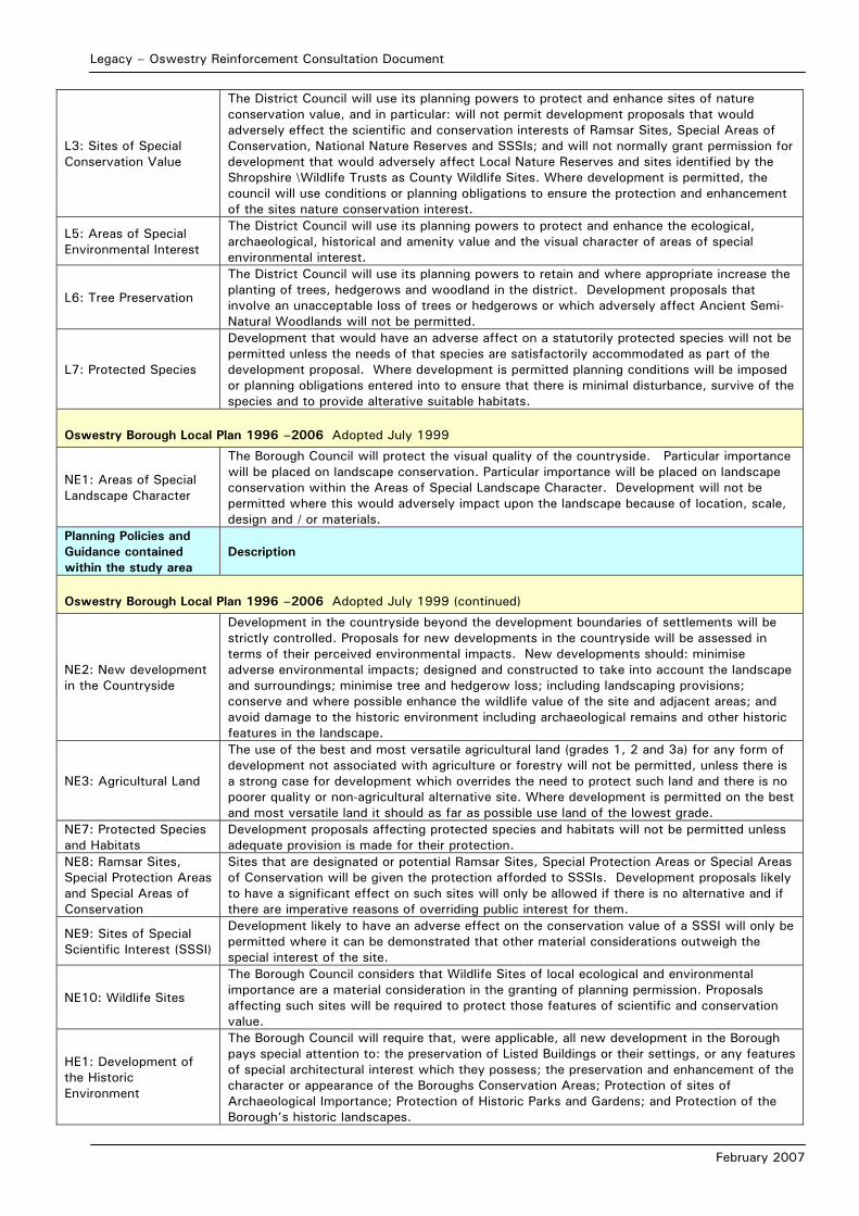
Legacy – Oswestry Reinforcement Consultation Document
February 2007
L3: Sites of Special Conservation Value
The District Council will use its planning powers to protect and enhance sites of nature conservation value, and in particular: will not permit development proposals that would adversely effect the scientific and conservation interests of Ramsar Sites, Special Areas of Conservation, National Nature Reserves and SSSIs; and will not normally grant permission for development that would adversely affect Local Nature Reserves and sites identified by the Shropshire \Wildlife Trusts as County Wildlife Sites. Where development is permitted, the council will use conditions or planning obligations to ensure the protection and enhancement of the sites nature conservation interest.
L5: Areas of Special Environmental Interest
The District Council will use its planning powers to protect and enhance the ecological, archaeological, historical and amenity value and the visual character of areas of special environmental interest.
L6: Tree Preservation
The District Council will use its planning powers to retain and where appropriate increase the planting of trees, hedgerows and woodland in the district. Development proposals that involve an unacceptable loss of trees or hedgerows or which adversely affect Ancient Semi-Natural Woodlands will not be permitted.
L7: Protected Species
Development that would have an adverse affect on a statutorily protected species will not be permitted unless the needs of that species are satisfactorily accommodated as part of the development proposal. Where development is permitted planning conditions will be imposed or planning obligations entered into to ensure that there is minimal disturbance, survive of the species and to provide alterative suitable habitats.
Oswestry Borough Local Plan 1996 –2006 Adopted July 1999
NE1: Areas of Special Landscape Character
The Borough Council will protect the visual quality of the countryside. Particular importance will be placed on landscape conservation. Particular importance will be placed on landscape conservation within the Areas of Special Landscape Character. Development will not be permitted where this would adversely impact upon the landscape because of location, scale, design and / or materials.
Planning Policies and Guidance contained within the study area
Description
Oswestry Borough Local Plan 1996 –2006 Adopted July 1999 (continued)
NE2: New development in the Countryside
Development in the countryside beyond the development boundaries of settlements will be strictly controlled. Proposals for new developments in the countryside will be assessed in terms of their perceived environmental impacts. New developments should: minimise adverse environmental impacts; designed and constructed to take into account the landscape and surroundings; minimise tree and hedgerow loss; including landscaping provisions; conserve and where possible enhance the wildlife value of the site and adjacent areas; and avoid damage to the historic environment including archaeological remains and other historic features in the landscape.
NE3: Agricultural Land
The use of the best and most versatile agricultural land (grades 1, 2 and 3a) for any form of development not associated with agriculture or forestry will not be permitted, unless there is a strong case for development which overrides the need to protect such land and there is no poorer quality or non-agricultural alternative site. Where development is permitted on the best and most versatile land it should as far as possible use land of the lowest grade.
NE7: Protected Species and Habitats
Development proposals affecting protected species and habitats will not be permitted unless adequate provision is made for their protection.
NE8: Ramsar Sites, Special Protection Areas and Special Areas of Conservation
Sites that are designated or potential Ramsar Sites, Special Protection Areas or Special Areas of Conservation will be given the protection afforded to SSSIs. Development proposals likely to have a significant effect on such sites will only be allowed if there is no alternative and if there are imperative reasons of overriding public interest for them.
NE9: Sites of Special Scientific Interest (SSSI)
Development likely to have an adverse effect on the conservation value of a SSSI will only be permitted where it can be demonstrated that other material considerations outweigh the special interest of the site.
NE10: Wildlife Sites
The Borough Council considers that Wildlife Sites of local ecological and environmental importance are a material consideration in the granting of planning permission. Proposals affecting such sites will be required to protect those features of scientific and conservation value.
HE1: Development of the Historic Environment
The Borough Council will require that, were applicable, all new development in the Borough pays special attention to: the preservation of Listed Buildings or their settings, or any features of special architectural interest which they possess; the preservation and enhancement of the character or appearance of the Boroughs Conservation Areas; Protection of sites of Archaeological Importance; Protection of Historic Parks and Gardens; and Protection of the Borough’s historic landscapes.

Legacy – Oswestry Reinforcement Consultation Document
February 2007
HE12: Areas of Environmental Character
Chirk Bank is considered to be suitable for designation as a Conservation Area and is therefore identified on the proposals maps as an ‘Area of Environmental Character’. All development that may adversely affect architectural and historical nature of this area prior to designation must take into account the existing quality of this built environment.
HE13: Archaeological Remains of National Importance.
There will be a presumption against development proposals that would significantly alter or damage nationally important archaeological remains, whether scheduled or not, or which would have a significant impact on the setting of visible remains.
HE14: Archaeological Sites of Regional or Local Importance
Planning applications affecting sites of regional or local importance should take into account the full archaeological importance of the site. The Council will seek the preservation in-situ of important archaeological remains when considering development proposals. Where in-situ preservation is not feasible or justified, taking into account the intrinsic importance of the remains and the need for the development, planning permission may be granted subject to satisfactory provision being made for excavation and recording of the remains.
HE16: Assessment of Sites of Archaeological Importance
In the case of development proposals affecting sites of archaeological significance (or potential significance) the Council will require the results of an archaeological assessment to be submitted with any planning application.
Wrexham Unitary Development Plan 1996-2011 Adopted 14th February 2005
PS2 General Development
Development must not materially detrimentally affect countryside, landscape/townscape character, open space, or the quality of the natural environment.
PS3 General Development
Development should use previously developed brownfield land comprising vacant, derelict or underused land in preference to the use of greenfield land, wherever possible, particularly so where greenfield land is of ecological, landscape or amenity value, or comprises agricultural land of grades 1, 2 or 3a quality.
PS11 Biodiversity Encouragement will be given to proposals that improve the biodiversity value of sites and to the establishment of local nature reserves where the nature conservation and landscape interest of the land will be protected and enhanced.
EC1: Green Barriers
Within Green Barriers, development will only be granted planning permission if it for agriculture, forestry, essential facilities for outdoor sport and recreation, cemeteries and other uses of land which maintain the openness of the Green Barrier and do not conflict with the purpose of including land within it.
EC2: Agricultural Land Development on agricultural land of grades 1, 2 or 3a will only be permitted if it does not lead to the irreversible loss of that land.
Planning Policies and Guidance contained within the study area
Description
Wrexham Unitary Development Plan 1996-2011 Adopted 14th February 2005
EC4: Hedgerows, Trees and Woodland
Development proposals should provide for the conservation and management of hedgerows, trees, orchards, woodland, wildlife and other natural landscape and water features, and include new planting in order to enhance the character of the landscape and townscape. Development which results in the loss or significant damage to valuable trees, important hedgerows or ancient woodland sites will not be permitted.
EC5: Special Landscape Areas
Within Special Landscape Areas, priority will be given to the conservation and enhancement of the landscape. Development, other than for agriculture, small-scale farm-based and other rural enterprises, and essential operational development by utility service providers, will be strictly controlled. Development will be required to conform to a high standard of design and landscaping, and special attention will be paid to minimising its visual impact both from nearby and distant viewpoints.
EC6: Biodiversity Conservation
Development either within or close to sites of biodiversity interest will only be permitted where it can be clearly demonstrated that the need for the development outweighs the need to safeguard the intrinsic nature conservation value of the site. Where such development is permitted, damage should be kept to a minimum, and compensatory measures should be provided. Measures to improve the biodiversity value of sites and enhance their natural conservation interest and landscape quality including the establishment of local nature reserves, will be supported.
EC7: Conservation Areas
Within, and in close proximity to, conservation areas, the priority will be to preserve and/or enhance those buildings, structures, streets, trees, open spaces, archaeological remains, views, and other elements that contribute to the unique character of the area.
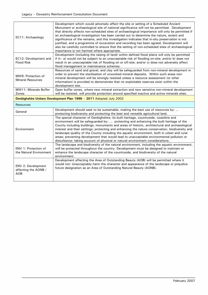
Legacy – Oswestry Reinforcement Consultation Document
February 2007
EC11: Archaeology
Development which would adversely affect the site or setting of a Scheduled Ancient Monument or archaeological site of national significance will not be permitted. Development that directly affects non-scheduled sites of archaeological importance will only be permitted if an archaeological investigation has been carried out to determine the nature, extent and significance of the remains, and this investigation indicates that in-situ preservation is not justified, and a programme of excavation and recording has been agreed. Development will also be carefully controlled to ensure that the setting of non-scheduled sites of archaeological importance is not harmed where appropriate.
EC12: Development and Flood Risk
Development (including the raising of land) within defined flood plains will only be permitted if it:- a) would not be subject to an unacceptable risk of flooding on-site; and/or b) does not result in an unacceptable risk of flooding on or off-site; and/or c) does not adversely affect flood management or maintenance schemes.
MW9: Protection of Mineral Resources
Resources of sand and gravel, and clay will be safeguarded from non-mineral development in order to prevent the sterilisation of unworked mineral deposits. Within such areas non-mineral development will be strongly resisted unless a resource assessment (or other information) is provided to demonstrate that no exploitable reserves exist within the development site.
MW11: Minerals Buffer Zones
Open buffer zones, where new mineral extraction and new sensitive non-mineral development will be resisted, will provide protection around specified inactive and active minerals sites.
Denbighshire Unitary Development Plan 1996 – 2011 Adopted July 2002
Resources
General Development should seek to be sustainable, making the best use of resources by: … protecting biodiversity and protecting the best and versatile agricultural land.
Environment
The special character of Denbighshire; its built heritage, countryside, coastline and environment will be safeguarded by: … protecting and enhancing the built heritage of the County including buildings, monuments and areas of historic, architectural and archaeological interest and their settings; protecting and enhancing the nature conservation, biodiversity and landscape quality of the County including the aquatic environment, both in urban and rural areas; preventing development that would lead to unacceptable environmental pollution or disturbance; taking account of physical or natural environment considerations.
ENV 1: Protection of the Natural Environment
The landscape and biodiversity of the natural environment, including the aquatic environment, will be protected throughout the country. Development must be designed to maintain or enhance the landscape character of the countryside, and biodiversity of the natural environment.
ENV 2: Development affecting the AONB / AOB
Development affecting the Area of Outstanding Beauty (AOB) will be permitted where it would not: Unacceptably harm the character and appearance of the landscape or prejudice future designation as an Area of Outstanding Natural Beauty (AONB).

Legacy – Oswestry Reinforcement Consultation Document
February 2007
Planning Policies and Guidance contained within the study area
Description
Denbighshire Unitary Development Plan 1996 – 2011 Adopted July 2002
Natural Environment (continued)
ENV 4: International/National Sites of Nature Conservation Value
Development that would affect the integrity of a site of European nature conservation value will be subject to rigorous examination. Development will only be permitted where there is no alterative solution and there are imperative reasons of overriding public interest. If the site hosts a priority natural habitat or species, development will only be permitted where it is necessary for reasons of human health or public safety or there would be benefits of primary importance to the environment. Development that would demonstrably harm the nature conservation value of Sites of Special Scientific Interest (SSSI) will not be permitted unless the reasons for the development clearly outweigh the nature conservation value of the site. Where development is permitted planning conditions and obligations may be sought to ensure necessary compensatory measures.
ENV 5: Sites of Local Conservation Importance
Development that would unacceptably harm the conservation value of Sites of Local Conservation Importance including those shown on the proposals map will only be permitted where appropriate mitigation measures can be taken.
ENV 6: Species Protection
Development that would unacceptably harm species given special protection by law will not be permitted unless appropriate steps can be taken to secure their protection.
ENV 7: Landscape and Townscape Features
Development should be designed to retain features such as traditional field boundaries, trees and ponds or any other features that are of substantial value to landscape / townscape character and nature conservation. Development that would cause harm to these features will only be permitted where appropriate mitigation measures are taken.
ENV 8: Woodlands Development will not be permitted where it would result in unacceptable harm to woodland, especially ancient semi-nature woodlands that have amenity or conservation value.
ENV 11: Safeguarding High Quality Agricultural Land
Development that would result in the unacceptable permanent loss of agricultural land of grades 1, 2, 3A will only be permitted where: There is an overriding need for the development and land of lower quality is unavailable or available lower grade land has an environmental value recognised by a statutory designation.
Conservation of the Built Environment
CON 5: Development within Conservation Areas
The council will permit applications that demonstrate that they preserve or enhance the character or appearance of conservation areas.
CON 6: Development Adjacent to Conservation Areas
The authority will permit applications adjacent to conservation areas that do not detrimentally affect important views into and out of the conservation area.
CON 10: Scheduled Ancient Monuments
Development that would cause unacceptable harm to a nationally important monument, or its setting, including those shown on the proposals map will not be permitted. Wherever possible, planning applications that affect a scheduled ancient monument or its setting should be accompanied by the completed scheduled monument consent approval from CADW.
CON 11: Areas of archaeological importance
The Council will require, in line with PPW (2002) and Circular 60/96, that an acceptable report on the results of archaeological evaluations, is submitted prior to the determination of proposals affecting sites of known or potential archaeological significance. In cases where remains are affected but preservation in situ is not merited, the council will expect to secure excavations and/or recording in advance of construction work either by the imposition of suitable conditions attached to a planning permission or through a formal obligation entered into with the developer.
CON 12: Historic Parks and Gardens
Development that would unacceptably harm the character of a historic landscape, park or garden or its essential setting will not be permitted.
Highways, Transportation and Communications
TRA 10: Public Right of Way
In respect of public rights of way the council will: retain and where possible extend and enhance the existing public rights of way and other legitimate access rights; carefully assess the impact of development requiring the satisfactory incorporation of the right of way within the development or where this is not practicable provide adequate provisions for re-routing or replacing the existing public access or create new public access routes; resist development that would prevent proposals for the extension of public footpaths, cycleways or bridleways.

Legacy – Oswestry Reinforcement Consultation Document
February 2007
TRA 11: Walking and Cycling Routes
In developing a county wide network of cycling/walking routes the council will: … safeguard land comprising or adjoining the existing Prestatyn – Dyserth railway route; promote the re-use of other former railway routes as and when opportunities and resources allow and resist development that would unacceptably harm existing and proposed recreational routes; safeguard land forming the trackbed between Llangollen and Trevor and resist development which would prejudice its use a walkway and cycleway.
Legacy – Oswestry Reinforcement Consultation Document
February 2007
APPENDIX4B: LANDSCAPE CHARACTER AREAS
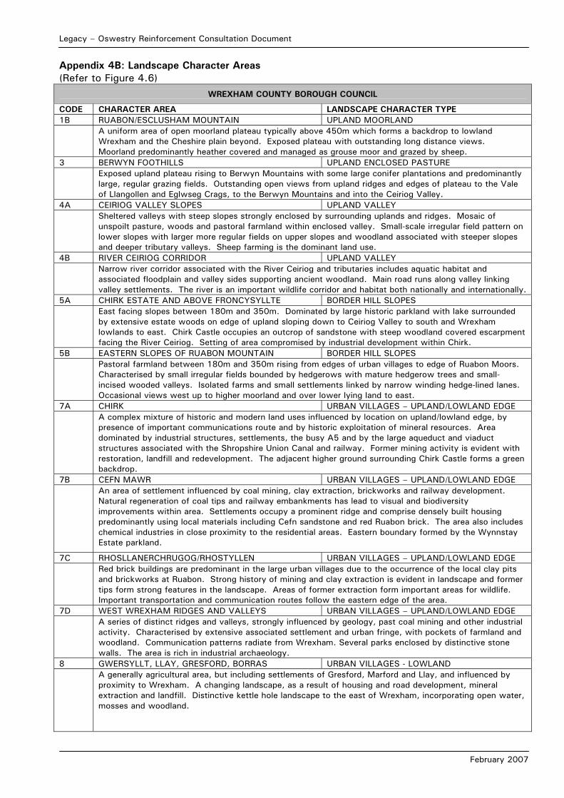
Legacy – Oswestry Reinforcement Consultation Document
February 2007
Appendix 4B: Landscape Character Areas (Refer to Figure 4.6)
WREXHAM COUNTY BOROUGH COUNCIL
CODE CHARACTER AREA LANDSCAPE CHARACTER TYPE 1B RUABON/ESCLUSHAM MOUNTAIN UPLAND MOORLAND A uniform area of open moorland plateau typically above 450m which forms a backdrop to lowland
Wrexham and the Cheshire plain beyond. Exposed plateau with outstanding long distance views. Moorland predominantly heather covered and managed as grouse moor and grazed by sheep.
3 BERWYN FOOTHILLS UPLAND ENCLOSED PASTURE Exposed upland plateau rising to Berwyn Mountains with some large conifer plantations and predominantly
large, regular grazing fields. Outstanding open views from upland ridges and edges of plateau to the Vale of Llangollen and Eglwseg Crags, to the Berwyn Mountains and into the Ceiriog Valley.
4A CEIRIOG VALLEY SLOPES UPLAND VALLEY Sheltered valleys with steep slopes strongly enclosed by surrounding uplands and ridges. Mosaic of
unspoilt pasture, woods and pastoral farmland within enclosed valley. Small-scale irregular field pattern on lower slopes with larger more regular fields on upper slopes and woodland associated with steeper slopes and deeper tributary valleys. Sheep farming is the dominant land use.
4B RIVER CEIRIOG CORRIDOR UPLAND VALLEY Narrow river corridor associated with the River Ceiriog and tributaries includes aquatic habitat and
associated floodplain and valley sides supporting ancient woodland. Main road runs along valley linking valley settlements. The river is an important wildlife corridor and habitat both nationally and internationally.
5A CHIRK ESTATE AND ABOVE FRONCYSYLLTE BORDER HILL SLOPES East facing slopes between 180m and 350m. Dominated by large historic parkland with lake surrounded
by extensive estate woods on edge of upland sloping down to Ceiriog Valley to south and Wrexham lowlands to east. Chirk Castle occupies an outcrop of sandstone with steep woodland covered escarpment facing the River Ceiriog. Setting of area compromised by industrial development within Chirk.
5B EASTERN SLOPES OF RUABON MOUNTAIN BORDER HILL SLOPES Pastoral farmland between 180m and 350m rising from edges of urban villages to edge of Ruabon Moors.
Characterised by small irregular fields bounded by hedgerows with mature hedgerow trees and small-incised wooded valleys. Isolated farms and small settlements linked by narrow winding hedge-lined lanes. Occasional views west up to higher moorland and over lower lying land to east.
7A CHIRK URBAN VILLAGES – UPLAND/LOWLAND EDGE A complex mixture of historic and modern land uses influenced by location on upland/lowland edge, by
presence of important communications route and by historic exploitation of mineral resources. Area dominated by industrial structures, settlements, the busy A5 and by the large aqueduct and viaduct structures associated with the Shropshire Union Canal and railway. Former mining activity is evident with restoration, landfill and redevelopment. The adjacent higher ground surrounding Chirk Castle forms a green backdrop.
7B CEFN MAWR URBAN VILLAGES – UPLAND/LOWLAND EDGE An area of settlement influenced by coal mining, clay extraction, brickworks and railway development.
Natural regeneration of coal tips and railway embankments has lead to visual and biodiversity improvements within area. Settlements occupy a prominent ridge and comprise densely built housing predominantly using local materials including Cefn sandstone and red Ruabon brick. The area also includes chemical industries in close proximity to the residential areas. Eastern boundary formed by the Wynnstay Estate parkland.
7C RHOSLLANERCHRUGOG/RHOSTYLLEN URBAN VILLAGES – UPLAND/LOWLAND EDGE Red brick buildings are predominant in the large urban villages due to the occurrence of the local clay pits
and brickworks at Ruabon. Strong history of mining and clay extraction is evident in landscape and former tips form strong features in the landscape. Areas of former extraction form important areas for wildlife. Important transportation and communication routes follow the eastern edge of the area.
7D WEST WREXHAM RIDGES AND VALLEYS URBAN VILLAGES – UPLAND/LOWLAND EDGE A series of distinct ridges and valleys, strongly influenced by geology, past coal mining and other industrial
activity. Characterised by extensive associated settlement and urban fringe, with pockets of farmland and woodland. Communication patterns radiate from Wrexham. Several parks enclosed by distinctive stone walls. The area is rich in industrial archaeology.
8 GWERSYLLT, LLAY, GRESFORD, BORRAS URBAN VILLAGES - LOWLAND A generally agricultural area, but including settlements of Gresford, Marford and Llay, and influenced by
proximity to Wrexham. A changing landscape, as a result of housing and road development, mineral extraction and landfill. Distinctive kettle hole landscape to the east of Wrexham, incorporating open water, mosses and woodland.
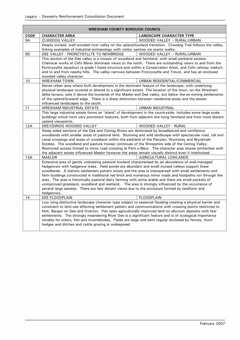
Legacy – Oswestry Reinforcement Consultation Document
February 2007
WREXHAM COUNTY BOROUGH COUNCIL
CODE CHARACTER AREA LANDSCAPE CHARACTER TYPE 9A CLWEDOG VALLEY WOODED VALLEY – RURAL/URBAN Deeply incised, well-wooded river valley on the upland/lowland transition. Clwedog Trail follows the valley,
linking examples of industrial archaeology with visitor centres via scenic walks. 9D DEE VALLEY - FRONCYSYLLTE TO NEWBRIDGE WOODED VALLEY – RURAL/URBAN This section of the Dee valley is a mosaic of woodland and farmland, with small parkland estates.
Chemical works at Cefn Mawr dominate views to the north. There are outstanding views to and from the Pontcysyllte aqueduct (a grade I listed structure and within a Conservation Area), and Cefn railway viaduct, and to and from nearby hills. The valley narrows between Froncysyllte and Trevor, and has an enclosed wooded valley character.
10 WREXHAM TOWN URBAN RESIDENTIAL/COMMERCIAL Dense urban area where built development is the dominant feature of the landscape, with underlying
physical landscape covered or altered to a significant extent. The location of the town, on the Wrexham delta terrace, sets it above the lowlands of the Maelor and Dee valley, but below the ex-mining settlements of the upland/lowland edge. There is a sharp distinction between residential areas and the estate-influenced landscapes to the south.
11 WREXHAM INDUSTRIAL ESTATE URBAN INDUSTRIAL This large industrial estate forms an ‘island’ of development in the countryside. Includes some large-scale
buildings which form very prominent features, both from adjacent low-lying farmland and from more distant upland viewpoints.
12A DEE/CEIRIOG WOODED VALLEY WOODED VALLEY - RURAL Steep sided sections of the Dee and Ceiriog Rivers are dominated by broadleaved and coniferous
woodlands with smaller areas of pastoral land. Stunning and wild landscape with spectacular road, rail and canal crossings and areas of woodland within the parkland of the Penylan, Wynnstay and Brynkinalt Estates. The woodland and pasture mosaic continues of the Shropshire side of the Ceiriog Valley. Restricted access limited to minor road crossing at Pont-y-Blew. The character area shares similarities with the adjacent estate influenced Maelor however the areas remain visually distinct even if interlocked.
13A MAELOR AGRICULTURAL LOWLANDS Extensive area of gently undulating pastoral lowland characterised by an abundance of well-managed
hedgerows with hedgerow trees. Field ponds are abundant and small incised valleys support linear woodlands. A historic settlement pattern exists and the area is interspersed with small settlements and farm buildings constructed in traditional red brick and numerous minor roads and footpaths run through the area. The area is historically pastoral dairy farming with some arable and there are small pockets of unimproved grassland, woodland and wetland. The area is strongly influenced by the occurrence of several large estates. There are few distant views due to the enclosure formed by landform and hedgerows.
14 DEE FLOODPLAIN FLOODPLAIN Low lying distinctive landscape character type subject to seasonal flooding creating a physical barrier and
constraint to land use affecting settlement pattern and communications with crossing points restricted to Holt, Bangor on Dee and Overton. Flat open agriculturally improved land on alluvium deposits with few settlements. The strongly meandering River Dee is a significant feature and is of ecological importance notably for otters, fish and invertebrates. Fields are large and semi regular enclosed by fences, thorn hedges and ditches and cattle grazing is widespread.
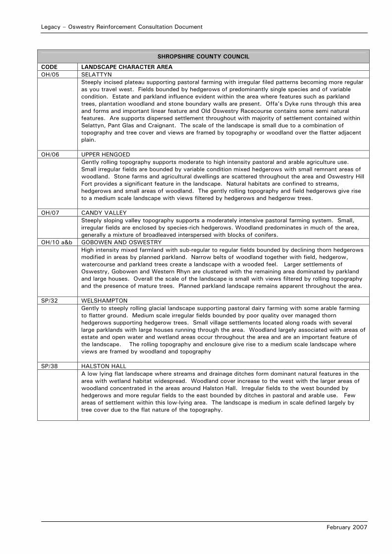
Legacy – Oswestry Reinforcement Consultation Document
February 2007
SHROPSHIRE COUNTY COUNCIL
CODE LANDSCAPE CHARACTER AREA OH/05 SELATTYN Steeply incised plateau supporting pastoral farming with irregular filed patterns becoming more regular
as you travel west. Fields bounded by hedgerows of predominantly single species and of variable condition. Estate and parkland influence evident within the area where features such as parkland trees, plantation woodland and stone boundary walls are present. Offa’s Dyke runs through this area and forms and important linear feature and Old Oswestry Racecourse contains some semi natural features. Are supports dispersed settlement throughout with majority of settlement contained within Selattyn, Pant Glas and Craignant. The scale of the landscape is small due to a combination of topography and tree cover and views are framed by topography or woodland over the flatter adjacent plain.
OH/06 UPPER HENGOED Gently rolling topography supports moderate to high intensity pastoral and arable agriculture use.
Small irregular fields are bounded by variable condition mixed hedgerows with small remnant areas of woodland. Stone farms and agricultural dwellings are scattered throughout the area and Oswestry Hill Fort provides a significant feature in the landscape. Natural habitats are confined to streams, hedgerows and small areas of woodland. The gently rolling topography and field hedgerows give rise to a medium scale landscape with views filtered by hedgerows and hedgerow trees.
OH/07 CANDY VALLEY Steeply sloping valley topography supports a moderately intensive pastoral farming system. Small,
irregular fields are enclosed by species-rich hedgerows. Woodland predominates in much of the area, generally a mixture of broadleaved interspersed with blocks of conifers.
OH/10 a&b GOBOWEN AND OSWESTRY High intensity mixed farmland with sub-regular to regular fields bounded by declining thorn hedgerows
modified in areas by planned parkland. Narrow belts of woodland together with field, hedgerow, watercourse and parkland trees create a landscape with a wooded feel. Larger settlements of Oswestry, Gobowen and Western Rhyn are clustered with the remaining area dominated by parkland and large houses. Overall the scale of the landscape is small with views filtered by rolling topography and the presence of mature trees. Planned parkland landscape remains apparent throughout the area.
SP/32 WELSHAMPTON Gently to steeply rolling glacial landscape supporting pastoral dairy farming with some arable farming
to flatter ground. Medium scale irregular fields bounded by poor quality over managed thorn hedgerows supporting hedgerow trees. Small village settlements located along roads with several large parklands with large houses running through the area. Woodland largely associated with areas of estate and open water and wetland areas occur throughout the area and are an important feature of the landscape. The rolling topography and enclosure give rise to a medium scale landscape where views are framed by woodland and topography
SP/38 HALSTON HALL A low lying flat landscape where streams and drainage ditches form dominant natural features in the
area with wetland habitat widespread. Woodland cover increase to the west with the larger areas of woodland concentrated in the areas around Halston Hall. Irregular fields to the west bounded by hedgerows and more regular fields to the east bounded by ditches in pastoral and arable use. Few areas of settlement within this low-lying area. The landscape is medium in scale defined largely by tree cover due to the flat nature of the topography.
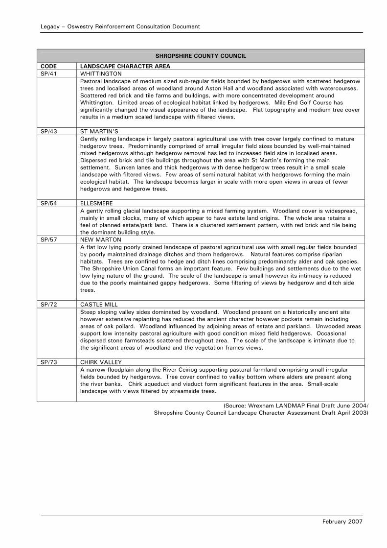
Legacy – Oswestry Reinforcement Consultation Document
February 2007
SHROPSHIRE COUNTY COUNCIL
CODE LANDSCAPE CHARACTER AREA SP/41 WHITTINGTON Pastoral landscape of medium sized sub-regular fields bounded by hedgerows with scattered hedgerow
trees and localised areas of woodland around Aston Hall and woodland associated with watercourses. Scattered red brick and tile farms and buildings, with more concentrated development around Whittington. Limited areas of ecological habitat linked by hedgerows. Mile End Golf Course has significantly changed the visual appearance of the landscape. Flat topography and medium tree cover results in a medium scaled landscape with filtered views.
SP/43 ST MARTIN’S Gently rolling landscape in largely pastoral agricultural use with tree cover largely confined to mature
hedgerow trees. Predominantly comprised of small irregular field sizes bounded by well-maintained mixed hedgerows although hedgerow removal has led to increased field size in localised areas. Dispersed red brick and tile buildings throughout the area with St Martin’s forming the main settlement. Sunken lanes and thick hedgerows with dense hedgerow trees result in a small scale landscape with filtered views. Few areas of semi natural habitat with hedgerows forming the main ecological habitat. The landscape becomes larger in scale with more open views in areas of fewer hedgerows and hedgerow trees.
SP/54 ELLESMERE A gently rolling glacial landscape supporting a mixed farming system. Woodland cover is widespread,
mainly in small blocks, many of which appear to have estate land origins. The whole area retains a feel of planned estate/park land. There is a clustered settlement pattern, with red brick and tile being the dominant building style.
SP/57 NEW MARTON A flat low lying poorly drained landscape of pastoral agricultural use with small regular fields bounded
by poorly maintained drainage ditches and thorn hedgerows. Natural features comprise riparian habitats. Trees are confined to hedge and ditch lines comprising predominantly alder and oak species. The Shropshire Union Canal forms an important feature. Few buildings and settlements due to the wet low lying nature of the ground. The scale of the landscape is small however its intimacy is reduced due to the poorly maintained gappy hedgerows. Some filtering of views by hedgerow and ditch side trees.
SP/72 CASTLE MILL Steep sloping valley sides dominated by woodland. Woodland present on a historically ancient site
however extensive replanting has reduced the ancient character however pockets remain including areas of oak pollard. Woodland influenced by adjoining areas of estate and parkland. Unwooded areas support low intensity pastoral agriculture with good condition mixed field hedgerows. Occasional dispersed stone farmsteads scattered throughout area. The scale of the landscape is intimate due to the significant areas of woodland and the vegetation frames views.
SP/73 CHIRK VALLEY A narrow floodplain along the River Ceiriog supporting pastoral farmland comprising small irregular
fields bounded by hedgerows. Tree cover confined to valley bottom where alders are present along the river banks. Chirk aqueduct and viaduct form significant features in the area. Small-scale landscape with views filtered by streamside trees.
(Source: Wrexham LANDMAP Final Draft June 2004/ Shropshire County Council Landscape Character Assessment Draft April 2003)
Legacy – Oswestry Reinforcement Consultation Document
February 2007
APPENDIX4C: SCHEDULED MONUMENTS WITHIN THE STUDY AREA
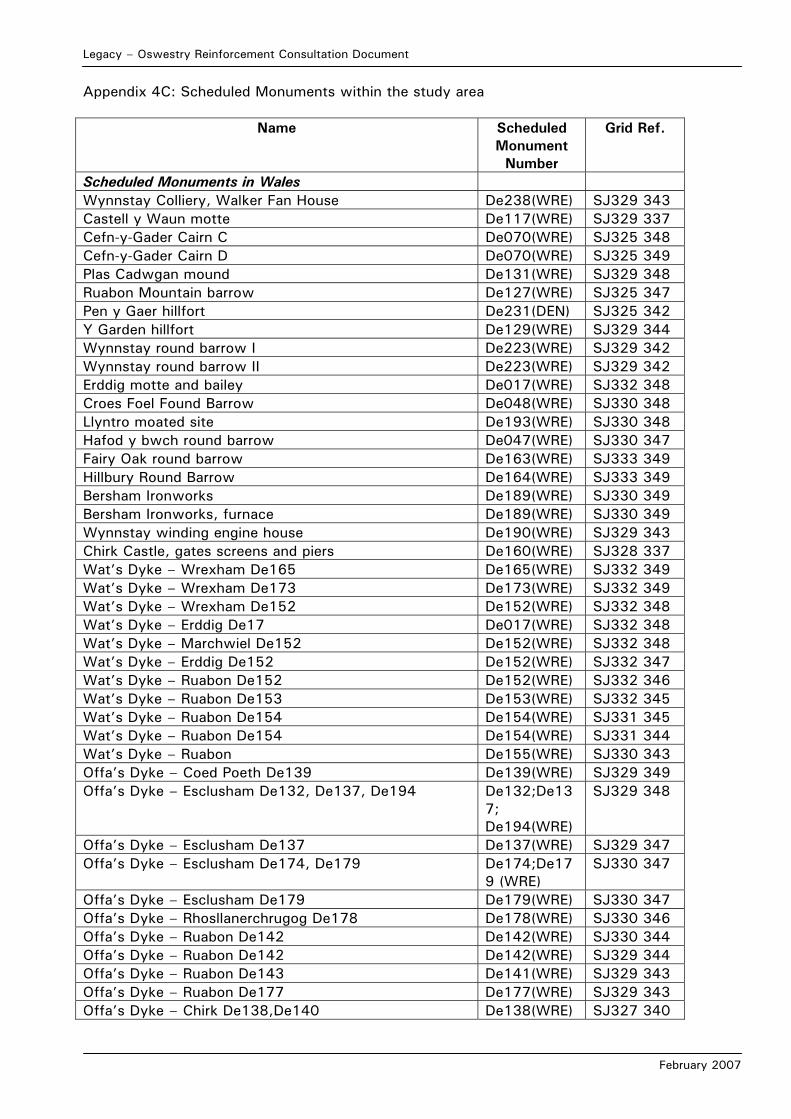
Legacy – Oswestry Reinforcement Consultation Document
February 2007
Appendix 4C: Scheduled Monuments within the study area
Name Scheduled Monument
Number
Grid Ref.
Scheduled Monuments in Wales Wynnstay Colliery, Walker Fan House De238(WRE) SJ329 343 Castell y Waun motte De117(WRE) SJ329 337 Cefn-y-Gader Cairn C De070(WRE) SJ325 348 Cefn-y-Gader Cairn D De070(WRE) SJ325 349 Plas Cadwgan mound De131(WRE) SJ329 348 Ruabon Mountain barrow De127(WRE) SJ325 347 Pen y Gaer hillfort De231(DEN) SJ325 342 Y Garden hillfort De129(WRE) SJ329 344 Wynnstay round barrow I De223(WRE) SJ329 342 Wynnstay round barrow II De223(WRE) SJ329 342 Erddig motte and bailey De017(WRE) SJ332 348 Croes Foel Found Barrow De048(WRE) SJ330 348 Llyntro moated site De193(WRE) SJ330 348 Hafod y bwch round barrow De047(WRE) SJ330 347 Fairy Oak round barrow De163(WRE) SJ333 349 Hillbury Round Barrow De164(WRE) SJ333 349 Bersham Ironworks De189(WRE) SJ330 349 Bersham Ironworks, furnace De189(WRE) SJ330 349 Wynnstay winding engine house De190(WRE) SJ329 343 Chirk Castle, gates screens and piers De160(WRE) SJ328 337 Wat’s Dyke – Wrexham De165 De165(WRE) SJ332 349 Wat’s Dyke – Wrexham De173 De173(WRE) SJ332 349 Wat’s Dyke – Wrexham De152 De152(WRE) SJ332 348 Wat’s Dyke – Erddig De17 De017(WRE) SJ332 348 Wat’s Dyke – Marchwiel De152 De152(WRE) SJ332 348 Wat’s Dyke – Erddig De152 De152(WRE) SJ332 347 Wat’s Dyke – Ruabon De152 De152(WRE) SJ332 346 Wat’s Dyke – Ruabon De153 De153(WRE) SJ332 345 Wat’s Dyke – Ruabon De154 De154(WRE) SJ331 345 Wat’s Dyke – Ruabon De154 De154(WRE) SJ331 344 Wat’s Dyke – Ruabon De155(WRE) SJ330 343 Offa’s Dyke – Coed Poeth De139 De139(WRE) SJ329 349 Offa’s Dyke – Esclusham De132, De137, De194 De132;De13
7; De194(WRE)
SJ329 348
Offa’s Dyke – Esclusham De137 De137(WRE) SJ329 347 Offa’s Dyke – Esclusham De174, De179 De174;De17
9 (WRE) SJ330 347
Offa’s Dyke – Esclusham De179 De179(WRE) SJ330 347 Offa’s Dyke – Rhosllanerchrugog De178 De178(WRE) SJ330 346 Offa’s Dyke – Ruabon De142 De142(WRE) SJ330 344 Offa’s Dyke – Ruabon De142 De142(WRE) SJ329 344 Offa’s Dyke – Ruabon De143 De141(WRE) SJ329 343 Offa’s Dyke – Ruabon De177 De177(WRE) SJ329 343 Offa’s Dyke – Chirk De138,De140 De138(WRE) SJ327 340
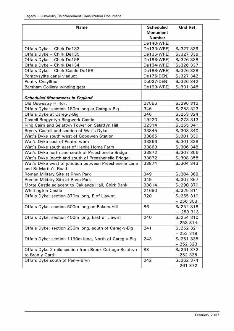
Legacy – Oswestry Reinforcement Consultation Document
February 2007
Name Scheduled Monument
Number
Grid Ref.
De140(WRE) Offa’s Dyke – Chirk De133 De133(WRE) SJ327 339 Offa’s Dyke – Chirk De135 De135(WRE) SJ327 338 Offa’s Dyke – Chirk De198 De198(WRE) SJ326 338 Offa’s Dyke – Chirk De134 De134(WRE) SJ326 337 Offa’s Dyke – Chirk Castle De198 De198(WRE) SJ326 338 Pontcysyllte canal viaduct De175(DEN) SJ327 342 Pont y Cysylltau De027(DEN) SJ326 342 Bersham Colliery winding gear De199(WRE) SJ331 348 Scheduled Monuments in England Old Oswestry Hillfort 27556 SJ296 312 Offa’s Dyke: section 180m long at Careg-y-Big 346 SJ253 323 Offa’s Dyke at Careg-y-Big 346 SJ253 324 Castell Brogyntyn Ringwork Castle 19220 SJ273 313 Ring Cairn and Selattyn Tower on Selattyn Hill 32314 SJ255 341 Bryn-y-Castell and section of Wat’s Dyke 33845 SJ303 340 Wat’s Dyke south west of Gobowen Station 33865 SJ301 330 Wat’s Dyke east of Pentre-wern 33866 SJ301 328 Wat’s Dyke south east of Henlle Home Farm 33869 SJ306 348 Wat’s Dyke north and south of Preeshenelle Bridge 33872 SJ307 356 Wat’s Dyke (north and south of Preeshenelle Bridge) 33872 SJ308 358 Wat’s Dyke west of junction between Preeshenelle Lane and St Martin’s Road
33874 SJ304 343
Roman Military Site at Rhyn Park 349 SJ304 368 Roman Military Site at Rhyn Park 349 SJ307 367 Motte Castle adjacent to Oaklands Hall, Chirk Bank 33814 SJ290 370 Whittington Castle 21680 SJ325 311 Offa’s Dyke: section 370m long, E of Llawnt 320 SJ255 310
– 256 303 Offa’s Dyke: section 500m long on Bakers Hill 86 SJ252 318
– 253 313 Offa’s Dyke: section 400m long, East of Llawnt 240 SJ254 310
– 253 314 Offa’s Dyke: section 230m long, south of Careg-y-Big 241 SJ252 321
– 253 319 Offa’s Dyke: section 1190m long, North of Careg-y-Big 243 SJ251 335
– 252 323 Offa’s Dyke 2 mile section from Brook Cottage Selattyn to Bron-y-Garth
83 SJ261 372 – 252 335
Offa’s Dyke south of Pen-y-Bryn 242 SJ262 374 – 261 372
Legacy – Oswestry Reinforcement Consultation Document
February 2007
APPENDIX 6A: ENVIRONMENTAL AND TECHNICAL
CONSTRAINTS TO DETAILED ROUTEING
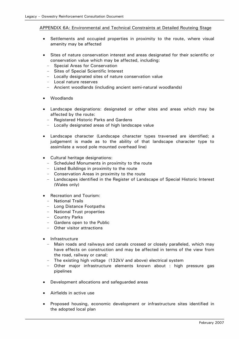
Legacy – Oswestry Reinforcement Consultation Document
February 2007
APPENDIX 6A: Environmental and Technical Constraints at Detailed Routeing Stage • Settlements and occupied properties in proximity to the route, where visual
amenity may be affected • Sites of nature conservation interest and areas designated for their scientific or
conservation value which may be affected, including: - Special Areas for Conservation - Sites of Special Scientific Interest - Locally designated sites of nature conservation value - Local nature reserves - Ancient woodlands (including ancient semi-natural woodlands)
• Woodlands • Landscape designations: designated or other sites and areas which may be
affected by the route: - Registered Historic Parks and Gardens - Locally designated areas of high landscape value
• Landscape character (Landscape character types traversed are identified; a judgement is made as to the ability of that landscape character type to assimilate a wood pole mounted overhead line)
• Cultural heritage designations:
- Scheduled Monuments in proximity to the route - Listed Buildings in proximity to the route - Conservation Areas in proximity to the route - Landscapes identified in the Register of Landscape of Special Historic Interest
(Wales only)
• Recreation and Tourism: - National Trails - Long Distance Footpaths - National Trust properties - Country Parks - Gardens open to the Public - Other visitor attractions
• Infrastructure - Main roads and railways and canals crossed or closely paralleled, which may
have effects on construction and may be affected in terms of the view from the road, railway or canal;
- The existing high voltage (132kV and above) electrical system - Other major infrastructure elements known about : high pressure gas
pipelines
• Development allocations and safeguarded areas • Airfields in active use
• Proposed housing, economic development or infrastructure sites identified in
the adopted local plan

Legacy – Oswestry Reinforcement Consultation Document
February 2007
• Mineral and landfill sites and mineral consultation zones
• Technical considerations:
- Route length
Legacy – Oswestry Reinforcement Consultation Document
February 2007
APPENDIX 6B: SUMMARY TABLE OF KEY ENVIRONMENTAL FACTORS RELATING TO
DETAILED ROUTE OPTIONS
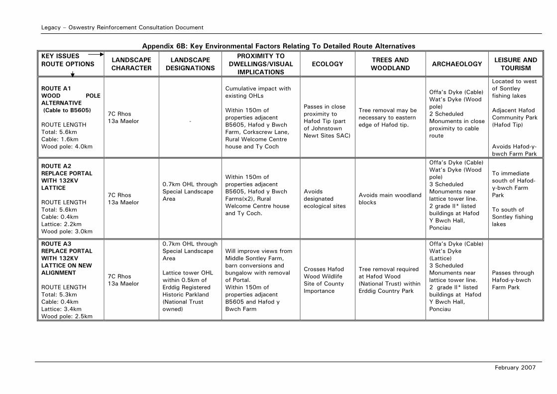
Legacy – Oswestry Reinforcement Consultation Document
February 2007
Appendix 6B: Key Environmental Factors Relating To Detailed Route Alternatives KEY ISSUES ROUTE OPTIONS
LANDSCAPE CHARACTER
LANDSCAPE DESIGNATIONS
PROXIMITY TO DWELLINGS/VISUAL
IMPLICATIONS ECOLOGY
TREES AND WOODLAND
ARCHAEOLOGY LEISURE AND
TOURISM
ROUTE A1 WOOD POLE ALTERNATIVE (Cable to B5605) ROUTE LENGTH Total: 5.6km Cable: 1.6km Wood pole: 4.0km
7C Rhos 13a Maelor
-
Cumulative impact with existing OHLs Within 150m of properties adjacent B5605, Hafod y Bwch Farm, Corkscrew Lane, Rural Welcome Centre house and Ty Coch
Passes in close proximity to Hafod Tip (part of Johnstown Newt Sites SAC)
Tree removal may be necessary to eastern edge of Hafod tip.
Offa’s Dyke (Cable) Wat’s Dyke (Wood pole) 2 Scheduled Monuments in close proximity to cable route
Located to west of Sontley fishing lakes Adjacent Hafod Community Park (Hafod Tip) Avoids Hafod-y-bwch Farm Park
ROUTE A2 REPLACE PORTAL WITH 132KV LATTICE ROUTE LENGTH Total: 5.6km Cable: 0.4km Lattice: 2.2km Wood pole: 3.0km
7C Rhos 13a Maelor
0.7km OHL through Special Landscape Area
Within 150m of properties adjacent B5605, Hafod y Bwch Farms(x2), Rural Welcome Centre house and Ty Coch.
Avoids designated ecological sites
Avoids main woodland blocks
Offa’s Dyke (Cable) Wat’s Dyke (Wood pole) 3 Scheduled Monuments near lattice tower line. 2 grade II* listed buildings at Hafod Y Bwch Hall, Ponciau
To immediate south of Hafod-y-bwch Farm Park To south of Sontley fishing lakes
ROUTE A3 REPLACE PORTAL WITH 132KV LATTICE ON NEW ALIGNMENT ROUTE LENGTH Total: 5.3km Cable: 0.4km Lattice: 3.4km Wood pole: 2.5km
7C Rhos 13a Maelor
0.7km OHL through Special Landscape Area Lattice tower OHL within 0.5km of Erddig Registered Historic Parkland (National Trust owned)
Will improve views from Middle Sontley Farm, barn conversions and bungalow with removal of Portal. Within 150m of properties adjacent B5605 and Hafod y Bwch Farm
Crosses Hafod Wood Wildlife Site of County Importance
Tree removal required at Hafod Wood (National Trust) within Erddig Country Park
Offa’s Dyke (Cable) Wat’s Dyke (Lattice) 3 Scheduled Monuments near lattice tower line. 2 grade II* listed buildings at Hafod Y Bwch Hall, Ponciau
Passes through Hafod-y-bwch Farm Park
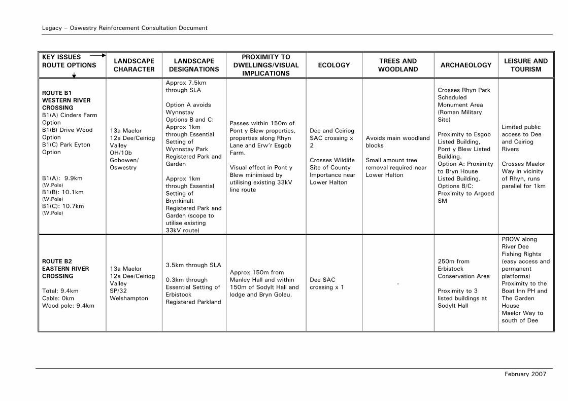
Legacy – Oswestry Reinforcement Consultation Document
February 2007
KEY ISSUES ROUTE OPTIONS
LANDSCAPE CHARACTER
LANDSCAPE DESIGNATIONS
PROXIMITY TO DWELLINGS/VISUAL
IMPLICATIONS ECOLOGY
TREES AND WOODLAND
ARCHAEOLOGY LEISURE AND
TOURISM
ROUTE B1 WESTERN RIVER CROSSING B1(A) Cinders Farm Option B1(B) Drive Wood Option B1(C) Park Eyton Option
B1(A): 9.9km (W.Pole) B1(B): 10.1km (W.Pole) B1(C): 10.7km (W.Pole)
13a Maelor 12a Dee/Ceiriog Valley OH/10b Gobowen/ Oswestry
Approx 7.5km through SLA Option A avoids Wynnstay Options B and C: Approx 1km through Essential Setting of Wynnstay Park Registered Park and Garden Approx 1km through Essential Setting of Brynkinalt Registered Park and Garden (scope to utilise existing 33kV route)
Passes within 150m of Pont y Blew properties, properties along Rhyn Lane and Erw’r Esgob Farm. Visual effect in Pont y Blew minimised by utilising existing 33kV line route
Dee and Ceiriog SAC crossing x 2 Crosses Wildlife Site of County Importance near Lower Halton
Avoids main woodland blocks Small amount tree removal required near Lower Halton
Crosses Rhyn Park Scheduled Monument Area (Roman Military Site) Proximity to Esgob Listed Building, Pont y Blew Listed Building. Option A: Proximity to Bryn House Listed Building. Options B/C: Proximity to Argoed SM
Limited public access to Dee and Ceiriog Rivers Crosses Maelor Way in vicinity of Rhyn, runs parallel for 1km
ROUTE B2 EASTERN RIVER CROSSING Total: 9.4km Cable: 0km Wood pole: 9.4km
13a Maelor 12a Dee/Ceiriog Valley SP/32 Welshampton
3.5km through SLA 0.3km through Essential Setting of Erbistock Registered Parkland
Approx 150m from Manley Hall and within 150m of Sodylt Hall and lodge and Bryn Goleu.
Dee SAC crossing x 1 -
250m from Erbistock Conservation Area Proximity to 3 listed buildings at Sodylt Hall
PROW along River Dee Fishing Rights (easy access and permanent platforms) Proximity to the Boat Inn PH and The Garden House Maelor Way to south of Dee
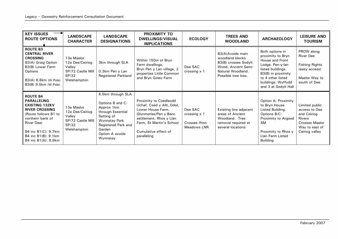
Legacy – Oswestry Reinforcement Consultation Document
February 2007
KEY ISSUES ROUTE OPTIONS
LANDSCAPE CHARACTER
LANDSCAPE DESIGNATIONS
PROXIMITY TO DWELLINGS/VISUAL
IMPLICATIONS ECOLOGY
TREES AND WOODLAND
ARCHAEOLOGY LEISURE AND
TOURISM
ROUTE B3 CENTRAL RIVER CROSSING B3(A) Graig Option B3(B) Lower Farm Options B3(A) 8.8km (W.Pole) B3(B) 9.5km (W.Pole)
13a Maelor 12a Dee/Ceiriog Valley SP/72 Castle Mill SP/32 Welshampton
3km through SLA 0.3km Pen y Lan Registered Parkland
Within 150m of Bryn Farm dwellings, Bryn Pen y Lan village, 2 properties Little Common and Bryn Goleu Farm
Dee SAC crossing x 1
B3(A)Avoids main woodland blocks B3(B) crosses Sodylt Wood, Ancient Semi-Natural Woodland. Possible tree loss.
Both options in proximity to Bryn House and Front Lodge, Pen-y-lan listed buildings. B3(B) in proximity to 4 other listed buildings: Wyffydd and 3 at Sodylt Hall
PROW along River Dee Fishing Rights (easy access) Maelor Way to south of Dee
ROUTE B4 PARALLELING EXISTING 132KV RIVER CROSSING (Route follows B1 to northern bank of River Dee) B4 inc B1(C): 9.7km B4 inc B1(B): 9.1km B4 inc B1(A): 8.9km
13a Maelor 12a Dee/Ceiriog Valley SP/72 Castle Mill SP/32 Welshampton
6.5km through SLA Options B and C: Approx 1km through Essential Setting of Wynnstay Park Registered Park and Garden Option A avoids Wynnstay
Proximity to Coedleodd Uchaf, Coed y Allt, Ddol, Lower House Farm, Glynmorlas/Pen y Banc settlement, Rhos y Llan Farm, St Martin’s School Cumulative effect of paralleling
Dee SAC crossing x 1 Crosses Ifton Meadows LNR
Existing line adjacent areas of Ancient Woodland. Tree removal required at several locations
Option A: Proximity to Bryn House Listed Building. Options B/C: Proximity to Argoed SM Proximity to Rhos y Llan Farm Listed Building
Limited public access to Dee and Ceiriog Rivers Crosses Maelor Way to east of Ceiriog valley
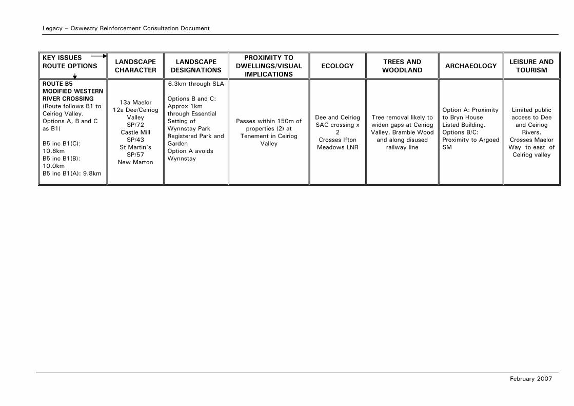
Legacy – Oswestry Reinforcement Consultation Document
February 2007
KEY ISSUES ROUTE OPTIONS
LANDSCAPE CHARACTER
LANDSCAPE DESIGNATIONS
PROXIMITY TO DWELLINGS/VISUAL
IMPLICATIONS ECOLOGY
TREES AND WOODLAND
ARCHAEOLOGY LEISURE AND
TOURISM
ROUTE B5 MODIFIED WESTERN RIVER CROSSING (Route follows B1 to Ceiriog Valley. Options A, B and C as B1) B5 inc B1(C): 10.6km B5 inc B1(B): 10.0km B5 inc B1(A): 9.8km
13a Maelor 12a Dee/Ceiriog
Valley SP/72
Castle Mill SP/43
St Martin’s SP/57
New Marton
6.3km through SLA
Options B and C: Approx 1km through Essential Setting of Wynnstay Park Registered Park and Garden Option A avoids Wynnstay
Passes within 150m of properties (2) at
Tenement in Ceiriog Valley
Dee and Ceiriog SAC crossing x
2 Crosses Ifton Meadows LNR
Tree removal likely to widen gaps at Ceiriog Valley, Bramble Wood
and along disused railway line
Option A: Proximity to Bryn House Listed Building. Options B/C: Proximity to Argoed SM
Limited public access to Dee and Ceiriog
Rivers. Crosses Maelor Way to east of
Ceiriog valley
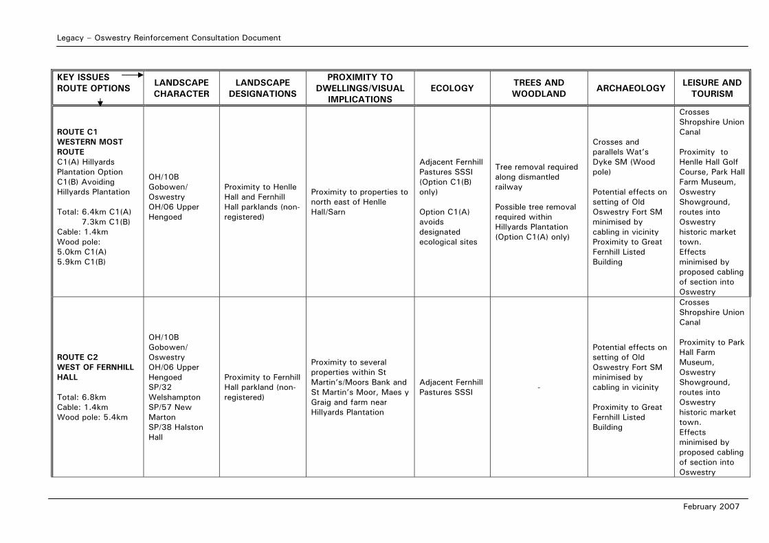
Legacy – Oswestry Reinforcement Consultation Document
February 2007
KEY ISSUES ROUTE OPTIONS
LANDSCAPE CHARACTER
LANDSCAPE DESIGNATIONS
PROXIMITY TO DWELLINGS/VISUAL
IMPLICATIONS ECOLOGY
TREES AND WOODLAND
ARCHAEOLOGY LEISURE AND
TOURISM
ROUTE C1 WESTERN MOST ROUTE C1(A) Hillyards Plantation Option C1(B) Avoiding Hillyards Plantation Total: 6.4km C1(A) 7.3km C1(B) Cable: 1.4km Wood pole: 5.0km C1(A) 5.9km C1(B)
OH/10B Gobowen/ Oswestry OH/06 Upper Hengoed
Proximity to Henlle Hall and Fernhill Hall parklands (non-registered)
Proximity to properties to north east of Henlle Hall/Sarn
Adjacent Fernhill Pastures SSSI (Option C1(B) only) Option C1(A) avoids designated ecological sites
Tree removal required along dismantled railway Possible tree removal required within Hillyards Plantation (Option C1(A) only)
Crosses and parallels Wat’s Dyke SM (Wood pole) Potential effects on setting of Old Oswestry Fort SM minimised by cabling in vicinity Proximity to Great Fernhill Listed Building
Crosses Shropshire Union Canal Proximity to Henlle Hall Golf Course, Park Hall Farm Museum, Oswestry Showground, routes into Oswestry historic market town. Effects minimised by proposed cabling of section into Oswestry
ROUTE C2 WEST OF FERNHILL HALL Total: 6.8km Cable: 1.4km Wood pole: 5.4km
OH/10B Gobowen/ Oswestry OH/06 Upper Hengoed SP/32 Welshampton SP/57 New Marton SP/38 Halston Hall
Proximity to Fernhill Hall parkland (non-registered)
Proximity to several properties within St Martin’s/Moors Bank and St Martin’s Moor, Maes y Graig and farm near Hillyards Plantation
Adjacent Fernhill Pastures SSSI -
Potential effects on setting of Old Oswestry Fort SM minimised by cabling in vicinity Proximity to Great Fernhill Listed Building
Crosses Shropshire Union Canal Proximity to Park Hall Farm Museum, Oswestry Showground, routes into Oswestry historic market town. Effects minimised by proposed cabling of section into Oswestry
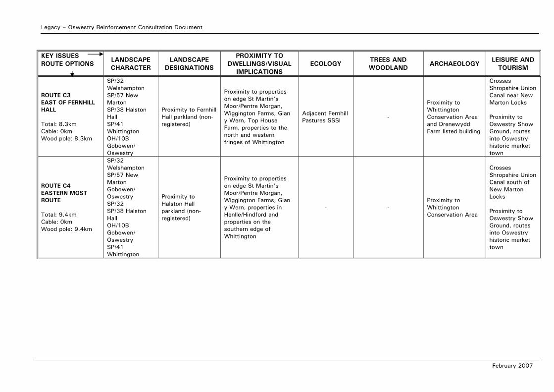
Legacy – Oswestry Reinforcement Consultation Document
February 2007
KEY ISSUES ROUTE OPTIONS
LANDSCAPE CHARACTER
LANDSCAPE DESIGNATIONS
PROXIMITY TO DWELLINGS/VISUAL
IMPLICATIONS ECOLOGY
TREES AND WOODLAND
ARCHAEOLOGY LEISURE AND
TOURISM
ROUTE C3 EAST OF FERNHILL HALL Total: 8.3km Cable: 0km Wood pole: 8.3km
SP/32 Welshampton SP/57 New Marton SP/38 Halston Hall SP/41 Whittington OH/10B Gobowen/ Oswestry
Proximity to Fernhill Hall parkland (non-registered)
Proximity to properties on edge St Martin’s Moor/Pentre Morgan, Wiggington Farms, Glan y Wern, Top House Farm, properties to the north and western fringes of Whittington
Adjacent Fernhill Pastures SSSI -
Proximity to Whittington Conservation Area and Drenewydd Farm listed building
Crosses Shropshire Union Canal near New Marton Locks Proximity to Oswestry Show Ground, routes into Oswestry historic market town
ROUTE C4 EASTERN MOST ROUTE Total: 9.4km Cable: 0km Wood pole: 9.4km
SP/32 Welshampton SP/57 New Marton Gobowen/ Oswestry SP/32 SP/38 Halston Hall OH/10B Gobowen/ Oswestry SP/41 Whittington
Proximity to Halston Hall parkland (non-registered)
Proximity to properties on edge St Martin’s Moor/Pentre Morgan, Wiggington Farms, Glan y Wern, properties in Henlle/Hindford and properties on the southern edge of Whittington
- - Proximity to Whittington Conservation Area
Crosses Shropshire Union Canal south of New Marton Locks Proximity to Oswestry Show Ground, routes into Oswestry historic market town

Legacy – Oswestry Reinforcement Consultation Document
February 2007
APPENDIX 6C: COMPARISON OF ROUTE B1 SUB-OPTIONS
AROUND WYNNSTAY PARK
Legacy – Oswestry Reinforcement Consultation Document
February 2007
APPENDIX 6C:Comparison of Route B1 Options in Vicinity of Wynnstay Park: B1(A), B1(B), and B1(C) Route B1 has three sub-options in the vicinity of Wynnstay Park and Park Eyton. The key issue is the effect upon Wynnstay Park Registered Parkland and its associated setting, which needs to be balanced against the increased effect on visual amenity of residential properties likely if the line is routed around the parkland. The situation is further complicated by the presence of two existing high voltage overhead lines in the vicinity, which take a direct north-south route across the drive connecting Park Eyton Lodge with Wynnstay Park (which is part of the registered parkland) and through the Essential Setting of the parkland. They are located approximately 0.25km west of Argoed Farm. There is a Scheduled Monument at Argoed Farm. Park Eyton Lodge, The Kennels (both associated with Wynnstay Hall) and Bryn House are listed buildings. Route B1(A) is the most direct, taking a broadly north to south route approximately 0.3km east of the existing 132kV and 400kV overhead lines, and crossing both a short section of the Registered Parkland and a greater extent of its Essential Setting. This option may have some effect on the setting of the Scheduled Monument at Argoed Farm, (and upon the visual amenity of the farmhouse, which has views south and eastwards) although the route would be partially backgrounded by The Drive Wood in views eastwards from Argoed.
Route B1(C) is the longest and least direct, avoiding the Essential Setting of the park. It is likely to have the greatest effect of these sub-options upon the visual amenity and setting of The Kennels and Bryn House, but would have little effect upon Park Eyton Lodge or Argoed Farm. In taking a route south-eastwards to Park Eyton and then south-westwards, this route is the least sympathetic of the three options to the local topography, which is a series of gentle ridges and intervening hollows, orientated in a north-south direction. It also takes a route through more open land than the other options. Option B1(B) takes the middle route, geographically, crossing the short section of Registered Parkland at the same point as Option B1(A). It would have a similar effect upon the Scheduled Monument and listed buildings as Option B1(A). The route alignment alongside The Drive Wood is considered to offer a greater extent of backgrounding (in views from the road network including the A539) than the more direct option, and so Option B1(B) is preferred to B1(A).
Although it is less sympathetic to local topography, and introduces potential effects on the setting of two listed buildings, Option B1(C) is preferred as it does not affect the Registered Parkland or its Essential Setting, and it avoids Argoed Farm and Scheduled Monument. Option B1(C) is the preferred option in the vicinity of Wynnstay Park.
Legacy – Oswestry Reinforcement Consultation Document
February 2007
APPENDIX 6D: COMPARISON OF ROUTE B3 SUB-OPTIONS
FOR CROSSING THE RIVER DEE
Legacy – Oswestry Reinforcement Consultation Document
February 2007
APPENDIX 6D: Comparison of Route B3 Options Crossing the River Dee: B3(A) and B3(B)
Route B3 has two options in the vicinity of the river Dee crossing. Option B3(B) takes a route to cross from north to south of the river, following an alignment sympathetic to local landform, and utilising existing woodlands for backgrounding, particularly north of the river. Option B3(A) takes a more direct and open route over a local ridgeline north of its river crossing point.
Although both river crossing points have been selected to minimise riverside tree loss, option B3(B) would cross Sodylt Wood, an area of Ancient Semi-Natural Woodland, managed by the Woodland Trust.
Option B3(B) would be routed close to four listed buildings, Wyffydd and three buildings in the vicinity of Sodylt Hall, which B3(A) would not affect.
The recreational route Llwybr Maelor Way follows minor lanes on the southern bank of the Dee. Option B3(B) would cross it twice in the vicinity of Sodylt and closely parallel the path for approximately 1km. The route of this option on the upper bank of the Dee would provide little opportunity for backgrounding (Sodylt Wood is at a lower level) and so is likely to affect views westwards over the Dee valley from the footpath. Option B3(A) would have a lesser effect, crossing the path once at 90 degrees.
A variation of B3(B), running alongside the northern bank of the Dee and crossing at the same point as option B3(A), rather than crossing east of Lower Farm, is considered preferable to B3(B) in terms of overall visibility from the surrounding area and effect upon Sodylt Hall buildings. It would, however, be closely aligned with a public right of way alongside the Dee on its northern bank. Option B3(A) provides a more direct crossing of the Dee valley, and is considered to have the lesser impact upon visual amenity of footpath users, listed buildings and residential properties. Option B3(A) is the preferred option for Route B3 crossing the River Dee.

Legacy – Oswestry Reinforcement Consultation Document
February 2007
APPENDIX 6E: COMPARISON OF ROUTE C1 SUB-OPTIONS
IN THE RIVER PERRY VALLEY
Legacy – Oswestry Reinforcement Consultation Document
February 2007
APPENDIX 6E: Comparison of Route C1 Options in the River Perry Valley: C1(A) and C1(B) To the east of Gobowen, Option C1 has two options to negotiate a way through the Hillyards Plantation and Fernhill Pastures and other woodlands and meadows associated with the shallow valley of the river Perry. Option C1(A) takes the most direct route across the valley, following the western edge of Hillyards Plantation and maintaining distance from the few properties in the vicinity. Option C1(B) is routed further east, avoiding Hillyards Plantation and crossing the valley immediately adjacent to Fernhill Pastures, a SSSI. Option C1(B) crosses three minor lanes and would be within closer proximity to isolated properties (less than 5) than Option C1(A). On this basis, Option C(1)A is preferred as it has lower effects on views and avoids Fernhill Pastures SSSI. An additional consideration is that Option C1(A) occupies the route of an existing low voltage (33kV) overhead line for approximately 1km, and accommodating the higher voltage overhead line may require tree removal from the small plantation to the west of Hillyards Plantation. However this was not considered to be sufficient to change the preferred option from C1(A) to C1(B). The preferred option for Route C1 in the River Perry Valley is C1(A).

Legacy Oswestry ConsultationSP Manweb
3 Prenton WayCH43 3ET
Legacy Oswestry ConsultationSP Manweb
3 Prenton WayCH43 3ET