proposed school extension prince william school …...2015/04/09 · proposed school extension...
TRANSCRIPT
Cedar Barn, White Lodge, Walgrave, Northampton, NN6 9PY
T: F: E:
W:
01604 781811 01604 781999
[email protected] jppuk.net
Proposed School Extension Prince William School
Herne Road, Oundle Northamptonshire
Transport Assessment
Revision B: April 2015 R-TS-S7426FA-01-C

Proposed School Extension Prince William School, Oundle, Northamptonshire Transport Assessment
R-TS-S7426FA-01-C Page 1 April 2015
Proposed School Extension Prince William School
Herne Road, Oundle Northamptonshire
Transport Assessment
JPP Consulting Ltd., Cedar Barn, White Lodge, Walgrave, Northampton, NN6 9PY
T: 01604 781811 F: 01604 781999 E: [email protected] W: jppuk.net Report Reference Date
R-TS-S7426FA-01-C Revision C: April 2015
Report Originators
Prepared by
Katherine Jenner BSc (Hons)
Graduate Engineer
Reviewed by
Martin Andrews MEng (Hons) MCIHT
Associate
Revision Date Description Prepared Reviewed 0 20th Feb 2015 Original Report Katherine Jenner Martin Andrews A 26th March 2015 Update to TA Martin Andrews B 30th March 2015 Change to parking arrangements Martin Andrews C 9th April 2015 Updated to suit comments from
Northamptonshire Highways Katherine Jenner Martin Andrews

Proposed School Extension Prince William School, Oundle, Northamptonshire Transport Assessment
R-TS-S7426FA-01-C Page 2 April 2015
Contents 1.0 Introduction ..................................................................................................................... 4
1.1 Background ............................................................................................................................ 4 1.2 Consultation ............................................................................................................................ 5 1.3 Revision Record ....................................................................................................................... 5
2.0 Site Description and Development Proposals ..................................................................... 6
2.1 Site Location ........................................................................................................................... 6 2.2 Development Description ...................................................................................................... 6 2.3 Vehicular Access ..................................................................................................................... 6 2.4 Pedestrian and Cycle Access .................................................................................................. 6 2.5 Parking.................................................................................................................................... 7
3.0 Existing Conditions ............................................................................................................ 8
3.1 Road Network ........................................................................................................................ 8 3.2 Pedestrian Facilities ............................................................................................................... 8 3.3 Cycle Facilities ........................................................................................................................ 8 3.4 School Transport .................................................................................................................... 8 3.5 Public Buses ............................................................................................................................ 9 3.6 Rail ........................................................................................................................................... 9 3.7 Summary .............................................................................................................................. 10
4.0 Traffic Flow Observations ................................................................................................ 11
5.0 Accessibility .................................................................................................................... 13
5.1 Walking................................................................................................................................. 13 5.2 Cycling .................................................................................................................................. 13 5.3 School Transport .................................................................................................................. 14 5.4 Public Buses .......................................................................................................................... 14 5.5 Summary .............................................................................................................................. 14
6.0 Trip Generation and Distribution ..................................................................................... 15
7.0 Junction Analysis ............................................................................................................ 19
7.1 Introduction ......................................................................................................................... 19 7.2 Background Traffic ............................................................................................................... 19 7.3 Committed Development Traffic ......................................................................................... 19 7.4 Assessment Periods ............................................................................................................. 19 7.5 Junction Analysis: Herne Rd / South Road ........................................................................... 20
8.0 Parking Accumulation ..................................................................................................... 21
9.0 Internal Circulation ......................................................................................................... 24
10.0 Conclusions .................................................................................................................... 25
Proposed School Extension Prince William School, Oundle, Northamptonshire Transport Assessment
R-TS-S7426FA-01-C Page 3 April 2015
Appendix A .................................................................................................................................. A
Site Location Plan ................................................................................................................................ A JPP drawing no. S7426PM-TA01 ......................................................................................................... A
Appendix B .................................................................................................................................. B
Site Strategy Plan ................................................................................................................................ B pHp Architects drawing no.4157/01/P6 ............................................................................................. B
Appendix C .................................................................................................................................. C
Walking Distances ............................................................................................................................... C JPP drawing no. S7426FA-TA02 .......................................................................................................... C
Appendix D ................................................................................................................................. D
Bus Maps and Timetables ...................................................................................................................D
Appendix E .................................................................................................................................. E
Site Observations – Traffic Movements – 25th February 2015 ........................................................... E
Appendix F .................................................................................................................................. F
Site Observations – Parking Drawings – 25th February 2015 .............................................................. F JPP drawing no. S7426FA-TA07 to TA11 ............................................................................................. F
Appendix G ................................................................................................................................. G
Home Locations ................................................................................................................................. G JPP drawing no. S7426FA-TA06 ......................................................................................................... G
Appendix H ................................................................................................................................. H
Trip Movement Diagrams .................................................................................................................. H JPP drawings no. S7426FA-TA03, TA04 and TA05.............................................................................. H
Appendix I .................................................................................................................................... I
Traffic Counts and Parking Accumulation Data ................................................................................... I
Appendix J .................................................................................................................................... J
Vehicle Movement Matrices – Herne Road / South Road ................................................................... J
Appendix K .................................................................................................................................. K
Junction Analysis Results – Herne Road / South Road ....................................................................... K
Appendix L ................................................................................................................................... L
Swept Path Analysis Drawings ............................................................................................................ L JPP drawings S7426/FA-T40 to T44..................................................................................................... L
Proposed School Extension Prince William School, Oundle, Northamptonshire Transport Assessment
R-TS-S7426FA-01-C Page 4 April 2015
1.0 Introduction 1.1 Background 1.1.1 This report has been prepared by JPP Consulting Limited on behalf of Lend Lease to
support a planning application for the extension of Prince William School. The benefit of this report is limited to our instructing Client.
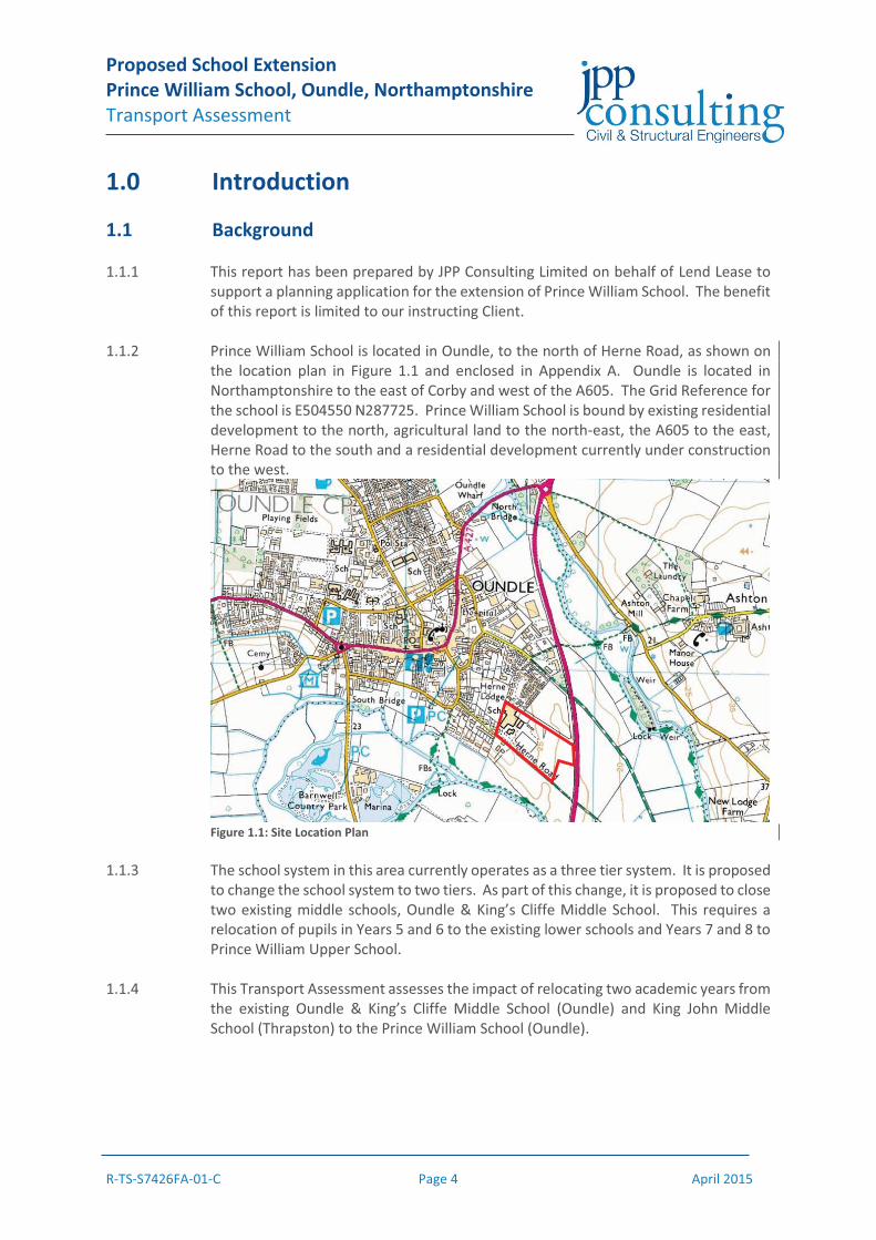
1.1.2 Prince William School is located in Oundle, to the north of Herne Road, as shown on
the location plan in Figure 1.1 and enclosed in Appendix A. Oundle is located in Northamptonshire to the east of Corby and west of the A605. The Grid Reference for the school is E504550 N287725. Prince William School is bound by existing residential development to the north, agricultural land to the north-east, the A605 to the east, Herne Road to the south and a residential development currently under construction to the west.
Figure 1.1: Site Location Plan 1.1.3 The school system in this area currently operates as a three tier system. It is proposed
to change the school system to two tiers. As part of this change, it is proposed to close two existing middle schools, Oundle & King’s Cliffe Middle School. This requires a relocation of pupils in Years 5 and 6 to the existing lower schools and Years 7 and 8 to Prince William Upper School.
1.1.4 This Transport Assessment assesses the impact of relocating two academic years from
the existing Oundle & King’s Cliffe Middle School (Oundle) and King John Middle School (Thrapston) to the Prince William School (Oundle).
Proposed School Extension Prince William School, Oundle, Northamptonshire Transport Assessment
R-TS-S7426FA-01-C Page 5 April 2015
1.2 Consultation 1.2.1 A meeting was held with Mr Richard Hall of Northamptonshire County Council (NCC)
on Tuesday 24th February 2015. Prior to this meeting a draft Transport Statement was issued to NCC. At this meeting the following additional survey information was requested:
� Junction analysis – Herne Road / South Road; � Parking accumulation survey – Oundle School; and � Parking accumulation / beat survey – Herne Road.
1.3 Revision Record 1.3.1 A Transport Statement has been submitted to NCC, as described above. This report
has been amended to from a Transport Assessment. Revisions from the previously submitted Transport Statement are marked by a vertical line in the right hand column.

Proposed School Extension Prince William School, Oundle, Northamptonshire Transport Assessment
R-TS-S7426FA-01-C Page 6 April 2015
2.0 Site Description and Development Proposals 2.1 Site Location 2.1.1 Prince William School is located in Oundle, to the north of Herne Road, as shown on
the location plan in Figure 1.1 and enclosed in Appendix A. Oundle is located in Northamptonshire to the east of Corby and west of the A605. Prince William School is bound by existing residential development to the north, agricultural land to the north-east, the A605 to the east, Herne Road to the south and a residential development currently under construction to the west.
2.2 Development Description 2.2.1 Prince William School is currently an Upper School catering for 1190 pupils in years 9,
10, 11, 12 and 13 (6th form). From September 2015 Prince William School will be a Secondary School and cater for 1750 pupils in years 7, 8, 9, 10, 11 12 and 13. To accommodate these extra pupils on the Prince William School site, additional classrooms will be required.
2.2.2 The proposed extension of Prince William School is to accommodate Year 7 and 8
pupils from Oundle & King’s Cliffe Middle School and King John Middle School which are planned to close in August 2015. The extension will comprise the addition of temporary buildings to accommodate an increase in the maximum pupil capacity from 1,190 pupils at present to 1,750 pupils from September 2015. There will also be an increase in total staff from 142 to 175 by September 2015. The layout of the proposed school expansion is shown on the plan enclosed in Appendix B. Over time, the temporary classrooms will be removed, to be replaced with permanent structures.
2.2.3 It should be noted that whilst the consolidation of the school system from three to
two tiers will result in more pupils using Prince William School, it will not result in an increase in pupil spaces within the school system. Hence, this extension does not provide additional school places nor will extra staff be required to teach at the school. The pupils and staff will simply move to the new school site from the existing middle school sites in Oundle and Thrapston.
2.3 Vehicular Access 2.3.1 Prince William School is currently accessed off Herne Road, to the south of the site,
via a simple priority junction. There are currently two accesses off Herne Road: one entrance and one exit. The extended school will continue to be accessed off Herne Road via a simple priority junction, as shown on the drawing enclosed in Appendix B.
2.4 Pedestrian and Cycle Access 2.4.1 Prince William School currently provides a pedestrian access to Herne Road in the
south-west corner of the site. This pedestrian access will remain unchanged following the proposed extension of the school.

Proposed School Extension Prince William School, Oundle, Northamptonshire Transport Assessment
R-TS-S7426FA-01-C Page 7 April 2015
2.5 Parking 2.5.1 The current school parking provision is thus: Cars 143 designated spaces
Mini-buses 2 spaces Coaches (Buses) 16 spaces
2.5.2 The proposed school extension will create 3 new school bus parking bays, resulting in
the loss of 11 car parking spaces. A further 48 car parking spaces will be provided on the site, resulting in an overall gain of 37 car parking spaces. The location of the additional parking bays is shown on the site strategy plan enclosed in Appendix B.

Proposed School Extension Prince William School, Oundle, Northamptonshire Transport Assessment
R-TS-S7426FA-01-C Page 8 April 2015
3.0 Existing Conditions 3.1 Road Network 3.1.1 Prince William School currently has two accesses off Herne Road: an entrance at the
western access and an exit at the eastern access. Herne Road is a cul-de-sac serving the school and 32 residential dwellings. A new development is under construction which will serve 140 dwellings; this development will be accessed via Herne Road.
3.1.2 To the west of the entrance, Herne Road has a width of 6.0m. Extending east of the
existing entrance towards the exit, Herne Road reduces in width to 4.2m. Herne Road does not extend further east than the school’s exit.
3.1.3 Herne Road provides connections to Oundle town centre and the A427. In turn, the
A427 provides connections to the A43 to the west and the A605 to the east. 3.1.4 Herne Road is subject to a 30mph speed limit and is street lit. The roads within the
school site are subject to a 10mph speed limit. 3.2 Pedestrian Facilities 3.2.1 To the west of the current school entrance, Herne Road is bound by a single 1.2m wide
footway to the school side (north) of the carriageway. Dropped kerbs are generally provided at the appropriate locations.
3.2.3 Walking distances are shown on the plan enclosed in Appendix C. 3.3 Cycle Facilities 3.3.1 There are limited dedicated cycling facilities within the vicinity of Prince William
School. 3.4 School Transport 3.4.1 Northamptonshire County Council currently provides a significant number of bus
services direct to the existing middle schools and Prince William School for those pupils living outside a 3 mile radius. This legal obligation to provide school transport will continue with the school amalgamation. Whilst the number of pupils who require school transport services varies each year, Prince William School will have additional bus services operating at the school as it will now need to accommodate pupils who relocate from Oundle & King’s Cliffe Middle School and King John Middle School.
3.4.2 The school bus services offers pupils at Prince William School a sustainable alternative
to the private car.
Proposed School Extension Prince William School, Oundle, Northamptonshire Transport Assessment
R-TS-S7426FA-01-C Page 9 April 2015
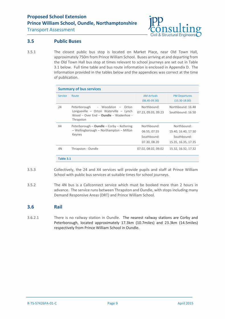
3.5 Public Buses 3.5.1 The closest public bus stop is located on Market Place, near Old Town Hall,
approximately 750m from Prince William School. Buses arriving at and departing from the Old Town Hall bus stop at times relevant to school journeys are set out in Table 3.1 below. Full time table and bus route information is enclosed in Appendix D. The information provided in the tables below and the appendices was correct at the time of publication.
Summary of bus services Service Route AM Arrivals
(06.45-09.30)
PM Departures
(15.30-18.00)
24 Peterborough - Woodston – Orton Longueville – Orton Waterville – Lynch Wood – Over End – Oundle – Wadenhoe - Thrapston
Northbound: 07.23, 09.03, 09.23
Northbound: 16.48 Southbound: 16.50
X4 Peterborough – Oundle – Corby – Kettering – Wellingborough – Northampton – Milton Keynes
Northbound: 06.55, 07.55 Southbound: 07.30, 08.20
Northbound: 15.40, 16.40, 17.50
Southbound: 15.35, 16.35, 17.35
4N Thrapston - Oundle 07.02, 08.02, 09.02 15.32, 16.32, 17.32
Table 3.1
3.5.3 Collectively, the 24 and X4 services will provide pupils and staff at Prince William
School with public bus services at suitable times for school journeys. 3.5.2 The 4N bus is a Callconnect service which must be booked more than 2 hours in
advance. The service runs between Thrapston and Oundle, with stops including many Demand Responsive Areas (DRT) and Prince William School.
3.6 Rail 3.6.2.1 There is no railway station in Oundle. The nearest railway stations are Corby and
Peterborough, located approximately 17.3km (10.7miles) and 23.3km (14.5miles) respectively from Prince William School in Oundle.
Proposed School Extension Prince William School, Oundle, Northamptonshire Transport Assessment
R-TS-S7426FA-01-C Page 10 April 2015
3.7 Summary 3.7.1 Prince William School is located in Oundle, to the north of Herne Road. The extended
school will continue to be accessed off Herne Road. 3.7.2 The proposed development has adequate links to the existing walking infrastructure.
3.7.3 Northamptonshire County Council currently provides a number of school buses direct
to the school for those pupils living outside the 3 mile radius. These school bus services offer pupils at Prince William School a sustainable alternative to the private car.
3.7.4 The nearest bus stop to Prince William School offers public bus services at times
suitable for school journeys. 3.7.5 The nearest railway stations are Corby and Peterborough, located approximately
17.3km (10.7miles) and 23.3km (14.5miles) respectively from Prince William School in Oundle.
Proposed School Extension Prince William School, Oundle, Northamptonshire Transport Assessment
R-TS-S7426FA-01-C Page 11 April 2015
4.0 Traffic Flow Observations 4.1 On site observations of vehicle movements and parking were completed on
Wednesday 25th February between 0800-0900 and 1500-1600. The weather was dry on the day of observation.
4.2 Construction work had started on the Kier Housing Development which accesses
Herne Road between nos. 25 and 27. The site is at an early stage and onsite parking had not been fully established, hence, a small number of vehicles associated with the construction works were parked on Herne Road near the site’s access.
Morning Observation: 0800 to 0900 4.3 During the observation period, traffic was typically free flowing on Herne Road with
two exceptions as described below. Parents / guardians who were dropping off their child(ren) at the school entered the school site, pulled up to drop off and then left via the site’s egress. This ensured the free movement of vehicles. The school buses also followed this same operation and did not park up in the school, only waiting whilst pupils disembarked. A photographic record of the survey is enclosed in Appendix E.
1. At the junction of Herne Road and South Street, cars parked on the north
side (see below) preventing free flow of traffic on Herne Road. This meant that eastbound traffic occasionally had to wait for westbound traffic on Herne Road in order to access the school. When school buses arrived this could occasionally cause limited duration blocking of the junction whilst school buses waited for westbound vehicles to pass the parked cars. The waiting and occasional blocking was of limited duration. To overcome this issue, the junction double yellow lines could be extended further away from the junction to create more free space for vehicle movements near the junction. However, this will be to the detriment of residents without driveways who prefer to park outside their house. It is therefore not recommended that this improvement is carried out.
2. Where road width was restricted by parked vehicles associated with the construction works, occasional waiting of vehicles was observed. This is a time limited restriction and does not need to be addressed.
4.4 The location of cars parked on Herne Road at 0800 is shown on the drawing enclosed
in Appendix F. The cars parked at the western end of Herne Road were residential cars that typically did not move for the duration of the survey period. A second area of parked cars was located near the construction site for the new residential development. At 0800 there were no cars parked on Herne Road that we could associate with the school.
4.5 As the start of the school day approached (approx. 0845) 6th form students were
observed parking near the school as shown on the drawing enclosed in Appendix F.
Proposed School Extension Prince William School, Oundle, Northamptonshire Transport Assessment
R-TS-S7426FA-01-C Page 12 April 2015
Afternoon Observation: 1500 to 1600 4.6 During the evening peak, again the movement of vehicles was fairly well co-ordinated
with the following happening, as shown on the photographic record enclosed in Appendix E:
� Parents parked on Herne Road waiting for their children to leave school. The extent of cars parked with waiting parents is shown on drawing TA10 enclosed on Appendix F.
� School buses arrived typically 1520 ready for school finishing at 1530. � Parents started leaving as and when their child(ren) left school. � The buses departed at approximately 1540 once filled, with all buses leaving
at once. 4.7 Generally this operation appeared to work well, however, on the day of observation
we would note the following:
� A couple of buses arrived late and struggled to get into the school due to a small number of cars entering the site and cars parked in the bus bays. This caused blocking of Herne Way by the school access and prevented the free flow of vehicles, particularly staff and parents who had parked within the school site.
� Parked cars, particularly those associated with the construction site, prohibited the free flow of two way traffic. It should be noted that a significant proportion of parent and 6th form vehicles had left by the time the school buses departed. Although free flow of two way traffic was restricted in places, we would note that the limited volume of traffic headed towards the school meant that this did not cause significant congestion.
4.8 From observation it would appear that fewer pupils were picked up from the school
in the PM peak than were dropped off in the morning. 4.9 Overall we consider the school has a good system for dealing with the flow of traffic
during the PM peak, however, better parking management of the bus turning area to prevent cars parking in bus bays and stop new cars entering would ensure that the above noted problems do not occur in the future.
4.10 The proposed extension of the school will provide additional bus parking spaces and
should hopefully reduce the risk of the above noted problems occurring again.
Observation Summary 4.11 Herne Road and its junction with South Road is shown to operate smoothly in both
the morning and evening peak periods with limited restrictions to movement. 4.12 Better management of the bus parking area should reduce the likelihood of vehicles
blocking the top of Herne Road as observed. However, we understand that the issues observed whilst not unusual are far from common.
Proposed School Extension Prince William School, Oundle, Northamptonshire Transport Assessment
R-TS-S7426FA-01-C Page 13 April 2015
5.0 Accessibility
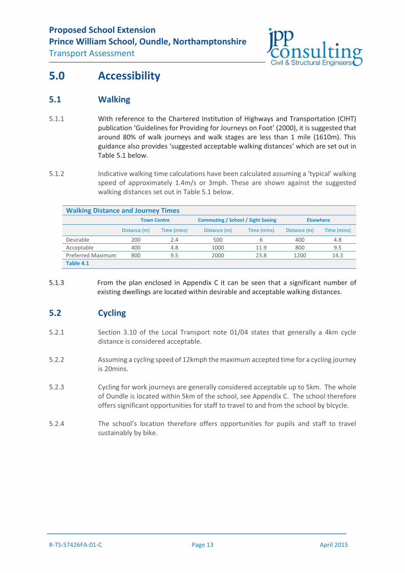
5.1 Walking 5.1.1 With reference to the Chartered Institution of Highways and Transportation (CIHT)
publication ‘Guidelines for Providing for Journeys on Foot’ (2000), it is suggested that around 80% of walk journeys and walk stages are less than 1 mile (1610m). This guidance also provides ‘suggested acceptable walking distances’ which are set out in Table 5.1 below.
5.1.2 Indicative walking time calculations have been calculated assuming a ‘typical’ walking
speed of approximately 1.4m/s or 3mph. These are shown against the suggested walking distances set out in Table 5.1 below.
Walking Distance and Journey Times Town Centre Commuting / School / Sight Seeing Elsewhere
Distance (m) Time (mins) Distance (m) Time (mins) Distance (m) Time (mins)
Desirable 200 2.4 500 6 400 4.8 Acceptable 400 4.8 1000 11.9 800 9.5 Preferred Maximum 800 9.5 2000 23.8 1200 14.3 Table 4.1
5.1.3 From the plan enclosed in Appendix C it can be seen that a significant number of
existing dwellings are located within desirable and acceptable walking distances.
5.2 Cycling 5.2.1 Section 3.10 of the Local Transport note 01/04 states that generally a 4km cycle
distance is considered acceptable. 5.2.2 Assuming a cycling speed of 12kmph the maximum accepted time for a cycling journey
is 20mins. 5.2.3 Cycling for work journeys are generally considered acceptable up to 5km. The whole
of Oundle is located within 5km of the school, see Appendix C. The school therefore offers significant opportunities for staff to travel to and from the school by bicycle.
5.2.4 The school’s location therefore offers opportunities for pupils and staff to travel
sustainably by bike.
Proposed School Extension Prince William School, Oundle, Northamptonshire Transport Assessment
R-TS-S7426FA-01-C Page 14 April 2015
5.3 School Transport 5.3.1 Due to the school’s predominantly rural catchment, the school provides a significant
number of free bus places to pupils located further than 3 radial miles from the school site. The existing school bus services are described in Section 3.4. These services will provide opportunities for staff and pupils to travel to and from the school sustainably.
5.4 Public Buses 5.4.1 The closest bus stop is located on Market Place, near Old Town Hall, approximately
750m from Prince William School. The existing public bus services using the Old Town Hall bus stop are described in Section 3.5. These services will provide opportunities for staff and pupils to travel to and from the school sustainably.
5.5 Summary 5.5.1 It can be seen that the school is adequately served by more sustainable forms of
transport.

Proposed School Extension Prince William School, Oundle, Northamptonshire Transport Assessment
R-TS-S7426FA-01-C Page 15 April 2015
6.0 Trip Generation and Distribution 6.1 Due to the predominately rural catchment of Prince William School the use of
standard TRICS trip rates would not provide an accurate assessment of vehicle trips to the school.
6.2 Mode of travel data for pupils of Prince William School was obtained in January 2015
to represent the school year starting in September 2014, based on the current school occupancy of 826. The number and percentage of pupils travelling by each mode of travel is detailed in Table 6.1 below.
Mode of Travel: September 2014 September 2014 (Pupils 826) Mode of Travel Number Percentage (%)
Taxi 6 0.7 Walk 152 18.4 Dedicated school bus 542 65.6 Car or van 89 10.8 Car share 27 3.3 Public bus service 6 0.7 Cycle 1 0.1 Not known 3 0.4 TOTAL 826 100% Table 6.1
6.3 The September 2014 mode of travel data shows that 89.2% of pupils travel to school
using more sustainable forms of transport which means that only 10.8% of pupils travel to school by car.
6.4 The introduction of years 7 and 8 to Prince William School is likely to change the mode
split as more pupils, particularly from King John, will be travelling further and therefore will qualify for school transport.
6.5 Mode of travel data for the school year starting in September 2015 has been predicted
by Northamptonshire County Council, based on the expected school occupancy of 1226 pupils. This prediction takes into consideration pupils moving up a school year and the additional Year 7 and 8 pupils moving to Prince William School from Oundle & King’s Cliffe Middle School and King John Middle School. The predicted number and percentage of pupils travelling by each mode of transport from September 2015 is detailed in Table 6.2 below.

Proposed School Extension Prince William School, Oundle, Northamptonshire Transport Assessment
R-TS-S7426FA-01-C Page 16 April 2015
Mode of Travel: September 2015 September 2015 (Pupils 1226) Mode of Travel Number Percentage (%)
Taxi 4 0.3 Walk 216 17.7 Dedicated school bus 872 71.4 Car or van 106 8.7 Car share 17 1.4 Public bus service 2 0.2 Cycle 1 0.1 Not known 3 0.2 TOTAL 1226 100% Table 6.2
6.6 The change in school operation is predicted to result in more pupils using dedicated
bus transport with fewer pupils travelling by car. The change in pupils travelling by school bus or by car between the school years starting September 2014 and September 2015 are shown in Table 6.3 below. Pupils travelling by school bus is predicted to increase by 5.8 percentage points with pupils travelling by car decreasing by 2.1 percentage points between the school year starting September 2014 and September 2015. This shift in mode of travel is likely to be predominately caused by pupils who are currently travelling to King John Middle School in Thrapston now travelling to Prince William School in Oundle from September 2015.
Change in mode of travel: September 2014 to September 2015 September 2014 (Pupils 826) September 2015 (Pupils 1226) Mode of Travel Number Percentage (%) Number Percentage (%)
Dedicated school bus 542 65.6 872 71.4 Car or van 89 10.8 106 8.7 Table 6.3
6.7 The maximum capacity of Prince William School is increasing from 1190 pupils for the
school year starting September 2014 to 1750 pupils for the school year starting September 2015. To assume a worst case scenario, the mode of travel data from September 2014 has been utilised which will result in a higher number of predicted pupil car trips. The number of trips by mode for September 2014 and 2015 is shown in Table 6.4.

Proposed School Extension Prince William School, Oundle, Northamptonshire Transport Assessment
R-TS-S7426FA-01-C Page 17 April 2015
Change in mode of travel for maximum capacity: September 2014 to September 2015 Mode of Travel
Travel Mode September 2014 September 2015
Difference September
2014
Max Capacity:
1190 pupils
Max Capacity:
1750 pupils
Percentage Numbers Numbers Numbers
Taxi 0.7 9 13 4 Walk 18.4 219 322 103 Dedicated school bus
65.6 781 1148 367
Car or van 10.8 128 189 60 Car share 3.3 39 57 18 Public bus service 0.7 9 13 4 Cycle 0.1 1 2 1 Not known 0.4 4 6 2 TOTAL 100% 1190 1750 560 Table 6.4
6.8 The proposed change in the operation of the school system from a three tiered system
to a two tiered system will result in an increase of 560 new all mode pupil trips at Prince William School. Of these 60 new pupils are expected to arrive by private car. Although there are estimated to be 60 new pupils arriving by car at Prince William School, it should be remembered that all of these pupils are already in the school system and will currently be generating movements on the highway network. Hence, these are diverted vehicle trips and not new vehicle trips.
6.9 Total staff at Prince William School will increase from 142 at present to 175 from
September 2015. Whilst new staff working at Prince William School, these staff will already be working at the Middle Schools. Hence, these are not new trips on the highway network. It is assumed that all of these trips will be by private car, although they will be diverted and not new trips on the highway network. For the purposes of the above analysis, whilst it is assumed that all staff will travel by car it is also assumed that all staff which arrive outside of the peak periods associated with the school and will therefore have not been considered.
6.9 To try and understand where these trips have diverted from, a distribution and
assignment exercise has been completed, see drawing enclosed in Appendix G. This is based on postcode data for pupils in Years 7 and 8 and has been factored up to represent a Years 7 and 8 operating at full capacity.
6.10 Trip movement diagrams for Oundle are enclosed in Appendix H. These diagrams
show:
� TA03 - Vehicle Trips for Year 7 & 8 September 2015 assuming Oundle & King’s Cliffe Middle School does not close;
� TA04 - Vehicle Trips for Year 7 & 8 September 2015 as per proposed plan. i.e. trips to Prince William School; and
� TA05 – Changes in vehicle trip reductions and additions in September 2015.
Proposed School Extension Prince William School, Oundle, Northamptonshire Transport Assessment
R-TS-S7426FA-01-C Page 18 April 2015
6.11 Assuming a worst case scenario where all parents / guardians dropping off children at
the school will return to their home destination, which takes no account of linked trips, the increase in vehicle movements is relatively minor. With the exception of Herne Road / South Road and South Road / Mill Road / Barnwell Road junctions, the maximum increase in vehicle trips is 44 which is unlikely to have a significant adverse impact.
6.12 The Herne Road / South Road junction will see an increase of 60 two way vehicle
vehicle trips, whilst the South Road / Mill Road / Barnwell Road junction will have a predicted increase of 38 two way vehicle trips. We would not expect the above vehicle trip numbers to result in a significant adverse impact at these junctions.

Proposed School Extension Prince William School, Oundle, Northamptonshire Transport Assessment
R-TS-S7426FA-01-C Page 19 April 2015
7.0 Junction Analysis
7.1 Introduction 7.1.1 A junction assessment of the Herne Road / South Road junction has been completed
using Junction 8. The assessment has been completed for existing March 2015 operation and future assessment year of 2026.
7.2 Background Traffic 7.2.1 Vehicle counts at the above junctions were completed on Wednesday 18th March
2015 between 0730-0930 and 1430-1630. The traffic count data is enclosed in Appendix I with trip matrices enclosed in Appendix J.
7.3 Committed Development Traffic 7.3.1 As discussed with Northamptonshire County Council, the following committed
developments have been considered within the assessment:
� 140 dwellings; land off Herne Road – Woods Hardwick Transport Assessment dated August 2012.
7.3.2 Vehicle trip numbers have been obtained from the Transport Assessment submitted
with the planning application. Trip matrices for the committed development are enclosed in Appendix J.
7.4 Assessment Periods 7.4.1 The impact of the development will be considered on the surrounding highway
infrastructure during the morning and evening peak periods of 0800-0900 and the measured afternoon peak 1515-1615.
7.4.2 In line with the requirements of Northamptonshire County Council the assessment
will be completed for a background year of 2015 and a future development year of 2026.
7.4.3 To adjust these traffic counts to the assessment year of 2026 traffic, growth factors
have been utilised from NTEM dataset 6.2 and NTM dataset AF09. Growth factors have been obtained for Oundle. The growth factors are set out in Table 8.5 below.
Tempro Growth Factors
AM Peak PM Peak 2015-2026 1.1604 1.2070
Table 7.5

Proposed School Extension Prince William School, Oundle, Northamptonshire Transport Assessment
R-TS-S7426FA-01-C Page 20 April 2015
7.5 Junction Analysis: Herne Rd / South Road 7.5.1 The junction has been assessed utilising TRL software Junctions 8. The results of the
assessment are summarised in the table below with full input data and results enclosed in Appendix K.
Herne Road / South Road – AM Peak 0800-0900
2015 Background 2026 Background + +Committed +
2026 Background + +Committed + Development
Max RFC Max Queue Max RFC Max Queue Max RFC Max Queue B-AC 0.26 0 0.38 1 0.52 1 C-AB 0.15 0 0.17 0 0.25 0
Table 7.5.1 Herne Road / South Road – PM Peak 1700-1800
2015 Background 2026 Background + +Committed +
2026 Background + +Committed + Development
Max RFC Max Queue Max RFC Max Queue Max RFC Max Queue B-AC 0.31 0 0.41 1 0.55 1 C-AB 0.12 0 0.15 0 0.23 0
Table 7.5.2 7.5.2 The completed junction analysis shows that the Herne Road / South Road junction will
operate significantly within capacity in the future year of 2026 with the proposed extension of Prince William School.
Proposed School Extension Prince William School, Oundle, Northamptonshire Transport Assessment
R-TS-S7426FA-01-C Page 21 April 2015
8.0 Parking Accumulation 8.1 Two parking accumulation exercises have been completed as set out below, full survey
results are enclosed in Appendix I.
� Parking accumulation of Prince William School car park – 0730 to 1730; and � Parking Beat Survey – Herne Road – 0730 to 0930 and 1430 to 1630
8.2 A summary of the Prince William School car park accumulation count is set out in Table
8.2 below. It should be noted that the parking accumulation survey included incoming buses, however, the parking capacity percentage is based on the number of car parking spaces within the site only, hence, the percentage capacity is a worst case assessment.
8.3 The results of the car parking accumulation survey shows that the car park is generally
operating in the order of 85-90% occupancy. This shows that the car park is adequately sized to serve the existing school.
8.4 The proposed extension of the school will provided 37 additional car parking places
on the site. The proposed extension will result in 33 additional staff. The school car park which typically has 5% spare capacity has 7 spare car parking spaces. Hence, the proposed car park extension with the existing car park provision is adequate to serve the proposed development.
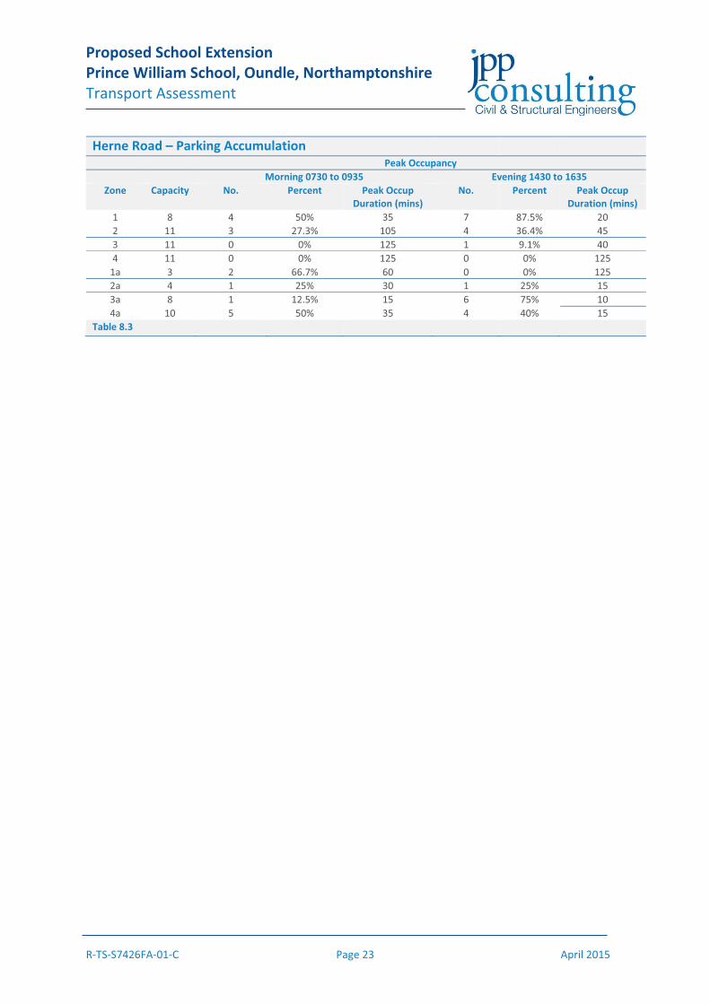
8.4 The parking accumulation exercise completed on Herne Road split the road into four
zones on either side of the carriageway. Within these four zones the vehicular parking capacity was assessed. The peak car parking occupancy by zone with duration of the peak occupancy is shown for the morning and evening peak periods in Table 8.3 below, with full results enclosed in Appendix I.
8.5 From the results it can be seen that Herne Road is not operating at full capacity in
terms of parking space. Zones 3 and 4 have very low parking proportions in line with their use for circulation. As would be expected Zone 1 located near the school has a higher occupancy rate, especially in the evening peak caused by waiting parents / guardians. Whilst Zone 1a has a peak capacity of 66.7% in the morning peak period, this is cleared by 0820 which would suggest the traffic is not related to use of Prince William School.
8.6 The parking accumulation survey of Herne Road would indicate that there is spare
capacity for parents / guardians to use Herne Road to park whilst dropping off or waiting to pick child(ren) up from school.

Proposed School Extension Prince William School, Oundle, Northamptonshire Transport Assessment
R-TS-S7426FA-01-C Page 22 April 2015
Prince William School – Parking Accumulation
Time Parking Accumulation Percentage Capacity 143 spaces
07:30 13 9.1% 07:45 22 15.4% 08:00 37 25.9% 08:15 74 51.7% 08:30 99 69.2% 08:45 129 90.2% 09:00 125 87.4% 09:15 127 88.8% 09:30 129 90.2% 09:45 130 90.9% 10:00 132 92.3% 10:15 130 90.9% 10:30 131 91.6% 10:45 131 91.6% 11:00 134 93.7% 11:15 133 93.0% 11:30 130 90.9% 11:45 128 89.5% 12:00 128 89.5% 12:15 134 93.7% 12:30 130 90.9% 12:45 133 93.0% 13:00 129 90.2% 13:15 122 85.3% 13:30 122 85.3% 13:45 125 87.4% 14:00 123 86.0% 14:15 120 83.9% 14:30 118 82.5% 14:45 117 81.8% 15:00 123 86.0% 15:15 129 90.2% 15:30 97 67.8% 15:45 142 99.3% 16:00 135 94.4% 16:15 136 95.1% 16:30 123 86.0% 16:45 124 86.7% 17:00 112 78.3% 17:15 127 88.8%
Table 8.2
Proposed School Extension Prince William School, Oundle, Northamptonshire Transport Assessment
R-TS-S7426FA-01-C Page 23 April 2015
Herne Road – Parking Accumulation
Peak Occupancy Morning 0730 to 0935 Evening 1430 to 1635
Zone Capacity No. Percent Peak Occup Duration (mins)
No. Percent Peak Occup Duration (mins)
1 8 4 50% 35 7 87.5% 20 2 11 3 27.3% 105 4 36.4% 45 3 11 0 0% 125 1 9.1% 40 4 11 0 0% 125 0 0% 125
1a 3 2 66.7% 60 0 0% 125 2a 4 1 25% 30 1 25% 15 3a 8 1 12.5% 15 6 75% 10 4a 10 5 50% 35 4 40% 15
Table 8.3

Proposed School Extension Prince William School, Oundle, Northamptonshire Transport Assessment
R-TS-S7426FA-01-C Page 24 April 2015
9.0 Internal Circulation 9.1 As described in the observations section during the morning peak period the following
occurs with regard to parent / guardian and bus drop offs:
Parents / guardians who were dropping off their child(ren) at the school entered the school site, pulled up to drop off and then left via the site’s egress. This ensured the free movement of vehicles. The school buses also followed this same operation and did not park up in the school, only waiting whilst pupils disembarked.
9.2 Following the expansion of the school these movements can and will continue to
happen. Hence, the school will / has a drop off are during the morning peak period. 9.3 During the afternoon peak period parents are banned from the school and access is
for buses only. The car park currently provides parking for 16 buses which will be expanded to accommodate 19 buses post redevelopment. The reconfigured car park is shown on the plan enclosed in Appendix B.
9.4 Swept path analysis has been completed to show that the bus parking arrangement is
viable. The buses will be required to park in a certain order and this will be managed by the school. Swept path analysis drawings are enclosed on Appendix L.
9.5 With the existing and new arrangement it is not possible to incorporate a parent /
guardian pick up area for the afternoon peak period. However, observations of the current arrangement and the parking accumulation survey for Herne Road would suggest that the existing highway infrastructure could accommodate the expanded school.
Proposed School Extension Prince William School, Oundle, Northamptonshire Transport Assessment
R-TS-S7426FA-01-C Page 25 April 2015
10.0 Conclusions 10.1 Prince William School is located in Oundle, to the north of Herne Road. Oundle is
located in Northamptonshire to the east of Corby and west of the A605. The Grid Reference for the school is E504550 N287725. Prince William School is bound by existing residential development to the north, agricultural land to the north-east, the A605 to the east, Herne Road to the south and a residential development currently under construction to the west.
10.2 The proposed school extension will accommodate two additional years raising
capacity from 1190 to 1750 pupils and increasing staff from 142 to 175. 10.3 The proposed development is shown to be well served and accessible to more
sustainable modes of transport. The proposed development has good accessibility to education, health, employment, retail and leisure facilities.
10.5 The proposed development is not predicted to have an adverse impact on the
sustainable transport infrastructure. 10.6 Parking accumulation exercises of Prince William School’s car park and Herne Road
show that the with the proposed car park extension there is adequate car parking space.
10.7 There are therefore no reasons on highway grounds why planning permission for the
present development should not be granted.