proposed school extension sen college assessment · katherine rose bsc (hons) amienvsc ... 1.1.2...
TRANSCRIPT

Northampton Office Cedar Barn, White Lodge, Walgrave, Northampton, NN6 9PY
T: F: E: W:
01604 78181101604 781999
[email protected] jppuk.net
Proposed School Extension Isebrook SEN College
Eastleigh Road Kettering
Northamptonshire
Flood Risk Assessment
Revision B: March 2017 R‐FRA‐U8234PM‐01‐B

Proposed School Extension Isebrook SEN College, Eastleigh Road, Kettering Flood Risk Assessment
R‐FRA‐U8234PM‐01‐B 1 March 2017 Revision B
Proposed School Extension Isebrook SEN College
Eastleigh Road Kettering
Northamptonshire
Flood Risk Assessment
JPP Consulting Ltd., Cedar Barn, White Lodge, Walgrave, Northampton, NN6 9PY
T: 01604 781811 F: 01604 781999 E: [email protected] W: jppuk.net
Report Reference Date
R‐FRA‐U8234PM‐01‐B Revision B: March 2017
Report Originators
Prepared by
Marc Nightingale
Technician
Katherine Rose BSc (Hons) AMIEnvSc
Graduate Engineer
Reviewed by
Martin Andrews MEng (Hons) CEng MICE MCIHT
Associate
Revision Date Description Prepared Reviewed
0 8th August 2016 Initial Report Marc Nightingale Martin Andrews
A 14th November 2016 Revised to suit latest drainage strategy
Katherine Rose Martin Andrews
B 10th March 2017 Revised to suit LLFA comments
Martin Andrews Martin Andrews

Proposed School Extension Isebrook SEN College, Eastleigh Road, Kettering Flood Risk Assessment
R‐FRA‐U8234PM‐01‐B 2 March 2017 Revision B
Contents 1.0 Introduction ........................................................................................................................ 4
1.1 Background .............................................................................................................................. 4 1.2 Objectives ................................................................................................................................ 4 1.3 Reference documents ............................................................................................................. 5
2.0 Description and history of the site and development proposals .......................................... 6
2.1 Location and description of the site ........................................................................................ 6 2.2 History of the site .................................................................................................................... 6 2.3 Proposed development ........................................................................................................... 6 2.4 Geology of the site and ground investigation data ................................................................. 6 2.5 Development proposals and flood risk vulnerability .............................................................. 7
3.0 Flood risk ............................................................................................................................ 8
3.1 Fluvial / Tidal flooding ............................................................................................................. 8 3.2 Flooding from surface water ................................................................................................. 10 3.3 Flooding from groundwater .................................................................................................. 11 3.4 Flooding from sewers ............................................................................................................ 12 3.5 Flooding from reservoirs, canals and other artificial sources ............................................... 12 3.6 Historic flooding .................................................................................................................... 13 3.7 Flood risk vulnerability and flood zone compatibility ........................................................... 13 3.8 Access and egress .................................................................................................................. 13
4.0 Management of surface water ........................................................................................... 14
4.1 Current conditions ................................................................................................................. 14 4.2 Surface water drainage outfalls ............................................................................................ 14 4.3 Surface water drainage strategy ........................................................................................... 15 4.4 Surface water drainage design and management ................................................................ 15 4.5 Existing runoff rates .............................................................................................................. 16 4.6 Attenuation requirements .................................................................................................... 16 4.7 Overland flows....................................................................................................................... 17 4.8 Foul water drainage strategy ................................................................................................ 17
5.0 Maintenance ...................................................................................................................... 18
5.1 Surface drainage maintenance .............................................................................................. 18 5.2 Foul drainage maintenance ................................................................................................... 18
6.0 Conclusions and flood risk from site drainage proposals .................................................... 19
Proposed School Extension Isebrook SEN College, Eastleigh Road, Kettering Flood Risk Assessment
R‐FRA‐U8234PM‐01‐B 3 March 2017 Revision B
Appendix Appendix A .................................................................................................................................... A
Location Plan ....................................................................................................................................... A JPP drawing no. U8234PM‐FRA01 ....................................................................................................... A
Appendix B ..................................................................................................................................... B
Topographic Survey ............................................................................................................................. B Global Surveys drawing no. 15486 Topo 1&2 ..................................................................................... B
Appendix C ..................................................................................................................................... C
Proposed Site Layout ........................................................................................................................... C BB Architects drawing no. 91428‐GA‐S2 ............................................................................................. C
Appendix D .................................................................................................................................... D
Environment Agency Data .................................................................................................................. D EA reference CCN‐2016‐9170 ............................................................................................................. D
Appendix E ...................................................................................................................................... E
Flood Zones & Proposed Layout .......................................................................................................... E JPP drawing no. U8234PM‐FRA03 ....................................................................................................... E
Appendix F ...................................................................................................................................... F
Anglian Water Report .......................................................................................................................... F Anglian Water Ref. 00014002 ............................................................................................................. F
Appendix G .................................................................................................................................... G
Proposed Drainage Strategy ............................................................................................................... G JPP drawing no. U8234PM‐FRA04 ...................................................................................................... G
Appendix H .................................................................................................................................... H
Greenfield Calculations ...................................................................................................................... H
Appendix I ....................................................................................................................................... I
Proposed Impermeable Area ............................................................................................................... I JPP drawing no. U8234PM‐FRA02‐P2 .................................................................................................. I
Appendix J ...................................................................................................................................... J
Drainage Network Calculations ............................................................................................................ J 1 in 100 year plus Climate Change ...................................................................................................... A 1 in 30 year .......................................................................................................................................... B
Appendix K ..................................................................................................................................... K
Extract from Geotechnical Investigation ............................................................................................. K

Proposed School Extension Isebrook SEN College, Eastleigh Road, Kettering Flood Risk Assessment
R‐FRA‐U8234PM‐01‐B 4 March 2017 Revision B
1.0 Introduction
1.1 Background
1.1.1 This report is a Flood Risk Assessment which has been prepared by JPP Consulting Limited on behalf of Northamptonshire County Council for the proposed extension of Isebrook SEN College. The benefit of this report is to our instructing Client.
1.1.2 Isebrook SEN College is located on Eastleigh Road, Kettering, as shown in Figure 1.1 below and enclosed in Appendix A. Isebrook SEN is located to the south‐east of Kettering and north of the A14. The National Grid Reference for the site is E488050 N277366. The school site has a total area of 2.224ha (22,239m²).
1.2 Objectives
1.2.1 The objective of this report is to advise interested parties in the development to the potential risk of flooding and the management of surface water from a drainage perspective. This report both assesses flood risk and describes a strategy to drain the site in respect of surface water drainage.
Figure 1.1 Site Location Plan

Proposed School Extension Isebrook SEN College, Eastleigh Road, Kettering Flood Risk Assessment
R‐FRA‐U8234PM‐01‐B 5 March 2017 Revision B
1.3 Reference documents
1.3.1 This report has been prepared with reference to the following publications:‐
Department for Communities and Local Government (March 2012), National Planning Policy Framework
Department for Communities and Local Government (March 2014),
Planning Practice Guidance ‘Flood Risk and Coastal Change’
Department for Environment, Food and Rural Affairs (March 2015), Non‐statutory technical standards for sustainable drainage systems
Environment Agency (September 2013), Climate Change Allowances for Planners: Guidance to support the National Planning Policy Framework
Environment Agency (October 2013), Delivering benefits through evidence: Rainfall runoff management for developments
HM Government (2010), The Building Regulations (2010), Drainage and Waste Disposal, Approved Document H, The NBS, Newcastle Upon Tyne
Wilson, Bray, Cooper (2004), Sustainable drainage systems: Hydraulic, structural and water quality advise,C609, CIRIA, London
Woods‐Ballard et al (2015), The SUDS Manual, C753, CIRIA, London
CIRIA Report C624 Development and flood risk
National SUDS Working Group (2004), Interim Code of Practice for Sustainable Drainage Systems,
Institute of Hydrology (1999), Flood Estimation Handbook, Institute of Hydrology, Wallingford
BS EN 752:2008 Drain and sewer systems outside buildings. Hydraulic design and environmental considerations
BS 8533:2011 Assessing and managing flood risk in development – Code of Practice
CIRIA Report C635 Designing for exceedance in urban drainage – good practice
Proposed School Extension Isebrook SEN College, Eastleigh Road, Kettering Flood Risk Assessment
R‐FRA‐U8234PM‐01‐B 6 March 2017 Revision B
2.0 Description and history of the site and development proposals
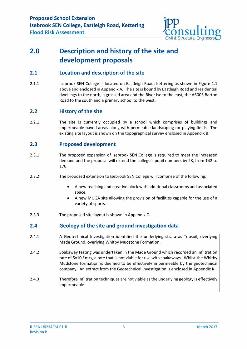
2.1 Location and description of the site
2.1.1 Isebrook SEN College is located on Eastleigh Road, Kettering as shown in Figure 1.1 above and enclosed in Appendix A. The site is bound by Eastleigh Road and residential dwellings to the north, a grassed area and the River Ise to the east, the A6003 Barton Road to the south and a primary school to the west.
2.2 History of the site
2.2.1 The site is currently occupied by a school which comprises of buildings and impermeable paved areas along with permeable landscaping for playing fields. The existing site layout is shown on the topographical survey enclosed in Appendix B.
2.3 Proposed development
2.3.1 The proposed expansion of Isebrook SEN College is required to meet the increased demand and the proposal will extend the college’s pupil numbers by 28, from 142 to 170.
2.3.2 The proposed extension to Isebrook SEN College will comprise of the following:
A new teaching and creative block with additional classrooms and associated space.
A new MUGA site allowing the provision of facilities capable for the use of a variety of sports.
2.3.3 The proposed site layout is shown in Appendix C.
2.4 Geology of the site and ground investigation data
2.4.1 A Geotechnical Investigation identified the underlying strata as Topsoil, overlying Made Ground, overlying Whitby Mudstone Formation.
2.4.2 Soakaway testing was undertaken in the Made Ground which recorded an infiltration rate of 5x10‐8 m/s, a rate that is not viable for use with soakaways. Whilst the Whitby Mudstone formation is deemed to be effectively impermeable by the geotechnical company. An extract from the Geotechnical Investigation is enclosed in Appendix K.
2.4.3 Therefore infiltration techniques are not viable as the underlying geology is effectively impermeable.

Proposed School Extension Isebrook SEN College, Eastleigh Road, Kettering Flood Risk Assessment
R‐FRA‐U8234PM‐01‐B 7 March 2017 Revision B
2.5 Development proposals and flood risk vulnerability
2.5.1 With reference to Table 2 of the Planning Practice Guidance (PPG) to the National Planning Policy Framework (NPPF), the proposed college extension would be classed as a More Vulnerable development.
2.5.2 An extract from Table 2 of the PPG for Flood Risk and Coastal Change is replicated below in Table 2.1 with the proposed development type highlighted.
Flood Risk Vulnerability Classification
Vulnerability Development Types
More Vulnerable Hospitals.
Residential institutions such as residential care homes, children’s homes, social services homes, prisons and hostels.
Buildings used for dwelling houses, student halls of residence, drinking establishments, nightclubs and hotels.
Non‐residential uses for health services, nurseries and educational establishments.
Landfill and site used for waste management facilities for hazardous waste.
Sites used for holiday or short‐let caravans and camping, subject to a specific warning and evacuation plan.
Source: Planning Practice Guidance ‐ 2014
Table 2.1

Proposed School Extension Isebrook SEN College, Eastleigh Road, Kettering Flood Risk Assessment
R‐FRA‐U8234PM‐01‐B 8 March 2017 Revision B
3.0 Flood risk
3.1 Fluvial / Tidal flooding
3.1.1 An extract of the Environment Agency’s Flood Map for Planning (Rivers and Sea) is provided below in Figure 3.1. The flood map was extracted from the Environment Agency’s website on the 10th November 2016. The approximate application site boundary is shown in red. The map indicates that the proposed development site is located within Flood Zone 1 (Low Probability) with a small section on the boundary with Flood Zone 2 (Medium Probability).
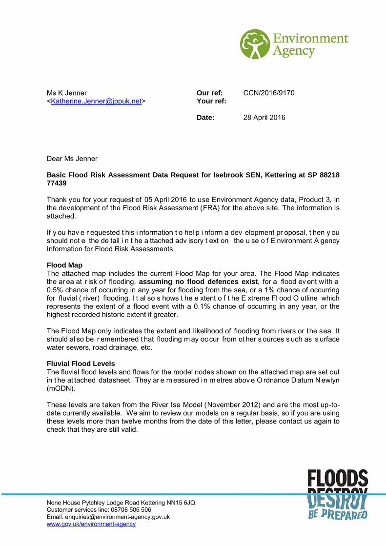
3.1.2 Flood level information has been obtained from the Environment Agency dated the 28th April 2016, see Appendix D. The Environment Agency has provided flood level from the River ISE Model (November 2012).
3.1.3 The nearest flood level node to the site is ISE12400. The flood levels affecting the site are shown in Table 3.1 below.
Flood Level Information (Willow Brook Model)
Node Maximum Water Level (mODN)
1% (1 in 100 year event + 20% CC) 0.1% (1 in 1000 year event+20% CC)
ISE12400 58.87m 59.20m
Source: Environment Agency, 6th May 2016
Table 3.1
Figure 3.1 Flood Map for Planning (Rivers and Sea) Source: Environment Agency website – 10th November 2016

Proposed School Extension Isebrook SEN College, Eastleigh Road, Kettering Flood Risk Assessment
R‐FRA‐U8234PM‐01‐B 9 March 2017 Revision B
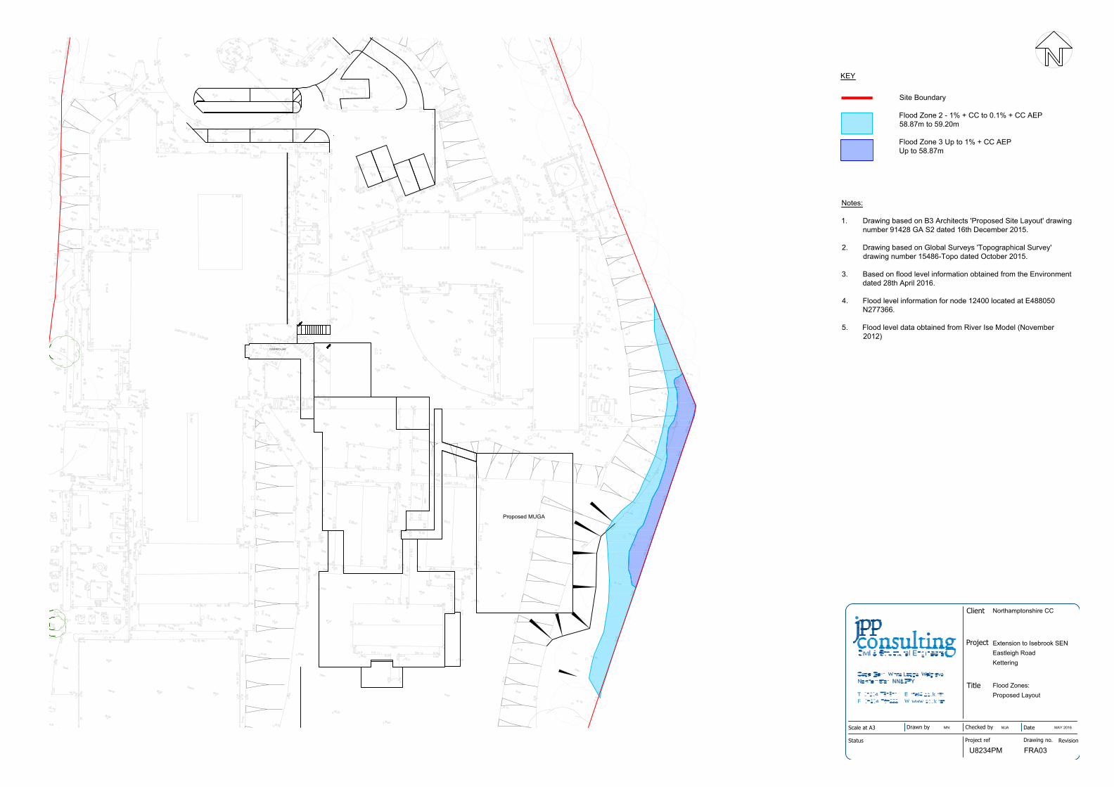
3.1.4 The extent of Flood Zones, based on predicted flood level information for node
IS12400, is shown in relation to the proposed development layout in Appendix E. This shows that the existing site is located predominantly within Flood Zones 1 (Low Probability) with a small section of the site in Flood Zone 2 (Medium Probability) and Flood Zone 3 (High Probability).
3.1.5 All new construction works are located entirely within Flood Zone 1, except for a small element of the regraded embankment which is located within Flood Zone 2.
3.1.6 Further, to ensure that the new building will not be adversely affected by flooding, the minimum finished floor level (FFL) will be 300mm above the 1 in 100 + CC extreme flood event, therefore the minimum FFL is 59.17 AOD.
3.1.7 Flood compensation is not required as no ground levels will be raised within Flood Zone 3.
3.1.8 Table 3.2 below is a copy of Table 1 from Planning Practice Guidance for ‘Flood Risk and Coastal Change’ to the National Planning Policy Framework which defines Flood Zones. The proposed development, which is located within Flood Zone 1, 2 and 3. The buildings are located in Flood Zone 1 and are defined as having a less than 1 in 1000 annual probability of river of flooding in any year
Flood Zone Definitions
Flood Zone Definition
Zone 1:
Low Probability
Land having a less than 1 in 1,000 annual probability of river or sea flooding.
Zone 2:
Medium Probability
Land having between a 1 in 100 and 1 in 1,000 annual probability of river flooding; or
Land having between a 1 in 200 and 1 in 1,000 annual probability of sea flooding.
Zone 3a:
High Probability
Land having a 1 in 100 or greater annual probability of river flooding; or
Land having a 1 in 200 or greater annual probability of sea flooding.
Zone 3b:
The Functional Floodplain
This zone comprises land where water has to flow or be stored in times of flood.
Local planning authorities should identify in their Strategic Flood Risk Assessments areas of functional floodplain and its boundaries accordingly, in agreement with the Environment Agency.
Source: Planning Practice Guidance ‐ 2014
Table 3.2

Proposed School Extension Isebrook SEN College, Eastleigh Road, Kettering Flood Risk Assessment
R‐FRA‐U8234PM‐01‐B 10 March 2017 Revision B
3.2 Flooding from surface water
3.2.1 An extract of the Environment Agency map ‘Risk of Flooding from Surface Water’ is provided below in Figure 3.2. The approximate application site boundary is shown in red. The majority of the site is shown to be located in an area of very low (less than 1 in 1000) risk of surface water flooding in a given year. A small part of the site, located along the eastern boundary is shown to be at a low (1 in 100 to 1 in 1000) risk of surface water flooding in a given year.
3.2.2 Existing and proposed buildings are located within an area of very low risk. We therefore consider the school site to be at very low risk of surface water flooding.
Figure 3.2 Risk of Flooding from Surface Water Source: Environment Agency website – 10th November 2016

Proposed School Extension Isebrook SEN College, Eastleigh Road, Kettering Flood Risk Assessment
R‐FRA‐U8234PM‐01‐B 11 March 2017 Revision B
3.3 Flooding from groundwater
3.3.1 From information provided on the Environment Agency’s website, see Figure 3.3 and Figure 3.4 below, the site does not appear to be underlain by an aquifer in either the superficial deposits or in the bedrock layer. We are not aware of any flooding on the site caused by groundwater. We would therefore consider the probability of flooding on the site from groundwater as low.
Figure 3.3 Groundwater – Superficial Designation Source: Environment Agency website – 10th November 2016
Figure 3.4 Groundwater – Bedrock Designation Source: Environment Agency website – 10th November 2016
Proposed School Extension Isebrook SEN College, Eastleigh Road, Kettering Flood Risk Assessment
R‐FRA‐U8234PM‐01‐B 12 March 2017 Revision B
3.4 Flooding from sewers
3.4.1 We are not aware of any sewers located within the site application boundary. We do not have any records of sewer flooding within the vicinity of the proposed development.
3.4.2 We therefore consider the risk of flooding from sewers to be low for the proposed development.
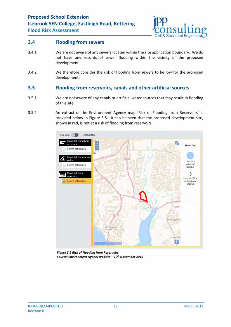
3.5 Flooding from reservoirs, canals and other artificial sources
3.5.1 We are not aware of any canals or artificial water sources that may result in flooding of this site.
3.5.2 An extract of the Environment Agency map ‘Risk of Flooding from Reservoirs’ is provided below in Figure 3.5. It can be seen that the proposed development site, shown in red, is not at a risk of flooding from reservoirs.
Figure 3.5 Risk of Flooding from Reservoirs Source: Environment Agency website – 10th November 2016

Proposed School Extension Isebrook SEN College, Eastleigh Road, Kettering Flood Risk Assessment
R‐FRA‐U8234PM‐01‐B 13 March 2017 Revision B
3.6 Historic flooding
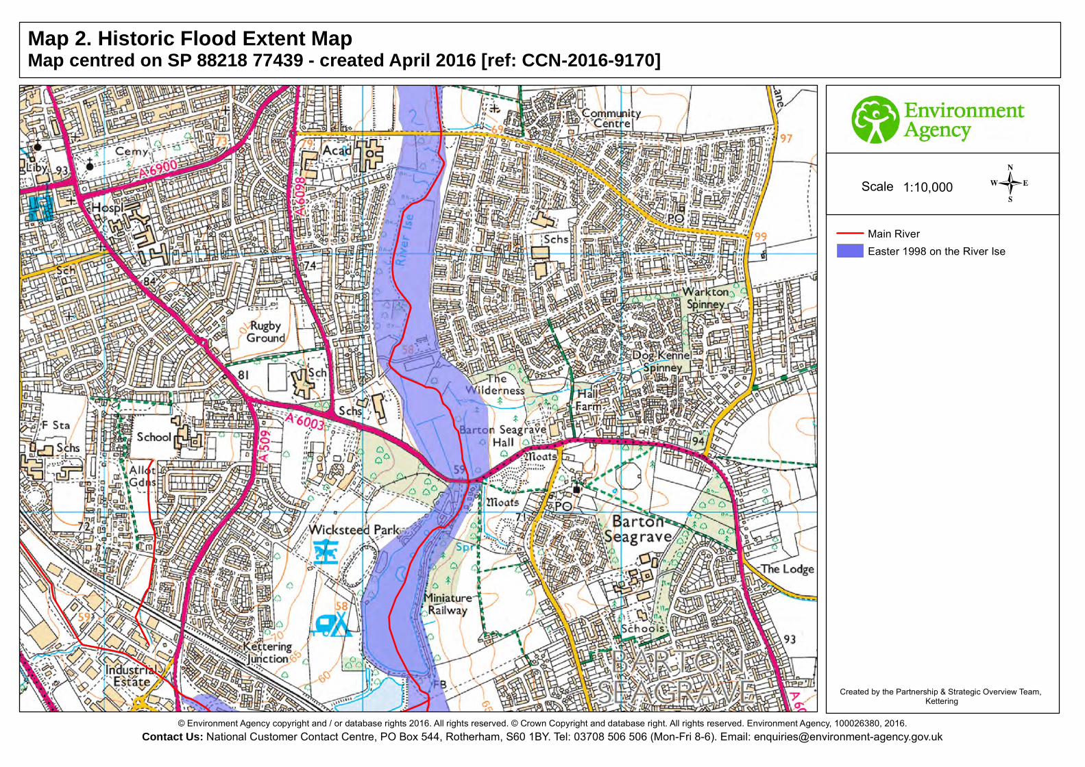
3.6.1 The Historic Flood Event Map provided by the Environment Agency, see Appendix D, shows that the River Ise flooded during the Easter 1998 floods. From the map, a very small portion of the eastern boundary is shown to have been affected. The extent of flooding shown in this drawing from the Easter 1998 event is similar to the predicted extent of Flood Zone 3 on the site.
3.7 Flood risk vulnerability and flood zone compatibility
3.7.1 Based on the above assessment of the new works being located within Flood Zone 1 and classified as a More Vulnerable development, and with reference to Table 3.3 below (Planning Practice Guidance for ‘Flood Risk and Coastal Change’ to the National Planning Policy Framework, Table 3), the proposed development of this site would be considered "appropriate". A copy of Table 3 is presented below highlighting the above. As the proposed works are within Flood Zone 1 neither a sequential test nor exception test are required.
Table 3 – Flood Risk Vulnerability and Flood Zone Compatibility
Flood Risk Vulnerability Classification
Essential Infrastructure
Water Compatibility
Highly Vulnerable
More Vulnerable
Less Vulnerable
Zone 1
Zone 2 Exception test required
Zone 3a Exception test required
X Exception test required
Zone 3b Exception test required
X X X
= Development is appropriate X = Development should not be permitted
Source: Planning Practice Guidance ‐ 2014
Table 3.3
3.8 Access and egress
3.8.1 Access and egress to and from this site in the event of flooding will be via the proposed school access road off Eastleigh Road which will allow users of the development to move to higher ground.

Proposed School Extension Isebrook SEN College, Eastleigh Road, Kettering Flood Risk Assessment
R‐FRA‐U8234PM‐01‐B 14 March 2017 Revision B
4.0 Management of surface water
4.1 Current conditions
4.1.1 The proposed development is located on an existing school site. The existing site drains unrestricted. The new extension works will drain separately from the existing drainage, hence, for the purpose of this assessment the drainage for the existing site will be considered to be located on a greenfield site.
4.2 Surface water drainage outfalls
4.2.1 It is a requirement of the The Building Regulations (2010), Drainage and Waste Disposal, Approved Document H, to dispose of surface water collected by a development in the following list of priorities:‐
1. Infiltration systems where ground condition permit 2. To watercourses 3. To sewers
4.2.2 Each of these is considered separately below:
4.2.2 Infiltration systems
4.2.2.1 Infiltration techniques are not viable as the underlying geology is effectively impermeable.
4.2.3 Watercourses / Main River
4.2.3.1 The River Ise is located to the east of the college. The school has attempted to obtained drainage rights to the neighbouring watercourse, but has been unable to secure appropriate drainage rights. Hence, discharging to a watercourse is not a viable option.
4.2.4 Sewers
4.2.4.1 The school current drains to Anglian Water sewers within Eastleigh Road and Cheyne Walk to the north of the site. Drainage from the proposed extension will connect to the existing school drainage which ultimately connects with Anglian Water’s sewer network. Due to the relative levels on the site the new impermeable areas will require a surface water pumping. Details are shown on the drainage strategy drawing enclosed in Appendix G.
4.2.4.2 Anglian Water has been consulted with respect to use of their sewers to discharge foul and surface water. A copy of their report is enclosed within Appendix F. A connection will be made to Manhole 0551 in Eastleigh Road / Cheyne Walk, as shown in Figure 2 within Appendix F. Anglian Water has confirmed that they can accommodate a flow of 5.0l/s in their south‐west sewer.

Proposed School Extension Isebrook SEN College, Eastleigh Road, Kettering Flood Risk Assessment
R‐FRA‐U8234PM‐01‐B 15 March 2017 Revision B
4.3 Surface water drainage strategy
4.3.1 Surface water discharge from new impermeable areas will be restricted to greenfield equivalent runoff rates to ensure that the rate of surface water runoff from the site does not increase as a result of the proposed development.
4.3.2 The proposed drainage strategy will comprise a piped network with attenuation provided in geocellular storage beneath the proposed MUGA. Flows will be limited to a maximum rate of 5.0 l/s via a hydrobrake. The MUGA will not have any positive drainage and it will act like a permeable surface for drainage purposes.
4.3.3 Drainage from the proposed extension will connect to the existing school drainage which ultimately connects with Anglian Water’s sewer network.
4.3.4 An indicative surface water layout plan is enclosed in Appendix G. The drawing shows that surface water attenuation can be accommodated on the site and the method of discharge assuming that infiltration techniques are not viable. The detail design parameters of the drainage are described in detail in Section 4.4.
4.4 Surface water drainage design and management
4.4.1 Proposals are to design the surface water drainage system to accommodate storms up to the 1 in 100 year event plus an allowance for climate change. The design life of a residential development is considered to be greater than 60 years. Table 4.1 below is a copy of Table 2 from the Environment Agency’s guidance ‘Flood risk assessments: climate change allowances’ to support the National Planning Policy Framework, which defines the climate change allowances.
4.4.2 The surface water drainage system will be designed to accommodate storms up to the 1 in 100 year event plus an allowance of 40 % for climate change. . The final design will comply with Northamptonshire County Council’s Lead Local Flood Authority (LLFA) new Climate Change Allowance guidelines published March 2016. Should the 40% climate change event result in surface water flooding, this will be contained within the development site and will not flood any buildings on site.
Peak rainfall intensity allowance in small and urban catchments
Allowance ‘2020s’ (2015 to 2039) ‘2050s’ (2040 to 2069) ‘2080s’ (2070 to 2115)
Upper end +10% +20% +40%
Central +5% +10% +20%
Source: Environment Agency ‐ 2016
Table 4.1

Proposed School Extension Isebrook SEN College, Eastleigh Road, Kettering Flood Risk Assessment
R‐FRA‐U8234PM‐01‐B 16 March 2017 Revision B
4.5 Existing runoff rates
4.5.1 To reflect the changes in the near surface geology across the site the greenfield runoff rates have been calculated. The method used to calculate the greenfield run off rates is the ICP SUDS and the calculations are presented in Appendix H.
4.5.2 The greenfield run off rate, for the application site is:
Soil type = 0.388 – determined from the FEH Parameters SAAR = 649mm – obtained from the FEH parameters Urban = 0.000 Region number = 5 Proposed Imp Area = 0.125ha Q1 = 0.3l/s Qbar = 0.4 l/s Q30 = 0.9 l/s Q100 = 1.3 l/s
4.5.3 The Qbar equivalent rate for the proposed development is 0.4 l/s. A restriction of 0.4 l/s could potentially result in a small aperture at the outfall which could increase the risk of blockage. The minimum recommended discharge rate is 5.0 l/s, as set out in the Environment Agency’s document ‘Delivering benefits through evidence: Rainfall runoff management for developments’. Therefore surface water will be restricted to 5.0 l/s to ensure a minimum aperture size.
4.6 Attenuation requirements
4.6.1 Surface water will connect to the existing school’s surface water drainage network which ultimately connects with Anglian Water’s sewer. Surface water will be attenuated to a maximum discharge rate of 5.0 l/s. To achieve a discharge rate of 5.0 l/s, surface water will be attenuated via underground storage beneath the proposed MUGA to accommodate a 1 in 100 year event plus an allowance of 40% for climate change.
4.6.2 The proposed impermeable area of the development is 0.125ha as shown on the plan enclosed in Appendix I. Based on the proposed impermeable area and allowable discharge rate of 5.0 l/s the storage requirement for the 1 in 100 year plus climate change event has been calculated utilising the following parameters. Full calculations are enclosed in Appendix J.
Rainfall profile = Flood Estimation Handbook Return Period = 100 year Durations = 15 to 10080 minutes Climate change = 40% Drained area = 0.125 ha Limiting flow to SW Sewer = 5.0 l/s Control = Hydrobrake Total Storage required = 68.3 m³

Proposed School Extension Isebrook SEN College, Eastleigh Road, Kettering Flood Risk Assessment
R‐FRA‐U8234PM‐01‐B 17 March 2017 Revision B
4.6.3 The indicative surface water drainage layout incorporating the attenuation is shown
on the plan enclosed in Appendix G.
4.7 Overland flows
4.7.1 Proposals are to design the surface water drainage to accommodate the 1 in 100 year storm event taking into account the predicted future effects of climate. Clearly there is a risk of this storm event being exceeded, albeit this risk is considered very low. In such an event the proposed drainage systems will become overwhelmed and overland flows could occur. Overland flows will be directed to follow the path that overland flows currently follow.
4.8 Foul water drainage strategy
4.8.1 Foul water will be pumped into the school’s existing gravity system, which ultimately discharges to Anglian Water’s sewer network located in Eastleigh Road / Cheyne Walk. Anglian Water have confirmed that they have sufficient capacity within their existing network to accept gravity foul flows from the school extension, see Appendix F. A discharge rate of 3.8 l/s, in addition to the existing discharge rate from the site, has been agreed with Anglian Water.
Proposed School Extension Isebrook SEN College, Eastleigh Road, Kettering Flood Risk Assessment
R‐FRA‐U8234PM‐01‐B 18 March 2017 Revision B
5.0 Maintenance
5.1 Surface drainage maintenance
5.1.1 The drainage system will be designed to minimise maintenance requirements, however, a full maintenance scheme will be established for those elements not being offered for adoption. The various areas will be maintained as set out in Table 5.1 below.
Maintenance Areas – Surface Water
Aspect Maintainer
Private Drains / Sewers Isebrook SEN College
Adopted Sewers Anglian Water
Table 5.1
5.2 Foul drainage maintenance
5.2.1 The drainage system will be designed to minimise maintenance requirements, however, a full maintenance scheme will be established for those elements not being offered for adoption. The various areas will be maintained as set out in Table 5.2 below.
Maintenance Areas – Foul Water
Aspect Maintainer
Private Drains / Sewers Isebrook SEN College
Adopted Sewers Anglian Water
Table 5.2

Proposed School Extension Isebrook SEN College, Eastleigh Road, Kettering Flood Risk Assessment
R‐FRA‐U8234PM‐01‐B 19 March 2017 Revision B
6.0 Conclusions and flood risk from site drainage proposals
6.1 Isebrook SEN College is located on Eastleigh Road, south‐east of Kettering. The site is bound by Eastleigh Road and residential dwellings to the north, a grassed area and the River Ise towards the east, the A6003 Barton Road to the south and a primary school to the west. At present the site is currently occupied by a school which comprises of a building and impermeable areas along with permeable landscaping for playing fields.
6.2 The proposed expansion of Isebrook SEN College is required to meet the increased demand and the proposal will extend the college’s pupil number from 142 to 170. The proposed extension to Isebrook SEN College will comprise of a new MUGA site allowing the provision of facilities capable for the use of a variety of sports and a new teaching and creative block with additional classrooms and associated space.
6.3 The school site is located in Flood Zones 1 & 2. All new construction works are entirely within Flood Zone 1 and at the lowest risk of flooding from fluvial sources. The site is shown to be at a low risk of flooding from surface, groundwater, sewers and artificial sources, such as reservoirs.
6.4 The proposed drainage strategy will comprise a piped network with attenuation provided in geocellular storage beneath the proposed MUGA. Surface water will drain to the existing on site surface water network which ultimately connects with Anglian Water’s surface water network located within the highway. Surface water will be attenuated to a maximum discharge rate of 5.0 l/s. Surface water will be attenuated via underground storage beneath the proposed MUGA to accommodate a 1 in 100 year event plus an allowance of 40% for climate change. The total volume of surface water storage provided is 68.3m3.
6.5 Foul water will be pumped into the school’s existing gravity system, which ultimately discharges to Anglian Water’s sewer network located in Eastleigh Road / Cheyne Walk. Anglian Water have confirmed that they have sufficient capacity within their existing network to accept gravity foul flows from the school extension. A discharge rate of 3.8 l/s, in addition to the existing discharge rate from the site, has been agreed with Anglian Water.
6.6 The surface water drainage from this site, post development, is such that the surface water will be managed and disposed of within the site boundary, thus complying with the Planning Practice Guidance for ‘Flood Risk and Climate Change’ to the National Planning Policy Framework. Based on the above, providing the above strategies are adopted the developed site will not contribute further to flood risk thus satisfying the principles of the National Planning Policy Framework.

Proposed School Extension Isebrook SEN College, Eastleigh Road, Kettering Flood Risk Assessment
R‐FRA‐U8234PM‐01‐B A March 2017 Revision B
Appendix A Location Plan
JPP drawing no. U8234PM‐FRA01

Reproduced from Ordnance Survey map. Licencenumber 100022432. Ordnance Survey. CrownCopyright. All Rights Reserved.
Title
Project
Client
Scale at A4
Drawn by
Checked by
Date
Project ref Drawing no. Revision
Northamptonshire CC
Extension to Isebrook SEN
Eastleigh Road, Kettering
Site Location Drawing
1:10000
MN
MJA
8th July 2016
U8234PM FRA01

Proposed School Extension Isebrook SEN College, Eastleigh Road, Kettering Flood Risk Assessment
R‐FRA‐U8234PM‐01‐B B March 2017 Revision B
Appendix B Topographic Survey
Global Surveys drawing no. 15486 Topo 1&2


Proposed School Extension Isebrook SEN College, Eastleigh Road, Kettering Flood Risk Assessment
R‐FRA‐U8234PM‐01‐B C March 2017 Revision B
Appendix C Proposed Site Layout
BB Architects drawing no. 91428‐GA‐S2


Proposed School Extension Isebrook SEN College, Eastleigh Road, Kettering Flood Risk Assessment
R‐FRA‐U8234PM‐01‐B D March 2017 Revision B
Appendix D Environment Agency Data
EA reference CCN‐2016‐9170
Nene House Pytchley Lodge Road Kettering NN15 6JQ. Customer services line: 08708 506 506 Email: [email protected] www.gov.uk/environment-agency
Ms K Jenner <[email protected]>
Our ref: CCN/2016/9170 Your ref: Date: 28 April 2016
Dear Ms Jenner Basic Flood Risk Assessment Data Request for Isebrook SEN, Kettering at SP 88218 77439 Thank you for your request of 05 April 2016 to use Environment Agency data, Product 3, in the development of the Flood Risk Assessment (FRA) for the above site. The information is attached. If y ou hav e r equested t his i nformation t o hel p i nform a dev elopment pr oposal, t hen y ou should not e the de tail i n t he a ttached adv isory t ext on the u se o f E nvironment A gency Information for Flood Risk Assessments. Flood Map The attached map includes the current Flood Map for your area. The Flood Map indicates the ar ea at r isk o f flooding, assuming no flood defences exist, for a flood event w ith a 0.5% chance of occurring in any year for flooding from the sea, or a 1% chance of occurring for fluvial ( river) flooding. I t al so s hows t he e xtent o f t he E xtreme Fl ood O utline which represents the extent of a flood event with a 0.1% chance of occurring in any year, or the highest recorded historic extent if greater. The Flood Map only indicates the extent and l ikelihood of flooding from rivers or the sea. It should al so be r emembered t hat flooding m ay oc cur from ot her s ources s uch as s urface water sewers, road drainage, etc. Fluvial Flood Levels The fluvial flood levels and flows for the model nodes shown on the attached map are set out in t he at tached datasheet. They ar e m easured i n m etres above O rdnance D atum N ewlyn (mODN). These levels are taken from the River Ise Model (November 2012) and a re the most up-to-date currently available. We aim to review our models on a regular basis, so if you are using these levels more than twelve months from the date of this letter, please contact us again to check that they are still valid.

Nene House Pytchley Lodge Road Kettering NN15 6JQ. Customer services line: 08708 506 506 Email: [email protected] www.gov.uk/environment-agency
Please not e t hat t hese l evels ar e “ in-channel” l evels and t herefore m ay not r epresent t he flood l evel on t he floodplain, par ticularly where t he c hannel i s em banked o r has r aised defences. Climate Change Flood risk data requests including an al lowance for climate change will be based on the 1% annual probability flood including an additional 20% increase on peak flows to account for climate change impacts, unless otherwise stated. You should refer to 'Flood risk assessments: c limate change al lowances' t o check i f this al lowance is s till appr opriate for the t ype of dev elopment y ou ar e pr oposing and i ts l ocation. Y ou m ay n eed t o under take further assessment of future flood risk using different allowances to ensure your assessment of future flood risk is based on best available evidence. Fluvial Defence Information There ar e no f ormal flood def ences pr otecting this s ite. T he nat ural c hannel pr ovides a nominal protection against a flood event with a 50% chance of occurring in any year (1 in 2). Historic Flood Extent Map A copy of the Historic Flood Extent Map for your area is enclosed. This shows the extent of previous recorded flooding in your area, notably Easter 1998. It is possible that other flooding may have occurred that we do not have records for, and ot her organisations, such as the Local Authority, may have records. Other Information Requested Further details about the Environment Agency information supplied can be found on the GOV.UK website: https://www.gov.uk/browse/environment-countryside/flooding-extreme-weather If y ou hav e r equested t his i nformation t o hel p i nform a dev elopment pr oposal, t hen y ou should note the information on G OV.UK on t he use of Environment Agency Information for Flood Risk Assessments https://www.gov.uk/planning-applications-assessing-flood-risk https://www.gov.uk/government/publications/pre-planning-application-enquiry-form-preliminary-opinion Supporting Information This information is provided subject to the enclosed notice which you should read. I hope that we have correctly interpreted your request. Please see the Standard Notice or licence for details of permitted use. The Standard Notice can be found at the link below. http://www.nationalarchives.gov.uk/doc/open-government-licence/version/3/ We r espond t o r equests f or r ecorded i nformation t hat w e ho ld under t he Fr eedom of Information A ct 2000 ( FOIA) and t he as sociated E nvironmental I nformation R egulations 2004 (EIR).

Nene House Pytchley Lodge Road Kettering NN15 6JQ. Customer services line: 08708 506 506 Email: [email protected] www.gov.uk/environment-agency
If you are not satisfied with our response to your request for information you can contact us within 2 calendar months to ask for our decision to be reviewed. If you have any queries or would like to discuss the content of this letter further please contact Rebecca Bristow at the Environment Agency. Yours sincerely
Rebecca Bristow FOR Alastair Windler Partnership and Strategic Overview Team Leader Lincolnshire & Northamptonshire Area Direct dial 02030 253516 e-mail [email protected]
Awarded to Lincolnshire & Northamptonshire Area Enc. Basic FRA Map Historic Flood Map Data sheet FRA Advisory Text

!(
!(
!(
!(
ISE12400
ISE12800
ISE11762U
ISE11974U
Contact Us: National Customer Contact Centre, PO Box 544, Rotherham, S60 1BY. Tel: 03708 506 506 (Mon-Fri 8-6). Email: [email protected]© Environment Agency copyright and / or database rights 2016. All rights reserved. © Crown Copyright and database right. All rights reserved. Environment Agency, 100026380, 2016.
Basic FRA MapMap centred on SP 88218 77439 - created April 2016 [ref: CCN-2016-9170]
-1:10,000Scale
Created by the Partnerships & Strategic Overview Team, Kettering
Dark blue shows the area that could be affected by flooding,either from rivers or the sea, if there were no flood defences. This area could be flooded:
- from the sea by a flood that has a 0.5% (1 in 200) or greater chance of happening each year.
- or from a river by a flood that has a 1% (1 in 100) or greaterchance of happening each year.
Light blue shows the extent of the Extreme Flood Outline,which represents the extent of a flood event with a 0.1% chance of occurring in any year, or the highest recorded historic extent if greater.
These two colours show the extent of the natural floodplain if there were no flood defences or certain other manmade structures and channel improvements. Sites outside the twoextents, but behind raised defences, may be affected byflooding if the defences are overtopped or fail.
!( Model Nodes
Main River
Area at Risk of Flooding from Rivers or The Sea
Extreme Flood Outline
Contact Us: National Customer Contact Centre, PO Box 544, Rotherham, S60 1BY. Tel: 03708 506 506 (Mon-Fri 8-6). Email: [email protected]© Environment Agency copyright and / or database rights 2016. All rights reserved. © Crown Copyright and database right. All rights reserved. Environment Agency, 100026380, 2016.
Main RiverEaster 1998 on the River Ise
Map 2. Historic Flood Extent MapMap centred on SP 88218 77439 - created April 2016 [ref: CCN-2016-9170]
-1:10,000Scale
Created by the Partnership & Strategic Overview Team, Kettering

28 April 2016
Fluvial Flood Levels (mODN) The fluvial flood levels for the model nodes shown on the attached map are set out in the table below. They are measured in metres above Ordnance Datum Newlyn (mODN).
Annual Exceedance Probability - Maximum Water Levels (mODN)
Node Label Easting Northing 50%
(1 in 2) 20%
(1 in 5)
10% (1 in 10)
5% (1 in 20)
4% (1 in 25)
2% (1 in 50)
1.33% (1 in 75)
1% (1 in 100)
1% (1 in 100) inc 20% Climate Change
0.5% (1 in 200)
0.1% (1 in 1000)
0.1% (1 in 1000)
inc 20% Climate Change
ISE12800 488187 277788 58.42 58.60 58.69 58.75 58.78 58.82 58.87 58.90 59.01 58.98 59.18 59.30 ISE12400 488250 277483 58.18 58.30 58.35 58.38 58.41 58.47 58.58 58.65 58.87 58.81 59.07 59.20 ISE11974U 488409 277133 58.02 58.12 58.17 58.20 58.27 58.40 58.55 58.63 58.86 58.80 59.06 59.17 ISE11762U 488327 276933 57.37 57.45 57.55 57.61 57.64 57.69 57.74 57.77 57.85 57.82 58.03 58.25
Fluvial Flood Flows (m³/s) The fluvial flood flows for the model nodes shown on the attached map are set out in the table below. They are measured in metres cubed per second (m³/s).
Annual Exceedance Probability - Maximum Flows (m³/s)
Node Label Easting Northing 50%
(1 in 2) 20%
(1 in 5)
10% (1 in 10)
5% (1 in 20)
4% (1 in 25)
2% (1 in 50)
1.33% (1 in 75)
1% (1 in 100)
1% (1 in 100) inc 20% Climate Change
0.5% (1 in 200)
0.1% (1 in 1000)
0.1% (1 in 1000)
inc 20% Climate Change
ISE12800 488187 277788 6.93 10.20 13.25 15.85 16.96 18.94 20.95 22.20 25.38 24.54 31.64 39.49 ISE12400 488250 277483 6.92 10.11 12.42 14.12 14.59 15.11 15.53 15.60 15.80 15.87 15.97 16.47 ISE11974U 488409 277133 4.96 5.18 5.21 5.21 5.21 5.59 6.01 6.24 6.90 6.68 10.09 14.35 ISE11762U 488327 276933 4.96 5.17 5.20 5.20 5.20 5.59 6.01 6.24 6.91 6.68 10.09 14.34
Datasheet [Ref: CCN-2016-9170]

Use of Environment Agency Information for Flood Risk / Flood Consequence Assessments Important If you have requested this information to help inform a development proposal, then we recommend that you undertake a formal pre-application enquiry using the form available from our website:- http://www.environment-agency.gov.uk/research/planning/33580.aspx Depending on the enquiry, we may also prov ide advice on other issues related to our responsibilities in cluding flooding, was te, land co ntamination, water quality, biodiversity, navigation, pollution, water resources, foul drainage or Environmental Impact Assessment. In England, you should refer to the Enviro nment Agency’s F lood Risk Standing Advice, the technical guidance to the National Planning Po licy Framework and the ex isting PPS25 Practice Guide fo r information about what flood risk assessment is needed for new developmen t in the different Flood Zones. T hese documents can be accessed via:
http://www.environment-agency.gov.uk/research/planning/82587.aspx http://www.communities.gov.uk/publications/planningandbuilding/nppftechnicalguidance http://www.communities.gov.uk/publications/planningandbuilding/pps25guideupdate You should also cons ult the Strategic Flood Risk Assessment produced by y our local planning authority. In Wales, you should refer to TAN15 fo r information about what flood consequence assessment is needed for new dev elopment in the different flood zones http://new.wales.gov.uk/splash;jsessionid=8ylGTfGZthmB0t2vhp6hS1GcB1LXvZzB3Ylczf20Xn7LK3zK0nMk!981825250?orig=/topics/planning/policy/tans/tan15/ You should also consult the Strategi c Flood Consequence Ass essment if one has been produced by your local planning authority.

In both England and Wales you should note that:
1. Information supplied by the Env ironment Agency may be used to assist in producing a Flood Risk / Consequence As sessment (FRA / FCA) wher e one is required, but does not constitute such an assessment on its own.
2. This information covers flood risk from main rivers and the sea, and you
will need to consider other potential sources of flooding, such as groundwater or overland runoff. The information produced by the loca l planning authority referred to above may assist here.
3. Where a planning app lication requires a FRA / F CA and this is not
submitted or deficient, the Envi ronment Agency m ay well r aise an objection.
4. For more signific ant proposals in higher flood risk areas, we would be
pleased to discuss details wit h y ou ahead of m aking any planning application, and you should also discuss the matter with your local planning authority.

Proposed School Extension Isebrook SEN College, Eastleigh Road, Kettering Flood Risk Assessment
R‐FRA‐U8234PM‐01‐B E March 2017 Revision B
Appendix E Flood Zones & Proposed Layout
JPP drawing no. U8234PM‐FRA03
COVERED LINK
Proposed MUGA
Title
Project
Client
Status
Scale at A3 Drawn by Checked by Date
Project ref Drawing no. Revision
Northamptonshire CC
Extension to Isebrook SENEastleigh RoadKettering
Flood Zones: Proposed Layout
MN MJA MAY 2016
U8234PM FRA03
Site Boundary
Flood Zone 2 - 1% + CC to 0.1% + CC AEP58.87m to 59.20m
Flood Zone 3 Up to 1% + CC AEPUp to 58.87m
KEY
Notes:
1. Drawing based on B3 Architects 'Proposed Site Layout' drawingnumber 91428 GA S2 dated 16th December 2015.
2. Drawing based on Global Surveys 'Topographical Survey'drawing number 15486-Topo dated October 2015.
3. Based on flood level information obtained from the Environment dated 28th April 2016.
4. Flood level information for node 12400 located at E488050N277366.
5. Flood level data obtained from River Ise Model (November2012)

Proposed School Extension Isebrook SEN College, Eastleigh Road, Kettering Flood Risk Assessment
R‐FRA‐U8234PM‐01‐B F March 2017 Revision B
Appendix F Anglian Water Report
Anglian Water Ref. 00014002

Pre-Planning Report Monday, 27 June 2016
Pre-Planning
Assessment Report Eastleigh Road, KETTERING - Pipers Hill

Pre-Planning Report 1 Monday, 27 June 2016
Section 1: Proposed Development
Thank you for submitting a pre-planning enquiry. This has been produced for JPP Consulting. Your reference number is 00014002. If you have any questions upon receipt
of this report, please contact Mark Rhodes on 01733 414690 or email [email protected].
The response within this report has been based on the following information which was
submitted as part of your application:
List of Planned Developments
Type of Development No. Of Units
D1 Non-residential 1
The grid reference for the site is SP8803377369.
The site currently does not have planning permission and is located on a brownfield
site.

Pre-Planning Report 2 Monday, 27 June 2016
Section 2: Assets Affected
Our records indicate that there are no public water mains or public sewers or other assets
owned by Anglian Water within the boundary or overlapping your development site.
However, it is recommended that you carry out a thorough investigation of your proposed
working area to establish whether any unmapped public or private sewers and lateral
drains are in existence.
Due to the private sewer transfer in October 2011 many newly adopted public used water
assets and their history are not indicated on our records. You also need to be aware that
your development site may contain private water mains, drains or other assets not shown
on our records. These are private assets and not the responsibility of Anglian Water but
that of the landowner.

Pre-Planning Report 3 Monday, 27 June 2016
Section 3: Water Recycling Services
In examining the used water system we assess the ability for your site to connect to the
public sewerage network without causing a detriment to the operation of the system. We
also assess the receiving water recycling centre and determine whether the water
recycling centre can cope with the increased flow and influent quality arising from your
development.
Water Recycling Centre
The foul drainage from the proposed development is in the catchment of Broadholme
Water Recycling Centre, which currently has capacity to treat the flows from your
development site. Anglian Water cannot reserve capacity and the available capacity at the
water recycling centre can be reduced at any time due to growth, environmental and
regulation driven changes.
Used Water Network
Anglian Water has assessed the impact of gravity flows from the planned development to
the public foul sewerage network. We can confirm this is acceptable as the foul sewerage
system, at present, has available capacity for your site. The connection will be made to
via gravity to manhole 0502 at NGR SP8805977575 and this is the preferred connection
point subject to your site layout.
Anglian Water has also assessed the impact of a pumped flow at 3.8 l/s to an alternative
connection point to the south east of your site at manhole 4104 at NGR SP8844777115.
There is insufficient capacity at this manhole to accept a pumped regime from your site as
this will run an unacceptable risk of flooding downstream.
Surface Water Disposal
We have examined your development site for available surface water discharge options. It
is our understanding that the evidence to confirm your compliance with the surface water
hierarchy is not currently available. However once the evidence has been confirmed, then
a connection point may be made to manhole 0551 located at Isebrook SEN School at NGR
SP8806077519 at a rate of 5.00l/s.
It is your responsibility to provide the evidence to confirm that all alternative methods of
surface water disposal have been explored and these will be required before your
connection can be agreed. This is subject to satisfactory evidence which shows the surface
water management hierarchy as outlined in Building Regulations Part H has been
explored. This would encompass the results from the site specific infiltration testing
and/or confirmation that the flows cannot be discharged to a watercourse.
Anglian Water's surface water policy follows the Surface Water hierarchy, outlined in Part
H of the Building Regulations. Should your assumptions or evidence change then an
alternative solution, connection point or flow rate may be required. You are therefore

Pre-Planning Report 4 Monday, 27 June 2016
advised to update Anglian Water with the key supporting evidence at your earliest
convenience.
As you may be aware, Anglian Water will consider the adoption of SuDs provided that they
meet the criteria outline in our SuDs adoption manual. This can be found on our website
at http://www.anglianwater.co.uk/developers/suds.aspx. We will adopt features located in
public open space that are designed and constructed, in conjunction with the Local
Authority and Lead Local Flood Authority (LLFA), to the criteria within our SuDs adoption
manual. Specifically, developers must be able to demonstrate:
1. Effective upstream source control,
2. Effective exceedance design, and
3. Effective maintenance schedule demonstrating than the assets can be maintained
both now and in the future with adequate access.
If you wish to look at the adoption of any SuDs then an expression of interest form can be
found on our website at: http://www.anglianwater.co.uk/developers/suds.aspx
Trade Effluent
We note that you do not have any trade effluent requirements. Should this be required in
the future you will need our written formal consent. This is in accordance with Section 118
of the Water Industry Act (1991).
Used Water Budget Costs
It has been assumed that the onsite used water network will be provided under a section
104 Water Industry Act application. It is recommended that you also budget for both
infrastructure charges and connection costs. The 2015/16 charges are:
Infrastructure Charge £351.00 per connection
Please note that we offer alternative types of connections depending on your needs and
these costs are available in our annual charges booklet, which can be downloaded from
www.anglianwater.co.uk/developers/charges.

Pre-Planning Report 5 Monday, 27 June 2016
Section 4: Map of Proposed Connection Points
Figure 1: Showing your used water point of connection at manhole 0502 with a Cover Level of 60.97m and an Invert Level of 60.1m
Figure 2: Showing your surface water point of connection at manhole 0551
Connection point
Connection point

Pre-Planning Report 6 Monday, 27 June 2016
Section 5: Useful Information
Water
Water Industry Act – Key Water Sections:
• Section 41: This provides you with the right to requisition a new water main for
domestic purposes to connect your site to the public water network.
• Section 45: This provides you with the right to have a connection for domestic
purposes from a building or part of a building to the public water main.
• Section 51A: This provides you with the right to provide the water main or service
connection yourself and for us to vest them into our company.
Section 55: This applies where you request a supply of water for non domestic
premises.
• Section 185: This provides you with the right to make a reasonable request to have
a public water main, sewer or public lateral drain removed or altered, at your expense.
Details on how to make an application and the s185 form is available on our website at
http://www.anglianwater.co.uk20/developers or via our Developer Services team on
08457 60 66 087.
Details on how you can make a formal application for a new water main, new connection
or diversion are available on from our Developer Services team on 08457 60 66 087 or via
our website at www.anglianwater.co.uk/developers
If you have any other queries on the rights to requisition or connect your housing to the
public water and sewerage infrastructure then please contact our developer services team
at: Developer Services, Anglian Water, PO Box 495, Huntingdon, PE29 6YY or Telephone:
0845 60 66 087 or Email: [email protected]
Water pressure and flow rate: The water pressure and consistency that we must meet for
your site is laid out in the Water Industry Act (1991). This states that we must supply a
flow rate of 9 litres per minute at a pressure of 10 metres of head to the external stop
tap. If your water pressure requirements exceed this then you will need to provide and
maintain any booster requirements to the development site.
Self Lay of Water Mains: A list of accredited Self Lay Organisations can be found at
www.lloydsregister.co.uk/schemes/WIRS/providers-list.aspx.
Used Water
Water Industry Act – Key Used Water Sections:
• Section 98: This provides you with the right to requisition a new public sewer. The
new public sewer can be constructed by Anglian Water on your behalf. Alternatively, you
can construct the sewer yourself under section 30 of the Anglian Water Authority Act
1977.

Pre-Planning Report 7 Monday, 27 June 2016
• Section 102: This provides you with the right to have an existing sewerage asset
vested by us. It is your responsibility to bring the infrastructure to an adoptable condition
ahead of the asset being vested.
• Section 104: This provides you with the right to have a design technically vetted
and an agreement reached that will see us adopt your assets following their satisfactory
construction and connection to the public sewer.
• Section 106: This provides you with the right to have your constructed sewer
connected to the public sewer.
• Section 185: This provides you with the right to have a public sewerage asset
diverted.
Details on how to make a formal application for a new sewer, new connection or diversion
are available on our website at www.anglianwater.co.uk/developers or via our Developer
Services team on 08457 60 66 087.
Sustainable Drainage Systems:
Many existing urban drainage systems can cause problems of flooding, pollution or
damage to the environment and are not resilient to climate change in the long term.
Therefore our preferred method of surface water disposal is through the use of
Sustainable Drainage Systems (SuDS). SuDS are a range of techniques that aim to mimic
the way surface water drains in natural systems within urban areas. For more information
on SuDS, please visit our website at http://www.anglianwater.co.uk/developers/suds.aspx
We also recommend that you contact the Local Authority and Lead Local Flood Authority
(LLFA) for the area to discuss your application.
Private Sewer Transfers: Sewers and lateral drains connected to the public sewer on the
1 July 2011 transferred into Water Company ownership on the 1 October 2011. This
follows the implementation of the Floods and Water Management Act (FWMA). This
included sewers and lateral drains that were subject to an existing Section 104 Adoption
Agreement and those that were not. There were exemptions and the main non-
transferable assets were as follows:
• Surface water sewers and lateral drains that did not discharge to the public sewer,
e.g. those that discharged to a watercourse.
• Foul sewers and lateral drains that discharged to a privately owned sewage
treatment/collection facility.
• Pumping stations and rising mains will transfer between 1 October 2011 and 1
October 2016.
The implementation of Section 42 of the FWMA will ensure that future private sewers will
not be created. It is anticipated that all new sewer applications will need to have an
approved section 104 application ahead of a section 106 connection.
Encroachment: Anglian Water operates a risk based approach to development encroaching
close to our used water infrastructure. We assess the issue of encroachment if you are
Pre-Planning Report 8 Monday, 27 June 2016
planning to build within 400 metres of a water recycling centre or, within 15 metres to
100 metres of a pumping station. We have more information available on our website at
http://anglianwater.co.uk/developers/encroachment.aspx
Locating our assets: Maps detailing the location of our water and used water infrastructure
including both underground assets and above ground assets such as pumping stations and
recycling centres are available from www.digdat.co.uk. All requests from members of the
public or non-statutory bodies for maps showing the location of our assets will be subject
to an appropriate administrative charge. We have more information on our website at:
www.anglianwater.co.uk/developers/our-assets/
Summary of charges: A summary of this year’s water and used water connection and
infrastructure charges can be found at
http://www.anglianwater.co.uk/developers/charges/
Disclaimer: The information provided within this report is based on the best data currently
recorded, recorded within the last 12 months or provided by a third party. The position
must be regarded as approximate. If there is further development in the area or for other
reasons the position may change.
The accuracy of this report is therefore not guaranteed and does not obviate the need to
make additional appropriate searches, inspections and enquiries. You are advised
therefore to renew your enquiry should there be a delay in submitting your application for
water supply/sewer connection to re-confirm the situation.
Any cost calculations provided within the report are estimated only and may be subject to
change.
The responses made in this report are based on the presumption that your proposed
development obtains planning permission. Whilst this report has been prepared to help
assess the viability of your proposal, it must not be considered in isolation. Anglian Water
supports the plan led approach to sustainable development that is set out in the National
Planning Policy Framework (NPPF). As a spatial planning statutory consultee, we assist
planning authorities in the preparation of a sustainable local plan on the basis of capacity
within our water and water recycling (formerly referred to as wastewater) infrastructure.
Consequently, any infrastructure needs identified in this report must only be considered in
the context of up to date, adopted or emerging local plans. Where local plans are absent,
silent or out of date these needs should be considered against the definition of
sustainability set out in the NPPF as a whole.
No liability whatsoever including liability for negligence is accepted by Anglian Water
Services Limited for any error or inaccuracy or omission including the failure to accurately
record or record at all, the location of any water main, discharge pipe, sewer, or drain or
disposal main or any item of apparatus.

Proposed School Extension Isebrook SEN College, Eastleigh Road, Kettering Flood Risk Assessment
R‐FRA‐U8234PM‐01‐B G March 2017 Revision B
Appendix G Proposed Drainage Strategy
JPP drawing no. U8234PM‐FRA04

01 COVERED LINKapprox 56sq.m
33 FOOD TECHNOLOGY64.8sq.m.
41 MUSIC64.8sq.m.
lift car1.1x1.4m
16 CLASSROOM 260sq.m.
14 CLASSROOM 160sq.m.
20 CLASSROOM 460sq.m.
18 CLASSROOM 360sq.m.
39 CDT94.3sq.m. (incl CAD-CAM)
28 Clnr Store
26 TOILETS
29 TOILETS
35 RECORDINGSTUDIO7.75sq.m.
34 WASH4.32sq.m.
up
down
05 Soundproof Room5.4m x 2.4m
12 PLANT ROOM& ELECSSWITCHGEAR5.8m x 3.0m17.4sq.m.
up
03 FOYER(datum FFL)
06 lower FFL(datum -1.8m)
lift access
22 GROUPROOM19.25sq.m.5.5x 3.5m
24 GROUPROOM14.0sq.m.4.0 x 3.5m
23 QuietRoom6sq.m2.3 x 2.6m
15 Store1.69sq.m.
17 Store1.69sq.m.
19 Store1.69sq.m.
21 Store1.69sq.m.
30 Store6.0sq.m.
40 Resources+ Work in Progress15.7sq.m.
38 CAD-CAMMachines19.3sq.m.
3D
3D
lase
rcu
tter
CN
Cm
achi
ne
08 Staff M
09 Staff F
07 Elec anddata 3.8sq.m.
10 HYGIENEROOM4m x 3m
11 Services / Store4.9sq.m.
04 LEARNINGRESOURCES CENTRE(Library & IT)101sq.m10.0m x 10.0m
02 Lobby
43 ART64.8sq.m.
47 ART WORK INPROGRESSSTORE6.6sq.m.2.75m x 2.4m
42 BREAK-OUT /MULTI-USE SPACE,e.g. art displays,performance4.5m x 6m
46 KILN ROOM4.3sq.m.1.8m x 2.4m
44 RESOURCESSTORE9.0sq.m.3.75m x 2.4m
45 A3 dyesublimation on2.5x0.6 worktop
perimeter worktop
teac
hing
wal
l
Entrance
48 covered outdoorArt activities area
13 corridor
25 corridor
27 DISABLETOILET
31 STAIR
32 corridor
STORE 348.1sq.m.
ram
p gr
adie
nt 1
:18
steps down
ramp gradient 1:15 ramp gradient 1:15
ram
p gr
adie
nt 1
:18
P
--
--
--
--
--
---
--
-
--
--
--
-
--
--
-
--
-
--
-
-
-
---------------
1.001 225Ø at 1:100
1.002 225Ø at 1:27
1.003 - 225Ø at 1:48
2.001 100Ø at 1:67
2.000 100Ø at 1:67
F9450Ø PPICCL: 62.85IL: 59.640
F8450Ø PPICCL: 62.85IL: 59.928
Connection ofpumped run intoexisting manholechamber.Existing IL: 63.43
Connection ofpumped run intoexisting manholechamber.Existing IL: 63.00
----------------------
--
--
--
--
--
--
-----------------
-
2.002 150Ø
at 1
:66
P
100Ø perforateddistribution pipes inherringbone pattern.
Stormcell (or similarapproved) storagesystem to specialistmanufacturer'sdesign and details.7.2m x 19.2m x0.52m thick.CL: 61.055Inlet IL: 60.350Outlet IL: 60.200IL of Storage: 60.175
7200
1920
0
S91200Ø PCC CatchpitCL: 61.72 with recessed cover. Finish to match MUGA.Inlet IL: 60.450Outlet IL: 60.400Base: 60.100
F6450Ø PPICCL: 62.85IL: 59.905
F3450Ø PPICCL: 62.85IL: 60.235
F7450Ø PPICCL: 62.85IL: 59.855
F102400Ø Packagedpumping station tospecialist's design anddetails. Twin pump(duty and standby) withan output flow rate nogreater than 3.81 l/s.CL: 63.335IL: 60.515
S3450Ø PPICCL: 62.90 TBC100Ø IL: 61.475150Ø IL: 61.425
S2450Ø PPICCL: 62.86 TBCIL: 61.79
C
RE
100Ø at 1:67
F1450Ø PPICCL: 62.77IL: 61.075
F2450Ø PPIC
CL: 62.87IL: 60.525
100Ø at 1:40
100Ø at 1:40
F4450Ø PPICCL: 62.85IL: 60.110
F5450Ø PPICCL: 62.85IL: 60.030
1.000 150Ø at 1:67
S5450Ø PPICCL: 62.83IL: 62.16
S6600Ø PPICCL: 62.82 TBC150Ø IL: 61.575225Ø IL: 61.500
S7600Ø PPICCL: 62.54 TBCIL: 61.200
2.003 150Ø at 1:49
S1450Ø PPICCL: 62.91 (to match) existingIL: 61.99
S4450Ø PPICCL: 62.527 TBCIL: 61.075
S8600Ø PPICCL: 62.050 TBC150Ø IL: 60.790225Ø IL: 60.715
100Ø at 1:40
100Ø
at 1
:40
100Ø at 1:40
100Ø
at 1
:80
100Ø at 1:80
100Ø
at 1
:10
36 FOOD &RESOURCESSTORE8.64sq.m.1.8m x 2.4m
CL: 61.73 TBCIL: 60.114
Proprietary ACO Swale Inlet to specialist'sdesign and details. Swale Inlet to outfall intoexisting open channel watercourse/drain. Exactlocation and level of Swale Inlet TBC on site bythe contractor and confirmed by The Engineerprior to construction.
Outfall to existing open channelwatercourse/drain to be confirmed followingliaison with the Environment Agency andInternal Drainage Board.
Existing open channel watercourse/drain.
S11450Ø PPICCL: 60.30 TBC on site - to match existing ground level.IL: 59.70 TBC following confirmation of pump details.
100Ø at no f
latter than 1
:67
100Ø at approximately 1:7.8 TBCon site to suit existing levels of
slope and open channelwatercourse/drain.
• All works carried outin a tree rootprotection area(RPA) must besupervised by aArboriculturalspecialist.
• The Contractor mustallow sufficient leadtime to appointArboriculturalspecialist prior toworks commencingin RPA.
• Hand digging only inRPA.
• All works carried out in a tree root protection area (RPA) mustbe supervised by a Arboricultural specialist.
• The Contractor must allow sufficient lead time to appointArboricultural specialist prior to works commencing in RPA.
• Hand digging only in RPA.
• All works carried out in a tree root protection area (RPA) mustbe supervised by a Arboricultural specialist.
• The Contractor must allow sufficient lead time to appointArboricultural specialist prior to works commencing in RPA.
• Hand digging only in RPA.
1.00
4
No rising main
KEY
Proposed surface water drainage pipe.
P
- - - -
Proposed surface water PPIC.
Stormcell (or similar approved) storagesystem to specialist manufacturer's designand details.
Proposed surface water drainage packagedpumping station.
Proposed pumped surface water rising main. Rising main to specialist's design anddetails, including thrust blocks as required.
C Proposed surface water PCC catchpit.
Proposed foul water drainage pipe.
Proposed surface water PPIC.
Proposed foul water drainage packagedpumping station.P
- - - - Proposed pumped foul water rising main. Rising main to specialist's design anddetails, including thrust blocks as required.
RE Proposed surface water Rodding eye.
Proposed surface water linear drainage channel, with heel guard and lockable grating.
Tree root protection area (RPA). All works carried out in a RPA must besupervised by a Arboricultural specialist. The Contractor must allow sufficientlead time to appoint Arboricultural specialist prior to works commencing inRPA. Hand digging only in RPA.
KEY CONTINUED
Rev By Checked DateT1 Issued for Tender. 19.01.2017LCS
County Council
Rev By Checked DateT2 Drainage levels updated to suit proposed ground levels. Headwall omitted. S11and Swale Inlet added. Existing open channel watercourse/ditch shown.
31.01.2017LCS
Rev By Checked DateT3 Tree roof protection areas added. Tree root protection dig notes added. Notesmoved to bottom of drawing sheet.
14.02.2017LCS
NOTES
GENERAL
All dimensions and levels shown are in metres unless indicated otherwise.
Install all drainage access chambers within 1 surface type and perpendicular or parallel to any road or building lines. Fit drainage accesschambers with recessed covers suitable for accepting landscaping/building finish as specified by the architect.
DRAINAGE
Allow for jetting of all existing sewers being retained.
All foul water connecting the stacks to the main drainage shall be 100mm Ø laid with a maximum gradient of 1 in 10 and minimum gradient of 1in 80 for connections with at least 1 WC. For connections with no WC then a minimum gradient of 1 in 40 must be used.
All storm water connections shall be 100mm Ø laid no flatter than 1 in 100 unless stated otherwise.
CELLULAR STORAGE NOTES
The chosen specialist cellular storage manufacturer to ensure the structural design of the cellular storage tanks are in accordance with'Structural design of buried pipelines under various conditions of loading' BS EN 1295, 'Highways Agency Specification for Highway Works',and Sewers for Adoption, 6th Edition.
JPP Consulting provide the required capacity only. The overall responsibility for the design of the cellular storage shall rest entirely withthe chosen manufacturer. Design, details and drawing must be issued to JPP prior to ordering and installation, and will be viewed by theEngineer and may be subject to comments but will not be "Approved".
The Cellular storage shall be designed to accommodate the following:Distributed load = 10kN/m² (un-factored)Concentrated load = 100kN (un-factored)Dynamic factor = 2Material factor = 1.5In addition to the above, the system must also accommodate load from proposed backfill, sub-base and surfacing.
The contractor must confirm if the cellular storage is to accommodate construction traffic/plant loading and the storage designed accordingly. Ifthe storage is not to receive construction traffic/plant, the contractor must endure adequate measures are taken to prevent accidental loading.
The contractor shall provide adequate protection to the drainage network to ensure construction sediments do not enter the cellular storagesystem.
The designer of the cellular storage shall provide full details of how the cellular storage shall be maintained during the life time of the system.
Installation of the cellular storage shall be carried out by competent personnel only in accordance with manufactures requirements.
Reference shall be made to CIRIA C698, site hand book for the construction of SUDS, prior to construction.
The design of the cellular storage shall demonstrate compliance with Ciria C680, structural design of modular geocell and drainage tanks.
PUMPING STATION NOTES
The packaged pumping station shall be fully automatic with provision for remote monitoring. Plant and equipment shall be capable ofoperating between the manufacturers recommended service intervals without attention or inspection.
The packaged pumping station shall meet the requirements of BS EN 752, BS EN12056 part 4 and shall be installed strictly in accordancewith the manufacturers requirements.
The packaged pumping station shall be supplied by a specialist manufacturer to meet foul and surface water drainage details indicated on thisdrawing.
Facilities for odour control shall be installed as necessary to suit the location.
The location of the control kiosk and alarm system supplied with the packaged pumping station shall be in accordance with the Architect'srequirements.
Construction drawings of the packaged pumping station shall be submitted to the structural engineer prior to installation to determine anyconcrete surround requirements to avoid flotation.
Draft operating instructions and maintenance manuals shall be submitted to the contractors for approval prior to installation. Working operatinginstructions and maintenance manuals shall be provided within 3 months of instruction.
Pumping station specification - general:
The pumping station shall be designed to accommodate the following: Liquid - Domestic foul water and surface storm water.
The pumping station shall remain in private ownership.
There is no pump discharge restriction.
Pumping station shall be a packaged pumping station.
Number of pumps required = Twin.
Location of contact panel to be confirmed by the Architect.
Contact panel distance from pump chamber to be confirmed by the Architect.
Weather proof kiosk not required.
Electricity meter not required.
Electric supply to be 415v three phase.
Access cover loading to be 1 tonne.
Telemetering system not required.
Proposed drainage has not been designed to accommodate existing services. All servicesto be diverted as required prior to construction.
Foul stack positions shown indicatively only. Architect to confirm foul stack locations.
Rev By Checked DateT4 Changes to drainage drawing. 08.03.2017MJA
Title
Project
Client
Status
Scale at A1 Drawn by Checked by Date
Project ref Drawing no. Revision
Northamptonshire
Isebrook SEN CollegeEastleigh Road, KetteringNN16 6PT
Proposed DrainageLayout - FRA
1:200 LCS/MJA March 2017
U8170AA FRA04

Proposed School Extension Isebrook SEN College, Eastleigh Road, Kettering Flood Risk Assessment
R‐FRA‐U8234PM‐01‐B H March 2017 Revision B
Appendix H Greenfield Calculations

JPP Consulting Ltd Page 1
Cedar Barn White Lodge
Walgrave
Northampton NN6 9PY
Date 11/05/2016 09:11 Designed by MartinA
File Checked by
XP Solutions Source Control 2015.1
ICP SUDS Mean Annual Flood
©1982-2015 XP Solutions
Input
Return Period (years) 100 Soil 0.388
Area (ha) 0.125 Urban 0.000
SAAR (mm) 649 Region Number Region 5
Results l/s
QBAR Rural 0.4
QBAR Urban 0.4
Q100 years 1.3
Q1 year 0.3
Q30 years 0.9
Q100 years 1.3

Proposed School Extension Isebrook SEN College, Eastleigh Road, Kettering Flood Risk Assessment
R‐FRA‐U8234PM‐01‐B I March 2017 Revision B
Appendix I Proposed Impermeable Area
JPP drawing no. U8234PM‐FRA02‐P2
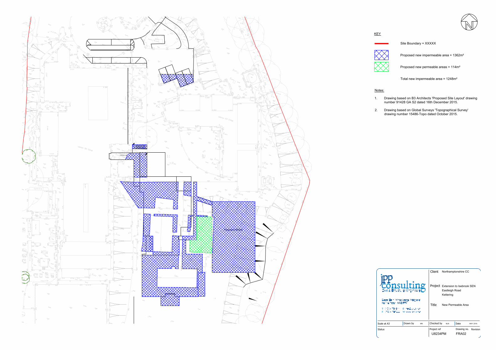
COVERED LINK
Proposed MUGA
Title
Project
Client
Status
Scale at A3 Drawn by Checked by Date
Project ref Drawing no. Revision
Northamptonshire CC
Extension to Isebrook SENEastleigh RoadKettering
New Permeable Area
MN MJA MAY 2016
U8234PM FRA02
Site Boundary = XXXXX
Proposed new impermeable area = 1362m²
Proposed new permeable areas = 114m²
Total new impermeable area = 1248m²
KEY
Notes:
1. Drawing based on B3 Architects 'Proposed Site Layout' drawingnumber 91428 GA S2 dated 16th December 2015.
2. Drawing based on Global Surveys 'Topographical Survey'drawing number 15486-Topo dated October 2015.

Proposed School Extension Isebrook SEN College, Eastleigh Road, Kettering Flood Risk Assessment
R‐FRA‐U8234PM‐01‐B J March 2017 Revision B
Appendix J Drainage Network Calculations

Proposed School Extension Isebrook SEN College, Eastleigh Road, Kettering Flood Risk Assessment
R‐FRA‐U8234PM‐01‐B March 2017 Revision B
1 in 100 year plus Climate Change

J P P Consulting Page 1
Cedar Barn
White Lodge
Northampton NN6 9PY
Date 13/03/2017 15:58 Designed by MartinA
File U8234PM-SW Drainage Dei... Checked by
Micro Drainage Network 2015.1
STORM SEWER DESIGN by the Modified Rational Method
Design Criteria for Storm
©1982-2015 XP Solutions
Pipe Sizes STANDARD Manhole Sizes STANDARD
FSR Rainfall Model - England and Wales
Return Period (years) 1 Add Flow / Climate Change (%) 0
M5-60 (mm) 20.900 Minimum Backdrop Height (m) 0.200
Ratio R 0.434 Maximum Backdrop Height (m) 1.500
Maximum Rainfall (mm/hr) 50 Min Design Depth for Optimisation (m) 1.200
Maximum Time of Concentration (mins) 30 Min Vel for Auto Design only (m/s) 1.00
Foul Sewage (l/s/ha) 0.000 Min Slope for Optimisation (1:X) 500
Volumetric Runoff Coeff. 0.750
Designed with Level Soffits
Time Area Diagram for Storm
Time
(mins)
Area
(ha)
Time
(mins)
Area
(ha)
0-4 0.110 4-8 0.028
Total Area Contributing (ha) = 0.138
Total Pipe Volume (m³) = 6.227
Network Design Table for Storm
PN Length
(m)
Fall
(m)
Slope
(1:X)
I.Area
(ha)
T.E.
(mins)
Base
Flow (l/s)
k
(mm)
HYD
SECT
DIA
(mm)
Auto
Design
1.000 39.000 0.585 66.7 0.049 1.00 0.0 0.600 o 150
1.001 30.000 0.300 100.0 0.020 0.00 0.0 0.600 o 225
1.002 13.000 0.485 26.8 0.000 0.00 0.0 0.600 o 225
2.000 13.400 0.200 67.0 0.013 1.00 0.0 0.600 o 100
2.001 21.000 0.315 66.7 0.017 0.00 0.0 0.600 o 100
2.002 23.000 0.350 65.7 0.028 0.00 0.0 0.600 o 150
Network Results Table
PN Rain
(mm/hr)
T.C.
(mins)
US/IL
(m)
Σ I.Area
(ha)
Σ Base
Flow (l/s)
Foul
(l/s)
Add Flow
(l/s)
Vel
(m/s)
Cap
(l/s)
Flow
(l/s)
1.000 50.00 1.53 62.160 0.049 0.0 0.0 0.0 1.23 21.8 6.6
1.001 50.00 1.91 61.500 0.069 0.0 0.0 0.0 1.31 52.0 9.3
1.002 50.00 1.99 61.200 0.069 0.0 0.0 0.0 2.54 100.9 9.3
2.000 50.00 1.24 61.990 0.013 0.0 0.0 0.0 0.94 7.4 1.8
2.001 50.00 1.61 61.790 0.030 0.0 0.0 0.0 0.94 7.4 4.1
2.002 50.00 1.92 61.425 0.058 0.0 0.0 0.0 1.24 22.0 7.9
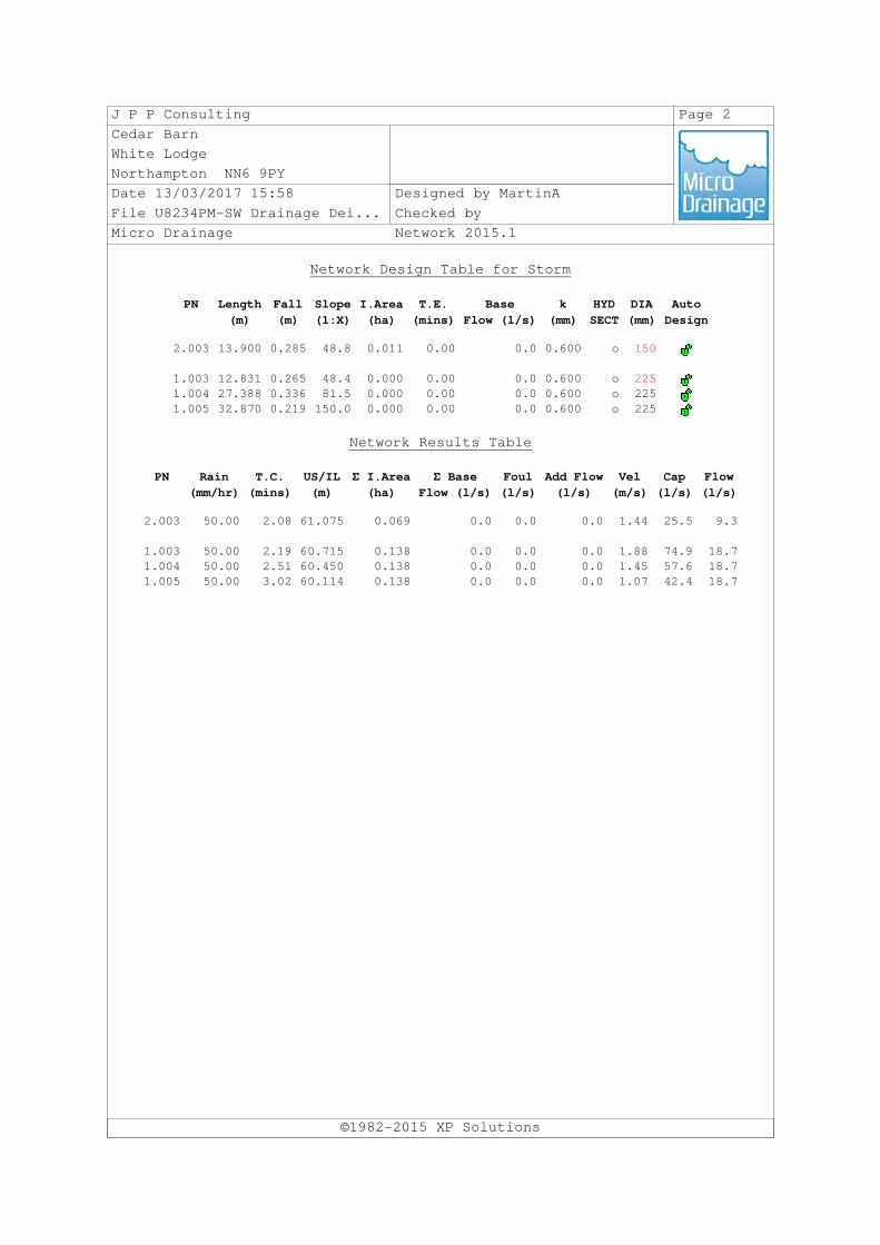
J P P Consulting Page 2
Cedar Barn
White Lodge
Northampton NN6 9PY
Date 13/03/2017 15:58 Designed by MartinA
File U8234PM-SW Drainage Dei... Checked by
Micro Drainage Network 2015.1
Network Design Table for Storm
©1982-2015 XP Solutions
PN Length
(m)
Fall
(m)
Slope
(1:X)
I.Area
(ha)
T.E.
(mins)
Base
Flow (l/s)
k
(mm)
HYD
SECT
DIA
(mm)
Auto
Design
2.003 13.900 0.285 48.8 0.011 0.00 0.0 0.600 o 150
1.003 12.831 0.265 48.4 0.000 0.00 0.0 0.600 o 225
1.004 27.388 0.336 81.5 0.000 0.00 0.0 0.600 o 225
1.005 32.870 0.219 150.0 0.000 0.00 0.0 0.600 o 225
Network Results Table
PN Rain
(mm/hr)
T.C.
(mins)
US/IL
(m)
Σ I.Area
(ha)
Σ Base
Flow (l/s)
Foul
(l/s)
Add Flow
(l/s)
Vel
(m/s)
Cap
(l/s)
Flow
(l/s)
2.003 50.00 2.08 61.075 0.069 0.0 0.0 0.0 1.44 25.5 9.3
1.003 50.00 2.19 60.715 0.138 0.0 0.0 0.0 1.88 74.9 18.7
1.004 50.00 2.51 60.450 0.138 0.0 0.0 0.0 1.45 57.6 18.7
1.005 50.00 3.02 60.114 0.138 0.0 0.0 0.0 1.07 42.4 18.7

J P P Consulting Page 3
Cedar Barn
White Lodge
Northampton NN6 9PY
Date 13/03/2017 15:58 Designed by MartinA
File U8234PM-SW Drainage Dei... Checked by
Micro Drainage Network 2015.1
PIPELINE SCHEDULES for Storm
Upstream Manhole
©1982-2015 XP Solutions
PN Hyd
Sect
Diam
(mm)
MH
Name
C.Level
(m)
I.Level
(m)
D.Depth
(m)
MH
Connection
MH DIAM., L*W
(mm)
1.000 o 150 1 62.830 62.160 0.520 Open Manhole 1200
1.001 o 225 2 62.820 61.500 1.095 Open Manhole 1200
1.002 o 225 3 62.540 61.200 1.115 Open Manhole 1200
2.000 o 100 4 62.910 61.990 0.820 Open Manhole 1200
2.001 o 100 5 62.860 61.790 0.970 Open Manhole 1200
2.002 o 150 6 62.900 61.425 1.325 Open Manhole 1200
2.003 o 150 7 62.527 61.075 1.302 Open Manhole 1200
1.003 o 225 8 62.050 60.715 1.110 Open Manhole 1200
1.004 o 225 9 61.730 60.450 1.055 Open Manhole 1200
1.005 o 225 10 61.730 60.114 1.391 Open Manhole 1200
Downstream Manhole
PN Length
(m)
Slope
(1:X)
MH
Name
C.Level
(m)
I.Level
(m)
D.Depth
(m)
MH
Connection
MH DIAM., L*W
(mm)
1.000 39.000 66.7 2 62.820 61.575 1.095 Open Manhole 1200
1.001 30.000 100.0 3 62.540 61.200 1.115 Open Manhole 1200
1.002 13.000 26.8 8 62.050 60.715 1.110 Open Manhole 1200
2.000 13.400 67.0 5 62.860 61.790 0.970 Open Manhole 1200
2.001 21.000 66.7 6 62.900 61.475 1.325 Open Manhole 1200
2.002 23.000 65.7 7 62.527 61.075 1.302 Open Manhole 1200
2.003 13.900 48.8 8 62.050 60.790 1.110 Open Manhole 1200
1.003 12.831 48.4 9 61.730 60.450 1.055 Open Manhole 1200
1.004 27.388 81.5 10 61.730 60.114 1.391 Open Manhole 1200
1.005 32.870 150.0 65.000 59.895 4.880 Open Manhole 0
Free Flowing Outfall Details for Storm
Outfall
Pipe Number
Outfall
Name
C. Level
(m)
I. Level
(m)
Min
I. Level
(m)
D,L
(mm)
W
(mm)
1.005 65.000 59.895 0.000 0 0

J P P Consulting Page 4
Cedar Barn
White Lodge
Northampton NN6 9PY
Date 13/03/2017 15:58 Designed by MartinA
File U8234PM-SW Drainage Dei... Checked by
Micro Drainage Network 2015.1
Simulation Criteria for Storm
©1982-2015 XP Solutions
Volumetric Runoff Coeff 0.750 Additional Flow - % of Total Flow 0.000
Areal Reduction Factor 1.000 MADD Factor * 10m³/ha Storage 2.000
Hot Start (mins) 0 Inlet Coeffiecient 0.800
Hot Start Level (mm) 0 Flow per Person per Day (l/per/day) 0.000
Manhole Headloss Coeff (Global) 0.500 Run Time (mins) 60
Foul Sewage per hectare (l/s) 0.000 Output Interval (mins) 1
Number of Input Hydrographs 0 Number of Storage Structures 1
Number of Online Controls 1 Number of Time/Area Diagrams 0
Number of Offline Controls 0 Number of Real Time Controls 0
Synthetic Rainfall Details
Rainfall Model FSR Profile Type Summer
Return Period (years) 1 Cv (Summer) 0.750
Region England and Wales Cv (Winter) 0.840
M5-60 (mm) 20.900 Storm Duration (mins) 30
Ratio R 0.434
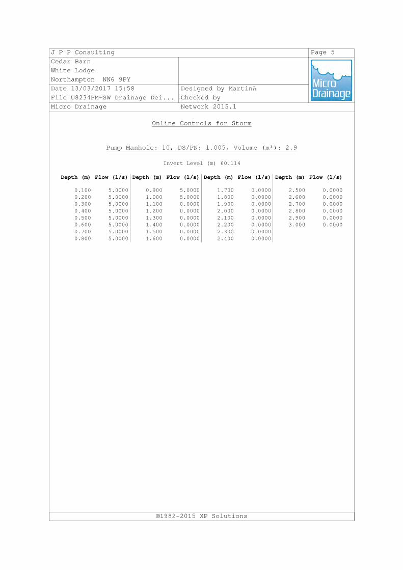
J P P Consulting Page 5
Cedar Barn
White Lodge
Northampton NN6 9PY
Date 13/03/2017 15:58 Designed by MartinA
File U8234PM-SW Drainage Dei... Checked by
Micro Drainage Network 2015.1
Online Controls for Storm
©1982-2015 XP Solutions
Pump Manhole: 10, DS/PN: 1.005, Volume (m³): 2.9
Invert Level (m) 60.114
Depth (m) Flow (l/s) Depth (m) Flow (l/s) Depth (m) Flow (l/s) Depth (m) Flow (l/s)
0.100 5.0000 0.900 5.0000 1.700 0.0000 2.500 0.0000
0.200 5.0000 1.000 5.0000 1.800 0.0000 2.600 0.0000
0.300 5.0000 1.100 0.0000 1.900 0.0000 2.700 0.0000
0.400 5.0000 1.200 0.0000 2.000 0.0000 2.800 0.0000
0.500 5.0000 1.300 0.0000 2.100 0.0000 2.900 0.0000
0.600 5.0000 1.400 0.0000 2.200 0.0000 3.000 0.0000
0.700 5.0000 1.500 0.0000 2.300 0.0000
0.800 5.0000 1.600 0.0000 2.400 0.0000

J P P Consulting Page 6
Cedar Barn
White Lodge
Northampton NN6 9PY
Date 13/03/2017 15:58 Designed by MartinA
File U8234PM-SW Drainage Dei... Checked by
Micro Drainage Network 2015.1
Storage Structures for Storm
©1982-2015 XP Solutions
Cellular Storage Manhole: 10, DS/PN: 1.005
Invert Level (m) 60.175 Safety Factor 1.0
Infiltration Coefficient Base (m/hr) 0.00000 Porosity 0.95
Infiltration Coefficient Side (m/hr) 0.00000
Depth (m) Area (m²) Inf. Area (m²) Depth (m) Area (m²) Inf. Area (m²)
0.000 138.3 0.0 0.521 0.0 0.0
0.520 138.3 0.0

J P P Consulting Page 7
Cedar Barn
White Lodge
Northampton NN6 9PY
Date 13/03/2017 15:58 Designed by MartinA
File U8234PM-SW Drainage Dei... Checked by
Micro Drainage Network 2015.1
Summary of Critical Results by Maximum Level (Rank 1) for Storm
©1982-2015 XP Solutions
Simulation Criteria
Areal Reduction Factor 1.000 Additional Flow - % of Total Flow 0.000
Hot Start (mins) 0 MADD Factor * 10m³/ha Storage 2.000
Hot Start Level (mm) 0 Inlet Coeffiecient 0.800
Manhole Headloss Coeff (Global) 0.500 Flow per Person per Day (l/per/day) 0.000
Foul Sewage per hectare (l/s) 0.000
Number of Input Hydrographs 0 Number of Storage Structures 1
Number of Online Controls 1 Number of Time/Area Diagrams 0
Number of Offline Controls 0 Number of Real Time Controls 0
Synthetic Rainfall Details
Rainfall Model FEH
Return Period (years) 100
Site Location 488200 277500 SP 88200 77500
C (1km) -0.026
D1 (1km) 0.329
D2 (1km) 0.263
D3 (1km) 0.243
E (1km) 0.310
F (1km) 2.555
Cv (Summer) 0.750
Cv (Winter) 0.840
Margin for Flood Risk Warning (mm) 300.0 DVD Status OFF
Analysis Timestep Fine Inertia Status OFF
DTS Status ON
Profile(s) Summer and Winter
Duration(s) (mins) 60, 120, 180, 240, 360, 480, 600, 720, 960,
1440, 2160, 2880, 4320, 5760, 7200, 8640,
10080
Sensitivity flows(s) (%) 0, +40
PN
US/MH
Name Storm
Climate
Change
First (X)
Surcharge
First (Y)
Flood
First (Z)
Overflow
Overflow
Act.
Water
Level
(m)
1.000 1 60 Summer +40% +40%/60 Summer 62.563
1.001 2 60 Summer +40% 61.645
1.002 3 60 Summer +40% 61.300
2.000 4 60 Summer +40% +0%/60 Summer 62.702
2.001 5 60 Summer +40% +0%/60 Summer 62.634
2.002 6 60 Summer +40% +40%/60 Summer 61.893
2.003 7 60 Summer +40% +0%/60 Summer 61.453
1.003 8 60 Summer +40% +40%/60 Summer 61.065
1.004 9 60 Summer +40% +40%/60 Summer 60.846
1.005 10 60 Winter +40% +0%/60 Summer 60.693

J P P Consulting Page 8
Cedar Barn
White Lodge
Northampton NN6 9PY
Date 13/03/2017 15:58 Designed by MartinA
File U8234PM-SW Drainage Dei... Checked by
Micro Drainage Network 2015.1
Summary of Critical Results by Maximum Level (Rank 1) for Storm
©1982-2015 XP Solutions
PN
US/MH
Name
Surcharged
Depth
(m)
Flooded
Volume
(m³)
Flow /
Cap.
Overflow
(l/s)
Pipe
Flow
(l/s) Status
Level
Exceeded
1.000 1 0.253 0.000 1.16 24.5 FLOOD RISK
1.001 2 -0.080 0.000 0.71 34.7 OK
1.002 3 -0.125 0.000 0.40 34.9 OK
2.000 4 0.612 0.000 0.69 4.8 FLOOD RISK
2.001 5 0.744 0.000 1.56 11.2 FLOOD RISK
2.002 6 0.318 0.000 1.12 23.3 SURCHARGED
2.003 7 0.228 0.000 1.16 27.1 SURCHARGED
1.003 8 0.125 0.000 0.93 60.2 SURCHARGED
1.004 9 0.171 0.000 1.10 58.8 SURCHARGED
1.005 10 0.354 0.000 0.13 5.0 SURCHARGED

Proposed School Extension Isebrook SEN College, Eastleigh Road, Kettering Flood Risk Assessment
R‐FRA‐U8234PM‐01‐B March 2017 Revision B
1 in 30 year

J P P Consulting Page 1
Cedar Barn
White Lodge
Northampton NN6 9PY
Date 13/03/2017 16:00 Designed by MartinA
File U8234PM-SW Drainage Dei... Checked by
Micro Drainage Network 2015.1
STORM SEWER DESIGN by the Modified Rational Method
Design Criteria for Storm
©1982-2015 XP Solutions
Pipe Sizes STANDARD Manhole Sizes STANDARD
FSR Rainfall Model - England and Wales
Return Period (years) 1 Add Flow / Climate Change (%) 0
M5-60 (mm) 20.900 Minimum Backdrop Height (m) 0.200
Ratio R 0.434 Maximum Backdrop Height (m) 1.500
Maximum Rainfall (mm/hr) 50 Min Design Depth for Optimisation (m) 1.200
Maximum Time of Concentration (mins) 30 Min Vel for Auto Design only (m/s) 1.00
Foul Sewage (l/s/ha) 0.000 Min Slope for Optimisation (1:X) 500
Volumetric Runoff Coeff. 0.750
Designed with Level Soffits
Time Area Diagram for Storm
Time
(mins)
Area
(ha)
Time
(mins)
Area
(ha)
0-4 0.110 4-8 0.028
Total Area Contributing (ha) = 0.138
Total Pipe Volume (m³) = 6.227
Network Design Table for Storm
PN Length
(m)
Fall
(m)
Slope
(1:X)
I.Area
(ha)
T.E.
(mins)
Base
Flow (l/s)
k
(mm)
HYD
SECT
DIA
(mm)
Auto
Design
1.000 39.000 0.585 66.7 0.049 1.00 0.0 0.600 o 150
1.001 30.000 0.300 100.0 0.020 0.00 0.0 0.600 o 225
1.002 13.000 0.485 26.8 0.000 0.00 0.0 0.600 o 225
2.000 13.400 0.200 67.0 0.013 1.00 0.0 0.600 o 100
2.001 21.000 0.315 66.7 0.017 0.00 0.0 0.600 o 100
2.002 23.000 0.350 65.7 0.028 0.00 0.0 0.600 o 150
Network Results Table
PN Rain
(mm/hr)
T.C.
(mins)
US/IL
(m)
Σ I.Area
(ha)
Σ Base
Flow (l/s)
Foul
(l/s)
Add Flow
(l/s)
Vel
(m/s)
Cap
(l/s)
Flow
(l/s)
1.000 50.00 1.53 62.160 0.049 0.0 0.0 0.0 1.23 21.8 6.6
1.001 50.00 1.91 61.500 0.069 0.0 0.0 0.0 1.31 52.0 9.3
1.002 50.00 1.99 61.200 0.069 0.0 0.0 0.0 2.54 100.9 9.3
2.000 50.00 1.24 61.990 0.013 0.0 0.0 0.0 0.94 7.4 1.8
2.001 50.00 1.61 61.790 0.030 0.0 0.0 0.0 0.94 7.4 4.1
2.002 50.00 1.92 61.425 0.058 0.0 0.0 0.0 1.24 22.0 7.9

J P P Consulting Page 2
Cedar Barn
White Lodge
Northampton NN6 9PY
Date 13/03/2017 16:00 Designed by MartinA
File U8234PM-SW Drainage Dei... Checked by
Micro Drainage Network 2015.1
Network Design Table for Storm
©1982-2015 XP Solutions
PN Length
(m)
Fall
(m)
Slope
(1:X)
I.Area
(ha)
T.E.
(mins)
Base
Flow (l/s)
k
(mm)
HYD
SECT
DIA
(mm)
Auto
Design
2.003 13.900 0.285 48.8 0.011 0.00 0.0 0.600 o 150
1.003 12.831 0.265 48.4 0.000 0.00 0.0 0.600 o 225
1.004 27.388 0.336 81.5 0.000 0.00 0.0 0.600 o 225
1.005 32.870 0.219 150.0 0.000 0.00 0.0 0.600 o 225
Network Results Table
PN Rain
(mm/hr)
T.C.
(mins)
US/IL
(m)
Σ I.Area
(ha)
Σ Base
Flow (l/s)
Foul
(l/s)
Add Flow
(l/s)
Vel
(m/s)
Cap
(l/s)
Flow
(l/s)
2.003 50.00 2.08 61.075 0.069 0.0 0.0 0.0 1.44 25.5 9.3
1.003 50.00 2.19 60.715 0.138 0.0 0.0 0.0 1.88 74.9 18.7
1.004 50.00 2.51 60.450 0.138 0.0 0.0 0.0 1.45 57.6 18.7
1.005 50.00 3.02 60.114 0.138 0.0 0.0 0.0 1.07 42.4 18.7

J P P Consulting Page 3
Cedar Barn
White Lodge
Northampton NN6 9PY
Date 13/03/2017 16:00 Designed by MartinA
File U8234PM-SW Drainage Dei... Checked by
Micro Drainage Network 2015.1
PIPELINE SCHEDULES for Storm
Upstream Manhole
©1982-2015 XP Solutions
PN Hyd
Sect
Diam
(mm)
MH
Name
C.Level
(m)
I.Level
(m)
D.Depth
(m)
MH
Connection
MH DIAM., L*W
(mm)
1.000 o 150 1 62.830 62.160 0.520 Open Manhole 1200
1.001 o 225 2 62.820 61.500 1.095 Open Manhole 1200
1.002 o 225 3 62.540 61.200 1.115 Open Manhole 1200
2.000 o 100 4 62.910 61.990 0.820 Open Manhole 1200
2.001 o 100 5 62.860 61.790 0.970 Open Manhole 1200
2.002 o 150 6 62.900 61.425 1.325 Open Manhole 1200
2.003 o 150 7 62.527 61.075 1.302 Open Manhole 1200
1.003 o 225 8 62.050 60.715 1.110 Open Manhole 1200
1.004 o 225 9 61.730 60.450 1.055 Open Manhole 1200
1.005 o 225 10 61.730 60.114 1.391 Open Manhole 1200
Downstream Manhole
PN Length
(m)
Slope
(1:X)
MH
Name
C.Level
(m)
I.Level
(m)
D.Depth
(m)
MH
Connection
MH DIAM., L*W
(mm)
1.000 39.000 66.7 2 62.820 61.575 1.095 Open Manhole 1200
1.001 30.000 100.0 3 62.540 61.200 1.115 Open Manhole 1200
1.002 13.000 26.8 8 62.050 60.715 1.110 Open Manhole 1200
2.000 13.400 67.0 5 62.860 61.790 0.970 Open Manhole 1200
2.001 21.000 66.7 6 62.900 61.475 1.325 Open Manhole 1200
2.002 23.000 65.7 7 62.527 61.075 1.302 Open Manhole 1200
2.003 13.900 48.8 8 62.050 60.790 1.110 Open Manhole 1200
1.003 12.831 48.4 9 61.730 60.450 1.055 Open Manhole 1200
1.004 27.388 81.5 10 61.730 60.114 1.391 Open Manhole 1200
1.005 32.870 150.0 65.000 59.895 4.880 Open Manhole 0
Free Flowing Outfall Details for Storm
Outfall
Pipe Number
Outfall
Name
C. Level
(m)
I. Level
(m)
Min
I. Level
(m)
D,L
(mm)
W
(mm)
1.005 65.000 59.895 0.000 0 0

J P P Consulting Page 4
Cedar Barn
White Lodge
Northampton NN6 9PY
Date 13/03/2017 16:00 Designed by MartinA
File U8234PM-SW Drainage Dei... Checked by
Micro Drainage Network 2015.1
Simulation Criteria for Storm
©1982-2015 XP Solutions
Volumetric Runoff Coeff 0.750 Additional Flow - % of Total Flow 0.000
Areal Reduction Factor 1.000 MADD Factor * 10m³/ha Storage 2.000
Hot Start (mins) 0 Inlet Coeffiecient 0.800
Hot Start Level (mm) 0 Flow per Person per Day (l/per/day) 0.000
Manhole Headloss Coeff (Global) 0.500 Run Time (mins) 60
Foul Sewage per hectare (l/s) 0.000 Output Interval (mins) 1
Number of Input Hydrographs 0 Number of Storage Structures 1
Number of Online Controls 1 Number of Time/Area Diagrams 0
Number of Offline Controls 0 Number of Real Time Controls 0
Synthetic Rainfall Details
Rainfall Model FSR Profile Type Summer
Return Period (years) 1 Cv (Summer) 0.750
Region England and Wales Cv (Winter) 0.840
M5-60 (mm) 20.900 Storm Duration (mins) 30
Ratio R 0.434

J P P Consulting Page 5
Cedar Barn
White Lodge
Northampton NN6 9PY
Date 13/03/2017 16:00 Designed by MartinA
File U8234PM-SW Drainage Dei... Checked by
Micro Drainage Network 2015.1
Online Controls for Storm
©1982-2015 XP Solutions
Pump Manhole: 10, DS/PN: 1.005, Volume (m³): 2.9
Invert Level (m) 60.114
Depth (m) Flow (l/s) Depth (m) Flow (l/s) Depth (m) Flow (l/s) Depth (m) Flow (l/s)
0.100 5.0000 0.900 5.0000 1.700 0.0000 2.500 0.0000
0.200 5.0000 1.000 5.0000 1.800 0.0000 2.600 0.0000
0.300 5.0000 1.100 0.0000 1.900 0.0000 2.700 0.0000
0.400 5.0000 1.200 0.0000 2.000 0.0000 2.800 0.0000
0.500 5.0000 1.300 0.0000 2.100 0.0000 2.900 0.0000
0.600 5.0000 1.400 0.0000 2.200 0.0000 3.000 0.0000
0.700 5.0000 1.500 0.0000 2.300 0.0000
0.800 5.0000 1.600 0.0000 2.400 0.0000

J P P Consulting Page 6
Cedar Barn
White Lodge
Northampton NN6 9PY
Date 13/03/2017 16:00 Designed by MartinA
File U8234PM-SW Drainage Dei... Checked by
Micro Drainage Network 2015.1
Storage Structures for Storm
©1982-2015 XP Solutions
Cellular Storage Manhole: 10, DS/PN: 1.005
Invert Level (m) 60.175 Safety Factor 1.0
Infiltration Coefficient Base (m/hr) 0.00000 Porosity 0.95
Infiltration Coefficient Side (m/hr) 0.00000
Depth (m) Area (m²) Inf. Area (m²) Depth (m) Area (m²) Inf. Area (m²)
0.000 138.3 0.0 0.521 0.0 0.0
0.520 138.3 0.0

J P P Consulting Page 7
Cedar Barn
White Lodge
Northampton NN6 9PY
Date 13/03/2017 16:00 Designed by MartinA
File U8234PM-SW Drainage Dei... Checked by
Micro Drainage Network 2015.1
Summary of Critical Results by Maximum Level (Rank 1) for Storm
©1982-2015 XP Solutions
Simulation Criteria
Areal Reduction Factor 1.000 Additional Flow - % of Total Flow 0.000
Hot Start (mins) 0 MADD Factor * 10m³/ha Storage 2.000
Hot Start Level (mm) 0 Inlet Coeffiecient 0.800
Manhole Headloss Coeff (Global) 0.500 Flow per Person per Day (l/per/day) 0.000
Foul Sewage per hectare (l/s) 0.000
Number of Input Hydrographs 0 Number of Storage Structures 1
Number of Online Controls 1 Number of Time/Area Diagrams 0
Number of Offline Controls 0 Number of Real Time Controls 0
Synthetic Rainfall Details
Rainfall Model FEH
Return Period (years) 30
Site Location 488200 277500 SP 88200 77500
C (1km) -0.026
D1 (1km) 0.329
D2 (1km) 0.263
D3 (1km) 0.243
E (1km) 0.310
F (1km) 2.555
Cv (Summer) 0.750
Cv (Winter) 0.840
Margin for Flood Risk Warning (mm) 300.0 DVD Status OFF
Analysis Timestep Fine Inertia Status OFF
DTS Status ON
Profile(s) Summer and Winter
Duration(s) (mins) 60, 120, 180, 240, 360, 480, 600, 720, 960,
1440, 2160, 2880, 4320, 5760, 7200, 8640,
10080
Sensitivity flows(s) (%) 0
PN
US/MH
Name Storm
Climate
Change
First (X)
Surcharge
First (Y)
Flood
First (Z)
Overflow
Overflow
Act.
Water
Level
(m)
1.000 1 60 Summer +0% 62.246
1.001 2 60 Summer +0% 61.596
1.002 3 60 Summer +0% 61.270
2.000 4 60 Summer +0% 62.040
2.001 5 60 Summer +0% +0%/60 Summer 61.928
2.002 6 60 Summer +0% 61.520
2.003 7 60 Summer +0% 61.174
1.003 8 60 Summer +0% 60.836
1.004 9 60 Summer +0% 60.587
1.005 10 60 Winter +0% +0%/60 Summer 60.376
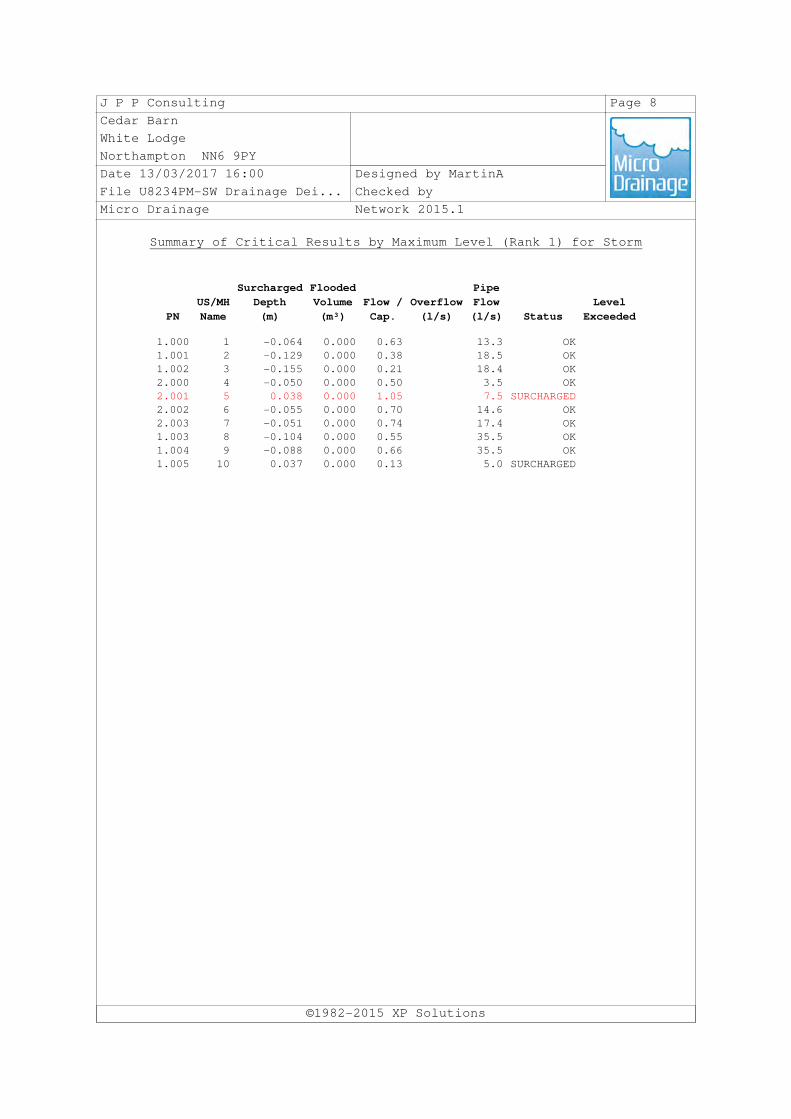
J P P Consulting Page 8
Cedar Barn
White Lodge
Northampton NN6 9PY
Date 13/03/2017 16:00 Designed by MartinA
File U8234PM-SW Drainage Dei... Checked by
Micro Drainage Network 2015.1
Summary of Critical Results by Maximum Level (Rank 1) for Storm
©1982-2015 XP Solutions
PN
US/MH
Name
Surcharged
Depth
(m)
Flooded
Volume
(m³)
Flow /
Cap.
Overflow
(l/s)
Pipe
Flow
(l/s) Status
Level
Exceeded
1.000 1 -0.064 0.000 0.63 13.3 OK
1.001 2 -0.129 0.000 0.38 18.5 OK
1.002 3 -0.155 0.000 0.21 18.4 OK
2.000 4 -0.050 0.000 0.50 3.5 OK
2.001 5 0.038 0.000 1.05 7.5 SURCHARGED
2.002 6 -0.055 0.000 0.70 14.6 OK
2.003 7 -0.051 0.000 0.74 17.4 OK
1.003 8 -0.104 0.000 0.55 35.5 OK
1.004 9 -0.088 0.000 0.66 35.5 OK
1.005 10 0.037 0.000 0.13 5.0 SURCHARGED

Proposed School Extension Isebrook SEN College, Eastleigh Road, Kettering Flood Risk Assessment
R‐FRA‐U8234PM‐01‐B March 2017 Revision B
1 in 1 year
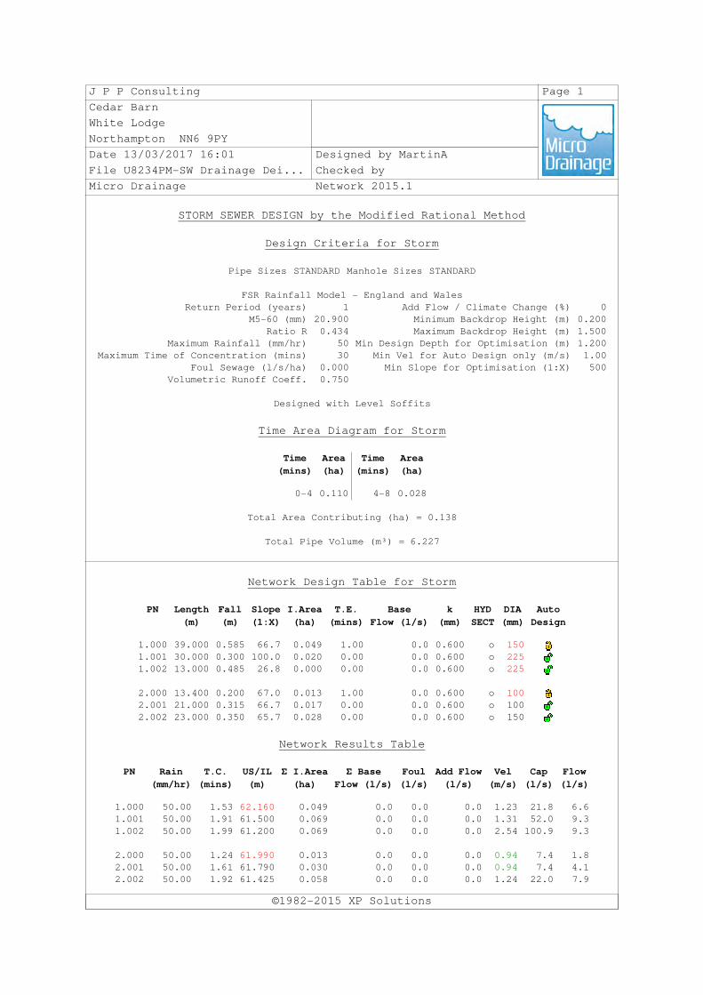
J P P Consulting Page 1
Cedar Barn
White Lodge
Northampton NN6 9PY
Date 13/03/2017 16:01 Designed by MartinA
File U8234PM-SW Drainage Dei... Checked by
Micro Drainage Network 2015.1
STORM SEWER DESIGN by the Modified Rational Method
Design Criteria for Storm
©1982-2015 XP Solutions
Pipe Sizes STANDARD Manhole Sizes STANDARD
FSR Rainfall Model - England and Wales
Return Period (years) 1 Add Flow / Climate Change (%) 0
M5-60 (mm) 20.900 Minimum Backdrop Height (m) 0.200
Ratio R 0.434 Maximum Backdrop Height (m) 1.500
Maximum Rainfall (mm/hr) 50 Min Design Depth for Optimisation (m) 1.200
Maximum Time of Concentration (mins) 30 Min Vel for Auto Design only (m/s) 1.00
Foul Sewage (l/s/ha) 0.000 Min Slope for Optimisation (1:X) 500
Volumetric Runoff Coeff. 0.750
Designed with Level Soffits
Time Area Diagram for Storm
Time
(mins)
Area
(ha)
Time
(mins)
Area
(ha)
0-4 0.110 4-8 0.028
Total Area Contributing (ha) = 0.138
Total Pipe Volume (m³) = 6.227
Network Design Table for Storm
PN Length
(m)
Fall
(m)
Slope
(1:X)
I.Area
(ha)
T.E.
(mins)
Base
Flow (l/s)
k
(mm)
HYD
SECT
DIA
(mm)
Auto
Design
1.000 39.000 0.585 66.7 0.049 1.00 0.0 0.600 o 150
1.001 30.000 0.300 100.0 0.020 0.00 0.0 0.600 o 225
1.002 13.000 0.485 26.8 0.000 0.00 0.0 0.600 o 225
2.000 13.400 0.200 67.0 0.013 1.00 0.0 0.600 o 100
2.001 21.000 0.315 66.7 0.017 0.00 0.0 0.600 o 100
2.002 23.000 0.350 65.7 0.028 0.00 0.0 0.600 o 150
Network Results Table
PN Rain
(mm/hr)
T.C.
(mins)
US/IL
(m)
Σ I.Area
(ha)
Σ Base
Flow (l/s)
Foul
(l/s)
Add Flow
(l/s)
Vel
(m/s)
Cap
(l/s)
Flow
(l/s)
1.000 50.00 1.53 62.160 0.049 0.0 0.0 0.0 1.23 21.8 6.6
1.001 50.00 1.91 61.500 0.069 0.0 0.0 0.0 1.31 52.0 9.3
1.002 50.00 1.99 61.200 0.069 0.0 0.0 0.0 2.54 100.9 9.3
2.000 50.00 1.24 61.990 0.013 0.0 0.0 0.0 0.94 7.4 1.8
2.001 50.00 1.61 61.790 0.030 0.0 0.0 0.0 0.94 7.4 4.1
2.002 50.00 1.92 61.425 0.058 0.0 0.0 0.0 1.24 22.0 7.9

J P P Consulting Page 2
Cedar Barn
White Lodge
Northampton NN6 9PY
Date 13/03/2017 16:01 Designed by MartinA
File U8234PM-SW Drainage Dei... Checked by
Micro Drainage Network 2015.1
Network Design Table for Storm
©1982-2015 XP Solutions
PN Length
(m)
Fall
(m)
Slope
(1:X)
I.Area
(ha)
T.E.
(mins)
Base
Flow (l/s)
k
(mm)
HYD
SECT
DIA
(mm)
Auto
Design
2.003 13.900 0.285 48.8 0.011 0.00 0.0 0.600 o 150
1.003 12.831 0.265 48.4 0.000 0.00 0.0 0.600 o 225
1.004 27.388 0.336 81.5 0.000 0.00 0.0 0.600 o 225
1.005 32.870 0.219 150.0 0.000 0.00 0.0 0.600 o 225
Network Results Table
PN Rain
(mm/hr)
T.C.
(mins)
US/IL
(m)
Σ I.Area
(ha)
Σ Base
Flow (l/s)
Foul
(l/s)
Add Flow
(l/s)
Vel
(m/s)
Cap
(l/s)
Flow
(l/s)
2.003 50.00 2.08 61.075 0.069 0.0 0.0 0.0 1.44 25.5 9.3
1.003 50.00 2.19 60.715 0.138 0.0 0.0 0.0 1.88 74.9 18.7
1.004 50.00 2.51 60.450 0.138 0.0 0.0 0.0 1.45 57.6 18.7
1.005 50.00 3.02 60.114 0.138 0.0 0.0 0.0 1.07 42.4 18.7
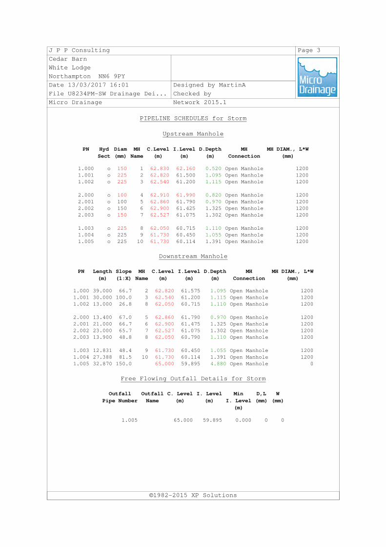
J P P Consulting Page 3
Cedar Barn
White Lodge
Northampton NN6 9PY
Date 13/03/2017 16:01 Designed by MartinA
File U8234PM-SW Drainage Dei... Checked by
Micro Drainage Network 2015.1
PIPELINE SCHEDULES for Storm
Upstream Manhole
©1982-2015 XP Solutions
PN Hyd
Sect
Diam
(mm)
MH
Name
C.Level
(m)
I.Level
(m)
D.Depth
(m)
MH
Connection
MH DIAM., L*W
(mm)
1.000 o 150 1 62.830 62.160 0.520 Open Manhole 1200
1.001 o 225 2 62.820 61.500 1.095 Open Manhole 1200
1.002 o 225 3 62.540 61.200 1.115 Open Manhole 1200
2.000 o 100 4 62.910 61.990 0.820 Open Manhole 1200
2.001 o 100 5 62.860 61.790 0.970 Open Manhole 1200
2.002 o 150 6 62.900 61.425 1.325 Open Manhole 1200
2.003 o 150 7 62.527 61.075 1.302 Open Manhole 1200
1.003 o 225 8 62.050 60.715 1.110 Open Manhole 1200
1.004 o 225 9 61.730 60.450 1.055 Open Manhole 1200
1.005 o 225 10 61.730 60.114 1.391 Open Manhole 1200
Downstream Manhole
PN Length
(m)
Slope
(1:X)
MH
Name
C.Level
(m)
I.Level
(m)
D.Depth
(m)
MH
Connection
MH DIAM., L*W
(mm)
1.000 39.000 66.7 2 62.820 61.575 1.095 Open Manhole 1200
1.001 30.000 100.0 3 62.540 61.200 1.115 Open Manhole 1200
1.002 13.000 26.8 8 62.050 60.715 1.110 Open Manhole 1200
2.000 13.400 67.0 5 62.860 61.790 0.970 Open Manhole 1200
2.001 21.000 66.7 6 62.900 61.475 1.325 Open Manhole 1200
2.002 23.000 65.7 7 62.527 61.075 1.302 Open Manhole 1200
2.003 13.900 48.8 8 62.050 60.790 1.110 Open Manhole 1200
1.003 12.831 48.4 9 61.730 60.450 1.055 Open Manhole 1200
1.004 27.388 81.5 10 61.730 60.114 1.391 Open Manhole 1200
1.005 32.870 150.0 65.000 59.895 4.880 Open Manhole 0
Free Flowing Outfall Details for Storm
Outfall
Pipe Number
Outfall
Name
C. Level
(m)
I. Level
(m)
Min
I. Level
(m)
D,L
(mm)
W
(mm)
1.005 65.000 59.895 0.000 0 0
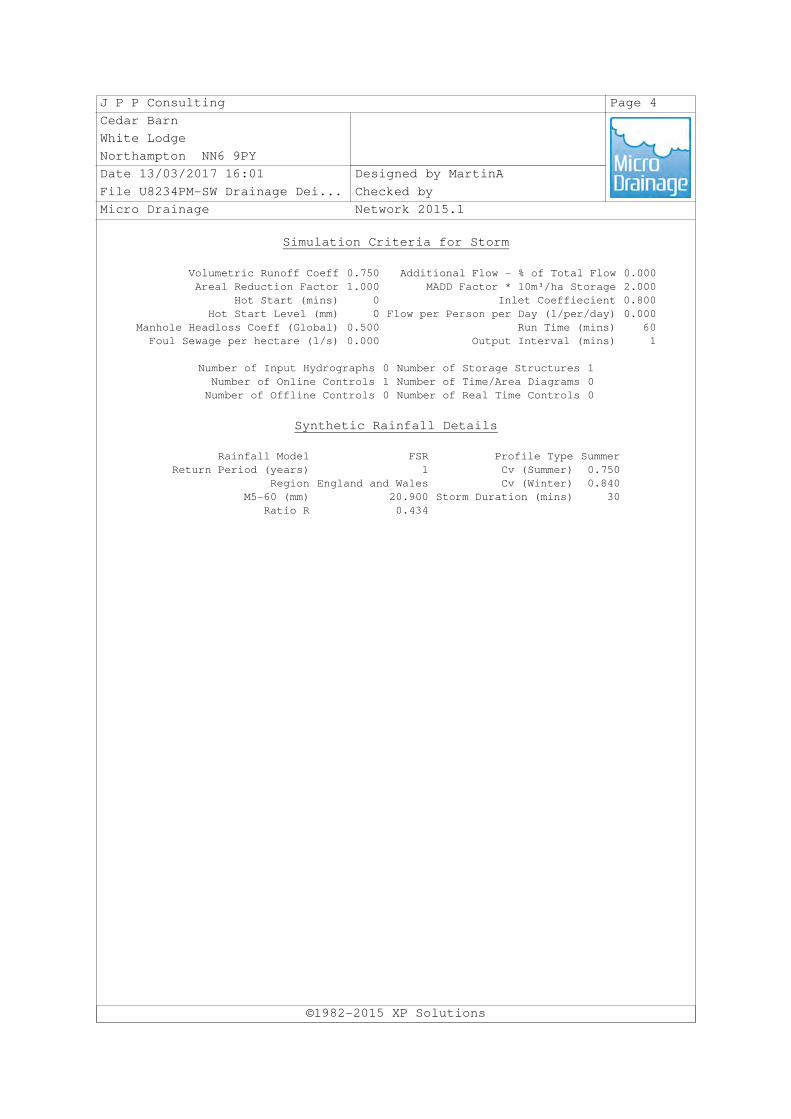
J P P Consulting Page 4
Cedar Barn
White Lodge
Northampton NN6 9PY
Date 13/03/2017 16:01 Designed by MartinA
File U8234PM-SW Drainage Dei... Checked by
Micro Drainage Network 2015.1
Simulation Criteria for Storm
©1982-2015 XP Solutions
Volumetric Runoff Coeff 0.750 Additional Flow - % of Total Flow 0.000
Areal Reduction Factor 1.000 MADD Factor * 10m³/ha Storage 2.000
Hot Start (mins) 0 Inlet Coeffiecient 0.800
Hot Start Level (mm) 0 Flow per Person per Day (l/per/day) 0.000
Manhole Headloss Coeff (Global) 0.500 Run Time (mins) 60
Foul Sewage per hectare (l/s) 0.000 Output Interval (mins) 1
Number of Input Hydrographs 0 Number of Storage Structures 1
Number of Online Controls 1 Number of Time/Area Diagrams 0
Number of Offline Controls 0 Number of Real Time Controls 0
Synthetic Rainfall Details
Rainfall Model FSR Profile Type Summer
Return Period (years) 1 Cv (Summer) 0.750
Region England and Wales Cv (Winter) 0.840
M5-60 (mm) 20.900 Storm Duration (mins) 30
Ratio R 0.434

J P P Consulting Page 5
Cedar Barn
White Lodge
Northampton NN6 9PY
Date 13/03/2017 16:01 Designed by MartinA
File U8234PM-SW Drainage Dei... Checked by
Micro Drainage Network 2015.1
Online Controls for Storm
©1982-2015 XP Solutions
Pump Manhole: 10, DS/PN: 1.005, Volume (m³): 2.9
Invert Level (m) 60.114
Depth (m) Flow (l/s) Depth (m) Flow (l/s) Depth (m) Flow (l/s) Depth (m) Flow (l/s)
0.100 5.0000 0.900 5.0000 1.700 0.0000 2.500 0.0000
0.200 5.0000 1.000 5.0000 1.800 0.0000 2.600 0.0000
0.300 5.0000 1.100 0.0000 1.900 0.0000 2.700 0.0000
0.400 5.0000 1.200 0.0000 2.000 0.0000 2.800 0.0000
0.500 5.0000 1.300 0.0000 2.100 0.0000 2.900 0.0000
0.600 5.0000 1.400 0.0000 2.200 0.0000 3.000 0.0000
0.700 5.0000 1.500 0.0000 2.300 0.0000
0.800 5.0000 1.600 0.0000 2.400 0.0000

J P P Consulting Page 6
Cedar Barn
White Lodge
Northampton NN6 9PY
Date 13/03/2017 16:01 Designed by MartinA
File U8234PM-SW Drainage Dei... Checked by
Micro Drainage Network 2015.1
Storage Structures for Storm
©1982-2015 XP Solutions
Cellular Storage Manhole: 10, DS/PN: 1.005
Invert Level (m) 60.175 Safety Factor 1.0
Infiltration Coefficient Base (m/hr) 0.00000 Porosity 0.95
Infiltration Coefficient Side (m/hr) 0.00000
Depth (m) Area (m²) Inf. Area (m²) Depth (m) Area (m²) Inf. Area (m²)
0.000 138.3 0.0 0.521 0.0 0.0
0.520 138.3 0.0

J P P Consulting Page 7
Cedar Barn
White Lodge
Northampton NN6 9PY
Date 13/03/2017 16:01 Designed by MartinA
File U8234PM-SW Drainage Dei... Checked by
Micro Drainage Network 2015.1
Summary of Critical Results by Maximum Level (Rank 1) for Storm
©1982-2015 XP Solutions
Simulation Criteria
Areal Reduction Factor 1.000 Additional Flow - % of Total Flow 0.000
Hot Start (mins) 0 MADD Factor * 10m³/ha Storage 2.000
Hot Start Level (mm) 0 Inlet Coeffiecient 0.800
Manhole Headloss Coeff (Global) 0.500 Flow per Person per Day (l/per/day) 0.000
Foul Sewage per hectare (l/s) 0.000
Number of Input Hydrographs 0 Number of Storage Structures 1
Number of Online Controls 1 Number of Time/Area Diagrams 0
Number of Offline Controls 0 Number of Real Time Controls 0
Synthetic Rainfall Details
Rainfall Model FEH
Return Period (years) 1
Site Location 488200 277500 SP 88200 77500
C (1km) -0.026
D1 (1km) 0.329
D2 (1km) 0.263
D3 (1km) 0.243
E (1km) 0.310
F (1km) 2.555
Cv (Summer) 0.750
Cv (Winter) 0.840
Margin for Flood Risk Warning (mm) 300.0 DVD Status OFF
Analysis Timestep Fine Inertia Status OFF
DTS Status ON
Profile(s) Summer and Winter
Duration(s) (mins) 60, 120, 180, 240, 360, 480, 600, 720, 960,
1440, 2160, 2880, 4320, 5760, 7200, 8640,
10080
Sensitivity flows(s) (%) 0
PN
US/MH
Name Storm
Climate
Change
First (X)
Surcharge
First (Y)
Flood
First (Z)
Overflow
Overflow
Act.
Water
Level
(m)
Surcharged
Depth
(m)
1.000 1 60 Summer +0% 62.207 -0.103
1.001 2 60 Summer +0% 61.554 -0.171
1.002 3 60 Summer +0% 61.240 -0.185
2.000 4 60 Summer +0% 62.018 -0.072
2.001 5 60 Summer +0% 61.832 -0.058
2.002 6 60 Summer +0% 61.475 -0.100
2.003 7 60 Summer +0% 61.126 -0.099
1.003 8 60 Summer +0% 60.781 -0.159
1.004 9 60 Summer +0% 60.522 -0.153
1.005 10 60 Winter +0% 60.211 -0.128

J P P Consulting Page 8
Cedar Barn
White Lodge
Northampton NN6 9PY
Date 13/03/2017 16:01 Designed by MartinA
File U8234PM-SW Drainage Dei... Checked by
Micro Drainage Network 2015.1
Summary of Critical Results by Maximum Level (Rank 1) for Storm
©1982-2015 XP Solutions
PN
US/MH
Name
Flooded
Volume
(m³)
Flow /
Cap.
Overflow
(l/s)
Pipe
Flow
(l/s) Status
Level
Exceeded
1.000 1 0.000 0.22 4.6 OK
1.001 2 0.000 0.13 6.2 OK
1.002 3 0.000 0.07 6.2 OK
2.000 4 0.000 0.18 1.2 OK
2.001 5 0.000 0.36 2.6 OK
2.002 6 0.000 0.23 4.9 OK
2.003 7 0.000 0.25 5.8 OK
1.003 8 0.000 0.19 12.0 OK
1.004 9 0.000 0.23 12.1 OK
1.005 10 0.000 0.12 4.9 OK

Proposed School Extension Isebrook SEN College, Eastleigh Road, Kettering Flood Risk Assessment
R‐FRA‐U8234PM‐01‐B K March 2017 Revision B
Appendix K Extract from Geotechnical Investigation