provincial journal.,,, - cmscontent.nrs.gov.bc.ca
TRANSCRIPT
Provincial Geologists
1986 Journal
Journal.,,, L..
des geologues provinciaux
Published annually by Committee of Provincial Geologists
Publication annuelle du Comite des geologues provinciaux
CONTENTS
Foreword . . . . . . . . . . . . . . . . . . . . . . . . . . . . . . . . . . iii Chairman’s report .......................... 1 Geoscience organization charts . . . . . . . . . . . . . . 3
British Columbia ......................... 4 Alberta . . . . . . . . . . . . . . . . . . . . . . . . . . . . . . . . . . . 5
~ Saskatchewan ........................... 6 ~ Manitoba ................................ 7
Ontario .................................. 8 Quebec ................................. 9 New Brunswick .......................... 10 Nova Scotia . . . . . . . . . . . . . . . . . . . . . . . . . . . . . 11
~
~ Prince Edward Island ..................... 12
I Newfoundland ........................... 13 I Northwest Territories 14
Yukon . . . . . . . . . . . . . . . . . . . . . . . . . . . . . . . . . . 15 I
I
~
~
,
.....................
Provincial Geological Survey Expendices. 1985-1 986 . . . . . . . . . . . . . . . . . . . . . . . . . . . . . . . . .17. 18
British Columbia ......................... 19 Alberta . . . . . . . . . . . . . . . . . . . . . . . . . . . . . . . . . . 20 Saskatchewan ........................... 21 Manitoba . . . . . . . . . . . . . . . . . . . . . . . . . . . . . . . . 22 Ontario . . . . . . . . . . . . . . . . . . . . . . . . . . . . . . . . . . 23 Quebec .................................. 24 New Brunswick .......................... 25 Nova Scotia . . . . . . . . . . . . . . . . . . . . . . . . . . . . . 26 Newfoundland ........................... 27 Northwest Territories ..................... 28 Yukon . . . . . . . . . . . . . . . . . . . . . . . . . . . . . . . . . . 29
Geological Program Highlights . . . . . . . . . . . . . . . 31 British Columbia ......................... 32 Alberta . . . . . . . . . . . . . . . . . . . . . . . . . . . . . . . . . . 36 Saskatchewan ........................... 39 Manitoba . . . . . . . . . . . . . . . . . . . . . . . . . . . . . . . . 42 Ontario . . . . . . . . . . . . . . . . . . . . . . . . . . . . . . . . . . 50 Quebec . . . . . . . . . . . . . . . . . . . . . . . . . . . . . . . . . 54
New Brunswick .......................... 60 Nova Scotia ............................. 63 Prince Edward Island ..................... 67 Newfoundland ........................... 67
.Northwest Territories ..................... 71 Yukon .................................. 75
Geological Publications ..................... 79 British Columbia ......................... 80 Alberta . . . . . . . . . . . . . . . . . . . . . . . . . . . . . . . . . . 81 Saskatchewan ........................... 82 Manitoba . . . . . . . . . . . . . . . . . . . . . . . . . . . . . . . . 82 Ontario . . . . . . . . . . . . . . . . . . . . . . . . . . . . . . . . . . 83 Quebec ................................. 93 New Brunswick .......................... 96 Nova Scotia ............................. 101 Prince Edward Island ..................... 103 Newfoundland ........................... 103 Northwest Territories ..................... 105 Yukon . . . . . . . . . . . . . . . . . . . . . . . . . . . . . . . . . . 106
Articles . . . . . . . . . . . . . . . . . . . . . . . . . . . . . . . . . . . . 107
industry ............................... 108 111
Reports on technical liaison committees . . . . 113 Survey of federal-provincial mineral
development agreements . . . . . . . . . . . . . . . 121 Provincial day at the Prospectors and
Developers Association Convention ....... 124 Annual reviews of activities provincial
and federal geosciendfic organizations . . . 125 Survey of hard rock drill core programs
in Canada fiscal year 1985-86 . . . . . . . . . . 126 Membership of the Committee of Provincial
Geologists ........................ back cover
Transportation systems and the mineral
Geoscience data management . . . . . . . . . ’ . . .

1986 PROVINCIAL GEOLOGISTS JOURNAL
JOURNAL DES GEOLOGUES PROVINCIAUX
VOLUME 4
PUBLICATION ANNUELLE DU
COMITE DES GEOLOGUES PROVINCIAUX
PUBLISHED ANNUALLY BY
COMMITTEE OF PROVINCIAL GEOLOGISTS


AVANT-PROPOS
Nous sommes heureux de vous presenter le volume4 du Journal des geologues provin- ciaux. Lorsque nous avons accepte le mandat d’editer et de publier ce quatrieme volume, c’etait avant tout pour nous I’occasion de te- moigner de I’importance que nous accordons a cette publication et aussi afin d’assurer sa continuation.
Nous desirons remercier toutes les personnes ainsi que les institutions qui ont aide a assem- bler le volume 4. Parmi celles-ci, mentionnons W.R. Smyth, Ministry of Energy, Mines and Petroleum resources, British Colombia ; Ja- mes Christopher, Department of Energy and Mines, Saskatchewan; V. Milne et G. Ken- dricks, Ministry of Northern Development and Mines, Ontario ; et P. Giles, Department of Energy and Mines, Nova Scotia.
Le Service de la geoinformation du ministere de I’Energie et des Ressources du Quebec a edite et compile le present volume. Nos re- merciements s’adressent tout particulierement a Luc Chauvin et son equipe pour avoir per- mis la realisation de ce volume avec un si bref echeancier.
Le Journal des geologues provinciaux est dis- ponible dans chaque province et territoire au comptoir habitue1 servant a diffuser I’informa- tion geoscientifique.
Andre F. Laurin Sous-ministre adjoint Exploration geologique et minerale (Mines) Ministere de I’Energie et des Ressources, Quebec
FOREWORD
We are pleased to present Volume4 of the Provincial Geologists Journal. When we ac- cepted to edit and publish Volume4, we did so because all of us recognized the impor- tance the Journal has for our individual or- ganizations and industries and the need to perpetuate the Journal was self-evident.
I would like to thank all the people and institu- tions that helped put together this volume. They include W.R. Smyth, Ministry of Energy, Mines and Petroleum Resources, British Col- ombia ; James Christopher, Energy and Mines, Saskatchewan ; V. Milne and G. Ken- dricks, Ministry of Northern Development and Mines, Ontario ; and P. Giles, Department of Energy and Mines, Nova Scotia.
The Geoinformation Service of the Ministry of Energy and Resources, Quebec, edited and compiled the present volume. Special thanks go to Luc Chauvin and his team for producing the volume in such a short period of time.
The Provincial Geologist Journal is available in each province and territory through the offices of geological surveys or relavant infor- mation centres or distribution offices of miner- al resources departments of provincial or terri- torial governments.
Andre F. Laurin Sous-ministre adjoint Exploration geologique et minerale (Mines) Ministere de I’Energie et des Ressources, Quebec
... 111


THE COMMITTEE OF PROVINCIAL GEOLOGISTS CHAIRMAN’S REPORT 1986
It is ten years since the Committee of Provincial Geologists was formed at the Meeting of the Provincial Mines Ministers in St. John’s, Newfoundland. The Chief Geologists or equivalent from each provincial and territorial Survey of Mineral Resources Division comprise the Committee. In anticipation of future devolution of mineral resource responsibilities for the northern territories, the Yukon and Northwest Territories governments were given observer status in 1985.
The Committee provides a forum for discussion of those geological and mineral resource exploration and development issues that lie within the jurisdiction of the Provinces, and through contacts with private sector mineral oriented organizations maintains an effective and highly useful liaison with most of the components of the mineral industry. The Committee, through its individual members, is a major component of the National Geological Survey’s Committee, through which a formal communication channel has been established with the Geological Survey of Canada. Committee representation on the Geoscience Council of Canada provides an effective window to many other facets of the earth science community in Canada. Active participation in the annual convention of the Prospectors and Developers’ Association is maintained through a Provincial Day, during which activities in the provinces and regions as well as their resource potential are discussed, and through the Provincial Room in which each province and territory advertises to the mining and mineral exploration community activities and potential within its domain.
The Committee meets twice a year: in March, just prior to the Prospectors and Developers’ Convention ; and usually in September in conjunction with the Provincial Mines Ministers’ Conference. Various mining, exploration and related mineral industry groups and federal agencies are invited to discuss issues of current interest with the Committee.
A topic of high priority has been the maintenance, expansion and enhancement of Canada’s geoscience data base. Mineral exploration and development, land use planning, and geo- technical hazard evaluation, a growing concern as our country becomes more and more urbanized, are all dependent for success of this data base. Under the current economic restraint that affects all levels of the Canadian economy, the need to enhance the effectiveness of all geoscientific investigations, and to preserve and ultimately to make available both the results and data generated by such investigations has become more apparent. Thus, among the topics of concern to the Committee, ones which are regularly discussed with private industry, academic and federal communities are :
(1) Computerization of the various types of data files that have been built up, and how these can be made available to potential users.
(2) Capture and preservation of geological data, including drill core, produced by various industry activities, and data produced by geochemical and geophysical surveys.
(3) Review of government supported geological programs to enhance their usefulness and relevance to private and public sector needs and to avoid, as far as possible, non-productive duplication of work.
To further these goals at the individual survey level, Mineral Exploration Liaison Committees have been formed to improve communications between the various provincial geoscience organizations and their client communities. Most of these committees are made up of industry and academic representatives.
The Committee published Volume 3 of its Journal in March 1986. This Journal, by publicizing the work of the Committee and of the member organizations, provides a vehicle to acquaint the many client groups of provincial surveys with basic information on provincial survey operations.

, Achievements of Committee of Provincial Geologists in 1986 , 1.) A survey of geological data files was conducted to ascertain the status and variety of such
data bases and their availability to industry and other public users.
2) A survey of Mineral Development Agreements was completed in order to share experiences and expertise with these programs and ensure there will be no unnecessary duplication of studies.
3) Consultations continued to develop and ensure the use of standard geological map symbols.
4) A survey of the methods used in the discovery of Canadian mineral deposits was begun. First results for mines that began production during the past 20 years will be published in the next Committee Journal.
5) A Provincial Room, at which all provincial and territorial geological surveys displayed their products and advertised their current activities, was held at the March Prospectors and Developers Convention in Toronto. More than 1500 people viewed these exhibits.
W.A. Padgham

GEOSCIENCE ORGANIZATION CHARTS
Each provincial and territorial government in Canada has developed its own organizational structure for conducting geoscientific survey and research work. Some provinces have what is formally called a Geological Survey (e.g. Ontario Geological Survey), but in most jurisdictions the main elements of the geological survey function are embraced in one or more Branches or Divisions of provincial Mines/ Energy/ Natural Resources Departments (e.g. the British Columbia Ministry of Energy, Mines and Petroleum Resources is divided into a Mineral Resources Division and a Petroleum Resources Division, with the bulk of geological survey and research work conducted in the Geological Branch of the Mineral Resources Division). The following organization charts are set out in standard format to help alleviate confusion amongst potential users of provincial geoscience services. The charts contain reference to the lines of reporting of the various units in each hierarchy, the manpower associated with each separate jurisdiction, and the names and telephone numbers of key individuals in each system.
3

BRITISH COLUMBIA GEOSCIENCE ORGANIZATION CHART
MINISTER ENERGY MINES 8
PETROLEUM RESOURCES
HON A J BRUMMET r 16041 387- 5295
DEPUTY MINISTER
R ILLING
DIRECTOR O F COMMUNICATION
J J BANKV
16041 367-5178 ENERGY
RESOURCES
F INANCE 6
ADMINISTRATION
ASSISTANT DEPUTY MINISTER
MINERAL RESOURCES DIVISION
L E SIVERTSON 15041 387- 6242
DEPUTY MINISTER PETROLEUM
RESOURCE DIVISION R OURlE
(6041 367 - 3485
1 INSPEgCTlON A 1 G E ~ ~ ~ ~ ~ A L ~ I A W R SMYTH ENGINEERING 16041 367 - 5975
MINERAL POLICY 8
RESERVOIR
ENGINEERING
GEOLOGICAL
16071 387 - 5993
I I I
1
TITLES
FIELD
OPERATIONS I
DISTRICT G E O L O G Y 8 C O A L d RESOURCES
ANALYTICAL
J G MCARTHUR W M JOHNSON
16041 387- 5975 16041 387-6249 V A PRETO I 161141 367-5579 rl
4 7 J DEPOSITS LAND U S E
STUDIES
REGIONAL ::::I MAPPING L! MINERAL
INVENTORY
INDUSTRIAL q T J GEOCHIMISTRY u CARTOGRAPHY
r
r/; LAPIDARY
@ NUM0ER OF STAFF EMPLOYED
[PROFESSIONAL TECHNICAL AND CLERICAL]
PROFESSIONAL [ENGlNEERlNG AND GEOLOGY)
*-
49 PERMANENT STAFF
22 CONTRACT STAFF
4
,

ALBERTA GEOSCIENCE ORGANIZATION CHART
EXECUTIVE
COUNCIL
1 MINISTER ENERGY
WON DR N WEBBER
,4031 421L3740
ALBERTA RESEARCH
COUNCIL
ENERGY RESOURCES
CONSERVATION 1 BOARD I
N A T U R A L R E S O U R C E S ~
~
M 1 D I "
-403 "27 ,825 L
1 e- -
GEOLOGICAL SURVEY
OR 2 A BoON (4031 438 055s
OFFICE OF
C O A L RCSEP.ACH
I MINERAL
R E S O U R C E S 8 T E C H SERVICES
DEPARTMEN1 , A B R I "
,1031 257-8568
DEPARTMENT R PATERSON i ,403, 2 4 7 ~ 8193
LANDSCAPE P R O C E S S E S
OIL SANDS
G E O L O G Y
G R O U P R HARRISON a] DIRECTOR
COAL G E O L O G Y
G R O U P 0 J MCCABE
DIRECTOR 0 LUFF
,403, 427-6574

SASKATCHEWAN GEOSCIENCE ORGANISATION CHART
SASKATCHEWAN
RESEARCH COUNCIL
CHAIRMAN G BIRNEY ,3061 665 7727
MINISTER HON G MCLEOD ,3061 787 9355
PRESIDENT
13"b b64 5402
VICE PRESIDENT
1 --
MINISTER ENERGY 6 MINES
L HEPWORTH
DEPUTY MINISTER
ENERGY 6 MINES R REID
PETROLEUM 6 NATURAL GAS
DIVISION B WlLSON
RESOURCE POLICY
6 ECONOMICS DIV
(3061 787-2454
ADMINISTRATION DIVISION
W BROWNLEE ,3061 787-2xC
DIVISION L S BECK
,3061 187 ~ 2560
1 I
A 1 6 0
ACTING DIRECTOR J HUTCHlNSON
MINERAL
DEVELOPMENT T I SIBBALD
GEOLOGICAL
SURVEY J t CHRISTOPHER
13061 m - m n
PETROLEUM
GEOLOGY D PATERSON
13061 767-2619
BRANCH J KIRKLAND
(3061 7887 ~ 2589
6 e GEOCHEMICAL
13061 6M-5426
0 0 1 - ~ - -
RESOURCES
PROCESSING 1 i W
SPYKER 1 13u61 664 5420
1-
RESOURCES B T SLHA€INER
,3061 661 5495
I-
I I T r l
AGGREGATE
RESOURCES
(3Nl6M - 3486
EDITORIAL 6 CARTOGRAPHY
R DAVlE
INDUSTRIAL MINERALS P GULlOV
(306) 781-2583
GEOLOGY R MACWIIALD
(YS) 787-2558
1 L ITHOGEOCHEMISTRY 1 MECHANICS STUUIES
PROCESSING
SLURRY PIPELINE
PILOT PLANT
I SUBSURFACE GEOLOGICAL I LABORATORY
GROUNDWATER
~ STUDIES I 1 PROCESSING t i i
I METALLOGENIC
STUDIES , L
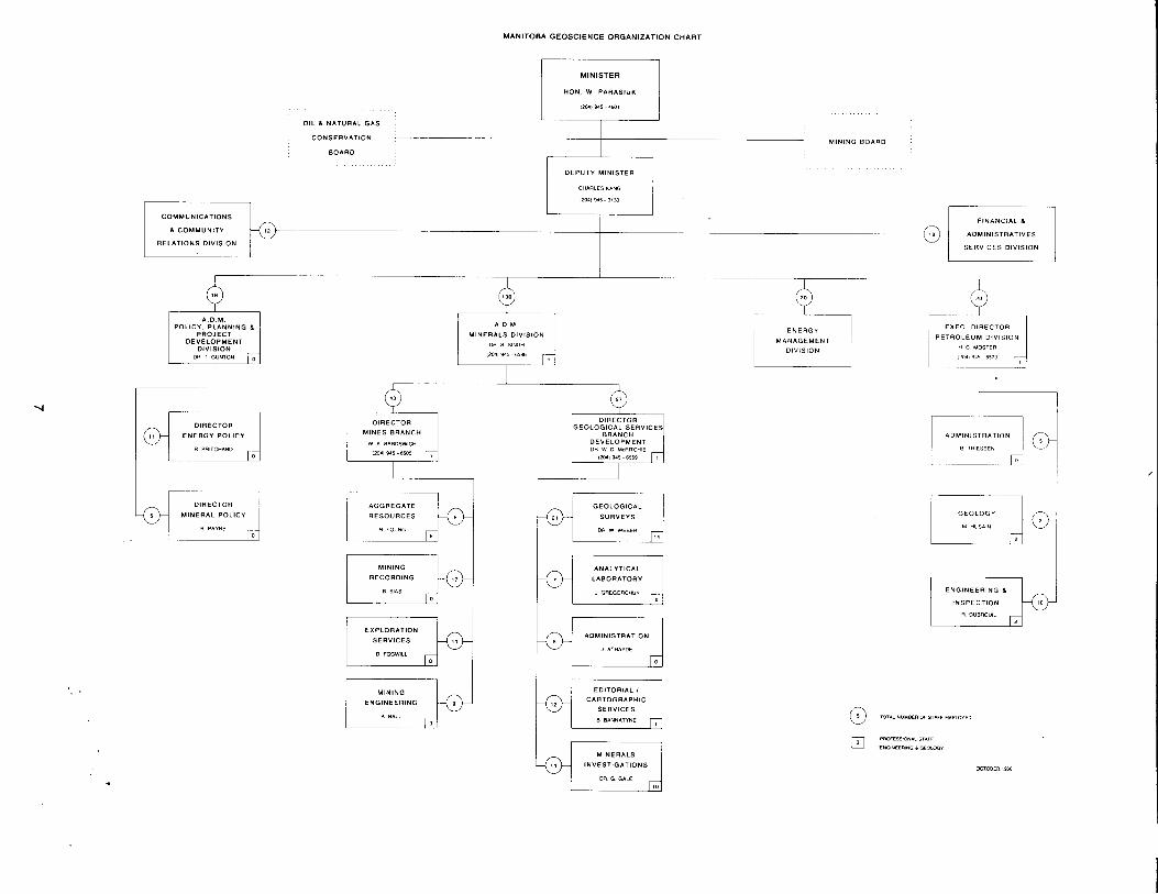
MANITOBA GEOSCIENCE ORGANIZATION CHART
OIL L N A T U R A L GAS
CONSERVATION
BOARD
I
MINISTER
H O N W PARASIUK
MINING BOARD
I 1 DEPUTY MINISTER ~
CHARLESKANG
I r n l - 5 313u
FINANCIAL 1
AOMlNlSTRATlVES
SERVICES DIVISION
COMMUNICATIONS
L COMMUNITY
RELATIONS DIVISION
POLICY, P L A N N I N G L PROJECT
DEVELOPMENT DIVISION
l
0 MINES BRANCH
w A 8AROSWICH
DIRECTOR
MINERAL POLICY
R P*"NE
AGGREGATE RESOURCES 1 R YOUNG
MINERALS DIVISION DR s SlNGH
,2w 9 4 - 6 5 8 6
MINING RECORDING
I EXPLORATION
SERVICES 1 0 FCGWlLL & ENGINEERING j :".: Jo
GEOLOGICAL SURVEYS
OR w W E E R
ENERGY M A N A G E M E N T
DIVISION
BRANCH DEVELOPMENT
EXEC DIRECTOR
PETROLEUM DIVISION H c MOSTER
ADMINISTRATION
8 THIESSEN
ANALYTICAL LABORATORY
J GREGORCHUK
ADMINISTRATION
2 A T H A I O E
I I ENGINEERING L
INSPECTION
9 OUBAEUlL
EDITORIAL I CARTOGRAPHIC
SERVICES 8 BANNATINE ,
MINERALS INVESTIGATIONS
DR G GALE

ONTARIO GEOSCIENCE ORGANIZATION CHART
MINISTRY OF NORTHERN DEVELOPMENT
I OEPUTVMINISTER 1 G TOUGH
L; MINES & MINERALS
DIVISION ASST DEPUTY MIN
0 TIEMAN sn.42,l
/ I ~-
I -1- >
MINERAL IRESOURCES BRANCH , BRANCH ' %I 1659 ,
- ~~
MINERAL DEV I BRANCHINWL
JOHN WOOD ,8071 "68 3111
MINERAL BRANCH INE) DEV
SAND" I*CINTOSH
, ,,"S, 267 1401
i !
ME T A L L I C MINERALS 1
% - I 3 1 1 1
GEOSERVICES SECTION G YlUClE
MINERAL STATISTICS s s 6 - !ole
GEOSCIENCE
C REOLE SUBSECTION
INFORMATION OFFICE
GEOSCIENCE DATA CENTRE
ONTARIO EXPLORATION MINERAL
EOSOLONYIA 961- 1062
PROTEROZOIC 4 SUBSECTION 1 0 0 DRESSLER
SCIENTIFIC
G u scon
AREA CODE 416
TELEX 085-24131
MINES LIBRARY
N munsim
,

ORGANIGRAMME GEOSCIENCE DU QUCBEC
SOUS - MINISTRE ASSOCIP
MINES ONlL ROY
1418) -46611
DIRECTION
POLITIOUE E T CVALUATION
0 HAHONEY
SERVICE DE LA STATISTIOUE, DE L 'ANALVSE
E T D E S O P d R A T l O N S
L
3 DIRECTION GCNCRALE
Y GWBOUT 14181 €4 -4617
DIRECTION GCNERALE
DE L 'EXPLORATION
GEOLOGIQUE E T MINBRALE
RECHERCHES MINERALES
SERVICE D U
ET DE LA
A *'LARD
0 A DIRECTION DE DIRECTION
D E S REDEVANCES E T TITRES M l N l E R S
R BOUTIN
SERVICE D'IMPOSITION MINIERE
R ROBITAILLE 14181 643-4478
P BOUTIN
DE LA RECHERCHE GCOLOGIOUE
L ' A S S I S T A N C E A L 'EXPLORATION MINIERE L 'ANALYSE MINERALE
M PICHETTE A BISSONNETTE 14181 -3-5159
SERVICE DE LA PHYSIQUE E T DE
S TURMEL 11161 €4-8785
SERVICE DE LA GEOLOGIE
J ClMON (4181 M3- lW3
SERVICE D E M l N l E R
Y LALIBERTE L'EXPLORATION MINIERE
J P LALONDE
SERVICE DE
M I N C R A L E 0 JACQUES
1118) W - l b l l
SERVICE DE LA GEOCHIMIE E T
F WMPlERRE
SERVICE D U LABORATOIRE
METALLURGIQUE
SERVICE DE LA G~OINFORMATION
B WARREN
SERVICE DE LA C H l M l E 2 GUlMONT
14781 643-4505

MINERAL DEVELOPMENT
SECTOR D. E. BARNETT [ (506)453-2206
PROCESS ENGINEERING J. D. THIBAULT 1 (506)453-2206
ENGINEERING J. J. CHANDRA (506)453-2205
NEW BRUNSWICK GEOSCIENCE ORGANIZATION CHART
MINISTER
HON M N MacLEOD
(506) 453-2510
DEPUTY MINISTER
8. J. WALKER
(5c6) 453 - 2501
ASSISTANT
DEPUTY MINISTER
W DENNY
(506) 453 - 3862
DIRECTOR I OF MINERAL I DEVELOPMENT
G J GREER
I
MINERAL LANDS
D. W. BAILEY
(506) 453 - 2206
S. L. DeVENNEY
WORD -4 PROCESSING L WARD 1 (W) 453 - 2206
GEOLOGICAL
(5061 546 - 6Mx)
DIRECTOR OF GEOLOGICAL
SURVEYS J L DAVIES
(506) 453 - 2206 T REGIONAL
GEOLOGICAL
A A RUITENBERG (506) 433-4317
I I GEOLOGY I GEOPHYSICS
GEOCHEMISTRY L R MFFE
(5061 453 - 3687
INFORMATION D J CARROLL
(PROFESSIONAL, TECHNICAL AN0 CLERICAL,
PROFESSIMIAL ENGINEERING AN0 GEWDW

N O V A S C O T I A G E O S C I E N C E O R G A N I Z A T I O N C H A R T
HON JOELMATHESON
PH 19021 424-6657
I I DEPUTY MlNlSTEH
JOHN J LAFFIN
ASSISTANT DEPUTY MINISTER
JACK GARNETT MINES a MINERALS
DIRECTOR INERAL DEVELOPMENT
DAN MURRAY
DIRECTOR MINERAL RESOURCES
PETER GlLES
MINING ENGINEERING PAT PHELAN
MANAGER MINING ENGINEERING
PATRICK HANNON I: PH (902) 424-4049
MANAGER OF RESOURCE GEOLOGY
JIM BINGLEV
MANAGER OF TITLES REGISTRY
RICK RATCLIFFE
MANAGER OF REGIONAL SURVEYS
J DUNCAN KEPPIE
MANAGER OPERATIONS
DON MacNElL
m MINING REGIONAL GEOLOGY
GROUP
DRILLING
SERVICES
OPERATIONS AND
MAINT. SUPPORT
TITLES REGISTRY GROUP
LIBRARY SERVICES
GEOCHEMISTRY
GROUP
INDUSTRIAL
MINERALS GROUP
MINERAL DEPOSITS
GROUP
PUBLICATIONS I EDUCATION GROUP
REGIONAL OFFICE STELLARTON PH (902) 752-0429
@ TOTAL STAFF (INCLUDES SUPPORT STAFq 4 LAND USE GROUP A PROFESSIONAL
SEPTEMBERIDaR

PRINCE EDWARD ISLAND GEOSCIENCE ORGANIZATION CHART
MINISTER ADMINISTRATION
I ASSISTANT MARIE BROOKINS
HON. A. ELLIS 1 (902) 892 - 2029 (902) 892 - 2929
ACTING DEPUTY
MINISTER
WILLIAM G. EUSTARD
(902) 892-rn29 r
ADMINISTRATION
BILL EUSTARD
(902) 892-1034
b
ACTING DIRECTOR ENERGY 8 MINERALS
BRANCH JAMES F. FOLLWELL
(902)892-1094
MINERAL DEVELOPMENT COORDINATOR D. W. MacOUARRlE
(902) 89-1094
Q MANAGER MINERAL
AGGREGATES T G N COVERT
0 ENERGY PLANNING
COORDINATOR J. F FOLLWELL
ENERGY OFFICER
J P MOONEY
NUMBER OF STAFF EMPLOYED @ (PROFESSIONAL, TECHNICAL AND CLERICAL)
PROFESSIONAL (ENGINEERING AND GEOLOGY)
ENERGY INFORMATION
OFFICER VACANT
(902) 892- 1094

,
NEWFOUNDLAND GEOSCIENCE ORGANIZATION CHART
MINISTER
HON W MARSHALL
(709) 576 - 2500
MINISTER
HON JEROME 01”
(709) 576 - 2920
I 1 I
OFFSHORE PETROLEUM
DIRECTORATE G GOSSE 1 (709) 576-2356 A DEPUTY
MINISTER J H McKlLLOP
ASSISTANT DEPUTY MINISTER
ENERGY VACANT
(7091 576 - 2768
DEPUTY MINISTER MINES
J FLEMING
(709) 576 - 2768
ENERGY POLICY
DIVISION 0. INKSTER
(709) 576 - 2765 1
ENERGY POLICY 8 PROGRAM r ANALYSIS
MINERAL LANDS 8 MINES
DIVISION N. KlPNlS
17091 576-2773
ENERGY PROGRAMS
DIVISION P. GRAHAM
DEVELOPMENT DIVISION 6. GREENE
REGIONAL MAPPING
LABRADOR
ECONOMIC
ANALYSIS DEMONSTRATION
REGIONAL MAPPING
NEWFOUND- 4 LAND 111 ENERGY AUDIT
MANAGEMENT
INFORMATION 8
TRANSFER
ENGINEERING
ANALYSIS
MINERAL
LANDS
GEOCHEMISTRY
GEOPHYSICS
MINERAL
DEPOSITS
3
QUATERNARY
GEOLOGY 8
NUMBER OF STAFF EMPLOYED @ (PROFESSIONAL, TECHNICAL AND CLERICAL)
PROFESSIONAL (ENGINEERING AND GEOLOGY)
U L U m
ADMINISTRATION @ - l I 13

NORTHWEST TERRITORIES GEOSCIENCE ORGANIZATION CHART
~
E COOK
(403) 920 - 8235
MINING RECORDER
MACKENZIE T MEDIEMA
(403) 920 - 8225
-
MINISTER INDIAN AND NORTHERN
AFFAIRS BILL McKNlGHT
(819) 997-wo2
NAHANNI DISTRICT
GEOLOGIST 4 J A 0ROPHY 1 (403) 920-8221
DEPUTY MINISTER
0RUCE RAWSON
I8191 997-0133
ASSOCIATE DEPUTY
MINISTER (NORTH)
JACOUES GERlN
(8191 994-3517
DIRECTOR GENERAL
N. W. T. REGION OR A H MacPHERSON
(403) 920-8111
AND ECONOMIC ANALYSIS G PATENAUOE
(403) 920 - 8263
ECONOMIC
ANALYSIS
(403) 920 - 8202
MINING RECORDER
ARCTIC, HUDSON BAY AND NAHANNI
E McLEOD
NUMBER OF STAFF EMPLOYED @ (PROFESSIONAL TECHNICAL AND CLERICAL)
PROFESSIONAL (ENGINEERING AND GEOLOGY)
.I ON CAREER ASSIGNMENT PROGRAMM 186 I WI REPLACEMENT EXPECTED 87 I 0 1 -
REGIONAL MANAGER
GEOLOGY W A PADGHAM
REGIONAL MANAGER
GEOLOGY W A PADGHAM
GEOLOGIST J M SEATON
ARCTIC INLANDS
DISTRICT GEOLOGIST 4 W GlB0lNS
(403) 920-8216
GEOLOGIST P J LAPORTE *
(403) 920-6213
ADMINISTRATION
OFFICER R GREENING
1403) 920-8210
STAFF
GEOLOGIST C E ELLIS
(403) 920 - 8220
ARCHIVES
GEOLOGIST J CRUX
(403) 920 - 8222 ,
PROJECT
GEOLOGIST
V JACKSON
(403) 920 - 8552
MATERIALS, STORAGE AND PROCESSING
OFFICER K. LEISHMAN
(403) 920-8229
14
,

YUKON GEOSCIENCE ORGANIZATION CHART
MINISTER INDIAN AND NORTHERN
AFFAIRS
HON W L McKNlGHT
(619) 997-0002
DEPUTY MINISTER
6 RAWSON
(619) 997-0133
ASSOCIATE
DEPUTY MINISTER
J GERlN
(819) 994- 3517
DIRECTOR GENERAL N A T U R A L R E S O U R C E S A N D ECONOMIC DEVELOPMENT
W. WETHERUP (819) 997-9361
4 b
A / DIRECTOR GENERAL O F RESOURCES YUKON REGION
J. E. GANSKE
(403) 667-3136
4 b
DIRECTOR
MINERAL RESOURCES A C OGILVY
(403) 667 - 31 26
REGIONAL MANAGER
MINERAL RIGHTS B. R. BAXTER (403) 667-3130 r
MINING ENGINEER
C H MacDONALD
NUMBER OF STAFF EMPLOYED @ (PROFESSIONAL, TECHNICAL AND CLERICAL)
PROFESSIONAL (ENGINEERING AND GEOLOGY)
CHIEF GEOLOGIST REGIONAL MANAGER J A MOWN
(403) 667 - 3200
15

.
,

,
PROVINCIAL GEOLOGICAL SURVEY EXPENDITURES, 1985-86
17

I ' PROVINCE/ TERRITORY
Newfoundland . . . . . . . . . . . . Nova Scotia . . . . . . . . . . . . . . Prince Edward Island . . . . . . New Brunswick ........... Quebec .................. Ontario . . . . . . . . . . . . . . . . . . Manitoba . . . . . . . . . . . . . . . . Saskatchewan ............ Alberta . . . . . . . . . . . . . . . . . . British Columbia . . . . . . . . . . Yukon . . . . . . . . . . . . . . . . . . . Northwest Territories ......
SURVEY EXPENDITURES % OF
$ x 106 TOTAL
5.1 4.0 0.1 1.3 15.6 15.8 3.5 2.2 4.7 4.0 0.8 1.3
8.7 6.8 0.2 2.2 26.7 27.0 6.0 3.8 8.0 6.8 1.4 2.2
TOTALS 58.4 - *Preliminary; includes petroleum and natural gas values as follows:
.................
PROVINCIAL GEOSCIENCES EXPENDITURES 1985-1 986
TOTAL 1985 VALUE OF
PROVINCIAL MINERAL
PRODUCTION* $ x 106
927.1 327.8 1.6
550.3 2 236.8 4 565.6 828.5
3 782.6 27 346.0 3 465.0
58.0 843.8
44 933.1
Manitoba,-$lBOA; Saskatchewan, $2 350.O;Alberta, $25 752.6; British Columbia, $862.0 tlncludes Mineral Development Branch and Geological Surveys Branch expenditures
SURVEY EXPENDITURES
VALUE OF PROVINCIAL
MINERAL PRODUCTION
0.55 1.22 5.40 0.24 0.70 0.35 0.42 0.06 0.17 0.12 1.38 0.15
AS % OF TOTAL AREA OF
PROVINCE/ TERRITORY
km2 x 103
405 55 6 73
1541 1 069 650 652 66 1 948 483
3 380
9 922
SURVEY $ SPENTkm2
12.6 72.4 14.8 17.8 10.0 14.8 5.3 3.4 7.2 4.3 1.6 0.4
-
POPULATION (1981) x 103
568 847 123 696
6 438 8 625 1 026 968
2 238 2 744
23 46
24 343
SURVEY $
SPENT/ CAPITA
9.0 4.7 0.7 1.9 2.4 1.8 3.4 2.3 2.1 1.5 34.8 28.3
-
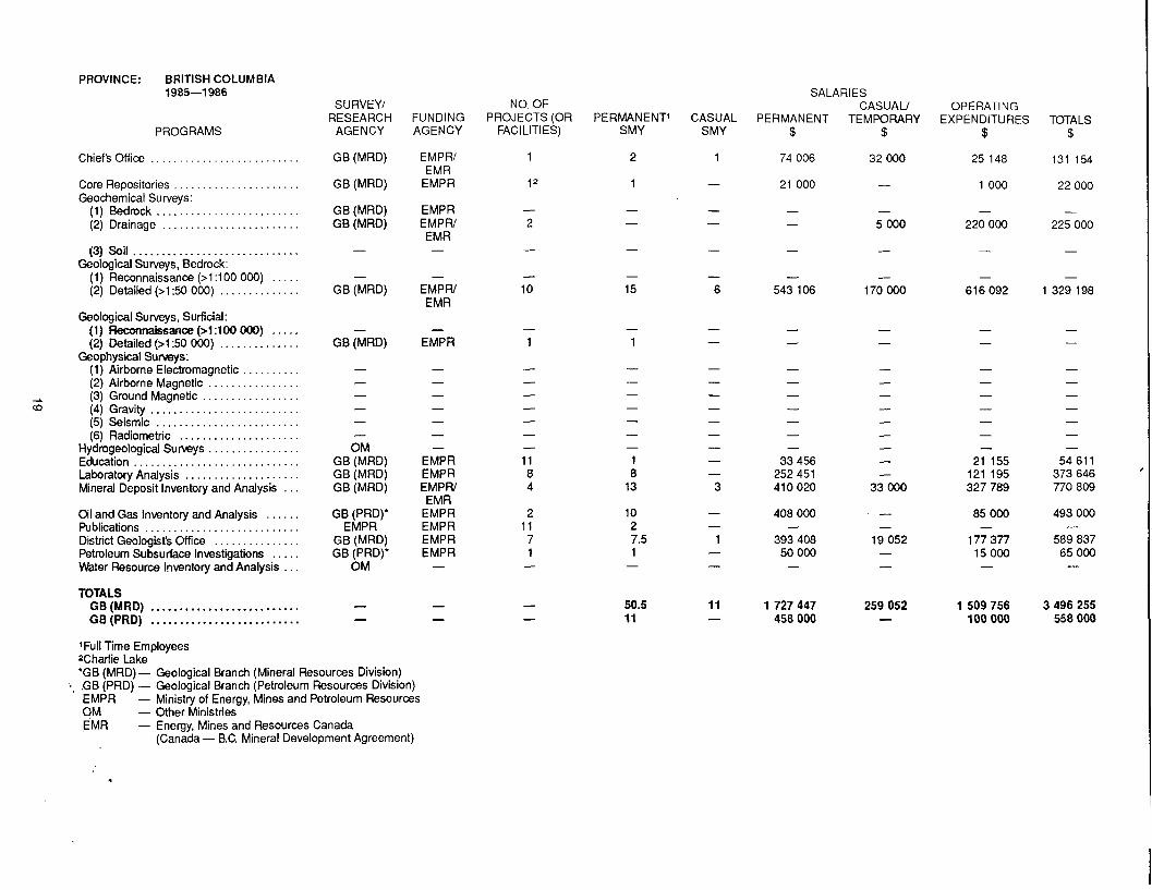
PROVINCE: BRITISH COLUMBIA 1985-1986
PROGRAMS
Chief's Office . , . . , . .
Core Repositories ,
(3) Soil .............................
(1) Reconnaissance (>1:100 (2) Detailed (>1:50 000) . . .
(1) Reconnaissance (>1:100 OOO) ..... (2) Detailed (>1:50 OOO) ..............
(1) Airborne Electromagnetic . . . . (2) Airborne Magnetic . . . . . . . . . . . . . . . .
A (3) Ground Magnetic CD (4) Gravity ..........................
(5) Seismic . . . . . . . . (6) Radiometric .....................
Hydrogeological Surveys . . . . . . . . . . . . . . . . Education ....................... Laboratory Analysis .................... Mineral Deposit Inventory and Analysis . . .
Oil and Gas Inventory and Analysis Publications ........................... District Geologist's Office . . . . . . . . . Petroleum Subsurface Investigations . . . . . Water Resource lrlventory and Analysis . . .
TOTALS
Geological Surveys, Bedrock:
Geological Surveys, Surficial:
Geophysical Surveys:
GB (MRD) .......................... GB (PRD) ..........................
'Full Time Employees
S U RVEYI RESEARCH
AGENCY
GB (MRD)
GB (MRD)
GB (MRD) GB (MRD)
-
- GB (MRD)
- GB (MRD)
- - - - - - OM
GB (MRD) GB (MRD) GB (MRD)
GB (PRD)' EMPR
GB (MRD) GB (PRD)'
OM
- -
FUNDING AGENCY
EMPW EMR
EMPR
EMPR EMPW EMR -
- EMPW EMR
- EMPR
- - - - - - -
EMPR EMPR EMPW EMR
EMPR EMPR EMPR EMPR -
- -
- . *Charlie Lake 'GB (MRD) - Geological Branch (Mineral Resources Division)
c, ,GB (PRD) - Geological Branch (Petroleum Resources Division) EMPR - Ministry of Energy, Mines and Petroleum Resources OM - Other Ministries EMR - Energy, Mines and Resources Canada
(Canada - B.C. Mineral Development Agreement)
NO. OF PROJECTS (OR PERMANENT1 CASUAL
FAClLlTl ES) SMY SMY
1 2 1
- 12 1
- 2
- 10
- 1
2 11 7 1 -
- - 15 6
- 50.5 11 - 11 -
SALARl ES
PERMANENT TEMPORARY CASUAL/
$
74 006
21 000
- -
-
- 543 106
- -
- - - - - - -
33 456 252 451 410 020
408 000
393 408 50 000
-
-
1 727 447 458 000
OPE RAT1 N G EXPENDITURES
$
25 148
1 000
- 220 000
- 616 092
- - - - - - -
21 155 121 195 327 789
85 000
177 377 15 000
-
-
1 509 756 100 000
TOTALS $
131 154
22 000
- 225 000
-
- 1 329 198
- -
- - - - - - -
54 611 373 646 770 809
493 000
589 837 65 000
-
-
3 496 255 558 000
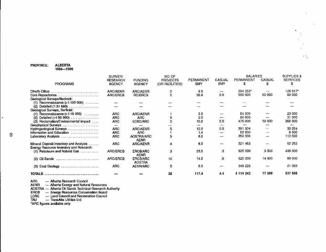
PROVINCE: ALBERTA 1985-1 986
SURVEY/ RESEARCH AGENCY
ARC/AENR ARClERCB
NO. OF PROJECTS
(OR FACILITIES)
2 2
SALARIES PERMANENT CASUAL
$ $
294 252' - 900 000 60 000
SUPPLIES & SERVICES
$ PERMANENT
SMY CASUAL
SMY FUNDING AGENCY
ARC/AENR RClERCB
PROGRAMS
Chief's Office ............................. Core Repositories ......................... Geological Surveys/Bedrock:
Geological Surveys, Surficial:
(1) Reconnaissance (>1:100 000) . . . . . . . . (2) Detailed (1:31 680) . . . . . . . . . . . . . . . . . .
(1) Reconnaissance (>1:10 000) ......... (2) Detailed (>1:50 000) ................. (3) ReclamatiorVEnvironmental Impact ....
Geophysical Surveys ...................... Hydrogeological Surveys . . . . . . . . . . . . . . . . . . . Information and Education ................. Laboratory Analysis .......................
9.5 35.0
128 917' 60 000
- 3.0
ARC ARC ARC
ARC ARC ARC
-
ARC/AENR ARC
2.0 2.0
10.0
12.0 1.4 8.0
8.0
-
84 500 - 88 000 -
475 000 50 000
391 504 - 63 800 -
350 000 -
- -
23 000 31 000
368 - 000
33 054 9 500
112 500
1 5 2
5 1 5
- LCRC/ARC -
ARC/AENR ARC
AOSTRA/ARC AENR
ARC/AENR Mineral Deposit Inventory and Analysis . . . . . . ARC
(1) Petroleum and Natural Gas . . . . . . . . . . . ARC/ERCB
(2) Oil Sands .......................... ARClERCB
Energy Resource Inventory and Research:
(3) Coal Geology ....................... ARC
TOTALS - ARC - Alberta Research Council AENR - Alberta Energy and Natural Resources AOSTRA - Alberta Oil Sands Technical Research Authority ERCB - Energy Resources Conservation Board LCRC - Land Council and Reclamation Council TAU - TransAlta Utilities Ltd. 'ARC figures amilable only
.................................
321 463 -
925 000 3 500
52 252
400 000
4
.3 ERCB/ARC AENR
ERCB/ARC AOSTRA
AENWARC
3
10
23.5
14.0
6.0
.6 520 000 14 000
348 223 -
4 114 242 77 500
80 000
21 383
537 606
5
38 117.4 4.4

PROVINCE: SASKATCHEWAN 1985-1986 SALARIES
OPERATING PERMANENT TEMPORARY CASUAL/ EXPENDITURES
$ $ $
268 500 18 600 45 200 152 400 23 000 25 300
SURVEY/ RESEARCH
AGENCY
NO. OF PROJECTS (OR
FACl LIT1 ES)
1 1
FUNDING AGENCY
PERMANENT CASUAL SMY SMY
9.0 0.8 7.0 1.3
PROGRAMS
Administration (Head Office) . . . . . . . . . . . .
Geochemical S
(2) Drainage . . . . . . . (3) Vegetation ......
Geological Surveys, Bedr
Geophysical Surveys, Surficial:
Geophysical Surveys:
(2) Detailed (1 :50 000) . . . . . . . . . . . . . . .
(2) Detailed (1 :50 000) . . . .
(1) Airborne Electromagnetic . .
(1) Reconnaissance (1:lOO 000) . . . . . . . .
(2) Airborne Magnetic . . . . . . . . . . . . . . . . (3) Ground Magnetic . . . . . . . . . . . . . . . .
(5) Seismic . . . . . . . . . . . . . . . . . . . . . . . . .
Information and Education . . . . . . . . . . . . . . Laboratory Analysis ....................
Mineral Deposit Inventory and Analysis Including Industrial Minerals . . . . . . . . . .
Oil and Gas Inventory and Analy Publications . . . . . . . . . . . . . . . . . . . . . . . . . . .
Subsurface Investigations . . . . . . . . . . . . . . . Water Resource Inventory and Analysis . . Metallogenic Mineral Deposit Studies . . . .
TOTALS .............................. Grand Total ........................
SGS - Saskatchewan Geological Survey SRC - Saskatchewan Research Council UofR - University of Regina 'Sedimentary rocks t Includes igneous-metamorphic core storage
. . . . . . . . . . . . . . . .
tResident Geologist's Office . . . .
SGS SGS
SGS SGS
- 33 000
49 500 17 400 24 200
163 000 114 750 155 200
- - - -
- - -
- SGS
SGS -
- SGS
SGS -
- 1
- - 1 .o 1 .o
3.0 3.3 - - 3
-
SRC -
SGS -
1 -
- SGS
SRC/UofR Carleton
SGS SGS SGS SGS SGS
SGS -
- SGS SGS
- 1 2
SGS SGS SGS SGS SGS
SGS -
4 1 -
3.0 1 .o 7.0 1 .o
3.0 0.8 7.0 -
2.0 1 .o
42.0 10.2
- -
- -
30 000 49 450 147 000 198 000 18 500 1 1 000
- 73 500 112 600 1 1 000 31 900 286 500 - 1 1 000
97 500 7 500 20 200
1 47s 000 240 750 507 450
-
- - - 2 5
2 218 100

PROVINCE: MANITOBA 1985-1 986
PROGRAMS
Core Repositories . . . . . . . . . . . . . . . . . . . . . . . . . . . . . . . . . . . . . . . . . . . . . . .
(1) Bedrock . . . . . . . . . . . . . . . . . . . . . . . . . . . . . . . . . . . . . . . . . . . . . . . . . . (2) Drainage . . . . . . . . . . . . . . . . . . . . . . . . . . . . . . . . . . . . (3) Soil . . . . . . . . . . . . . . . . . . . . . . . . . . . . . . . . . . . . . . . . . . . . . . . . . (4) Peat.. . . . . . . . . . . . . . . . . . . . . . . . . . . . . . . . . . . . . . . . . . . . . . .
(1) Reconnaissance (1 :lo0 000) . . . . . . . . . . . . . . . . . . . . . . . . . . . . . . . . (2) Detailed (1 :50 000)
(1) Reconnaissance (1 5 0 000) . . . . . . . . . . . . . . . . . . . . . . . . . . . . . . . . . (2) Detailed (1% 000) . . . . . . . . . . . . . . . . . . . . . (3) Resource Management . . . . . . . . . . . . . . . . . . . . . . . . . . . . . . . . . . . . .
(1) Airborne Electromagnetic ................................... (2) Airborne Magnetic, Gradiometer . . . . . . . . . . . . . . . (3) Ground Magnetic . . . . . . . . . . . . . . . . . . . . . . . . (4) Gravity . . . . . . . . . . . . . . . . . . . . . . . .
(6) Radiometric . . . . . . . . . . . . . . . . . . . (7) Remote Sensing . . . . . . . . . ...............
Hydrogeological Surveys . . Information, Education, Assessment Services
and Compilation . . . . . . . . . . . . . . . . . . . . . . . . . . . . . . . . . . . . Laboratory Analysis . . . . . . . . . Mineral Deposit lnven Industrial Minerals ............................................... Oil and Gas Inventory and Analysis . . . . . . . . . . . Publications ....................... . . . . . . . . . . . . . . . Resident Geologist's Office .......... . . . . . . . . . . . . . . . Subsurface Investigations, Industrial Mi
Drilling and Management . . . . . . . . . . . . . . . . . . . . . . . . Water Resource Inventory and Analysis ............................ Other:
(1) Administration . . . . . . . . . . . . . . . . . . . . . . . . . . . . . . . . . . . . . . . . . . . . . (2) Drafting . . . . . . . . . . . . . . .
Analyses ....................... . . . . . . . . . . . . . . . . .
Geochemical Surveys:
Geological Surveys, Bedrock:
. . . . . . . . . . . . . . . . . . . . . . . . . . . . (3) Phanerozoic . . . . . . . . . . . . . . . . . . . . . . . . . . . . . . . . . . . . . . . . . . .
Geological Surveys, Surficia
Geophysical Surveys:
(5) Seismic . . . . . . . . . . . .
..........
..................... (3) UraniumlLead and RubidiumlStm
TOTALS ....................................................... GSC - Geological Survey of Canada MGS - Manitoba Geological Services Branch MM - Manitoba Mines Branch UNlV - Universities CAN - Canada MAN - Manitoba Ilncludes 188.1 for Field Equipment and Capital
SU RVEYI RESEARCH
AGENCY
MM
- -
MGS MGS
MGS MGS MGS
- - -
- -
FAGS - - -
MGS -
MGSIMM MGS
MGSlUNIV MGS
MGS -
-
MGS -
MGS MGS
MGSlUNlVl GSC
-
FUNDING AGENCY
CANIMAN
- -
MAN MAN
MAN MAN MAN
- - -
- -
MAN - - -
CANlMAN -
CANIMAN MAN MAN MAN
MAN -
-
MAN -
MAN MAN
CANlMAN
-
NO. OF PROJECTS (OR
FAC I LIT1 ES)
4
- - 3 -
2 15 1
- - -
- - 1 - - - 1 -
7 3 16 4
39 -
-
2 -
- -
6
-
PERMANENT S MY
2.00
- - 1 .oo -
.46 8.00 1 .oo - - -
- - 1 .oo - - - - -
3.00 1 1 .oo 4.00 2.00 - - -
2.00 -
5.00 12.00
.06
53.00
CASUAL SMY
.08
-
- 1.38 -
.27 5.02 -
- - -
- - .13 - - - - -
.07 2.00 9.16 5.19 - - -
.32 -
- -
-
26.12
SALARIES PERMANENT CASUAL
$
66 900
- -
43 500 -
43 000 365 700 46 800
- -
-
- - 36 000 - -
- - -
90 900 316 800 204 700 73 600 - - -
57 600 -
185 500 342 000
6 300
1 879 300
$
3 600
-
- 23 000 -
8 000 96 800 -
- - -
- - 4 000 - - - - -
6 800 18 100 167 200 72 700 - - -
12 100 -
- -
-
412 300
OPERATING EXPENDITURE:
$
90 300
- 90 700 23 700
2 500 127 000 15 200
41 700 53 400 258 300 29 000
54 400 -
-
32 700 -
288 600' 12 500
46 700
1 169 700

PROW NCE: ONTARIO 1985-1 986
PROGRAMS
Administration (Head Office) . . . . . . . . . . . . . . . . . . . . . . . . Core Repositories . . . . . . . . . . . . . . . . . . . . . . Geochemical SurveyslResearch . . . . . . . . . . . . . . Geophysical Surveys:
Airborne Electromagn ........................ Gravity . . . . . . . . . . . . . . . . . . . . . . . . . . . . . . . . . . . . Seismic . . . . . . . . . . . . . . . . . . . . . . . . . . . . . . . . . . .
Precambrian . . . . . . . . . . . . . . . . . . . . . . . . . . . . . . . . . . . . Geological Surveys:
Geological Surveys: Phanerozoic . . .
Aggregate . . . . . . . . . . . . . . . . . . . . . .
Publications . . . . . . . . . . . . . . . . . . . . . . . . . . . . . . .
Quaternary . . . . . . . . . . . . . . . . . . . . . . . . . . . . . . .
Geoservices:
Laboratory Analysis . . . .....................
Assessment Services . . . . Equipment, Vehicles .............................
Industrial Minerals ....................
Information, Education, Library . . . . . . Mineral Deposits Studies Including
Resident Geologist's Offices . . . . . . . . . . . . . . . . . . . . . . . . . Geoscience Research Grants Program . . . . . . . . . . . . . . . Exploration Technology Development Fund . . . . . . . . . . . . Hydrocarbon Energy Resources Program . . . . . . . . . . . . . Drill Core Storage Program . . . . . . . . . . . . . .
TOTALS ..........................................
FUNDING AGENCY
MNR MNDM -
MNWMNA - -
MNWMNA/ DREl
- MNWMNA -
- MNWMNA/
DREl - -
MNWMNA MNWMNN
DREl MNWMNA
MNR BlLD BlLD BlLD
-
NO. OF PROJECTS MAN-Y EARS
(OR FACILITIES) PERMANENT CASUAL
5 1 7 4 8 -
- - -
20 20 21
- - - - 5 -
20 8 15
- 35 63 23
1 18 10 7
3
- - - - - -
117 135 150
SALARIES PERMANENT
$
116 000 76 000 -
253 000 - -
846 000
- 456 000 -
- 1 194 000
- -
105 000 355 000
1 242 000 - - - -
4 643 000
CASUAL $
67 000 150 000 -
64 000 - -
596 000
- 247 000 -
- 327 000
- -
37 000 294 000
1 170 000 - -
331 000 -
3 283 000
OPE RAT1 N G EXPENDITURES
$
106 000 166 000 -
915 000 - -
654 000
- 209 000 -
- 1 233000
- -
54 000 235 000
582 000 502 000 837 000
1 228000 1 187000
7 908 000
TOTALS $
289 000 392 000' -
1 232000 -
-
2 096 000
- 912 000 -
- 2 754 000
- -
196 000 884 000
2 994 000 502 000 837 000
1 559000 1 187000
15 834 000
MNR - Ontario Ministry of Natural Resources MNA - Ontario Ministry of Northern Affairs DREl - Federal Department of Regional Expansion of Industry BlLD - Board of Industrial Leadership Development
, *Estimate

PROVINCE: QUEBEC 1985-1986
PROGRAMS
Core Repositories . . . . . . . . . . . . . . . . . . . . . Geochemical Surveys: . . . . . . . . . . . . . . . . . . . . . . . . . . .
(1) Bedrock .. ... . .. . . . . . . . . . . . . . . . . . (2) Drainage . . . . . . . . . .. . . . . . . . . . . . . .... .. . . . . (3) Lakes . . . . . . . . . . . . . . . . . . . . . . . . . . . . . . . . . . . .
Geological Surveys, (Bedrock) . . . . . . . . . . . . . . . . . . . . Geological Surveys: . . . . . . . . . . . . . . . . . . . . . . . . . . . . .
(1) Airborne Electromagnetic . . . . . . . (2) Airborne Magnetic . . . . . . . . . . . . . . . . . . . . . . . . . (3) Ground Magnetic (4) Gravity.. . . . . . . . . .. . . . . . . . . . . . .. . .. . . . . .. . (5) Others (Sismique-refraction)
Hydrogeological Surveys . . . . . . . . . . . . . . . . . . . . . . . . Information and Education . . . . . .
Publications Distribution . . . . . . . . . . . . . . . . . . . . . . . . . Subsidies . . . . . . . . . . . . . . . . . . . . . . . . . . . . . . . . . . . . . . Research and Development . . . . . . . . . . . . . . . . . . . . . . Geoscience Information Acquisitions . . . . . . . . . . . . . . Other (Informatiquebureautique) . . . . . . . . . . . . . . . . . TOTALS . . . . . . . . . . . . . . . . . . . . . . . . . . . . . . . . . . . . . . .
Resident Geologist's Offices** . . . . . . . . . . . . . . .
DIR. GENERALE EXPLORATION
GEOL. ET MINERALE
- DGEGM DGEGM - -
DGEGM - -
DGEGM I
- DGEGM - -
DGEGM DGEGM DGEGM DGEGM DGEGM DGEGM DGEGM DGEGM DGEGM DGEGM
FUNDING AGENCY
MINISTERE ENERGIE ET
RESSOU RCES
- -
"'MERIEMR "'MEWEMR
'*'MER/EMR -
- -
"'MERIEMR - -
***ME RIE M R MEWEMR -
MER MER
"'MERIEMR MER MER MER MER MER ME R MER
NO. OF PROJECTS
- 1 6 2
36 - - 5
- 40
1 8 5
112
PERMANENT STAFF
MAN-Y EARS P-T-C
- 3 P-2T- 1 C - - -
14P-3T-4C -
2P-1T -
- -
4P-1T 7P-16T-2C 4P-1T-7C 8P-4T-9C
2P-1 c
5P -
49P-28T-24C
CASUAL STAFF
MAN-Y EARS
- 14.0
1.9 2.2
40.0 2.0 2.0 -
153.1
BUDGET ALLOCATIONS
$
79 500
20 000 812 800 308 000
5 949 000
-
- -
1 236 000 - -
1 000 000 31 500
25 000 300 000 279 400 960 000 172 500 275 500
2971 700 200 000 786 500 234 000
-
15 641 400
P: Professional T: Technical c: clerical 'Salaries of permanent staff not induded "Regional representatives "'Program I , CanaddQuebec subsidiary agreement on mineral development

PROVINCE: NEW BRUNSWlCK 1985-1986
STAFF-Y EARS CONTINUING
AUXILIARY
SALARIES
AUXILIARY CONTINUING SUMMER OPERATING SURVEY1
RESEARCH FUNDING NO, OF
PROJECTS (OR FACILITIES)
5
SUMMER PERMANENT AUXILIARY
AUXILIARY EXPENDITURES PROGRAMS PERMANENT AGENCY
GSB
- GSB -
- GSB
- -
- - - - - - -
GSB GSB GS B/ MDB
MDB MDB MDB -
MDB GSB GSB
MDB -
-
GSB/ MDB
- $1.3 million
AGENCY
DNRE
- DNRE -
- DNRE
- - - - - - - - -
DNRE DNRE DNRE
DNRE DNRE DNRE -
DNRE DNRE DNRE
DNRE - -
DNRE
-
$
-
- - -
- 67 816
- -
- - - - - - -
75 375 45 410 77 074
35 476
68 404 -
-
68 068 56 731 296 177
30 160 -
-
63 075
891 766
$
5 308
- 20 000 -
- 51 849
- 17 200
- - - - - - -
52 241 14 570 22 813
8 000
27 670 -
-
- 9 618
122 470
18 950 -
-
21 854
354 955
Core Repositories . . . . . . . . . . . . . . . . Geochemical Surveys: (1) Bedrock . . . . . . . . . . . . . . . . . . . (2) Drainage . . . . . . . . . . . . . . . . . . (3) Soil . . . . . . . . . . . . . . . . . . . . . . .
. . . . . .
. . . . . .
. . . . . .
. . . . . . Geological Surveys, Bedrock:
(2) Detailed (1 :20 000) . . . . . . . . . . . . . . . . . Geological Surveys, Sudicial:
(1) Reconnaissance (1:lOO 000) . . . . . (2) Detailed (1 :50 000) . . . . . . . . . . . . . . . . .
Geophysical Surveys: (1) Airborne Electromagnetic . . . . . . . . . . . . (2) Airborne Magnetic . . . . . . . . . . . . . . . . . .
(4) Gravity . . . . . . . . . . . . . . . . . . . . . . . . . . . . (5) Seismic . . . . . . . . . . . . . . . . . . . . .
(1) Reconnaissance (1 :lo0 000) . . . . . . . . .
Information and Education . . . . . . . . . . . . 2 Laboratory Analysis ......................
Metallic-Mineral Deposit Inventory and Analysis . . . . . . . . . . . . . . . . . . . . . . . . . . . . . . .
Industrial Minerals: (i) Evaporites . . . . . . . . . . . . . . . . . . . . . . . . . (2) Limestone .................... (3) Granular Resources . . . . . . . . . . . . . . . . .
Coal Inventory and Analysis . . . . . . . . . . . . . . . Oil and Gas-Oil Shale Inventory
. . . . . . . . . . . . . .
. . . . . . . . . . . . . .
. . . . . . . . . . . . . . . . . . .
. . . . . . . . . . . .
- 2
- 2
- 1
1
2 -
-
2 3 8
1 -
-
3 2
TOTALS ................................ 28 25
Grand Total ........................... GSB - Geological Surveys Branch MDB - Mineral Development Branch DNRE- Department of Natural Resources and Energy 'Includes mineral economic, and mining studies and mrious research projects supported by GSB

PROVINCE: NOVA SCOTIA iga5-19a6 SURVEY
RESEARCH AGENCY
NSDME
NSDME
PERMAN EN1 STAFF
MAN-Y EARS
3
CASUAL STAFF
MAN-YEARS
BUDGET ALLOCATIONS
$
230 000
140 000
FUNDING AGENCY
NSDME/ NSDOD NSDMU NSDOD
NO. OF PROJECTS (OR FACILITIES)
3
PROGRAMS
Core Repositories . . . . . . . . . . . . . . . . . . . . . . . . . . . . . . .
Geochemical Surveys: ...........................
(1) Bedrock .......................... (2) Drainage ................................. (3) Soil . . . . . . . . . . . . . . . . .
(1) Reconnaissance (>1:100 000) ........ (2) Detailed (>1:50 000) .......................
Geological Surveys, Bedrock
information and Education ........................
Laboratory Analysis (included in budgets above) Mineral Deposit Analysis ........
Mineral Deposit Inventory . . . . . . . . . . . . .
Coal and Peat . , , , , . Oil and Gas Inventory and An PU b l i t ions ............................
. . . .
. . . . . . . . . .
Resident Geoiogisrs Office . . . . . . . . . . . . Subsurface Investigations ........................
TOTALS ....................................... NSDME - Nova Scotia Department of Mines and Energy NSDOD - Nova Scotia Department of Development
1
2 1 1
- NSDMB NSDOD
- 6
- 3
- 1
- 2
- 160 000
- NSDME
- NSDME
- 2
- - - - - -
NSDMU NSDOD
NSDMV NSDOD NSDMV NSDOD NSDMU NSDOD NSDME NSDMU NSDOD NSDME NSDME
-
- - -
208 000 -
NSDME
- NSDME
NSDME
NSDME
- 4
- 5
- 275 000
- 9
4
3
3
7
2
2.6
100 000
573 000
539 000 180 000
NSDME NSDME
NSDME NSDME
1 NIA
N/A N/A
31
5 2
0.8 -
15 4
46
412 400 486 400 7
29.4 3 984 300
TERRITORY: NEWFOUNDLAND 1985-1 986
PROGRAMS
Director's Office .......................
(2) Detailed (>1:50 000) . . . . . .
(1) Reconnaissance (>1:100 000) . . . . . Geological Surveys, Surficial:
(2) Detailed (>1:50 000) Geophysical Sumys: (1) Airborne Electromag
(3) Ground Magnetic . . . . . . . . . . . . . . . . (4) Gravity . . . . . . . . . . . . . . . . . (5) Seismic ......................... (6) Radiometric .....................
Hydrogeological Surveys: . . . . . . . . . . . . . . . Information and Education . . . . . . . . . . . . . . Laboratory Analysis ....................
Mineral Deposit Inventory and Analysis . . .
Publications . . . . . . . . . . . . . . . . .
Resident Geologist's Office . . . . . . . . . . . . . Subsurface Investigations ............... Water Resource Inventory and Analysis . .
TOTALS ..............................
(2) Airborne Magnetic . . . . .
Grand Total ...................... , llncludes lona term temporaw staff
SURVEY/ RESEARCH AGENCY
NDME NDME
- NDME -
NDME
NDME
- NDME
- -
NDME NDME - - -
NDME NDME
NDME
NDME
- - -
- 5 084 700
FUNDING AGENCY
NDME NDME
- NDME -
NDMU DEMR NDMW DEMR
- NDME
- -
NDME NDME - - -
NDME NDMO DEMR NDMW DEMR NDMW DEMR - - -
-
NO. OF PROJECTS (OR PERMANENT' CASUAL
FACl LIT1 ES) s MY SMY
- 3
6 2 2 2
5 6 21
6 7 6
- - - 7 9 14
7 15 12
- N/A 17
34 76 73
PERMANENT $
139 600 36 000
- 132 200 -
171 000
134 000
- 86 000
- - - - - - - -
140 000
202 000
241 900
- - -
1 282 700
SALARIES CONTRACT' CASUAL
$
30 800 30 000
- - -
70 000
116 200
- 201 000
- -
34 000 - - - - -
75 800
228 000
94 300
- - -
880 100
~
$
8 000 6 300
- 33 500 -
124 600
19 200
- 68 400
- - 9 000 8 000 - - - - 5 300
38 000
-
- - -
320 300
OPERATING EXPENDITURES
$
I19900 56 700
- 78 000 -
844 200
234 200
- 273 900
- - 36 000 45 000 - - - -
176 500
506 300
230 909
2 601 600
'' ' NDME - Newfoundland Department of Mines and Energy DEMR - Department of Energy, Mines and Resources, Canada
TERRITORY: NORTHWEST TERRITORIES 1985-1 986 SALARIES
PROGRAMS
Head Office (Administration, General Support) . . . Core Repositories . . . . . . . . . . . . . Geochemical Surveys:
(1) Bedrock . . . . . . . . . . . . . . . . . . . . . . . . . . . . . . . (2) Drainage ..............................
(1) Reconnaissance (1:100 000) . . . . . . . . . . . . .
(1) Reconnaissance (1:100 000) . .
(1) Airborne Electromagnetic . . . . . . . . . . . . . . . . (2) Airborne Magnetic ...................... (3) Ground Magnetic ....................... (4) Gravity ................................ (5) Seismic ............................... (6) Radiometric ....................
Hydrogeological Surveys . . . . . . . . . . . . . . Education ...................................
Mineral Deposit Inventory and Analysis
PU blications ................................. Resident Geologist's Office .................... Subsurface Investigations .....................
Other: (1) Prospector$ Assistance . . . . . . . . . . . . . . . . . (2) Geological Contracts ....................
Geology Division .......................... Grand Totals ..............................
INA - Indian and Northern Affairs, Canada MRD - Mineral Rights Division INA
...................
(2) Detailed (1:50 000) . . . . . . . . . .
(2) Detailed (1:50 000) ..........
Geological Surveys, Surficial:
Geophysical Sumys:
Laboratory Analysis ..........................
Oil and Gas Inventory and Analysis . . . . . . . . . . . . .
Water Resource Inventory and Analysis . . . . . . . . .
TOTALS
SURVEY/ RESEARCH
AGENCY
I NA INA
- - -
- INA
- INA
- - - - - - - INA INA INA
I NA -
- - -
INA I NA
- -
FUN N NO. OF
PROJECTS (C FACILITIES)
1 1
- - -
1 20
- -
- - - - - - -
1 1 7
2 -
- - -
- 12
- -
PERMANE SMY
3.4 0.4
- - -
0.3 1.2
- -
- - - - - - - 0.1 0.1 3.0
3.0 -
- - -
- 0.5
12.0
12.0
IT C PERMANENT $
220 000 20 000
17 000 - -
7 000 40 000
- -
- - - - - - - 7 000 3 000
149 700
120 000 -
- - -
- 30 000
613 700
613 700
CASUAU TEMPORAR'
$
2 000 2 000
- - -
8 000 70 000
2 500 5 000
- - - - - - - - - - - - - - -
- -
89 500
89 500
OPERATING ' ' XPENDITURES
$
110 000 17 000
9 000 - -
23 000 160 000
8 000 8 000
- 97 000
608 400
608 400

TERRITORY: YUKON 1985-1 986
SALARIES
PROGRAMS
Head Office (Administration, General Support) . . . . . . . . . . . . . . . . Core Repositories . . . . . . . . . . Geological Surveys, Bedrock: . . . . . . . . . . . . . . . . . . . . . . . . . . . . . . .
(1) Detailed (1 :50 000) . . . . Geological Surveys, Surficial:
Iu (D . . . . . . . . . . . . . . . . . . . . . . . . . . . . . . . . .
Other:
TOTALS Exploration and Geological Services Division,
Yukon ................................................. Grand Totals ...........................................
INA - Indian and Northern Affairs Canada EDA - Canada - Yukon Economic Development Agreement
CASUAL/ OPERATING SURVEY/ NO. OF
AGENCY AGENCY FACILITIES) RESEARCH FUNDING PROJECTS (OR PERMANENT CASUAL PERMANENT TEMPORARY EXPENDITURES
SMY SMY $ $ $
INA INA 1 3.0 0.5 98 000 7 000 110 000 INA INA 1 0.5 15 000 2 000 10 000
10 000 25 000 INA INA 2 - 0.5 - EDA 1 1.3 - 56 000 34 000
-
- -
INA INA 2 0.5 0.5 25 000 22 000 15 000 - 15 000 INA I NA 1
7 000 I NA INA 3 INA INA 9 3.5 2.0 165 000 46 000 65 000 I NA INA 1 0.5 - 18 000 - -
- - - - - - -
- - 362 000 87 000 247 000
- - 21 8.0 4.8 362 000 143 000 281 000
- - -

.

GEOLOGICAL PROGRAM
HIGHLIGHTS
PROVINCIAL AND TERRITORIAL
GEOLOGICAL SURVEYS
1985 - 1986
31
BRITISH COLUMBIA GEOLOGICAL SURVEY
BRITISH COLUMBIA MINISTRY OF ENERGY, MINES AND PETROLEUM RESOURCES
. The British Columbia Geological Survey is one of four branches in the Mineral Resources Division. In 1986, the name was changed from Geological Branch to Geological Survey Branch to better reflect its primary purpose of conducting geoscientific surveys.
For the Survey, 1986 was an exciting year in its colourful 91-year history. In July 1985, the Province joined with the Federal Government and signed a $1 0 million 5-year Mineral Develop- ment Agreement under ERDA to further development of the Province’s exploration and mining industries. Of this, $6.7 million will be spent on expanding Branch geological and geochemical surveys and improving Branch geoscience data systems. In 1986, the Branch carried out some 30 field projects (figure 1 and table 1). Noteworthy is an ambitious new program of regional 1 :50 000 scale mapping, aimed at providing systematic coverage of poorly understood or underexplored parts of the Province. Four senior contract geologists will deliver this program under the direction of Senior Staff Geologist Don Maclntyre.
In April 1986, the branch was reorganized to give a clear mandate and responsibilites to the four sections so they can better deliver the core program and projects under the Mineral Develop- ment Agreement. Coal responsibilities were combined into one subsection under Senior Geologist Ward Kilby, and subsections responsible for regional mapping and geochemistry were created. Also, in June 1986, an office was opened in Vancouver, headed by Senior Regional Geologist Tom Schroeter. The aim of this office is to increase communication and liaison between the Survey, which has headquarters in Victoria and senior industry, government, and university officials, which have their headquarters in Vancouver. The following overview adheres to the new organizational breakdown.
MINERAL DEPOSITS AND REGIONAL MAPPING SECTION This section comprises three subsections, each charged with carrying out geoscientific surveys.
THE MINERAL DEPOSITS SUBSECTION conducts geologic and metallogenic studies of metallic mineral deposits in mining camps and in areas with mineral wealth potential to determine the distribution, origin, mode of formation and exploration guidelines for deposits.
1986 subsection highlights Two compilation maps were published in 1986, one portraying the gold and silver deposits of onshore B.C. compiled by Andre Panteleyev and Tom Schroeter, and the other, the mineral deposits of offshore B.C., compiled by Andre Panteleyev and Keri Marks. Major field projects were undertaken by Gerry Ray in the Hedley Gold Camp; Andre Panteleyev in the Quesnel mineral belt; Don Maclntyre in the Babine Range in an area of newly discovered Au-Ag quartz veins hosted by Jurassic volcanics at Dome Mountain ; B.N. Church in the Bralorne gold camp ; and T. Hoy in the Skokumchuk area of southeastern B.C.
In addition, a number of detailed studies of individual deposits were undertaken by University of British Columbia graduate students under a research agreement with the University of British Columbia Geology Department ; including the Bralorne-Pioneer Gold Vein (C. Leitch), Indian River-Britannia Volcanogenic Belt (D. Reddy), Midway Massive Sulphide Deposit (J. Bradford).
REGIONAL MAPPING SUBSECTION conducts systematic 1 :50 000 scale mapping. Although maps of this scale are generally accepted as an essential precursor to effective mineral exploration, only 5 percent of British Columbia has been covered by maps of this scale. In 1986 four new multi-year projects were initiated : the Sicker Volcanogenic Belt, Vancouver Island (N. Massey), Mesozoic and Tertiary Volcanic Rocks of the Intermontane Belt at Taseko Lake and Whitesail Lake areas (K. Glover and L. Diakow) ; and the autochthonous and allochthonous shelf and oceanic sequences at Midway area, Northwest B.C. (J. Elson). In addition, the Branch
32
BRITISH COLUMBIA GEOLOGICAL S U M BRANCH
LOCATION OF 1988 FIELD PROJECTS
QEOLOGICAL SURVEY BRANCH AND MINERAL DEVELOPMENT AGREEMENT PROJECTS , , . . . , , , , . . .o 0
UBC PROJECTS FUNDED BY MDA . . . . . . . . . . . . . . . . . . . . . . . . .UBC 0
AEROMAGNETIC SURVEY
100 200 300 ---qw -~ 0
K I L O M C I R E S
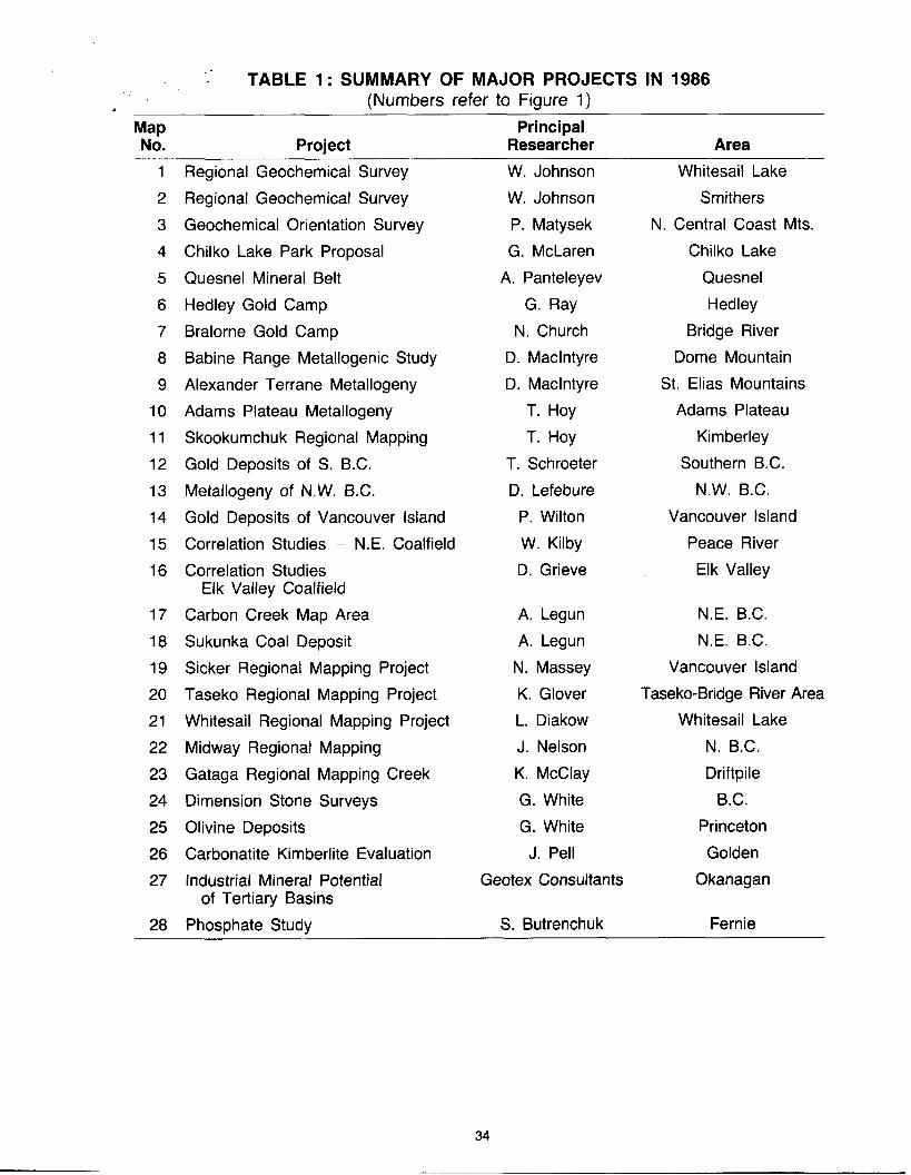
- TABLE 1 : SUMMARY OF MAJOR PROJECTS IN 1986 (Numbers refer to Figure 1)
Map Principal No. Project Researcher Area
4
1
2
3
4
5
6
7
8
9
10
11
12
13
14
15
16
17
18
19
20
21
22
23
24
25
26
27
28
Regional Geochemical Survey
Regional Geochemical Survey
Geochemical Orientation Survey
Chilko Lake Park Proposal
Quesnel Mineral Belt
Hedley Gold Camp Bralorne Gold Camp
Babine Range Metallogenic Study
Alexander Terrane Metallogeny Adams Plateau Metallogeny
Skookumchuk Regional Mapping
Gold Deposits of S. B.C.
Metallogeny of N.W. B.C.
Gold Deposits of Vancouver Island
Correlation Studies - N.E. Coalfield Correlation Studies -
Elk Valley Coalfield
Carbon Creek Map Area
Sukunka Coal Deposit
Sicker Regional Mapping Project Taseko Regional Mapping Project
Whitesail Regional Mapping Project
Midway Regional Mapping
Gataga Regional Mapping Creek Dimension Stone Surveys
Olivine Deposits
Carbonatite Kimberlite Evaluation
Industrial Mineral Potential
Phosphate Study
of Tertiary Basins
W. Johnson W. Johnson
P. Matysek
G. McLaren
A. Panteleyev
G. Ray
N. Church D. Maclntyre
D. Maclntyre T. Hoy
T. Hoy
T. Schroeter
D. Lefebure P. Wilton
W. Kilby
D. Grieve
A. Legun
A. Legun
N. Massey K. Glover
L. Diakow
J. Nelson K. McClay
G. White
G. White
J. Pel1
Geotex Consultants
S. Butrenchuk
Whitesail Lake
Smithers
N. Central Coast Mts.
Chilko Lake
Quesnel
Hedley Bridge River
Dome Mountain
St. Elias Mountains Adams Plateau
Kimberley
Southern B.C.
N.W. B.C.
Vancouver Island
Peace River Elk Valley
N.E. B.C.
N.E. B.C.
Vancouver Island Taseko-Bridge River Area
Whitesail Lake
N. B.C.
Driftpile
B.C.
Princeton
Golden
Okanagan
Fernie

partially sponsored a University of London mapping project in the Driftpile Creak area of Northeast B.C. (K. McClay).
REGIONAL GEOCHEMISTRY SUBSECTION conducts geochemical orientation and follow-up surveys in connection with the Regional Geochemical Survey Program, that has been conduct- ed in cooperation with the Geological Survey of Canada for the past 10 years. In 1986, contract geochemist, Paul Matysek, converted results of past surveys so they are available to the public in microcomputer format on floppy disks ; he also undertook a heavy mineral sampling program in the two 1986 RGS survey areas - Whitesail Lake and Smithers map sheets.
DISTRICT GEOLOGY AND COAL RESOURCES SECTION The District Geology Subsection maintains an up-to-date inventory of the geology, mineral deposits, exploration trends, and developments in the districts. Prospector training and advice and consultation to the mineral and coal industry is also provided.
These functions include reviewing duties for the annual volume Exploration in B.C. as well as providing descriptions of mineral properties visited. District Geologists are also involved in smaller scale metallogenic studies and early in the new year provide an annual review of mineral exploration.
In 1986 Paul Wilton continued his study of precious metal deposits in the Insular Belt and Dave Lefebure examined the setting of the Sulphurets gold deposits in Northwest B.C.
Results of 1986 fieldwork by district staff on selected hot exploration targets will appear in the annual volume Exploration in B.C.
The Tenth Annual Mineral Exploration Course for Prospectors was held at the Cowichan Lake Forestry Research Station in May 1986. Twenty-six students attended. In addition, basic prospector courses were delivered in five locations throughout the Province in 1986. E.L. Faulk- ner completed a new and comprehensive instruction manual for prospectors which will become the basic instruction tool for these courses.
THE COAL RESOURCES SUBSECTION is responsible for mapping, inventory and analysis of British Columbia coalfields and for the approval of coal exploration assessment reports. A computer file of coal exploration data - COALFILE and a coal core repository at Fort St. John is maintained. In 1986, the Coal Act Regulations were extensively revised. Field studies in 1986 concentrated on stratigraphic coal measures and coal seam correlation in the Elk Valley Coalfield (D. Grieve), Northeast Coalfield - Butler Ridge area (A. Legun), and in the Tumbler Ridge area (W. Kilby).
RESOURCE DATA AND ANALYSIS SECTION THE MINERAL INVENTORY SUBSECTION collects, compiles, and interprets mineral explora- tion data submitted by industry. A library of over 14000 mineral assessment reports is maintained and approximately 1000 reports are added annually. In 1986, the library was available for sale on microfiche format. The information collected from industry is summarized and published annually in the volume Exploration in British Columbia.
An open file summary of “Occurrence and Distribution of Platinum-Group Elements in British Columbia” by J. Rublee was published in 1986. The information was gathered from published and unpublished reports on file with the Ministry.
This subsection is spearheading a Branch project to design and redevelop the computer mineral inventory system - MINFILE. The database redesign was completed in 1985 and programming commenced using the fourth generation software product ULTRA. The project is behind schedule due to instability of the software produce - and the unforeseen amount of complex programming required for a relational database.
v
35
. THE INDGSTRIAL MINERALS SUBSECTION conducts studies on industrial mineral deposits to determine their distribution, grade, and quality to promote their development. In 1986 studies were undertaken on dimension stone, olivine, and phosphate, and a study of the interior Tertiary Basins was initiated to determine the potential for commercial deposits of kaolin, fireclay, ceramic clays, bentonite, zeolite, and pozzolans. A post-doctoral study on carbonatite and kimberlite deposits and a Ph.D study on the Aley Carbonatite in N.E. British Columbia were sponsored by the Branch at the University of British Columbia.
’
THE LAND USE SUBSECTION carries out field and office evaluations of proposed land alienation areas. In 1986, the Government of British Columbia appointed a Wilderness Advisory Committee to enquire into and make recommendations on land use designations for 16 areas and 8 park boundaries in the Province. This subsection provided the Committee with a comprehensive evaluation of the mineral potential of the study areas. In 1986, Graeme McLaren completed fieldwork in the proposed Chilko Lake Park.
ANALYTICAL SCIENCES SECTION This section provides a complete range of analyses of rocks, minerals, and ores in support of projects conducted by Branch geologists.
This section is responsible for certifying assayers in the Province and for managing the Regional Geochemical Survey Program.
In 1986 the Section took delivery of a new XRF unit.
FINANCIAL ASSISTANCE FOR MINERAL EXPLORATION (FAME) In March 1986, the Government of British Columbia announced a new, one year, $5 million program to provide grants in support of private sector mineral exploration. The program is administered by the Geological Survey.
The program has three components ; prospector assistance, mineral exploration incentive and accelerated mine xploration. Grants up to one third of exploration costs were awarded to @2 l i e 3 prospectors, &exploration projects and )43%%ne exploration projects in 1986. Major criteria applied in awarding the grants were : technical quality, state of project advancement, incre- k mental benefits, local economic impact, and the applicant’s financial commitment and financial need.
ALBERTA GEOLOGICAL SURVEY ALBERTA RESEARCH COUNCIL
The activities of the Alberta Geological Survey were organized into four groups, namely:
1. Basin Analysis Group
2. Mineral Resources Group
3. Coal Geology Group
4. Oil Sands Geology Group
The following overview adheres to this organizational breakdown. Further information on any of the Survey’s projects or operations can be obtained by reference to the publication list or to the Annual Report of Investigations of the Alberta Geological Survey.
36

BASIN ANALYSIS The major effort of the Basin Analysis Group within the past year has been directed at extending the hydrogeological work reported last year for the Cold Lake area, Alberta, both southward and into Saskatchewan. The objective is to model the effects of deep waste disposal in the Cold Lake oil sands deposit and adjacent heavy oil areas. This is a jointly funded project with Alberta Environment.
Work which has continued on a variety of other studies includes; a) a regional and detailed stratigraphic and structural examination of the Peace River Arch; b) evaluation of the geo- pressured and geothermal regimes in the Beaufort-Mackenzie Basin, under contract to the Geological Survey of Canada; c) preparation of several papers dealing with deep waste disposal ; and c) the development of techniques for use with large databases when studying the fluid and heat regimes in sedimentary basins.
MINERAL RESOURCES The Mineral Resources Group of the Alberta Geological Survey is involved with fundamental geological research on Alberta’s non-fuel resources and the resource applications of these commodities. Fundamental research (mapping and core analysis) focused on aggregate, limestone, and uranium in 1985/86. Resource analyses were completed for limestone, gold, sodium sulphate, lead-zinc, silica sand, gypsum, phosphate, dimension stone, and aggregate. The Mineral Resources Group received funding for this project from the Alberta Departments of Energy/Forestry, Lands, and Wildlife in five separate contracts.
The Aggregate mapping program continues as one of the most important industrial mineral studies in Alberta. Mapping is being done in the northern (Bistcho, Peerless, and Calling Lake areas) and western (Rocky Mountain House) parts of the province at a reconnaissance level. An economic evaluation of aggregate in the eastern-central part of Alberta was published in 1985. This analysis is based on the detailed information (1 :50 000 scale) gathered from more than 50 NTS sheets which were mapped between 1977 and 1983. The rate of depletion of the resources in the region is estimated and recommendations made for more effective aggregate resource management.
A number of maps and reports were published for the Precambrian Shield/Athabasca Basin area of northeastern Alberta and core from uranium and gold exploration programs in this region was filed with the Mineral Core Research facility of the Alberta Geological Survey. Complete coverage of the Shield area, through maps and reports, was achieved in 1986. Compilations of geological maps, at 1 :250 000 scale, are also available for both the Precambrian Shield and Athabasca Basin areas. Research studies and further compilations are underway to document and evaluate the mineral occurrences and potential of the region.
A project to document and evaluate Alberta’s knowledge of the metallic and industrial minerals of the province was commenced in 1985 with the publication of a bibliographic reference catalogue of 21 commodities and four commodity profile reports (limestone, gold, sodium sulphate, and lead-zinc). Additional four commodities were analyzed in 1986 (silica sand, gypsum, phosphate, and dimension stone). The commodity profile reports provide a ready source of technical data and clearly identify research needs for the future.
The Mineral Resources Group also coordinates the computing, laboratory, and information services of the Alberta Geological Survey. Laboratory and computing services are presently located in a new facility in Edmonton’s Research and Development Park. Most of the focus of information services has been with Alberta’s geological bibliographic reference database named GEODIAL. This database is freely accessible and is being used by the entire geological community in Alberta.
COAL GEOLOGY The Coal Geology Group completed a major contract for Alberta Energy/Forestry, Lands, and Wildlife to make an evaluation of the plains coal deposits. Three reports documenting the coal . resources of the Belly River Group, the Horseshoe Canyon Formation, and the Ardley Coal
,
37
. Zone were completed in March 1986. The maps and reports detail the geological character and resource potential of the units. These reports were significant in that they delineated huge coal ’ resources previously poorly understood. The findings of these assessments should be particu- larly useful in the future designation of coal fields for underground mining.
A geological model developed for the lower Horseshoe Canyon Formation coals and applicable for the Belly River Group coals helps to explain many of the depositional trends observed. The model involves a coastal plain setting characterized by shore-parallel peat swamps which are 30 to 50 km inland from actual shorelines. Frequent transgressions and regressions of the ancient seas resulted in deposition of many thin peat beds. The peak could only accumulate for a relatively short time because of frequent periods of marine transgression. Repeated transgres- sive-regressive cycles resulted in an interfingering of the coal-bearing sequences of the Lower Horseshoe Canyon Formation with thick marine sequences of the contiguous Bearpaw Forma- tion. The best coal deposits are located in this zone of interfingering. The north-south orientation of the ancient peat swamps, parallel to the shorelines, explains the elongate geometry of coal trends.
The Ardley coal zone, however, was deposited in the lower Tertiary at a time when terrestrial sedimentation was prevalent throughout Alberta. Clastic sediments associated with the Ardley coals are predominantly fluvial in origin. There are also some lacustrine sediments and paleosols. The development of the Ardley coal zone appears to be the result of basin-wide control on sedimentation, either tectonic or climatic, which allowed the development of extensive peat swamps with little introduction of clastics for a long period of time. The coal zone extends northward from Township 30 to the outcrop edge and westward to the “disturbed belt” at the margin of the foothills. As a general rule, the amount of coal increases toward the west.
Since early in 1986 members of the group have been concentrating on proposal development, detailed work plans for new projects, and a comprehensive review of the current status of coal geology within Alberta. New research initiatives in geostatistics related to coal geology and integration of coal data in a geographical information system have been initiated. The group’s research in the future will address coal quality from a geological perspective. The scope of
_-
these new programs will be finalized in the Fall of 1986. c
OIL SANDS GEOLOGY Activities within the Oil Sands Group of the Alberta Geological Survey focus on regional stratigraphic synthesis, sedimentological studies, mapping, and characterization of Alberta’s non-conventional oil sands and heavy oil resources, and supporting specialist studies in palynology. A substantial part of the funding for this group is derived from various contracts with two main agencies : the Alberta Oil Sands Technology and Research Authority (AOSTRA), and Alberta Energy and Natural Resources (AENR).
Research under the AOSTRA/AENR/ARC Joint Program addresses two major areas. The first of these is documentation and interpretation of the character of those oil sands resources in the unmapped parts of the oil sands deposits. This mapping and research provides fundamental insight into the fluid content, stratigraphical, sedimentological, and mineralogical framework, and reservoir boundaries of individual deposits. Within the Cold Lake Deposit, work is aimed primarily at development of a depositional model to explain variations in reservoir quality in the north Cold Lake area. In the central part of the Athabasca Deposit, a suite of bitumen resource maps is being prepared to outline the extent, quality, and characteristics of the oil sand horizons. Models of facies patterns document sedimentological controls on the distribution and quality of the resource.
The second major area under the Joint Program addresses the increasing need to provide detailed fabric analysis for sophisticated geological evaluations of individual reservoirs, pools, pilot sites, and recovery schemes. The Reservoir Geology Modelling project is developing detailed geological and petrophysical models of pools/reservoirs being considered for thermal pilot or enhanced oil recovery projects in order to aid reservoir engineers in numerical modelling and operational strategy decisions.
I
38

In contrast to the more fundamental and public AOSTRA/AENR/ARC Joint Program, the AOSTRA Strategic Program is intended to provide a confidential forum within which applied proprietary research on resource assessment and development can be undertaken. Research is concentrated on specific geological investigations relating to problems of resource assessment, pilot siting and operations, and process transferability.
In addition to these regional studies, a great deal of time and effort has been devoted, through AOSTRA’s technical and financial partnership in several industry-operated in-situ pilot projects, to proprietary, site-specific, reservoir studies.
The palynological research provides important fundamental data for subtle problems of facies analysis and stratigraphic separation. In addition, two long-term investigations are presently underway: (a) a synthesis of numerous individual studies previously done on the Lower Cretaceous oil sand deposits; and (b) a study of the coal-bearing Late Cretaceous strata in the Red Deer River Valley of southern Alberta.
SASKATCHEWAN GEOLOGICAL SURVEY
SASKATCHEWAN DEPARTMENT OF ENERGY AND MINES
Those mineral industry activities which demanded the most attention in 1985 were petroleum and natural gas, by virtue of record-breaking exploration and development ; potash, because of water breakthroughs endangering two of the mines; and kaolin and gold for their high growth potential as new industries which are unfolding in Saskatchewan. Apart from an all-out successful effort to cope with the massive inflow of data from petroleum related activities, the bulk of the budgetary operational resources was concentrated on the Precambrian Shield of Northern Saskatchewan to support the rising level of gold exploration.
Field project operations were again funded under the Canada-Saskatchewan Subsidiary Mineral Development Agreement 1984-89 which is in its second year.
The provincial “Gold Belt Geology” program consists of a number of projects ranging from detailed bedrock mapping to detailed mineral deposit and geochemical studies in areas perceived to have the highest potential for gold exploration. These are especially concentrated in the triangle of country between La Ronge, Reindeer Lake, and Flin Flon.
Bedrock mapping was continued in the Central La Ronge Metavolcanic Belt at 1 :20 000 scale. Two field parties worked in the belt. This was the second year of the mapping program which is expected to be completed as far south as the Churchill River by the end of fiscal year 1986-87. This region is currently regarded as the most promising gold exploration terrain in the province. The open file reports issued and the presentations made to the mineral industry have provided regional criteria for gold exploration targets in the belt. These mapping projects were supported by work on regional compilation geologic and metallogenic maps as well as by geochemical studies in the La Ronge region by the University of Regina.
Results of a project to test biogeochemical exploration methodology show a positive relation between plant uptake of gold and mineralized zones, and establish the value of this technique in the exploration for gold in glaciated terrains. Geochronological and isotopic studies were conducted with Carleton University, the University of Regina as well as Kansas University, in order to provide a chronological framework for classifying bedrock units, thereby leading to improved models for mineralization. Likewise, the Saskatchewan Research Council undertook to prepare a report on the Quaternary (glacial) geology of the La Ronge-Reindeer-Flin Flon triangle area as a guide to methodology for gold exploration.
, ,
39

A total of 590 mineral exploration assessment files submitted under the Mineral Disposition Regulations were processed, 178 visitors were received, and 1 18 requests for information were handled. Two indexes to assessment files, for the Reindeer and La Ronge Mining Districts, were published. Some 1800 visits were recorded at the Resident Geologists' Offices.
'
A
The mineralized core collection, stored in La Ronge, received additions totaling some 3925 m in length from the Dawn Lake, Cluff Lake, Dominique-Peter, Fond-du-Lac, and Stewart Island uranium ore bodies ; from four other uranium projects in the Athabasca Basin ; and from several gold properties in the La Ronge and Flin Flon Belts. About 90 persons examined cores from the collection during the fiscal year.
Work was continued on the Saskatchewan Mineral Deposits Index with the documentation of 11 7 new occurrences and updating of the records. The index provides a primary reference for mineral exploration and land use planning. A total of 18 major requests for index data were handled. In general, the number of information requests increased over the previous year. This was primarily a result of the current gold exploration boom in northern Saskatchewan.
In industrial minerals, two projects were initiated under the Canada-Saskatchewan Mineral Development Agreement :
1. a four-year project with the University of Saskatchewan to examine geological anomalies in potash mines and to develop a spatial predictive methodology;
2. a project to compile a bibliography of potash mine data relevant to anomalous geological conditions as a basis for developing a standard nomenclature, and as a guide for mine research.
Other projects include studies of the Winnipegosis and Dawson Bay Formations in the eastern potash mining district, and the petrology of the potash-bearing members of the Prairie Evapo- rite.
Approximately 170 technical inquiries were handled on a wide variety of industrial minerals. This represents about a 6 percent increase over the previous year.
Petroleum-related activity continued its hectic pace. This is reflected in the work of the Well Records Unit, where 3162 new well files were created and 3300 new wells were added to the computerized well information system.
Demand for information services increased substantially during the period. The staff pulled and refiled the records of 32 000 wells, provided industry with over 63 000 pages of photocopied data, and conducted 102 computerized data searches. Over 16 000 submissions of technical data were processed and 1500 letters requesting overdue information of delinquent companies were mailed.
In-house studies of the subsurface formations of Southern Saskatchewan were reduced to two in the Lloydminster heavy oil region, because of the involvement of staff in handling the petroleum data overload. A co-operative program of investigation for strata with hydrocarbon source potential was, however, initiated through the Geological Survey of Canada with funding from the Office of Energy Research and Development. Success in this program will enable a better focused search for new petroleum prospects beyond the present heavily explored districts.
The 1985 Annual Open House of the Geological Survey was attended by some 250 people and included participation from the Universities of Saskatchewan and Regina, the Saskatchewan Research Council, and members of industry. The event provided a synopsis of the geological work being done in the province by public agencies.
40

SASKATCHEWAN RESEARCH COUNCIL RESOURCES DIVISION
Lithogeochemistry A comparative study was completed of lithogeochemical data files for a number of unconformity- type uranium deposits in the Athabasca Basin. Preliminary results from a study of gold deposits in the La Ronge and Flin Flon areas have shown that geochemical signatures are associated with epigenetic vein deposits.
Data analysis Correspondence analysis techniques are being used routinely in geochemical analysis. Pro- grams have been modified to make them run on both IBM and Macintosh personal computers. A new project is being undertaken with CNRS/INRIA, France, to develop an image analysis/ remote sensing system for the integrated study of mineral exploration data.
Metallogenic studies Investigations are continuing of the relationships between the formation of unconformity-type uranium ores and the evolution of the Athabasca Basin. Publications in preparation include a paper on the significance of a stationary redox front as a critical factor in the formation of high grade uranium deposits, and a paper entitled “Cover-basement Interaction and the Origin of U-Ni-Co Mineralization in the Athabasca Basin : Isotopic Evidence C-H-0.” A project is underway to investigate the possible relationship between episodes of diabase dike intrusion (thermal events) into the Athabasca Basin and the formation of uranium ores.
The diagenetic-hydrothermal model of uranium ore formation is being extended to the formation of other metals in sedimentary basins. A paper is in press outlining a possible common diagenetic-hydrothermal origin for unconformity-type uranium and stratiform copper deposits.
A study of the metallogenesis of gold in the Beaverlodge district is continuing as a cooperative project with the staff of the division and a student at the University of Saskatchewan.
Rock mechanics studies This project includes the design, development, and fabrication of stress cells, extensometers and data acquisition systems for remote locations primarily for the potash mining industry. A triaxial testing facility is being commissioned which has the capacity to test large 200-mm diameter by 400-mm long cores. A project is underway to investigate the stress-strain-time behavior of cores from the COMINCO potash mine. A research project has been initiated in cooperation with the University of Saskatchewan to investigate crystal size effects in triaxial tests.
Mineral processing Recent projects undertaken include bench scale processing of Saskatchewan uranium and gold ores, and studies of the fate of thorium, nickel, and arsenic in uranium mine tailings. Studies are continuing on the upgrading of Saskatchewan’s kaolin resources. Some advice has been provided to private industry on the quality and uses of silica sand deposits.
Slurry pipeline studies Recent studies have been focused on the pipelining of tailings for the design of tailings transport systems and for developing computer models of flow regimes in pipelines. Oil-in-water emulsion studies are being initiated as an option for the transport of heavy crude oil in pipelines.
Aggregate resources The inventory of aggregate resources of selected areas of the plains region is continuing. Five aggregate resources potential maps, using surficial geology maps at a scale of 1 :250 000, were published for the Melville (621 & K), Yorkton (62M & N), Wynyard (72P), Rosetown (720), and Kindersley (72N) NTS map sheets. It is planned to initiate more detailed aggregate maps at 1 :50 000 scale for high demand areas which would summarize the location, extent, quantity, and quality of aggregate resources.
,
41

Groundwater resources ‘
A series of ten Geology and Groundwater Resources maps with cross sections at 1 :lo0 000 scale are being prepared for use in groundwater and soil salinity studies as a cooperative project with the Saskatchewan Institute of Pedology, University of Saskatchewan. Monitoring and analysis of data from the network of 50 site groundwater observation wells is continuing. Detailed studies of the rate of flow and chemistry of groundwater in glacial tills at two sites near Saskatoon, being carried out in cooperation with the Institute for Groundwater Research, University of Waterloo, will be completed this year. Groundwater monitoring and sampling in the vicinity of a waste disposal facility at a potash mine is continuing. A project to investigate the occurrence and migration of pesticides in the subsurface in agricultural areas is being initiated in cooperation with the National Hydrology Research Institute which has recently moved to Saskatoon.
’
Quaternary geology Quaternary geology studies are being undertaken in the La Ronge Gold Belt. A report of the field work completed in 1985 in the Waddy Lake area has been completed. The report describes the geology and gold geochemistry of the surficial deposits and will assist exploration compa- nies in the interpretation of till geochemistry projects. Field work during the summer of 1986 was concentrated in the Sulphide Lake-Hebden Lake area. A compilation of existing information on the Quaternary geology and related geochemistry in the La Ronge-Reindeer Lake-Flin Flon region was undertaken for the Saskatchewan Geological Survey. A more modern facility to concentrate heavy minerals, such as gold, from surficial sediments was established.
In the plains region, five surficial geology maps were completed at 1 :250 000 scale (see the section on Aggregate Resources). A project was initiated to evaluate the benefits of computer- aided map preparation using commercially available software for both mini- and microcom- puters.
Geochemical services The geochemical analysis laboratory provides analytical services to in-house projects and external clients such as mining companies operating in Saskatchewan. Approximately 25 000 analyses per year are performed on rocks, cores, ores, soils, lake sediments, and organic samples.
GEOLOGICAL SERVICES BRANCH MANITOBA ENERGY AND MINES
INTRODUCTION In this, the third year of the Canada-Manitoba Mineral Development Agreement (1 984-89)’ an accelerated level of industry-supportive, minerals-oriented programming was again mounted by the Provincial Department of Energy and Mines in concert with parallel program delivery by EMR Canada.
The joint Federal/Provincial Workplan for 1986-87 was approved by the Management Commit- tee to the Agreement in February, 1986, and copies distributed in March to members of the newly constituted Mining and Mineral Exploration Liaison Committees.
The Sector A Geoscientific program encompassed 55 Provincial and 22 Federal projects with operational budgets of one million and two million dollars, respectively. In large part, the
I A subsidiary Agreement to the Economic and Regional Development Agreement (ERDA).
42

projectswere conducted by staff of the Manitoba Geological Services Branch (MGSB) and the Geological Survey of Canada (GSC).
Even though Provincial Sector A budgets were reduced to 66 percent of those available in 1985, efforts were still maintained in all districts of concern with a special focus on the Lynn Lake- Ruttan and Flin Flon-Snow Lake mineral belts (figure 1). For several projects, the initial field objectives set under the MDA were attained, and the stage was set for data compilation, analysis, and final report production during the concluding years of the Agreement.
Briefing sessions were given in each of the northern mining districts and a complete review of all MDA activities was presented to the Winnipeg section of the CIM in April prior to the field season. Government-industry field tours and demonstrations were held in the Thompson and Flin Flon-Snow Lake areas. However, an extensive demonstration planned for the Cross Lake region had to be postponed in the face of extraordinarily high water levels on the Nelson River, a factor which also necessitated radical rescheduling of mapping programs planned for the Jenpeg region.
A progress report covering all aspects of Sector A programming during fiscal year 1985-86 was released in August, 1986. Other Open File reports were released throughout the year together with numerous brochures on various aspects of Agreement programming.
The reduced funding levels had an adverse effect on the Province’s ability to sponsor support studies and, accordingly, applied geoscience research (AGR) efforts were constrained to 6 projects, 4 being with the University of Manitoba. The Geological Survey of Canada sponsored 12 AGR projects, 6 through the University of Manitoba and 6 to universities and agencies in other provinces.
MGSB staff also provided input to other MDA Sectoral activities including drilling of tailings at Sherridon and Flin Flon, dimension stone site-selection in southeast Manitoba, acquisition of kaolin samples from Black Island for beneficiation studies by CANMET, and editorial and technical input to brochures on industrial minerals, gold, basal till studies, educational programs, and a contracted evaluation of feldspar from Bernic Lake.
Enquiries from the private sector focused principally on gold and platinum, with an equivalent level of demand for information on industrial minerals including high-calcium limestone, silica, gypsum, kaolin, building stone, peat, and crushed stone (dolomite).
Even though the MDA mechanism continues to facilitate the generation of useful, timely and pragmatic geoscientific information, as a backdrop and underpinning to exploration initiatives in the Province, efforts are still being made to encourage and maintain a high level of dialogue between all interested parties.
The principal successful elements of the MDA approach-ear to be :
1. the emphasis given to task-oriented and co-operative (parallel and integrated) program delivery by the Federal and Provincial Surveys (with full support from other agencies, universities, etc.)
2. an increased level and commitment to liaison and collaboration with industry geologists in all stages of programming from planning to implementation
3. a concerted effort to increase everybody’s awareness of the programming through wide- spread circulation of interim and progress reports, briefs, etc.
4. an elevated sense of urgency fostered by immediate association with communities over- shadowed by possible mine closure, as well as the awareness that these difficulties are part of a much larger crisis requiring readjustments on a national as well as international scale
5. provision of the Governmental staffing and budgetary resources necessary to plan, mount, audit, restructure, and conclude a coherent and unbroken five-year Survey program ; and, most importantly
- _.-- --_____ _c_--__ - - -
43
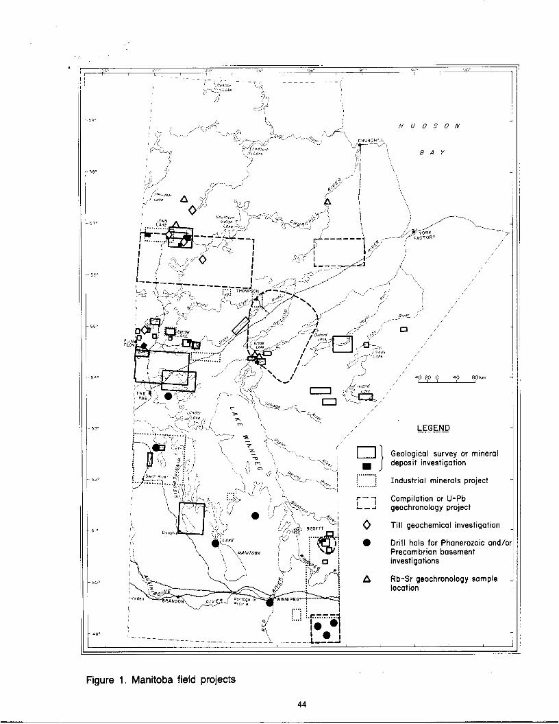
.
Geological survey or mineral
Industrial minerals project
I deposit investigation 9 . . . . . . . . . . .. i . . i
r - 7 I Compilation or U-Pb L - 2 geochronology project
. . . . . . . . ..
0 Till geochemical investigation
0 Drill hole for Phanerozoic andh Precambrian basement investigations
A Rb-Sr geochronology sample location
Figure 1. Manitoba field projects
44

6. a coincident upsurge and expansion of the Private Sector’s ability to mount aggressive exploration programs funded in large part with capital stemming from flow-through shares
In addition to its MDA commitments, the Provincial Geological Services Branch also contributed to a Workshop convened in April, 1986, at the University of Manitoba. Discussions led to the formation of a steering committee and the formulation of a proposal for a lithoprobe geophysical and geological transect of the Trans-Hudson Orogen, with coordinated participation by univer- sities in Manitoba and Saskatchewan. If accepted, the proposal could lead to the generation of unique data on megascopic crustal features associated with the Churchill-Superior Province boundary, as well as additional near-surface data of use to the mining sector.
Studies of Quaternary deposits led to joint MGSB/GSC involvement in the regional docu- mentation of the Gillam area, as well as Provincial participation in the EMR-sponsored reconnaissance of sea-floor sediments and submarine resources in Hudson Bay.
A Devonian outcrop belt tour provided to Home Oil was reportedly helpful in interpreting reef structures in Saskatchewan and in the subsequent discovery of a producing well in that province.
MGSB staff also collaborated in other research projects involving U-Pb geochronology (Univer- sity of Kansas) ; fluid inclusion studies, geothermobarometry of the Pikwitonei region ; petro- graphic investigation of the Namew Lake deposit (University of Regina) ; and ongoing coopera- tive studies with geologists from NASA on anorthosites from the Pikwitonei region and elsewhere in the Province.
LYNN LAKE-RUTTAN DISTRICT (including northern Churchill Province) Documentation of mineral deposits in the Lynn Lake area was completed as a first step to creating a mineral deposit inventory for the district. The results will be compiled into 1 50 000 synoptic maps identifying, on a geological base, the deposit type, host rock to mineralization, ore type by weight and volume, and other relevant parameters of the deposits.
Detailed mapping and geochemical sampling at Sheila, Ralph, Spider, Farley, and Motriuk Lakes compared these sections with those of the MacLellan gold mine, and extended the Agassiz Metallotect at least 5 km southwest of Lynn Lake to Margaret Lake. Other settings of gold mineralization between Franklin and Wasekwan Lakes were also investigated, as was the relationship between stratigraphy and base-metal mineralization in the Lynn Lake Rhyolite complex, and the West Anomaly near Ruttan.
Vegetation studies at the MacLellan Mine, Spider, Farley, and Dot Lakes (as well as the Ferguson Mine near Herblet Lake) encountered much lower levels of trace gold in alder twigs than has been recorded from control studies in Saskatchewan. It was concluded that the gold contents of ash from alder twigs may be substantially affected by the drainage pattern of the sampling area.
Multi-spectral remote sensing data have now been acquired for the Lynn Lake region, and will be used to search for metal-induced stress in vegetation associated with blind mineralization along the entire length of the Agassiz Metallotect.
Basal till studies initiated in 1985, and subsequently adopted by exploration companies active in northern Manitoba, encountered anomalous arsenic and gold values in the Ruttan region in till deposited on the lee side of large outcrops. Several factors indicated a principal source associated with the Vol Fault.
Till sampling east of Great Island, Seal River, confirmed earlier reported high arsenic values, some of which were significantly well above regional background values. These results, together with previously identified lake sediment geochemical anomalies and recent accounts of extensive arsenopyrite traced to bedrock northwest of Great Island, collectively indicate a hitherto unrecognized metallogenic signature and high gold potential for the greenstones of this region.
.
45

, U-Pb zircsn ages from porphyritic granite and monzocharnockite in the Chipewyan Batholith are coeval, agree with those from the Saskatchewan extensions of the pluton, and appear to indicate emplacement of magma at 1855 Ma into slightly older (1875-1880 Ma) crustal rocks. Although intense deformation appears to have waned by 1832 Ma, the largely post-tectonic dike on Reindeer Lake giving this age shows evidence of subsequent deformation and recrystalli- zation.
’
FLlN FLON-SNOW LAKE DISTRICT Detailed mapping, sampling, and mineral deposit investigations focused on the Vamp, Tartan Lake, Baker Patton, Neso Lake, Twin Lake, and Fay Lake deposits. At Tartan Lake, the recognition of a distinctive zonation in the shear zones, and pattern of alteration, will assist the search for extensions to the shear zones containing the main mineralization. Preliminary geological maps of volcanogenic sulphide mineralization were prepared for the Baker Patton and Fay Lake occurrences.
In the Snow Lake region, the bulk of data acquisition for preparation of 1 :50 000 and 1 :20 000 scale metallogenic maps has been completed. Further evidence was obtained supporting the concept that polymetallic quartz veins, within or close to mafic volcanic rocks containing Cu-Zn massive sulphide deposits, represent a genetically associated ’leakage’ or ’sweat-out’ alteration phenomenon.
Industrial minerals investigations focused on garnet and sillimanite deposits at Star Lake, talc at lskwasum Lake, dolomite south of the exposed Flin Flon and Snow Lake greenstone district, and kaolin associated with the Paleozoic unconformity.
Mineral deposits studies in the Kisseynew terrain entailed detailed mapping of selected mineral occurrences at Puffy, Walton, and Evans Lakes as well as a reconnaissance north of Nokomis Lake and south of Walton Lake. It is now apparent that quartzofeldspathic gneisses may locally occur within the so-called Nokomis greywacke sequence ; however, the structural as opposed to stratigraphic controls on this more complex configuration have yet to be resolved.
Mapping at a scale of 1 :20000 in the Flin Flon region extended coverage into the Athapapus- kow Lake area and confirmed the principal structural control by major block-bounding faults of several different ages, as well as the difficulty of correlating stratigraphy and mineralized zones between fault blocks.
Reconnaissance mapping of the Tartan and Aimee Lakes area established the late emplace- ment age of the gabbro complex which hosts the sulphide and gold mineralization.
Continuing work in the Kisseynew Lake area provided further confirmation that a single mineralized metallotect is an oversimplified concept since the paragneissic sequences contain numerous amphibolite layers at different levels within the intensely deformed migmatitic complex. A unit of metamorphosed feldspar-phyric basalt at Weasel Bay, and a metamorphic- ally armoured norite intrusion south of Imperial Lake, may represent northern extensions of the Amisk Group and Boundary Intrusions, respectively.
On Kississing Lake intensive documentation of shoreline exposures seems to confirm the existence, at a regional scale, of the three principal lithologic associations defined by earlier workers (garnet-biotite-graphite gneiss, amphibolites, and quartzofeldspathic gneiss). However, in detail this simplistic grouping appears invalid and numerous instances occur where units appear out of sequence and with little along-strike continuity. Preliminary interpretations of structural history indicate at least three folding events (recumbent, isoclinal, cross-folding), the latter with associated brittle deformation. Mineral occurrences/conductors appear associated with the amphibolite sequence, especially in areas of considerable deformation intensity.
Geological mapping at a scale of 1 :15 840 in the Chisel-Morgan Lakes area, delineated several major fault structures and identified more than one age of synvolcanic quartz-phyric tonalite displaying Fe-Mg alteration networks. A direct though tentative corollary to this is the inference
46

that associated hydrothermal activity (and hence mineralizing events), may have spanned a considerable time interval during the evolution of the Flin Flon-Snow Lake greenstone belt and consequently mineral deposits may occur at several rather than a single stratigraphic level in the volcanic sequence.
Close to 400 samples collected from granitic intrusives in the Flin Flon belt are being analyzed at the University of Manitoba as the initial step of a longer term program to geochemically categorize the felsic intrusions of this region and evaluate their metallogenic potential.
Ten additional drill holes were put down south of Athapapuskow Lake as a continuation of the sub-Paleozoic compilation in the Project Cormorant area.
SOUTHEAST MANITOBA DISTRICT An additional 30 mineral occurrences were examined in the Rice Lake region bringing docu- mentation in this region near to completion. Particular attention was given to gold associated with epigenetic sulphide mineralization at the 'Tut' occurrence, gold-bearing quartz veins in a 2 km long stratigraphic unit at Lily Lake, and gold within arkosic rocks of the Edmunds Lake Formation.
Samples from the Dumbarton MinelMaskwa West pit, the Wards occurrence, New Manitoba Mine, Hititrite and Mayville occurrences, English Lake and the Bird River Complex, returned only sub-economic and/or marginally detectable Pt and Pd values, as did 50 samples from the Neepawa mafic-ultramafic complex.
Industrial minerals activities continued evaluation of potential sites for dimension stone in southeast Manitoba as well as collection of additional samples of kaolin on Black Island using a solid stem auger.
Ground truthing of peat bogs near Grindstone Point was conducted in cooperation with the Manitoba Centre for Remote Sensing and the University of Manitoba Department of Botany, as part of an ongoing program to evaluate the use of remote sensing as a means to conducting a rapid and economic regional inventory of sphagnum peat bogs.
Detailed mapping near Stormy Lake and the Manigotagan River refined the structure and stratigraphy of the Wadhope-Gunnar Anticlinorium as well as the transition from volcanism to sedimentation in the Rice Lake Group. Several new factors of economic significance were unveiled including definition of subaerial volcanics, location of volcanic vents and a structural control of mineralization in gabbroic rocks.
Backhoe sampling in the Manigotagan area confirmed the presence of trace gold in reworked littoral glacial sands, and a potential for placer deposits.
An evaluation of geophysical and subsurface drill hole information has led to an enhanced interpretation of the Precambrian geology beneath Phanerozoic cover rocks in the Whitemouth and Black Island areas.
THOMPSON DISTRICT In north-central Manitoba the industrial minerals evaluation focused on marble in the Thompson and Pipe open pits, cordierite in the Nelson House region, and alteration minerals at the Ruttan Mine. Samples were also collected from the Manasan quarry which may have a potential as a source for lump silica.
Mapping at a scale of 1 :20 000 at Cross Lake extended eastwards to encompass supracrustal sequences at Butterfly Lake as well as all lithologies in the Jenpeg forebay, on Playgreen and Kiskittogisu Lakes. Geologically, the latter area is similar to the Molson Lake batholithic domain comprising an older suite of large batholith complexes with an extended tectonic history. The batholiths predate the Cross Lake supracrustal sequence. Detailed sampling of anorthosites . and the associated magnetite! ilmenite deposit on Pipestone Lake was extended we$wards to
47

. include the “West Channel” anorthosite between the Minago River and Kiskitto Lake. Although no chromitite seams were discovered in this anorthosite, numerous samples were collected for analysis and the initial appraisal suggests mineralogical and textural similarities with the Fiskenaesset complex in Greenland, a generally high anorthite content, as well as some potential for building stone.
In Thompson the recent development of INCO’s new open pit mine facilitated detailed docu- mentation of a complete reference section of metasedimentary and mafic-ultramafic rocks, associated with the ore zone, which are only sporadically and incompletely exposed elsewhere. Several factors appear to support an originally Archean age for ultramafics exposed in the Pit.
Geochemical, rare earth, and trace element analyses are being undertaken, with cooperation from the University of Manitoba, on mafic and ultramafic rocks along the Thompson belt, and rubidium-strontium determinations were also initiated on felsic intrusions and late deformation zones (pseudotachylite). Together with detailed and regional structural studies funded by the GSC, and the U-Pb geochronology program, these projects represent a concerted attempt to come to grips with the geology of the Churchill-Superior boundary zone, to understand the paragenesis of the nickel deposits, and to evaluate the potential for other types of mineraliza- tion.
U-Pb geochronology in the Pikwitonei-Cross Lake region consistently revealed the presence of two distinct events at a number of localities throughout the Pikwitonei subprovince, although minor differences in these ages were also evident. The older ages all fall within a limited range, i.e. 2719 (Sipiwesk), 2690 (Natawahunan) and 2695 Ma (Cauchon); however, the younger set encompasses a time span of 44 Ma with the youngest age occurring at Cauchon Lake where post-granulite pegmatite has been dated at 2629 Ma.
Ages on a Cross Lake-Molson Lake dike (1884 Ma), a Cuthbert Lake ultramafic dike (1883 Ma) and the Fox River Sill itself (1884 Ma) suggest that these intrusions are coeval and possibly comagmatic, recording an intrusive event that took place after extrusion of the Lynn Lake arc volcanics (1917 Ma) and slightly prior to intrusions along the Churchill River magmatic zone, and the contemporaneous Ruttan volcanics (1 878 Ma).
NORTHWEST SUPERIOR PROVINCE - GODS-ISLAND LAKE REGION A reconnaissance of the Ponask Lake region encountered widespread mylonites, amphibolites and quartz diorite, but, with the exception of some small mafic intrusions, no economically significant mafic or ultramafic complexes were encountered. Consequently, there appears to be little potential for economic Ti, V, Cr, or Pt mineralization in the area.
The continuing evaluation of rare-element pegmatites in the Province, by the University of Manitoba, has brought to light extensive and possibly economically significant occurrences of petalite in pegmatitic leucogranite at Red Sucker Lake. The associated highly fractionated geochemical anomaly is not only large but compares favourably with that developed over the Bernic Lake pegmatite in southeast Manitoba.
SOUTHERN MANITOBA Documentation of industrial minerals in the Duck Mountain area was undertaken to provide background data for an industrial minerals potential map, the first of several intended for southern Manitoba.
Four projects were conducted as part of the stratigraphic mapping, and stratigraphic and industrial minerals drilling program. Sampling and core drilling of the Stonewall Formation were undertaken to provide accurate stratigraphic control on the location of the Silurian/Ordovician boundary in Manitoba. Additional drilling was undertaken to obtain a detailed profile of a Winnipegosis reef and to establish a model for reef development.
Outcrop mapping was completed in the Clearwater-Cormorant-Moose Lake area as part of an extensive program, also involving ’scout’ drilling, designed to provide information on the lower
48

Paleozoic sequences, as well as additional control on the distribution of units in the Pre- cambrian basement inferred from gradiometer surveys conducted by the GSC.
Eight Precambrian sites in southeastern Manitoba were cored as part of a project to evaluate the quality of selected granitic rocks as ornamental /dimension stone.
EXPLORATION SERVICES The Exploration Services Section of the Mines Branch continued core collection and cataloguing of existing holdings at its four facilities - Lynn Lake, Thompson, The Pas, and Winnipeg. A considerable effort was expended to condense holdings at Lynn Lake and Thompson, and in the construction of additional racking at the Thompson River Base. Consolidation of core in Winnipeg has been suspended and awaits the availability of new quarters at Midland Street currently occupied by the Department of Highways.
Compilation work resulted in the issuance of several new brochures and publications, including h a BiJbliograDhy of M anitoba Geology, updates to the M m I n ventory, and the new ' Index tg Non-confidential Assessment Reports. _ _ ~ _ _ c
GEOLOGICAL SURVEY OF CANADA A comprehensive array of programs was also delivered by the Geological Survey of Canada as the Federal contribution to the MDA. These included several new aeromagnetic gradiometer surveys of the Elbow Lake, Hargrave River, and Moose Lake regions near Flin Flon, and Rice Lake (NTS 52M/4 and 52L/13NE) and Whitemouth (52E/6, 11) areas in southeast Manitoba.
Total field and vertical gradient maps at a scale of 1 50 000 were released for the Laurie Lake- Lynn Lake and lssett Lake-Pemichigamau Lake areas on April 29, 1986.
Regional lake sediment geochemical surveys were extended to the Red Sucker Lake and Island Lake region (NTS areas 53K, 53L, 53M (S 1 /2) and 53E (N 1 /2)), and regional till sampling and surficial mapping to NTS areas 63N, 63-0 (W 1 /2), 648 (S 1 /2) and the north half of 63K near Flin Flon. The Terrain Sciences Division is also continuing research into the influence of glacial Lake Agassiz clays on the geochemistry of recent lake sediments, including deep coring of several lakes to assess vertical geochemical variations and possible vertical pathways for metal migration.
Detailed geological mapping is continuing near Laurie Lake and the Fox Mine, as well as investigations concentrated on examining alteration zones associated with volcanogenic mas- sive sulphide deposits in the Lynn Lake, Flin Flon, and Snow Lake areas.
U-Pb ages have been determined for several of the key units in the southern Churchill Province and others are near to completion.
Mineral investigations in the Flin Flon area involve the study of gold metallogeny, the metal- logeny of mafic and ultramafic rocks and the study of deep footwall alteration zones below massive sulphide deposits.
A Master's degree will be completed at Carleton University on the pervasive silicification of rocks deep in the footwall to the Chisel Mine. Gold studies involved mapping of areas containing gold deposits in the Elbow Lake and Snow Lake regions, as well as around Phantom Lake, in Saskatchewan.
A University of Manitoba study, characterizing the mafic and ultramafic intrusions in the Flin Ron-Snow Lake Belt, concentrated this year on the Reed Lake Pluton.
The Namew Lake PGE-nickel deposit was also investigated.
49

In the Bissett area, the GSC continued regional structural studies in the area centred on the San Antonio Gold Mine. The University of Manitoba continued its work on the mine-scale structures
’
’ controlling the gold mineralization.
On the Chrome Property, in the Bird River layered intrusion, mapping of the chromite layers continued at a 1 : 100 scale.
Farther south, several students from the University of Manitoba engaged in studies on the Falcon Lake Stock including a thesis on the internal structure of the plug as well as studies of the petrography and gold mineralization, the latter centred on the Sunbeam-Kirkland Mine.
In the Thompson region the U-Pb geochronology program under contract to the Royal Ontario Museum continued, with the area of interest extended to Cross Lake, where mapping by provincial geologists has revealed well exposed rock types amenable to age dating.
A University of Toronto doctoral study investigated the structural setting of the Thompson Belt based on a detailed transect from the Pikwitonei granulite terrain to the Churchill-Superior boundary.
Under the Mineral Investigations sub-program the structure and related geology of the nickel deposits at the Thompson Mine constitutes a Ph.D. study at the University of New Brunswick.
The Terrain Sciences Division supervised a shallow seismic survey in the Thompson area along a line towards Gillam, the objective being to define thick deposits of glacial material that can be drilled during the 1987/88 season in the hope of characterizing the glaciation that has affected much of Northern Manitoba.
Several 1 :250 000 scale Quaternary maps covering a large portion of the Superior Province in Manitoba are also being compiled from airphoto interpretations, together with selected ground truthing.
ONTARIO MINISTRY OF NORTHERN DEVELOPMENT AND MINES
MINES AND MINERALS DIVISION
ONTARIO GEOLOGICAL SURVEY
During 1985-1986, the Ontario Geological Survey (OGS) carried out a large number of independent, geological, geophysical, geochemical, geochronological, and mineral deposit studies (figure 1). In addition, studies were undertaken in cooperation with the ministry’s regional geological staff, personnel from a number of universities, and several private consulting firms. Funding for a number of regional stimulation projects was provided by the Ontario Ministry of Northern Development and Mines and the Government of Canada. The Ministry carried out 59 field projects in various parts of the province and supported 24 applied research projects by Ontario universities as well as 17 exploration technology development projects by the private sector of Ontario’s mineral industry. The program highlights are detailed below.
PRECAMBRIAN SECTION Staff of the Precambrian Section took part in 19 geological mapping projects and special studies ; 13 involved detailed mapping (1 :I 5 840), one was a regional reconnaissance survey (1 :50 000), four were surveys to solve specific geologic problems, and one was a regional tectono-stratigraphic project. Regional reconnaissance in the Central Uchi Subprovince has located regional scale shear zones which control distribution of three recent gold discoveries,
50

4
Figure 1. Distribution and types of programs in Ontario.
51
and has ‘extended regional scale stratigraphic units to cover almost half the Subprovince. Work in the Cobalt area is designed to refine potential sedimentologic controls on gold mineralization in the Huronian sediments forming a cratonic cover sequence in Northeastern Ontario. In the Hemlo gold camp, detailed mapping at the property scale is defining folds in the shear zones spatially associated with the gold deposits ; progress is being made on lithologic correlation between properties. A structural study in the Lake of the Woods Greenstone Belt is designed to provide a structural framework for two detailed mapping projects and one regional tectono- stratigraphic project. A project on the geology of mafic-ultramafic intrusions has elucidated the controls on platinum group metal mineralization at Lac des Iles. Work continues on projects designed to produce new regional scale interpretations in the Kirkland Lake-Larder Lake and Lakehead-Atikokan areas. These projects and further regional synthesis will be integrated in a revised 1 : 1000 000 geologic map of Ontario.
’
’
ENGINEERING AND TERRAIN GEOLOGY SECTION Staff of the Engineering and Terrain Geology Section carried out 15 projects across the Province involving Quaternary geology and Paleozoic/ Mesozoic geology, Aggregate Assess- ment, and a Hydrocarbon Energy Resources Inventory Program. Staff of the Quaternary Geology Subsection were involved in seven projects. Three projects involved mapping and special studies in three gold camps (Black River-Matheson, Hemlo, and Opapimiskan Lake) to establish the geological framework and develop drift exploration strategies. Four projects undertaken in Southern Ontario included mapping and stratigraphic studies in the Port Stanley, Brampton, and Renfrew County areas. The fourth project was the completion of a geological report of Algonquin Provincial Park which was accompanied by an inventory of geological features for use by Park’s staff to prepare interpretation programs for Park visitors. Late in the year, staff initiated a study of the internationally-known geological sections at the Don Valley Brickyard and commenced work on a compilation map of the Quaternary geology of Ontario. Throughout the year, Quaternary staff participated in several mineral exploration /geochemistry and scientific meetings. Preparation of guidebooks for the 1987 Congress in Ottawa of the International Quaternary Association involved considerable staff input.
Paleozoic/ Mesozoic Geology Subsection staff completed the final year of a five-year Hydrocar- bon Energy Resources Program (HERP) to assess peat, lignite, oil shale, and conventional oil and gas resources within the Province. A considerable volume of basic data on these resources was released during the year and more data is currently being prepared for inclusion in the final reports. Two new projects were commenced this year. Detailed mapping of Cockburn Island (Lake Huron) involved the production of an updated geological map and the completion of a stratigraphic test hole to a depth of 521 m to the Precambrian basement. A second study to extend over a period of two years was initiated to provide a geological database for a review of Ontario’s Limestone Industries. This project was undertaken jointly by staff of the OGS and private consultants and was funded by the Ministry of Natural Resources.
Staff of the Aggregate Assessment Office continued with the preparation of Aggregate Re- sources Inventory Papers (ARIP). Assessments of sand and gravel potential were completed for six Southwestern Ontario townships (Amabel, West Wawanosh, Hibbert, Wallace, Adelaide, and Oxford). Seven townships were investigated in the Massey area (Gough, Harrow, May, Salter, Shakespeare, Victoria, and Truman) of Northern Ontario. A special study to investigate aggregate quality (especially with respect to chemical reactivity) was initiated in 20 townships northwest of Sudbury.
MINERAL DEPOSITS SECTION The major components of the Section’s program continued to be field studies of gold mineraliza- tion, including studies in the Red Lake, Beardmore-Geraldton and Abitibi camps. These studies approached completion in 1985/86. More recent studies continued in this program. These studies include projects in the North Caribou Lake Belt, Lake of the Woods, Uchi-Confederation Lakes, Shebandowan, Mishibishu Lake, Black River-Matheson, and Detour Lake areas.
The Section increased investigation of industrial mineral resources and uses, with programs on clay and ceramics resources, building stone, phosphates and lithophile elements.
52

Work was initiated on Platinum Group Elements in the Lac des lles area as part of a broader program in co-operation with the Precambrian Section.
New projects were started and utilized funding provided by the Canada-Ontario Mineral Development Agreement. These projects are in the Lake of the Woods, Rowan-Kakagi Lakes, Ignace, Beardmore-Geraldton, Cobalt, and Madoc areas.
GEOPHYSICS / GEOCHEMISTRY SECTION A helicopter-borne EM and magnetic field survey covering 1540 kmz was flown in the Hearst- Kapuskasing area and was released in July 1986. Also, a fixed-wing magnetometer and time domain EM survey was flown over 3910 kmz of the Pickle Lake Volcanic Belt and is due for release in the last quarter of 1986. Airborne magnetic data from the 1984 Black River-Matheson (BRiM) project were processed to produce a second vertical derivative map. Ground EM surveying was continued on the Nighthawk Lake geophysical test range. Central loop transient EM and loop-loop frequency domain EM soundings were performed on the overburden test range near Matheson, Ontario, and interpretation work is under way. A project to map deep basement conductors is in progress in the Cobalt Embayment area of east-central Ontario. Approximately 650 new gravity stations were established in the Lac des lles area east of Thunder Bay. Also, a humus geochemistry survey was carried out near Lac des lles as well as two other similar surveys over mineral showings near Opapimiskan Lake. An experimental lake sediment survey is also in progress in the Opapimiskan Lake area. Interdisciplinary regional geochemical surveys have been completed north of Sudbury and at Algoma south of the Montreal River. The reconnaissance overburden sampling program in the BRIM area continued through 1986 using mainly sonic drilling methods and 102 holes have been completed.
GEOSERVICES SECTION Compilation and computerization of mineral deposit and rock chemical data was continued by the Geoscience Data Centre. The mineral deposit database contained skeleton information on
data on 20400 samples taken by ministry geologists. Also, new Mines and Minerals Division pu b l i c a r l D n s x p ioration assessment work reports were indexed and added to both the in- house database and the national GEOSCAN bibliographic file. This file currently totals 18 000 Ontario Geological Survey entries. On request, retrievals are made for the public from the various computerized data files maintained. The 1985 Supplement to the Index to Published Reports and Maps by the Mines and Minerals Division was published. The Geoscience Data File, the system providing standardized access to exploration reports received from the industry, was maintained for the Sault Ste. Marie and Sudbury Resident Geologists’ offices.
5680 deposits by year end ; and the PETROGH database provided s w . I -&
Several development projects were completed on the SCIEX “ELAN ” inductively-coupled plasma-mass spectrometer (ICP-MS) system. These include a routine method for the determi- nation of a complete rare earth element package at or below chondrite levels; a routine method for the determination of U, Th, Pb, and T1 ; and a routine method for Sn Work on the ’in situ’ laser ablation of mineral grains was presented at the 1986 Pittsburgh Conference.
In addition, a two-day international ICP-MS Workshop was organized in Toronto by the Geoscience Laboratories, providing an opportunity for users and manufacturers from around the world to discuss ICP-MS applications.
A coulometric method to the determination of carbonate carbon in rock samples was developed and applied to 41 international geochemical reference samples.
Dr. Chris Riddle contributed articles on Rock and Mineral Analysis to the forthcoming Encyclo- pedia of Science and Technology which is being published by Academic Press.
The Scientific Review Office initiated and developed a computerized geoscience information system (GEOSIS) for geoscience data covering Ontario. It is based on the existing Ontario Geological Survey Computerized publishing system, part of which will be enhanced to form’ .
53

GE0SIS.’-*A pilot study has commenced testing all aspects of GEOSIS including data input methods, data storage and retrieval, response rate to user queries, and user friendliness. Three issues of the GEOSIS newsletter have been distributed to about 700 interested companies and individuals worldwide.
. ’
The Mines Library provides an information and reference service to Ministry personnel and the mining industry on the geology of Ontario and its mineral deposits. During 1985/86, the Library responded to approximately 9000 requests for information.
GEOSCIENCE RESEARCH AND DEVELOPMENT In 1985/86, the Ontario Geoscience Research Grants Program awarded 26 grants totalling $500 000 to 10 Ontario universities. The grants finance mission-oriented research in Ontario which is closely integrated with, but does not duplicate the activities of the Ontario Geological Survey. The Exploration Technology Development Program supported joint ventures with Ontario companies, offering research and development capabilities leading to the development of innovative technology, specifically in those areas which support the mineral exploration industry. In total, the 1985/86 program supported 17 projects involving 16 Ontario companies with expenditures totalling $836 800. Reports by OGRF and ETDF recipients were presented at the annual Ontario Geological Survey Geoscience Research Seminar on December 4 and 5 , 1985.
MINISTERE DE L’ENERGIE ET DES RESSOURCES GOUVERNEMENT DU QUEBEC
SECTEUR u MINES )) Pour I’annee 1986-87 I’objectif de base du ministere, en ce qui concerne le secteur Mines, est de promouvoir le developpement de I’industrie minerale du Quebec par un ensemble de mesures visant a appuyer I’initiative et le leadership du secteur prive, tout en s’assurant que I’exploitation des ressources minerales se fait selon les meilleurs inter& des Quebecois. Plus particulierement, iI s’agit de: 1. stimuler les investissements prives pour le developpement de nouveaux gisements, I’expan-
sion des capacites de production existante et la modernisation des usines de premiere transformation ;
2. localiser la recherche et le developpement sur des projets specifiques repondant aux besoins de I’industrie et pouvant aider a consolider notre position concurrentielle et susciter le developpement industriel a court et moyen terme;
3. contribuer au renouvellement des reserves domestiques pour les minerais de cuivre et de zinc et favoriser la diversification de la production minerale dans les regions du Quebec par la stimulation de I’exploration miniere;
4. assurer la promotion et la defense de I’amiante et, au niveau mondial, promouvoir I’adoption de legislations visant un usage securitaire de ce produit.
Chacune des trois directions generales du secteur (( Mines ’> repond plus specifiquement a I’une ou I’autre des grands objectifs cites.
LA DIRECTION GENERALE DE L’INDUSTRIE MINERALE (DGIM) La DGIM a pour mandat de favoriser le developpement, I’exploitation et la transformation des ressources minerales du Quebec par I’entreprise privee. Elle administre des programmes d’assistance financiere et les legislations minieres. De plus, cette direction generale analyse les facteurs economiques et reglementaires qui ont une incidence sur I’industrie minerale en vue
54

d’en degager les orientations et les programmes gouvernementaux susceptibles de contribuer a I’essor des entreprises minieres oeuvrant au Quebec.
Programmes d’assistance f inanciere
Infrastructures de developpement mineral: Ce programme est inscrit dans le cadre de I’Entente auxiliaire Canada-Quebec sur le develop- pement mineral. Son objectif est de favoriser I’implantation de nouvelles installations de production et de transformation de mineraux au Quebec qui soient hautement productives et concurrentielles au plan mondial, grsce a une intervention gouvernementale qui assurera I’implantation des infrastructures necessaires a leur avenement. En vertu de ce programme, la contribution des gouvernements au coirt de construction des infrastructures (routes, lignes electriques, ponts, pipelines, sites residentiels, aquaduc, egouts, tec.) pourra atteindre 20 YO du coQt total du projet d’immobilisation.
€tudes technico-economigues ; L’objectif de ce programme est de favoriser I’elaboration de projets industriels miniers et d’inciter I’industrie minerale a analyser diverses avenues susceptibles d’ameliorer sa productivi- te et sa competitivite. En vertu de ce programme, une assistance financiere de 50 YO du coQt de realisation d’etudes technico-economiques et de travaux d’experimentation destines a verifier la praticabilite ou la viabilite economique d’un projet peut etre accordee, avec un maximum de 250 000 $ par projet. Cette assistance peut atteindre 75 YO des depenses admissibles pour des etudes de marche et de commercialisation dans le secteur des mineraux industriels.
Politique fiscale Les entreprises qui oeuvrent dans le secteur de la production miniere au Quebec et les particuliers qui veulent y investir, beneficient de nouveaux avantages fiscaux suite aux modifica- tions qui ont ete apportees a la fiscalite miniere lors du Discours sur le budget du 23 avril 1985.
lmpot sur le revenu des particuliers: Avant le 1 er janvier 1986, un particulier pouvait deduire, dans le calcul de son revenu pour une annee d’imposition, 166 2/3 Yo des frais d’exploration engages au Quebec. Cette deduction est maintenant prolongee jusqu’au lerjanvier 1988 pour les frais qui, a compter du 1“‘janvier 1986, auront ete engages pour des programmes d’exploration et sous reserve que ce particulier ne soit pas un exploitant minier.
Droits payables par les exploitants : Pour donner effet aux mesures relatives aux droits de mines payables par les exploitants, le gouvernement a adopte, le 19 decembre 1985, la Loi 3 modifiant la Loi concernant les droits sur les mines.
Depuis le 23 avril 1985, les droits payables a meme les profits annuels des entreprises sont fixes a 18 Yo. De plus, I’exemption de base qui etait de 250 000 $, a ete remplacee par un credit de droits de 90 000 $. La partie de ce credit qui n’est pas utilisee dans une annee d’imposition peut &re reportee sur les trois annees ulterieures.
Par ailleurs, un regime de droits negatifs a ete introduit dans la loi. Ainsi I’exploitant d’une mine au Quebec et une societe d’exploration miniere peuvent se faire rembourser, a certaines conditions, 18% de la perte d’une annee, jusqu’a concurrence de 18% des depenses d’exploration, de mise en valeur et de la depreciation des investissements en immobilisations effectues depuis le 24 avril 1985 au Quebec. La partie d’une perte qui ne fait pas I’objet du credit remboursable est assujettie a la nouvelle regle de report des pertes.
Cette derniere permet maintenant a un exploitant de reporter les pertes d’un exercice financier sur les trois annees precedentes et sur les sept annees suivantes.
55

LE CENTRE DE RECHERCHES MINERALES ’ Le Centre de recherches minerales (CRM) est I’une des trois directions generales du secteur
Mines du ministere de I’Energie et des Ressources (MER). Le Centre repond aux attentes de I’industrie et offre un soutien technologique aux entreprises minieres et metallurgiques afin qu’elles puissent augmenter leur productivite et se mesurer avec avantage a la concurrence internationale. Le CRM est devenu depuis quelques annees un organisme axe presque exclusivement sur le service a la clientele industrielle. L’orientation du Centre se caracterise par le souci de se mettre davantage au service de I’industrie; ses depenses en 1985-86 se sont elevees a 7,6 millions $.
’
II est compose de trois entites operationnelles qui sont I’Analyse minerale, la Recherche metallurgique et la Technologie miniere.
Analyse minerale La direction de I’Analyse minerale (DAM) fournit aux intervenants du secteur mineral quebecois des services d’analyse et de recherche specialisee. Les depenses totales de la DAM se sont elevees a 2,9 millions $ en 1985-86. Pres des deux tiers de I’effort d’analyse sont consacres a satisfaire les besoins analytiques de la direction generale de I’Exploration geologique et minerale (DGEGM) du ministere de I’Energie et des Ressources (MER). Ces donnees analyti- ques sont essentielles pour augementer la connaissance geologique du territoire quebecois. Ces services d’analyse sont evaluees a plus d’un million$ par annee. D’autres travaux d’analyse sont executes directement pour le benefice d’entreprises qui ont des besoins particuliers a combler dans ce domaine. Au total, plus de 46 000 echantillons de mineraux, de roches, de sols, de sediments et d’eaux souterraines ou de surface ont ete achemines en 1985- 86 au laboratoire du CRM. Ce travail analytique represente plus de 900 000 dosages, determi- nations et etudes mineralogiques. Les teneurs des elements doses peuvent varier de quelques fractions de partie par milliard (ppb) jusqu’a 50 % dans certains cas. Ces exigences requierent I’utilisation de nombreuses techniques d’analyse differentes et de systemes automatises et informatises hautement performants tels que la spectrometrie d’emission atomique au plasma (ICP) et la spectrometrie des rayons->(.
Actuellement, la direction de I’Analyse minerale investit surtout pour developper tout le secteur de la mineralogie. Elle fait tous les efforts requis pour doter le CRM d’un laboratoire de mineralogie ou I’on retrouve des specialistes et des instruments diversifies et sophistiques capables de fournir rapidement et avec precision tous les resultats d’analyses mineralogiques et physiques susceptibles d’aider les scientifiques du secteur mineral. Les nouveaux systemes mis en place, dont un microscope a balayage couple a un analyseur d’images, contribuent fortement a augmenter les possibilites d’analyse dans le domaine de la mineralogie.
Traitement des minerais et metallurgie extractive La direction de la Recherche metallurgique (DRM) offre I’ensemble des services techniques necessaires a la valorisation d’une gamme etendue de differents minerais comme le fer, l’or, le niobium, le zinc, le cuivre, les mineraux industriels, etc. Elle s’implique aussi dans le domaine du contrde et de I’optimisation des procedes mineralurgiques en vue de satisfaire les besoins prioritaires des industriels miniers. Les depenses totales de la DRM se sont elevees a 3,7 millions $ en 1985-86.
La survie de I’industrie du minerai de fer au Quebec-Labrador repose en grande partie sur la reduction des coirts et sur la mise en marche de nouveaux produits mieux adaptes aux besoins de la siderurgie. La recherche, le developpement et le transfert technologique doivent jouer un grand rdle dans I’atteinte de ces objectifs. Le CRM possede un equipement elabore et le noyau le plus important d’ingenieurs-chercheurs et de techniciens d’experience dans ce domaine au Can ad a.
Dans le secteur de l’or, le CRM est le seul laboratoire quebecois qui offre une expertise complete tant au niveau laboratoire qu’a I’echelle pilote. II offre a la clientele industrielle des services techniques de qualite tant dans le domaine de la valorisation de nouveaux gisements que dans celui de I’amelioration des exploitations existantes.
56

Dans le secteur des mineraux industriels, le CRM, avec le personnel scientifique et les equipements dont iI dispose, peut jouer un r61e de premier plan en collaborant avec les entreprises du secteur. II peut contribuer au developpement de nouvelles utilisations des mineraux industriels du Quebec et a la mise en exploitation de nouveaux dep6ts. L’usine-pilote du CRM est la seule du genre au Quebec. Elle est au service de I’industrie miniere et metallurgique et met a sa disposition un ensemble d’equipement evalue a plus de 20 millions $.
Exploitation miniere Le service de Technologie miniere (STM) effectue et coordonne des etudes et des travaux dans le domaine de I’exploitation miniere afin d’aider I’industrie a optimiser la rentabilite des entreprises et a promouvoir la production rationnelle des substances minerales. Les services du STM s’adressent directement aux exploitants miniers. Le STM intervient principalement dans trois domaines: celui du controk du terrain, du genie industriel minier et de I’information appliquee. II procede a des essais de laboratoire pour connaitre la nature et la resistance de la roche ainsi qu’a des mesures in situ pour determiner I’intensite des pressions. En ingenierie miniere, iI contribue a ameliorer la conception et le rendement de divers elements comme le fonctionnement des ventilateurs, les dimensions des ouvertures, les systemes de soutene- ments, etc. II contribue a augmenter la productivite et favorise le transfert des connaissances et de la technologie aux exploitants miniers concernes. Par exemple, aux exploitants de mines souterraines, le STM offre, en collaboration avec I’Association des Mines de Metaux du quebec Inc., les services d’un expert en entretien des treuils de mines. Le bon fonctionnement du treuil est essentiel pour maintenir elevee la productivite de la mine et assurer la securite des employes. Le STM fait des efforts particuliers pour ameliorer les echanges et les contacts avec I’industrie afin de mieux connaitre ses besoins et lui procurer un meilleur service.
LA DIRECTION GENERALE DE L’EXPLORATION GEOLOGIQUE ET MINERALE L’annee financiere 1986-87 fut comme I’annee precedente marquee par un haut niveau d’activites en acquisition de connaissances geoscientifiques et par la consolidation du program- me d’assistance financiere a I’exploration miniere.
Ainsi, la DGEGM a consacre pres de 1 1 , l millions $ sur volet << acquisition de connaissances ’> et un montant de 9,0millions$ fut consacre a des programmes d’assistance financiere a I’exploration et a la preparation et a la diffusion de la geoinformation.
Service de la geologie
Sud du Quebec: La region de la Gaspesie a fait I’objet en 86-87 de 7 projets de terrain pour un montant global de 890 000 $. Ces projets se regroupent comme suit : cartographie geologique de base ; etudes stratigraphique et tectonique ; etude relationnelle et genetique de corps volcaniques ; et une etude metallogenique.
En Estrie-Beauce, nous avons realise 9 projets pour un montant global de 660000$. Parmis ces projets, 6 etaient consacres a la cartographie et aux etudes tectono-stratigraphiques, 2 portaient sur la metallogenie regionale et un dernier sur les amas granitiques.
L’Ouest du Quebec: La programmation 1986-87 de la Division de I’ouest comprend 12 projets evalues a 2,O mil- lions $. Cette somme represente une augmentation de pres de l ,O million $ par rapport a 85-86 et est attribuable en grande partie au projet de synthese structurale a Chibougamau et aux forages stratigraphiques.
Les projets de I’annee peuvent 6tre regroupes en deux grandes categories: les leves detailles (6) a I’echelle de 1 :20 000 et les etudes specifiques (5). Les leves detailles ont ete realises dans les regions de Casa Berardi - Matagami, de Rouyn-Noranda, de Val-d’Or, de Chibouga- mau et de la riviere Eastmain.
,
57

Deux desetudes specifiques font I’objet de theses de doctorat et trois de ces projets portent sur . la gitologie, dont particulierement I’etude metallogenie sur la region de Val-d’Or - Malartic.
Nous avons termine au cours de l’ete la section de forages stratigraphiques dans le secteur de la mine Lemoine a Chibougamau et entreprendrons a la fin de I’hiver les forages stratigraphi- ques du projet Harricana - Grasset.
.
Nord-Est du Quebec: Dans ce vaste territoire, un montant de 2,l millions $ a ete alloue a la poursuite de quelque 18 projets regroupes dans trois regions distinctes: la Fosse de I’Ungava, la Fosse du Labrador et le Grenville a I’est de Havre St-Pierre.
Dans la Fosse de I’Ungava, la cartographie systematique au 1 :50 000 s’est poursuivie en bordure des regions couvertes anterieurement. Nous avons entrepris, suite a I’interet pour les platinoi’des dans ce secteur, des etudes detaillees reliees a la petrologie des volcanites et des filons-couches ainsi que des etudes gitologique et metallogenique.
Dans la Fosse du Labrador, nous avons poursuivi la cartographie au 1 :50 000 dans I’Archeen a I’ouest de Schefferville, suite aux decouvertes d’indices d’or dans ce secteur. Le programme de cartographie dans I’arriere-pays de la Fosse s’est poursuivi au cours de I’ete 1986, et nous y avons greffe 5 projets, dont la petrologie du batholite de De Pas, la lithostratigraphie et la metallogenie d’un secteur a potentiel aurifere, la geochronologie de la region de la riviere George et une etude des caracteristiques structurales par Landsat de la meme region.
Deux projets importants, I’un portant sur I’evolution tectono-metamorphique, I’autre sur la metallogenie des gites Zn-Cu-Pb-Au-Ag, ont eu lieu dans le secteur nord de la Fosse du Labrador. Nous avons aussi continue, plus au sud, le programme d’etude et d’evaluation du potentiel mineral dans le Groupe de Wakeham dans le Grenville pres de Havre-St-Pierre.
Mineraux industriels En 1986-87, sept (7) projets ont ete retenus par la Division des mineraux industriels. Quatre sont relies a I’inventaire des mineraux industriels dont celui d’inventaire regional dans la region de Wakefield en Outaouais et celui des indices de wollastonite dans la region de St-Sauveur. La division a aussi effectue trois projets d’inventaires regionaux de materiaux de construction et de la tourbe, sur la Basse-CGte-Nord en particulier.
Service de geochimie-geophysique
Division de la geochimie; L’inventaire geochimique du territoire quebecois a fait I’objet de deux leves. L’un, concernant les sediments de ruisseau d’une partie de I’Estrie et de la Beauce, a pour but de developper le potentiel aurifere des Appalaches, I’autre, sur des sols dans la region du lac Grasset, a pour but d’identifier des cibles economiques dans le secteur a I’Ouest de Matagami.
Nous avons entrepris, a I’automne, une vaste campagne de forages stratigraphiques (Rotaso- nic) des dep6ts meubles dans la region de Harricana-Grasset afin d’aider les compagnies a mieux interpreter leurs donnees de geochimie du till de base.
En plus de ces principaux projets d’inventaire la division de geochimie a realise en cours d’annee de nombreux projets de recherche ou de suivi afin de sensibiliser I’industrie a la geochimie d’exploration et aussi d’ameliorer I’efficacite des techniques utilisees.
Division de la geophysique ; L‘inventaire geophysique du Quebec s’est poursuivi en 86-87 ; ainsi, un leve electromagnetique et spectrometrique aeroporte a ete effectue durant l’ete dans la region aurifere a I’ouest de Schefferville et un leve electromagnetique heliporte a ete effectue dans la region de Beaucevil- le.
58

De plus, en cours d’annee, les donnees de quatre leves electromagnetiques entrepris en 1985 ont ete traitees et rendues pretes pour publication.
Une equipe geophysique du MER a fait des coupes sismiques dans la region de Joutel-Selbaie afin de definir les contacts geologiques, I’epaisseur des dep8ts superficiels et certains accidents geologiques.
Un repertoire des travaux geohysiques effectues par le MER a ete prepare.
A partir de 1985-86, le MER produit des cartes couleurs du champ magnetique total residue1 et du gradient magnetique vertical calcule pour tous ses nouveaux leves aeriens.
ASSISTANCE A L’EXPLORATION MINIERE Cette direction a pour mandat de promouvoir I’exploration miniere au Quebec et, a cette fin, offre aux societes minieres, aux prospecteurs, aux universitaires et autres, I’information geo- scientifique pertinente, elabore et met en oeuvre des politiques et des programmes d’assistance a I’exploration miniere et represente le secteur Mines du MER en region.
Assistance aux regions minieres Le Service de I’assistance aux regions minieres a pourvuivi ses activites de representation de I’ensemble du secteur Mines en region par I’organisation de plusieurs colloques en region dont les themes touchaient aussi bien au developpement et a la transformation qu’a I’exploration des ressources minerales.
Les representants regionaux ont participe activement au choix des projets de recherche geologique, chacun dans leurs districts respectifs, dans une perspective de coordination entre le processus d’acquisition de connaissances geoscientifiques, propre au gouvernement, et les besoins de I’industrie miniere.
Le service a, d’autre part, initi4 un projet pilote de lithotheque a air libre, dans la region de Rouyn-Noranda en mettant de I’avant le principe d’un autofinancement par les utilisateurs. Les depenses ainsi encourues par les compagnies seraient admissibles a titre de travaux statutai- res. Le projet a fait I’objet d’un accord de principe avec les gens de I’industrie et devrait se concretiser au cours de I’exercice financier 1987-88.
Geoinformation Le ministere de I’Energie et des Ressources a decide d’implanter des systemes informatises de production et de diffusion de la documentation geoscientifique. Ces systemes devront permettre a I’industrie miniere d’avoir un acces plus rapide et plus efficace a la masse de plus en plus considerable d’informations geoscientifiques disponibles concernant le territoire quebecois. Une etude de faisabilite actuellement en cours permettra de preciser les nouvelles technologies et les nouveaux modes de production qui sont le mieux adaptes aux besoins du ministere et de I’industrie.
Dans le domaine de I’information geoscientifique, signalons la publication de la carte minerale du Quebec a I’echelle de 1 : 1 500 000. Quelque 120 nouveaux documents concernant les resultats des travaux geoscientifiques du ministere ont ete rendus disponibles. En cours d’annee, la clientele a commande quelque 33 000 copies des rapports geoscientifiques du ministere.
Programme d’assistance financiere a I’exploration Le programme d’assistance financiere a I’exploration miniere mis de I’avant en avril 1985 s’est poursuivi cette annee. Ce programme est en vigueur jusqu’au 31 mars 1987.
Pour I’annee financiere 1985-86, plus de 2.9M $ ont ete verses en subventions. Sur les 66 projets presentes touchant les trois volets du programme, 43 ont ete retenus. Ainsi, 34 projets d’egploration miniere se sont partages 2.6M $, un projet de construction d’une route d’acces a
, \ .
~
59

I’explorat’ibn s’est vu octroyer 27 500 $, et huit projets de mise a I’essai de nouvelles technolo- gies en exploration miniere ont reCu pres de 0.3M$.
Les zones designees de Matagami, Chibougamau-Chapais et de la Gaspesie ont beneficie chacune de subventions de plus de 0,5M $ pour la realisation de travaux d’exploration par I’industrie miniere. Ce sont les projets axes sur la recherche du cuivre/zinc qui ont accapare plus de 95% des subventions a I’exploration. Le programme a ainsi permis la realisation de plus de 100,OO metres de forages tout en maintenant ou en creant de I’emploi pour 85 personnes/annees dans I’industrie de I’exploration miniere.
’ .
Le point marquant de I’impact du programme est la decouverte du gisement Isle-Dieu par Exploration Noranda a Matagami. La compagnie a d’ailleurs annonce sa decision d’aller en production, ce qui engendrera des investissements de I’ordre de 35M $ pour la realisation des infrastrutures necessaires auxquels s’ajoutent les retombees economiques sur la region par le biais des salaires verses et de I’achat de biens et service au cours des annees d’operation.
Pour I’annee financiere 1986-87, 4.3M $ de subventions ont ete octroyes dans des travaux d’exploration dont plus de 2M$ dans la seule region de Chibougamau-Chapais ou les producteurs actuels font face a un probleme d’epuisement des reserves economiquement exploitables. Les impacts de I’aide financiere accordee en 1986-87 ne peuvent actuellement etre evalues puisque tous les projets d’exploration subventionnes sont toujours en cours.
MINERAL RESOURCES DIVISION
NEW BRUNSWICK DEPARTMENT OF NATURAL RESOURCES
Many of the activities of the Mineral Resources Division in 1985 were funded by a Federal- Provincial Mineral Development Agreement (MDA) that expires in 1989. New Brunswick’s part of the MDA budget for 1985-86 was $1.97 million. The Provincial budget for the Mineral Resources Division for the same period amounted to $1.3 million (see Provincial Geosciences Expenditures 1985-86, this volume).
MDA PROGRAMS MDA programs fall into four categories, these are: (1) geoscience, (2) mining and mineral technology, (3) economic development, and (4) public information and evaluation. A summary of the agreement is tabulated in VOLUMEIII of the JOURNAL under SURVEY OF FEDERAL- PROVINCIAL MINERAL DEVELOPMENT AGREEMENTS.
GEOSCIENCE Studies of granitic plutons and associated mineral deposits were begun in southern and central New Brunswick. M.J. McLeod reports that the eastern lobe of the Carboniferous St. George batholith (A, see location map, Figure 1) comprises three biotite granite phases. The oldest coarse-grained but variable-textured phase contains local swarms of tin- and tungsten-bearing greisen veins. In the Burnt Hill-Dungarvon area (B, see location map, Figure 1) E. MacLellan started a study aimed at determining the petrochemical evolution of the late Devonian-early Mississippian granites and associated tin-tungsten mineralization.
Studies of gold potential were initiated by S.E. Watters in the Cape Spencer-Mispec Beach area (C) (see Figure 1) near Saint John, and by G. Philpott and J.L. Davies in the Nigadoo-Millstream area (D) (Figure 1) in northeastern New Brunswick. In the Cape Spencer area, gold along with pyrite is concentrated in the altered arkosic sedimentary rocks surrounding shallow-plunging quartz-vein stockworks below major thrust planes. The host rocks are intensively folded and thrusted slices of Carboniferous and older sedimentary and plutonic rocks.
60

DCVONIAN PLUTONIC ROCKS
D E V O N I A N
S I L U R I A N
UPPER ORDOVICIAN LOWER S I L U R I A N
ORDOVICIAN TO P R E C A M B R I A N PLUTONIC R O C K S
CAMBRIAN - MIDDLE ORDOVICIAN
P R E C A M B R I A N
F A U L T
- K F ) ~
3
1985
NEW BRUNSWICK MINERAL RESOURCES DIVISION
x.vr[-l<.\l. RESOI'RCES .\XD EXERGY I X I ' A I<T M E ST OF
I 80 0 ,c x Y YL,&-. .
Figure 1. Distribution of programs in New Brunswick.
61

. Many gild, silver, and base-metal mineral discoveries have been made in the Nigadoo- Millstream River over the past 100 years, although only one (the Nigadoo zinc-lead-silver deposit) has been mined. Most occurrences are vein or skarn types hosted by Silurian sedimentary rocks that unconformably overlie polydeformed Ordovician turbidites and mafic volcanic rocks. The transcurrent Rocky Brook-Millstream Fault System seems to have provided the plumbing system for hydrothermal solutions associated with Devonian magmatism.
A surficial geology mapping project was begun in the Tetagouche Lake area (E) (Figure 1) in northern New Brunswick. It is hoped that results of this work will provide useful information for the mineral exploration industry, as well as aid the Forest Service in forest site classification. A.G. Pronk reports that till compositions are related to local bedrock, although some compo- nents have been transported 20 km eastward. Samples obtained from the A, B, and C horizons on a 2 km grid will be analyzed for several elements including gold.
To aid mineral exploration in the Bathurst-Newcastle mining district, a project was begun to compile all exploration data filed with the Mineral Resources Division over the past 35 years. The data is to be plotted on 1 : 10 000 base maps covering approximately 37 000 km. In 1985, however, funds were only available for production of twenty-five (25) digitized base maps for NTS map area 21 0 / 8 (see Figure 1, F).
To accommodate the ever increasing amount of drill core the Province is asked to collect and store, a new storage facility was built in Sussex with MDA funds. Two large facilities are located in Bathurst, and two smaller ones in Fredericton. G. Crouse, recently appointed Core Librarian, is responsible for all matters involving drill core.
ECONOMIC DEVELOPMENT Projects in this category include: (1) study of limestone resources and an up-date on the state of the industry by T.C. Webb; (2) a geologic and economic assessment of the Albert Oil Shale (GI Figure 1) by C. St. Peter; and (3) contract granular resources mapping in central and northwestern New Brunswick. (HI Figure 1).
PROVINCIALLY FUNDED PROGRAMS S.R. McCutcheon continued his study of the Mississippian Mount Pleasant caldera ( I , Figure 1) . Five 1 :20 000 geology maps covering the structure were completed in 1985. L.R. Fyffe investigated amphibolites from the Miramichi Zone (J, Figure 1) to determine their age, variously ascribed to the Precambrian, Cambro-Ordovician, or Ordovician.
A.A. Ruitenberg and J.L. Davies began work on a report dealing with gold in New Brunswick. The initial findings were the subject of a paper presented at the 1986 Prospectors and Developers Meeting. Dr. Ruitenberg is also compiling a metallogenic map of New Brunswick, and has taken the initial steps toward preparation of a computerized mineral deposit data file.
In Bathurst-Newcastle mining district, R.R. lrrinki began an assessment of the larger, better grade, massive zinc-lead-silver-copper sulphide deposits to establish an inventory of potential Zn-Pb-Ag-Cu ore in the region. The so-called Stratmat deposits (Cominco Limited) (K, Figure 1) and a related sulphide body owned by Heath Steele Mines were the first to be evaluated. Future plans will involve the Key Anacon (L) and Half Mile Lake deposits (M, Figure 1). J.A. Maclntosh is in the final stages of his report covering the area surrounding the Heath Steele Mine (N, Figure 1).
To help prospecting for gold in southern New Brunswick, a surficial geology mapping project was started in the Goose Creek area (0, Figure 1) by P.G. Chiswell and L. Long. Two major and one minor till sheets were identified. “B” horizon samples will be analyzed for gold and several other elements.
Other work carried out by the Division includes hydrocarbon investigations in the southeastern and northeastern parts of New Brunswick by T. Martel; and economic studies of mining properties, compilation of mineral production statistics, and investigation of mineral based
62

manufacturing opportunities by J.J. Chandra. Chandra is also continuing to study the 1983 Miramichi earthquake epicentre, and the use of salt as backfill in potash mines.
PUBLIC INFORMATION, EVALUATION, AND ADMINISTRATION This program, directed by D.J.J. Carroll, comprises (1) Public Awareness, aimed at promoting the MDA agreement and the Mineral Industry in general, and publicizing the benefits derived from the programs, (2) advanced prospecting courses, and (3) editorial activities related to the publishing of project results. The latter is the responsibility of B.W. Carroll and S.A. Abbott.
GEOSClENTlFlC SURVEYS
NOVA SCOTIA DEPARTMENT OF MINES AND ENERGY
INTRODUCTION Geoscience investigations at the Department of Mines and Energy are divided among three Divisions. In the Mines and Minerals Branch, the Mineral Resources Division and Mineral Development Division provide geological expertise in non-energy resource matters. The Energy Resource Division of the Energy Branch deals with energy minerals and commodities.
The Energy Resources Division is responsible for long term and applied research on the geological setting of coal, oil shales, peat, oil, and natural gas. The Division is charged with the responsibility of determining the broad aspects of the geological environment for these energy commodities so that, in the future, private sector and government development may proceed with an understanding of the quantity and quality of these commodities.
The Mineral Development Division is concerned with the development of mineral deposits through applied geological research. This division monitors all exploration work in the Province, maintains drill core libraries, and develops the GEOSCAN database.
The Mineral Resource Division undertakes long term geological research to increase the knowledge about the geological development and mineral deposits of the Province. These projects focus on the geological development of broad structural features and their associated mineral occurrences and deposits. The Division provides support for the Mines and Minerals Branch Education and Public Awareness Program.
In support of these varied mandates in three divisions, the Department employs over 25 geologists. During the 1985/86 fiscal year, the geological staff of the Department nearly doubled as a result of implementation of the many projects supported by the Canada-Nova Scotia Mineral Development Agreement (CNSMDA). Between 1984 and 1989, over $27 million will be spent (Canada $16.1 million and Nova Scotia $10.9 million) on programs that develop the Province's mineral resources and mineral industry.
The 1985 fiscal year was the first fully operational year for CNSMDA supported projects. Many of these projects complement similar projects in Nova Scotia by the Geological Survey of Canada (GSC). All of the work is coordinated through the CNSMDA.
ENERGY RESOURCES DIVISION ACTIVITIES
Coal Staff of the Energy Resources Division supervised eleven varied projects (figure 1). Many of these projects focused on former producing coal fields. Stratigraphic and sedimentological , studies continued in the Springhill, Debert-Kemptown, and Pictou coalfields to delineate the coal
' '
63

.
GEOSCIENCE ACTIVIlIES D U R I N G 1985/86
Energy Resources D i v i s i o n
1. 2. 3. 4.
5. 6 .
7.
8.
9. 10. 11.
Geologica l mapping - S p r i n g h i l l c o a l f i e l d Se ismic survey - S p r i n g h i l l * Geologica l mapping - Debert-Kemptown S t r a t i g r a p h i c work - ( S t e l l a r t o n graben)
Diamond-dri l l ing - Pt . Aconi Diamond-dri l l ing - Maple Brook s y n c l i n e ,
s t r a t i g r a p h y and paleonology Offshore s e i s m i c survey - Por t Hood and
I n v e r n e s s c o a l f i e l d s * O i l s h a l e s p r o j e c t - Pic tou c o a l f i e l d ,
S t e l l a r t o n graben* Coal geology computer iza t ion p r o j e c t * Coal and s e d i m e n t o l o g i c a l r e s e a r c h Onshore o i l and n a t u r a l g a s e v a l u a t i o n *
P i c t o u c o a l f i e l d
14. 15. Bui ld ing s t o n e r e s o u r c e p r o j e c t * 16. Mineral inventory* 17. Drill c o r e l i b r a r i e s * 18. Explora t lon moni tor ing , r e g i o n a l o f f i c e
Minera l Resources D i v i s i o n
19. South Mountaln B a t h o l i t h * 20. Cumberland Basin* 21. Regional s u r f i c i a l mapping* 22. Geochemical s t u d i e s * 23. M e t a l l o t e c t o n i c s tud ies ’ 24. Liscomb complex* 25. Mineral d e p o s i t investigations* 26. P u b l i c e d u c a t l o n and awareness program*
Gypsum - a n h y d r i t e r e s o u r c e s p r o j e c t *
Minera l Development Div is ion
12. Gold r e s o u r c e s inventory p r o j e c t * 13. Land u s e d a t a compi la t ion*
* i n d i c a t e s f i n a n c i a l suppor t from t h e Canada-Nova S c o t i a Mineral Development Agreement.
Figure 1. Locations and types of Geoscience projects undertaken by the Nova Scotia Depart- ment of Mines and Energy.
64

horizons and extensions. Seismic surveys in the Springhill coalfield and offshore from the Port Hood-lnverness coalfield were designed to explore the subsurface structure and extension of coal seams.
Two locations in the Province were explored with diamond drilling The extensions of the Point Aconi coal seams were evaluated by drilling, and the structure and coal quality in the Maple Brook Syncline were assessed.
Oil shales are exposed in many parts of northern Nova Scotia and Cape Breton Island. Work has begun on evaluating the quality and quantity of this resource. The first part of the project is centred in the Pictou Coalfield (Stellarton Graben).
All coal information in the Province is presently being placed in a coal information database. Specific information about part production, coal quality in a specific seam, or geological information about a coalfield may be accessed by interested parties when this database has been completed.
Oil and natural gas I he valuation of Nova Scotia’s energy resources also included undertaking geological projects on oil and gas resources situated onshore and offshore.
--
The Division is responsible for all petroleum exploration and development activities onshore, and works in conjunction with the Nova Scotia office of the Canada Oil and Gas Lands Administration (COGLA), in the administration of offshore Nova Scotia. Work continued on compiling reports containing information about onshore petroleum shows, wells, and geophys- ical information. The reports are nearing completion and are expected to be available in the fall of 1986 to all companies exploring for petroleum resources in “onshore” Nova Scotia. Studies were undertaken to better understand the geology and provide an improved definition of reserves for a number of offshore significant discoveries. The Division produced a publication reviewing oil and gas activities during the past year.
Significant petroleum-related events happened in the onshore and offshore environments during the past year, but exploration activity focused offshore, primarily in the Sable Island area.
Regulations governing onshore oil and gas exploration and production activity were put in place and negotiations were undertaken with onshore licence holders under these new regulations.
In the offshore, a number of exploration agreements expired and new exploration agreements were negotiated by governments and industry. For the first time, the Canada-Nova Scotia Oil and Gas Board requested to be informed, through the Call for Nominations, of any Crown lands companies would be interested in acquiring offshore.
Progress was made on the Venture Gas Project. Additional drilling was undertaken to firm up the reserves and applications were made by the producers to the regulatory authorities to export the gas from the Venture States. Negotiations commenced between the governments of Nova Scotia and Canada regarding changes to the Canada-Nova Scotia Agreement on Offshore Resource Management and Revenue Sharing concluded in 1982.
MINERAL DEVELOPMENT DIVISION ACTIVITIES The Division has developed several major commodity studies under the CNSMDA to help the private sector develop these mineral resources. A major study of gold in former gold districts and other areas of Nova Scotia is designed to investigate the diversity of geological environ- ments and their economic potential. Two other commodity studies will assess the reserves of gypsum-anhydrite and building stone. Both projects involve concurrent emphasis on the development on new uses and markets for these commodities (figure 1).
Geologists in the Division are assembling information databases for land use and -mineral inventory. The land use project was developed to compile information about the uses of .mineral
65

. potential land and to diminish the alienation of these lands. Mineral inventory is a broad heading fdr the compilation of a drill hole database, journal literature, and data pertaining to mining operations. This material will become part of GEOSCAN information database in the Depart- ment.
,
The Mineral Development Division maintains an extensive drill core library at the Stellarton regional office. During the 1985/86 fiscal year over 157 000 feet (48 000 m) of diamond drill core were added to the library holdings. Monitoring of exploration activity is carried out from the regional office.
MINERAL RESOURCES DIVISION ACTIVITIES The CNSMDA is supporting many long term mineral resource studies of parts of Nova Scotia (figure 1). The South Mountain Batholith Project is presently assessing the geology and mineral potential of this large granitoid body in southern Nova Scotia by means of bedrock and surficial deposits mapping. Seven 1 : 50 000 map sheets have been produced from the 1985-86 mapping activity. The project goal is to test the potential of this large area to host East Kemptville type deposits (Sn-Cu-Zn-Ag) and other deposits (Sb, Au, Mo, Mn, Be, rare earths).
During 1985/86, the first major field effort began on the regional mapping and total mineral resource assessment of the Cumberland Basin. Another major regional project is the mapping of surficial Pleistocene deposits across northern Nova Scotia. The search for mineral occur- rences is being continued in this project through the use of till geochemistry.
A joint federal-provincial project began the assessment of stream sediment geochemistry and its relationship to the geology of individual stream catchment basins. An additional part of this regional geochemistry project is the compilation of all geochemical data into a comprehensive geochemical atlas.
Work began on the evaluation of several mineral deposits under the Mineral Deposits Investiga- tion Project. Over the term of the CNSMDA, geologists from the Geological Survey of Canada and the Department will be working together to understand the geology of the major mineral deposits in Nova Scotia. Closely related to this project is a Metallotectonic Study of the Province. Through the use of new geological data applied to plate tectonic models, a better appreciation is being sought of the location and emplacement of mineral deposits.
As part of the CNSMDA work nearly all granitoid bodies in southern Nova Scotia will be studied by the Geological Survey of Canada or the Department. One of these plutons, the Liscomb Complex, is the subject of a field mapping and of geochemical studies.
The Education and Public Awareness Program promotes an understanding of the minerals, geology, and mineral industry in Nova Scotia and the importance of the CNSMDA. Prospecting courses, displays, publications, and education material for schools were prepared and com- pleted during 1985/86.
EXPLORATION ACTIVITY Mineral exploration in Nova Scotia during 1985 continued at a moderate level. The total area held under exploration licenses increased from 1258720 acres (509397 ha) in 1984 to 1 288 920 acres (521 619 ha). The value of exploration and development work rose to an estimated value of $8 000 000 from $7 300 000 in 1984. Development of several gold properties to near production, and the successful mining operations at Rio Algom’s East Kemptville tin mine have encouraged the exploration and mining sector., Nova Scotia looks forward to continued progress in the development of a healthy and diversified mineral industry. Geosci- ence activities are an important part of this development.
66
ENERGY AND MINERALS BRANCH, PRINCE EDWARD ISLAND
DEPARTMENT OF ENERGY AND FORESTRY
INTRODUCTION The goal of the Prince Edward Island Minerals Branch is to develop the capability to respond effectively to public requests and needs relating to mineral, oil, and gas administration. In addition, the branch is striving to become the centre of expertise on the geology of Prince Edward Island and is committed to carrying out essential geological survey activities.
The highlight of the 1985/86 fiscal year was the signing of the Canada-Prince Edward Island Mineral Development Subsidiary Agreement designed to evaluate the province’s onshore mineral aggregate (sand and gravel) resources. Other activities undertaken during the year included the hosting of the 42nd Annual Mines Ministers’ Conference in September, and the indexing and entry of the province’s mineral resources information into GEOSCAN, the national database for geological bibliographic information.
The 1985/86 fiscal year saw no fewer than four companies holding oil and natural gas permits to approximately 1.6 million acres of offshore territory and to 1.5 million acres of onshore land. Bro Resources Limited showed a renewed interest in the H.B. Fina et a/. Green Gables #1 Well which was originally drilled in 1972. At year end, Bro Resources Limited was attempting to stimulate the well in the hopes of being able to produce commercial quantities of natural gas.
MINERAL DEVELOPMENT SUBSIDIARY AGREEMENT On January 7, 1986, representatives from both the federal and provincial governments signed a three-year, 300 000 $ Canada-Prince Edward Island Subsidiary Agreement. The Agreement became effective as of 2 January 1986 and will terminate on 1 January 1989. It is being funded on an 80 %/20 o/o federal-provincial basis and will be totally delivered by the Province.
The purpose of the Agreement is to carry out programs with the objective of moving the Province closer to self-sufficiency in mineral aggregates (sand and gravel). Program I , namely Onshore Aggregate Resources, will permit a comprehensive qualitative and, where possible, quantitative analysis of both surficial and bedrock mineral aggregate deposits within the Province. This program will involve the collection and assessment of existing information, air photo interpretation, as well as ground investigation and mapping and the sampling and testing of selected sites. Program II, namely, Public Information and Evaluation will ensure that the results of Program 1 are transferred to potential developers. It is hoped that such an evaluation will provide potential developers with basic information on the nature, size, and potential for the development of the aggregate resources of the Province.
NEWFOUNDLAND DEPARTMENT OF MINES AND ENERGY
MINERAL DEVELOPMENT DIVISION
INTRODUCTION The Mineral Development Division of the Newfoundland Department of Mines and Energy is responsible for obtaining, interpreting, and disseminating the geoscientific data required for the optimal development of the Province’s mineral resources. To that end, the Division carries out continuing programs in bedrock geological mapping, geochemical and geophysical surveys, mineral deposit studies, surficial mapping, and information services. Many of these programs were funded under the five year (1 984-1 989) Canada-Newfoundland Mineral Development Agreement in 1985. The 1985 field program is summarized in Figure 1 and Table 1. .
67

. 6C
5E
5:
4
Figure 1. Distribution of field projects, 1985 (Numbers refer to Table 1)
68

k
Table 1 : Summary of 1985 Field program, Newfoundland Department of Mines and Energy
(Numbers refer to Figure 1)
No Geologist Project Name (and scale) NTS Area Project 1985
A. Geological Mapping Sections 1. S. Colman-Sadd 2. I. Knight
Bay d’Espoir project (1 : 50K) Daniel’s Harbour project (1 : 50K)
3. D. Boyce Biostratigraphic studies 4. R. Wardle 5. 6. Ryan 6. C. Gower 7. G. Nunn
Goose Bay project (1 : 1 OOK) Strange Lake project (1 : 1 1 OK) Eastern Grenville project (1 : 1 OOK) Western Grenville project (1 : 1 OOK)
8. A. Kerr Lithogeochemistry of granitoid rocks, Makkovik area
B. Geochemistry/ Geophysics Section
10. J. McConnell 11. J. Tod 12. H. Miller
C. Mineral Deposits Section 13. B. Kean
14. J. Tuach
9. J. Butler Geochemical follow-up, Labrador Trough Geochemical follow-up, granitoid terranes Geophysical support - magnetics and EM Geophysical support - gravity
Metallogeny, volcanogenic sulphide
Metallogeny of Newfoundland granitoids deposits, Victoria Lake area
15. C. O’Driscoll Metallogeny, Avalon Zone and A. Huard
16. A. Howse
17. R. Miller and J. Meyer
Industrial Minerals Survey, western
Metallogeny of Labrador granitoids Labrador Newfoundland
D. Quaternary Geology Section 19. B. Sparkes Quaternary Mapping, South Coast (1 : 50K)
20. M. Mihychuk Quaternary Mapping, Daniel’s Hr. 21. D. Bragg
22. M. Ricketts
23. M. Batterson
E. Publications and Information Section 24. A. Harris
Bedrock Aggregate Inventory,
Detailed Aggregate Assessment,
Quaternary Mapping, Letitia Lake (1 :50K)
Avalon Peninsula
Placentia Bay
Drill Core Collection and Storage
12Ai7 1211 1 5 1 6;
12P/1,2
13F/7,8 14D/1,8 13H/SE 23A/ SE, 22P/ 15 13J/13, 14,15;
130/2,3
12Al9, 10,11 , I6
11 0/9,15,16 ; 12Hl10,15
1M112, 1M/16
24Al8, 13L l l
11P/13; 12Al4
121, 12H IL , 1M
1M13, 1M/16
69
. GEOLOGICAL MAPPING A general assessment of the geoscientific database in Newfoundland and Labrador was carried out in the early 1970s. That study identified a need for bedrock geological mapping as a basis for mineral exploration, mineral potential assessment, and land use planning. Much of the Divisions effort since that time has been directed towards geological mapping, at the 1 :50 000 scale in Newfoundland and at the 1 : 100 000 scale in the larger, more remote areas of Labrador. Geological maps at these scales are now available for about 50 percent of the Province, and the program is continuing.
Two field mapping projects were carried out in Newfoundland in 1985. Ian Knight continued his work on the Cambro-Ordovician carbonates along the west coast. Steve Colman-Sadd contin- ued his mapping north of Bay d’Espoir. Three of the Newfoundland project geologists remained in the office during the 1985 season, completing maps and reports dealing with the south- central part of the island, where field work was completed in 1984.
Five mapping parties were active in Labrador. Bruce Ryan began a three year project in northern Labrador in the area of the Zr-Nb-REE deposits at Strange Lake. Ges Nunn, Dick Wardle, and Charlie Gower continued their mapping projects in the western, central, and eastern parts of Grenville Province, respectively. Andy Kerr initiated a new project aimed at the mapping and a lithogeochemical study of granites in the Makkovik area.
Significant results derived from the 1985 mapping program included : the delineation of a major unconformity within the carbonate sequence in western Newfoundland which controlled lithofacies in subsequent deposits and must be considered the primary control of most of the base metal mineralization in the area; the identification of mineralized granites in the Cape Makkovik area ; the subdivision of Grenville gneisses into thrust-fault bounded terranes in southeastern and southwestern Labrador, and the subdivision of the Nain igneous complex and associated gneisses in northern Labrador.
GEOCHEMISTRY /GEOPHYSICS The Division continued its program of follow-up studies over anomalies revealed by regional lake sediment surveys. J. Butler conducted follow-up investigations over base-metal anomalies in the Labrador Trough, while J. McConnell investigated F, Mo, and U anomalies in east-central Labrador and initiated a pilot project to investigate geochemical methods for gold exploration. J. Tod conducted geophysical studies in support of follow-up mapping, and mineral deposit studies. H. Miller, on sabbatical leave from Memorial University, carried out gravity surveys over the Ackley Granite, the Middle Ridge Granite, and in the Gander area. P. Davenport continued with a computer analysis of regional geochemical data and compilation of a geochemical atlas of Newfoundland.
The laboratory performed a wide variety of chemical analyses in support of the Division’s programs and completed installation of a new ARL 3520 sequential quantometer for the analysis of rare earths and other highly refractory elements. A modern graphite furnace was added to our atomic absorption equipment for the analysis of gold in the parts per billion range. The computer unit completed a review of the computer requirements of the Division and initiated a pilot project on the integration of regionalized multivariate data in geology, geochemistry, geophysics, and mineral deposits.
The Geological Survey of Canada, under the Canada-Newfoundland Mineral Development Agreement, completed reconnaissance geochemical lake sediment surveys of northern La- brador to Latitude 58’39”.
MINERAL DEPOSITS The Mineral Deposits Section is responsible for metallogenic studies, industrial mineral surveys, and mineral inventory. Four metallogenic projects were conducted in 1985. 8. Kean continued his study of volcanogenic sulphide deposits in central Newfoundland. R. Miller worked on the geological setting and mineralogy of the rare earth deposits at Strange Lake and Letitia Lake. C. O’Driscoll and A. Huard continued their examination of gold mineralization on the Burin
70

Peninsula. J. Tuach initiated a new study of gold deposits associated with granitoid rocks in western and southern Newfoundland. P. Dean began work on a new metallogenic map of the island part of the Province.
In the industrial minerals field, A. Howse initiated a reconnaissance study of marble occurrences in western Newfoundland, and was successful in identifying high quality marble deposits with potential for use in the filler, lime, and whitening industries. J. Meyer completed an assessment of dolomite and silica deposits in western Labrador, and initiated an assessment of the potential of the anorthosites and labradorite occurrences in the Nain area ; dolomite deposits outlined by the study in the Wabush area are currently being developed for use in the manufacture of self- fluxing iron-ore pellets.
C. O’Driscoll and his staff completed the manual mineral occurrence file for the island of Newfoundland, and for western Labrador. Computerization of the file for the island of Newfound- land was also completed, and a number of mineral occurrence maps were published.
QUATERNARY GEOLOGY The Quaternary Geology Section continued programs in surficial mapping and aggregate resource assessment. Three Quaternary mapping projects were carried out in 1985. B. Sparkes initiated a new, long term project in southwestern Newfoundland, in the vicinity of the Cinq Cerf gold discovery. M. Batterson completed surficial mapping and till geochemistry in the area of the rare earth deposits at Letitia Lake in Labrador. M. Mihychuk carried out detailed mapping and drift prospecting studies near the zinc deposits at Daniel’s Harbour. The Letitia Lake till geochemistry indicated several anomalous areas unrelated to known deposits.
Aggregate resource inventory continued in the immediate area of communities and in areas identified for development associated with offshore oil. F. Kirby conducted detailed aggregate assessments in municipal areas, and worked with municipal planning process. M. Ricketts carried out a detailed assessment of the aggregate resources in the Placentia Bay area, where construction of concrete platforms for offshore use is anticipated. D. Bragg conducted a survey of possible bedrock aggregate sources on the Avalon Peninsula.
PUBLICATIONS AND INFORMATION SECTION A new editor, F. Blackwood, was appointed to the Publications and Information Section in 1985. The results of the Division’s field projects were released in some 47 publications and open files, the latest being typeset on the Division’s new Compugraphic Powerview IV system. The drill core storage program, under the direction of A. Harris, added some 24 000 m of core to the collection. The technical information management team, under N. Mercer, handled a record number of new reports and requests for information, completed microfiching of the geofiles for the island of Newfoundland, and continued contributions to GEOSCAN.
GEOLOGY DIVISION
DEPARTMENT OF INDIAN AFFAIRS AND NORTHERN DEVELOPMENT
NORTHWEST TERRITORIES
The Northern Affairs Program of INAC is responsible for the administration of all non-oil and gas mineral resources in the Northwest Territories (N.W.T.). The Geology Division, under this authority, acts much as a provincial geological survey. Its major tasks or functions are to:
1. maintain a geological database to assist in the furtherance of mineral exploration and, *
development ;
71

2. monitor mining and mineral exploration ;
3. review technical assessment work submitted through the Mining Lands Division ;
4. provide advice and assistance, where possible, to individuals or organizations interested in
5. expand geological knowledge of the Northwest Territories, its mineral deposits, and mineral
6. administer resources allocated to the Geology Division so as to further the above functions.
any aspect of mineral resources and geology in the Northwest Territories;
potential ;
The following section elaborates on the above functions and describes some of the activities undertaken to fulfill these :
1. The Division husbands the geological / mineral exploration / mining database for the North- west Territories and makes available as much as possible of the information collected.
To this end, the Division:
i. maintains a geologicallassessment work archive ;
ii. maintains a core library in which to store core, mineral, and rock samples to assist those interested ;
iii manages the mineral resource side of the Regional Natural Resources Library for the Northwest Territories.
The Staff and Archives Geologist, assisted by an Archives Technician, maintain the archive. More than a third of their time is devoted directly to assisting archive users and information seekers. Another third is devoted to,maintaining the archive. Much of the remainder of their time goes into assisting in the preparation of the Division’s various publications, namely Mineral Industry Reports, Exploration Overviews, Previews, the Division’s contributions volumes, and numerous open file releases. Ten percent is spent on mineral deposit related research and field investigations. Recently, the geological archive was reorganized to make its upkeep more efficient and to enhance the long term integrity of the files stored there. The Division is awaiting a new shelving system which should simplify and condense the document storage area and more than double the space available for clients to work in.
The Core Library Manager spends only a small part of his time on the library and its collections; he also manages the extensive field equipment store, and this year also has had to act as an exped i tor.
Some term or student resources are used as well to handle the considerable work load relating to the database.
2. The Division monitors mines and mineral exploration in order to:
i. keep abreast of developments, record developments, and be able to advise the ministry and other interested persons or groups ;
ii. develop and maintain expertise and knowledge on the geology of the Northwest Territories and its mineral deposits in order to assist interested people and evaluate assessment submissions and generally enforce those parts of the Canada Mining Regulations delegated to the Division.
The Division does this by:
i. visiting mines approximately once each year; ii. visiting as many exploration projects in the field as time and operating and maintenance
funds permit ;
72

iii. contacting mineral exploration people in their offices, as they pass through Yellowknife, and
iv. monitoring trade publications and the popular press for information on mining and explora- at conferences ;
tion.
The continued shift of exploration effort from uranium, base metals, and tungsten to gold and, to a lesser extent, the platinoids, has resulted in a major shift in mineral exploration in the Northwest Territories. There has been a decline in exploration in all areas of the N.W.T. except in the Archean parts of the Churchill Province (Keewatin District) and in the Slave Province. The latter structural province contains four producing gold mines, two gold mines at the bulk testing stage, and another which commenced underground exploration and bulk sampling in 1986.
Because nearly 80 percent of all exploration is at present (1986) concentrated in the Slave Structural Province, two additional District Geologists were assigned, in the spring of 1986, to work in that area.
3. The Division reviews assessment and Prospecting Permit submissions for acceptance under the Canada Mining Regulations in order to ensure these submissions are useful, complete, and are in compliance with the regulations. They also assist in the review of Prospecting Permit applications.
4. The Division conducts and assists others to conduct geological studies within the N.W.T., including mapping at various scales, but mainly at 1 :50 000 and larger, and mineral deposit studies inchding mapping of showings. Our assistance to other groups, the Geological Survey of Canada, universities, prospectors, and less commonly, mineral exploration companies or consultants include : i . an expediting service for associated groups working with the Division under contract;
i i . expediting resources and storage for Geological Survey of Canada crews operating out of Yellowknife :
iii. visits, on request, to prospectors in the field to advise them on prospecting techniques and on the potential of the area they are working in or of finds they have made;
iv. advice to mineral exploration geologists on their work, problems, and showings, when requested, mainly during property visits ;
v. advice and consultations to/with students/contractors, etc. working for or with the Division ;
vi. cooperation with all groups to maximize transportation resources and reduce the overall cost of field work.
5. The Division expends considerable time and effort on administration of expenditures and personnel (especially in these days of restraint when special effort is required to obtain approval to conduct normal operations). For this reason, in any Mineral Development Agreement the Division is called on to manage, the Division will insist on obtaining a budget for the services of an administration manager, with a strong geological background, to organize MDA delivery.
GEOLOGY DIVISION 1986 PROJECTS -
Personnel Project Description Scale (months)
~ ~~
1 Russell Lake Mapping supracrustals - granitoids - 1 :30 000 5 (1 .O) (NTS 85 J/13, 85 0/3,4) volcanics - 1 : 50 000
1:10000
2. Hood River Mapping southern extension of the High 6 (1.5) (NTS 75 L/9, 10,15,16) Lake Volcanic Belt
73

Personnel . Project Description Scale (months)
Russel Lake and Hood River areas and end-glacial marine sediments along Coronation Gulf from Paulatuk to Spence
3. Superficial Mapping 1 (2.5)
Bay 4. Hope Bay (NTS 77 A) Volcanic belt mapping. Detailed mapping
of ultramafic sills 2 (1.5)
5. Octopus Formation (NTS 85 J/7,8)
Yellowknife Volcanic Belt 1 :10000 3 (1.0)
6. Ellington Lake Bear Province Supracrustal (mainly vol- 1 :50 000 2 (1.5)
7. Jackfish Island Yellowknife Bay area, southeastern end 1 : 10 000 1 (2.5)
(NTS 86 E/11) canic) Belt
(NTS 85 J/1,8) of Yellowknife Volcanic Belt (Duck and Burwash Formations)
8. Cameron River Volcanic Mapping to elucidate structure1 and 1 :10 000 2 (1.0) Belt (NTS 85 1/15) stratigraphy
Belt & Sleepy Dragon volcanics of the Yellowknife Supergroup Metavolcanic Complex to the basement complex (NTS 85 1/15)
Structural relationships of the Yellowknife (Kess-Karrah Bay) Supergroup to the basement complex (NTS 86 H/7)
9. Cameron River Volcanic Structural mapping of the relationships of 2 (1.0)
10. Point Lake Area 4 (5.0)
11. Kam/Banting Transition Mainly logging of core from holes drilled 1 (1.0) by Golden Marlin Resources. Advice to Octopus project
side of the Yellowknife Volcanic Belt to investigate the granite-gold connection
Nonacho Group. Collection of material for heavy mineral analysis and gold content
Detailed mapping of gold quartz veins in the Burwash Formation (Yellowknife Ba- sin)
tionships in the Slave Province (W.K. Fy- son, Carleton University) Geochronological studies in the Wopmay Orogen. (Cooperative work by S.A. Bowr- ing, Washington University, with the Geological Survey of Canada)
of the Slave Province to improve maps and relate the mineral deposits to struc- tural events
12. Western Plutonic Mapping granitoids along the western 1 :50 000 3 (1 .O) Complex
13. Nonacho Basin Mapping of the extensions of the 1 :50000 2 (2.0)
14. Gold Vein Studies 1 (0.5)
15. Deformation Studies, Detailed studies to clarify structural rela- contract Yellowknife Basin
contract 16. Dating in the Bear Province
17. Dating in the Slave Geochronological studies in many parts 1 (0.2) Province
I 74
Project Description Personnel
Scale (months)
18. Mineral Deposit Studies Mineralogical studies, Thor Lake rare metal deposits (W.G. Smith, University of Alberta)
19. Mineral Deposit Studies Geology and mineralogy of the N-81 ore body, Pine Point Mines (R.L. Morton, Uni- versity of Alberta)
contract
contract
EXPLORATION AND GEOLOGICAL SERVICE DIVISION
YUKON DEPARTMENT OF INDIAN AFFAIRS AND NORTHERN DEVELOPMENT
ACTIVITIES FALL 1985 TO SUMMER 1986 The Exploration and Geological Services Division (EGSD), Yukon, consists of six geologists, an office manager, a map salesperson, and a secretary. The Division is part of the Mineral Resources Directorate of the Northern Affairs Program (NAP) in Yukon as well as the Mineral Rights and Mining Engineering Divisions. NAP is one of five programs of the Federal Depart- ment of Indian Affairs and Northern Development and has responsibilities in Yukon for mineral resource management much the same as any provincial department of mines. Most of the projects described below were funded by EGSD, with the exception of those projects of the Mineral Resources Sub-Agreement of the Canada-Yukon Economic Development Agreement (EDA).
Chief Geologist Jim Morin coordinated and monitored most projects of the division and of the EDA. His main ongoing project involves precious metal mineralization and volcanic rocks.
Minerals Geologist Grant Abbott examined mineral showings in west-central Yukon in associa- tion with ongoing Geological Survey of Canada regional mapping work. The showings are mainly breccia related and are hosted by Late Proterozoic rocks. Extensional mafic volcanism, associated volcanogenic polymetallic mineralization, and relevant Proterozoic stratigraphy were investigated by 1 : 50 000 scale mapping in the Hart River Area (1 16 A 10). Geology of the silver- lead veins in the Hess Mountains at the Plata-Inca property (105 0 12 and N 9), and geology and structure associated with mineralization in the Pelly Mountains were written up as reports in Yukon Geology Vol. 1.
Placer Geologist Steve Morrison continued his ongoing examinations of placers in the Klondike and Sixty Mile River areas. He completed his M. Sc. ThFsis work on the sedimentology of the Plio-Pleistocene White Channel gravel deposits and co-authored a paper on them for “Yukon Geology”. He also compiled and edited the guidebook for the International Quaternary Associa- tion field trip to be held in the Yukon in summer 1987.
He also coordinated investigations into heap leaching potential of altered and unaltered auriferous gravels as an extension of the Division sponsored studies on epithermally altered bedrock and gravel in the Klondike.
Staff Geologist Diane Emond wrote a paper on tin-tungsten mineralization in the Mayo- Mcquesten area of central Yukon for “Yukon Geology”. She spent much of 1986 on maternity leave and was replaced from February to September by Brian Lueck.
I
75

. Staff Geologist Dave Downing continued 1 :50 000 scale mapping in the Sekulmun Lake area of Southwestern Yukon (1 15 H 12). Early Cenozoic volcanic rocks overlie a Mesozoic basement of gneisses, schists, and granitic rocks. The objective of this study is to determine the controls and associations of epithermal - and porphyry-style mineralization that occurs in these rocks.
Office Geologist Bill Lebarge joined the division in January 1986 and assisted with several of the Division’s field projects during the summer.
,
Greg Lynch continued his study of mineral and metal zonation in the Keno Hill area of central Yukon (105 M) as part of a Ph. D. program at the University of Alberta. The first field season was sponsored by the EDA and this second by EGSD, with some support coming from United Keno Hill Mines both years. Fluid inclusions, metamorphic and hydrothermal mineral assem- blages, metal abundance, sulphur isotopes, and geology all point to zonation centred about the Roop Lakes Batholith.
The Canada/ Germany Science and Technology Exchange Agreement saw several geoscience studies conducted in the Yukon in 1986. Within this framework, EGSD provides direction and partial support for German students working on projects that geologically have some economic sign if icance.
Ulrich Glasmacher finished field work for his Ph. D. Thesis at the University of Aachen, Germany. The thesis deals with the physiochemistry of hydrothermal mineralization associated with Cretaceous-Tertiary volcanic rocks in the Sixty Mile River area(l l6 C 2), Sekulmun Lake (1 15 H 12), and Prospector Mountain (1 15 I5), all within the Yukon Crystalline Terrain.
Two other students from the University of Aachen conducted fieldwork in the Livingstone Creek area for their Diploma theses. Rudy Reible studied the sedimentology, stratigraphy, and heavy mineral assemblages of gold-bearing placer gravels, and Ludwig Stroink concentrated on structure, petrology, and economic geology of the surrounding bedrock.
Tom Skulski finished his field work in the Miocene Wrangell volcanic rocks of the Kluane Range in southwestern Yukon (1 15 G 5). It forms the basis for his Ph. D. Thesis at McGill University regarding structure, stratigraphy, and petrochemistry. The geology of the area is being docu- mented on maps at a scale of 1 125 000. These rocks host large areas of hydrothermal alteration that may have some potential economic significance, especially for precious metals.
Also in this part of the Kluane Range (1 15 G 5), as part of an M. Sc. Thesis at the University of Alberta, Mike Power investigated a large land subsidence-slide feature at Cement Creek. Major movement has locally dammed a creek and created very unstable areas of detached bedrock within a larger area that has suffered much hydrothermal alteration.
Jennifer Smith studied the structural setting and metamorphic aureole of the late Cretaceous Mt. Mye Batholith northeast Lof the Far0 Mine (105 K 3,6). The study forms the basis of an M. Sc. Thesis at the University of Alberta and is part of an effort by EGSD to understand more fully the regional geology of the zinc-silver-lead rich Anvil District.
Steve Johnston conducted his second summer of field work in the Aishihik Lake area (1 15 51) as the basis for a Ph. D. Thesis at the University of Alberta. The study concerns the structural, metamorphic, and petrogenetic aspects of the large Aishihik Lake Batholith. Preliminary findings indicate that these early Mesozoic granitic rocks may be thrust upon North American Crust and actually underlie part of the Whitehorse Trough.
Mike Cathro studied the structural and physiochemical aspects of important gold-bearing mantos and quartz veins of the Ketza River Deposit in the Pelly Mountains of south central Yukon (1 05 F 9). The mineralization appears to be zoned from a subjacent stock through biotite hornfels to gold-bearing, and later lead-zinc-silver-bearing mantos and veins.
The study forms the basis of a thesis at the Colorado School of Mines.
76

Charlie Roots mapped early- to mid-Paleozoic volcanic rocks in the Dawson map area (1 16 B) on a contract basis in conjunction with a Geological Survey of Canada regional mapping project. EGSD is interested in the potential of these rocks for both syngenetic and epigenetic mineraliza- tion.
Monica Pride studied, on a contract basis, Eocene volcanic rocks in the Tintina Trench (1 05 K S, 105 F N). These rocks host an important disseminated epithermal gold deposit at Grew Creek. This study of volcanofacies, structure, alteration, and petrochemistry may point toward further potential for other similar mineralization.
Mike Cosec conducted a summer field study of a gold-bearing copper-iron skarn at Jackson Creek north of the Whitehorse Copper Belt. The mineralization is located within retrograde actinolite-magnetite skarn that is locally bismuth rich.
Under the Canada-Yukon Economic Development Agreement (EDA), a Mineral Resources Sub- agreement was struck in May, 1985, that consists of three programs: I. Geological mapping, II. Geochemistry, and 111. Placer mining technology. EGSD managed and administered Program I, which consisted of three contract geological mapping projects during the summer of 1986 : Dawson Range West, Dawson Range East, and Rancheria.
The Dawson Range West contract was awarded to Archean Engineering of Vancouver for the 1 :50 000 scale geological mapping of 11 5 15, 11 5 J 9 and 10. The basic geology consists of a metasedimentary terrane of probable Paleozoic age that is intruded by Mesozoic granitic plutons and is overlain by late Cretaceous volcanic rocks. The Dawson Range East contract was awarded to Focus Minerals of Sudbury for 11 5 I 3 and 6. Here, the geology is similar, but is complicated by yet another volcanic suite of early Cenozoic age. Porphyry systems involving copper, molybdenum, and gold and hydrothermal veins bearing gold, silver, and base metals summarize the economic geology reasons for this work.
The Rancheria contract was awarded to Tesso International of Toronto for 105 B 7 and 8. The basic geology consists of a Paleozoic miogeoclinal sedimentary sequence intruded by the Cretaceous Cassiar Batholith and subsequent small plutonic bodies of Eocene age. Mineraliza- tion consists of silver, lead, zinc veins and replacement bodies, and tungsten-tin bearing quartz veins.
Multi-element stream sediment geochemical data for 105 C,D, and 11 5 I and H was released in July and August 1986. In addition, gold, cadmium, tin, and antimony analyses of samples collected during earlier surveys of 105 B and F were also released. Much industry interest was generated and several previously unknown mineralized areas were indicated.
During the summer of 1986, multi-element stream sediment geochemical surveys were carried out in western Yukon (1 15 0, N-east 1 /2 and 115 J, K-east 1 /2) under the management and administration of the Geological Survey of Canada. The results will be forthcoming in early summer 1987.
Most of the information generated from the above projects was disclosed by way of an informal end of field season meeting in mid-October in Whitehorse, the Whitehorse Geoscience Forum in early December 1985, and at the Cordilleran Round Up in Vancouver in late January 1986.
77

.

1985-1 986
GEOLOGICAL PUBLICATIONS PROVINCIAL AND TERRITORIAL GEOLOGICAL SURVEYS
79

. BRITISH COLUMBIA 1985 1 1986 INFORMATION CIRCULARS
B.C. Mineral Exploration Review, 1985; Stan. Geological Branch, Information Circu- lar 1986.1
B C Mineral Exploration Review, 1984; Staff, Geological Branch. Information Circu- lar 1985-1
Summary of Operations. Mineral Resources Division 1980; 1981 ; 1982; IR 1984-2, IR 1984-3. IR 1984-4. respectively.
Summary of Operations. 1983, Mineral Resources Division IR 1985-2.
Summary of Operations, 1984. Mineral Resources Division IR 1986-1.
British Columbia Mineral Quarterly IR 1986-2.
British Columbia Mineral Quarterly IR 1986-3.
PAPERS
Geological Fieldwork 1985, Paper 1986-1 contained the following papers:
D.A. Grieve, and P.R. Elkins: Correlation and Comparison of Two Coal-Bearing Zones between Ewin Pass and Bare Mountain, Elk Valley Coalfield, Southeastern British Columbia (82Gi15, 82J12).
D.A. Grieve, and W.E. Kilby: Flathead Ridge Coal Area, Southern Dominion Coal Block (Parcel 82). Southern British Columbia (82G17).
G.E. Ray, and J. McClintock and W. Roberts: A Comparison Between the Geochemistry of the Gold-rich and Silver-rich Skarns in the Tillicum Mountain Area (82F113. 82K14).
G.E. Ray, and A. Spence: The Potassium-rich Volcanic Rocks at Tillicum Mountain- Their Geochemistry, Origin, and Regional Significance (82F113, 82Ki4).
Z.D. Hora, and B.N. Church: Zeolites in Eocene Rocks 01 the Penticton Group, Okanagan-Boundary Region, South-central British Columbia (82E).
T. Hoy: The Rebar and Sherpa Lead-zinc Occurrences, Shuswap Complex
T. Hoy, and F. Goutier: Rea Gold (Hilton) and Homestake Volcanogenic Sulphide- barite Deposits. Southeastern British Columbia (82M14W).
T. Hoy and J. ?ell: Carbonatites and Associated Alkalic Rocks, Perry River Sand Mount Grace Areas, Shuswap Complex, Southeastern British Columbia (82M17, 10).
P. Schiarizza: Geology of the Eagle Bay Formation Between the Raft and Baldy Batholiths (82M15. 11, 12).
G.E. Ray: Gold Associated with a Regionally Developed Mid-Tertiary Plutonic Event in the Harrison Lake Area, Southwestern British Columbia (92G19; 92Hi3, 4, 5, 6.
G.E. Ray, J.T. Shearer, and R.J.E. Niels: The Geology of the Carolin Mine Gold Deposit in Southwestern British Columbia and the Geochemistry of its Replacement Sulphide-Albite-Quartz-Gold Mineralization (92H / 1 1).
G.E. Ray, R. Simpson, W. Wiikinson. and P. Thomas: Preliminary Report on the Hedley Mapping Project (92H18. 82E15).
E.L. Faulkner: Blackdome Deposit (92017E. 8W).
E.L. Faulkner: British Columbia Regional Geochemical Survey (RGS) Release, Preliminary Results (93GiE 112, 93Hi2 112, plus parts of 93HiE 112).
A.J. Boronowski, and W.M. Johnson: Regional Geochemical Surveys RGS 13- Prince George 93GiW 112 and McBride 93HiE 112; RGS 14 - McLeod Lake 93J.
A.J. Boronowski: 1985 Orientation Survey, A Follow Up of Two 1984 Regional Geochemical Survey, Geochemically Anomalous Drainages by Panned Stream Sediment and Silt Sampling, Blackwater Mountain Area (93Gi2) and Clear Mountain Area (93H16).
B.N. Church: The Bob Creek Gold-silver Prospect (93L).
B.N. Church: A Computer Program of the Determination of Molecular Norms for the Fine-grained and Altered Rocks of the Bob Creek Area (93L/7).
W.E. Kilby: Biaxial Reflecting Coals in the Peace River Coalfield (980,P.I).
W.E. Kilby : Some Chemical and Mineralogical Characteristics of Tonsteins and Bentonites in Northeast British Columbia (930.P.I ; 94A).
A. Legun. and P. Elkins: Wapiti Syncline Phosphate Potential (93J/10, 7).
A. Legun: Geology of the Carbon Creek Area (930115).
H.P. Oppeit : Stratigraphy and Character of the Bluesky Formation (94A,B,H,G ; 931.0,P).
T.G. Schroeter, L.J. Diakow. and A. Panteleyev: Toodoggone River Area (94E).
T.G. Schroeter: Muddy Lake Prospect (104Ki1).
T.G. Schroeter: Bennett Project (1 04M).
T.G. Schroeter and D.G. Maclntyre: Tatshenshini Map-Area (1 14P).
D.G. Maclntyre: The Geochemistry of Basalts Hosting Massive Sulphide Deposits, Alexander Terrane, Northwest British Columbia (1 14P).
(82L110).
12).
D.J. Alldrick: Stratigraphy and Structure in the Anyox Area (103P.5).
D.J. Alldrick. J.K. Mortensen. and R.L. Armstrong: Uranium-lead Age Determinations in the Stewart Area (104611).
G.L. Dawson, and D.J. Alldrirk: Geology and Mineral Deposits of the Kitsault Valley (103P111, 12).
J. Koo: Geology of the Klappan Coalfield in Northwestern British Columbia (104H.2. 3, 6, 7).
A.F. Wilcox. and C. Borsholm: MINFILE.
C.E. Kenyon: COALFILE.
B.J. Thompson: CanadaiBritish Columbia Coal Data Project.
Z.D. Hora: New Developments in Industrial Minerals
Z.D. Hora, and Y.T.J. Kwong: Anomalous Rare Earth Elements (REE) in the Deeo Purple and Candy Claims (82J13E).
J. Pell: Diatreme Breccias in British Columbia (82G.J.N; 83C; 948)
J. Pell: Nepheline Syenite Gneiss Complexes in British Columbia (82M,U, 83D; 931).
G.V. White: Preliminary Report, Lang Bay Germanium Prospect (9LFI16W).
G.P. McLaren: Geology and Mineral Potential of the Chilko-Taseko Lakes Area (92014, 5; 92JI13; 92K116; 92N11).
J. Pell: Carbonatites in British Columbia: The Aiey Property (94615).
G.V. White: Preliminary Report. O'Connor River Gypsum Deposit (1 14P. 10E)
G.G. Addie: Referendum Mine (82F16).
G.G. Addie: Hailstorm Mountain Gold Prospect Reconnaissance Geology and Self- Potential Survey (82F113).
K.R. McClay and M.W. lnsley: Structure and Mineralization of the Drillpile Creek Area, Northeastern British Columbia (94E/18, 94F114, 94K14, 94L/l).
G.G. Addie: Structural Geology of the Millie Mack Mine and a Theoretical Ore Control (82K14).
B.N. Church : Geological Setting and Mineralization in the Mount Attwood-Phoenix Area of the Greenwood Mining Division. Paper 1986-2. Coal in British Columbia. Paper 1986-3.
E.L. Faulkner: Prospecting Manual, Paper 1986-4
J. Koo, T.G. Schroeter. and G.V. White: Coal in Northwestern British Columbia, Paper 1986-5.
REGIONAL GEOCHEMICAL SURVEY
B.C. RGS 12 - 1984 (GSC Open File 1107) NTS 93G(E/2), 93H(W12) and parts of 93H(Ei2) Regional Stream Sediment and Water Geochemical Reconnaissance Data, British Columbia.
B.C. RGS 13 - 1985 (GSC Open File 1214) NTS 93G(W12), 93H(E/2). 93J
BULLETINS
Grove, E.W. Geology and Mineral Deposits of the Unuk River-Salmon River-Anyox Area; Bulletin 63.
Maclntyre, D.G. Geology and Mineral Deposits of the Tahtsa Lake District West Central British Columbia (93E111, 14); Bulletin 75.
Hoy, T. The Purcell Supergroup, Fernie West-Haif, Southeastern British Columbia Part A - stratigraphy - Measured Sections; Bulletin 76.
Kwong. Y.T.J. Evolution of the Iron Mask Batholith and its Associated Copper Mineralization ; Bulletin 77.
OTHER GEOLOGICAL SURVEY BRANCH PUBLICATIONS
Producing Mines, Mineral Deposits with Reserves and Significant Coal Deposits of British Columbia (1984) Scale 1 :2000000.
Geology in British Columbia 1977-1981.
Exploration in British Columbia, 1980
Exploration in British Columbia, 1982
Exploration in British Columbia, 1983.
Exploration in British Columbia, 1984
Exploration in British Columbia, 1985
PRELIMINARY MAPS AND NOTES
Legun, A. Geology of the Butler Ridge Area; Preliminary Map 57, Scale 1 :50 000.
Schroeter. T.G. Mineral and Coal Potential, Northwestern British Columbia; Prelimi- nary Map 58, scale 1 : 1 000 000.
Church, B.N. Geology and Mineralization in the Mount Anwood-Phoenix Area Greenwood, B.C.; Preliminary Map 59, scale 1 :25000.
80

Grieve, D.A. and Fraser, J.M. Geology of the Elk Valley Coalfield SoLthern Half (Kiiamock Creek to Alexander Creek); Preliminary Map 60, scale 1 :10000.
Diakow, L.J.. Panteleyev. A,, and Schroeter. T.G. Geology of the Toodoggone River Ar-a NTS 94E; Preliminary Map 61, scale 1:50000.
Bennett. S. Geology of the Mount Forster Map-Area (82K89, 10, 15): Preliminary Map 62, scale 1 '25 000
Grieve, D.A., and Price. R.A. Geological Setting of the South Half of the Elk Valley Coalfield. Southeastern British Columbia (82GI15, 82J/2) ; Preliminary Map 63 (scale not known).
Schroeter. T.G., and Panteleyev. A. Gold in British Columbia; Preliminary Map 64. scale 1 :2 000 000
OPEN FILE MAPS AND REPORTS
Ray, G.E. Geology of the Hozameen Fault Area (92H, 9ZHi6,l l) (1 :20000, 1 :6 000, and detailed) ; Open File 1986-1
Aildrick, D.J., Dawson. G.L., Bosher. J.A.. and Webster, 1.C.L Geology of the Kitsault River Area (103P), (1 :50000); Open File 1986-2.
Koo, J. Geology of the Klappan Coalfield in Northwest British Columbia (104H/2,3.6.7) (1 :50000); Open File 1986-3.
McLaren. G.P. Geology and Lithogeochemistry of the Chilko-Taseko Lakes Area (920/4,5: 92J/13; 92Ki16; 92NI1) (1 :50000) : Open File 1986-4.
Schiar,?za. P. Geology of the Vavenby Area (82Mi12 and parts of 5 and 11) f1:50000); Open File 1986-5.
McLaren, G.P. Stream Sediment Geochemistry of the Chilko-Taseko Lake Area (920/4,5; 92J/13; 92K/ l6; 92Ni l ) (1 '50000); Open File 1986-6.
Rublee, J. Occurrence and Distribution of Platinum-Group Elements in British Columbia (1 :2000000) Open File 1986-7.
ALBERTA GEOLOGICAL SURVEY PUBLICATIONS 1985-86
Basin Analysis Group 1985: Hydrogeology of the Swan Hills area, Alberta: Evalua- tion for Deep Waste Disposal, Brian Hitchon, Project Manager, Report, 189p; Database 233p; Atlas (208 maps and cross-sections). Prepared by the Basin Analysis Group, Alberta Geological Survey (Research Manager, Brian Hitchon). Consultant report prepared for Alberta Special Waste Management Corporation, Project Manager, Brian Hitchon.
Edwards, W.A.D., Hudson, R.B., ar d Scafe. S.W. 1985: Aggregate Resou-ces of the EdmontonILloydminster Region; Alberta Research Council, Bulletin No. 47.
Edwards, W.A.D , and MacGiilivray, J.R. 1985: Industrial and Metallic Mineral Resources: Catalogue of Study P.reas and Reports: ARC Internal Report to AENR, 118P.
Godfrey, J.A. 1986: Dimension Stone-Mineral Commodity Profile; Alberta Research Couccil Contribution No. 1408.
Hamilton, W.N. 1986a: Gypsum-Mineral Commodity Profile; Alberta Research Council Contribution No. 1409.
- 1986b: Silica-Mineral Commodity Profile; Alberta Research Council Contribution No. 1411.
Macdonald, D.E. 1986: Phosphate-Mineral Commodity Profile; Alberta Research Council Contribution No. 1410.
Nurkowski. J.R. 1985: Coal Quality and Rank Variation Within Upper Cretaceous and Tertiary Sediments. Alberta Plains Region; Alberta Research Council, Earth Science Report 85-1, 33p.
Wilson, J.A. 1985: Geology of the Athabasca Group in Alberta: Alberta Research Council Bulletin 49, 78p.
- 1986: Geology of the Basement Beneath the Athabasca Basin in Alberta; Alberta Research Council Bulletin 55.
OPEN FILE REPORTS
Fenton, M., Langenberg, C.W., Jones, C., Trudell. M.. Pawlowicz, J., Tapics, J.. and Nikols, D. 1985: Tour of the Highvale Open Pit Coal Mine; CIM-CSPG Conference Field Trip Guidebook; Alberta Research Council, Open File Report 85-7.
Ing, A. 1985: Delineation of the Northern Extension of the Rimbey-Meadowbrook Reef Tract, Upper Devonian, Northeastern Alberta; Alberta Research Council, Open File Report 1985-2.
iosert. J. 1986: Jurassic Rock Creek Member in the Subsurface of the Edson Area (West-Central Alberta) : Alberta Research Council, Open File Report 1986-3.
Walker, D. 1986: Regional Stratigraphy of the Upper Devonian Grosmont Formation, Northern Alberta; Alberta Research Council, Open File Report 1986-2.
Yoon. T. 1986: Bitumen Resources of the Upper Devonian Grosmont Formation, Northern Alberta; Alberta Research Council, Open File Report 1986-1.
MAPS
Dredge, L.A.. Nixon, F.M.. and Richardson, R.J. 1985: Surficial Geology,, North- wester1 Manitoba; Geological Survey of Canada, Map 1608A. scale 1 :500,000.
Fox. J.C. 1985a: Aggregate Resources, Mount Watt, 84K; Alberta Research Coun- cil, Open File Report 1985-21.
- 1985b: Aggregate Resources, Bison Lake, 84F: Alberta Research Council, Open File Report 1985-22.
- 1985c: Aggregate Resources, Vermilion Chutes, 84L; Alberta Research Council, Open File Report 1985-21,
- 1986a: Sand and Gravel Resources of Bistcho Lake (Northern three quarters, 84M) and Steen River (West Half, 84N) Areas; Alberta Research Council, Open File Report 1986-9.
- 1986b: Aggregate Resources, Ruth Lake (74Di 13); Alberta Research Council, Open File Report 1986-17.
Richardson, R.J.H. 1985a: Aggregate Resources, Zama Lake, 84L: Alberta Re- search Council, Open File Report 1985-12.
- 1985b: Aggregate Resources, Bistcho Lake, 84M; Alberta Research Council, Open File Report 1985-13.
Richardson, R.J.H., and Sham, P.C. 1985: Aggregate Resources, Peace River, 84C: Alberta Research Council, Open File Report 1985-11.
Scafe, S.W.. and Sham, P.C. 1988: Sand and Gravel Resources of the Peerless Lake (South Half of 846) and Lesser Slave Lake (North Half of 83D) Map Areas, Alberta; Alberta Research Council, Open File Report 1986-5.
Wilson, J.A. 1985: Basement Geology Beneath and Around the Western End of the Athabasca Basin. Alberta; Alberta Research Council, Open File Map 85-10, with marginal notes.
EXTERNAL PUBLICATIONS
Bachu, S. 1985: Influence of Lithology and Fluid Flow on the Temperature Distribu- tion in a Sedimentary Basin: A Case Study from the Cold Lake Area, Alberta, Canada; Tectonophysics, Volume 120, p.257-284.
Bosman, A. 1985: Monitor Coal Drilling for Maximum Cost Efficiency; Canadian Mining Journal, April, 1985.
Cant. D.J. 1986: Diagenetic Traps in Sandstone; AmericanAssociation of Petroleum Geologists Bulletin, Volume 70, p.155-160.
Edwards, W.A.D.. Fox, J.$, and Richardson, R.J.H. 1985: Choose Right Rig for Exploration; Rock Products, May 1985.
Flach, P.D., and Mossop, G.D. 1985: Depositional Environments of the Lower Cretaceous McMurray Formation, Athabasca Oil Sands, Alberta; American Associa- tion of Petroleum Geologists Bulletin, Volume 69, p.1195-1207.
Harrison, R.S. 1985: The Grosmont formation of Northern Alberta. A Hugh Carbo- nate Platform. A Hugh Non-conventional Resource; abstract in Society of Economic Mineralogists and Paleontologists Mid-Year Meeting. Colorado
- 1986: Stratigraphy, Sedimentology and Bitumen Potential of the Upper Devonian Grosmont Formation ; abstract in Canadian Society of Petroleum Geologists reser- voir newsletter.
Harrison. R.S., and Coniglio, M. 1985: Origin of the Pleistocene Key Large Limes- tone. Florida Keys; Bulletin Canadian Society of Petroleum Geologists, Volume 33, Number 3, p.350-358.
Hitchon, B. 1986a: Editorial; Applied Geochemistry, Volume 1. Number 1, p.1-2.
- 1986b: International Association of Geochemistry and Cosmochemistry: A His- tory; Applied Geochemistry, Volume 1. Number 1, p.7-14.
Koster, E.H. 1986: Review of "Sedimentology of Coal and Coal-Bearing Se- quences", edited by R.A. Rahmani and R.M. Flores; international Association of Sedimentoiogists Special Publication 7, Geoscience Canada, Volume 13.
- 1985b: Review of '"Modern and Ancient Fluvial Systems", edited by J.D. Collinson and J. Lewin : International Association of Sedimentologists Special Publication 6. Geoscience Canada, Volume 12, p.80-81.
Langenberg, C.W. 1985: The Geometry of Folded and Thrusted Rocks in the Rocky Mountain Foothills Near Grande Cache, Alberta; Canadian Journal of Earth Sci- ences. Volume 22, p.1711-1719.
Langenberg. C.W., and McMechan, M.E. 1985: Lower Cretaceous Luscar Group (revised) of the Northern and North-Central Foothills of Alberta; Bulletin of Canadian Petroleum Geology, Volume 33, Number 1. p.1-I1
Macdonald. D.E. 1985: Geology and Resource Potential of Phosphates in Alberta and Southeastern British Columbia; M.Sc. thesis, University of Alberta.
McCabe, P.J. 1984: Depositional Environments of Coal and Coal-bearing Strata: p.163-176 in Special Publication. edited by R. Rahmani and R. Flores, International Association of Sedimentologists. Number 7.
Nurkowski, J.R., and Rahmani. R.A. 1984: An Upper Cretaceous Fluvio-Lacustrine Coalbearing Sequence, Red Deer, Alberta; p.163-176 in Special Publication, edited by R. Rahmani and R. Flores, Association of Sedimentologists. Number 7
OConnell. S.C. 1985a: The Sedimentology of the Lower and Mid-Mannville Forma- tion of the South Lloydminsler heavy Oil Trend, Alberta; AOSTRAIARC Oil Sands Geology Agreement 1588, 47p.
- 1985b: The petrography of the Lower and Mid-Mannville Formation of the South ' Lloydminster Heavy Oil Trend, Alberta; AOSTRA/4RC Oil Sands Geology i4gree- ment 1586, 47p.
v
. .
81

- 1985~: A Flesource Analysis of the Lower and Mid-Mannville Formation of the South Lloydmmter Heavy Oil Trend, Alberta; AOSTRAIARC Oil Sands Geology Ngreement 1588. 41p.
Richardson. R.J.H. 1985: Quaternary Geology of the North Kaipara Barrier, North- land, New Zealand, New Zealand Journal of Geology and Geophysics, Volume 28, p.111-127.
Rust, E.R., and Koster. E.H. 1984' Coarse Alluvial Deposits; p.53-69 in Facies Models, Second Edition, edited by R G. Walker, Geoscience Canada Reprint Se- ries t .
Stea, R.R.. Ftnck. P.W., and Wightman, D.M 1986: Quaternary Geology and Till Geochemistry of the Western Part of Cumberland Country. Nova Scotia (sheet 9); Geological Survey of Canada, Paper 85-17, 58p.
Wilson, J.A. 1985: Crandallite Group Minerals in the Helikian Athabasca Group in Alberta, Canada; Canadian Journal of Earth Sciences, Volume 22, p.637-641.
ABSTRACTS AND CONFERENCE PRESENTATIONS
Cant. D.J. 1986: Regional Geology of the Peace River Arch: Abstract. Edmonton Geological Society.
Dusseault, M.B., and Scafe. D.W. 1985: Water Sensitivity of Smectitic Cretaceous Clay Shales of Alberta; Presentation. 1985 International Clay Conference, Denver, Colorado.
Hitchon. B. 1985: Graphical and Statistical Treatment of Standard Formation Water Analyses; p.225-236 in Proceedings, First Canadian/ American Conference on Hy- drogeology: Practical Applicanons of Ground Water Geochemistry, edited by B Htch- on and E.i. Wailid, National Water Well Association, Worthington. Ohio.
Hitchon. B., Sauveplane. C.M.. Bachu, S., and Lytviak, A.T. 1986: The Swan Hills Facility of Alberta Special Waste Management Corporation : Evaluation for Deep Waste Disposal; p.115-I22 in Proceedings. Second CanadianlAmerican Confer- ence on Hydrogeology: Hazardous Wastes in Ground Water - A Soluble Dilemma, edited by 8. Hitchon and M.R. Trudell. National Water Well Association. Worthing- ton, Ohio.
Koster, E.H. 1985: Channel Processes, Vertebrate Taphonomy and Architecture of an Upper Cretaceous Coastal Plain Sequence - Southeast Alberta; Abstract in Third International Fluvial Sedimentology Conference, Fort Collins, Colorado, 7-9 August. 1985, Abstracts Volume, p.24.
- 1986a: Environments and Architecture of a Coastal Plain Sequence: Upper Cretaceous Judith (Belly) River Formation at Dinosaur Park, Alberta: Abstract in Canada's Hydrocarbon Reserves for the 21st Century. Canadian Society of Petro- leum Geologists Convention, Calgary, June i -4, 1986. Abstracts Volume.
- 1986b: Archilecture of Point Bar Units: New Insights from Badlands' Outcrop of Upper Cretaceous Coastal Plain Sediments in Alberta. Canada; Abstract in 12th International Sedimentological Congress, Canberra, Australia, 24-30 August, 1986, Volume of Abstracts
- 1 9 8 6 ~ : Practical Definition of 'Marine Influence' for Estuarine Reaches of Low- gradient River Systems; Abstract in 12th International Sedimentilogical Congress, Canberra, Australia. 24-30 August. 1986, Volume of Abstracts.
Langenberg. C.W. 1985 : Structural Geology of the Lower Cretaceous Coal-bearing Strata in the Grande Cache Area, Alberta: Abstract in 11th Cordilleran Tectonics Workshop, Calgary. February, 1985.
McCabe, P.J., and Macdonald, D.E. 1985: Transition between the Bearpaw and Horseshoe Canyon Formations in the Drumheller Area of Alberta; Abstract and Poster in CIMM-CSPG Conference, 1985.
OConnell, S.C. 1985a: Depositional Environments of the Lower Cretaceous Mid- Mannville Subgroup, Lloydminster Heavy Oil Trend, Alberta; Abstract in ClMiSCPG Conference, "Energy Challenges and Opportunities", Edmonton, June 2-5 1985. Program with abstracts.
- 1985b: The Sedimentology and Reservoir Geology of the Lower Cretaceous Mid- Mannville Subgroup, Lloydminster, Alberta, Canada; Abstract in Society of Econom- ic Paleontologists and Mineralogists, Annual Mid-year Meeting, Golden, Colorado, August. 1985. Program with abstracts.
- 1985~: The Sedimentology of the Mid-Mannville Subgroup in the South Lloyd- minster Heavy Oil Trend of Alberta; Abstract in CSPG Resewoir, Volume 12, Number 6. June, 1985.
Rottenfusser. B.A. 1985: Regional Resource Inventory Mapping of the Peace River Oil Sands; Abstract in Canadian Society of Petroleum GeologistsiThe Petroleurn Society of CIM; "Energy - Challenges and Opportunities", General Program, p.73.
Sauveplene. C.M., Bachu, S., and Hitchon, 8. 1986: Comparison of Analytical and Numerical Methods for Evaluating Cross-formational Flow and Selecting the Pre- ferred Injection Aquifer, Swan Hills, Alberta, Canada; p.485-508 in Proceeding, International Symposium on Subsurface Injection of Liquid Wastes. New Orleans, Louisiana, March 3-5, 1986.
Scafe. D.W.. Dusseault, M.B., and Scott, J.D. 1985: Clay Mineralogy of Oil Sands and Oil Sands Sludge; Presentation in 1985 International Clay Conference, Denver, Colorado.
Wightman. D.M., and Berezniuk. T. 1985: Resource Characterization of the Clear- water Formation, Cold Lake Oil Sands Deposit, East-Central Alberta; Abstract in Petroleum Society of CIM - Canadian Society of Petroleum Geologists 1985 Annual Convention. General Program, p.74.
Wilson, J.A. 1986: Geology of the Basement Beneath the Athabasca Basin; in Proceedings of the Symposium in Economic Minerals in Saskatchewan, November 17-18, 1986.
. . . SASKATCHEWAN REPORTS
Fuzesy. A 1985 Assessment Work Catalogue, La Ronge Mining District; Sas- katchewan Energy and Mines, Miscellaneous Report 85-5, 126p (Supplement lo Miscellaneous Report 79-4).
- 1986 Assessment Work Catalogue, Reindeer Mining District, Saskatchewan Energy and Mines. Miscellaneous Report 86-5. 8Op (Supplement to Miscellaneous Report 82-10)
Gilboy. C.F. 1985a' Basement Geology, part of the Cree Lake (South) Area, Saskatchewan Energy and Mines, Report 203, 47p.
- 1985b: Compilation Bedrock Geology, Cree Lake, NTS Area 74G; Saskatchewan Energy and Mines, Report 237 (1 :250000 scale Map with Marginal Notes).
Lane, D.M. 1985: Souris River Formation in Southern Saskatchewan; Saskatche- wan Energy and Mines, Report 92, 72p. (Reprint of a Report Originally Published in 1964).
Lewry. J F , an0 SI mmon. W L 1985 Compilat on Beorow Geology, Lac La Ronge NTS area 73P 731, SesGatchewan Energy and Mmes. Report225 (1 250 000 scale Map win Marginal Notes)
Macdonald. R . , and Slimmon, W.L. 1985: Bedrock Geology of the Greater Bea- verlodge area, NTS 74N-6 to ~ 11 ; Saskatchewan Energy and Mines, Map 241 A. scale 1 :100000.
Macdonald, R . el al.. eds. 1985: Summary of Investigations 1985, Saskatchewan Geological Survey; Saskatchewan Energy and Mines, Miscellaneous Report 85-4, 202p.
Thomas, M.W. 1985: Compilation Bedrock Geology, Ile-a-lacrosse, NTS area 730, Saskatchewan Energy and Mines, Report 245 (1 :250 000 scale map with Marginal Notes).
Troyer. D.R. 1985: Peat Resources in Saskatchewan; Saskatchewan Energy and Mines, Report 218, 74p.
OPEN FILES AND DATA FILES
Geological Suwey of Canada 1985: Regional Lake Sediment and Water Geochein- ical Reconnaissance Suwey (NTS 64E and Part of 74A and H): Geological Survey of Canada, Open File 1106, 92p. (including 20 maps).
Geological Survey of Canada 1985: Regional Lake Sediment Geochemical Recon- naissance data (NTS 63M. 64D, and parts of 63K, L, N. 731. 0. P, and 74A); Geological Survey of Canada, Open File 1129, 15Op. (including 8 maps).
Lee, N. 1985: Index to Precambrian Original Data (POD) File (to November 14, 1985); Saskatchewan Energy and Mines, Data File 5, 39p.
Parslow, G.R., and Gaskarth, J.W. 1986: Geochemistry of the Hanson Lake Area; Saskatchewan Energy and Mines, Open File Report 86-1, 106p.
Salt, D.P. 1986. Annotated Bibliography of Theses on the Geology of Saskatche- wan; Saskatchewan Energy and Mines, Data File 10, 105p.
Scott. B.P. 1985: Geology of the Upper Cleanvater River Area; Saskatchewan Energy and Mines, Open File Report 85-2. 26p.
Slimmon, W.L., and Bing-Wo, R.J. 1985: Ile-a-la-Crosse Geological Bibliography (NTS Area 730); Saskatchewan Energy and Mines, Data File 7, 6p.
Slimmon, W.L., and Bing-Wo, R.J. 1985: Lac La Ronge Geological Bibliography (NTS area 73Pil); Saskatchewan Energy and Mines, Data File 9, 15p.
Thomas, D.J. 1985: Geology of the Forsyih Lake (East) Area; Saskatchewan Energy and Mines, Open File Report 85-4, 28p.
Thomas, D.J. 1986: Geology of an Area Around Star Lake; Saskatchewan Energy and Mines, Open File Report 85-6. 83p.
Thomas, M.W. 1985: Cree Lake Geological Bibliography (NTS area 74G); Sas- katchewan Energy and Mines, Data File 8. 6p.
Wilson, M.A. and Bennett, R.W. 1986: Evaluation of Saskatchewan's Heavy Oil Reserves; Saskatchewan Energy and Mines, 25p.
MANITOBA PUBLICATIONS: NOV. I985 - OCT. 1986
GEOLOGICAL REPORTS AND COMPILATION MAP
Corkery, M.T. 1985: Geology of the Lower Nelson River Project Area; Manitoba Energy and Mines, Geological Report GR82-1.
Esposito. 8. 1986: Copper and Zinc in Manitoba; Manitoba Energy and Mines, Mineral Education Series.
Galarnyk. A. 1986: Oil in Manitoba; Manitoba Energy and Mines, Mineral Educatioq Series.
Gilbert, H.P. 1985: Geology of the Knee Lake-Gods Lake Area; Manitoba Energy and Mines, Geological Report GABS-16.
Groom, H.D. 1986: Aggregate Resources in the Rural Municipality of Minlota; Manitoba Energy and Mines, Aggregate Report AR85-3.
Manitoba Energy and Mines 1985' Manitoba Energy and Mines. Report of Field Activities 1985.
- 1986. Uhlman Lake ~ NTS area 648; Manitoba Energy and Mines, Bedrock Geology Compilation Map 648, Scale 1 :250 000
Rodgers, M. 1986: Petroleum Geology of the Misslssippian Mission Canyon Forma- tion. Waskada Field. Southwestern Manitoba; Manitoba Energy and Mines, Petro- leum Geology Report PRI-85.
Schledewitz, D.C.P. 1986: Geology of the Cochrane and Seal Rivers Area; Manito- ba Energy and Mines. Geological Report 80-9.
Syme. E.C. 1985: Geochemistry of Metavolcanic Rocks in the Lynn Lake Belt; Manitoba Energy and Mines, Geological Report GR84-1.
Underwood McLellan Lid. 1985 : Surficial Geology and Aggregate Resource Invento- ry of the Rural Municipality of Shell River; Manitoba Energy and Mines, Aggregate Report AR85-4.
Young, R.V. 1986: Sand and Gravel in Manitoba; Manitoba Energy and Mines, Mineral Education Series.
Canada-Manitoba Mineral Development Agreement 1984-89 (ERDA) 1986: Sector A Geoscientific Activities Progress Report 1985-86, Manitoba Energy and Mines. Open File Report OF86-4.
Esposito, B. 1986: Index to Non-Confidential Assessment Reports; Manitoba Energy and Mines. Open File Report OF86-5.
Fedikow. M.A.F. 1985a: Mercury Gas Surveys over Base and Precious Metal Mineral Deposits in the Lynn Lake and Snow Lake reas. Manitoba, Manitoba Energy and Mines, Open File Report OF85-11.
- 198513: Geology of the Agassiz Stratabound Au-Ag Deposit, Lynn Lake, Manito- ba; Maiitoba Energy and Mines, Open File Repolt OF85-5.
Nielsen, E.. and Fedikow, M.A.F. 1986: Till Geochemistry of the Minion Lake-Nickel Lake Area (Agassiz Metallotect), Lynn Lake, Manitoba; Manitoba Energy and Mines, Open File Report OF86-2.
Richardson, D.J. 1986: Gold Mineral Inventory Update of the Rice Lake Greenstone Belt; Manitoba Energy and Mines. Inventory File.
Theyer, P. 1985: Platinum-Palladium Distribution of Ultramafic Rocks in the Bird River Complex, Southwestern Manitoba; Manitoba Energy and Mines, Open File Report OF85-4.
Watson, D M. 1985: Chromite Reserves of the Bird River Sill; Manitoba Energy and Mines. Open File Report OF85-8.
PRELIMINARY MAPS
Berk, P R. 1985: Aggregate Resources in the Rural Municipality of Roblin (62G13; part of 62016); Manitoba Energy and Mines. Preliminary Map 1985 ROB, scale 1 :50 000.
Cameron, H.D.M. 1985: Pipestone Lake, south shore (detailed) (part of 631112SE): Manitoba Energy and Mines, Preliminary Map 1985 N-3, scale 1 :loo.
Cameron, H.D.M.. and Corkery, M.T. 1985: Pipestone Lake (parts of 63115 and 631112): Manitoba Energy and Mines, Preliminary Map 1985 N-2, scale 1 :20000.
Gilbert. H.P. 1985a: Wakun Lake (53E/13NE), Manitoba Energy and Mines, Prelimi- nary Map 1985 1-1 ; scale 1 :20 000.
- 1985b: Ogit Lake (53E113NW); Manitoba Energy and Mines, Preliminary Map 1985 1-3, (Revised 1984 1-1). scale 1 :20M)o.
- 1985~: Meegeesiwaseeson Island (53Ei 16SW); Manitoba Energy and Mines, Preliminary Map 1985 1-4. scale 1 .20000.
- 1985d- Wagner Island (63H116NE); Manitoba Energy and Mines, Preliminary Map 1985 1-5). scale 1 :20000.
Groom, H.D 1985. Aggregate Resources in the Rural Municipality of Shellmouth (parts of 62N/3, 4 and 62K113, 14): Manitoba Energy and Mines. Preliminary Map 1985 SM, scale 1 :50000.
Macek. J.J. 1985a: Cat Creek (52Lj12); Manitoba Energy and Mines, Preliminary Map 1985 C-1 , scale 1 : 10 000.
- 1985b: Phillips Lake (part of 63-011,8); Manitoba Energy and Mines, Preliminaly Map 1985 T-I . scale 1 :20000.
Macek. J.J , Finnson. G., and Liebrecht G. 1985: Cross Lake, Northeast (parts of 631111. 14). Manitoba Energy and Mines. Preliminary Map 1985 N-1 (Revised 1984 N-I), scale 1 :50000.
McRitchie. WD. 1985 Kisseynew Lake West: Weasel Bay area (63K113NW) Manitoba Energy and Mines, Preliminary Map 1985 K-1, scale 1 :20000.
Neale. K.L 1985 Knight Lake-Wass Lake (53E/IlNW), Manitoba Energy and Mines, Preliminary Map 1985-8-1, scale 1 :20000.
Owens, D J.. and Seneshen. D M 1985 Stormy Lake (part of 52L/14SW), Manitoba Energy and Mines. Preliminary Map 1985 R - I , scale 1 : 10 000.
Peloquin, S. 1985 Geology of the Tartan Lake area (part of 63K/13). Manitoba Energy and Mines. Preliminary Map 1985 MI-I, scale 1 :5000.
Peloquin, S.. and Hayden-Luck D 1985 Geology of the Evans Lake (Kay Lake) area (part of 63Ni2): Manitoba Energy and Mines, Preliminary Map 1985 MI-2, scale 1 : 5000
8
Schledewitz. D.C.P. 1985: Big Island-Yakushavich Island, Kississing Lake (63N $31, Manitoba Energy and Mines, Preliminary Map 1985 K-2, scale 1 :20000.
Young, R.V. 1985: Aggregate Resources in the Rural Municipality of South Norfolk (62Gi10. 11. 15); Manitoba Energy and Mines. Preliminary Map 1985 SN. scale 1 :50 000.
EXTERNAL PUBLICATIONS
Augsten. B.. Thorpe. R., Harris, D.. and Fedikow, M.A.F. 1986. Opaque Mineralogy of the Stratabound Agassiz Au-Ag Deposit, Lynn Lake, Manitoba; Canadian Mineralogist. Volume 24. Part 2
Ayres. L D., Thurston, P.C.. Card, K.D.. and Weber. W. 1985: Archean Supracrustal Sequences: An Introduction and Perspective; p. 1-6 in Evolution of Archean Suprac- rustal Sequences, L.D. Ayres, P.C. Thurston, K.D Card, and W. Weber. editors. Geologlcal Association of Canada, Special Paper 28.
Cerny, P., Pentinghaus, H., and Macek, J.J. 1985: Rubidium Microcline from Red Cross Lake, Northeastern Manitoba; Bulletin of Geological Society of Finland, Volume 57, Part 1-2, p.217-230.
Dredge, L.A.. and Nielsen. E. 1986: Gold Concentrations in Till. Great Island. Northern Manitoba; in Current Research, Part A; Geological Survey of Canada, Paper 86-1 A.
Green, A.G., Weber, W.. and Hajnal, Z. 1985: Evolution of Proterozoic Terrains Beneath the Williston Basin; Geology, Volume 13, p.624-628.
Green, A.G.. Hajnal, Z., and Weber, W. 1985: An Evolutionary Model of the Western Churchill Province and Western Margin of the Superior Province in Canada and the North-Central United States : Tectonophysics, Volume 1 16, p.282-322.
McRitchie, W.D. 1986: Geological Program Highlights: Geological Services Branch Manitoba Energy and Mines; p.39-42. Provincial Geologists Journal 1985. Volume 3, 107p.
Turek, A.. Carson, T.M., Smith, P.E., Van Schmus. W.R., and Weber. W. 1986: U- Pb Zircon Ages for Rocks from the Island Lake Greenstone Belt. Manitoba; Canadi- an Journal of Earth Sciences, Volume 23, p.92-101.
ABSTRACTS AND CONFERENCE PRESENTATIONS
Baldwin, D.A.. Syme. E.C., Zwanzig, H.V.. Gordon, T.M.. Hunt. P.A.. and Stevens, R.P. 1985: U-Pb Zircon Ages from the Lynn Lake and Rusty Lake Metavolcanic Belts. Manitoba: Two ages of Proterozoic Magmatism : Geological Association of Canada-Mineralogical Association of Canada, Joint Annual meeting, Fredericton. Program with Abstracts. Volume 10, p.A3.
Corkery, M.T. 1985: Geological Evolution of the Cross Lake Supracrustal Belt with Emphasis on Titanium-Vanadium-Bearing Ilmenite-Magnetite Layers Within an Anor- thosite Complex; CIM Ninth District Four Meeting, Thompson; Program with ab- stracts, p.17.
Doyle P. 1985. Mineral Exploration in Manitoba; CIM Ninth District Four Meeting. Thompson, Program with Abstracts. p.10.
Fedikow. M.A.F. 1985. Rock, Basal Till and Vegetation Geochemical Signatures of the Agassiz Stratabound Au-Ag Deposit, Lynn Lake, Manitoba; International Geochemical Exploration Symposium. Program with Abstracts, p.54.
Hosain, I. 1985: Gradiometer Interpretation of the Flin Flon Mineral Belt: CIM Ninth District Four Meeting, Thompson, Program with Abstracts, p.18.
Turek. A,, Smith. P., Van Schmus, W.R.. and Weber. W. 1985: Advances in the U- Pb Zircon Geochronology of the Island Lake Greenstone Belt, Manitoba; Geological Association d Canada, Mineralogical Association of Canada, Joint Annual Meeting, Fredericton, Program with Abstracts. Volume 10, p.A64.
ONTARIO GEOLOGICAL SURVEY PUBLICATIONS, SEPTEMBER 1985-AUGUST 31, 1986
EXTERNAL PUBLICATIONS 19851 1986
Barnett, Peter J. 1986: Glacial Retreat and Lake Levels, North Central Lake Erie Basin, Ontario; p.185-194 in Quaternary Evolution of the Great Lakes; P.F. Karrow and P.E. Calkin eds.. Geological Association of Canada Special Paper 30.
Breaks. F.W., Cherry, M.E., and Janes, D.A. 1985: Metallogeny of Archean Granitoid Rocks of the English River Subprovince, Superior Province, Ontario. Canada: A Review: p.9-31 in High Heat Production Granites, Hydrothermal Circula- tion and Ore Genesis, Institute of Mining and Metallurgy, London, 593p.
Corfu, F., and Grunsky, E.C. In Press: Igneous and Tectonic Evolution of the Batchawana Greenstone Belt, Superior Province: Au-Pb Zircon and Titanite Study; in The Journal of Geology.
Corfu, F., and Wallace, H. 1986: U - Pb Zircon Ages for Magmatism in the Red Lake Greenstone Belt, Northwestern Ontario; p.27-42 in Canadian Journal of Earth Science, Volume 23.
Doherty, W.. and Vander Voet, A. 1985: The Application of lndudively Coupled Plasma Mass Spectrometry to the Determination of Rare Earth Elements in Geolog- ical Materials; Canadian Jour,nal of Spectroscopy. Volume 30, p.135-141.
Dressler. B.O., and Muir, T.L. 1986: Crescent-Shaped Amygdules in Metadacite flows of the Huronian Supergroup, Sudbury, Ontario; Neues Jahrbuch Mineralogie,, Monatshefle.
3

Easton. R.M. 1986: Geochronoiogy of the Grenville Province, Part 1 : Compilation of Data; in The Grenville Province - New Perspectives. edited by J.M. Moore, A. Dauidson. and A.J. Baer. Geological Association of Canada Special Paper 31.
- 1986b' Geochronology of the Grenville Province, Part 2: Overview and Syn- thesis; in The Grenville Province - New Perspectives, edited by J.M. Moore, A. Davidson, and A.J Baer. Geological Association of Canada Special Paper 31.
- 1986c: Stratigraphy of Kilauea Volcano: in 75th Anniversary Volume, Hawaiian Volcano Observatory; edited by R.W. Decker, United States Geological Survey Prolessional Paper 1350. Volume 1
Easton, R.M , Carter, T.R., and Springer, J.S. 1986: Mineral Deposits of the Central Metasedimentary Belt. Grenville Province. Ontario and Quebec, Guidebook #3 ; Ottawa '86, Geological Association of Canada, 60p.
Easton, R.M., and Easton, M.G. 1986: Roadguide to the Geology of the Hawaiian Islands. Geological Association of Canada, second edition. Brampton, Ontario, 175p.
Geddes, R.S.. and Kristjansson. F.J. 1986: Quaternary Geology of the Hemlo area: Constraints on Mineral Exploration; Canadian Geology Journal of CIM Volume 1, Number 1, p.5-8.
George, H., Dusseault, M., Kesik. A.B.. and Sado. E.V. 1986: Evaluation of MEISA ii Multispectral Imagery for Surficial Geologic Mapping in the Chatham Area, South- western Ontario; Proceedings, 10th Canadian Symposium on Remote Sensing, Edmonton, Alberta.
Grunsky, E.C. 1986: Recognition of Alteration and Mineralization in Volcanic Ter- rains; p.51-56 in Proceedings of Symposium 5. Volcanism, Hydrothermal Systems and Related Mineralization. International Volcanological Congress, 109p.
McLaren. J., Beauchemin. D., and Vander Voet, A. 1985: ICP-MS Activities in Canada; Canadian Journal of Spectroscopy, Volume 30, p.29A-32A.
Sado, E.V., White, O.L., and Lee, P.K. 1985: The Urban and Environmental Geology of the Toronto Region; Field Trip Guide for the 1985 National Association of Geology Teachers, Eastern Section Meeting. Mississauga. 32p.
Sharpe, D.R.. and Barnett, P.J. 1985: Significance of Sedimentological Studies on the Wisconsinan Stratigraphy of Southern Ontario; Geographie Physique et Quater- naire, Volume XXXiX, Number 3, p.255-273.
Telford, P.G., and Johnson, M.D. 1985: Silurian and Devonian Rocks of the Niagara Peninsula,, Ontario; Field Trip Guide for the 1985 National Association of Geology Teachers, Eastern Section Meeting, Mississauga, Ontario, 15p.
Thomas, M.D.. Losier, L., Thurston, P.C., Gupta, V.K., Gibb, R.A., and Grieve, R.A.F. 1986: Geophysical Characteristics and Crustal Structure of Greenstone Terranes, Canadian Shield ; p.123-125 in Workshop on the Tectonic Evolution of Greenstone Belts, A Lunar and Planetary Institute Workshop, Houston, Texas, January 16-18, 1986. 135p.
Thurston. P.C., and Ayres, L.D. 1986: Volcanological Constraints on Archean Tectonics; p.126-128 in Workshop on the Tectonic Evolution of Greenstone Belts, A Lunar and Planetary Institute Workshop, Houston. Texas, January 16-18, 1986, 135p.
ABSTRACTS AND CONFERENCE PRESENTATIONS
Arrowsmith, P.. Boorn, A.W., and Doherty, W. 1986: Analysis of Solid Samples by Laser Ablation - ICP-MS; Paper 104, The 1986 Pittsburgh Conference and Expsi- tion on Analytical Chemistly and Applied Spectroscopy, Atlantic City, New Jersey.
Barnett, P.J. 1986: Geology of the Northwestern Arm of the Champlain Sea; Geological Association of Canada, Annual Meeting Program with Abstracts, Ottawa, Canada, p.43-44.
Colvine, A.C. 1985: Archean Gold Mineralization and Metamorphism: Timing Con- straints from Precise U-Pb Dating (abstract), Geological Society of America, 98th Annual Meeting, Program with Abstracts, Orlando, Florida, p.551.
Codu. F.. and Muir, T.L. 1986: Preliminary U-Pb Ages from the Hemlo Area, Northwestern Ontario; p.59 in Program with Abstracts, Geological Association of Canada - Mineralogical Association of Canada, Joint Annual Meeting, Ottawa, Ontario, Volume 11, 158p.
Davis, D.W., Edwards, G., Sutcliffe, R., and Jackson, M. 1986: Geochronology of the Western Wabigwn Subprovince and Its Boundaries: Constraints on the Origin of Greenstone Belts; p.61 in Program with Abstracts, Geological Association of Cana- da - Mineralogical Assoccation of Canada, Joint Annual Meeting, Ottawa, Ontario Volume 11, 158p.
Easton, R.M. 1986a: Pyroclastic Flows and Volcanic Edifices within the Yellowknife Supergroups (2.65-2.75 Ga), Slave Province. N.W.T., Canada: A Review; p.40 in Abstracts, International Volcanological Congress, New Zeaiand. 384p.
- 1986b: Determination of Tectonic Setting for Ancient Volcanic Rocks: the Use of an integrated Stratigraphic, Geochemical and Regional Geological Approach; p.150 in Abstracts, International Volcanological Congress, New Zealand, 384p.
- 1986~: Correlation of Geochronological Events in Eastern North America: In- sights from a New Geochronology Compilation for Ontario and the Grenville Prov- ince; p.14 in Geological Society of America, Northeastern Section. Program with Abstracts, Volume 18.
Fowler, AD., Jensen, L.S., and Peioquin, AS. 1986: Archean Variolitic Textured Basalt; Products of Spherulitic Growth as a Result of Undercooling; p.69 in Program with Abstracts, Geological Association of Canada - Mineralogical Association 01 Canada, Joint Annual Meeting, Ottawa. Ontario, Volume 11, 158p.
. Grunsky, E.C. 1986' Recognition of Alteration and Mineralization in Volcanic Ter- rains; p.295 in Abstracts, International Volcanological Congress, New Zealand. 384p.
Johns, G.W., 1986: Facies Interpretation of Deformed Archean Pyroclastic Se- quences : p 50 in Abstracts. International Volcanological Congress, New Zeaiand, 384p.
Lewis, C.F.M.. Cameron, G.D.M.. Barnett. P.J., and Anderson, T.W. 1986 Onshore- Offshore Correlation of Late Wisconsinan Strata. Central Lake Erie and Implications for Regional Geology; Geological Association of Canada, Annual Meeting. Program with Abstracts. Ottawa, p.95.
Marmont, Soussan 1985a: Detour Lake Mine - Gold in Upper Greenschist-Lower Amphibolite Terrane, Abstracts with Programs, Geological Society of America, Orlando, Florida, 1985.
- 1985b: Detour Lake Mine - Geology of a Large Tonnage Open Pit. Canadian Institute of Mining and Metallurgy, Program with Abstracts, Timmins, Ontario, 1985.
Muir, T.L. 1986a: Sudbury's Onaping Formation - An Unrecognized Volcanic Phenomenon? ; p.65 in Abstracts, International Volcanological Congress New Zea- land, 38413.
- 1986b- Regional Geology of the Hemlo Area; p.109 in Program with Abstracts. Geological Association of Canada - Mineralogical Association of Canada, Joint Annual Meeting. Ottawa, Ontario. Volume 11, 158p.
Reimold. W.U., Dressier, 6.0.. and Tao, D. 1986: First Results of a Petrographic Comparison of Pseudotachylite from Vredefort, Sudbury and Endogenic-Tectonic Settings; p.699-700 in Abstracts, Lunar and Planetary Science XVII.
Sage, R.P., and Watkinson. D.H. 1986: Alkalic Rock - Carbonatite Complexes of the Precambrian Shield of Ontario; p.122 in Program with Abstracts. Geological Association of Canada ~ Mineralogical Association of Canada, Joint Annual Meet- ing, Ottawa, Ontario. Volume 11, 158p.
Siragusa, G. 1986a: Geology of the Eastern Extension of The Mineralized Hemlo Belt, White River Area; p.128 in Program with Abstracts, Geological Association of Canada - Mineralogical Association of Canada, Joint Annual Meeting, Ottawa. Ontario, Volume 11, 158p.
- 1986b: Gossans in the Northern Lobe of the Hemlo Belt; p.128 in Program with Abstracts, Geological Association of Canada - Mineralogical Association of Cana- da, Joint Annual Meeting, Ottawa, Ontario,, Volume l l, 158p.
Telford, P.G., and Johnson, M.D. 1986, Oil Shale Resources 01 Ontario; Canadian Society of Petroleum Geologists, Annual Conference, Calgary. Programme with Abstracts, p 11
Thurston, P.C. 1986: The Wabigoon Diapiric Axis as a Basement Complex?; p.136 in Program with Abstracts. Geological Association of Canada - Mineralogical Associ- ation of Canada, Joint Annual Meeting, Ottawa, Ontario, Volume 11, 158p.
Thurston, P.C., Ayres, L.D., Dimroth, E., Easton. R.M., and Johns, G.W. 1986: Archean Volcanology - Progress to Date; p.358 in Abstracts, International Vol- canological Congress, New Zealand, 384p.
Thurston, P.C.. and Sutcliffe, R.H. 1986: The Archean Crust as a Density Filter: p.136 in Program with Abstracts, Geological Association of Canada - Mineralogical Association of Canada, Joint Annual Meeting, Ottawa, Ontario, Volume 11, 158p.
Williams, D.A., and Telford, P.G. 1986: Paleozoic Geology of the Ottawa Area; Field Trip Guidebook Number 8 for Geological Association of Canada 1986 Meeting, Ottawa. 25p.
Wood. J., and Thurston, P.C. 1986: Ancient Quartzites and Carbonates in North- western Ontario - Evidence for Early (Archean) Crustal Stability?; p.146 in Program with Abstracts, Geological Association of Canada - Mineralogical Association of Canada, Joint Annual Meeting, Ottawa, Ontario, Volume 11, 158p.
Vander Voet, A. 1986: The Application of Inductively Coupled Plasma Mass Spec- trometry to the Analysis of Geological Material: The Determination of the Rare Earth Elements at Chondrite Levels; Geoexpo '86, Vancouver, British Columbia.
FINAL REPORTS
Owlogleal reports
CARTER, M.W. 1986: GEOLOGY OF CABOT AND KELVIN TOWNSHIPS, NTS 41P/ l lN, SUDBURY DISTRICT; ONTARIO GEOLOGICAL SURVEY, REPORT 249, 52 P., WITH MAP 2470 SCALE 1 :31 680.
DRESSLER. 6.0. 1986: GEOLOGY OF THE CHlNlGUCHl LAKE AREA, NTS
VEY, REPORT 242. 19 P., WITH MAP 2468 SCALE 1 :31 680.
FUMERTON, S.L. 1965: GEOLOGY OF THE CALM LAKE AREA, NTS 52Ci9N AND 52C1165, RAINY RIVER DISTRICT, ONTARIO; ONTARIO GEOLOGICAL SURVEY, REPORT 226, 72 P., WITH MAP 2467 SCALE 1 :31680.
526113s. RAINY RIVER DISTRICT; ONTARIO GEOLOGICAL SURVEY, REPORT 239, 57 P.. WITH MAP 2464 SCALE 1 :31 680.
JOHNS, G.W. 1986: GEOLOGY OF THE HILL LAKE AREA, NTS 31Mi12NW. 31Mi13SW. 41Pi9NE AND 41Pi18SE. TlMlSKAMlNG DISTRICT; ONTARiO GEOLOGICAL SURVEY, REPORT250,lOO P., WITH MAP 2501 SCALE 1 :31 680.
MOORE, J.M.. MORTON, R.L. 1986: GEOLOGY OF THE MARBLE LAKE AREA, NTS 31Ci14SE. FRONENAC AND LENNOX AND ADDfNGTON COUNTIES; ONTARiO GEOLOGICAL SURVEY, REPORT 238, 63 P., WITH MAP 2499 SCALE 1 :31 680.
411115N AND 41P12SE. SUDBURY DISTRICT; ONTARIO GEOLOGICAL SUR-
-1986: GEOLOGY OF THE RIGHTEYE LAKE AREA, NTS 52B112N AND
84
SIRAGUSA, G.M. 1986: GEOLOGY OF T M BATCHEWAWA-PANGIS AREA, NTS 41N'IN, ALGOMA DISTRICT; ONTAPIO GEOLOGICAL SURVEY, REPORT 243. 56 P., WITH MAPS 2479 AND 2480 SCALE 1.31 680.
SUTCLIFFE. R.H. 1986: GEOLOGY OF THE FUNGER LAKE AREA, NTS 521'6 AND 521.11. THUNDER BAY DISTRICT; ONTARIO GEOLOGICAL SURVEY, RE- PORT 247. 58 P., WITH MAP 2466 SCALE 1.31 680.
THURSTON, P C. 1985: PHYSICAL VOLCANOLOGY AND STRATIGRAPHY OF THE CONFEDERATION LAKE AREA, NTS 52N/2, PATRICIA KENORA DISTRICT, ONTARIO, ONTARIO GEOLOGICAL SURVEY, REPORT 236, 117 P., WITH MAP 2498 SCALE 1 :50 000.
WALLACE, H. 1985: GEOLOGY OF THE SLATE FALLS AREA, NTS 520/SW, PATRICIA KENORA DISTRICT, ONTARIO; ONTARIO GEOLOGICAL SURVEY, REPORT 232, 85 P.. WITH MAPS 2481 AND 2482 SCALE 1 :31 680.
WOLFF. J.M. 1985: GEOLOGY OF THE SHARBOT LAKE AREA, NTS 31C/15SE, FRONTENAC AND LANARK COUNTIES, SOUTHEASTERN ONTARIO: ONTARIO GEOLOGICAL SURVEY, REPORT 228. 70 P., WITH MAP 2471 SCALE 1 :31 680.
STUDIES
KRETSCHMAR. U.. KRETSCHMAR, D. 1986. TALC, MAGNESITE AND ASBES- TOS DEPOSITS IN THE TIMMINS-KIRKLAND LAKE AREA, TlMlSKAMlNG AND COCHRANE DISTRICTS; ONTARIO GEOLOGICAL SURVEY, STUDY 28. 100 P.
QUIGLEY. R.M., HAYNES. J.E., BOHDANOWICZ, A., GWYN. Q.H.J. 1985: GEOL- OGY, GEOTECHNIQUE. MINERALOGY AND GEOCHEMISTRY OF LEDA CLAY FPOM DEEP BOREHOLES, HAWKESBURY AREA, NTS 31G/5 AND 31G/10, PRESCOTT COUNTY, ONTARIO: ONTARIO GEOLOGICAL SURVEY, STUDY 29, 128 P
SAGE, R.P 1985: GEOLOGY OF CARBONATITE-ALKALIC ROCK COMPLEXES OF ONTARIO, CHIPMAN LAKE AREA, NTS 42E/16N, THUNDER BAY AND COCHRANE DISTRICTS; ONTARIO GEOLOGICAL SURVEY, STUDY 44, 40 P.
WHITTAKER. P J. 1986' CHROMITE DEPOSITS IN ONTARIO: ONTARIO GEOLOGICAL SURVEY, STUDY 55. 97 P.
MISCELLANEOUS PAPERS
GEOSCIENCE DATA CENTRE 1986: INDEX TO PUBLISHED REPORTS AND MAPS, MINES AND MINERALS DIVISION. 1985; ONTARIO GEOLOGICAL SUR- VEY, MISCELLANEOUS PAPER 77, 94 P.
JENSEN, L.S.. LANGFORD, F.F. 1985: GEOLOGY AND PETROGENESIS OF THE ARCHEAN ABlTlBl BELT IN THE KIRKLAND LAKE AREA, NTS 32015 AND 32D112, ONTARIO; ONTARIO GEOLOGICAL SURVEY, MISCELLANEOUS PA- PER 123, 130 P.
KUSTRA. C.R. 1386: REPORT OF ACTIVITIES, 1985. MISCELLANEOUS PAPER
MILNE, V.G. 1985: GEOSCIENCE RESEARCH GRANT PROGRAM, SUMMARY
128. 340 P.
OF RESEARCH 1984-1985: ONTARIO GEOLOGICAL SURVEY, MISCELLA- NEOUS PAPER 127, 246 P.
MILNE, V.G.. BARLOW. R.B. 1985: EXPLORATION TECHNOLOGY DEVELOP- MENT PROGRAM OF THE BOARD OF INDUSTRIAL LEADERSHIP AND DEVEL- OPMENT, SUMMARY OF RESEARCH 1984-1985; ONTARIO GEOLOGICAL SUR- VEY, MISCELLANEOUS PAPER 125, 110 P.
WOOD, J.. WALLACE, H. 1986: VOLCANOLOGY AND MINERAL DEPOSITS; ONTARIO GEOLOGICAL SURVEY, MISCELLANEOUS PAPER 129, 183 P.
WOOD, J.. WHITE, O.L., BARLOW, R.B.. COLVINE. A.C. 1985: SUMMARY OF FIELD WORK AND OTHER ACTIVITIES 1985. ONTARIO GEOLOGICAL SURVEY; ONTARIO GEOLOGICAL SURVEY, MISCELLANEOUS PAPER 126, 351 P.
COLOURED GEOLOGICAL MAPS
BARNETT, P.J. 1985: QUATERNARY GEOLOGY, BANCROFT. NTS 31F/4, SOUTHERN ONTARIO; ONTARIO GEOLOGICAL SURVEY, COLOUR MAP 2500, SCALE 1 :50 000.
GEOLOGICAL STAFF OF MNR 1985: ONTARIO MINERAL MAP; ONTARIO GEOLOGICAL SURVEY, COLOUR MAP 2472, SCALE 1 : 1 584 000.
JOHNS, G.W.. HOYLE. W., GOOD, D. 1985: HILL LAKE, NTS 31M/12NW, 31M/13SW. 41P/9N AND 41P/16S, TlMlSKAMlNG DISTRICT; ONTARIO GEOLOGICAL SURVEY, COLOUR MAP 2501, SCALE 1 :31 680, ACCOMP RE- PORT 250.
WCLFF. J M. 1985: SHARBOT LAKE, NTS 31Ci15SE. SOUTHERN ONTARIO, ONTARIO GEOLOGICAL SURVEY, COLOUR MAP 2471, SCALE 1 :31 680. AC- COMP REPORT 228, RELATED MAP P-2373.
MINERAL DEPOSITS CIRCULAR
STOREY, C.C. 1986: BUILDING AND ORNAMENTAL STONE INVENTORY IN THE DISTRICTS OF KENORA AND RAINY RIVER; ONTARIO GEOLOGICAL SURVEY, MINERAL DEPOSITS CIRCULAR 27, 168 P.
AGGREGATE RESOURCES INVENTORY PAPERS
CAMBRIDGE DISTRICT OFFICE, ENGINEERING AND TERRAIN GEOLOGY SEC- TION 1985a: AGGREGATE RESOURCES INVENTORY OF THE KITCHENER- WATERLOO-CAMBRIDGE AREA, NTS 440Pi15NE AND 40Pi16NW. REGIONAL MUNICIPALITY OF WATERLOO, SOUTHERN ONTARIO; ONTARIO GEOLOGIC- AL SURVEY, AGGREGATE RESOURCES INVENTORY PAPER 102, 35 P.
- 1985b: AGGREGATE RESOURCES INVENTORY OF THE TOWNSHIP OF LVOOLWICH. NTS 40P/ l5E AND 40Pj16SW. REGIONAL MUNICIPALITY OF WATERLOO, SOUTHERN ONTARIO; ONTARIO GEOLOGICAL SURVEY. AG GREGATE RESOURCES INVENTORY PAPER 103, 32 P.
ENGINEERING AND TERRAIN GEOLOGY SECTION 1985a: AGGREGATE RE- SOURCES INVENTORY OF CAVAN, NORTH MONAGHAN AND SOUTH MONAGHAN TOWNSHIPS, NTS 31D/1. 31Di2NE. 31D/7SE AND 31D#8SW. PETERBOROUGH COUNTY, SOUTHERN ONTARIO; ONTARIO GEOLOGICAL SURVEY, AGGREGATE RESOURCES INVENTORY PAPER 96. 37 P.
- 1985b: AGGREGATE RESOURCES INVENTORY OF THE CITY OF GUELPH AND GUELPH TOWNSHIP, NTS 40P19N AND 40P/16S, WELLINGTON COUNTY, SOUTHERN ONTARIO; ONTARIO GEOLOGICAL SURVEY, AGGREGATE RE- SOURCES INVENTORY PAPER 88, 30 P.
- 1985c: AGGREGATE RESOURCES INVENTORY OF THE TOWN OF HAL- DIMAND, NTS 30Li13, 30M/4S. 401116E AND 40P/ISE, REGIONAL MUNICIPALI- TY OF HALDIMAND-NORFOLK, SOUTHERN ONTARIO; ONTARIO GEOLOGICAL SURVEY, AGGREGATE RESOURCES INVENTORY PAPER 64, 35 P.
-1985d: AGGREGATE RESOURCES INVENTORY OF THE CITY OF PORT COLBORNE AND TOWN OF FORT ERIE, NTS 30Li14N AND 30L/15NW, RE- GIONAL MUNICIPALITY OF NIAGARA, SOUTHERN ONTARIO; ONTARIO GEOLOGICAL SURVEY, AGGREGATE RESOURCES INVENTORY PAPER 117, 34 P.
GEOLOGICAL DATA INVENTORY FOLIOS
BANCROFT RESIDENT GEOLOGISTS OFFICE 1986: CHANDOS TONWSHIP, NTS 31C/12NW. 31C/13W, 31D/9NE AND 31D/16E, PETERBOROUGH COUN- TY; ONTARIO GEOLOGICAL SURVEY GEOLOGICAL DATA INVENTORY FOLIO 280, 26 P.
COBALT RESIDENT GEOLOGISTS OFFICE 1986a: BURNABY TOWNSHIP, NTS 31 L/13NW. NIPISSING DISTRICT; ONTARIO GEOLOGICAL SURVEY GEOLOG- ICAL DATA INVENTORY FOLIO 310, 18 P.
- 1986b: JOCK0 TOWNSHIP, NTS 31L/11SE, NIPISSING DISTRICT; ONTARIO GEOLOGICAL SURVEY GEOLOGICAL DATA INVENTORY FOLIO 288, 18 P.
- 1 9 8 6 ~ : LA SALLE TOWNSHIP, NTS 31L/12NW AND 31L/13SW, NIPISSING DISTRICT; ONTARIO GEOLOGICAL SURVEY GEOLOGICAL DATA INVENTORY FOLIO 31 1, 18 P.
- 1986d: LUNDY TOWNSHIP, NTS 31M/12SW AND 41P/9SE, TlMlSKAMlNG DISTRICT; ONTARIO GEOLOGICAL SURVEY GEOLOGICAL DATA INVENTORY FOLIO 286, 20 P.
- 1986e: MCAUSLAN TOWNSHIP, NTS 031L/12NW AND 31L/13SW. NIPISSING DISTRICT; ONTARIO GEOLOGICAL SURVEY GEOLOGICAL DATA INVENTORY FOLIO 312, 20 P.
- 1986f: MEDINA TOWNSHIP, NTS 41P/8SE, TlMlSKAMlNG DISTRICT; ON- TARIO GEOLOGICAL SURVEY GEOLOGICAL DATA INVENTORY FOLIO 287. 18P.
KENORA RESIDENT GEOLOGISTS OFFICE 1986a: BARKER BAY AREA, NTS 52FI6SE. KENORA DISTRICT; ONTARIO GEOLOGICAL SURVEY GEOLOGICAL DATA INVENTORY FOLIO 284, 16 P.
- 1986b: LOWER MANITOU LAKE AREA, NTS 52Fi7SW. KENORA DISTRICT; ONTARIO GEOLOGICAL SURVEY GEOLOGICAL DATA INVENTORY FOLIO 31 3, 36 P.
- 1986C: MEGGlSl LAKE AREA, NTS 52F/7SE, KENORA DISTRICT; ONTARIO GEOLOGICAL SURVEY GEOLOGICAL DATA INVENTORY FOLIO 314. 18 P.
KIRKLAND LAKE RESIDENT GEOLOGISTS OFFICE 1985a: FRECHEVILLE TOWNSHIP, NTS 32D/12SE, COCHRANE DISTRICT, ONTARIO; ONTARIO GEOLOGICAL SURVEY GEOLOGICAL DATA INVENTORY FOLIO 268. 16 P.
- 1985b: LAMPLUGH TOWNSHIP, NTS 32D/12SW, COCHRANE DISTRICT, ONTARIO; ONTARIO GEOLOGICAL SURVEY GEOLOGICAL DATA INVENTORY FOLIO 267, 14 P.
- 1985~: MARRIOlT TOWNSHIP, NTS 32Di5NE AND 32D/12SE, COCHRANE DISTRICT, ONTARIO; ONTARIO GEOLOGICAL SURVEY GEOLOGICAL DATA INVENTORY FOLIO 273, 20 P.
- 1986a: BEATTY TOWNSHIP, NTS 42A/9SW, COCHRANE DISTRICT, ON- TARIO GEOLOGICAL SURVEY GEOLOGICAL DATA INVENTORY FOLIO 266, 36 P.
- 1986b: HOLLOWAY TOWNSHIP, NTS 32D/5NE AND 32D/12SE. COCHRANE DISTRICT; ONTARIO GEOLOGICAL SURVEY GEOLOGICAL DATA INVENTORY FOLIO 272, 32 P.
SAULT STE MARIE RESIDENT GEOLOGISTS OFFICE 1986a: ANDERSON TOWNSHIP, NTS 41Ji12NW AND 41K/9NE, ALGOMA DISTRICT; ONTARIO GEOLOGICAL SURVEY GEOLOGICAL DATA INVENTORY FOLIO 309, 14 P.
- 1986b: BRUYERE TOWNSHIP, NTS 42C/IN AND 42C/8S, ALGOMA DIS- TRICT, ONTARIO; ONTARIO GEOLOGICAL SURVEY GEOLOGICAL DATA IN- VENTORY FOLIO 294, 24 P.
- 1986C: COPENACE TOWNSHIP, NTS 42CilNE AND 42C/8SE, ALGOMA DIS- TRICT, ONTARIO; ONTARIO GEOLOGICAL SURVEY GEOLOGICAL DATA IN- VENTORY FOLIO 295, 14 P.
- 1986d: CORBIERE TOWNSHIP, NTS 42Ci2E, ALGOMA DISTRICT, ONTARlO; ' ONTARIO GEOLOGICAL SURVEY GEOLOGICAL DATA INVENTORY FOLIO 297, 56 P.
t
85
- 1986e' DAUMbNT TOWNSHIP, NTS 41J/13SW. ALGOMA DISTRICT; ON- TARIO GEOLOGICAL SURVEY GEOLOGICAL DATA INVENTORY FOLIO 307, 16 P.
- 19861' DOLSON TOWNSHIP, NTS 42C! 1. ALGOMA DISTRICT, ONTARIO; ONTARIO GEOLOGICAL SURVEY GEOLOGICAL DATA INVENTORY FOLIO 298. 18 P.
- 19869: DUMAS TOWNSHIP, NTS 42C/7S, ALGOMA DISTRICT, ONTARIO; ONTARIO GEOLOGICAL SURVEY GEOLOGICAL DATA INVENTORY FOLIO 290. 14 P.
.
- 1986h: DUNPHY TOWNSHIP, NTS 42C/7SE, ALGOMA DISTRICT, ONTARIO; ONTARIO GEOLOGICAL SURVEY GEOLOGICAL DATA INVENTORY FOLIO 291. 14 P.
- 19861: ECHUM TOWNSHIP, NTS 42C/IE. ALGOMA DISTRICT; ONTARIO GEOLOGICAL SURVEY GEOLOGICAL DATA INVENTORY FOLIO 299. 16 P.
~ 1986J: GAUDRY TOWNSHIP, NTS 41014, ALGOMA DISTRICT; ONTARIO GEOLOGICAL SURVEY GEOLOGICAL DATA INVENTORY FOLIO 303, 14 P.
- 1986k: GLASGOW TOWNSHIP, NTS 42C/8N, ALGOMA DISTRICT, ONTARIO; ONTARIO GEOLOGICAL SURVEY GEOLOGICAL DATA INVENTORY FOLIO 289, 18 P.
- 19861: HUGHES TOWNSHIP, NTS 41J/13SW, ALGOMA DISTRICT, ONTARIO; ONTARIO GEOLOGICAL SURVEY GEOLOGICAL DATA INVENTORY FOLIO 308, 16 P.
- 1986m: LOACH TOWNSHIP, NTS 41N/8, ALGOMA DISTRICT; ONTARIO GEOLOGICAL SURVEY GEOLOGICAL DATA INVENTORY FOLIO 300, 14 P.
~ 1986n: LUNKIE TOWNSHIP, NTS 41J:13NW AND 410,4SW. ALGOMA DIS- TRICT, ONTARIO; ONTARIO GEOLOGICAL SURVEY GEOLOGICAL DATA IN- VENTORY FOLIO 305, 14 P.
- 19860: MUSQUASH TOWNSHIP, NTS 42C/2, ALGOMA DISTRICT, ONTARIO; ONTARIO GEOLOGICAL SURVEY GEOLOGICAL DATA INVENTORY FOLIO 296, 16 P.
- 1988p: RAAFLAUB TOWNSHIP, NTS 4 l N i l N AND 41N/8S, ALGOMA DIS- TRICT; ONTARIO GEOLOGICAL SURVEY GEOLOGICAL DATA INVENTORY FOLIO 301, 14 P.
- 1986q: RIGGS TOWNSHIP, NTS 42C/8S, ALGOMA DISTRICT; ONTARIO GEOLOGICAL SURVEY GEOLOGICAL DATA INVENTORY FOLIO 292, 38 P.
- 1986r: RUNNING TOWNSHIP, NTS 41N/lNE, 41N/8SE, 41014NW AND 41015SW, ALGOMA DISTRICT,; ONTARIO GEOLOGICAL SURVEY GEOLOGIC- AL DATA INVENTORY FOLIO 302, 18 P.
- 1986s: TUPPER TOWNSHIP, NTS 41K116, ALGOMA DISTRICT, ONTARIO; ONTARIO GEOLOGICAL SURVEY GEOLOGICAL DATA INVENTORY FOLIO 306, 16 P.
- 1986t: WEST TOWNSHIP, NTS 42C/8SE. ALGOMA DISTRICT; ONTARIO GEOLOGICAL SURVEY GEOLOGICAL DATA INVENTORY FOLIO 293, 24 P.
- 1986~ : WISHART TOWNSHIP, NTS 41Ki16NW AND 41NIlSW. ALGOMA DISTRICT; ONTARIO GEOLOGICAL SURVEY GEOLOGICAL DATA INVENTORY FOLIO 304, 14 P.
SIOUX LOOKOUT RESIDENT GEOLOGISTS OFFICE 1986a: COUCHEEMOS- KOG LAKE AREA, NTS 52A18SE. PATRICIA KENORA DISTRICT; ONTARIO GEOLOGICAL SURVEY GEOLOGICAL DATA INVENTORY FOLIO 276. 20 P.
- 1986b: DONA LAKE AREA, NTS 52018NE, PATRICIA KENORA DISTRICT; ONTARIO GEOLOGICAL SURVEY GEOLOGICAL DATA INVENTORY FOLIO 279, 42 P.
- 1986c: ECHO TOWNSHIP, NTS 52F/16NW, KENORA DISTRICT; ONTARIO GEOLOGICAL SURVEY GEOLOGICAL DATA INVENTORY FOLIO 318. 32 P.
- 19864: PONSFORD LAKE AREA, NTS 52019SW, PATRICIA KENORA DIS- TRICT; ONTARIO GEOLOGICAL SURVEY GEOLOGICAL DATA INVENTORY FOLIO 274. 22 P.
- 1986e: SMOCK LAKE AREA, NTS 52G/13NE. KENORA DISTRICT; ONTARIO GEOLOGICAL SURVEY GEOLOGICAL DATA INVENTORY FOLIO 319, 20 P.
- 19861: TARP LAKE AREA, NTS 52019SE, PATRICIA KENORA DISTRICT; ONTARIO GEOLOGICAL SURVEY GEOLOGICAL DATA INVENTORY FOLIO 275, 42 P.
SUDBURY RESIDENT GEOLOGISTS OFFICE 1985a' HART TOWNSHIP, NTS 411 12NE SUDBURY DISTRICT. ONTARIO. ONTARIO GEOLOGICAL SUR. VEY GEOLOGICAL DATA INVENTORY FOLIO 245 , 22 P
- 1985b: HESS TOWNSHIP, NTS 41I/NW, SUDBURY DISTRICT, ONTARIO; ONTARIO GEOLOGICAL SURVEY GEOLOGICAL DATA INVENTORY FOLIO 244, 26 P.
- 1 9 8 5 ~ : MUNSTER TOWNSHIP, NTS 411113E AND 411114W. SUDBURY DIS- TRICT, ONTARIO; ONTARIO GEOLOGICAL SURVEY GEOLOGICAL DATA IN- VENTORY FOLIO 241, 16 P.
- 1986a: DENISON TOWNSHIP, NTS 411/6NW, SUDBURY DISTRICT; ONTARIO GEOLOGICAL SURVEY GEOLOGICAL DATA INVENTORY FOLIO 315, 52 P.
-1986b: DRURY TOWNSHIP, NTS 41115NE AND 41116NW. SUDBURY DIS- TRICT: ONTARIO GEOLOGICAL SURVEY GEOLOGICAL DATA INVENTORY FOLIO 285. 42 P.
- 1986~: HYMAN TOWNSHIP, NTS 41115NE, SUDBURY DISTRICT; ONTARIO GEOLOGICAL SURVEY GEOLOGICAL DATA INVENTORY FOLIO 282. 36 P.
- 1986d: MACKELCAN TOWNSHIP, NTS 411/15E, SUDBURY DISTRICT: ON- TARIO GEOLOGICAL SURVEY GEOLOGICAL DATA INVENTORY FOLIO 251, 20 P.
- 1986e: SHAKESPEARE TOWNSHIP, NTS 41115SW. SUDBURY DISTRICT, ONTARIO GEOLOGICAL SURVEY GEOLOGICAL DATA INVENTORY FOLIO 283. 34 P.
GEOPHYSICAL-GEOCHEMICAL SERIES MAPS
Airborne electromagnetic surveys
ONTARIO GEOLOGICAL SURVEY 1985a: AIRBORNE ELECTROMAGNETIC SURVEY TOTAL INTENSITY MAGNETIC SURVEY, OPAPIMISKAN LAKE AREA, NTS 53Bi13NE. 53B/14NW, 53G/3SW, 53G/4SE, PATRICIA KENORA DIS- TRICT; BY AERODAT LIMITED, ONTARIO GEOLOGICAL SURVEY, GEOPHYSIC- AL-GEOCHEMICAL SERIES MAP 80 716, SCALE 1 :20000.
- 1985b: AIRBORNE ELECTROMAGNETIC SURVEY TOTAL INTENSITY MAG- NETIC SURVEY, OPAPIMISKAN LAKE AREA, NTS 53B/14NW, 53G/3SW, PA- TRICIA KENORA DISTRICT; BY AERODAT LIMITED, ONTARIO GEOLOGICAL SURVEY, GEOPHYSICAL-GEOCHEMICAL SERIES MAP 80 717, SCALE 1 :20 000.
- 1985c: AIRBORNE ELECTROMAGNETIC SURVEY TOTAL INTENSITY MAG- NETIC SURVEY, OPAPIMISKAN LAKE AREA, NTS 53B114NE, 53Gi3SE. PA- TRICIA KENORA DISTRICT; BY AERODAT LIMITED, ONTARIO GEOLOGICAL SURVEY, GEOPHYSICAL-GEOCHEMICAL SERIES MAP 80 718, SCALE 1 : 20 000.
- 1985d: AIRBORNE ELECTROMAGNETIC SURVEY TOTAL INTENSITY MAG- NETIC SURVEY, OPAPIMISKAN LAKE AREA, NTS 53B/14NE, 53B115NW. 53Gi2SW. 53G/3SE, PATRICIA KENORA DISTRICT; BY AERODAT LIMITED, ONTARIO GEOLOGICAL SURVEY, GEOPHYSICAL-GEOCHEMICAL SERIES MAP 80 719, SCALE 1 :20000.
- 1985e: AIRBORNE ELECTROMAGNETIC SURVEY TOTAL INTENSITY MAG- NETIC SURVEY, OPAPIMISKAN LAKE AREA, NTS 53B/15NW,53G/ZSW. PA- TRICIA KENORA DISTRICT; BY AERODAT LIMITED, ONTARIO GEOLOGICAL SURVEY, GEOPHYSICAL-GEOCHEMICAL SERIES MAP 80 720, SCALE 1 : 20 000.
- 19851: AIRBORNE ELECTROMAGNETIC SURVEY TOTAL INTENSITY MAG- NETIC SURVEY, OPAPIMISKAN LAKE AREA, NTS 538/15NW,53GiZSW, PA- TRICIA KENORA DISTRICT; BY AERODAT LIMITED, ONTARIO GEOLOGICAL SURVEY, GEOPHYSICAL-GEOCHEMICAL SERIES MAP 80 721, SCALE 1 :20 000.
- 19859: AIRBORNE ELECTROMAGNETIC SURVEY TOTAL INTENSITY MAG- NETIC SURVEY, OPAPIMISKAN LAKE AREA, NTS 536/15NE,53G/ZSE. PA- TRICIA KENORA DISTRICT; BY AERODAT LIMITED, ONTARIO GEOLOGICAL SURVEY, GEOPHYSICAL-GEOCHEMICAL SERIES MAP 80 722, SCALE 1 :20 000.
- 1985h: AIRBORNE ELECTROMAGNETIC SURVEY TOTAL INTENSITY MAG- NETIC SURVEY, OPAPIMISKAN LAKE AREA, NTS 53B/15NE,53B/16NW, 53GilSW,53G/ZSE, PATRICIA KENORA DISTRICT; BY AERODAT LIMITED, ONTARIO GEOLOGICAL SURVEY, GEOPHYSICAL-GEOCHEMICAL SERIES MAP 80 723, SCALE 1 :20 000.
- 19851: AIRBORNE ELECTROMAGNETIC SURVEY TOTAL INTENSITY MAG- NETIC SURVEY, OPAPIMISKAN LAKE AREA, NTS 53B/14NW. PATRICIA KEN- ORA DISTRICT; BY AERODAT LIMITED, ONTARIO GEOLOGICAL SURVEY, GEOPHYSICAL-GEOCHEMICAL SERIES MAP 80 724, SCALE 1 :20 000.
- 1985j: AIRBORNE ELECTROMAGNETIC SURVEY TOTAL INTENSITY MAG-
ORA DISTRICT; BY AERODAT LIMITED, ONTARIO GEOLOGICAL SURVEY, GEOPHYSICAL-GEOCHEMICAL SERIES MAP 80 725, SCALE I :20 000.
NETIC SURVEY, OPAPIMISKAN LAKE AREA, NTS 53B/14NE, PATRICIA KEN-
- 1985k: AIRBORNE ELECTROMAGNETIC SURVEY TOTAL INTENSITY MAG- NETIC SURVEY, OPAPIMISKAN LAKE AREA, NTS 538/14NE,538/15NW, PA- TRICIA KENORA DISTRICT; BY AERODAT LIMITED, ONTARIO GEOLOGICAL SURVEY, GEOPHYSICAL-GEOCHEMICAL SERIES MAP 80 726, SCALE 1 :20000.
- 19851: AIRBORNE ELECTROMAGNETIC SURVEY TOTAL INTENSITY MAG- NETIC SURVEY, OPAPIMISKAN LAKE AREA, NTS 53B/15NW, PATRICIA KEN-
GEOPHYSICAL-GEOCHEMICAL SERIES MAP 80 727, SCALE 1 :20 000. ORA DISTRICT: BY AERODAT LIMITED, ONTARIO GEOLOGICAL SURVEY,
- 1985m: AIRBORNE ELECTROMAGNETIC SURVEY TOTAL INTENSITY MAG-
ORA DISTRICT; BY AERODAT LIMITED, ONTARIO GEOLOGICAL SURVEY, GEOPHYSICAL-GEOCHEMICAL SERIES MAP 80 728. SCALE 1 :20 000.
- 198511: AIRBOSNE ELECTROMAGNETIC SURVEY TOTAL INTENSITY MAG-
ORA DISTRICT; BY AERODAT LIMITED, ONTARiO GEOLOGICAL SURVEY, GEOPHYSICAL-GEOCHEMICAL SERIES MAP 80 729, SCALE 1 :20 000.
NETIC SURVEY, OPAPIMISKAN LAKE AREA, NTS 53Bi15NW. PATRICIA KEN-
NETIC SURVEi. OPAPIMISKAN LAKE AREA, NTS 53B115NE. PATRICIA KEN-
- 19850: AIRBORNE ELECTROMAGNETIC SURVEY TOTAL INTENSITY MAG- NETIC SURVEY, OPAPIMISKAN LAKE AREA, NTS 538115NE,53B/16NW, PA- TRICIA KENORA DISTRICT; BY AERODAT LIMITED, ONTARIO GEOLOGICAL SURVEY, GEOPHYSICAL-GEOCHEMICAL SERIES MAP 80 730, SCALE 1 :20000.
86
- 1 9 8 5 ~ : AIRBORNE ELECTROMAGNETIC SURVEY TOTAL INTENSITY MAG- NETIC SURVEY, OPAPIMISKAN LAKE AREA, NTS 53B/16NW, PATRICIA KEN- ORA DISTRICT: BY AERODAT LIMITED. ONTARIO GEOLOGICAL SURVEY. GEOPHYSICAL-GEOCHEMICAL SERIES MAP 80 731, SCALE 1.20 000.
- 1985q' AIRBORNE ELECTROMAGNETIC SURVEY TOTAL INTENSITY MAG- NETIC SURVEY, OPAPIMISKAN LAKE AREA, NTS 538/14SW, PATRICIA KEN- ORA DISTRICT; BY AERODAT LIMITED, ONTARIO GEOLOGICAL SURVEY, GEOPHYSICAL-GEOCHEMICAL SERIES MAP 80 732, SCALE 1 :20 000.
- 1 9 8 5 AIRBORNE ELECTROMAGNETIC SURVEY TOTAL INTENSITY MAG- NETIC SURVEY, OPAPIMISKAN LAKE AREA, NTS 53Bj14SE. PATRICIA KEN- ORA DISTRICT, BY AERODAT LIMITED, ONTARIO GEOLOGICAL SURVEY, GEOPHYSICAL-GEOCHEMICAL SERIES MAP 80 733. SCALE 1 20000
- 1985s: AIRBORNE ELECTROMAGNETIC SURVEY TOTAL INTENSITY MAG- NETIC SURVEY, OPAPIMISKAN LAKE AREA, NTS 53B/l4SE,538/15SW. PA- TRICIA KENORA DISTRICT; BY AERODAT LIMITED, ONTARIO GEOLOGICAL SURVEY. GEOPHYSICAL-GEOCHEMICAL SERIES MAP 80 734, SCALE 1.20 000.
- 19851: AIRBORNE ELECTROMAGNETIC SURVEY TOTAL INTENSITY MAG- NETIC SURVEY, OPAPIMISKAN LAKE AREA, NTS 53B/I5SE,53B< 16SW, PA- TRICIA KENORA DISTRICT, BY AERODAT LIMITED, ONTARIO GEOLOGICAL SURVEY, GEOPHYSICAL-GEOCHEMICAL SERIES MAP 80 735, SCALE 1 :20 000.
- 1 9 8 5 : AIRBORNE ELECTROMAGNETIC SURVEY TOTAL INTENSITY MAG- NETIC SURVEY, OPAPIMISKAN LAKE AREA, NTS 5383 16SW. PATRICIA KEN- ORA DISTRICT, BY AERODAT LIMITED, ONTARIO GEOLOGICAL SURVEY, GEOPHYSICAL-GEOCHEMICAL SERIES MAP 80 736, SCALE 1 :20 000.
- 1985v: AIRBORNE ELECTROMAGNETIC SURVEY TOTAL INTENSITY MAG- NETIC SURVEY, OPAPIMISKAN LAKE AREA, NTS 53B/16SW, PATRICIA KEN- ORA DISTRICT; BY AERODAT LIMITED, ONTARIO GEOLOGICAL SURVEY, GEOPHYSICAL-GEOCHEMICAL SERIES MAP 80 737, SCALE 1 '20 000.
- 1 9 8 5 ~ : AIRBORNE ELECTROMAGNETIC SURVEY TOTAL INTENSITY MAG- NETIC SURVEY, OPAPIMISKAN LAKE AREA, NTS 53B/9NW,53B!lONE, 538 15SE,53B< 16SW. PATRICIA KENORA DISTRICT; BY AERODAT LIMITED, ONTARIO GEOLOGICAL SURVEY, GEOPHYSICAL-GEOCHEMICAL SERIES MAP 80738. SCALE 1 :2OM)O.
- 1 9 8 5 ~ : AIPBORNE ELECTROMAGNETIC SURVEY TOTAL INTENSITY MAG- NETIC SURVEY, OPAPIMISKAN LAKE AREA, NTS 53B/9NW,53B/16SW, PA- TRICIA KENORA DISTRICT; BY AERODAT LIMITED, ONTARIO GEOLOGICAL SURVEY, GEOPHYSICAL-GEOCHEMICAL SERIES MAP 80 739. SCALE 1.20 000.
- 1985V: AIRBORNE ELECTROMAGNETIC SURVEY TOTAL INTENSITY MAG- NETIC SLRVEY. OPAPIM SKAI\, -AKE AREA NTS 536 9 w DiSTRlCT BY AERODAT LIMITED. OhTARlO GEOLOGICAL
PATRICIA KENORA SURVEY, GEOPHY-
SICAL-GEOCHEMICAL SERIES MAP 80 740. SCALE 1 :20 000.
- 19852: AIRBORNE ELECTROMAGNETIC SURVEY TOTAL INTENSITY MAG- NETIC SURVEY, OPAPIMISKAN LAKE AREA, NTS 536/9. PATRICIA KENORA DISTRICT; BY AERODAT LIMITED, ONTARIO GEOLOGICAL SURVEY, GEOPHY- SICAL-GEOCHEMICAL SERIES MAP 80741, SCALE 1 :20000.
- 1985A: AIRBORNE ELECTROMAGNETIC SURVEY TOTAL INTENSITY MAG- NETIC SURVEY, OPAPIMISKAN LAKE AREA, NTS 53B/9E. PATRICIA KENORA DISTRICT; BY AERODAT LIMITED, ONTARIO GEOLOGICAL SURVEY, GEOPHY- SICAL-GEOCHEMICAL SERIES MAP 80 742, SCALE I :20000.
- 19858: AIRBORNE ELECTROMAGNETIC SURVEY TOTAL INTENSITY MAG- NETIC SURVEY, OPAPIMISKAN LAKE AREA, NTS 53B/9SW, PATRICIA KEN- ORA DISTRICT, BY AERODAT LIMITED. ONTARIO GEOLOGICAL SURVEY. GEOPHYSICAL-GEOCHEMICAL SERIES MAP 80 743, SCALE 1 :20 000.
- 1985C: AIRBORNE ELECTROMAGNETIC SURVEY TOTAL INTENSITY MAG- NETIC SURVEY, OPAPIMISKAN LAKE AREA, NTS 53B/9S. PATRICIA KENORA DISTRICT, BY AERODAT LIMITED, ONTARIO GEOLOGICAL SURVEY, GEOPHY- SICAL-GEOCHEMICAL SERIES MAP 80 744, SCALE 1 :20000.
- 1985D' AIRBORNE ELECTROMAGNETIC SURVEY TOTAL INTENSITY MAG- NETIC SURVEY, OPAPIMISKAN LAKE AREA, NTS 53B19SE. PATRICIA KENORA DISTRICT: BY AERODAT LIMITED, ONTARIO GEOLOGICAL SURVEY, GEOPHY- SICAL-GEOCHEMICAL SERIES MAP 80 745. SCALE 1 :20 000.
- 1985E. AIRBORNE ELECTROMAGNETIC SURVEY TOTAL INTENSITY MAG- NETIC SURVEY, OPAPIMISKAN LAKE AREA, NTS 53A/l2SW,53B/9SE. PA- TRICIA KENORA DISTRICT, BY AERODAT LIMITED, ONTARIO GEOLOGICAL SURVEY, GEOPHYSICAL-GEOCHEMICAL SERIES MAP 80746, SCALE 1 :20 000.
- 1985F' AIRBORNE ELECTROMAGNETIC SURVEY TOTAL INTENSITY MAG- NETIC SURVEY, OPAPIMISKAN LAKE AREA, NTS 53A/12SW. PATRICIA KEN- ORA DISTRICT; BY AERODAT LIMITED, ONTARIO GEOLOGICAL SURVEY, GEOPHYSICAL-GEOCHEMICAL SERIES MAP 80 747, SCALE 1 :20 000.
- 1985G AIRBORNE ELECTROMAGNETIC SURVEY TOTAL INTENSITY MAG- NETIC SURVEY, OPAPIMISKAN LAKE AREA, NTS 53Bi8NW. PATRICIA KEN- ORA DISTRICT BY AERODAT LIMITED ONTARIO GEOLOGICAL SURVEY. GEOPHYSICAL GEOCHEMICAL SERIES MAP 80748 SCALE 1 20000
- 1985H AIRBORNE ELECTROMAGNETIC SURVEY TOTAL INTENSITY MAG NETIC SURVEY OPAPIMISKAN LAKE AREA NTS 538 8N PATRICIA KENORA DISTRICT BY AERODAT LIMITED ONTARIO GEOLOGICAL SURVEY GEOPHY SlCAL GEOCHEMICAL SERIES MAP 80 749 SCALE 1 20 000
- 19851 ' AIRBORNE ELECTROMAGNETIC SURVEY TOTAL INTENSITY MAG- NETIC SURVEY, OPAPIMISKAN LAKE AREA, NTS 53B'ENE. PATRICIA KENORA DISTRICT, BY AERODAT LIMITED, ONTARIO GEOLOGICAL SURVEY, GEOPHY- SICAL-GEOCHEMICAL SERIES MAP 80 750. SCALE 1 :20000
- 1985J. AIRBORNE ELECTROMAGNETIC SURVEY TOTAL INTENSITY MAG- NETIC SURVEY, OPAPIMISKAN LAKE AREA, NTS 53A 5NW,53B 8NE, PA- TRICIA KENORA DISTRICT; BY AERODAT LIMITED, ONTARIO GEOLOGICAL SURVEY, GEOPHYSICAL-GEOCHEMICAL SERIES MAP 80 751, SCALE 1 :20 000.
- 1985K: AIRBORNE ELECTROMAGNETIC SURVEY TOTAL INTENSITY MAG- NETIC SURVEY, OPAPIMISKAN LAKE AREA, NTS 53A 5NW. PATRICIA KEN- ORA DISTRICT; BY AERODAT LIMITED, ONTARIO GEOLOGICAL SURVEY. GEOPHYSICAL-GEOCHEMICAL SERIES MAP 80 752, SCALE 1 '20000
- 1985L. AIRBORNE ELECTROMAGNETIC SURVEY TOTAL INTENSITY MAG- NETIC SURVEY, OPAPIMISKAN LAKE AREA, NTS 53Aj5NW. PATRICIA KEN- ORA DISTRICT; BY AERODAT LIMITED, ONTARIO GEOLOGICAL SURVEY, GEOPHYSICAL-GEOCHEMICAL SERIES MAP 80 753. SCALE 1 :20 000.
- 1986a' AIRBORNE ELECTROMAGNETIC SURVEY TOTAL INTENSITY MAG. NETIC SURVEY, OBA-KAPUSKASING REGION, PELLETIER-ECCLESTONE TOWNSHIPS AREA, NTS 42G.4SW. ALGOMA DISTRICT; BY AERODAT LIMIT- ED, ONTARIO GEOLOGICAL SURVEY, GEOPHYSICAL-GEOCHEMICAL SERIES MAP 80 822, SCALE 1 :20 000.
- 1986b: AIRBORNE ELECTROMAGNETIC SURVEY TOTAL INTENSITY MAG- NETIC SURVEY, OBA-KAPUSKASING REGION, PELLETIER-ECCLESTONE TOWNSHIPS AREA, NTS 42G/4N. ALGOMA AND COCHRANE DISTRICTS; BY AERODAT LIMITED, ONTARIO GEOLOGICAL SURVEY, GEOPHYSICAL- GEOCHEMICAL SERIES MAP 80823, SCALE 1 :20000.
- 1986c: AIRBORNE ELECTROMAGNETIC SURVEY TOTAL INTENSITY MAG- NETIC SURVEY, OBA-KAPUSKASING REGION, PELLETIER-ECCLESTONE TOWNSHIPS AREA, NTS 42G13NW AND 42G/4NE. ALGOMA AND COCHRANE DISTRICTS; BY AERODAT LIMITED, ONTARIO GEOLOGICAL SURVEY, GEOPHYSICAL-GEOCHEMICAL SERIES MAP 80 824, SCALE 1 :20 000.
- 1986d: AIRBORNE ELECTROMAGNETIC SURVEY TOTAL INTENSITY MAG- NETIC SURVEY, OBA-KAPUSKASING REGION, PELLETIER-ECCLESTONE TOWNSHIPS AREA, NTS 42Gj3NW AND 42G16SW. ALGOMA AND COCHRANE DISTRICTS, BY AERODAT LIMITED, ONTARIO GEOLOGICAL SURVEY, GEOPHYSICAL-GEOCHEMICAL SERIES MAP 80 825, SCALE 1 :20000.
- 1986e: AIRBORNE ELECTROMAGNETIC SURVEY TOTAL INTENSITY MAG- NETIC SURVEY, OBA-KAPUSKASING REGION, PELLETIER-ECCLESTONE TOWNSHIPS AREA, NTS 42G/3N AND 42G/6S, ALGOMA AND COCHRANE DISTRICTS; BY AERODAT LIMITED, ONTARIO GEOLOGICAL SURVEY, GEOPHYSICAL-GEOCHEMICAL SERIES MAP 80 826. SCALE 1 :20 000.
- 1986f: AIRBORNE ELECTROMAGNETIC SURVEY TOTAL INTENSITY MAG- NETIC SURVEY, OBA-KAPUSKASING REGION, PELLETIER-ECCLESTONE TOWNSHIPS AREA, NTS 42Gi3NE AND 42G!6SE, COCHRANE DISTRICT, BY AERODAT LIMITED, ONTARIO GEOLOGICAL SURVEY. GEOPHYSICAL- GEOCHEMICAL SERIES MAP 80 827, SCALE 1 :20 000.
- 19869: AIRBORNE ELECTROMAGNETIC SURVEY TOTAL INTENSITY MAG- NETIC SURVEY, OBA-KAPJSKASING REGION. PE-LETIER.ECCLESTOhE TOWNSHIPS AREA, NTS 42G 2NW. 42G 3NE. 42G 6SE AND 42G 7SW COC. HRANE DISTRICT BY AERODAT LIMITED ONTARIO GEOLOGICAL SURVEY GEOPHYSICAL-GEOCHEMICAL SERIES MAP 80 828, SCALE 1 20 000
- 1986h AIRBORNE ELECTROMAGNETIC SURVEY TOTAL INTENSITY MAG NETIC SURVEY OBA-KAPUSKASING REGION PELLETIER ECCLESTONE TOWNSHIPS AREA, NTS 42Gi3NE. ALGOMA AND COCHRANE DISTRICTS; BY AERODAT LIMITED. ONTARIO GEOLOGICAL SURVEY. GEOPHYSICAL- GEOCHEMICAL SERIES MAP 80 829, SCALE I :20 000.
- 19861: AIRBORNE ELECTROMAGNETIC SURVEY TOTAL INTENSITY MAG- NETIC SURVEY, OBA-KAPUSKASING REGION, PELLETIER-ECCLESTONE TOWNSHIPS AREA, NTS 42Gi2NW AND 42G13NE. ALGOMA AND COCHRANE DISTRICTS: BY AERODAT LIMITED, ONTARIO GEOLOGICAL SURVEY, GEOPHYSICAL-GEOCHEMICAL SERIES MAP 80 830. SCALE 1 :20 000.
- 19861: AIRBORNE ELECTROMAGNETIC SURVEY TOTAL INTENSITY MAG- NETIC SURVEY, OBA-KAPUSKASING REGION, DERRY-MINNIPUKA TOWN- SHIPS AREA, NTS 42C/16N AND 42Fi lS. ALGOMA DISTRICT; BY AERODAT LIMITED. ONTARIO GEOLOGICAL SURVEY, GEOPHYSICAL-GEOCHEMICAL SERIES MAP 80 831, SCALE 1 :20 000.
- 1986k: AIRBORNE ELECTROMAGNETIC SURVEY TOTAL INTENSITY MAG- NETIC SURVEY, OBA-KAPUSKASING REGION, DERRY-MINNIPUKA TOWN- SHIPS AREA. NTS 42C116NE AND 42F11SE. ALGOMA DISTRICT; BY AERODAT LIMITED, ONTARIO GEOLOGICAL SURVEY, GEOPHYSICAL-GEOCHEMICAL SERIES MAP 80 832, SCALE 1 :20 000.
- 19861: AIRBORNE ELECTROMAGNETIC SURVEY TOTAL INTENSITY MAG- NETIC SURVEY, OBA-KAPUSKASING REGION, DERRY-MINNIPUKA TOWN- SHIPS AREA. NTS 42Bi13NW. 42C/16NE, 42F/ lSE AND 42Gi4SW. ALGOMA DISTRICT; BY AERODAT LIMITED, ONTARIO GEOLOGICAL SURVEY, GEOPHY- SICAL-GEOCHEMICAL SERIES MAP 80 833. SCALE 1 :20 000.
- 1986rn: AIRBORNE ELECTROMAGNETIC SURVEY TOTAL INTENSITY MAG- NETIC SURVEY, OBA-KAPUSKASING REGION, DERRY-MINNIPUKA TOWN- SHIPS AREA, NTS 42B/13NW AND 42G/4SW, ALGOMA DISTRICT; BY AERODAT LIMITED, ONTARIO GEOLOGICAL SURVEY, GEOPHYSICAL- GEOCHEMICAL SERIES MAP 80 834, SCALE 1 :20 000.
87
. - 1986n: AlRBdRNE ELECTROMAGNETIC SURVEY TOTAL INTENSITY MAG- NETIC SURVN, OBA-KAPUSKASING REGION, DERRY-MINNIPUKA TOWN- SHIPS AREA, NTS 42B~13NE AND 42G.4SE. ALGOMA DISTRICT, BY AERODAT LIMITED, ONTARIO GEOLOGICAL SURVEY, GEOPHYSICAL-GEOCHEMICAL SERIES MAP 80 835, SCALE 1 :20 000
- 19860: AIRBORNE EL ECTROMAGNETIC SURVEY TOTAL INTENSITY MAG- NETIC SURVEY, OBA-KAPUSKASING REGION, DERRY-MINNIPUKA TOWN- SHIPS AREA, NTS 42C116N. ALGOMA DISTRICT; BY AERODAT LIMITED, ON- TARIO GEOLOGICAL SURVEY, GEOPHYSICAL-GEOCHEMICAL SERIES MAP 80 836, SCALE 1 '20000.
- 1986p: AIRBORNE ELECTROMAGNETIC SURVEY TOTAL INTENSITY MAG- NETIC SURVEY, OBA-KAPUSKASING REGION, DERRY-MINNIPUKA TOWN- SHIPS AREA, NTS 42C/16NE, ALGOMA DISTRICT; BY AERODAT LIMITEC. ONTARIO GEOLOGICAL SURVEY, GEOPHYSICAL-GEOCHEMICAL SERIES MAP 80 837. SCALE 1 :20 000.
Geochemical maps
FORTESCUE, J.A.C. 1985a: A STANDARD APPROACH TO THE STUDY OF THE GEOCHEMISTRY OF HUMUS, WILLIAMS PROPERTIES, HEMLO, NTS 42C/NW, THUNDER BAY DISTRICT; ONTARIO GEOLOGICAL SURVEY, GEOPHYSICAL- GEOCHEMICAL SERIES MAP 80754.
- 1985b: A SMALL SCALE LAKE SEDIMENT GEOCHEMICAL SURVEY, BATCH- AWANA MOUNTAIN AREA, NTS 41Ni l . 41Ni2 AND 410!4, ALGOMA DISTRICT, ONTARIO; ONTARIO GEOLOGICAL SURVEY, GEOPHYSICAL-GEOCHEMICAL SERIES MAP 80755, SCALE 1 :400000.
- 1 9 8 5 ~ ' PRELIMINARY STUDIES OF LAKE SEDIMENT GEOCHEMISTRY IN AN AREA NORTHEAST OF SUDBURY, NTS 411J15, 41P/2, 41P'7 AND 41Pi10, SUDBURY AND TlMlSKAMlNG DISTRICTS; ONTARIO GEOLOGICAL SURVEY, GEOPHYSICAL-GEOCHEMICAL SERIES MAP 80 756, SCALE I :200 000.
- 1986: GEOCHEMICAL STRATIGRAPHY OF ORGANIC LAKE SEDIMENTS, SELECTED LAKES AND EAST OF LAKE SUPERIOR: ONTARIC GEOLOGICAL SIJRVEY. GEOPHYSICAL-GEOCHEMICAL SERIES MAP 80 757.
FORTESCUE, J.A.C., WEBB, J.R. 1986: THE GEOCHEMISTRY OF SEDIMENTS AND WATERS FROM MICHIPICOTEN ISLAND, NTS 41N/12N AND 41N/13S, ALGOMA DISTRICT; ONTARIO GEOLOGICAL SURVEY, GEOPHYSICAL- GEOCHEMICAL SERIES MAP 80758.
Sonic drlllhole maps
ONTARIO GEOLOGICAL SURVEY 1986a: SONIC DRILLHOLE 84-01. CARR TOWNSHIP, NTS 42A/9SW, COCHRANE DISTRICT: ONTARIO GEOLOGICAL SURVEY, GEOPHYSICAL-GEOCHEMICAL SERIES MAP 80 761, SCALE 1 :100000.
- 1986b: SONIC DRILLHOLE 84-02, CARR TOWNSHIP, NTS 42A/9SW, COCH-
GEOCHEMICAL SERIES MAP 80762, SCALE 1 :100000.
- 1 9 8 6 ~ : SONIC DRILLHOLE 84-03. BEATTY TOWNSHIP, NTS 42Ai9SW, COCH- RANE; ONTARIO GEOLOGICAL SURVEY, GEOPHYSICAL-GEOCHEMICAL SE- RIES MAP 80 763, SCALE 1 : 100 000.
- 1986d: SONIC DRILLHOLE 84-04. BEATTY TOWNSHIP, NTS 42A/9SW, COCH-
GEOCHEMICAL SERIES MAP 80 764, SCALE 1 : 100 000.
RANE DISTRICT; ONTARIO GEOLOGICAL SURVEY, GEOPHYSICAL-
RANE DISTRICT: ONTARIO GEOLOGICAL SURVEY, GEOPHYSICAL-
- 1986e: SONIC DRILLHOLE 84-05, CARR TOWNSHIP, NTS 42Ai9SW. COCH- RANE DISTRICT; ONTARIO GEOLOGICAL SURVEY, GEOPHYSICAL- GEOCHEMICAL SERIES MAP 80 765, SCALE 1 : 100 000.
- 19861: SONIC DRILLHOLE 84-06, BEATTY TOWNSHIP, NTS 42A19SW. COCH- RANE DISTRICT, : ONTARIO GEOLOGICAL SURVEY, GEOPHYSICAL- GEOCHEMICAL SERIES MAP 80 766.
- 19869: SONIC DRILLHOLE 84-07, CARR TOWNSHIP, NTS 42A/9SW, COCH- RANE DISTRICT: ONTARIO GEOLOGICAL SURVEY, GEOPHYSICAL- GEOCHEMICAL SERIES MAP 80 767.
- 1986h: SONIC DRILLHOLES 84-08 AND 84-11. BEATTY AND HISLOP TOWN- SHIPS, NTS 42Ai9SW. COCHRANE DISTRICT; ONTARIO GEOLOGICAL SUR- VEY, GEOPHYSICAL-GEOCHEMICAL SERIES MAP 80 768.
- 19861: SONIC DRILLHOLE 84-09, HISLOP TOWNSHIP, NTS 42A/9SW, COCH- RANE DISTRICT; ONTARIO GEOLOGICAL SURVEY, GEOPHYSICAL- GEOCHEMICAL SERIES MAP 80769.
- 1986j: SONIC DRILLHOLE 84-10, BEATTY TOWNSHIP, NTS 42A/9SW, COCH- RANE DISTRICT; ONTARIO GEOLOGICAL SURVEY, GEOPHYSICAL- GEOCHEMICAL SERIES MAP 80770.
- 1986k: SONIC DRILLHOLE 84-12, BEATTY TOWNSHIP, NTS 42A/9SW, COCH- RANE DISTRICT: ONTARIO GEOLOGICAL SURVEY, GEOPHYSICAL- GEOCHEMICAL SERIES MAP 80 771.
- 19861: SONIC DRILLHOLE 84-13, HISLOP TOWNSHIP, NTS 42A/9SW, COCH- RANE DISTRICT: ONTARIO GEOLOGICAL SURVEY, GEOPHYSICAL- GEOCHEMICAL SERIES MAP 80 772.
- 1986m: SONIC DRILLHOLES 84-14 AND 84-16, HISLOP AND PLAYFAIR TOWNSHIPS, NTS 42A/8NW, COCHRANE DISTRICT; ONTARIO GEOLOGICAL SURVEY, GEOPHYSICAL-GEOCHEMICAL SERIES MAP 80 773.
- 198611: SONIC DRILLHOLE 84-15, PLAYFAIR TOWNSHIP, NTS 42A18NW, COCHRANE DISTRICT: ONTARIO GEOLOGICAL SURVEY, GEOPHYSICAL- GEOCHEMICAL SERIES MAP 80 774.
- 19860: SONIC DRILLHOLE 84-17, HISLOP TOWNSHIP, NTS 42Aj8NW. COCH- RANE DISTRICT; ONTARIO GEOLOGICAL SURVEY, GEOPHYSICAL- GEOCHEMICAL SERIES MAP 80 775.
- 1986p: SONIC DRILLHOLES 84-18 AND 84-19. BOWMAN AND MCCANN TOWNSHIPS, NTS 42Ai8NW AND 42A/9SW, COCHRANE DIS7RICT; ONTARIO GEOLOGICAL SURVEY, GEOPHYSICAL-GEOCHEMICAL SERIES MAP 80 776.
- 1986q' SONIC DRILLHOLES 84-20 AND 84-21. BOWMAN AND CARR TOWN- SHIPS, NTS 42A/9SW. COCHRANE DISTRICT; ONTARIO GEOLOGICAL SUR- VEY, GEOPHYSICAL-GEOCHEMICAL SERIES MAP 80 777
- 1986r: SONIC DRILLHOLE 84-22. TAYLOR TOWNSHIP, NTS 42A/10SE, COCH- RANE DISTRICT; ONTARIO GEOLOGICAL SURVEY, GEOPHYSICAL- GEOCHEMICAL SERIES MAP 80 778.
- 1986s: SONIC DRILLHOLE 84-23. CARR TOWNSHIP, NTS 42A/10SE, COCH- RANE DISTRICT; ONTARIO GEOLOGICAL SURVEY, GEOPHYSICAL- GEOCHEMICAL SERIES MAP 80 779.
- 19861: SONIC DRILLHOLE 84-25. CURRIE TOWNSHIP, NTS 42A/10SE, COCH- RANE DISTRICT; ONTARIO GEOLOGICAL SURVEY, GEOPHYSICAL- GEOCHEMICAL SERIES MAP 80780.
- 1 9 8 6 ~ : SONIC DRILLHOLE 84-26, CURRIE TOWNSHIP, NTS 42A110SE. COCH- RANE DISTRICT, ONTARIO GEOLOGICAL SURVEY, GEOPHYSICAL- GEOCHEMICAL SERIES MAP 80 781.
- 1986V: SONIC DRILLHOLE 84-27, TAYLOR TOWNSHIP, NTS 42A/lOSE, COCH- RANE DISTRICT; ONTARIO GEOLOGICAL SURVEY, GEOPHYSICAL- GEOCHEMICAL SERIES MAP 80 782.
- 1986w: SONIC DRILLHOLE 84-29, CURRIE TOWNSHIP, NTS 42A/7NE. COCH- RANE DISTRICT; ONTARIO GEOLOGICAL SURVEY, GEOPHYSICAL- GEOCHEMICAL SERIES MAP 80783.
- 1986X: SONIC DRILLHOLES 84-30 AND 84-34, STOCK AND TAYLOR TOWN- SHIPS, NTS 42Ai 10SE. COCHRANE DISTRICT; ONTARIO GEOLOGICAL SUR- VEY, GEOPHYSICAL-GEOCHEMICAL SERIES MAP 80 784.
- 1986~: SONIC DRILLHOLE 84-31, BOND TOWNSHIP, NTS 42A/lOSW, COCW RANE DISTRICT; ONTARIO GEOLOGICAL SURVEY, GEOPHYSICAL- GEOCHEMICAL SERIES MAP 80 785.
- 19862: SONIC DRILLHOLE 84-32, STOCK TOWNSHIP, NTS 42A/IOSW, COCH- RANE DISTRICT; ONTARIO GEOLOGICAL SURVEY, GEOPHYSICAL- GEOCHEMICAL SERIES MAP 80 786.
- 1986A: SONIC DRILLHOLE 84-33, STOCK TOWNSHIP, NTS 42A/10SE. COCH- RANE DISTRICT; ONTARIO GEOLOGICAL SURVEY, GEOPHYSICAL- GEOCHEMICAL SERIES MAP 80 787.
- 19868: SONIC DRILLHOLE 84-35, STOCK TOWNSHIP, NTS 42A/lOSE, COCH- RANE DISTRICT; ONTARIO GEOLOGICAL SURVEY, GEOPHYSICAL- GEOCHEMICAL SERIES MAP 80 788.
- 1986C: SONIC DRILLHOLE 84-36. STOCK TOWNSHIP, NTS 42A/lOSW, COCH- RANE DISTRICT; ONTARIO GEOLOGICAL SURVEY, GEOPHYSICAL- GEOCHEMICAL SERIES MAP 80 789.
- 1986D: SONIC DRILLHOLE 84-37, STOCK TOWNSHIP, NTS 42A/lOSE, COCH- RANE DISTRICT; ONTARIO GEOLOGICAL SURVEY, GEOPHYSICAL- GEOCHEMICAL SERIES MAP 80 790.
- 1986E: SONIC DRILLHOLES 84-38 AND 84-39, TAYLOR TOWNSHIP, NTS 42A/IOSE, COCHRANE DISTRICT; ONTARIO GEOLOGICAL SURVEY, GEOPHY- SICAL-GEOCHEMICAL SERIES MAP 80 791.
- 1986F: SONIC DRILLHOLES 84-40. 84-41 AND 84-42, TAYLOR AND CARR TOWNSHIPS, NTS 42A/lOSE, COCHRANE DISTRICT; ONTARIO GEOLOGICAL SURVEY. GEOPHYSICAL-GEOCHEMICAL SERIES MAP 80 792.
STEELE, K.G., MCCLENAGHAN, M.B.. BAKER, C.L. 1986a: SONIC DRILLHOLE 84-24, BOWMAN TOWNSHIP, NTS 42AilOSE. COCHRANE DISTRICT; ONTARIO GEOLOGICAL SURVEY, GEOPHYSICAL-GEOCHEMICAL SERIES MAP 80 759.
- 1986b: SONIC DRILLHOLE 84-28, CURRIE TOWNSHIP, NTS 42A/7NE, COCH- RANE DISTRICT; ONTARIO GEOLOGICAL SURVEY, GEOPHYSICAL- GEOCHEMICAL SERIES MAP 80 760.
Backhoe till maps
ONTARIO GEOLOGICAL SURVEY 1986a: BACKHOE TILL SAMPLES, STOCK, TAYLOR, CARR. CURRIE, BOWMAN AND SHERATON TOWNSHIPS, NTS 42A17, 42A/8NW, 42Ai9SW AND 42AilOS. COCHRANE DISTRICT; ONTARIO GEOLOGICAL SURVEY, GEOPHYSICAL-GEOCHEMICAL SERIES MAP 80 793.
- 1986b: BACKHOE TILL SAMPLES, CLERGUE, WALKER AND WlLKlE TOWN- SHIPS, NTS 42Pi9NW AND 422AilON. COCHRANE DISTRICT; ONTARIO GEOLOGICAL SURVEY, GEOPHYSICAL-GEOCHEMICAL SERIES MAP 80 795.
- 1986C: BACKHOE TILL SAMPLES, COULSON, BEA'TTY AND HISLOP TOWN- SHIPS, NTS 42Ai8NW AND 42A/9W, COCHRANE; ONTARIO GEOLOGICAL SURVEY, GEOPHYSICAL-GEOCHEMICAL SERIES MAP 80 794.
- 19864: BACKHOE TILL SAMPLES, PLAYFAIR AND MCCANN TOWNSHIPS, NTS 42Ai7NE AND 42A/8NW, COCHRANE DISTRICT: ONTARIO GEOLOGICAL SURVEY, GEOPHYSICAL-GEOCHEMICAL SERIES MAP 80 796.
88

PRELIMINARY MAPS
Back h o e till maps
STEELE. K.G.. MCCLENAGHAN, M.B.. BAKER, C.L. 1986: GOLD GRAINS IN
32D 5, 32D112. 42A 7, 42A 8, 42A 9 AND 42A,10, COCHRANE DISTRICT; BACKHOE TILL SAMPLES (1984-1965). MATHESON-LAKE ABlTlBl AREA, NTS
ONTARIO GEOLOGICAL SURVEY, MAP P-2983. SCALE 1.100000.
Bedrock aggregate assessment maps
TROTTER. R.D 1986: BEDROCK AGGREGATE ASSESSMENT OF RENFREW COUNTY, RENFREW SHEET, BROUGHAM, ADMASTON, HORTON, BLITHFIELD. BAGOT AND MCNAB TOWNSHIPS, NTS 31F82N. 31F16SE. 31FI7. 31F/8NW AND 31F: 10s; ONTARIO GEOLOGICAL SURVEY, MAP P-2851, SCALE 1 :50000
TROTTER, R.D. 1986: BEDROCK AGGREGATE ASSESSMENT OF RENFREW COUNTY, PEMBROKE SHEET, ALICE, PEMBROKE, STAFFORD. WESTMEATH, WILBERFORCE, GRATTAN. BROMELY AND ROSS TOWNSHIPS, NTS 31 FIGNE, 31Fi7NW, 31F 10, 3 1 F I l l . 31F:l4S AND 31F115: ONTARIO GEOLOGICAL SURVEY, MAP P-2852, SCALE 1 :50000.
Geochronology maps
EASTON, R M. 1986a: GEOCHRONOLOGY COMPILATION MAP FOR ONTARIO, SHEET 1 : SOUTHERN ONTARIO; GRENVILLE PROVINCE AND ENVIRONS, AR- AR AND K-AR ISOTOPIC SYSTEMS; ONTARIO GEOLOGICAL SURVEY, MAP P-2840, SCALE 1.1 013760.
EASTON, R M. 198Cb- GEOCHRONOLOGY COMPILATION MAP FOR ONTARIO, SHEET 2: SOUTHERN ONTARIO; GRENVILLE PROVINCE AND ENVIRONS, RB- SR. ND-SM. U-PB AND OTHER ISOTOPIC SYSTEMS, ONTARIO GEOLOGICAL SURVEY, MAP P-2841, SCALE 1 : 1 013 760.
EASTON, R M, 1 9 8 6 ~ . GEOCHRONOLOGY COMPILATION MAP FOR ONTARIO, SHEET 3: EAST-CENTRAL ONTARIO, ALL ISOTOPIC SYSTEMS; ONTARIO GEOLOGICAL SURVEY, MAP P-2842, SCALE 1 : l 013760.
EASTON. R M, 1986d: GEOCHRONOLOGY COMPILATION MAP FOR ONTARIO. SHEET 4: WEST-CENTRAL ONTARIO, ALL ISOTOPIC SYSTEMS; ONTARIO GEOLOGICAL SURVEY, MAP P-2843 , SCALE 1 :1 013 760.
EASTON. R M. 1986e. GEOCHRONOLOGY COMPILATION MAP FOR ONTARIO, SHEET 5 . NORTHWESTERN ONTARIO, ALL ISOTOPIC SYSTEMS; ONTARIO GEOLOGICAL SURVEY, MAP P-2844 , SCALE 1 : I 013 760
Paleozoic geology maps
RUSSELL, D.J.. WILLIAMS, D.A 1985a PALEOZOIC GEOLOGY, BRUDENELL AREA, NTS 31FI6. SOUTHERN ONTARIO; ONTARIO GEOLOGICAL SURVEY. MAP P-2731, SCALE 1 :50 000.
- 1985b: PALEOZOIC GEOLOGY, COBDEN AREA, NTS 31F110, SOUTHERN ONTARIO: ONTARIO GEOLOGICAL SURVEY, MAP P-2730, SCALE 1 :50000.
~ 1 9 8 5 - PALEOZOIC GEOLOGY, FORT COULONGE, NTS 31 F i 15, SOUTHERN ONTARIO: ONTARIO GEOLOGICAL SURVEY, MAP P-2728, SCALE 1-50000.
- 19854. PALEOZOIC GEOLOGY, GOLDEN LAKE AREA, NTS 31F111, SOUTH- ERN ONTARIO, ONTARIO GEOLOGICAL SURVEY, MAP P-2729. SCALE 1 '50 000.
- 1985e: PALEOZOIC GEOLOGY, PEMBROKE AREA, NTS 31F/14, SOUTHERN ONTARIO. ONTARIO GEOLOGICAL SURVEY, MAP P-2727. SCALE 1 :50000
- 19851. PALEOZOIC GEOLOGY, RENFREW AREA, NTS 31F17, SOUTHERN ONTARIO, ONTARIO GEOLOGICAL SURVEY, MAP P-02732 PALEO, SCALE 1:50000
WOLF, R.R. 1986: PALEOZOIC GEOLOGY, COCKBURN ISLAND, NTS 41G/14W, MANITOULIN DISTRICT: ONTARIO GEOLOGICAL SURVEY, MAP P-2987. SCALE 1 : 50 000
Mineral deposit map
FYON. A.J.. LANE, L 1986: ASSESSMENT OF THE GOLD POTENTIAL IN THE UCHI-CONFEDERATION-WOMAN LAKES AREA, NTS 52N12, PRELIMINARY RE- SULTS, PATRICIA KENORA DISTRICT: ONTARIO GEOLOGICAL SURVEY. MAP P-2989. SCALE 1 : 50 000
Petroleum resources maps
ONTARIO GEOLOGICAL SURVEY 1985a' STRUCTURE, TOP PRE-HAMILTON, DEVONIAN CARBONATES, LAKE ERIE MAP A, NTS 3 0 L / l l , 30L114 r\ND 30Li15. SOUTHERN ONTARIO; BY BAILEY GEOLOGICAL SERVICES LTD, ONTARIO GEOLOGICAL SURVEY, MAP P-2740, SCALE 1 :lOOOOO.
- 1985b: STRUCTURE, TOP PRE-HAMILTON, DEVONIAN CARBONATES. LAKE ERIE MAP 6. NTS 30L/5. 30L/12 AND 30L113, SOUTHERN ONTARIO; BY BAILEY GEOLOGICAL SERVICES LTD., ONTARIO GEOLOGiCAL SURVEY. MAP P-2741, SCALE 1 : 100 000.
- 1985c: STRUCTURE, TOP PRE-HAMILTON, DEVONIAN CARBONATES, LAKE ERIE MAP C. NTS 40118, 40119 AND 40116, SOUTHERN ONTARIO; BY BAILEY GEOLOGICAL SERVICES LTD., ONTARIO GEOLOGICAL SURVEY, MAP P-2742, SCALE 1 : 100 000.
- 19854: STRUCTURE, TOP PRE-HAMILTON, DEVONIAN CARBONATES, LAKE ERIE MAP D. NTS 40117 AND 401110. SOUTHERN ONTARIO, BY BAILEY GEOLOGICAL SERVICES LTD , ONTARIO GEOLOGICAL SURVEY, MAP P-2743. SCALE 1 : 100 000.
- 1985e STRUCTURE TOP PRE-HAMlLTOh. DEVOhlAN CARBONATES. LAKC ERIE MAP E. NTS 40 3. 401 6 AND 401 11 SOLTHERh ONTARIO BY BAI-EY GEOLOGICAL SERVICES LTD ONTARIO GEOLOGICA, SLRVEY. MAP P 2744. SCALE 1 100000
19851 STRUCTJRE. TOP PRE-hAMLTON DEVOhiAN CARBONATES. LAKE ERIE MAP F. h l S 40H 13. 401 4 AND 401 5 SOJTnERN ONTARIO. BY BAILEY GEOLOG,CAL SERVICES LTD OhTARlO GEOLOGICAL SJRVEY MAP P-2745 SCALE 1 100000
19859 STRUCTURE. TOP PRE-MAMI~TON DEVOhlAN CARBOhATES. -AKE ERIE MAP G. hTS 40G 9 40G 16,40J 1 AND 40J 8 SOLThERN ONTARIO. BY BAILEY GEOLOG CAL SERVICES LTD , ONTARIO GEOLOGICAL SJRVEY. MAP P.2746 . SCALE 1 100000
- 1985h STRUCTURE, TOP PRE-~AMILTON. DEVOhlAN CARBOhATES LAKE ERIE MAP h. NTS 40G 10. 40G 14, 40G 15 40J 2 AND 40J 3. SOLThERh ONTARIO BY BAILEY GEOLOGICAL SERVICES LTD , OhTARIO GEOLOGICAL SURVEY. MAP P-2747. SCALE 1 : 100 000
- 19851 STRUCTURE, TOP PRE-HAMILTOh. DEVON.AN CARBONATES. ES. SEX COUNTY. NTS 40G 15, 40J S SOUTHERN ONTAR,O BY BALEY GEOLOGICAL SERVICES -TD, ONTARIO GEOLOGICAL SLRVEY MAP P-2748. SCALE 1 100000
- 19851. STRUCTURE, TOP PRE-HAMILTON. DEVONIAN CARBONATES, KENT COUNTY. hTS 401 5. 401 12 AND 40J E. SOLTHERN ONTARIO, BY BAILEY GEOLOGICAL SERVICES LTD , ONTARIO GEOLOGICAL SURVEY. MAP P-2749 SCALE 1 100000
- 1985% STRLCTURE. TOP PRE-HAMOLTON, DEVON Ah CARBONATES. LAMBTON COUNTY. NTS 401 12, 401 13. 40J E. 400 1. 40P 4 AND 40P 5. SOUTHERN ONTARIO; BY BAILEY GEOLOGICAL SERVICES LTD , ONTARIO GEOLOGICAL SURVEY, MAP P-02750 PETROL, SCALE 1 100000
- 1985 . STRUCTURE. TOP PRE-HAMILTON. DEVONIAN CARBONATES. ELGIN COJNTY NTS 401 5. 401 NW. 401 10 AND 401 15. SOUTHERN ONTARIO. BY BAILEY GEOLOGICAL SERVICES LTD , ONTARIO GEOLOGICAL SbRVEY. MAP P-2751. SCALE 1 100000
- 1985m STRUCTURE, TOP PRE-HAMILTON. DEVONIAN CARBONATES, RE- GIONAL MUNICIPALITY OF HALDIMAhD-NORFOLK. hTS 30L 13. 30L 14. 30M 4. 401 NE AND 40P 1. SOUTHERN ONTARIO: BY BAILEY GEOLOGICAL SERVICES LTD , ONTARIO GEOLOGICAL SclRVEY. MAP P-2752 SCALE 1:100000
- 198511. STRUCTURE, TOP PRE-HAMILTON. DEVONIAN CARBONATES, MID- DLESEX COUNTY. NTS 401 NW. 401 15. 40P SW AND 40P 2. SOJTHERN ONTARIO. BY BAILEY GEOLOGICAL SERVICES LTD , ONTARIO GEOLOGICAL SURVEY. MAP P-2753 , SCALE 1.100000
- 19850 STRUCTURE TOP PRE-HAMILTON. DEVONIAN CARBONATES, OX- FORD COUNTY. NTS 401 15. 40P SE. 40P 3 AND 40P 6. SOJTHERN ON. TAR10 , BY BAILEY GEOLOGICAL SERVICES LTD.. ONTARIO GEOLOGICAL SURVEY, MAP P-2754. SCALE 1 100000
- 1985P STRUCTURE. TOP PRE-tiAMILTON. DEVOPviAN CAilBONATES BRANT COUNTY NTS 30M 4. 401 15. 401 16 AND 40P SE SOUTHERN ON- TARIO: BY BAILEY GEOLOGICAL SERVICES LTD ONTARIO GEOLOGICAL SURVEY, MAP P-2755. SCALE 1 100000.
- 198%. STRUCTURE, TOP PRE-HAMILTON. DEVONIAN CARBONATES, RE- GIONAL MUNICIPALITY OF NIAGARA. hTS 30L 13. 3 0 ~ 14 AND 30M SW. SOUTHERN ONTARIO; BY BAILEY GEOLOGICAL SERVICES -TD. ONTARIO GEOLOGICAL SURVEY, MAP P-2756. SCALE 1 100000
- 1985r. STRUCTURE. TOP PRE-HAMILTON. DEVONiAN CARBONATES hU- RON COUNTY, NTS 40P W, 40P 15 AND 41A 4, SOUThERN ONTARIO. BY BAILEY GEOLOGICAL SERVICES LTD.. ONTARIO GEOLOGICAL SURVEY, MAP P-2757. SCALE 1'1WM)O
- 19858 STRUCTURE, TOP PRE-HAMILTON. DEVONIAN CARBONATES. PERTH COUNTY, NTS 40P 3, 40P 6. 40P 7. 40P 10. 40P 11. 40P 14 AND 40P 15. SOUTHERN ONTARIO, BY BAILEY GEOLOGICAL SERVICES LTD.. ONTARIO GEOLOGICAL SURVEY, MAP P-?758. SCALE 1 '1OOOOO
- 19851 STRUCTURE, TOP PRE-HAMILTON. DEVONIAN CARBONATES. BRUCE COUNTY, NTS 40P 13. 40P 14. 41A W AND 41H SW, SOUTHERN ONTARIO: BY BAILEY GEOLOGICAL SERVICES LTD , ONTARIO GEOLOGICAL SURVEY. MAP P-2759. SCALE 1'100000
- 1985U. ISOPACH GROSS COLUMBUS SANDSTONE SECTION, LAKE ERIE MAP A. NTS 30L 11. 30L 14 AND 30L 15. SOUTHERN ONTARIO, BY BAILEY GEOLOGICAL SERVICES LTD , ONTARIO GEOLOGICAL SURVEY, MAP P-2760. SCALE 1 ' 100 000
- 1985V. ISOPACH GROSS COLUMBUS SANDSTONE SECTION, LAKE ERIE MAP 6. NTS 30L 5. 30L 12 AND 30L 13. SOUTHERN ONTARIO, BY BAILEY GEOLOGICAL SERVICES LTD.. ONTARIO GEOLOGICAL SURVEY. MAP P-2761, SCALE 1 : 100 000
- 1965W. ISOPACH GROSS COLUMBUS SANDSTONE SECTION, LAKE ERIE MAP C. NTS 401 8. 401 9 AND 401 16. SOUTHERN ONTARIO; BY BAILEY GEOLOGICAL SERVICES LTD.. ONTARIO GEOLOGICAL SURVEY, MAP P-2762, SCALE 1 ' 100 000.
- 1985.~. ISOPACH GROSS COLUMBUS SANDSTONE SECTION, LAKE ERIE MAP D. NTS 401 7 AND 401 10. SOUTHERN ONTARIO; BY BAILEY GEOLOGIC- AL SERVICES LTD ONTARIO GEOLOGICAL SURVEY. MAP P.2763. SCALE, ' 1 :100000
89

- 1 9 8 5 ~ : ISOPPI'CH GROSS COLUMBUS SANDSTONE SECTION, LAKE ERIE MAP E, .NTS 40113. 40116 AND 401/11. SOUTHERN ONTARIO: BY BAILEY . . GEOLOGICAL SERVICES LTD., ONTARIO GEOLOGICAL SURVEY, MAP P-2764,
, SCALE 1:100ooO.
- 19852: ISOPACH GROSS COLUMBUS SANDSTONE SECTION, LAKE ERIE MAP F. NTS 40H113, 40114 AND 40115, SOUTHERN ONTARIO; BY BAILEY GEOLOGICAL SERVICES LTD., ONTARIO GEOLOGICAL SURVEY, MAP P-2765, SCALE 1 : 100 000.
- 1985A: ISOPACH GROSS COLUMBUS SANDSTONE SECTION, LAKE ERIE MAP G, NTS 40G19. 40G116. 40J/1 AND 40J18, SOUTHERN ONTARIO; BY BAILEY GEOLOGICAL SERVICES LTD.. ONTARIO GEOLOGICAL SURVEY, MAP P-2766. SCALE 1 : 100 000.
- 19856: ISOPACH GROSS COLUMBUS SANDSTONE SECTION, LAKE ERIE MAP H, NTS 40G110, 40G114, 40G115, 40J12 AND 40J13, SOUTHERN ON- TARIO; BY BAILEY GEOLOGICAL SERVICES LTD.. ONTARIO GEOLOGICAL SURVEY, MAP P-2767, SCALE 1 :100000.
- 19850. ISOPACH GROSS COLUMBUS SANDSTONE SECTION, ESSEX COUNTY, NTS 40G115, 4OJ/SE, 40J13 AND 40J16, SOUTHERN ONTARIO; BY BAILEY GEOLOGICAL SERVICES LTD., ONTARIO GEOLOGICAL SURVEY, MAP P-2768. SCALE 1 :100000.
- 1985D: ISOPACH GROSS COLUMBUS SANDSTONE SECTION, KENT COUN- TY, NTS 40115. 401112, 40JISE, 40J19 AND 40J110, SOUTHERN ONTARIO; BY BAILEY GEOLOGICAL SERVICES LTD., ONTARIO GEOLOGICAL SURVEY, MAP P-2769, SCALE 1 : 100 000.
- 1985E: ISOPACH GROSS COLUMBUS SANDSTONE SECTION, LAMBTON COUNTY, NTS 401112, 401113, 40J/NE, 40011, 40P14 AND 40P15, SOUTHERN ONTARIO; BY BAILEY GEOLOGICAL SERVICES LTD., ONTARIO GEOLOGICAL SURVEY, MAP P-2770, SCALE 1 :100000.
- 1985f: ISOPACH GROSS COLUMBUS SANDSTONE SECTION, ELGIN COUN-
GEOLOGICAL SERVICES LTD., ONTARIO GEOLOGICAL SURVEY, MAP P-2771, TY. NTS 40115. 4011NW, 401110 AND 401115. SOUTHERN ONTARIO; BY BAILEY
SCALE 1 : 100 000.
- 1985G: ISOPACH GROSS COLUMBUS SANDSTONE SECTION, REGIONAL MUNICIPALITY OF HALDIMAND.NORFOLK. NTS 30L 1 3 . 3 0 ~ 14.30M 4.401 NE AND 40P 1. SOUTHERN ONTARIO. BY BAILEY GEOLOGICAL SERVICES LTD ONTARIO GEOLOGICAL SURVEY, MAP P-2772, SCALE 1 I00000
- 1985H ISOPACH GROSS COLUMBUS SANDSTONE SECTION, MIDDLESEX COUNTY, NTS 4011NW. 401115,40P/SW AND 40P12, SOUTHERN ONTARIO, BY BAILEY GEOLOGICAL SERVICES LTD , ONTARIO GEOLOGICAL SURVEY, MAP P-2773, SCALE 1 100000
- 19851 ISOPACH GROSS COLUMBUS SANDSTONE SECTION, OXFORD COUNTY, NTS 401115. 40PID. 40P16 AND 40PISE. SOUTHERN ONTARIO, BY BAILEY GEOLOGICAL SERVICES LTD., ONTARIO GEOLOGICAL SURVEY, MAP P-2774. SCALE 1 : 100 000.
- 1985J: STRUCTURE BASE. COLUMBUS SANDSTONE, LAKE ERIE MAP A, NTS 30L 11. 30L 14 AND 30L 75. SOUTHERN ONTARIO: BY BAILEY GEOLOG- ICAL SERVICES LTD.. ONTARIO GEOLOGICAL SURVEY. MAP P-2775. SCALE 1:100OOO
- 1985K: STRUCTURE BASE, COLUMBUS SANDSTONE, LAKE ERIE MAP B. NTS 30L 5.30L I2 AND 30L 13. SOUTHERN ONTARIO: BY BAILEY GEOLOGIC- AL SERVICES LTD., ONTARIO GEOLOGICAL SURVEY, MAP P-2776, SCALE 1:100OOO.
- 1985L: STRUCTURE BASE. COLUMBUS SANDSTONE, LAKE ERIE MAP C, NTS 40118.40119 AND 401116, SOUTHERN ONTARIO; BY BAILEY GEOLOGICAL SERVICES LTD.. ONTARIO GEOLOGICAL SURVEY, MAP P-2777, SCALE 1:100000.
- 1985M: STRUCTURE BASE. COLUMBUS SANDSTONE, LAKE ERIE MAP D. NTS 40117 AND 401110, SOUTHERN ONTARIO; BY BAILEY GEOLOGICAL SER- VICES LTD., ONTARIO GEOLOGICAL SURVEY, MAP P-2778, SCALE 1 :100000.
- 1985N: STRUCTURE BASE, COLUMBUS SANDSTONE, LAKE ERIE MAP E, NTS 40113.40116 AND 401111, SOUTHERN ONTARIO; BY BAILEY GEOLOGICAL SERVICES LTD., ONTARIO GEOLOGICAL SURVEY, MAP P-2779, SCALE 1 : 100 000.
- 1985P: STRUCTURE BASE, COLUMBUS SANDSTONE, LAKE ERIE MAP F, NTS 40H113,40114 AND 40115, SOUTHERN ONTARIO; BY BAILEY GEOLOGICAL SERVICES LTD., ONTARIO GEOLOGICAL SURVEY, MAP P-2780, SCALE 1 :100000.
- 19850: STRUCTURE BASE, COLUMBUS SANDSTONE, LAKE ERIE MAP G, NTS 40G19, 40G118, 40J1l AND 40J18, SOUTHERN ONTARIO; BY BAILEY GEOLOGICAL SERVICES LTD.. ONTARIO GEOLOGICAL SURVEY, MAP P-2781. SCALE 1 : I00 OM).
- 1985R: STRUCTURE BASE, COLUMBUS SANDSTONE, LAKE ERIE MAP H, NTS 40G110, 40G114, 405115, 4OJ12 AND 40J13, SOUTHERN ONTARIO; BY BAILEY GEOLOGICAL SERVICES LTD.. ONTARIO GEOLOGICAL SURVEY, MAP P-2782, SCALE 1 :lOOOOO.
- 19855: STRUCTURE BASE. COLUMBUS SANDSTONE, ESSEX COUNTY, NTS 40G115, 4OJ12E, 40J13 AND 40J16. SOUTHERN ONTARIO; BY BAILEY GEOLOGICAL SERVICES LTD., ONTARIO GEOLOGICAL SURVEY, MAP P-2783, SCALE 1 : 100 OOO.
- 1985T: STRUCTURE BASE, COLUMBUS SANDSTONE, KENT COUNTY, NTS 40115. 401112, 40J/SE, 40J19 AND 40J110, SOUTHERN ONTARIO; BY BAILEY GEOLOGICAL SERVICES LTD., ONTARIO GEOLOGICAL SURVEY, MAP P-2784, SCALE 1 : 100 000.
- 198511: STRUCTURE BASE, COLUMBUS SANDSTONE, LAMBTON COUNTY, NTS 401112, 401113, 40J/7, 40J18, 40JINE, 40011, 40P/4 AND 40P15. SOUTH- ERN ONTARIO; BY BAILEY GEOLOGICAL SERVICES LTD., ONTARIO GEOLOG- ICAL SURVEY, MAP P-2785, SCALE 1 :100000.
- 1985V: STRUCTURE BASE, COLUMBUS SANDSTONE, ELGIN COUNTY, NTS 40115, IOIINW, 401110 AND 401115. SOUTHERN ONTARIO, BY BAILEY GEOLOG- ICAL SERVICES LTD., ONTARIO GEOLOGICAL SURVEY, MAP P-2786. SCALE 1 : 100 000.
- 1985W: STRUCTURE BASE, COLUMBUS SANDSTONE, MIDDLESEX COUN- TY, NTS 401/NW, 401115, 4OP1SW AND 40P12. SOUTHERN ONTARIO; BY BAILEY GEOLOGICAL SERVICES LTD., ONTARIO GEOLOGICAL SURVEY, MAP P-2787, SCALE 1 :100000.
- 1985X: STRUCTURE BASE, COLUMBUS SANDSTONE, OXFORD COUNTY. NTS 401115, 40PISE, 40P13 AND 40P16. SOUTHERN ONTARIO; BY BAILEY GEOLOGICAL SERVICES LTD.. ONTARIO GEOLOGICAL SURVEY, MAP P-2788. SCALE 1:1OOooO.
- 1985Y: ISOPACH ORISKANY-SPRINGVALE SANDSTONE, LAKE ERIE MAP A, NTS 30L111, 30L114 AND 30L115, SOUTHERN ONTARIO; BY BAILEY GEOLOG- ICAL SERVICES LTD.. ONTARIO GEOLOGICAL SURVEY, MAP P-2789. SCALE 1:1M)Mx1.
- 19852: ISOPACH ORISKANY-SPRINGVALE SANDSTONE, LAKE ERIE MAP B, NTS 30L15,30L112AND 30L113, SOUTHERN ONTARIO; BY BAILEY GEOLOGIC- AL SERVICES LTD.. ONTARIO GEOLOGICAL SURVEY, MAP P-2790, SCALE 1 : 100 000.
- 1985aa: ISOPACH ORISKANY-SPRINGVALE SANDSTONE, LAKE ERIE MAP C, NTS 40118,40119 AND 401116, SOUTHERN ONTARIO; BY BAILEY GEOLOGIC- AL SERVICES LTD., ONTARIO GEOLOGICAL SURVEY, MAP P-2791, SCALE 1 :100000.
- 1985bb: ISOPACH ORISKANY-SPRINGVALE SANDSTONE, LAKE ERIE MAP D. NTS 40117 AND 401110. SOUTHERN ONTARIO; BY BAILEY GEOLOGICAL SERVICES LTD., ONTARIO GEOLOGICAL SURVEY, MAP P-2792. SCALE 1 : I00 000.
- 1985cc: ISOPACH ORISKANY-SPRINGVALE SANDSTONE, LAKE ERIE MAP E, NTS 40113, 40116 AND 401111, SOUTHERN ONTARIO; BY BAILEY GEOLOGIC- AL SERVICES LTD.. ONTARIO GEOLOGICAL SURVEY, MAP P-2793. SCALE 1:100000.
- 1985dd: ISOPACH ORISKANY-SPRINGVALE SANDSTONE, LAKE ERIE MAP F, NTS 40H113, 40114 AND 40115, SOUTHERN ONTARIO; BY BAILEY GEOLOG- ICAL SERVICES LTD., ONTARIO GEOLOGICAL SURVEY, MAP P-2794, SCALE 1 :loo 000.
- 1985ee: ISOPACH ORISKANY-SPRINGVALE SANDSTONE, LAKE ERIE MAP G, NTS 40Gj9, 40G116. 40J11 AND 40J.'8, SOUTHERN ONTARIO; BY BAILEY GEOLOGICAL SERVICES LTD., ONTARIO GEOLOGICAL SURVEY, MAP P-2795, SCALE 1 : 100 000.
- 1985ff: ISOPACH ORISKANY-SPRINGVALE SANDSTONE, LAKE ERIE MAP H, NTS 40G10, 40G/14, 40G115, 40J12 AND 40J13. SOUTHERN ONTARIO; BY BAILEY GEOLOGICAL SERVICES LTD., ONTARIO GEOLOGICAL SURVEY, MAP P-2796, SCALE 1 :100OOO.
- 198599: ISOPACH ORISKANY-SPRINGVALE SANDSTONE, ESSEX COUNTY, NTS 40G115, 40J/SE, 40J13 AND 40J16, SOUTHERN ONTARIO; BY BAILEY GEOLOGICAL SERVICES LTD., ONTARIO GEOLOGICAL SURVEY, MAP P-2797, SCALE 1:100000.
- 1985hh: ISOPACH ORISKANY-SPRINGVALE SANDSTONE, KENT COUNTY, NTS 40115, 401112, 40J/SE, 40J19 AND 40J110. SOUTHERN ONTARIO; BY BAILEY GEOLOGICAL SERVICES LTD., ONTARIO GEOLOGICAL SURVEY, MAP P-2798. SCALE 1 : 100 000.
- 1985ii: ISOPACH ORISKANY-SPRINGVALE SANDSTONE, LAMBTON COUN- TY, NTS 401112. 401113. 4OJ/NE, 4OJ17, 40J18, 40011, 40P14 AND 40P15. SOUTHERN ONTARIO; BY BAILEY GEOLOGICAL SERVICES LTD., ONTARIO GEOLOGICAL SURVEY, MAP P-2799. SCALE 1 :lWOOO.
- 1985Ji: ISOPACH ORISKANY-SPRINGVALE SANDSTONE, ELGIN COUNTY, NTS 40115, 4011NW. 401110 AND 401115, SOUTHERN ONTARIO; BY BAILEY GEOLOGICAL SERVICES LTD.. ONTARIO GEOLOGICAL SURVEY, MAP P-2800, SCALE 1 : 100 000.
- 1985kk: ISOPACH ORISKANY-SPRINGVALE SANDSTONE, REGIONAL MU- NICIPALITY OF HALDIMAND-NORFOLK, NTS 30L113, 30L114, 30M14, 4011NE AND 40P11, SOUTHERN ONTARIO; BY BAILEY GEOLOGICAL SERVICES LTD.. ONTARIO GEOLOGICAL SURVEY, MAP P-2801, SCALE 1 :lOOooO.
- 198511: ISOPACH SYLVANIA SANDSTONE, MIDDLESEX COUNTY. NTS 4011NW, 401115. 4OPISW AND 40P12. SOUTHERN ONTARIO; BY BAILEY GEOLOGICAL SERVICES LTD., ONTARIO GEOLOGICAL SURVEY, MAP P-2802, SCALE 1 : 100 000.
- 1985mm : ISOPACH ORISKANY-SPRINGVALE SANDSTONE, OXFORD COUN- TY, NTS 401115,40P/SE, 40P13 AND 40P16, SOUTHERN ONTARIO; BY BAILEY GEOLOGICAL SERVICES LTD., ONTARIO GEOLOGICAL SURVEY, MAP P-2803, SCALE 1:100000.
90

- 1985nn: ISOPACH SYLVANIA SANDSTONE, ESSEX COUNTY-LAKE ERIE, NTS 40J/3. 40J/6, 40J/SE, 40G/10. 40G/14 AND 40G/15, SOUTHERN ON- TARIO; BY BAILEY GEOLOGICAL SERVICES LTD.. ONTARIO GEOLOGICAL SURVEY, MAP P-2804. SCALE 1 :100000.
- 198500: STRUCTURE, TOP DEVONIAN SULPHUR WATER-POROSITY, ES- SEX COUNTY, NTS 40G/15, 40JISE. 40JI3 AND 40Ji6. SOUTHERN ONTARIO: BY BAILEY GEOLOGICAL SERVICES LTD., ONTARIO GEOLOGICAL SURVEY, MAP P-2805, SCALE 1 : 100 000.
- 1985pp: STRUCTURE, TOP DEVONIAN SULPHUR WATER-POROSITY, KENT COUNTY, NTS 401/5. 401112, 40J/SE, 40J19 AND 40J110. SOUTHERN ON- TARIO; BY BAILEY GEOLOGICAL SERVICES LTD., ONTARIO GEOLOGICAL SURVEY, MAP P-2806, SCALE 1 : 100 000.
- 1985qq: STRUCTURE, TOP DEVONIAN SULPHUR WATER-POROSITY, LAMBTON COUNTY, NTS 401112, 401/13. 40JINE, 40J/7, 40J/8. 400/1. 40P/4 AND 40P/5. SOUTHERN ONTARIO, BY BAILEY GEOLOGICAL SERVICES LTD., ONTARIO GEOLOGICAL SURVEY, MAP P-2807, SCALE 1 :100000.
- 1985rr: STRUCTURE, TOP DEVONIAN SULPHUR WATER-POROSITY, ELGIN COUNTY, NTS 401/5. 401/NW, 401/10 AND 401/15. SOUTHERN ONTARIO; BY BAILEY GEOLOGICAL SERVICES LTD.. ONTARIO GEOLOGICAL SURVEY, MAP P-2808, SCALE 1 : 100 000.
- 1985ss: STRUCTURE, TOP DEVONIAN SULPHUR WATER-POROSITY, RE- GIONAL MUNICIPALITY OF HALDIMAND-NORFOLK, NTS 30L113, 30L114. 30M/4. 401/NE AND 40P/1. SOUTHERN ONTARIO; BY BAILEY GEOLOGICAL SERVICES LTD.. ONTARIO GEOLOGICAL SURVEY, MAP P-2809, SCALE 1 :I00 000.
- 198511: STRUCTURE, TOP DEVONIAN SULPHUR WATER-POROSITY, MID- DLESEX COUNTY, NTS 401INW. 401115. 4OPISW AND 40P/2. SOUTHERN ONTARIO: BY BAILEY GEOLOGICAL SERVICES LTD , ONTARIO GEOLOGICAL SURVEY, MAP P-2810, SCALE 1:100000.
- 1985uu: STRUCTURE, TOP DEVONIAN SULPHUR WATER-POROSITY, OX- FORD COUNTY, NTS 401115. 40P/SE, 40P13 AND 40P16, SOUTHERN ON- TARIO; BY BAILEY GEOLOGICAL SERVICES LTD.. ONTARIO GEOLOGICAL SURVEY, MAP P-2811, SCALE 1 : 100 000.
- 1 9 8 5 ~ : STRUCTURE, TOP DEVONIAN SULPHUR WATER-POROSITY, HU- RON COUNTY, NTS 40P/W AND 41A/14, SOUTHERN ONTARIO; BY BAILEY GEOLOGICAL SERVICES LTD.. ONTARIO GEOLOGICAL SURVEY, MAP P-2812. SCALE 1 : 100 000.
- 1985ww: STRUCTURE, TOP DEVONIAN SULPHUR WATER-POROSITY, PERTH COUNTY, NTS 40P13, 40P16, 40P17. 40P/10, 40P111, 40P/14 AND 40P115. SOUTHERN ONTARIO: BY BAILEY GEOLOGICAL SERVICES LTD., ONTARIO GEOLOGICAL SURVEY, MAP P-2813, SCALE 1 :100000.
~ 1985xx: STRUCTURE, TOP DEVONIAN SULPHUR WATER-POROSITY, BRUCE COUNTY, NTS 40P/13, 40Pi14, 41A/W, 41A/15 AND 41H/SW. SOUTH- ERN ONTARIO: BY BA!LEY GEOLOGICAL SERVICES LTD., ONTARIO GEOLOG- , ICAL SURVEY, MAP P-2814, SCALE 1 :I00 000.
- 1 9 8 5 ~ : ISOPACH TOP DEVONIAN CARBONATE TO TOP SULPHUR WATER- POROSITY, ESSEX COUNTY, NTS 40Gi15, 10JISE. 40J13 AND 40Ji6. SOUTH- ERN ONTARIO; BY BAILEY GEOLOGICAL SERVICES LTD., ONTARIO GEOLOG- ICAL SURVEY, MAP P-2815, SCALE 1 :100000.
- 198522: ISOPACH TOP DEVONIAN CARBONATE TO TOP SULPHUR WATER- POROSITY, KENT COUNTY, NTS 40115, 401112. 40JISE. 40J19 AND 4OJi10, SOUTHERN ONTARIO; BY RAILEY GEOLOGICAL SERVICES LTD., ONTARIO GEOLOGICAL SURVEY, MAP P-2816, SCALE 1 :1OOOOO.
- 1985AA: ISOPACH TOP DEVONIAN CARBONATE TO TOP SULPHUR WA- TER-POROSITY, LAMBTON COUNTY, NTS 401112. 401113. 40J/NE. 40J17. 40J18. 40011, 40P/4 AND 4OPi5, SOUTHERN ONTARIO; BY BAILEY GEOLOG- ICAL SERVICES LTD., ONTARIO GEOLOGICAL SURVEY, MAP P-2817. SCALE 1 :100000.
- 198588: ISOPACH TOP DEVONIAN CARBONATE TO TOP SULPHUR WA- TER-POROSITY, ELGIN COUNTY, NTS 40115, 401INW, 401/10 AND 401/15, SOUTHERN ONTARIO: BY BAILEY GEOLOGICAL SERVICES LTD , ONTARIO GEOLOGICAL SURVEY, MAP P-2818, SCALE 1 :100000.
- 1985CC: ISOPACH TOP DEVONIAN CARBONATE TO TOP SULPHUR WA- TER-POROSITY, REGIONAL MUNICIPALITY OF HALDIMAND-NORFOLK, NTS 30L/13, 30L/14. 30M14. 4011NE AND 40P/1, SOUTHERN ONTARIO; BY BAILEY GEOLOGICAL SERVICES LTD , ONTARIO GEOLOGICAL SURVEY, MAP P-2819, SCALE I . lo0 000.
- 1985DD: ISOPACH TOP DEVONIAN CARBONATE TO TOP SULPHUR WA- TER-POROSITY, MIDDLESEX COUNTY, NTS 4011NW. 401115. 4OP/SW AND 40P12. SOUTHERN ONTARIO; BY BAILEY GEOLOGICAL SERVICES LTD.. OF(- TAR10 GEOLOGICAL SURVEY, MAP P-2820, SCALE 1 :lOOOOO.
- 1985EE ISOPACH TOP DEVONIAN CARBONATE TO TOP SULPHUR WA- TER-POROSITY. OXFORD COUNTY, NTS 401115. 40PISE. 40P13 AND 4OPi6.
GEOLOGICAL SURVEY, MAP P-2821 , SCALE 1:100000.
- 1985FF- ISOPACH TOP DEVONIAN CARBONATE TO TOP SULPHUR WATER- POROSITY, REGIONAL MUNICIPALITY OF NIAGARA, NTS 30L/13, 3OLi14, 3OMISW. SOUTHERN ONTARIO; BY BAILEY GEOLOGICAL SERVICES LTD.. ONTARIO GEOLOGICAL SURVEY, MAP P-2822, SCALE 1 :100000.
- 1985GG- ISOPACH TOP DEVONIAN CARBONATE TO TOP SULPHUR WA- TER-POROSITY, HURON COUNTY, NTS 40P/W AND 4QA14, SOUTHERN ON- TARIO; BY BAILEY GEOLOGICAL SERVICES LTD.. ONTARIO GEOLOGICAL SURVEY, MAP P-2823. SCALE 1 100000,
SOUTHERN ONTARIO: BY BAILEY GEOLOGICAL SERVICES LTD., ONTARIO
- 1985HH- ISOPACH TOP DEVONIAN CARBONATE TO TOP SULPHUR WA- TER-SPOROSITY, PERTH COUNTY, NTS 40P 3. 40P 6, 40P~7, 40P) 10. 4OPflll. 40P 14 AND 40P 15. SOUTHERN ONTARIO; BY BAILEY GEOLOGICAL SER- VICES LTD., ONTARIO GEOLOGICAL SURVEY, MAP P-2824. SCALE 1'100000.
- 198511. ISOPACH TOP DEVONIAN CARBONATE TO TOP SULPHUR WATER- POROSITY. BRUCE COUNTY. NTS 40P 13. 40P 14, 41A,W, 41Ai15 AND 4lHjSW. SOUTHERN ONTARIO, BY BAILEY GEOLOGICAL SERVICES LTD.. ONTARIO GEOLOGICAL SURVEY. MAP P-2825, SCALE 1 :I00000
Precambrian geology maps
AYER. J.A. GIL. KM. 1986. PRECAMBRIAN GEOLOGY, RAT PORTAGE BAY. NORTHERN PART. NTS 52E 9NW AND 52E,IONE. BIGSTONE BAY PROJECT, KENORA DISTRICT. ONTARIO GEOLOGICAL SURVEY, MAP P-2966. SCALE 1 .15 840.
- 1986: PRECAMBRIAN GEOLOGY, RAT PORTAGE BAY, SOUTHERN PART, NTS 52E/9W AND 52E 10E. BIGSTONE BAY PROJECT, KENORA DISTRICT; ONTARIO GEOLOGICAL SURVEY, MAP P-2967. SCALE 1 : 15 840.
BERGER, B.R., MACMILLAN, D W , ROY. P.L. 1986a. PRECAMBRIAN GEOLO- GY. ECCLESTONE AND PARTS OF OPASATIKA. BOURINOT, CARGILL AND SHANLY TOWNSHIPS, HEARST-KAPUSKASING AREA, NTS 42G/2NW, 42G13NE. 42GI6SE AND 42G 7SW. ALGOMA AND COCHRANE DISTRICTS; ONTARIO GEOLOGICAL SURVEY, MAP P-2963. SCALE 1 :31 680.
- 1986b: PRECAMBRIAN GEOLOGY, RYKERT, FERGUS AND PARTS OF AB-
42G13N AND 42G/6S, ALGOMA AND COCHRANE DISTRICTS: ONTARIO GEOLOGICAL SURVEY, MAP P-2962 , SCALE 1 :31 680
BORN, P., WORONA, R.. STEPHENSON, C. 1986. PRECAMBRIAN GEOLOGY, HAVILLAND-GOULAIS BAY AREA, NTS 41 K/16SW. ALGOMA DISTRICT; ON- TARIO GEOLOGICAL SURVEY, MAP P-2959. SCALE 1 :15840.
BOWEN, R.P., LOGOTHETIS, J , HEATHER, K.B. 1986a: PRECAMBRIAN GEOL- OGY, MlSHlBlSHU LAKE AREA, NORTH-CENTRAL SECTION, NTS 42C14SE. THUNDER BAY DISTRICT: ONTARIO GEOLOGICAL SURVEY, MAP P-2969. SCALE 1 ' 15 840.
- 1986b: PRECAMBRIAN GEOLOGY, MlSHlBlSHU LAKE AREA, NORTH- EASTERN SECTION. NTS 42C/3SW, THUNDER BAY AND ALGOMA DISTRICTS: ONTARIO GEOLOGICAL SURVEY, MAP P-2970, SCALE 1 :15840.
- 1986c: PRECAMBRIAN GEOLOGY, MISHIBISHU LAKE AREA, NORTHWEST- ERN SECTION, NTS 42C!4SW, THUNDER BAY DISTRICT; ONTARIO GEOLOG- ICAL SURVEY, MAP P-2968. SCALE 1 : 15 840.
- 1986d: PRECAMBRIAN GEOLOGY, MlSHlBlSHU LAKE AREA. SOUTH- CENTRAL SECTION, NTS 41N!l3NE, THUNDER BAY DISTRICT: ONTARIO GEOLOGICAL SURVEY, MAP P-2971, SCALE 1 : 15 840.
- 1986e: PRECAMBRIAN GEOL0GY;MISHIBISHU LAKE AREA, SOUTHEAST- ERN SECTION, NTS 41Nj14NW. THUNDER BAY AND ALGOMA DISTRICTS: ONTARIO GEOLOGICAL SURVEY. MAP P-2972, SCALE 1 :15840.
BREAKS, F.W., BARTLETT. J.R., DEKEMP, E.A., OSMANI. I.A. 1986: PRECAMB- RIAN GEOLOGY, DOUBTFUL-AKOW LAKES AREA, NTS 53B115E AND 536/16SW, OPAPIMISKAN LAKE PROJECT, PATRICIA KENORA DISTRICT; ON- TARIO GEOLOGICAL SURVEY, MAP P-2965. SCALE 1 :31 680.
BRIGHT, E.G. 1985. PRECAMBRIAN GEOLOGY, MELLON LAKE AREA, NTS 31C/lISE. HASTINGS, LENNOX AND ADDINGTON, AND FRONTENAC COUN- TIES, ONTARIO; ONTARIO GEOLOGICAL SURVEY, MAP P-2648, SCALE 1 :I5 840.
CARTER, M.W. 1985a: PRECAMBRIAN GEOLOGY, GOLDIE TOWNSHIP, NTS 52A112W, THUNDER BAY DISTRICT, ONTARIO; ONTARIO GEOLOGICAL SUR- VEY, MAP P-2855.
- 1985b: PRECAMBRIAN GEOLOGY, HORNE TOWNSHIP, NTS 52A112SW. THUNDER BAY DISTRICT, ONTARIO, ONTARIO GEOLOGICAL SURVEY, MAP P-2856. SCALE 1 : 15 840.
- 1 9 8 5 ~ : PRECAMBRIAN GEOLOGY, MCCOMBER TOWNSHIP, NTS 42EI12W, THUNDER BAY DISTRICT, ONTARIO: ONTARIO GEOLOGICAL SURVEY, MAP P-2853, SCALE 1:15840.
- 19854: PRECAMBRIAN GEOLOGY, VINCENT TOWNSHIP, NTS 42EI12, THUNDER BAY DISTRICT, ONTARIO: ONTARIO GEOLOGICAL SURVEY, MAP P-2854.
- 1986a: PRECAMBRIAN GEOLOGY, FORBES AND CONMEE TOWNSHIPS AREA, NORTH HALF. NTS 52A/12S, THUNDER BAY DISTRICT: ONTARIO GEOLOGICAL SURVEY. MAP P-2990, SCA1.E 1 :15840.
- 1986b: PRECAMBRIAN GEOLOGY, FORBES AND CONMEE TOWNSHIPS
BOTT AND OPASATIKA TOWNSHIPS, HEARST-KAPUSKASING AREA, NTS
AREA, SOUTH HALF, NTS 52Ai5N. THUNDER BAY DISTRICT; ONTARIO GEOLOGICAL SURVEY, MAP P-2991, SCALE 1 : 15 840.
EASTON. R.M.. VAN KRANENDONK. M.. SANDERSON, D. 198%: PRECAMB- RIAN GEOLOGY, DIGBY-LUTTERWORTH AREA, EAST HALF, NTS 31D115SW. HALIBURTON AND VICTORIA COUNTIES, ONTARIO; ONTARIO GEOLOGICAL SURVEY, MAP P-2952. SCALE 1 : 15 840.
- 1985b: PRECAMBRIAN GEOLOGY. DIGBY-LUTTERWORTH AREA, WEST HALF, NTS 31D/15SW, HALIBURTON AND VICTORIA COUNTIES, ONTARIO; ONTARIO GEOLOGICAL SURVEY, MAP P-2951. SCALE 1 :15840.
GOOD, D.J.. DAWSON. D., WU, L. 1986: PRECAMBRIAN GEOLOGY, BIRCH LAKE AREA, EASTERN HALF, NTS 52N'8S, PATRICIA KENORA DISTRICT, ONTARIO; ONTARIO GEOLOGICAL SURVEY, MAP P-2964, SGALE 1 :15840.
. .
91

JENSEN. L.S. 1985a. PRECAMBRIAN GEOLOGY, RAMORE AREA, NORTH- EASTERN PART. NTS 42Ai8NE. COCHRANE DISTRICT, ONTARIO; ONTARIO
' -GEOLOGICAL SURVEY, MAP P-2861. SCALE 1 :15840.
' - 1985b: PRECAMBRIAN GEOLOGY, RAMORE AREA, NORTHWESTERN PART. NTS 42A/8NW. COCHRANE DISTRICT, ONTARIO; ONTARIO GEOLOGIC-
MARMONT, C. 1986: PRECAMBRIAN GEOLOGY, TOFFLEMIRE. VENTURI AND VERNON TOWNSHIPS. NTS 411/5N AND 411112. SUDBURY DISTRICT; ON- TARIO GEOLOGICAL SURVEY, MAP P-2960, SCALE 1 :1'5840.
PRYSLAK. A.P. 1986: PRECAMBRIAN GEOLOGY, SKINNER TOWNSHIP, NTS 52N12NW AND 52N17SW. PATRICIA KENORA DISTRICT: ONTARIO GEOLOGIC-
AL SURVEY, MAP P-2860, SCALE 1 :15840.
AL SURVEY, MAP P-2953. SCALE 1:15840.
SAGE. R.P. 1985: PRECAMBRIAN GEOLOGY, LECLAIRE TOWNSHIP, NTS 42C12N AND 42C17S. ALGOMA DISTRICT, ONTARIO: ONTARIO GEOLOGICAL SURVEY, MAP P-2636, SCALE 1 : I 5 840.
SCOTT, J.F. 1986a: PRECAMBRIAN GEOLOGY, MACGREGOH TOWNSHIP, EAST HALF, NTS 52A/lOSW, THUNDER BAY DISTRICT: ONTARIO GEOLOGIC- AL SURVEY, MAP P-2985, SCALE 1 :15840.
- 1986b: PRECAMBRIAN GEOLOGY, MACGREGOR TOWNSHIP, WEST HALF, NTS 52A/1 ISE, THUNDER BAY DISTRICT: ONTARIO GEOLOGICAL SURVEY, MAP P-2984, SCALE 1 :15840.
SIRAGUSA. G.M.. CHIVERS. K.M. 1986: PRECAMBRIAN GEOLOGY, WHITE LAKE (HEMLO) AREA, DOTTED LAKE AND BLACK RIVER SECTIONS, NTS 42C113, THUNDER BAY DISTRICT; ONTARIO GEOLOGICAL SURVEY, MAP P- 3046, SCALE I : 15 840.
STOTT, G.M., WILSON. A.C. 1986: PRECAMBRIAN GEOLOGY, MUSKEGSAGA- GEN-BANCROFT LAKES AREA, NTS 52012NW. 52013NE. 52016E AND 52017W, PATRICIA KENORA DISTRICT; ONTARIO GEOLOGICAL SURVEY, MAP P-3049, SCALE 1 :50000.
SUTCLIFFE. R.H., SWEENY, J.M. 1986: PRECAMBRIAN GEOLOGY, LAC DES ILES COMPLEX, NTS 52H14NE, THUNDER BAY DISTRICT; ONTARIO GEOLOG- ICAL SURVEY, MAP P-3047, SCALE 1 :15840.
THURSTON, P.C.. PAKTUNC, 0. 1985a: WESTERN UCHl SUBPROVINCE STRATIGRAPHY, (TROUTLAKE RIVER AREA), BLUFFY LAKE SHEET, NTS 52K115. PATRICIA KENORA .DISTRICT, ONTARIO: ONTARIO GEOLOGICAL SURVEY, MAP P-2859, SCALE 1 :50000.
- 1985b: WESTERN UCHl SUBPROVINCE STRATIGRAPHY, (TROUTLAKE RIV- ER AREA), MADSEN SHEET, NTS 52K/13, PATRICIA KENORA DISTRICT, ON- TARIO; ONTARIO GEOLOGICAL SURVEY, MAP P-2857. SCALE 1 :50000.
- 1985c: WESTERN UCHl SUBPROVINCE STRATIGRAPHY, (TROUTLAKE RIV- ER AREA), PAKWASH LAKE SHEET, NTS 52K114 AND 52N13SW. PATRICIA KENORA DISTRICT, ONTARIO; ONTARIO GEOLOGICAL SURVEY, MAP P-2858, SCALE 1 :50 000. ,
VAN BERKEL. J.T., SCHWERDTNER, W.M. 1986: STRUCTURAL GEOLOGY, MOON RIVER AREA, NTS 31Di13N. 31E14 AND 41H/1E. PARRY SOUND AND MUSKOKA DISTRICTS, ONTARIO; ONTARIO GEOLOGICAL SURVEY, MAP P-2954, SCALE 1 :50 000.
Sand and gravel assessment maps
TROTTER. R.D.. FLETCHER, T.W.. STEELE. 0. 1986a: SAND AND GRAVEL ASSESSMENT OF RENFREW COUNTY, BARRY'S BAY SHEET, BURNS. RICHARDS, FRASER. JONES, SHERWOOD, HAGARN. NORTH ALGONA AND SOUTH ALGONA TOWNSHIPS, NTS 31F/5N, 31F/6NW.,31F/ll. 31F112 AND 31F114SW; ONTARIO GEOLOGICAL SURVEY, MAP P-2687. SCALE 1 :50000.
- 1986b: SAND AND GRAVEL ASSESSMENT OF RENFREW COUNTY, COM- BERMERE SHEET, RADCLIFFE, BRUDENELL, SABASTOPOL, RAGLAN, LYN- DOCH, GRlFFlTH AND MATAWATCHAN TOWNSHIPS, NTS 31F13N. 31F/4NE, 31F15E AND 31F16; ONTARIO GEOLOGICAL SURVEY, MAP P-2686. SCALE 1 :50 000.
- 1986C: SAND AND GRAVEL ASSESSMENT OF RENFREW COUNTY, PEM- BROKE SHEET, ALICE, PEMBROKE, STAFFORD. WESTMEATH. WILBER- FORCE, GRATTAN. BROMELY AND ROSS TOWNSHIPS, NTS 31F/6NE. 31F17NW, 31F/10. 3 1 F / l l , 31Fi14S AND 31F115; ONTARIO GEOLOGICAL SURVEY, MAP P-2688. SCALE 1 : 50 000.
- 19864: SAND AND GRAVEL ASSESSMENT OF RENFREW COUNTY, PETAWAWA SHEET, ROLPH, WYLIE, MCKAY AND PETAWAWA TOWNSHIPS, NTS 31F113E. 31F114. 31K13S AND 31K14: ONTARIO GEOLOGICAL SURVEY, MAP P-2689, SCALE 1 :50 000.
- 1988e: SAND AND GRAVEL ASSESSMENT OF RENFREW COUNN. REN- FREW SHEET, BROUGHAM, ADMASTON, HORTON, BLITHFIELD. BAGOT AND MCNAB TOWNSHIPS, NTS 31F12N, 31F/6SE, 31F17. 31FlONW AND 3lFi lOS: ONTARIO GEOLOGICAL SURVEY, MAP P-2685, SCALE 1 :50000.
-1988f: SAND AND GRAVEL ASSESSMENT OF RENFREW COUNTY, STONECLIFFE SHEET, CLARA, MARIA AND HEAD TOWNSHIPS, NTS 31K14. 31Li l AND 31L18S; ONTARIO GEOLOGICAL SURVEY, MAP P-2690, SCALE 1 : 50 000.
Quaternary geology maps
BAJC. A.F , KRISTJANSSON. F J 1986 QUATERNARY GEOLOGY, MARATHON AREA NTS 42D 9 THUNDER BAY DISTRICT ONTARIO ONTARIO GEOLOGIC-
COWAN, W.R., COOPER, A.J.. PINCH, J.J. 1986: QUATERNARY GEOLOGY. WINGHAM-LUCKNOW AREA, NTS 40Pi13E AND 40P/14. 'SOUTHERN ON- TARIO; ONTARIO GEOLOGICAL SURVEY, MAP P-2957. SCALE 1 :50000.
COWAN, W.R.. PINCH, J.J. 1986: QUATERNARY GEOLOGY, WAL-KERTON- KINCARDINE AREA, NTS 41A13 AND 41A14E. SOUTHERN ONTARIO, ONTARIO GEOLOGICAL SURVEY, MAP P-2956, SCALE 1 :50000.
FINAMORE, P.F. 1986: QUATERNARY GEOLOGY, NORTH CARIBOU LAKE- WEAGAMOW LAKE AREA, NTS 53B114E AND 53B/15, PATRICIA KENORA DISTRICT; ONTARIO GEOLOGICAL SURVEY, MAP ,P-3043. SCALE 1 :50 000.
FINAMORE. P.F., CARSWELL, B.F. 1986a: QUATERNARY GEOLOGY, DONNEL- LY RIVER-OPAPIMISKAN LAKE AREA, NTS 53B/9W AND 53B/10E. PATRICIA KENORA DISTRICT; ONTARIO GEOLOGICAL SURVEY, MAP P-3044. SCALE 1 :50000.
- 1986b: QUATERNARY GEOLOGY, MAWLEY LAKE-FORESTER-LAKE AREA, NTS 53B17E AND 53B/8W, PATRICIA KENORA DISTRICT; ONTARIO GEOLOG- ICAL SURVEY, MAP P-3045, SCALE 1 ' 5 0 000.
GEDDES. R.S., KRISTJANSSON, F.J. 1986: QUATERNARY GEOLOGY, WHITE RIVER AREA, NTS 4 2 C i l l . THUNDER BAY AND ALGOMA DISTRICTS; ON- TARIO GEOLOGICAL SURVEY, MAP P-2988. SCALE 1 :50000.
RICHARD, J.A., MCCLENAGHAN. M.B. 1985a: QUATERNARY GEOLOGY, POR- QUlS JUNCTION AREA, NTS 42A110. COCHRANE DISTRICT, ONTARIO; ON- TARIO GEOLOGICAL SURVEY, MAP P-2949. SCALE 1 :50000.
- 1985b: QUATERNARY GEOLOGY, WATABEAG RIVER AREA, NTS 42A17. COCHRANE AND TlMlSKAMlNG DISTRICT, ONTARIO; ONTARIO GEOLOGICAL SURVEY, MAP P-2950, SCALE 1 :50000.
Sonic drlll core maps
BAKER, C.L., STEELE. C.L., MCCLENAGHAN. M.B. 1986: GOLD GRAINS IN SONIC DRILL CORE SAMPLES (1985), LAKE ABITIBI-MATHESON AREA, NTS 32D15, 32D112, 42A/7, 42Ai8. 42A19 AND 42A110, COCHRANE DISTRICT; ONTARIO GEOLOGICAL SURVEY, MAP P-2958, SCALE I :100000.
JENSEN. L.S., BAKER, C.L.21986: PRELIMINARY RESULTS OF BEDROCK SAM- PLES FROM THE SONIC DRILLING, 1985. LAKE ABITIBI-MATHESON AREA, NTS 32D15N. 32D112, 42A17N, 42A18N. 42A19 AND 42A110. COCHRANE DIS- TRICT; ONTARIO GEOLOGICAL SURVEY, MAP P-2986, SCALE 1 : lOOOOO.
OPEN FILE REPORTS
AVERILL, S.A., MACNEIL. K.A., HUNEAULT, R.G., BAKER, C.L. 1986: ROTASON- IC DRILLING OPERATIONS (1984) AND OVERBURDEN HEAVY MINERAL STUDIES, MATHESON AREA, NTS 42A/7NE,8NW:9W+ IOE, COCHRANE DIS- TRICT; ONTARIO GEOLOGICAL SURVEY, OPEN FILE REPORT 5569, 61 P.
BARKER. J.F. 1985: GEOCHEMICAL ANALYSES OF ONTARIO OIL SHALES; ONTARIO GEOLOGICAL SURVEY, OPEN FILE REPORT 5568, 77 P.
BARKER, J.F., MACQUEEN, R.W., WALDRON, J. 1986: GRANT NO. 114- SOURCE, CORRELATION AND THERMAL MATURATION HISTORY OF HY- DROCARBON DEPOSITS OF SOUTHERN ONTARIO; ONTARIO GEOLOGICAL SURVEY, OPEN FILE REPORT 5575, 11 P.
BARRETT. T.J.. FRALICK, P,W, 1986: GRANT NO. 167-RESEDIMENTATION 'ASSOCIATED WITH THE GOLD BEARING BANDED IRON FORMATION IN THE GERALDTON-BEARDMORE GREENSTONE BELT, NTS 42E, ONTARIO; ON- TARIO GEOLOGICAL SURVEY, OPEN FILE REPORT 5577, 27 P.
BERGER. B.R. 1986: GEOLOGY OF THE HEARST-KAPUSKASING AREA. NTS 42GiS. ALGOMA AND COCHRANE DISTRICTS; ONTARIO GEOLOGICAL SUR- VEY, OPEN FILE REPORT 5599, 88 P.
I
BORTHWICK. A.A.. NALDRETT, A.J. 1986: GRANT NO. 106-PLATINUM GROUP ELEMENTS IN LAYERED INTRUSIONS, THE GEOLOGY AND GEOCHEMISTRY OF THE BIG TROUT LAKE LAYERED INTRUSION, NTS 52A/lONE, THUNDER BAY DISTRICT; ONTARIO GEOLOGICAL SURVEY, OPEN FILE REPORT 5584, 277 P.
BRIGHT, E.G. 1986: GEOLOGY OF THE MELLON LAKE AREA, NTS 3 IC/ I lSE. SOUTHERN ONTARIO; ONTARIO GEOLOGICAL SURVEY, OPEN FILE REPORT 5598. 197 P.
BRIGHT, E.G. 1986: PETROGRAPHY OF THE PRECAMBRIAN BASEMENT ROCKS IN DEEP DRILLHOLES BENEATH THE PHANEROZOIC COVER IN SOUTHERN ONTARIO; ONTARIO GEOLOGICAL SURVEY, OPEN FILE REPORT 5603, 25 P.
COCHRANE. R.O., ONTARIO GEOLOGICAL SURVEY, 1985: EVALUATION OF THE CONVENTIONAL AND POTENTIAL OIL AND GAS RESERVES OF THE DEVONIAN OF ONTARIO; BY BAILEY GEOLOGICAL SERVICES LTD.. ONTARIO GEOLOGICAL SURVEY, OPEN FILE REPORT 5555. 178 P.
CULSHAW, N.G. 1986: GEOLOGY OF THE DRAG LAKE AREA, NTS BlEIlSW, HALIBURTON COUNTY; ONTARIO GEOLOGICAL SURVEY, OPEN FILE RE- PORT 5594, 79 P.
DENDRON RESOURCES SURVEYS LTD. 1986: PEAT AND PEATLAND EVALUA- TION OF THE LONGLAC-NAKINA AREA, NTS 42E AfVD 42L/S, THUNDER BAY DISTRICT; ONTARIO GEOLOGICAL SURVEY, OPEN FILE REPORT 5542,382 P.
EASTERN REGION, 1986: MINERAL AGGREGATE RESOURCE INVENTORY FOR THE COUNTY OF RENFREW, NTS 31F, 31KISW AND 31LISE, SOUTHERN ONTARIO; ONTARIO GEOLOGICAL SURVEY, OPEN FILE REPORT 5579. 168 P.
tI
AL SURVEY, MAP P-2955, SCALE 1 :50 Mx).
92

EASTON, R.M 1986a' GEOLOGY OF THE DIGBY-LUlTERWORTH AREA, NTS 31D/15SW. HALIBURTON AND VICTORIA COUNTIES; ONTARIO GEOLOGICAL SURVEY, OPEN FILE REPORT 5601, 270 P.
- 1986t: GEOCHRONOLOGY OF ONTARIO, PART I-COMPILATION OF DATA: ONTARIO GEOLOGICAL SURVEY, OPEN FILE REPORT 5592, 179 P.
EDGAR, AD. 1986: G R A M NO. 100-PETROLOGY, GEOCHEMISTRY AND ECO- NOMIC POTENTIAL OF THE NIPISSING DIABASE, NTS 411INE: ONTARIO GEOLOGICAL SURVEY, OPEN FILE REPORT 5573, 42 P.
ENGINEERING AND TERRAIN GEOLOGY SECTION, 1985: AGGREGATE RE- SOURCES INVENTORY OF HALLAM, MCKINNON. MONGOWIN AND FOSTER TOWNSHIPS, NTS 41 114, SUDBURY DISTRICT AND SHEDDEN TOWNSHIP, NTS 41JIlNW AND 41J/8SW, ALGOMA DISTRICT; ONTARIO GEOLOGICAL SUR- VEY, OPEN FILE REPORT 5562, 60 P.
- 1986: SAND AND GRAVEL RESOURCES OF THE OPAPIMISKAN LAKE AREA, NTS 53B/E, PATRICIA KENORA DISTRICT: ONTARIO GEOLOGICAL SURVEY, OPEN FILE REPORT 5564, 67 P.
FORD, M.J., GEDDES, R.S. 1986: QUATERNARY GEOLOGY OF THE ALGON- QUlN PARK AREA; ONTARIO GEOLOGICAL SURVEY, OPEN FILE REPORT 5600, 87 P.
FRALICK, P.W.. MIALL, A.D., RAHMAN, A. 1986: GRANT NO. 136-ROCK GEOCHEMISTRY AS A PLACER EXPLORATION TOOL IN THE SOUTHEASTERN DISTRICT OF ALGOMA; ONTARIO GEOLOGICAL SURVEY, OPEN FILE REPORT 5576, 83 P.
PION, J.A.. CROCKET, J.H. 1986: EXPLORATION POTENTIAL FOR BASE AND PRECIOUS METAL MINERALIZATION IN PART OF STRATHY TOWNSHIP, NTS 31M/04SW, TEMAGAMI AREA: ONTARIO GEOLOGICAL SURVEY, OPEN FILE REPORT 5591, 46 P.
GEO-ANALYSIS LIMITED, 1986: PEAT AND PEATLAND EVALUATION OF THE COCHRANE-KAPUSKASING AREA, NTS 42GiE AND 42H1W. COCHRANE DIS- TRICT, ONTARIO; ONTARIO GEOLOGICAL SURVEY, OPEN FILE REPORT 5541, 360 P.
KARROW, P.F. 1986: QUATERNARY GEOLOGY OF THE STRATFORD- CONESTOGO AREA, NTS 40P/7 AND 40Pil1, ONTARIO; ONTARIO GEOLOGIC- AL SURVEY, OPEN FILE REPORT 5605, 271 P.
KENNEY, T.C. 1986: GRANT NO. 113-INVESTIGATION OF FACTORS CONTROL- LING CHANGES OF GROUND WATER PRESSURE IN CLAY SLOPES; ONTARIO GEOLOGICAL SURVEY, OPEN FILE REPORT 5574, 26 P.
KWONG. J.P., MARTINI, I.P.. NARAIN. M. 1985: CERAMIC PROPERTIES OF SELECTED SHALE AND CLAY RESOURCES IN SOUTH CENTRAL ONTARIO; ONTARIO GEOLOGICAL SURVEY, OPEN FILE REPORT 5571, 60 P.
LONG, D.G.F.. LESLIE, C.A. 1986: THE PLACER GOLD POTENTIAL OF THE EARLY APHEBIAN GOWGANDA FORMATION ALONG THE NORTHERN MARGIN OF THE COBALT EMBAYMENT, ONTARIO, WITH COMMENTS ON ASSOCIATED CONCENTRATIONS OF SILVER AND COPPER; ONTARIO GEOLOGICAL SUR- VEY, OPEN FILE REPORT 5608. 54 P.
MARTINI, I.P., KWONG, J.K.P. 1986: GEOLOGY AND CERAMIC PROPERTIES OF SELECTED SHALES AND CLAYS OF SOUTHWESTERN ONTARIO; ON- TARIO GEOLOGICAL SURVEY, OPEN FILE REPORT 5583. 11 1 P.
MONENCO ONTARIO LIMITED 1986: PEAT AND PEATLAND EVALUATION OF THE DRYDEN-LAC SEUL AREA, NTS 52F1N AND 52K, KENORA AND PATRICIA KENORA DISTRICTS; ONTARIO GEOLOGICAL SURVEY, OPEN FILE REPORT 5544, 226 P.
NORRIS. G.. ZIPPI. P. 1986: PANYNOLOGICAL ANALYSES OF DRILLHOLE SERIES OGS 83-01 TO 83-08D AND OGS 84-01 TO 84-11, MOOSE RIVER BASIN, NTS 42J, COCHRANE DISTRICT, ONTARIO; ONTARIO GEOLOGICAL SURVEY, OPEN FILE REPORT 5597, 157 P.
NORTHLAND ASSOCIATES LIMITED 1985: PEAT AND PEATLAND INVENTORY OF THE TIMMINS-KIRKLAND LAKE AREA, NTS 32D1W AND 42A; ONTARIO GEOLOGICAL SURVEY, OPEN FILE REPORT 5540, 609 P.
PALA, S.. BOISSONNEAU, A. 1985: PEATLAND RESOURCE INVENTORY NORTHWEST OF TIMMINS, NTS 42A/NW, 42B/NE, 42GiSE AND 42H/SW, BY REMOTE SENSING AND GROUND RECONNAISSANCE-1982; ONTARIO GEOLOGICAL SURVEY, OPEN FILE REPORT 5567, 200 P.
PHANTOM EXPLORATION SERVICES, THREE-D GEOCONSULTANTS LIMITED 1985: PEAT AND PEATLAND EVALUATION OF THE SIOUX LOOKOUT AREA, NTS 525; ONTARIO GEOLOGICAL SURVEY, OPEN FILE REPORT 5543, 275 P.
RILEY, J.L. 1986: LABORATORY METHODS FOR TESTING PEAT-ONTARIO PEATLAND INVENTORY PROJECT; ONTARIO GEOLOGICAL SURVEY, OPEN FILE REPORT 5572, 108 P.
SPEED. A.A., MASON, J.K.. VOS, M.A. 1985: LIME RESOURCES OF THE THUNDER BAY AREA, NTS 420, 42E, 52A, 526, 52G AND 52H; ONTARIO GEOLOGICAL SURVEY, OPEN FILE REPORT 5566, 173 P.
THURSTON, P.C. 1986: GEOLOGY OF THE BIRCH LAKE AREA, NTS 52N/7E AND 52Ni8, PATRICIA KENORA DISTRICT; ONTARIO GEOLOGICAL SURVEY, OPEN FILE REPORT 5607. 96 P.
TORTOSA, D. 1986: RECONNAISSANCE GEOLOGY OF THE GRANITIC AND GNEISSIC TERRANES IN THE ALGOMA DISTRICT, PART 1; ONTARIO GEOLOGICAL SURVEY, OPEN FILE REPORT 5595 , 121 P.
TROWELL, N.F. 1986: GEOLOGY OF THE SAVANT LAKE AREA, NTS 52Ji6, 52Ji7. 52J18, 52Ji9 AND 52Ji10, KENORA AND THUNDER BAY DISTRICTS; ONTARIO GEOLOGICAL SURVEY, OPEN FILE REPORT 5606. 181 P.
VERSCHUREN, C.P., PAPERTZIAN, V.C.. KINGSTON, P.W., VILLARD, D.J. 1986: RECONNAISSANCE SURVEY OF BUILDING STONES OF EASTERN AND CEN- TRALONTARIO. ONTARIO GEOLOG~AL SURVEY, OPEN FILE REPORT 5585. 302 P
QUEBEC LITHOGRAPHIES
S r l e DV
AVRAMTCHEV. L, 1985. CARTE GEOLOGIQUE DU QUEBEC. DV 84-02, CARTE 200012F (ECHELLE 111 500000).
AVRAMTCHEV. L. 1986, CARTE MINERALE DU QUEBEC. DV 85-09, I CARTE (ECHELLE 111 500 000).
DION. D J. 1986, LA METHODE SlSMlQUE REFRACTION APPLIQUEE AU GENIE GEOLOGIQUE. DV 85-06, 92 PAGE(S).
KENTING EARTH SCIENCES LTD, RELEVES GEOPHYSIQUES INC. 1984. LEVE GRADIOMETRIQUE - REGION DE MATAGAMI. DV 85-13. 3 CARTES (ECHEL- LE: 1/50000).
KENTING EARTH SCIENCES LTD. RELEVES GEOPHYSIQUES INC, 1984, LEVE GRADIOMETRIQUE - REGION DE MATAGAMI. DV 85-14. 3 CARTES (ECHEL- LE: IiSoMx)).
KENTING EARTH SCIENCES LTD. RELEVES GEOPHYSIQUES INC. 1984. LEV€ GRADIOMETRIQUE - REGION DE MATAGAMI. DV 85-15, 3 CARTES (ECHEL- LE: 1/50000).
KENTING EARTH SCIENCES LTD, RELEVES GEOPHYSIQUES INC, 1984, LEV€ GRADIOMETRIOUE - REGION DE MATAGAMI. DV 85-16, 3 CARTES (ECHEL- LE: 1i50000).
KENTING EARTH SCIENCES LTD. RELEVES GEOPHYSIQUES INC. 1984, LEVC GRADIOMETRIQUE - REGION DE MATAGAMI. DV 85-17, 3 CARTES (~CHEL- LE: 1/5OOOO).
KENTING EARTH SCIENCES LTD, RELEVES GEOPHYSIQUES INC. 1984, LEVE GRADIOMETRIQUE - REGION DE MATAGAMI. DV 85-18, 3 CARTES (ECHEL- LE : 1 /50 000).
LAVERGNE, C, 1986. CARTE MINIERE DU QUEBEC. DV 85-07. CARTE 2014 (ECHELLE I / s o o ~ ) .
TION MINERALE DU QUEBEC . DV 85-08, 84 PAGE(S), LAVERGNE, C. 1985. GiTES MINERAUX A TONNAGE EVALUE ET PRODUC-
M E R, 1985, ENONCE DE POLlTlQUE EN MATIERE D'EXPLORATION GCOLOGIQUE ET D'ASSISTANCE A L'EXPLORATION MINIERE. DV 85-01, 49 PAGE(S),
M E R, 1985, LA GEOCHIMIE DEXPLORATION AU QUEBEC - SEMINAIRE DINFORMATION 1985 -. DV 85-11. 168 PAGE(S),
M E R, 1985, RAPPORTS D'ACTIVITE 1985 - DIRECTION DE LA RECHERCHE GEOLOGIQUE. DV 85-12, 92 PAGE(S).
M E R. 1986, RAPPORT D'ACTIVITE 1986 - DIRECTION DE LA RECHERCHE GEOLOGIQUE. DV 86-14, 92 PAGE(S),
M,E R, 1986, EXPLORATION EN UNGAVA - DONNEES RECENTES SUR LA GEOLOGIE ET LA GITOLOGIE. DV 86-16, 88 PAGE(S),
MORIN. R, 1985. POTENTIEL MINERAL DE LA REGION DE SAINT-ANDRE-DE- RISTIGOUCHE. DV 84-12. 40 PAGE(S). 3 CARTES (ECHELLES: 1 X - 1/10 000, 2 x - 1/20 000).
PELLETIER, M, LALONDE, J P, CHOUINARD. N, 1985. GEOCHIMIE DES EAUX SOUTERRAINES DANS LA REGION DE MONTREAL: DONNEES BRUTES ET CARTES DE COMPILATION. DV 84-15, 444 PAGE(S), CARTES 2013-A a 2013-G (ECHELLES: 2 X - 1/lOOOOO, 5 X - 1/250000).
RIVE, M, RACICOT, D, GOBEIL. A, VALLIERES, A, LACHANCE. S, DUQUElTE. G. MARCOUX. P, 1985, RAPPORTS DES REPRCSENTANTS REGIONAUX 1985. DV 86-04. 238 PAGE@), 1 CARTE (ECHELLE 1113 500 000).
Srls E l
AMYOT, G, 1986. GEOLOGIE DE LA REGION DE BONNECAMP. ET 85-07, 25 PAGE(S), 1 CARTE (ECHELLE 1/50 000).
BABINEAU, J, 1985, GEOLOGIE DE LA REGION DE LA MOTTE, ABITIBI. ET 84-03. 17 PAGE@), 1 CARTE (ECHELLE 1/10000) ET 1 CARTE (ECHELLE 1/20 000).
BEAUMIER. M. DION, D J, HOCQ, M, KIROUAC. F, LEFEBVRE. D, PELLETIER, M . SIMARD. A, 1985, PROJET HARRICANA-GRASSET - FEUILLE LAC MATAGAMI - ILES BANCROFT (PARTIES). ET 85-08, CARTES 2005,2008, 2007. 2008, 2009 ET 2010 (ECHELLE 1150000).
BEDARD, J H, 1986. LES SUITES MAGMATIQUES DU PALEOZOIQUE SU- PERIEUR EN GASPESIE ET 84-09. 112 PAGE(S).
BRUN, J, 1984, GEOLOGIE DE LA REGION DE PORTAGE-DU-FORT, ET 83-03, 96 PAGE(% 3 CARTES (ECHELLE 115 000) ET 10 FIGURES HORS TEXTE.
*
93

BUTEAU, P, 1985: 'TOURBIERE DE RIVIERE-DU-LOUP ET 85-03. CARTE 1996 (ECHELLE 1120 000)
FO~RNIER, D. 1985, MINERALISATION DE LA PARTIE ORIENTALE DU GEOSYNCLINAL DU LABRADOR (GROUPE DE LAPORTE). ET 83-23, 56 PAGE@), 2 CARTES (ECHELLE 1 1 2 0 0 ~ ) ) I CARTE (ECHELLE r i ioooo) I
HEBERT. Y, 1986, GEOLOGIE DE LA REGION DU LAC CAPISISIT. ET 84-07, 48
HEBERT, Y, 1986, GEOLOGIE DU CANTON DE BRONGNIART - REGION DE
'
CARTE (ECHELLE 1125 000).
PAGE(S), 1 CARTE (ECHELLE 1 120000).
CHIBOUGAMAU. ET 84-10. 32 PAGE(S), 1 CARTE (ECHELLE 1120000).
KISH, L, BOURQUE. Y, POLGARI, M, DARLING, R, VALADE, M. I R E M. 1986, LE MANGANESE DANS LA REGION DE SCHEFFERVILLE. ET 85-04, 113 PAGE(S), CARTE 2026 (ECHELLE 1 150 000), 3 CARTES (ECHELLES 1/50 OM), 112 400 ET 1 1100 000).
NANTEL, S, MARTIGNOLE, J, WOUSSEN, G, 1985. GEOLOGIE ET ZONES POTENTIELLES POUR LEXPLOITATION DE LA PIERRE DE TAILLE - PARTIE SUD-OUEST DU COMPLEXE ANORTHOSITIQUE DU LAC SAINT-JEAN. ET 83-17, 32 PAGE(S), 2 CARTES (ECHELLE 1/2OOOO).
RHEAULT, M. 1986, GEOLOGIE DE LA REGION DE MURDOCHVILLE. ET 85-06. 34 PAGE(S), 1 CARTE (ECHELLE 1 150 000).
RONDOT. J. 1986, GEOLOGIE DE LA REGION DE FORESNILLE-LES ES- COUMINS. ET 85-05. 52 PAGE@), 1 CARTE12 F (ECHELLE 1150000).
ROY, c, 1986. GEOLOGIE DE LA PARTIE ORIENTALE DE LA REGION DES LACS FROTET ET DOMERGUE. ET 84-08,40 PAGE(S), CARTE 2020 (ECHELLE
SAVARD. M. 1985, INDICES MINERALISES DU SUD DE LA GASPESIE. ET 83-08, 98 PAGE(S), I CARTE (ECHELLE 11506 880) I CARTE (ECHELLE 113125) 1
SHARMA. K N M. LAUZIERE, K. 1986, GEOLOGIE DE LA REGION DU LAC
1150 000).
CARTE (ECHELLE 114 166).
RENAULT. ET 84-02. 52 PAGE@). CARTE 2016 (ECHELLE 1150000) ET 1 FIGURE HORS-TEXTE.
SIMARD, A, 1985. EVOLUTION DU VOLCANISME ARCHEEN DANS LA REGION
SIMARD. M. 1986. GEOLOGIE ET EVALUATION DU POTENTIEL MINERAL DE LA
DU LAC TROILUS. ET 83-18, 52 PAGE(S),
REGION DE CARLETON. ET 84-11. 32 PAGE(% 1 CARTE (ECHELLE 1150000) ET 1 CARTE1 2F (ECHELLE 1 120000).
S r l e GT
McGERRIGLE, H W. 1985, TOUR GEOLOGIQUE DE LA GASPESIE. GT 001.218 PAGE(S), 1 CARTE (ECHELLE 11506 880).
Srle MM
CHOINIERE. J, 1985, SYNTHESE DE LA GEOCHIMIE DES SEDIMENTS DE RUISSEAU DE LA GASPESIE. MM 84-01, 11 CARTES (ECHELLE 1/5000@3).
DE ROMER. H S, 1985. GEOLOGIE DES MONTS STOKE. MM 85-03.62 PAGE(S). 1 CARTEIZF (ECHELLE 112OooO).
GLOBENSKY, Y. 1985, GEOLOGIE DES REGIONS DE ST-JEAN (PARTIE NORD) ET DE BELOEIL. MM 84-03, 106 PAGE@), 1 CARTE/PF (ECHELLE 1163360).
GLOBENSKY. Y, 1986. GEOLOGIE DE LA REGION DE SAINT-CHRYSOSTOME ET DE LACHINE (SUD). MM 84-02, 182 PAGE(S). CARTES 1985 ET 1986 (ECHELLE I 163 360).
PICARD, C, 1986. PETROGRAPHIE ET GEOCHlMlE DES ROCHES VOLCANI- QUES ARCHEENNES A LOUEST DE CHAPAIS (SILLON DE MATAGAMI - CHIBOUGAMAU). MM 85-01,106 PAGE(S), CARTE 2024 (ECHELLE 1/20 OM)) ET 1 CARTE (ECHELLE 1160000).
REPRODUCTIONS CONTACT
Srle DP
BOURQUE, Y, 1986. GEOLOGIE DE LA REGION DU LAC MlNA - NOUVEAU- QUEBEC. DP-85-30, 1 CARTEiPF (ECHELLE 1 /50ooO).
BROUILLElTE, P, 1988, GEOLOGIE ET METALLOGENIE, REGION DU LAC MINOWEAN. DP-85-28, 1 CARTE (ECHELLE 1 /20000) AVEC INSERTIONS CAR- TOGRAPHIQUES DES INDICES (CCHELLE 112000).
DANIS. D, 1986, GEOLOGIE DE LA REGION DU LAC RECQUET - QUEBEC. DP-85-31. 1 CARTEiZF (ECHELLE 1150000).
NOUVEAU-
DESJARDINS, D, 1985. GEOLOGIE DE LA REGION DU LAC BARRIN. DP-65-22. 1 CARTE (ECHELLE 1/20ooO).
DESJARDINS. D, INDARES, A, MARTIGNOLE, J, 1986, GEOLOGIE DE LA RE-
(ECHELLE 1150ooo).
GAUTHIER. J, EXPL MIN BOILEAU GAUTHIER INC, 1986, GEOLOGIE DE LA
1/20 OM)).
GAUTHIER, N, 1986, GEOLOGIE DU SITE MlNlER ASTORIA - DISTRICT ROUYN-NORANDA. DP-86-14, 1 CARTE (ECHELLE 112 500).
GION DU LAC ARTHUR - MOYENNE COTE-NORD. DP-86-06, 1 CARTE
REGION DE MIQUELON - ABITIBI. DP-86-10, 1 CARTE12 F (ECHELLE
GIOVENAZZO. D, 1986, INDICES MINERALISES DU SECTEUR CENTRAL DE LA FOSSE DE LUNGAVA. DP-66-04, 1 CARTE (ECHELLE l/lOOOOO).
GIRARD, R. 1986, GEOLOGIE DE LA REGION DE LA RIVIERE DEAT - NOUVEAU-QUEBEC. DP-85-27. 1 CARTE (ECHELLE 1120 000).
KEARVELL. G, 1985, BRECHES ET ALTERATIONS ALBITIQUES DE LA RIVIERE ROMANET-FOSSE DU LABRADOR. DP-65-24. 1 CARTE12F (ECHELLE 1 15 000).
LACOSTE. P. GAUDREAU. R. 1986, CANTON DE VAUQUELIN ET DE PERSH- ING. ABITIBCEST. DP-85-32. 1 CARTE (ECHELLE 1/20 000).
LACROIX, s. 1986, GEOLOGIE DE LA REGION HARRICANA-GRASSET. DP-86-1 I, 9 PAGE(S), 4 CARTES (ECHELLES: i x 115oooo. 3x 1/2oooo).
MARQUIS, R, 1985, GEOLOGIE DU GROUPE DOAK HILL DANS LA REGION DE RICHMOND. DP-86-08. 1 CARTE (ECHELLE 1/20 000).
MOORHEAD. J, 1985. GEOLOGIE DE LA REGION DU LAC CHUKOTAT - FOSSE DE LUNGAVA. DP-86-01. 1 CARTE (ECHELLE 1150000).
PELLETIER. M. 1986, GEOCHIMIE DES SEDIMENTS DE LAC - ReGION DE LA BAlE JOHAN-BEETZ. DP-85-16, 8 PAGE(S), 80 CARTES129 F (ECHELLE 11250 000).
PICARD. C. 1985. COUPES GEOLOGIQUES PRELIMINAIRES DE LA PARTIE CENTRALE DE LA FOSSE DE LUNGAVA. DP-85-12. 11 PAGE(S). 1 CARTE (ECHELLE I /SOOOO).
PICARD, C, 1986. PETROLOGIE DES ROCHES MAGMATIQUES DE LA FOSSE DE LUNGAVA: COUPES LITHOLOGIQUES AU SUD DU LAC LANYAN ET A LEST DU LAC CECILIA. DP-85-26. 13 PAGE@). 1 CARTE (ECHELLE 1120000).
RELEVES GEOPHYSIQUES INC. 1985. LEVE EM AERlEN HELIPORTE REXHEM- 111 - REGION DE JOHAN-BEETZ. DP-85-25. 38 PAGE(S), 6 CARTESIBOF (ECHELLES: 68X 112OOO0, 12X 1150000).
RELEVES GEOPHYSIQUES INC, 1984. BANDES D'ENREGISTREMENTS EN VOL DU LEVE INPUT EFFECTUE DANS LES SECTEURS HAUY, LEMOINE ET MCKENZIE - DISTRICT DE CHIBOUGAMAU. DP-84-44, 100 PAGE@),
RELEVES GEOPHYSIQUES INC. 1984, LEVE EM AERIEN HELIPORTE REXHEM- 111 - REGION DE SCHEFFERVILLE. DP-86-02, 4 CARTES184F (ECHELLES. 72X 1120000, 12X 1/50 000).
RELEVES GEOPHYSIQUES INC. 1985, LEVE EM AERIEN HELIPORTE REXHEM IV - REGION DE GRANDES-BERGERONNES. DP-66-03, 4 CARTES126F (ECHELLES: 2OX 1/20 000, 6X 1/50 000).
ROY, C, 1988. GEOLOGIE DE LA BANDE VOLCANOSEDIMENTAIRE DE LA RIVIERE EASTMAIN SUP6RIEURE. SECTEUR DE LiLE BOHIER. DP-86-05. 1 CARTE (ECHELLE 1120 OM)).
TAIT, L. PILOTE. P, CHOWN. E H. 1986, GEOLOGIE DE LA REGION DU LAC A LEAU-JAUNE - DISTRICT DE CHIBOUGAMAU. DP-66-09 , 1 CARTEIPF (ECHELLE 1/20 000).
TREMBLAY. A 8, 1986. LA FORMATION DASCOT ENTRE SHERBROOKE ET ASCOT-CORNER - ESTRIE. DP-86-07, 1 CARTE (ECHELLE 1120000).
TREMBLAY. G. 1985. GEOLOGIE DE LA REGION DU LAC VANASSE - FOSSE DE L'UNGAVA. DP-85-29. 1 CARTE12F (ECHELLE 1 150000).
VAN DER LEEDEN, J, 1986, G~OLOGIE DE LA REGION DU LAC MlSTlNlBl - NOUVEAU-QUEBEC. DP-86-12. 2 CARTES (ECHELLE i 150 000).
slrlo MB
ASSELIN. P, 1986, RECHERCHES GEOLOGIQUES DANS LA REGION DU LAC GAUDREAULT - COTE-NORD. MB 86-06, 21 PAGE(S). 1 CARTE (ECHELLE 1/20 000).
AVRAMTCHEV, L, VALLkRES, A, SKIDMORE, B. BIRON, S, SAINT-JULIEN. P. 1984. CARTE MINCRALE DES APPALACHES DU QUEBEC. MB 85-24, 1 CARTE (ECHELLE i/sooooo).
BEAUDRY. C, GAUCHER, E, EDWlN GAUCHER 8 ASSOCIES INC. 1988, CAR- TOGRAPHIE GEOLOGIQUE DANS LA REGION DE MATAGAMI. MB 86-32. 147 PAGE@), 6 CARTES (ECHELLE 1 /20 000).
BEAUMIER, M, 1985. LARSENIC DANS LES SEDIMENTS DE LAC - REGION DE SCHEFFERVILLE. MB 85-22, 23 PAGE@). 2 CARTES (ECHELLE 11250 000).
BEAUMIER. M. 1985, LOR DANS LES SOLS (HORIZON HUMIQUE) - REGION DE MONTAUBAN -. MB 85-26, 6 PAGE(% 1 CARTE (ECHELLE 1/5OOOO).
BEAUMIER. M. 1985, LITHOGtOCHIMIE DUNE PARTIE DU COMPLEXE RHYO- LlTlQUE DE HUNTER - REGION DE PALMAROLLE-DUPARQUET. MB 85-53, 114 PAGE(S), 8 CARTESIP PLANCHES (ECHELLE 1110000).
BEAUMIER. M, 1985. LOR DANS LHUMUS - REGION DE LA RIVIERE TUR- GEON (DONNeES COMPLEMENTAIRES AU DP-896. MB 85-57. 7 PAGE(S), 1 CARTE (ECHELLE 1 /125000).
BEAUMIER, M, 1985, LOR DANS LHUMUS - REGION DE BROUILLAN (DON- NCES COMPL6MENTAIRES AU DP-83-10). MB 85-58, 7 PAGE@). 1 CARTE (ECHELLE I /i25000).
BEAUMIER. M. 1985, LOR DANS LHUMUS - REGION DE JOUTEL (DONNEES COMPLEMENTAIRES AU DP-930). MB 85-56. 7 PAGE@). 1 CARTE (ECHELLE I /125 ooO).

BEAUMIER. M, KIROUAC, F, C R M, 1986, GEOCHIMIE DES SOLS DANS LA REGION DE BARVILLE, ABITIBI. MB 86-38. 42 PAGE(S).
BEAUMIER, M. 1986. GEOCHIMIE DES SEDIMENTS DE LAC DE LA REGION DE
BELLEHUMEUR, c, VALIQUETTE, G. I R E M, 1986. LITHOGEOCHIMIE DES
SCHEFFERVILLE. MB 86-50, 37 CARTES (ECHELLE 1 /250000).
CALCAIRES SUPERIEURS DE GASP€. MB 66-45, 68 PAGE@).
BERGERON, M, TASSE, N, BEAUDOIN. G. I N R S-GEORESSOURCES, 1986, POTENTIEL AURlF6RE DES VElNES DE QUARTZ DU GROUPE DE FORTIN
66 PAGE(S), 1 CARTE (ECHELLE 1150 000).
BERNARD, D, ST-JULIEN, P, 1986, ANALYSE STRUCTURALE DU SILURO-
DANS LA REGION DE LA RIVERE ASSEMETQUAGAN - GASPESIE. MB 86-60,
DEVONIEN DU CENTRE DE LA GASPESIE ET DU CARBONIFERE DU SUD ET DE LEST DE LA GASPESIE. MB 86-36. 38 PAGE(S), 2 CARTES (ECHELLE 1150000).
BOURNE, J , 1986. GEOLOGIE DU COMPLEXE GRANITIQUE DAYLMER - ESTRIE. MB 86-40, 54 PAGE(S), 1 CARTE (ECHELLE 1/20 000).
BOURNE, J. 1986, GEOLOGIE DU COMPLEXE GRANITIQUE DE SAINT- S@ASTlEN - SAINTE-CECILE - ESTRIE. MB 86-41, 51 PAGE@). 1 CARTE (ECHELLE 1/20 000).
BOURQUE, P A, MALO, M, GOSSELIN, C, LAVOIE, D, BERNARD, D, ST-JULIEN,
RAPHIQUE DU BASSIN SlLURlEN DE GASPESIE-MATAPEDIA-TEMISCOUATA. P, ROCHELEAU. M. I 986. SYNTHESE STRATIGRAPHIQUE ET PALEOGEOG-
MB 86-01.47 PAGE@). 7 CARTES (ECHELLES: 1 x - I~ZOOOO, 2 x - 1/5oooo. 2 x ~ 1/100000, 2 x - 11500000).
BOURQUE, P A, GOSSELIN. C, 1986, STRATIGRAPHIE DU SlLURlEN ET DU DEVONIEN BASAL DE LA GASPESIE. MB 86-34, 55 PAGE@), 6 PUNCHES (ECHELLES 1110000, 1/50 ooo ET I/ZOOOO).
BRISEBOIS, D, 1986. GEOLOGIE DE LA REGION DE LA RIVIERE DARTMOUTH - GASPESIE. MB 86-49, 9 PAGE@). I CARTE (ECHELLE 1150000).
CHEVE. s R . 1986. METALLOGENIE DANS LES SECTEURS DES LACS
CHOINIERE. J, 1986, ANALYSE COMPARATIVE DES SEDIMENTS DE RUIS- SEAUX ET DES MINERAUX LOURDS LE LONG DE LA RIVIERE ASSEMET-
CLOUTIER, G H, c R M, 1986, CONCENTRATION DU MANGANESE DANS UN
ROMANET ET DUNPHY - FOSSE DU LABRADOR. MB 85-64. 22 PAGE(S).
QUAGAN, GASPESIE. MB 86-22. 30 PAGE(S), 1 CARTE (ECHELLE 1/125000).
MlNERAl DE SCHEFFERVILLE. MB 86-28, 27 PAGE(S),
DANIS. D. 1984. GEOLOGIE DU COMPLEXE GRANlTlQUE DE WINSLOW. MB 85-31. 69 PAGE@). 1 CARTE (ECHELLE 1/2OOOO).
DANIS. D, 1985. G~OLOGIE DU COMPLEXE GRANITIQUE DU MONT MEGAN- TIC. MB 85-32, 56 PAGE(S), 1 CARTE (ECHELLE 1/20000).
DANIS, D, 1984, COMPLEXE GRANlTlQUE DU MONT MEGANTIC . MB 85-07, 23 PAGE@), 1 CARTE (ECHELLE 1/20000).
DARLING. R, VU. L. POPOV, V, DUSSAULT. C, WAITZENEGGER. B. IREM. 1985. GEOLOGIE DE LA MINE BELMORAL - REGION DE VAL-D'OR. M0 85-41, 57 PAGE(S),
DE BROUCKER, G, 1985, GEOLOGIE DES GROUPES DE MICTAW ET DE MAQUEREAU: REGION DE PORT-DANIEL, GASPESIE. MB 85-08,55 PAGEW, 1 CARTE (ORIENTATION DES ELEMENTS STRUCTURAUX SUR PROJECTIONS EQUIAIRES).
DOYON, M, VALIQUETTE, G, 1986, SYNTHESE GEOLOGIQUE DES ROCHES VOLCANIQUES DU CENTRE NORD DE LA GASPESIE. ME 86-48.53 PAGE(S). 1 CARTE (ECHELLE 1120000).
DUBE, 8, GUHA, J. 1986, ETUDE,METALLOGENIQUE (AURIFERE) DU FILON- COUCHE DE BOURBEAU - REGION DE CHIBOUGAMAU. MB 86-04. 53 PAGE(S).
FRECHETTE, G. 1986, TRAITEMENT DES DONNEES G~OCHIMIQUES DE SOLS
FRECHETTE, G, c R M. 1986, DISTRIBUTION DES ELEMENTS DANS LE
ET ANALYSES DE L'OR DANS L'EAU SOUTERRAINE - ABITIBI. MB 86-53,73 PAGE(S).
RECOUVREMENT GLAClAlRE - REGION DE PALMAROLLE. MB 86-54, 154 PAGE(S).
FRECHETTE, G. AZZARIA. L. 1986, ETUDE TRIDIMENSIONNELLE DE LA DIS- PERSION CHlMlQUE ET DETRITIQUE DANS LES SEDIMENTS GLACIAIRES ET GLACIOLACUSTRES REPOSANT SUR LE COMPLEXE RHYOLITIQUE DE LA MINE HUNTER - REGION DE PALMAROLLE. ME 86-55. 134 PAGE(S),
GAUTHIER. M. 1985, SYNTHESE METALLOG6NIQUE DE L'ESTRIE 13 DE LA BEAUCE (SECTEUR SUD). MB 85-20, 191 PAGE(S), 13 CARTES (ECHELLES 11333333. 11250, 1 1 5 0 0 IIlMK), 112500, 115000 ET 1/50000).
GAUTHIER, M. UQUAM, 1986. SYNTHESE METALLOGENIQUE DE L'ESTRIE ET DE LA BEAUCE (SECTEUR CENTRE-OUEST). MB 86-46, 107 PAGE(S). 10 CARTES (ECHELLES 11500. 1 1 1 000, 112500, 1/5000, 1115000, 11sOo000).
GAUTHIER, M. UQUAM, 1986, SYNTHESE METALLOGENIQUE DE L'ESTRIE ET DE LA BEAUCE (SECTEUR CENTRE-OUEST ANNEXE NO 1 : FICHES DE- SCRlPTlVES DES GiTES METALLIFERES REPJRES SUR LE TERRAIN EN 1985. MB 86-47, 145 PAGE@),
GAUTHIER, N. 1986, METALLOGENIE DES GiTES MlNlERS NEW ROUYN MER- GER ET ONEILL THOMPSON - REGION DE ROUYN-NORANDA. MB 85-60, 78 PAGE(S). 5 CARTES (ECHELLES: 2 X -- 115 000. 1 X - 114 000. 11200 000. 1 X - 50000) ET 2 FIGURES HORS TEXTE.
GEBERT. J. 1986. METALLOGENIE DES INDICES DE CU-ZN-PB-AG-AU DANS LA REGION DU LAC FREDERICKSON - FOSSE DU LABRADOR. MB 86-20,lO PAGE(S), 2 CARTES (ECHELLE 1120 000).
GIOVENAZZO. D. 1985, ETUDE DES MINERALISATIONS DU SECTEUR CENTRE DE LA FOSSE DE L'UNGAVA: REGION DES LACS NUVILIK. MB 85-13, 52 PAGE(S), 1 CARTE12 F (ECHELLE 1120 000).
GOULET, N. 1986. ETUDE TECTONIQUE ET STRATIGRAPHIQUE DE LA PARTIE
D,U LAC BERARD. MB 86-27, 22 PAGE(S), 6 CARTES ET HORS-TEXTES (ECHELLE 1150 OOO).
HEBERT. Y. 1985, GEOLOGIE DES GiTES ET INDICES DE TALC DE LA REGION DE THETFORD-MINES. MB 85-38, 50 PAGE(S). 5 PLANS (ECHELLES: 1X 1/20000, 2X l i l 000. 1X 11500, 1X 11250).
DES GRES DE LA FORMATION DE YORK RIVER DU CANTON DE GALT ~ EST DE LA GASPESIE -. MB 85-27, 44 PAGEE).
HEROUX, Y, CHAGNON. A, I N R S-GEORESSOURCES. 1986, RELATIONS ENTRE L'HYDROTHERMALISME, LES AlRES DALTERATION, LES INDICES MINERALISES ET LA DIAGENESE DES MATIERES ORGANIQUES DES GROUPES D'HONORAT. DE MATAPEDIA ET DE FORTIN - REGION DE SAINT- ANDRE-DE-RESTIGOUCHE ET DE CARLETON. MB 86-61, 52 PAGE(S), 2 CARTES (ECHELLE 11100 000).
KIROUAC, F, 1985. GEOCHIMIE DES SEDIMENTS DE RUISSEAUX. QUART SUD-OUEST DU CANTON DE BARLOW. MB 85-25. 22 PAGE(S),
KIROUAC. F. 1985. GEOCHIMIE DES SEDIMENTS DE RUISSEAU DANS LA REGION DE DUPARQUET - LA SARRE -. MB 85-28, 17 PAGE(S). 1 CARTE
NORD DE LA FOSSE DU LABRADOR - REGION DE LA BAIE AUX FEUILLES ET
HEROUX, Y, TASSE, N. I N R S-GEORESSOURCES, 1985, PETROGRAPHIE
(ECHELLE I 150 om). KIROUAC. F. 1986. GEOCHIMIE DES SOLS DANS LA REGION DE ST-FELIX-DE- DALQUIER, ABITIBI. MB 86-03. 31 PAGE(S),
KIROUAC. F. c R M. 1986. GEOCHIMIE DES SEDIMENTS DE RUISSESUX - REGION DU LAC BARRIN. MB 86-37, 14 PAGE(S),
KIROUAC, F, BEAUMIER. M, 1986, GEOCHIMIE DES SOLS SUR LA ZONE PLOMBO-ZINCIFERE DE MEIGS-CORNER. CANTON DE DUNHAM. MB 86-44, 42 PAGE(S),
KIROUAC. F. c R M, J DESCARREAUX B ASSOCIES LTEE, 1986. GEOCHIMIE DES SOLS DANS LE CANTON DE ROUSSEAU - ABITIBI. MB 86-17, 46 PAGE(S),
KIROUAC. F. PELLETIER, M. 1986. GEOCHIMIE DES SOLS DANS LA REGION DE SAINT-POLYCARPE - COMTE DE SOULANGES. MB 86-57. 57 PAGE(S). t CARTE (ECHELLE 1150 000).
KIROUAC, F, C R M, 1986, GEOCHIMIE DES SOLS DANS LA REGION DE COLOMBOURG - ABITIBCOUEST. MB 86-58, 17 PAGE(S).
KIROUAC, F, C R M, 1986, GEOCHIMIE DES SOLS ENTRE LES RANGS 8 ET 9 DU CANTON DE PALMAROLLE - ABITIBI-OUEST. MB 86-59. 15 PAGE(S).
LA SALLE, P, WARREN, B, LA SALLE. Y R. 1986. ESKER DE L'ABITIBI: MINERALOGIE ET GEOCHIMIE. MB 86-42, 60 PAGE(S).
LACROIX, S, 1985. INCIDENCE DE LA TECTONIQUE HUDSONIENNE SUR LA MINERALISATION DE CU-NI DU LAC AULNEAU - FOSSE DU LABRADOR. MB 85-62, 74 PAGE@).
LAPOINTE. 8,1986, RECONNAISSANCE GEOLOGIQUE DE LA REGION DU LAC PAILLERAULT - TERRITOIRE DU NOUVEAU-QUEBEC. MB 85-73, 13 PAGE(S). 1 CARTE (ECHELLE 1150 000).
LASALLE. P. 1985. STRATIGRAPHIE DU QUATERNAIRE DU QUEBEC: UNE REVUE. MB 85-11, 74 PAGE(S),
LASALLE. P, WARREN, 8, 1986, MINERAUX LOURDS DANS LE TILL DE BASE
LAVOIE, D. BOURQUE, P A, 1986, STRATIGRAPHIE, P~TROGRAPHIE ET FACIES DU NIVEAU SAYABEC - LAFORCE ~ LA VIEILLE, GASPESIE ET VALLEE DE LA MATAPEDIA. MB 86-35, 35 PAGE(S). 4 PLANCHES (ECHELLE
DE LABITIBI. MB 85-29.
VERTICALE 1 11 000) ET UNE LEGENDE.
LEBLOND, N. 1986, INDICES AURIFERES DANS LE SUD-EST DU QUl?BEC - BlBLlOGRAPHlE ANNOTEE ET CARTES DE LOCALISATION (FEUILLETS SNRC 21E. 21L ET 31H). MB 86-05, 84 PAGE(S), 3 CARTES (ECHELLE 1125OOOO).
LEWC. M, 1985, GiOCHlMlE DU TILL - REGION DE SCHEFFERVILLE. MB 85-59, 47 PAGE(S), 1 CARTE (ECHELLE 11250 000).
LEDUC. M, GEOMINES LTEE, 1986, GEOLOGIE DE LA REGION DU LAC DAS- SERAT. ABITIBI (GROUPE DE BLAKE,RIVER). MB 86-14. 189 PAGE(S). 1 CARTE12F (ECHELLE 1/20 000) ET 1 LEGENDE.
MALO. M. 1988. L'ANTICLINORIUM D'AROOSTOOK - PERCE AU NORD DE NEW-RICHMOND. MB 86-33, 45 PAGE(S). 2 PUNCHES (ECHELLES 1120000, 1/50000 ET 11100 OOO).
95

MAROLIS R 1985 ?3EOLOGIE DE LA REGION DE RICHMOND CANTONS DE MELBOURNE ET DE DURHAM COMTES DE RIChMOND ET DE DRUMMOND MB 85 30 62 PAGE(SJ 1 FIGURE HORS TEXTE
MAROUIS R 1986 GEOLOGIE DE LA REGION DE RICHMOND CANTONS DE CLEVELAND KINGSEY ET SHIPTOk MB 86 31 58 PAGE(S) 1 FIGURE HORS TEXTE
'
OTIS, M. 1985. GEOCHIMIE DES SEDIMENTS DE RUISSEAU DANS LA REGION DU LAC GAUDREAULT (PROJET WAKEHAM. COTE-NORD). MB 85-33. 28 ~~ ~~
PAGE(S), 1 CARTE (ECHELLE I 150 000)
OTIS, M. 1985, GEOCHIMIE DES SOLS DANS LE CANTON DE DAINE - REGION
OTIS, M. 1985. GEOCHIMIE DES SOLS DANS LA REGION DU LAC BIGNIBA - ABITIBI. MB 85-35, 24 PAGE(S), I CARTE (ECHELLE i / iooooo).
DE CHIBOUGAMAU -. MB 85-34, 25 PAGE(S). 1 . CARTE (ECHELLE 1120000).
OTIS, M. 1985, GEOCHIMIE DES SEDIMENTS DE RUISSEAU DANS LA REGION DES MONTS STOKE. MB 85-36. 45 PAGE(S), 1 CARTE (ECHELLE 1 150000).
OTIS, M. BELAND, G. EDWIN GAUCHER & ASSOCIES INC, 1986, PROJET DE CARTOGRAPHIE - REGION D'AMOS. MB 86-21, 1 3 8 PAGE(S), 1 CARTEIIPF (ECHELLE 1120000) ET 1 LEGENDE12F).
OTIS, M B. 1985. GEOCHIMIE DES SOLS - REGION DU LAC TROILUS. MB 85-44. 48 PAGE(S). 1 CARTE (ECHELLE 1150 000).
OTIS, M 6,1985, GEOCHIMIE DES SOLS - REGION DE TROILUS. MB 85-45,29 PAGE(S), 1 CARTE (ECHELLE 1150 000).
OTIS, M 8. 1985, GEOCHIMIE DES SEDIMENTS DE RUISSEAU - DEMlE EST DU CANTON DE LAMARCK. MB 85-48. 23 PAGE(S). 1 CARTE (ECHELLE 1 150 000).
OTIS, M B. 1985. GEOCHIMIE DES SEDIMENTS DE RUISSEAU - PARTIE 0,RlENTALE DU PLUTON DE CHIBOUGAMAU. MB 85-47, 16 PAGE(S), 1 CARTE (ECHELLE 1/50 000).
LAC FAUJAS. MB 85-48, 21 PAGE(S), 1 CARTE (ECHELLE 1150000).
OTIS, M B, 1985, GEOCHlMlE DES SEDIMENTS DE RUISSEAU - OUART NORD-OUEST DU CANTON DE HAUY. MB 85-49, 16 PAGE(S). 1 CARTE (ECHELLE 1150 OOO).
OTIS, M 8, 1985, GEOCHIMIE DES SEDIMENTS DE RUISSEAUX - REGION A L'OUEST DU LAC ROMANET. MB 85-50. 27 PAGEIS). 1 CARTE (ECHELLE 1/50 000).
OTIS, M B. 1985, GEoCHlMlE DES SOLS - REGION DU LAC OPAWICA. MB 85-51, 28 PAGE@), 1 CARTE (ECHELLE 1 /50000).
OTIS, M B. 1985, GEOCHIMIE DES SEDIMENTS DE RUISSEAU - REGION DU LAC DE LA HUTTE SAUVAGE. MB 85-52, 59 PAGE(S), 1 CARTE (ECHELLE
OTIS, M B, 1985. GEOCHIMIE DES SEDIMENTS DE RUISSEAU - REGION DU
1 1 100 OOO).
OTIS, M 8, 1985, GEOCHIMIE DES SOLS - REGION DES LACS LA LANDE ET DOUAY. MB 85-54, 44 PAGE(S). 1 CARTE (ECHELLE 1150000).
OTIS, M 8, 1985, GEOCHIMIE DES SEDIMENTS DE RUISSEAU - REGION DU LAC FROTET. MB 85-55, 17 PAGE(S). 1 CARTE (ECHELLE 1150 O00).
OTIS, M B, C R M. 1986. GEOCHIMIE DES TILLS - CANTON DORFORD. MB 85-65. 16 PAGE(S). 1 CARTE (ECHELLE l / l00000).
OTIS, M 8, C R M, 1986, GEOCHIMIE DES SEDIMENTS DE RUISSEAUX - Rl?GION ,DE SAINT-ELZEAR-DE-TEMISCOUATA. MB 85-66, 42 PAGE(S). 1 CARTE (ECHELLE 1150000).
OTIS, M 8, C R M. 1986. GEOCHIMIE DES SOLS - PARTIE SUD DU CANTON DE GUETTARD. MB 85-68, 25 PAGE(S), 1 CARTE (ECHELLE l/lOooO).
OTIS, M B, C R M, 1986. GEOCHIMIE DES SOLS - DEMl SUD DU CANTON DE LA RIBOURDE. ME 85-70, 25 PAGE(S), 1 CARTE (6CHELLE 115 000).
OTIS, M 8, C R M, 1988, GEOCHIMIE DES SOLS -REGION DU LAC DUNPHY. MB 85-71. 81 PAGE@), 3 CARTES (ECHELLES: 1 1 1 000, 115000, 1110000).
OTIS, M 8. C R M, 1986, GEOCHIMIE DES SEDIMENTS DE RUISSEAU DANS LES CANTONS DE POWER ET DE JONCAS. MB 85-72. 17 PAGE@), 1 CARTE (ECHELLE 1 150 000).
REGION DU LAC COLOMBET (WAPANIKSKAN). MB 88-10, 28 PAGE(S), OTIS, M 8, C R M, 1986, GEOCHIMIE DES SEDIMENTS DE RUISSEAU -
OTIS, M 6.1986, GEOCHIMIE DES SOLS DANS LA PARTIE SUD DU CANTON DE LEMOINE. MB 85-69, 28 PAGE(S), 1 CARTE (ECHELLE: l/SOOO).
BERT - REGION DE CHIBOUGAMAU. MB 88-12,15 PAGE(S), 1 CARTE (ECHEL- LE 1150000).
OTIS, M B, 1986. GEOCHIMIE DES SEDIMENTS DE RUISSEAU - REGION DU
OTIS, M B, 1986, GEOCHIMIE DES SOLS DANS LE CANTON DE MONTALEM-
LAC BRISSON. MB 86-11, 113 PAGE(S). 2 CARTES (ECHELLE i/iooooo).
OTIS, M B. 1986. GEOCHIMIE DES S6DIMENTS DE RUISSEAU DANS LA REGION DU LAC MUSSET - FOSSE DU LABRADOR. MB 86-09, 55 PAGE@). I CARTE (ECHELLE 1120000).
OTIS, M 8. 1988, GEOCHIMIE DES SEDIMENTS DE RUISSEAUX DANS LA REGION DE NOUVELLE - GASPESIE. MB 86-08. 16 PAGE(% 14 CARTES (CCHELLE 1/50 000).
OTIS M B 1986 GEOCHIMIE DES SOLS DANS LA PARTIE ORIENTALE DE LA REGION DES LACS FROTET ET DOMERGUE MB 86 29 44 PAGEiSI 1 CARTE (ECHELLE 1 5000)
OTIS M B 1986 GEOCHIMIE DES SEDIMENTS DE RUISSEAU DANS LA REGION DU LAC MlSTlNlBl - SUD DE LA RlVlERE GEORGES MB 86-30 70 PAGE(S1 1 CARTE (ECHELLE 1 100000)
OTIS, M B, 1986. GEOCHIMIE DES SEDIMENTS DE RUISSEAUX ~ REGION DU LAC ROMANET. MB 86-39. 27 PAGE(S), 2 CARTES (ECHELLE 1150000).
PARE, c. 1986, INDUSTRIE MINERALE DU TALC ET APERCU DE LA RESSOUR- CE AU QUEBEC. MB 85-67. 103 PAGE(S), I CARTE (ECHELLE 11250000).
PILLET. D. 1985. LE GRANITE PERALCALIN DU LAC BRISSON, TERRITOIRE- OU-NOUVEAU-QUEBEC - RESULTATS PRELIMINAIRES. MB 85-37, 51 PAGE(S). 1 CARTE (ECHELLE 1120 000).
PRUDHOMME. S, 1985. BRECHE URANIFERE DE ST-ARMAND. MB 85-19, 12 PAGE(S),
PRUD'HOMME, S, 1986, INDICE URANO-ZINCIFERE DE SAINT-ARMAND. MB 86-16, 1 1 PAGE(S). I CARTE (ECHELLE l/iOOO).
ROHON, M L. 1986, INDICES DE CU-NI ET DE PYRITE-PYRRHOTITE DES LACS RETTY ET DOUBLET. FOSSE DU LABRADOR. MB 86-52. 38 PAGE(S). 5 CAR- TES12 F (ECHELLES: 1X 1120000, 4X 115000.
ROUILLARD, M. 1986. LES CALCAIRES SUPERIEURS DE GASPE (DEVONIEN INFERIEUR) - GASPEP4SIE. MB 86-15. 94 PAGE(S). 1 FIGURE HORS-TEXTE.
SAUVE, P. IREM. 1984, GEOLOGIE DE LA MINE D'OR JACOLA OU GREENE- STABELL. VAL-D'OR, QUEBEC. MB 85-15, 44 PAGE(S),
SAUVE, P, IREM, 1985, GEOLOGIE DE LA MINE DOR SHAWKEY, VAL-DOR, QUEBEC. MB 85-17, 38 PAGE(S).
snuvE, P, IREM, 1985, GEOLOGIE DE LA MINE D'OR AKASABA - REGION DE VAL-DOR. MB 85-40, 51 PAGE(S),
SAUVE. P, IREM, 1985, GEOLOGIE DE LA MINE D'OR LOUVICOURT GOLD- FIELD - REGION DE VAL-DOR. MB 85-43, 36 PAGE(S),
SAUVE. P. PERRAULT, G, TRUDEL, P, 1986. COMPILATION ET DONNEES NOUVELLES SUR LES GiTES DOR DU CAMP MlNlER DE VAL-DOR. MB 86-24. 131 PAGE@), 1 CARTE (ECHELLE l/lOOO00).
THEBERGE. J. 1986. CARTOGRAPHIE GEOTECHNIQUE DANS LA REGION DE GATINEAU-AYLMER-HULL. MB 88-43, 200 PAGE(S). 3 CARTES (ECHELLES 115OOOO) ET 1 TABLEAU.
TREMBLAY, A 8, 1986, LA FORMATION DASCOT ENTRE SHERBROOKE ET ASCOT-CORNER. MB 86-26. 85 PAGE(S).
TRUDEL. P. BAZINET. R. CLOUTIER, MA, BOIVIN, M, LABRECOUE. P. BERUBE, P, CHOUTEAU. M. 1985, EVALUATION DU POTENTIEL MINERAL DUN GRAND
DE RICHARDSON, REGION DE CHIBOUGAMAU. MB 85-10. 207 PAGE(S). 10 CARTES (EHELLE 1 /20 000).
AXE CONDUCTEUR IDENTIFIE PAR DES RELEVES INPUT DANS LE CANTON
TRUDEL, P, IREM. 1985. GEOLOGIE DE LA MINE SULLIVAN, VAL-DOR, ouE- BEC. MB 85-16. 42 PAGE@),
TRUDEL. P. IREM. 1985, GEOLOGIE DE LA MINE SISCOE. VAL-D'OR, OUEBEC. MB 85-18, 47 PAGE(S),
TRUDEL. P, IREM. 1985. GEOLOGIE DE LA MINE PERRON - REGION DE VAL- DOR. MB 85-39. 38 PAGE(S).
TRUDEL, P, IREM, 1985. GEOLOGIE DE LA MINE BEAUFOR - REGION DE VAL- D'OR. MB 85-42, 33 PAGE(S).
TRUDEL. P. IREM. 1988, GEOLOGIE DE LA MINE BUISSIERES (COURNOR OU COURVAN) PASCALIS - REGION DE VAL-DOR. MB 86-23. 51 PAGE(S),
VALIQUETTE, G, 1988, LEVES PRcLIMINAIRES DES VOLCANITES DU MONT LYALL ET VcRIFICATION DES SITES PONCTUELS - REGIONS DE LAC SAINTE-
58 PAGE(S), 3 CARTES (ECHELLES 1/2000. 1/10000, 1 1 1 OOO).
VALIQUETTE. G, 1986. SYNTHeSE GEOLOGIQUE DES ROCHES VOLCANI- QUES DU CENTRE NORD DE LA GASPESIE. MB 88-07. 15 PAGE(%
WILHEM, E, 1985, METHODOLOGIE D'UTILISATION DES CONCENTRES ALLU- VlONNAlRES COMME OUTILS DE PROSPECTION AU QUEBEC. MB 85-09, 70 PAGE(S),
WILSON, C, 1985. ROCHES VOLCANIQUES CAMBRO-ORDOVICIENNES DE LA GASPESIE. MB 85-23, 14 PAGE(S),
ANNE - RIVI~RE CASCAPEDIA ET LAC MADELEINE - LAC ADAM. MB 85-61,
NEW BRUNSWICK MAP PUBLICATIONS
Brown, D.F. 1986a: Lithologic Log, Rosevale Number 1 (21 H115W) Scale 1 :100; New Brunswick Department of Forests, Mines and Energy, Mineral Resources Division. Map Plate 86-163.
-1986b: Lithologic Log, Rosevale Number 2 (21 H/15W) scale 1:100; New Brunswick Department of Forests, Mines and Energy, Mineral Resources Division. Map Plate 88-164.
96
-1986c: Lithologic Log, Rosevale Number 3 (21 Hi15W) scale 1:100; New BNnSWiCk Department of Forests, Mines and Energy, Mineral Resources Division. Map Plate 86-165.
- 19%~: Lithologic Log, Rosevale Number 4 (21 HI15W) scale 1 :100; New Brunswick Department of Forests, Mines and Energy, Mineral Resources Division. Map Plate 86-166.
- 1986e: Lithologic Log, Rosevale Number 5 (21 H115W) scale 1:100; New Brunswick Department of Forests, Mines and Energy, Mineral Resources Division. Map Plate 86-167.
- 19861: Lithologic Log, Rosevale Number 6 (21 H115W) scale 1 :100; New Brunswick Department of Forests, Mines and Energy, Mineral Resources Division. Map Plate 86-168.
- 198%: Geophysical Log, Rosevale Number 1 (21 HI15W) scale 1 :200: New Brunswick Department of Forests, Mines and Energy, Mineral Resources Division. Map Plate 66-169.
- 1986h: Geophysical Log. Rosevale Number 2 (21 HI15W) scale 1 :200; New Brunswick Department of Forests, Mines and Energy, Mineral Resources Division. Map Plate 86-1 70.
- 19861: Geophysical Log, Rosevale Number 3 (21 H/15W) scale 1 :200; New Brunswick Department of Forests, Mines and Energy, Mineral Resources Division. Map Plate 86-171.
- 1986j: Geophysical Log, Rosevale Number 4 (21 H/15W) scale 1 :200; New Brunswick Department of Forests, Mines and Energy, Mineral Resources Division. Map Plate 86-172.
- 1986k: Geophysical Log, Rosevale Number 5 (21 H115W) scale 1 :ZOO; New Brunswick Department of Forests, Mines and Energy, Mineral Resources Division. Map Plate 86-173A.
- 19861: Geophysical Log, Rosevale Number 5 (21 Hi15W) scale 1 :200; New Brunswick Department of Forests, Mines and Energy, Mineral Resources Division. Map Plate 86-1738.
- 1986m: Geophysical Log, Rosevale Number 6 (21 H/15W) scale 1 :200; New Brunswick Department of Fprests. Mines and Energy, Mineral Resources Division. Map Plate 86-1 74.
- 1986n: Organic Geochemical Log, Rosevale Number 1 (21 HI15W) scale 1 :200; New Brunswick Department of Forests, Mines and Energy, Mineral Resources Division. Map Plate 86-175.
- 19860: Organic Geochemical Log, Rosevale Number 2 (21 H115W) scale 1 :ZOO; New Brunswick Department of Forests, Mines and Energy, Mineral Resources Division. Map Plate 86-176.
- 1986~: Organic Geochemical Log, Rosevale Number 3 (21 H115W) scale I :200; New Brunswick Department of Forests, Mines and Energy, Mineral Resources Division. Map Plate 86-177.
- 1986q: Organic Geochemical Lcg. Rosevale Number 4 (21 H/15W) scale 1 :200; New Brunswick Department of Forests, Mines and Energy, Mineral Resources Division. Map Plate 86-178.
- 1986r: Organic Geochemical Log, Rosevale Number 5 (21 H/15W) scale 1 :200; New Brunswick Department of Forests, Mines and Energy, Mineral Resources Division. Map Plate 86-179.
- 1986s: Organic Geochemical Log, Rosevale Number 6 (21 HI15W) scale I :2W; New Brunswick Department of Forests, Mines and Energy, Mineral Resources Division. Map Plate 86-180.
Brown. D.F.. and Whaley, K.D.A. 1986a: Geological Compilation M a p of the Albert Formation in the Rosevale Area (21 HI15W) scale 1:lOOOO; New Brunswick Department of Forests, Mines and Energy, Mineral Resources Division. Map Plate
- 1986b: Detailed Geological Map of the Rosevale Oil Shale Area (21 HI15W) scale 1 :2 500; New Brunswick Department of Forests, Mines and Energy, Mineral Resources Division. Map Plate 86-162.
- 1986c: Geological Cross Section A-B 01 the Rosevale Oil Shale Area (21 H/15W) scale 1 :I 000; New Brunswick Department of Forests, Mines and Energy, Mineral Resources Division. Map Plate 86-181.
- 1986d: Geological Cross Section C-D of the Rosevale Oil Shale Area (21 H/ 15W) scale 1 : 1 OOO; New Brunswick Department of Forests, Mines and Energy, Mineral Resources Division. Map Plate 86-182.
- 1986e: Geological Cross Section E-F of the Rosevale Oil Shale Area (21 HI15W) Scale 1 : 1 OOO; New Brunswick Department of Forests, Mines and Energy, Mineral Resources Division. Map Plate 86-183.
- 1986f: Geological Cross Sec t in G-H of the Rosevale Oil Shale Area (21 HI15W) scale 1 : I OOO; New Brunswick Department of Forests, Mines and Energy, Mineral Resources Division. Map Plate 66-184.
- 198%: Geological Cross Section I-J of the Rosevale Oil Shale Area (21 H/15W) scale 1 : I OOO; New Brunswick Department of Forests, Mines and Energy, Mineral Resources Division. Map Plate 86-185.
- 1986h: Geological Cross Section K-L of the Rosevale Oil Shale Area (21 H/15W) scale 1 : 1 OOO ; New Brunswick Department of Forests, Mines and Energy, Mineral Resources Division. Map Plate 86-186.
86-161.
- 19861: Longitudinal Section A - 6 of the Rosevale Oil Shale Area (21 Hi15W) scale 1 : 1 000; New Brunswick Department of Forests, Mines and Energy, Mineral Resources Division. Map Plate 86-187.
Carroll, B.M.W. 1978: Mineral Occurrence Map of New Brunswick scale 1 :500000: New Brunswick Department of Natural Resources, Mineral Resources Division. Map Plate 85-22. (Black and white version of N.R.-2).
Chiswell. P.G. 1985: Surficial Geology of Goose Creek (Parts of 21 H i 6 . 11) scale 1 :20000; New Brunswick Department of Forests, Mines and Energy, Mineral Resources Division. Map Plate 86-43.
- 1985a: Till Geochemistry, Gold (Humus and 6-Horizon), Goose Creek Area (Parts of 21 H16, 11) scale I :20OOO; New Brunswick Department of Forests, Mines and Energy, Mineral Resources Division. Map Plate 86-44.
- 1985b: Till Geochemistry, Arsenic (8-Horizon), Goose Creek Area (Parts of 21 H/6,11) scale 1 :20 OOO; New Brunswick Department of Forests, Mines and Energy, Mineral Resources Division. Map Plate 86-45.
- 1985c: Till Geochemistry. Silver (B-Horizon), Goose Creek Area (Parts of 21 HI6. 11) scale 1 :20000; New Brunswick Department of Forests, Mines and Energy, Mineral Resources Division. Map Plate 86-46.
- 19854: Till Geochemistry. Zinc (8-Horizon). Goose Creek Area (Parts of 21 Hi6. 11) scale 1 :2OOOO; New Brunswick Department of Forests, Mines and Energy, Mineral Resources Division. Map Plate 86-47.
- 1985e: Till Geochemistry, Copper (B-Horizon). Goose Creek Area (Parts of 21 H/6,11) scale 1 :20000; New Brunswick Department of Forests, Mines and Energy, Mineral Resources Division. Map Plate 86-48.
Davies, J.L. 1977: Geological Map of Northern New Brunswick (21 0, P) scale 1 :500 OOO; New Brunswick Department of Natural Resources, Mineral Resources Division. Map Plate 85-16. (Black and White Version 01 N.R.-3).
- 1983a: Stream Sediment Geochemistry Survey, Copper-Lead-Zinc, Manganese- Iron, Silver-Cobalt, Nickel, Molybdenum-Tungsten, Uranium, Connors (21 NI2e) scale 1 :20000; New Brunswick Department of Natural Resources. Mineral Re- sources Division. Map Plates 86-58(A-F).
- 1983b: Stream Sediment Geochemistry Survey, Copper-Lead-Zinc, Manganese- Iron, Silver-Cobalt, Nickel, Molybdenum-Tungsten, Uranium, Connors (21 Ni2f) scale 1 :2OOOO; New Brunswick Department of Natural Resources, Mineral Re- sources Division. Map Plates 86-59(A-F).
- 1983~: Stream Sediment Geochemistry Survey, Copper-Lead-Zinc, Manganese- Iron. Silver-Cobalt, Nickel, Molybdenum-Tungsten, Uranium, Connors (21 Ni2g) scale 1 :20000; New Brunswick Department of Natural Resources. Mineral Re- sources Division. Map Plates 86-60(A-F).
- 1983d: Stream Sediment Geochemistry Survey. Copper-Lead-Zinc, Manganese- Iron, Silver-Cobalt, Nickel, Molybdenum-Tungsten, Uranium, Estcourt (21 N/6a) scale 1 :20 000: New Brunswick Department of Natural Resources, Mineral Re- sources Division. Map Plates 86-61 (A-F).
- 1983e : Stream Sediment Geochemistry Survey, Copper-Lead-Zinc, Manganese- Iron, Silver-Cobalt, Nickel, Molybdenum-Tungsten, Uranium, Lac Baker (21 N17a) scale 1 :20OOO; New Brunswick Department 01 Natural Resources, Mineral Re- sources Division. Map Plates 86-62(A-F).
- 19831: Stream Sediment Geochemistry Survey, Copper-Lead-Zinc, Manganese- Iron. Silver-Cobalt, Nickel, Molybdenum-Tungsten, Uranium, Lac Baker (21 N17b) scale 1 :2OOOO; New Brunswick Department of Natural Resources, Mineral Re- sources Division. Map Plates 86-63(A-F).
- 19839: Stream Sediment Geochemistry Survey, Copper-Lead-Zinc, Manganese- Iron, Silver-Cobalt, Nickel, Molybdenum-Tungsten, Uranium, Lac Baker (21 N/7c) scale I :20 000; New Brunswick Department of Natural Resources, Mineral Re- sources Division. Map Plates 86-64(A-F).
- 1983h: Stream Sediment Geochemistry Survey, Copper-Lead-Zinc. Manganese- Iron. Silver-Cobalt, Nickel, Molybdenum-Tungsten, Uranium, Lac Baker (21 N17d) scale 1 2 0 OOO; New Brunswick Department of Natural Resources, Mineral Re- sources Division. Map Plates 86-65(A-F).
- 19831: Stream Sediment Geochemistry Survey, Copper-Lead-Zinc, Manganese- Iron. Silver-Cobalt, Nickel, Molybdenum-Tungsten, Uranium, Lac Baker (21 Ni7g) scale 1:2OOOO; New Brunswick Department of Natural Resources, Mineral Re- sources Division. Map Plates 86-66(A-F).
- 1983j : Stream Sediment Geochemistry Survey, Copper-Lead-Zinc, Manganese- Iron, Silver-Cobalt, Nickel, Molybdenum-Tungsten, Uranium, Lac Baker (21 N/7h) scale 1 :20OOO; New Brunswick Department of Natural Resources. Mineral Re- sources Division. Map Plates 86-67(A-F).
- 1983k : Stream Sediment Geochemistry Survey, Copper-Lead-Zinc, Mangenese- Iron, Silver-Cobalt, Nickel, Molybdenum-Tungsten, Uranium, Edmundston (21 N/6a) scale 1 :2OOOO; New Brunswick Department of Natural Resources, Mineral Re-
- 19831: Stream Sediment Geochemistry Survey, Copper-Lead-Zinc, Manganese- Iron. Silver-Cobalt, Nickel, Molybdenum-Tungsten, Uranium, Edmundston (21 Ni8b) scale 1 :20000; New Brunswick Department of Natural Resources, Mineral Re- sources Division. Map Plates 86-69(A-F).
- 1983m: Stream Sediment Geochemistry Survey. Copper-Lead-Zinc, Manganese- Iron. Sllver-Cobalt. Nickel,' Molybdenum-Tungsten, Uranium, Edmundston (21 N /&) scale 1 :20000; New Brunswick Department of Natural Resources, Mineral Re- sources Division. Map Plates 86-70(A-F).
on. Map Plates 86-68(A-F).
,
97

- 1983n : Stream Sidiment Geochemistry Survey, Copper-Lead-Zinc, Manganese- Iron, Silver-Cobalt, Nickel, Molybdenum-Tungsten, Uranium, Edmundston (21 N/8d)
' scale 1 :20 000: New Brunswick Department of Natural Resources, Mineral Re- sources Division. Map Plates 86-71(A-F).
- 19830: Stream Sediment Geochemistry Survey, Copper-Lead-Zinc, Manganese- Iron. Silver-Cobalt. Nickel, Molybdenum-Tungsten, Uranium, Edmundston (21 N /8e) scale 1 :20000; New Brunswick Department of Natural Resources, Mineral Re- sources Division. Map Plates 86-72(A-F).
- 1983p: Stream Sediment Geochemistry Survey, Copper-Lead-Zinc, Manganese- Iron. Silver-Cobalt, Nickel, Molybdenum-Tungsten, Uranium, Edmundston (21 N/8f) scale 1 :20000; New Brunswick Department of Natural Resources. Mineral Re- sources Division. Map Plates 86-73(A-F).
- 1983q: Stream Sediment Geochemistry Survey. Copper-Lead-Zinc, Manganese- Iron, Silver-Cobalt, Nickel, Molybdenum-Tungsten, Uranium, Edmundston (21 Ni8g) scale 1 :20000: New Brunswick Department of Natural Resources. Mineral Re- sources Division. Map Plates 86-74(A-F).
- 1983r: Stream Sediment Geochemistry Survey, Copper-Lead-Zinc, Manganese- Iron, Silver-Cobalt, Nickel, Molybdenum-Tungsten, Uranium, Edmundston (21 N18h) scale 1 :20000: New Brunswick Department of Natural Resources. Mineral Re- sources Division. Map Plates 86-75(A-F).
- 1983s: Stream Sediment Geochemistry Survey, Silt Sample Numbers. Connors (21 N/2 e-g) scale 1 :20000; New Brunswick Department of Natural Resources, Mineral Resources Division. Map Plates 86-76(A-C).
- 19831: Stream Sediment Geochemistry Survey. Silt Sample Numbers, Estcourt (21 N/6a) scale 1 :20000; New Brunswick Department of Natural Resources, Mineral Resources Division. Map Plate 86-76(D).
- 19831: Stream Sediment Geochemistry Survey, Silt Sample Numbers, Lac Baker (21 Ni7 a-d. g-h) scale 1 :20 OOo: New Brunswick Department of Natural Resources, Mineral Resources Division. Map Plates 86-58(A-F).
- 1983~: Stream Sediment Geochemistry Survey, Silt Sample Numbers, Edmund- ston (21 Ni8 a-h) scale 1 :20OOO; New Brunswick Department of Natural Re- sources, Mineral Resources Division. Map Plates 86-76(K R).
- 1984a: Gold Occurrences in Northern New Brunswick (21 I, J, N, 0, P) scale 1 :500000; New Brunswick Department of Natural Resources, Mineral Resources Division. Map Plate 85-29.
- 1984b: Stream Sediment Geochemistry Survey, Copper-Lead-Zinc, Manganese- Iron, Silver-Cobalt, Nickel, Molybdenum-Tungsten, Uranium, Heath Steele (21 0/8a) scale 1 :2OOOO; New Brunswick Department of Natural Resources, Mineral Re- sources Division. Map Plates 86-106 (A-E).
- 1984c: Stream Sediment Geochemistry Survey, Copper-Lead-Zinc, Manganese- Iron. Silver-Cobalt, Nickel, Molybdenum-Tungsten, Uranium, North Little River Lake (21 Oi8b) scale 1 :20000: New Brunswick Department of Natural Resources, Mineral Resources Division. Map Plates 86-107 (A-E).
- 19846: Stream Sediment Geochemistry Survey, Copper-Lead-Zinc, Manganese- Iron, Silver-Cobalt, Nickel, Molybdenum-Tungsten. Uranium, California Lake (21 O/@) scale 1 :20000: New Brunswick Department of Natural Resources, Mineral Resources Division. Map Plates 86-108 (A-E).
- 1984e: Stream Sediment Geochemistry Survey. Copper-Lead-Zinc, Manganese- Iron, Silver-Cobalt, Nickel, Molybdenum-Tungsten, Uranium, Nepisiguit River (21 O/8h) scale 1 :2OooO; New Brunswick Department of Natural Resources. Mineral Resources Division. Map Plates 86-109 (A-E).
- 19841: Stream Sediment Geochemistry Survey, Silt Sample Numbers, Heath Steele (21 0/8a) scale 1 :20 OOO: New Brunswick Department of Natural Resources. Mineral Resources Division. Map Plate 86-1 1OA.
- 19849: Stream Sediment Geochemistry Survey, Silt Sample Numbers. North Little River Lake (21 0/8b) scale 1 :2OOOO: New BNnswick Department of Natural Resources, Mineral Resources Division. Map Plate 86-1 IOB.
- 1984h: Stream Sediment Geochemistry Survey, Silt Sample Numbers. California Lake (21 O/@) scale 1 :2O OOO; New Brunswick Department of Natural Resources, Mineral Resources Division. Map Plate 86-1 1OC.
- 19841: Stream Sediment Geochemistry Survey. Siil Sample Numbers, Nepisiguit River (21 0/8h) scale 1 :2O000; New Brunswick Department of Natural Resources, Mineral Resources Division. Map Plate 86-1 10D.
- l986a: Arsenic, Antimony, Barium, and Gold Content of Stream Sediments, Map J-6. Northwest Upsalquitch. Twenty-eight Mile to Chislom Brooks (21 0/11E) sa le 1 :25000: New Brunswick Department of Natural Resources. Mineral Resources Division. Map Plate 81-47j.
- 1986b: Arsenic, Antimony, Barium, and Gold Content of Stream Sediments, Map K-6. Nine Mile and Oxford Brooks (21 O/lOW) scale 1:25ooO; New Brunswick Department of Natural Resources. Mineral Resources Division. Map Plate 81 -4%
- 1986c: Arsenic, Antimony, Barium, and Gold Content of Stream and Spring Sediments, Serpentine Lake (21 0 / 2 ) scale 1 :50OOO; New Brunswick Department of Natural Resources, Mineral Resources Division. Map Plate 83-33m.
- 19864: Arsenic, Antimony, Barium, and Gold Content of Stream Sediments. Map J-5, Pam of Bumtland, Richie and Indian Brooks (21 0/11E) scale 1 :25000; New Brunswick Department of Natural Resources, Mineral Resources Division. Map Plate 83-6lj.
- 1986e: Arsenic, Antimony, Barium, and Gold Content of Stream Sediments, Map L-6. Head of McCormack, Ferguson, and Ramsey Brooks (21 0110) scale 1 :25 OOO; New BNnSWlCk Department of Natural Resources, Mineral Resources Division. Map Plate 83-62j.
,
- 19861: Arsenic. Antimony, Barium, and Gold Content of Stream Sediments, Map M-5, Forks of Southeast and Little Southeast Upsalquitch Rivers (West Half Only) (21 Oi10E) scale 1 :25000; New Brunswick Department of Natural Resources, Mineral Resources Division. Map Plate 83-63j.
- 198%: Arsenic, Antimony, Barium, and Gold Content of Stream Sediments. Map M-6, Junction of Ramsay and Murray Brooks (West Half Only) (21 OilOE) scale I :25 000: New Brunswick Department of Natural Resources. Mineral Resources Division. Map Plate 83-64j.
- 1986h: Arsenic, Antimony, Barium, and Gold Content of Stream Sediments, SiSSOn (21 01%) scale 1 :20000; New Brunswick Department of Natural Re- sources, Mineral Resources Division. Map Plate 84-189.
- 19861: Arsenic, Antimony, Barium, and Gold Content of Stream Sediments, Map J-6, Sisson (21 0i6h) scale 1 :20000; New Brunswick Department of Natural Resources. Mineral Resources Division. Map Plate 84.199.
Fyffe, L.R. 1982: Geology of Woodstock (21 J) scale 1 :5OOOOO, New Brunswick Department of Natural Resources, Mineral Resources Division. Map Plate 85-17. (Black and White Version of N.R.-4).
Gartner Lee Associates Limited 1985a: Granular Aggregate Resources of Wild Goose Lake Map Area (21 Ni16) scale 1 :50000; New Brunswick Department of Forests, Mines and Energy, Mineral Resources Division. Map Plate 86-1. (See Open File Report 86-4).
- 1985b: Granular Aggregate Resources of Grand River Map Area (21 015) scale 1 :50000; New Brunswick Department of Forests, Mines and Energy, Mineral Resources Division. Map Plate 86-2. (See Open File Report 86-4).
- 1985c: Granular Aggregate Resources of Kedgwick Map Area (21 0111) scale 1 :50000; New Brunswick Department of Forests, Mines and Energy, Mineral Resources Division. Map Plate 86-3. (See Open File Report 86-4).
- 1985d: Granular Aggregate Resources of Gounamitz River Map Area (21 0112) scale 1 :50000: New Brunswick Department of Forests, Mines and Energy, Mineral Resources Division. Map Plate 86-4. (See Open File Report 86-4).
- 1985e: Granular Aggregate Resources of States Brook Map Area (21 0113) scale 1 :50 000; New Brunswick Department of Forests, Mines and Energy, Mineral Resources Division. Map Plate 86-5. (See Open File Report 86-4).
- 19851: Granular Aggregate Resources of Menneval Lake Map Area (21 0114) scale 1 :50 OOO; New Brunswick Department of Forests, Mines and Energy, Mineral Resources Division. Map Plate 86-6. (See Open File Report 86-4).
Gemmell, D.E. 1972: Geology of the Mount Pleasant Area, Sunbury and Charlotte Counties (21 G/7) scale 1 inch to 1/2 mile: New Brunswick Department of Natural Resources, Mineral Resources Division. Map Plate 85-18. (See U.N.B. Thesis 'Carboniferous Volcanic and Sedimentary Rocks of the Mount Pleasant Caldera and Hofl Appendage", D.E. Gemmell. 1975).
- 1973r: Residual Magnetic Map, Mount Pleasant Caldera (21 Gi7) scale 1 inch to 1 /2 mile; New Brunswick Department of Natural Resources, Mineral Resources Division. Map Plate 85-19. (Overlay for MP 85-18).
- 1973b: Residual Trend Map, Mount Pleasant Caldera (21 Gi7) scale 1 inch to 1 12 mile; New BNnswick Department of Natural Resources, Mineral Resources Division. Map Plate 85-20. (Overlay for MP 85-18),
Hassan. H.H. 1985: Generalized Geological Map of Southwestern New Brunswick (21 G) Approximate scale 1 :250OOO; New Brunswick Department of Forests, Mines and Energy, Mineral Resources Division. Map Plate 86-213. (See Open File Report 86-10),
Irrinki, R.R. 1985a: Surface Geology of the Chester Sulphide Deposit, N.B. (21 O i l ) scale 1 inch to 400 feet; New Brunswick Department of Natural Resources. Mineral Resources Division. Map Plate 86-1 1.
- 1985b: Surface Geology of the Chester Sulphide Deposit. N.B. (21 O i l ) Scale 1 inch to 500 feet; New Brunswick Department of Natural Resources, Mineral Re- sources Division. Map Plate 86-11A, Reduction of Map Plate 86-11. (See Map Report 86-2).
- 198%: Surface Drill Hole Plan of the Chester Sulphide Deposit. N.B. (21 011) scale 1 inch to 200 feet: New Brunswick Department of Natural Resources. Mineral Resources Division. Map Plate 86-12.
- 19856: Surface Drill Hole Plan of the Chester Sulphide Deposit, N.B. (21 011) scale 1 inch to 250 feet; New Brunswick Department of Natural Resources, Mineral Resources Division. Map Plate 86-12. (See Map Report 86-2).
- 1985e: Longitudinal Sections of the Chester Sulphide Deposit, N.B. (21 O i l ) scale 1 inch to 100 feet; New Brunswick Department of Natural Resources. Mineral Resources Division. Map Plate 86-13.
- 19851: Longitudinal Sections of the Chester Sulphide Deposit, N.B. (21 0 /1 ) scale I inch to 500 feet; New Brunswick Department of Natural Resources, Mineral Resources Division. Map Plate 86-13A, Reduction of Map Plate 86-13. (See Map Report 86-2).
- 198%: Cross Sections of the Chester Sulphide Deposit, N.B. (21 O i l ) Scale 1 inch to 100 feet; New Brunswick Department of Natural Resources, Mineral Re- sources Division. Map Plate 86-14.
- 198511: Cross Sections of the Chester Sulphide Deposit, N.B. (21 O i l ) scale 1 inch to 500 feet; New Brunswick Department of Natural Resources. Mineral Re- sources Division. Map Plate 86-14A, Reduction of Map Plate 86-14. (See Map Report 86-2).
98

- 19851: Geology of Big Bald Mountain Map Area, N.B. (21 O i l ) scale 1 :50000: New Brunswick Department of Natural Resources, Mineral Resources Division. Map Plate 86-10.
Three-D GeoConsultants Limited 1985a: Minto-Chipman Mined Lands Inventory Project, Section Index Map (21 114. 21 J i l ) scale 1 :50000; New Brunswick Department of Natural Resources, Mineral Resources Division. Map Plate 86-1 5.
- 1985b: Minto-Chipman Mined Lands Inventory Project, General Inventory Map- Section I a (21 J i l ) scale 1 :lOWO: New Brunswick Department of Natural Re- sources, Mineral Resources Division. Map Plate 86-16,
- 1985~: Minto-Chipman Mined Lands Inventory Project, General Inventory Map- Section I b (21 J i l ) scale 1:lOOOO; New Brunswick Department of Natural Re- sources, Mineral Resources Division. Map Plate 86-1 7.
- 19856 : Minto-Chipman Mined Lands Inventory Project, General Inventory Map- Section II a (21 J i l ) scale 1:10000; New Brunswick Department of Natural Resources, Mineral Resources Division. Map Plate 86-1 8.
- 1985e: Minto-Chipman Mined Lands Inventory Project, General Inventory Map- Section II b (21 J i l ) scale 1:10000: New Brunswick Department of Natural Resources, Mineral Resources Division. Map Plate 86-1 9.
- 19851: Minto-Chipman Mined Lands Inventory Project, General Inventory Map- Section I1 c (21 J / I ) scale 1 :10000; New Brunswick Department of Natural Resources, Mineral Resources Division. Map Plate 86-20.
- 19859: Minto-Chipman Mined Lands Inventory Project, General Inventory Map- Section 111 a (21 114) scale 1 :10000; New Brunswick Department of Natural Resources, Mineral Resources Division. Map Plate 86-21.
- 1985h: Mtnto-Chipman Mined Lands Inventory Project. General Inventory Map- Section 111 b (21 114) scale 1 :10000; New Brunswick Department of Natural Resources, Mineral Resources Division. Map Plate 86-22.
- 1985i: Minto-Chipman Mined Lands Inventory Project. General Inventory Map- Section IV (21 114) scale 1 :10000; New Brunswick Department of Natural Re- sources, Mineral Resources Division. Map Plate 86-23.
MacPherson, M., and O'Donnell. T. 1985a: Minto-Chipman Mined Lands Inventory Project, General Inventory Map-Section V (21 114) scale 1 :I0 000, New Brunswick Department of Natural Resources, Mtneral Resources Division. Map Plate 86-24.
- 1985b: Minto-Chipman Mined Lands Inventory Project, Forest Cover Map-Section I a (21 J i l ) scale 1 :10000; New Brunswick Department of Natural Resources, Mineral Resources Division. Map Plate 86-25.
- 1985~: Minto-Chipman Mined Lands Inventory Project. Forest Cover Map-Section I b (21 J i l ) scale 1:lOOOO; New Brunswick Department of Natural Resources, Mineral Resources Division. Map Plate 86-26.
- 1985d: Minto-Chipman Mined Lands Inventory Project. Forest Cover Map-Section II a (21 J i l ) scale 1 :10000; New Brunswick Department of Natural Resources, Mineral Resources Division. Map Plate 86-27.
- 1985e: Minto-Chipman Mined Lands Inventory Project, Forest Cover Map-Section I1 b (21 J i l ) scale 1:lOOOO: New Brunswick Department of Natural Resources, Mineral Resources Division. Map Plate 86-28.
- 19851: Minto-Chipman Mined Lands Inventory Project, Forest Cover Map-Section II c (21 Ji1) scale 1 :10000; New Brunswick Department of Natural Resources, Mineral Resources Division. Map Plate 86-29.
- 19859 : Minto-Chipman Mined Lands Inventory Project, Forest Cover Map-Section Ill a (21 114) scale 1 :lOOOO; New Brunswick Department of Natural Resources, Mineral Resources Division. Map Plate 86-30.
- 1985h: Minto-Chipman Mined Lands Inventory Project, Forest Cwer Map-Section Ill b (21 114) scale 1 :10000; New Brunswick Department of Natural Resources, Mineral Resources Division. Map Plate 86-31.
- 19851 : Minto-Chipman Mined Lands Inventory Project, Forest Cover Map-Section IV (21 114) scale 1:10000; New Brunswick Department of Natural Resources, Mineral Resources Division. Map Plate 86-32.
- 19851 : Minto-Chipman Mined Lands Inventory Project. Forest Cover Map-Section V (21 114) scale 1 :10000; New Brunswick Department of Natural Resources, Mineral Resources Division. Map Plate 86-33.
- 1985k: Minto-Chipman Mined Lands Inventory Project. Property Map-Section I a (21 J / 1 ) scale 1 : 10 000 ; New Brunswick Department of Natural Resources. Mineral Resources Division. Map Plate 86-34.
~ 19851. Minlo-Chipman Mined Lands Inventory Project. Property Map-Section I b (21 J I 1 J scale 1 ' 10 OW, New Brunswick Department of Natural Resources, Mineral Resources Division Map Plate 86-35.
-- 1985m Minto-Chipman Mined Lands Inventory Project. Property Map-Section II a (21 J 11 scale 1 10 Mx). New Brunswick Department of Natural Resources, Mineral Resources Division Map Plate 86-36
~ 1F185n Minlo-Chipman Mined Lands Inventory Project, Property Map-Section II b 121 J, 11 scale 1 1 O o 0 0 , New Brunswick Department of Natural Resources, Mineral RewJurrm Division Map Plate 86-37
- 19850 Minto-Chipman Mined Lands Inventory Prolect, Property Map-Section II c 121 J i l j scale 1 10000. New Brunswick Department of Natural Resources, Mineral Resources Division Map Plate 86-38.
- 1985p: Minto-Chipman Mined Lands Inventory Prolect, Property Map-Section Ill a (21 1/4) scale 1 : IOOOO: New Brunswick Departmenl of Natural Resources, Mineral Resources Division. Map Plate 86-39.
- 1985q: Minto-Chipman Mined Lands Inventory Project, Property Map-Section Ill b (21 114) scale 1 :IOOOO; New Brunswick Department of Natural Resources, Mineral Resources Division. Map Plate 86-40.
- 1985r: Minto-Chipman Mined Lands Inventory Project. Property Map-Section IV (21 1/4) scale 1 :10000; New Brunswick Department of Natural Resources, Mineral Resources Division. Map Plate 86-41.
- 1985s: Minto-Chipman Mined Lands Inventory Project, Property Map-Section V (21 114) scale 1 :10000; New Brunswick Department of Natural Resources, Mineral Resources Division. Map Plate 86-42.
McCutcheon, S.R. 1984: Geology of Gold-Bearing Rocks in the Lorneville-Lepreau Area (21 G i l ) scale 1 :5OOOO: New Brunswick Department of Natural Resources, Mineral Resources Division. Map Plate 85-28.
Martel, A.T. 1985a: Provenance Map, Waterford (21 H i l l ) scale 1:50000; New Brunswick Department of Forests, Mines and Energy, Mineral Resources Division. Map Plate 86-80A.
- 1985b: Reservoir Characteristics of Surface Showings, Waterford (21 H i l l ) scale 1 :50000, New Brunswick Department of Forests, Mines and Energy, Mineral Resources Division. Map Plate 86-808.
-1985~: Rock Sample Locations, Waterford (21 H i l l ) scale 1.50000; New Brunswick Department of Forests, Mines and Energy, Mineral Resourcs Division. Map Plate 86-8OC.
- 1985d: Provenance Map, Sussex (21 Hi12) scale 1 :50000; New Brunswick Department of Forests. Mines and Energy, Mineral Resources Division. Map Plate 86-81A.
- 1985e: Reservoir Characteristics of Surface Showings, Sussex (21 Hi12) scale 1 :50 000, New Brunswick Department of Forests. Mines and Energy, Mineral Resources Division. Map Plate 86-81 B.
-19851: Rock Sample Locations, Sussex (21 Hi12) scale 1 :50000; New Bruns- wick Department of Forests, Mines and Energy, Mineral Resources Division. Map Plate 86-810.
- 19859: Provenance Map, Petitcodiac (21 Hi14) scale 1 :50000; New Brunswick Department of Forests, Mines and Energy, Mineral Resources Division. Map Plate 86-82A.
- 1985h: Reservoir Characteristics of Surface Showings. Petitcodiac (21 Hi14) scale 1 :50 000, New Brunswick Department of Forests, Mines and Energy, Mineral Resources Division. Map Plate 86-826.
- 19851: Rock Sample Locations, Petitcodiac (21 Hi14) scale 1 :50000; New Brunswick Department of Forests, Mines and Energy, Mineral Resources Division. Map Plate 86-82C.
- 1983: Provenance Map, Hillsborough (21 Hi15) scale 1 :50000; New Brunswick Department of Forests, Mines and Energy, Mineral Resources Division. Map Plate
- 1985k: Reservoir Characteristics of Surface Showings, Hillsborough (21 Hi15) scale 1 :50 000, New Brunswick Department of Forests, Mines and Energy, Mineral Resources Division. Map Plate 86-836.
- 19851: Rock Sample Locations, Hillsborough (21 Hi15) scale 1 :50000; New Brunswick Department of Forests, Mines and Energy, Mineral Resources Division. Map Plate 86-83C.
- 1985m: Provenance Map and Resewoir Characteristics of Surface Showings, Moncton (21 1/2) scale 1 :50 000; New Brunswick Department of Forests. Mines and Energy, Mineral Resources Division. Map Plate 86-84.
- 1985n: Provenance Map and Reservoir characteristics of Surface Showings. Salisbury (21 113) scale 1:50000; New Brunswick Department of Forests, Mines and Energy, Mineral Resources Division. Map Plate 86-85.
-19850: Seismic Shotpoint Localions. Alma (21 HilO) scale 1:50000; New Brunswick Department of Natural Resources. Mineral Resources Division. Map Plate 88-86.
- 1985~: Seismic Shotpoint Locations, Waterford (21 H i l l ) scale 1 :50000; New Brunswick Department of Natural Resources, Mineral Resources Division. Map Plate 86-87.
- 1985q: Seismic Shotpoint Locations, Sussex (21 Hi12) scale 1 :50000; New Brunswick Department of Natural Resources, Mineral Resources Division. Map Plate
- 1983: Seismic Shotpoint Locations, Codys (21 Hi13) scale 1 :50000; New Brunswick Department of Natural Resources, Mineral Resources Division. Map Plate 86-89.
- 1985s: Seismic Shotpoint Locations, Petitcodiac (21 Hi14) scale 1 :5OWO; New Brunswick Department of Natural Resources. Mineral Resources Division. Map Plate 86-90.
- 19851: Seismic Shotpoint Locations, Hillsborough (21 Hi15) scale 1 :50000; New Brunswick Department of Natural Resources, Mineral Resources Division. Map Plate 86-91.
- 1985~: Seismic Shotpoint Locations, Amherst (21 Hi16) scale 1 :50000; New Brunswick Department of Natural Resources, Mineral Resources Division. Map Plate
- 1985v: Seismic Shotpoint Locations, Port Elgin (21 l i l ) scale 1 :50000; New Brunswick Department of Natural Resources, Mineral Resources Division. Map Plate 86-93.
86-83A.
86-88.
86-92. '
. .
99

- 1 9 8 5 ~ : Seismii; Shotpoint Locations, Moncton (21 112) scale 1 :50000; New , Brunswick Department of Natural Resources, Mineral Resources Division. Map Plate
86-94.
- 1985x: Seismic Shotpoint Locations, Salisbury (21 113) scale 1 :50000: New Brunswick Department of Natural Resources, Mineral Resources Division. Map Plate 86-95.
- 1985~: Seismic Shotpoint Locations, Harcourt (21 116) scale 1 :50000; New Brunswick Department of Natural Resources, Mineral Resources Division. Map Plate 86-96.
- 19852: Seismic Shotpoint Locations. Buclouche (21 117) scale 1 :50000; New Brunswick Department of Natural Resources, Mineral Resources Division. Map Plate 86-97.
- 1985A: Seismic Shotpoint Location Map, Southeastern New Brunswick and Northumberland Strait (21 I) scale 1 :I25 OOO; New Brunswick Department of Natural Resources, Mineral Resources Division. Map Plate 86-98.
- 19858: Seismic Shotpoint Location Map, Southern New Brunswick (21 H. I) Scale 1 : 125 000; New Brunswick Department of Natural Resources, Mineral Resources Division. Map Plate 86-99.
- 19850: Seismic Shotpoint Location Map, Bay of Fundy (21 H) scale 1 :50000; New Brunswick Department of Natural Resources, Mineral Resources Division. Map Plate 86-100.
N.B. Oilfields Limited 1951 : Log of Test Well Number 160, Albert County, N.B. (21 H115) scale 1 inch to 100 feet; New Brunswick Department of Natural Resources, Mineral Resources Division. Map Plate 85-21.
O'Leary. P. 1985: Crown Land Quarry Sites, 1984 to Date, scale 1 :500000; New Brunswick Department of Natural Resources, Mineral Resources Division. Map Plate 85-2.
Potler, R.R., Hamilton, J.B., and Davies. J.L. 1979: Geology of New Brunswick, scale 1 :500000; New Brunswick Department of Natural Resources, Mineral Re- sources Division. Map Plate 85-2.
Pronk. AG. 1986: Surficial Geology of the Tetagouche Lakes Area (21 019) scale 1 :50000; New Brunswick Department of Forests, Mines and Energy, Mineral Resources Division. Map Plate 86-218. (See Geological Not Series P.M. 66-216).
Ruitenberg. A.A., and McCutcheon, S.R. 1983a: Surficial Geology, North Head, Grand Manan (21 W15) scale 1 :50OOO; New Brunswick Department of Natural Resources, Mineral Resources Division. Map Plate 85-9. (See Open File Report 83-
- 1983b: Bedrock Geology, North Head, Grand Manan (21 8/15) scale 1 :50000; New Brunswick Department of Natural Resources, Mineral Resources Division. Map Plate 85-10. (See Open File Report 83-1).
Seaman, A.A. 1983: Till Sample Geochemistry. Nepisiguit Lakes (21 017) scale 1 :50000; New Brunswick Department of Natural Resources, Mineral Resources Division. Map Plate 85-5.
- 1984a: Surficial Geology, Village of McAdam, York County, N.B. (21 G i l l ) scale 1 : 10 OOO; New Brunswick Department of Natural Resources, Mineral Resources Division. Map Plate 85-6.
- 19B4b: Surficial Geology, Village of Chatham, Northumberland County, N.B. (21 P/3) scale I : lOoOO; New Brunswick Department of Natural Resources, Mineral Resources Division. Map Plate 85-7.
- 1985a: Granular Aggregate Resources of Cape Tormentine Map Area, N.B. (11 L/4) scale 1 :50OOO; New Brunswick Department of Natural Resources, Mineral Resources Division. Map Plate 86-217.
- 1985b: Granular Aggregate Resources of Amherst Map Area, N.B. (21 H116) scale 1 :50OOO; New Brunswick Department of Natural Resources, Mineral Re- sources Division. Map Plate 86-219.
Seaman, A.A.. and Lohse, H. 1985a: Granular Aggregate Resources of Hillsborough Map Area, N.B. (21 H/15) scale 1 :5OOOO; New Brunswick Department of Natural Resources, Mineral Resources Division. Map Plate 86-218.
- 1985b: Granular Aggregate Resources of Port Elgin Map Area, N.B. (21 111) scale 1 :5OOOO; New Brunswick Department of Natural Resources, Mineral Re- sources Division. Map Plate 66-220.
- 1985~: Granular Aggregate Resources of Moncton Map Area, N.B. (21 112) scale 1 :50OOO; New Brunswick Department of Natural Resources, Mineral Resources Division. Map Plate 86-221.
Shaw, R.D. 1985: Coal Licences and Exploration Blocks in New Brunswick, Scale 1 :5OOOOO; New Brunswick Department of Natural Resources, Mineral Resources
- 1986: Distribution of Peatlands Leased or Having Development Potential. scale 1 :5OOOOO; New Brunswick Department of Natural Resources, Mineral Resources Division. Map Plate 86-49.
Terrain Analysis and Mapping Services Limited 1985a: Granular Aggregate Re- sources of Big Bald Mountain Map Area, East and West Halves (21 O1lE and W) scale 1 :5OOOO; New Brunswick Department of Forests, Mines and Energy, Mineral Resources Division. Map Plates 86-7A and 8. (See Open File Report 86-5).
- 1985b: Granular Aggregate Resources of Serpenline Lake Map Area, (21 0/12) scale 1 :5OoOO; New Brunswick Department of Forests, Mines and Energy, Mineral Resources Division. Map Plate 86-8. (See Open File Report 86-5).
.
1).
- 1985c: Granular Aggregate Resources of California Lake Map Area, East and West Halves (21 O18E and W) scale 1 :50000; New Brunswick Department of Forests, Mines and Energy, Mineral Resources Division. Map Plates 86-9A and 8. (See Open File Report 86-51,
Thibault, J.J. 1983a: Granular Aggregate Resources of Sisson Branch Reservoir (21 016) scale 1 :50000; New Brunswick Department of Natural Resources, Mineral Resources Division. Map Plate 85-1.
- 1983b: Surficial Geology of Perth-Andover (21 J/12) scale I :10000; New Brunswick Department of Natural Resources, Mineral Resources Division. Map Plate 85-1 1.
- 1983c: Surficial Geology, Village of Drummond. Victoria County (21 014) scale 1 :50 000; New Brunswick Department of Natural Resources, Mineral Resources Division. Map Plate 85-12. (8 112 x 11 8 8 ) .
- 1983d: Surficial Geology of Fredericton Junction (21 GilO) scale 1 :50000; New Brunswick Department of Natural Resources, Mineral Resources Division. Map Plate
- 1983e: Surficial Geology of Petitcodiac (21 H114) scale 1 :50000; New Bruns- wick Deparhnent of Natural Resources, Mineral Resources Division. Map Plate 85-
- 19831: Surficial Geology of Alma, Albert County (21 HilO) scale 1 :50 000; New Brunswick Department of Natural Resources, Mineral Resources Division. Map Plate
Thibault, J.J.. and Seaman, A.A. 1984a: Granular Aggregate Resources of Grand Lake Map Area (21 G116) scale 1 :50000; New Brunswick Department of Natural Resources, Mineral Resources Division. Map Plate 85-30.
- 1984b: Granular Aggregate Resources of Codys Map Area (21 H113) scale 1 :50 000; New Brunswick Department of Natural Resources, Mineral Resources Division. Map Plate 85-31.
- 1984~: Granular Aggregate Resources of Salisbury Map Area (21 113) scale 1 :50 001; New Brunswick Department of Natural Resources, Mineral Resources Division. Map Plate 85-32.
- 1984d: Granular Aggregate Resources of Chipman Map Area (21 114) scale 1 :50 000; New Brunswick Department of Natural Resources, Mineral Resources Division. Map Plate 85-33.
- 1984e: Granular Aggregate Resources 01 Salmon River Map Area (21 115) scale 1 :50 OOO; New Brunswick Department of Natural Resources, Mineral Resources Division. Map Plate 85-34.
- 19841: Granular Aggregate Resources of Harcourt Map Area (21 116) scale 1 :50 000; New Brunswick Department of Natural Resources, Mineral Resources Division. Map Plate 85-35.
- 19849: Granular Aggregate Resources of Buctouche Map Area (21 117) scale 1 :50 000; New Brunswick Department of Natural Resources, Mineral Resources Division. Map Plate 85-36.
- 1984h: Granular Aggregate Resources of Richibuclo Map Area (21 1/10) scale 1 :50 000; New Brunswick Department of Natural Resources, Mineral Resources Division. Map Plate 85-37.
- 19841: Granular Aggregate Resources of Rogersville Map Area (21 1/14) scale 1 :50 OOO; New Brunswick Department of Natural Resources, Mineral Resources Division. Map Plate 85-38.
- 1984j: Granular Aggregate Resources of Kouchibouguac Map Area (21 1/14) Scale 1 :50000; New Brunswick Department of Natural Resources, Mineral Re- sources Division. Map Plate 85-39.
- 1984k: Granular Aggregate Resources of Point-Sapin Map Area (21 1115) scale I :50 OOO; New Brunswick Department of Natural Resources, Mineral Resources Division. Map Plate 85-40.
-19841: Granular Aggregate Resources of Minto Map Area (21 J i l ) scale 1 :50 OOO; New Brunswick Department of Natural Resources, Mineral Resources Division. Map Plate 85-41.
- 1984m: Granular Aggregate Resources of Boiestown Map Area (21 J18) scale 1 :50 000; New Brunswick Department of Natural Resources, Mineral Resources Division. Map Plate 85-42.
- 198411: Granular Aggregate Resources of Point Escuminac Map Area (21 P12) scale 1 :50000; New Brunswick Department of Natural Resources. Mineral Re- sources Division. Map Plate 85-43.
- 19840: Granular Aggregate Resources of Chatham Map Area (21 P13) scale 1 :50 000; New Brunswick Department of Natural Resources, Mineral Resources Division. Map Plate 85-44.
(Author Unknown), 198?: Tender Proposal for Gravity Coverage of the Magundy Hill-Blaney Ridge Area (21 G114) scale 1:lOOM); New Brunswick Department of Natural Resources, Mineral Resources Division. Map Plate 85-27.
INFORMATlON CIRCULARS
Abbott, S.A., (Editor) 1985: Tenth Annual Review of Activities, Project Resumes, 1985; New Brunswick Department of Forests, Mines and Energy, Mineral Resources Division, Information Circular 85-3, 8Op.
Carroll, B.M.W.. (Editor) 1985: New Brunswicks Mineral Industry, 1984; New Brunswick Department of Forests, Mines and Energy, Mineral Resources Division, Information Circular 85-2. 136p.
85-13. (8 112 x 11 n).
14. (8112. x 11 n).
85-15. (8112.. x 11 n).

OPEN FILE REPORTS
AD1 Limited 1986a: Study of Markets for Sillca and Silica Sands Accessible from Nova Scotia and New Brunswick: New Brunswick Department of Natural Resources, Mineral Resources Division. Open File Report 86-8, 217p.
- 1986b: Final Report, Study of Markets for Aggregate Materials Accessible from Nova Scotia and New Brunswick; New Brunswick Department of Natural Resources, Mineral Resources Division. Open File Report 86-9.
Barua, S., Sy, O., Salib. P.F., and Abbott, D. 1985: Demonstration of an Integrated Oil Shale Retort System, Interim Report Number 1 : New Brunswick Department of Natural Resources, Mineral Resources Division. Open File Report 85-1, 83p.
Brown, D.F., and Whaley, K.D.A. 1986: Oil Shale Assessment of the Albert Forma- tion in the Rosevale ARea of Albert County, New Brunswick: New Brunswick Department of Natural Resources, Mineral Resources Division. Open File Report 86- 7, 135p.
Chandra, J.J. 1986a: Mineral Production Statistics 1899-1985, New Brunswick: New Brunswick Department of Natural Resources, Mineral Resources Division. Open File Report 86-2, 107p.
- 1986b: New Brunswick Mineral-Based Commodities for the Manufacturing Sec- tor; New Brunswick Department of Natural Resources, Mineral Resources Division. Open File Report 86-3, 70p.
Cooper, A.J.. (Gartner Lee Assoclates Limited) in Conjuction with Three-D GeoCon- Sultants Limited 1986: Granular Aggregate Resources of the Kedgwick-Saint- Quentin-Grand River area (NTS 21 Ni16. 21 015, 11. 12, 13, 14), Northwestern New Brunswick; New Brunswick Department of Natural Resources, Mineral Re- sources Division. Open File Report 86-4, 145p.
Jacques, Whitford. and Associates Limited with Cleland. Dunsmuir Consulting Limit- ed 1986: A Study of Industrial Minerals Used in Oil and Gas Exploration on the Eastern Canadian Offshore: New Brunswick Department of Natural Resources, Mineral Resources Division. Open File Report 86-6, 218p.
Paradis, S., Thomas, R.D.. Rampton, V.N. (Terrain Analysis and Mapping Services Limited) 1986: Granular Aggregate Resources of the Big Bald Mountain (NTS 21 Oil), Serpentine Lake (NTS 21 012), and California Lake (NTS 21 0 / 8 ) New Brunswick: New Brunswick Department of Natural Resources, Mineral Resources Division. Open File Report 86-5, 137p.
Salib. P.F., Barua, S., and Abbott. D. 1984: Demonstration of an Integrated Oil Shale Retort System, final report. New Brunswick Department of Natural Resources, Mineral Resources Division. Open File Report 85-2. 157p.
Seaman, A.A.. and Thibault, Jacques, J. 1986: Granular Aggregate Resources of the Central Lowland Area, East-Central New Brunswick: New Brunswick Department Of Natural Resources, Mineral Resources Division. Open File Report 86-1, 219p.
ABSTRACTS AND CONFERENCES
Chandra. J.J. 1985: Geothermal Heat Potential of the Central Carboniferous Basin, New Brunswick (Abstract) : Geothermal Energy from Sedimentary Basins Confer- ence, Institute of Sedimentology and Petroleum Geology, Calgary, Alberta.
MacLellan. H.E.. and Taylor. R.P. 1986: Geology of the Burnthill Granite and its associated Tin-Tungsten-Molybdenum Mineralization (Abstract); Atlantic Geosci- ence Society, Amherst. N.S.
McCutcheon. S.R. 1985a: Late Carboniferous Structure in Southern New Brunswick and its Relationship to the Meguma Block (Abstract); Maritime Sediments and Atlantic Geology, 21, Part 1.
- 1985b: The Mount Pleasant Caldera and the Consanguineous Mount Pleasant Deposit (Extended Abstract) ; Canadian Institute of Mining and Metallurgy, Granite Related Mineral Deposits Symposium, Halifax, N.S., p.188-192.
McLeod, M.J. 1986a: Contrasting Geology Across the Cradle Brook Thrust: Subae- rial vs. Marine Precambrian Environment, Caledonia Highlands, New Brunswick (Abstract) : Atlantic Geoscience Society Colloquium, Amherst, N.S.
- 1986b: The Eastern St. George Batholith-Recent Advances in Interpretation (Abstract); Atlantic Geoscience Society Colloquium, Amherst. N.S.
Ruitenberg. A.A. 1986a: Comparison of Auriferous Structures in New Brunswick (Abstract); Atlantic Geoscience Society Colloquium, Amherst, N.S.
- 1986b: Metallogeny of Gold Deposits in New Brunswick (Abstract 101769); Geological Society of America. Northeast Section, Kiamesha Lake, New York, p.63.
Ruitenberg, A.A., and Davies, J.L. 1986: Gold Environments and Exploration Oppor- tunities in New Brunswick; Paper presented at the 541h Annual Convention of the Prospectors and Developers Association, Toronto, Ontario.
Ruitenberg, A.A.. and Fyfte. L.R. 1985: Characteristics and Tectonic Setting of Granitoid-Related Deposits in New Brunswick (Extended Abstract) : Canadian Insti- tute of Mining and Metallurgy, Granite Related Mineral Deposits Symposium, Halifax, N.S., p.205-210.
Taylor, R.P., and MacLellan, H.E. 1985: Two Contrasting Styles of Granite-Related Mineralization in the Burnthill-Dungarvon Area of Central New Brunswick (Abstract); New Brunswick Branch of the Canadian Institute of Mining and Metallurgy, 16th Annual Mini-Convention. Bathurst. N.B.
Watters, S.D. 1986: A Segment of the Hercynian Thrust Belt Between Saint John and Cape Spencer, Southern New Brunswick (Abstract): Atlantic Geoscience Soci- ety Colloquium, Amherst, Nova Scotia.
MAP REPORTS
Irrinki, R.R.. and Crouse. G.W. 1986: Geology of Sisson Branch Reservoir (21 016): New Brunswick Department of Forests, Mines and Energy, Mineral Resources Division. Map Report 86-1. 19p.
EXTERNAL PUBLICATIONS
Greenough, J.D.. McCutcheon, S.R., and Papezik, V.S. 1985: Petrology and Geochemistry of Cambrian Volcanic Rocks from the Avalon Zone in New Brunswick. Canadian Journal of Earth Sciences. 22, p.881-892.
Seguin. M.K.. and Fyffe. L.R. 1986: Paleomagnetics of Lower Carboniferous (Tour- naisian to Namurian) Volcanic Rocks of New Brunswick, Canada, and its Tectonic Implication. Tectonophysics. 122. p 357-379.
Williams, G.L.. Fyffe, L.R.. Wardle, R.J., Colman-Sadd, S.P.. and Boehner, R.C.. (Editors) 1985: Lexicon of Canadian Stratigraphy, Volume VI. Atlantic Region. Canadian Society of Petroleum Geologists, Calgary, Canada, 586p.
NOVA SCOTIA PUBLICATIONS
Boehner. R.C. 1985: Salt and Potash Resources in Nova Scotia: Nova Scotia Department of Mines and Energy, Bulletin No 5, 346p.
Brown. Y., Devanney, M.E.. Donohoe. H.V., Doyle, S., and Shaw, M. 1986: A Walking Tour of Rocks, Minerals, and Building Stones in Downtown Halifax: Nova Scotia Department of Mines and Energy, Information Circular No. 4.
Devanney, M., and Doyle, S. 1986: Nova Scotia Gold; Nova Scotia Department of Mines and Energy, Information Circular NO. 4.
Keppie, J D 1985 The Appalachian Collage, Nova Scotia Department of Mines and Energy, Reprint 84-4. 100 Reprinted from The Caledonide Orogen - Scandinavia and Related Areas, edited by D G Gee and B A Stuart
MacDonald, M.A.. and Clarke, D.B. 1985: The Petrology, Geochemistry, and Eco- nomic Potential of the Musquodoboit Batholith, Nova Scotia; Nova Scotia Depart- ment of Mines and Energy, Reprint 86-1. lop. Reprinted from Canadian Journal of Earth Sciences, Volume 22.
McBournie, B., Donohoe. H.. and Devanney. M. 1986: A Walking Tour of Rocks, Minerals, and Landforms of Point Pleasant Park; Nova Scotia Department of Mines and Energy, Information Circular No. 7.
Mills, K.A., and Bates. J.L. (editors) 1985: Mines and Minerals Branch. Report of Activities. 1984; Nova Scotia Department of Mines and Energy, Report 85-1. 2321,
Nova Scotia Department of Mines and Energy - 1985. Ninth Annual Open House and Review of Activities, November 27 and 28, Program and Summaries, Nova Scotia Department of Mines and Energy, Information Series Number 9, 136p
- 1986a: Directory of Goods and Services for Exploration Companies; Nova Scotia Department of Mines and Energy, Information Circular No. 1.
- 1986b: Mineral Rights, Landowners, and Mineral Exploration: Nova Scotia De- partment of Mines and Energy, Information Circular No. 2.
OBrien, B.H. 1985: The Formation of Veins in Greenschist Facies of the Neguma Group, Eastern Nova Scotia: Nova Scotia Department of Mines and Energy, Paper 85-2, 35p.
MAPS
Boehner, R.C., and Giles, P.S. 1986' Geological Map of the Sydney Basin, Cape Breton Island. Nova Scotla, Scale 1 :50000: Nova Scotia Department of Mines and Energy, Map 86-1.
Fowler, J.H. (compiler) 1985: Industrial Mineral Commodities Map of the Province of Nova SCOtia. Scale 1 :500000; Nova Scotia Department of Mines and Energy, Map 85-1.
OPEN FILE REPORTS
Akhavi, M.S. 1985: Application of a Geocoded Database for Geological Investigation and Exploration; Nova Scotia Department of Mines and Energy, Open File Report 664. 1 map. 8p.
Akhavi, M.S.. and Wedler, E. 1985: Superposition of Map and Image Data to Assist Geological Exploration and Surveying. Guysborough Area, Nova Scotia; Nova Scotia Department of Mines and Energy, Open File Report 663. 1 map, 7p.
Chatterjee, A.K., and Clarke, D.B. (editors) 1985: Preprint of Paper 85-3: Guide to the Granites and Mineral Deposits of Southwestern Nova Scotia: Nova Scotia Department of Mines and Energy, Open File Report 650. 264p.
DeMont, G.J., Bates, J.L.E., Frotten, G.M., Maclntyre W.A., and Lyttle, N.A. 1986a: Compilation of Drillhole Information from Open Assessment Reports Available to the End of December, 1985: Eastern Nova Scotia - Map Sheets 11 F, 11G. 11 J, 11 K. 11 N : Nova Scotia Department of Mines and Energy, Open File Report 86-020. 355p.
- 1986~: Compilation of Drillhole Information From Open Assessment Reports Available to the End of December, 1985: Western Nova Scotia - Map sheets 200, 2OP. 21A, 216, 21H; Nova Scotia Department of Mines and Energy, Open File Report 86-021. 235p.
Fowler. J., and Miller, C 1985 The Development Potential for Nova Scotias Offshore Aggregate and Placer Resources, Nova Scotia Department of Mines and Energy, Open File Report 656 6 maps, 37p
.
101

Genereux. J.A. 198s: Structural and Surficial Geologic Investigations of the Mus- quodoboil Batholith,-Nova Scotia. Using Remote Sensing Techniques; Nova Scotia
. Department of Mines and Energy, Open File Report 655. 10 maps, 65p. '
Johnson, T. 1985: Geobotanlcal Investigations Utilizing Remote Sensing Tech- niques: Guysborough County. Nova Scotia Department of Mines and Energy, Open File Report 652. 1 map 57p.
King, M.W.G. 1985: Gypsum Property Ownership and Leases; Nova Scotia Depart- ment of Mines and Energy, Open File Report 652. 1 map. 57p.
Kurdoch. T.A., and Clair, T.A. 1985: The Impact of Past Gold Mining Activities on the Shubenacadie River Headwaters Ecosystem; Nova Scotia Department of Mines and Energy, Open File Report 86-038. 208p.
Mclnnis. T.R. 1985: Geocoded Database Investigations Utilizing Remote Sensing Techniques, Guysborough Area, Nova Scotia; Nova Scotia Department of Mines and Energy. Open File Report 647. 1 map 109p.
McPherson, B.D. 1985: Geological Investigations Utilizing Remote Sensing Tech- niques, East Kemptville Area, Nova Scolia; Nova Scotia Department of Mines and Energy, open File Report 648. 54p.
Metals Economic Group 1985: Current Market Economics of the Strontium Minerals; Nova Smtia Department of Mines and Energy, Open File Report 648. 54p.
Miller, C., Fowler, J.. and Hale, P. 1985: Placer Gold and Industrial Minerals Resources Off Nova Scolia; Nova Scotia Department of Mines and Energy, Open File Report 662. 4 maps, 34p.
Piper, G.. and Piper, D. 1986: Detailed Geological Maps of the Western Cobequid Hills; Nova Scotia Department 01 Mines and Energy, Open File Report 86-022. 8
Rogers, P.J. 1985: Aspects of Geochemical in Nova Scotia Department of Mines and Energy, Open File Report 637. 17p.
Rowley, B.R. 1985: Geological Mapping and Structural Interpretation of the Lunen- burg Area Using Remote Sensing Methods; Nova Scotia Department of Mines and Energy, Open File Report 658. 14 maps, 68p.
Webber, D.E., and Smith, P.K. 1985: Preliminary Geological Description of the C-1 Diamond Drillhole and its Antimony-Gold Potential. Hanls County. Nova Scotia; Nova Scotia Department of Mines and Energy, Open File Report 665. 3p.
Wright, RE., and Brown. J.H. 1985: The Gypsum Industry in Nova Smtia - Present Status and Future Prospects; Centre for Resource Studies, Queen's University, Kingston, Ontario; Nova Scotia Department of Mines and Energy, Open File Report 86025. 125p.
OPEN FILE MAPS
Ferguson, S.A. 1985a: Geological Map of the Centre Burlington-Avondale Area, Hants County. Nova scotia, Scale 1 : 10 OOO; Nova Scotia Department of Mines and Energy, Open File Map 65402.
- 198%: Geological Map of the Upper Burlington-Brooklyn Area, Hants County. Nova Scotia. Scale 1 :lOOOO; Nova Scotia Department of Mines and Energy, Open File Map 85006.
maps, 33p.
- 1986d: Geochemical Stream Sediment and Stream Water Maps, Nova Scotia. l lE/05E. Bass River, Nova Scotia. Scale 1 :50000; Nova Scotia Department of Mines and Energy, Open File Map 004.
- 1986e: Geochemical Stream Sediment and Stream Water Maps, Nova Scotia, 1lEIO5W. Bass River, Nova Scotia. Scale 1 :50000; Nova Scotia Department of Mines and Energy, Open File Map 86-005.
- 19861: Geochemical Stream Sediment and Stream Water Maps, Nova Scotia, 11Ei06, Truro. Nova Scotia. Scale 1 :50 000; Nova Scotia Department of Mines and Energy, Open File Map 86-006.
- 1986g: Geochemical Stream Sediment and Stream Water Maps, Nova Scotia, 11E/07, Hopewell. Nova Scotia, Scale 1 :50 000; Nova Scotia Department of Mines and Energy, Open File Map 86-007.
- 1986h: Geochemical Stream Sediment and Stream Water Maps, Nova Scotia, 11Eil0, New Glasgow. Nova Scotia. Scale 1 :50000; Nova Scotia Department of Mines and Energy, Open File Map 86-008.
- 19861: Geochemical Stream Sediment and Stream Water Maps, Nova Scotia, 11 E / 11 E, Tatamagouche. Nova Scotia, Scale 1 50 OW ; Nova Scotia Department of Mines and Energy, Open File Map 86009.
- 19861: Geochemical Stream Sediment and Stream Water Maps, Nova Scotia, 11 El1 1 W, Tatamagouche, Nova Scotia, Scale 1 :50 OW; Nova Scotia Department of Mines and energy, Open File Map 86-010.
- 1986k: Geochemical Stream Sediment and Stream Water Maps, Nova Scotia, l lEi12. Oxford, Nova Scotia. Scale 1 :5OWO; Nova Scotia Department of Mines and Energy, Open File Map 86-01 1.
- 19861: Geochemical Slream Sediment and Stream Water Maps, Nova Scotia, 11E/13, Pugwash. Nova Scotia, Scale 1 :50 000; Nova Scotia Department of Mines and Energy, Open File Map 86-012.
- 1986m: Geochemical Stream Sediment and Stream Water Maps, Nova Scotia, 11E/14, Malagash. Nova Scotia, Scale 1 :50000; Nova Scotia Department of Mines and Energy, Open File Map 86-013.
- 1986n: Geochemical Stream Sediment and Stream Water Maps, Nova Scotia, l lEi15, Pictou Island, Nova Scotia. Scale 1 :5OOOO; Nova Scotia Department of Mines and Energy, Open File Map 86-014..
- 19860: Geochemical Stream Sediment and Stream Water Maps, Nova Scotia. 21H/16E, Amherst (E/2), Nova Scotia. Scale 1 :50000; Nova Scolia Department of Mines and Energy, Open File Map 86-015.
- 1986p: Geochemical Stream Sediment and Stream Water Maps, Nova Scotia, 21H/16W, Amherst (W/2), Nova Scotia, Scale 1 :500W; Nova Scotia Department of Mines and Energy, Open File Map 86-016.
- 1986q: Geochemical Stream Sediment and Stream Water Maps, Nova Scotia, 21Hi10. Alma, Nova Scotia. Scale 1 :5OOOO; Nova Scotia Department of Mines and Energy, Open File Map 86-017.
- 1986r: Geochemical Stream Sediment and Stream Water Maps, Nova Scotia, 21H/09, Springhill, Nova Scotia. Scale 1 :50 000; Nova Smlia Department of Mines and Energy, Open File Map 86-018.
- 1985~: Geological Map of the h v & n Lake@anjamins Mil Area, Hanls County. Nova Scotia, Scale 1 :lOOOO; Nova Scotia Department of Mines and Energy, Open File Map 85006.
- 19854: Geological Map of the Falmouth Forks Area, Hanls County, Nova Scotia, Scale 1 : 10 OOO; Nova Scotia Department of Mines and Energy, Open File Map 85- 007.
- 1986s: Geochemical Stream Sediment and Stream Water Maps, Nova Scotia, 21H/08. Pansboro, Nova Scotia, Scale 1 :5OOOO; Nova Scotia Department of Mines and Energy. Open File Map 86-019.
- 19861: Geochemical Stream Sediment and Stream Water Maps, Nova Scotia, 21 H/07, Cape Chignecto. Nova Scotia, Scale 1 :5O OOO; Nova Scotia Department of Mines and Energy, Open File Map 86-020.
- 198%: Geologlcal Map of the Windsor-Martock Area. Hants County, Nova Smtia, Scale 1 :lo0 OOO; Nova Scotia Department of Mines and Energy, Open File Map 85- 008.
- 1985f: Geological Map of the St. Cmix-Panuke Area, Hants County. Nova M a , Scale 1:lOOOO; Nova Scotia Deparbnentof Mines and Energy, Open File Map 85 009.
Hopper, D.B.. MacDonakL D.R., and Wilkinson, D A (compilers) 1985: ThesisSudy Locatiis in Nova scotia. Scale 1 :5OOOOO; Nova scotia Deparbnem of Mines and Energy, Open File Map 65-01.
Kurdoch, A. 1985: Transport of Contaminants by Streams Connecting Shubenacadie River Headwater Lakes; Nova Smtia oepartment of Mines and Energy, Open File Map 86-038.
Nova Scotia Department of Mines and and Energy 1985: Compilatin of Mineral Rights in Nova Scotia; Nova Smtia Department of Mines and Energy, Open File Map 85-002.
Rogers. P.J., and MacDonald. M.A. 1986a: Geochemical Stream Sediment and Stream Water Maps, Nova M a . l lE/02, Upper Musquodoboii, Nova Scotia, Scale 1 :50 OOO; Nova Scotia Department of Mines and Energy, Open File Map 86- 001.
- 1986b: Geochemical Stream Sediment and Stream Water Maps, Nova Scotia, 11 E/03, Shubenacadie, Nova Scotia. Scale 1 :5O OOO; Nova Smtia Department of Mines and Energy, Open File Map 86002.
- 1986c: Geochemical Stream Sediment and Stream Water Maps. Nova Scotia, 1 1 E W Kennetcook. Nova Scotia, Scale 1:WMX); Nova Scotia Department of Mines and Energy, open File Map 86003.
EXTERNAL PUBLICATIONS
Boehner, R.C.. Calder, J.H., Carter, D.C., Donohoe, H.V., Jr., Ferguson. L.. Pickerill. R.F.. and Ryan, R.J. 1986: Carboniferous-Jurassic Sedimentation and Tectonics: Minas. Cumbertand and Moncton Basins, Nova Scotia and New Brunswick; Allantic Geoscience Society. Special Publicatin Number 4 (Field Trip Guidebook), 122p.
Boehner, R.C. 1985: Windsor Group Salt and Potash in Nova Scotia, Canada; Sixth International Symposium on Salt. 1983. Volume 1, Salt l ns t i ie of Virginia. p. 99- 113.
Carter, D.C.. and Pickerill. R.K. 1985a: Lithostratigraphy of the Late Devonian-Early Carboniferous Horton Group of the Moncton Sub-basin, Southern New BNnswick; Maritime Sediments and Atlantic Geology, Volume 21, p.11-24.
- 196%: Algal Swamp Marginal and Shallow Evaporitic Lawstrine Lithofacies from the Late Devonian-Early Carboniferous Albert Formation, Southeastern New BNnS- wick, Canada; Maritime Sediments and Atlantic Geology, Volume 21, p.6486.
Fowler, J.H. 1986: Barytes. The - No-Wait - Agent; Canadian lns t i ie of Mining and Metallurgy. Volume 79, Number 889, p.38-42.
Kontak, D.J., Clark, A.H.,. Fanar, E.. Pearat, T.H., Strong. D.F.. and Baadsgaard, H. 1986: The Volcano-Plutonic King's Point Complex. Newfoundland; Current Re- search, Part A; Geological Survey of Canada, Paper 86-1A. p.465470.
Kontak. D.J.. and Strong, D.F. 1986: The Volcano-Plutonic King's Point Complex, Newtoundland; Current Research, Part A; Geological Survey 01 Canada, Paper 86- lA, p.465470.
Ryan, R.J. 1985: Upper Carboniferous Strata of the Talamagouche Syncline. Cumberland Basin, Nova Scotia; Current Research, Part B; Geological Survay of Canada, Paper 65-18, p.481-490.
102
Stea, R.R.. Finck, P.W.. and Wightman, D.M. 1986: Quaternary Geology and Till Geochemistry of the Western Part of Cumberland County, Nova Scotia (Sheet 9); Geological Survey of Canada, Paper 85-17, 58p.
Williams, G L., Fyffe. L.R., Wardle, R.J., Colman-Sadd, S.P., and Boehner, R.C. (editors) 1986: Lexicon of Canadian Stratigraphy, Volume VI, Atlantic Region; Canadian Society of Petroleum Geologists, Calgary, Alberta, Canada, 572p.
ABSTRACTS AND CONFERENCE PRESENTATIONS
Banen, L.. and Dickie. G. 1986: Nova Scotla Freestone Dimensions Past, Present and Future; Presented at Annual Meeting of the Mining Society of Nova Scotia. Ingonish. Nova Scotia. June 27, 1986.
Boehner, R.C. 1986: Bromine Stratigraphy of Windsor Group Major Cycle 1, A Guide to Depositional Conditions, Correlation and Structural Configuration; Abstract in Abstracts, Atlantic Geoscience Society Colloquium on Current Research in the Atlantic Provinces, 1986.
Calder. J.H. 1986: The Westphalian B Springhill Coalfield of Nova Scotia: Proces- ses of Coal Formation at an Alluvial Basin Margin; Presented at Symposium on Coal and Coal-Bearing Strata. Royal Holloway and Bedford New College, University of London, England, April 1986. Abstract in An International Symposium on Coal and Coal-Bearing Strata, Geological Society of London, Abstracts, p.7.
Dostal. J.. Keppie, J.D., and Murphy, J.B. 1988: Volcanic Rocks of the Avalon Zone of Nova Scotia; Abstract in Atlantic Geoscience Society Abstracts, Maritime Sedi- ments and Atlantic Geology, in press.
Ford, K.L.. and O'Reiliy, G.A. 1985: Airborne Gamma-Ray Spectrometric Surveys as an Indicator of Granophile Element Specialization and Associated Mineral Deposits in the Granitic Rocks of the Meguma Zone of Nova Scotia. Canada; Presented at Institution of Mining and Metallurgy Conference, High Heat Production (HHP) Gran- ites, Hydrothermal Circulation and Ore Genesis, St. Austell, Cornwall. England, September 22 to 25, 1985.
Giles, P.S. 1986: A Major Post-Visean Sinistral Shear Zone - New Perspectives on Devonian and Carboniferous Rocks of Southern Nova Scotia; Presented at Canadi- an Institute of Mining and Metallurgy Conference on Granite-Related Mineral Depos- its, Halifax. Nova Scotia. September 15-17, 1985.
Giles, P.S., and Chatterjee, A.K. 1986. New Perspectives on Granite-Related Mineral Deposits in Southern Nova Scotia; Presented at Prospectors and Develop- ers Association Annual Meeting Toronto, Ontario, March, 1986.
Keppie, J.D. 1986 : Paleozoic Structural Development of the Canadian Appalach- ians; Abstract in Geological Society of America Program with Abstracts. 1986.
Kontak, D.J., and Clark, A.H. 1985: Exploration Criteria for Sn and W Mineralization in the Cordillera Oriental of Southeast Peru ; Abstrad in Granite-Related Mineral Deposits : Geology, Petrogenesis, and Tectonic Setting, R.P. Taylor, and D.F. Strong (editors), Extended Abstracts of Papers, Canadian Institute of Mining and Metallurgy Conference on Granite-Related Mineral Deposits. Halifax, Nova Scotia. September 15-17. 1985, p. 173-178.
Krogh. T.E.. and Keppie, J.D. 1986: Detrital Zircon Ages Indicating a North African Provenance for the Goldenville Formation of Nova Scotia; Presented at Geological Association of Canada-Mineralogical Association of Canada Joint Annual Meeting Program with Abstracts, Volume 11. p.91.
MacDonald. D.J. 1986: Petroleum Encountered in Water Well; Presented at the Atlantic Water Well Convention, Truro, Nova Scotia, May 1986.
Miller, C.K., and Fowler, J.H. 1985: The Development Potential for Nova Scotia's Offshore Placer and Aggregate Resources; Presented at the 16th Annual Un- derwater Mining Institute. Halifax, Nova Scotia, October 22. 1985
Naylor, R.D., Prime, G.A., and Smith, W.D. 1986: Stratigraphy and Sedimentology of the Oil Shales and Associated Clastics of the Stellarton Group, Nova Scotia; Presented at the Atlantic Geoscience Colloquium, Amherst. Nova Scotia, January 17 and 18, 1986.
Potter. R.R. 1986: Nova Scotia Mineral Resources Opportunities for New Invest- ment, New Products and New Markets. A Preliminary Review; Presented at the Annual Meeting of the Mining Society of Nova Scotia, Ingonish, Nova Scotia, June 27. 1986.
Rogers, P.J. 1986: A New Look at Geochemical Anomalies; Presented at Prospec- tors and Developers Association Annual Meeting, Toronto, Ontario, March 1986.
Rogers, P.J., and Mills, R. 1986: Regional Lake Sampling Surveys: Geochemical Exploration and Metallogenesis in the Meguma Zone, Southern Nova Scotia; Pre- sented at GeoExpo 86, The Association of Exploration Geochemists, Vancouver, British Columbia, May 12-14, 1986.
Ryan, R.J., Boehner. R.C., Stea, R.R.. and Rogers, P.J. 1986: Geology, Geochemistry and the Exploration Potential of Sediment-Hosted Stratiform Copper- Silver Occurrences in Permo-Carboniferous Strata; Eastern Part of the Cumberland Basin. Nova Scotia; Presented at Geological Association of Canada Mineralogical Association of Canada Joint Annual Meeting, Ottawa, Ontario, 1986.
PRINCE EDWARD ISLAND EXTERNAL PUBLICATIONS
Ferguson, L.. and Fyffe. L.R. 1985: Geological Highway Map of New Brunswick and Prince Edward Island; Atlantic Geoscience Society, Special Publication Number 2.
van de Poll, H.W., and Ryan, R.J. 1985: Lithostratigraphic. Physical Diogenetic and Economic Aspects of the Pennsylvanian Permian Transition Sequence of Prince Edward Island and Nova Scotia; Excursion 14; Geological Association of Canada- Mineralogical Association of Canada Joint Annual Meeting. Fredericton, New Bruns- wick.
NEWFOUNDLAND LIST OF PUBLICATIONS 1985186
Reports
Blackwood, R. Frank 1985: Geology of the Facheux Bay Map Area ( i l P j 9 ) Newfoundland; Newfoundland Department of Mines and Energy. Repotl 85-4
Blackwood, R.F.. and Wahh. Des 1985: Preliminary Current Research for 1985, Newfoundland Department of Mines and Energy.
Blackwood. R.F.. Waish. D., and Gibbons. R.V. 1986: Current Research; Newfound land Department of Mines and Energy, Report 86-1
Colman-Sadd, S.P. 1985: Geology of the Burnt Hill Map Area (2D'5), Newfound- land; Newfoundland Department of Mines and Energy, Report 85-3.
Brewer. K., Walsh, D.. and Gibbons, R.V 1985: Current Research: Newfoundland Department of Mines and Energy, Report 85-1
Wardle. R.J. 1985: Geology of the Churchill Falls Area (13E112, 23H!9. 10, 15. 16); Newfoundland Department of Mines and Energy, Report 85-2.
NEWFOUNDLAND MINERAL OCCURRENCE MAPS
Map 8530 2L & 121. Port Saunders. scale 1 '250 000
Map 8562 1K. 1L. 1M. I N 8 2C, Avalon Peninsula. scale 1 :250000
NEWFOUNDLAND GEOLOGY MAPS
Colman-Sadd, S.P. 1985: Geology of Snowshoe Pond Map Area (12A.7. east part). Newfoundland ; Newfoundland Department of Mines and Energy, Map 8564. Scale 1 :50 000.
King, A.F. 1985a: Geology of the St. John's Area (INilOb,a). Newfoundland; Newfoundland Department of Mines and Energy, Map 8567. Scale: 1 :25 000.
- 1985b: Geology of the Cochrane Pond Area (1N/7F north half), Newfoundland; Newfoundland Department of Mines and Energy, Map 8568. Scale: 1 :25000.
- 1985~: Geology of the Torbay Area (INIIOG south half), Newfoundland; New- foundland Department of Mines and Energy, Map 8569. Scale: 1 :25 000.
- 1985d: Geology of the Petty Harbour Area (1N/7G north half), Newfoundland; Newfoundland Department of Mines and Energy, Map 8569 Scale: 1 :25 000.
- 1985e: Geology of the Windsor Lake Area (INIIOC), Newfoundland; Newfound. land Department of Mines and Energy, Map 8571. Scale: 1 :25 000
- 19851: Geology Of the Bauline Area (IN/lOF south half), Newfoundland; New- foundland Department of Mines and Energy, Map 8572. Scale: 1 :25000.
- 19859: Geology Of the Topsail Area (lN/lOd). Newfoundland; Newfoundland Department of Mines and Energy, Map 8573. Scale 1 :25 000.
Knight. Ian 1985: Geology of Bellburns Map Area (12115,6). Newfoundland; New- foundland Department of Mines and Energy, Map 8563. Scale: 1 :50000.
Newfoundland Department of Mines and Energy 1986: Index to the Most Recent Geological Maps for the island of Newfoundland; Newfoundland Department of Mines and Energy, Map 8631.
LABRADOR GEOLOGY MAPS
Rivers, T. 1985a: Geology of the Opocopa Lake Area, Labrador (23BINE); New- foundland Department of Mines and Energy, Map 8524. (Coloured) Scale: 1 : 100 000.
- 1985b: Geology of the Lac Virot Area, Labrador (parts of 23G and 236); Newfoundland Department of Mines and Energy, Map 8525. (Coloured) Scale: 1 :100000.
- 198%: Geology of the Gabbro Lake Area, Labrador (23HiNW); Newfoundland Department of Mines and Energy, Map 8526. (Coloured) Scale: 1 :100000.
- 19854: Geology of the Evening Lake Area, Labrador (23G1NE); Newfoundland Department of Mines and Energy, Map 8527. (Coloured) Scale: 1 : 100 000.
- 1985e: Geology of the Wightman Lake Area, Labrador (23GINE): Newfoundland Department of Mines and Energy, Map 8528. (Coloured) Scale: 1 :100000.
Ryan, A.B. 1985: Geology of the Anaktalik Brook-Kogaluk River Map Areas (14D/1,8), Labrador; Newfoundland Department of Mines and Energy, Map 8566. Scale: i :100000.
Wardle. R.J. 1985: Geology of the Goose Bay-Goose River Map Areas (13F17,8), Labrador; Newfoundland Department of Mines and Energy, Map 8565. Scale: 1 :100000.
OPEN FILE REPORTS - NEWFOUNDLAND
Bragg, D. 1985: Geotechnical Bedrock Compilation Maps of Newfoundland; New- foundland Department of Mines and Energy, Open File NFLD (1485). Scale: 1 2-50 000. (Supplemental maps to Report 83-2).
Butler, A.J. 1985a: Stream Sediment Geochemistry of the Kim Lake Area (Parts of N.T.S. 2D), South-central Newfoundland; Newfoundland Department of Mines and Energy, Open File NFLD (1482). 11 maps.
- 1985b: Stream and Soil Geochemistry of the Catalina Area, Bonavista Peninsula, Newfoundland; Newfoundland Department of Mines and Energy, Open File ZC(53). Report; 20 maps.
* . '
103
. Harris, A,. and Cdchrane. S. 1985: Core Storage Program and Catalogue of Drill Core on File at -the Department of Mines and Energy Core Storage Libraries; Nqwfoundland Department of Mines and Energy, Open File NFLD (1479). Report; 71 location maps.
McConneli. J.W. 1985: Gold in Newfoundland Lake Sediments: A Pilot Study; Newfoundland Department of Mines and Energy, Open File NFLD 1488.
Meyer. J R , and Butler, A.J. 1985: Stream Sediment Geochemistry of the Fleur de Lys Belt on the Western Side of the Bale Verte Peninsula, Newfoundland Depart- ment of Mines and Energy, Open File 12H(906). Text; 13 maps.
Miller. H.G. 1985: (1) indian Bay Pond Gravity Survey; Open File NFLD (1486). (2) Ackley Batholith Gravity Survey, Open File NFLD (1487). (3) Third Berry Hill Pond Gravity Survey: Open File 2D (155) Newfoundland Department of Mines and Energy.
OPEN FILE REPORTS - LABRADOR
Newfoundland Department of Mines and Energy 1985: Regional Lake Sediment and Water Geochemical Reconnaissance Data, N.T.S. Area 13A, and Parts of 3D. 2M and 12P, Labrador; Newfoundland Department of Mines and Energy, Open File Lab. (689) (GSC Open File 1102). Report; sample location map; 21 geochemical maps.
RELEASE OF UPDATED MINERAL OCCURRENCE RECORDS ON MICROFICHE
N.T.S. 1N ~ 13 microfiche duplicates N.T.S. 11 P - 9 microfiche duplicates N.T.S. 12A - 31 microfiche duplicates
RELEASE OF MICROFICHE OF OPEN GEOFILES - LABRADOR (Part 6)
This release consists of 32 open files on a total of 69 microfiche duplicates (also includes an index list)
EXTERNAL PUBLICATIONS
Andrews, K., and Mercer, N. 1985' Significant Gold Discovery Sparks Claim Staking Rush in Newfoundland; The Northern Miner, March 7, 1985.
Colman-Sadd, S.P., and Swinden. H.S. 1985: The Tim Horton Complex; Tim's Times, 2, p l
Dean, P.L., Swinden. H.S.. ODriscoll, C.F., and Kean, B.F. 1985. Gold-bearing Geological Environments in Newfoundland and Labrador; The Northern Miner, 71(15). June 20, 1985. Also Presented to the Annual Meeting of the Prospectors and Developers Association, Toronto, March, 1985.
Gower. C.F. 1985 : Correlations Between the Grenville Province and Sveconowe- gian Orogenic Belt - Implications for Proterozoic Evolution of the Southern Margin of the Canadian and Baltic Shields; in The Deep Proterozoic Crust in the North Atlantic Provinces, edited by A.C. Tubi and J.L.R. Torrnet. NATO Advanced Studies Institute, Series C: Mathematical and Physical Sciences, Volume 158.
- 1986: Geology of the Double Mer-White Hills and Surrounding Region, Grenviile Province, Eastern Labrador; Geological Survey of Canada, Paper 86-1 5.
Gower, C.F.. Erdmer, P.E., and Wardle, R.J. 1986: The Double Mer Formation and the Lake Melville Rift System, Eastern Labrador; Canadian Journal of Earth Sci- ences, Volume 23, p.359-368.
Keen, C.E.. Keen, M.J., Nichols, 6.. Reid, I., Stockmal, G.S., Colman-Sadd, S.P., OBrien. S.J., Miller, H.G., Quinlan, G., Williams, H., and Wright, J. 1986: Deep Seismic Reflection Profile Across the Northern Appalachians; Geology, Volume 14, p.141-145.
Thomas, A., Nunn. G.A.G., and Wardle. R.J. 1985: A Circa 1650 Ma Orogenic Belt Within the Grenville Province of Northeastern Canada; in The Deep Proterozoic CrUSt in the North Atlantic Provinces, edited by A.C. Tobi and J.L.R. Touret. NATO Advanced Studies Institute, Series C: Mathematical and Physical Sciences, Volume 158.
Tuach. J., Davenport, P.H., Dickson, W.L., and Strong, D.F. 1986: Geochemical Trends in the Ackley Granite, Southeast Newfoundland: Their Relevance to Mag- matic-metallogenic Processes in High-silica Granitoid Systems; Canadian Journal of Earth Sciences, 23, p.747-765.
Tuach, J., Kerrich. R., Strong, D.E.. and Willmore, L.M. 1985: Variations in Oxygen Isotope Ratings Related to Source Terranes and to Hydrothermal Regimes in the Ackley Granite, Newfoundland ; p.285-289 in Granite-Related Mineral Deposits: Geology, Petrogenesis. and Tectonic Setting. edited by R.P. Taylor and D.F. Stront. Canadian Institute of Mining and Metallurgy.
ABSTRACTS AND CONFERENCE PRESENTATIONS
Arima. M., Kerrich, R., and Thomas, A. 1988: Geobarometry, Geothermometry <U>18<E>O/<U>16<E>O and Related Geochemistry of Grenville Province Sapphirine Bearing Granulites from Central Labrador; Geological Association of Canada, Program with Abstracts, Volume 11, p.42.
Blackwood, R.F. 1985: The Hermitage Flexure, Southern Newfoundland: The Resuit of Strike-slip Faulting along the Margins of the Central Mobile Belt?; Geological Association of Canada - Mineralogical Association of Canada. Joint Annual Meet- ing, Fredericton. New Brunswick.
Colman-Sadd, S.P. 1985: The Extent and Significance of Proposed Tectonic Win- dows in the Central Newfoundland Appalachians; Geological Association of Canada- Mineralogical Association of Canada Joint Annual Meeting. Fredericton.
Dean. P.L., Swinden. H.S., O'Driscoll, C.F., Tuach. J.. and Kean. B.F. 1985: Goid- bearing Geological Environments in Newfoundland ; A Paper presented to the Northwest Mining Association 91 st Annual Convention, Spokane, Washington, U.S.A.
Dickson, W.L., and Tuach, J. 1986: Docking of Avaionia with North America - The Significance of the Ackley Granite, Newfoundland ; Abstract with Program, iberian Terranes Conference, Oviedo, Spain, September 1986.
Dunning. G.R., Krogh. T.E. Kean, B.F., OBrien, S., and Swinden, H.S. 1986: UlPb Zircon Ages of Volcanic Groups from the Central Mobile Belt, Newfoundland. GAC- MAC Joint Annual Meeting, Ottawa.
Gower. C.F. 1985: Middle Proterozoic Metamorphism in the Grenvilie Province of Eastern Labrador; Geological Association of Canada-Mineralogical Association of Canada, Joint Annual Meeting, Fredericton.
Keen, C.E., Reid, I., Nichols, B., Keen, M., Quinlan. G.. Williams, H., Wright, J., Miller. H., Coiman-Sadd, S.P.. and Stockmal. G. 1985: Lithoprobe East: Resuits from Marine Deep Seismic Reflection Lines across the Appalachians and the Continental Margin Northeast of Newfoundland; Canadian Society of Exploration Geophysicists-Canadian Geophysical Union National Convention. Calgary, and Geological Association of Canada-Mineralogical Association of Canada Joint Annual Meeting, Fredericton.
Labrador Mapping Section 1986 : Proterozoic Crustal Evolution, Labrador; p.92 in Geological Association of Canada, Program with Abstract, Volume 11
McConneil, J.W., and Batterson. M.J. 1985: The Strange Lake Zr-Y-REF-Nb-Be Deposit: An Exploration Geochemical Profile; p.70 in 1 I th International Geochemic- al Exploration Symposium. Toronto, Program and Abstracts.
Miller, H.G.. and Tuach, J. 1986: Geophysical Studies and Emplacement of the Ackley Granite Suite, Newfoundland ; Geological Association of Canada, Program with Abstracts, Volume 11
Miller. R.R. 1985: Geology of the Strange Lake Alkalic Complex and the Associated Zr-Y-Nb-Be-REE Mineralization, p.193-196 in Granite Related Mineral Deposits: Geology, Petrogenesis, and Tectonic Setting, edited by R.P. Taylor and D.F. Strong. Extended Abstracts of Papers presented at the CIM conference on Granite-Related Mineral Deposits, 1985.
1986: Trace Element Characteristics of the Strange Lake Zr-Y-Nb-Be-REE Mineralization and the Host Beralkaline Granite; Geological Association of Canada- Mineralogical Association of Canada Joint Annual Meeting, Ottawa.
Mihychuk, M.A., Batterson, M.. and Vanderveer, D.G. 1985: Deglaciation Modes and Their Implications on Quaternary Exploration Programs in Newfoundland; p.48 in CANQUA Symposium on the Paleoenvironmentai Reconstruction of the Late Wis- consin Deglaciation and the Holocene, Program with Abstracts. Biennial Conference and Field Trip. Lethbridge, Alberta.
OBrien, S.J.. Blackwood, R.F., Chorlton. L.B.. Colman-Sadd, S.P., and Dickson. W.L. 1385: Recent Geological Mapping in the Southern Newfoundland Appala- chians ; Geological Association of Canada-Mineralogical Association of Canada Joint Annual Meeting, Fredericton.
ODriscoli, C.F. 1985: Newfoundland Mineral Occurrence Data System. Geological Survey of Canada. Mineral Policy Sector; Workshop on Mineral Inventory Data Files, March, 1985.
Ryan, B., Kontak. D., and Baragar. W.R.A. 1985: The Bruce River Group: A Middle Proterozoic High-potassium Ensialic Volcanic Terrane in Central Labrador, Canada; p.28 in Geochemistry and Mineralization of Proterozoic Volcanic Suites, IGCP Projea 217, Special Meeting, Keywoh. Notts, England. April, 1986. Abstract Volume.
Ryan, B., and Gower, C.F. 1986: Two-stage Felsic Volcanism in the Lower Protero- zoic Upper Aillik Group, Labrador, Canada: Its Relationship to Syn - and Post- kinematic Magmatism and Associated Mineralization ; p.22 in Geochemistry and Mineralization of Proterozoic Volcanic Suites. IGCP Project 217, Special Meeting, Keyworth, Notts. England, April, 1986. Abstract Volume.
Ryan, B., and Wardle. R.J. 1986: Polyphase Metamorphism of Granulite Facies Rocks from Northern Labrador: Examples of Wet/dry and Dynamiclstatic Recrystal- lization; p.122 in Geological Assocation 01 Canada, Program with Abstracts, Volume 11.
Stockmal. G.S, Keen, C.E., Colman-Sadd. S.P., OBrien, S.J., and Quinlan, G. 1985: Regional Tectonic Implications 01 the Lithoprobe East Marine Deep Seismic Reflec- tion Line Across the Northern Canadian Appalachians; Geological Society of Ameri- ca, Fall Meeting, Orlando, Florida.
Tuach, J., and Kontak, D. 1986: Rb-Sr and <U>40<E>Ar/<U>39<E>Ar Studies, and Redefinition of the Ackley Granite, Southeast Newfoundland; Newfoundland Section of the Geological Association of Canada, Annual Spring Meeting, March 20- 21, 1986. p.9.
VandeNeer. D.G., and Batterson, M. 1985: The Use of Till in Exploration Programs in Newfoundland and Labrador, Canada; Till Symposium. INQUA Commission on Genesis and Lithology of Quaternary Deposits, Work Group 9, Program with Abstracts, Geological Survey of Finland, Department of Quaternary Geology, Espoo, 1985.
Wardle, R.J.. Ryan, A.B., Ash, C., and Miller, H.G. 1986: The Cape Caribou River Allochthon, Grenville Province, Labrador: Structure and Tectonic implications; p.42 in Geological Association of Canada, Program with Abstracts, Volume 11.
Wilton, D.H.C., and Wardle, R.J. 1986: Metallogeny of the Upper Aillik Group, Labrador; p.23 in Geochemistry and Mineralization of Proterozoic Volcanic Suites; IGCP Project 217, Special Meeting, Keyworth, Notts, England, April. 1986. Abstract Volume.
104

NORTHWEST TERRITORIES PUBLICATIONS
Bailey, G. 1985. Stratigraphic Relations in the Upper Part of the Yellowknife Belt: p.15 in Exploration Overview, Mining, Exploration and Geological Investigations, J.C.E. Crux and C.E. Ellis, editors. Northwest Territories.
Blenkinsop, J. and Reichenbach I. 1985: The Geology of the Early Proterozoic Bell Island Group. District of MacKenzie; p.16 in Exploration Overview, Mining. Explora- tion and Geological Investigations. J.C.E. Crux and C.E. Ellis, editors. Northwest Territories.
Brophy. J.A. 1985a: Gold Deposits of the Northwest Territories. an Overview; p.16-I7 in Exploration Overview, Mining, Exploration and Geological Investigations. J.C.E. Crux and C.E Ellis, editors, Northwest Territories.
Brophy, J.A 1985b: Progress Report on Investigations of Auriferous Quartz Veins in Archean Turbidites of the Yellowknife Supracrustal Basin ; p.16-18 in Exploration Overview, Mining. Exploration and Geological Investigations. J.C.E. Crux and C.E. Ellis. editors, Northwest Territories.
Brophy. J.A. (ed ) 1985: Contributions to the Geology of the Northwest Territories, Volume 2; Department of Indian Affairs and Northern Development. EGS 1985.6, 96p., including the following papers:
Chemical Composition of the Sparrow Pluton and Associated Pegmatite Dikes; by R. Kretz, p.1-14.
The Yellowknife Pegmatite Field : Mineralogy and Geochemistry of Nb-Ta-Sn Oxide Minerals; by M.A. Wise. R.E. Meintzer, and P. Cerny, p.15-26.
Paragneisses and Graniloids of the Slave Province. Christie Bay and Reliance Map Sheets, Barnston River Area, by R. St. J. Lambert, J.G. Holland. M. Cunningham. V.E. Chamberlain, and S.J. Hook, p.27-32.
Mineralogy of the Co-product Metals in the T-Zone Beryllium Deposits, Thor Lake, N W.T.: by D.G.W. Smith and L. de St. Jorre, p.33-34.
Geochemistry, Phase Relations. and Geothermometry as Indications of Primary Rock History and Conditions of Metamorphism at Rutledge Lake, N.W.T.: by M. Fyson. p.35-54.
Stratigraphic Evidence for the Existence of a Glacial Lake in the Richardson and Rae River Basins, N.W.T.; by D E. Kerr, p.55-62.
Glacial Geology of the Bebensee Lake Map-Area (NTS 86 M), Great Bear Lake Region. Northwest Territories; by V.K. Prest. p.63-70
Geology of Northwestern Brodeur Peninsula, Baffin Island, N.W.T.; by F.W. Nentwich and B. Jones, p.71-84.
Devonian Hare Indian-Ramparts Evolution. Mackenzie Mountains. N.W.T. ; by I. Muir and 0. Dixon. p.85-90.
Preliminary Report on the Geology of the Wilson Island Group, Great Slave Lake, N.W.T.; by B.J. Johnson, p.91-94.
Progress Report on Mapping. Great Bear Magmatic Zone, Wopmay Orogen; by W.R. Van Schmus and S.A. Bowring. p.95-96.
Fyfe. W.S. 1985: Gold and Global Tectonics; p.19 in Exploration Overview, Mining, Exploration and Geological Investigations. J.C.E. Crux and C.E. Ellis, editors. Northwest Territories.
Helmstaedt. H 1985: Report on Status of Yellowknife Volcanic Belt Project; p.20-21 in Exploration Overview, Mining. Exploration and Geological Investigations, J.C.E. Crux and C.E. Ellis, editors. Northwest Territories.
Helmstaedt. H., Bell, R.. Ellis, C.E.. Howson, S., Jackson, V.A., and Relf, C. 1985: Geology of the Sit0 Lake Area (NTS 85 Ji16); Department of Indian Affairs and Northern Development, EGS 1985-10, map with notes, scale 1 :10000.
Jackson. V. 1985a: Geology of Eastern Hepburn Island Area (76M); p.21-23 in Exploration Overview, Mining. Exploration and Geological Investigations, J.C.E. Crux and C.E. Ellis. editors, Northwest Territories.
- 1985b: Geology of Quyta Lake Area (85 J/16), p.23-25 in Exploration Overview, Mining, Exploration and Geological Investigations, J.C.E. Crux and C.E. Ellis, editors, Northwest Territories.
Johnson, B.J. 1985: Geology of the Wilson Island Group. Great Slave Lake, North West Territories; p.25 in Exploration Overview, Mining. Exploration and Geological Investigations, J.C.E. Crux and C.E. Ellis, editors, Northwest Territories.
Kerr, D.E. 1985: Depositional Environments During a Glaciolacustrine to Marine Transition in the Basin of the Richardson and Rae Rivers, North West Territories; P.25-26 in Exploration Overview, Mining, Exploration and Geological Investigations, J.C.E. Crux and C.E. Ellis, editors, Northwest Territories.
Kusky, T.M. 1985: Thrusting Beiween the Cameron River Greenstone Belt and the Sleepy Dragon Metamorphic Complex, Slave Province, District of Mackenzie; p.26-28 in Exploration Overview. Mining, Exploration and Geological Investigations. J.C.E. Crux and C.E. Ellis, editors. Northwest Territories.
Laporte, P.J. 1985a: Gold Potential of the Ketyet River and Woodburn Lake Groups, Tehek Lake Area, Northwest Territories ; p.28 in Exploration Overview, Mining, Exploration and Geological Investigations, J.C.E. Crux and C.E. Ellis, editors, Northwest Territories.
- 1985b: Gold Potential of the Ketyet River and Woodburn Lake Groups. Tehek Lake Area (NTS56 D / I I - I 4 , 5 6 E/4,5;66A/9,16;86 HI1.8); Department of Indian Affairs and Northern Development, EGS 1985-1 1. 23p.
- 1986: Proposed Mineral Exploration Activity, Keewatin. Department of Indian Affairs and Northern Development. EGS 1986-1, map, scale 1 : 1 000 000.
NAP Geology Division 1986: Exploration Preview, NWT-1986; Department of Indian Affairs and Northern Development, EGS 1986-4, 6p.
Padgham, W.A., and Gault. C.D. 1986: Gold Deposit Zoning. Slave Structural Province; Department of Indian Aftairs and Northern Development. EGS 1986-3, map with notes, scale 1 : I 000000.
Relf, C. 1985: A Study of Alteration Along Shear Zones, West Mirage Islands, Yellowknife Bay; p. 29-30 in Exploration Overview, Mining, Exploration and Geologi- cal Investigations. J.C.E. Crux and C.E. Ellis, editors. Northwest Territories.
Smith, D.G.W. 1985: Mineralogical and Economic Geology Evaluations. Thor Lake Rare Metal Deposits. Northwest Territories ; p 30 in Exploration Overview, Mining, Exploration and Geological Investigations. J.C.E. Crux and C.E. Ellis. editors, Northwest Territories.
Swatton, S. 1985: The Bullmoose Lake Project; p. 31-34 in Exploration Overview, Mining. Exploration and Geologcal Investigations; J.C.E. Crux and C.E. Ellis, editors, Northwest Territories.
EXTERNAL PUBLICATIONS
Brophy, J.A. 1986a: The History of Gold Mining in the Northwest Territories; Up- Here, February-March 1986.
- 1986b: Gypsum Karstlands of Wood Buffalo National Park; Prince of Wales Heritage Museums, Occasional Papers Serles Number 3.
Helmstaedt. H., and Padgham, W.A. 1986: A New Look at the Stratigraphy of the Yellowknife Supergroup at Yellowknife, N.W.T.: Implications for the Age of Gold- bearing Shear Zones and Archean Basin Evolution; Canadian Journal of Earth Science. Volume 23, p.454-475.
Helmstaedt. H.. Padgham, W.A., and Brophy. J.A. 1986: Multiple Dykes in Lower Kam Group, Yellowknife Greenstone Belt: Evidence for Archean Sea Floor Sprea- ding; Geology. Volume 14, p.562-566.
ABSTRACTS AND CONFERENCE PRESENTATIONS
Gibbins, W.A.. and Hogarth, D.D. 1986: High Magnesium or Komatiitic Peridotite from the Archean Hope Bay Volcanic Belt. Slave Province. Northwest Territories: paper presented at GAC-MAC Joint Annual Meeting. May 19-21, 1986, Carleton University, Ottawa, Ontario.
Helmstaedt, H. and Padgham. W.A. 1985: Stratigraphic and Structural Setting of Gold-Bearing Shear Zones in the Yellowknife Greenstone Belt: paper presented at "Gold in the Western Shield", CIM Symposium. September 9-10, 1985, Saskatoon. Saskatchewan.
NAP Geology Division 1985: 1985 Exploration Overview. Northwest Territories: abstracts of papers or poster sessions at the 1985 Geoscience Forum, Yellowknife:
Stratigraphic Relations in the Upper Part of the Yellowknife Belt; by G. Bailey
The Geology of the Early Proterozoic Bell Island Group, District of Mackenzie; by J. Blenkinsop and I. Reichenbact.
Gold Deposits of the Northwest Territories: An Overview: by J.A. Brophy.
Progress Report on Investigations of Auriferous Quartz Veins in Archean Turbidites of the Yellowknife Supracrustal Basin: by J.A. Brophy.
A Study of Alteration Along Shear Zones, West Mirage Islands, Yellowknife Bay; by C. Relf.
Mineralogical and Economic Geology Evaluations, Thor Lake Rare Metal Deposits. N.W.T.: by D.G.W. Smith.
The Bullmoose Lake Project: by S. Swatton.
Report on Status of Yellowknife Volcanic Belt Project; by H. Helmstaedt.
The Geology and Genesis of the Bullmoose Lake Turbidite-Hosted Gold Deposit; by R.T. Henneberry.
Geology of Eastern Hepburn Island Area (76M); by V. Jackson.
Geology of Quyta Lake Area (85 J/16); by V. Jackson.
Geology of the Wilson Island Group, Great Slave Lake, N.W.T.; by B.J. Johnson.
Depositional Environments during a Glaciolacustrine to Marine Transition in the Basin of the Richardson and Rae Rivers, N.W.T.; by D.E. Kerr.
Thrusting between the Cameron River Greenstone Belt and the Sleepy Dragon Metamorphic Complex. Slave Province, District of Mackenzie; by T.M. Kusky.
Gold Potential of the Ketyet River and Woodburn Lake Groups. Tehek Lake Area, N.W.T.; by P.J. Laporte.
.
105
Padgham. W.A. 'li85: Gold Deposits of the Western Shield (Concentrating on Those in the Nohhwest Territories); paper presented at "Gold in the Western Shield, CIM Symposium. September 9-10, 1985. Saskatoon. Saskatchewan.
Padgham. W.A., and Brophy. J.A. 1985: Gold Deposits of the Northwest Territories; paper presented at "Gold in the Western Shield". CIM Symposium. September 9-10, 1985. Saskatwn. Saskatchewan.
Loney. G.W.. and Lowey. J.F. 1986: Geology of Spencer Creek (105 8 1) and Daughney Lake (105 B 2) Map Areas, Rancheria District. Southeastern Yukon; Exploration and Geological Services Division. Yukon, Indian and Northern Alfairs Canada, Open File. two t :50000 scale maps with text. '
YUKON PUBLICATIONS 1985-86
Abbolt. J G 1986 Devonian Extension and Wrench Tectonics near MacMillan Pass, Yukon Territory, Canada in The Genesis of Stratiform Sediment-hosted Pb-Zn Deposits, Stanford University Ore Deposits Research Group, Stanford University
ARTICLES
107

TRANSPORTATION SYSTEMS AND THE MINERAL INDUSTRY . A presentation to the plenary session of the 43rd annual meeting
of Mines Ministers, Banff September 14-17, 1986
By the Provincial Geologists Committee
A presentation to the plenary session of the Mines Ministers Conference, Banff September 1986 by the Committee of Provincial Geologists.
SUMMARY Historically, transportation systems in much of Canada were built to service mineral develop- ments, and in the long run such transportation systems were paid for, both the construction and the operation, by levies made on the transportation of the mineral commodities produced, or on the supplies and personnel the mines required.
Future discoveries of world class mineral deposits can : a) make existing transportation routes profitable, ensuring their continued service and,
b) make it feasible to construct new transportation routes that will permit other developments and settlement to take place.
Enhancement, expansion and improvement of access to the Geoscience data base will greatly assist mineral exploration in finding more world class deposits, thus making the mining industry and Canada’s transportation systems more viable.
INTRODUCTION Minerals constitute both the largest tonnage and greatest bulk of all materials moved on modern transportation systems. During times of slow economic growth, such as at present, the economics of mineral production and mineral exploration are much more affected by transporta- tion costs than during times of rapid economic expansion and high mineral prices. During the past five years, as mineral prices fluctuated widely, transportation systems that are dependent on minerals have been seriously affected. Mineral producers competing in a shrinking market have seen transportation costs become a major factor in their survival and, in many jurisdic- tions, exploration has shifted steadily away from the high bulk, low value commodities to high value low bulk commodities, particularly gold, and more recently the platinoids.
Mining and mineral exploration have been in the forefront of development in many of Canada’s frontier areas. Transportation routes, developed to serve the Caribou and Klondike goldfields, the silver-base metal rich Kootenay, Slocan and Rossland areas of B.C., and the silver and oil deposits of the western Mackenzie District, laid the foundation for development and settlement in these areas. The most recent major mineral transportation system built in Canada, the Norman Wells Pipeline, was financed by private capital.
Because other organizations making presentations to-day will cover most aspects of mining and commodity transportation, the Provincial Geologists Committee’s presentation will concentrate on the effects of transportation costs on mineral exploration, and particularly, its effect on the metals side of that exploration. It will also draw attention to the importance of mineral deposit development in financing transportation routes that open up new areas for exploitation and settlement.
MINERAL EXPLORATION Canadian mineral exploration is a multi-billion dollar industry. In 1985 hard rock mineral exploration expenditures in Canada exceeded one billion dollars, and oil and gas exploration expenditures were at least 5 times as great. These levels of exploration expenditure are
108

critically affected by the world demand for minerals which are quickly reflected in commodity prices.
Governmental attempts to ameliorate the effects of decline in demand and prices on the minerals industry are usually directed towards improving the competitiveness of various sec- tions of the production side of the industry. Royalty and tax aspects of the complex cost equation are most commonly the major concern of the producers. Assistance with major costs, such as power, transportation, and other infrastructures, have recently become more important. Likewise, the increasing public concern over the environment and wilderness preservation has made costs related to these issues an important impediment to profitability, and hence threatens viability of existing operations and the development of new ones.
Such concerns and their related costs also affect mineral exploration. Any increase in costs raises the threshold of grade and tonnage required for the progression of a mineral deposit from the exploration stage to the development stage, and finally to the production stage.
THE MINERAL EXPLORATION INDUSTRY AND TRANSPORTATION Transportation costs can be a major portion of the cost of exploring for and exploiting a mineral deposit. Exploration in frontier areas is most obviously affected. The more remote the region, the more likely exploration groups are to reject the exploration opportunities presented because they cannot justify the expenditure when, for example, transportation costs may be greater than 50 70 of the exploration budget.
Small exploration groups and prospectors are most strongly penalized by transportation costs. They do not have as ready an access to tax deductible dollars as do the mining operators and larger companies. Thus we find that most junior mining companies, exploration syndicates, and prospectors work close to transportation networks.
It is an axiom in the mining industry that it is the smaller organizations, the prospectors, the syndicates, the promoters, who find the mineral showings and develop them to a state that attracts the developmental dollars of the larger mining companies. Mineral exploration attracts small scale entrepreneurs and is one of the last entreprises that provides a home for the entrepreneurial capitalist. The importance of the efforts of such people is underscored by the recent Hemlo discoveries. They represent an important and highly productive mine finding segment of the exploration industry and governments at all levels should strive to assist their efforts. There are two main ways that governments can assist small exploration groups, without taking on the problems of monitoring and attempting to control their expenditures.
First they can provide the geological data base on which all explorers depend. Expenditures on the geological data base are of use to all explorers, and give little advantage to one group over the other, with the exception of course of the more enlightened users.
Second they can provide more roads, or in some frontier areas such as the Northwest Territories, strategically placed airstrips to reduce transportation costs, and extend the frontiers of exploration. Such expenditures also give little advantage to one group over the other, and better, cheaper transportation alternatives can only enhance regional economic expansion.
We suggest that these expenditures should be considered long term investments. The roads we build today will certainly be in use 25 years from now, and possibly 100 years from now. For example, the road built in Saskatchewan during the 1970’s to supply the Rabbit Lake uranium mine and nearby exploration is, in the 1980’s, supporting gold exploration and the new Star Lake gold mine development. Portions of the Canol Road, built during the war, have greatly assisted in exploration in parts of the Yukon and adjacent NWT.
MINERAL DISCOVERIES : AN ENGINE OF DEVELOPMENT Much has been said about the need to provide transportation routes to assist in economic development and in exploitation of mineral deposits. But the history of mineral deposit develop- . ment records a different perspective. It is rarely that major mineral discoveries follow on the
,
109

construction of transportation routes. There are far more examples of routes developed in order . to exploit major discoveries. Canadian examples are legion and include the systems established
recently in the Yukon to exploit the Keno Hill silver deposits, the Clinton Creek asbestos deposit, the Anvil Range lead zinc deposits and the Cantung tungsten deposit. The main transportation routes in the NWT were also built to reach and exploit mineral resources at Norma Wells, at Port Radium, at Pine Point and at Yellowknife. Transportation systems have even more recently been built in British Columbia to exploit coal deposits and earlier in Saskatchewan and Manitoba to reach major resources at Flin Flon, Snow Lake, Lynn Lake and Thompson. Numerous examples can be found in Ontario and Quebec, notably roads to Red Lake and to Chibougamou, and railroads to tap the iron deposits along the Quebec-Labrador border.
'
These routes were all developed because mineral deposit exploitation required them. The final cost to the public treasury has been minimal. We should therefore consider how we can ensure discovery of more world-class deposits which will stand the cost of any new transportation link needed for their exploitation.
Mineral discoveries result from the application of exploration techniques in areas of favourable geology. Governments can ensure further discoveries : 1. by assisting in the development and preservation of the geological data base by expanding
support for geological survey work, particularly in the area of detailed geological mapping, and by providing incentives to industry to record their exploration data in publically available data base systems,
2. by providing support for research and development in mineral exploration technology, and
3. by ensuring that lands with mineral potential are not withdrawn from exploration.
Continued development of the geological data base is in any case required to ensure our mineral economy has access to modern data when the next increase in demand for minerals comes, as it surely will, and a modern expanded road network is needed to provide access to potential mineral lands for efficient and cost effective exploration and development. Ensuring future major discoveries by improving exploration technology and the geological data base through which it operates will contribute to the development of new transportation systems at minimal long term cost to the taxpayers of this nation.
110

GEOSCIENCE DATA MANAGEMENT by V.G. Milne, Ontario Geological Survey
INTRODUCTION Within geoscience survey organizations information transfer has always been a crucial compo- nent of operations, whether for encouraging mineral exploration, supporting mineral potential evaluation, government policy development, land use planning, engineering applications, or many of the other uses of earth resource data. Acquisition, research and contemplation of information by the geoscientist is the beginning ; providing easy public access to accurate, comprehensive geoscience information and informed interpretation is the goal. The survey geoscientist has always been in the information business; what is being experienced in the 'information age' is a revolution in the means of processing, managing and accessing that information. Not surprisingly, therefore, geoscientists are increasingly involved, and variably enthused or disillusioned, with hardware, software, systems development, compatibility and crashing .
Geoscience data/ information in Provincial survey repositories has been acquired from many sources over several decades and exists in a wide type and quality range of numerical, graphical, textual, and map formats. Observations recorded 20, 50, 100 years ago are often still significant. The simple cumulative volume of this information alone makes comprehensive detailed assessment by manual processes time-consuming and error-prone. The time required by a geological mapper or mineral explorationist to provide an assessment of an area is either increasingly consumed in background compilation, or the investigator proceeds in ignorance of past work, perhaps missing important features or expensively duplicating previous efforts. In these circumstances the promises of computers are as seductive as they are inevitable. But what can the current technology do, is it worth the cost and how much will it cost?
Most Provincial surveys have entered into 'computerization' and, based upon different program priorities, have entered at different points in the information stream. The purpose of this short article is to report briefly on the progress of the geoscience database management system, GEOSIS, under development in the Ontario Geological Survey.
GEOSIS In 1985 the Mines and Minerals Division, Ontario, initiated a program to improve the accessibili- ty of geoscience information by creating a province-wide computerized Geoscience Spatial Information System, GEOSIS, which is a map-related database management system designed to effectively integrate computerized geoscientific, map, report, and exploration information.
The GEOSIS program is an extension of the existing Ontario Geological Survey computerized publishing system. In addition to creating a spatial database of the map and report data flowing through the computerized publishing system from this time forward, Geosis is designed ultimately to incorporate information now contained in geoscience information folios, assess- ment files, mineral deposit inventories, chemical analysis data files, and report and map index files.
A pilot study, funded under the Canada Ontario Mineral Development Agreement, COMDA, was conducted by the Ontario Geological Survey in 1985/86 to test the feasibility and effectiveness of the essential aspects of GEOSIS. The pilot project was successfully completed in November 1986 and work is proceeding on the full development of the database management system.
A critically important aspect of any geological feature is its geological environment, its spatial relationship to other adjacent or distant geological features. Maps have been used for centuries because of their ability to display not only positional data but also spatial relationships. Spatial information systems are designed to permit the geoscientist to work with map data and descriptive data from several different sources simultaneously and thus mimic the spatial portrayal capability of maps.
111

. The pilot study has tested the feasibility and effectiveness of all aspects of GEOSIS including , database design and use, data input methods and costs, and user interface friendliness. The
technological capabilities now available in data input methods such as text scanning, graphics and map scanning and digitizing bring the conversion of large volumes of existing information to computerized databases within the realm of practical possibilty. Linked with the expanded power of microcomputers, the enormous storage capacity of optical disks and the current capabilities of network operating systems, the development of an integrated, spatially-related database management system is possible.
The objective of GEOSIS is to provide explorationists, geoscientists and other users from government, industry and universities, at their place of work, with a cost effective and integrated method of accessing geoscience data collected and managed by the Mines and Minerals Division.
CONCLUSION The understanding gained from the GEOSIS pilot project indicates it is practical to build a spatially related database management system. A complete system with comprehensive data- bases will take many years, large expenditures and will engender ongoing maintainance. A clear strategy with well defined, staged objectives is essential in order to maximize cost benefit, avoid wastage (the dollar potential of which is very large) and to provide direction and control to the implementation process.
This will not be a simple matter in that a strategy will be required to adjust to progressive technological developments, concurrent management system development, database building, applications implementation and fluctuation in support committment while continuing to maintain a satisfactory level of information service.
112

REPORTS ON TECHNICAL LIAISON COMMITTEES
Technical Liaison Committees, acting as advisory bodies to government sponsored geological programs bearing on the mineral resources of the province or territory, arose out of a suggestion by the Prospectors and Developers Association to the Committee of Provincial Geologists. The introduction of such committees was formally endorsed by the Mines Ministers at their 40th Annual Meeting held in Regina in 1983.
THE YUKON MINERAL EXPLORATION LIAISON COMMllTEE
The Yukon Mineral Exploration Liaison Committee (YMELC) was formed in spring of 1984, Chairman is the Chief Geologist of Exploration and Geological Services Division (EGSD) of the DIAND Northern Affairs Program in Yukon. The YMELC meets semi-annually in the spring and fall and is used as a consultative group to advise on the merits and wherewithal of projects currently being undertaken, finished and being considered for the future of EGSD. Minutes of the meetings (including YMELC recommendations and comments) are directed to the Director of Mineral Resources with northern Affairs Program in Yukon.
Membership are as follows:
President of the Yukon Chamber of Mines, President of the Yukon Prospectors Association,
Representative of the executive of the Whitehorse Branch of the Canadian Institute of Mining and Metallurgy,
Representative of a major private sector mineral concern in Yukon (currently Hudson Bay Exploration and Development),
President of the Klondike Placer Miners Association, Representative of the Government of Yukon, Department of Mines and Small Business,
Chief Geologist, Exploration and Geological Services Division, Department of Indian Affairs and Northern Development, Yukon.
The committee ensures that communication is maintained between the mineral exploration industry and the Exploration and Geological Services Division. Results include the following :
- establishment of an annual “end of field season” meeting to be held in Whitehorse in October
- priorizing of areas to be geologically mapped in detail,
-establishment of a committee to arrange the Whitehorse Geoscience Forum and also to
- airing and discussion of government projects to ensure maximum usefulness to the mineral
THE NORTHWEST TERRITORIES MINERAL EXPLORATION LIAISON COMMITTEE
of each year to informally summarize EGSD and industry field season results,
advise on its scheduling,
exploration industry.
The Committee’s Terms of Reference are to advise the appropriate level of government of its evaluations and recommendations regarding governement related mineral activity in the North- west Territories, concentrating on the activities of the Geology Division of the Northern Affairs Program.
At present the Committee has a member from the Geological Survey of Canada, two members from the Northern Affairs Program Geology Division, four representatives from the Northwest Territories Mining Industry, and a representative from the Geology Department at the University of Alberta.
113

The committee had one formal meeting in 1985. The difficulty of getting the committee members
The committee requested that the Minerals Directorate of the Northern Affairs Program standardize its map scales by :
. together in Yelowknife was the main impediment to meeting more often. .
(1 ) having preliminary geological maps drawn at international standard scales ; and
(2) switching all clzim maps to standard 1 :50 000 Surveys and Mapping Branch topographical sheets as soon as such maps are available.
BRITISH COLUMBIA GEOLOGICAL SURVEY TECHNICAL LIAISON COMMITTEE
The Technical Liaison Committee was formed in 1984 at the request of the Minister of Energy, Mines and Petroleum Resources to support the Geological Survey Branch, recommend and criticize projects of the Branch, document industry comments and reactions to programs and give assistance and support in Geological Survey Branch presentations to Treasury Board.
Since then, the Committee has scheduled two meetings a year. One is held in Victoria in the Fall to meet with Geological Survey employees to review progress of individual projects; the second is held in Vancouver in the Spring to review planned projects and budgets for the coming year. Other meetings are called to discuss extraordinary business that may arise.
Mandate of the committee is as follows:
1 ) to aid and stimulate the growth of the mineral resource industry in British Columbia by the
2) to co-ordinate mapping with the Geological Survey of Canada,
3) to identify natural hazards, and 4) to make liaison with other departments within the government.
collection and dissemination of geological data,
The Technical Liaison Committee comprises eight individuals from varied aspects of the geological community in British Columbia. A list of current members follows :
R. Smyth; Geological Branch; Ministry of Energy, Mines and Ressources
D. McKelvie; Coal Division; Denison Mines Ltd.
R.S. Hewton ; Exploration Office ; Cassiar Mining Corporation
C.A. Aird; Esso Minerals Canada H.D. Meade; Mining Division ; Westmin Resources Ltd.
A.J. Sinclair ; Department of Geological Sciences ; University of British Columbia
O.E. Owens ; Exploration ; Cominco Ltd.
R.B. Campbell ; Geological Survey of Canada
In addition to regular comments on specific programs, the Technical Liaison Committee has made the following recommendations :
1) Up-to-date field maps are a basic need of the mineral industry and society at large. Their preparation should be the primary activity of the Geological Survey Branch,
2) Current financing of the Geological Survey Branch is insufficient to allow it to accomplish the foregoing mandate. Budgets should be increased to allow field mapping to be undertaken. MDA funding has temporarily overcome the shortage of funds but long-term planning should include increases.
114
-~

3) A staff geologist is required in Vancouver to be available to the large mining-exploration population resident there. Geological Survey Branch has acted upon this recommendation and a Vancouver office is being opened.
4) Nominations for an Advisory Committee to the Analytical Laboratory were provided to Geological Survey Branch.
5) Suggestions for field projects and types of surveys to be conducted using Mineral Develop- ment Agreement Funds.
ALBERTA GEOLOGY ADVISORY COMMITTEE
The program of the Alberta Geological Survey is reviewed annually by the Geology Advisory Committee.
The Committee : Provides advice to the Director of the Natural Resources Division of the Alberta Research Council; meets at least once a year to review all Alberta Research Council projects involving geology in order to provide advice on research methods and approaches being utilized, the direction of effort and the nature and quality of the outputs; and maintains an interface with external advisors who provides advice for strategic planning related to needs for geological research in all of the Council’s program areas.
The committee consists of at least nine external members, from whom the Chairman is selected, and includes representatives from :
Energy company - major
Energy company - small independent Canadian
Minerals company
Canadian Society of Petroleum Geologists
Alberta Energy and Natural Resources
Geotechnical Consulting Company
Energy Resources Conservation Board
Geological Survey of Canada
Geology Department of an Alberta university
It also includes three members of staff of the Alberta Research Council as follows:
Director of the Natural Resources Division, who attends as an observer and relays advice from the Committee to the appropriate Program Committee or Research Committee of the Alberta Research Council ;
Head of the Alberta Geological Survey who serves as an information resource to and receives advice from the Committee, but does not participate in its deliberations; and
Research Officer (recording secretary).
Membership term on the committee is three years, with turnover dates staggered so that one third of the membership changes annually.
115
SASKATCHEWAN GEOLOGICAL LIAISON COMMITTEE ’ The Saskatchewan Geological Liaison Committee was drawn together following the direction of
the 40th Provincial Mines Ministers’ Meeting in Regina, Saskatchewan, 1984. Membership of the committee is designed to reflect a cross-section of the working geological milieu of the province, and totals 8 as taken from the Saskatchewan Geological Survey, Saskatchewan Research Council, the University of Saskatchewan, the University of Regina, the Saskatchewan Mining Association, the Canadian Institute of Mining and Metallurgy - Geology Division, the Prospectors and Developers Association (Saskatchewan - Manitoba) and the Independent Mineral Developers Association.
Objective of the committee is to preview and review programs of the Saskatchewan Geological Survey in order to provide input to projects with respect to industry concerns and linkages with sister organizations.
Membership has been as follows : G.L. Colborne (PDA) - Chairman
J.E. Christopher (SGS) - Secretary
R. Arnold (S.R.C.)
L.A. Clark, R.T. Laine (C.I.M.)
D.M. Kent (U. of R.)
L. Homeniuk, K. Lehnert-Thiel (S.M.A.)
E.G. Nisbet (U. of S.)
A major concern of the committee in the year was focussed on the restricted size of the Geological Survey’s budget and consequently the scope of its program. The constraint impacted most heavily on the higher cost field mapping and mineral development projects, but it was also noted that the program areas in petroleum geology and industrial minerals were operating at near minimum levels.
Another concern arose from out of the broad base of the committee itself. Its membership is drawn from the 4 major geological institutions, 1 professional society and 3 industry repre- sentative groups. This spread of membership created a divergence of viewpoints with respect to objectives :
a) the short-term versus the long-term;
b) a focus on the precious metallic minerals related programs versus minerals and geology of
c) the role of the Geological Survey vis-a-vis the other institutions.
the sedimentary basins, and
Pragmatism mandated a concentration on (a), the short-term, because survival of the mapping projects in Precambrian Geology was necessary to long-term progress of the Geological Survey, and on (b), the igneous-metamorphic geology-precious metals projects, because of the entry of the Canada-Saskatchewan Mineral Development Agreement and its energizing impact in this area. Additionally, response time would be shortest with respect to the needs of the many small operators for mineral prospecting-related geological information.
As a result of the committee’s deliberations, the Geological Survey was advised to improve its public relations advertisements by articles in the mineral industry media. This was done with 2 articles in the << Prospect )), paper of the Independent Mineral Developers Association. The committee, for its part, provided an effective lobby for projects pertinent to the developing gold play in northern Saskatchewan.
116
MANITOBA MINERAL EXPLORATION LIAISON COMMITTEE
A Mineral Exploration Liaison Committee similar to those now operating in other provinces has been established in order to facilitate a more formal dialogue with industry and to solicit comment on the appropriateness of initiatives under Sector A of the Canada-Manitoba Mineral Development Agreement (MDA). Invitations for representation were distributed to the Manitoba Mining Association, the Canadian Institute of Mining and Metallurgy-Winnipeg Branch, the Prospectors and Developers Association and the Manitoba-Saskatchewan branch of the Pros- pectors and Developers Association. On March 28, 1985, copies of the approved workplan for 1985186 were sent to these organizations in order to brief them on the work to be undertaken in 1985. Throughout the remainder of the year the committee was kept informed on and was able to monitor activities under the MDA, as the work progressed.
The first formal meeting of the Mineral Exploration Liaison Committee was held on November 21st, 1985, to invite comment from Industry on the acceptability of the programming, as well as suggestions for new initiatives or modifications to the existing format.
A subsequent letter from the regional representative of the PDA to National President, PDA, endorsed the focus and scale of the programming and acknowledged the input of both Federal and Provincial agencies, indicating that “the program as a whole remains as planned and scheduled.....”.
The 1986 annual Meeting with Industry in Winnipeg is currently scheduled for November 20th and 21st. The second meeting of the Mineral Exploration Liaison Committee will take place on or close to these dates.
ONTARIO GEOLOGICAL SURVEY TECHNICAL LIAISON COMMITTEE
In 1984 mining, exploration, geoscience and university associations were invited to nominate representatives to a Technical Liaison Committee which would assist in strengthening ongoing communication and relevance of Ontario Geological Survey (O.G.S.) programs. The Committee met for the first time in 1985 and meets twice a year. There are currently eight committee members :
J. Chivers R.H. McMillan (W.T. Chatham Associates Ltd.) Rep : Ontario Petroleum Institute
(Westmin Resources) Rep : Canadian Institute Mining & Metallurgy
J.F. Church V.G. Milne (INCO Limited) Director Rep : Ontario Mining Association Ontario Geological Survey
C.J. Hodgson (Queen’s University) Rep : Council University
Departments-Geology
I. Jennings (Jennings Engineering) Rep : Aggregate Producers
Association, Ontario
R.E. Van Tassel1 (Dickenson Mines Ltd.) Rep : Prospectors & Developers Association
R. Wallis (Billiton Canada Ltd.) Rep : Geological Association of Canada
The Committee reports to the Assistant Deputy Minister, Mines and Minerals Division, Ministry of Northern Development and Mines.
In the past advisory liaison and communication between the mineral industry, university community and the O.G.S. has been largely ad hoc in nature. Individual and temporary committee interactions with mineral industry and geoscience associations have, over the years,
, .
117

provided valuable input to the development of operational initiatives in the O.G.S., but these . temporary interactions do not provide for continuity, progressive understanding and well ’
balanced advice in the broader perspective of programs.
The benefits anticipated from the Technical Liaison Committee are in improvement of:
- communication and co-operation,
- understanding of industry and research interests,
- O.G.S. program focus and new initiatives,
-advisory comment on program policy, strategy and budget, and
- evaluation of feedback on programs.
In seeking representation, technical relevance, broad communication and a group of practical size, the committee has been comprised of association representatives who can bring to the group broad-based, objective and technically focussed viewpoints. Committee meetings during the year are timed to provide input to the Survey’s program planning and strategy development process.
The initial meetings have, in large part, involved development of background understanding of the Survey’s current and immediate future program, and of recent changes in the organization. The Committee has provided valuable perspective in these areas and has already contributed strategically to new program initiatives being developed for 1986. It is expected that Ontario will benefit significantly in the long term from the Committee’s influence upon the relevance of the Survey’s programs.
COMITE CONSULTATIF DE LA DGEGM MINISTERE DE L’ENERGIE ET DES RESSOURCES QUEBEC
Historique et role En 1983, la DGEGM s’est dote d’un Comite consultatif. Son r81e est de faire, au sous-ministre associe, les recommandations utiles pour I’elaboration de la politique d’exploration minerale de la DGEGM et de conseiller la DGEGM sur I’elaboration de ses programmes de recherche geologique et minerale au Quebec. Le Comite consultatif agit comme liaison entre I’industrie, les universites et la DGEGM de faCon a promouvoir des actions prioritaires.
Sa composition Le Comite consultatif se compose d’au plus dix (10) personnes nommees pour un mandat n’excedant pas deux (2) ans par le ministre de I’Energie et des Ressources. Le mandat est renouvelable. Ces personnes, dont deux (2) proviennent de la DGEGM, six (6) de I’industrie et deux (2) du milieu universitaire, sont reconnues pour leur competence dans tous les domaines de I’exploration miniere au Quebec.
Le comite actuel 1985-1 9861 1986-1 987 est compose de : M. Andre F. Laurin Sous-ministre adjoint (MER) President
M. Jean-Louis Caty Directeur, Rech. geol. (MER) Secretaire
M. Jean Boissonnault Cambior Val-d’Or
M. Guy Perrault Ecole Polytechnique Montreal
M. Michel Gauthier Universite du Quebec Montreal
M. Denis Simoneau Soquem Quebec
M. Denis Francoeur Explorations Noranda Noranda
118

M. Roger Doucet Minerais Lac Ltee Malartic
M. T. Flanagan Flanagan, McAdam Ltee Toronto
M. Bernard Coulombe J.M. Asbestos Asbestos
Son fonctionnement Le president et le secretaire proviennent des deux membres de la DGEGM.
Le Comite consultatif tient au moins deux reunions par annee a quebec: I’une au printemps et I’autre a I’automne.
NEW BRUNSWICK INDUSTRY ADVISORY COMMITTEE
This committee was set up several years ago so that the spectrum of geoscience data users could have input in formulating provincial geoscience and mineral development programs and strategies.
The members represent the Mining and Mineral Exploration Industry, universities, the Prospec- tors and Developers Association and private consulting firms. The governement representatives are the assistant Deputy Minister (N.B. Mineral and Energy Resources), and the directors of the Geological Surveys and Mineral Development branches (Mineral Resources Division).
The committee was scheduled to meet once in November and again in the early part of the next year. The last meeting was held on November 26, 1985, in Fredericton. However, there was no follow-up meeting. The 1985 committee comprised A. Wayne Lockhart (consulting Geologist), B. Bourgoin (Durham Resources), 0. Bonham (Rio Algom Exploration Inc.), P. Dimmell and T.G. Mersereau (N.B. Prospectors and Developers Association).
NOVA SCOTIA ADVISORY COMMITTEE ON GEOSCIENCE PROGRAMS
In Nova Scotia, liaison between the Department of Mines and Energy and external agencies was formalized in early 1986, in order to provide a structured review of geoscience programs on a regular basis. A broad spectrum of geoscience interests exists in Nova Scotia, represented by the exploration /mining community, both Provincial and Federal government agencies, a crown corporation (Nova Scotia Research Foundation) and six degree-granting institutions. Liaison between government agencies in Nova Scotia is maintained through mutual involvement in the Canada-Nova Scotia Mineral Development Agreement. The advisory committee therefore was structured to enhance links with the exploration/mining groups and with the academic communi- tY.
The Nova Scotia Chamber of Mineral Resources was invited to nominate two members to the Advisory Committee. The academic geoscience community was approached through the Atlantic Provincial Council on the Sciences (APICS) with similar request for two nominees. It was agreed that these four committee members, although representing their respective organi- zations, should be free to express their individual opinions rather than opinions or policies of the organizations.
The committee meets at least once and preferably twice per year with senior representatives of the Department. Meetings are chaired by the Director, Mineral Resources Division. The committee mandate is to become informed and to advise on a general basis. It does not attempt to manage programs or give specific management direction.
The committee files a confidential report with the Director of Mineral Resources with copies to APICS and the Chamber of Mineral Resources. The Department is expected to respond to the committee report.
119

Initial members of the Advisory Committee were, from APICS, Drs. M. Zentilli and S. Barr, and . from the Chamber of Mineral Resources, Mr. J. Amireault and Mr. R. Mosher. One member from each organization will continue to serve in 1987 in order to maintain continuity and current familiarity with on-going programs.
’
The Advisory Committee on Geoscience Programs is relatively new and will no doubt evolve into an increasingly effective link between industry, governement and the academic sector. Initial discussions have stimulated significant changes and improvements in at least one major program. Nova Scotia looks forward to expanded communication of benefits to all concerned through the activities of the committee.
NEWFOUNDLAND AND LABRADOR TECHNICAL LIAISON COMMITTEE
The Technical Liaison Committee for the Mineral Development Division of the Newfoundland Department of Mines and Energy was formed late in 1984 and held its first meeting in February, 1985. The Committee consists of four members of the Newfoundland and Labrador Exploration- ists (NALE) and one representative of the Earth Science Department at Memorial University. Present members are Dr. Geoffrey Thurlow (6.P.-Selco), Mr. James Robertson (Kidd Creek Mines), Mr. Lewis Murphy (Murphy Corp.), Mr. Dan Maclnnes (Noranda Exploration) and Mr. Toby Rivers (Memorial University).
The Committee’s terms of reference are:
(1) to review the geoscientific programs of Mineral Development Division and recommend changes or additions which will maximize the usefulness of these programs to the explora- tion industry ;
(2) to provide the Division with a continuing evaluation of its geoscientific programs, and to participate in formal evaluations which may be required for specific programs from time to time.
The Committee meets once annually and reports in writing to the Minister of Energy and Mines.
Both the Department and NALE feel that the Committee offers a valuable opportunity for industry input into the planning of government geoscientific programs. The Committee’s recom- mendations that more emphasis be placed on gold, that 1 :250 000 compilation maps be prepared, and that lithogeochemical studies of volcanic suites be undertaken, were all imple- mented in the Division’s 1986 program. Action on other recommendations is being initiated or is under study.
120

SURVEY OF FEDERAL-PROVINCIAL MINERAL DEVELOPMENT AGREEMENTS
Major ComponentslProjects Industry Province Total S Value Cost Delivery Delivery Involvement Contact
or ofAgreement Sharing Time %Canada Budget (Prov. or (e.5 Person dl Territory ($ million) Formula Period % Province Project Name ($,OOO's) Canada) Tech. Comm.) Tel. No.
British $10 5060 1985-1990 96% B.C. Geosdentific Surveys
-geochemistry - industrial minerals
investigations Geoscience Data Systems - MlNFlLE update Market. Technical 8
Feasibility Studies Financial Assist. for
Mine Development - Engineering Studies Management, Public Info.,
Evaluation
Columbia 4% Can. - mapping 6650 90%RC. Industry G. McKillop
Technical (604) 387-5975 Liaison
Committee advises on
450 94% RC. projects
750 100% B.C. Industry Geochemical
Advisory 1 620 Committee
530 Industrial Minerals Advisory
Sub-committee ~
Saskatchewan $6 380 N/A 1984-1989 50 Can. Geoscience 5 340 41.2 Can. Sask. J. E. 50 Sask. 51.8 Sask. Geological Christopher Parallel Liaison
Geophysics 1 000 100 Can. Committee Mineral Deposits 500 100 Can.
work Delivery
Geochemistry 700 100 Can. Gold Belt Geology 2 690 100 Sask. Industrial Minerals 50 100 Sask. Biogeochemistry 400 100 Sask. Minerals Technology 400 100 Can. Mineral Development 400 100 Can. Public Information 240 79.2Can.
20.8 Sask. ~
Manitoba 24.7 6O%Fed. 1984-89 60%Can. Sector A 13 000 38.5% Mineral W. D. McRitchie 40% Prov. 40% Man. Geoscientific Activities Man. Exploration (204) 945-6559
Liaison Committee
Sector B 7430 37.2% Research B Technology Man. Mining
Liaison Committee
Sector C 1770 50% Development Studies Man.
Sector D 2500 50% Public Information, Man. Evaluation and Administration
R. Watson Ontario $30 W 5 0 19851990 63%Ont. Geoscience Program 18 350 64% Ont. Program
Review with Tech.
Liaison Comm. prior to
work plans submission
37% Can. Information Exchange 100% Ont. Planning (41 6) 965-1 546
Productivity B Technology
Economic Development
3 550 100% Ont. Discussion with industry
groups prior to project
proposals
4 500 96%Ont. Ongoing discussion
with industry groups
Public Information, Evaluation and Administration
121

Major Components/Projects Industry Province . Total $Value Cost Delivery Delivery Involvement Contact
.or of Agreement Sharing Time %Canada Budget (Prov. or (e.g. Person & Territory ($ million) Formula Period % Province Project Name ($,OOO's) Canada) Tech. Comm.) Tel. No.
Quebec $100 5060 19851 990 96% QUb. 5 Volets 4% Can.
1. Activitbs 34 750 Qubbec gboscientifiques
2. Recherche et 8 000 Qubbec- dbveloppement Canada sur I'amiante
3. Infrastructure de 42000 Qubbec dCeloppement mineral
I'industrie qubbbcoise du mineral de fer
4. Dbsenclavement de 15 000 Quebec
5. Information au public 250 Qubbec
New $22.3 - 1984-1989 30% N.B. GEOSCIENCE Brunswick 60% Can. Metallic Mineral Dep. 3 020 26% N.B.
Regional Geology 3 590 39% N.B. Geochemistry 300 O%N.B. Geophysics (Gravity Surv.) 2 110 11% N.B. Surficial Geology and Till
Geochemistry 1 900 0% N.B.
Geoscience Compilation 1 153 100%N.B. Drill Hole Core Mgt. 300 100% N.B.
- J. L. Caty 643-1803
a determiner
A. Jean 643-4896
G. Richard 643-441 0
M. Lecours 643-1 803
ADM - - R. R. Potter
North - J. J. Davies
Central - L. R. Fyffe
A. A. Ruitenberg
F. D. Anderson W, H. Poole
South - GSC -
MINING a MINERALS TECH. G. Greer or Ferric Chloride Leach Process 1 700 0% N.B.
Manganese Processing Eval. 200 0% N.B. D. Barnett
Potash Mineralogy 200 04bN.B.
Dewatering in Coal Min. 125 100%N.B. Peat Geochemistry 150 100%N.B.
Evaluation of Aggregates 500 O%N.B. (506) 453-2206
. Backfill-Potash Mines 400 O%N.B.
ECONOMIC DEVELOPMENT Manganese Market Review 100 0% N.B. Processing Opportunities 400 O%N.B. Commodity Studies 850 30%N.B.
G. Greer or D. Barnett
Resource -Management Strategies 2 51 1 100% N.B.
Metallurgical Assist.-
PUBLIC INFORMATION, EVALUATION, ADMIN.
Prospecting Courses 181 100% N.B. D. Carroll
Small Firms 1000 O%N.B.
Public Awareness 117 100% N.B.
Evaluation, Administration 1 500 0% N.B. (506) 453-2206
Nova Scotia $26.945 W40 1984-89 60% Can. GEOSCIENCE 14 507 62% Can. Technical J. D. Keppie 40% N.S. - Regional Surveys 38% N.S. Liaison MDA Coord.
-Mineral Deposits Committee (902) 424-4700 - Metallogeny Reviews -Tectonics Programs -Geochemistry - Pleistocene
MINERAL TECHNOLOGY 4 982 66% Can. -Commodity Studies 33% N.S. -Minerals Testing
DEVELOPMENT STUDIES 1 841 48% Can.
- Inventory Files -Core Library
MINERAL INVESTMENT 1 600 80% Can. STIMULATION PROGRAM 20% N.S. (MiSP)
PUBLIC INFORMATION 1 21 5 37% Can. 63% N.S.
-Market Studies 52% N.S.
ADMINISTRATION 2 800 47%Can. 53% N.S.
122
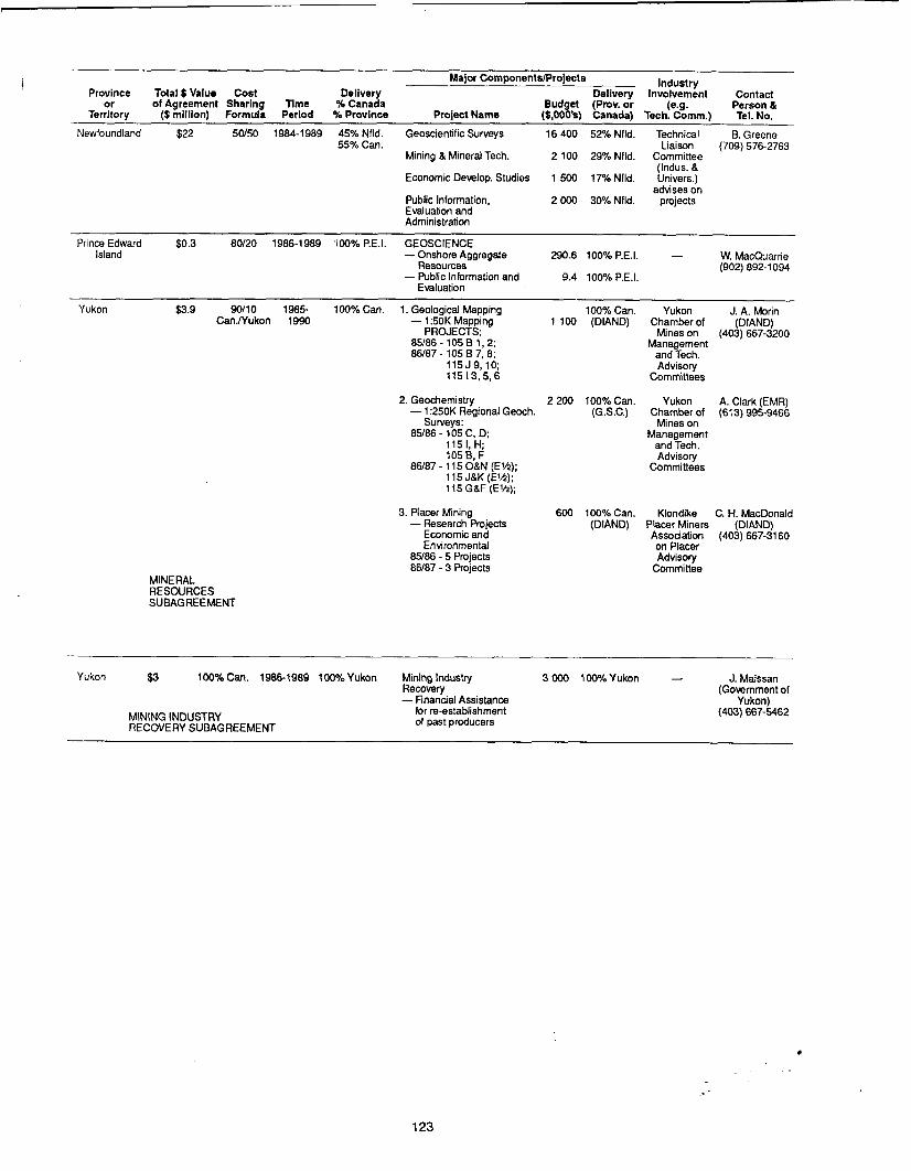
Major ComponentslProjects Province Total $ Value Cost Delivery Delivery
or of Agreement Sharing Time % Canada Budget (Prov. or Territory ($ million) Formula Period %Province Project Name (S,OOO's) Canada)
Newfoundland $22 50/50 1984-1989 45% Nfld. Geoscientific Surveys 16 400 52% Nfld. 55% Can.
Mining B Mineral Tech. 2 100 29% Nfld.
Economic Develop. Studies 1 500 17% Nfld.
Public Information, 2 OOO 30% Nfld. Evaluation and Administration
Industry Involvement Contact
(e.g. Person 8 Tech. Comm.) Tel. No.
Technical B. Greene Liaison (709) 576-2763
Committee (Indus. B Univers.)
advises on projects
Prince Edward $0.3 80120 1986-1989 "00% P.E.I. GEOSCIENCE W. MacQuarne - Island -Onshore Aggregate 290.6 100% P.E.I.
- Public Information and 9.4 100% P.E.I. Resources (902) 892-1 094
Evaluation
Yukon $3.9 9011 0 1985- 100% Can. 1. Geological Mapping 100% Can. Yukon J. A. Morin Can.lYukon 1990 - 1:50K Mapping 1 100 (DIAND) Chamberof (DIAND)
Mines on (403) 667-3200 PROJECTS: 85186-105B1,2; Management 86/87 - 105 B 7, 8; and Tech.
115J9,lO; Advisory 115 I3.5,6 Committees
2. Geochemistry 2 200 100% Can. Yukon A. Clark (EMR) - 1 :250K Regional Geoch. (G.S.C.) Chamber of (613) 995-9466
85/86 - 105 C, D; Management
86/87- 115OBN (Elh); Committees
Suweys: Mines on
115 I, H; and Tech. 105 B, F Advisory
115 JBK (EM): lt5GBF(Elh):
3. Placer Mining - Research Projects
Economic and Environmental
85/86 - 5 Projects 86187 - 3 Projects
600 100% Can. Klondike C. H. MacDonald (DIAND) Placer Miners (DIAND)
Association (403) 667-3160 on Placer Advisory
Committee MINERAL RESOURCES SUBAGREEMENT
100% Can. 1986-1989 100%Yukon Mining Industry 3000 1000iLYukon - J. Maissan Recovery (Government of - Financial Assistance Yukon)
Yukon $3
for re-establishment (403) 667-5462 of past producers MINING INDUSTRY
RECOVERY SUBAGREEMENT
123

PROVINCIAL DAY AT THE PROSPECTORS AND DEVELOPERS . ASSOCIATION CONVENTION
The Prospectors and Developers Association (PDA) Convention, held annually since 1932, traditionally featured a Provincial Day, in which Provincial Geological Surveys were invited to present papers reviewing the provincial exploration scene. Provincial Day was allowed to lapse in the mid-l970s, but was reactivated with a new format at the PDA’s 1983 convention.
The new provincial contribution to the PDA convention consists of poster sessions and presentations. The provincial poster session is presented for the full three days of the convention, with each province or territory displaying the results of recent geoscientific work. One morning of the convention is devoted to presentation of papers by the provinces. These papers have a scientific thrust, dealing with the description of mineral deposits and their environments, and the role of geoscience in mineral exploration. Extended abstracts of proposed presentations are reviewed by a selection committee consisting of two provincial geologists, appointed by the Provincial Geologists Subcommittee, and one or two geologists appointed by the PDA Convention Program Committee.
The 1986 PDA convention was held from March 9 to March 12. All provinces and territories, with the exception of Prince Edward Island, participated in the provincial poster displays. Six provinces presented papers at the morning session, entitled “The Provincial Scene”. Titles and authors of these presentations are given below:
- Precious Metals in New-Quebec - D. Giovenazzo, M. Belanger and T. Clark.
- New Perspectives on Granite-Related Mineral Deposits in Southern Nova Scotia - A.K.
- Precious Metal-Bearing Deposits in Northern British Columbia : Examples and Future Devel-
- Gold Environments and Exploration Opportunities in New Brunswick - A.A. Ruitenberg and
- Platinum-Palladium Distribution and Petrology of the Ultramafic Part of the Bird River
- A Comparison of Gold-Bearing Environments in Newfoundland, California and the Carolinas
Chatterjee and P.S. Giles.
opments - T. Schroeter.
J.L. Davis.
Complex, Manitoba - P. Theyer.
- C.F. O’Driscoll.
124

ANWAL REVIEWS OF ACTIVITIES PROVIWIAL AN) FEDERAL EOSCIENTIFIC ORGANIZATIONS
Province or territory Date(s)
B r i t i s h Columbia 27 Jan. 87
Locat i o n (b. o f Days)
Vancouver (1 o f 3 )
29 Nov. 86 Whitehorse
(DIAND) 28 Jan. 87 Vancouver ( 1 o f 3 )
Yukon T e r r i t o r y (1) Whitehorse
Northwest T e r r i t o r i e s 1 - 4 Dec. 86 Ye l l owkn i fe ( 3 ) (DIAND)
- Invo lved? Invo lved? 1 1 P u b l i - c a t i o n I N a t t e r s 'Energy 1 2:: C o n e n t s
Session I I Pos te r U n i v e r s i t i e s I n d u s t r y Time for U n i v e r s i t i e s I n d u s t r y Talks Invo lved? Involved?
1 day Yes Yes B.C. &
Yukon Chamber Annual Meet ing
1 day Yes No
two
sessions 2-hour Yes No
3 days Yes Yes
+
Edmonton
3 Repts. o f A c t i v i t i e s
Rept. o f A c t i v i t i e s
Yes (1986 Pro jec t
Resumes)
Yes P u b l i c a t i o n
Yes Yes
No No
Yes Yes
Yes Yes
Newfoundland ' S t . John's
6 Nov. 86 0.5 day Yes No 0.5 day Yes No Yes No Yes GSC i nvo l ved (1 )
Geologica l Surv. Can. Ottawa
19 t o 21 Jan.87 2.5 days Yes No Concur ren t Yes Yes Yes (Current Yes Yes P r o v i n c i a l agencles Cooperat ive Programs Research 1 ( 2 )
Yes Yes Yes Yes Coal, Geo-
thermal
Yes Yes - Geologica l
F ie ldwork - B.C.
M ine ra l E x p l o r a t i o n Review, 198t
Geoloqy and E x p l o r a t i o Round;p" 26 Jan. - GSC 27 Jan. - BCEMPR 28 Jan. - BC-YCM;
DIAND-Yukon 1 Main l y EDA and contrac l II No p r o j e c t s No
No Par t o f " C o r d i l l e r a n Geology and E x p l o r a t i o Round-Up'' w i t h BCEMPR BC-YCM, and GSC
Organized wi th NWT Chamber o f Mines GSC invo lved. Also t&l
p a r t i n " C o r d i l l e r a n Geology and E x p l o r a t i o Round-Up", Vancmve r
Yes
Yes Dec. 2 , 3 Mining and
overv iew geology
. . N H O U S E I 0 B E S C H E D U L E D 1 Saskatchewan
Regina 19 Nov. 86
(1) ( I n v e s t i g a t i o n s 1 Summary o f Yes 1 Yes Sask. Research Counci l
i nvo l ved , t a l k s and p o s t e r d i s p l a y s
I 20,21 Nnv. 86
(1.5) Manitoba
Winnipeg Rept. o f F i e l d
A c t i v i t i e s
C o n t r i b u t i o n s frun GSC and U n i v e r s i t y o f Manitoba
Research o r ien ted ; s p e c i a l symposium
Spec ia l p u b l i c a t i o n p l a t i r u m m i n e r a l i z a t i o
GSC invo lved
3 , 4 Dec. 86 ( 2 )
Ont a r i o loront o
Quebec C i t y
17 Nov. 86 (1)
New Brunswlck F r e d e r i c t o n
H a l i f a x 19,20 Nnv. 86
(1.5) GSC i nvo l ved ; coo rd ina ted w i th D i s t r i c t . 1 C I M Meeting 20-22 Nov., H a l i f a x
I Pr ince Edward I s l a n d I N O O P E N H O U S E

SURV-EY OF HARD ROCK DRILL CORE PROGRAMS IN CANADA . FISCAL YEAR 1985-86 B.C. ALBERTA SASK. MAN. ONT. QUE. N.B. N.S. NFLD. P.E.I. YUKON N.W.T.
PROVINCE ,1985) (1985) & LAB.
No. of Facilities 2 1 1 4 7 4 3 4 3 1 1 1 Staff Man-Days Work 1985-86 145 30 119.5 680 2,376 nil 300 800 700 - 95 107
Capital Cost 1985-1 986 $0.2 nil 3.0 10.0 nil 9.0 400.0 nil 15.0 - nil 58.0
Operating Cost 1985-86 $12.4 13.0 9.4 96.4 225.2 0.8 5.2 67.5 95.8 - 12.0 49.0
Core Collected or Delivered 1985-86 3,43T2 400 3,925 32,625 271,783 11,547 19,020 66,968 23,984 - 3,450 4,545
Core Reduction” nil 15% nil 5.5% 2.5 Yo 50 Yo nil nil nil - nil nil
Use of Facilities
1985-86 (days) (62 days) (persons) (visits or persons) 56V 4 v 28 23V 956V 15V 30V 122V 77V - 68 52V
Total Core in Storage (from all years) 169,13Y2 19,259 57,725 211,848 515,039 111,953 196,000 353.500 176,372 1,298 105,000 57,042
Total Exploration 5,89T2 5,000 21 1,784 153,716 282,250 1,000,000 18,970 34,291 30,441 - 75,000 123,415 Drilling 1985-86 (approx.) (approx.) *‘ Over last 8 years *‘ Metres

COMMITTEE OF PROVINCIAL GEOLOGISTS 1986
British Columbia : New Brunswick: Dr. W.R. Smyth (604) 387-5975 Dr. J.L. Davis Chief Geologist, Geological Branch TELEX: 049-7135 Regional Geologist Mineral Resources Division Ministry of Energy, Mines and Petroleum Resources Parliament Buildings, Room 418, 61 7 Government Street VICTORIA, British Columbia E2A 321 V8V 1x4
Department of Forest, Mines and Energy PO Box 50 BATHURST, New Brunswick
Alberta : Mr. Ivo Tyl, P.Eng. Director, Minerals Agreements Mineral Resources Division Department of Energy and Natural Resources Petroleum Plaza, South Tower 9915 - 108 Street EDMONTON, Alberta T5K 2C9
Dr. J.Boon Head, Alberta Geological Survey Alberta Research Council Third Floor, Terrace Plaza 4445 Calgary Trail South EDMONTON, Alberta T6H 5R7
Saskatchewan : Secretary Dr. J.E. Christopher Director, Geological Survey Saskatchewan Energy and Mines Toronto Dominion Bank Building 1914 Hamilton Street REGINA, Saskatchewan S4P 4v4
(403) 427-81 67 TELEX: 037-3636
(506) 546-6600 no telex
Nova Scotia: Dr. Peter S. Giles (902) 424-4700 Director, Mineral Resources TELEX: 01-92-1690 Nova Scotia Department of Mines and Energy PO Box 1087 HALIFAX, Nova Scotia B3J 2x1
(403) K38335Y Prince Edward Island : TELEX : 037-21 47 Mr. John R. DeGrace, P. Eng.
Director of Energy and Minerals (902) 892-1094
TELEX: 014-44154 PO Box 2000 CHARLOTTETOWN, Prince Edward Island CIA 7N8
(306) 787-261 3 TELEX: 071-2768
Manitoba : Dr. Dave McRitchie (204) 945-6559 Director, Geological Services Branch TELEX : 06-986-947 Mineral Resources Division Department of Mines and Energy 555 - 330 Graham Avenue WINNIPEG, Manitoba R3C 4E3
Ontario: Dr. V.G. Milne Director, Ontario Geological Survey Mineral Resources Group Ministry of Natural Resources 1121 - 77 Grenville Street TORONTO, Ontario M5S 183
$Y”C (416) W - 1 2 8 3
TELEX: 06-21 -9701
Quebec: Dr. Andre F. Laurin (418) 643-4617 Sous-ministre adjoint TELEX: 05-13-1589 Direction generale de I’exploration geologique
Ministere de I’Energie et des Ressources Gouvernement du Quebec 1620 Boul. de I’Entente QUEBEC, Quebec G1S 4N6
et minerale ,
Newfoundland : Mr. B.A. Greene (709) 576-2763 Director, Mineral Developmental Division TELEX 01 6-4724 Department of Mines and Energy PO Box 4750 ST.JOHN’S, Newfoundland AIC 5T7
Northwest Territories:
Chief Geologist, Department of Indian Affairs
PO Box 1500 YELLOWKNIFE, Northwest Territories 04E 1HO
Dr. W.A. Padgham (403) 920-8212 TELEX: 034-43519
and Northern Development
Yukon:
Chief Geologist, Department of Indian Affairs
Exploration and Geological Services Division 200 Ranae Road
Dr. J. Morin (403) 668-5151 TELEX : 03-68342
and Northern Development
W H I T E H k E , Yukon Territory YIA 3V1
Prepare par la Division de I’edition (Service de la geoinforrnation, DGEGM)
Ministere de I’Energie et des Ressources, Quebec