puainako street widening - hawaii department …...pacific basin agricultural research center new...
TRANSCRIPT

PUAINAKO STREET WIDENING
SECOND PUBLIC INFORMATION
MEETING AUGUST 8, 2013
WAIAKEA INTERMEDIATE SCHOOL
1

Purpose of This Meeting
Update the community on the status of the project and provide
an overview of the progress since the first public meeting
Explain where we are now with the Environmental Impact
Statement re-evaluation process and steps moving forward
Present the revisions made to the typical roadway sections
along various portions of the alignment
2

Purpose & Need For The Project
This area is identified as a corridor
deficiency in the 1998 Hawaii Long
Range Transportation Plan
Address congestion
Improve vehicle and pedestrian
safety on existing Puainako Street
Improve arterial traffic flows by
connecting the existing Puainako
Street with Saddle Road
Create a direct route between East
and West Hawaii
3
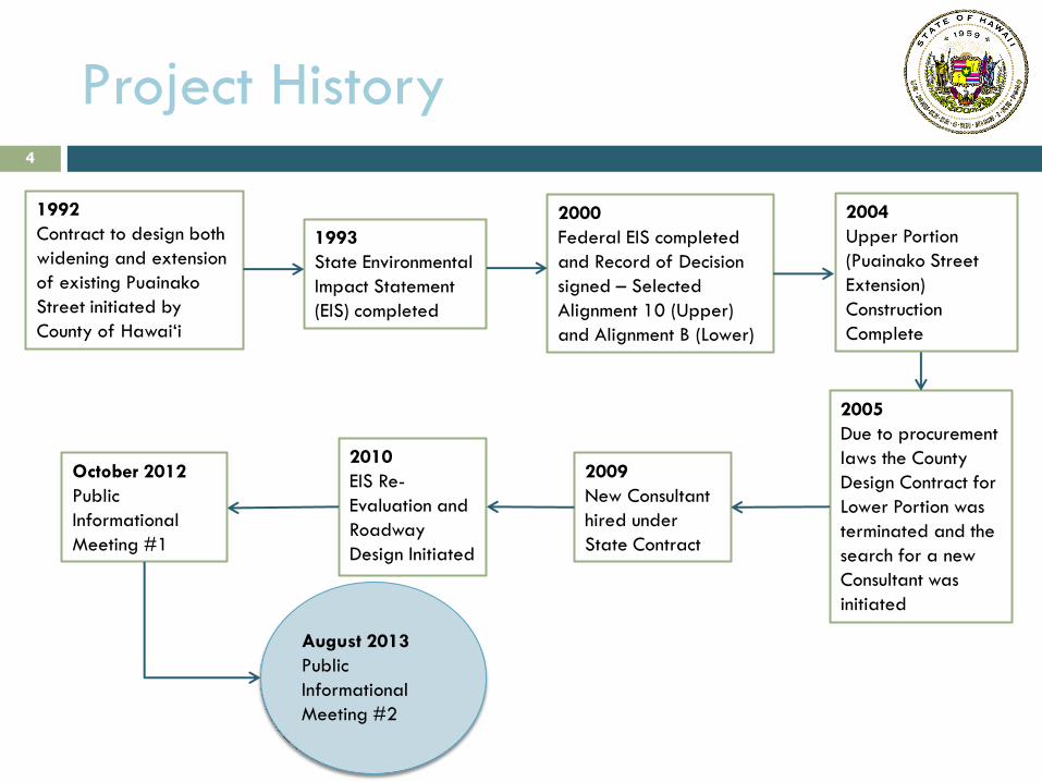
Project History
1993
State Environmental
Impact Statement
(EIS) completed
1992
Contract to design both
widening and extension
of existing Puainako
Street initiated by
County of Hawai‘i
2000
Federal EIS completed
and Record of Decision
signed – Selected
Alignment 10 (Upper)
and Alignment B (Lower)
2009
New Consultant
hired under
State Contract
2010
EIS Re-
Evaluation and
Roadway
Design Initiated
October 2012
Public
Informational
Meeting #1
2005
Due to procurement
laws the County
Design Contract for
Lower Portion was
terminated and the
search for a new
Consultant was
initiated
2004
Upper Portion
(Puainako Street
Extension)
Construction
Complete
4
August 2013
Public
Informational
Meeting #2
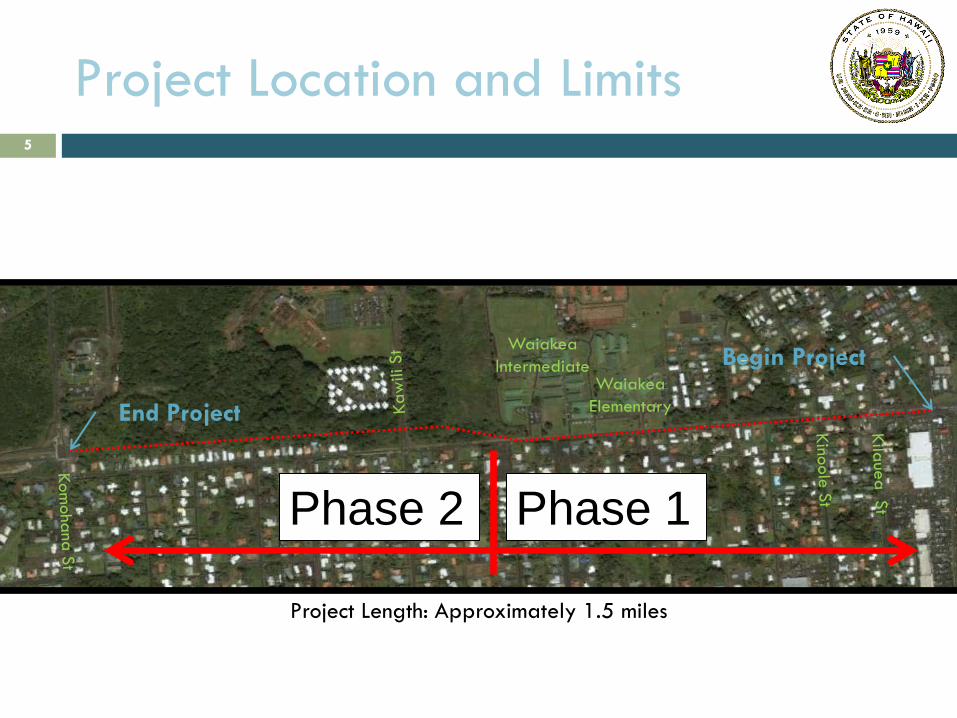
Project Location and Limits
Project Length: Approximately 1.5 miles
Waiakea
Intermediate Waiakea
Elementary End Project
Begin Project
5
Phase 1 Phase 2

Existing Concerns
Naniakea St. Intersection (Looking
North) Kinoole St. Intersection (Looking
West/Mauka)
Unsignalized intersections slow traffic flow
and create potential conflicts
3 Intersections (North side) to Waiakea Schools
More than 20 existing driveway connections
7 side streets (south side) from subdivisions
Sight distance
Intersection sight distance is not optimal
at some locations.
Roadside obstructions present potential
concerns for motorists and pedestrians.
6

Existing Concerns
Pedestrian access
No raised sidewalks (only intermittent
asphalt curbing)
No bike lanes
Many roadside utilities including
telephone poles and associated
anchors are obstacles for pedestrians
Traffic
Congestion at Kinoole and Kilauea
intersections during school drop
off/pick up hours
Increase in thru traffic due to Saddle Road
improvements
7

Existing Concerns
Recent and Future
Developments near and
along Puainako:
Imiloa Astronomy Center
Expansion of University of
Hawai‘i- Hilo
University Village – Phase 1
Pacific Basin Agricultural
Research Center
New University of Hawaii
Community College Campus Saddle Road
8
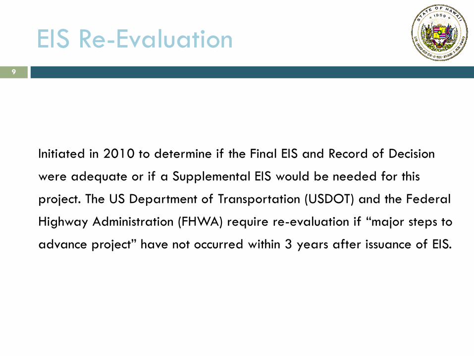
EIS Re-Evaluation
Initiated in 2010 to determine if the Final EIS and Record of Decision
were adequate or if a Supplemental EIS would be needed for this
project. The US Department of Transportation (USDOT) and the Federal
Highway Administration (FHWA) require re-evaluation if “major steps to
advance project” have not occurred within 3 years after issuance of EIS.
9

MAP OF ALIGNMENTS CONSIDERED IN FEIS
10
Portion Constructed In 2004

EIS Re-Evaluation
Considerations Include Changes Since 2000:
Project design
Project traffic
The physical, natural, and social environment
Legislative and regulatory requirements
Evaluation is specific to the Lower Portion since the Upper Portion was
constructed in 2004.
Mitigation measures identified in Final EIS and Record of Decision
must be followed in addition to those outlined in the Re-evaluation
document.
11

Proposed Alignment & Design
Features
Improved segment will extend between Komohana St. and
Kekela Street (just east of Kilauea).
Improvements:
Crosswalks
Traffic Signals
Drainage enhancements
Noise barrier walls
Lighting Upgrades
Intersection Upgrades
ADA provisions
Improved sight distance
Retaining walls
Buffer Zones
12
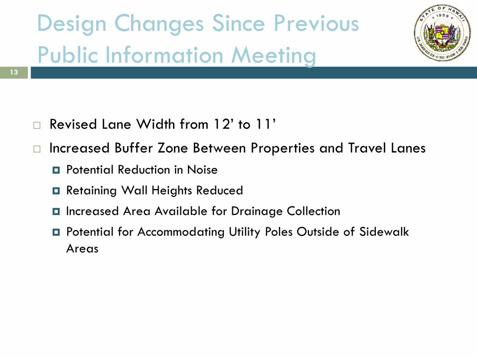
Design Changes Since Previous
Public Information Meeting
Revised Lane Width from 12’ to 11’
Increased Buffer Zone Between Properties and Travel Lanes
Potential Reduction in Noise
Retaining Wall Heights Reduced
Increased Area Available for Drainage Collection
Potential for Accommodating Utility Poles Outside of Sidewalk
Areas
13

DISPLAY DESCRIPTIONS
STATION 1 – PROJECT LOCATION AND ROADWAY
PLAN VIEW EXHIBITS
Existing homes that will be displaced with project.
14
3 RESIDENTIAL
DISPLACEMENTS
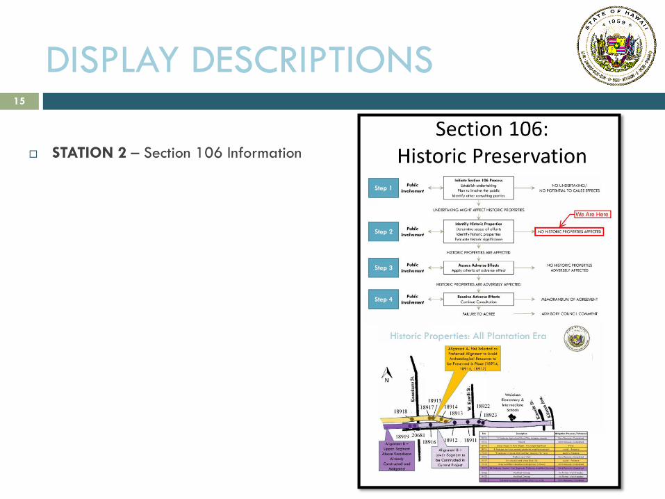
DISPLAY DESCRIPTIONS
STATION 2 – Section 106 Information
15
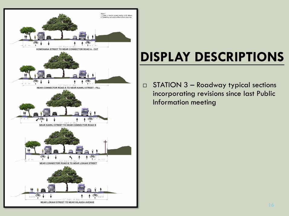
DISPLAY DESCRIPTIONS
STATION 3 – Roadway typical sections incorporating revisions since last Public Information meeting
16
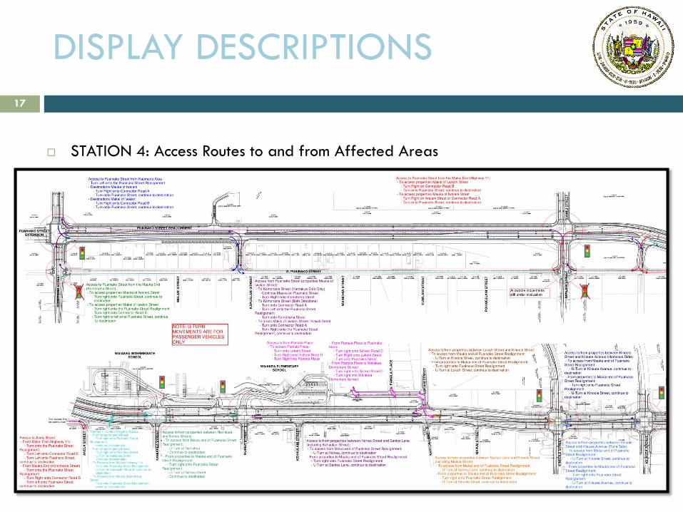
DISPLAY DESCRIPTIONS
STATION 4: Access Routes to and from Affected Areas
17

Potential Impacts to Property Owners Due to Widening and/or Realignment
Some property frontages adjacent to the roadway improvements will be
impacted
Partial loss of existing parking areas for businesses, schools, and churches along
the existing Puainako St.
3 homes might be affected.
The back of 32 lots adjacent to the realignment may be impacted
Noise levels may increase along corridor for properties where improvements
move traffic lanes closer to homes/ businesses
Access to Puainako Street will be altered for property owners adjacent to the
realigned roadway.
18

Proposed Mitigation to Decrease
Impacts
Land Issues:
Construct retaining walls (4’-10’) to
reduce the size and number of
easements and acquisitions
Optimize vertical alignment to limit
impacts to property owner access to
Puainako St.
Provide noise barriers where justified
*Noise barriers are different than
retaining walls in that their purpose is
to decrease noise levels and not retain
soil.
Potential Impacts During Construction:
Traffic (Mitigation: construction of section in front of Waiakea schools shall be scheduled for summer vacation as much as possible)
Noise (Mitigation: contractor to apply for noise permit which may include mitigation measures, such as restriction of equipment type during restricted hours)
Utilities (Mitigation: construction schedule to minimize length of time utility customers are inconvenienced)
Dust (Mitigation: wind screens, watering of active work areas, etc.)
Sediment pollution (Mitigation: time certain construction activities during periods of minimal rainfall)
19
Section 106 Consultation
Requires the federal agencies to take into account the effects of
undertakings on historic properties through consultation with parties with an
interest in the effected historic properties.
Recognizes Native Hawaiian Organizations (NHOs) and requires
consultation with NHOs that attach religious and cultural significance to
historic properties that may be affected by the undertaking
Goals
Identify historic properties potentially affected by an undertaking
Assess the effects
Seek ways to AVOID, MINIMIZE or MITIGATE any adverse effects on
historic properties
20

Section 106 Update
A Memorandum of Agreement (MOA) was completed in 2000. It included
the following stipulations on existing historic sites:
State Sites (50-10-35) 1814, 18915, and 18917 to be PRESERVED IN PLACE and
protected during construction with TEMPORARY FENCING.
No further data recovery necessary for State Sites (50-10-35) 18911, 18912,
18916, 18919, 18921, 18922, 18923, and 20681.
MOA signatories include FHWA, HDOT, SHPD, COH-DPW and HHF
21

Historic Properties: All Plantation Era
18911 18912
18914 18915
18913
18916
18917 18922
18923 18918
20681 18919
Alignment A- Not Selected as
Preferred Alignment to Avoid
Archaeological Resources to
be Preserved in Place (18914,
18915, 18917)
Alignment B –
Upper Segment
Above Komohana
Already
Constructed and
Mitigated
Alignment B –
Lower Segment to
be Constructed in
Current Project
Site Description Mitigation Proposed/Performed
18911 11 Features: Agricultural Rock Piles, terraces, mounds Data Recovery Completed
18912 Mound Data Recovery Completed
18913 Linear Mound in Poor Shape - No Longer Significant None
18914 8 Features: terraces, mounds, platforms, modified outcrops Avoid – Preserve
18915 9 Features: Enclosure, Railroad Bed, Mounds, Platforms Avoid – Preserve
18916 Platform and Wall Data Recovery Completed
18917 Two Mounds and Linear Rock Pile Avoid – Preserve
18918 Three modified Pahoehoe Outcrops and a Mound Data Recovery Completed
18919 36 Features: Mounds, Wall Segments, Platforms, modified Outcrops Data Recovery Completed
18922 Modified Outcrop No Further Work Needed
18923 Modified Outcrop No Further Work Needed
20681 16 Features: mounds, modified Outcrops, walls, Data Recovery Completed
Waiakea
Elementary &
Intermediate
Schools
22

Section 106 Update
In 2012, Section 106 Consultation was re-opened to cover the extension of
the project from Kilauea Avenue to Kanoelehua Avenue (approx. 850 ft.)
SHPD, OHA, and NHO’s were sent letters requesting comments and any knowledge
of historic, archaeological, or cultural properties in the project area.
A Section 106 Consultation public meeting held in Hilo on October 16, 2012.
Following consultation with SHPD, OHA and NHO’s, NO historic, archaeological, or
cultural sites were identified.
Next Steps:
Seek SHPD concurrence on the determination
Seek concurrence of the MOA signatories, either through extension in time of the
existing MOA, or by creating a new MOA
23

HISTORIC PROPERTIES ARE ADVERSELY AFFECTED
UNDERTAKING MIGHT AFFECT HISTORIC PROPERTIES
Section 106 – 4 Step Process
Step 1
Initiate Section 106 Process
Establish undertaking
Plan to involve the public
Identify other consulting parties
Public
Involvement
NO UNDERTAKING/
NO POTENTIAL TO CAUSE EFFECTS
Identify Historic Properties
Determine scope of efforts
Identify historic properties
Evaluate historic significance
Public
Involvement Step 2 NO HISTORIC PROPERTIES AFFECTED
HISTORIC PROPERTIES ARE AFFECTED
Assess Adverse Effects
Apply criteria of adverse effect
Public
Involvement Step 3
NO HISTORIC PROPERTIES
ADVERSELY AFFECTED
Resolve Adverse Effects
Continue Consultation MEMORANDUM OF AGREEMENT
Public
Involvement Step 4
FAILURE TO AGREE ADVISORY COUNCIL COMMENT
24
WE ARE HERE

Construction Phasing
Construction is currently being planned as two phases:
Phase 1
Waiakea Intermediate School to just east of Kilauea Avenue (near Kekela Street)
Widening of the existing two-lane Puainako Street to four lanes.
Phase 2
Komohana Street to Waiakea Intermediate School
New construction of a four-lane roadway on a new alignment.
25

Construction Phasing 26

Project Schedule
2013: Permits and Preliminary Design
2014/2015: Construction, Land Acquisition and Bid
Documents
2016: Contract Award, Start Construction of Phase 1
2018: Complete Construction of Phase 1
Contract Award, Start Construction of Phase 2
2020: Complete Construction of Phase 2
27
Contact Information
State Department of Transportation
Robert Sun, Project Manager
(808) 692-7578
Prime Consultant: SSFM International, Inc.
Austen Drake, P.E., Engineer
Cheryl Soon, Planning Group Manager
28

Question and Answer
Session
29