publi safety management plan lw22-23 - centennial...
TRANSCRIPT

Public Safety Management Plan
Longwalls 22 and 23
Mandalong Mine
MEMS-EP-9000-PMP-9060
April 2017

Mandalong Public Safety Management Plan
Table of Contents i
Table of Contents 1 BACKGROUND ........................................................................................................................................ 1
1.1 INTRODUCTION ............................................................................................................................................. 1 1.2 PROJECT DESCRIPTION ................................................................................................................................... 2
2 PURPOSE ................................................................................................................................................ 4
3 SCOPE ..................................................................................................................................................... 4
3.1 EXTRACTION PLAN AREA ................................................................................................................................. 4 3.2 WORK HEALTH AND SAFETY LEGISLATION .......................................................................................................... 4 3.3 KEY FEATURES .............................................................................................................................................. 4
4 CONSULTATION AND PLAN DEVELOPMENT ............................................................................................ 6
5 REGULATORY REQUIREMENTS ................................................................................................................ 8
5.1 DEVELOPMENT CONSENT ................................................................................................................................ 8 5.2 MINING LEASES ............................................................................................................................................ 9 5.3 EXTRACTION PLAN GUIDELINES ........................................................................................................................ 9 5.4 WORK, HEALTH AND SAFETY LEGISLATION ....................................................................................................... 10
6 PERFORMANCE MEASURES AND INDICATORS ...................................................................................... 15
6.1 MINE DESIGN ............................................................................................................................................. 15 6.2 PERFORMANCE MEASURES ........................................................................................................................... 16 6.3 PERFORMANCE INDICATORS .......................................................................................................................... 17
7 RISK MANAGEMENT ............................................................................................................................. 18
7.1 IDENTIFIED RISKS ......................................................................................................................................... 19 7.1.1 Public Roads ..................................................................................................................................... 19 7.1.2 Ausgrid 11kV Power Lines ................................................................................................................ 20 7.1.3 Telstra Communication Network ...................................................................................................... 20 7.1.4 TransGrid 330kV Transmission Towers ............................................................................................ 20 7.1.5 Forestry Access Roads and Tracks .................................................................................................... 20 7.1.6 Steep Slopes and Rock Outcrops ..................................................................................................... 21 7.1.7 Private Properties and Dwellings...................................................................................................... 21
7.2 RISK ASSESSMENT OUTCOME ........................................................................................................................ 21
8 FEATURES AND PREDICTED IMPACTS .................................................................................................... 22
8.1 PUBLIC ROADS ............................................................................................................................................ 22 8.1.1 Predicted Impacts ............................................................................................................................. 22
8.2 TELSTRA COMMUNICATIONS.......................................................................................................................... 24 8.2.1 Predicted Impacts ............................................................................................................................. 24
8.3 AUSGRID POWERLINES ................................................................................................................................. 26 8.3.1 Predicted Impact .............................................................................................................................. 26
8.4 TRANSGRID TRANSMISSION LINE NO.24 ......................................................................................................... 26 8.4.1 Predicted Impacts ............................................................................................................................. 26
8.5 OLNEY STATE FOREST UNSEALED ROAD AND TRACKS ......................................................................................... 26 8.5.1 Predicted Impact .............................................................................................................................. 27
8.6 STEEP SLOPES AND ROCK OUTCROPS .............................................................................................................. 29 8.6.1 Predicted Impact .............................................................................................................................. 30
8.7 PRIVATE PROPERTY AND DWELLINGS ............................................................................................................... 31 8.7.1 Predicted Impact .............................................................................................................................. 31
9 MANAGEMENT MEASURES ................................................................................................................... 39
10 MONITORING PROGRAM ...................................................................................................................... 39

Mandalong Public Safety Management Plan
Table of Contents ii
10.1 BASELINE MONITORING ........................................................................................................................... 39 10.1.1 Detail Aerial Mapping ...................................................................................................................... 39 10.1.2 Conventional Subsidence Monitoring ............................................................................................... 39 10.1.3 Telstra Phone Line and Optical Fibre Functionality .......................................................................... 40 10.1.4 Dwellings and Property Features...................................................................................................... 40
10.2 SUBSIDENCE MONITORING ....................................................................................................................... 40 10.2.1 Subsidence Monitoring Zones ......................................................................................................... 40 10.2.2 Public Roads ..................................................................................................................................... 41 10.2.3 Telstra Communications ................................................................................................................... 41 10.2.4 Ausgrid Power Lines ......................................................................................................................... 41 10.2.5 TransGrid 330kV Transmission Line No. 24 ...................................................................................... 42 10.2.6 Olney State Forest Unsealed Roads and Tracks ............................................................................... 42 10.2.7 Steep Slopes...................................................................................................................................... 42 10.2.8 Property and Dwellings .................................................................................................................... 42
11 ADAPTIVE MANAGEMENT .................................................................................................................... 47
12 CONTINGENCY PLANS ........................................................................................................................... 47
13 ROLES AND RESPONSIBILITIES .............................................................................................................. 48
14 REPORTING ........................................................................................................................................... 49
15 AUDIT AND REVIEW .............................................................................................................................. 50
15.1 AUDIT .................................................................................................................................................. 50 15.2 REVIEW ................................................................................................................................................ 50
16 DOCUMENT CONTROL .......................................................................................................................... 50
17 BIBLIOGRAPHY...................................................................................................................................... 51

Mandalong Public Safety Management Plan
Table of Contents iii
List of Figures FIGURE 1 – REGIONAL LOCATION.................................................................................................................................... 3 FIGURE 2 – EXTRACTION PLAN AREA LW22-23 ................................................................................................................ 7 FIGURE 3 – PUBLIC ROADS AND MINE WORKINGS WITH EXTRACTION PLAN AREA LW22-23 .................................................. 23 FIGURE 4 – TELSTRA NETWORK AND PREDICTED VERTICAL SUBSIDENCE LW22-23 ................................................................ 25 FIGURE 5 – LOCATION OF AUSGRID POWERLINES AND TRANSGRID 330KV TRANSMISSION LINE ............................................... 27 FIGURE 6 – LAND OWNERSHIP, DWELLINGS AND OLNEY STATE FOREST WITH EXTRACTION PLAN AREA ...................................... 28 FIGURE 7 – STEEP SLOPES ........................................................................................................................................... 29 FIGURE 8 – STEEPEST SLOPES INSPECTED LOCATED NEAR THE COMMENCEMENT OF LW23 ....................................................... 29
List of Tables TABLE 1 – PUBLIC SAFETY FEATURE WITHIN EXTRACTION PLAN AREA AND RELEVANT MANAGEMENT PLANS ................................ 5 TABLE 2 - DEVELOPMENT CONSENT CONDITIONS SSD-5144 ............................................................................................... 8 TABLE 3 - EXTRACTION PLAN GUIDELINE REQUIREMENTS FOR KEY COMPONENT PLANS ............................................................ 9 TABLE 4 – SUMMARY OF WHS LEGISLATION RELATING TO MINE SUBSIDENCE ...................................................................... 10 TABLE 5 – MEASURED SUBSIDENCE AGAINST SSR CRITERIA FOR DWELLINGS ........................................................................ 15 TABLE 6 - SUBSIDENCE IMPACT PERFORMANCE MEASURES ............................................................................................... 16 TABLE 7 – PERFORMANCE INDICATORS .......................................................................................................................... 17 TABLE 8 – SUBSIDENCE SENSITIVITIES ............................................................................................................................ 19 TABLE 9 –SUBSIDENCE PREDICTION FOR PUBLIC ROADS, TELSTRA COMMUNICATION LINES AND POWERLINES ............................. 22 TABLE 10 - DWELLING FREEBOARD – 100 YEAR ARI STORM EVENT .................................................................................... 32 TABLE 11 - DWELLING STRUCTURAL ASSESSMENT SUMMARY ............................................................................................ 33 TABLE 12 - FLOOD HAZARD CATEGORIES – ACCESS ROUTES AT 100 YEAR ARI STORM EVENT ................................................. 36 TABLE 13 - FLOOD HAZARD CATEGORIES – ACCESS ROUTES AT 1 YEAR ARI STORM EVENT ..................................................... 37 TABLE 14 - FLOOD HAZARD CATEGORIES – DWELLINGS AT 100 YEAR ARI STORM EVENT ....................................................... 38 TABLE 15 –PUBLIC SAFETY SUBSIDENCE MONITORING PROGRAM SUMMARY ....................................................................... 43 TABLE 16 – PUBLIC SAFETY MANAGEMENT PLAN ROLES AND RESPONSIBILITIES .................................................................... 48 TABLE 17 - REPORTING REQUIREMENTS ......................................................................................................................... 49
Appendices APPENDIX 1 – TRIGGER ACTION RESPONSE PLANS

Mandalong Public Safety Management Plan
Document Control Details iv
DOCUMENT CONTROL
DOCUMENT DETAILS
Name: Public Safety Management Plan Author: Phil Enright Number: MEMS-EP-9000-PMP-9060 Revision No.: 2 Document Status Final
APPROVAL DETAILS
Revision No.
Date Sent Details of Approval Approved By Approval Date
0 19/12/16 Draft Phil Enright 19/12/16
1 19/12/16 Final John Turner 21/12/16
2 13/04/17 Final Owen Farrugia 13/04/17
CIRCULATION DETAILS
Name Department Circulation Date
Dr Gang Li DRE 22/12/16
Mr Howard Read DPE 22/12/16
Dr Gang Li DPE-Resource Regulator 13/04/17
Mr Howard Read DPE 13/04/17

Mandalong Public Safety Management Plan
1
1 BACKGROUND
1.1 Introduction
Mandalong Mine is a modern underground longwall operation located on the western side of Lake Macquarie near Morisset and west of the M1 Motorway (Figure 1). The Mine is situated approximately 130 km north of Sydney and 50 km from the Port of Newcastle, suppling approximately six million tonnes of coal to the domestic power and export markets. Centennial Mandalong Pty Ltd (Centennial Mandalong) is the operator of Mandalong Mine and is a wholly owned subsidiary of Centennial Coal Company Limited which is also a wholly owned subsidiary of by Banpu Public Company Limited. Mandalong Mine commenced longwall mining in 2005 and operates narrow longwall panels in the West Wallarah Seam that utilise the bridging effect of the overlying massive strata to provide reduced levels of subsidence. This design is proven and provides subsidence impacts below safe, serviceable and repairable (SSR) criteria for dwellings and minimises the impacts to the Mandalong Valley flood plain, natural features and built features. Centennial Mandalong comprises the underground workings and surface infrastructure of:
The Mandalong Mine underground workings including longwall panels, development units and surface infrastructure located near Morisset;
The Cooranbong Entry Site, consisting of the Cooranbong Colliery underground workings and surface infrastructure located near Dora Creek;
The Delta Entry Site, which encompasses an entry and coal delivery system, located near Wyee at the Vales Point Rail Unloader Facility; and
The proposed new surface facilities site, referred to as the Mandalong South Surface Site located off Mandalong Road.
Mandalong Mine operates under Development Consent SSD-5144 which was granted on 12 October 2015 by the NSW Planning Assessment Commission under Part 4, Division 4.1 of the NSW Environmental Planning and Assessment Act 1979 (EP&A Act), and provided for extension of the mining area with a production limit of 6.5 million tonnes per annum of thermal coal from the West Wallarah and Wallarah-Great Northern Seams. First workings development approval for longwall panels 22 and 23 (as extended following updated geological information on an igneous sill) was granted under Modification 2 (MOD2) to SSD-5144 on 22 September 2016. An application for secondary extraction of longwall panels 22 and 23 under MOD4 was approved on 24 March 2017. For clarity, MOD3 was approved on 16 November 2016 to increase the production limit to 6.5 million tonnes per annum. This Public Safety Management Plan (in support of the LW22-23 Extraction Plan) has been developed in accordance with the current requirements of Condition 6, Schedule 4 of SSD-5144 for the extraction of Longwalls 22 and 23, and in accordance with Mining Leases (ML1443 and ML1543) requirements issued under the Mining Act 1992 to extract longwall panels 22 and 23 within the West Wallarah Seam. The Extraction Plan and Public Safety Management Plan have been prepared

Mandalong Public Safety Management Plan
2
generally in accordance with the Department of Planning & Environment, Draft Guidelines for the Preparation of Extraction Plans V5 (2015). Additionally, the Public Safety Management Plan has also been prepared to address the requirements of the Work Health and Safety Regulation 2011 and Work Health and Safety (Mines and Petroleum Sites) Regulation 2014. Regulatory requirements applicable to the development of the Public Safety Management Plan are outlined in Section 5. The area applicable to this extraction plan is defined in detail in Section 3.1 For clarity, existing mining operations in longwall panels 1 to 21 at the mine have been subject to Subsidence Management Plan (SMP) approvals issued under the NSW Mining Act 1992, which has since been replaced in recent years by Extraction Plans required by conditions of planning approvals issued under the NSW Environmental Planning and Assessment Act, 1979. Condition 6, Schedule 4 of SSD-5144 (Extraction Plan) includes recognition of existing mining operations covered by an approved SMP in place at the time of commencement of the new consent. Due to the angle of draw by longwall mining operations and the active subsidence monitoring zone extending into adjacent panels, for operational consistency and continuity this Extraction Plan has conservatively considered existing management and monitoring processes and stakeholder commitments established within previous approved SMPs (particularly adjacent panels 18-21), and built on those where appropriate to assist ongoing stakeholder relations.
1.2 Project Description
The topography of the Mandalong Valley and the Extraction Plan Area ranges from the broad flat floodplain of Tobins Creek and Morans Creek to the foothills of the Watagan Mountain range. The land affected by longwall mining is a combination of natural bushland of the Watagan Ranges together with cleared areas of the floodplain. Properties located within the valley and Extraction Plan area are typically 17 ha rural residential properties, although a number of small properties less than 4 ha are also located within the area. Within the Extraction Plan area there are 21 properties of which four are owned by Centennial Coal, 17 privately owned. The privately owned properties and affected dwellings (11) are managed by individual Property Subsidence Management Plans (PSMP) as required by SSD-5144 Schedule 4 Condition 6 (h). The remainder of the Extraction Plan Area is in a small portion of Olney State Forest. Local roads, power lines, transmission lines, telecommunication networks and other associated infrastructure are also included in the area of potential subsidence influence and are managed by the Built Features Management Plan and supporting individual infrastructure management plans have been prepared for Public Roads, Communications, Powerlines and TransGrid Transmission Lines.

Mandalong Public Safety Management Plan
3
Figure 1 – Regional Location

Mandalong Public Safety Management Plan
4
2 Purpose
The purpose of the Public Safety Management Plan is to provide the management strategies, controls and monitoring programs to be implemented for the management of potential risks from subsidence related impacts that may affect public safety, specifically from the secondary extraction of Longwalls 22 and 23 (LW22-23).
3 Scope
3.1 Extraction Plan Area
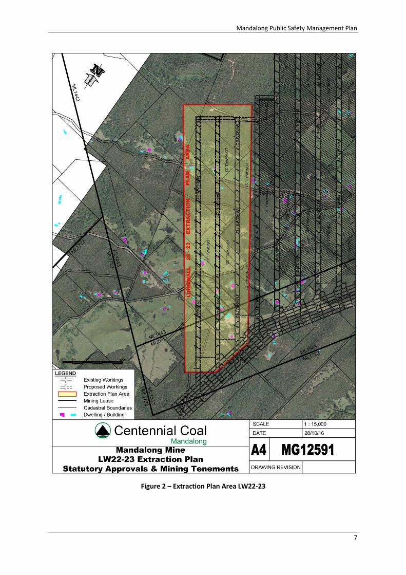
The Public Safety Management Plan applies to the management of risks relating to the development of subsidence from the extraction of LW22-23, located within Centennial Mandalong Mining Leases (ML1443, ML1543) and the SDD-5144 approved mining area. The Extraction Plan Area is defined by the 26.5⁰ angle of draw from the limit of proposed extraction (Figure 2).
3.2 Work Health and Safety Legislation
The Public Safety Management Plan has also been prepared to address the requirements of the Work Health and Safety (Mines and Petroleum Sites) Regulation 2014 (Clause 23 and 24) to manage subsidence as a principal mining hazard. Regulatory requirements applicable to the development of the Public Safety Management Plan to manage subsidence related risks to public safety, including to private property and public infrastructure are outlined in Section 5.4. A Public Safety Management Plan is also necessary under the details required as part of a High Risk Activity Notification required under Clause 33 of the Work Health and Safety (Mines and Petroleum Sites) Regulation 2014. Under this legislation the Public Safety Management Plan covers all activities associated with the secondary extraction by longwall mining.
3.3 Key Features
The key features identified relevant to public safety within the Extraction Plan Area which are subject to this Public Safety Management Plan are detailed in Table 1 along with their relevant management plan and monitoring programs.

Mandalong Public Safety Management Plan
5
Table 1 – Public Safety Feature within Extraction Plan Area and Relevant Management Plans
Feature Identification and Assessment Management and Monitoring
Public Roads -LMCC Prediction of Subsidence Impacts LW22-23 (Seedsman Geotechnics, 2016b)
Centennial Mandalong Flood Assessment LW22-23 (Umwelt, 2016)
Public Roads Management Plan
Built Features Management Plan
Public Safety Management Plan
Subsidence Monitoring Program
Telstra Communication Network
Prediction of Subsidence Impacts LW22-23 (Seedsman Geotechnics, 2016b)
Audit Assessment Report for Mandalong Mine LW22-23 Crossing Under Telstra Network at Mandalong
(Comms Network Solutions, 2016)
Communication Management Plan
Built Features Management Plan
Subsidence Monitoring Program
TransGrid 330 kV Transmission Line No. 24
Prediction of Subsidence Impacts LW22-23 (Seedsman Geotechnics, 2016b)
Report – Scoping Study into Mine Subsidence Mitigation (Structures 45-48 of TL24) (TransGrid, 2016)
TransGrid engineering assessment
TransGrid Management Plan
Built Features Management Plan
Subsidence Monitoring Program
Ausgrid Powerlines Prediction of Subsidence Impacts LW22-23 (Seedsman Geotechnics, 2016b)
Ausgrid assessment
Powerline Management Plan
Built Features Management Plan
Steep Slopes and Rock Outcrops
Slope Stability Assessment LW22-24A (Seedsman Geotechnics, 2016a)
Land Management Plan
Public Safety Management Plan
Property Subsidence Management Plans (PSMP)
Subsidence Monitoring Program
Private Dwellings Prediction of Subsidence Impacts LW22-23 (Seedsman, 2016)
Pre-mining Dwelling Structural Assessments – ACOR Consultants
Property Subsidence Management Plans (PSMP)
Public Safety Management Plan
Subsidence Monitoring Program
Olney State Forest – NSW Forestry Corporation
Slope Stability Assessment LW22-24A (Seedsman Geotechnics, 2016a)
Extraction Plan LW22-23 Land and Agricultural Resource Assessment (SLR, 2016)
Land Management Plan
Public Safety Management Plan
Subsidence Monitoring Program
Biodiversity Management Plan
Flood Plain Centennial Mandalong Flood Assessment LW22-23 (Umwelt, 2016)
Water Management Plan
Property Subsidence Management Plans (PSMP)
Flood path inspections
Subsidence Monitoring Program

Mandalong Public Safety Management Plan
6
4 Consultation and Plan Development
During the development of the Extraction Plan and component plans, substantial consultation has been undertaken with key stakeholders as detailed in the overarching Extraction Plan. A brief summary is provided:
Consultation for this management plan and part of the SSD-4144 modification for extension of first workings for Longwall 22 and 23 (MOD 2) and proposed modification for the secondary extraction of Longwall 22 and 23 extension (MOD 4).
Consultation with Infrastructure owners during development of infrastructure management plans
o LMCC and DPI-Lands– Public Roads Management Plan
o Telstra – Communications Management Plan
o Ausgrid – Powerline Management Plan
o TransGrid – Transmission Line Management Plan
o Forestry Corporation NSW – Land Management Plan
Consultation with government departments during development of environmental management plans
o OEH and RAPs – Cultural Heritage Management Plan
o OEH – Biodiversity Management Plan
o DPI-Water and EPA – Water Management Plan
Consultation with private property owners for development of individual Property Subsidence Management Plans.
Consultation with DRE for preparation of the Extraction Plan, sub plans, subsidence monitoring program and Public Safety Management Plan.
The process for consultation, communication and the provision of information pertaining to this management plan will be managed according to Centennial Mandalong’s HSMC-SC-Information and Communications Arrangements and HSMS-SE-6592-Consultation Arrangements.
Mandalong Public Safety Management Plan
7
Figure 2 – Extraction Plan Area LW22-23

Mandalong Public Safety Management Plan
8
5 Regulatory Requirements
Centennial Mandalong operations are conducted in accordance with the relevant legislation and requirements of statutory authorities. Legislative and regulatory requirements are generally recognised through the imposition of conditions on the development consent, licences, mining approvals and Work, Health and Safety legislation.
5.1 Development Consent
Development Consent SSD-5144 provides a number of conditions relating to the preparation of the Public Safety Management Plan. These conditions are summarised in Table 2 below, together with the notation of the section of this document in which each matter is addressed.
Table 2 - Development Consent Conditions SSD-5144
Condition Development Consent Condition Section Addressed
Schedule 4 Condition 4
Performance Measures – Built Features The Applicant shall ensure that the development does not cause any exceedances of the performance measures in Table 7, to the satisfaction of the Secretary.
Section 6 and
Table 6
Schedule 4 Condition 5
Performance Measures Any dispute between the Applicant and the owner of any built feature over the interpretation, application or implementation of the performance measures in Table 7 is to be settled by the Secretary, following consultation with DRE. Any decision by the Secretary shall be final and not subject to further dispute resolution under this consent.
Section 6
Schedule 4 Condition 6 (m)
(m) include a Public Safety Management Plan, which has been prepared in consultation with DRE, to ensure that the proposed second workings do not impact on public safety;
Extraction Plan LW22-23
Public Safety
Management Plan
Schedule 4 Condition 6 (o)
(o) Trigger Action Response Plan addressing all features in Tables 6 and 7 which contain:
appropriate triggers to warn of the development of an increasing risk of exceedance of any performance measures;
specific actions to respond to high risk exceedance of any performance measure to ensure that the measure is not exceeded; and
an assessment of remediation measures that may be required if exceedances occur and the capacity to implement the measures;
Section 12
Appendix 1
Schedule 4 Condition 6 (p)
(p) include a Contingency Plan that expressly provides for:
adaptive management where monitoring indicates that there has been an exceedance of any performance measure in Tables 6 and 7, or where any such exceedance appears likely; and
an assessment of the remediation measures that may be required if exceedances occur and the capacity to implement the measures;
Section 12
Appendix 1
Statement of Commitments
Subsidence Monitoring and Management As part of the development of each Extraction Plan, Centennial Mandalong will update the Public Safety Management Plan and Built Features Management Plans in consultation with the relevant infrastructure owners.
This Plan and
Build Features Management Plan

Mandalong Public Safety Management Plan
9
5.2 Mining Leases
The Extraction Plan Area for LW22-23 is associated with two approved mining leases held by Centennial Mandalong; ML1443 and ML1543. There are no specific conditions within the two mining leases that directly specify public safety requirements.
5.3 Extraction Plan Guidelines
The Extraction Plan and Public Safety Management Plan have been prepared generally in accordance with the Department of Planning & Environment, Draft Guidelines for the Preparation of Extraction Plans V5 (2015). Table 3 provides a summary of the guidelines requirements for key component plans together with the notation of the section of this document in which each matter is addressed.
Table 3 - Extraction Plan Guideline Requirements for Key Component Plans
Extraction Plan Guideline Requirement – Key Component Plans Section Addressed
An overview of all landscape features, heritage sites, environmental values, built features or other values to be managed under the component plan
Section 1 Section 3
Setting out all performance measures included in the development consent relevant to the features or values to be managed under the component plan
Section 6
Setting out clear objectives to ensure the delivery of the performance measures and all other relevant statutory requirements (including relevant safety legislation)
Section 6
Proposing performance indicators to establish compliance with these performance measures and statutory requirements;
Section 6 TARPS
Describe the landscape features, heritage sites and environmental values to be managed under the component plan, and their significance. It should be noted that a full description of such features, sites and values would commonly have been provided and considered in a recent environmental impact assessment. Consequently, this section can be relatively brief, and focus on the presentation of appropriate figures and/or graphical plans;
Section 8
Describe all currently-predicted subsidence impacts and environmental consequences relevant to the features, sites and values to be managed under the component plan;
Section 8
Describe all measures planned to remediate these impacts and/or consequences, including any measures proposed to ensure that impacts and/or consequences comply with performance measures and/or the Applicant’s commitments;
Section 9 Section 10.2
TARPS in Appendix 1
Describe the existing baseline monitoring network and the current baseline monitoring results, including pre-subsidence photographic surveys of key landscape features and key heritage sites which may be subject to significant subsidence impacts (such as significant watercourses, swamps and Aboriginal heritage sites);
Section 10.1
Fully describing the proposed monitoring of subsidence impacts and environmental consequences;
Section 10.2
Describe the proposed monitoring of the success of remediation measures following implementation;
Section 0
Describe adaptive management proposed to avoid repetition of unpredicted subsidence impacts and/or environmental consequences;
Section 11 And
TARPS in Appendix 1
Describe contingency plans proposed to prevent, mitigate or remediate subsidence impacts and/or environmental consequences which substantially exceed predictions or which exceed performance measures;
Section 11 Section 12
TARPS in Appendix 1
Listing responsibilities for implementation of the plan; and Section 13
An attached Trigger, Action, Response Plan (effectively a tabular summary of most of the above). TARPS in Appendix 1

Mandalong Public Safety Management Plan
10
5.4 Work, Health and Safety Legislation
Mandalong Mine has developed a Safety Management System framework (MS-1001) that integrates plans, policies and procedures that enables a systematic approach to establishing and maintaining effective systems to manage health and safety consistent with WHS legislation and AS/NZS 4804:2001. The following Work, Health and Safety (WHS) requirements have been considered for the Extraction Plan principally within the context of subsidence related risks to public safety, including to private property and public infrastructure (Table 4).
Table 4 – Summary of WHS Legislation Relating to Mine Subsidence
Work Health and Safety Legislation
Clause
Requirement Section
Addressed
WHS Regulation 2011
Clause 34
Duty to identify hazards A duty holder, in managing risks to health and safety, must identify reasonably foreseeable hazards that could give rise to risks to health and safety.
Section 7
Section 8
Extraction Plan Appendix 4 -Risk
Assessments
WHS Regulation 2011
Clause 35
Managing risks to health and safety A duty holder, in managing risks to health and safety, must: (a) eliminate risks to health and safety so far as is reasonably practicable, and (b) if it is not reasonably practicable to eliminate risks to health and safety, minimise those risks so far as is reasonably practicable.
Section 6.1
Section 7
Section 9
Section 11
WHS Regulation 2011
Clause 36
Hierarchy of control measures (1) This clause applies if it is not reasonably practicable for a duty holder to eliminate risks to health and safety. (2) A duty holder, in minimising risks to health and safety, must implement risk control measures in accordance with this clause. (3) The duty holder must minimise risks, so far as is reasonably practicable, by doing 1 or more of the following: (a) substituting (wholly or partly) the hazard giving rise to the risk with something that gives rise to a lesser risk, (b) isolating the hazard from any person exposed to it, (c) implementing engineering controls. (4) If a risk then remains, the duty holder must minimise the remaining risk, so far as is reasonably practicable, by implementing administrative controls. (5) If a risk then remains, the duty holder must minimise the remaining risk, so far as is reasonably practicable, by ensuring the provision and use of suitable personal protective equipment. Note. A combination of the controls set out in this clause may be used to minimise risks, so far as is reasonably practicable, if a single control is not sufficient for the purpose.
Section 6.1
Section 7
Section 9
MS-1001
WHS Regulation 2011
Clause 37
Maintenance of control measures A duty holder who implements a control measure to eliminate or minimise risks to health and safety must ensure that the control measure is, and is maintained so that it remains, effective, including by ensuring that the control measure is and remains: (a) fit for purpose, and (b) suitable for the nature and duration of the work, and
(c) installed, set up and used correctly.
Section 9
Section 10
Volume 3 of LW22-23 EP
WHS Regulation 2011
Clause 38
Review of control measures (1) A duty holder must review and as necessary revise control measures implemented under this Regulation so as to maintain, so far as is reasonably practicable, a work environment that is without risks to health or safety.
Section 11
Section 0
Extraction Plan

Mandalong Public Safety Management Plan
11
Work Health and Safety Legislation
Clause
Requirement Section
Addressed
(2) Without limiting subclause (1), the duty holder must review and as necessary revise a control measure in the following circumstances: (a) the control measure does not control the risk it was implemented to control so far as is reasonably practicable, (b) before a change at the workplace that is likely to give rise to a new or different risk to health or safety that the measure may not effectively control, (c) a new relevant hazard or risk is identified, (d) the results of consultation by the duty holder under the Act or this Regulation indicate that a review is necessary, (e) a health and safety representative requests a review under subclause (4). (3) Without limiting subclause (2) (b), a change at the workplace includes: (a) a change to the workplace itself or any aspect of the work environment, or (b) a change to a system of work, a process or a procedure. (4) A health and safety representative for workers at a workplace may request a review of a control measure if the representative reasonably believes that: (a) a circumstance referred to in subclause (2) (a), (b), (c) or (d) affects or may affect the health and safety of a member of the work group represented by the health and safety representative, and (b) the duty holder has not adequately reviewed the control measure in response to the circumstance.
Appendix 4 -Risk Assessments
WHS Regulation (Mines and
Petroleum Sites) 2014
Clause 9
Management of risks to health and safety (cl 617 model WHS Regs) (1) A person conducting a business or undertaking at a mine must manage risks to health and safety associated with mining operations at the mine in accordance with Part 3.1 of the WHS Regulations. (2) A person conducting a business or undertaking at a mine must ensure that a risk assessment is conducted in accordance with this clause by a person who is competent to conduct the particular risk assessment having regard to the nature of the hazard. (3) In conducting a risk assessment, the person must have regard to: (a) the nature of the hazard, and (b) the likelihood of the hazard affecting the health or safety of a person, and (c) the severity of the potential health and safety consequences. (4) Nothing in subclause (3) limits the operation of any other requirement to conduct a risk assessment under this Regulation. (5) A person conducting a business or undertaking at a mine (who is the mine operator of the mine or who is a contractor) must keep a record of the following: (a) each risk assessment conducted under this clause and the name and competency of the person who conducted the risk assessment, (b) the control measures implemented to eliminate or minimise any risk that was identified through any such risk assessment. (6) A person conducting a business or undertaking at a mine is not required to keep a record of a risk assessment if: (a) the risk assessment is one that an individual worker is required to carry out before commencing a particular task, and (b) the person keeps a record of risk assessments that addresses the overall activity being undertaken (of which the task forms a part) such as risk assessments carried out in relation to the development of the safety management system for the mine or for a principal mining hazard management plan. (7) The record kept under subclause (5): (a) if kept by a mine operator—forms part of the safety management system of the mine and the records of the mine, or (b) if kept by a contractor who has prepared a contractor health and safety management plan—forms part of the plan.
Section 7
MS-1001
WHS Regulation (Mines and
Petroleum Sites)
Review of control measures (cl 618 model WHS Regs) (1) A person conducting a business or undertaking at a mine must review and as necessary revise control measures implemented under clause 9 in the following circumstances:
Section 11
Section 14
Section 0
Mandalong Public Safety Management Plan
12
Work Health and Safety Legislation
Clause
Requirement Section
Addressed
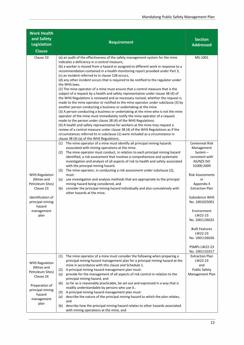
Clause 10 (a) an audit of the effectiveness of the safety management system for the mine indicates a deficiency in a control measure, (b) a worker is moved from a hazard or assigned to different work in response to a recommendation contained in a health monitoring report provided under Part 3, (c) an incident referred to in clause 128 occurs, (d) any other incident occurs that is required to be notified to the regulator under the WHS laws. (2) The mine operator of a mine must ensure that a control measure that is the subject of a request by a health and safety representative under clause 38 (4) of the WHS Regulations is reviewed and as necessary revised, whether the request is made to the mine operator or notified to the mine operator under subclause (3) by another person conducting a business or undertaking at the mine. (3) A person conducting a business or undertaking at the mine who is not the mine operator of the mine must immediately notify the mine operator of a request made to the person under clause 38 (4) of the WHS Regulations. (4) A health and safety representative for workers at the mine may request a review of a control measure under clause 38 (4) of the WHS Regulations as if the circumstances referred to in subclause (1) were included as a circumstance in clause 38 (4) (a) of the WHS Regulations.
MS-1001
WHS Regulation (Mines and
Petroleum Sites) Clause 23
Identification of principal mining
hazard management
plan
(1) The mine operator of a mine must identify all principal mining hazards associated with mining operations at the mine.
(2) The mine operator must conduct, in relation to each principal mining hazard identified, a risk assessment that involves a comprehensive and systematic investigation and analysis of all aspects of risk to health and safety associated with the principal mining hazard.
(3) The mine operator, in conducting a risk assessment under subclause (2), must:
(a) use investigation and analysis methods that are appropriate to the principal mining hazard being considered, and
(b) consider the principal mining hazard individually and also cumulatively with other hazards at the mine.
Centennial Risk Management
System – consistent with
AS/NZS ISO 31000:2009
Risk Assessments
in Appendix 4
Extraction Plan
Subsidence WHS No. 1001025001
Environment
LW22-23 No. 1001136032
Built Features
LW22-23 No. 1001136026
PSMPs LW22-23 No. 1001131017
WHS Regulation (Mines and
Petroleum Sites) Clause 24
Preparation of
principal mining hazard
management plan
(1) The mine operator of a mine must consider the following when preparing a principal mining hazard management plan for a principal mining hazard at the mine in accordance with this clause and Schedule 1.
(2) A principal mining hazard management plan must: (a) provide for the management of all aspects of risk control in relation to the
principal mining hazard, and (b) so far as is reasonably practicable, be set out and expressed in a way that is
readily understandable by persons who use it.. (3) A principal mining hazard management plan must: (a) describe the nature of the principal mining hazard to which the plan relates,
and (b) describe how the principal mining hazard relates to other hazards associated
with mining operations at the mine, and
Extraction Plan LW22-23
and Public Safety
Management Plan

Mandalong Public Safety Management Plan
13
Work Health and Safety Legislation
Clause
Requirement Section
Addressed
(c) describe the analysis methods used in identifying the principal mining hazard to which the plan relates, and
(d) include a record of the most recent risk assessment conducted in relation to the principal mining hazard, and
(e) describe the investigation and analysis methods used in determining the control measures to be implemented, and
(f) describe all control measures to be implemented to manage risks to health and safety associated with the principal mining hazard, and
(g) describe the arrangements in place for providing the information, training and instruction required by clause 39 of the WHS Regulations in relation to the principal mining hazard, and
(h) refer to any design principles, engineering standards and technical standards relied on for control measures for the principal mining hazard, and
(i) set out the reasons for adopting or rejecting each control measure considered.
(4) The mine operator of a mine must consider the following when preparing a principal mining hazard management plan for a principal mining hazard at the mine:
(a) the matters set out in Schedule 1 in respect of the principal mining hazard, and
(b) any other matter relevant to managing the risks associated with the principal mining hazard at the mine.
WHS Regulation (Mines and
Petroleum Sites) Clause 67
Subsidence
(1) In complying with clause 9, the mine operator of an underground coal mine must manage risks to health and safety associated with subsidence at the mine. (2) Without limiting subclause (1), the mine operator must ensure that: (a) so far as is reasonably practicable, the rate, method, layout, schedule and
sequence of mining operations do not put the health and safety of any person at risk from subsidence, and
(b) monitoring of subsidence is conducted, including monitoring of its effects on relevant surface and subsurface features, and
(c) any investigation of subsidence and any interpretation of subsidence information is carried out only by a competent person, and
(d) all subsidence monitoring data is provided to the regulator in the form and at the times required by the regulator, and
(e) so far as is reasonably practicable, procedures are implemented for the effective consultation, co-operation and co-ordination of action with respect to subsidence between the mine operator and relevant persons conducting any business or undertaking that is, or is likely to be, affected by subsidence
Section 6.1 Section 9
Section 10 Section 13
Section 14
TARPs Extraction Plan
Appendix 4 - Risk Assessments
WHS Regulation (Mines and
Petroleum Sites) Clause 128
Duty to notify regulator of
certain incidents
(1) The operator of a mine or petroleum site must take all reasonable steps to ensure that the regulator is notified in accordance with this clause after becoming aware of an incident (other than a notifiable incident) arising out of the carrying out of mining operations or petroleum operations at the mine or petroleum site, but only if the incident: (a) results in illness or injury that requires medical treatment within the meaning of clause 13 of Schedule 9, or (b) is a high potential incident. (5) In this clause: high potential incident means any of the following: (m) any indication from monitoring data of the development of subsidence which
may result in any incident referred to in clause 179 (a) (xvi) - a failure of ground, or of slope stability control measures, or 179 (a) (xvii) - rock falls, instability of cliffs, steep slopes or natural dams, occurrence of sinkholes, development of surface cracking or deformations or release of gas at the surface, due to subsidence.
Appendix 1 TARPs
Public Safety
Management Plan

Mandalong Public Safety Management Plan
14
Work Health and Safety Legislation
Clause
Requirement Section
Addressed
WHS Regulation (Mines and
Petroleum Sites) Schedule 1
Subsidence
Clause 3C
Principal hazard management
plans – additional
matters to be considered
Subsidence The following matters must be considered in developing the control measures to manage the risks of subsidence: (a) the characteristics of all relevant surface and subsurface features, (b) the characteristics of all relevant geological, hydrogeological, hydrological, geotechnical, topographic and climatic conditions, including any conditions that may cause elevated or abnormal subsidence or the formation of sinkholes, (c) the characteristics of any previously excavated or abandoned workings that may interact with any proposed or existing mine workings, (d) the existence, distribution, geometry and stability of significant voids, standing pillars or remnants within any old pillar workings that may interact with any proposed or existing mine workings, (e) the predicted and actual nature, magnitude, distribution, timing and duration of subsidence,
(f) the rate, method, layout, schedule and sequence of mining operations.
Extraction Plan - Appendix 1
(Seedsman Geotechnics,
2016b)
Extraction Plan and Volume 3
(Component Plans)
WHS Regulation (Mines and
Petroleum Sites)
Schedule 3
Clause 16
High Risk Activities
Secondary extraction or pillar extraction, splitting or reduction (1) The following are identified as high risk activities: (a) secondary extraction by longwall mining, shortwall mining or miniwall mining, (b) pillar extraction, (c) pillar splitting, (d) pillar reduction. (2) The waiting period for any such activity is 3 months. (3) The information and documents that must be provided in relation to any such activity are as follows: (a) details of the authoritative sources used in determining that the proposed method of work can be done safely, (b) engineering plans showing the manner and sequence of extraction, endorsed by the individual nominated to exercise the statutory function of mining engineering manager at the mine, (c) information about the land above or in the vicinity of the proposed activity including land use and details of who owns or occupies any land that may be affected by subsidence, (d) in the case of a pillar extraction, details of the procedures for the recovery of buried and immobile mining plant in or around a goaf, (e) details of how the risks to the health and safety of workers and other persons from subsidence caused by the activity will be managed.
Extraction Plan LW22-23
and
High Risk Activity Notification for
LW22-23

Mandalong Public Safety Management Plan
15
6 Performance Measures and Indicators
6.1 Mine Design
Mandalong Mine is designed to provide reduced levels of subsidence by using “sub-critical” longwall panels (160m) combined with 37m wide chain pillars that utilise the bridging effect of the overlying massive strata. This design is proven and provides subsidence impacts below safe, serviceable and repairable (SSR) criteria for dwellings and also minimises the impacts to the flood plain, natural features and the built features managed by this plan. Centennial Mandalong has adopted SSR criteria values for dwellings as:
Tilt < 7mm/m
Compressive Strain < -5mm
Tensile Strain < 5mm/m
The mine design has proven to be effective in providing subsidence and subsidence impacts below the SSR criteria. With more than 66km of subsidence monitoring lines established, over 97% of all subsidence measurements have been recorded below the SSR criteria. Table 5 provides a summary of all subsidence measurement taken over Longwalls 6 to 19 compared to the adopted SSR criteria values. During the extraction of these longwall panels, over 50 dwellings affected by subsidence have remained safe, serviceable and repairable.
Table 5 – Measured Subsidence against SSR Criteria for Dwellings
Frequency Histogram Summary for Longwalls 6 to 19 Measured Subsidence Compared Against SSR Criteria for Dwellings
Longwall Panel Tilt
Less that 7mm/m Tensile Strain
Less than 5mm/m Compressive Strain Less than -5mm/m
LW6 97.7% 99.8% 97.4%
LW7 97.6% 100% 97.8%
LW8 100% 100% 99.4%
LW9 100% 100% 100%
LW10 98.8% 100% 98.5%
LW11 96.5% 100% 100%
LW12 96.4% 100% 93.3%
LW13 95.6% 100% 95.6%
LW14 100% 100% 100%
LW15 96.9% 100% 100%
LW16 90.9% 100% 96.7%
LW17 96.0% 100% 96.3%
LW18 97.9% 100.0% 95.7%
LW19 95.0% 100.0% 100.0%
Average 97.1% 100.0% 97.8%

Mandalong Public Safety Management Plan
16
6.2 Performance Measures
As outlined in Section 6.1, the primary objective of the mine design is to prevent any significant mine induced risk to public safety by providing low levels of subsidence, that allow built features including private dwellings to remain safe, serviceable and repairable and negligible risk to public safety. The Public Safety Management Plan together with the Built Features Management Plan and supporting infrastructure management plans aim to ensure the performance measures in SSD-5144 Schedule 4 Condition 4 Table 7 are not exceeded. The performance measures are shown in Table 6.
Table 6 - Subsidence Impact Performance Measures
Key Public Infrastructure M1 Motorway Always safe and serviceable.
Damage that does not affect safety or serviceability must be fully repairable, and must be fully repaired.
Main Northern Railway
330 kV power supply infrastructure
Other Built Infrastructure Power lines and power poles Always safe.
Serviceability should be maintained wherever practicable.
Loss of serviceability must be fully compensated.
Damage must be fully repairable, and must be fully repaired or else replaced or fully compensated.
Telecommunications infrastructure
Privately-owned residences
Local Roads
Other built features and improvements, (including access roads, farm dams, swimming pools, tracks and fences)
Public Safety Public Safety Negligible additional risk.
Notes:
Key public infrastructure is shown in Figure 2 of Appendix 2 and in Figure 1 of Appendix 5
Other built infrastructure is shown in Figure 1 of Appendix 5.
The Applicant will be required to define more detailed performance indicators for each of these performance measures in the Built Features Management Plan, Property Subsidence Management Plans and Public Safety Management Plan (see condition 6 below).
Measurement and/or monitoring of compliance with performance measures and performance indicators is to be undertaken using generally accepted methods that are appropriate to the environment and circumstances in which the feature or characteristic is located. These methods are to be fully described in the relevant management plans. In the event of a dispute over the appropriateness of proposed methods, the Secretary will be the final arbiter.
Requirements regarding safety or serviceability do not preclude preventative or mitigatory actions being taken prior to or during mining in order to achieve or maintain these outcomes.
Requirements under this condition may be met by measures undertaken in accordance with the Mine Subsidence Compensation Act 1961.

Mandalong Public Safety Management Plan
17
6.3 Performance Indicators
To establish compliance with the performance measured outlined in Section 6.2, Centennial Mandalong has established a subsidence and environmental monitoring program developed in consultation with the built feature owners and DRE. Trigger Action Response Plans (TARPs) have also been established and provided in Appendix 1. These documents establish the appropriate subsidence monitoring, parameters and associated trigger levels to demonstrate that subsidence performance satisfies the Subsidence Performance Measures set in Table 6 and infrastructure requirements. The Performance Indicators have been established for each built feature. The TARPS provide the trigger values as outlined in Table 7.
Table 7 – Performance Indicators
Performance Indicator
Tigger Action / Response
Level 1 Low
Operations within prediction and approved impact.
Continued operations and monitoring as normal.
Level 2 Medium
Operations within approved impacts but exceed or potentially exceed predictions.
Review and investigation processes are engaged, with adaptive management as required.
Level 3 High
Operations exceed approved impact. Adaptive Management fully engaged

Mandalong Public Safety Management Plan
18
7 Risk Management
Centennial Mandalong has adopted the Stature Risk Assessment Program which was developed to ensure consistency in all risk assessments across the Centennial Coal operations. The Stature Risk Assessment Program sets out a consequences table and risk ranking matrix for managing identified risks consistent with AS/NZS ISO 31000:2009. All operational processes undertaken at the Centennial Mandalong operations are subject to the risk assessment process prior to implementation. The process for risk and change management is undertaken according to the methodology and tools contained within HSMS-SE-1024-Risk Management Arrangements and HSMS-SE-1082- Change Management System. Centennial Mandalong has completed a WRAC Risk Assessment (No. 1001025001) as required by the Work Health Safety (Mines and Petroleum Sites) Regulation 2014 to develop control measures to manage the risk to health and safety associated with subsidence. As outlined in WHS Regulation (Mines and Petroleum Sites) Schedule 1 Clause 3C, the following matters were considered in developing the control measures to manage the risks of subsidence:
(a) the characteristics of all relevant surface and subsurface features, (b) the characteristics of all relevant geological, hydrogeological, hydrological, geotechnical, topographic and climatic conditions, including any conditions that may cause elevated or abnormal subsidence or the formation of sinkholes, (c) the characteristics of any previously excavated or abandoned workings that may interact with any proposed or existing mine workings, (d) the existence, distribution, geometry and stability of significant voids, standing pillars or remnants within any old pillar workings that may interact with any proposed or existing mine workings, (e) the predicted and actual nature, magnitude, distribution, timing and duration of subsidence, (f) the rate, method, layout, schedule and sequence of mining operations.
In addition, three separate risk assessments were undertaken, specifically for the LW22-23 Extraction Plan and associated management plans. The three risk assessments were:
RA No. 1001136032 – Environmental Features
o Surface water, ponding and flooding o Groundwater o Land – steep slopes, agricultural land capability o Biodiversity – GDE’s, wetlands, threatened flora and fauna o Heritage – Aboriginal and European
RA No. 1001136026 – Built Features
o Public Roads – Mandalong Rd, Tobins Rd and Chapmans Rd o Telstra Communications o TransGrid 330kV Transmission Line No. 24, Towers 46 and 47 o Ausgrid 11kV powerlines o Olney State Forest unsealed roads and tracks o State Survey Marks o Flooding at 1 year and 100 year ARI storm events

Mandalong Public Safety Management Plan
19
RA No. 1001131017 – Property Subsidence Management Plans (private property)
o Dwellings and buildings o Agricultural land capability o Dams, fences, access roads, bridges o Flooding (property, dwelling, access routes and land at 1 year and 100 year ARI
storm events) o Creeks, drainage, remnant ponding o Steep slopes
7.1 Identified Risks
Mandalong Mine has well established Infrastructure Management Plans, which have been developed and refined since the commencement of longwall mining in 2005. The risks to features from the development of mine subsidence within the Extraction Plan area are detailed for each infrastructure item. Subsidence predictions and assessment was provided by Seedsman Geotechnics (2016b). The maximum predicted subsidence values for LW22-23 are:
Vertical 960 mm
Tilt 7.1 mm/m
Tensile Strain 1.6mm/m
Compressive Strain 3.0 mm/m The risk assessment team also considered the tolerance of the features to increased levels of subsidence due to the low levels of predicted subsidence. As a conservative approach for risk assessment and management, specifically in relation to infrastructure and private property, three (3) case studies were modelled additional to the base predictions. This enabled a form of sensitivity analysis of the subsidence predictions to be made as outlined in Table 8.
Table 8 – Subsidence Sensitivities
Prediction Sensitivity Cause
Base Case Maximum Predicted Subsidence Expected geotechnical conditions
Case 1 1.5 times Base Case Geotechnical conditions worse than anticipated
Case 2 2 times Base Case Geotechnical conditions worse than anticipated
Case 3 Conglomerate Beam Failure Geotechnical conditions worse than anticipated, or
Geological anomaly
7.1.1 Public Roads
Potential hazards to public roads and public safety from the impact of mine subsidence can include:
Potential for surface cracking - edges of extraction void and travelling abutments particularly in rock outcrop areas;
Potential for surface humps (compression) - near centre of extracted panels and travelling abutment;
Potential for step change in road pavement - associated with cracking;

Mandalong Public Safety Management Plan
20
Potential reduced serviceability of drainage channels; and
Potential for flooding hazards for roads and access tracks.
7.1.2 Ausgrid 11kV Power Lines
Potential hazards to the Ausgrid power supply network and public safety from the impact of mine subsidence on powerlines can include:
Potential damage to poles, cross arms, insulators and conductors;
Potential for tilting poles, increased/decreased conductor tension;
Potential for reduced conductor ground clearance; and
Potential interruption of power supply to customers.
7.1.3 Telstra Communication Network
Potential hazards to the Telstra communications network and public safety from the impact of mine subsidence on phone lines can include:
Potential damage to direct buried copper cables and potential loss of service to customers;
Potential damage to conduit and pit network supporting communications cables; and
Potential damage to inactive direct buried optical fibre cable.
7.1.4 TransGrid 330kV Transmission Towers
Potential hazards to the TransGrid 330KV transmission lines and towers and public safety from the impact of mine subsidence can include:
Potential for increased or decreased tensions in various spans which could cause tower or conductor failure due to tilting or horizontal movement of towers;
Potential for buckling of the tower or induced stresses in the tower members lessening the tower’s ability to carry the normal transmission line loads due to differential movement of tower legs;
Potential reduction of clearance between line conductors and tower which could place line at risk of tripping under extreme conditions due to tilting; and
Potential interruption of service to customers
7.1.5 Forestry Access Roads and Tracks
Potential hazards to unsealed Forestry tracks from the impact of mine subsidence can include:
Potential for surface cracking - edges of extraction void and travelling abutments particularly in rock outcrop areas;
Potential for surface humps (compression) - near centre of extracted panels and travelling abutment;
Potential step change in road pavement - associated with cracking; and
Potential reduced serviceability of drainage channels.
Mandalong Public Safety Management Plan
21
7.1.6 Steep Slopes and Rock Outcrops
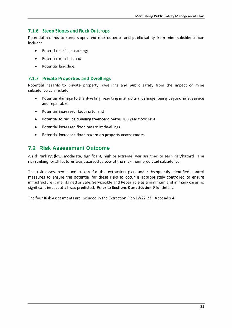
Potential hazards to steep slopes and rock outcrops and public safety from mine subsidence can include:
Potential surface cracking;
Potential rock fall; and
Potential landslide.
7.1.7 Private Properties and Dwellings
Potential hazards to private property, dwellings and public safety from the impact of mine subsidence can include:
Potential damage to the dwelling, resulting in structural damage, being beyond safe, service and repairable.
Potential increased flooding to land
Potential to reduce dwelling freeboard below 100 year flood level
Potential increased flood hazard at dwellings
Potential increased flood hazard on property access routes
7.2 Risk Assessment Outcome
A risk ranking (low, moderate, significant, high or extreme) was assigned to each risk/hazard. The risk ranking for all features was assessed as Low at the maximum predicted subsidence. The risk assessments undertaken for the extraction plan and subsequently identified control measures to ensure the potential for these risks to occur is appropriately controlled to ensure infrastructure is maintained as Safe, Serviceable and Repairable as a minimum and in many cases no significant impact at all was predicted. Refer to Sections 8 and Section 9 for details. The four Risk Assessments are included in the Extraction Plan LW22-23 - Appendix 4.

Mandalong Public Safety Management Plan
22
8 Features and Predicted Impacts
8.1 Public Roads
Lake Macquarie City Council (LMCC) is responsible for the maintenance of the sealed Mandalong Road and Tobins Road. The unsealed Chapman Road is a crown road and managed by the Department of Industry - Lands. The existing Public Roads Management Plan (MEMS-EP-9000-PRMP-9051) has been reviewed for LW22-23 and developed in consultation with LMCC and DPI-Lands. The location of public roads and the Extraction Plan Area are shown in Figure 3.
8.1.1 Predicted Impacts
Mandalong Mine has been mining beneath sections of both sealed and unsealed public roads since the commencement of longwall mining in 2005. Where actual subsidence has been within prediction and below SSR criteria, the road pavement has not been affected. Where compressive strains have been recorded greater than 5mm/m, a number of compression humps have developed in the pavement located over the centre of the longwall panel. In these few cases, LMCC and the MSB have repaired the pavement. Subsidence predictions for LW22-23 are similar to those of previous longwall panels; with the maximum subsidence prediction for each road shown in Table 9. The expected subsidence impact to the sealed Mandalong Road and Tobins Road is assessed as Low, limiting the impact to possible minor tensile and compression cracking not requiring repair or immediate repair. Subsidence impact to the unsealed Chapmans Road is also assessed as Low, with no visible damage or surface cracking expected. The Flood Assessment for LW18 to 23 (Umwelt, 2016) has determined that there is no increase in flood hazard to the three roads from the maximum predicted subsidence or at twice the maximum predicted subsidence values.
Table 9 –Subsidence Prediction for Public Roads, Telstra Communication Lines and Powerlines
Maximum Subsidence
Prediction
Mandalong Rd. Tobins Rd. Chapmans Rd.
(unsealed)
Vertical (m) 0.60 0.90 0.35
Tilt (mm/m) 4 5 3
Compressive Strain (mm/m) -2 -3 -2
Tensile Strain (mm/m) 1 2 1

Mandalong Public Safety Management Plan
23
Figure 3 – Public Roads and Mine Workings with Extraction Plan Area LW22-23

Mandalong Public Safety Management Plan
24
8.2 Telstra Communications
Telstra Network Integrity Services and their approved contractor Comms Network Solutions have been consulted on the development of the Communications Management Plan for LW22-23 (MEMS-EP-9000-CMP-9052). The communication lines are generally located within the public road easements as shown in Figure 4. Within the application area the communication network comprises: Customer Access Network (CAN) Optical Fibre Cable (inactive) The optical fibre cable feeds areas south of Cooranbong telephone exchange along Mandalong Road. This cable is an un-terminated optical fibre cable (inactive) installed for future use which follows Deaves Road to Mandalong Road and then continues south west along Mandalong Road where it will be impacted by LW22-23. Main CAN Copper Cable Network The Main CAN copper cable network feeds areas south of Cooranbong telephone exchange along Deaves Road to a distribution pillar at the corner of Deaves Road and then continuing further south west along Mandalong Road. Local CAN Distribution Cable The Local CAN distribution cable provides cable reticulation to customers located in Mandalong, Tobins, Little Valley Roads and Chapmans Lane. Pits, Conduits and Elevated Joints Associated pits conduits and elevated joints support the above cable network.
8.2.1 Predicted Impacts
Centennial Mandalong has a proven history of mining beneath the Telstra communications network. Communications Management Plans have been developed in consultation with Telstra for each of the previous seven SMP areas. Similarly, a Communications Management Plan (MEMS-9000-CMP-9052) has been developed in consultation with Telstra for the Extraction Plan for LW22-23, based on the Seedsman Geotechnics (2016b) subsidence predictions as detailed in Table 9 above and shown in Figure 4. There has been no recorded impact to the Telstra copper cable network since during the development of subsidence over Longwalls 1 to 20. There has only been one recorded incident of damage to a direct buried optical fibre cable located over Longwall 12 with compressive strains greater than -5mm/m being measured. The expected subsidence impact over the LW22-23 extraction plan area is Low to the direct buried copper cables, associated pits, joints conduits and the inactive optical fibre cable. Serviceability of the network is not expected to be affected.

Mandalong Public Safety Management Plan
25
Figure 4 – Telstra Network and Predicted Vertical Subsidence LW22-23

Mandalong Public Safety Management Plan
26
8.3 Ausgrid Powerlines
A number Ausgrid 11kV powerlines supply properties within Mandalong. The powerlines and timber poles located within the Extraction Plan Area for LW22-23 are generally located within or near the road easements of Mandalong Road and Tobins Road as shown in Figure 5.
8.3.1 Predicted Impact
Centennial Mandalong has successfully mined beneath the Ausgrid powerline network during the extraction of the 20 previous longwall panels with the Powerline Management Plan. The management plan was developed or revised for each of the previous seven SMP areas. Similarly, a Powerline Management Plan (MEMS-9000-PLMP-9054) has been prepared in consultation with Ausgrid for the Extraction Plan for LW22-23, based on the Seedsman Geotechnics (2016b) subsidence predictions as detailed in Table 9. There has been no visible or recorded impact from subsidence on powerline infrastructure during the extraction of the previous 20 longwall panels due to the low levels of vertical subsidence, tilt and strain. Consistent with previous mining, there are no predicted impacts to the powerline infrastructure or to the serviceably of the Ausgrid powerline network.
8.4 TransGrid Transmission Line No.24
The Vales Point to Eraring 330 kV Transmission Line No. 24 is 30.5km long and is constructed in a steel lattice tower structure arrangement. The line was originally constructed in 1967 as a Vales Point power station to Newcastle feeder and was later redirected into Eraring power station in 2008. Transmission Line No. 24 (TL24) now acts as a link between the two power stations, to provide redundancy in the network, with no direct customers. TL24 towers 46 and 47 are directly located above Longwalls 22 to 23. TransGrid have been engaged by Centennial Mandalong to investigate, design and install mitigation for the affected towers. The TransGrid, Report – Scoping Study into Mine Subsidence Mitigation (Structures 45-48 of TL24 (TransGrid, 2016) provides results of the investigation and the work program to install the mitigation cruciform footings on TL24 Towers 45 to 47. The design works for the construction of the cruciform footing have been completed by TransGrid. The cruciform footing mitigation work commenced on 13 March 2017 and by mid April had completed construction of the cruciform footing on Tower 47. The scheduled completion date for the mitigation work on Towers 45 and 46 is during August 2017.
8.4.1 Predicted Impacts
Subsidence impact to the towers fitted with cruciform footings is assessed as being Low. A Transmission Line Management Plan (MEMS- EP-9000-TLMP-9053) will be developed and prepared in consultation with TransGrid to manage and monitor the subsidence impacts to the transmission towers retro-fitted with the cruciform footings.
8.5 Olney State Forest Unsealed Road and Tracks
The unsealed Prickly Ridge Road and a number of tracks are located within Olney State Forest and the Extraction Plan Area. Subsidence impact to the unsealed Prickly Ridge Road and tracks have been limited during the extraction of the past four longwall panels, with no surface cracking detected. Subsidence impacts to the roads and tracks within Olney State Forest are managed by the Public Safety Management Plan (MEMS-EP-9000-PMP-9060) and Land Management Plan (MEMS-

Mandalong Public Safety Management Plan
27
EP-9000-PMP-9020) and involve a weekly visual inspection being conducted when the unsealed roads, tracks and steep slopes are located within the active subsidence zone of the longwall panel.
8.5.1 Predicted Impact
While Prickly Ridge Road is located within the Extraction Plan Area, the road is positioned outside the longwall void, limiting its exposure to less than 100mm of vertical subsidence (Figure 6). The predicted subsidence impact to the unsealed Prickly Ridge Road and tracks are assessed as Low, with no surface cracking or impact to drainage expected.
Figure 5 – Location of Ausgrid Powerlines and TransGrid 330kV Transmission Line
Mandalong Public Safety Management Plan
28
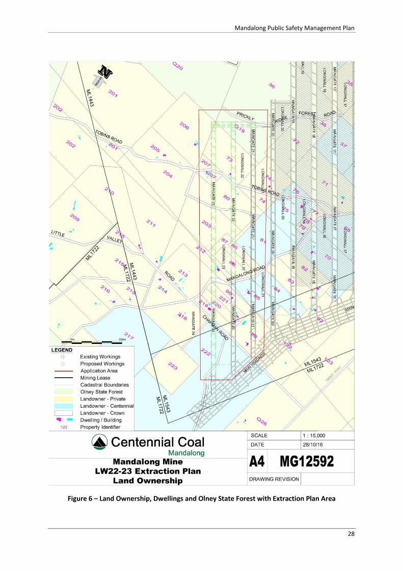
Figure 6 – Land Ownership, Dwellings and Olney State Forest with Extraction Plan Area

Mandalong Public Safety Management Plan
29
8.6 Steep Slopes and Rock Outcrops
Steep slopes have been identified over the Extraction Plan Area. These steep slope areas cover the northern and a small southern portion of LW22 and LW23 and are managed by the Land Management Plan. The land ownership includes the Olney State Forest, private land and Centennial owned land (Figure 6). There are no dwellings or other public infrastructure located within the vicinity of these steep slope areas.
Source: (Seedsman Geotechnics, 2016b)
Figure 7 – Steep Slopes
Figure 8 – Steepest slopes inspected located near the commencement of LW23

Mandalong Public Safety Management Plan
30
8.6.1 Predicted Impact
Since January 2005 when longwall extraction began at Mandalong Mine there have been no adverse slope stability impacts. Given the similarities in both the nature of the surface topography and the predicted subsidence deformations it is assessed that the same lack of adverse impacts will continue. Subsidence monitoring on Crossline 3Ex and Crossline 20 that was designed specifically to monitor the steep slopes over LW18-21 have demonstrated that vertical subsidence, tilts, strains and horizontal movements are within the predicted low values, with no rock falls and no surface cracking in rocks or soils observed. A steep slope inspection and assessment has been conducted by Seedsman Geotechnics (2016a) to assess the potential for hazards associated with the impact of subsidence on steep slopes over the LW22-23 and the proposed LW24-24A mining areas. Figure 7 shows the slope areas categorised (expressed in degrees from horizontal) over the mining area, together with roads, tracks and dwellings. The maximum slope identified is 27° (Very Steep) but located outside the mining area. Less than 12% of the mining area is classified as ‘Steep’, being greater than 18° (1 in 3) and no cliff faces exist within the area.
8.6.1.1 Surface Cracking
It is assessed by Seedsman Geotechnics (2016a) and (2016b) that given the predicted low strains and experiences to date at Mandalong Mine, it is unlikely that there will be any tensile cracking or compressive buckling developed in soil or rock.
8.6.1.2 Rock Fall
A rock fall analysis conducted by Seedsman Geotechnics (2016a) concluded that no rock fall hazard exists within the Extraction Plan area and none will be created by a change in ground slope from longwall extraction. No dwellings are located within the vicinity of steep slopes or rock fall hazard.
8.6.1.3 Landslide
It is assessed that no landslip hazard will be induced by the subsidence since there is only a thin soil cover above a rock mass with favourable joint and bedding. The magnitude of any change in slope angle is assessed to be negligible compared to the current slopes and compared with those angles that would cause landslides (Seedsman Geotechnics, 2016a).
8.6.1.4 Cliff Lines
There are no cliff lines within or surrounding the extraction plan area.

Mandalong Public Safety Management Plan
31
8.7 Private Property and Dwellings
Within the Extraction Plan area there are 21 properties of which four are owned by Centennial Coal, 17 are privately owned by 13 landowners. The privately owned properties and affected dwellings (11) are managed by individual Property Subsidence Management Plans (PSMP) as required by SSD-5144 Schedule 4 Condition 6 (h). The remainder of the Extraction Plan Area is in a small portion of Olney State Forest as shown in Figure 6.
8.7.1 Predicted Impact
8.7.1.1 Dwelling - Structural
Subsidence impacts to the nine private dwellings are expected to be similar to approximately 50 dwellings previously affected by subsidence from Longwalls 1-20. All dwellings have remained safe, serviceable and repairable. The level of damage has typically been limited to hairline cracking of internal plaster walls, sticking doors and tilting of roof guttering, requiring realignment. All nine private dwellings are expected to remain Safe, Serviceable and Repairable at maximum predicted subsidence values. Pre-mining structural assessments of the dwellings were conducted by ACOR Consultants - structural and civil engineer, confirming the design and form of all the structures would adequately tolerate the predicted level of subsidence. Individual PSMPs document the predicted impacts and any mitigation or potential remediation measures required. Table 11 provides a summary of the dwellings, MSB construction design status and structural assessment.
8.7.1.2 Dwelling - Flood
Flood Modelling and Assessment was prepared by Umwelt (2016) for the subsidence impact from mining LW22-23. The modelling and assessment concluded:
All private dwelling freeboards within the Extraction Plan area remained more than 0.5m above the 100 year ARI Storm Event level, with the exception of one dwelling with a pre-mining freeboard of 0.24m that continues to be above the 100 year flood level.
There was no increase in flood hazard category at the dwellings at the 100 year ARI Storm Event within the Extraction Plan Area.
There was no increase in flood hazard at the 1 year and 100 year ARI Storm Events along property access routes within the Extraction Plan Area.
Table 10 provides a summary of the of the pre-mining dwelling floor RL at predicted subsidence and two additional sensitivity cases, being 1.5 times and 2 times predicted subsidence. Table 12 provides a summary of the pre and post mining flood hazard category along property access routes at the 100 year ARI Storm Event. Table 13 provides a summary of the pre and post mining flood hazard category along property access routes at the 1 year ARI Storm Event. Table 14 provides a summary of the pre and post mining flood hazard category at the dwellings at the 100 year ARI Storm Event.

Mandalong Public Safety Management Plan
32
Table 10 - Dwelling Freeboard – 100 year ARI Storm Event
Property Structure Pre-Mining (m) Predicted
Subsidence (m)
Sensitivity Case 1 Subsidence (m)
Sensitivity Case 2 Subsidence (m)
212 Residence 0.24 0.22 0.25 0.29
85 Centennial Residence -0.19 -0.08 -0.22 -0.41
90 Residence 0.75 0.62 0.63 0.64
219 Residence 0.60 0.58 0.38 0.32
218 Residence 0.77 0.77 0.60 0.63
89 Residence 5.57 5.57 5.57 5.57
88 Residence 4.63 4.63 4.63 4.63
213 Residence 2.34 2.34 2.34 2.34
207 Residence 4.35 4.35 4.35 4.35
84 Residence 8.54 8.54 8.54 8.54
73 Residence 0.87 0.87 0.87 0.87
221 Residence 3.6 3.60 3.60 3.60
220 Residence 5.41 5.41 5.41 5.41
74 Residence 2.47 2.25 2.25 2.25
Legend
1 Not flooded pre-mining, predicted to flood
2 Flooded pre-mining, predicted higher flooding
3 Flooded pre-mining, predicted lower flooding
4 Not flooded pre-mining, predicted more freeboard (i.e. less flooding)
5 Not flooded pre-mining, predicted less freeboard (i.e. more flooding)
6 No change

Mandalong Public Safety Management Plan
33
Table 11 - Dwelling Structural Assessment Summary
Centennial Property
Reference
Owner Lot & DP
Address MSB File Number
MSB Approval No. Building Description
Dwelling (Residence)
Dwelling Potentially Affected by
LW22-23 Subsidence
Dwelling Structural Inspection
PSMP Prepared in
Consultation with
Landowner (refer Section 4)
73 Privately Owned Lot 93 DP 755238
120 Tobins Road Mandalong
FN98-00725L0. Single storey timber framed dwelling built prior to proclamation. No transactions on file.
Yes Yes Completed Yes
74 Privately Owned Lot 76 DP 755238
64 Tobins Road Mandalong
FN98-00569L0 TBA15-32340L1 Single storey timber framed dwelling on strips.
Yes
Yes Also previously
assessed in SMP LW18-21
Completed Yes
80 Privately Owned Lot 3 DP 1090233
115 Tobins Road Mandalong
FN98-00724L0. Single storey timber framed dwelling and steel shed built prior to proclamation. No transactions on file. *Timber cabin with no services, not currently used for permanent occupation.
Yes* Yes NA* Yes
86 Privately Owned Lot 28 DP 829792
692 Mandalong Road Mandalong
FN98-00668L0 No MSB records of any structures built prior to proclamation or since.
No No dwelling NA Yes
87 Privately Owned Lot 27 DP 829792
692 Mandalong Road Mandalong
FN98-00664L0 Vacant land No No dwelling Completed Yes

Mandalong Public Safety Management Plan
34
Centennial Property
Reference
Owner Lot & DP
Address MSB File Number
MSB Approval No. Building Description
Dwelling (Residence)
Dwelling Potentially Affected by
LW22-23 Subsidence
Dwelling Structural Inspection
PSMP Prepared in
Consultation with
Landowner (refer Section 4)
88 Privately Owned Lot 1 DP 126595
716 Mandalong Road Mandalong
FN98-00663L0 Single storey timber framed dwelling and steel shed built prior to proclamation. No transactions on file. (converted shed)
Yes Yes (shed) Completed Yes
203 Privately Owned Lot 2 DP 126594
716 Mandalong Road Mandalong
FN98-00728L0 Vacant land No No dwelling NA Yes
212 Privately Owned Lot 3 DP 3039
716 Mandalong Road Mandalong
FN98-00647L0 TBA06-05420L4 Single storey timber frame dwelling
Yes Yes Completed Yes
89 Privately Owned Lot 41 DP 755238
51 Chapman Road Mandalong
FN97-00930L0 Single storey brick veneer dwelling on strip footings and steel framed workshop/shed approved by the Board 1998. Gazebo and tennis court approved 2009. Pool refused.
Yes Yes Completed Yes
90 Privately Owned Lot 11 DP 869483
711 Mandalong Road Mandalong
FN97-00800L0 MSB approved small steel dwelling 1997 and TBA07-04890L1 Single storey brick veneer dwelling on strips
Yes Yes Completed Yes
206 Privately Owned Lot 1 DP 1090233
158 Tobins Rd Mandalong
FN97-00467L0 TBA97-04898L0 Single storey timber frame dwelling
Yes No Completed Yes
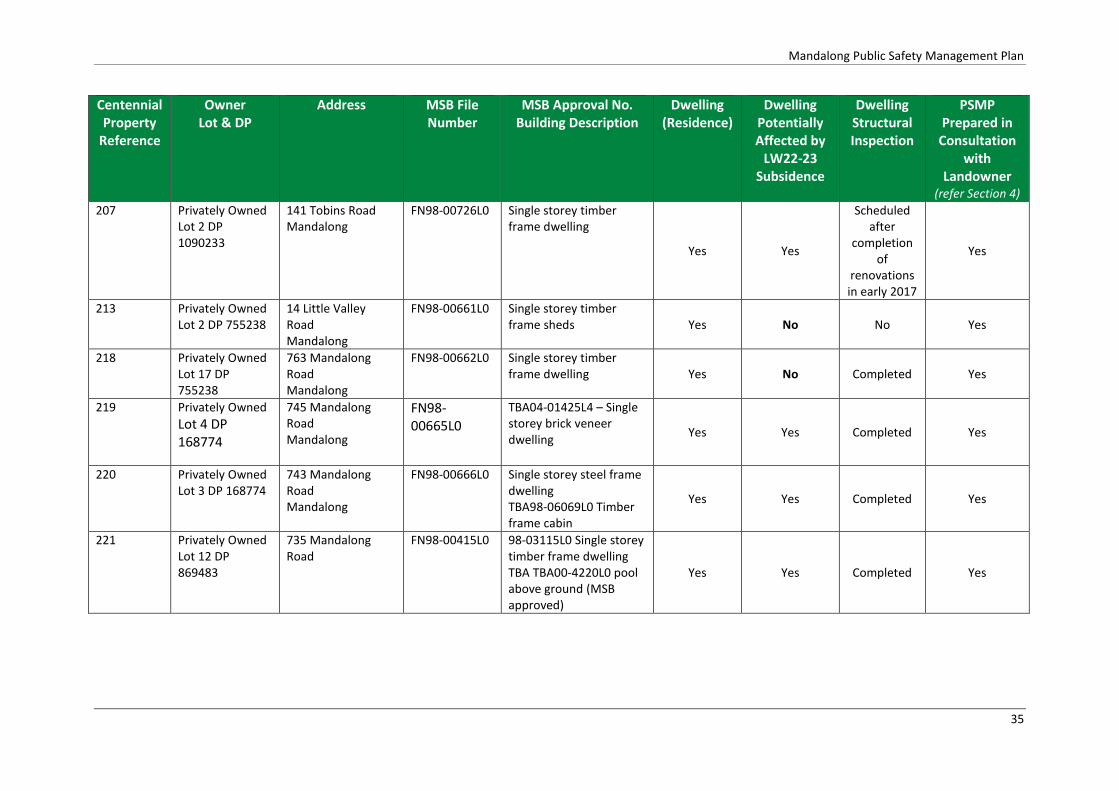
Mandalong Public Safety Management Plan
35
Centennial Property
Reference
Owner Lot & DP
Address MSB File Number
MSB Approval No. Building Description
Dwelling (Residence)
Dwelling Potentially Affected by
LW22-23 Subsidence
Dwelling Structural Inspection
PSMP Prepared in
Consultation with
Landowner (refer Section 4)
207 Privately Owned Lot 2 DP 1090233
141 Tobins Road Mandalong
FN98-00726L0
Single storey timber frame dwelling
Yes Yes
Scheduled after
completion of
renovations in early 2017
Yes
213 Privately Owned Lot 2 DP 755238
14 Little Valley Road Mandalong
FN98-00661L0
Single storey timber frame sheds Yes No No Yes
218 Privately Owned Lot 17 DP 755238
763 Mandalong Road Mandalong
FN98-00662L0 Single storey timber frame dwelling
Yes No Completed Yes
219 Privately Owned
Lot 4 DP 168774
745 Mandalong Road Mandalong
FN98-00665L0
TBA04-01425L4 – Single storey brick veneer dwelling
Yes Yes Completed Yes
220 Privately Owned Lot 3 DP 168774
743 Mandalong Road Mandalong
FN98-00666L0 Single storey steel frame dwelling TBA98-06069L0 Timber frame cabin
Yes Yes Completed Yes
221 Privately Owned Lot 12 DP 869483
735 Mandalong Road
FN98-00415L0 98-03115L0 Single storey timber frame dwelling TBA TBA00-4220L0 pool above ground (MSB approved)
Yes Yes Completed Yes

Mandalong Public Safety Management Plan
36
Table 12 - Flood Hazard Categories – Access Routes at 100 Year ARI Storm Event
Ref No. Dwelling ID Structure Pre-Mining Predicted Subsidence Sensitivity Case 1
1.5 times predicted subsidence
Sensitivity Case 2
2 times predicted subsidence
73 No flooding Houses, buildings No flooding No flooding No flooding No flooding
74 No flooding Houses No flooding No flooding No flooding No flooding
84 No flooding Houses, buildings Damage to light structures
(L4)
Damage to light structures
(L4)
Damage to light structures (L4) Damage to light structures
(L4)
85 85A Houses, buildings Damage to light structures
(L4)
Damage to light structures
(L4)
Damage to light structures (L4) Damage to light structures
(L4)
88 88A Houses, buildings Damage to light structures
(L4) Damage to light structures (L4) Damage to light structures (L4) Damage to light structures (L4)
89 No flooding Houses, buildings No flooding No flooding No flooding No flooding
90 90A Houses Wading unsafe (L3) Wading unsafe (L3) Wading unsafe (L3) Wading unsafe (L3)
212 212 Houses, buildings Damage to light structures
(L4)
Damage to light structures
(L4)
Damage to light structures (L4) Damage to light structures
(L4)
213 No flooding Houses, buildings No flooding No flooding No flooding No flooding
218 218A Houses, buildings Vehicles unstable (L2) Walking and vehicle access
(L1)
Walking and vehicle access (L1) Wading unsafe (L3)
219 219A Houses, buildings Vehicles unstable (L2) Vehicles unstable (L2) Vehicles unstable (L2) Vehicles unstable (L2)
220 No flooding Houses, buildings Damage to light structures
(L4)
Damage to light structures
(L4)
Damage to light structures (L4) Damage to light structures
(L4)
221 No flooding Houses, buildings Damage to light structures
(L4) in channel, otherwise
wading unsafe (L3)
Damage to light structures
(L4) in channel, otherwise
wading unsafe (L3)
Damage to light structures (L4)
in channel, otherwise wading
unsafe (L3)
Damage to light structures
(L4) in channel, otherwise
wading unsafe (L3)
206 206A Houses Damage to light structures
(L4) in channel, otherwise
wading unsafe (L3)
Damage to light structures
(L4) in channel, otherwise
wading unsafe (L3)
Damage to light structures (L4)
in channel, otherwise wading
unsafe (L3)
Damage to light structures
(L4) in channel, otherwise
wading unsafe (L3)

Mandalong Public Safety Management Plan
37
Note: Highlighted cells represent those sites where flood hazard categories have changed from the pre-mining case to the predicted subsidence case (blue for increased hazard and grey for decreased hazard).
Table 13 - Flood Hazard Categories – Access Routes at 1 Year ARI Storm Event
Property
No.
Dwelling ID Structure Pre-Mining Predicted Subsidence Sensitivity Case 1
1.5 times predicted ubsidence
Sensitivity Case 2
2 times predicted subsidence
73 No flooding Houses, buildings No flooding No flooding No flooding No flooding
74 No flooding Houses No flooding No flooding No flooding No flooding
84 No flooding Houses, buildings Wading unsafe (L3) Wading unsafe (L3) Wading unsafe (L3) Wading unsafe (L3)
85 85A Houses, buildings Vehicles unstable (L2) Vehicles unstable (L2) Vehicles unstable (L2) Vehicles unstable (L2)
89 No flooding Houses, buildings No flooding No flooding No flooding No flooding
90 90A Houses Vehicles unstable (L2) Vehicles unstable (L2) Vehicles unstable (L2) Vehicles unstable (L2)
212 212 Houses, buildings Vehicles unstable (L2) Vehicles unstable (L2) Vehicles unstable (L2) Vehicles unstable (L2)
213 No flooding Houses, buildings No flooding No flooding No flooding No flooding
218 218A Houses, buildings No flooding No flooding No flooding No flooding
219 219A Houses, buildings No flooding No flooding No flooding No flooding
220 No flooding Houses, buildings Damage to light structures
(L4)/Wading unsafe (L3)
Wading unsafe (L3) Wading unsafe (L3) Wading unsafe (L3)
221 No flooding Houses, buildings Wading unsafe (L3) Wading unsafe (L3) Wading unsafe (L3) Wading unsafe (L3)
206 206A House Vehicles unstable (L2) Wading unsafe (L3) in channel,
otherwise vehicles unstable
(L2)
Wading unsafe (L3) in channel,
otherwise vehicles unstable
(L2)
Wading unsafe (L3) in channel,
otherwise vehicles unstable
(L2)
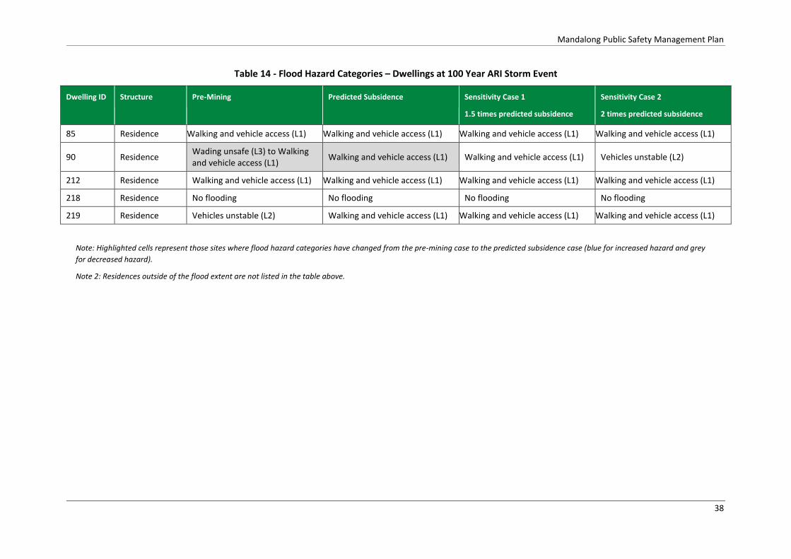
Mandalong Public Safety Management Plan
38
Table 14 - Flood Hazard Categories – Dwellings at 100 Year ARI Storm Event
Dwelling ID Structure Pre-Mining Predicted Subsidence Sensitivity Case 1
1.5 times predicted subsidence
Sensitivity Case 2
2 times predicted subsidence
85 Residence Walking and vehicle access (L1) Walking and vehicle access (L1) Walking and vehicle access (L1) Walking and vehicle access (L1)
90 Residence Wading unsafe (L3) to Walking and vehicle access (L1)
Walking and vehicle access (L1) Walking and vehicle access (L1) Vehicles unstable (L2)
212 Residence Walking and vehicle access (L1) Walking and vehicle access (L1) Walking and vehicle access (L1) Walking and vehicle access (L1)
218 Residence No flooding No flooding No flooding No flooding
219 Residence Vehicles unstable (L2) Walking and vehicle access (L1) Walking and vehicle access (L1) Walking and vehicle access (L1)
Note: Highlighted cells represent those sites where flood hazard categories have changed from the pre-mining case to the predicted subsidence case (blue for increased hazard and grey
for decreased hazard).
Note 2: Residences outside of the flood extent are not listed in the table above.

Mandalong Public Safety Management Plan
39
9 Management Measures
The primary management strategy being implemented is impact avoidance through the narrow longwall design and bridging overburden to provide reduced levels of subsidence. Monitoring will be undertaken to confirm that mine design measures to prevent impact are adequate and will provide data for trend analysis to enable adaptive management if required. The only mitigation work required is the retro-fitting of cruciform footings to TransGrid Transmission Line No.24 Towers 45 to 47 as outlined in Section 8.4.
10 Monitoring Program
The Mandalong Mine Subsidence Monitoring Program consists of conventional subsidence monitoring, visual inspections and aerial LIDAR surveys, developed in order to:
Demonstrate mine development and extraction is undertaken as per approved designs;
Provide information to demonstrate statutory compliance and obligations are satisfied;
Targeted monitoring of sensitive surface and built features;
Meet stakeholder monitoring requirements to minimise impact to infrastructure;
Provide data to manage the risk associated with both conventional and non-conventional subsidence;
Provide appropriate and timely subsidence information to assess against triggers established in the TARPs.
To provide data for future monitoring systems for ongoing mining within Mandalong mining leases.
The Subsidence Monitoring Program is scheduled in the Centennial Compliance Database. The compliance database allows for surveys, inspections and notifications to be scheduled on either time or productions schedule (longwall face position). The required actions are assigned to the relevant role to ensure the subsidence monitoring program is achieved.
10.1 Baseline Monitoring
10.1.1 Detail Aerial Mapping
An aerial LIDAR survey was undertaken in December 2015, providing the pre-mining landform for the Extraction Plan area and post mining landform for Longwalls 1 to 17. The LIDAR surveys provide surface mapping with a vertical accuracy of 0.15m. Aerial LIDAR surveys of the whole mining area are conducted approximately every three years.
10.1.2 Conventional Subsidence Monitoring
Centennial Mandalong has a well-established conventional subsidence line monitoring program, with currently over 66km of crosslines and centrelines established over the whole mining area and beyond LW23. The monitoring lines typically consist of buried star pickets with cast iron covers, nominally spaced at 10m intervals. Within the Extraction Plan area, five crosslines have been established:
Crossline 3Ex;

Mandalong Public Safety Management Plan
40
Crossline 8 (Sauls Rd easement);
Crossline 15 (Morans Creek)
Crossline 18; and
Crossline 19 (Tobins Rd pavement)
10.1.3 Telstra Phone Line and Optical Fibre Functionality
The Telstra communication lines are generally located within the public road easements. Both Crossline 8 (Mandalong Road) and Crossline 19 (Tobins Rd) will provide the baseline subsidence monitoring for the communication lines within the Extraction Plan area. In addition, similar to previous Communications Management Plans, Telstra will conduct pre-mining OTDR (Optical Time Domain Reflectometer) testing on the inactive optical fibre cable along Mandalong Road to determine the line transmission status. Post mining OTDR tests are conducted at the completion of each longwall to determine if there has been any transmission loss to the optical fibre cable caused by subsidence.
10.1.4 Dwellings and Property Features
In consultation with each affected landowner, Centennial Mandalong will establish subsidence monitoring on the dwellings, dams and surface improvements to record their pre-mining condition. The MSB will also conduct an inspection of the dwellings and improvements prior to mining. The MSB will provide a copy of the pre-mining condition report to the landowner.
10.2 Subsidence Monitoring
10.2.1 Subsidence Monitoring Zones
Mandalong Mine has developed three subsidence monitoring zones to accommodate the development of subsidence from the narrow longwall panels and the bridging effect of the overlying massive strata that provides the reduced levels of subsidence. Unique to Mandalong Mine and as a result of the bridging massive strata, subsidence develops later than in typical longwall operations, with the majority of subsidence realised after the longwall face has retreated approximately 500m. Additional subsidence also develops over the longwall panel following the extraction of the next adjacent longwall panel. This is due to the compression of the intervening chain pillar and strata. The additional subsidence contributed is typically in the order of 0.15m to 0.30m and is dependent on the geotechnical conditions and the depth of cover. Tilts and strains typically remain unchanged and may be reduced as a result of the decreased vertical subsidence differential between the maingate chain pillar and the centre of the longwall panel. In areas with higher depth of cover over 300m some additional minor settlement may occur following the extraction of the adjacent two to three longwall panels. Accordingly, with over 20 longwall panels now completed, Mandalong has developed three subsidence monitoring zones which define required monitoring activities in actively subsiding and stable areas of the mine as follows below. Full details of proposed monitoring activities within each zone are described within the Subsidence Monitoring Program for each Extraction Plan progressively approved by the mine.
10.2.1.1 Active Subsidence Zone for Visual Monitoring
The “Active Subsidence Zone” for visual monitoring inspections is defined as:
100m in advance of the current longwall face position; and
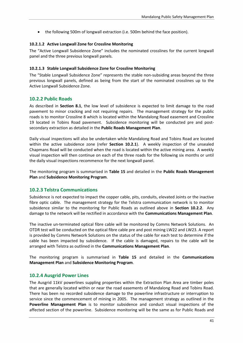
Mandalong Public Safety Management Plan
41
the following 500m of longwall extraction (i.e. 500m behind the face position).
10.2.1.2 Active Longwall Zone for Crossline Monitoring
The “Active Longwall Subsidence Zone” includes the nominated crosslines for the current longwall panel and the three previous longwall panels.
10.2.1.3 Stable Longwall Subsidence Zone for Crossline Monitoring
The “Stable Longwall Subsidence Zone” represents the stable non-subsiding areas beyond the three previous longwall panels, defined as being from the start of the nominated crosslines up to the Active Longwall Subsidence Zone.
10.2.2 Public Roads
As described in Section 8.1, the low level of subsidence is expected to limit damage to the road pavement to minor cracking and not requiring repairs. The management strategy for the public roads is to monitor Crossline 8 which is located within the Mandalong Road easement and Crossline 19 located in Tobins Road pavement. Subsidence monitoring will be conducted pre and post-secondary extraction as detailed in the Public Roads Management Plan. Daily visual inspections will also be undertaken while Mandalong Road and Tobins Road are located within the active subsidence zone (refer Section 10.2.1). A weekly inspection of the unsealed Chapmans Road will be conducted when the road is located within the active mining area. A weekly visual inspection will then continue on each of the three roads for the following six months or until the daily visual inspections recommence for the next longwall panel. The monitoring program is summarised in Table 15 and detailed in the Public Roads Management Plan and Subsidence Monitoring Program.
10.2.3 Telstra Communications
Subsidence is not expected to impact the copper cable, pits, conduits, elevated Joints or the inactive fibre optic cable. The management strategy for the Telstra communication network is to monitor subsidence similar to the monitoring for Public Roads as outlined above in Section 10.2.2. Any damage to the network will be rectified in accordance with the Communications Management Plan. The inactive un-terminated optical fibre cable will be monitored by Comms Network Solutions. An OTDR test will be conducted on the optical fibre cable pre and post mining LW22 and LW23. A report is provided by Comms Network Solutions on the status of the cable for each test to determine if the cable has been impacted by subsidence. If the cable is damaged, repairs to the cable will be arranged with Telstra as outlined in the Communications Management Plan. The monitoring program is summarised in Table 15 and detailed in the Communications Management Plan and Subsidence Monitoring Program.
10.2.4 Ausgrid Power Lines
The Ausgrid 11kV powerlines suppling properties within the Extraction Plan Area are timber poles that are generally located within or near the road easements of Mandalong Road and Tobins Road. There has been no recorded subsidence damage to the powerline infrastructure or interruption to service since the commencement of mining in 2005. The management strategy as outlined in the Powerline Management Plan is to monitor subsidence and conduct visual inspections of the affected section of the powerline. Subsidence monitoring will be the same as for Public Roads and

Mandalong Public Safety Management Plan
42
Telstra Communications as detailed in Section 10.2.2. Daily and weekly visual inspections will record the condition of the powerline infrastructure.
10.2.5 TransGrid 330kV Transmission Line No. 24
Subsidence monitoring will be established on the cruciform footings of each tower following their construction. The peak earth wire and four surrounding ground pegs will also be monitored. TransGrid and DRE will be consulted on the establishment of the subsidence monitoring program for the transmission towers and documented in the Transmission Line Management Plan.
10.2.6 Olney State Forest Unsealed Roads and Tracks
Similar to previous mining within Olney State Forest, subsidence is not expected to result in surface cracking, impact to steep slopes or affect road drainage. The Land Management Plan details the subsidence management procedure for mining within Olney State Forest. The management strategy will consist of subsidence monitoring on Crossline 3Ex and conducting weekly inspections when areas of Olney State Forest are located within the active mining areas of LW22 and LW23. The monitoring program is summarised in Table 15.
10.2.7 Steep Slopes
Subsidence monitoring within steep slope areas will consist of conventional monitoring pre and post mining of Crossline 3 Ex. Weekly visual inspections will also be conducted over the steep slope areas of Olney State Forest that are positioned within the active subsidence zone. Weekly inspections will also on private property with landowner agreement. The monitoring program is summarised in Table 15 and detailed in the Land Management Plan and Subsidence Monitoring Program.
10.2.8 Property and Dwellings
The proposed management measures for each property are documented in each of the landowner’s PSMP. A copy of the 13 PSMPs are included in the Extraction Plan LW22-23. The management measures for properties affected by LW22-23 are typically restricted to monitoring subsidence on the dwellings, dams, surface improvements and drainage channels. A pre-mining inspection will also be conducted by the MSB to record the pre-mining condition of the dwellings and improvements. Any necessary remediation works will be undertaken following the completion of subsidence and in consultation with the landowner and MSB. The monitoring for private dwellings is summarised in Table 15, PSMPs and Subsidence Monitoring Program.

Mandalong Public Safety Management Plan
43
Table 15 –Public Safety Subsidence Monitoring Program Summary
Feature Location Monitoring Method Parameter Monitoring Frequency and Duration
Public Roads Public Roads Management Plan
Powerlines Powerline Management Plan
Telstra Communications Network Communications Management Plan
Mandalong Road
Crossline 8
Vertical subsidence, tilt and strain.
Baseline Prior to mining LW22, LW23 Post Mining 2 months after mining LW22, LW23 Stable Zone 2 yearly
Visual Inspection
Presence of mine-induced damage – surface cracking, damage to pavement , drainage, culverts and pipes Risk to public safety Powerline –tilting pole, damage cross arms, insulators; change in conductor sag/tension; ground clearance.
Active Zone Daily visual inspection while road is within the current LW active zone. Post Mining Weekly visual inspection for the following six months or next longwall panel.
Telstra - Comms Network Solutions OTDR Testing on inactive optical fibre cable; and Visual inspection of infrastructure
Loss or change in transmission wavelength. Inspection of pits, cables, joints, conduits
Baseline Prior to mining LW22, LW23 Post Mining 2 months after mining LW22, LW23
Tobins Road Crossline 19 Vertical subsidence, tilt and strain Baseline Prior to mining LW22, LW23 Post Mining 2 months after mining LW22, LW23

Mandalong Public Safety Management Plan
44
Feature Location Monitoring Method Parameter Monitoring Frequency and Duration
Visual Inspection
Presence of mine-induced damage – surface cracking, damage to pavement drainage, culverts and pipes Risk to public safety Powerline –tilting pole, damage cross arms, insulators; change in conductor sag/tension; ground clearance; risk to public safety
Active Zone Daily visual inspection while road is within the current LW active zone. Post Mining Weekly visual inspection for the following six months or next longwall panel.
Chapmans Road Visual Inspection
Presence of mine-induced damage – surface cracking, road surface drainage, culverts and pipes Risk to public safety
Active Zone Weekly visual inspection while road is within the current LW active zone. Post Mining Weekly visual inspection for the following six months or next longwall panel.
Unsealed roads and tracks Land Management Plan
Olney State Forest
Visual Inspection
Presence of mine-induced damage – surface cracking, road surface, drainage, culverts and pipes Risk to public safety
Active Zone Weekly visual inspection while road is within the current LW active zone. Post Mining Weekly visual inspection for the following six months or next longwall panel.
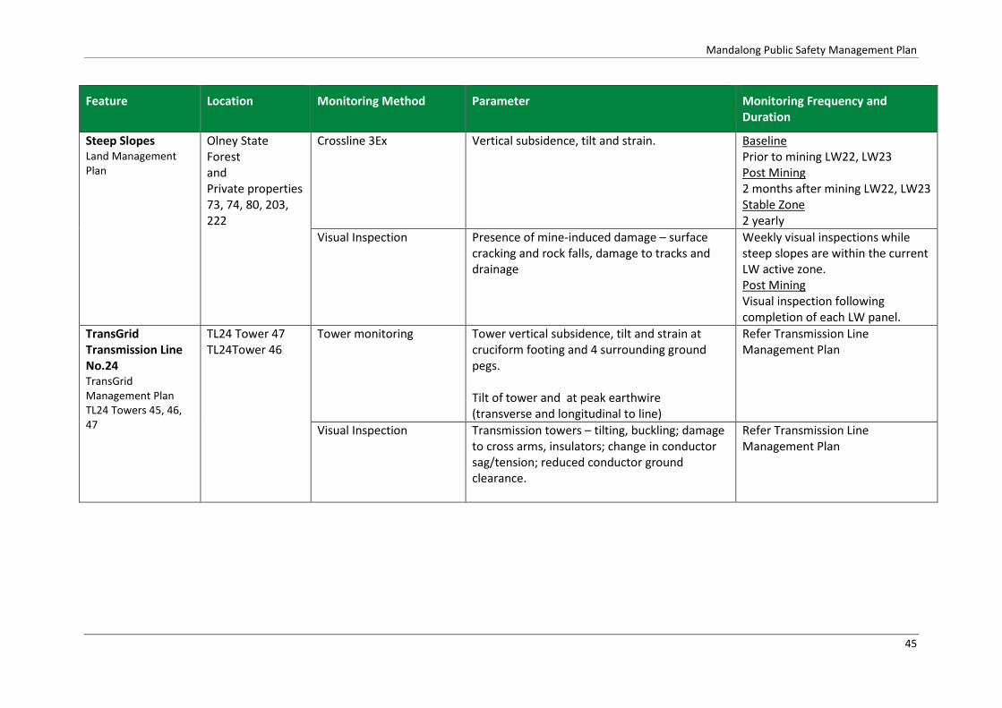
Mandalong Public Safety Management Plan
45
Feature Location Monitoring Method Parameter Monitoring Frequency and Duration
Steep Slopes Land Management Plan
Olney State Forest and Private properties 73, 74, 80, 203, 222
Crossline 3Ex
Vertical subsidence, tilt and strain.
Baseline Prior to mining LW22, LW23 Post Mining 2 months after mining LW22, LW23 Stable Zone 2 yearly
Visual Inspection
Presence of mine-induced damage – surface cracking and rock falls, damage to tracks and drainage
Weekly visual inspections while steep slopes are within the current LW active zone. Post Mining Visual inspection following completion of each LW panel.
TransGrid Transmission Line No.24 TransGrid Management Plan TL24 Towers 45, 46, 47
TL24 Tower 47 TL24Tower 46
Tower monitoring Tower vertical subsidence, tilt and strain at cruciform footing and 4 surrounding ground pegs. Tilt of tower and at peak earthwire (transverse and longitudinal to line)
Refer Transmission Line Management Plan
Visual Inspection Transmission towers – tilting, buckling; damage to cross arms, insulators; change in conductor sag/tension; reduced conductor ground clearance.
Refer Transmission Line Management Plan

Mandalong Public Safety Management Plan
46
Feature Location Monitoring Method Parameter Monitoring Frequency and Duration
Private Dwellings PSMP LW22-23
Centennial Ref. 73, 74, 89, 90, 207, 212, 219, 220, 221
Monitoring points installed as agreed in consultation with each landowner:
Four points in ground surrounding dwelling
Pins installed at dwelling corners
Points on dams and other structures
As agreed in PSMP
Vertical subsidence, tilt and strain Baseline Prior to mining LW22 or LW23 Post Mining 2 months after mining LW22, LW23
Visual Inspection Pre-mining Structural Assessment by civil/structural engineer (ACOR Consulting) Post-mining MSB Inspection Centennial Mandalong Inspection
Baseline Prior to mining LW22 or LW23
Post-mining MSB Inspection (on request) Centennial Mandalong
Post Mining Following completion of subsidence or request by landowner

Mandalong Public Safety Management Plan
47
11 Adaptive Management
In addition to the conservative narrow longwall panel design specifically designed to provide reduced levels of subsidence and impact, Centennial Mandalong developed an adaptive management approach designed to avoid repetition of any unpredicted subsidence and or environmental consequences. This system involves the monitoring and evaluation of impacts to built and natural features against the performance indicators defined in Section 6.3 and contingency plan (TARP) in the event that a performance indicator is exceeded.
12 Contingency Plans
Trigger Action Response Plans (TARP) have been developed using performance indicators for built features. In the event that subsidence monitoring and or visual inspections identify that a performance indicator has been exceeded, Centennial Mandalong will implement the contingency measures as detailed in the TARP for the specific built feature (refer Appendix 1).

Mandalong Public Safety Management Plan
48
13 Roles and Responsibilities
The responsibility for implementation, monitoring and review of the Public Safety Management Plan lies with the Mining Approvals Coordinator. The roles and responsibilities for the Public Safety Management Plan are outline in Table 16.
Table 16 – Public Safety Management Plan Roles and Responsibilities
Position Responsibility
Mine Manager Authorisation of the Public Safety Management Plan
Ensuring that sufficient resources are available to implement this plan.
Notifying Regulator of Incidents
Mining Approvals Coordinator
Implementation, monitoring and review of this plan, including:
Ensure that the Subsidence Monitoring Program, required inspections, mining notifications are scheduled into the Centennial Compliance Database prior to the commencement of each longwall panel.
Ensuring subsidence monitoring and inspections are conducted at the required schedule and persons conducting monitoring/inspections are trained in the requirements of this plan.
Consulting with the landowners, infrastructure owners and relevant government departments including TransGrid, Ausgrid, Telstra, LMCC, DPI-Lands, NSW Forests, DPE, DRE and MSB.
Review and assess the subsidence monitoring results against the performance measures.
Notification of any exceedance of performance indicators in accordance with the TARPs and management plan.
Coordinating any remedial work as required.
Preparation and submission of formal reporting requirements outlined in this plan.
Review and audit the Public Safety Management Plan.
Subsidence Surveyor
Establishment of subsidence monitoring in accordance with the Subsidence Monitoring Program.
Ensure all subsidence surveys are conducted in accordance with the approved Subsidence Monitoring Program.
Review and assess subsidence monitoring results.
Notify the Mining Approvals Coordinator of any identified public safety issues.
Provide the monitoring results to the Mining Approvals Coordinator, DRE, TransGrid, AusGrid, Telstra, LMCC, MSB and NSW Forests.
Survey Department
When required, conduct inspections within the applicable subsidence zone to the standard required, using the subsidence inspection checklist.
Promptly notify the Mining Approvals Coordinator of any issue identified during a subsidence inspection.

Mandalong Public Safety Management Plan
49
14 Reporting
Reporting will be completed in accordance with the Guidelines for the Preparation of Extraction Plans (NSW Department of Planning & Environment, 2015) and WHS (Mines and Petroleum Sites) Regulation requirements, as summarised in Table 17.
Table 17 - Reporting Requirements
Report Trigger Requirements Stakeholders
Six Monthly Report
Every six months during mining of LW 22 to 23.
Summary of all impacts;
Any revisions to the TARP;
Assessment of compliance with performance measures and indicators; and
Summary of environmental monitoring results.
DRE
DPE
LMCC
Telstra
Forests NSW
TransGrid
DPI-Lands
Seedsman Geotechnics
MSB
CCC
Incident Reporting
Any occasion or incident in accordance with consent condition, WHS Regulations or TARP.
In accordance with requirements of:
Development Consent Schedule 6 Condition 10; or
WHS Regulation (Mines and Petroleum Sites) Clause 128; or
TARP.
Bi-Monthly Subsidence Impact Reporting
If a new impact is identified, compile after monthly subsidence.
Distinguish impact:
within predictions;
those which exceed predictions but remain within performance measures and/or performance indicators; and
those which exceed performance measures and/or performance indicators.
Report to include:
full description;
location identification using aerial photos with longwall layout superimposed;
photos of the impact; and
preliminary characterisation of the impact in accordance with the relevant TARP(s).
Annual Review
Annual Report required under development consent SSD-5144.
Report to include:
six-monthly reports of impacts and environmental monitoring results;
monitoring results; and
summary of subsidence impacts.
DRE
DPE
CCC
LMCC
Community Consultative Committee (CCC)
CCC meetings are typically held three times per year.
Subsidence and environmental performance is included as an agenda item at each meeting.
CCC

Mandalong Public Safety Management Plan
50
Report Trigger Requirements Stakeholders
Mining Notifications
One month prior to mining beneath property or built feature.
Scheduled date that the property or built feature will be affected by subsidence and within the Active Subsidence Zone.
LMCC, Telstra, Comms Network
Solutions, Ausgrid, Forest
Corporation NSW, DPI-Lands,
Private Landowners
15 Audit and Review
Audit and review procedures are outlined in Centennial Mandalong’s Safety Management System that comply with the NSW Work Health and Safety (Mines and Petroleum Sites) Regulations. These procedures are utilised to manage audit and review functions of the Public Safety Management Plan. Refer Document HSMS-SE-1028- System Evaluation.
15.1 Audit
The requirements of the Public Safety Management Plan are to be audited annually for compliance and effectiveness during the extraction of LW22-23. Any non-conformances or deficiencies found during the audit are to be brought to the attention of the System Coordinator so that corrective actions can be outlined. These corrective actions are to be allocated and carried out accordance with HSMS-SE-1029 - Corrective Action Procedure.
15.2 Review
The Public Safety Management Plan will be reviewed every three years or in the event that one of the following occurs:
Stakeholders raise issues that necessitates a review;
Where unpredicted impacts or consequences have required implementation of contingency actions under this plan;
Monitoring, incident or audit processes demonstrate a review is required;
Where triggered by a TARP;
Where triggered by circumstances in either Clause 10 or Clause 128 of WHS (Mines and Petroleum Sites) Regulation or Clause 38 WHS Regulation;
Each new Extraction Plan; and
Change in mine design or layout.
16 Document Control
An integrated Document Control Procedure is incorporated into Centennial Mandalong’s Safety Management System. Documents, data and records pertaining to this plan will be managed according to HSMS-SE-1025-Information Control.
Mandalong Public Safety Management Plan
51
17 BIBLIOGRAPHY
Comms Network Solutions. (2016). Audit Assessment Report for Mandalong Mine LW22-23 Crossing Under Telstra Network at Mandalong.
NSW Department of Planning & Environment. (2015). Draft Guidelines for the Preparation of Extraction Plans V5.
Seedsman Geotechnics. (2016a). Slope Stability Assesssment LW22-24A - MAND16-03.
Seedsman Geotechnics. (2016b). Centennial Mandalong Prediciton of Subsidence Impacts for LW22-LW23, MAND16-07.
SLR. (2016). Centennial Mandalong Extraction Plan LW22-23, Land and Agricultural Resource Assessment, Report No. 630.11678.
TransGrid. (2016). Report – Scoping Study into Mine Subsidence Mitigation (Structures 45-48 of TL24).
Umwelt. (2016). Centennial Mandalong Flood Assessment Longwalls 22 to 23.

Mandalong Public Safety Management Plan
APPENDIX 1 – Trigger Action Response Plans

Mandalong Public Safety Management Plan

Monitoring and Controls Trigger Action
Steep Slopes
Centennial to conduct pre mining steep slope inspection and assessment by Geotechnical Engineer.
Centennial to conduct subsidence monitoring and inspections as per the Public Safety Management Plan and Subsidence Monitoring Programme.
Centennial to conduct weekly visual inspections when mining within steep slope zones.
Centennial to provide pre and post mining subsidence monitoring results to DRE, MSB and Landowners.
CONTROLS Steep Slope Inspection and Assessment Report LW22 to LW24A (Seedsman, 2016) determined that there is no rock fall hazard or potential for landslip within the LW22-24A mining area. There are no cliff formations within the mining area.
LEVEL 1 – LOW Operation within prediction and approved impact
Development of subsidence and impact as expected.
Vertical subsidence within predicted range.
Tilts and Strains within predicted range.
No visible impact on gravel access roads.
No impact to steep slopes.
No indications down slope rock or bolder movements.
No rock mass instability.
Minor opening of rock joints that does not cause dislodgement of rocks.
Centennial to conduct weekly visual inspections of land within steep slope zones
Centennial to conduct post mining inspection and subsidence monitoring and provide results to the DRE and Landowner.
LEVEL 2 – MEDIUM Operations within approved impact but exceed or potentially exceed predictions
Development of subsidence exceeding or potentially exceeding prediction.
Vertical subsidence greater than predicted.
Tilts and Strains greater than predicted.
Minor cracking to gravel access roads.
Minor cracking to surface not requiring repairs.
Opening of rock joints that may cause dislodgement of rocks.
Centennial to conduct post mining inspection and subsidence monitoring and provide results to the DRE and Landowner.
Centennial to inspect and erect warnings signs or barricades as per Public Safety Management Plan.
Centennial to notify Landowner
Centennial to arrange repairs to access roads or areas of rock instability in consultation with landowner.
Centennial to notify Principal Subsidence Engineer of higher than expected subsidence and impact.
Centennial to arrange a Geotechnical Engineer to inspect any areas of suspected rock mass instability in consultation with Landowner.
Centennial to review results and predictions as per Extraction Plan.
LEVEL 3 – HIGH Operations exceed approved impact
Development of subsidence and impact greater than expected.
Vertical subsidence greater than predicted.
Tilts and Strains greater than predicted.
Tensile cracks and/or compression humps develop on access roads that need repairing to ensure public safety.
Surface cracking visible that may be dangerous to the public.
Repairs required, reshaping road and restore drainage.
Opening of rock joints that may cause dislodgement of rocks.
Centennial to conduct post mining inspection and subsidence monitoring and provide results to the DRE and Landowner.
Centennial to inspect and erect warnings signs or barricades as per Public Safety Management Plan.
Centennial to notify Landowner.
Centennial to notify Principal Subsidence Engineer of higher than expected subsidence and impact.
Centennial to notify DPE as per S4 Condition 2 SSD-5144.
Centennial to arrange immediate repairs to dangerous surface cracking (eg backfilling) any necessary repairs in consultation with the Landowner and DRE.
Centennial to arrange a Geotechnical Engineer to inspect any areas of suspected rock mass instability.
Centennial to notify external stakeholders including government agencies in accordance with Incident Reporting S6 Condition 10.
Centennial to review results and predictions as per Extraction Plan.

Powerline Management Plan
Monitoring and Controls Trigger Action / Response
Powerlines – LW22-23
Centennial to establish subsidence monitoring / inspection sites for public roads and adjacent powerlines prior to mining.
Centennial to mark the centreline and edges of current longwall panel on public road pavement one month prior to public road and powerlines being affected by subsidence.
Centennial to notify Ausgrid one month prior to powerline being affected by subsidence from each longwall panel.
Centennial to conduct daily visual inspections of public roads and powerlines located along road easement when influenced by subsidence within the Active Subsidence Zone. Record results on the Subsidence Inspection Checklist.
Centennial to conduct weekly visual inspections for the following six months and record results on the Subsidence Inspection Checklist.
Centennial to be in regular contact with private property owner during the development of subsidence.
Centennial to conduct post-mining surveys following the development of subsidence (majority of subsidence developed when LW is completed or LW face is 800m past feature).
Centennial to provide pre and post mining subsidence monitoring results to Ausgrid, DRE and MSB.
LEVEL 1 – LOW Operations within prediction and approved impact
Development of subsidence and impact as expected.
Subsidence within predicted range.
No mitigation works required.
No noticeable impact to the surface or powerline network.
Damage powerlines highly unlikely.
Centennial to conduct post mining inspection and subsidence monitoring and provide results to the Ausgrid, DRE and MSB.
LEVEL 2 – MEDIUM Operations within approved impact but exceed or potentially exceed predictions
Development of subsidence exceeding or potentially exceeding prediction.
Subsidence results twice predicted values.
No noticeable impact to powerline network
Mitigation / remediation work on insulators and conductors may be considered necessary.
Centennial to inspect powerlines.
Centennial to notify Ausgrid and DRE of increased subsidence and any observed impact to powerline network.
Ausgrid to conduct inspection and investigate the impact of increased subsidence on powerline network.
Ausgrid to conduct repairs if considered necessary.
Centennial to advise MSB or potential repairs Centennial to review results and predictions as per Extraction Plan LW22-23.
LEVEL 3 – HIGH Operations exceed approved impact
Development of subsidence and impact greater than expected.
Increased subsidence from conglomerate beam failure.
Visible cracking on gravel and sealed roads.
Visible cracking to surface.
Damage to powerline network, cross arms, insulators or coductors.
Tiltlng poles – increased or decreased conductor tension.
Reduced conductor ground clearance.
Potential loss of service.
Centennial to immediately advise Ausgrid of observed damage to the powerline network.
Ausgrid Emergency Service - 1800 627 005
Ausgrid to inspect any damage to powerline network and arrange repairs.
Centennial to promptly notify DRE and MSB of increased subsidence and observed impact to powerlines.
Centennial to conduct post mining inspection and subsidence monitoring and provide results to Ausgrid, DRE and the MSB.
Centennial to review results and predictions as per Extraction Plan LW22-23.
Centennial to notify external stakeholders and government agencies in accordance with Incident Reporting requirements DC S6 Condition 10 and WHS Regulations.

Public Roads Management Plan
Monitoring and Controls Trigger Action
Public Roads – LW22-23
Centennial to conduct flood modelling and assessment to identify potential changes to flooding on public roads and access roads to dwellings.
Centennial to establish subsidence monitoring / inspection sites for public roads prior to mining.
Centennial to mark the centreline and edges of current longwall panel one month prior to public road being affected by subsidence.
Centennial to notify LMCC one month prior to public road affected by subsidence from each longwall panel.
Centennial to conduct daily visual inspections of sealed public roads and weekly inspections of unsealed public roads when influenced by subsidence. Record results on the Subsidence Inspection Checklist.
Centennial to conduct post-mining surveys following the development of subsidence (majority of subsidence developed when LW is completed or LW face is 800m past feature).
Centennial to provide pre and post mining subsidence monitoring results to LMCC, DRE and MSB.
CONTROLS
Flood Modelling and Assessment LW22-23 (Umwelt 2016) determined that there was no predicted increase in flood hazard category on the public roads at both the 1 year and 100 year ARI Storm Events.
LEVEL 1 – LOW Operations within prediction and approved impact
Development of subsidence or impact as expected.
Tensile Strains less than 5mm/m
Compressive Strains less than -5mm/m
Vertical subsidence within predicted range.
Typically no impact on gravel access roads.
Possible hairline cracking on sealed roads.
Damage to public road not likely.
Centennial to conduct post mining inspection and subsidence monitoring and provide results to the LMCC, DPI-Lands, DRE and MSB.
LMCC to conduct post mining inspection and arrange any necessary repairs in consultation with the MSB.
LEVEL 2 – MEDIUM Operations within approved impact but exceed or potentially exceed predictions
Development of subsidence exceeding or potentially exceeding prediction.
Tensile Strains greater than 5 mm/m.
Compressive Strains greater than -5mm/m
Vertical subsidence 1.5 times predicted.
Typically no impact to gravel access roads.
Cracking may be visible on sealed roads – development of minor compression hump near centre of longwall and minor tensile cracking to pavement.
Repairs to pavement may be required to reseal pavement.
Centennial to advise LMCC, DPI-Lands and MSB of observed damage to the public road.
LMCC to erect warning signs near affected area of road if necessary.
Centennial to conduct post mining inspection and subsidence monitoring and provide results to the LMCC, DPI-Lands, DRE and MSB.
LMCC to conduct post mining inspection and arrange any necessary repairs in consultation with the MSB.
LMCC or approved contractor to conduct repairs to damaged pavement.
Centennial to consult with DPI-Lands prior to conducting any necessary remediation works.
LEVEL 3 – HIGH Operations exceed approved impact
Development of subsidence and impact greater than expected.
Strain greater than 10 mm/m.
Vertical subsidence 2 times predicted or beam failure.
Visible cracking on gravel and sealed access roads.
Tensile cracks develop on sealed roads.
Subsidence steps > 100mm
Compression hump > 100mm
Repairs required, reshaping road, restoring drainage and resealing pavement.
Centennial to immediately advise LMCC, DPI-Lands and MSB of observed damage to the public road.
LMCC to erect warning signs near affected area of road.
Centennial to conduct post mining inspection and subsidence monitoring and provide results to LMCC, DRE, DPI-Lands and the MSB.
LMCC to conduct post mining inspections and arrange repairs in consultation with the MSB.
Centennial to consult with DPI-Lands prior to conducting any necessary remediation works.
LMCC or approved contractor to conduct repairs to damaged pavement.
Centennial to review results and predictions as per Extraction Plan.
Centennial to notify external stakeholders including relevant government agencies in accordance with Incident Reporting S6 Condition 10 and WHS Regulations
FLOODING
Flood modelling has assessed that there would not be an increase in flood hazard on public roads located over LW22-23 at either maximum predicted subsidence or two times maximum predicted subsidence.

Telstra Communications Management Plan LW22-23
Monitoring and Controls Trigger Action
Built Feature – Telstra Communications Network CAN Local Cables – 50, 30, 10 & 2 pair direct buried copper cables, conduit and pit network supporting cables that are installed across LW22-23 Centennial has established subsidence
monitoring / inspection sites for public roads and adjacent communications lines
Centennial to mark the centreline and edges of current longwall panel on public road pavement one month prior to public road and communications being affected by subsidence.
Centennial to notify Telstra one month prior to powerline being affected by subsidence from each longwall panel.
Centennial to conduct daily visual inspections of public roads and communications located along road easement when influenced by subsidence within the Active Subsidence Zone. Record results on the Subsidence Inspection Checklist.
Centennial to conduct weekly visual inspections for the following six months or until next longwall, and record results on the Subsidence Inspection Checklist.
Centennial to be in regular contact with private property owner during the development of subsidence to ensure no interruption of communication service.
Centennial to conduct post-mining surveys following the development of subsidence (majority of subsidence developed when LW is completed or LW face is 800m past feature).
Centennial to provide pre and post mining subsidence monitoring results to Telstra, DRE and MSB.
LEVEL 1 – LOW Operations within predicted subsidence and impact.
Development of subsidence and impact as expected.
Subsidence – strains within prediction
No interruption of service.
Continue operations and monitoring program
Unlikely remedial work will be required.
Centennial to conduct post mining inspection and provide subsidence monitoring results to Telstra, DRE and MSB.
LEVEL 2 – MEDIUM Operations within approved impacts but exceed or potentially exceed predictions
Development of subsidence strains greater than expected
Strains greater than two times maximum predicted (6mm/m).
No impact to communication network
No interruption of service.
Continue operations and monitoring program
Centennial to notify Telstra Integrity Services and Comms Network Solutions that subsidence predictions have exceeded or potentially exceeded predictions.
Comms Network Solutions to inspect Telstra network for any damage and provide report to Centennial and Telstra.
Centennial to conduct post mining inspection and provide subsidence monitoring results to Telstra, DRE and MSB.
LEVEL 3 – HIGH Operations exceed approved impact
Development of subsidence and impact greater than expected
Damage to copper cable phone line
Damage to conduit and pit network
Interuption to Telstra communications service
Centennial to immediately report fault to Telstra’s fault line number 132203.
Centennial to notify Telstra Integrity Services and Comms Network Solutions that there has been damage to network and interruption to service.
Centennial to provide notification to DRE and MSB
Centennial to arrange a Review Meeting to review survey results, cable inspections and proposed action to remediate damage to communication network.
Centennial to notify external stakeholders including relevant government agencies in accordance with Incident Reporting S6 Condition 10 and WHS Regulations.
Centennial to conduct review and predictions as per adaptive management process as detailed in the Extraction Plan LW22-23.

Monitoring Trigger Action
Dwelling Strain
Centennial to conduct property inventory and detail predicted impacts from subsidence in PSMP as per DC Schedule 4 Condition 6(h).
Centennial to arrange pre-mining structural inspection of dwellings and buildings as per DC Schedule 4 Condition 6(h).
Centennial to arrange MSB pre-mining inspection of dwelling and improvements.
Centennial to establish subsidence monitoring on dwelling and improvements in consultation with Landowner and MSB.
Centennial to conduct post-mining surveys following the development of subsidence (majority of subsidence developed when LW face is 800m past dwelling).
Centennial to provide subsidence monitoring results to Landowner, DRE and MSB.
LEVEL 1 – LOW Operation within prediction and approved impact
Development of subsidence and impact as expected.
Strain < 5mm/m Strain Category 0-2 (AS2870-2011).
No noticeable impact to dwelling.
Possible hairline to fine cracks noticeable that can be easily filled.
Possible slightly sticking doors or windows.
Centennial to conduct subsidence monitoring on dwelling to determine strains and provide results to the Landowner, DRE and MSB.
Centennial to assist landowner with any claim for damage to property.
MSB to conduct post mining inspections and arrange any necessary repairs in consultation with Landowner.
LEVEL 2 – MEDIUM Operations within approved impact but exceed or potentially exceed predictions
Development of subsidence greater than predicted, but impact as expected
Strains approaching 5 mm/m Strain Category 0-2 (AS2870-2011).
Minor impact to dwelling.
Possible hairline to fine cracks noticeable that can be easily filled.
Possible slightly sticking doors or windows.
Centennial to conduct subsidence monitoring on dwelling to determine strains and provide results to the Landowner, DRE and MSB.
Centennial to assist landowner with any MSB claim for damage to property.
Centennial to arrange a structural inspection of dwelling to assess that dwelling is SSR.
MSB to conduct post mining inspections and arrange any necessary repairs in consultation with Landowner.
Centennial to review results and predictions as per Extraction Plan.
LEVEL 3 – HIGH Operations exceed approved impact
Development of subsidence and impact greater than expected and beyond SSR
Strain >5mm/m Beyond SSR Strain Category 3 to 5 (AS2870-2011)
Crack width > 5mm/to 25mm o Windows and door frames distorting o Service pipes disrupted o Roof and floor beams lose bearing o Windows broken o Severe buckling and bulging of roof and walls o Will require partial or complete rebuild.
Centennial to conduct subsidence monitoring on dwelling to determine tilt and provide results to the Landowner, DRE and MSB.
Centennial to commence negotiations with Landowner as per the Acquisition and Compensation process consistent with DC Schedule 5 Conditions 3 and 4.
Centennial to arrange structural inspection to assess if dwelling is repairable.
Centennial to arrange alternate temporary accommodation for occupants if necessary.
Centennial to notify external stakeholders including government agencies in accordance with Incident Reporting S6 Condition 10.
Centennial to review results and predictions as per Extraction Plan.

Monitoring Trigger Action
Dwelling Tilt
Centennial to conduct property inventory and detail predicted impacts from subsidence in PSMP as per DC Schedule 4 Condition 6(h).
Centennial to arrange pre-mining structural inspection of dwellings and buildings as per DC Schedule 4 Condition 6(h).
Centennial to arrange MSB pre-mining inspection of dwelling and improvements.
Centennial to establish subsidence monitoring on dwelling and improvements in consultation with Landowner and MSB.
Centennial to conduct post-mining surveys following the development of subsidence (majority of subsidence developed when LW face is 800m past dwelling).
Centennial to provide pre and post mining subsidence monitoring results to Landowner, DRE and MSB.
LEVEL 1 – LOW
Operation within prediction and approved impact
Development of subsidence and impact as expected
Tilt < 5mm/m Tilt Category A (AS2870-2011)
No noticeable impact to dwelling.
Possible sticking doors or windows
Unlikely remedial work will be required
Centennial to conduct subsidence monitoring on dwelling to determine tilt and provide results to the Landowner, DRE and MSB.
Centennial to assist landowner with any claim for damage to property.
MSB to conduct post mining inspections and arrange any necessary repairs in consultation with Landowner.
LEVEL 2 – MEDIUM
Operations within approved impact but exceed or potentially exceed predictions
Development of subsidence greater than predicted, but impact as expected
Tilt 5 to 7mm/m Tilt Category B (AS2870-2011)
Roof drainage overflowing or wet areas not draining effectively
Adjustment of roof drainage or wet areas might be required
Centennial to conduct subsidence monitoring on dwelling to determine tilt and provide results to the Landowner, DRE and MSB.
Centennial to assist landowner with any claim for damage to property.
MSB to conduct post mining inspections and arrange any necessary repairs in consultation with Landowner.
Centennial to provide alternate water supply if required.
LEVEL 3 – HIGH Operations exceed approved impact
Development of subsidence and impact greater than expected and beyond Safe, Serviceable and Repariable (SSR).
Tilt >7mm/m Beyond SSR. Tilt Category C & D (AS2870-2011).
Tilt on dwelling may be noticeable.
Minor structural work might be required to rectify tilt.
Considerable structural work may be required to rectify tilt >10mm/m.
Centennial to conduct subsidence monitoring on dwelling to determine tilt and provide results to the Landowner, DRE and MSB.
Centennial to arrange structural inspection to assess if the dwelling is safe, serviceable and repairable.
Centennial to commence negotiations with Landowner as per the Acquisition and Compensation process consistent with DC Schedule 5 Conditions 3 and 4.
Centennial to arrange alternate temporary accommodation for occupants if necessary.
Centennial to notify external stakeholders including government agencies in accordance with Incident Reporting S6 Condition 10
Centennial to provide alternate water supply if required.
Centennial to review results and predictions as per Extraction Plan.


Centennial Mandalong 12 Kerry Anderson Drive
Mandalong NSW 2264
PO Box 1000
Toronto NSW 2283
Telephone 1800 730 919
Facsimile 49 730 999